role of geology in solving some political problems case ... of geology in... · role of geology in...
TRANSCRIPT

Salman,A.B., 2016. Role of Geology in Solving some Political Problems, Case Study: Tiran
and Sanafir islands, North Red Sea, http://kenanaonline.com/absalman, 12 p
_______________________________________________________________________
Role of Geology in Solving some Political Problems
Case Study: Tiran and Sanafir islands, North Red Sea
Abdel Aty Badr Salman*
Abstract
This paper through some light on the role of geology in solving
some political debate using Tiran and Sanafir Islands, northern Red Sea
as a case study. The author used the tectonic history of the opening of the
Red Sea and East Africa Rift, features on space images, topographic and
bathymetric maps of the Red Sea region to clarify dependency of Tiran
and Sanafir islands to the Kingdom of Saudi Arabia or the Arab Republic
of Egypt. Also, the author inspected some official documents between the
two countries which related to the same subject.
Evidences from the analyzed space images and topographic and
bathymetric maps indicated that Tiran and Sanafir Islands are a part of
the Arabian continental shelf and these islands are really Saudi Arabia
land.
Key words: Tiran & Sanafir Islands, Red Sea, Egypt, Saudi Arabia
Former Chairman, Nuclear Materials Authority, POB: 530, El aadi, Cairo, Egypt, * e-mail:[email protected]
Introduction Floated on the surface of events during the month of April 2016
the problem of dependency of Tiran and Sana fir Islands to the Kingdom
of Saudi Arabia or the Arab Republic of Egypt when both governments of
Egypt and Saudi Arabia agreed on the subordination of the two islands to
Saudi Arabia, issued a presidential decree and a royal decree to this
concept. As a result of this agreement between the two governments at

Salman,A.B., 2016. Role of Geology in Solving some Political Problems, Case Study: Tiran
and Sanafir islands, North Red Sea, http://kenanaonline.com/absalman, 12 p
_______________________________________________________________________
April 9, 2016, gossip and rumors began and says that Egypt sells its
islands to Saudi Arabia for its need for financial aid and loans due to the
deteriorating economic situation in Egypt as a result of the revolution of
June 30, 2013 against the rule of the Muslim Brotherhood who take the
advantage of the demarcation of the maritime border between Egypt and
Saudi Arabia, a process which took place in April 2016, some individuals
exploited it bad. They either Gunn or lack of knowledge or enemies of the
Arab nation or opportunists in Egypt and haters stability, they began to
broadcast rumors that Egypt sells its land (islands) to Saudi Arabia.
This paper aims to show the role of geology and satellite images
applications to solve some political problems and I focus here on the
status of Tiran and Sanafir the islands which are located in the northern
part of the Red Sea to the south of Gulf of Aqaba (Figure 1), and whether
the two islands are Egyptian or Saudi lands.
Apart from the political circumstances and events associated In
the Middle East region in general, I have found that it is essential to be
aware of Geology and applications of satellite imagery opinion on this
issue, and clarify matters based on non-biased scientific study. The idea
has been focus on the analysis of geological history from the beginning of
Mother Earth Continent (Pangea) and the first opening of the Red Sea and
the Gulf of Aqaba. Also analysis of the space images, topographic and
bathymetric maps, as well as the analysis of its relationship with both
Egyptian territory and Saudi Arabia and the circumstances of the
structural geology and its role on the form in which these two islands
appears.
The author collected various types of space images, topographic
and bathymetric maps and Pangea Content maps. All these maps are
analyzed and interpreted to define the tectonic history of the Red Sea and
the nature of distribution and appearance of Tiran and Sanafir Islands.
Also, some official documents which have relations to Tiran and Sanafir
Islands are collected and reviewed to elucidate the final conclusion about
these two islands (1 to 8)
.

Salman,A.B., 2016. Role of Geology in Solving some Political Problems, Case Study: Tiran
and Sanafir islands, North Red Sea, http://kenanaonline.com/absalman, 12 p
_______________________________________________________________________
Red Sea
Tiran Sanafir
Gulf of Aqaba
Fig. 1: Topographic map showing Tiran and Sanafir Islands
Location Tiran Island is located at the entrance of the Strait of Tiran,
which represent the continuation of Red Sea to the Gulf of Aqaba. It has
an area of 80 square kilometers, and Sanafir Island lies about 2.5
kilometers east of Tiran Island with an area of 33 square kilometers
(Figure 1). Characterized Tiran Island, the existence of coral floating
reefs is also a popular destination for lovers of sports diving in its clear
water and the beauty of coral formations her, going through shipping
lanes of the west front of the Sharm el-Sheikh through the Strait of Tiran,
which is the only waterway that connects the Gulf of Aqaba in the Red
Sea, hence the importance of Tiran Island, where the strategy of which
can be controlled at the entrance to the Gulf of Aqaba
Geological history of the Red Sea
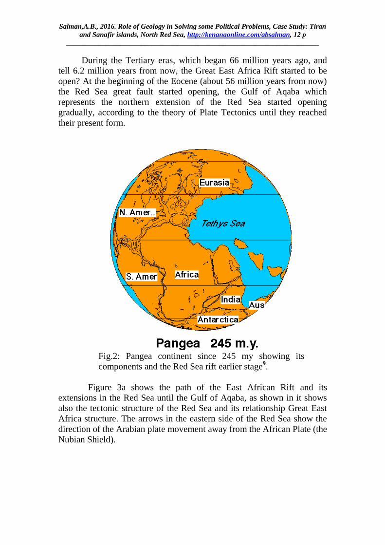
About 245 million years from now, since the Earth was a single
continent nominated Pangea, derived from the integration of two Greek
words mean "all of Mother Earth ". At 2013 geology scientists prepared a
new map for Pangea which is sharper and clearer than the previous maps.
Saudi Arabia was in Pangea stuck in Egypt and Sudan, Iran, Qatar, and
Canada, an hour away by plane from Algeria. While Australia and India
neighbors for the southern pole, and Afghanistan had marine coast, Brazil
was not existed (9, 10, 11 and 12)
.
Salman,A.B., 2016. Role of Geology in Solving some Political Problems, Case Study: Tiran
and Sanafir islands, North Red Sea, http://kenanaonline.com/absalman, 12 p
_______________________________________________________________________
During the Tertiary eras, which began 66 million years ago, and
tell 6.2 million years from now, the Great East Africa Rift started to be
open? At the beginning of the Eocene (about 56 million years from now)
the Red Sea great fault started opening, the Gulf of Aqaba which
represents the northern extension of the Red Sea started opening
gradually, according to the theory of Plate Tectonics until they reached
their present form.
Fig.2: Pangea continent since 245 my showing its main
components and the Red Sea rift earlier stage9.
Figure 3a shows the path of the East African Rift and its
extensions in the Red Sea until the Gulf of Aqaba, as shown in it shows
also the tectonic structure of the Red Sea and its relationship Great East
Africa structure. The arrows in the eastern side of the Red Sea show the
direction of the Arabian plate movement away from the African Plate (the
Nubian Shield).

Salman,A.B., 2016. Role of Geology in Solving some Political Problems, Case Study: Tiran
and Sanafir islands, North Red Sea, http://kenanaonline.com/absalman, 12 p
_______________________________________________________________________
Fig.3a: Tectonic features of the greater Red Sea rift system including the East Africa
Rift, Red Sea and Gulf of Aqaba development according to the Plate Tectonic Theory
)William Bosworth, ,2015)
Figure 3b represents a tectonic map of the area of the Red Sea and the
tectonic plates around the Red Sea to the Zagros tectonic belt, which
stretches from eastern Iran to eastern Anatolia. And it appears in this
figure also that the Red Sea is expanding at a rate of 16 millimeters per
year, according to the theory of plate tectonics. However, Spreading is
asymmetric (Enrico Bonatti et al., 2015) faster in the northern (Arabia)
side (11–13 mm/a) than in the southern (Somalia) side (8 mm/a).

Salman,A.B., 2016. Role of Geology in Solving some Political Problems, Case Study: Tiran
and Sanafir islands, North Red Sea, http://kenanaonline.com/absalman, 12 p
_______________________________________________________________________
Fig.3b: Main tectonic features of the Arabian Peninsula and surrounding areas,
showing the rate of spreading of Red Sea and Arabian Plate according to the Plate
Tectonic Theory ) Nageeb, et al., 2015) Main tectonic features of the Arabian
Peninsula and surrounding areas (modified after Stern and Johnson 2010)
Figure 4 is representing the current shape of the Red Sea and
the location of the Arabian plate and the African plate (Nubian Shield)
and the location of both Egypt and Saudi Arabia.
The Red sea is a part of the Great East Africa Rift; the Red Sea
covers an area of approximately 438,000 km2. Its length is about 2,250
km, and the widest point is 355 km., the maximum depth is 2,211 meters,
with an average depth of 490 meters13
The Gulf of Aqaba is located to the east of the Sinai Peninsula, and
to the west of the Arabian Peninsula, the length of the Gulf of Aqaba
from the south at Strait of Tiran to Wadi Araba at the north is 160
km.with a 24 km. width. The deepest point in the Gulf of Aqaba is 1,850
meters below sea level. The Gulf of Suez from the far south to the
entrance of the Suez Canal to the north is 175 miles and with a maximum
depth of 60 meters or 18 feet. A comparison of the depth of the Gulf of
Aqaba (maximum depth of 1850 meters)14
with the depth of the Gulf of
Suez (60 meters), the Gulf of Suez is very shallow relative the Gulf of

Salman,A.B., 2016. Role of Geology in Solving some Political Problems, Case Study: Tiran
and Sanafir islands, North Red Sea, http://kenanaonline.com/absalman, 12 p
_______________________________________________________________________
Aqaba which is more closely related in its tectonic origin to the tectonic
evolution of the Red Sea.
Arabian PLate
Africa Plate
Saudia ArabiaEgypt
Sudan
Yeman
Fig.4: Space map for the Red Sea region at its current state showing Egypt, Saudi
Arabia, and other countries
Analysis of Satellite Images
I have found that it is important to use space images to help in
solving this debate as the satellite images are covering a large area, the
careful analysis of these images can help in through light on the facts
which helps in delineating the boundaries, nature of distribution,
characteristics and the relation of Tiran and Sanafir Islands to the
surrounding land.

Salman,A.B., 2016. Role of Geology in Solving some Political Problems, Case Study: Tiran
and Sanafir islands, North Red Sea, http://kenanaonline.com/absalman, 12 p
_______________________________________________________________________
Saudi ArabiaEgyptSinai
Red SEa
Abdel Aty Salman,2016
Fig.5: Space image for the northern part of the Red Sea which includes Tiran and
Sanafir Islands, Also it is clear in the image the direct connection with the Saudi
Arabia Land
Figure 5 and Figure 6 represent almost one satellite image for the
northern area of the Red Sea and south of the Gulf of Aqaba, which
includes Tiran and Sanafir Islands and other islands. When I review
carefully the first image (Figure 5), I found that Tiran Island tied
geographically with the contenetal shelf of Saudi Arabia. The direct
contact with Arabia land appears has been split and changed during
tectonics and geological changes that have affected the region through the
evolutions of the Red Sea and the Gulf Aqaba associated geology with
the great East Africa Rift tectonic, which occurred millions of years ago.
If we look at the rest of the islands near the Saudi shore, it is noticed that
most of these islands show limited parts above the Red Sea water and the
rest of the islands are extended underwater and connected directly to
Saudi Arabia land (Figure 6).This confirms the subordination of these
islands including Tiran and Sanafir to Saudi Arabia land. This zone is
delineated (S) and well defined in figure 6.
The topographic map of both Egypt and Saudi Arabia and the Red
Sea Bathymetric map are analyzed (Fig. 7). If we look at the bathymetric
map of the Red Sea region, note that the light zone in the eastern part of
the Red Sea is closely linked to the Arabia Land. The head of the white
arrow points to the islands of Tiran and Sanafir site in the same domain as
the territory of Saudi Arabia (Figure 7). It is clear from this map that the
islands are tied to the Saudi Arabia land.

Salman,A.B., 2016. Role of Geology in Solving some Political Problems, Case Study: Tiran
and Sanafir islands, North Red Sea, http://kenanaonline.com/absalman, 12 p
_______________________________________________________________________
Saudi ArabiaEgyptSinai
Red SEa
Abdel Aty Salman,2016
S
Fig.6: Space image for north Red Sea showing many islands including Tiran and
Sanafir and their genetic relation to Saudi Arabia Land (S)
Saudi Arabia
Egypt
Sinai
Fig7: Topography and bathymetric map. Bathymetric contours are at 500 m interval, (Axel
Ehrhardt and Christian Hübscher, 2015) for parts of Egypt, Saudi Arabia and Red Sea,
the white arrow pointed to Tiran and Sanafir Islands, (Najeeb et.al,2015).

Salman,A.B., 2016. Role of Geology in Solving some Political Problems, Case Study: Tiran
and Sanafir islands, North Red Sea, http://kenanaonline.com/absalman, 12 p
_______________________________________________________________________
Saudi ArabiaEgypt
Red Sea
Fig.8: Close up Bathymetric map (from satellite altimetry; Sandwell and Smith 1997)
for the northern part of the Red Sea, the arrow pointed to Tiran and Sanafir Islands
which are located at the continental shelf of Saudi Arabia land
Note in Figure 8, which represents the topographic map and
bathymetric portion of a part of Saudi Arabia land, the Red Sea, the Gulf
of Aqaba and the Gulf of Suez, is a strong support to the reached
conclusion up to uncertainty in the figures No. 7 and No. 8 to that the
Tiran and Sanafir Islands are connected to the continental shelf of Saudi
Arabia, and this proves that Tiran and Sanafir Islands are Saudi Arabia
land.
Conclusion
It is concluded from this study which based on the geological and
structural phenomena, the applications of space imagery in the regional
studies that Tiran and Sanafir islands are originally Saudi Arabia land.
This is shown clearly, especially in the satellite images, topographic and
bathymetric maps of the Red Sea region.
The management of Egypt for these islands was an Egyptian-
Saudi agreement to serve the political and strategic objectives of the two
countries, so the remit to Egypt and Saudi Arabia on 9 April 2016 of the

Salman,A.B., 2016. Role of Geology in Solving some Political Problems, Case Study: Tiran
and Sanafir islands, North Red Sea, http://kenanaonline.com/absalman, 12 p
_______________________________________________________________________
agreement on the Saudi ownership of these islands is a sound and
supported by the scientific point of view shown in this paper.
Moreover, there are a lot of official documents (Presidential
Decree No. 27 of 1990 on the demarcation of maritime borders files, the
talks between the two brotherly countries in this regard are supporting the
scientific geologic opinion that confirms that Tiran and Sanafir islands
are Saudi Arabia land.
At the end I would like to insure what is clearly explained that no
difference between Egypt and Saudi Arabia, they have the same interests
and the two countries represent the heart of the Arab nation and represent
the backbone, and that all the attempts of the enemies of the homeland are
doomed to failure.
References Axel Ehrhardt and Christian Hübscher, 2015: The Northern Red Sea in Transition
from Rifting to Drifting-Lessons Learned from Ocean Deeps
Enrico Bonatti, Anna Cipriani, and Luca Lupi,2015: The Red Sea: Birth of an Ocean:
Springer Earth System Sciences, DOI 10.1007/978-3-662-45201-1_2, 17 p.
Najeeb M.A. Rasul, Ian C.F. Stewart, and Zohair A. Nawab, 2015: Introduction to
the Red Sea: Its Origin, Structure, and Environment, Springer Earth System
Sciences, 10-37pp. In The Red Sea: Formation, Morphology, Oceanography
and Environment of a Young Ocean Basin, 727 p.
Sandwell DT, Smith WHF (1997) Marine gravity anomaly from geosat and ERS-1
altimetry. J Geophys Res 102(B5):10039–10054
Stern RJ, Johnson PR (2010) Continental lithosphere of the Arabian Plate: a geologic,
petrologic, and geophysical synthesis. Earth Sci Rev 101:29–67
William Bosworth, 2015: Geological Evolution of the Red Sea: Historical
Background, Review, and Synthesis: In The Red Sea: The Formation,
Morphology, Oceanography and Environment of a Young Ocean Basin:
Springer Earth System Sciences, 2015, pp 54-87
1- http://www.elwatannews.com/news/details/1089011)
2-http://www.alaan.cc/pagedetails.asp?nid=246117&cid=46#.V4wZ9mNS0dA
3- http://www.elwatannews.com/news/details/1088948
4-http://www.elwatannews.com/news/details/1088861
5-http://www.elwatannews.com/news/details/1088939

Salman,A.B., 2016. Role of Geology in Solving some Political Problems, Case Study: Tiran
and Sanafir islands, North Red Sea, http://kenanaonline.com/absalman, 12 p
_______________________________________________________________________
6- http://www.daralhilal.com.eg/show ( تحقيق صحفي مع الدكتور : 2016مجلة المصور المصرية
-9، صفحات 2016 إبريل 27 بتاريخ 4777السيد الحسيني رئيس الجمعية الجغرافية المصرية، العدد رقم
11.)
7- http://www.daralhilal.com.eg/show ( تحقيق صحفي مع الدكتور : 2016مجلة المصور المصرية
(.13-12، صفحات 2016 إبريل 27 بتاريخ 4777فتحي مصيلحي أستاذ الجغرافيا بجامعة المنوفية، العدد رقم
8 -http://www.elwatannews.com/news/details/1089116
9.https://maktoob.images.search.yahoo.com/search/images;_ylt=A2KLj.vY_nZXTic
AvOPVlQx.;_ylu=X3oDMTBsZ29xY3ZzBHNlYwNzZWFyY2gEc2xrA2J1dH
Rvbg-
;_ylc=X1MDMjExNDc1NDAwNQRfcgMyBGJjawNjYXFydGt0Yms0amhqJT
I2YiUzRDQlMjZkJTNETHdGR2VIeHBZRkpKMy53OTJMaFdENE1aRjZvLS
UyNnMlM0RybCUyNmklM0QxcFdGa0ZtdVphQTgzNE5qcml0SQRmcgN5Z
nAtdC03MjEEZ3ByaWQDBG10ZXN0aWQDbnVsbARuX3N1Z2cDMARvcm
lnaW4DbWFrdG9vYi5pbWFnZXMuc2VhcmNoLnlhaG9vLmNvbQRwb3MD
MARwcXN0cgMEcHFzdHJsAwRxc3RybAMxMQRxdWVyeQNwYW5nZWE
tbWFwcwR0X3N0bXADMTQ2NzQxNjMwNgR2dGVzdGlkA251bGw-
?pvid=_GFENzcyLjPFa32nV0JOMwWJMjE3LgAAAAB6IA1G&p=pangea-
maps&fr=yfp-t-721&fr2=sb-top-maktoob.images.search.yahoo.com&ei=UTF-
8&n=60&x=wrt&y=%D8%A8%D8%AD%D8%AB#id=3&iurl=http%3A%2F
%2Featrio.net%2Fwp-content%2Fuploads%2F2013%2F01%2F2.-
pangea_245.gif&action=click
10-http://www.alarabiya.net/ar/saudi-
today/2016/04/13/%D8%AD%D9%8A%D9%86-
%D9%83%D8%A7%D9%86%D8%AA-%D9%85%D8%B5%D8%B1-
%D9%85%D9%84%D8%AA%D8%B5%D9%82%D8%A9-
%D8%A8%D8%A7%D9%84%D8%B3%D8%B9%D9%88%D8%AF%D9%8
A%D8%A9-%D8%A8%D9%84%D8%A7-
%D8%AE%D9%84%D9%8A%D8%AC-
%D9%88%D8%AA%D9%8A%D8%B1%D8%A7%D9%86-
%D9%88%D8%B5%D9%86%D8%A7%D9%81%D9%8A%D8%B1.html
11 -http://eatrio.net/pangea-maps
12.https://www.google.com.eg/search?q=pangea+map&tbm=isch&imgil=PEHyhcA7
GC0X0M%253A%253BJEfVqDq_FIDe0M%253Bhttps%25253A%25252F%2
5252Fwww.reddit.com%25252Fr%25252FMapPorn%25252Fcomments%2525
2F1ezjos%25252Fmap_of_pangea_with_current_international_borders%25252
F&source=iu&pf=m&fir=PEHyhcA7GC0X0M%253A%252CJEfVqDq_FIDe0
M%252C_&usg=__W58Qn_zpqRvdesDO79edZgbOFnU%3D&biw=1024&bih
=677&ved=0ahUKEwj6h4ezjMrMAhXJfRoKHZGiBT8QyjcINw&ei=rv0uV_r
4Jcn7aZHFlvgD#imgrc=PEHyhcA7GC0X0M%3A
13.(https://ar.wikipedia.org/wiki/%D8%A7%D9%84%D8%A8%D8%AD%D8%B1_
%D8%A7%D9%84 % D8% A3% D8% AD% D9% 85% D8% B1)
14.https://ar.wikipedia.org/wiki/%D8%AE%D9%84%D9%8A%D8%AC_%D8%A7
%D9%84%D8%B9%D9%82%D8%A8%D8%A9