rod machado's private pilot ehandbook - los alamos … · 2015-02-23 · magnetic compass...
TRANSCRIPT

Have you ever wondered what all those small trucks at airports—the ones with the flashing yellow lights—do? Ithought I knew. For a long time I was convinced they brought sandwiches to the student pilots who became lost onthe airfield. After all, even students need sustenance while attempting to navigate from taxiway to runway to parkingspot.
An airport’s signage and markings are one situationwhere consistency makes for confidence, and theFAA lends a helping airfoil by specifying ingreat detail how airport runways, taxiways,and other aircraft movement areas are tobe laid out, marked, and lit. While it’s notquite true that if you’ve seen one airportyou’ve seen ‘em all, there is a method tothe apparent madness. As with a BuckRogers secret decoder ring, you justhave to decipher what’s in front of you.
Let’s take a look at the airport inFigure 1. The airport is graced with tworunways capable of handling takeoffs andlandings in four different directions (twodirections on each of two runways, for thegeographically and mathematically challenged).
If we assume that the airport in Figure 1 is anairport with an air traffic control tower, and since con-trollers get so upset when you land on a different runwayfrom the one they had in mind, it’s helpful to know that run-ways come with numbers, which are always large andpainted in white. Runway numbers and their markingshelp distinguish them from the airport’s nonlanding sur-faces. The runways in Figure 1 are numbered 8, 26, 21 and 3.
You think they just make those numbers up, don’t you? Ihad a student who thought runway numbers were based onsome sort of speed limit or seismograph record. Uh huh.There’s a method to the madness. The numbers represent thefirst two digits of the runway’s actual three digit magnetic direction.
True north pole
Magneticnorth pole
THE AIRPORT LAYOUT
D
C ARP
26
260
3
30
880
21
210
Cansomeoneget me a
sandwich?
Runways numbers are angleswith respect to the magneticnorth pole (where the compasspoints) and not the true northpole (the earth's axis).
Fig. 1
Page G1
Chapter Seven
Airport OperationsNo Doctor Needed
Licensed exclusively for DeWayne Britton ([email protected]) Transaction: #0002858938

Rod Machado’s Private Pilot Handbook
Essentially, a runway’s numbers areits direction, rounded off to the near-est 10 degrees. A runway oriented at211 degrees becomes Runway 21(pronounced runway two one whenspeaking to controllers and other avi-ation-savvy people). A runway point-ed 076 degrees becomes Runwayeight (rounding up).
There are two sides to almostevery issue, and two ends to everyrunway. With rare exceptions (usual-ly having to do with terrain), you cantheoretically land or take off fromeither end. This means each piece ofrunway pavement has numbers oneach end. Those who are way aheadof me will realize these numbers,when expressed as three digit figures,differ by a value of 180. Makes sense,since the two directions are 180degrees apart.
All runway angles are oriented tothe magnetic north pole, where themagnetic compass points, and not thetrue north pole, where Santa Claus (apilot) lives. When your airplane is
pointed down any runway, the air-plane’s magnetic compass shouldapproximately indicate that run-way’s direction. Figure 2 showswhat the compass and the direction-al gyro might look like when alignedwith Runway 26. In Chapter 14you’ll learn more about magneticand true direction. For now, justremember this when operating at anairport: wind direction, landingdirection and any headings ATCasks you to fly are all based on mag-netic direction.
Runway LightingPainted white runway markings
are easy to identify during the day,but what about at night? Don’t lookfor Day-Glo orange any time soon.The airport has an image to main-tain. Besides, the airport wouldbecome a magnet for rock stars andflower-painted VW buses.
The answer at night is light. As thesun sinks slowly into the west, theairport often lights up like one ofthose Disneyland Main Streetparades. All kinds and colors oflights, some flashing and somesteady, are there to amuse and con-fuse you. Think of it as color-codedhints and you’ll be on the right track.
White lights, shown in Figure 3,border both sides of the runway.Called runway edge lighting, theselights are spaced 200 feet apart.Controllers turn these lights onbetween sunset and sunrise or whenthe visibility is poor.
The beginning of the runway isannounced with green thresholdlights, while the far end of the run-way is lit in red. It’s an appropriatecolor to indicate you are running out
of usable landing surface (only trac-tors, bulldozers, and dune buggiesbeyond those red lights, please!).These lights actually lead a dual life.On one side they’re green; on theother, red. Think about it for a sec-ond. The beginning (or threshold) ofone runway is the end of another.The lights on the threshold ofRunway 21 are also at the terminusof Runway 3.
What I’ve described so far is thebasics of runway lighting, which youwill encounter at almost any airportthat supports night operations. It canand does get a lot fancier. Whilegathering aviation experience, you’resure to come across airports withsophisticated lighting. In fact, air-ports with precision instrument run-ways can have such detailed lightingthat it’s possible to mistake it for aprairie fire. Some runways have
G2
Speaking of RunwaysThere are three ways to say anything. The right way, the wrong way, and the runway.
Let’s learn the runway. In order to sound like a pilot, you need to know that real pilots like runways so much they always sayeach digit in a runway’s name separately. Thus Runway 26 become Runway Two Six when spoken. Runway 3 is Runway Three.
There’s actually a reason the numbers are spoken in this manner. English is the international language of aviation. Every towerhandling international traffic must, by treaty, have at least one English-speaking controller on duty at all times. In order to avertinternational chaos, as well as crashes, it has been agreed that a certain controlled English vocabulary will be what everyonespeaking Aviation English uses. Part of the deal is that instead of having to learn all the numbers from 0 to 360 in English, only thenumbers 0-9 will be used in referencing runways and headings. That’s how Runway 21 comes to be Runway Two One, and whyheadings are given as three single digits, rather than one hundred seventy five.
26
W 24.
33
N3
6E12
15
S21
24 W30
Both the heading indicator and themagnetic compass show the mag-netic direction when pointed downthe center of Runway 26.
THE RUNWAY'SMAGNETIC DIRECTION
Go Ahead,make my day!
3
21
BASIC RUNWAYLIGHTING
Runway Edge LightingWhite lights
Green on this sideindicates the
runway threshold.
Red on this sideindicates the
end of the runway.
Runway EndLighting
Fig. 2
Fig. 3
Licensed exclusively for DeWayne Britton ([email protected]) Transaction: #0002858938

Chapter 7 - Airport Operations: No Doctor Needed
centerline lighting, with embedded lights running theentire length of the runway centerline. Some have bril-liant sequenced flashing strobe lights leading to the run-way threshold. Others have touchdown zone lighting thatlooks like a gigantic Christmas tree was squished into thefirst 3,000 feet of the runway. One of my students said itwas so pretty he wasn’t sure he should land on it. Youcan! See the Aeronautical Information Manual for addi-tional information on these lighting systems.
Taxiway MarkingsThere are few things as pitiful as a pilot on the ground,
even in the daytime. The King or Queen of the Airwayscan easily become the Lost Platoon when the gear hitsthe ground. It is a common misconception that pilots areendowed with some superior ability to find their wayaround airports. This is demonstrably untrue. Most pilotscan find a vending machine blindfolded, but many of ushave trouble getting from the runway to the tiedown spotat an unfamiliar airport. Pilots and their airplanes havebeen extracted from some very unusual places (like thetime a fellow pilot accidentally taxied into a secret mili-tary hangar at a combo civil/military airport. It obviouslywasn’t much of a secret, since they were in the habit ofleaving their doors open.)Figure 4 shows a drawing of taxiway markings from an
airport chart. Taxiway D (Delta) parallels the north sideof Runway 8L-26R and Taxiway C (Charlie) parallels thenorthwest side of Runway 3-21. There are several inter-secting taxiways with individual phonetic names.At larger airports, and even at smaller ones when
ground traffic or construction exists, it’s not unusual for
a tower controller to offer a complex taxi clearance.Here’s such a clearance: “November 2132 Bravo, taxi toRunway 21 via Charlie, southwest to Delta, turn left;cross Runway 21, left on Golf, hold short of Runway 21at Golf.” Students normally respond to this clearancewith a, “Huh?” If you had an airport chart out youcould easily navigate from position A1 to position A2 inFigure 4 without getting lost. Figure 5 is an airborneview of the airport in Figure 4. Many varieties of air-port charts (similar to the one in Figure 4) are avail-able to make airport ground navigation easier.
G3
Bravo, CharlieRemember our international
English lesson a bit ago? Here’sPart 2.
Pilotspeak includes a phoneticalphabet. Some letters and numberscan sound a lot like others, especial-ly when spoken over an aviationradio by a non-native speaker ofEnglish. The phonetic alphabet isthere to save the day. It permitsunambiguous communication. It’salso what verbally distinguishespilots from those controlling othertypes of moving vehicles.
Every letter in the alphabet has aphonetic pronunciation. By speakingthe word, instead of the letter, pilotsmake themselves heard and under-stood under some pretty non-opti-mal conditions. It’s easy to mistakeB for C, or E, but there’s little chanceof mixing up Bravo, Charlie, andEcho.
After a surprisingly short time, youwill speak phonetic like a native.
A AlphaB BravoC CharlieD DeltaE EchoF FoxtrotG GolfH HotelI IndiaJ JulietK KiloL LimaM MikeN NovemberO OscarP Papa Q Quebec R RomeoS SierraT TangoU UniformV VictorW WhiskeyX XrayY YankeeZ Zulu
1 WUN2 TOO3 TREE4 FOW-er5 FIFE6 SIX7 SEV-en8 AIT9 NIN-er0 ZEE-RO
Fig. 4
Fig. 5
Chino airport in Figure 4 as seen from the air.
Runway 21
Runway 26R
Runway 26LRunway 3
Runway 8R and 8L
Licensed exclusively for DeWayne Britton ([email protected]) Transaction: #0002858938
Rod Machado’s Private Pilot Handbook
Taxiways are identified by a con-tinuous yellow line with parallel dou-ble yellow lines on the outer edges ofthe taxi surface (Figure 6). Taxiwaynames are shown by small signs(Figure 6). Placed along the side ofthe taxiway, these signs consist ofyellow lettering on a black back-ground. Signs containing black let-tering on a yellow background indi-cate the position of intersecting taxi-ways. Arrows indicate the relativedirection of these intersecting taxi-ways. At night, many (not necessarilyall) taxiways have blue omnidirec-tional sideline lighting (Figure 7). Atsome airports, taxiways may haveembedded green centerline lighting.
One time I caught an empatheticand sensitive student of mine weav-ing between the embedded greentaxiway lights. I thought she washaving a Nyquil flashback until Ifound out that she was afraid of dam-aging either the lights or the tires.You won’t hurt the lights or the tires,but feel free (if you wish) to keep thenose wheel a f e w i n c h e s t o t h eside of the embedded lighting.
As a pilot you must be able toidentify the point where the taxiwayends and the runway begins. Thistransition is identified by four yellowlines—two solid and two dashed—crossing perpendicular to the taxi-way and running parallel to the run-way (Figure 8). These markings areknown as runway hold markings.
If the two solid lines are on your side,then, at a tower-controlled airport, aclearance is required to enter therunway. If the double broken dashedlines are on your side, then youshould cross those lines to clear therunway and enter the taxiway. (Fromnow on we’ll assume that a controlledairport is one having an operatingcontrol tower.)
Assuming you have just landed andare taxiing off the runway, youshould taxi across the double brokendashed lines and clear the runway.The FAA assumes that your airplanehasn’t cleared the runway until theentire airplane (down to the lastrivet) is on the other side of thosebroken double yellow lines. The rea-
son for this is to prevent the tails oflong airplanes (like a stretched DC-8)from poking out onto the runway.This could make landing quite chal-lenging for another pilot and possiblygive him or her an extra EKG blip.
At airports without an operatingcontrol tower (meaning the airporthas no control tower or the tower hasshut down for the night), entering anactive runway is done at the discre-tion of the pilot. (From now on, anairport having no control tower orone at which the tower is not in oper-ation will be referred to as an uncon-trolled airport.) In this instance, youshould hold short of the runway,behind the solid taxiway-hold lines.Taxi onto the runway only when it’s
G4
RUNWAY MARKINGS
30-12 30-12
White numbers on red indicate mandatory hold points for alltower controlled airports. They indicate that you're about totaxi onto a runway (possibly an active one!).
I know Ican cross thoselines. I'm just not
into it rightnow!
C C
If the broken double-yellowlines are on your side, youmay cross them and enterthe taxiway thus movingclear of the runway area.
Runway-hold markingsconsisting of four yellowlines: two are solid &two are dashed. At acontrolled airport, aclearance is required tocross these lines whenthe double-solid yellowlines are on your side.
Anconsists of broken
yellow lines bordering ataxiway line. They indicatethat you are approachinga runway hold line.
enhanced taxiway cen-terline
Yellow taxiwaycenter line
BB
AB
AB
Taxi
way
Bra
voDouble yellow
taxiway edge lineBlack letters on
yellow show inter-secting taxiways.
TAXIWAY MARKINGSAll taxiway markings are in yellow.
Yellowletters
on blackidentifies
the taxiwayyou're on.
A A
Alpha
Green centerline lighting identifies thecenter of the taxiway at some airports.
TAXIWAY LIGHTING
Taxiways mayhave blue edge
lighting.
BA B AFig. 6
Fig. 7
Fig. 8
A Tern for the Worst!
The copilot was flyingand I was working theradios. Approach Con-trol cleared us for theapproach. At 1,500’we had a bird strike.
Evidently I did not change over totower frequency, since the birddistracted me. The first time werecognized that we had landedwithout a clearance was whenGround Control said, “The towersays you’re cleared to land.” Ascaptain, I should have made surewe were cleared to land.
ASRS Report
?
Licensed exclusively for DeWayne Britton ([email protected]) Transaction: #0002858938

Chapter 7 - Airport Operations: No Doctor Needed
clear of traffic and no airplanes areon a short final (getting ready toland). In other words “look carefullybefore taxiing onto the runway.” Thelast thing you want is for someone todo a touch and go on you. And mak-ing another pilot go around won’twin you too many friends at the air-port. It’s also a good idea to broad-cast your intentions on somethingknown as the Common TrafficAdvisory Frequency (CTAF) when notower is in operation. This lets otherpilots in the traffic pattern knowwhat you’re doing. More on thislater.
Another way to identify where therunway begins is the presence of awhite-on-red sign next to the dashedand solid double yellow lines (Figure8). These information billboards arecalled runway holding signs, thoughthey don’t actually hold anything.They exist to inform you when you’reabout to enter an active runway.They also indicate the runway direc-tion. In Figure 8, 30-12 indicatesRunway 30 is to the left and Runway12 is to the right (in other words, goto the left to find the beginning ofRunway 30, etc.). At controlled air-ports, these signs are your cue tohold your position unless a clearancehas been given to enter or cross therunway. Figure 9 shows a single run-way holding sign indicating that thetaxiway intersects the beginning ofthe takeoff runway.
At uncontrolled airports, the run-way hold signs indicate that you canproceed across or onto the runwaywhen you’ve assured yourself no traf-fic conflict exists (an airplane prepar-ing to take off or land is most definite-ly a conflict). At a tower-controlled air-port, these signs are coupled with thedouble solid and dashed taxiway-holdlines, providing ample warning thatyou’re crossing into the action area.
Holding position markings for ataxiway, consisting of a single dashedyellow line as shown in Figure 9, areinstalled at some airport. When atower controller instructs you to holdshort of a taxiway intersection, youshould stop so that no part of the air-plane crosses the dashed yellow line.
Some airports may have taxiwaysthat interfere with the runway safetyarea, as shown in Figure 9. TaxiwayDelta is located directly behind thebeginning of Runway 15. Airplanesl a n d i n g o n R u n w a y 1 5 c o u l dapproach low enough to present aproblem to both the approaching andtaxiing airplane. This is more likelyto be a problem for big airplanes, butthe rules take into account the worst-case scenario. Holding position signsfor this peripheral runway are shownby white on red lettering. The term15APCH next to the solid double yel-low lines indicates a mandatory holdpoint at tower controlled airports(this means any aircraft on the fol-lowing taxiway might affect aircrafton approach to Runway 15). On theopposite side of the runway, on taxi-
way Delta, on the back side of therunway hold sign, is a runway safetyarea sign (normally only found atonly tower controlled airports). Thisconsists of the same marking shownon the taxiway (double solid anddashed lines). These signs can beused as a guide in deciding when toreport back to a controller that youare clear of the runway. Remember,at uncontrolled airports pilots mustdecide for themselves whether toenter or cross a runway.
It’s difficult, but not impossible,for pilots to accidentally taxi onto anactive runway at a tower controlledairport. One pilot at a very busy air-port taxied right into the middle of anactive runway and just sat there(probably waiting for one of those yel-low trucks to bring him a sandwich).Completely confused about thetower’s directions and unwilling toask for clarification, he stopped hisairplane while a jet was on finalapproach. The tower controller said,“32 Bravo, do you know where youare?” The pilot replied, “BurbankAirport?” The controller said, “Yes,that’s good, but do you see that bigBoeing 707 out there on finalapproach headed directly for you?”The pilot replied, “Yes.” “Do you wanthim to do a touch and go on you?” Thepilot replied, “No.” The controllersaid, “Then you’d better get off hisrunway.” The pilot, not wanting to getbounced on by a Boeing 707, immedi-ately exited the runway.
G5
Thum
p!
15A15APCHD 15APCH D 15 A
On reverse sideof this sign
This is a holding position sign for the runway safety area. An ATCclearance is required to cross the solid yellow hold lines whenyou're at an airport with an operating control tower.
Protection of the runway safety area prevents colli-sions between taxiing and landing airplanes.
You should cross the broken double-yellow lines when they're on your sideso as to clear the runway safety area.
This is a holdingposition sign forRunway 15.
Some airports have holding po-sition markings for taxiways andtaxiway intersections consistingof a single yellow dashed line ex-
ADDITIONAL RUNWAY MARKINGS
Ouch!OK, where's theplane that did
this?
Fig. 9
Licensed exclusively for DeWayne Britton ([email protected]) Transaction: #0002858938

Rod Machado’s Private Pilot Handbook
Additional Runway MarkingsJust because there is concrete in
the shape of a runway doesn’t meanthat it can be used for landing. Somerunways have yellow chevrons paint-ed on them (Figure 10, position A).This signals that the surface isunsuitable for either taxiing, takingoff, or landing. It’s basically an air-plane no man’s land. Don’t use anyportion of this area. It might be offlimits because the surface won’t sup-port the weight of an airplane evenfor taxiing, let alone landing, orbecause the surface is otherwiseunsuitable. Planes that venture ontochevrons can find themselves up totheir axles in asphalt, trapped like agigantic fly on a No-Pest strip.
White arrows pointing in onedirection form what is called a dis-placed threshold (Figure 10, positionB). This is a runway area that is notto be used for landing, but on whichyou can taxi, take off, or roll out afterlanding. Displaced thresholds oftenexist as part of a noise abatementeffort. By forcing you to land farther
down the runway this causes you tomaintain a higher altitude on theapproach than you would if landingat the very beginning of the runway.A displaced threshold can exist forother reasons, such as the presenceof a surface that will support theweight of an airplane, but not theimpact of an airplane landing.(There’s a big difference. I know thissince one of my instructors used tocall out Richter scale values followingmy touchdowns.)
I won’t mention any names, but onoccasion professional airline pilotshave been known to land at thewrong airport, with a full load of pas-sengers. Nothing like bringing yourown audience to a faux pas. Severalyears ago, a pilot did this at an eastcoast airport. He accidentally landedat a small training field with nothingbut itty-bitty Cessnas and Pipersfluttering around the pattern. As hetouched down and came to a stop, hiswheels punched holes in the thinrunway surface. He knew he was introuble when it took full power justto taxi. A few of the locals came out
and said, “Hey! Look what you did toour runway! You put divots in it.Geesh!” The only way they could getthe airplane out was to completelystrip it down to barebones metal, mak-ing it light enough to take off withoutfurther runway damage. The samecould not be said for the pilot’s career.(See Postflight Briefing #7-2 for moreinformation on airport lighting.)
Airport BeaconsAirports have rotating beacons to
make them easier to find at night.Civilian airports with runway lightshave a two-color rotating beacon thatalternately flashes green-white,green-white... Military airports, onthe other hand, have rotating bea-cons that alternately flash green-white-white, green-white-white (thetwo white lights flash very quickly).A lighted heliport has a rotating bea-con that flashes green-yellow-white. Imention the heliport lightingbecause if you try to land at a heli-port I can guarantee the runway willbe extremely short.
Figure 11 shows Taft Kern Countyairport with a small star (point A)near the airport symbol. This starindicates the presence of a rotatingbeacon at the airport. Elk Hills air-port (point B) doesn’t have a star;therefore, no rotating beacon is pre-sent (and the airport doesn’t haverunway lights either). Figure 12shows the actual rotating beaconfound at many airports.
G6
RUNWAY SURFACE MARKINGS
31
6
24
13
Yellow chevronsindicate that this
portion of the runwayis unusable.
A displaced threshold is indi-cated by white arrows. You canuse this area for taxiing and tak-ing off but not for landing.
A relocated thresholdis identified by taxiway
markings. You mustland beyond the white
threshold bar.
Bob?
A
B
Large yellow crosses indicatethat this runway is closed.
Fig. 11
The smallstar(positionA) at TaftKernCountyindicatesthe air-port has arotatingbeacon.Elk Hillsairport(positionB), doesnot havea rotatingbeacon.
A
B
Fig. 10
Licensed exclusively for DeWayne Britton ([email protected]) Transaction: #0002858938

Chapter 7 - Airport Operations: No Doctor Needed
Rotating beacons (some flashinstead of rotate) are normally onbetween sunset and sunrise. If an air-port’s beacon is up and running dur-ing daylight hours, it means that theairport is below basic VFR conditions(ceiling less than 1000 feet AGLand/or visibility less than 3 miles). Ofcourse, if the visibility is that bad youprobably can’t see the beacon untilyou’ve violated all kinds of airspace,but they turn it on anyway. In suchconditions, a special VFR clearance isrequired if Class B, C, D, or E airspaceexists at the airport (see Chapter 9 formore info on special VFR operations).
The Traffic PatternIf you’ve ever seen moths dancing
around a light bulb, you’ll under-stand why airports have traffic pat-terns. If it weren’t for some organiza-tion, airplanes might fly freneticallyover, above and to the side of run-ways, vying for a position to land.Fortunately, it’s not like that. Wehave traffic patterns that impose arespectable and safe order on theflow of traffic at airports. These pat-
terns are usually rectangular inshape with each portion having a spe-cific name, for easy identification(Figure 13).
All airports—controlled anduncontrolled—have traffic patterns.At controlled airports, air traffic con-trollers manage the flow of aircraft.This becomes especially importantwhen the airports are extremelybusy. While it’s obvious that airportssuch as Los Angeles, Chicago, andNew York need towers, there aremany general aviation airports thatalso have a very heavy volume oftraffic. At such airports, pilots simplyfly the established traffic patternwhile controllers verbally coax theminto an orderly sequence.
At airports with less activity, it’sdifficult to justify establishing an airtraffic control tower. At these non-tower airports, pilots typically fly theairport’s traffic pattern on their own.They are left to their own devices indeciding their landing direction andsequence among other aircraft in thepattern.
If the idea of a lot of pilots flyingaround near an airport withoutsomeone telling them what to do rais-es a few questions, then you have atleast a modicum of common sense.Believe it or not, things work outremarkably well because pilots arereasonably adept at following rules.Much of aviation depends on therebeing a high degree of predictability.Knowing what pattern another pilotis flying or is likely to fly is the keyto making the system work foreveryone.
That’s why the concept of the traf-fic pattern is so important. The trafficpattern represents a very standard-ized way for pilots to depart from orland at an airport. If everyone doeswhat they’re supposed to do in thetraffic pattern, then everybody’sactions become quite predictable.Once you know where you fit in thesequence of traffic, you will knowwhat is going on and when it is yourturn to take a particular action.
G7
Where Are We?It’s important to know which airports
have beacons, since this helps preventan accidental landing at the wrong air-port. I’m not proud of my mistakes, buteveryone makes them (the secret, ofcourse, is not to make the same onetwice, unless of course you’ve hadyour name changed). As a newly ratedprivate pilot, I took a friend toWatsonvil le (CA) airport late oneevening. It was a clear night except fora few patches of low stratus.Watsonville, located on the Pacificcoast, was visible many miles out. Ikept my eye on the airport beacon, flewover the airport, identified the appropri-ate traffic pattern and direction for land-ing, then landed.
We touched down, taxied off the run-way and pulled back the canopy of theAmerican Yankee TR-2. I looked at myfriend and said, “Hey Phil, when didWatsonville get all these army tanks?”Phil replied, “Rod, Watsonville (a civil-ian airport) doesn’t have any armytanks.” Then I said, “Well, maybe theguy pointing a gun at us can give ussome information.” I had accidentallylanded at an army base a few milessouth of Watsonville. I hadn’t evennoticed the double-peaked white lightsignifying a military airport.
Fortunately, the military tower hadshut down 30 minutes earlier. Theyoung military guard said, “What areyou guys doing here?” The only thing Icould say was, “Ahhhh, we were won-dering if you know how to get toWatsonville?” He said, “This ain’t nogas station so you fellows better leavenow.” Poof! We were gone. No sand-wich, either. David Copperfield couldn’thave gotten rid of our airplane so fast.A big mistake and certainly one Ilearned from. Rod
AF
G
B
CD
E
DeparturelegUpwind leg
(parallel & offset)
THE TRAFFIC PATTERN
N2132B
30 12
N2132B
N2132B
N2132B
N2132B
N2132BN2132B
Wind direction
Crosswind legDownwind leg
Base leg
Finalapproach
Decision Point(for turn to base leg)
Fig. 12
An Airport’s Rotating Beacon(some beacons are omnidirectional
capacitor-discharge devices that flash
instead of rotate)
Fig. 13
Licensed exclusively for DeWayne Britton ([email protected]) Transaction: #0002858938

Rod Machado’s Private Pilot Handbook
Let’s take a closer look at the air-port traffic pattern, and what youwill do once you’re in one.
Traffic Pattern ComponentsTraffic patterns are rectangular in
shape and consist of six segments:departure leg, crosswind leg, down-wind leg, base leg, final approachand upwind leg (Figure 13).
Airplane takeoffs are made intothe wind, and the takeoff flight pathis thus called the departure leg (pointA). After takeoff, you have two majorchoices—you can either depart theairport traffic area, or you canremain in the pattern, which meansyou will fly a prescribed path, comearound, and land on the runway youjust departed from. This is done bypilots who enjoy very short flights, aswell as by pilots who are practicinglandings. From time to time, wepilots remain in the traffic patternin order to polish our skills and mini-mize the explanations to passengersfor our occasional bad landings.
If you’re remaining in the pattern,a turn (generally a left turn) to thecrosswind leg (point B) will be madewhen the airplane is beyond thedeparture end of the runway andwithin 300 feet of the traffic patternaltitude. This portion of the pattern iscalled the crosswind leg because theflight path is perpendicular to therunway and generally crosswise to thewind direction (one time I asked a stu-dent what leg he was on in the trafficpattern. He replied, “I’m on my rightleg, but plan on using my left leg oncethe right one gets tired” (I, of course,immediately asked if anyone haddelivered him a sandwich lately).
As the airplane continues itsclimb, another 90 degree turn ismade. This places the airplane paral-lel to the runway and traveling oppo-site to the direction of landing. Thisis called the downwind leg (point C)because your direction is with thewind. Throughout the upwind, cross-wind and even a part of the down-wind leg, the airplane continues toclimb until reaching traffic pattern
altitude. This altitude varies from oneairport to the next because of terrain,obstruction and noise concerns. Expecttraffic pattern altitudes to range from600 to 1,500 feet above the airport ele-vation, typically averaging about 1,000feet AGL. The downwind leg is flownapproximately 1/2 to one mile out fromthe landing runway. This keeps youcomfortably close to the runway. Inthe event of an engine problem, youcan glide to a safe landing.
You continue downwind untilpassing a point abeam the beginningof the landing threshold of the run-way. Then it’s another 90 degreeturn and you’re on base leg (pointE). From here you make one more 90degree turn, onto final approach(point F). The upwind leg (point G)is flown parallel to the runway in thedirection of landing. It’s often usedduring go-arounds or overflights toavoid departing traffic.
Assuming traffic isn’t a factor, it’sconvenient and practical to start yourturn onto base leg when the landingthreshold appears 45° between thewing and the tail of your airplane. Inother words, as you look out the leftwindow (Figure 14, point D), thethreshold appears to be at a 45° angleto the left of the wing (or midwaybetween the wing and the tail). Thisprovides you with a symmetrical, rec-tangular-type pattern and gives youenough distance from the runway tomake a comfortable approach.
Aviation is one place where it isnot good to become a homeboy orhomegirl. Some student pilots fudgeby using familiar landmarks on theground to tell them when to make
G8
12
Decision point(for turning)
When the runway appears midway be-tween the wing and your tail, this is a goodtime to think about turning onto your base leg.
DN2132B
THE TRAFFIC PATTERN
AF
G
B
CD
E
DeparturelegUpwind leg
(parallel & offset)
THE TRAFFIC PATTERN
N2132B
30 12
N2132B
N2132B
N2132B
N2132B
N2132BN2132B
Wind direction
Crosswind legDownwind leg
Base leg
Finalapproach
Decision Point(for turn to base leg)
Left Wing PilotsTraffic patterns are, unless posted other-
wise, made with a series of left turns. This isreferred to as flying left traffic.
Given a choice, pilots generally favor leftturns because their visibility is better when theairplane is tilted toward the side they’re sittingon. This is another example of a way in whichflying is completely unlike driving. In a car, nomatter which way you turn, your visibility fromthe driver’s seat is pretty much the same. Anairplane, however, operates in three dimen-sions. All things being equal, a pilot wouldrather have things rolling his or her way whenit comes to turns.
Fig. 13 Repeat
Fig. 14
Licensed exclusively for DeWayne Britton ([email protected]) Transaction: #0002858938

Chapter 7 - Airport Operations: No Doctor Needed
their turns. This is bad because itleads to a lack of flexibility. If youneed the local Burger Boy restaurantto land, what will you do when you goto a new airport? There’s nothingmore pitiful than a pilot who canonly fly to and from his or her homeairport comfortably!
I’ve seen student pilots comeabsolutely unglued when they weren’tallowed to turn base at “their” land-mark. You will not always be able toturn base or final at an ideal time,and the ability to make adjustmentsis crucial. When traffic is heavy, youmay have to fly the downwind leg forsome distance past the airport beforeturning base leg. In fact, I was oncein a traffic pattern with 19 other air-planes. One pilot was so far down-wind that the controller called andasked, “45 Charlie, what time zoneare you in now?”
Base leg is a point of transition forlanding. It’s the place where impor-tant adjustments are made in the air-plane’s speed and landing configura-
tion. This is why, even when there islittle or no traffic, you should avoidturning base too early, as shown inFigure 15. Things happen mightyfast as you approach the runway. Youwant to give yourself enough time toadjust your airspeed, flaps, and glide-path. The descent for landing is nor-mally started on base leg and contin-ues throughout the final approach.
The final approach (sometimesjust called final) is a critical part ofthe landing sequence. Generally, asquare turn from base onto finalapproach is best (Figure 16). Thisprovides you with enough time toobserve your airplane’s descent pathand alignment with the runway. Youcan observe and correct for the effectof crosswinds on the airplane if yougive yourself a reasonably long finalapproach. During the finalapproach, the airplane’s glide pathcan be adjusted (using flaps, slips, orS-turns), making it easier for you toland on any selected runway spot.
When turning from base leg ontofinal approach, you have an addition-al opportunity to correct your glide-path (Figure 17). Let’s assume thatyou are making a power-off approachfrom the base leg. After turning base,you retard the power and commencea descent. Your objective is to land onthe runway numbers (the ones at thebeginning, not the end of the run-way—unless you want a sandwich!).If you’re too low, you can cut shortthe turn from the base leg to finalapproach as shown in Figure 17A.Flying path 1 allows you to fly lessdistance during the descent, thusincreasing your chances of makingthe runway numbers. Path 2 islonger, and path 3 is a nice squareturn onto final.
If you’re too high, you can deliber-ately overshoot the turn onto finalapproach giving you more distance tocover during your descent as shownin Figure 17B. Another option is to S-turn on final as shown in Figure 17C.S-turns are simply a series of alternat-ing turns left and right of the directglide path. Since the shortest distancebetween any two points is a straight
line, anything you do to fly otherthan a straight line lengthens thetrip. Assuming a constant rate ofdescent, taking the long way homewill allow you to lose more altitude.
S-turns, coupled with forward slipsand use of flaps, provide you withseveral ways of adjusting your glide-path. This knowledge becomes espe-cially important when a precisionlanding is necessary, such as on ashort field or in the event of anengine failure when you generally getonly one opportunity to hit the safelanding spot you’ve chosen. With alittle practice you will be able to putthe airplane down in the preciseplace you want. (We won’t discussforward or side slips in this book.Any good aviation procedures bookshould have information on this.)
G9
TURNING ONTOBASE LEG
30
N2132B
Normal turnpoint forbase leg
Normalfinal
approachpath
Final approach paththat's high because
base leg turned early
Base legturned early
N2132
B
N2132
B
N2132B
N2132B
TURNING BASE TO FINAL
30
N2132
B
N2132B
A square turn (90 ) from base to finalgives you time to assess your glide pathand the effects of any crosswind.
A modified turnfrom base to final
PATTERNADJUSTMENTS
If you're attempting a power-off glide,you can purposely modify your pattern(the distance you travel) to allow you tomake the runway.
Another way of modifying the distanceyou travel is to purposely overshoot yourturn to final.
Another very effective way to modify yourpattern is to make S-turns while on finalapproach. This is also very effective ifyou're following slower traffic ahead.
30N2132B
N2132
B
B
30N2132B
N2132
B
C
30
Path 1Path 2Path 3
A
N2132B
N2132B
N2132
B
Fig. 15
Fig. 16 Fig. 17Licensed exclusively for DeWayne Britton ([email protected]) Transaction: #0002858938

Rod Machado’s Private Pilot Handbook
Crabbing in the PatternNo, this isn’t what happens when
your instructor doesn’t get enoughsleep, though it definitely describeshow the instructor, the tower, andother pilots will act if you don’t learnhow to take account of the wind andadjust for its effects on your airplane.
The path your airplane traces overthe ground is called its ground track.If you sit there fat, dumb, and happywith your compass showing a 165°heading, you will track a 165° head-ing over the ground from any givenpoint only when there is no wind (orthe wind blows directly on your noseor tail).
Think of the wind as being a gianthand. Because the airplane doesn’thave its feet on the ground, it getsp u s h e d a r o u n d b y t h e w i n d .Depending on how much wind thereis and what angle the hand is push-ing from, the effect can be anywherefrom slight to considerable.
The only way to create a straightground track is to compensate forwhatever wind there is by pointingthe airplane’s nose (slightly or moreso, depending on conditions) into thewind (Figure 18). If you head theplane to the right a bit, and the windpushes to the left a bit, everythingbalances and you make your intendedstraight line over the ground. Theterm “crabbing” comes from the factthat crabs walk in a direction otherthan the one where they’re facing.
How do you know the preciseamount to crab? You simply make aslight turn (say 5° or 10° at first) intothe wind, level the wings and watchthe results. If the airplane is crabbedproperly, it will make a rectangularground track about the runway asshown by the dashed line in Figure18. The airplane’s ground track isnow perpendicular to the runway, asflown by Airplane A. Airplane C iscrabbed to the left, into the wind, tomaintain the desired ground trackwhile on base leg. Of course, if thewind is not directly aligned with therunway you’ll have to crab on all fivesegments of the traffic pattern to
maintain a rectangular ground track(Figure 19).
If you let yourself get pushedaround by the wind, you won’t bewhere you’re supposed to be. This isa particular problem in the trafficpattern. Remember a while ago I saidpredictability was important? Otherpilots and the tower expect you to flya traffic pattern that tracks straighton each leg, and crabbing to takeaccount of the wind is the only wayto do it.
Entering the Traffic PatternSo far we’ve been talking about
taking off and staying in the pattern,and we’ve been talking about flyingat a tower-controlled airport. Whathappens when you are arriving at anairport to land, and there’s no towerto issue instructions?
Before entering the traffic patternat uncontrolled airports, you areexpected to observe the flow of traf-fic and conform to the traffic patternin use. In other words, you shouldn’tbe going in a direction differentfrom everyone else. Doing so is notpolite, smart, safe, or sanctioned. So,avoid doing this unless you want toend up on one of those TV showslike Cops, Rescue 911 or America’sMost Wanted.
G10
CORRECTING FOR WIND DRIFTWITHIN THE TRAFFIC PATTERN
268
Wind direction A
B
C
D
In positions A & C the airplanecrabs (points) into the wind tomaintain a rectangular groundtrack in the traffic pattern. Thestronger the wind, the greaterthe crab angle needed to fly arectangular ground track.
Crab pointsthis way
Crab movesthis way
It's called crabbingbecause the crabpoints one wayand moves another,just like airplanesA and C.
Who are youlooking at?
CROSSWIND CORRECTIONWITHIN THE TRAFFIC PATTERN
268
Wind directio
n
A
B
C
D
Because of the wind direction, the airplane must be crabbed in allpositions, (A, B, C, and D), to maintain a rectangular traffic pattern.
Fig. 18
Fig. 19
Licensed exclusively for DeWayne Britton ([email protected]) Transaction: #0002858938
Chapter 7 - Airport Operations: No Doctor Needed
OK, you want to do what’s right.How do you find out what that is?You need two pieces of information inorder to figure out a traffic pattern—the runway in use, and the directionof turns in the pattern (left or righttraffic).
The runway in use is normallydetermined by the wind direction.With rare exceptions, you take offand land into the wind. The excep-tions (very rare) would be situationswhere the airport is situated in sucha way that you can only land in onedirection no matter what the wind(this generally has to do with terrainobstruction or other geographicaloddities).
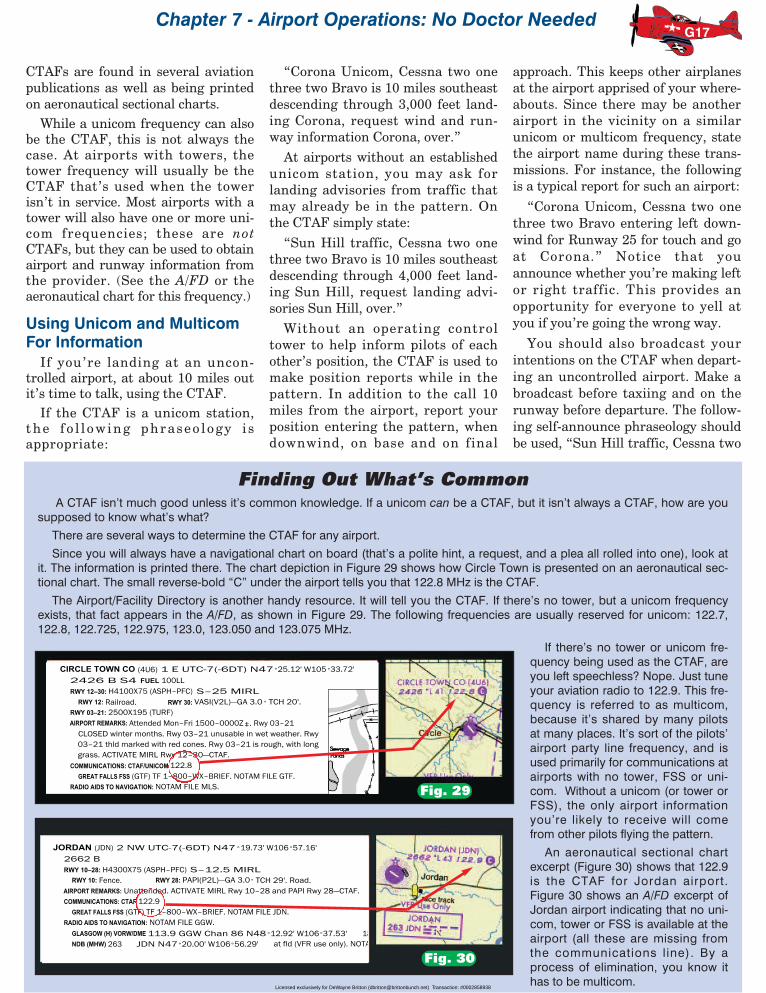
You don’t need a weatherman toknow which way the wind blows. Youdo, however, need either a wind sockor a report from the ground.Wind socks look like brightly col-
ored nets for capturing butterflies onsteroids (See Figure 24, position A).They are supposed to be easily visiblefrom the air. This is one of those avi-ation secrets, but I’m going to tellbecause you’ve been nice enough toread this far. Wind socks are not usu-ally easy to spot, and when they are,it isn’t always easy to figure out whatthey’re telling you. In theory, the fatend is facing into the wind and the
narrow end is pointed toward the endof the runway where you’ll land. Thisis most easily seen while standing onthe ground next to the wind sock.Trying to discern it while 1000 ormore feet in the air, traveling 150miles an hour and keeping the air-plane upright, is a bit more of a chal-lenge.There is often an easier way to get
the info. Many uncontrolled airportshave what is called a unicom(short foruniversal communications). This is anauthorized frequency on which some-one—usually the operator of one of
the refueling and repair operations(fixed base operators, or FBO’s inpilotspeak)—provides information onthe wind and traffic pattern direc-tions. The unicom information isadvisory in nature only. Unicom oper-ators are not air traffic controllers.They cannot i s sue commands ,sequence traffic, etc. though they willusually advise you if there are otheraircraft in the pattern or inbound.Another option is a multicom fre-
quency. This is a frequency approvedfor air-to-air use. Other pilots in oraround your destination airport willgenerally help out with informationon request.
If information is not available fromeither unicom or multicom, then youhave to take clues from wherever youcan on wind direction (smoke, waveson a lake or ocean), and should referto the segmented circle located at theairport for directions on the type oftraffic pattern to fly.
Segmented circles are often con-structed of large white blocks, bricksor ground paintings. Figure 20shows how a segmented circle looksfrom the air. These circles containseveral additional items to help youdecide upon the proper runway forlanding as well as the appropriatetraffic pattern to fly (I’ll show youhow to interpret the segmented cir-cle shortly).
G11
Fig. 20
TWO MISSES...Having my own small airplane at a private strip gives me a privilege few people
get to enjoy, of being able to fly when I please. I always do a complete preflightbefore moving the airplane; however, this time I was preoccupied with worldly mat-ters during my check. I taxied out, did a quick runup, and headed for the blue. Afterclimbout, I wanted to turn left but was unable. Then it struck me. How stupid. I hadforgotten to remove the wooden wedges used as rudder gust locks. Fortunately, alarge open field near my runway provided ample room to land in any direction Idesired by using ailerons only. It was an uneventful landing. A rather embarrassedbut wiser pilot removed the gust locks. ASRS Report
Forget the elevator lock, rather than rudder locks, and you will find yourself witheven less control. A proper pre-takeoff check for freedom and direction of move-ment is imperative. Not doing so, this pilot missed his second chance to catch hiswalk-around foul.
...AND A HIT“If I have been interrupted for any reason, or feel that my full attention has not beengiven to the task of an aircraft preflight walkaround, I will start again from the begin-ning.” (Ahh, Grasshopper can learn much from this wise man.)
Dave GwinnAirline pilot, CFII, aviation educator and author
The segmented circle as seen from
the air over an airport.
THE SEGMENTED CIRCLE
Licensed exclusively for DeWayne Britton ([email protected]) Transaction: #0002858938

Rod Machado’s Private Pilot Handbook
Segmented circles are segmentedso they are easier to identify at high-er altitudes. If you are unaware ofthe proper traffic pattern, simply flyover the airport and look for the seg-mented circle. The proper way to dothis at uncontrolled airports is tooverfly the field, above traffic patternaltitude and observe the indicator.Usually 1000 feet above the estab-lished traffic pattern altitude is suffi-cient to avoid the flow of airport traf-fic. In other words, if the traffic pat-tern altitude is 700 feet AGL andyou’re an additional 1,000 feet abovethat, this puts you at 1,700 feet AGL.At this altitude, you can easilyobserve the segmented circle withoutunexpectedly bumping into peoplewho are minding their own businessand trying to land.
At controlled airports, air trafficcontrollers will inform you of therunway on which to land and theappropriate traffic pattern to beflown. Some people are just born do-it-yourselfers, and they want todetermine for themselves the lay ofthe land. It is often very helpful tosee which way the runways runbefore attempting a landing, especial-ly if visibility is less than optimal. Infact, I prefer that students unfamiliarwith the complex taxiway and run-way layout of an airport overfly thefield and observe its runway and taxi-way layout before attempting toenter the pattern. Things can get
pretty confusing down close to theground and the overflight helps ori-ent you to a runway direction. Onceyou gain a little experience, you canplan on skipping this overflight andenter the downwind at a 45 degreeangle. To overfly a controlled field fora preliminary “look see,” just ask thecontroller for permission to overfly atwhatever altitude you want that issafely above the traffic pattern. Sucha request will almost always beapproved.
If you really want to take a lookfirst, before even engaging the con-troller, keep in mind that Class D air-space normally ends at 2500 feetAGL. You can overfly at any altitudeabove that boundary without theneed to tell anyone what you’redoing. Then, when you’re ready toenter the traffic pattern, you simplyestablish and maintain communica-tion with the tower and enter thepattern (more later on how to call thetower and what to say). Remember,we’re talking about overflying an air-port in Class D airspace here, notClass C or B airspace, which extendsto higher altitudes.
A few years ago, a student pilot gothopelessly lost on a solo cross coun-try. He spotted a controlled airportand commenced circling the field afew hundred feet above the tower.Fortunately, the pilot knew enoughto transmit on the emergency fre-quency of 121.5 MHz. The towerheard a transmission that went likethis, “Will the tower that has a smallairplane circling above it, with me init, please identify yourself.” Thetower replied, “This is Long Beachairport. What are you doing upthere?” The pilot replied, “I’m lost.Well, I was lost; but thanks to you, Ithink I just found myself.” Theycleared him to land on Runway 25Left. When the pilot said he wasn’tfamiliar with the runways, the towersaid to pick out any piece of asphaltat the airport and land on it (ofcourse, I’m sure all the controllerswere placing bets on what kind ofsandwich this pilot liked).
The Segmented CircleThe segmented circle shown in
Figure 21 contains several usefulpieces of information, once you knowhow to read the hieroglyphics.Attached to the segmented circle (A)are the landing strip indicators (D)and the traffic pattern indicators (Band C). The landing strip indicatorsare aligned with and represent theairport’s runway(s). These are shownby the two strips (D) located oneither side of the segmented circle.Attached to each end of landingstrips are the traffic pattern indica-tors (B and C). Because of this combi-nation, the landing strip and trafficpattern indicators take on an L shapewhen viewed from the air.
Basically, the traffic pattern indi-cators (B and C) point to the side ofthe runway on which the traffic pat-tern is flown. For instance, pilots
G12
THE SEGMENTED CIRCLE
A
G
BC D D
The segmented circle has several elements associated with it. These may in-clude the landing-strip indicator (D); the traffic pattern indicator (B and C) andsome form of wind or landing indicator (G) usually found inside the circle(A). According to the segmented circle's information, left traffic is made toRunway 9 with a wind from the east (Airplane F) and right traffic is made toRunway 27 with a wind from the west (Airplane E). Of course, pilots land intothe wind whenever possible. The wind or landing indicator identifies the ap-propriate runway on which to land (G).
F E
279
Hey?Your flying
gets anF grade.
Oh no.I fly so badthat I get
an E!
EVERYTHING’S COMING UP ROSES...I watched as my aircraft was refueled with 35 gallons of 100 octane fuel. After goinginside, I came back out to look in tanks and drained a sample. Imagine my surprise atseeing a pink sample! I was ready to yell and scream when I realized my eyeglasses(brown-rose colored) had changed the color. Suppose I had worn blue sunglassesand looked at clear fuel? Moral: Look at fuel samples without sunglasses.
REMINDER: 80 octane=red, 100 octane=blue, Jet fuel=clearASRS Report
Fig. 21
Licensed exclusively for DeWayne Britton ([email protected]) Transaction: #0002858938

Chapter 7 - Airport Operations: No Doctor Needed
landing on Runway 27 should maketheir pattern to the north of the air-port, since the traffic pattern indica-tor (B) is on the north side of landingstrip (D). This results in Airplane Emaking right traffic for Runway 27
(all right turns). Pilots landing onRunway 9 should, likewise, maketheir pattern north of the runway asshown by traffic pattern indicator(C). Consequently, Airplane F makesleft traffic (all left turns) to Runway 9.
Where two or more runways exist,multiple L shaped bars may protrudefrom the segmented circle as shownin Figure 22. Landing on Runway 3requires a right hand traffic pattern;Runway 21, a right hand pattern;Runway 18, a left hand; and Runway36, a right hand pattern.
What happens if no landing stripindicators or traffic pattern indica-tors protrude from the segmentedcircle, as shown in Figure 23? Is thisa sign of airport vandalism? No.Segmented circles without these indi-cators imply that you should fly astandard left hand traffic pattern forthe runway in use. Left hand trafficis considered standard and pilotsshould make all turns to the left in
the absence of other indications.Right hand traffic patterns, bydefault, are considered to be non-standard patterns.
Wind and Landing-DirectionIndicators
Knowing whether it’s a right orleft hand traffic pattern is one thing,but what about deciding which wayto land? Within the segmented circleyou’ll normally find some type ofwind or landing direction indicators.Either one of these help you select arunway for landing that’s most near-ly aligned with the wind. We want toland into the wind whenever possi-ble. It slows our touchdown speedand makes landings safer as well aseasier.
Three types of indicators are usedto identify the proper direction forlanding. The first two are known aswind direction indicators and the lastis called a landing direction indicator.
G13
TRAFFIC PATTERNINDICATORS
(Multiple Runways)
21
3
18
36
AB
CD
The landing strip & traffic patternindicator informs the pilot that thepattern for:Runway 18 (A) is left traffic,Runway 21 (B) is right traffic,Runway 3 (C) is right traffic andRunway 36 (D) is right traffic.
I’ll teachyou to land
on Bob!
THE SEGMENTED CIRCLE(indicating standard, left-hand traffic)
279
When neither landing-strip nor traffic-pattern indi-cators are shown along with the segmented circle,make all turns in the pattern to the left.
The landing strip & traffic-pattern indicators aremissing from the sides ofthe segmented circle.
Fig. 22
Fig. 23
Actually Heard at the Airport...Situation: A student pilot was on final approach toland with a Cessna jet (called a Citation) followingclose behind.
Tower: “Cherokee 43511, keep your speed up andmake the first turnout, Citation to follow.”
Cherokee 43511: “Hey, what did I do wrong?”
Go AroundYou can always go around,
If it don’t look right coming down.Don’t wait until you’re sideways,
Maybe sliding on the ground,You can always go around.
Ken DravisSinger, Songwriter, Pilot
Licensed exclusively for DeWayne Britton ([email protected]) Transaction: #0002858938

Rod Machado’s Private Pilot Handbook
The first type of wind direction indicatoris the wind sock, which I discussed earlier.It’s a big help—if you can see it. StudyFigure 24A, so you’ll at least know whatyou’re looking for.
The wind tee, shown in Figure 24B, isanother means of determining landingdirection. This device looks like a little air-plane. It’s free to rotate around its baseand is aerodynamically constructed so thesmall airplane points into the wind.Sometimes the device isn’t free to rotateand airport personnel manually place it inthe proper direction of landing. Either way,you can determine the appropriate landingdirection by imagining the wind tee as asmall airplane pointing in the direction (ornearly so) that you should land. Simplyland on the runway most nearly aligned inthe direction the wind tee points. The windtee in Figure 24B suggests a landing onRunway 9 would head you into the wind.
A more direct means of determininglanding direction is with a tetrahedron(this isn’t a prehistoric dinosaur). Figure24C shows what appears to be an arrowlocated within the segmented circle. This isa tetrahedron (a four sided object —threesides on top and one side on the bottom)and is technically called a landing-directionindicator instead of a wind indicator. It’s athree dimensional structure that’s usuallyfree to rotate about its base. When it canrotate freely, it points into the wind; whenit can’t, it is also manually rotated by air-port personnel to point in the appropriatelanding direction. Determining landingdirection is simply a matter of landing onthe runway most nearly aligned with thedirection the tetrahedron points (childrenseen playing on the tetrahedron shouldarouse suspicion as to the actual directionin which to land).
The tetrahedron should be used withcaution when the winds are light or calm.These things are large hunks of wood ormetal, not ballerinas. It takes at least amodest puff of wind to move one. It’s agood rule in general aviation to treat allinformation with a high index of suspi-cion until you can confirm it in anotherway. I’ve had students who were crabbing60° into the wind while insisting it had tobe coming from another direction becausethey’d heard it on the radio or seen it onthe tetrahedron. The airplane is the ulti-
G14
The tetrahedron pointsin the direction youshould land (or it ismanually pointed inthe direction youshould land). It ismounted on a swiveland can pivot, and likethe wind tee, its reli-ability is questionableduring light winds.
LANDING & WIND DIRECTION INDICATOR
Winddirection
The wind cone (or wind sock) aligns itself parallel to the wind. The small end or open-ing points downwind and the big end (the opening) is upwind. To decide on wind di-rection, simply look at which way the small end points. This is the direction the windis blowing. You'll land into the wind.
The wind tee looks like a small airplane placed on a swivel. It's free to rotate into thewind. Think of its shape as an airplane that points in the direction you should land(into the wind). The wind tee may be manually rotated by airport personnel to iden-tify the proper landing direction. It may also be tethered, unattended and com-pletely inaccurate! Use caution when using it to assess landing direction.
The Wind Tee
The Tetrahedron
Winddirection
Winddirection
A
B
C
The Wind Sock
The Wind Tee
The Tetrahedron2
799
27
9
27
A wind sock anda tetrahedron
side by side.
Fig. 24
Licensed exclusively for DeWayne Britton ([email protected]) Transaction: #0002858938

Chapter 7 - Airport Operations: No Doctor Needed
mate authority on what’s reallyhappening!
Some airports have a designatedcalm wind runway (usually the run-way that’s less noise sensitive).Under calm wind conditions, airportpersonnel may manually point thetetrahedron in the direction of thecalm-wind runway. Be sure andmaintain special vigilance duringlandings at uncontrolled airportswhen the winds are calm. This is nec-essary for two reasons. First, anotherpilot might have chosen another run-way, since the wind didn’t enforce itswill. Second, keep in mind that calmdoesn’t necessarily mean none, so beprepared for the possibility of abreeze from any angle.
Many times the landing or winddirection indicators aren’t alignedwith any specific runway. This meansa crosswind exists at the airport. Inthese conditions, pick a runwaythat’s most nearly aligned with thewind. With a little practice you’llhave no difficulty handling thesecrosswind landings. Honest!
The 45° Entry PointOnce you know the direction of the
landing runway and the appropriatetraffic pattern to use, you’re ready toenter the pattern in an organizedway. The best way to do this is toenter the traffic pattern in levelflight at a 45° angle to the downwindleg at the approximate midpoint ofthe runway, as depicted in Figure 25,point A. This doesn’t have to beexactly 45° but it should be close.
This angle of entry allows you tomore easily see traffic on the cross-wind and downwind legs of the trafficpattern. Seeing these airplanesmakes it easier for you to blend intothe flow of traffic. A 45° entry alsomakes it easier for other airplanes inthe pattern to see and blend in withyou. Of course, if it’s a controlled air-port, tower controllers will usuallyadvise you of traffic in the pattern.Once again, keep in mind that pre-dictability is important. The con-trollers expect you to make a stan-dard pattern entry, at the standardpattern place. They don’t like sur-prises very much, perhaps becausethey’re responsible for what happenson their shift (they’re concerned too!).
Aim to enter the pattern abeamthe midpoint of the runway (point B).And always enter the pattern at thespecified pattern altitude for that air-port. This allows everyone to be atthe same height, making it easier tosee other airplanes. If no traffic pat-tern altitude is established, it’s usu-ally best to fly the pattern at 1000feet AGL if no tower is available toadvise otherwise.
I do want to make it clear thatwe’re talking about an entry at a 45°angle and not a 45° bank to thedownwind leg. I gave a phase checkto a student pilot who didn’t quiteunderstand this. We were approach-ing the pattern when I reminded himto use a 45° entry. He immediate-ly rolled the airplane into a 45°bank ( then he asked me for asandwich). How novel! I’m justglad the FAA doesn’t recommenda 90° entry!
It should come as no surprise toyou that the majority of midair colli-sions occur within five miles of anairport at an altitude of less than3,000 feet AGL (79% in one study).Makes sense, since that’s where themajority of the airplanes are. Thesame study found nearly half of allmidair collisions occurred within 5miles of an airport at an altitude of500 feet or less AGL (49% to be spe-cific). This is a common altitude forbase leg and final approach, isn’t it?A word or three to the wise should besufficient here. Pay close attention.Look with your eyes and ears (i.e.,listen for the call and position ofother aircraft).
Departing the pattern alsorequires that you avoid interferingwith traffic entering and remainingin the pattern. Figure 25, points Cand D, depict two common methodsfor departing an airport. First, adeparture can be made straight outas in position C. A 45° turn on thepattern side of the runway (the leftside of Runway 30 in this case) is alsorecommended after the airplane hasreached traffic pattern altitude. Ofcourse, if there are parallel runways,noise sensitive areas, or obstructions,then you should follow the recom-mended procedures for departingthat particular airport. These recom-mended procedures are sometimesfound posted near the departure endof the runway (Figure 26). They may
G15
ENTERING & DEPARTINGTHE PATTERN
30
N2132B
D45N2132B
Enter the traffic pattern at a 45 degree angle (A) to the downwind leg aboutmidfield (B). When departing an airport, make either a straight out (C) or a 45 de-gree turn in the direction of the pattern (D) when reaching pattern altitude.
A
B
C
Fig. 25
Fig. 26
An airport’s recommended
departure procedure.
Licensed exclusively for DeWayne Britton ([email protected]) Transaction: #0002858938

Rod Machado’s Private Pilot Handbook
also be found in a useful documentknown as the Airport/FacilityDirectory (the A/FD as it’s affection-ately known to pilots) as shown inFigure 27. More on the A/FD inChapter 17.
CTAF (Common TrafficAdvisory Frequency)
The airports you’ll land at anddepart from will be either controlled or
uncontrolled. Operations at con-trolled airports are accomplished bycommunicating with an air trafficcontroller. We’ll discuss how to dothis shortly. For now, let’s examinethe proper communication tech-niques when operating into or out ofan uncontrolled airport (remember,this is an airport without a controltower or one whose tower isn’t inoperation).
At uncontrolled airports, pilots arenot required to use their radio tocommunicate with other traffic dur-ing takeoff or landing. Simple see-and-avoid vigilance is considered sat-isfactory. Common sense, however,dictates using a radio if one is onboard. Airplanes with radios tuned tothe same (common) frequency canbroadcast their intentions to eachother while operating in the trafficpattern. This makes the airport asafer and more harmonious place.
At many uncontrolled airports afrequency known as the CommonTraffic Advisory Frequency (CTAF) isavailable for pilots to communicatetheir intentions and receive informa-tion during takeoff or landing. It’scalled common simply because allpilots communicating at a particularairport use that frequency. The CTAFmay be either a unicom, multicom,FSS (Flight Service Station), or towerfrequency (if the airport has a towerbut it’s not in operation at the time).
G16
Getting from Overhead to Over ThereMany student pilots overfly an uncontrolled airport and take a look to see what’s where. Then they say “OK big fella’, now how
do I get from way up here to over there for a standard 45° entry?”Some of the more creative students might think about flying to the entry spot at
several thousand feet above the pattern altitude and diving into the pattern (afterone too many reruns of Tora, Tora, Tora). This earns a Swiss cheese sandwich, forhaving enormous holes in their judgment.
Here are two options. Overfly an uncontrolled airport at a minimum of 2000 feetAGL to observe the runways and traffic pattern indicator. Once you’ve identified therunway you’ll be using, fly parallel to the runway direction and off to one side asshown in Figure 28. Flying from A to B allows you to keep the runway in sight outof your left window. When the airplane is beyond the crosswind leg (point B), makea left 90° turn. This allows you to keep departing traffic and pattern traffic in sight.
Make sure you keep your eyes out for high performance airplanes departing therunway. These aircraft climb like a big hungry bat whose sonar is locked on the moon.It’s no problem if you maintain a good scan, as pilots are supposed to do at all times.
Continue beyond the downwind leg until reaching point C. You can start yourdescent here or start it at point D as you turn toward the midpoint of the runway.Descend so as to enter the traffic pattern at traffic pattern altitude. Point D is cho-sen far enough from the runway to lose the excess altitude you had while overflyingthe airport. On the return to the airport, enter the downwind at a 45° angle, at trafficpattern altitude. Adjust your flight path, speed or timing to follow any traffic in thepattern or entering the pattern.
Another method is to fly from A to F while keeping the runway in sight out your leftwindow. Point F is chosen far enough from the airport to keep the runway visibleover your right shoulder as you fly from F to G to H. You can start your descent totraffic pattern altitude at position G, which is beyond the downwind leg
These methods of pattern entry allow you to keep the airport in sight at all times.The same procedures apply to a right hand traffic pattern. These procedures alsowork at tower controlled airports when the controller hasn’t provided you with spe-cific instructions on how to enter the traffic pattern. Always make it a point to enterthe pattern at traffic pattern altitude—no higher and no lower.
27
9
B
A
CG
F
HD
E
There are two common ways to enter thetraffic pattern at an uncontrolled field fromoverhead. You can observe the seg-mented circle at 2000 feet AGL then flyfrom A to B to C to D, then inbound to therunway at a 45 degree angle (D to E). An-other way is to start at 2,000 feet AGL andfly from A to F to G to H to D. The descentfrom 2,000 feet AGL to traffic pattern alti-tude is started from D to E. Traffic and ter-rain permitting, the descent can be doneearlier at the pilot's discretion (from G to H,H to D or C to D.
ENTERING THE PATTERN
Fig. 28
SANTA MONICA MUNI (SMO) 3 E UTC-8(-7DT) N34°00.95' W118°27.08' LOS ANGELES177 B S4 FUEL 100LL, JET A OX 1, 2, 3, 4 TPA—See Remarks LRA COPTERRWY 03–21: H4973X150 (ASPH) S–40, D–60, DT–105 MIRL 1.2% up NE L–3E, 4G, 7B, A
RWY 03: REIL. VASI(V4L)—GA 4.0 ° TCH 27'. Tree. Rgt tfc. IAP, ADRWY 21: REIL. PAPI(P4L)—GA 4.0° TCH 65'.
AIRPORT REMARKS: Attended continuously. PPR for dual wheel acft inexcess of 60,000 pounds certified maximum ldg weight, ctc arptmanager 310–458–8591. Helicopter flight training ops prohibited,helicopter ops apch boundry at midfield at or above 900' MSL. Notouch/go, stop/go, or low apch permitted on Sat, Sun, holidays,weekdays SS–1500Z‡ . Noise test on 122.85. Continuous noiseordinance in effect ctc noise office prior to arrival310–458–8759/8692 or 310–434–2640. Noise abatementprocedures: Pure jet and stage II (with/without hush kits)prohibited. Maximum noise limit 95.0 senal all acft. No enginestarts or departures except PPR lifeguard flights 0700–1500Z ‡Mon–Fri and 0700–1600Z‡ weekends. PPR ex–military acft ctcarpt manager 310–458–8591. VFR departures Rwy 21 turn left10° at end of rwy then turn right 225 ° to over–fly golf course W ofa
Fig. 27
The Airport/Facility Directory describes an airport’s departure procedures.
Licensed exclusively for DeWayne Britton ([email protected]) Transaction: #0002858938
Chapter 7 - Airport Operations: No Doctor Needed
CTAFs are found in several aviationpublications as well as being printedon aeronautical sectional charts.While a unicom frequency can also
be the CTAF, this is not always thecase. At airports with towers, thetower frequency will usually be theCTAF that’s used when the towerisn’t in service. Most airports with atower will also have one or more uni-com frequencies; these are notCTAFs, but they can be used to obtainairport and runway information fromthe provider. (See the A/FD or theaeronautical chart for this frequency.)
Using Unicom and MulticomFor InformationIf you’re landing at an uncon-
trolled airport, at about 10 miles outit’s time to talk, using the CTAF.If the CTAF is a unicom station,
the f o l l ow ing phraseo logy i sappropriate:
“Corona Unicom, Cessna two onethree two Bravo is 10 miles southeastdescending through 3,000 feet land-ing Corona, request wind and run-way information Corona, over.”
At airports without an establishedunicom station, you may ask forlanding advisories from traffic thatmay already be in the pattern. Onthe CTAF simply state:
“Sun Hill traffic, Cessna two onethree two Bravo is 10 miles southeastdescending through 4,000 feet land-ing Sun Hill, request landing advi-sories Sun Hill, over.”
Without an operating controltower to help inform pilots of eachother’s position, the CTAF is used tomake position reports while in thepattern. In addition to the call 10miles from the airport, report yourposition entering the pattern, whendownwind, on base and on final
approach. This keeps other airplanesat the airport apprised of your where-abouts. Since there may be anotherairport in the vicinity on a similarunicom or multicom frequency, statethe airport name during these trans-missions. For instance, the followingis a typical report for such an airport:
“Corona Unicom, Cessna two onethree two Bravo entering left down-wind for Runway 25 for touch and goat Corona.” Notice that youannounce whether you’re making leftor right traffic. This provides anopportunity for everyone to yell atyou if you’re going the wrong way.
You should also broadcast yourintentions on the CTAF when depart-ing an uncontrolled airport. Make abroadcast before taxiing and on therunway before departure. The follow-ing self-announce phraseology shouldbe used, “Sun Hill traffic, Cessna two
G17
Finding Out What’s CommonA CTAF isn’t much good unless it’s common knowledge. If a unicom can be a CTAF, but it isn’t always a CTAF, how are you
supposed to know what’s what?
There are several ways to determine the CTAF for any airport.
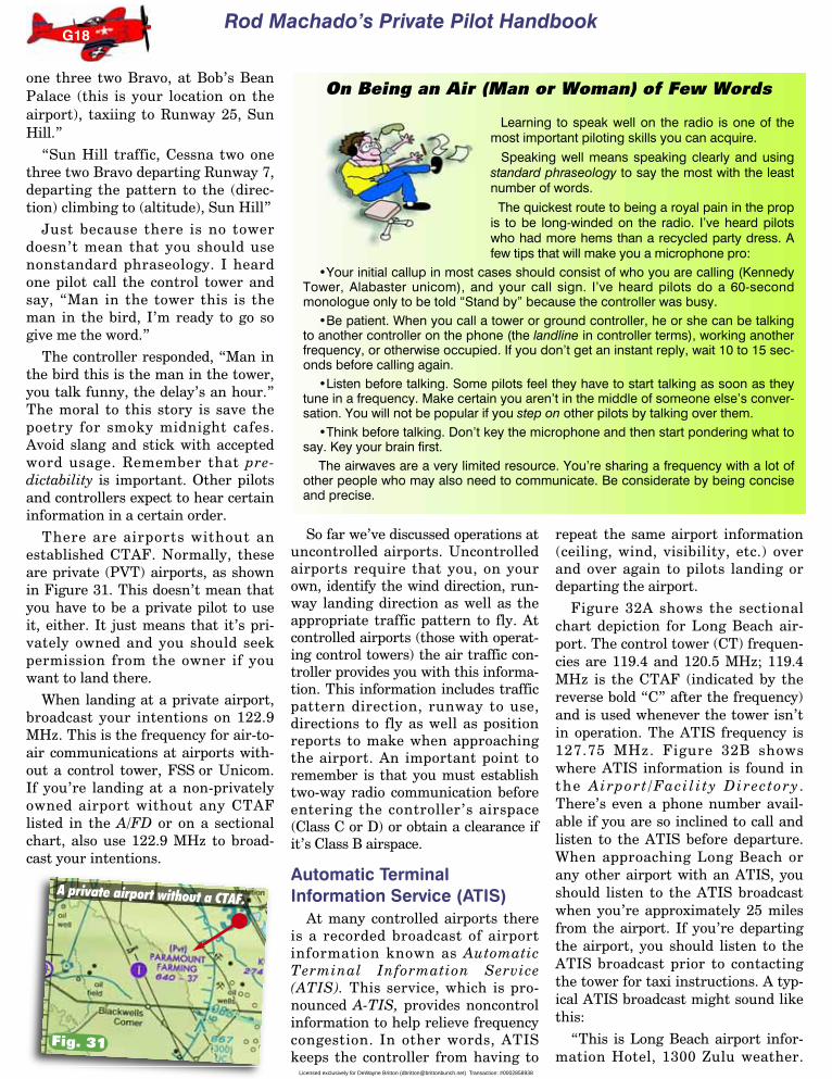
Since you will always have a navigational chart on board (that’s a polite hint, a request, and a plea all rolled into one), look atit. The information is printed there. The chart depiction in Figure 29 shows how Circle Town is presented on an aeronautical sec-tional chart. The small reverse-bold “C” under the airport tells you that 122.8 MHz is the CTAF.
The Airport/Facility Directory is another handy resource. It will tell you the CTAF. If there’s no tower, but a unicom frequencyexists, that fact appears in the A/FD, as shown in Figure 29. The following frequencies are usually reserved for unicom: 122.7,122.8, 122.725, 122.975, 123.0, 123.050 and 123.075 MHz.
If there’s no tower or unicom fre-quency being used as the CTAF, areyou left speechless? Nope. Just tuneyour aviation radio to 122.9. This fre-quency is referred to as multicom,because it’s shared by many pilotsat many places. It’s sort of the pilots’airport party line frequency, and isused primarily for communications atairports with no tower, FSS or uni-com. Without a unicom (or tower orFSS), the only airport informationyou’re likely to receive will comefrom other pilots flying the pattern.
An aeronautical sectional chartexcerpt (Figure 30) shows that 122.9is the CTAF for Jordan airport.Figure 30 shows an A/FD excerpt ofJordan airport indicating that no uni-com, tower or FSS is available at theairport (all these are missing fromthe communications l ine). By aprocess of elimination, you know ithas to be multicom.
Fig. 29
Fig. 30
CIRCLE TOWN CO (4U6) 1 E UTC-7(-6DT) N47 °25.12' W105 °33.72'2426 B S4 FUEL 100LLRWY 12–30: H4100X75 (ASPH–PFC) S–25 MIRL
RWY 12: Railroad. RWY 30: VASI(V2L)—GA 3.0 ° TCH 20'.RWY 03–21: 2500X195 (TURF)AIRPORT REMARKS: Attended Mon–Fri 1500–0000Z ‡. Rwy 03–21
CLOSED winter months. Rwy 03–21 unusable in wet weather. Rwy03–21 thld marked with red cones. Rwy 03–21 is rough, with longgrass. ACTIVATE MIRL Rwy 12–30—CTAF.
COMMUNICATIONS: CTAF/UNICOM 122.8GREAT FALLS FSS (GTF) TF 1–800–WX–BRIEF. NOTAM FILE GTF.
RADIO AIDS TO NAVIGATION: NOTAM FILE MLS.
JORDAN (JDN) 2 NW UTC-7(-6DT) N47 °19.73' W106 °57.16'2662 BRWY 10–28: H4300X75 (ASPH–PFC) S–12.5 MIRL
RWY 10: Fence. RWY 28: PAPI(P2L)—GA 3.0 ° TCH 29'. Road.AIRPORT REMARKS: Unattended. ACTIVATE MIRL Rwy 10–28 and PAPI Rwy 28—CTAF.COMMUNICATIONS: CTAF 122.9
GREAT FALLS FSS (GTF) TF 1–800–WX–BRIEF. NOTAM FILE JDN.RADIO AIDS TO NAVIGATION: NOTAM FILE GGW.
GLASGOW (H) VORW/DME 113.9 GGW Chan 86 N48 °12.92' W106°37.53' 18 NDB (MHW) 263 JDN N47°20.00' W106°56.29' at fld (VFR use only). NOTA
Licensed exclusively for DeWayne Britton ([email protected]) Transaction: #0002858938
Rod Machado’s Private Pilot Handbook
one three two Bravo, at Bob’s BeanPalace (this is your location on theairport), taxiing to Runway 25, SunHill.”
“Sun Hill traffic, Cessna two onethree two Bravo departing Runway 7,departing the pattern to the (direc-tion) climbing to (altitude), Sun Hill”
Just because there is no towerdoesn’t mean that you should usenonstandard phraseology. I heardone pilot call the control tower andsay, “Man in the tower this is theman in the bird, I’m ready to go sogive me the word.”
The controller responded, “Man inthe bird this is the man in the tower,you talk funny, the delay’s an hour.”The moral to this story is save thepoetry for smoky midnight cafes.Avoid slang and stick with acceptedword usage. Remember that pre-dictability is important. Other pilotsand controllers expect to hear certaininformation in a certain order.
There are airports without anestablished CTAF. Normally, theseare private (PVT) airports, as shownin Figure 31. This doesn’t mean thatyou have to be a private pilot to useit, either. It just means that it’s pri-vately owned and you should seekpermission from the owner if youwant to land there.
When landing at a private airport,broadcast your intentions on 122.9MHz. This is the frequency for air-to-air communications at airports with-out a control tower, FSS or Unicom.If you’re landing at a non-privatelyowned airport without any CTAFlisted in the A/FD or on a sectionalchart, also use 122.9 MHz to broad-cast your intentions.
So far we’ve discussed operations atuncontrolled airports. Uncontrolledairports require that you, on yourown, identify the wind direction, run-way landing direction as well as theappropriate traffic pattern to fly. Atcontrolled airports (those with operat-ing control towers) the air traffic con-troller provides you with this informa-tion. This information includes trafficpattern direction, runway to use,directions to fly as well as positionreports to make when approachingthe airport. An important point toremember is that you must establishtwo-way radio communication beforeentering the controller’s airspace(Class C or D) or obtain a clearance ifit’s Class B airspace.
Automatic TerminalInformation Service (ATIS)
At many controlled airports thereis a recorded broadcast of airportinformation known as AutomaticTerminal Information Service(ATIS). This service, which is pro-nounced A-TIS, provides noncontrolinformation to help relieve frequencycongestion. In other words, ATISkeeps the controller from having to
repeat the same airport information(ceiling, wind, visibility, etc.) overand over again to pilots landing ordeparting the airport.
Figure 32A shows the sectionalchart depiction for Long Beach air-port. The control tower (CT) frequen-cies are 119.4 and 120.5 MHz; 119.4MHz is the CTAF (indicated by thereverse bold “C” after the frequency)and is used whenever the tower isn’tin operation. The ATIS frequency is127.75 MHz. Figure 32B showswhere ATIS information is found inthe Airport /Faci l i ty Direc tory .There’s even a phone number avail-able if you are so inclined to call andlisten to the ATIS before departure.When approaching Long Beach orany other airport with an ATIS, youshould listen to the ATIS broadcastwhen you’re approximately 25 milesfrom the airport. If you’re departingthe airport, you should listen to theATIS broadcast prior to contactingthe tower for taxi instructions. A typ-ical ATIS broadcast might sound likethis:
“This is Long Beach airport infor-mation Hotel, 1300 Zulu weather.
G18
On Being an Air (Man or Woman) of Few Words
Learning to speak well on the radio is one of themost important piloting skills you can acquire.
Speaking well means speaking clearly and usingstandard phraseology to say the most with the leastnumber of words.
The quickest route to being a royal pain in the propis to be long-winded on the radio. I’ve heard pilotswho had more hems than a recycled party dress. Afew tips that will make you a microphone pro:
•Your initial callup in most cases should consist of who you are calling (KennedyTower, Alabaster unicom), and your call sign. I’ve heard pilots do a 60-secondmonologue only to be told “Stand by” because the controller was busy.
•Be patient. When you call a tower or ground controller, he or she can be talkingto another controller on the phone (the landline in controller terms), working anotherfrequency, or otherwise occupied. If you don’t get an instant reply, wait 10 to 15 sec-onds before calling again.
•Listen before talking. Some pilots feel they have to start talking as soon as theytune in a frequency. Make certain you aren’t in the middle of someone else’s conver-sation. You will not be popular if you step on other pilots by talking over them.
•Think before talking. Don’t key the microphone and then start pondering what tosay. Key your brain first.
The airwaves are a very limited resource. You’re sharing a frequency with a lot ofother people who may also need to communicate. Be considerate by being conciseand precise.
Fig. 31
A private airport without a CTAF.
Licensed exclusively for DeWayne Britton ([email protected]) Transaction: #0002858938
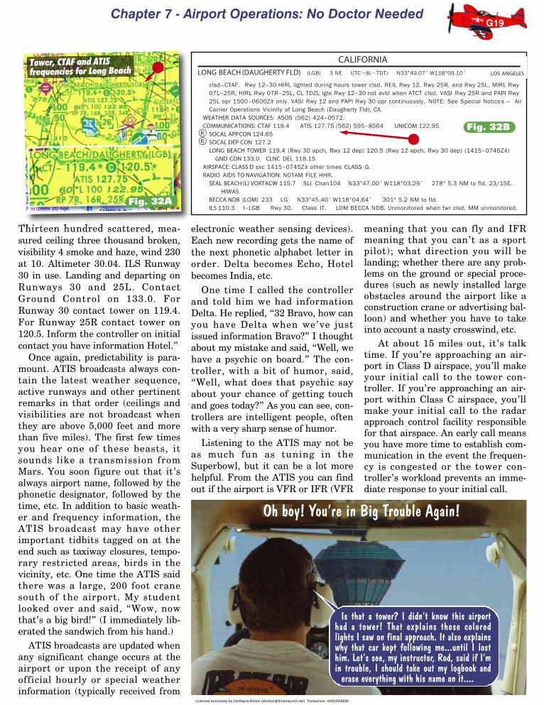
Chapter 7 - Airport Operations: No Doctor Needed
Thirteen hundred scattered, mea-sured ceiling three thousand broken,visibility 4 smoke and haze, wind 230at 10. Altimeter 30.04. ILS Runway30 in use. Landing and departing onRunways 30 and 25L. ContactGround Control on 133.0. ForRunway 30 contact tower on 119.4.For Runway 25R contact tower on120.5. Inform the controller on initialcontact you have information Hotel.”
Once again, predictability is para-mount. ATIS broadcasts always con-tain the latest weather sequence,active runways and other pertinentremarks in that order (ceilings andvisibilities are not broadcast whenthey are above 5,000 feet and morethan five miles). The first few timesyou hear one of these beasts, itsounds like a transmission fromMars. You soon figure out that it’salways airport name, followed by thephonetic designator, followed by thetime, etc. In addition to basic weath-er and frequency information, theATIS broadcast may have otherimportant tidbits tagged on at theend such as taxiway closures, tempo-rary restricted areas, birds in thevicinity, etc. One time the ATIS saidthere was a large, 200 foot cranesouth of the airport. My studentlooked over and said, “Wow, nowthat’s a big bird!” (I immediately lib-erated the sandwich from his hand.)
ATIS broadcasts are updated whenany significant change occurs at theairport or upon the receipt of anyofficial hourly or special weatherinformation (typically received from
electronic weather sensing devices).Each new recording gets the name ofthe next phonetic alphabet letter inorder. Delta becomes Echo, Hotelbecomes India, etc.
One time I called the controllerand told him we had informationDelta. He replied, “32 Bravo, how canyou have Delta when we’ve justissued information Bravo?” I thoughtabout my mistake and said, “Well, wehave a psychic on board.” The con-troller, with a bit of humor, said,“Well, what does that psychic sayabout your chance of getting touchand goes today?” As you can see, con-trollers are intelligent people, oftenwith a very sharp sense of humor.
Listening to the ATIS may not beas much fun as tuning in theSuperbowl, but it can be a lot morehelpful. From the ATIS you can findout if the airport is VFR or IFR (VFR
meaning that you can fly and IFRmeaning that you can’t as a sportpilot); what direction you will belanding; whether there are any prob-lems on the ground or special proce-dures (such as newly installed largeobstacles around the airport like aconstruction crane or advertising bal-loon) and whether you have to takeinto account a nasty crosswind, etc.
At about 15 miles out, it’s talktime. If you’re approaching an air-port in Class D airspace, you’ll makeyour initial call to the tower con-troller. If you’re approaching an air-port within Class C airspace, you’llmake your initial call to the radarapproach control facility responsiblefor that airspace. An early call meansyou have more time to establish com-munication in the event the frequen-cy is congested or the tower con-troller’s workload prevents an imme-diate response to your initial call.
G19
Is that a tower? I didn’t know this airporthad a tower! That explains those coloredlights I saw on final approach. It also explainswhy that car kept following me...until I losthim. Let’s see, my instructor, Rod, said if I’min trouble, I should take out my logbook and
erase everything with his name on it....
Oh boy! You’re in Big Trouble Again!
Tower, CTAF and ATISfrequencies for Long Beach
Fig. 32B
Fig. 32A
Licensed exclusively for DeWayne Britton ([email protected]) Transaction: #0002858938

Rod Machado’s Private Pilot Handbook
Your initial contact with any airtraffic controller should contain thefollowing information:
1. The name of the facility you’recalling.
2. Your full aircraft call sign asfiled in your flight plan (if you filed aflight plan).
3. The type of message to follow, oryour request, if it’s short.
4. The word over if required.When contacting Long Beach
Tower, your initial should sound likethis:
“Long Beach Tower, Cessna twoone three two Bravo, 15 miles south-east at 3,500 feet for landing, infor-mation Whiskey received, over.”
The tower might reply with:“Cessna two one three two Bravo,
this is Long Beach Tower, make righttraffic for Runway 7 right. Reportentering downwind.”
I was sitting at the local flightschool when a student came backfrom a cross country to a busy tower-controlled airport. He was obviouslyflustered so I asked him what theproblem was. He said, “I tuned in thetower frequency and they neverstopped talking. All they did wasblab, blab, blab. I couldn’t get a wordin edgewise and finally had to returnhome.” I asked him to point out thetower frequency on the chart. Guesswhat? He pointed to the ATIS fre-quency (between taking big bites outof his sandwich). His instructor hadnever taken him to an airport with
an ATIS, so he knew nothing aboutit. I suppose if the tower ever askedhim if he had the ATIS (sounds like“A - TIS”) he might of thought theywere talking about some sort of tropi-cal skin rash.
Pilot Control OfAirport Lighting
At a few very busy airports therunway edge lights are kept on fromsunset to sunrise. Figure 33 shows asectional chart excerpt of Hogelandairport. Notice that next to the num-bers “3138” (this is the airport’s ele-vation above sea level) there is theletter “L.” This indicates that light-ing (specifically—runway edge light-ing) is in operation from sunset tosunrise.
At many airports, though, you getto turn the lights on yourself. No, itdoesn’t take really long arms. In fact,all you need is a short thumb,because you can activate the lights byclicking the microphone.
Figure 34 shows a sectional chartexcerpt of Turner airport. An aster-isk (*) next to the lighting symbol(the “L”) on the sectional chartmeans lighting limitations exist. Inthis instance, the limitation refers tothe fact that “pilot control” of airportlighting is in use (available) at thisairport. So don’t expect to seeTurner’s airport lights on at nightunless you or another pilot activatedthem. Figure 35 shows an excerptfrom the Airport/Facility Directoryfor Turner, indicating that pilotsshould activate the MIRL (mediumintensity runway lighting) on theCTAF of 122.9 MHz. The words,“ACTIVATE,” followed by the specif-
ic type of lighting system, indicatethat pilot control of airport lightingexists at that airport. The AF/D, notthe sectional chart, is where theappropriate frequencey for lightingactivation is found. (The “*L” symbolmay also mean lighting is availableon request or the lighting is part time.If it’s available on request, the A/FDwill identify who to contact for lightactivation. Always check the A/FD ifyou see the “*L” symbol.)
Three different intensities of run-way edge lighting (high, medium andlow) are available at many airports.To activate runway lighting from thecockpit, key (click) the microphonebutton on the appropriate CTAF fre-quency. How many times should youclick it? If all three intensities oflighting exist at an airport, simplyclick the mike 7 times within 5 sec-onds for the high intensity runwaylighting (HIRL), 5 times within 5 sec-onds for the medium intensity run-way lighting (MIRL) and 3 times in 5seconds for the low intensity runwaylighting (LIRL). Once activated thelights will stay on for 15 minutes.
G20
Speaking When Spoken ToWhen a controller speaks, you are expected to acknowledge the communication
orally. The acknowledgment consists of nothing more than the last three letters ofyour call sign. If the tower says “Cessna two one three two Bravo, report turningfinal” your reply is “32 Bravo.”
There is one situation in which a longer reply is mandatory. When a controllerissues instructions to taxi to but not enter a runway, you must acknowledge withyour call sign and the fact that you understand you are to hold short of the runway. Itmight sound like this:
“Cessna two one three two Bravo, hold short of Runway 21.”
“Cessna two one three two bravo, will hold short Runway 21.”
Fig. 33 Fig. 34
The “*L” in Turner’s airport informa-tion line indicates lighting limitationsexist (in Turner’s case the limitation isfor pilot controlled lighting). Checkthe A/FD for more info.
The “L” in Hogeland’s airport infor-mation line indicates lighting is inoperation from sunset to sunrise.
Licensed exclusively for DeWayne Britton ([email protected]) Transaction: #0002858938

Chapter 7 - Airport Operations: No Doctor Needed
If you’re approaching the airportat night and it’s approximately 15minutes since you’ve last activatedthe lights, you might want to re-clickthe microphone the appropriate num-ber of times to reactivate them for anadditional 15 minutes. Personally, Ire-key the microphone the appropri-ate number of times when I’m onfinal approach just to make sure thelights don’t go off by surprise.Imagine being on short final whenthe airport disappears. Not only willthis make you nervous, but imaginewhat it’ll do to the passengers.
Figure 35 shows only MIRL isavailable at Turner (look after theword “ACTIVATE” at point A).Keying the microphone more than 5times in 5 seconds will only activatethe medium intensity setting since itdoesn’t have high intensity capability.
If HIRL lighting exists and it’s toostrong for your eyes (some pilots sayyou can cook chicken on the bulbs ofthose high intensity lights), simplyre-key the mic 3 or 5 times withinfive seconds to step down the lightingsystem to lower intensity lighting (ifit is available). The FAA suggeststhat, when approaching an airport,you should key the microphone 7times in 5 seconds just to activate allthe airport’s controlled lighting.After this, you can re-key the mikeand lower the lighting intensity (ifMIRL or HIRL are installed) or deac-tivate other lighting systems (VASI,REIL, PAPI, approach lights) thatmay be wired into the control system(more on these other lighting sys-tems shortly).
The A/FD excerpt in Figure 35,point B also shows a PrecisionApproach Path Indicator (PAPI) iswired into the pilot controlled light-ing system at Turner (I promise, I’llcover the PAPI shortly, honest!).Make it a point to activate airportlighting when close to the field.Activating the system at high alti-tudes far from the airport mightneedlessly activate another airport’slighting systems. It may also changeanother pilot’s light system settingswhile on approach.
At some airports there are twosmall stroboscopic lights near therunway’s threshold. These are calledRunway End Identifier Lights. Theacronym is REIL, pronounced likethe word real. REIL lights help iden-tify the beginning of the runwaythreshold, making it easier to see.
New pilots are sometimes surprisedat how hard it can be to spot an air-port from the air, day or night.
Re-keying the mike button mayallow you to step down or turn off theREIL system. At one airport, a towercontroller called a pilot on approachand asked him if he wanted the REILlights activated. The pilot replied,“Well, how can I tell the differencebetween the real lights and the imita-tion ones?” It wouldn’t have sur-prised me if the controller said,“Well, I guess that all depends onwhat kind of sandwich you’re hav-ing.”
Visual Approach SlopeIndicator (VASI)
Under poor visibility conditions orat night, the lack of outside visualclues sometimes makes a determina-tion of the proper landing glidepathdifficult. Fortunately there is some-thing known as a Visual ApproachSlope Indicator (VASI) that providesyou with a visual clue as to the prop-er glidepath to fly. (By the way, VASIis pronounced VAZ-eee. It is notsomething in which you put flowers).
A VASI usually consists of twopairs of lightbars along the side ofthe runway (it’s often called a twobar VASI for this reason). The twoVASI bars are usually 500 to 1,000feet from the approach threshold as
G21
Light of My LifeAccording to one reliable source,
this really happened.
A pilot who flew freight at night gotto be familiar with the controllers at thenumerous airports where he madestops.
Slightly bored with the repetitiousnature of his work, he liked to key themicrophone and say “Guess who?” tothe controllers as his first callup.
One night the tower controller at asmall airport was just waiting for hisopportunity. Right on time came“Guess who?”
The tower controller turned out theairport lights, and said “Guess who?Guess where!!”
Highway to HeavenOn final with gear
down and full f laps, Inoticed a movement outof the corner of my eye.Another aircraft wasturning final ahead and
to our left. We took evasive action andwent around. The aircraft took foreverto get off the runway and we thoughtwe might have to go around again. Wedidn’t, but on short final, right beforewe landed, the pilot of the other aircraftsaid, “Tower, were you trying to callme?” We decided that we ought to talkwith this pilot about the close call. Hewas apologetic. His excuse was thathe had his personal tape player head-set on and couldn’t hear the tower overthe music. ASRS Report.
TURNER (9U0/) 1 NE UTC�7(�6DT) N48°51.25� W108°24.50� BILLINGS3049 B L–13DRWY 07–25: H3612X60 (ASPH) S–12.5 MIRL
RWY 07: Road.RWY 25: PAPI(P2L)—GA 3.0° TCH 38�. Antenna.
RWY 10–28: 2190X90 (TURF)RWY 10: Fence. RWY 28: Fence.
AIRPORT REMARKS: Attended dawn–dusk Mon–Fri. Rwy 10–28 markedwith white cones full length thlds marked with red cones. MIRLRwy 07–25 and PAPI Rwy 25 opr dusk–0500Z‡, after 0500Z‡ACTIVATE MIRL Rwy 07–25 and PAPI Rwy 25—CTAF.
COMMUNICATIONS: CTAF 122.9GREAT FALLS FSS (GTF) TF 1–800–WX–BRIEF. NOTAM FILE GTF.
RADIO AIDS TO NAVIGATION: NOTAM FILE HVR.
The word ACTIVATE in the A/FD excerpt for Turner indicates MIRL (Medium IntensityRunway Lighting) is available (point A). The PAPI (Precision Approach PathIndicator) is also wired into the pilot controlled lighting circuitry (point B).
Fig. 35
A
BLicensed exclusively for DeWayne Britton ([email protected]) Transaction: #0002858938

Rod Machado’s Private Pilot Handbook
shown in Figure 36. These lights pro-ject either a red or white color,depending on your altitude. The col-ors are constant and don’t actuallychange within the box. What changesis your height, which allows you tolook at the VASI from differentangles and see different colors.
When you are below the properglideslope, both VASI bars show red.Some pilots remember that this sig-nals trouble by thinking of it as Redover red, you’ll conk your head. Leveloff until you see red over white. Redover white means that you’re abovethe glidepath for the bar closest toyou and below the glidepath for thebar farther away. This is a complicat-ed way of saying you’re on the glide-path that will plunk you downhalfway between the two bars. Agood way to remember this is Redover white, you’re all right. Ofcourse, if you’re too high, both barswill show white. A good memory aidfor this is White over white, you’llsoon be out of sight. Increase the
descent rate until the upwind barturns red. You can expect the VASI’sred and white bars to transitionthrough a pink color as your altitudein relation to the proper glideslopechanges.
If you see flashing red over flash-ing white, then you’re making anapproach to a police car. Now you’rein really big trouble (besides, it’s notnatural for the VASI bars to chaseother cars down the highway).
VASIs are visible from 3 to 5 milesduring the day and up to 20 miles ormore at night. You can count on safeobstruction clearance for 10° eitherside of the runway centerline whenusing the VASI. Obstruction clear-ance is guaranteed for a distance up
to 4 miles out along the centerline ofthe runway (Figure 37). If, however,you’re nearing your turn onto finalapproach, it’s best not to start adescent using the VASI until you arealigned with the runway. Personally,I wouldn’t start my descent untilaligned with the runway even if I waswithin 10° of the runway centerline.You never know what’s out there,and I’m not about to turn my air-plane into some sort of probe whosemission is to find a newly installedobstruction.
Keep in mind that regulationsrequire you to fly at or above theglideslope when approaching a run-way equipped with a VASI in Class B,C and D airspace. Be cautious about
G22
The VASI units are located to the right or left side of the runway.
26
26
26A "red over red" indication on theVASI means you're below glidepath. Think, "Red over red, you'llsoon conk your head."
A "red over white" indication on theVASI means you're on the properglide path. Think, "Red over white,you'll be all right."
A white over white indication on the VASImeans that you're above the proper glidepath. Think, "White over white you'll soonbe out of sight."
THE 2-BAR VASI(Visual Approach Slope Indicator)
RED RED
REDRED
4 nm
10 10
VASI PROTECTED AREA
The VASI provides you with obstacle clearance for plus or minus 10degrees either side of the runway centerline for 4 nautical miles.
THE 2-BAR VISUAL APPROACH SLOPE INDICATOR
Fig. 36
Fig. 37
Licensed exclusively for DeWayne Britton ([email protected]) Transaction: #0002858938

Chapter 7 - Airport Operations: No Doctor Needed
making premature descents belowthe glideslope. In addition to safety,VASIs aid in keeping pilots fromdescending over noise-sensitive areasalong the flight path.
Precision Approach PathIndicator (PAPI)
The precision approach path indi-cator (PAPI, pronounced PAP-pee) isanother version of a visual glideslopeindicator, as shown in Figure 40 (no,it’s not that nice guy who’s payingfor your flying lessons either—that’syour pappy). The PAPI uses red andwhite signaling colors in an arrange-ment of four horizontal lights toidentify the correct glidepath. Thesefour horizontal light units appear tochange color as your glidepath varies.If you’re above a 3.5° glide slope, thePAPI shows all four light units aswhite. When on a 3° glideslope theright two lights are red and the lefttwo lights are white. When below a2.5° glideslope, all four light unitsshow red. A pink transition between
lights doesn’t exist as it does with atwo- or three-bar VASI.
G23
3-Bar VASISome of the larger air carrier airports have a 3-bar VASI. This exists to serve thejumbo jet crowd, as shown in Figure 38. Problems arise in long-bodied aircraft
when the captain is on a safe glideslope but the passengers behind him or her are not, as shown in Figure 39. If pilots ofjumbo jets landed this way, obstructions in the flight path might intrude on passengers seated in row 38 through L(lavatory).
Three-bar VASI’s have two glideslopes. One is angled at 3° and is identified by a bar combination of red/red over white asshown in Figure 38. The higher glideslope is angled at approximately 3.25° (1/4 degree steeper than the lower glideslope).Long bodied aircraft use this and see a color combination of red/white over white. VASI glideslope angles vary depending onthe obstructions located along the approach path. It’s possible to have VASI glideslopes as steep as 4.5°. Even if you’re in aCessna 152 pretending to be a Boeing 747, it’s best to use the lower glideslope to avoid steep descents. Look for red/redover white as the appropriate on-glidepath indication for this lower (3°) glideslope.
THE 3-BAR VASIHigh (3.25 )glide-slope
When flying the lower glideslope (he should be on the upper one), the captain ofthis airliner is on glidepath while the rest of his long-bodied airplane is belowglideslope. This is why many large aircraft use the high glideslope for landing.
Low (3 )glide-slope
I'm thecaptain and I'm on
the glidepath!
We're the passengersin the cheap seats and
we're below the safe glide path.Now we know why first class
seats are moreexpensive.
26
26
THE 3-BAR VASI(Visual Approach Slope Indicator)
Larger aircraft use the higher glidepath giving them a 3.25 degree
(or higher) glideslope.
Smaller aircraft use the lowerglidepath giving them a
3 degree glideslope.
REDRED
26
26
26
PAPIPrecision Approach Path Indicator
Below a 2.5 Degree Glide Path
On a 3 Degree Glide Path
Above a 3.5 Degree Glide Path
RED
WHITE
RED
Fig. 40
RIDE ‘EM COWBOY!A very hot pilot was Henry Hightowers,
Who boasted of having two hundred hours.
To prove it, he dove on this girl’s house one day;
They would have been married the fifteenth of May.
After departure, I remained inground effect to the end of the runway,then pulled up sharply, turning to theleft. Remaining in the pattern, I made asteep 60° turn and come down alongthe runway for a low pass. Flew thelength of the runway and repeated thepattern. I put the airplane in a high for-ward slip and came in low. When Ipulled up, the airplane’s nose exceed-ed a safe angle of attack. The airplaneflipped and rolled. I had to recover atlow altitude. I was so shook that it tookme a half hour to stop shaking. This isa lesson in lack of judgment and com-mon sense. Low passes and subse-quent pull-ups are more dangerousthan they appear. NEVER, NEVERAGAIN!!
Unlike the cowboy in the poem, thisone survived and seems to havelearned a lesson conducive to longevity.Don’t horse around in an airplane.
ASRS Report
Fig. 38
Fig. 39
Licensed exclusively for DeWayne Britton ([email protected]) Transaction: #0002858938

Rod Machado’s Private Pilot Handbook
Tricolor VASIThe tricolor VASI is not as com-
mon as the two- and three-barVASIs. It normally consists of a sin-gle light unit projecting a three-colorvisual approach path into the finalapproach area of the runway (Figure41). Red is the below glideslope indi-cation. The above glideslope indica-tion is amber, and the on glideslopeindication is green. When the air-plane descends from green to red thepilot may see a dark amber colorduring the transition. TricolorVASIs have a useful range ofapproximately one-half to one mileduring the day and up to five milesat night.
Pulsating VASI SystemsThe last type of the fairly common
VASI systems is the the PulsatingLight Visual Approach SlopeIndicator (PLASI, Figure 42). A pul-sating VASI consists of a single lightunit projecting a two-color signal to
pilots in the final approach area. Ifyou are above the glide slope, you’llsee a pulsating white light. A steadywhite light appears when you’re onthe glide slope. If you’re below theglide slope, you’ll see a steady redindication. If you descend furtherbelow the glide slope, you’ll notice apulsing red light. The pulsating rateincreases the further the airplane isabove or below the desired glideslope. The useful range of this systemis approximately four miles duringthe day and up to ten miles at night(depending on the visibility).
Wake TurbulenceOne of the unseen hazards of flight
is something known as wake turbu-lence. This can be any form of air-plane-generated disturbance of theatmosphere. The most common andhazardous type of wake turbulence isknown as wingtip vortices. Wingtipvortices pose quite a hazard to otherairplanes. An airplane caught in wake
turbulence can experience a rollingmotion so severe that there isn’tenough control capacity to fight it.Wake turbulence can roll a small planeinverted and, quite frankly, passengersoften become very upset when sudden-ly placed upside down in an airplane.
If that’s not enough, the rollingmotions and turbulence produced bythe vortices can damage aircraft com-ponents. This doesn’t mean that yourairplane is necessarily going to go topieces upon encountering vortices,but it’s a risk not worth the gamble.
Wingtip vortices come not fromsomebody’s shoes, but as an unwant-ed byproduct of lift. Wingtip vorticesare generated by the differentialpressure which exists over and underthe wing’s surfaces (Figure 43). High
pressure air under the wing attemptsto sneak over the tip of the wing,toward the low pressure air above.The wing’s vortex starts from underthe wing, moves outward, thenupward and inward toward the fuse-lage. The vortex appears to coil orrotate while trailing behind the wingof a moving airplane.
Generally, the heavier the air-plane, the stronger the wingtip vor-tex (there are a few exceptions tothis). In other words, the vorticesproduced by a fully loaded Boeing747 are a lot stronger than those of afully loaded Cessna 152. The reasonis that the pressure differentialbetween the top and bottom of the747’s wing is a lot greater than thepressure differential of a Cessna’swing. After all, the 747 has a lot moreto lift. A greater difference in pres-sure implies air at the wingtiprotates faster.
When an airplane’s gear and flapsare retracted, there is a tendency toproduce stronger vortices. An air-plane in this no-gear-and-flap config-uration is said to be clean (no, thisisn’t a newly washed airplane).Couple a cleanly-configured airplanewith slow airspeed and you’ve got acondition that normally produces thestrongest wingtip vortices. Slowspeed means a higher angle of attack,which results in a greater lift differ-ential between the bottom and thetop of the wing. Any large airplanethat’s flying heavy, clean and slowcould produce more serious wingtipvortices.
As a small-airplane pilot, you mustwatch out for airplanes that producehazardous wingtip vortices. Some are
G24
TRI-COLOR VASI
The Tri-Color VASI is a single-light unitwhose projected colors change in ap-pearance based on your relation to theglideslope.
Red- below glideslopeGreen- on glideslope
Amber- above glideslope
PULSATING VASISYSTEM
Below glide slope
On glide slopeAbove glide slope
Pulsating White
Steady White
Steady Red
Pulsating Red
Slightly below glide slope
WINGTIP VORTICES
BOB'S AIRLINE
Low pressure ontop of wing
High pressureunderneath wing
As the airplane moves forward, air spirals outward,upward and inward from underneath to on top of thewing creating cylindrical shaped wingtip vortices.
The vortices remain spaced a bit less than awingspan apart, at altitudes greater than a wing-span above the ground, and drift with the wind.
Fig. 41
Fig. 43
Fig. 42Licensed exclusively for DeWayne Britton ([email protected]) Transaction: #0002858938

Chapter 7 - Airport Operations: No Doctor Needed
famous, or infamous, as generators ofthese horizontal tornadoes. Bewareof Boeing 747, 757 and 767’s, andDC-10’s. Even other large airplanestry to avoid the vortices of thesemammoth jumbos. But don’t bedeceived by the airplane’s size. Learjets, although small in size, can pro-duce serious wingtip vortices.
Always remember that wingtipvortices are a byproduct of lift. The
moment an airplane’s wheels leavethe ground, lift is being generatedand vortices are produced. So expectvortices at and beyond the point ofairplane rotation, as shown in Figure44B. Likewise, as soon as the air-plane’s wheels touch down, wingtipvortice production stops (Figure 44C).
If you are departing behind a larg-er airplane, it’s best to lift off beforethe point where that airplane raised
its nose (rotated) and commencedclimbing. Once off the ground, avoidflying into the flight path of thedeparting airplane as shown in Figure44B. In a small airplane with limitedperformance, it’s unlikely you willclimb above the glide path of the larg-er airplane. Turn right or left to avoidclimbing into the larger airplane’sdeparture path (and its vortices), asshown in Figure 44B. Let the towercontroller know what you’re doing (ifdeparting a controlled field).
The unique thing about wingtipvortices is that they tend to descendat a rate of several hundred feet perminute and normally level off at 500to 1,000 feet below the generating air-plane (Figure 45). They also tend toremain a little less than a wingspanapart and drift with the wind. It’salways wise to avoid the area 1,000feet below any large airplane. Somaneuver laterally (preferablyupwind) to avoid flying below andbehind these large aircraft.
While vortices diminish with time aswell as with atmospheric turbulence(this helps chop them up and disrupttheir rotational energy), they remain athreat for many minutes after the pas-sage of a large airplane. Vertical sepa-ration of at least 1,000 feet below theairplane is considered safe by the FAA.Personally, I’d recommend you avoidflying directly beneath and parallel tothe flight path of a large transport air-plane even if you’re more than 1,000feet below it (vortices can remainformed 8 to 10 nautical miles behindan airplane). It never makes sense tothumb your nose at any in-flight hazard.
G25
WINGTIP VORTEX PRODUCTION
Wingtip vortices begin at the point where the heavier airplane lifts off the runway(to be precise, vortices begin when the nose wheel lifts off the runway). Make sureyou lift off long before this point and avoid flying directly into the path of the vorti-ces. You may need to turn left or right to avoid the vortices.
When landing behind a heavier airplane, plan to land beyond the point where theairplane touched down. And make sure you don't sink into the the vortices whileon the approach.
B
A
CCVortex production
stops here.
Plan to land beyond thispoint after the jet clearsthe runway (don’t land
on the jet!).
Plan to lift off before thispoint, where the jetlifted off the runway.
Vortex productionstars here.
Wingtip vortex end where theairplane touches down.
Wingtip vortex begin where theairplane leaves the runway.
Flight Path
Wingtip vortices descend at severalhundred feet per minute, tend to leveloff at 500' to 1,000' below the gener-ating airplane and can trail for asmuch as 8-10 nautical miles behind.
VORTEX MOVEMENT
Trail about 8 - 10 miles
Avoidthis
entirearea!
500' to 1,000'
Fig. 44
Fig. 45N2132B
Our wind-up key!
Tower, we can’t move. Looks like we got oneof those little toy airplanes blocking us.
Will the small airplane blocking thejet tell us what you’re waiting for?
Licensed exclusively for DeWayne Britton ([email protected]) Transaction: #0002858938

Rod Machado’s Private Pilot Handbook
Be prepared for vortices to driftwhen crosswinds exist at the airport.Figure 46(A) shows the typicalbehavior of a drifting vortex near thesurface. When vortices sink to within100 to 200 feet above the ground,they tend to move sideways at aspeed of 2 to 3 knots. A crosswindwill decrease the sideways movementof the upwind vortex and increasethe movement of the downwind vor-tex as shown in Figure 46B. Expectthe upwind vortex to remain over ornear the touchdown zone if a lightcrosswind component of 1 to 5 knotsexists.
A light quartering tailwind canmove the vortices forward into thetouchdown zone as shown in Figure46C. You must be especially cautiousbecause this increases the possibilityof lingering vortices in the touch-down area. Be especially cautiouswhen departing on close, parallelrunways when a large airplane isupwind of your runway as depicted inFigure 46D. The vortices may driftdirectly into your flight path.
Another area of concern is when alarger airplane makes a low approach,missed approach or a go-around andflies directly over your airplane dur-ing the climbout. This is most com-mon on parallel, closely spaced run-ways. It’s also a problem on runwaysthat intersect at a small angle. If youexperience such an event and feel theairplane will pass less than 1,000 feetover your airplane during the go-around, move out from under the air-plane’s flight path. Your job is to pro-tect you and your passengers. Callthe tower and explain that you’d liketo turn right or left in the interest ofwake turbulence avoidance (if it’scritical, turn first, talk later). I havenever been refused a request to dosomething in the interest of “safety.”
In many cases ATC will issue a“caution wake turbulence” warningwhen such a hazard presents itself.Even if ATC issues no warning,adjust your flight path as necessaryto prevent encountering these dan-gerous wingtip vortices.
And always be prepared for theunexpected. One of my friends in aCessna 421 (a twin-engine airplane)was cleared for takeoff when a smallrabbit pulled out on the runway. Heradioed the tower that he couldn’ttakeoff until the rabbit moved. The
tower replied, “The rabbit on therunway is now cleared for takeoff.And Cessna 421, you’re cleared fortakeoff too, caution wake turbulencefrom the departing rabbit.” This iswhat happens when tower controllershave a lot of free time on their hands.
G26
3 knots 3 knots
No wind
Vortex movement near ground - no wind present
When the vortices of larger aircraft sink close to the ground (within 100 to 200 feet),they tend to move sideways over the ground at a speed of 2 or 3 knots if no wind ispresent.
Downwind vortexhas 6 knots of speed(3 knots + 3 knots)
3 kt.Wind
3 kt.Vortex
Upwind vortexhas zero speed
Vortex movement near ground with crosswind
A crosswind will decrease the sideways movement of the upwind vortex and in-crease the movement of the downwind vortex. Thus a light wind with a cross- run-way component of 1 to 5 knots could result in the upwind vortex remaining in thetouchdown zone for a period of time and hasten the drift of the downwind vortex to-ward another runway.
Tailwind
Light quarteringtailwind Touchdown point
A tailwind condition can move the vortices of the preceding aircraft forward into thetouchdown zone. The light quartering tailwind requires maximum caution. Pilotsshould be alert to large aircraft upwind from their approach and takeoff flight paths(especially when the runways are closer than 2,500 feet).
9R9L
Use caution, vortex might drift onto your runway.
WINGTIP VORTEX DRIFT
3 Knot wind
A
B
C
D
Fig. 46
Licensed exclusively for DeWayne Britton ([email protected]) Transaction: #0002858938

Chapter 7 - Airport Operations: No Doctor Needed
ATC Wake TurbulenceSeparation Requirements
For the purposes of wake turbulence sepa-ration minima, ATC classifies aircraft asheavy, large and small.
Heavy aircraft are aircraft capable of takeoffweights of more than 255,000 pounds regard-less of their weight during any particular phaseof flight. Large aircraft are aircraft of more than41,000 pounds maximum certified takeoff weightup to 255,000 pounds. Small aircraft are aircraft of41,000 pounds or less maximum certified takeoffweight. (For the purposes of an aircraft type rat-ing, a large aircraft is one weighing more than12,500 pounds. See Chapter 6, page F3.)
Be especially alert to the word heavy whenused by transport-type airplanes. This meansthe airplane can weigh over a quarter of a mil-lion pounds. And don’t be fooled by the wordssmall either. A Falcon 50 jet is a three-enginebusiness jet that packs tremendous wake turbu-lence potential and it is classified as a small air-craft under these definitions.
If you’re landing your small airplane behinda heavy jet (or a Boeing 757, notorious for itsdangerous wingtip vortices), ATC will ensurethat at least a six mile separation existsbetween you and that heavy jet (or five milesfor a B757) by the time it crosses the runwaythreshold. If you’re following (not landingbehind) a heavy/B757 jet, ATC will keep youeither 1,000 feet below or at least five milesbehind the big fellow. These distances tell somethingabout how smaller airplanes are affected by wingtip vor-tices. And if ATC provides traffic information, issues avisual approach clearance or asks you to maintain visualseparation from an airplane and you accept these instruc-tions, then you immediately become responsible for yourown distance and wake turbulence separation.
When departing directly behind a heavy/B757 jet orwhen your projected flight paths will cross, ATC providesa two minute wait for wake turbulence (or the five mileseparation mentioned above). ATC may state, “2132Bravo, hold for wake turbulence avoidance.” The con-troller can’t waive these holding times for you. Norshould you want him/her to, either. Doing so is about asrisky as accidentally honking your horn while ridingbehind a Hell’s Angels biker gang.
Taking off from a runway intersection poses significanthazards if a large or heavy aircraft has just departed. Yourdeparture path could put you directly into this airplane’sdescending vortices. Controllers request a 3 minute waitfor wake turbulence separation in these instances. Youcan waive the hold time if it’s a large aircraft but not ifit’s a heavy/B757 jet. Then again, this isn’t always a wisething to do even if you’re wearing a helmet.
Taxiing in Crosswind ConditionsStrong crosswinds present quite a challenge when
landing as well as when taxiing. I’ve always felt muchmore comfortable flying an airplane than taxiing one.Why? Airplanes were meant to fly; cars were meant totaxi. Frankly, airplanes are a little awkward on theground. It’s possible, with a strong enough wind, coupledwith a mishandling of the flight controls, for an airplaneto tip over resulting in wingtip or propeller damage. If,however, you know how to position your flight controls tocompensate for these strong crosswinds, your airplanewill always remain upright.
When taxiing in strong winds, the proper placement ormovement of the flight controls helps keep downwardpressure on the airplane’s wings. Remember, wind wantsto lift the wing up. Your job is to keep it forced downwarduntil you’re ready to fly.
When taxiing into a quartering headwind in a tri-cycle-gear airplane, turn the ailerons into the windand put the elevator in a neutral position (Figure47). This forces the upwind wing downward. Keepingthe elevator neutral (instead of back or forward)keeps the nose from coming up or going down andexposing more wing surface to the wind. If you are
G27
WHERE TO PLACE THE FLIGHT CONTROLSWHILE TAXIING IN A QUARTERING HEADWIND
Flaps
10
20
30
L
L
R
R
Left quarteringheadwind
The wheel is turned into the wind (to the left) which moves the leftaileron up and keeps the left wing (upwind wing) from lifting. Theelevator is held in a neutral position.
Fig. 47
Leftquartering
tailwind
The wheel is turned with the wind (to the right) which moves left aileron down.This keeps the left wing (upwind wing) from lifting as the wind pushes down onthis aileron. Elevator is pushed forward so that the wind pushes down on the tailinstead of pushing it up and tipping the airplane to the right or left.
In a left-quartering tailwind while on ground,move the controls as if you were diving with the
wind--wheel forward and to the right.
WHERE TO PLACE THE FLIGHT CONTROLSWHILE TAXIING INTO A QUARTERING TAILWIND
Fig. 48
Licensed exclusively for DeWayne Britton ([email protected]) Transaction: #0002858938

Rod Machado’s Private Pilot Handbook
in a taildragger, position the aileronsin the same way but keep the eleva-tor stick pulled full aft. This keepsthe tailwheel stuck to the ground formore effective steering.
Quartering tailwinds are handled alittle differently. Do you rememberwhen you rode your first tricycle as achild? When you fell (and I know youdid), you fell forward to the right orleft. Tricycles are unstable in thisdirection. Unfortunately, a quarter-ing tailwind tends to push in thedirection the airplane’s most unsta-ble. Therefore, the ailerons should bepositioned so that the upwind aileronis deflected downward (Figure 48).This aileron position allows the quar-tering tailwind to push downward onthe upwind wing instead of lifting itand tipping the airplane. Applyingdown elevator allows the wind topush the tail down. A downward pushon the tail means that the airplane isless likely to roll forward to the rightor left. With quartering tailwinds,think of moving the control as if youare diving with the wind. This helpsyou to properly place the aileron and
elevator controls. If you’re in a tail-dragger and have a quartering tail-wind, keep the elevator well forwardto prevent that tail from lifting.
Knowing how to handle yourselfaround an airport is important. Thischapter provides you with much of theinformation you’ll need to successfullycope during your first solo and continu-ing operations. But don’t be surprisedif something new arises. After all, isn’tthat what makes flying so novel? Newexperiences imply new learning.
A while back, Long Beach airporthad a spectacular airshow with dis-plays of several large aircraft. One ofthese was a C5A Galaxy aircraft—oneof the largest transports in the world.As the show ended these large air-planes readied themselves for depar-ture. A student pilot was number onein position on Runway 30 for depar-ture. He was listening on 119.4MHz—the tower frequency. Behindhim was a C5A Galaxy whose pilotswere listening on both the tower(119.4) and ground control (133.0)frequency. The C5A pilot had forgot-ten to load a jeep. So the pilot called
ground control (unbeknown to thestudent) and requested permission toload it right there on the taxiway,while holding in the number twoposition for takeoff.
C5As load their equipment by rais-ing the nose of their airplane andsticking out a large metal pallet thatlooks like a big tongue. As the stu-dent pilot looks behind him he seessomething his instructor never toldhim about. The student calls the con-troller and says, “Hey tower, what’sthat guy doing?” Before the towercould respond the C5A pilot says,“Hey little buddy, we’re going to eatyou.” The student says, “Tower,what’s he going to do?” The towerreplied, “Well, it sure does look likehe’s going to eat you, 32 Bravo!” Thestudent pilot in that Cessna 150made one of the fastest takeoffs everrecorded in Long Beach history.
Having covered airport operationsat controlled and uncontrolled air-ports, we’ll discuss the specifics ofradio communication in the nextchapter.
G28
8
26
33
15
A
26-08
26-08
These numbers (whiteon red) represent theintersecting runwayreferenced in theLAHSO clearance.
YellowLAHSOLines
15-3315-33
B
Yes, 8, that’sthe number of bounces
allowed on this particularrunway. That other guy is
using the runwayyou want!
3,550 feet
4,250 feet
YellowLAHSOLines
LAHSO (Land And Hold Short Operations)Postflight Briefing #7-1At some controlled airports, LAHSO (Land And Hold Short Operations) provides visual signage for you to land and hold short of intersect-ing runways, taxiways or other designated points on a runway. Two solid yellow lines followed by two rows of dashed yellow lines alongwith runway number identifiers on each side depict the designated LAHSO hold point as shown below. For instance, in the figure below,you're in Airplane B and are landing onRunway 8. ATC clears you to land butinstructs you to hold short of Runway 15 forcrossing traffic, a Boeing 767 (Airplane A).This means that if you accept the LAHSOclearance, you can’t use the full length ofRunway 8. You should land and exit by thefirst convenient taxiway short of the LAHSOhold lines. If you can’t exit the runway, thenhold at the LAHSO hold lines. A LAHSOclearance doesn’t preclude a rejected land-ing (a go-around). If this is necessary, thengo around, but maintain safe separation fromother traffic and promptly notify the con-troller. A ceiling of 1000’ and 3 miles visibilityis required for a LAHSO clearance. Studentpilots should not participate in the LAHSOprogram. The available landing distance on aLAHSO runway is found in the A/FD. It’s veryimportant that you give the controller a fullreadback of the LAHSO clearance. This letsthe controller know that you know what’sexpected of you. And, if you need the fulllength of the runway, then don’t accept theclearance. Remember, you’re the PIC!
Airport/Facility
Directory excerpt
Some airports haveLAHSO lights, that con-sist of a row of pulsatingwhite lights installedacross the runway at thehold short point. Theselights, when installed, willbe on at all times thatLAHSO is in effect.
Licensed exclusively for DeWayne Britton ([email protected]) Transaction: #0002858938

Chapter 7 - Airport Operations: No Doctor NeededG29
Postflight Briefing #7-2
The ILS (instrument landing system) critical area is identified by double-double solid yellow bars. When the weather is poor and pilotsare flying instrument approaches (one of which is called an ILS approach), then the controller might protect the ILS critical area, mean-ing that your airplane shouldn’t cross these double-double lines unless you’re instructed to do so. This prevents your airplane frominterfering with the navigation signal used by pilots flying instrument approaches. Since the weather is quite poor when the ILS criticalarea is in use, you probably won’t be flying and thus won’t have a reason to use these lines. It’s nice to know about them, nevertheless.
Licensed exclusively for DeWayne Britton ([email protected]) Transaction: #0002858938

Rod Machado’s Private Pilot HandbookG30
Postflight Briefing #7-3
THE RUNWAY STATUS LIGHT SYSTEM (RWLS)
Runway Entrance Lights: RELRELs are flush mounted, one-directional red lights
directed toward the pilot at the runway hold line.RELs turn red when activated, indicating that high
speed traffic is on the runway or an aircraft is on finalapproach within the designated activation area.
When departing traffic on Rwy 26 reaches 30 knots, allintersection RELs ahead of the aircraft turn red thenextinguish 3-4 seconds before aircraft reaches RELs.
When aircraft landing on Rwy 26 is one mile from thethreshold, all RELs on Rwy 26 illuminate. Lightsextinguish 3-4 seconds before aircraft approaches RELs.
Pilots would see RELs illuminating then extinguishingin relation to an airplane or vehicle operating on runway.
If you observe RELs illuminated red, you must stop athold line or remain stopped (regardless of what yourclearance says) and contact ATC to ask why yourclearance is in conflict with illuminated lights.
!
!
!
!
!
!
Takeoff Hold Lights (THL)lush mounted lights directed
toward the arriving end of the runwayat the line-up-and-wait point.
THLs extend for 1,500 feet in front ofholding aircraft.
When illuminated (red color), THLssignal pilot that takeoff is unsafebecause the runway is occupied byanother aircraft or vehicle.
Once other aircraft or vehicle exitsrunway, the red THL lights extinguish.
When you observe red THLsilluminate, you should stop or remainstopped and contact ATC for aresolution if your clearance is inconflict with the lights.
NOTE: When THLs extinguish, thisis not a clearance for takeoff! OnlyATC can give you a clearance fortakeoff!
•
•
•
•
•
•
F
Final Approach Runway OccupancySignal (FAROS)
When activated, the PAPI lights flash orpulse to indicate to the pilot on finalapproach that the runway is occupiedand may be unsafe for landing.
PAPI lights will stop flashing or pulsingwhen traffic moves outside of the runwayhold short lines.
If PAPI lights are flashing, you must lookfor and acquire runway traffic at 500 feetAGL. At 300 feet AGL you must contactATC for a resolution if PAPA are flashing.
If PAPI continues to flash (as you gobelow 300 feet AGL) then you mustimmediately execute a go-around.
•
•
•
•
RELs consist of one light beforethe hold line followed by a seriesof evenly spaced lights to therunway edge. One additionallight is located in line with otherlights at runway centerline
The RWLS is a fully automated system (using multipleairport sensing devices) that provides runway statusinformation to pilots on final approach as well as to pilotsduring taxi and when holding in position for takeoff. TheRWLS is based on red illuminated lights that tell pilots toeither stop or remain stopped until a runway conflict isresolved. The operation of this system depends on yourtransponder being on at all times when departing theparking area and until engine shutdown.
NOTE: The RWLS system usesAirport Surface DetectionEquipment (ASDE). If you areoperating at any airport withASDE, then your transpondershould be on “ALT” mode at alltimes when moving on theairport surface.
Runway Intersection Lights (RIL)Flush mounted, one-directional red
lights just like THLs (see below).Lights are directed toward arriving
end of runway and extend for 3,000feet in front of aircraft approaching anintersecting runway.
RILs end at LAHSO light bars or thehold short line for the intersectingrunway.
RILs illuminate for departing aircraft oraircraft in position to depart when thereis high speed traffic operating on theintersecting runway. Once traffic passesthe intersection, the RILs willextinguish.
RILs illuminate for an aircraft that haslanded and/or is rolling and there ishigh speed traffic on the intersectingrunway that’s within 5 seconds ofmeeting at the intersection. Once trafficpasses, the RILs will extinguish.
If you observe RILs illuminate, you willstop before LAHSO bars or the holdshort line for the intersecting runway.
•
•
•
•
•
•
RIL, THS and REL are in-pavement flush lights. These lights have no distinct color when notilluminated; they are bright red when lit. ATC can adjust the settings of these lights to one offive brightness levels. Never cross illuminated red lights! Red means stop, so stop!
Precision ApproachPath Indicator Lights
Licensed exclusively for DeWayne Britton ([email protected]) Transaction: #0002858938
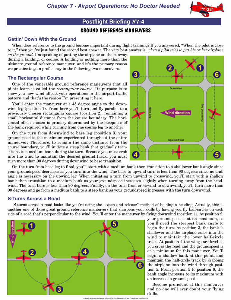
Chapter 7 - Airport Operations: No Doctor Needed
GROUND REFERENCE MANEUVERSGettin’ Down With the Ground
When does reference to the ground become important during flight training? If you answered, “When the pilot is closeto it,” then you’ve just found the second best answer. The very best answer is, when a pilot tries to put his or her airplaneon the ground. I’m speaking of putting the airplane on the runwayduring a landing, of course. A landing is nothing more than theultimate ground reference maneuver, and it’s the primary reasonwe practice to gain proficiency in the following two maneuvers.
The Rectangular CourseOne of the venerable ground reference maneuvers that all
pilots learn is called the rectangular course. Its purpose is toshow you how wind affects your operations in the airport trafficpattern and that’s the reason I’m presenting it here.
You’ll enter the maneuver at a 45 degree angle to the down-wind leg (position 1). From here you’ll turn and fly parallel to apreviously chosen rectangular course (position 2), remaining asmall horizontal distance from the course boundary. The hori-zontal offset chosen is primary determined by the steepness ofthe bank required while turning from one course leg to another.
On the turn from downwind to base leg (position 3) yourgroundspeed is the maximum experienced throughout the entiremaneuver. Therefore, to remain the same distance from thecourse boundary, you’ll initiate a steep bank that gradually tran-sitions to a medium bank during the turn. Because you must crabinto the wind to maintain the desired ground track, you mustturn more than 90 degrees during downwind to base transition.
On the turn from base leg to final, you’ll start with a medium bank then transition to a shallower bank angle sinceyour groundspeed decreases as you turn into the wind. The base to upwind turn is less than 90 degrees since no crabangle is necessary on the upwind leg. When initiating a turn from upwind to crosswind, you’ll start with a shallowbank then transition to a medium bank as your groundspeed increases slightly when turning away from the head-wind. The turn here is less than 90 degrees. Finally, on the turn from crosswind to downwind, you’ll turn more than90 degrees and go from a medium bank to a steep bank as your groundspeed increases with the turn downwind.
S-Turns Across a RoadS-turns across a road looks like you’re using the “catch and release” method of holding a heading. Actually, this is
another one of those great ground reference maneuvers that sharpens your skills by having you fly half-circles on eachside of a road that’s perpendicular to the wind. You’ll enter the maneuver by flying downwind (position 1). At position 2,
your groundspeed is at its maximum, soyou’ll need the steepest bank angle tobegin the turn. At position 3, the bank isshallower and the airplane crabs into thewind to maintain the lower half-circletrack. At position 4 the wings are level asyou cross the road and the groundspeed isat a minimum for this maneuver. You’llbegin a shallow bank at this point, andmaintain the half-circle track by crabbingthe airplane into the wind through posi-tion 5. From position 5 to position 6, thebank angle increases to its maximum withan increase in groundspeed.
Become proficient at this maneuverand no one will ever doubt your flyingskills.
G31
Postflight Briefing #7-4
Licensed exclusively for DeWayne Britton ([email protected]) Transaction: #0002858938

Rod Machado’s Private Pilot Handbook
AVOIDING RUNWAY INCURSIONSThe FAA is very concerned about
something known as runway incursions.They don’t want airplanes to bump intoeach other (and not because airplane’sdon’t have bumpers, either). Runwayincursions are events involving the unau-thorized presence of an aircraft, vehicleor person on a protected area designatedfor the landing and takeoff of aircraft.According to the FAA, approximately65% of these incursions are caused bypilots, three-quarters of the 65% arecaused by general aviation pilots. Let’s seehow we might avoid this problem.
Tower controlled airports have their air-port surface divided into movement areassuch as taxiways and runways, and non-movement areas such as ramps, aprons, etc.(See Postflight Briefing 7-2, position O.) Themovement area is found on the solid side ofthe parallel “solid yellow, dashed yellow” lineand is controlled by the tower. You must obtain a taxi clearance before entering thisarea. A clearance is not necessary to taxi on the dashed side of the parallel “solid yel-low, dashed yellow” line (the non-movement area). This area is not controlled by ATC.
When operating out of an unfamiliar airport, you should check theAirport/Facility Directory supplemental pages for the airport diagram and the hotspots page. The hot spots page describes any recognized hot spots for your airport(Figure 51). These are areas designated by the letters HS followed by a referencenumber on the airport diagram. Hot spots are enclosed by open circles or polygonson the airport diagram and are areas which are complex or confusing areas of taxiway or runway intersections offeringincreased risk of runway incursions for the unaware. Make sure you look closely at these areas before taxi and beforelanding. At John Wayne airport, for instance, HS 2 is an area between parallel runways where pilots have been known toturn off one runway and directly onto another without a clearance (Figure 52).
Once you’re familiar with any hot spots that exist you’ll want to use the airport diagram (Figure 53) to plot yourassigned or planned taxi route to the departure runway. That’s right. Run your finger along the route you wereassigned as if it’s a miniature airplane (just don’t make the engine noise...unless you really want to).
If at any time you become uncertain about your position or the instructions you were given, ask ATC to say themagain or request progressive taxi instructions (meaning that ATC will give you step-by-step taxi instructions).
ATC will normally give you a clearance to the departure runway. If ATC tells you to hold short of the runway, thenyou are required to read back all runway hold short instructions to the controller, verbatim. If you want a career instandup comedy, this isn’t the place to start it. Be serious, be clear, be accurate with your readback. When cleared to arunway, I set the heading bug (on the DG) to the number of the departure runway. This helps ensure that when ATCclears me onto the runway, I’m actually on the correct runway (some runways intersect at a small angle and it’s possi-ble to confuse one with the other if you’re not careful). Speaking of being cleared onto the runway, ATC no longer usesthe term taxi into position and hold for departing airplanes. Instead, the phrase line up and wait is now used because itoffers less chance of misinterpretation. And if you’re waiting on the runway and don’t hear anything from ATC for 90seconds, call them and remind them of where you are. Yes, controllers are people too, and they can forget about you.
Whatever you do, don’t taxi onto a runway unless you’ve been given clearance to do so. Period! Doing so becomesextremely dangerous if that runway is being used by another airplane. This is the reason that pilots are requested toilluminate all external airplane lights when crossing any runway (landing and taxi lights, nav lights, strobe lights,etc.). It simply makes it easier for other airplanes to see you just in case you aren’t where you’re supposed to be orsomeone else isn’t where one of you should be. And when you line up and wait on the runway at night, do so a little tothe left or right of the centerline. This makes your airplane easier to identify (and avoid) on the runway at night.
So keep your eyes open, ask ATC for clarification when necessary, and before you start taxiing, always use yourairport diagram to make certain you know where you're going and how you are going to get there.
G32
Postflight Briefing #7-5
Fig. 51
Fig. 52
Fig. 53
Licensed exclusively for DeWayne Britton ([email protected]) Transaction: #0002858938