rock varnish and desert ironbutcontains very
TRANSCRIPT

Figure 1. Petroglyphs etched on varnished rocks in Saguaro Natronal Monument west of Tucson.Photo by Evelyn Vanden Dolder.
ROCK VARNISH AND DESERT
PAVEMENT PROVIDE GEOLOGICAL
AND ARCHAEOLOGICAL RECORDS
Vol. 22, No. 1
by Evelyn M. VandenDolderArizona Geological Survey
In the deserts of the southwestern United States, "rock art" in the form ofpetroglyphs and geoglyphs provides glimpsesinto the lives of early inhabitants (Figure1). Rock varnish and desert pavementwere the "paints" and "canvases" usedfor these artworks. These same materials
_,hold clues to climates of the past and offergeologists another means of dating landsurfaces and recent geologic events, suchas floods and debris flows.
ROCKVARNISH
Rock varnish is the thin (commonly 10to 30 microns thick), dark, hard, glossy
Investigations . Service . Information
coating that accumulates on rock surfaces after long exposure (Dorn and Oberlander, 1982). The commonly used termdesert varnish is somewhat of a misnomer because the same type of glaze thatcoats rocks in desert environments alsocovers rocks in arctic, alpine, and otherregions (Krinsley and Dorn, 1991). Thisterm, however, may be more popularbecause rock varnish is best developedand most noticeable in desert regions,where rock exposures are numerous.
The color of the rock varnish reflectsits composition. Black varnish, the focusof most studies of rock varnish, forms onsurfaces exposed to air. The black coloris due to the concentration of manganeseoxides. Orange varnish, which is rich in
Spring1992
iron but contains very little manganese,develops on the undersides of rocks indesert areas. The manganese concentration inblack varnishis commonly50 timesthat in orange varnish (Dorn and Oberlander, 1981b). Dusky-brown varnish isintermediate in both color and composition. As the varnish thickens with time,its color darkens: The upper surfaces ofrocks graduate from brownish-black toebony, and the undersides ofrocks changefrom orange to red.
Scientists studying the rate of varnishaccumulation have discovered differences based on the environment. In laboratory experiments in which limitingfactors were controlled, vamishesformedin less than 6 months (Dorn and Oberlander, 1981a). Varnishes have formedwithin 40 years in arctic regions and inless than 100 years in riverine areas (Dornand Oberlander, 1982). In deserts, however, varnishes form much more slowly.Most scientists believe that it takes thousands to tens of thousands of years forvarnish to coat a rock completely in thedesert (Krinsley and Dorn, 1991). Thevarnishes on many desert rocks havebeen accumula ting since the Pleistocene.
Rockvarnish is composed of clay minerals, such as illite, montmorillonite, andkaolinite, as well as manganese and ironoxides. Clay minerals compose up to 70percent ofblack manganese-rich varnishand up to 90 percent of orange manganese-poor varnish (Potter and Rossman,1977,1979). Lesser amounts of silica, calcium carbonate, and trace elements (e.g.,magnesium, potassium, phosphorus, calcium, and titanium) may also be present(Dohrenwend, 1987; Krinsleyand Dorn,1991).
Conflicting theories have been proposed for the formation of black rockvarnish. Early theories suggested aninternal source (the underlying rock)for varnish constituents and a chemical
(continued on page 4)
ALSO IN THIS ISSUEEnvironmentaIEducationPlan 2Crustal Extension in Arizona 8Resources for Teachers 11

Environmental Education in ArizonaBecomes a Coordinated Effort
Figure 1. Chris Willmms (left foreground) of the U.S. Soil Conservation Service and Chairman ofthe Governor's Task Force on Environmental Education, presents a copy of the Comprehensive Planfor Environmental Education to Governor Fife Symington. Other government officmls pictured inthe background are, left to right, Dan McGovern (U.S. Environmental Protection Agency, Region.aIX), C. Dmne Bishop (Superintendent of Public Instruction), Cynthm Krug (Arizona State Parks),"Senator Karan English (Chairman of the Arizona Senate Environment Committee and primary sponsorof the Arizona Environmental Education Act), Jack Haenichen (Arizona Energy Office), and Representative Bill Mundell (Chairman of the Arizona House of Representatives Environment Committee).
On January 7, 1992, the Governor'sTask Force on Environmental Educationpresented its report, Comprehensive Planfor Environmental Education, to GovernorFife Symington (Figure 1). The Task Forcewas established by the Arizona Environmental EducationActofJune 6, 1990(HB2675). It consists of 31 members withexperience in environmental issues whorepresent private citizens and organizations, educational institutions, State andFederal agencies, the Legislature, and theGovernor's Office. The Comprehensive Planfor Environmental Education presents 5goals, 14 objectives, and92 recommendations to accomplish the legislative intentof HB 2675: to develop an integratedenvironmental education program thatprovides students and the general publicwith an awareness that is "thorough,continuous and meaningful." The TaskForce has specified the organizations thatit believes should be responsible for enacting the recommendations, bothformaleducational institutions (e.g., the ArizonaDepartmentofEducation, public and private schools, and universities) and informal educational groups (e.g., the Governor, Legisla ture, Sta te agencies, media,and industry).
At that same meeting on January 7,Governor Symingtonandrepresentativesfrom 16 State agencies signed a Memorandum ofUnderstanding to encourage coordination of interagency activities in environmental education. The 16-memberArizona Interagency Committee onEnvironmental Education, established by theArizona Environmental Education Act,includes the following agencies: ArizonaDepartment of Transportation, ArizonaDepartment ofWater Resources, ArizonaDepartment of Environmental Quality,Arizona State Land Department, ArizonaState Parks, Arizona Geological Survey,Arizona Energy Office, Arizona Solar Energy Advisory Council, Arizona Gameand Fish Department, Arizona Department of Agriculture, Arizona Office ofTourism, Arizona DepartmentofEducation, Commission on the Arizona Environment, Arizona State Mine Inspector,Arizona Department of Health Services,and Office of the Attorney General.
Excerpts from bothof these documentsare reprinted below.
Comprehensive PlanforEnvironmental Education
"Environmentaleducationis that component of education thatmay include one
2
or more of the following: aesthetic appreciation of the natural world; basic scientific knowledge ofhow the natural worldworks; appreciation of the value of environmental quality; understanding ofhowhumans affect their environmentandhowthe environment affects humans, pastand present; experience in how personalchoices and actions affect the naturalenvironment; and experience inmethodsoflocal-through-global communityresponsibility, in order to deal effectively withcontemporary environmental issues....
"The primary goals of environmentaleducation in Arizona are:(1) Each individual should have a basic
understanding of the environmentalsciences.
(2) Each individual should understandthe interrelationships between human actions and the environment.
(3) Environmental education should beintegrated into all school curriculums.
(4) Diverse environmental educationopportunities should be available tothe general publi~.
(5) Environmental education inArizonashould be a cooperative venture,
coordina ted at all levels within thestate and with national and international networks....
"The ... objectives developed by theTask Force [are]:(1) To coordinate environmental edu
cation efforts among all public andprivate agencies, organizations andeducational institutions.
(2) To begin operation of a statewidenetwork for environmental education.
(3) To develop policy documents recognizing the importance of environmental education and establishprogram guidelines to implementARS 15-706.
(4) To coordinate research in environmental education among public andprivate agencies, organizations andeducational institutions.
(5) To identify diverse funding sourcesand direct allocation of availablefunds for environmental education_inArizona. ,.,
(6) To create models of environmentalresponsibility at schools and otherpublic facilities.
Arizona Geology, vol. 22,no.1,Spring1992

-- William K. ReillyAdministrator, U.S. Environmental Protection Agency
iiln the end, environmental education boilsdown to a simple yetprofoundly importantimperative: preparing ourselves for life andall its surprises in the next century. Whenthe 21st century rolls around, itwill not beenough for a few specialists to know whatis going on while the rest of us wanderaround in ignorance."
I) (8)
(7) Assessing the characteristics and effectiveness of intra and interagencyprograms; and
(8) Providing recommendations for action by agencies to improve theirenvironmental educationprograms.
"The undersigned agencies agree:(1) To direct their respective staffs to
provide information and cooperatefully with the Committee.
(2) To submit to the Department of Ed~ucation references of environmentaleducational materials used by theagency for inclusion in the Environmental EducationResourceInformationSystem.
(3) To provide available resources, atthe discretion of the Agency, including funds, staff and technical information to the Committee to facilitatethe Committee's statutorymandates.
(4) To establisha formal processfor sharing environmental educationmaterials for review by the Committee.
(5) To periodically provide informationto the Committee regarding the agencies' environmental education programs and events.
(6) To develop interagency training opportunities to facilitate the development and coordination of environmental education."
Memorandum ofUnderstanding
Education Task Force Fund will be financed by private individuals and organizations. By December 3t 1991, about$110,000 had been donated to the firstand third funds. Most of this money camefrom the Arizona Game and Fish Heritage Fund.
The 66-page Comprehensive Plan forEnvironmental Education also includes thetext of the Arizona Environmental Education Act of 1990, SB 1176 amending the1990 Act, and the Tbilisi Declaration(adoptedby delegates to the World's FirstIntergovernmental Conference on Environmental Education inOctober 1977), aswell as a synopsis of the National Environmental Education Act of 1990. Singlecopies of the Comprehensive Plan for Environmental Education are free and available from Jeff Cohen, Arizona Dept. ofEducation, 1535 W. Jefferson, Phoenix,AZ 85007; tel: 1-602-542-5950.
"The objectives of this agreement arethat the undersigned agencies ... haveformed the Arizona Interagency Committee on Environmental Education ... tocoordinate, improve and supporteducation aboutArizona's Natural and CulturalEnvironments past and present. TheCommittee shall encourage the coordination of interagency activities regardingenvironmental education to promote theefficient distribution of information, andto facilitate the planning and development of educational materials of stateagencies. The Committee shall also act as
a liaison betweenlocal, state andfederal agenciesrelating to environmental education in Arizona.
,'The Committee shall achieveits purpose by:(l)Coordinatingagency services,programs andmaterials;(2) Cooperativelydeveloping educationalmaterialsand programs;(3) Providing technical review for
accuracy and validity of memberagency educational materials;
(4) Implementingprograms;(5) Communicatingbetween and among
participating local, state and federalagencies;
(6) Providing professional developmentand training opportunities for member agencies and audiences;
(7) To implement a comprehensive program integrating environmental education throughoutthekindergartenthrough twelfth grade curriculum insupport of ARS 15-706 by 1994.To provide training in environmental education as a part of preserviceand graduate-level teachers' coursework to implement ARS 15-1643 by1993.
(9) To implementanintegratedprogramof teacher in-service training in environmental education by 1993.
(10) To integrate environmental education into all post-secondary degreeprograms in Arizona by 1994.
(11) To assess Arizona's environmentaleducationprograms ona regular basisbeginning in 1995.
(12) To improve communication betweenagencies, organizations and the media and expand coverage of environmental issues and environmentaleducation.
(13) To create new and utilize existingrecognition programs which supportinnovative or outstanding efforts inenvironmental education.
(14) To establish a body to pursue fullimplementation of this comprehensive environmental education planfor Arizona."
Bypassing theArizona Environmental~ .• Education Act, Arizona became one of~ only a handful of States who have rec
ognized the importance ofcreatinga strongenvironmental education program. HB2675 established three funds to supportthe activities described in the bill. The
Arizona Department of Education's Environmental Education Fund maybe subsidized by legislative appropriations ordonations from interested individuals and
_.. organizations. The Environmental Num-• ber Plate Fund will be collected by the
Arizona Department of Transportationthrough the sale of environmental number plates. The Arizona Environmental
Arizona Geology, vol. 22, no.1, Spring 1992 3
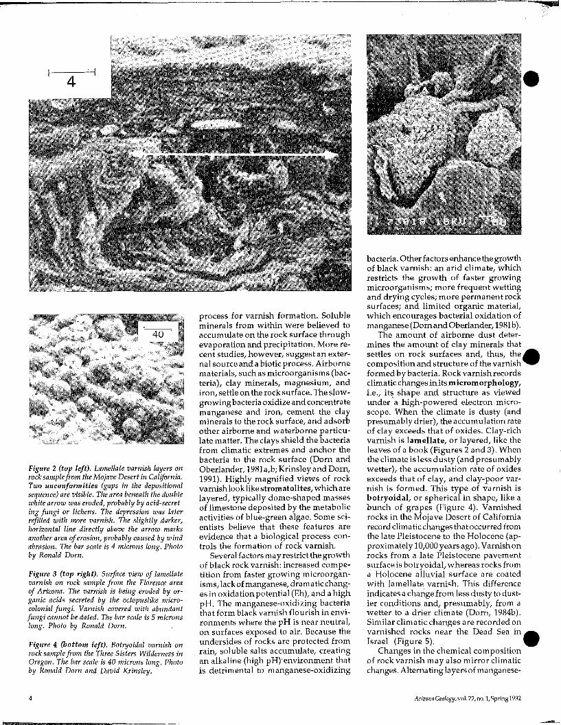
Figure 2 (top left). Lamellate varnish layers onrock samplefrom the Mojave Desert in California.Two unconformities (gaps in the depositionalsequence) are visible. The area beneath the doublewhite arrow was eroded, probably by acid-secreting fungi or lichens. The depression was laterrefilled with nwre varnish. The slightly darker,horizontal line directly above the arrow marksanother area oferosion, probably caused by windabrasion. The bar scale is 4 microns long. Photoby Ronald Dorn.
Figure 3 (top right). Surface view of lamellatevarnish on rock sample from the Florence areaof Arizona. The varnish is being eroded by organic acids secreted by the octopuslike microcolonial fungi. Varnish covered with abundantfungi cannot be dated. The bar scale is 5 micronslong. Photo by Ronald Dorn.
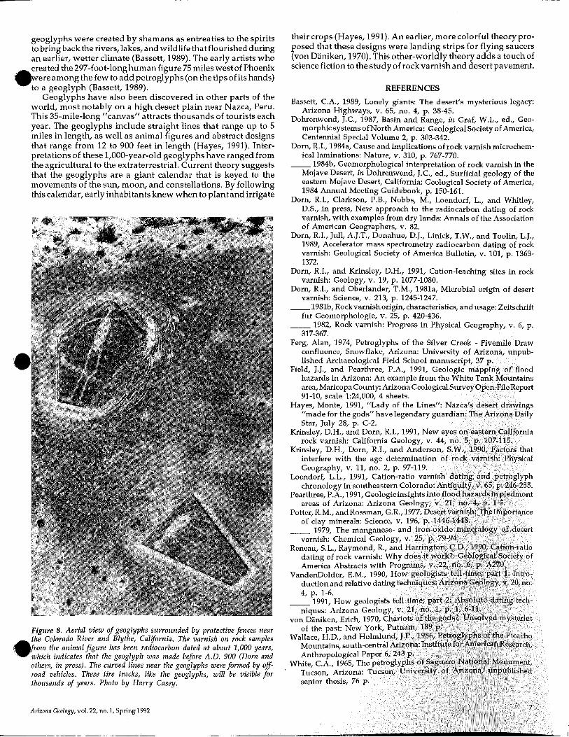
Figure 4 (bottom left). Botryoidal varnish onrock sample from the Three Sisters Wilderness inOregon. The bar scale is 40 microns long. Photoby Ronald Dorn and David Krinsley.
4
process for varnish formation. Solubleminerals from within were believed toaccumulate on the rock surface throughevaporation and precipitation. More recent studies, however, suggest an external source and a biotic process. Airbornematerials, such as microorganisms (bacteria), clay minerals, magnesium, andiron, settle on the rock surface. The slowgrowingbacteria oxidize and concentratemanganese and iron, cement the clayminerals to the rock surface, and adsorbother airborne and waterborne particUlate matter. The clays shield the bacteriafrom climatic extremes and anchor thebacteria to the rock surface (Dorn andOberlander, 1981a,b; Krinsley and Darn,1991). Highly magnified views of rockvarnish looklike stromatolites, which arelayered, typically dome-shaped massesof limestone deposited by the metabolicactivities of blue-green algae. Some scientists believe that these features areevidence that a biological process controls the forma tion of rock varnish.
Severalfactors may restrict the growthof black rock varnish: increased competition from faster growing microorganisms,lack of manganese, dramatic changes in oxidation potential (Eh), and a highpH. The manganese-oxidizing bacteriathat form black varnish flourish in environments where the pH is near neutral,on surfaces exposed to air. Because theundersides of rocks are protected fromrain, soluble salts accumulate, creatingan alkaline (high pH)'environment thatis detrimental to manganese-oxidizing
bacteria. Other factors enhance the growthof black varnish: an arid climate, whichrestricts the growth of faster growingmicroorganisms; more frequent wettingand drying cycles; more permanent rocksurfaces; and limited organic material,which encourages bacterial oxidation ofmanganese (Dorn and Oberlander, 1981b).
The amount of airborne dust determines the amount of clay minerals thatsettles on rock surfaces and, thus, the acomposition and structure of the varnish..formed by bacteria. Rockvarnish recordsclimatic changes inits micromorphology,Le., it~. shape and structure as viewedunder a high-powered electron microscope. When the climate is dusty (andpresumably drier), the accumulation rateof clay exceeds that of oxides. Clay-richvarnish is lamellate, or layered, like theleaves of a book (Figures 2 and 3). Whenthe climate is less dusty (andpresumablywetter), the accumulation rate of oxidesexceeds that of clay, and clay-poor var-nish is formed. This type of varnish isbotryoidal, or spherical in shape, like abunch of grapes (Figure 4). Varnishedrocks in the Mojave Desert of Californiarecord climatic changes that occurred fromthe late Pleistocene to the Holocene (approximately 10,000 years ago). Varnish onrocks from a late Pleistocene pavementsurface is botryoidal, whereas rocks froma Holocene alluvial surface are coatedwith lamellate varnish. This differenceindicates a change from less dusty to dust-ier conditions and, presumably, from awetter to a drier climate (Dorn, 1984b).Similar climatic changes are recorded onvarnished rocks near the Dead Sea in_Israel (Figure 5). •
Changes in the chemical compositionof rock varnish may also mirror climaticchanges. Alternating layers ofmanganese-
Arizona Geology, vol. 22, no. 'i,Spring1992

Figure 5. Lamellate varnish layers deposited on top of botryoidal varnish layers on rock sample fromIsrael. The sample was collected from an ancient shoreline of Lake Lisan (the precursor of the DeadSea). This shoreline receded about 18,000 years ago. The climate in the area was still wet, however,and fostered the development of the botryoidal varnish. About 10,000 years ago, as the climate becamedrier, the lamellate varnish formed. The bar scale is 7 microns long. The white line indicates theboundary between the varnish and the rock. Photo by Ronald Dorn.
rich and manganese-poor varnish mayindicate changes in the alkalinity of airborne (eolian) dust. Based on studies ofrock varnish, scientists estimate that atleast 13 fluctuations in eolian alkalinityhave occurred during the last 1.1 millionyears. These fluctuations may reflect cycles of low moisture, sparse vegetation,and playas (dry lake basins) followed byhigh moisture, denser vegetation, andshallow lakes (Dorn, 1984a).
Both geologists and archaeologists(ehave used rock varnish as a relative dat" ing method. (See VandenDolder, 1990,
1991 for more information onrelative andabsolute dating techniques.) Geologistsstudying areas with potential flood anddebris-flow hazards use the presence ofrock varnish and the degree of its development as one measure of the time thathas elapsed since an area was flooded ordisturbed (Pearthree, 1991). Archaeologists have also used this method to determine the relative ages of petroglyphsand varnished artifacts.
Petroglyphs, or incised rock designs(Figures 1 and 6), were created by earlyinhabitants of the Southwest, who scrapedaway the dark varnish to expose theunderlying light-colored rock. (Pictographs, by comparison, are designs thathave been painted on rocks.) Archaeologists believe that petroglyphs are not acomplex language, as are hieroglyphs,nor are they the idle doodles of prehistoric peoples. Petroglyphswith geometricdesigns that are similar to those used inprehistoric pottery maybejust decorativeelements. Anthropomorphic petroglyphsof figures tha t are dancing or wearingheaddresses, however, mayillustrate cere-
A.monial aspects of a prehistoric culture,.,(Figure 6). Some petroglyphs may depict
shamans, mythical beings, or even gods.Petroglyphs that show successful huntingscenes may be a ceremonial way of cap-
turing the magic of the hunt and controlling nature by invoking the help of thespirit world (White, 1965i Ferg, 1974).Galleries of petroglyphs adorn the rocksof the Southwest, including Arizona,which contains more petroglyphs thanany other State (White, 1965). Hundredsof sites and thousands of designs havebeen discovered in the Picacho Mountains alone, midwaybetweenTucson andPhoenix (Wallace and Holmlund, 1986).Petroglyphs discovered in the westernsection of Saguaro National Monumentnear Tucson were probably etchedby theHohokam from A.D. 900 to 1300 (White,1965).
To obtain more quantitative, absolutedates for black rock varnish, scientistsrequire rock samples on which the varnish has been continually deposited. Byviewing thin sections of varnish sampIesunder an electron microscope, scientistscandetermine which sampIes have neverbeen eroded by wind abrasion, acidsecretingmicroorganisms, or other mechanisms and, thus, are more reliable forabsolute dating (Figures 2and 3i Krinsleyand others, 1990).
The oxidizing and alkaline environment of desert regions hinders the preservation of charcoal and other materialsthat could be dated by the 14C (radiocarbon) method. Because rock varnish contains organic carbon, the radiocarbonmethod has been used to date samplesscraped from the lowest (oldest) layers ofthe varnish. The dates represent minimum ages because they reflect when thelowest varnish layers were deposited,not necessarily when the object was firstexposed to air (Dorn and others, 1989).
Another dating technique, bulk chemical analysis of varnish coats, has beenused when the amount of carbon in avarnish sample is insufficient or the sample is too old for radiocarbon dating. Thesurface area of most petroglyphs, forexample, is too small for radiocarbon dating (Dorn and others, 1989). Throughchemical analysis, a researcher can determine the ratio of potassium and calciumcations (positively charged ions) to titanium cations (K+ + Ca2+/Ti4+) ina varnishsample (DornandOberlander, 1981bi Dornand Krinsley, 1991). This technique assumes that potassium and calcium aremore mobile than titanium and are leachedfrom the varnish as it ages. The cationra tio of rock varnish, therefore, decreases with time (Dorn and Krinsley, 1991).
Although the use of this dating methodis controversial (Reneau and others,1990), some tests of its validityhave beenfavorable (e.g., Loendorf, 1991).
DESERTPAVEMENT
Desert pavement is a veneer of closelypacked pebbles, cobbles, andboulders thatmantles a desert surface and overliesdeposits of sand, silt, and clay (Figure 7).It develops in relatively stable environments where the vegetation is sparse,such as abandoned alluvial-fan surfacesin arid regions (Dohrenwend, 1987).
Early theories suggested that desertpavement developed as thewind removedsmaller particles, such as sand and dust,from the spaces betweenrockfragments.Recent studies, however, suggest a more
Figure 6 (a and b). Petroglyphs near PictureRocks Retreat in northwestern Tucson reflectceremonial aspects ofa prehistoricculture. Photosby Evelyn VandenDolder.
5

complex series of processes. Repeated cycles of wetting anddrying cause the soil to swell and shrink, respectively. Whenthe soil swells, the larger rock fragments are lifted slightly; whenthe soil shrinks, it cracks, and finer grained material falls or iswashed into the cracks. The rockfragments are graduallybroughtto the surface, and the finer grained material is graduallydisplaced downward. Desert pavements, therefore, are notformed because finer grained material is carried away by thewind; rather, they are produced by the accumulationof this finegrained material and the lifting of larger rock fragments as thismaterial expands and contracts in response to repeated cyclesof wetting and drying (Dohrenwend, 1987).
Salts contained in desert soils cause the mechanical weathering (splitting) of rock fragments and the smoothing of desert
Where to See Rock Varnish, DesertPavement,Petroglyphs,and Geoglyphs
Rock varnish and desert pavement are especiallywell-developed in areas that have been relatively undisturbed, such as abandoned alluvial fans near mountain ranges. Varnish may also coat the rocks and pavement may mantle the desert surface along hiking trails.
Petroglyphs are etched in rocks throughoutArizona.Some of the most accessible sites are Painted Rocks StatePark west of Gila Bend, Petrified Forest National Parkeast of Holbrook, Waterfall Canyon (Maricopa CountyPark) in theWhite Tank Mountains west ofPhoenix, andSignal Hill in Saguaro National Monument west ofTucson. Archaeologists at the Pueblo Grande Museumand Cultural Park in Phoenix give tours to view petroglyphs in South Mountain Park. Call Tom Hulen at 1602-495-0901 for more information. To learn about interpretive programs on petroglyphs at Saguaro NationalMonument--West, call 1-602-883-6366.
Numerous geoglyphshavebeen discovered along theColorado River. The most accessible site is just north ofBlythe, California. Drive about 10 miles north on U.S.Highway 95 just past the agricultural area. Watch forthe turnoff and sign for the "Desert Intaglios."
Archaeologists andparkofficials request thatallvisitorstreat these and other cultural sites with respect, leavingall petroglyphs, geoglyphs, and artifacts untouched.
6
w
Figure 7 (a and b). Desert pavement on alluvial fan near the White TankMountains west of Phoenix. Note the mosaic of rock fragments and thepaucity of fine-grained sediments. Photos by John Field.
pavements. Medium- to coarse-grained plutonic andmetamorphic rocks are more susceptible to salt weathering, wh:reasmany fine-grained sedimentaryandvolcanic rocks are relativelyresistant. Inareas that contain a variety of rocks, the compositionof a desert pavement reflects the reIative age of that pavement:Older pavements consist of fewer coarse-grained and morefine-grained rock fragments (Dohrenwend, 1987). Varnish isgenerally darker on finer grained rocks because these rocks aremore stable.
Geologists studying the history of flooding in an area haveused the extent of pavement development to help determinewhen the last flood occurred (Field and Pearthree, 1991; Pearthree, 1991). The physical characteristics of alluvial surfaces(areas covered by stream deposits) on piedmonts in the aridSouthwest prOVide clues to their relative ages. The ages of thesesurfaces reflect the last time they were modified thr.ough de-_position or abrasionby large streams. Older surfaces, l.e., thosethathave notbeen disturbed for thousands of years, are mantledby well-developed desert pavements. Geologic processes, suchas floods and debris flows, may strip away desert pavements,leaving traces of their passage.
The rate of pavement development depends on the extentof development of the soil horizon closest to the land surface.(A soil horizon is a distinguishable layer of soil characterizedby its structure, color, texture, content of organic matter, ordegree of acidity or alkalinity. In the desert, the A horizon, thesoil horizon closest to the land surface, is typically composedof silt, clay, sand, and organic matter.) The more the underlyingsoil horizon is developed, the faster is the development of thedesert pavement. In areas where the desert pavement wasartificially stripped but the underlying soil horizon was leftintact, well-developed pavements re-formed in less than 25years. Onlate Holocene (younger than 4,000-year-old) alluvialfan surfaces, the uppermost soil horizons (and thus, the desertpavements) are commonly absentorveryweakly developed. Onolder surfaces (middle Holocene to late Pleistocene), bothhorizons and pavements are progressively better developed(Dohrenwend,1987).
Before desert pavement was studied by geologists, it wasaltered by early inhabitants of the Southwest to "draw" giantfigures called geoglyphs. Geoglyphs were created by movingand stacking the black varnished rocks of the desert pavementto expose the lighter, underlying soil horizon. About 300 geoglyphs portraying humans, game animals, reptiles, and abstractdesigns (Figure 8) have been discovered in the deserts of the_Southwest. Rock varnish on several geoglyphs along the Col- •orado River has been radiocarbon dated at about 1,000 years.'These geoglyphs, therefore, are older than aboutA.D. 900 (Dornand others, in press). Some archaeologists believe that the
Arizona Geology, vol. 22, no. I,Spring1992
their crops (Hayes, 1991). An earlier, more colorful theory proposed that these designs were landing strips for flying saucers(von Daniken, 1970). This other-worldly theory adds a touch ofscience fiction to the study of rock varnish and desert pavement.
REFERENCES
Bassett, CA., 1989, Lonely giants: The desert's mysterious legacy:Arizona Highways, v. 65, no. 4, p. 38-45.
Dohrenwend, J.C, 1987, Basin and Range, in Graf, W.L., ed., Geomorphic systems ofNorth America: Geological Society of America,Centennial Special Volume 2, p. 303-342.
Dorn, R.I., 1984a, Cause and implications ofrock varnishmicrochemicallaminations: Nature, v. 310, p. 767-770.
__ 1984b, Geomorphological interpretation of rock varnish in theMojave Desert, in Dohrenwend, J.C, ed., Surficial geology of theeastern Mojave Desert, California: Geological Society of America,1984 Annual Meeting Guidebook, p. 150-161.
Dorn, R.I., Clarkson, P.B., Nobbs, M., Loendorf, L., and Whitley,D.S., in press, New approach to the radiocarbon dating of rockvarnish, with examples from dry lands: Annals of the Associationof American Geographers, v. 82.
Dorn, R.I., Jull, A.J.T., Donahue, D.J., Linick, T.W., and TooHn, L.J.,1989, Accelerator mass spectrometry radiocarbon dating of rockvarnish: Geological Society of America Bulletin, v. 101, p. 13631372.
Dorn, R.I., and Krinsley, D.H., 1991, Cation-leaching sites in rockvarnish: Geology, v. 19, p. 1077-1080.
Dorn, R.I., and Oberlander, T.M., 1981a, Microbial origin of desertvarnish: Science, v. 213, p. 1245~1247.
__1981b, Rock varnish origin, characteristics, andusage: Zeitschriftfur Geomorphologie, v. 25, p. 420-436.
__ 1982, Rock varnish: Progress in Physical Geography, v. 6, p.317-367.
Ferg, Alan, 1974, Petroglyphs of the Silver Creek - Fivemile Drawconfluence, Snowflake, Arizona: University of Arizona, unpublished Archaeological Field School manuscript, 37
Field, J.J., and Pearthree, P.A., 1991, Geologic nU1PI,illghazards in Arizona: An from the White MCJtll!ltainsarea, Maricopa County: Arizona Ge,ol()gical SUlrv1eyIDpen-Fille:Ftep>ort91-10, scale 1:24,000,4 sheets.
Hayes, Monte, 1991, "Lady of the Lines": "'"'7""""made for the gods" have legendary guarcliaJtl:Star, July 28, p. C-2.
Krinsley, D.H., and Dorn, R.I., 1991, Newrock varnish: California v.
Krinsley, D.H., Dorn, R.I., and ArldclrSl)n,interfere with the age determinationGeography, v. 11, no. 2, p. 97-119.
Loendorf, L.L., 1991, Cation-ratiochronology in southeastern CO'101'ado: ,A:ntic!
Pearthree, P.A.,1991, Ge,ol()gilcIDLsiil.ht1,inetof1()(areas of Arizona: Arizona Gcml'Jl!:''f,
Potter, R.M., and Rossman, G.R.,of clay minerals: Science, v.
__ 1979, The manganesevarnish: Chemical Geology,
Reneau, S.L., Raymond, R., and mITringdating of rock varnish:America Abstracts with Pr'JgramLs,
VandenDolder, E.M., 1990,duction and relative dating bedlruJ4, p. 1-6.
__ 1991, How l!:ec)lo~.ists
niques: Arizona Ge1ology,von Diiniken, Erich, 1970, Clllati:ots
of the past: New York, Fl1",,,mF
Wallace, H.D., and Hc)lrrlIUJtld,].1Mountains, Sl)ll1ttl-ccmtralN'lzAnthropological
White, CA., 1965,Tucson, Arizona:senior thesis, 76
Arizona Geology, vol. 22, no. I, Spring 1992
geoglyphs were created by shamans as entreaties to the spiritstobringback the rivers, lakes, and wildlife that flourished duringan earlier, wetter climate (Bassett, 1989). The early artists who
~.:eated the 297-foot-longhumanfigure 75 miles west of PhoenixW~vereamongthefewtoaddpetroglyphs (on the tips ofitshands)
to a geoglyph (Bassett, 1989).Geoglyphs have also been discovered in other parts of the
world, most notably on a high desert plain near Nazca, Peru.This 35-mile-Iong "canvas" attracts thousands of tourists eachyear. The geoglyphs include straight lines that range up to 5miles in length, as well as animal figures and abstract designsthat range from 12 to 900 feet in length (Hayes, 1991). Interpretations of these l,OOO-year-old geoglyphs have ranged fromthe agricultural to the extraterrestrial. Current theory suggeststhat the geoglyphs are a giant calendar that is keyed to themovements of the sun, moon, and constella tions. By followingthis calendar, early inhabitants knew when to plant and irrigate
Figure 8. Aerial view of geoglyphs surrounded by protective fences nearthe Colorado River and Blythe, California. The varnish on rock samples
~~om the animal figure has been radiocarbon dated at about 1,000 years,which indicates that the geoglyph was made before A.D. 900 (Dom andothers, in press). The curved lines near the geoglyphs were formed by offroad vehicles. These tire tracks, like the geoglyphs, will be visible forthousands of years. Photo by Harry Casey.
Tertiary Extension inWest-Central Arizona
by Jon E. SpencerArizona Geological Survey
Arizona contains some of the world's best known and mostwellexposed areas of extreme crustal extension. Hundreds of mineral deposits containing gold, copper, manganese, and lessabundant uranium, lead, zinc, and silver formed during extension and associated igneous activity. Studies of the geology ofwest-central Arizona over the past 10 years have greatly increased geologists' understanding of how large-magnitude extension occurs and how mineral deposits formed during extension. This article outlines the processes associated with crustalextension andbriefly describes the middle Tertiary geology andtectonic history of west-central Arizona. It does not, however,discuss the origin of mineral deposits. (See Spencer and others[1988] and Spencer and Welty [1989] for information on mineraldeposits related to crustal extension.)
commonly known as detachment faults. Rocks exposed beneathdetachment faults maybeplastically defonned (deformed without fracturing) because they were deformed at high temperatures before being brought to the surface. Plastically deformedrocks, called mylonites, are exposed along the southern flanlr"of the Santa Catalina Mountains and the western flank of th~Rincon Mountains near Tucson (Davis, 1980; Spencer and Reynolds, 1989a; Dickinson, 1991) and in the eastern part of theSouth Mountains near Phoenix (Reynolds, 1985). Areas of detachment faults and associated mylonites are called metamorphic core complexes.
The upper crust (top 15 kilometers) of the Earth is generallybrittle and, thus, is the area where most continental earthquakesoriginate. At greater depths, the temperatures are so high thatrocks deform plastically and do not often build up the greatstresses that cause earthquakes. If temperatures in the lowercrust are high enough, such as during periods of magmatism(intrusion of great volumes of molten rock), the brittle uppercrust floats on the easily deformed lower crust. Under suchconditions, fa ult movement cannot significantly raise themountain ranges because they will sink into the hot, plasticallydeformed lower crust, nor can it significantly deepen thebasinsbecause the lower crustal material will flow into and fill the areasbeneath them. The concept of a strong upper layer floating on
Figure 1. Mountain ranges and regional structural plates in west-central Arizona and southeastern California.Plate 1 consists of rocks that are structurally below the three large normal faults in the area. Plate 2 consistsof rocks that are structurally above the lowest fault but below the highest and largest fault in the region (theBuckskin-Rawhide detachment fault). Rocks that are structurally above the three normal faults compose Plate3 and extend northeastward to the Transition Zone and Colorado Plateau physiographic provinces (e.g., Peirce,1984). Some correlations are speculative: Rocks shown as Plate 2 in California may actually be Plate 1 (Frostand Okaya, 1986).
':,.
Me;;;~~hills
~x 34°00',"
vulture~:
a deeper, fluidlike lower layer is known as isostasy; verticalmovements in the upper crust that occur in response to bUoy-.....ancy forces are known as isostatic adjustments. .,
Isostatic uplift can tilt a high-angle normal fault so that it dipsat a low angle and warp a low-angle normal fault so that it hasa subhorizontal undulating form. A specific type of fa ult, known
~',':::-
~S(~:.C'-'cj PLATE 3
~,':;:::;:?;:::I PLATE 2
m;:;1 PLATE I
~ DETACHMENTFAULT
-L NORMAL FAULT
CRUSTAL EXTENSION
Southern and western Arizona arewithin the Basinand Rangephysiographic province ofNorthAmerica. This area is characterizedbylargely isolatedmountainranges separated by Cenozoicbasins. The Phoenix and Tucsonmetropolitan areas are almost entirelywithinsuchbasins, flankedby mountain ranges of older resistant bedrock. The Basin andRange physiography of Arizonais mainly the result of geologicprocesses that greatly modifiedthe Earth's surface from 30 to 10million years ago. The primarygeologic process was crustal extension. During extension, theEarth's crust is stretched horizontally andbecomes thinner. Inthe traditional view of extension(e.g., Stewart, 1971), mountainranges arebounded by faults thatdip moderately to steeply beneathflankingbasins. Faultmovement causes uplift of the ranges,downdrop of the basins, andhorizontal extension of the crust.These nonnal faults displaceoverlying rocks downward relative to underlying rocks. Highangle nonnal faults, which dipsteeply (generally 40° to 70°),typicallyhave displacements of afew hundred meters to several kilometers.
In the 1970's, geologists began to recognize the importanceof gently dipping (generally 0° to 40°) normal faults known aslow-angle nonnal faults (e.g., Anderson, 1971). Total displacement on these faults may be as much as several tens of kilometers. Low-angle normal faults with large displacements are
8 Arizona Geology, vol. 22,no.1,Spring1992
[==:J QTsv
t::;<1 Tsv
1:;::;:'-::';:1 Mzpzsv
['."'<-'!,-d Tee
as a listric normal fault, is a high-angle normal fault thatflattens and becomes a low-angle normal fault at greaterdepths (e.g., Proffett, 1977). Consider a listric normal faultthat undergoes several tens of kilometers of displacement. Rocks directly below the fault and initially many
a.<ilometers below the Earth's surface are uncovered by-=ault movement. If these rocks remained at this depth,
they would be overlain by a very deep basin. Because ofisostasy, however, they float up to the approximate prefaulting level of the Earth's surface.
WEST-CENTRAL ARIZONA
In west-central Arizona, three low-angle normal faultsdip regionally to the northeast and separate shinglelikefault blocks. The easternmost and structurally highestfault, the Buckskin-Rawhide detachment fault, has by farthe largest displacement. Two structurally lower faultswith less displacement are exposed in the Plomosa andMoonMountains. Some mountain ranges in west-centralArizona lie structurally below all three faults; some lieabove all three faults; some lie above the lowest fault andbelow the highest fault (Figure 1). The structurally midpositioned fault, the Plomosa fault, is exposed in thenorthern Plomosa Mountains. Its location beneath adjacentbasins and its relationship to nearby mountain rangesare uncertain.
The structurally lowest of the three faults is exposedin the New Water and Plomosa Mountains. Rocks to thenortheast of this fault (designated breakaway in Figure2) are broken bynormal faults and tilted to the southwest;they appear to have "broken away" from the less faultedrocks southwest of the breakaway fault. The steep tilt ofsome of the rocks above this fault indicates that the faultflattens with depth and is therefore listric. The Plomosa
eFigure 3. Simplified geologic map of west-central Arizona andsoutheastern California, showing locations of transects for whichmagnitudes of extension have been estimated (Table 1).
Arizona Geology, vol. 22, no. 1, Spring 1992
Figure 2. Simplified geologic map of the Ranegras Plain area showinglocations of four transects for which magnitudes of extension have beenestimated (Table 1). Abbreviations are as follows: QTsv, undeformedQuaternary and upper Tertiary sedimentary and volcanic deposits; Tsv,middle Tertiary sedimentary and volcanic rocks; MzPzsv, Mesozoic andPaleozoic sedimentary and volcanic rocks; and Tec, Tertiary to Proterozoiccrystalline rocks.
(middle) fault has been tilted by movement on the breakawayfault and is now gently dipping. It is thus a tilted high-anglefault or a tilted and warped, listric normal fault.
Total displacement, or extension, along three transect segments of the Plomosa fault is estimated at 23 + 8 kilometers(Figure 2, transects lA, 1B, and 1C; Table 1). E;ctension alonga fourth transect across the Ranegras Plain (Figure 2, transect1D) is approximately 25 kilometers (Table 1). Detailed analysisof each segment is beyond the scope of this article but ispresented in another recent article (Spencer and Reynolds,1991). An example of this analysis follows. At location "A" inthe northern Plomosa Mountains (Figure 2), which is structurallybelow the Plomosa fault, Paleozoic and Mesozoic metasedimentary rocks form fault slices along a Mesozoic thrust fault.Similar rocks at location"B" above the Plomosa fault are thoughtto be the offset equivalents of the rocks at "A." Displacementalong this part of the Plomosa fault is estimated at 13 ± 2kilometers (Table I, segment 1B).
Analysis ofgeologic relationships along three parallel transectsthat cross the Buckskin-Rawhide detachment fault and correlative detachment faults in the Harcuvar and Whipple Moun-
9

Buckskin~Rawhide detachment fault
120110100
®
CD
80 9070
28
60
It
/Plomosa fault
INAC;rIVE
----
20
15
10
tains (Figure 3) shows that displacement along thesefaults was large. Alongtransect segments 2A and 2B, for example, the rocks below the BuckskinRawhide detachment fault have beenalmost completely uncovered by faultmovement. Total fault displacementwas at least as great as the width ofthe area of exposed rocks along thetransect (Spencer and Reynolds, 1989b).Total displacement on the BuckskinRawhide detachment fault and correlative faults has been estimated at 66± 8 kilometers (Table 1; Spencer andReynolds, 1991).
CONCLUSION
Figure 4. Cross-section evolution diagramalong transects lA, lB, and 1C (Figure 2) andtransects 2A, 2B, and 2C (Figure 3). Klippen(cross-section 1) are erosional remnants ofanoriginally sheetlike rock mass above a gentlydipping fault. .
Based on geologic data, researchers (Spencer and Reynolds,1991) have determined the approximate structure thatthe threemajor normal faults in west-central Arizona had when theyformed andbecame active. The faults were initially listric (Figure4, cross-section 1). The listric form of the underside of the faultblock above the Buckskin-Rawhide detachment fault did notchange much during fault movement (Figure 4, cross-sections2 and 3). As they were uncovered, rocks below this fault musthave warped to conform to the curved underside of the faultblock above the detachment fault. Uplift and warping werecausedby isostatic adjustment during uncovering. The flexibilityof the rocks thatform the fault block below the detachmentfault,as revealed by recent analyses (Spencer, 1984; Wernicke andAxen, 1988; Spencer and Reynolds, 1991), is a newly discovered
Table 1. Magnitudes of extension (in kilometers) along several transectsin west-central Arizona (Figures 2 and 3).
and rather astonishing aspect of this type of crustal extension.Earlier researchers (e.g:, Stewart, 1971) believed that the rocksin the fault blocks remained rigid during extension. The morerecent analyses have helped to explain how the processes ofplastic deformation and isostatic uplift were associated withlarge-magnitude crustal extension in west-central Arizona.
REFERENCES
Anderson, R.E., 1971, Thin-skinned distension ofTertiary rocks ofsoutheastertANevada: Geological Society of America Bulletin, v. 82, p. 43-58. •
Davis, G.H., 1980, Structural characteristics of metamorphic core complexes,southernArizona,inCrittenden,M.D.,Jr.,Coney,P.J.,andDavis,G.H.,eds.,Cordilleran metamorphic core complexes: Geological Society of AmericaMemoir 153, p. 35-77.
Dickinson, W.R., 1991, Tectonic setting offaulted Tertiary strata associated withthe Catalina core complex insouthern Arizona: Geological Societyof AmericaSpecial Paper 264,106 p.
Frost, E.G., and Okaya,D.A., 1986, Applicationofseismic reflection profiles totectonic analysis in mineral exploration, in Beatty,Barbara, and Wilkinson,P.A.K.,eds., Frontiers in geology and ore deposits ofArizona and the Southwest: Arizona Geological SocietyDigest 16, p.137-152.
Peirce, H.W., 1984,TheMogollonEscarpment: ArizonaBureau ofGeology andMineral TechnologyFieldnotes, v.14, no. 2, p. 8-11.
Proffett, J.M., Jr., 1977, Cenozoic geologyofthe Yerington district, Nevada, andimplications for the nature ofBasin and Range faulting: Geological Societyof America Bulletin, v. 88, p. 247-266.
Reynolds, S.J., 1985, Geology of the SouthMountains, central Arizona: ArizonaBureau of Geology and Mineral Technology Bulletin 195, 61 p.
Spencer, J.E., 1984, Role of tectonic denudation in warping and uplift of lowangle normal faults: Geology, v.12, p. 95-98.
Spencer, J.E., Duncan, J.T., and Burton, W.D., 1988, The Copperstone mine:Arizona's new gold producer: Arizona Bureau of Geology and MineralTechnology Fieldnotes, v.18, no: 2, p. 1-3.
Spencer, J.E., and Reynolds, S.J.,1989a, Middle Tertiary tectonics ofArizona andadjacent areas, inJenney, J.P., and Reynolds, S.J., eds., Geologic evolution ofArizona: Arizona Geological Society Digest 17, p. 539-574.
__ 1989b, Overview of the geology and mineral resources of the Buckskinand Rawhide Mountains: Arizona Geology, v.19, no. 2, p.l, 6-11.
__1991, Tectonics of mid-Tertiary extension along a transect through westcentral Arizona: Tectonics, p.1204-1221.
Spencer,J.E., and Welty, J.W., 1989, Mid-Tertiary ore depOSits in Arizona, illJenney, J.P., and Reynolds, S.J., eds., Geologic evolution ofArizona: ArizonaGeological Society Digest 17, p. 585-607.
Stewart, J.H., 1971,BasinandRange structure: A system ofhorsts andgrabe_producedby deep-seated extension: Geological Society of AmericaBulletin, v.82,p.l019-1044.
Wernicke, Brian, and Axen, G.J., 1988, On the role of isostasy in the evolutionof normal fault systems: Geology, v. 16, p. 848-851.
10 ArizollaGeology, voI.22,no.1,Spring1992

Resource Materials for Earth Science TeachersCompiled by Emily Creigh DiSante,Arizona Geological Survey
with contributions from Julie Jackson, American Geological Institute
~.
L
Earthquakes is a hands-on, introductory curriculum unit forgrades 4-7 that helps students organize their thinking about thephysical aspects and dynamic nature of the Earth. Developedby JoAnne Wolf, the 13 activities give students practice inmaking both direct and indirect observations, gathering andinterpreting data, and forming their own hypotheses. The 37page book may be ordered for $17.25 (includes shipping) fromScience/Social Science Resource Center, Mesa Public Schools,143 S. Alma School Rd., Mesa, AZ 85210-1103.
Earth Revealed: Introductory Geology is a new, 26-part televisioncourse and public television series thatis suitable for advancedhigh-school earth-science classes. The course is divided into sixtopic areas: an introduction, plate tectonics, geologic time andlife, the rock cycle, carving the landscape, and living withEarth.On February 6, the program began airing on KAET (Phoenix)on Thursday mornings at 2:30 and 3:00 a.m. (two consecutive,half-hour programs) and will run through April 30. For informationon buyingvideocasettes or off-air, duplication, or statewide rights, write to Kimberly A. Smith, The Annenberg/CPBProjects, 901 E Street, NW, Washington, DC 20004; tel: 1-202879-9657.
Science for Children: Resources for Teachers describes some ofthe best materials for hands-on, elementary science teachingthat are available from publishers, distributors, and libraries.
_The 177-page guide lists activity books, curriculum materials,
U5cums, and other sources of information. It was preparedy the National Science Resources Center, a joint effort of the
National Academy of Sciences and the Smithsonian Institu-tion, and is available from the National Academy Press, P.O.Box 285, Washington, DC 20055; tel: 1-800-624-6242. Singlecopies are $9.95; 2 to 9 copies are $8.50 each; 10 or more copiesare $7.95 each.
Earth Science Educationfor the 21st Century: A Planning Guideprovides a rationale and strategies for expanding earth-scienceeducation programs. Developed by the American GeologicalInstitute (AGI) in conjunction with school administrators, teachers, curriculum planners, and scientists, the guide is intendedto assist efforts to improve earth science teaching in gradesK-12. It is divided into four sections that provide a frameworkfor planning and implementing programs: goals for developing curricula; concepts essential to understanding the Earth andits interacting systems; recommendations for teaching earthscience subject matter; and recommendations for implementingnew curricula in the schools. Written primarily for individuals with little or no background in earth science, the 34-pageguide is available for $12.00 (includes shipping), with discountsfor bulk orders, from theAGIPublicationsCenter,P.O. Box 2010,Annapolis Junction, MD 20701; tel: 1-301-953-1744.
Earth Science Content Guidelines: Grades K-12 is a guide forincorporating earth science content into the precollege curriculum. Basedonthe goals, concepts, and recommendations outlinedin Earth Science Educationfor the 21st Century: A Planning Guide
~escribed above), this 76-page guide lists questions organizedWccording to the interacting systems that characterize the Earth
and its relationship to the Solar System. Each of the six contentareas -- Solid Earth, Air, Water, Ice, Life, and Earth in Space-- divides the questions into grade levels K-3, 3-6, 6-9, and
Arizona Geology, vol. 22, no. I, Spring 1992
9-12. Another section outlines ideas that students shouldunderstand while investigating the questions and includes suggestions for activities to help students acquire that understanding. The guide may be purchasedfor $19.00 (includes shipping),with discounts for bulk orders, from the AGIPublications Center(see above).
N.E.E. T. (News of Energy Education for Teachers) is a 12-pagenewsletter published three times a year for teachers of upperelementary to high school science. Covering issues of interestto Arizona, California, and Nevada, the newsletter featuresinformative articles, local news, book reviews, announcements,proposal requests, and student worksheets that may be photocopied and used in the classroom. The free newsletter maybe ordered from RobertC. Bird, Editor, N.E.E.T.,Arizona EnergyOffice, Dept. of Commerce, 3800 N. Central, Suite 1200, Phoenix,AZ 85012; tel: 1-602-280-1430.
Free Materials for Schoo Is and Libraries is a 16-pagebooklet thatprovides teachers and librarians with a regular list of freematerials in science, social studies, computers, business, andother areas. It is published by Dyad Services five times a year;subscriptions are available at $17.00 per year prepaid ($20.00if billed) from Free Materials for Schools and Libraries, Dept.284, Box C34069, Seattle, WA 98124-1069; tel: 1-604-734-0255.
Teachers Clearinghousefor Science and Society Educationnewsletter is a 36-page, densely packed resource for science and socialstudies teachers of all grade levels. Sponsored by the Associationof Teachers in Independent Schools, the newsletter containsarticles about science education, editorials, announcements, updates on current events (such as recycling), reviews, activitypages, and more. In addition to the newsletter, the associationpublishes single-topic supplements and provides networkingservices for teachers. The free newsletter may be ordered fromthe Teachers Clearinghouse for Science and Society Education,1 W. 88th St., New York, NY 10024.
The Catalyst Collection: OutstandingEarth/Space ScienceActivities is a collectionofhands-on class projects developed by earthscience teachers in southern California who participated in a3-year,Earth/space-science enhancementprogram called "ProjectCatalyst," which was funded by the National Science Foundation. Most activities are aimed at middle to highschool students,although some may be used with fourth graders. Chaptersinclude Geology, Space Science, Oceanography, Meteorology,and Miscellaneous and contain activities that may be photocopied. For information onhow to order the 390-page book, contactDr. Gaylen R. Carlson, Dept. of Geological Sciences and ScienceEducation, McCarthyHall, Rm. 263, California State University,Fullerton, CA 92634; tel: 1-714-772-3942.
Earth Science Research Activities, by James Scannell, is one offour books in the series "Explorations in Science." The bookcontains 50 individual- andgroup-enrichmentactivities for grades8-12. Each has been tested and includes a teacher's guide andanswer key. The 273-page, spiral-bound book may be orderedfor $38.50 (includes shipping) from Alpha Publishing Co., 1910Hidden Point Rd., Annapolis, MD 21401; tel: 1-301-757-5404.
(continued on next page)
11

ADEQ Denies Cholla Landfill PermitResourcesfor Earth Science Teachers 1991lists 43 sources of earth-science referenceand enrichment materials, including catalogs, publication lists, teacher packets,books, and journals. A copy may be obtained from the American GeologicalInstitute, National Center for Earth Science Education, 4220 King St., Alexandria, VA 22302; tel: 1-703-379-2480.
Earthquakes: A Teacher's Package forK-6 was developed by the National Science Teachers Association (NSTA) witha grantfrom the FederalEmergency Management Agency (FEMA). This six-unitbook contains a complete earthquake curriculum, withactivities, lessonplans, linemasters, and background information.FEMA is offering one free copy to schoolswhile supplies last; contactFEMA, Earthquake Program, Attn: Marilyn MacCabe,500 CSt., SW, Washington, DC 20472.Additional copies may be ordered for$17.50 (includes shipping) from NSTA,1742 ConnecticutAve.,NW, Washington,DC 20009; tel: 1-202-328-5800.
Earth: The Water Planet, a book of readings and activities for middle-grade students and teachers, resulted from a jointproject of Horizon Research, Inc., and theAmerican Geological Institute. His available for $19.00 (includes shipping) fromNSTA (see above).
How to Construct a Paper Model ShowingtheMotionThatOccurredon the SanAndreasFaultDuringthe LomaPrieta, California,Earthquake of October 17, 1989 (USGSOpen-File Report 89-640A) is availablefor $1.50 paper copy, $4.50 microfiche,from the U.S. Geological Survey, Booksand Open-File Reports Section, Box25425,Denver, CO 80225; tel: 1-303-236-7476.
In December 1991, the Arizona DepartmentofEnvironmentalQuality(ADEQ)denied an AqUifer Protection Permitapplication to Browning-Ferris Industries(BPI) for the Cholla landfill in EI Miragenear Phoenix. ADEQ denied the application because the proposed site was geologicallyinappropriate for a regional solidwaste landfill. The landfill would havebeenbuilt near the Agua Fria River channel, whichhas flooded significantly in thepast. The landfill would also have beendirectly over an aquifer that suppliesdrinking water to surrounding communities, and next to an area that is proneto land subsidence and earth fissures.
In 1990 the Arizona Legislature prohibited the locationoflandfills within 0.5mile of a 100-year floodplain. Because ofa grandfather clause, existing applica-
New AZGS EmployeeDr. Stephen M. Richard has joined thestaff of the Arizona Geological Survey(AZGS) as a Research Geologist. Steve~olds B.S. degrees in electrical engineermg and earth and planetary science andM.S. and Ph.D. degrees in geology. Hehas extensive geologic-mapping experience in Arizona, California, Colorado,Montana, andAntarctica .He has workedfor several mineral exploration companies and most recently for the Institutefor Crustal Studies at the University ofCalifornia in Santa Barbara. Steve is theauthor or coauthor of more than 25 publications. His research at the AZGS willfocus on the bedrock geology and mineraldeposits of Arizona.
tions, including that of the Cholla landfill,were exempted from this prohibition.ADEQ's denial of BFI's application cortarected "the unfortuna te public policycre~ated by the exemption," Governor FifeSymington said.
The 230-acre Cholla landfill site wouldhave operated for 15 to 30 years and wasexpected to accept 2,000 to 4,000 tons ofmunicipal solid waste per day from central and western Maricopa County andmetropolitan Phoenix. ADEQ DirectorEdward Z. Fox said, "The risks of aquifercontamination posed by the geologic andhydrologic conditions of the proposedlandfill site would require perpetual maintenance.... This site will always be here,but we can't guarantee that BPI will be."BPI announced that it would not appealthe ADEQ decision.
Geologic Mapping Bill Still in Senate
As of March I, 1992, the full Senate hadnot voted on S. 1179, the Geologic Mapping Act of 1991. (See Arizona Geology, v.21, no. 4, p. 7-8 for description of bill.)
r---- Arizona Geology -----,Vol. 22, No.1 Spring1992
State of Arizona: Governor Fife Symingbn
Arizona Geological Survey
Director & State Geologist: Larry D. FellowsEditor: EvelynM. VandenDolderEditorial Asst. & Designer: Emily Creigh DiSantelllustrator: Peter F. Corrao
Copyright © 1992 Arizona Geological Survey
Printed on recycled paper
Arizona Geological Survey845 N. Park Ave., Suite 100Tucson, AZ 85719Tel: (602) 882-4795