robert a. houze, jr., darren c. wilton, and bradley f. smull university of washington robert a....
Post on 20-Dec-2015
220 views
TRANSCRIPT

Robert A. Houze, Jr., Darren C. Wilton, and Bradley F. SmullRobert A. Houze, Jr., Darren C. Wilton, and Bradley F. SmullUniversity of WashingtonUniversity of Washington
Robert A. Houze, Jr., Darren C. Wilton, and Bradley F. SmullRobert A. Houze, Jr., Darren C. Wilton, and Bradley F. SmullUniversity of WashingtonUniversity of Washington
Monsoon Convection in the Himalayan RegionMonsoon Convection in the Himalayan Regionas seen by the TRMM Precipitation Radaras seen by the TRMM Precipitation Radar
Monsoon Convection in the Himalayan RegionMonsoon Convection in the Himalayan Regionas seen by the TRMM Precipitation Radaras seen by the TRMM Precipitation Radar
Thompson Lecture, NCAR, Boulder, 31 October 2006

Precipitation
Robert A. Houze, Jr., Darren C. Wilton, and Bradley F. SmullRobert A. Houze, Jr., Darren C. Wilton, and Bradley F. SmullUniversity of WashingtonUniversity of Washington
Robert A. Houze, Jr., Darren C. Wilton, and Bradley F. SmullRobert A. Houze, Jr., Darren C. Wilton, and Bradley F. SmullUniversity of WashingtonUniversity of Washington
Monsoon Convection in the Himalayan RegionMonsoon Convection in the Himalayan Regionas seen by the TRMM Precipitation Radaras seen by the TRMM Precipitation Radar
Monsoon Convection in the Himalayan RegionMonsoon Convection in the Himalayan Regionas seen by the TRMM Precipitation Radaras seen by the TRMM Precipitation Radar
Thompson Lecture, NCAR, Boulder, 31 October 2006

GoalGoalGoalGoal
To gain insight into the physical mechanisms by which heavy monsoon precipitation is producedTo gain insight into the physical mechanisms by which heavy monsoon precipitation is produced
ApproachApproachApproachApproach
•Use data from the Precipitation Radar (PR) on the Tropical Rainfall Measuring Mission (TRMM) satellite.
•Examine the three-dimensional structure of the storms producing intense monsoon precipitation.
•Determine how the 3D echo structure varies in relation to details of the Himalayan topography and proximity to surrounding oceans.

TRMM Precipitation Radar Data Set Used in TRMM Precipitation Radar Data Set Used in This StudyThis Study
TRMM Precipitation Radar Data Set Used in TRMM Precipitation Radar Data Set Used in This StudyThis Study
• June-September 2002, 2003June-September 2002, 2003
• 1648 Overpasses over Himalayan region1648 Overpasses over Himalayan region
• Data specially processed at UW to optimize vertical structure analysisData specially processed at UW to optimize vertical structure analysis

Analysis SubregionsAnalysis SubregionsAnalysis SubregionsAnalysis Subregions
WesternWesternSubregionSubregion
Central Central SubregionSubregion Eastern Eastern
SubregionSubregion
Mountain
Mountain
Lowland
Lowland
Foothills
Foothills
Arabian Arabian SeaSea
Bay of Bay of BengalBengal
°N
°E
INDIAINDIA

TRMM Satellite InstrumentationTRMM Satellite InstrumentationTRMM Satellite InstrumentationTRMM Satellite Instrumentation
Kummerow et al, 1998
= 2 cmImportant! PR measures 3D structure of radar echoes

Analysis of three-dimensional echo regionsAnalysis of three-dimensional echo regionsAnalysis of three-dimensional echo regionsAnalysis of three-dimensional echo regions
Used TRMM algorithm for separating echoes into stratiform & convective regions
STRATIFORMSTRATIFORM identified by 2 criteria:
Non-stratiform is either CONVECTIVECONVECTIVE or “OTHER”“OTHER”
Existence of bright band Lack of intense echo cores
Used TRMM algorithm for separating echoes into stratiform & convective regions
STRATIFORMSTRATIFORM identified by 2 criteria:
Non-stratiform is either CONVECTIVECONVECTIVE or “OTHER”“OTHER”

Analysis of Convective Echo CoresAnalysis of Convective Echo CoresAnalysis of Convective Echo CoresAnalysis of Convective Echo Cores

To study the vertical structure of convective To study the vertical structure of convective regions we first define 3D echo “regions we first define 3D echo “corescores””
To study the vertical structure of convective To study the vertical structure of convective regions we first define 3D echo “regions we first define 3D echo “corescores””
• The TRMM Precipitation Radar data are provided in “bins” ~5 km in the horizontal and ~0.25 km in the vertical
• Echo corecoress are formed by contiguous bins (in 3D3D space) of reflectivity values which exceed the threshold of 40 dBZ40 dBZ.
3D radar echo bounded by 40 dBZ contour
landland
echoechocorecore

Deep Intense Cores Deep Intense Cores 40 dBZ echo 40 dBZ echo > 10 km in height> 10 km in height
Deep Intense Cores Deep Intense Cores 40 dBZ echo 40 dBZ echo > 10 km in height> 10 km in height
WesternWesternCentralCentral
EasternEastern
Wide Intense CoresWide Intense Cores 40 dBZ echo 40 dBZ echo > 1000 km> 1000 km22 area area
Wide Intense CoresWide Intense Cores 40 dBZ echo 40 dBZ echo > 1000 km> 1000 km22 area area
Broad Stratiform EchoBroad Stratiform Echo stratiform echo stratiform echo > 50,000 km> 50,000 km22
Broad Stratiform EchoBroad Stratiform Echo stratiform echo stratiform echo > 50,000 km> 50,000 km22

Lightning frequency based on TRMM satellite Lightning frequency based on TRMM satellite observationsobservations
Lightning frequency based on TRMM satellite Lightning frequency based on TRMM satellite observationsobservations

Carlson et al. 1983Carlson et al. 1983Carlson et al. 1983Carlson et al. 1983
moist
dry,hot

Sawyer 1947Sawyer 1947Sawyer 1947Sawyer 1947

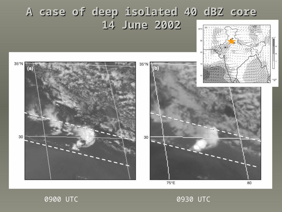
A case of deep isolated 40 dBZ coreA case of deep isolated 40 dBZ core14 June 200214 June 2002
A case of deep isolated 40 dBZ coreA case of deep isolated 40 dBZ core14 June 200214 June 2002
10 meter level10 meter level 200 mb level200 mb level
A case of deep isolated 40 dBZ coreA case of deep isolated 40 dBZ core14 June 200214 June 2002
A case of deep isolated 40 dBZ coreA case of deep isolated 40 dBZ core14 June 200214 June 2002
0900 UTC 0930 UTC

A case of deep isolated 40 dBZ coreA case of deep isolated 40 dBZ core14 June 200214 June 2002
A case of deep isolated 40 dBZ coreA case of deep isolated 40 dBZ core14 June 200214 June 2002
0900 UTC

Deep cores over the Tibetan PlateauDeep cores over the Tibetan Plateau14 July 200214 July 2002
Deep cores over the Tibetan PlateauDeep cores over the Tibetan Plateau14 July 200214 July 2002
1227 UTC

In western region--In western region--graupel particles graupel particles
lofted to great lofted to great heights by strong heights by strong
updraftsupdrafts
Height of 40 dBZ cores by regionHeight of 40 dBZ cores by regionHeight of 40 dBZ cores by regionHeight of 40 dBZ cores by region

10 meter level10 meter level 200 mb level200 mb level
A case of wide 40 dBZ echo coreA case of wide 40 dBZ echo core22 July 200222 July 2002
A case of wide 40 dBZ echo coreA case of wide 40 dBZ echo core22 July 200222 July 2002

A case of wide 40 dBZ echo coreA case of wide 40 dBZ echo core22 July 200222 July 2002
A case of wide 40 dBZ echo coreA case of wide 40 dBZ echo core22 July 200222 July 2002

A case of wide 40 dBZ echo coreA case of wide 40 dBZ echo core22 July 200222 July 2002
A case of wide 40 dBZ echo coreA case of wide 40 dBZ echo core22 July 200222 July 2002
1300 UTC 1400 UTC

A case of wide 40 dBZ echo coreA case of wide 40 dBZ echo core22 July 200222 July 2002
A case of wide 40 dBZ echo coreA case of wide 40 dBZ echo core22 July 200222 July 2002
1300 UTC

A typical case of wide 40 dBZ echo core with line A typical case of wide 40 dBZ echo core with line organizationorganization
A typical case of wide 40 dBZ echo core with line A typical case of wide 40 dBZ echo core with line organizationorganization
3 Sep 20033 Sep 20033 Sep 20033 Sep 2003
2208 UTC

A wide 40 dBZ echo core with squall-line A wide 40 dBZ echo core with squall-line organization—rare! organization—rare!
A wide 40 dBZ echo core with squall-line A wide 40 dBZ echo core with squall-line organization—rare! organization—rare!
5 June 20035 June 20035 June 20035 June 2003
2017 UTC
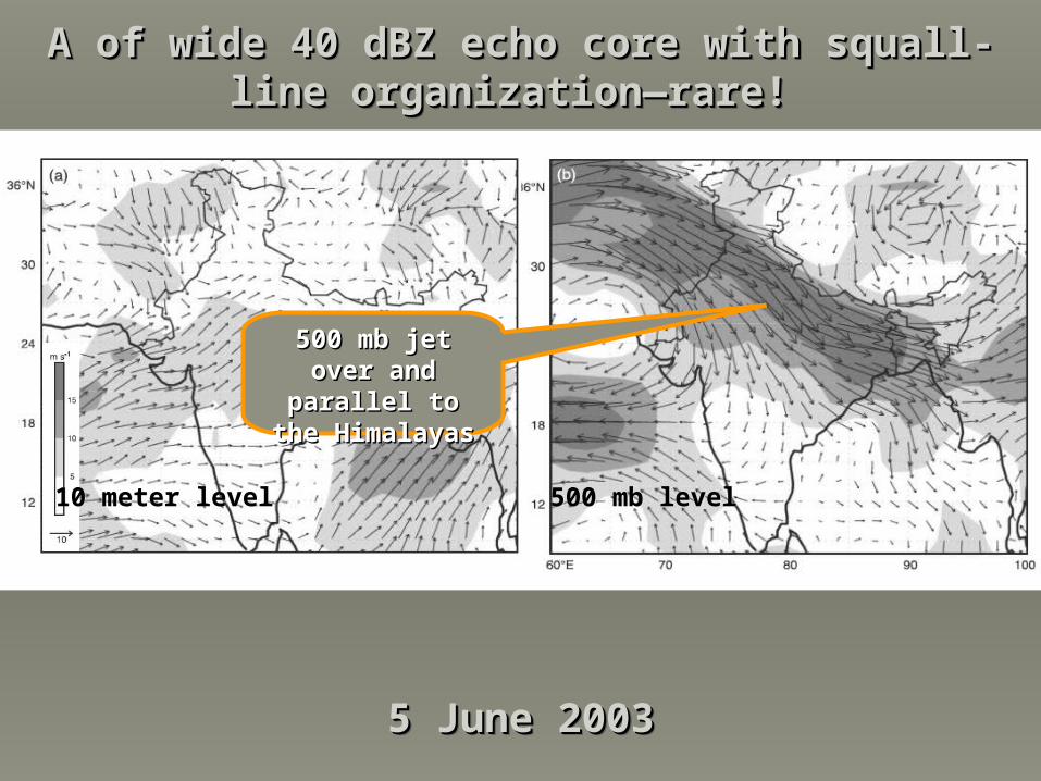
10 meter level10 meter level 500 mb level500 mb level
A of wide 40 dBZ echo core with squall-line A of wide 40 dBZ echo core with squall-line organization—rare! organization—rare!
A of wide 40 dBZ echo core with squall-line A of wide 40 dBZ echo core with squall-line organization—rare! organization—rare!
5 June 20035 June 20035 June 20035 June 2003
500 mb jet over 500 mb jet over and parallel to and parallel to the Himalayasthe Himalayas

Horizontal area of 40 dBZ cores by regionHorizontal area of 40 dBZ cores by regionHorizontal area of 40 dBZ cores by regionHorizontal area of 40 dBZ cores by region
In western regionIn western region—wide convective —wide convective
areas more areas more frequentfrequent
Area (km2)
Cum
ulat
ive
Fre
quen
cy

Analysis of Stratiform EchoesAnalysis of Stratiform EchoesAnalysis of Stratiform EchoesAnalysis of Stratiform Echoes

Intraseasonal Variation of the MonsoonIntraseasonal Variation of the MonsoonIntraseasonal Variation of the MonsoonIntraseasonal Variation of the MonsoonWebster & Tomas 1997
39 events1985-95
Day 0:8 mm/d5N-5S80-90E
“Break”
“Active”

10 meter level10 meter level 200 mb level200 mb level
Broad stratiform caseBroad stratiform case11 Aug 200211 Aug 2002
Broad stratiform caseBroad stratiform case11 Aug 200211 Aug 2002

Broad stratiform caseBroad stratiform case11 Aug 200211 Aug 2002
Broad stratiform caseBroad stratiform case11 Aug 200211 Aug 2002

Broad stratiform caseBroad stratiform case11 Aug 200211 Aug 2002
Broad stratiform caseBroad stratiform case11 Aug 200211 Aug 2002
0252 UTC

0455 UTC
Broad stratiform caseBroad stratiform caseUpstream of mountainsUpstream of mountains
Broad stratiform caseBroad stratiform caseUpstream of mountainsUpstream of mountains

Size of stratiform precipitation area by Size of stratiform precipitation area by geographical regiongeographical region
Size of stratiform precipitation area by Size of stratiform precipitation area by geographical regiongeographical region

Analysis of All the Reflectivity DataAnalysis of All the Reflectivity DataAnalysis of All the Reflectivity DataAnalysis of All the Reflectivity Data

Reflectivity data for 2 monsoon seasonsReflectivity data for 2 monsoon seasonsReflectivity data for 2 monsoon seasonsReflectivity data for 2 monsoon seasons
Relative frequency of occurrence

Reflectivity data for 2 monsoon seasonsReflectivity data for 2 monsoon seasonsReflectivity data for 2 monsoon seasonsReflectivity data for 2 monsoon seasons
Convection is Convection is stronger & stronger & deeper in westdeeper in west
Stratiform more Stratiform more pronounced in pronounced in easteast

Reflectivity data for 2 monsoon seasonsReflectivity data for 2 monsoon seasonsReflectivity data for 2 monsoon seasonsReflectivity data for 2 monsoon seasons
Convection is Convection is slightly deeper & slightly deeper & stronger over the stronger over the
lowlands than lowlands than the foothillsthe foothills

SummarySummarySummarySummary• West:West: “Deep” & “wide” “Deep” & “wide”
cores prone to occur just cores prone to occur just upstream & over the upstream & over the foothills, esp. in the west, foothills, esp. in the west, near confluence of dry near confluence of dry downslope & maritime downslope & maritime flows. flows.
• West:West: “Deep” & “wide” “Deep” & “wide” cores prone to occur just cores prone to occur just upstream & over the upstream & over the foothills, esp. in the west, foothills, esp. in the west, near confluence of dry near confluence of dry downslope & maritime downslope & maritime flows. flows.
• Strongest over lowlandsStrongest over lowlands
• Vertical cellsVertical cells
• Wide cores—amorphous Wide cores—amorphous or parallel to mt. rangeor parallel to mt. range
• Lots of lightning Lots of lightning
• No squall lines No squall lines
• Strongest over lowlandsStrongest over lowlands
• Vertical cellsVertical cells
• Wide cores—amorphous Wide cores—amorphous or parallel to mt. rangeor parallel to mt. range
• Lots of lightning Lots of lightning
• No squall lines No squall lines
• Central:Central: Get both deep Get both deep and wide cores, as in and wide cores, as in west, but not as frequent.west, but not as frequent.
• Central:Central: Get both deep Get both deep and wide cores, as in and wide cores, as in west, but not as frequent.west, but not as frequent.
• Squall lines when jet Squall lines when jet parallel to Himalayasparallel to Himalayas
• Isolated cells over Isolated cells over plateauplateau
• Squall lines when jet Squall lines when jet parallel to Himalayasparallel to Himalayas
• Isolated cells over Isolated cells over plateauplateau
• East:East: Get mesoscale, Get mesoscale, partially stratiform cloud partially stratiform cloud systems associated with systems associated with depressions over the Bay depressions over the Bay of Bengalof Bengal
• East:East: Get mesoscale, Get mesoscale, partially stratiform cloud partially stratiform cloud systems associated with systems associated with depressions over the Bay depressions over the Bay of Bengalof Bengal
• Mesoscale systems like Mesoscale systems like oceanic convection with oceanic convection with large stratiform regionslarge stratiform regions
• Get broad stratiform Get broad stratiform regions associated with regions associated with depressions propagating depressions propagating from equatorial regionfrom equatorial region

EpilogueEpilogueEpilogueEpilogue
• What has this study accomplished?
1) Particular structure and organization of summer monsoon convection over the subcontinent of South Asia
2) Behavior of highly convective clouds in a moist flow impinging on a mountain barrier
• What questions remain?
1) Why does the intense convection trigger just upstream of the barrier?
2) In depressions, what are the relative roles of orography and synoptic dynamics?
3) Can high-resolution models predict the observed structures?

ThanksThanks