roadway systems section 2010.ppt - magtug | mid-atlantic ... · shahid haji. public roadway mileage...
TRANSCRIPT

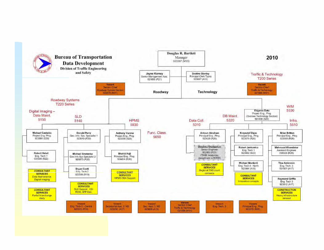
Division of Traffic Engineering & SafetyDivision of Traffic Engineering & SafetyB f T t ti D t D l t B f T t ti D t D l t Bureau of Transportation Data Development Bureau of Transportation Data Development Roadway Systems SectionRoadway Systems Section
FunctionsFunctions and Contactsand Contacts
Straight Line DiagramsStraight Line Diagramsg gg gRoad inventory obtained by the Roadway Systems Section staff and ourhired consultants is portrayed in the Straight Line Diagrams (SLD) - themost widely used medium for up to date geometric and system datamost widely used medium for up to date geometric and system dataavailable within the New Jersey Department of Transportation (NJDOT).
The SLD dates back to the mid 1960’s. Until 1997, the SLDs were drawnThe SLD dates back to the mid 1960 s. Until 1997, the SLDs were drawnmanually and limited to the State Highway System.
Today, the SLDs are produced through a specially designed computery, p g p y g pprogram and include all public roads in New Jersey.

Straight Line DiagramsStraight Line Diagramsg gg gSLDs are now distributed to our customers on a CD-ROM. The CD-ROM isa collection of static PDF files using a piece of software called AdobeAdobe (tm)t th fil Th f th CD ROM t i l t thi d tto access the files. The user of the CD-ROM can not manipulate this datain any way - basically, what they see is what they get.
Users of the SLD located on the NJDOT Headquarters are currently beingUsers of the SLD located on the NJDOT Headquarters are currently beingconnected to a dynamic “on-line” SLD Program housed in our dedicatedserver. This program allows the user to produce a customized SLD andperform queries using geographic and attribute data stored in the SLDdatabase.
Order of contacts for customer Order of contacts for customer questions:questions:
1. Donald Perry2 Michael G Castaldo2. Michael G. Castaldo

Standard Route Identifier (SRI)Standard Route Identifier (SRI)
The Standard Route Identifier (SRI) is a standard, consistent anduniform way of identifying every state, county, municipal and authority
d ithi th St t It i tt b tb t l hl h ii fi ldfi ld ithi llroadway within the State. It is a tenten bytebyte alphaalpha--numericnumeric fieldfield within allBTDD databases uniquely identifying the roadway and associated dataattributes. The SRI can be used to locate any linear and / or pointattributes along any roadway. The SRI process is currently used in theatt butes a o g a y oad ay e S p ocess s cu e t y used t eDepartment’s Geographical Information System (GIS) and willultimately be adopted by all database developers within the NJDOT.
OrderOrder ofof contactscontacts forfor customercustomerquestionsquestions::questionsquestions::
1. Donald Perry2. Michael G. Castaldo3 Anthony Varone3. Anthony Varone
Linear Referencing Systems (LRS)Linear Referencing Systems (LRS)
The Linear Referencing System (LRS) is a major component of theHighway Performance Monitoring System Program (HPMS). The LRSg y g y g ( )consists of a linklink data file and a nodenode data file with a network coveringall National Highway System Routes (including connectors), UrbanPrincipal Arterials, Rural Principal Arterials and Rural Minor Arterials.
The LRS is maintained in the GIS environment which allows forproduction of the final deliverable to the FHWA - individual countymaps displaying New Jersey’s LRS.maps displaying New Jersey s LRS.
OrderOrder ofof contactscontacts forfor customercustomertitiquestionsquestions::
1. Donald Perry - (5) 29452. Michael G. Castaldo

Highway Performance Monitoring System (HPMS)Highway Performance Monitoring System (HPMS)
Th Hi h P f M it i S t (HPMS) idThe Highway Performance Monitoring System (HPMS) providesessential data on highway conditions, performance and usage aswell as analytical products to the entire transportation community.
The HPMS was developed in 1978 to serve highway transportationdata and analytical needs at the national level. It replaced numerousuncoordinated annual State data reports as well as biennial specialstudies conducted by each State, resulting in a reduction in annualState data reporting.
S 1993 fEnhancements to the HPMS made in 1993 focused on programrequirements mandated by the ISTEA (Intermodal SurfaceTransportation and Efficiency Act) of 1991, the 1990 Clean Air ActAmendments and expanded transportation community data needs.Amendments and expanded transportation community data needs.
Highway Performance Monitoring System (HPMS)Highway Performance Monitoring System (HPMS)The HPMS has two distinct elements - a field element and an officeelement. In the field, technicians gather extensive road inventorydata (82 items) on sample sections. Sample sections are stratified indata (82 items) on sample sections. Sample sections are stratified inmany different groups/panels which are intended to represent thedifferent types of roadways throughout the state.
Data collected in the field is transferred (thro gh speciall designedData collected in the field is transferred (through specially designedsoftware) into the HPMS database maintained in the office. Severaledit routines are performed against the field data to verify accuracy.
Order of contacts for customer Order of contacts for customer questionsquestions:quest o squest o s
1. Anthony Varone2. Shahid Haji

Vehicle Miles Traveled (VMT) EstimatesVehicle Miles Traveled (VMT) EstimatesAs with all states, New Jersey’s official estimate of vehicle miles traveled(VMT) is a product of the HPMS Program. VMT is simply a measurementof the amount of traffic on a given mile of roadway. Deriving NewJersey’s VMT estimate involves multiplying the traffic volume in eachHPMS section, the section length and expansion factor, then summing theproduct to yield the VMT for any desired aggregation level.
VMT estimates are a key component of the Federal-Aid Highway fundapportionment formulae. They are central to estimating several of theDepartment’s performance indicators such as vehicle crash and fatalityp p yrates. VMT are also used in tracking Clean Air Act requirements and arecritical in the analysis that support the Condition and PerformanceReports to Congress.
OrderOrder ofof contactscontacts forfor customercustomerquestionsquestions::
1. Anthony Varone1. Anthony Varone2. Shahid Haji

Public Roadway Mileage and CertificationPublic Roadway Mileage and CertificationPublic roadway mileage figures are maintained by the BTDD throughPublic roadway mileage figures are maintained by the BTDD throughroad inventory efforts. A public road is any road or street owned andmaintained by a public authority and open to public travel. Each year inresponse to the Federal Aid Policy Guide Transmittal 1, dated December9, 1991, the BTDD acts as the designee of the Governor and provides theFHWA with New Jersey’s Certification of Public Road Mileage. Thisfigure represents mileage as of the end of a calendar year.
New Jersey has approximately 3838,,000000 milesmiles of public roadways. Certifiedpublic mileage figures, both current and historical, are available on theDepartment’s web site and can be dis-aggregated by either functionalp gg g yclassification or jurisdiction.
OrderOrder ofof contactscontacts forfor customercustomerOrderOrder ofof contactscontacts forfor customercustomerquestionsquestions::
1. Anthony Varone2 Donald Perry2. Donald Perry


Large Truck Network (National Network and Reasonable Large Truck Network (National Network and Reasonable Access Routes) & Truck RoutingAccess Routes) & Truck Routing) g) g
New Jersey’s Large Truck Network is maintained by the BTDD andportrays a roadway network of through routes (National Network)and permissible access routes which large trucks ((102102”” widewide 5353’’and permissible access routes which large trucks ((102102 wide,wide, 5353longlong andand doubledouble bottom)bottom) are permitted to travel. Prohibited travelroutes are also shown on the network.
A description of the Large Truck Network is available on theDepartment’s web site (http(http:://www//www..statestate..njnj..us/transportation)us/transportation) and also in amap format distributed by the BTDD. This network and associated
l ti tl d i f ibl i i Atregulations are currently under review for possible revisions. Attimes, calls from the trucking community are referred to the BTDD fortrucking routings. Routings should be given in accordance with themost current Large Truck Network map.g p
OrderOrder ofof contactscontacts forfor customercustomerquestionsquestions::
1. Michael G. Castaldo2. Donald Perry
Digital Roadway Imaging (Including Photolog and Videolog)Digital Roadway Imaging (Including Photolog and Videolog)The BTDD performs Digital Roadway Imaging (DRI) activities along allState Highway and Authority Routes in-house. This function provides adriver’s perspective of road conditions (geometry and access points) andserves as visual documentation to our road inventory activities. Prior tothe inception of the digital system, a photolog and videolog system wasthe inception of the digital system, a photolog and videolog system wasused. Both of these systems are still maintained for historicaldocumentation and are used extensively by the legal community (bothNJDOT and others) in litigation cases involving the State Highway System
d i d tiand in condemnation cases.The current videolog available to users at NJDOT, collected byconsultants, captures digital images while cruising at normal drivingspeed the video van captures 4 photos at approximately every 40 feetspeed, the video van captures 4 photos at approximately every 40 feetalong with other information such as GPS readings and date/time.
OrderOrder ofof contactscontacts forfor customercustomerOrderOrder ofof contactscontacts forfor customercustomerquestionsquestions::
1. Michael G. Castaldo2 Bob Habel2. Bob Habel

Functional Classification SystemFunctional Classification SystemDevelopment / maintenance of New Jersey’s Functional ClassificationSystem is performed in accordance with procedures set forth in the ISTEAof 1991 Section 1006 (c). Functional Classification is the process by whichall public roadways are grouped into categories based on the service theyare intended to provide. Smaller, less traveled roadways (local roads)are intended to provide. Smaller, less traveled roadways (local roads)provide motorists with a high degree of access. On the other hand, largerroadway (Interstates and freeways) provide motorists with a high degree ofmobility.
Another factor in the development of the Functional Classification Systemis Census data. This data determines the development of the UrbanBoundary which delineates the Rural and Urban classificationsBoundary which delineates the Rural and Urban classifications.Development of the Functional Classification System is performed incooperation with County and Metropolitan Planning Organization (MPO)officials. Functional Classification System statistics are available on theDepartment’s web site.
OrderOrder ofof contactscontacts forfor customercustomerquestionsquestions:: 1 Anthony Varonequestionsquestions:: 1. Anthony Varone
2. Donald Perry3. Michael G. Castaldo

Federal Aid System (Including National Highway Federal Aid System (Including National Highway System & Surface Transportation Program)System & Surface Transportation Program)
Functional Classification is the foundation for the Federal Aid System.This Federal Aid System has three (3) major elements - National HighwaySystem (NHS) routes, Surface Transportation Program (STP) routes andNon-Federal Aid routes Development and maintenance of the NHS isNon-Federal Aid routes. Development and maintenance of the NHS isperformed in accordance with procedures set forth in the ISTEA of 1991Section 1006 (a) and the NHS Designation Act of 1995.New Jersey has approximately 22,,100100 milesmiles of NHS designated roadways.Roadways not designated as NHS and functionally classified higher thanRural Minor Collector fall into the STP designation.Roadways functionally classified as Local (both Rural and Urban) andR ral Minor Collectors are designated as Non Federal Aid ro tes As ithRural Minor Collectors are designated as Non-Federal Aid routes. As withthe Functional Classification System, the NHS is developed in cooperationwith County and MPO officials. Establishment of the NHS, along with theSurface Transportation Program is the basis for funding transportationp g g pprojects.
OrderOrder ofof contactscontacts forfor customercustomerquestionsquestions:: 1 Anthony Varonequestionsquestions:: 1. Anthony Varone
2. Donald Perry3. Michael G. Castaldo

Route MilepostingRoute MilepostingMileposting of State Highways is performed to establish beginning, endand intermediate points along each route. These measured distances andpoints result in the installation of the small green placards along theshoulder of State Highways The location of these placards are based onshoulder of State Highways. The location of these placards are based onroad inventory data and measurements obtained from Distance MeasuringInstruments (DMIs) installed in field vehicles.
Federal guidelines require BTDD to establish the location of 11//1010 milepostplacards on all Interstate Highways and 11//22 milepost placards on all otherState Highways.
We also milepost new routes, emergency evacuation routes andemergency service patrol (ESP) routes.
OrderOrder ofof contactscontacts forfor customercustomerquestionsquestions:
1. Michael G. Castaldo2. Donald Perry
Project ManagementProject ManagementProject management is performed by several members within theRoadway Systems Section. Currently, we have contracts withconsultants to produce the Straight Line Diagrams (SLD), supportHi h P f M it i S t (HPMS) d F ti lHighway Performance Monitoring System (HPMS) and FunctionalClassification Programs and collect and process traffic count and othertransportation related data .During calendar year 20112011 we will have a contract executed to assistDuring calendar year 20112011, we will have a contract executed to assistwith Data warehouse and maintenance functions. This contract will bea continuation of the current Data warehouse and Maintenance project.Most of these contracts are multi-year contracts. Included in ourProject management tasks are the development of a project Scope ofWork (SOW), solicitation and review of Expressions of Interest (EOI),consultant selection, work assignment and review, monitoring andapproval of invoices.approval of invoices.
OrderOrder ofof contactscontacts forfor customercustomerquestionsquestions::
1. Michael G. Castaldo2. Donald Perry

Highway Type DesignationsHighway Type Designationsg y yp gg y yp gA Highway Type designations is an element used in project design andis typically shown on the keysheet of the project’s plan. A request for
d ’ hi h t i ll t t th BTDD f f tha roadway’s highway type is usually sent to the BTDD from one of theDepartment’s Design Units.
Development of Highway Type designations considers two (2) factorsDevelopment of Highway Type designations considers two (2) factors -thethe functionalfunctional classificationclassification ofof thethe roadwayroadway andand whetherwhether thethe roadwayroadway isisdivideddivided oror undividedundivided.. A set of codes, established by the FHWA, is usedto define the Highway Type of any given roadway.
OrderOrder ofof contactscontacts forfor customercustomerquestionsquestions::questionsquestions::
1. Michael G. Castaldo2. Donald Perry3 A th V3. Anthony Varone
Highway Maintenance Management System (HMMS)Highway Maintenance Management System (HMMS)
The Highway Maintenance Management System is used by NJDOT’sThe Highway Maintenance Management System is used by NJDOT sMaintenance forces to develop estimates for budgets, schedules,maintenance crew work assignments and various asset managementreporting.
OrderOrder ofof contactscontacts forfor customercustomerquestionsquestions::
1 Michael G Castaldo1. Michael G. Castaldo2. Donald Perry

Road InventoryRoad InventoryR d I t i f d ti l ll bli d i N J iRoad Inventory is performed routinely on all public roadways in New Jersey inaccordance with procedures set forth in the Bureau of Transportation DataDevelopment’s (BTDD) RoadwayRoadway InventoryInventory FieldField ManualManual. Primarily, it is carriedout to provide input to the Annual Mileage Certification.
Years ago, this function was performed entirely by our staff.
Today, road inventory is performed on the State Highway System by staff inthe RoadwayRoadway SystemSystem SectionSection. A consultant contract covers road inventory onother roadway - i.e.: County and Municipal Routes.
Typical road inventory data collected includes number of lanes, pavementwidth, presence / width of shoulder, presence / type / width of median, namesof intersecting streets, speed limit and length of road.
OrderOrder ofof contactscontacts forfor customercustomerquestionsquestions::
1 Michael G Castaldo (5) 45261. Michael G. Castaldo - (5) 45262. Donald Perry

Data Warehouse and Maintenance Data Warehouse and Maintenance
MAINTAIN A CONTINUED EFFORT IN MANAGING, UPDATING ANDMAINTAINING BTDD’S ROADWAY INVENTORY DATABASE.(INCLUDING ASSET MANAGEMENT DATA) THROUGH:
1. YEARLY INVENTORY PROGRAMS2. CONSULTANT CONTRACTS3. UPDATES RECEIVED FROM OTHER SOURCES
OrderOrder ofof contactscontacts forfor customercustomerquestionsquestions::
1 Michael G Castaldo1. Michael G. Castaldo2. Donald Perry3. Anthony Varone

20042004

20072007

20092009

Standard SLD Attributes: number of lanes pavement width shoulder width median type median width traffic signal locations interchange locations intersecting roadways railroad crossings railroad crossings stream crossings milepost start/end highway types (divided, undivided, etc.)
posted speed limit street name posted speed limit street name

HMMS Features: Inlet Manhole Highway Lighting (on wooden utility poles only) Attenuator Curb (including vertical barrier wall) Curb (including vertical, barrier wall) Delineator Guide Rail Island Pavement Raised Pavement Markings (RPM) Roadside Noise Wall Retaining Wall Longitudinal Rumble Striping Shoulder Type
Roadside Sidewalk Roadside Sidewalk NJDOT Jurisdiction Roadway Signs Sign Mounts

R d S t S tiR d S t S tiRoadway Systems SectionRoadway Systems SectionFunctionsFunctions and Contactsand Contacts

End of PresentationEnd of PresentationEnd of PresentationEnd of Presentation