roadmap to a sustainable right of way - california · pdf file24.11.2010 · roadmap...
TRANSCRIPT
ROADMAP TO A SUSTAINABLE PUBLIC RIGHT OF WAY
SUSTAINABLE
PUBLIC RIGHTS OF WAY Purpose and Use This document (website?) is intended to be a resource that both public officials and private developers may use to improve the sustainability of their projects constructed within the public rights-of-way. It is a collection of ideas, examples, reference material, and memory joggers that may be used to create more sustainable public rights-of-way for both new construction and rehabilitation/revitalization projects. Introduction During 2008 and 2009 the North Central Texas Council of Governments worked to establish a Sustainable Public Rights of Way Committee in order to look at how this region manages public rights of way and how that management could be more sustainable. This effort stemmed from the example of the New York City High Performance Infrastructure Guidelines (http://www.nyc.gov/html/ddc/downloads/pdf/hpig.pdf) and the Complete Streets initiative (http://www.completestreets.org/) and grew into a program to provide guidance to cities through out the region. A later effort we recognize as a great resource that should be used as a reference and guide for projects throughout the region is Greenroads (http://www.greenroads.us/) which includes a sustainability performance rating system for roadway projects as well as very helpful best practices fact sheets.
1
The 10 principals of a Sustainable public Right of Way include:
1. Meet the needs of today without compromising the ability of future generations to meet tomorrow’s needs 2. Create environmentally friendly, economically feasible, and socially acceptable public rights of way
3. Involve stakeholders and coordinate from start to finish 4. Improve air quality
5. Improve water quality 6. Create pedestrian and bicycle friendly communities
7. Improve performance and reduce lifecycle and maintenance costs 8. Ensure regulatory compliance
9. Promote economic development 10. Provide safer and healthier neighborhoods
Planning Proper planning requires asking the right questions, ensuring all stakeholders are involved and identifying existing elements needing to be included in the process. Planning occurs on many different levels and throughout design, construction and maintenance. This guide focuses on local planning activities ranging from city master planning to site plans.
Planning Fact Sheets Planning Books City and Regional Planning Project Planning
Becoming Part of the Solution, The Engineer’s Guide to Sustainable Development, Bill Wallace, ASCE (Can purchase on ASCE website)
FIDIC Project Sustainability Management Guidelines (2004), International Federation of Consulting Engineers
2
Design Design requires looking at the project from every angle and creating facilities that meet the needs of project stakeholders. Design occurs at after planning has occurred and continues through construction. This guide focuses on best practices for design in public corridors.
Design Fact Sheets Roadway Bike/Ped-Way ‘Scapes Utilities
3
Planning City and Regional Planning City and Regional planning efforts should consider all your community has to offer. Plans must reflect the important goals and challenges from community officials and citizens alike. General considerations when conducting general planning on this level include zoning, overlay districts, new development, re-development, stakeholders, types of master plans (thoroughfares, parks and trails, utilities, etc.), fees, codes and ordinances. Planning efforts should incorporate future growth predictions. City and Regional planning efforts can be limited by availability and accuracy of information about existing facilities as well as future development. These plans should be updated often to incorporate new data. Successful planning efforts can be limited by poor stakeholder participation. Early and ongoing coordination with all the stakeholders including neighboring communities and other city departments is extremely important. Resources:
• Context Sensitive Design o http://www.nctcog.org/trans/sustdev/landuse/css/ o http://www.ite.org/css/ o http://www.contextsensitivesolutions.org/
• Urban Zoning / Form based Code o Form Based Codes
http://www.nctcog.org/trans/sustdev/landuse/formbased_codes.asp http://www.smartcodecentral.org/
• Transit Oriented Design o http://www.nctcog.org/trans/sustdev/landuse/funding/tod.asp o http://www.transitorienteddevelopment.org/ o Reconnecting America Center for Transit-Oriented Development: http://www.reconnectingamerica.org/public/tod o See Greenroads Manual for information on Transit/HOV access issues
• Master Planning o Land Planning
Land planning directly corresponds with anticipated transportation needs. o Example: http://www.forwarddallas.org/
4
o Thoroughfares NCTCOG Regional Thoroughfare Plan: http://www.nctcog.org/trans/thoroughfare/rtp/index.asp
o Roadways Create street interconnectivity to create alternate routes to decrease congestion
o Bike/ped and Open Space – see more information below; Open space and bike/ped facilities create alternative transportation modes and a better sense of community
o Mass transportation – work within your community and with other communities to master plan mass transportation in order to maximize its efficiency and ridership
o Utilities Cities should map (GIS/GPS) all city-owned utility lines if possible Coordinate with franchise utilities Require submittals of as-built information
o Keeping Current and Coordinated Ask what has changed since last master planning occurred Ask who needs to be involved in the process and hold regular meetings Work with other entiies around you to coordinate shared cooridors
• Historical Sites o The Handbook of Texas Online (an encyclopedia of Texas history, geography and culture):
http://www.tshaonline.org/handbook o Texas History portal at UNT: http://texashistory.unt.edu/ o The Texas Historical Society Atlas: http://atlas.thc.state.tx.us/ o National Register of Historic Places in Texas: http://www.nationalregisterofhistoricplaces.com/TX/state.html
• Building Guidelines o http://www.nyc.gov/html/ddc/downloads/pdf/guidelines.pdf o Green Alleys, City of Chicago
• Easements vs right-of-way o Types (access, utility, maintenance, visibility, sidewalk, conservation, etc) o In fee (ownership vs. usage rights) o Utility – communicate in master planning efforts with utilities such as Oncor and Atmos o Utility “rights and rules” within public rights of way o http://www.apwa.net/ResourceCenter
• Districts o Special Districts
5
o Overlay districts - a common tool for establishing development restrictions, or extending development incentives, on land within a defined geographic area or characterized by specific physical features or site conditions
• Brownfields o http://www.nctcog.org/trans/sustdev/landuse/brownfields/index.asp
• Greenfields and Other Open Spaces o “Complete Streets”, New Urban News, December 2007 (http://newurbannetwork.com/article/cities-redo-streets-
pedestrians-cyclists-transit) o Regional Veloweb - http://www.nctcog.org/trans/sustdev/bikeped/veloweb.asp o NCTCOG BikeWeb (http://nctcog.org/trans/sustdev/bikeped/bikeweb/) o Bicycle and pedestrian funding opportunities
NCTCOG funding opportunities: http://www.nctcog.org/trans/sustdev/landuse/funding/BikePedFunding.asp o other helpful links
http://www.nctcog.org/trans/sustdev/bikeped/links.asp Example: http://www.dallascityhall.com/pwt/manuals_construction_standards.html The Trust for Public Land and Greenprinting (the development of conservation scenarios to help communities
make conservation decisions; http://www.tpl.org/tier3_cd.cfm?content_item_id=10648&folder_id=188) Open Space Planning Guide:
http://www.dos.state.ny.us/LG/publications/Local_Open_Space_Planning_Guide.pdf Finding a local land trust: http://www.landtrustalliance.org/ 5 Proven Ways to Preserve Open Space: http://www.thedailygreen.com/environmental-news/latest/open-
space-47030101 Rethinking the Street Space: Why Street Design Matters, Planetizen, 2009
• Fees o Texas Local Government Code;Title12;Subtitle C; Chapter 395 (http://statutes.legis.state.tx.us) o Roadway impact o Water and Sewer impact o Permitting
• Ordinances o Landscaping
http://www.nctcog.org/envir/SEEclean/stormwater/resources/Landscape_Ordinance.asp o Tree Preservation
Example: Fort Worth Tree Preservation Ordinance o Floodplain/drainage
Require SWPPP to be signed by PE who has visited site
6
7
Structure pay items for erosion and sediment control to promote effective usage (ie separate pay items for bmps such as final vegetation)
o Subdivision/unified Development Code/Form Based Code Examples: Dallas (http://www.dallascityhall.com/pdf/edd/DevelopmentGuide.pdf) Smart Code: http://smartcodecentral.com Require As-built submittals
o Create other hardscape/softscape requirements An arborist should be used when designing/selecting street trees
• Incentives o Fee reductions o Tax abatements or reimbursements o Requirement reductions o Cost participation
Joint contracts between cities and utilities could be used to share costs o Energy rebates (http://www.oncor.com/electricity/teem/default.aspx) o Variances to city ordinances o Performance bonds should be used for design and landscaping
• Coordination o Keep current and coordinated with other Cities and Counties in region, state government and federal agencies. o Require submittals of as –build for projects to stay coordinated with other local projects (both concurrent and in the
future) o Regularity train inspectors to ensure uniform construction standards o Regularly attend events that allow your community to learn about what other communities are doing and about new
resources for information
Planning Project Planning Project planning depends greatly on master planning efforts and city/county regulations, but also includes much more specific issues. Projects can range from roadways to parks and trails to utilities. General Considerations include involving stakeholders and agencies that may have a better understanding of the project requirements. This sort of involvement can save time during design and construction when stakeholders can start to demand changes that may significantly affect the project. Project planning must also take existing master plans, regulations and conditions into account. Project planning has more immediate results than city and regional planning and can be limited due to funding issues, project team communication, communication with stakeholders, and other variables such as permits. Resources and Important Considerations:
• Pre-Project o Possible incentives for sustainable development (http://www.nctcog.org/trans/sustdev/landuse/funding/index.asp) o Research master plans from cities and utility companies
Including existing lines and future planned lines o Research all applicable ordinances and regulations
Tree Preservation Stormwater Subdivision regulations Parking Building heights Overlay zones Easements Noise mitigation Waste management
o Going Green Use recycled materials Reuse and recycle construction waste such as crushing concrete onsite or mulching existing vegetation LEED Certification; Green Building Council (http://www.usgbc.org/) \
8
Greenroads Manual (http://www.greenroads.us/14/manual.html) Green Concrete
• Site Inventory o Perform a tree survey o Retrieve traffic counts for the area (http://www.nctcog.org/trans/data/tcins/ or TXDOT District offices) o Perform an Environmental Site Assessment (http://www.environmentalsiteassessment.net/) o Perform site inventory by visiting site in person- take pictures! o Review available aerial photography
http://www.dfwmaps.com DCAD - http://maps.dallascad.org/website/dcad/viewer.htm Google Earth - http://earth.google.com/
o Retrieve relevant floodplain information (FEMA Map Service Center) o Threatened and endangered species (http://www.tpwd.state.tx.us/landwater/land/maps/gis/ris/endangered_species/) o Retrieve historical or archeological information in area
The Handbook of Texas Online (an encyclopedia of Texas history, geography and culture): http://www.tshaonline.org/handbook
Texas History portal at UNT: http://texashistory.unt.edu/ The Texas Historical Society Atlas: http://atlas.thc.state.tx.us/ National Register of Historic Places in Texas: http://www.nationalregisterofhistoricplaces.com/TX/state.html
o Subsurface Utility Investigation (http://www.fhwa.dot.gov/design/sue/suebrochure.pdf) o Research existing easements in area
Example: Dallas County Clerk – http://www.dallascounty.org/department/countyclerk/realestate_index.html • Design Considerations
o Current and proposed ADA facilities and needs (Texas Accessibility Standards - http://www.license.state.tx.us/ab/abtas.htm)
o Consider ADA Transition Plan if applicable o Life cycle costs (http://www.fhwa.dot.gov/infrastructure/asstmgmt/lcca.cfm) or EPA Framework for Responsible
Environmental Decision‐Making (FRED), http://www.lcacenter.org/library/pdf/fred.pdf, a methodology to evaluate environmental costs integrated with material cost and performance.
o Research necessary city, state and federal permits USACE
• 404 permits (http://www.usace.army.mil/CECW/Pages/nw_permits.aspx) TCEQ
9
10
• 401 Certifications TWDB City permits
o Consider if new utilities lines will be necessary o Underground or overhead electrical and communication lines?
Consider safety Consider community needs and neighborhood character Consider community and right of way density
o Relocation of existing utility lines might be necessary o Co-location of utilities in dense rights of way or use of duct banks
• Coordination o Consider and coordinate with different types of utilities
Water Sanitary Sewer Storm Sewer Electrical Gas Communication City Utility Coordinator
o Identify all stakeholders and involved them early and often Permitting entities Adjacent property owners Utilities Cities/counties/regional/state and federal entities and various departments
Design Roadway Roadway design includes horizontal and vertical design of roadways as well as intersections, parking, pavement, medians, illumination, signage and many other issues. Roadways provide a place for vehicles, bicycles, pedestrians and many other types of transportation. General Considerations include safety of all roadway users, previous master and roadway planning efforts, involved city, state and federal agencies (depending on roadway classification, requirements by the users of the roadway and the context of the roadway’s surroundings). Other design elements such as utilities can also affect roadway design. Roadway design can be limited by the available funding for the road, the purchased right of way for the roadway, and city/county specifications. Resources and Important Considerations:
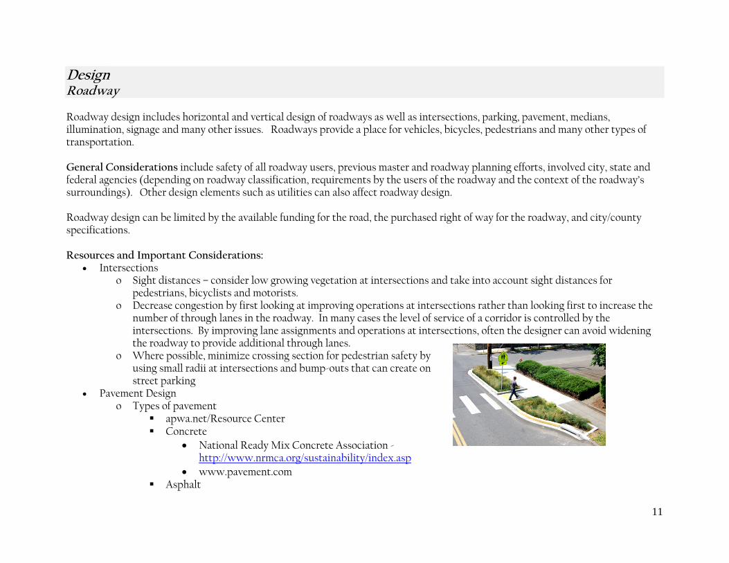
• Intersections o Sight distances – consider low growing vegetation at intersections and take into account sight distances for
pedestrians, bicyclists and motorists. o Decrease congestion by first looking at improving operations at intersections rather than looking first to increase the
number of through lanes in the roadway. In many cases the level of service of a corridor is controlled by the intersections. By improving lane assignments and operations at intersections, often the designer can avoid widening the roadway to provide additional through lanes.
o Where possible, minimize crossing section for pedestrian safety by using small radii at intersections and bump-outs that can create on street parking
• Pavement Design o Types of pavement
apwa.net/Resource Center Concrete
• National Ready Mix Concrete Association - http://www.nrmca.org/sustainability/index.asp
• www.pavement.com Asphalt
11
• National Asphalt Paving Association - http://www.hotmix.org/index.php?option=com_content&task=view&id=359&Itemid=863
• www.Asphaltinstitute.org Permeable pavement
• Icpi.org • Use pervious pavements properly (can be used used as a type of detention in this area) and more often
in parking areas • See Greenroads Manual for additional guidance
Consider using “long life pavement” as described in the Greenroads Manual o Geotechnical investigation is best way to determine proper pavement design for individual roadways
• Traveled-way design o Perform traffic studies in areas of redevelopment o Use speed limits and lane sizes that fit the neighborhood to create community atmosphere (>35mph use 12 ft lanes, 25
to 35 mph use 10 or 11 ft lanes, and <25 mph use 9 ft lanes) o Consider vehicle mix and specified bike lanes o Access management / Access limits o Sight Distances o Manual on Uniform Traffic Control Devices (MUTCD - http://mutcd.fhwa.dot.gov/ and Texas MUTCD
http://www.dot.state.tx.us/txdot_library/publications/tmutcd.htm) • Roadway Cross Section
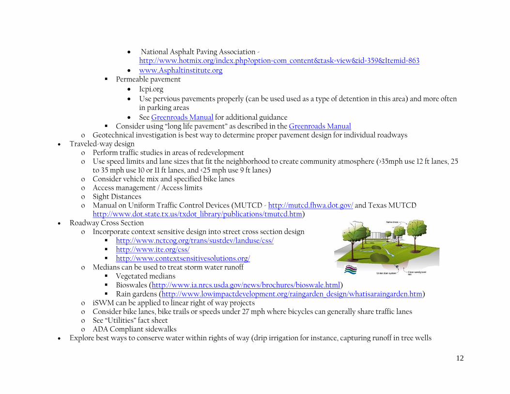
o Incorporate context sensitive design into street cross section design http://www.nctcog.org/trans/sustdev/landuse/css/ http://www.ite.org/css/ http://www.contextsensitivesolutions.org/
o Medians can be used to treat storm water runoff Vegetated medians Bioswales (http://www.ia.nrcs.usda.gov/news/brochures/bioswale.html) Rain gardens (http://www.lowimpactdevelopment.org/raingarden_design/whatisaraingarden.htm)
o iSWM can be applied to linear right of way projects o Consider bike lanes, bike trails or speeds under 27 mph where bicycles can generally share traffic lanes o See “Utilities” fact sheet o ADA Compliant sidewalks
• Explore best ways to conserve water within rights of way (drip irrigation for instance, capturing runoff in tree wells
12
13
• Future Expansion Opportunities o Turn bay provision o Bridge expansions o Coordinate master plans with neighboring entities o Medians at least 14 ft in width allow for future roadway expansion o Conduits for future signalization
• Street Lighting http://www.oncorgroup.com/electricity/construct/guidelines/const_guide.aspx ; www.DarkSky.org • Construction
o Consider temporary traffic control and project phasing • Technical resources:
o TxDOT Design Guidance and Details - http://www.txdot.gov/business/manuals_publications.htm o AASHTO - https://bookstore.transportation.org/category_item.aspx
• Other Resources: o New Urbanist Street Design http://www.tndengineering.com/papers/ULI-4-2000.pdf o “Residential Streets”, third Edition, ULI, NAHB, ASCE and ITE o “Correlating Transportation, Energy Efficiency, and Urban Heat Island Mitigation,” David Leopold, Streetscape and
Sustainable Design, City of Chicago o “Cool Pavements, Reducing Urban Heat Islands: Compendium of Strategies,” Environmental Protection Agency o Bioswales/Vegetated Swales, Florida Field Guide to Low Impact Development, 2008 o NE Siskiyou Green Street, Portland, Oregon, Kevin Robert Perry
Design Bike/Ped-way Ped-way design includes those facilities that accommodate public facility users not traveling in vehicles on roadways such as pedestrians and bicyclists. Elements within ped-way design are sidewalks, trails, roadway and other intersection crossings, and accessibility. General Considerations include accommodating all types of ped-way users while coordinating their public space with roadways, utilities and the surroundings that draw them to that space. Ped-way designs are often limited by funding, community support, safety issues and available right of way. Resources and Important Considerations:
• AASHTO Guide for the Planning, Design, and Operation of Pedestrian Facilities, 1st Edition (GPF-1) - https://bookstore.transportation.org/category_item.aspx
• Type of surface – ie; concrete; asphalt; crushed granite, etc • Types of traffic
Bike • Pedestrian Mixed use Types of users
o Commuters – bike and ped ways can be used as alternative commuting options to reduce congestion and pollution o Recreational users
• Locations o Buffers o Aesthetically pleasing o Regional and local connectivity
NCTCOG BikeWeb (http://nctcog.org/trans/sustdev/bikeped/bikeweb/) City master trail plans
• Safety o Trees close to pathways o Proximity to roadway traffic o Protection at roadway crossings o Lighting – consider LED and solar lighting o ADA requirements (Texas Accessibility Standards - http://www.license.state.tx.us/ab/abtas.htm)
14
15
o MUTCD standards (http://mutcd.fhwa.dot.gov/) • Amenities
o Shade trees o Benches o Water availability o Waste receptacles o Restrooms
Design ‘Scapes ‘Scape design includes landscaping, streetscaping and other non-roadway design elements such as signage and amenities that promote and instill a sense of community and safety within a public right of way. General Considerations include lighting, water conservation, plant types, safety, aesthetics, and surrounding property uses. Scape designs are mostly limited by funding and available space within the right of way. Resources and Important Considerations:
• Vision for long term appearance • Trees
o Types relevant to locations(do adult heights interfere with utility poles/wires) o Consider street trees for their impact on slowing traffic when placed in medians and behind the curb o Consider shade tree’s impact on lowering paved surface temperature (-40 degrees) and ambient temperature (-7 to 11
degrees) o Mitigation requirements o Tree survey should be performed prior to design o Trees must be considered at their mature age to ensure sustainability of pavement and utilities and to minimize effect
on traffic and safety o An arborist should be used when designing street trees if the City has not set specific guidelines for street trees o Consider ongoing maintenance issues o Compatibility w/ utilities
• Vegetation o Conventional o Xeriscape to minimize water usage o Buffalo grass to reduce mowing o Landscape Water Conservation information from design to plant selection to best maintenance practices for north
central Texas (www.txsmartscape.com) o Native Plant Data base (Wildflower Center) search for native plants by common or botanical name
(www.wildflower.org/explore) o Recommended native plant lists for selected plant areas. (Wildflower Center) (www.wildflower.org/collections)
16
o Low water use plant guide for Central Texas provided by the Austin Grow Green program (http://www.ci.austin.tx.us/growgreen/plants.htm )
o Gateway to Texas Horticulture information from plants and designs to crop and marketing also Plants Answers is a major location for founding information about plant and landscape problems (aggie-horticulture.tamu.edu/)
o Plant selection for specific locations throughout Texas (urbanlandscapeguide.tamu.edu/) o Native Plant Society of Texas (www.npsot.org)
• Irrigation methods o Conventional o Drip o Information about irrigation training conducted by Texas AgriLife (http://irrigation.tamu.edu) o Extension and TAMU Department of Biological and Agricultural Engineering Irrigation Technology Center ET site
contains weather information, current and average evapotranspiration data, and irrigation watering recommendations (texaset.tamu.edu)
• Lighting o Types of lighting
Solar LED New technologies
o Heights o Specific to cross section elements o Oncor street lighting brochure - http://www.oncor.com/pdf/construct/guidelines/DSL.pdf
• Safety o Create buffers between transportation modes when speeds exceed 20 mph o Consider intersection and approach surface treatments to signal to vehicles possible pedestrian and bike crossing
• Signage o Way-finding o Entry and area markings
• Facilities o Benches o Transit stops o Trash o Bicycle parking
• Vandalism vulnerability o Theft vulnerability
17

18
o Anti graffiti paint
Design Utilities Utility design includes public facilities such as storm drain systems, water distribution, sewer collection, natural gas lines, and electric lines as well as private facilities. General Considerations include overall coordination between utilities, cities/counties, and project designers. Easements must also be considered when designing utilities. Utility design can be severely limited by a lack of upfront coordination between utility owners. Resources and Important Considerations:
• Regularly scheduled or project specific meetings o Get utilities involved early on for needed relocations o Above or underground? o Cover and separation o Easements o Shared conduit banks o Coordinate closely with all utilities (city, franchise, etc) from beginning of project
• Design o Always take future service estimates into account when designing utilities o Consider distances between certain utilities (water and sanitary sewer, gas and electric, ect.) o Consider water absorption techniques such as Stormwater retention areas o Only place utilities that do not require frequent maintenance (such as storm water) under pavement if possible
• Electric o Oncor provides a significant online resource including contact information, design standards
http://www.oncorgroup.com/electricity/construct/guidelines/const_guide.aspx, service territory, and vegetation management: http://www.oncor.com/community/default.aspx
o Other Electric Coops include: Co-Serve, United, Tri County, Brazos, Hillco, other • Gas
o Atmos Energy provides online contact information at http://www.atmosenergy.com/business/index.html. • Franchise
o Communication utilities include Verizon, Time Warner, Charter, AT&T and others
19
20
• Placement o Consider the maintenance and upgrade requirements of utilities when designing their placement within the public
right of way. o Utilities that will require frequent maintenance should be not be placed under pavement if possible o Subsurface Utility Investigation (http://www.fhwa.dot.gov/design/sue/suebrochure.pdf) o Municipal, electric and gas utilities should be placed in easements outside of ROW when possible so only franchise
utilities are located in the public right of way o Consider use of boxes or chases can be used under roadways for future franchise utility installation o Include proposed locations for other utilities in plans o Submit as built information after project completion if city allows
• Easements o Easements can be used for placement of these items in areas not underneath roadways, plants or sidewalks o Easements can be pre-assigned when platted to ensure proper use
• Water & Sanitary Sewer o Water & Sanitary Sewer Guidelines (TCEQ): http://www.tceq.com/rules/indxpdf.html
• Stormwater o Integrated Stormwater Management Program (http://iswm.nctcog.org)
Transportation Integrated Stormwater Management o Stormwater / Watershed master plans o SWP3 Implementation
Consider recognition awards for contractors who do it right o Check MS4 (TCEQ Municipal Separate Storm Sewer System ) permit in project jurisdiction

DISCLAIMER
The North Central Texas Council of Governments (NCTCOG) maintains this World Wide Web site to enhance public access to NCTCOG information. This site is continually under development and therefore subject to change without notice. While we endeavor to provide timely and accurate information, we make no guarantees. The North Central Texas Council of Governments makes no warranty, express or implied, including warranties of merchantability and fitness for a particular purpose. Use of the information is the sole responsibility of the user.
The material on this site comes from a variety of sources. We do not control or guarantee the accuracy, relevance, timeliness or completeness of any outside information. Further, the inclusion of pointers to particular items is not intended to reflect their importance nor is it an endorsement of any of the views expressed or products or services offered.
If you find any links that are no longer active, please send an email to [email protected] listing the link that is not working. Last updated: November 24, 2010