rmi coastal management national framework - … reports/rmi coastal mgt framework.pdf · mec,...
TRANSCRIPT
NATIONAL COASTAL MANAGEMENT FRAMEWORK - 5/15/2006 – PAGE 1 OF 41
RRMMII CCOOAASSTTAALL MMAANNAAGGEEMMEENNTT
NNAATTIIOONNAALL FFRRAAMMEEWWOORRKK
DDRRAAFFTT FFOORR PPUUBBLLIICC CCOOMMMMEENNTT
MMAAYY 1100,, 22000066
RRMMII EENNVVIIRROONNMMEENNTTAALL
PPRROOTTEECCTTIIOONN AAUUTTHHOORRIITTYY
CCOOAASSTTAALL && LLAANNDD MMAANNAAGGEEMMEENNTT OOFFFFIICCEE

RMI COASTAL MANAGEMENT NATIONAL FRAMEWORK
SUBMITTED BY:
CALEB MCCLENNEN
ADVISOR
RMI ENVIRONMENTAL PROTECTION AUTHORITY
This Plan is a culmination of over a dozen meetings held with various stakeholder individuals and organizations from the summer of 2004 to the end of 2005. Outside of these meetings, many less organized dialogues have been held to help bring the Advisor up to date in understanding the Marshallese culture, legal system, environmental attitude and needs. Without these meetings and involvement of the numerous stakeholders below, this plan would have been unrealistic and impossible to develop. Many thanks to all of those who participated in the formulation of this plan, including many staff members of Anil Development, Attorney General’s Office, Beca, the Chamber of Commerce, Council of the Iroij, CMI, HPO, IBC, MalGOV, MEC, MIMRA, MIVA, OEPPC, Public Works, PII, United Atoll Construction, USP and WUTMI. A special recognition must be given to the staff of the RMI Environmental Protection Authority, notably Mr. Souvenior Kabua, Mr. Rito Akilang and Mr. John Bungitak. The Coastal Program and the entire EPA extend a sincere appreciation to all that have given their valuable time to contribute to the various components of this program, and look forward to continue cooperation as the program builds for the future.
NATIONAL COASTAL MANAGEMENT FRAMEWORK - 5/15/2006 – PAGE 2 OF 41
INDEX
____________________________________________________________________________ EXECUTIVE SUMMARY 4 I. INTRODUCTION 5 II. STATUS OF THE CCA 5
2.1 Director of Coastal Management 2.2 Survey of Coastal Zone 2.3 Coastal Permits 2.4 Waste, Foreign Matter and Water Quality
III. CURRENT COASTAL CONDITIONS 9 3.1 Coastal Stability 3.2 Marine Water Quality 3.3 Coastal Quality 3.4 Coral Reefs and other Marine Health 3.5 Human Health, Vulnerability and Economic Sustainability
IV. COASTAL ACTIVITIES 12 4.1 Coastal Development 13
4.1.A Residential and Commercial Construction 4.1.B Landfills and Reclamation 4.1.C Coastal Protection 4.1.D Aggregate Mining 4.1.E Residential scale beach mining
4.2 Living Coastal Resource Utilization 17 4.2.A Fishing 4.2.B Aquaculture 4.2.C Diving, Tourism and Recreation 4.2.D Conservation Areas 4.2.E Marine Invasive Species
4.3 Land-based Impacts ` 20 4.3.A Human Waste 4.3.B Animal Waste 4.3.C Solid Waste 4.3.D Outfalls
4.4 Marine Activities 23 4.4.A Vessel Discharges 4.4.B Oil Spills 4.4.C Shipwrecks 4.4.D Artificial Reefs 4.4.E Seaport Activities
4.5 Natural Threats/Disasters 27 4.5.A Sea Level Rise/Climate Change 4.5.B Typhoons and Large Storm Surges. 4.5.C Tsunami
V. COASTAL DATA COLLECTION SYSTEM 29 5.1 Biological Data 5.2 Remotely Sensed data management and analysis 5.3 Coastal Geological Data 5.4 Coastal Pollution 5.5 Permitting and Violation Data collection 5.6 Social Data Collection.
VI. EDUCATION AND OUTREACH 31 VII. LEGAL MANAGEMENT OPPORTUNITIES 32
7.1 Environmental Impact Assessment Regulations 7.2 Earthmoving Regulations 7.3 Sustainable Development Regulations 7.4 Marine Water Quality Regulations 7.5 Toilet and Sewer Facility Regulations 7.6 Solid Waste Regulation 7.7 EPA fining system 7.8 Local Coastal Management Programs
VIII. INSTITUTIONAL ARRANGEMENTS 35 IX. FUNDING POSSIBILITIES AND EXTERNAL ASSISTANCE 36 X. CONCLUSION 37 XI. RESOURCES UTILIZED 38
NATIONAL COASTAL MANAGEMENT FRAMEWORK - 5/15/2006 – PAGE 3 OF 41
EXECUTIVE SUMMARY
The vast majority of coasts in the Republic of the Marshall Islands are in pristine natural condition. Primarily due to lack of human inhabitants on a large number of islets and atolls, there have been little impacts since the end of the Second World War and the days of nuclear testing. However, as the economy of the RMI has developed from centralized foreign aid from a variety of donors, populations too have concentrated around several urban centers—the coasts of which are feeling the brunt of this intensification. While all atolls in the country have experienced some impact from the human hand, primarily Majuro and Kwajalein, and to a lesser degree Wotje and Jaluit are under significant environmental strain. For this reason, the National Coastal Management Framework, called for under the Coast Conservation Act of 1988, and associated surveys has focused on these four atolls. This document reviews coastal activities including development, living marine resource utilization, land-based impacts, marine impacts and natural disasters, and proposes solutions for their management. Most of the coastal threats in the aforementioned urban areas have arisen due to improper management of the coasts, including erosion, poor water quality, polluted beaches and highly vulnerable coastal populations. Significant proposals from the framework include: • New Sustainable Development Regulations to more actively manage the range of coastal
activities, bolster monitoring of both land-based and marine activities and meet the obligations of the CCA.
• A phase out of shallow water lagoon-side beach sand mining and dredging on a commercial scale.
• Continued national emphasis on the utilization of Environmental Impact Assessments as a tool for management of major development projects.
• Increased regulation of small scale coastal construction to minimize environmental impacts, maintain a sustainable shoreline, and prevent future erosion.
• Promotion of sustainable utilization and conservation of living marine resources in cooperation with MIMRA, including the promotion of national conservation area program.
• Elimination of plastics and hazardous materials from private land-fills that may enter the lagoon, due to large storm surges or waste mismanagement.
• Initiation of coastal clean-up program starting with up-current villages in Majuro and moving westwards.
• Educational campaign to promote a variety of components from this Framework. • Increased international promotion of the low-lying nature of the Marshall Islands, and
the drastic potential of sea-level rise for the nation. • Long-term coastal monitoring system using both satellite and on the ground data to
quantify and qualify pollution, water quality, coastal erosion and coral reef health.
NATIONAL COASTAL MANAGEMENT FRAMEWORK - 5/15/2006 – PAGE 4 OF 41
• Assistance to the Atolls of Majuro, Kwajalein, Jaluit and Wotje in the short-term to development local coastal management priorities and programs.
I. INTRODUCTION In 1988, the Coast Conservation Act came into force empowering the RMI Environmental Protection Authority as the enabling agency. The need for a National Coastal Management Plan has been repeated in National Environmental Management Strategy (1992-96), Vision 2018 Document, and 2004-07 EPA Strategic Plan and numerous other national documents, both internal and external to the RMI government for the past fifteen years. In 2005, the RMI EPA conducted workgroups and built capacity to generate this report and enable its adoption in fulfillment of the CCA’s directive to build the National Coastal Management Plan. In light of the diverse experiences across the RMI, it has become evident that a National Plan can only go so far to ameliorate the coastal problems in the RMI—and that local plans are necessary as the true enabling agents for many components of this plan. As well, though this document falls into said category, long paper documents of plans at the national level will accomplish little to resolve the serious threats to the coastal zone of the RMI. This paper should be viewed as a summary of activities and proposals, some already adopted and some proposed to protect and conserve the coastal zone of the Marshall Islands. Once approved – it will need continuous revision, and reassessment as progress is made nation-wide in the area of Coastal Management II. STATUS OF THE CCA The CCA calls for many actions, one of which is this plan. Briefly, this section reviews the status of other obligations under the act that are concurrently being dealt with in the EPA. 2.1 Director of Coastal Management The Director of Coastal Management in the RMI is the General Manger of the RMI EPA, per CCA §4(1). Given the range of duties potentially necessary for a Director of Coastal Management to complete – a separate position could certainly be justified under the supervision of the General Manager. At this time, for reasons of financial and bureaucratic efficiency the General Manager is proposed as the “Director” in the complementary “Sustainable Development Regulations.” 2.2 Survey of Coastal Zone
NATIONAL COASTAL MANAGEMENT FRAMEWORK - 5/15/2006 – PAGE 5 OF 41
§306 of the CCA calls for an extensive survey of the Coastal Zone to be commenced. This survey is currently underway, primarily through the development of Geographic Information System (GIS) databases from satellite imagery and on the ground data collection on Majuro, Ebeye, Jaluit and Wotje. (see Figure 1 below) Current land-use, infrastructure, coral reefs (and benthic habitat in general), aggregate resources, recreational and religious areas, wetlands, and research areas are all included in the survey. A separate report on erosion in the Coastal zone will be generated to analyze the changes to the shoreline of at least the four Major Atolls from World War II to present. Economic cost will be estimated from constructed current land values. SOPAC in cooperation with the RMI EPA has completed a study in November of 2005 that comments on the economic importance of aggregate extraction in the RMI. Table 1 presents the requirements of §306 and their current status in more detail. Figure 1 presents the extent to which the Coastal Survey has been completed as of May 2006.

Table 1. CCA §306 Survey of Coastal Zone requirements and status.
NATIONAL COASTAL MANAGEMENT FRAMEWORK - 5/15/2006 – PAGE 6 OF 41
Requirement Source Majuro Ebeye Jaluit Wotje (a) an inventory of all structures, roads, excavations, harbors, outfalls, dumping sites and other works located in the Coastal Zone;
IKONOS imagery (b) an inventory of all coral reefs found within the Coastal Zone; IKONOS imagery (c) an inventory of all commercially exploitable mineral deposits, both proven and suspected, located within the Coastal Zone;
SOPAC, EPA and IKONOS imagery
(d) an inventory of all areas within the Coastal Zone of religious significance or of unique scenic value or of value for recreational purposes, including those areas most suitable for recreational bathing;
IKONOS imagery, local knowledge
(e) an inventory of all estuarine or wetland areas within the Coastal Zone with an indication of their significance as fisheries or wildlife habitat;
IKONOS imagery (f) an inventory of all areas within the Coastal Zone of special value for research regarding coastal phenomena, including fisheries and shell fisheries, sea erosion, littoral movements and related subjects;
IKONOS imagery, communication with
past and present researchers
(g) an inventory of all areas within the Coastal Zone from which coral, sand, sea shells or other substances are regularly removed for commercial or industrial purposes;
IKONOS imagery, EPA records
(h) an assessment of the impact of sea erosion on the Coastal Zone including a quantified indication, by geographical location, of the amount of land lost thereby, an estimate of the economic cost of such loss and the extent to which human activity has contributed to such loss;
IKONOS imagery, historic aerial photography
(i) an estimate of the quantities of sand, coral, sea shells and other substances being removed from the Coastal Zone, together with an estimate of the extent to which such quantities can be supplied from other sources or other materials and an analysis of the economic practicability of doing so; and
SOPAC and EPA research.
(j) a census, classified by geographical areas, and by activity, of all workers currently engaged on a regular basis in the removal of coral, sand, sea shells or other substances from the Coastal Zone and a census of the dependents of such workers and estimate of the per capita income obtained from these activities.
SOPAC research nn//aa nn//aa nn//aa

Figure 1. Map of Areas covered by current Coastal Survey process. 2.3 Coastal Permits §309 of the Act requires that a permit procedure be established by the RMI EPA for “any development activity other than a prescribed development activity within the Coastal Zone except under the authority of a permit issued in that behalf by the Director.” These regulations are in a draft phase and are simultaneously in their public comment review period. Instead of proposing a separate set of regulations independent of current Earthmoving Regulations, the proposed Development Regulations super-cede those regulations. New fee structures are proposed, as well as a simplified system for all forms of development both within and outside of the coastal zone in the RMI. These permits, if accepted, will provide even more strength to the currently functioning environmental impact assessment (EIA) process. Specifics of the proposed permit system will be discussed later in this plan. 2.4 Waste, Foreign Matter and Water Quality
NATIONAL COASTAL MANAGEMENT FRAMEWORK - 5/15/2006 – PAGE 7 OF 41
§320 requires for the Director to give direction regarding various activities associated with waste generation, other foreign matter and water quality within the Coastal Zone. For these reasons this national framework will include detailed policy solutions for said concerns. To
date, the Coastal Management Unit in the EPA has only been involved with illegal construction that may indirectly relate to issues of coastal quality and oil spills that occur throughout the lagoon. Solid Waste has been left to the Solid Waste Division. However, this plan will cover issues such as Coastal Quality so that the Coastal Management Division will increase its mandate to concern coastal water quality and waste in, or that may end up in, the coastal zone.
NATIONAL COASTAL MANAGEMENT FRAMEWORK - 5/15/2006 – PAGE 8 OF 41
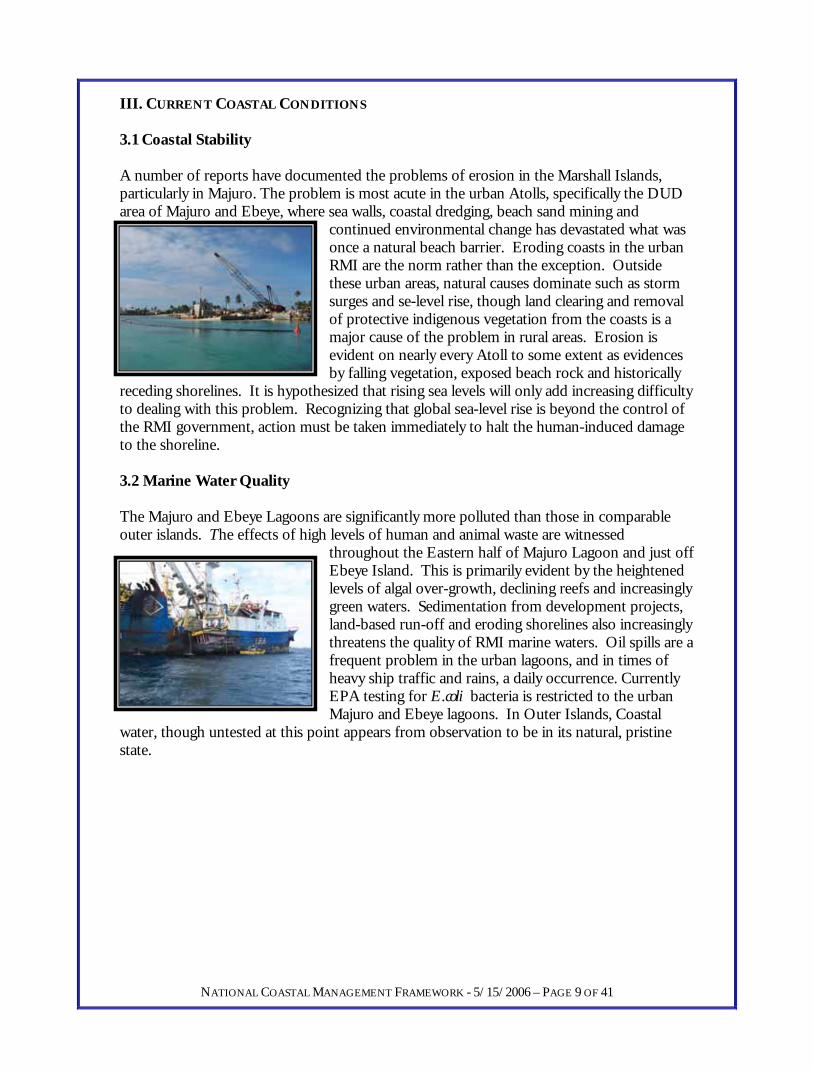
III. CURRENT COASTAL CONDITIONS 3.1 Coastal Stability A number of reports have documented the problems of erosion in the Marshall Islands, particularly in Majuro. The problem is most acute in the urban Atolls, specifically the DUD area of Majuro and Ebeye, where sea walls, coastal dredging, beach sand mining and
continued environmental change has devastated what was once a natural beach barrier. Eroding coasts in the urban RMI are the norm rather than the exception. Outside these urban areas, natural causes dominate such as storm surges and se-level rise, though land clearing and remoof protective indigenous vegetation from the coasts is a major cause of the problem in rural areas. Erosion is evident on nearly every Atoll to some extent as evidenceby falling vegetation, exposed beach rock and historically
receding shorelines. It is hypothesized that rising sea levels will only add increasing diffto dealing with this problem. Recognizing that global sea-level rise is beyond the control of the RMI government, action must be taken immediately to halt the human-induced damageto the shoreline.
val
s
iculty
ate.
3.2 Marine Water Quality The Majuro and Ebeye Lagoons are significantly more polluted than those in comparable outer islands. The effects of high levels of human and animal waste are witnessed
throughout the Eastern half of Majuro Lagoon and just off Ebeye Island. This is primarily evident by the heightened levels of algal over-growth, declining reefs and increasingly green waters. Sedimentation from development projects, land-based run-off and eroding shorelines also increasingly threatens the quality of RMI marine waters. Oil spills are a frequent problem in the urban lagoons, and in times of heavy ship traffic and rains, a daily occurrence. Currently EPA testing for E.coli bacteria is restricted to the urban Majuro and Ebeye lagoons. In Outer Islands, Coastal
water, though untested at this point appears from observation to be in its natural, pristine st
NATIONAL COASTAL MANAGEMENT FRAMEWORK - 5/15/2006 – PAGE 9 OF 41
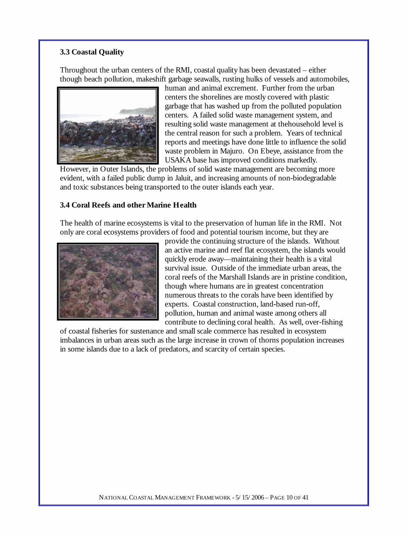
3.3 Coastal Quality Throughout the urban centers of the RMI, coastal quality has been devastated – either though beach pollution, makeshift garbage seawalls, rusting hulks of vessels and automobiles,
human and animal excrement. Further from the urban centers the shorelines are mostly covered with plastic garbage that has washed up from the polluted population centers. A failed solid waste management system, and resulting solid waste management at thehousehold level is the central reason for such a problem. Years of technical reports and meetings have done little to influence the solid waste problem in Majuro. On Ebeye, assistance from the USAKA base has improved conditions markedly.
However, in Outer Islands, the problems of solid waste management are becoming more evident, with a failed public dump in Jaluit, and increasing amounts of non-biodegradaband toxic substances being transported to the outer islands e
le ach year.
ld
ing
ases ecies.
3.4 Coral Reefs and other Marine Health The health of marine ecosystems is vital to the preservation of human life in the RMI. Not only are coral ecosystems providers of food and potential tourism income, but they are
provide the continuing structure of the islands. Without an active marine and reef flat ecosystem, the islands wouquickly erode away—maintaining their health is a vital survival issue. Outside of the immediate urban areas, the coral reefs of the Marshall Islands are in pristine condition, though where humans are in greatest concentration numerous threats to the corals have been identified by experts. Coastal construction, land-based run-off, pollution, human and animal waste among others all contribute to declining coral health. As well, over-fish
of coastal fisheries for sustenance and small scale commerce has resulted in ecosystem imbalances in urban areas such as the large increase in crown of thorns population increin some islands due to a lack of predators, and scarcity of certain sp
NATIONAL COASTAL MANAGEMENT FRAMEWORK - 5/15/2006 – PAGE 10 OF 41

3.5 Human Health, Vulnerability and Economic Sustainability Poor solid waste management, lack of appropriate treatment and facilities for human waste, and a densely populated and vulnerable shoreline all pose serious concerns for the health
and lives of the population on Majuro. Centrally through water-borne diseases, such as cholera and amoebas, human health can be severely affected by these coastal concerns. As well, with many of the urban poor population in Majuro currently being forced to settle on reclaimed and vulnerable land – their lives are threatened by the potentifor large storm events such as typhoons, storm suastronomical high tides. Coastal management is not environmental management only for the sake of keeping the RMI clean. it is an essential step to sustainably
developing the social and economic conditions of the coastal country. Several significant economic impacts of declining coastal quality are evident in the Marshall Islands. ThPacific Regional Geoscience Commission (SOPAC) has costed the losses due to coastal erosion and protection at over $400 million for Majuro alone. These costs are mainly through losses of productive and inhabitable land, and the protections that are erected to prevent such a loss. Tourism has been negatively impacted by the unsightliness and low interest of tourist in polluted and unhealthy beaches. Aquaculture development depends osources of clean marine water, preferably near the population centers, as well as healthy sources for controlled production. Many Marshallese rely on locally produced fisheries for either income or food security, the preservation and manage
al rges and
e South
n
ment of this resource is obvious.
NATIONAL COASTAL MANAGEMENT FRAMEWORK - 5/15/2006 – PAGE 11 OF 41
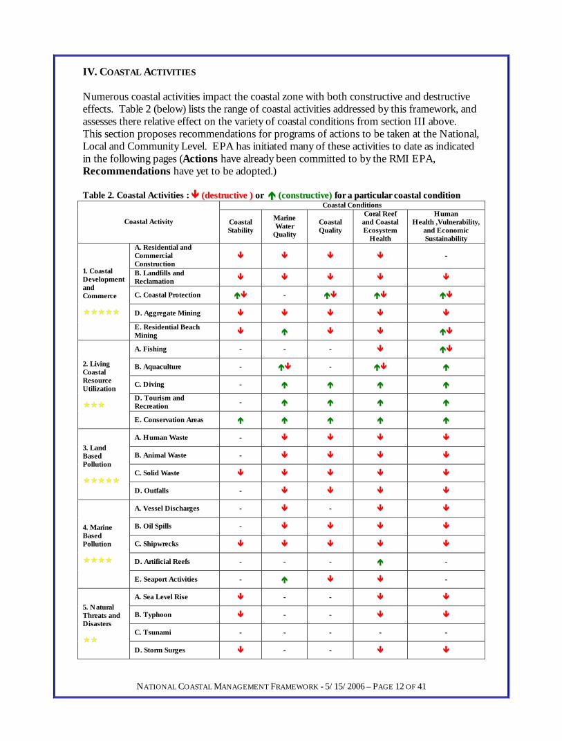
IV. COASTAL ACTIVITIES Numerous coastal activities impact the coastal zone with both constructive and destructive effects. Table 2 (below) lists the range of coastal activities addressed by this framework, and assesses there relative effect on the variety of coastal conditions from section III above. This section proposes recommendations for programs of actions to be taken at the National, Local and Community Level. EPA has initiated many of these activities to date as indicated in the following pages (Actions have already been committed to by the RMI EPA, Recommendations have yet to be adopted.) Table 2. Coastal Activities : ((ddeessttrruuccttiivvee )) oorr ((ccoonnssttrruuccttiivvee)) ffoorr aa ppaarrttiiccuullaarr ccooaassttaall ccoonnddiittiioonn
Coastal Conditions
Coastal Activity Coastal Stability
Marine Water
Quality
Coastal Quality
Coral Reef and Coastal Ecosystem
Health
Human Health ,Vulnerability,
and Economic Sustainability
A. Residential and Commercial Construction
--
B. Landfills and Reclamation
C. Coastal Protection --
D. Aggregate Mining
1. Coastal Development and Commerce
E. Residential Beach Mining
A. Fishing -- -- --
B. Aquaculture -- --
C. Diving --
D. Tourism and Recreation --
2. Living Coastal Resource Utilization
E. Conservation Areas
A. Human Waste --
B. Animal Waste --
C. Solid Waste
3. Land Based Pollution
D. Outfalls --
A. Vessel Discharges -- --
B. Oil Spills --
C. Shipwrecks
D. Artificial Reefs -- -- -- --
4. Marine Based Pollution
E. Seaport Activities -- --
A. Sea Level Rise -- --
B. Typhoon -- --
C. Tsunami -- -- -- -- --
5. Natural Threats and Disasters
D. Storm Surges -- --
NATIONAL COASTAL MANAGEMENT FRAMEWORK - 5/15/2006 – PAGE 12 OF 41

4.1 Coastal Development The vast majority of economic activity in the Marshall Islands is government funded, and as such allows for the potential for a great deal of environmental oversight. Until recently, this
oversight has been virtually non-existent. Coastal Development can be divided into three general tiers: major government funded projects, smaller private sector projects, and poorly or non-funded residential projects. In each case, there is a different scale of appropriate action to be taken. Coastal Development world-wide has been identified as one of the greatest threats to a healthy coastal system. Alterations to natural shorelines, aggregate extraction such as beach mining and near-shore dredging,
expanding reclamation and direct construction impacts such as run-off and sedimentation all contribute the greatest threat to the coastal systems of the RMI in both the urban and rural atolls. 4.1.A Residential and Commercial Construction Status: Construction projects are currently under the sole management of the RMI EPA. There are no building codes, no zoning plans, and limited interagency communication necessary from the construction of a small one room home to an entire office building or warehouse. While the EPA has limited ability to only manage certain environmental impacts of construction projects, and can potentially utilize the EIA regulations to vet major concerns, there are numerous planning and sustainability questions that should be addressed for construction projects in the future. This must be done in collaboration with the utilities companies, local governments and traditional land-owners to best find a sustainable path to managing the construction boom in the RMI. Additionally, small homes are continuously being built in the increasingly dense urban areas, such as Jenrock in Majuro and Ebeye. These shanty type communities are extremely vulnerable to large storm events, not readily accessing public utilities and experience extremely poor sanitation conditions due to their poorly planned nature. Management Proposals:
• Action : EPA shall take increased responsibility as an informal agent until
such a time as local governments are able implement their own ordinances. Both the EIA and Earthmoving permit procedures can be used for this planning purpose, given the desired intentions of local governments.
• Action : EPA shall gradually increase the requirements on developers to keep clean construction sites, free from run-off, and built in a manner to minimize impact on the environment and coastal zone. All via current Earthmoving and the draft Development regulation requirement for commercial projects to have an Environmental Management Plan to minimize environmental impacts.
• Recommendation : Local government should enact ordinances to enable zoning requirements and limited new home construction in Majuro and
NATIONAL COASTAL MANAGEMENT FRAMEWORK - 5/15/2006 – PAGE 13 OF 41
Ebeye. As well, Outer Islands such as Jaluit and Wotje have the potential to experience the same problems if planning actions are not taken immediately.
• Recommendation : Government should, to the extent possible, encourage vertical development, though economic forces have already begun to drive this transition. As buildings get larger, the need for building codes increases
• Recommendation : Shoreline residences that are directly threatened by storm water should be encouraged to have elevated bases (stilts)
• Recommendation : Public Works or local government should implement Building Code regulations on public and private buildings.
4.1.B Landfills and Reclamation Status: According to the RMI Public Lands Act, landowners have the right to reclaim their near-shore land, pending approval by the Chief Secretary of the national government. This legislation, as well as little or no restrictions on land reclamation in the RMI have led to numerous small scale reclamations that have resulted in large scale losses of natural beach, and protective barriers from the ocean. A great deal of the erosion evident in urban Majuro and Ebeye is most likely due to this uncontrolled and unplanned reclamation. Though reclamations require an earthmoving permit from the EPA, the activity is seen as a traditional right – even though reclamation is virtually non-existent in outer islands. The activity has led to highly unstable and vulnerable coastal areas and populations, many reclaimed with refuse, food wastes, and unstable vegetation. Additionally, as is detailed in the following section, the seawalls surrounding these landfills are haphazard and potentially create more vulnerability than they help avoid in the case of a large storm event. Finally, a central challenge to the management of land reclamation issues is the scarcity of land in the urban centers, along with exploding populations. Management Proposals:
• Action : EPA shall utilize effective Development Permitting to ensure environmentally sound design and construction of reclamation projects via consultation and the use of Environmental Management Plans. This Permitting shall foremost consider the necessity of landfills and the potential environmental cost to neighboring properties.
• Action : EPA shall prohibit the use of plastics and other floatable waste in private landfills.
• Action : EPA shall limit reclamation projects in rural areas that have no need for territorial expansion into the lagoon or ocean, where environmental costs outweigh economic benefits.
• Action : EPA shall encourage shoreline uniformity with reclamation projects in urban areas.
• Action : EPA shall facilitate artificial beaches for public and private utilization in design of reclamations.
NATIONAL COASTAL MANAGEMENT FRAMEWORK - 5/15/2006 – PAGE 14 OF 41
• Recommendation : The government promote larger scale cooperative projects for reclamation (potentially government sponsored) to unify shoreline and reduce vulnerability of poorer neighborhoods in urban areas.

4.1.C Coastal Protection Status: A great deal of coastal protection has been erected to enclose the previously discussed reclamation areas. Due to sea-level rise, a drastically human influenced shoreline, and beach-mining the coasts of the RMI experience extreme eroding pressure from the oceans. The majority of this in urban areas is due to the lack of planning and uncontrolled reclamation that has devastated the natural integrity of the coast. From Rita to the Airport in Majuro and on Ebeye, nearly 100% of the shoreline is protected by some form of coastal barrier. Coastal protection in the RMI ranges from riprap boulders extracted from the Oceanside to engineered vertical concrete seawalls to piles of vegetation and trash as pseudo barriers. Another issue is the increasing amount of steel cars, trucks, and other machinery that is populating the Majuro shoreline, these solutions leak oil, provide unsafe environments for RMI youth, and tremendously decrease tourism potential. Management Proposals:
• Action : The below education programs shall be incorporated into the Earthmoving or Development permit process.
• Recommendation : Landowner and developer workshops and consultations shall be organized by EPA to discuss the proper technologies for seawall construction to achieve the following goals:
1. Promotion of utilization of natural vegetation for the protection of the coasts
over constructed objects 2. Longevity of coastal protection 3. Decrease of wave energy 4. Integrity and Uniformity of the shoreline 5. Preservation of active beach system (if existent)
• Action : EPA shall utilize permit fees from development permits to provide
economic incentives to set-back from the ocean. • Recommendation : Pilot projects in sustainable coastal protection using vegetation
and setbacks should be endorsed by EPA • Recommendation : Remediation of environmentally unsafe shorelines such as
plastics and metal trash. Potentially these can be re-exported. • Recommendation : Imported material such as cars and other large metallic objects
should be taxed to provide for a re-export of their bodies once they can no longer operate. EPA shall coordinate a meeting at the national level to discuss this issue with importers and government agencies. A centralized collection site for metallic waste must be organized.
4.1.D Aggregate Mining
NATIONAL COASTAL MANAGEMENT FRAMEWORK - 5/15/2006 – PAGE 15 OF 41
Status: Coastal dredging places considerable pressure on the coastal zone of the RMI. Additionally, many outer islands have small-scale aggregate extraction sites, though currently undocumented. Majuro has four operational dredge sites at the time for the writing of this report, three on the lagoon side and one on the ocean. Though local aggregates are expensive, their cost continues to appear to out compete imported materials for both small and large scale construction. It has been documented, primarily by SOPAC that dredging of near-shore aggregates is unsustainable and places and contributes to a number of environmental problems in the RMI, including erosion, fisheries impacts, coral reef degradation, aesthetic impacts, and decreased natural protection from storms and tidal events Management proposals:
• Action : EPA regulated phase out of lagoon side dredging via new development regulations.
• Action : Promotion of aggregate importation – especially for major international funded projects.
• Action : Active biological and sedimentation monitoring of dredge operations. • Action : Full EIA for any dredging operation. • Recommendation : Promotion of lagoon bottom suction dredging via technical
feasibility assessment of the environmental impacts and economics of the operation. • Recommendation : Complete inventory of dredged area in Majuro and throughout
RMI compute rate of depletion, versus available area. 4.1.E Residential scale beach mining Status: A SOPAC study conducted in cooperation with the RMI EPA in August of 2005 reveals that nearly as much aggregate that is being extracted by commercial operations is illegally being extracted by residents of Majuro, and undoubtedly this is the same trend in outer islands. The extent to which this is contributing to coastal vulnerability is unknown, however it can only be negative. However, the competing needs for small amounts of aggregate for funerals, small home projects, etc. would be very difficult to regulate at the current capacity. As well, the practice is so widespread (with 80%) of houses in Majuro participating, that a major behavioral transformation would be necessary.
Table 3. Percent of Majuro Households engaging in aggregate extraction Household Use % of households Decoration 80% Home construction 47% Landscaping 33% Funeral 15% Seawall 3% Other 2% Reclamation 1% Commercial sale 0%
Management Proposals:
NATIONAL COASTAL MANAGEMENT FRAMEWORK - 5/15/2006 – PAGE 16 OF 41
• Recommendation : Local level decision making regarding traditional collection of aggregates for the coastal zone.
• Recommendation : Local governments should propose suitable locations as resource collection areas: certain locations that are off limits for sand and rock extraction, and other areas that are identified are utilization zones. Small-scale extraction can potentially be sustainable, but not on the current scale.
4.2 Living Coastal Resource Utilization Currently under the mandate of MIMRA, living coastal resources are utilized to an unknown extent throughout the Marshall Islands. On one end of the spectrum, several shark finning
operations have recently been in operation – a practice that is frowned upon world-wide, while on the other, several sustainable and nearly closed loop aquaculture ventures (clam, corals and pearl oysters) are currently operating. In between, a live reef fish trade for aquariums, and a large scale coastal fishery for food fish take in thebrunt of the wild capture. Though fisheries have a great deal of challenges in the RMI, particularly due to the lackof sufficient data and regulatory regimes, the EPA Coastal Management department, primarily for lack of resources is
recommended to only act in a supporting role in this area, and focus most on conservationprojects. That is, unless a major new fishery operations (ie. Aquaculture, secondary fishery activities, large scale operations) are required to engage in an Environmental Impact Assessment. The potential for such projects is very real, as one of the few options for true private sector development in the RMI concerns it
s central fishery resource and associated
n
the outer islands occasionally utilize the traditional o’ system for short term protection.
anagement Proposals:
• oastal fisheries with
• in reef fish data collection to monitor health of stock (in
• te fish and reef data collection at popular tour sites with local tourism operators.
industries. 4.2.A Fishing Status: Currently, coastal fisheries can be divided into three loose categories. Food fish for subsistence livelihoods, food-fish for commercial sale, and aquarium fish for export. Giventhe small population of the RMI on a national level there is a large area of coral cover andassociated fish habitat. However, high population densities in urban centers predictably over-fish their near-shore stocks. MIMRA is currently completing their coastal surveys offishing in Majuro. But, these give only a rough idea of the urban fisheries. Their chosemanagement tools are a system of locally managed marine protected areas, and several species catch dates. As well, leaders in ‘m M
Action : EPA shall actively support MIMRA efforts to manage ccommunity based plans through the inter-agency CMAC group. Action : EPA shall Engage association with MIMRA.) Action : EPA shall Initia
NATIONAL COASTAL MANAGEMENT FRAMEWORK - 5/15/2006 – PAGE 17 OF 41
4.2.B Aquaculture
ould maintain vigilance garding what new development projects are on deck for the RMI.
anagement Proposals:
• t any major new Aquaculture project would be required to
system. • t MIMRA efforts to actively promote aquaculture
development in the RMI.
each clean ups, and the ecessity of environmental protection for economic development.
anagement Proposals:
• d local partners to promote
• Action: EPA shall provide educational materials to MIVA for tourists.
ervation Areas
ck
ck the
the EPA
p in the governance of the arshall Islands that should be remedied as soon as possible.
anagement Proposals:
Status: Aquaculture in the RMI has yet to realize its true potential, not through lack of funding by national and international projects. As such, aquaculture in the RMI currently provides little if any environmental impact. This said, certain forms of aquaculture have a large potential for substantial environmental impact, and the EPA shre M
Action : Ensure thaundergo and EIA.
• Action : EPA shall incorporate aquaculture activities into Coastal Permitting Action : EPA shall suppor
4.2.C Diving, Tourism and Recreation Status: Several joint diving and tourism operations currently exist in the Marshalls, on Majuro, Jaluit, Arno, Bikini and Rongelap. These operations are the essence of sustainable development in the RMI. Their efforts should be given the full support and approval of the RMI EPA. This sector can be utilized to promote protected areas, bn M
Action: EPA shall cooperate with MIVA anenvironmentally sound tourism operations.
4.2.D Cons Status: The current status of conservation area protection in the RMI is dismal. Several local efforts have been supported at the national level, but otherwise there is a definite laof national recognition and coordination for conservation projects. With no nationally recognized protected area or park system, conservation efforts are not cohesive and ladedication and support of appropriate agencies. Currently, the Coastal Management Advisory Committee has in its mandate to coordinate these efforts in the marine realm. Two projects, the MIMRA fisheries management plans in Arno and Majuro, and Jaluit project have had some success. As a result, there are several “paper park” conservation projects, but as of the writing of this report, no adequately recognized and operated national system of protected areas. This is a major gaM
NATIONAL COASTAL MANAGEMENT FRAMEWORK - 5/15/2006 – PAGE 18 OF 41
M

• Action : EPA shall utilize the Coastal Management Framework as a catalyst for national level conservation area recognition by incorporating into new Sustainable Development regulations. This program shall include:
• A legal mandate • Privately-owned but publicly recognized conservation projects. • Small financial reward for establishing conservation area, as well as
provision of maps, capacity building and general support. • Small initiation of project with eventual goal of large national network.
• Action : EPA shall promote local fishery management plans and their associated ‘mo’s in cooperation with MIMRA and the entire CMAC group.
• Action : EPA shall develop incentives for privately initiated conservation projects. 4.2.E Marine Invasive Species Status: Currently, there is little data available in the RMI concerning the threat or occurrences of invasive species. However, world-wide there is increasing concern regarding invasives and their potential deleterious impact on coastal systems. The increasing ship traffic in Majuro lagoon provides a large potential for introduced marine stocks, and the EPA must take action to at a minimum begin to understand the threat. Management Proposals:
• Recommendation : Utilize EPA ship-boarding agent to check ship logs and be sure that ballasts are being pumped prior to entry into RMI territorial waters.
NATIONAL COASTAL MANAGEMENT FRAMEWORK - 5/15/2006 – PAGE 19 OF 41
• Recommendation : Cooperate with international efforts to restrict the potential of marine invasives.

4.3 Land-based Impacts As in most coastal environments, some of the greatest impacts to the near-shore environment are from activities based on nearby land. Though the RMI is in some ways
lucky enough to not have watershed and riverine systems to concentrate wastes on certain coastal areas, and the ocean and lagoon waters are extremely well flushed in most Atolls, immediate impacts of human populations are creating devastating effects on the urban Atolls of Majuro and Ebeye, as well as the rising urban center of Jaluit, and to a lesser extent on Wotje. These impacts include inappropriately managed human and animal waste, solid waste and outfalls from a variety of industrial activities. Managing these activitie
with the exception of major outfalls, involves a necessarily decentralized approach, though several major infrastructure improvements would be necessary for the human and solidwaste problems. While a range of work has been done to analyze the solid waste problem, reports have also focused on the inadequate treatment of human and animal waste in the
s,
r
n is
e gh
oncentrated on the seaward edge of ocean reefs, and avoided entirely in lagoon waters.
anagement Proposals:
• al data in urban lagoons on nutrient loading,
• roject to be sure that all new houses are
• ban
f all new households and a phase-in requirement for currently existing
• to establish if zone of contamination is spatially increasing, decreasing or steady.
RMI. 4.3.A Human Waste Status: Currently, human waste is only minimally regulated in the RMI. A public sewesystem is available in urban Majuro and Ebeye, and pseudo-septic systems are utilized elsewhere. However, these septics are never pumped to remove sludge, thus slowly seep into either the lagoon and ocean waters, or the increasingly contaminated fresh water lens. Otherwise, human waste is dealt with in a basic manner either in small pits, or directly input to ocean and lagoon waters. The impact on near-shore reefs in the urban lagoons is evident with high levels of algal overgrowth and nutrient loading, though data besides observatiocurrently not available. Concerning the Outfalls of Majuro and Ebeye, the latter is non-functioning and scheduled for repair and the former creates a large plume on the Oceanside of Delap. Both are not currently monitoring for biological and chemical criteria, and receivzero treatment. Finally, direct human input of waste into ocean and lagoon waters, thoudecentralized, directly impacts near-shore waters, and to the extent possible should be c M
Action : Begin to collect monthly coastto monitor condition of urban waters. Action : Partner with USDA Rural housing pconnected to public sewer in urban centers. Recommendation : Fulfill mandate of Toilet and Sewer regulations that all urhouseholds be required to connect to the public sewer system. Require sewer connection ohouseholds. Recommendation : Monitor extent of pollution on ocean outfalls
NATIONAL COASTAL MANAGEMENT FRAMEWORK - 5/15/2006 – PAGE 20 OF 41

• Recommendation : Engage local governments to initiate community awareness campaign concerning direct utilization of ocean and lagoons as latrines.
• Recommendation : Discuss with Public Works potential of getting trucks to pump septic systems and deliver to waste collection facility.
• Recommendation : National Governemnt should place a high priority on remedying conditions at Ebeye sewage disposal facility.
4.3.B Animal Waste Status: Piggeries, though currently undocumented are increasing in concentration in urban centers, bringing with them a substantially large amount of waste. Unfortunately, a large quantity of these piggeries utilizes the lagoon and ocean as their flushing system for waste products and, similar to human waste, directly contribute to coastal pollution. This direct input of waste, especially on lagoon shoreline, can easily be avoided with tougher regulation, community awareness and the provision of viable alternatives, such as composting. Management Proposals:
• Action : Conduct census of coastal piggeries in urban areas. • Action : Investigate waste system of pig farm in Laura. • Recommendation : Toughen enforcement of local piggery laws and cooperate in
enforcement. Concentrate efforts initially on lagoon side piggeries. • Recommendation : Engage local government in community outreach and
education concerning the impacts of piggeries on coastal waters, including human health and fishery issues.
• Recommendation : Assist in establishing utilization of piggery waste as fertilizer for potted plants and crops further out from urban centers. A dry compost system should successfully decrease associated odor issues.
4.3.C Solid Waste Status: In most outer islands, solid waste issues are successfully dealt with by digging small pits inland and eventually covering these, or small scale burning. However, as most officials in the RMI are aware, solid waste issues in the urban atolls are an increasingly serious problem. Primarily in Majuro, the landfill solution has created often more problems than it has helped solve, there are no efforts to reduce waste generation, few efforts in re-use, composting or recycling, massive amount of coastal dredging are necessitated to cover the large dump areas, and failed management systems scatter large amounts of trash around the atoll and lagoon beaches. As a result of the current collection and management system, many residents adopt their own private landfill systems, that are similarly mismanaged, and on most spring high tides flood the lagoon and ocean with garbage and provide significant health and vulnerability hazards. Management Proposals:
NATIONAL COASTAL MANAGEMENT FRAMEWORK - 5/15/2006 – PAGE 21 OF 41
• Action : EPA shall in the short term refuse to permit new private landfills until current landfills are under control.

• Action : EPA shall require and utilize EIAs as a tool to find more sustainable low cost solutions for solid waste in public dump.
• Action : EPA shall initiate a coastal clean-up campaign in all atolls. In Majuro, coastal monitoring and clean-ups for beach pollution shall start in certain up-current target areas (DUD) and moving outwards towards Laura in Majuro. Active management of these target areas will continue as the program moves west. The campaign must take a strong, slow and sustained approach to revitalizing the coastal zone from waste, and focus with the following objectives:
removal of all plastic wastes from private landfills capping and closure of unnecessary landfills demand for coastal permit of all existing landfills continuous monitoring for compliance with solid waste and
development regulations • Action : EPA shall work with private sector to assist in their innovation concerning
solid waste minimization potential. Hold initial meeting on private sector sustainability and push for business to conduct waste stream reduction assessments as well as careful consideration for import of Styrofoam and other plastics.
• Recommendation : Revise solid waste regulations in the long term to charge for private landfill sites. Utilize proceeds from permits to monitor the sites to assure that no plastics or toxic matter is entering the fills.
• Recommendation : Prioritize solid waste on the national level. What is now a problem on a few atolls will quickly spread to more outer islands – especially concerning toxic materials and eventually the limited availability of land.
• Recommendation : Push for international or national funding of a major revision of the solid waste management system in the RMI. Including composting, recycling and import levies on waste that needs to be removed from the island.
4.3.D Outfalls Status: Currently, several outfalls exist in the RMI for industrial operations, however, none are permitted. More importantly, the road system in Majuro contains many outfalls that are unfiltered and input a great deal of oil, waste, sediment and other materials into the lagoon in times of heavy rain. A first step towards understanding the impacts of these outfalls should include biological and chemical criteria assessments and monitoring. As well the current Marshall Islands Pollution Discharge Elimination System permits requirements under the EPA Marine Water Quality Regulations are not being enforced. Management Proposals:
• Action : EPA shall inventory all outfalls from industry, road infrastructure, sewage and otherwise.
• Action : EPA shall begin monitoring of water quality and biological criteria at outfalls sites on a monthly basis.
• Action : EPA shall monitor lagoon after heavy rain for point sources of pollution that can be assisted.
NATIONAL COASTAL MANAGEMENT FRAMEWORK - 5/15/2006 – PAGE 22 OF 41
• Action : EPA shall review marine water quality regulations and include outfall permitting in new development regulations to avoid redundancy.

4.4 Marine Activities As an oceanic nation, a range of marine activities impacts the coastal zone of the RMI. Primarily, the presence of large vessels and their associated discharge in the urban lagoons,
as well as the potential for oil spills, shipwrecks and other accidents create a largely unmanaged impact to date for the coastal waters. Considering there is a national strategy for economic developmthat focuses on the Marshalls as a future center for fishing interests in the Pacific, environmental oversight must be increased.Currently the involvement of the EPA concerns de-ratting certificates as well as violations for oil spills and shipwrecks. A more pro-active mission is necessary to facilitate improved performance in the
marine areas, including outreach to other agencies, primarily the Ports Authority, shipping agents and fishing ventures. With EPA currently on the boarding team for visiting vessels, there is an important opportunity to raise awareness of local laws, the consequences of o
ent
il necessary sewage and water treatment facilities on board.
potential
le smaller fishing vessels are subject to a reater risk of pumping into the lagoon waters.
anagement Proposals:
• rbor for illegal
•
tal permit in vessel
• holding tanks for their stay and that ballast water is not discharged in the lagoon.
spills, and inspection of 4.4.A Vessel Discharges Status: Currently there are strict laws concerning what can and cannot be discharged into the lagoon and near-shore waters by both visiting and domestic vessels. While the for penalties is very high compared to other environmental infractions, the rate of enforcement vs. the estimated rate of violation is extremely low. In other words, many violators are getting away without being caught. Most importantly however, no data exists on the extent to which vessels pump their sewage. Technically, the larger vessels have the potential to hold much more of their waste, whig M
Action : EPA shall monitor twice-weekly the ships in the hadischarges, potentially in cooperation with Ports Authority. Recommendation : Enlarge EPA inspection of vessels to not only deratting, but also inspection of sewage treatment facilities, and awareness raising concerning the potential consequences of illegal discharge. Include environmeninspection and include in sustainable development regulations. Recommendation : Utilize ship agents to be sure incoming vessels have adequate
4.4.B Oil Spills
NATIONAL COASTAL MANAGEMENT FRAMEWORK - 5/15/2006 – PAGE 23 OF 41

Status: By observation, oil spills into the urban lagoons are a nearly daily occurrence in the RMI. Though some of these spills are land-based, a great number are from the larger vesselsin the lagoon of Majuro. Not only are oil spills an environmental hazard, the constant flowof oil into the lagoon, much like solid waste, greatly inhibits the desirability of the RMItourist destination. While numerous violations are issued annually by EPA , there is scaevidence that the number of spills are decreasing. Monitoring of the urban lagoons is necessary to ensure that oil spills are not occurring. The current system of waiting for complaints by concerned citizens can only go so far in finding a solution to the problem, as undoubtedly many of the infractions go u
as a nt
nnoticed and unreported. Finally, the EPA should -invest some of its violations in oil spill preparedness kits and a program that can be ready
mergency.
Ma g
• he EPA Coastal Management Unit shall assume control of Oil Spill
y the
• control kits in
• Recommendation : Hold meeting with Oil Spill Contingency Plan group to discuss n r large vessel issues in the increasingly popular Majuro lagoon.
MI. ect
t the near-shore ecosystem. eavy violations are possible, but there is urgent need to take a more proactive approach
avigational errors in the RMI.
Ma g
• a database of historic shipwrecks around the Marshalls to such
• deal with abandoned vessels in the Marshalls, they are repeatedly ending up on reefs, and no specific person is legally mandated to cover the costs of recovery.
rein the case of a larger scale e
na ement Proposals:
Action : TViolations and Inspection, with the assistance of the Water quality and Waste divisions.
• Recommendation : More proactive enforcement of oil spill violations bAttorney general’s office.
• Recommendation : Greater outreach to visiting vessels concerning the consequences of oil spills. Recommendation : More financial and institutional support for spill the RMI—including some readiness at EPA. EPA should be trained in spill control technologies, and have a kit ready for use in the case of emergencies.
this a d othe 4.4.C Shipwrecks Status: Every year, a handful of vessels manage to place themselves on the reefs of the RThere are several reasons for the navigational difficulty presented in the RMI—incorrnavigational charts, drastically rising shorelines, abandoned vessels and of course human error. Shipwrecks cause significant damage to the coral reef ecosystem by physically shattering corals, spilling oil and scattering debris throughouHconcerning the reasons for n
na ement Proposals:
• Recommendation : Make the correction of the erroneous and outdated nautical charts of the RMI a national priority. Recommendation : Begin
NATIONAL COASTAL MANAGEMENT FRAMEWORK - 5/15/2006 – PAGE 24 OF 41
prioritize locations for navigational beacons (low cost) on highly impacted areasas Rong Rong in Majuro. Recommendation : Build a workgroup to

• Recommendation : Establish an equitable and standard fining system for the sharing of benefits and simultaneous prosecution of civil and government cases against ship owners that have crashed on privately owned islands.
4.4.D Artificial Reefs Status: There are numerous artificial reefs through the lagoons of the RMI, most due to military activity in World War II and afterwards. These are generally from war-period airplanes and ships. More recently an increasing number of vessels are being sunk as a means of disposal in the urban lagoons. However, there are no current regulations or oversight that specifically deals with artificial reef generation from sunken objects, bar the earthmoving regulations that at a minimum require permits and EPA approval. Several vested interests are apparent in the sinking of these vessels, including environmental consequences, diving potential and ownership of the vessels once sunk. It is apparent from national law that anything located below the low water mark is part of the public domain, though many would argue that the traditional right has infinite ownership in the lagoon and seaward. Regardless, a simple plan should be developed at the local level to prioritize both where ships are sank, and what levels of community consultation should be involved in the process. Management Proposals:
• Action : EPA shall ensure that all toxins, petrochemicals and non-biodegradable waste are removed from vessel prior to sinking and include in guidelines available at the EPA.
• Recommendation : Include priority zones for ship sinking in local coastal management plans in consultation with tourism and development interests.
• Recommendation : Adequately mark vessels on charts and tourism maps to promote maximum utilization.
• Recommendation : Monitor coral recruitment on vessels in various locations to identify where the most suitable locations are for coral recovery.
4.4.E Seaport Activities Status: Several major seaports in the RMI represent possible locations for an increase in vulnerability of the coastal zone. Currently there is little environmental oversight of these operations, primarily at two locations in Majuro and one in Ebeye. Undoubtedly seaport renovation and development will continue in the future, and it is recommended that this development utilize careful planning, as well as Environmental Impact Assessment to assure that impacts are minimized to the extent possible. Management Proposals:
• Action : EPA shall mandate Environmental Impact Assessment for new seaport development activities.
NATIONAL COASTAL MANAGEMENT FRAMEWORK - 5/15/2006 – PAGE 25 OF 41
• Action : EPA shall include seaports on list of inspections for weekly monitoring activities, taking special notice for polluting activities.

NATIONAL COASTAL MANAGEMENT FRAMEWORK - 5/15/2006 – PAGE 26 OF 41
• Recommendation : Ensure close coordination with Ports Authority and fishing industry regarding seaport activities.
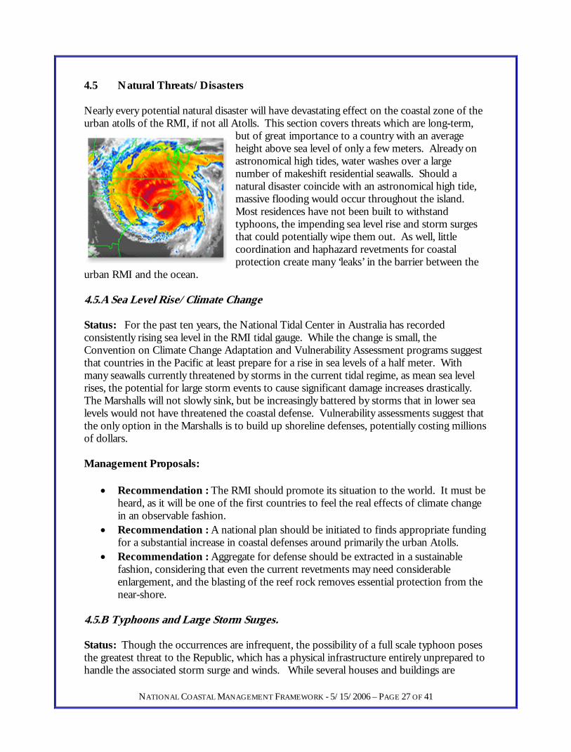
4.5 Natural Threats/Disasters Nearly every potential natural disaster will have devastating effect on the coastal zone of the urban atolls of the RMI, if not all Atolls. This section covers threats which are long-term,
but of great importance to a country with an average height above sea level of only a few meters. Already on astronomical high tides, water washes over a large number of makeshift residential seawalls. Should a natural disaster coincide with an astronomical high tide, massive flooding would occur throughout the island. Most residences have not been built to withstand typhoons, the impending sea level rise and storm surges that could potentially wipe them out. As well, little coordination and haphazard revetments for coastal protection create many ‘leaks’ in the barrier between the
urban RMI and the ocean. 4.5.A Sea Level Rise/Climate Change Status: For the past ten years, the National Tidal Center in Australia has recorded consistently rising sea level in the RMI tidal gauge. While the change is small, the Convention on Climate Change Adaptation and Vulnerability Assessment programs suggest that countries in the Pacific at least prepare for a rise in sea levels of a half meter. With many seawalls currently threatened by storms in the current tidal regime, as mean sea level rises, the potential for large storm events to cause significant damage increases drastically. The Marshalls will not slowly sink, but be increasingly battered by storms that in lower sea levels would not have threatened the coastal defense. Vulnerability assessments suggest that the only option in the Marshalls is to build up shoreline defenses, potentially costing millions of dollars. Management Proposals:
• Recommendation : The RMI should promote its situation to the world. It must be heard, as it will be one of the first countries to feel the real effects of climate change in an observable fashion.
• Recommendation : A national plan should be initiated to finds appropriate funding for a substantial increase in coastal defenses around primarily the urban Atolls.
• Recommendation : Aggregate for defense should be extracted in a sustainable fashion, considering that even the current revetments may need considerable enlargement, and the blasting of the reef rock removes essential protection from the near-shore.
4.5.B Typhoons and Large Storm Surges. Status: Though the occurrences are infrequent, the possibility of a full scale typhoon poses the greatest threat to the Republic, which has a physical infrastructure entirely unprepared to handle the associated storm surge and winds. While several houses and buildings are
NATIONAL COASTAL MANAGEMENT FRAMEWORK - 5/15/2006 – PAGE 27 OF 41
typhoon proof, the vast majority of residences built in especially the poor urban neighborhoods are extremely vulnerable would undoubtedly be washed away in the advent of a full scale storm. With the current status of homes being built only a few feet from crashing ocean waves, coastal planning in the RMI has to date been gambling that no such storm will occur. There does not appear to be an active warning network for weather information, though national radio would surely suffice. Management Proposals:
• Recommendation : The same as above, coastal defenses on a massive scale are necessary for the RMI, and only possible through international funding, as the cost is astronomical.
• Recommendation : In the short term, no further extension of the shoreline should be permitted seawards, as this only increases vulnerability.
• Recommendation : Ensure that national radio is capable of broadcasting warning messages for impending disasters.
4.5.C Tsunami Status: The surrounding bathymetry of the RMI and geographic location allows for the Atoll to escape vulnerability from this very obvious potential threat. Due to the fact that the Atolls are relatively narrow in size and rise sharply from the sea floor, there is little resistance to a passing tidal wave. This section is merely to answer potential questions on tsunamis in the RMI. Management Proposal:
NATIONAL COASTAL MANAGEMENT FRAMEWORK - 5/15/2006 – PAGE 28 OF 41
• Action : A study by SOPAC in May of 2006 should confirm the above assumption. Should the study prove otherwise, a reconsideration of this section would be required.
V. Coastal Data Collection System Data and long term monitoring are extremely important aspects of the coastal management project to observe long-term positive or negative change in the coastal area. The central data storage for all coastal data, including projects, biological, chemical, physical etc. should be via the ArcGIS based Geographic Information System for ready analysis and display for presentation and analysis of data. Currently coastal data collection is either decentralized, grant driven (sporadically), and minimal if existent. The EPA needs to find low cost solutions for collection of coastal data. While high-tech systems are interesting and powerful tools, they are worthless if the source of income providing for their existence is unsustainable. These funding efforts should be utilized to establish baseline conditions, while low cost science based long term monitoring must provide the evidence via indicators representing those conditions. These data provide powerful tools for decision makers, and are extremely useful in evaluating the utility of the coastal management program in the long run. 5.1 Biological Data The coral reef ecosystem may be the most surveyed marine ecosystem world-wide and the RMI is no exception. However, as mentioned above, survey teams are not guided by a particular government mandate, nor is their data input into any national system for comparative analysis with locally observed data. The EPA can facilitate through the CMAC group the collection and sharing of this information as big grant projects come through to engage in surveys in the outer islands. However, in the urban centers of Majuro and Ebeye, quarterly monitoring of long-term sites is recommended for true establishment of the condition of these lagoons. In Jaluit and Wotje (and other outer islands as they come on board) local survey teams can use mask and snorkel to monitor designated near-shore reef and send the data back to the EPA. 5.2 Remotely Sensed data management and analysis In the past year, a large amount of remotely sensed data has been made available to the RMI EPA via a combination of private interests and international donors. This data has proven invaluable in completing the coastal inventories of Majuro, Jaluit, Wotje and Ebeye. The EPA should maintain and active role in acquiring, maintenance of and analysis associated with satellite imagery and other GIS data products. Currently the RMI GIS User’s group is being coordinated by the Coastal Department with definite gains for the EPA, including cost sharing on imagery, equipment loaning from MEC and acquisition of remotely sensed data for in house processing at no cost. Current extent of Remotely sensed imagery for the RMI includes the four priority Atolls as well as Arno, Ujae, Utrik and Wotho. Several purchases are eminent via the USDA and SOPAC for large areas of the RMI territory. 5.3 Coastal Geological Data
NATIONAL COASTAL MANAGEMENT FRAMEWORK - 5/15/2006 – PAGE 29 OF 41
In the late 1990s several long term shoreline monitoring stations were established in Majuro. These stations should become part of the quarterly data collection recommended for the RMI EPA. In combination with long-term aerial photograph and satellite imagery analysis, EPA can successfully monitor erosion or accretion of the shoreline of the RMI. This data

collection should be expanded to include the other three prioritized Atolls and included in the GIS data management system. 5.4 Coastal Pollution While the problem of coastal pollution is ubiquitous in the RMI, there is little monitoring of shoreline conditions to understand the extent of the physical garbage. It is recommended that in order to measure future gains in this area, the EPA initiate quarterly surveys of designated sites for beach pollution. The data again can be input into the spatial data base, should be made public via the radio and newspaper and act as a metric by which the EPA and RMI can measure its handling of solid waste. 5.5 Permitting and Violation Data collection All environmental permits and violations should be constantly updated in electronic version via a GIS database. The resulting dataset can be utilized for simple reporting, and as a way to analyze the impacts of various development projects. This system is currently in place for Earthmoving permits, both major and minor, but not other permits and violations in general. 5.6 Social Data Collection. Periodically the EPA should conduct social awareness surveys that assess both environmental attitude and related behavior to the coastal issues identified in this report. To date, no such survey has been conducted, but could be included in local management plans as a priority for action.
NATIONAL COASTAL MANAGEMENT FRAMEWORK - 5/15/2006 – PAGE 30 OF 41

VI. EDUCATION AND OUTREACH The RMI EPA must rely heavily on local government and community partners for the outreach and promotion of the topics covered in this framework. Four key avenues are proposed for the outreach campaign:
• Media based (local newspaper and radio) awareness of environmental regulations. This campaign must be consistent and for a few years. Currently an Advertisement has been placed raising awareness of earthmoving regulations, this shall continue on a monthly basis, to bring compliance of EPA regulations to 100%.
• Web-based international promotion of the EPA Coastal program and associated regulations necessary for international firms conducting development projects in the RMI.
• Development of educational presentations by the EPA Education and Awareness Office for students and adults alike on coastal issues as they arise, including, but not limited to:
o Coastal erosion and seawall construction. o Elimination of Plastics from private landfills. o Coral Reef Health and importance. o Oil spill prevention and awareness. o Toilet and Sewer systems
• Development of Coastal Management Posters to address the same issues as above. • Coordination with MIVA, CMAC and NGOs to build alternative awareness
raising activities for coastal quality including: o Songs o Plays
NATIONAL COASTAL MANAGEMENT FRAMEWORK - 5/15/2006 – PAGE 31 OF 41
o Posters

VII. LEGAL MANAGEMENT OPPORTUNITIES The vast majority of this report involves not regulatory, but participatory solutions. However, the EPA must maintain it central role in the coastal area as an enforcer of relevant environmental law. The track record of EPA enforcement however, has not created a great deal of change in behavior in the coastal realm and the hope of this program is to provide improved incentives for this shift. As such, regulations and the potential of violations are a must for the campaign to be successful. However, this should not remain THE ONLY tool of the EPA, it should be an option of last resort, and should be triggered in a systematic objective manner. 7.1 Environmental Impact Assessment Regulations The RMI EIA regulations have gone through a major implementation phase in the past year. In total, five EIA procedures have been completed, and another five are on their way. Not without criticism, the central feedback the EPA has received is that it is not being strong enough, and that the EIA procedures should start earlier in the development project process. This is an excellent sign for the EPA that the tool can remain a vital tool for project management in the RMI. Of high importance is that the RMI EPA General Manager or a representative is included on all major project management or bid committees. This way, information concerning potential project impacts, and their management and regulatory requirements can be disseminated as early as possible. It is estimated that the EPA should be prepared for anywhere from four to ten EIAs in any given year as long as current compact and international funding allows for the push in infrastructure development that is currently driving construction on island. The EPA does have some problems concerning the effective evaluation of the highly technical components of EIAs. For this problem, it is recommended that the EPA utilize its long-term partners for free feedback on the scientific content in all future Environmental Impact Assessments. Three organizations are suggested as recipients of EIAs in the future for analysis and feedback, SOPAC, USEPA Region 9 Pacific Islands Office and SPREP. As well, it is recommended that EPA continue to keep an outside Environmental Advisor on staff to coordinate, among other things EIAs especially with international applications and companies. 7.2 Earthmoving Regulations It is proposed that these regulations be super-ceded by the proposed Sustainable Development Regulations that are currently being reviewed and awaiting approval by the RMI EPA Board. Though a highly effective tool to manage some development projects, there are serious loopholes in permit fee language, many coastal activities cannot be adequately regulated, and environmental management is not as flexible as is necessary given the current permit system. This said, a complete review of the current status of these regulations is not included in this survey 7.3 Sustainable Development Regulations
NATIONAL COASTAL MANAGEMENT FRAMEWORK - 5/15/2006 – PAGE 32 OF 41
The proposed sustainable development regulations suggest a new permit system that covers, among other things a fixed permit fee for three tiers of projects, broader regulatory power
than the previous Earthmoving permits, exceptions for outer islands residential projects outside of the coastal zone, several activities that are to be phased out, including lagoon side dredging, and the implementation of Environmental Management Plans (EMP) for projects that are major but do not require a full EIA. These EMPs will allow for EPA to work in consultation with the project applicants to predict major and minor environmental problems and hopefully avoid any unnecessary damage. These regulations are required by the Coast Conservation Act, and are intended to super-cede earthmoving regulations to avoid redundancy. Copies of the draft regulations are available at EPA upon request. 7.4 Marine Water Quality Regulations Currently a review of these regulations is being carried out between the Coastal and Water Quality department of the EPA. This review, part and parcel of the EPA’s Coastal Management program, should result in a new set of revised regulations as well as a revised program for monitoring marine water. 7.5 Toilet and Sewer Facility Regulations As has been identified in a previous section, these regulations must be adequately enforced by the RMI EPA. No new septic systems should be allowed in the DUD or Ebeye area, where public sewer systems are available. 7.6 Solid Waste Regulations A review of these regulations and their enforcement is suggested in order to effectively begin to handle the solid waste situation as it relates to coastal issues. This should be conducted independent of this project and be prioritized by the RMI EPA. Specifically these regulations should, among other things, severely restrict private landfills, encourage incineration, and require by law recycling, composting and waste reduction programs by private sector. 7.7 EPA fining system The current EPA fining system for both environmental damage and infractions of regulatory procedure is both haphazard and unequally enforced. This is partially because the EPA allows applications to bargain down their violation fee based on their explanation of the violation. This creates a significant problem with EPA of unpaid fines, unequal enforcement and associated inequitable treatment. EPA needs a clear, fixed and transparent system for handling minor coastal infractions. While incidents involving major environmental fines should remain subject to the judgment of the courts or General Manger, smaller and more routine fines need a public and judicial system for allocating fines.
NATIONAL COASTAL MANAGEMENT FRAMEWORK - 5/15/2006 – PAGE 33 OF 41

Table: Proposed EPA fining system
Activity 1st Instance
2nd Instance 3rd Instance 4th Instance Continued
Earthmoving w/o permit
$100.00
$200.00
$500.00
$1000
Increase by $1,000 to 10,000
Earth moving condition violation
warning $100.00 $200.00
$500.00
$5,000.00 plus cease and desist
Oil Spill (minor)
$500.00 $1000.00 $2500.00 $5000.00 $10,000
plus court action
EIA condition violation
warning $100.00 $200.00
$500.00
$5,000.00 plus cease and desist
7.8 Local Coastal Management Programs The RMI EPA shall immediately initiate discussion with local governments to draft local Coastal Management Programs. These programs should start with small projects that are conducted jointly with EPA support, and then can expand over time. The following are suggestions for projects under local government coastal management programs:
• Draft zoning maps to be utilized for planning decisions and EPA environmental permitting, then later incorporated into local ordinances or planning. These maps should at a minimum divide atolls into the following areas fro the requirements of the CCA §307(1)(c):
Residential Conservation Recreational Agricultural/Copra Industrial Seaport Commercial Government Development
• Solid Waste reduction, recycling and composting projects. • Coastal Clean-up projects. • Human and animal waste law enforcement and education. • Empowerment of local governments to be in close contact with EPA Coastal Office
concerning major development projects and general environmental concerns. Local government coastal management projects will be supported fully by the Coastal Management Office. Successful adoption of projects supported by local governments will contribute significantly to the sustainability of the EPA’s Coastal Program.
NATIONAL COASTAL MANAGEMENT FRAMEWORK - 5/15/2006 – PAGE 34 OF 41

VIII. INSTITUTIONAL ARRANGEMENTS Several organizations have crucial roles to play in the long-term sustainability of this coastal management project. CMAC – The MIMRA recognized (and soon to be EPA recognized) Coastal Management Advisory Committee shall be the de facto advisory council for the Coastal Management Division into the immediate future. EPA has helped shape the role of this organization to include coastal data collection, coral reef monitoring and assessments of land-based impacts. CMI – The central strength of the College of the Marshall Islands is the human resources it brings to the country. With strong Marine Science and Agricultural departments, much technical knowledge about environmental processes can be attained from this key partner. As well, CMI is an essential resource for providing capable individuals that can conduct Environmental Impact Assessments. The Partnership for coral reef monitoring and surveys must be continued and broadened given the mandate of this plan. EPPSO – The Economic Policy, Planning and Statistics Office has in its mandate to develop local planning programs if local government have failed to do so, according to the Planning and Zoning Act. EPPSO has the potential to be a powerful partner for large scale environmental planning, and coordinate of further formalize local planning ordinances that would greatly improve coastal quality in the RMI. GIS User’s Group – A small group of GIS User’s on Majuro have started this group to collaborate in data collection, training and knowledge exchange. EPA’s Coastal Division has served as the essential secretariat for this organization over the past year. Historic Preservation Office and Allele Museum – Coordination with these offices shall continue for all permitting projects. Importantly, any major development that is considered for EIA should be vetted through the HPO office. MICS and other NGOs – The EPA Coastal department will support any mutually beneficial efforts from the emerging environmental civil society in the RMI. Support can range from technical assistance, GIS mapping, cooperation for data collection etc. MIMRA – The benefits of this program represent large gains for MIRA coastal fisheries projects. As has been identified in earlier pages, MIMRA is vital to the successful environmental oversight and sustainability of marine operations MIVA – Sustainable and clean coasts have been established as a priority for the Visitor’s Authority, going hand in hand with successful tourism development in the RMI. MIVA is a strong partner for coastal clean-up campaigns, and has demonstrated effectiveness in greatly improving the situation with undisposed trash Majuro’s DUD area. The EPA Coastal department shall support MIVA’s efforts to promote sustainable tourism and consider jointly beneficial projects to improve the coastal zone.
NATIONAL COASTAL MANAGEMENT FRAMEWORK - 5/15/2006 – PAGE 35 OF 41
OEPPC – As the central agency for programming international environmental treaties and resulting funding, OEEPC should endorse this plan and assist EPA in finding funding partners and possibilities to ensure the programs long-term sustainability.

IX. FUNDING POSSIBILITIES AND EXTERNAL ASSISTANCE External funding has historically provided a large portion of the EPA budget. The US Compact of Free Association notably provided in FY2005 over $400,000 to the EPA. It is vital that funding on this scale continue for the RMI EPA, either through the Compact or directly from the central government. Beyond this, many grant driven projects have been initiated at EPA over the years. Many of these projects have resulted in unsustainable and highly technical results. Funding opportunities for the Coastal division should focus on outputs that can be directly utilized by the staff at the EPA. As well, funding efforts should provide outputs that can last long after the funding has been exhausted. This said, there will undoubtedly continue to be a large volume of funding available for coastal issues in the RMI. Elements of this plan that would require external assistance have been highlighted in the appendix. Funded projects should not disrupt the day to day operations of the department that can be funded through the annual budget and the revenue from permits and fines. This said the following entities should be potential external contacts for coastal funding or technical assistance in the future:
• US Department of Interior • US EPA Region 9 • South Pacific Regional Applied Geoscience Commission • South Pacific Regional Environmental Program • US National Oceanographic and Atmospheric Administration • Global Environment Facility – Desertification Convention • Global Environment Facility - Convention on Biological Diversity
NATIONAL COASTAL MANAGEMENT FRAMEWORK - 5/15/2006 – PAGE 36 OF 41
• Global Environment Facility - International Waters Project
X. CONCLUSION This Framework provides an action plan for the RMI on many issues that impact the coast. As a low elevation nation, the population of the Marshalls feels the impact of the ocean and environmental problems on their shores more than most nations. It is vital that the RMI at a national level continue to pursue the mission that has been initiated with the signing of the Coast Conservation Act of 1988. It is recommended that the plan be considered by all relevant government Ministries and an agenda for improvement of the coastal zone be adopted by each relevant ministry or regulatory authority. The EPA which currently houses the Coastal Program will continue to coordinate actions, meetings and projects per this Framework, and will review annually to assess its success or failure. With a renewed commitment to the importance of a successful coastal management program, , the coasts of the RMI will be secure from erosion, clean from trash, healthy for its children and attractive for foreign investors and visitors. Given that there is currently no National Environmental Council, this Plan will be on display for public comment until June l6, 2006, after which a revised final plan will be submitted to Cabinet through the Minister in Assistance to the President for final adoption and approval, per CCA §304(4).
NATIONAL COASTAL MANAGEMENT FRAMEWORK - 5/15/2006 – PAGE 37 OF 41
XI. RESOURCES UTILIZED Coastal Management Marshall Islands Anzdec LtD. Consultants. 1998 Optimization of the Environmental review Process for Fisheries Development Initiative in the Marshall Islands. ADB TA 2854. Baker, Nicole and Chutaro, Ben 2004. Capacity-Building Needs Assessment for Biodiversity Conservation in the Marshall Islands. Carter, Ralf 1995 Final Report: Technical Assistance to the Republic of the Marshall Islands for Strengthening the Environmental Protection Authority. Asian Development Bank (ADB) Crawford, Martha J. 1992. National Environmental Management Strategy. National Task Force on Environmental Management and Sustainable Development. Doig, Kevin. 1995. RMI Water and Sanitation Sector Strategy and Action Plan. SOPAC Technical Report 236 Hawaii Architects and Engineers 1968. Majuro Atoll, Marshall Islands District : Trust Territory Physical Planning Program Final Report. Hawaii Architects and Engineers 1968. Trust Territory of the Pacific Islands Wotje Master Plan. Planning Division, Dep. Of Public Works. Kijiner, Tom 1993. Addressing Porjected Impacts of Climate Change in the Context of Integrated Coastal Management Planning. Submitted to the US Department of State Office of Global Change. Kuston, Karness et al. 1998. Summary and Achievements of UNDP Project MAS 95/001 Formulation of a Coastal Zone Management Plan for Majuro Atoll. Maragos, James E. and Meier, Karen Z. 1994. Technical Assistance to the Republic of the Marshall Islands TA 1826 MAR Strengthening the Environmental Protection Authority. ADB Maragos, James E. 1989. Water Resources Plan of Action for the Republic of the Marshall Islands. Office of Economic Adjustment, Office of the Secretary of Defense. National Biodiversity Strategy and Action Plan Team 2000. RMI Biodiversity Strategy and Action Plan. GEF and UNDP St. Hildegard Publishing Co. Santa Clarita, CA USA. Phillips, Bill and Baker, Nicole. 2005. Institutional Capacity Building and Review of Training Needs for Implementationof the Ramsar Convention on Wetlands in the RMI. Ramsar. Pilkey, Orrin H. Coastal Erosion on Majuro Atoll, Marshall Islands RMI EPA 2004. RMI Environmental Protection Authority Strategic Action Plan 2004-2007. Jimor Wodejipel Pelaak Kein Ad. Rogers, Nick 2003. Case Study on the application of Traditional Environmental Management on Majuro Atoll RMI. ADB TA 5913 REG Strategic Econimic Development Plan Coordinating Committee. 2001. Vision 2018 Marshall Islands Sustainability Master Plan. Republic of the Marshall Islands. SOPAC 1997. Beach Monitoring Seminar Handout. Spennemann, Dirk H. R. 1990. Cultural Resource Management Plan for Majuro Atoll, RMI. US Department of Interior , Office of Territorial and Insular Affairs.
NATIONAL COASTAL MANAGEMENT FRAMEWORK - 5/15/2006 – PAGE 38 OF 41

Tobey, James et. Al 2005. Policies and Priority Actions for Sustainable Mariculture Development in the Republic of the Marshall Islands. Publication #2005-4. Coastal Management General De Fontaubert, A. Charlotte, Downes, David R. and Agardy, Tundi S. 1996. Biodiversity in the Seas : Implementing the Concention on Biological Diveristy in Marine and Coastal Habitats. IUCN, FAO 1992. Integrated Management of Coastal Zones. FAO Fisheries Technical Paper 327. Hale, Lynee Zeitlin et al. 1999. Application of International Experience to Formulation of a National Policy for Coastal Management for the Republic of south Africa. Coastal Managemetn Report #2206. CRC and Coastal Managemetn Policy Prgramme, South Africa. Howorth, Russell, 1995. Report on the Third Coastal Protection Meeting. SOPAC Miscellaneous Report 192. The International Tanker Owners Pollution Federation Ltd. 1987. Response to Marine Oil Spills. Witherby & Co. Ltd. London. Kay, Robert and alder, Jacqueline 1999. Coastal Planning and Management. Spon Press New York, New York. National Economic Development Authority Region I Philippines 1992. The Lingayen Gulf Coastal Area Management Plan. Association of Southeast Asian Nations/United States Coastal Resources Management Project Technical Publications Series 10. Olsen, Stephen et al. 1997. Survey of Current Purposes and Methods for Evaluating Coastal Managemnt Projects and Programs Funded by International Donors. Coastal Management Report #2200 Coastal Resources Center URI. Olsen, Stephen B. and Kerr Meg 1998. Building Constituencies for Coastal Management : A Handbook for the Planning Stage. Coastal Management Report #2214 coastal Resources Center URI. Preston, G.L. et al. Ship Groundings in the Pacific Islands Region. SPREP Robadue, Don Jr. 1995. Eight Years in Ecuador: The Road to Integrated Coastal Management. Coastal Resources Center, University of Rhode Island and USAID. SPREP, 1999. Coastal Management Profiles Sem, Graham et al. 1996. Integrated coastal Zone Managemetn Programme for Fiji and Tuvalu – Coastal Vulnerability and Resilience in Tuvalu Assessment of Climat Change Impacts and Adaptation. Environment Agency Japan, SPREP. Thaman, Batiri and Aalbersberg, Bill. 2004. Initiating Integrated Coastal Management in the Fiji Islands. Presented at the Coastal Zone Asia-Pacific Symposium, 2004. Scientific Reports/Surveys Aiello, Robin. 2001. Jaluit Atoll Conservation Area Marshall Islands Feasibility Assessment & Support for Community Ecotourism Development. Prepared for the South Pacific Biodiversity conservation Programme of SPREP. Terra Firma Associates. Collen, John D. 1995. Preliminary Comment on Visit to Funafuti, Majuro and Tarawa Atolls. SOPAC Preliminary Report 81. Fournial, Francoise, 1998. Hydrodynamic Simulations with Mike21 for Majuro Atoll, Marshall Islands SOPAC Preliminary Report 99.
NATIONAL COASTAL MANAGEMENT FRAMEWORK - 5/15/2006 – PAGE 39 OF 41
Harris, Larry G. Reef Study: fish Populations and Reef Structure of Eleven Reefs in Majuro Atoll, RMI. Marine Science 180 college of the Marshall Islands.
Holly, Matt 1998. Beach Profile and Underwater Survey for PII Dredging Project at Lojemwa Weto. Marshall Islands Aquatics. Holthus, P et al. 1992. Vulnerability Assessment of Accelerated Sea Level Rise Case Study: Majuro Atoll, Marshall Islands. SPREP Apia, Western Samoa. Lindsay, Stephen 2000. Marine Resource Survey of Jaluit Atoll, Republic of the Marshall Islands. SPREP. Maragos, James E. 1993. “Impact of Coastal Construction on Coral Reefs in the US Affiliated Pacific Islands.” Coastal Management. Volume 21 235-269. McKenzie, Emily et al. 2006 Economic Analysis of Alternative Methods of Obtaining Aggregates for Construction in Majuro Atoll, Marshall Islands. Draft SOPAC Technical Report. National Biodeiversity Team, 2000. The Marshall Islands – Living Atolls Amidst the Living Sea. The National Biodiversity Report of the Republic of the Marshall Islands. Pinca, Silvia 2004. Majuro Atoll Underwater Resource Assessment. National Resource Assessment Surveys(NRAS) Team. Smith, Robert, 1994. Survey for Alternative Sand and Gravel Resources, Majuro Atoll, Marshall Islands. SOPAC Preliminary Report 71. Smith, Robert, 1995. Sand and Aggregate Resource Majuro Atoll, Marshall Islands SOPAC Technical Report 215. Smith, Robert and Collen, John. 2004. Sand and Aggregate Resources of Majuro Atoll, Marshall Islands. SOPAC Technical Report 360. SOPAC 1987. Workshop on Coastal Processes in the South Pacific Island Nations. Technical Bulletin 7. SOPAC 1994. Coastal Protection in the South Pacific. SOPAC Technical Report 190. Spennemann, Dirk H. R. 1990. Eroding Cemetaries in the DUD Area, Majuo Atoll, RMI. Report Prepared for the Historic Preservation Office. Woodward, Phil and Howorth, Russell. 1997. Beach Monitoring in DUD and Laura, Majuro Atoll, Republic of the Marshall Islands. SOPAC Preliminary Report 88. Woodward, Phil, 1998. Re-survey of DUD & Laura Beach Profiles Majuro Atoll, Republic of the Marshall Islands. SOPAC Preliminary Report 93. Xue, Chunting 1997. Coastal Sedimentation and Erosion and Management of Majuro Atoll Republic of the Marshall Islands. (Including Appendices 1 & 2) SOPAC Technical Report 254. Yamano, H. 2002. “Sesitivity of Reef Flats and Reef Islands to Sea-level Change”. Proceedings of the 9th International Coral Reef Symposium 1193-1198 Yamano, Hiroya et al. 2005. “An Overview of the Nature and Dynamics of Reef Islands.” Global Environmental Research 9(1)/2005 : 9-20. Yokoki, Hiromune et al. 2005 “Comparison between Longshore Sediment Transport Due to Waves and Long-term Shoreline Change in Majuro Atoll, Marshall Islands. Global Environmental Research 9(1)/2005 : 21-26. Environmental Impact Assessment
NATIONAL COASTAL MANAGEMENT FRAMEWORK - 5/15/2006 – PAGE 40 OF 41
Carpenter, Richard A. and Maragos, James E. 1989. How to Assess Environmental Impacts on Tropical Islands and Coastal Areas. SPREP , Environmental and Policy Institute East-West Center. Federal Emergency Management Agency 1998. Environmental Assessment Seventh Day Adventist School and Majuro cooperative School Shoreline Protection Project Majuro Republic of the Marshall Islands. Cruickshank, Michael J. and Morgan, Charles L. 1996. Environmental Impact Assessment : Proposed Sand Dredging in Basin A Offshore from Nuku’Alofa, Kingdom of Tonga. Parsons Engineering Science Inc. 1995. Preliminary EIA :Engineering Study/Investigation for Majuro Airport Oceanside Revetment. Submitted to RMI Ministry of Public Works. Willard Resources Development. Date Unknown. Environmental Impact Study for Island Investments LtD. Proposed Erikub Atoll Resort. Prepared for Environmental Protection Department Republic of the Marshall Islands.. Geographic Information Systems Asia Air Survey Co. Ltd., 1996. Coastal Zone Mapping and Coastal Management System for Majuro Atoll in the RMI. CORIAL, 1993. Geographic Information System (GIS) for the Republic of the Marshall Islands. Howorth, Russell and Phil Woodward, 1994. SOPAC 1994 Coastal Mapping Workshop Majuro Atoll, Republic of the Marshall Islands. SOPAC Training Report 66. SOPAC 1993. Coastal Mapping Workshop Yamano, Hiroya et al. 2005. “Efforts to Generate Maps of Atoll Countries.” Global Environmental Research 9(1)/2005 : 37-46.
NATIONAL COASTAL MANAGEMENT FRAMEWORK - 5/15/2006 – PAGE 41 OF 41