risk sensitive vdp report kallanchiya - final draft
TRANSCRIPT
1 Village Development Plan of Kallanchiya GN Division at Galgamuwa DS Division
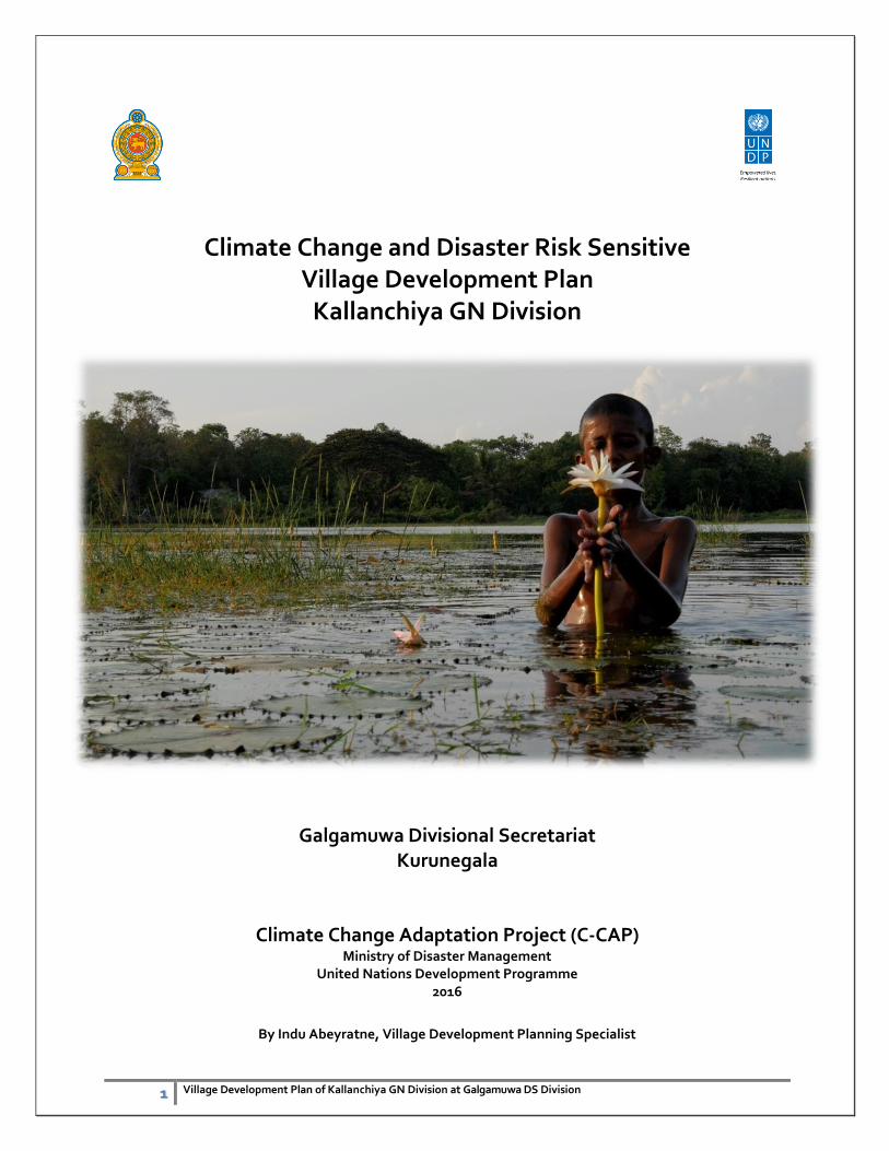
Climate Change and Disaster Risk Sensitive Village Development Plan
Kallanchiya GN Division
Galgamuwa Divisional Secretariat Kurunegala
Climate Change Adaptation Project (C-CAP) Ministry of Disaster Management
United Nations Development Programme 2016
By Indu Abeyratne, Village Development Planning Specialist
2 Village Development Plan of Kallanchiya GN Division at Galgamuwa DS Division
Preface
Building a safe, secure, and resilient community is one of the strategic goals of the Sri Lanka’
Comprehensive Disaster Management Programme of the Ministry of Disaster Management (MDM).
United Nations Development Programme (UNDP) directly supports the attainment of this goal by
providing financial and technical assistance to improve economic and social infrastructure and public
sector service delivery. This publication documents the output from a pilot adaptation project,
facilitating the risk sensitive village development planning through participatory development
initiatives at ground. The project focuses on three key areas: (i) fast-tracking and scaling up climate
change adaptation measures, (ii) building capacity to enable the integration of climate change into
national development plans and programs, and (iii) promoting disaster and climate change sensitive
development planning process. The project was funded under its Special Climate Change Fund
(SCCF) of Global Environment Facility (GEF) which assists in enhancing country initiatives on climate
change. The SCCF focuses on developing and pilot-testing innovative, low-cost adaptation
interventions in line with UNDP’s conscious effort to synthesize and disseminate lessons on effective
climate change adaptation responses. This publication is part of a series of community development
plans designed to facilitate Divisional Secretariat division level planning process which is based on
projected risks, and to provide a better understanding of what makes adaptation actions effective.
UNDP’s support for the project highlights its commitment to put in place climate change solutions
that are adapted to local contexts and guided by the interests of local communities, including the
vulnerable.
The MDM views local adaptation and community participation as crucial in addressing the diverse
range of physical and human geographic circumstances in the country, which express themselves in
differing patterns of vulnerability and in the varying levels, timing, and nature of climate change risks.
We hope that this publication will provide insights into how climate change adaptation may be
strengthened and accelerated through community-based risk assessment and participatory planning.
The process and tools used in the project were designed in consultation with divisional level officials,
the communities, local experts, relevant government agencies, and other development
organizations. MDM and UNDP encourage replication of the process and tools in ways that are best
suited to local conditions and the needs of vulnerable communities.
3 Village Development Plan of Kallanchiya GN Division at Galgamuwa DS Division
Executive Summery
Today uncertainties associated with climate variability poses great risks to the economic
development all over the world. Sri Lanka has reasons to be concerned about climate change. Its
population depends upon climate-sensitive sectors like agriculture and forestry for its livelihood. Any
adverse impact on water availability due to changes in rural ecosystem, decrease in rainfall and
increased flooding in certain pockets would threaten food security, pose risk to the natural
ecosystems including species that sustain the livelihood of rural households, and adversely impact the
coastal system due to sea-level rise and increased extreme events.
A culture of resilience provides a way to reduce vulnerability to disasters and their impacts before they
occur, with the potential to decrease disasters’ costs and consequences. However, building the culture
and practice of disaster resilience is not simple or inexpensive. Decisions about how and when to
invest in increasing resilience involve short- and long-term planning and investments of time and
resources prior to an event.
In this context Ministry of Disaster Management is implementing a Climate Change Adaptation
Project (C-CAP) with the support of UNDP Sri Lanka for four years in most vulnerable districts to
climate induces disasters in Puttalam, Kurunegala and Ratnapura. The project scope is in line with the
Community resilience Framework which will be key guiding framework for risk sensitive development
in the country in future which was developed under the Sri Lanka Comprehensive Disaster
Management Programme.
In order to address above risks, the project aims to build adaptability to climate change into the
design and implementation of developments planning. Building resilience in rural development
programmes to current and projected climatic change will include developing institutional capacities
to assess risk, designing appropriate interventions and implementing adaptation actions with
community participation.
This Village development Plan (VDP) for Kallanchiya Grama Niladhari Division (GND) in Galgamula
Divisional Secretariat (DS) Division in Kurunegala District will provide a better outlook of future
development planning measures derived based on disaster and climate change sensitive lenses which
will be support division level planning to be more focus on risk base.
The VDP has developed on a comprehensive risk assessment led by the Village Development
Committee (VDC) chaired by the GN officer with the support of Development Officer, Social Service
Officer and Agriculture Research Assistant with the guidance of Divisional Secretary and the
leadership of the Assitant Director of Planning at the Galgamuwa DS Division.
The VDP is articulated based on the Guidelines developed by the Ministry on Climate Resilient Village
Development Planning thorough the Climate Change Adaptation Project (C-CAP).
4 Village Development Plan of Kallanchiya GN Division at Galgamuwa DS Division
Acknowledgement
Author would like to acknowledge the enormous support given by the Divisional Secretary of
Galgamuwa and Assistant Director Planning in working with the Kallanchiya division and their officials.
Further special note goes to the Grama Niladhari of Kallanchiya GN division and also development
officer, social service officer and agriculture research assisting officer assigned to the division. Special
acknowledgement goes to relief Service officer attached to the Divisional Secretariat, who has helped
out of the way throughout the process.
Special appreciation to the people of Kallanchiya village for their commitment and cooperation in the
data collection and mapping exercises, and their active participation in the village development
process.
Author wishes to specially note appreciation to the C-CAP team and also National Project Director,
national Project Coordinator and technical specialist for their guidance and contribution. Further
author wishes to convey appreciation to all UNDP officials who are attached to the project for their
continuous support in delivering targets.
5 Village Development Plan of Kallanchiya GN Division at Galgamuwa DS Division
1. Background & Context
1.1 Introduction
Kurunegala District, which is situated in North Western Province, is comprised of 30 Divisional
Secretariats (DS) and 47 Grama Niladhari Divisions (GNDs), of which 12 are within the Municipal
area.
The population of the District is just over 1.5 million and Kurunegala City has a population of 28571.
The labour force participation rate in Kurunegala District was found to be around 51% with almost
twice as many men as women (DCS 2004; DCS 2003). Figures for the DS Division were not
available. The literacy rate of the population over 10 years of age in Kurunegala District is 92.7%
(Source Department of Census & Statistics).
Kurunegala District spans part of the dry zone and the intermediate zone of Sri Lanka. The
agricultural areas covered in this study are within the area defined as intermediate zone low
country. Most of the plots that are irrigated with clean water have sandy or mixed soil but in the
wastewater area around 60% of plots have highly sandy soil and 40% have clayey soils.
The target area of the project in confined to Galgamuwa Divisional Secretariat Division, of
Kurunegala district. Galgamuwa DS division covers an area of 249.72km2 which is 2.66% of the
total area of North Western Province. Division also covers inland water bodies or 4.36% from its
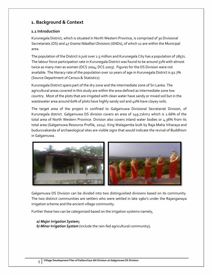
total area (Galgamuwa Resource Profile, 2014). King Walagamba built by Raja Maha Viharaya and
buduruvakanda of archaeological sites are visible signs that would indicate the revival of Buddhism
in Galgamuwa.
Galgamuwa DS Division can be divided into two distinguished divisions based on its community.
The two distinct communities are settlers who were settled in late 1960’s under the Rajanganaya
irrigation scheme and the ancient village community.
Further these two can be categorized based on the irrigation systems namely,
a) Major Irrigation System; b) Minor Irrigation System (include the rain-fed agricultural community);
6 Village Development Plan of Kallanchiya GN Division at Galgamuwa DS Division
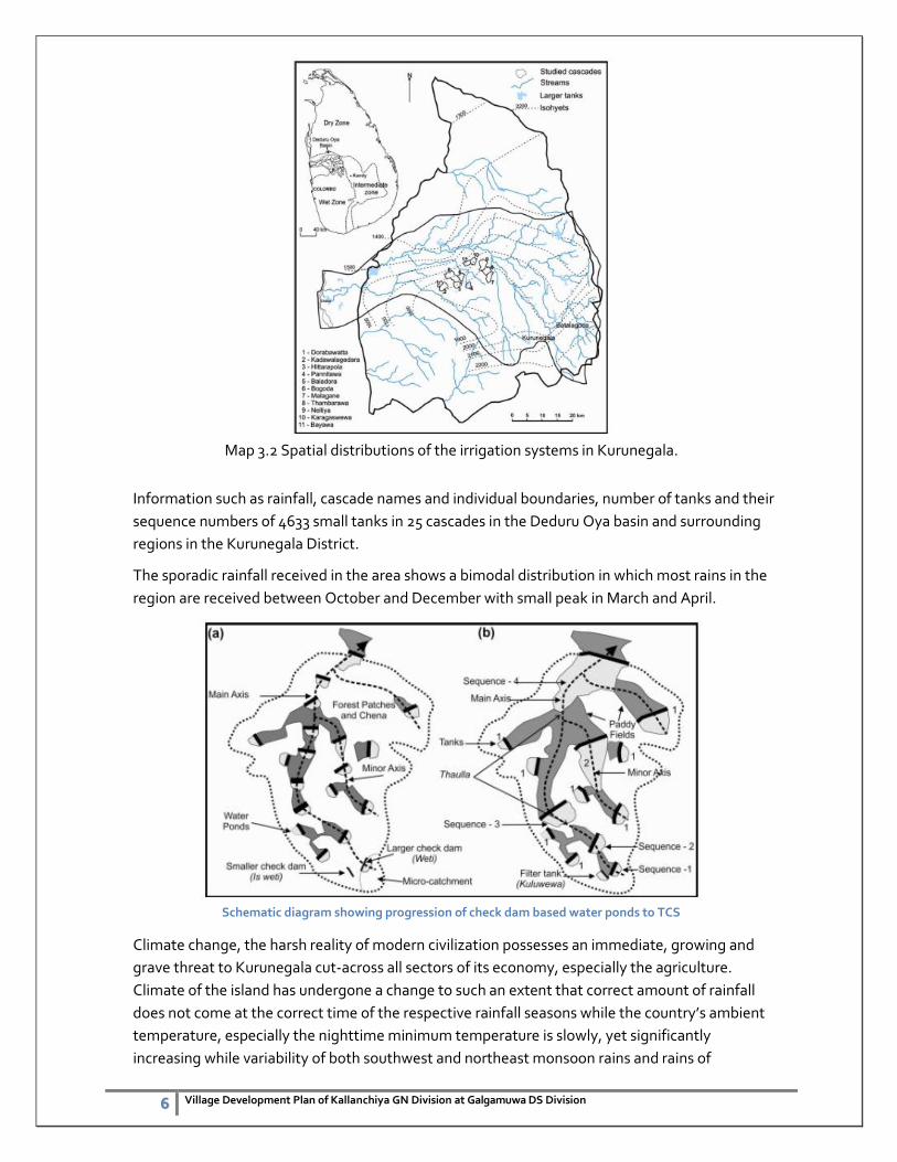
Map 3.2 Spatial distributions of the irrigation systems in Kurunegala.
Information such as rainfall, cascade names and individual boundaries, number of tanks and their
sequence numbers of 4633 small tanks in 25 cascades in the Deduru Oya basin and surrounding
regions in the Kurunegala District.
The sporadic rainfall received in the area shows a bimodal distribution in which most rains in the
region are received between October and December with small peak in March and April.
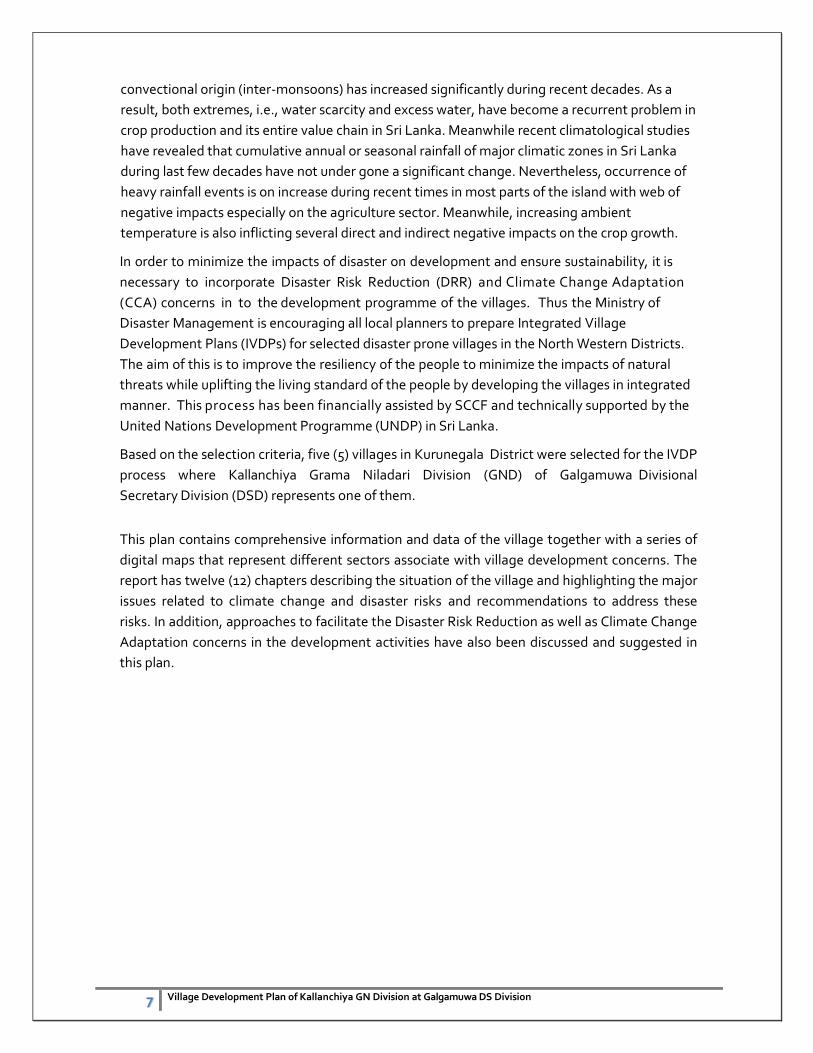
Schematic diagram showing progression of check dam based water ponds to TCS
Climate change, the harsh reality of modern civilization possesses an immediate, growing and
grave threat to Kurunegala cut-across all sectors of its economy, especially the agriculture.
Climate of the island has undergone a change to such an extent that correct amount of rainfall
does not come at the correct time of the respective rainfall seasons while the country’s ambient
temperature, especially the nighttime minimum temperature is slowly, yet significantly
increasing while variability of both southwest and northeast monsoon rains and rains of
7 Village Development Plan of Kallanchiya GN Division at Galgamuwa DS Division
convectional origin (inter-monsoons) has increased significantly during recent decades. As a
result, both extremes, i.e., water scarcity and excess water, have become a recurrent problem in
crop production and its entire value chain in Sri Lanka. Meanwhile recent climatological studies
have revealed that cumulative annual or seasonal rainfall of major climatic zones in Sri Lanka
during last few decades have not under gone a significant change. Nevertheless, occurrence of
heavy rainfall events is on increase during recent times in most parts of the island with web of
negative impacts especially on the agriculture sector. Meanwhile, increasing ambient
temperature is also inflicting several direct and indirect negative impacts on the crop growth.
In order to minimize the impacts of disaster on development and ensure sustainability, it is
necessary to incorporate Disaster Risk Reduction (DRR) and Climate Change Adaptation
(CCA) concerns in to the development programme of the villages. Thus the Ministry of
Disaster Management is encouraging all local planners to prepare Integrated Village
Development Plans (IVDPs) for selected disaster prone villages in the North Western Districts.
The aim of this is to improve the resiliency of the people to minimize the impacts of natural
threats while uplifting the living standard of the people by developing the villages in integrated
manner. This process has been financially assisted by SCCF and technically supported by the
United Nations Development Programme (UNDP) in Sri Lanka.
Based on the selection criteria, five (5) villages in Kurunegala District were selected for the IVDP
process where Kallanchiya Grama Niladari Division (GND) of Galgamuwa Divisional
Secretary Division (DSD) represents one of them.
This plan contains comprehensive information and data of the village together with a series of
digital maps that represent different sectors associate with village development concerns. The
report has twelve (12) chapters describing the situation of the village and highlighting the major
issues related to climate change and disaster risks and recommendations to address these
risks. In addition, approaches to facilitate the Disaster Risk Reduction as well as Climate Change
Adaptation concerns in the development activities have also been discussed and suggested in
this plan.
8 Village Development Plan of Kallanchiya GN Division at Galgamuwa DS Division
1.2 Objectives of the Plan
Main Objective
The main objective of the plan is to mainstream Disaster Risk Reduction concepts in to village
development plan and thereby improve the resilience capacity of vulnerable communities to
minimize the impacts of natural disasters on the economy of the village.
Specific Objectives
1) To identify the impacts of hazards into the development programme in the area
and measures to mitigate the impacts.
2) To identify the possible impacts of the proposed development programmes on
the environment and the possibility of triggering disaster situation and proposed
mitigation activities.
3) To improve the community awareness on mainstreaming disaster risk reduction
components in to village development plan and the contribution of community to
achieve development targets.
1.3 Methodology
1.3.1 Selection of the Village
The disaster profile of the village was considered for the selection. In addition availability of
infrastructure such as roads, drinking water, health services etc. and population were also
considered. District Secretary of Kurunegala District and Divisional Secretary of Galgamuwa
DSD were also consulted to finalize the selection.
1.3.2 Collection of Data
Secondary data was collected from the DS offices and officials specially the Planning unit of
the Secretariat. Key informant survey done together with GN officer of the Kallanchiya
division. Primary data were collected from the village mainly by using Participatory Rural
Appraisal (PRA) method. PRA was used to identify the issues of the village with the
participation of the people of the village, office bearers of the Village Development Society,
Grama Niladari and the officials of the planning branch of the Divisional Secretariat.
Subsequently the identified issues/needs were ranked by the consensus of majority of people
involved in the IVDP process.
In addition the other tools of the participatory approach such as community interviews,
workshops, participatory mapping, seasonal event calendars, transect walk, historical time
line, decision matrix were used when and where ever necessary. A questioner was also used to
collect the necessary data of the village.
9 Village Development Plan of Kallanchiya GN Division at Galgamuwa DS Division
Secondary data were collected from published documents (e.g. Census data) and unpublished
data available with other institutions. Due to unavailability of some secondary data (e.g.
rainfall data) for the village, the data available either for respective Divisional Secretary
Division or for respective District was considered.
Spatial information was collected by three methods i.e. participatory mapping exercise, using
updated maps and using recent satellite images. The final computer generated maps were
prepared using mapping software namely QGIS.
Kllanchiya GN Division
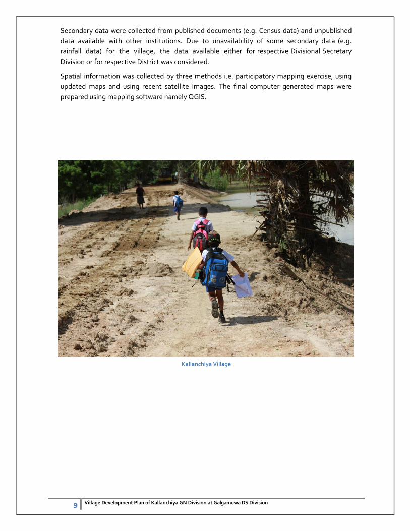
Kallanchiya Village
10 Village Development Plan of Kallanchiya GN Division at Galgamuwa DS Division
2. General Information
2.1 General Description of the Village
2.1.1 Location
The GN is located in the Galgamuwa Divisional Secretary Division of the Kurunegala
district (Map 2.1). The GND is located in the North of the District. The geographical
coordinates of the area are Lon 8.049709 Lat. 80.252649; 8.043458, 80.259158,
8.041212, 80.254959; 8.035902, 80.243795; 8.040321, 80.241476 and 8.046648,
80.243110. The total land area of the GND is 6.5 sq. km and the Kallanchiya is bounded
by the Molawa GND, Kumbukwewa GND and Buduruwakanda GND & Ihala
Palukandawa from north, east, south and west respectively. The village is situated
about 75 km away from the Kurunegala town and 38 km away from Anuradhapura
ancient town.
11 Village Development Plan of Kallanchiya GN Division at Galgamuwa DS Division
2.1.2 Historical Background
The Kallanchiya GND had been established in 1989 which was detached from
Mahagalkadawala division and the entire population of the village is 663 consisted with
Sinhala. The people of the village were continuously affected by the prolonged dry conditions
annually and affected my marked depreciations due to various adverse conditions. Total
population mainly relied on agri-based livelihoods however few government workers are also
representing the village.
2.1.3 Cultural Features
There are some special cultural features in the village but most of the places are not
clearly identified by the respective departments but Buduruwakanda temple is the one
evidence for that.
2.1.4 Population
The population density of the Kallanchiya GN Division is 642.8ha people in sq. km. (Map 2.2).
The total population of the village is 663 (Village Resource profile, 2014). The total number of
families is 227.
2.1 Location Map of the Kallanchiya GND
12 Village Development Plan of Kallanchiya GN Division at Galgamuwa DS Division
2.1.5 Socio – Economic Condition
Generally socio-economic situation of the people of the village are discussed here mainly
focusing on educational level and family income. There is about 1.2% of the total population
studied up to grade five (Table 2.1). The educational level of the 36.6% of the total population is
varying from grade 6 to 10. Among the community 40% passed G.C.E. (Ordinary level)
examination while 9.3% passed G.C.E. (Advance Level) examination. Five graduates (0.7%) are
living in the village. There are 57 people (about 8.6%) of the population who did not attend the
schools. Among them majority are Male. Approximately half of the population in the village
(83%) studied up to grade 5.
Table 2.1: Educational level of the village community
Educational Level Number %
Female Male Total
Primary Education (Grade 1- 5) 40 6.03
Grade 6 – 10 243 36.65
G.C.E. (Ordinary Level) 267 40.27
G.C.E. (Advance Level) 62 9.35
Diploma 01 0.15
Graduates 05 0.75
Not attending schools (below
5 years of age)
08 1.20
People who did not attend the schools
(above 5 years of age)
57 8.59
Total 663
(Source: GN, Kallanchiya)
Education has mainly been provided by the Kallanchiya Kanishta Vidayalaya and one pre-
school. The Kallanchiya Vidyalaya has 150 students and 14 teachers and pre – school has 35
students and 02 teachers.
Fig. 2.2: Number of families and their average monthly income range
Income Rs. Families
Below 5000 77
5001-10000 68
Over 10000 88
Total 227
13 Village Development Plan of Kallanchiya GN Division at Galgamuwa DS Division
Based on the available information, monthly income of the families is indicating the income of
the 88 families is varying from Rs. 10,000 to 15,000 due to the majority of the community
members’ depends on agriculture production. In other hand 34% of the families are earn
less than Rs.5000. per month (Fig. 2.2). Therefore, increase the family income is crucial in these
families to uplift the living standard of the people and thereby improving the disaster resilience
capacity of them. The present income generating activities are varying and given in the Table
2.2.
Table 2.2: Number of individuals and their income generating activities.
Income generating activity Number of people engaged %
Labour works 18 4.9
Agriculture 230 62.8
Self-employments 14 3.8
Government jobs 55 15
Private sector jobs 32 8.7
Foreign 17 4.6
Total 366
It is important to explore the ways and means to increase the income by present activities and
also find out new avenues for the income generation. Majority of the people live with
Agriculture. There are 62.8% people earn their income from agriculture mainly from paddy and
chena cultivation. Labor works is the income source of 18 people in the village. Self-
employments are being done by 14 people that include running groceries, carpentry and
masonry works. Apparently there is a potential to develop the agricultural activities to increase
the income of the families. The possibility of the introduction of Aquatic fisheries in these tanks
needed to be examined. The issues regarding the agriculture should be addressed to develop
minor irrigation tank and canal system. Increase productivity there by attracts more people for
paddy cultivation and chena cultivation. Since fruits like mango, oranges and wood apple are
available during the season, possibility of starting an industry has to be identified.
However 110 people are unemployed based on thee recent survey by the GN officer. There are
75 families receiving “Samurdi” benefits and majority of them (52 families) receiving Rs.
1500.00 per month.
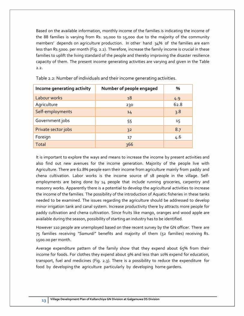
Average expenditure pattern of the family show that they expend about 65% from their
income for foods. For clothes they expend about 9% and less than 10% expend for education,
transport, fuel and medicines (Fig. 2.3). There is a possibility to reduce the expenditure for
food by developing the agriculture particularly by developing home gardens.
14 Village Development Plan of Kallanchiya GN Division at Galgamuwa DS Division
Fig. 2.3: Average family expenditure for various needs as % of total income.
(Source: Planning Branch, Divisional Secretariat, Galgamuwa)
2.1.6 Issues related to socio-economic conditions Majority of the people are engaged with economic activities still considerable skilled group
is unemployed which directly impacts the wealthiest of the community. Skilled labor
forces in not very much evident in the division which allowing internal financial capacity to
flow out from the community. This can be addressed through skill development and
entrepreneurship development in the area. Further small to medium scale entrepreneurs
are not very much present in the village and the initiatives and avenues need to be created
and also awareness must be raised amongst community members.
2.2 Physical condition of the village
2.2.1 Topography and soil
Generally the terrain of the area is undulating to dynamic. The drainage condition of the area is
varying from well drained to imperfectly drained condition. According to the general soil map,
the area is having Non-Calcic Brown (NCB) soils at the upper and middle parts of the catena.
The main type of soil can be seen Kallanchiya GND in the red-brown soil and divided into two
parts according to the thickness and texture of the soil containing the red-brown soil.
1. Reddish brown low humus soil
2. The soil consists of brown soil and gravel
In addition, the soil of alluvial valleys and rock outcrop and Rocky Plains can be found on.
15 Village Development Plan of Kallanchiya GN Division at Galgamuwa DS Division
District Division Agro Ecological Zones Annual Rainfall (mm)
Soil Type
Kurunegala District
IL1 - Intermediate Zone low country 1
>1200
Red-Yellow Podzolic soils ( RYPS) with strongly mottled sub-soils, Low Humic Gley soils
IL3 - Intermediate Zone low country 3
>900 Reddish brown earths, Non Calcic Brown soils and Reddish Brown Earth
Galgamuwa DS Division
DL1 - Dry Zone low country 1
>775 Reddish Brown Earths, Low Humic Gley
Source: Survey Department, 1988 2.2.2 Climate
The climatic data available for the District has been used to explain the climate of the village.
The village belongs to “Dry Zone low country 1” based on Agro-ecological zones derived by the
Department of Agriculture.
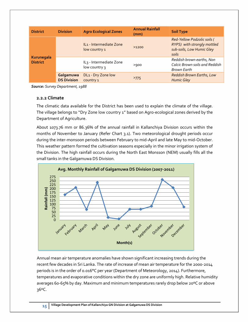
About 1073.76 mm or 86.36% of the annual rainfall in Kallanchiya Division occurs within the
months of November to January (Refer Chart 3.1). Two meteorological drought periods occur
during the inter-monsoon periods between February to mid-April and late May to mid-October.
This weather pattern formed the cultivation seasons especially in the minor irrigation system of
the Division. The high rainfall occurs during the North East Monsson (NEM) usually fills all the
small tanks in the Galgamuwa DS Division.
Annual mean air temperature anomalies have shown significant increasing trends during the
recent few decades in Sri Lanka. The rate of increase of mean air temperature for the 2000-2014
periods is in the order of 0.016°C per year (Department of Meteorology, 2014). Furthermore,
temperatures and evaporative conditions within the dry zone are uniformly high. Relative humidity
averages 60-65% by day. Maximum and minimum temperatures rarely drop below 20ºC or above
36ºC.
0255075
100125150175200225250275
Rai
nfa
ll (m
m)
Month(s)
Avg. Monthly Rainfall of Galgamuwa DS Division (2007-2011)
16 Village Development Plan of Kallanchiya GN Division at Galgamuwa DS Division
2.2.3 Flora and Fauna
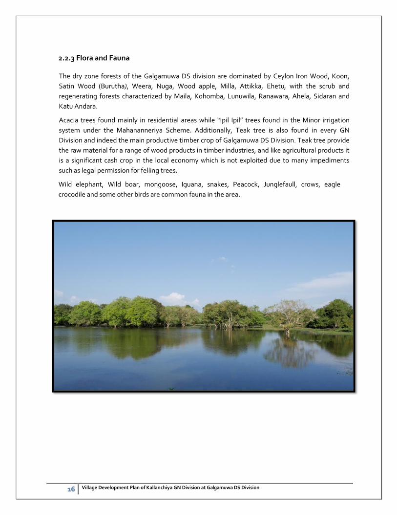
The dry zone forests of the Galgamuwa DS division are dominated by Ceylon Iron Wood, Koon,
Satin Wood (Burutha), Weera, Nuga, Wood apple, Milla, Attikka, Ehetu, with the scrub and
regenerating forests characterized by Maila, Kohomba, Lunuwila, Ranawara, Ahela, Sidaran and
Katu Andara.
Acacia trees found mainly in residential areas while “Ipil Ipil” trees found in the Minor irrigation
system under the Mahananneriya Scheme. Additionally, Teak tree is also found in every GN
Division and indeed the main productive timber crop of Galgamuwa DS Division. Teak tree provide
the raw material for a range of wood products in timber industries, and like agricultural products it
is a significant cash crop in the local economy which is not exploited due to many impediments
such as legal permission for felling trees.
Wild elephant, Wild boar, mongoose, Iguana, snakes, Peacock, Junglefaull, crows, eagle
crocodile and some other birds are common fauna in the area.
17 Village Development Plan of Kallanchiya GN Division at Galgamuwa DS Division
3. Natural Resources
The village is rich in terms of availability of Natural Resources. Forest and Mineral resources are
available in this village. People of the village obtain drinking water from dug wells and
shallow wells, water streams. The water resources of the village have been discussed in Chapter
seven.
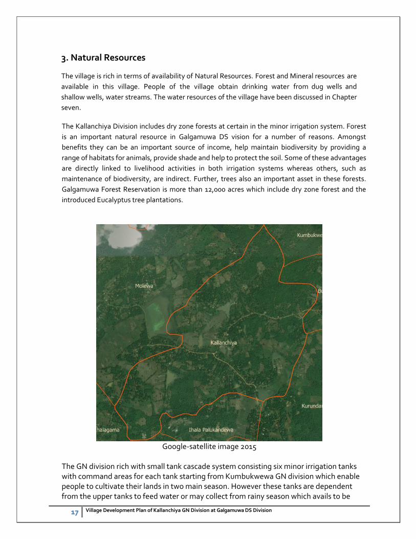
The Kallanchiya Division includes dry zone forests at certain in the minor irrigation system. Forest
is an important natural resource in Galgamuwa DS vision for a number of reasons. Amongst
benefits they can be an important source of income, help maintain biodiversity by providing a
range of habitats for animals, provide shade and help to protect the soil. Some of these advantages
are directly linked to livelihood activities in both irrigation systems whereas others, such as
maintenance of biodiversity, are indirect. Further, trees also an important asset in these forests.
Galgamuwa Forest Reservation is more than 12,000 acres which include dry zone forest and the
introduced Eucalyptus tree plantations.
Google-satellite image 2015
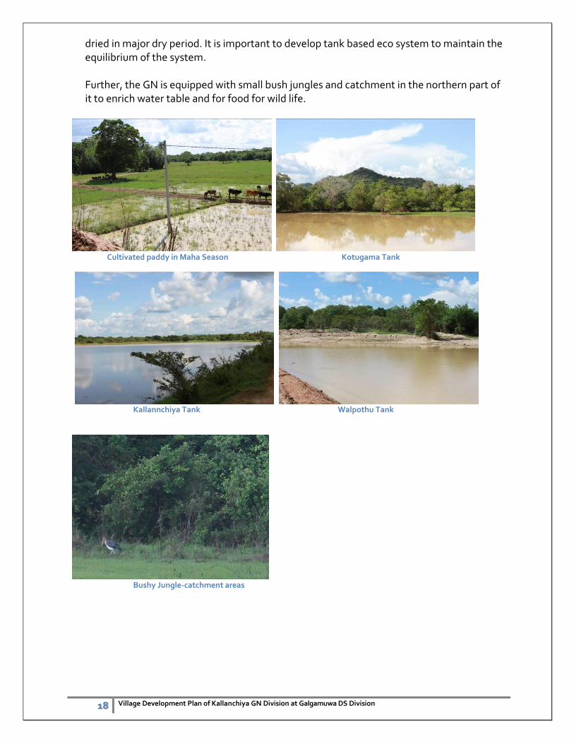
The GN division rich with small tank cascade system consisting six minor irrigation tanks with command areas for each tank starting from Kumbukwewa GN division which enable people to cultivate their lands in two main season. However these tanks are dependent from the upper tanks to feed water or may collect from rainy season which avails to be
18 Village Development Plan of Kallanchiya GN Division at Galgamuwa DS Division
dried in major dry period. It is important to develop tank based eco system to maintain the equilibrium of the system.
Further, the GN is equipped with small bush jungles and catchment in the northern part of it to enrich water table and for food for wild life.
Cultivated paddy in Maha Season Kotugama Tank
Kallannchiya Tank Walpothu Tank
Bushy Jungle-catchment areas
19
4. Land Use Pattern
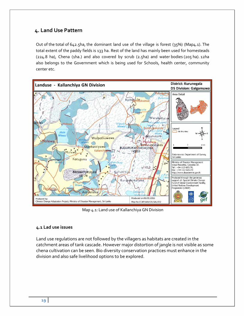
Out of the total of 642.5ha, the dominant land use of the village is forest (35%) (Map4.1). The
total extent of the paddy fields is 133 ha. Rest of the land has mainly been used for homesteads
(224.8 ha), Chena (1ha.) and also covered by scrub (2.5ha) and water bodies (205 ha). 12ha
also belongs to the Government which is being used for Schools, health center, community
center etc.
Map 4.1: Land use of Kallanchiya GN Division
4.1 Lad use issues Land use regulations are not followed by the villagers as habitats are created in the catchment areas of tank cascade. However major distortion of jangle is not visible as some chena cultivation can be seen. Bio diversity conservation practices must enhance in the division and also safe livelihood options to be explored.
20
5. Population
5.1 Population by Sex
The total population of the village is 663. Entire population is Sinhala except 1 Tamil person. It consisted with 337 (50.8%) males and 326 (49.2%) females. The significant character is male population is very close to the female population (Table 5.1).
Table. 5.1: Population of the village by sex
(Source: Planning Branch, Divisional Secretariat, Galgamuwa)
Sex Population Percentage (%)
Male 337 50.8
Female 326 49.2
Total 663
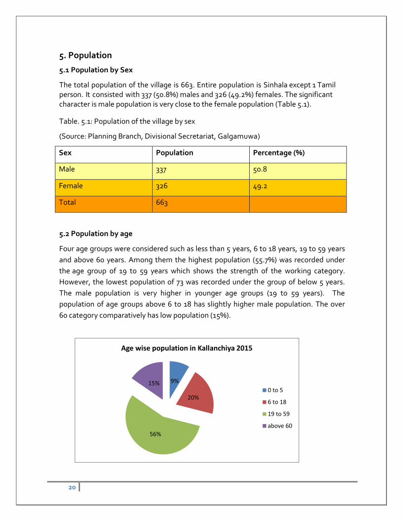
5.2 Population by age
Four age groups were considered such as less than 5 years, 6 to 18 years, 19 to 59 years
and above 60 years. Among them the highest population (55.7%) was recorded under
the age group of 19 to 59 years which shows the strength of the working category.
However, the lowest population of 73 was recorded under the group of below 5 years.
The male population is very higher in younger age groups (19 to 59 years). The
population of age groups above 6 to 18 has slightly higher male population. The over
60 category comparatively has low population (15%).
9%
20%
56%
15%
Age wise population in Kallanchiya 2015
0 to 5
6 to 18
19 to 59
above 60
21 Village Development Plan of Kallanchiya GN Division at Galgamuwa DS Division
6. Housing
6.1 Total number of houses
The total number of the houses in the village is 186. There are 02 families who are
under temporary houses.
6.2 Type of houses
Three types of houses, i.e. permanent, semi-permanent and temporary are available in
the village. Number of permanent houses is 170 there are 14 semi-permanent and
02 temporary houses available in the village and they are more vulnerable at the
disaster situation (Table. 6.1). The temporary houses are more may be due to the
poverty of respective families.
Table 6.1 Type of houses and their number
Type Number
Permanent Houses 170
Semi-permanent Houses 14
Temporary Houses 02
Total 186
Source: Planning Branch, Divisional Secretariat, Galgamuwa
6.3 Issues related to Housing
Presently there are 16 families are live in vulnerable housing conditions. However the
expansion of settlement has open land but there are limitations due to poverty. It is
therefore very important to explore the alternatives to accommodate the people who
do not have safer houses.
22 Village Development Plan of Kallanchiya GN Division at Galgamuwa DS Division
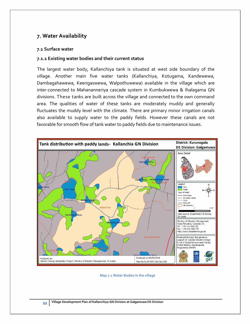
7. Water Availability
7.1 Surface water
7.1.1 Existing water bodies and their current status
The largest water body, Kallanchiya tank is situated at west side boundary of the
village. Another main five water tanks (Kallanchiya, Kotugama, Kandewewa,
Dambagahawewa, Keerigaswewa, Walpothuwewa) available in the village which are
inter-connected to Mahananneriya cascade system in Kumbukwewa & Ihalagama GN
divisions. These tanks are built across the village and connected to the own command
area. The qualities of water of these tanks are moderately muddy and generally
fluctuates the muddy level with the climate. There are primary minor irrigation canals
also available to supply water to the paddy fields. However these canals are not
favorable for smooth flow of tank water to paddy fields due to maintenance issues.
Map 7.1 Water Bodies in the village
23 Village Development Plan of Kallanchiya GN Division at Galgamuwa DS Division
7.1.2 Issues regarding the surface water
Main issue regarding the surface water is that during dry period as many tanks are
dried and insufficient to cater the water demand for paddy cultivation. This is difficult to
overcome due to the geographical nature of the area. Studies show that the
possibilities of introduction of some engineering measures to increase the water
storage and enhance water management efficiencies. Habitats in the tank upstream
and also chena cultivations in the tank reserve have severely aggravated the soil erosion
and siltation is very common in the division which has greatly reduced water capacities
of tanks.
In the Maha cultivation season, considerable crop is lost for farmers as water capacities
are not sufficient to release last two issues of water for crops. This has revealed as a
main problem for paddy farmers and needs very pragmatic and evidence based
adaptation measures. Further, only selected lands are being cultivated selected very
arbitrarily by farmer organizations which has created tense situation every year and
damaging social cohesion of the village.
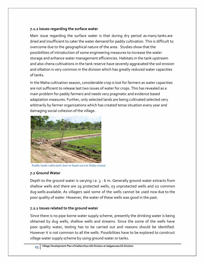
Paddy lands cultivated close to bund area in Maha season
7.2 Ground Water
Depth to the ground water is varying i.e. 3 - 6 m. Generally ground water extracts from
shallow wells and there are 29 protected wells, 03 unprotected wells and 02 common
dug wells available. As villagers said some of the wells cannot be used now due to the
poor quality of water. However, the water of these wells was good in the past.
7.2.1 Issues related to the ground water
Since there is no pipe borne water supply scheme, presently the drinking water is being
obtained by dug wells, shallow wells and streams. Since the some of the wells have
poor quality water, testing has to be carried out and reasons should be identified.
However it is not common to all the wells. Possibilities have to be explored to construct
village water supply scheme by using ground water or tanks.
24 Village Development Plan of Kallanchiya GN Division at Galgamuwa DS Division
8. Infrastructure and Community Facilities
8.1 Irrigation Infrastructure
The paddy lands have been cultivated by using rain water and minor irrigation facilities
provided by Moran tank and Pannalgama Irrigation Scheme. This settlement was
established based on ancient Morana tank. However, presently the some of the
irrigation structures are collapsed hence water is not delivering to the paddy lands. The
paddy lands are cultivated by using rain water. Therefore, total extent of paddy has not
been cultivated. It is therefore very important to identify the issues regarding the
irrigation and rehabilitate the irrigation system as early as possible. This will help to
increase the paddy production and thereby increase the family’s income.
8.2 Roads & Transport
Two main roads are available from Anamanduwa road and Anuradhappura main roads
to the village which is not far away from the main town. Comparatively road are in a
better condition for normal life and economic activities which may further enhanced
through government driven projects in the areas with annual funding.
Two transport board busses are operating for villagers for common transport other than
private vehicles.
8.3 Electricity
Whole area is equipped with Hydro-electricity and majority of house-holds are using
electricity. Out of total 186 houses, only 2 houses are used other sources to generate
power.
8.4 Health Services
There is a community health center available in the village. The Base Hospital is located
in Galgamuwa town which is 8km away from the village. Other routing health facilities
(service of the Public Health Inspector, Family Health Worker etc.) are available and
good health service available in the area.
8.5 Sanitation There are 112 families who do not have toilet facilities. Hence it has created a significant
sanitary problem in the village. Some assistance to construct toilets is necessary.
Seventy three families are having pit toilets.
8.6 Other Services/Facilities Presently a Grama Niladari Office, community hall and Pre- school is available in the
village. One community center and school playground is available. Most of other
important facilities available in the Galgamuwa town which is 6-7 Km away from the
village.
25 Village Development Plan of Kallanchiya GN Division at Galgamuwa DS Division
9. Livelihood
9.1 Types of Livelihood
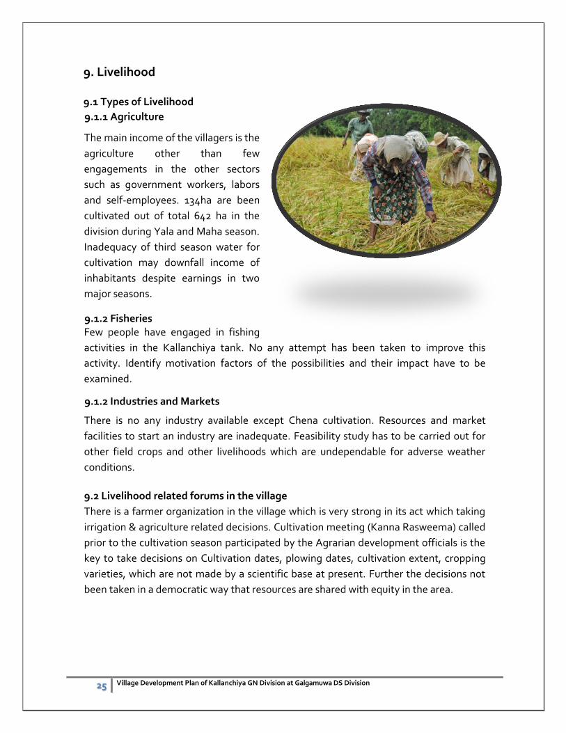
9.1.1 Agriculture
The main income of the villagers is the
agriculture other than few
engagements in the other sectors
such as government workers, labors
and self-employees. 134ha are been
cultivated out of total 642 ha in the
division during Yala and Maha season.
Inadequacy of third season water for
cultivation may downfall income of
inhabitants despite earnings in two
major seasons.
9.1.2 Fisheries Few people have engaged in fishing
activities in the Kallanchiya tank. No any attempt has been taken to improve this
activity. Identify motivation factors of the possibilities and their impact have to be
examined.
9.1.2 Industries and Markets
There is no any industry available except Chena cultivation. Resources and market
facilities to start an industry are inadequate. Feasibility study has to be carried out for
other field crops and other livelihoods which are undependable for adverse weather
conditions.
9.2 Livelihood related forums in the village
There is a farmer organization in the village which is very strong in its act which taking
irrigation & agriculture related decisions. Cultivation meeting (Kanna Rasweema) called
prior to the cultivation season participated by the Agrarian development officials is the
key to take decisions on Cultivation dates, plowing dates, cultivation extent, cropping
varieties, which are not made by a scientific base at present. Further the decisions not
been taken in a democratic way that resources are shared with equity in the area.
26 Village Development Plan of Kallanchiya GN Division at Galgamuwa DS Division
9.3 Issues related to livelihood
Majority of the people are performing cultivation under minor irrigation tanks which
are highly dependent on cascade Maha-Nanneriya system. Though there is a
participatory decision system through farmer organization is available in the
Kallanchiya GN, democratic decisions are not been practiced especially in the
cultivation as farmers close to tanks only gets water for cultivation which enables
unfavorable to others.
There is an immense gap in the market information to farmers as decisions are being
made just through product orientation rather having market orientation as cob-web
price fluctuation can be observed.
Home garden concept is not popular around the area to promote alternative income
and to promote diversity. There are 110 unemployed people. It is therefore necessary
to build up their capacity to increase the income level by providing necessary skills such
as carpentry, masonry, animal husbandry etc. There is no any rice mill and therefore
possibility to start a mill has to be examined.
Optimal utilization of resources needed to be considered in livelihood development of
the area in the long run, to create social capacities to build resilience in the villagers.
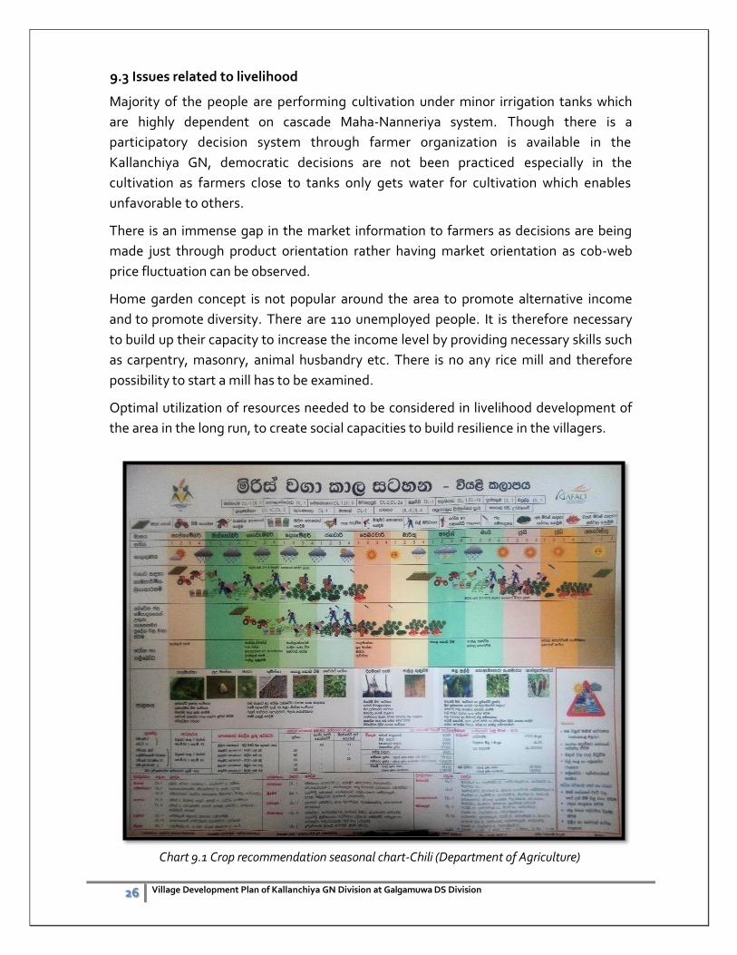
Chart 9.1 Crop recommendation seasonal chart-Chili (Department of Agriculture)
27 Village Development Plan of Kallanchiya GN Division at Galgamuwa DS Division
10. Village level risk sensitive development planning
10.1 Climate change and disaster Risk concern in ongoing development
Disasters can hamper economic growth, affect poverty levels and cause human suffering.
Without significant action, the extent and impact of economic and social damage associated
with disasters will get worse over the next 20 years, largely as a result of growing exposure of
people and assets. This has the potential to reverse development progress in hard-hit areas.
Without risk-sensitive planning and implementation, development can exacerbate existing risks
and create new ones. There is a need, therefore, across Asia, to ensure that development
planning and implementation at all levels considers and integrates disaster and climate change
risk. This activity, commonly known as mainstreaming disaster risk reduction and climate
change adaption into development should be systematic, participatory and science-based.
Mainstreaming involves embedding the stages of risk management process into the relevant
stages of the planning, programming, budgeting, and project management processes.
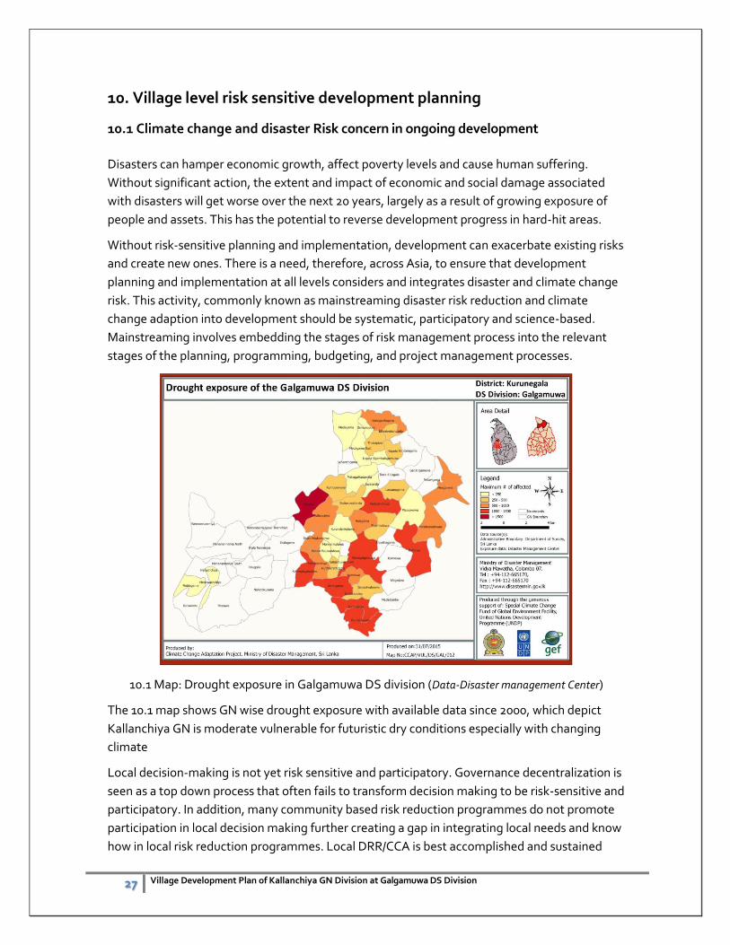
10.1 Map: Drought exposure in Galgamuwa DS division (Data-Disaster management Center)
The 10.1 map shows GN wise drought exposure with available data since 2000, which depict
Kallanchiya GN is moderate vulnerable for futuristic dry conditions especially with changing
climate
Local decision-making is not yet risk sensitive and participatory. Governance decentralization is
seen as a top down process that often fails to transform decision making to be risk-sensitive and
participatory. In addition, many community based risk reduction programmes do not promote
participation in local decision making further creating a gap in integrating local needs and know
how in local risk reduction programmes. Local DRR/CCA is best accomplished and sustained
28 Village Development Plan of Kallanchiya GN Division at Galgamuwa DS Division
when it is integral to local development processes, influencing local development plans and
actions. Clearly, though, in order for this to gain traction it must be in the best interest of each
organization and stakeholder at the local level to develop appropriate policies and strategies to
address specific DRR and CCA issues.
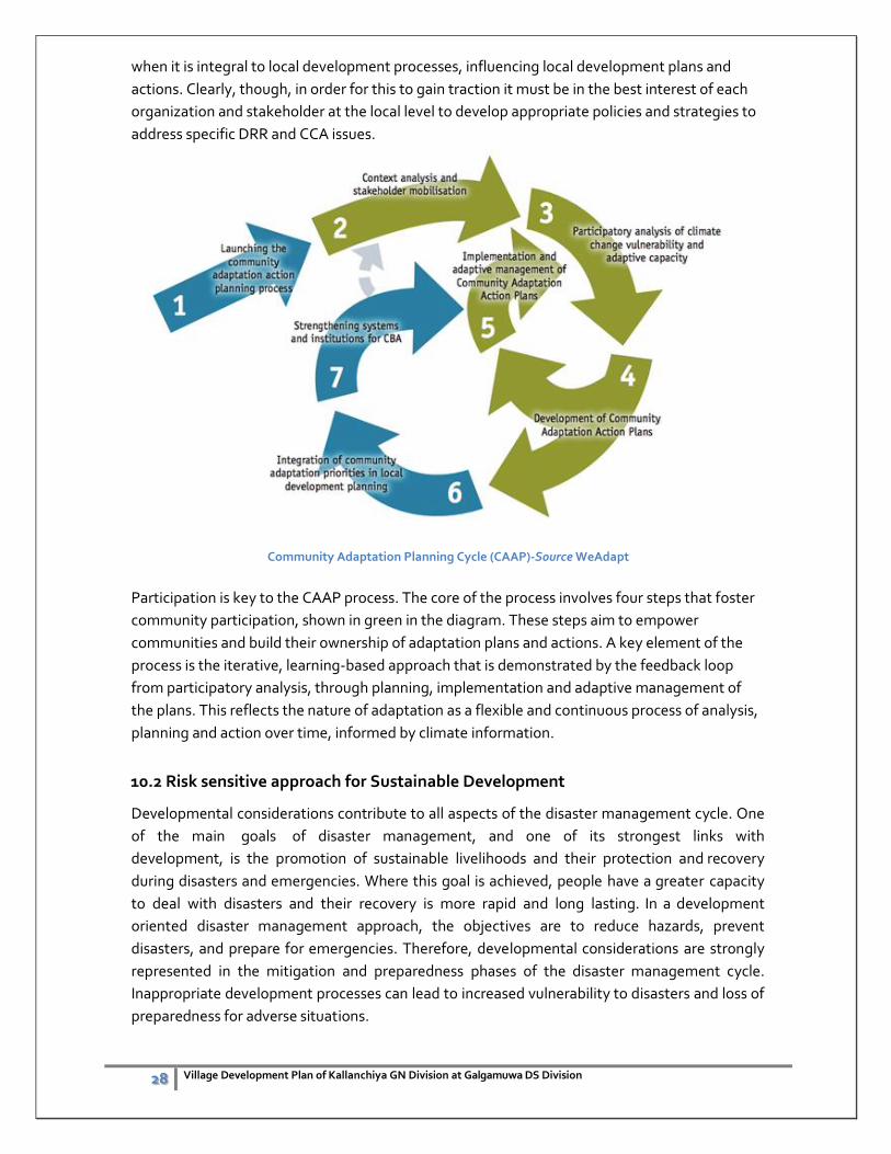
Community Adaptation Planning Cycle (CAAP)-Source WeAdapt
Participation is key to the CAAP process. The core of the process involves four steps that foster
community participation, shown in green in the diagram. These steps aim to empower
communities and build their ownership of adaptation plans and actions. A key element of the
process is the iterative, learning-based approach that is demonstrated by the feedback loop
from participatory analysis, through planning, implementation and adaptive management of
the plans. This reflects the nature of adaptation as a flexible and continuous process of analysis,
planning and action over time, informed by climate information.
10.2 Risk sensitive approach for Sustainable Development
Developmental considerations contribute to all aspects of the disaster management cycle. One
of the main goals of disaster management, and one of its strongest links with
development, is the promotion of sustainable livelihoods and their protection and recovery
during disasters and emergencies. Where this goal is achieved, people have a greater capacity
to deal with disasters and their recovery is more rapid and long lasting. In a development
oriented disaster management approach, the objectives are to reduce hazards, prevent
disasters, and prepare for emergencies. Therefore, developmental considerations are strongly
represented in the mitigation and preparedness phases of the disaster management cycle.
Inappropriate development processes can lead to increased vulnerability to disasters and loss of
preparedness for adverse situations.
29 Village Development Plan of Kallanchiya GN Division at Galgamuwa DS Division
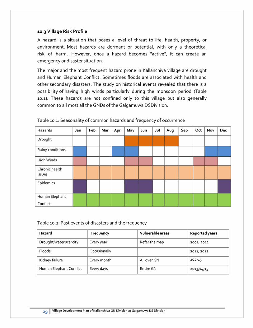
10.3 Village Risk Profile
A hazard is a situation that poses a level of threat to life, health, property, or
environment. Most hazards are dormant or potential, with only a theoretical
risk of harm. However, once a hazard becomes "active", it can create an
emergency or disaster situation.
The major and the most frequent hazard prone in Kallanchiya village are drought
and Human Elephant Conflict. Sometimes floods are associated with health and
other secondary disasters. The study on historical events revealed that there is a
possibility of having high winds particularly during the monsoon period (Table
10.1). These hazards are not confined only to this village but also generally
common to all most all the GNDs of the Galgamuwa DSDivision.
Table 10.1: Seasonality of common hazards and frequency of occurrence
Hazards Jan Feb Mar Apr May Jun Jul Aug Sep Oct Nov Dec
Drought
Rainy conditions
High Winds
Chronic health issues
Epidemics
Human Elephant
Conflict
Table 10.2: Past events of disasters and the frequency
Hazard Frequency Vulnerable areas Reported years
Drought/water scarcity Every year Refer the map 2001, 2012
Floods Occasionally 2011, 2012
Kidney failure Every month All over GN 202-15
Human Elephant Conflict Every days Entire GN 2013,14,15
30 Village Development Plan of Kallanchiya GN Division at Galgamuwa DS Division
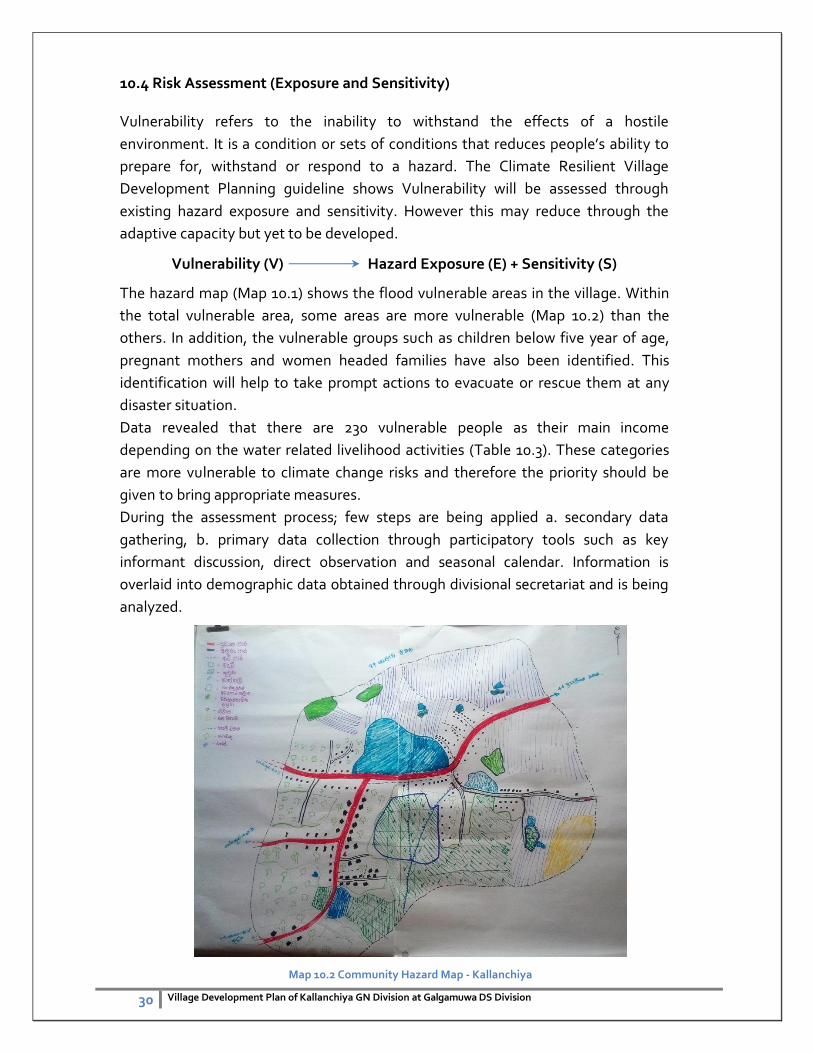
10.4 Risk Assessment (Exposure and Sensitivity)
Vulnerability refers to the inability to withstand the effects of a hostile
environment. It is a condition or sets of conditions that reduces people’s ability to
prepare for, withstand or respond to a hazard. The Climate Resilient Village
Development Planning guideline shows Vulnerability will be assessed through
existing hazard exposure and sensitivity. However this may reduce through the
adaptive capacity but yet to be developed.
Vulnerability (V) Hazard Exposure (E) + Sensitivity (S)
The hazard map (Map 10.1) shows the flood vulnerable areas in the village. Within
the total vulnerable area, some areas are more vulnerable (Map 10.2) than the
others. In addition, the vulnerable groups such as children below five year of age,
pregnant mothers and women headed families have also been identified. This
identification will help to take prompt actions to evacuate or rescue them at any
disaster situation.
Data revealed that there are 230 vulnerable people as their main income
depending on the water related livelihood activities (Table 10.3). These categories
are more vulnerable to climate change risks and therefore the priority should be
given to bring appropriate measures.
During the assessment process; few steps are being applied a. secondary data
gathering, b. primary data collection through participatory tools such as key
informant discussion, direct observation and seasonal calendar. Information is
overlaid into demographic data obtained through divisional secretariat and is being
analyzed.
Map 10.2 Community Hazard Map - Kallanchiya
31 Village Development Plan of Kallanchiya GN Division at Galgamuwa DS Division
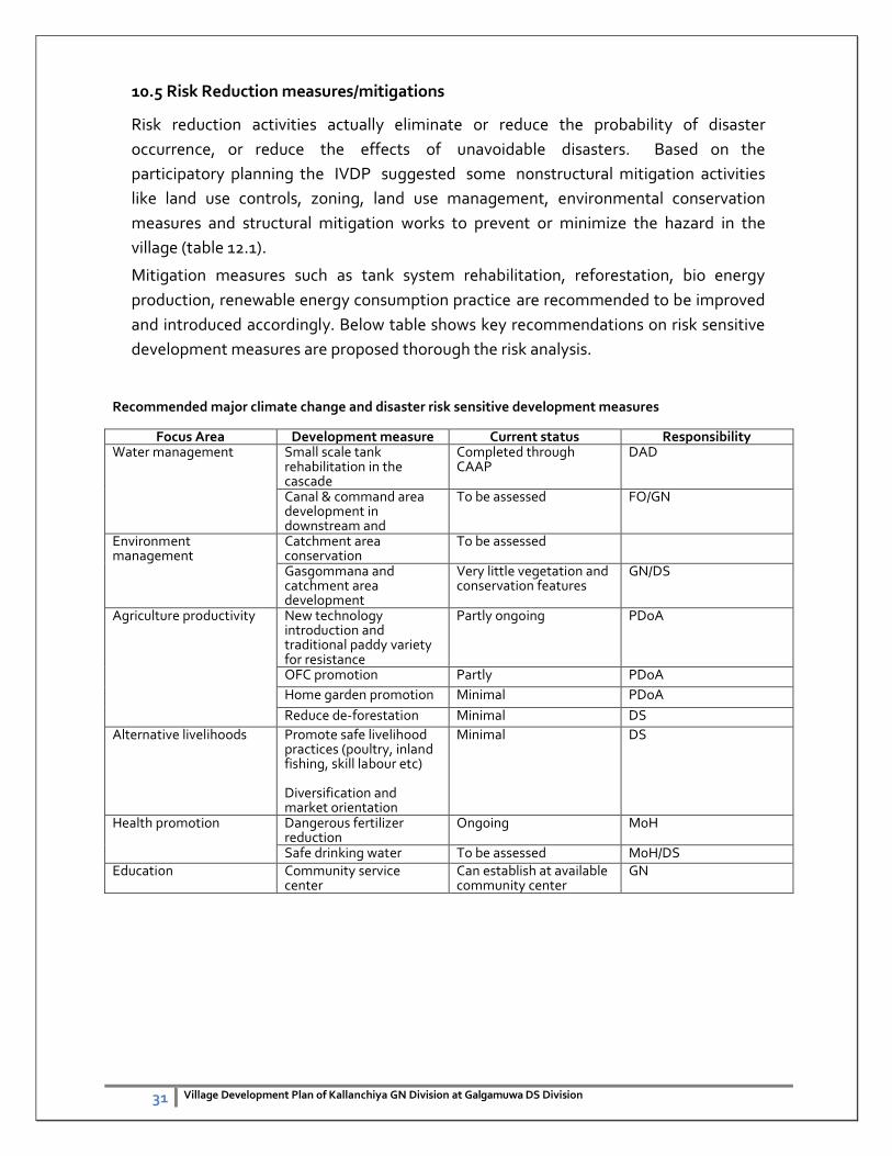
10.5 Risk Reduction measures/mitigations
Risk reduction activities actually eliminate or reduce the probability of disaster
occurrence, or reduce the effects of unavoidable disasters. Based on the
participatory planning the IVDP suggested some nonstructural mitigation activities
like land use controls, zoning, land use management, environmental conservation
measures and structural mitigation works to prevent or minimize the hazard in the
village (table 12.1).
Mitigation measures such as tank system rehabilitation, reforestation, bio energy
production, renewable energy consumption practice are recommended to be improved
and introduced accordingly. Below table shows key recommendations on risk sensitive
development measures are proposed thorough the risk analysis.
Recommended major climate change and disaster risk sensitive development measures
Focus Area Development measure Current status Responsibility Water management Small scale tank
rehabilitation in the cascade
Completed through CAAP
DAD
Canal & command area development in downstream and
To be assessed FO/GN
Environment management
Catchment area conservation
To be assessed
Gasgommana and catchment area development
Very little vegetation and conservation features
GN/DS
Agriculture productivity New technology introduction and traditional paddy variety for resistance
Partly ongoing PDoA
OFC promotion Partly PDoA
Home garden promotion Minimal PDoA
Reduce de-forestation Minimal DS
Alternative livelihoods Promote safe livelihood practices (poultry, inland fishing, skill labour etc) Diversification and market orientation
Minimal DS
Health promotion Dangerous fertilizer reduction
Ongoing MoH
Safe drinking water To be assessed MoH/DS Education Community service
center Can establish at available community center
GN
32 Village Development Plan of Kallanchiya GN Division at Galgamuwa DS Division
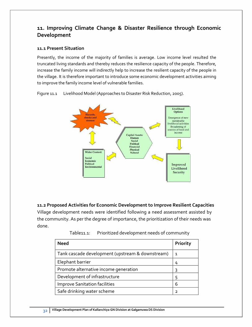
11. Improving Climate Change & Disaster Resilience through Economic Development
11.1 Present Situation
Presently, the income of the majority of families is average. Low income level resulted the
truncated living standards and thereby reduces the resilience capacity of the people. Therefore,
increase the family income will indirectly help to increase the resilient capacity of the people in
the village. It is therefore important to introduce some economic development activities aiming
to improve the family income level of vulnerable families.
Figure 11.1 Livelihood Model (Approaches to Disaster Risk Reduction, 2005).
11.2 Proposed Activities for Economic Development to Improve Resilient Capacities
Village development needs were identified following a need assessment assisted by
the community. As per the degree of importance, the prioritization of their needs was
done.
Table11.1: Prioritized development needs of community
Need Priority
Tank cascade development (upstream & downstream) 1
Elephant barrier 4
Promote alternative income generation 3
Development of infrastructure 5
Improve Sanitation facilities 6
Safe drinking water scheme 2
33 Village Development Plan of Kallanchiya GN Division at Galgamuwa DS Division
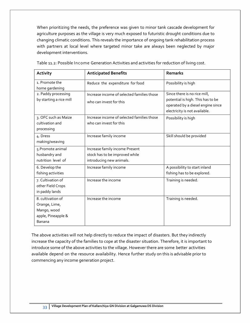
When prioritizing the needs, the preference was given to minor tank cascade development for
agriculture purposes as the village is very much exposed to futuristic drought conditions due to
changing climatic conditions. This reveals the importance of ongoing tank rehabilitation process
with partners at local level where targeted minor take are always been neglected by major
development interventions.
Table 11.2: Possible Income Generation Activities and activities for reduction of living cost.
Activity Anticipated Benefits Remarks
1. Promote the
home gardening Reduce the expenditure for food Possibility is high
2. Paddy processing
by starting a rice mill Increase income of selected families those
who can invest for this
Since there is no rice mill,
potential is high. This has to be
operated by a diesel engine since
electricity is not available.
3. OFC such as Maize
cultivation and
processing
Increase income of selected families those
who can invest for this
Possibility is high
4. Dress
making/weaving
Increase family income Skill should be provided
5.Promote animal
husbandry and
nutrition level of
the families
Increase family income Present
stock has to be improved while
introducing new animals.
6. Develop the
fishing activities
Increase family income A possibility to start inland
fishing has to be explored.
7. Cultivation of
other Field Crops
in paddy lands
where water is not
sufficient for
paddy during
minor season
Increase the income Training is needed.
8. cultivation of
Orange, Lime,
Mango, wood
apple, Pineapple &
Banana
Increase the income Training is needed.
The above activities will not help directly to reduce the impact of disasters. But they indirectly
increase the capacity of the families to cope at the disaster situation. Therefore, it is important to
introduce some of the above activities to the village. However there are some better activities
available depend on the resource availability. Hence further study on this is advisable prior to
commencing any income generation project.
34 Village Development Plan of Kallanchiya GN Division at Galgamuwa DS Division
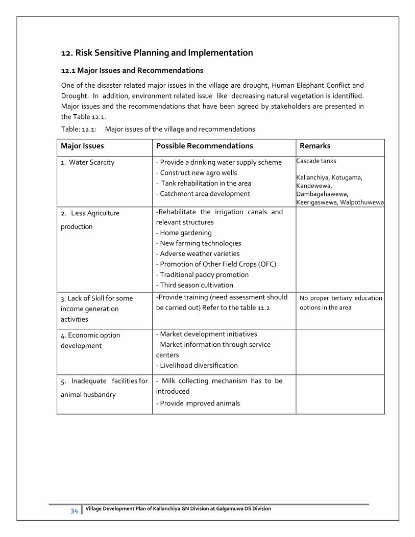
12. Risk Sensitive Planning and Implementation
12.1 Major Issues and Recommendations
One of the disaster related major issues in the village are drought, Human Elephant Conflict and
Drought. In addition, environment related issue like decreasing natural vegetation is identified.
Major issues and the recommendations that have been agreed by stakeholders are presented in
the Table 12.1.
Table: 12.1: Major issues of the village and recommendations
Major Issues Possible Recommendations Remarks
1. Water Scarcity - Provide a drinking water supply scheme
- Construct new agro wells
- Tank rehabilitation in the area
- Catchment area development
Cascade tanks Kallanchiya, Kotugama, Kandewewa, Dambagahawewa, Keerigaswewa, Walpothuwewa
2. Less Agriculture
production
-Rehabilitate the irrigation canals and
relevant structures
- Home gardening
- New farming technologies
- Adverse weather varieties
- Promotion of Other Field Crops (OFC)
- Traditional paddy promotion
- Third season cultivation
3. Lack of Skill for some
income generation
activities
-Provide training (need assessment should
be carried out) Refer to the table 11.2
No proper tertiary education
options in the area
4. Economic option
development
- Market development initiatives
- Market information through service
centers
- Livelihood diversification
5. Inadequate facilities for
animal husbandry
- Milk collecting mechanism has to be
introduced
- Provide improved animals
35 Village Development Plan of Kallanchiya GN Division at Galgamuwa DS Division
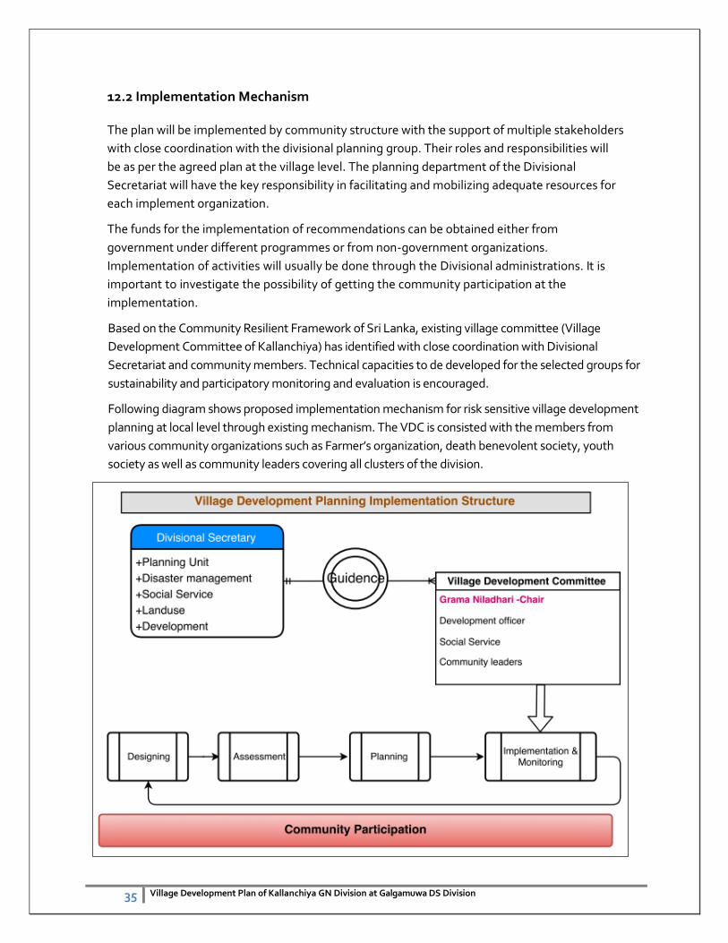
12.2 Implementation Mechanism
The plan will be implemented by community structure with the support of multiple stakeholders
with close coordination with the divisional planning group. Their roles and responsibilities will
be as per the agreed plan at the village level. The planning department of the Divisional
Secretariat will have the key responsibility in facilitating and mobilizing adequate resources for
each implement organization.
The funds for the implementation of recommendations can be obtained either from
government under different programmes or from non-government organizations.
Implementation of activities will usually be done through the Divisional administrations. It is
important to investigate the possibility of getting the community participation at the
implementation.
Based on the Community Resilient Framework of Sri Lanka, existing village committee (Village
Development Committee of Kallanchiya) has identified with close coordination with Divisional
Secretariat and community members. Technical capacities to de developed for the selected groups for
sustainability and participatory monitoring and evaluation is encouraged.
Following diagram shows proposed implementation mechanism for risk sensitive village development
planning at local level through existing mechanism. The VDC is consisted with the members from
various community organizations such as Farmer’s organization, death benevolent society, youth
society as well as community leaders covering all clusters of the division.
36 Village Development Plan of Kallanchiya GN Division at Galgamuwa DS Division
12.3 Monitoring and Evaluation
Integrate Risk Reduction Measures in Development Plans local level authorities (Divisional secretarial
& local governments) are the governmental body responsible for the long-term development of its
area and the well-being and safety of its populations. It cannot afford to ignore risk considerations
because disasters may destroy development outputs and gains.
Responsibility of monitoring needs to be taken by the VDC with close coordination with divisional
secretariat. Implementing process will be monitored by the Div. planning Group in collaboration with
VDC. Monthly progress meeting at divisional level proposed and quarterly stakeholder meeting is also
proposed with the leadership of the DS.
The VDC is suggesting the continuous support from the Ministry of Disaster Management in technical
aspects and resource mobilization with available avenues.
12.4 Conclusion
Most of the recommendations given in this report can be implemented at local level. However few
of them should be considered at National/Provincial level. Since these recommendations mainly
came out from the village people and discussed with relevant officials, the possibility for rejection
is very minimum. Therefore any agency could implement these recommendations without any
objections. The main conclusions are given below.
1. Irrigation system should be rehabilitated for the development of paddy cultivation,
changing cropping systems, structural rigidity issue changes and improvements.
2. Improvement of water uses efficiencies and brings democratic decision making culture with
scientific evidences.
3. Future land use should be regulated to promote environment conservation practices and
optimization of natural resources. Land use regulatory measures will help to create a better
environment in the village.
4. Increase the family income is important to improve the resilience capacity of the vulnerable
community and availing diversified options with market information.
5. Development of the agriculture sector is more appropriate to this village. Along with this
development other necessary infrastructure (e.g. agriculture input outlet, market systems
etc.) could also be developed. Adverse weather resistant agriculture options, traditional
varieties, eco-farming methods, carbonic fertilizer use, home garden concepts with agro-
forestry can be promoted.
6. Skilled labor development and optimization of available resources for economic development
is essential. Further alternation livelihood options with saving schemes to be introduces with
responsibility.