risk assessment. the four lines of defense in safety are: 1. planning* 2. physical and mental skills...
TRANSCRIPT

Risk Assessment

The four lines of defense in safety are:
1. Planning*2. Physical and mental skills3. Self and assisted rescue4. Outside rescue


http://www.expeditionkayak.com/resources/risk-assessment/
PADDLE LEG HAZARDS
Risk prior to control
sH/M/L
CONTROL MEASURES TO BE IMPLEMENTED
Risk with controls in
placeH/M/L
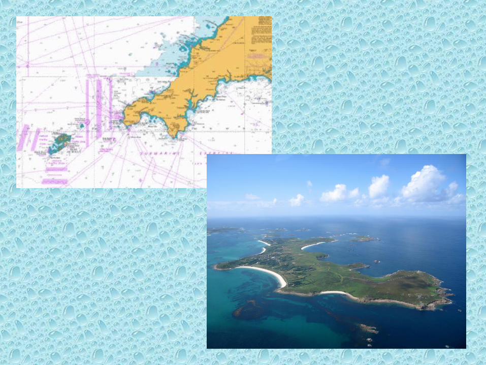
1. Sennen Cove to St Martin’s, Isles of Scilly (22.5 NM crossing)
1(a) Tidal race, over-falls and reefs between Land’s End and Longships1(b) Shipping Channels 1(c) Seven Stones Reefs1(d) Being taken too far N or S
HMMH
1(a) Begin crossing HW Devonport +0300. Stay well north of Longships 1(b) Only attempt the crossing with good visibility. Cross at right angles. Always pass astern of any vessels. Have collision-warning flares readily available. Have immediate access to VHF Ch 161(c) Pass well to the S of Seven Stones1(d) Make allowances for wind and wave conditions. Maintain steady pace throughout crossing. Double check position and course with GPS using waypoints during crossing. Only attempt crossing in good visibility. Only attempt crossing when wind is in sector N to SE < F5, SE to NE < F4. Stay N of flight path of helicopters.Only attempt if 5 day forecast is satisfactory and gives realistic prospect of completing return crossing. If forecast is unsatisfactory consider aborting crossing (may be attempted again at end of expedition)Escort vessel to be on stand-by in case of a problem
MLLM
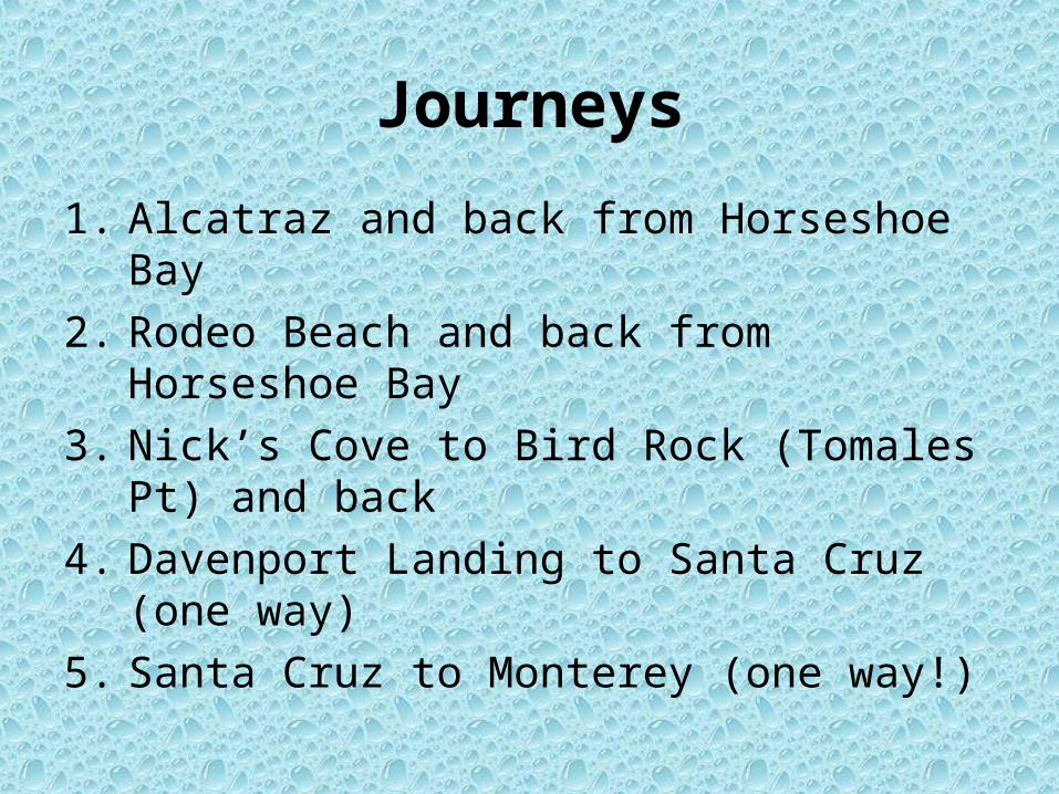
Journeys
1. Alcatraz and back from Horseshoe Bay
2. Rodeo Beach and back from Horseshoe Bay
3. Nick’s Cove to Bird Rock (Tomales Pt) and back
4. Davenport Landing to Santa Cruz (one way)
5. Santa Cruz to Monterey (one way!)
•HAZARDS
•CONTROL MEASURES

WIND
WEATHERSWELL
TIDE
YOU!

Sea Conditions Rating System (SCRS)http://tsunamirangers.com/articles/sea-conditions-kayaking-difficulty-rating-system/
Factor Computation Method PointsScore
(Maximum)
1- Wind Speed 1 point per mph of wind speed (40)
2- Wind Speed 1 point per mph of wind speed (50+)
3- Wave Height 2 points per vertical wave foot (40+)
4- Swim Distance to Safety 1 point per 100 meters (20)
5- Breaking Waves 30 points if waves are breaking (30)
6- Rock Garden 20 points if paddling in rocks (20)
7- Sea Cave 20 points if entering sea caves (20)
8- Night 20 points if it is night (20)
9- Fog Up to 20 points if fog is dense (20)
10- Miscellaneous 10 points or more for other danger (10+)
TOTAL POINTS =
Divide total points by 20 to obtain CLASS LEVEL =
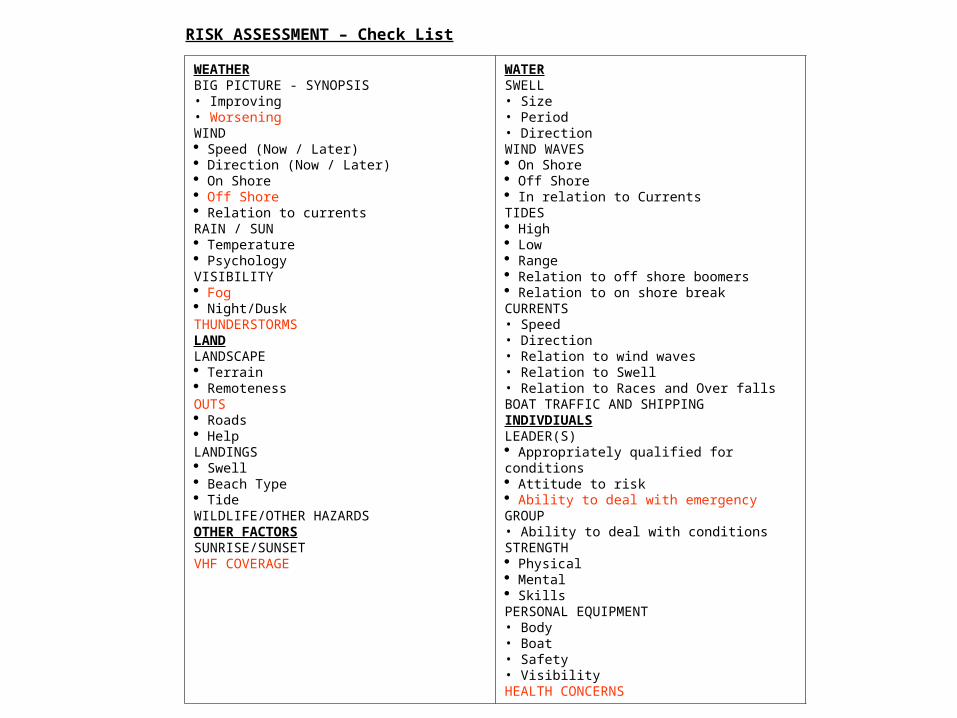
RISK ASSESSMENT – Check List
WEATHERBIG PICTURE - SYNOPSIS• Improving• WorseningWIND Speed (Now / Later) Direction (Now / Later) On Shore Off Shore Relation to currentsRAIN / SUN Temperature PsychologyVISIBILITY Fog Night/DuskTHUNDERSTORMSLANDLANDSCAPE Terrain RemotenessOUTS Roads HelpLANDINGS Swell Beach Type TideWILDLIFE/OTHER HAZARDSOTHER FACTORSSUNRISE/SUNSETVHF COVERAGE
WATERSWELL• Size• Period• DirectionWIND WAVES On Shore Off Shore In relation to CurrentsTIDES High Low Range Relation to off shore boomers Relation to on shore breakCURRENTS• Speed• Direction• Relation to wind waves• Relation to Swell• Relation to Races and Over fallsBOAT TRAFFIC AND SHIPPINGINDIVDIUALSLEADER(S) Appropriately qualified for conditions Attitude to risk Ability to deal with emergencyGROUP• Ability to deal with conditionsSTRENGTH Physical Mental SkillsPERSONAL EQUIPMENT• Body• Boat• Safety• VisibilityHEALTH CONCERNS

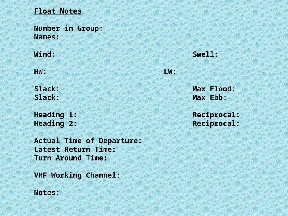
Float Notes
Number in Group:Names:
Wind: Swell:
HW: LW:
Slack: Max Flood:Slack: Max Ebb:
Heading 1: Reciprocal:Heading 2: Reciprocal:
Actual Time of Departure:Latest Return Time:Turn Around Time:
VHF Working Channel:
Notes:
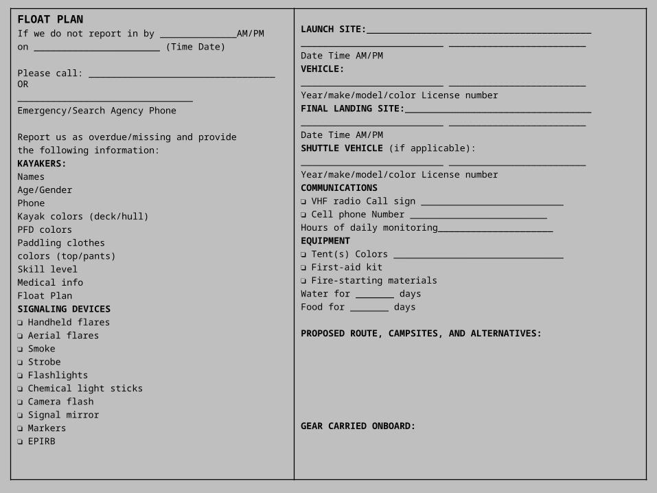
FLOAT PLANIf we do not report in by ______________AM/PM
on _______________________ (Time Date)
Please call: __________________________________ OR
________________________________
Emergency/Search Agency Phone
Report us as overdue/missing and provide
the following information:
KAYAKERS:
Names
Age/Gender
Phone
Kayak colors (deck/hull)
PFD colors
Paddling clothes
colors (top/pants)
Skill level
Medical info
Float Plan
SIGNALING DEVICES
❏ Handheld flares
❏ Aerial flares
❏ Smoke
❏ Strobe
❏ Flashlights
❏ Chemical light sticks
❏ Camera flash
❏ Signal mirror
❏ Markers
❏ EPIRB
LAUNCH SITE:_________________________________________
__________________________ _________________________
Date Time AM/PM
VEHICLE:
__________________________ _________________________
Year/make/model/color License number
FINAL LANDING SITE:__________________________________
__________________________ _________________________
Date Time AM/PM
SHUTTLE VEHICLE (if applicable):
__________________________ _________________________
Year/make/model/color License number
COMMUNICATIONS
❏ VHF radio Call sign __________________________
❏ Cell phone Number _________________________
Hours of daily monitoring_____________________
EQUIPMENT
❏ Tent(s) Colors _______________________________
❏ First-aid kit
❏ Fire-starting materials
Water for _______ days
Food for _______ days
PROPOSED ROUTE, CAMPSITES, AND ALTERNATIVES:
GEAR CARRIED ONBOARD:
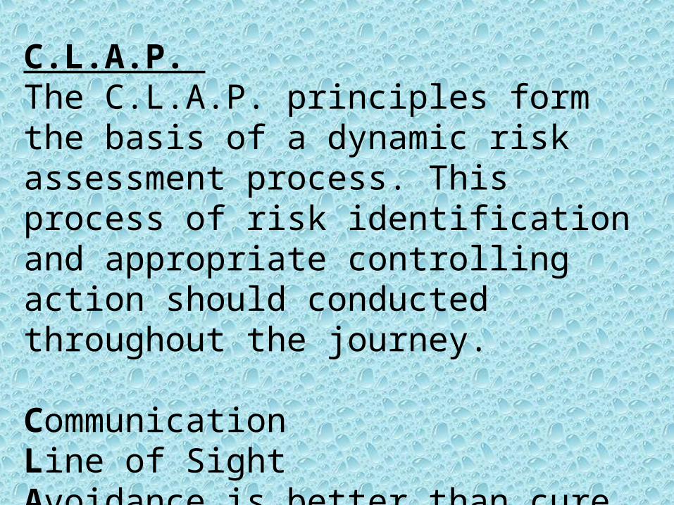
C.L.A.P. The C.L.A.P. principles form the basis of a dynamic risk assessment process. This process of risk identification and appropriate controlling action should conducted throughout the journey.
Communication Line of Sight Avoidance is better than cure Position of Maximum Usefulness

Communication • Signals should be agreed in advance. • KISS (Keep It Short and Simple)
Line of Sight • Always endeavor to have your fellow paddlers in your line of sight. • Do not all leave a place of safety to deal with a rescue. Send a capable rescuer and
maintain line of sight using a chain of paddlers.
Avoidance is better than cure • Create an atmosphere of mutual support within your group.• It is not enough to just ask someone: “How do you feel?”• If the intent is not to avoid, then be AWARE!
Position of Maximum Usefulness• When protecting a feature, capable paddlers should position themselves so as to cover
the highest risk. • This usually means covering the problems that are most likely to occur, rather than the
most dangerous hazard.• Where can you put yourself to be ready to go?

C – Collect your thoughtsA – Assess the complete situation and formulate a plan with a back upM – Manage yourself first, the rest of the group, then the casualtyE – Execute plan AR – Review the incident in context and as a wholeA – Assess plan A’s effectiveness and modify it given the evolving situation
Managing an Incident

Rescue priorities:
• Manage yourself first
• Secure the rest of the group
• Extricate the distressed paddler
• Rehabilitate the paddler

Open Water Trip Leader / InstructorEquipment ListHere is a list of equipment that should be carried by a trip leader or instructor when leading a group on open water such as San Francisco Bay or the Open Coast
Life JacketVHF RadioWhistleKnife Compass (hand-held)Flashlight/Headlamp/Light StickStrobe1 x Orange Smoke FlarePersonal Locator BeaconHydration BladderEnergy GelsShort Tow SystemDay HatchLunch including group snackWaterMinor boat repair (bituthene/butyl adhesive tape)Storm CagFirst Aid KitAdditional Flares (Rocket and Smoke)Neoprene GlovesBalaclava/Skull Cap
Main HatchesGroup ShelterSurvival BlanketExtra WaterDry Thermal WearComprehensive Repair KitFloat BagsBoatSpares PaddlesPumpPaddlefloatChart/MapFloat NotesDeck CompassLong Tow System (waist or deck mounted)

Scenarios
1. Injured swimmer recovery from cave or rocks.
2. Damaged kayak
3. Unconscious paddler in kayak
4. Unconscious swimmer
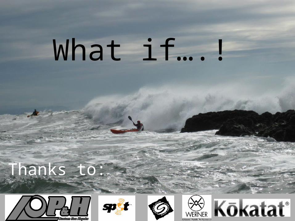
Thanks to:
What if….!