right of way & relocation technical memorandum … · hampton roads bridge -tunnel eis right of...
TRANSCRIPT

RIGHT OF WAY & RELOCATION TECHNICAL MEMORANDUM
November 27, 2012 1
1. INTRODUCTION
1.1 Project Description
The Virginia Department of Transportation (VDOT), in cooperation with the Federal Highway Administration (FHWA), is studying the environmental consequences of transportation alternatives along Interstate 64 (I-64) and the Hampton Roads Bridge-Tunnel (HRBT). The study area, as shown in Figure 1, is a one-mile-wide corridor along I-64 from the I-664 interchange in the City of Hampton to the I-564 interchange in the City of Norfolk, a distance of approximately 12 miles, including the 3.5-mile-long HRBT.
The purpose of this Technical Memorandum is to assess the potential right-of-way acquisition needs and relocations associated with the implementation of the Retained Build Alternatives, to inventory the availability of decent, safe, and sanitary replacement housing and or facilities to accommodate displaced residents, businesses, and non-profit organizations, and to characterize the potential relocations that could results from such implementation. Information in this memorandum will support discussions presented in the Environmental Impact Statement (EIS).
• Section 1 provides an overview of the study and outlines the methods and assumptions used to characterize and assess potential impacts in terms of right-of-way and relocations.
• Section 2 provides an examination of the demographics of the communities within the study area and potential relocation of residents and businesses..
• Section 3 assesses the availability of replacement residences and business locations in and around the study area.
• Section 4 provides an examination of the costs associated with acquiring right-of-way and relocating residents and businesses.
Details of all alternatives, including potential limits of disturbance, are included in the Alternatives Technical Report. Three Retained Build Alternatives, each representing a set of improvements that form a stand-alone solution to the identified needs within the study area, have been retained for detailed evaluation in the EIS. These Retained Build Alternatives form the basis for considering potential impacts in terms of right-of-way and relocations, as discussed in this Technical Memorandum:
• The Build-8 Alternative would provide four continuous mainline lanes in each direction of I-64 throughout the study area. Through the Hampton section of the study area, this alternative would require one lane of widening in each direction of I-64. Through the Norfolk section, this alternative would require the addition of two lanes in each direction of I-64. A concrete traffic barrier would separate the eastbound and westbound directions. The total pavement width of the Build-8 Alternative mainline would be approximately 150 feet. Through the Willoughby Spit, widening would occur on the south side of the existing roadway only. The eastbound approach bridge would be modified to carry two westbound lanes, and a new four-lane bridge would be constructed approximately 200 feet to the west of the existing bridges to carry the eastbound lanes. A new four-lane tunnel would be constructed approximately 200 feet west of the existing tunnel.
• The Build-8 Managed Alternative mainline, bridges, and tunnels would be similar to the Build-8 Alternative, providing four continuous mainline lanes in each direction of I-64 with a new bridge structure and tunnel. However, some or all of the travel lanes would be managed using tolls and/or vehicle occupancy restrictions. The typical section also would include an approximate four-foot buffer separation between the general purpose lanes and any managed lanes, resulting in a total mainline pavement width of approximately 160 feet. The managed lanes would tie to the high occupancy vehicle (HOV) lanes on I-64 on both ends of the study area.

Hampton Roads Bridge-Tunnel EIS Right of Way & Relocation Technical Memorandum
2 November 27, 2012

Hampton Roads Bridge-Tunnel EIS Right of Way & Relocation Technical Memorandum
November 27, 2012 3
• The Build-10 Alternative would provide five continuous mainline lanes in each direction of I-64 throughout the study area, with a concrete traffic barrier separating the eastbound and westbound directions. Throughout the Hampton section of the study area, this alternative would require widening both directions of I-64 by two lanes. In the Norfolk section of the study area, this alternative would require widening both directions of I-64 by three lanes. The total width of the mainline pavement would be approximately 170 feet. The approach bridges and tunnel would be similar to the Build-8 Alternative; however, the new bridge-tunnel would include one westbound lane and five eastbound lanes for the bridge and the tunnel.
The No-Build Alternative also has been retained to serve as a baseline for comparison of alternatives and their potential effects. Under the No-Build Alternative, I-64 would remain predominantly three lanes per direction within the Hampton section of the study area. The 3.5-mile HRBT would continue with current operations. Within the Norfolk section of the study area, I-64 would remain two lanes per direction, including the I-64 bridges across Willoughby Bay.
As the limits of disturbance (LOD) for the Retained Build Alternatives are similar, the figures in this memorandum show the limits for the Build-10 Alternative only, which would have the largest disturbance area and therefore the largest potential impact. The text and tables discuss the potential impact of all Retained Build Alternatives in comparison to the No-Build Alternative.
1.2 Methods and Assumptions
The acquisition of right-of-way and the relocation of displaces would take place in accordance with the Uniform Relocation Assistance and Real Property Acquisition Policies Act of 1970, as amended (42 USC 4601). This technical memorandum has been prepared based on guidance in VDOT’s Right-of-Way Manual of Instructions (last revised 8/25/2011). Data and information were collected on social demographics, property values, and potential relocations, including individual tax parcel data, within the limits of disturbance of the Retained Build Alternatives. This information was compiled from: city tax parcel databases, USGS mapping, aerial photos, the US Census web site, Geographic Information System (GIS) databases, conceptual drawings, and field inspections. All field inspections were conducted from within the public right-of-way. Given that potential property impacts are only being estimated at this time, local citizens/property owners were not contacted for any data to determine family size, household size, property value, owner/renter status, any other demographic information. Similarly, individual businesses potentially subject to relocation were not contacted to determine their number of employees. Rather, these data were estimated using the sources noted above.
Potential relocations were determined based on overlaying the estimated LOD of the Retained Build Alternatives on city tax parcel digital data through the use of GIS. The individual parcel data were then compiled and the area that may be acquired with implementation of a Retained Build Alternative was computed. Potential relocations were identified as residential (individuals/families), businesses, and non-profit organizations; the latter includes state-owned land, city-owned land, churches, schools, cemeteries, and parks/recreation areas. The relocations can be classified as total acquisitions or partial acquisitions:
• Total Acquisition: This occurs when the entire parcel (house, business, non-profit, or farm) is shown within the right-of-way or access to the parcel is removed and cannot be restored. The owner is compensated for the fair market value of the entire parcel and provided relocation assistance.
• Partial Acquisition: This occurs when a portion of a parcel is acquired and that portion does not include a primary improvement. The owner is compensated for the fair market value of the portion of their parcel and minor improvements that will be acquired. Some partial
Hampton Roads Bridge-Tunnel EIS Right of Way & Relocation Technical Memorandum
4 November 27, 2012
acquisitions result in uneconomic remnants of the remaining parcel. Uneconomic remnants occur when “the remainder of such tract or part thereof can no longer be utilized for the purpose for which the entire tract is then being utilized“ (VDOT, 2011). In this case, the owner is compensated for the fair market value of their entire parcel and may be provided relocation assistance. Due to the preliminary nature of the location of the alignments, uneconomic remnants were not determined in this analysis. Uneconomic remnants will be identified and compensated for during final design and right-of-way acquisition.
The city data for individual tax parcels includes the value of the land and the value of improvements (structures). The specific amount of right-of-way to be acquired for both total acquisitions and partial acquisitions is multiplied by the land value of the parcel, plus the value of improvements to determine the value of the acquisition. During final design and right-of-way estimation processes, additional costs that would be added to the fair market value of the properties could include administrative expenses for each property, remediation costs for potential hazardous materials sites, damage assessment to partial property acquisitions, and condemnation costs. Additional costs include the relocation cost for each owner and renter occupied residence, business, and non-profit organization, and cost per grave for reinterment for impacts to cemeteries.
2. CENSUS DATA AND RELOCATIONS
This document represents a preliminary examination of the potential relocations and therefore direct contact with individual residents, landowners, and business owners did not occur. Social and economic characteristics of the displaced population are based on US Census data from both the 2010 Decennial Census and 2006-2010 American Community Survey. The former includes data on total population, race, age, households, and housing; the latter includes income data on median household income and low-income persons.
The Build-8 Alternative would require the relocation of 107 residences and 12 businesses in Hampton, and 154 residences and four businesses in Norfolk. The Build-8 Managed Alternative would require the relocation of 115 residences and 12 businesses in Hampton, and 160 residences and four businesses in Norfolk. The Build-10 Alternative would require the relocation of 130 residences and 13 businesses in Hampton, and 185 residences and four businesses in Norfolk.
Title VI of the Civil Rights Act of 1964 states that “No person in the United States shall, on the ground of race, color, or national origin, be excluded from participation in, be denied the benefits of, or be subjected to discrimination under any program or activity receiving Federal financial assistance.” Title VI bars intentional discrimination as well as disparate impact discrimination (i.e., a neutral policy or practice that has an unequal impact on protected groups). Data collection to determine the presence of any Title VI populations as listed previously has occurred as a part of this project. More detail appears in the Socioeconomics Technical Report.
Executive Order 12898, “Federal Actions to Address Environmental Justice in Minority Populations and Low-Income Populations”, states that each Federal agency “shall make achieving environmental justice part of its mission by identifying and addressing, as appropriate, disproportionately high and adverse human health or environmental effects of its programs, policies, and activities on minority populations and low-income populations”.
As defined by Title VI and in the guidance for implementing EO 12898, minority populations include citizens or lawful permanent residents of the U.S. who, as defined by FHWA Order 6640.23A, are:
• Black: a person having origins in any of the black racial groups of Africa; • Hispanic or Latino: a person of Mexican, Puerto Rican, Cuban, Central, or South American or
other Spanish culture or origin, regardless of race;

Hampton Roads Bridge-Tunnel EIS Right of Way & Relocation Technical Memorandum
November 27, 2012 5
• Asian American: a person having origins in any of the original peoples of the Far East, Southeast Asia, or the Indian subcontinent;
• American Indian and Alaskan Native: a person having origins in any of the original people of North America or South America (including Central America) and who maintains cultural identification through tribal affiliation or community recognition; or
• Native Hawaiian and Other Pacific Islander: a person having origins in any of the original peoples of Hawaii, Guam, Samoa, or other Pacific Islands.
The US Department of Transportation’s most recent order on implementing environmental justice requirements (DOT Order 5610.2(a), issued March 3, 2012) states that “it is the policy of DOT to promote the principles of environmental justice (as embodied in the Executive Order) through the incorporation of those principles in all DOT programs, policies, and activities. This will be done by fully considering environmental justice principles throughout planning and decision-making processes in the development of programs, policies, and activities, using the principles of the National Environmental Policy Act of 1969 (NEPA), Title VI of the Civil Rights Act of 1964 (Title VI), the Uniform Relocation Assistance and Real Property Acquisition Policies Act of 1970, as amended, (URA), the Safe, Accountable, Flexible, Efficient Transportation Equity Act: A Legacy for Users (Public Law 109-59; SAFETEA-LU) and other DOT statutes, regulations and guidance that address or affect infrastructure planning and decision-making.” The Federal Highway Administration implemented the DOT order via FHWA Order 6640.23A, “FHWA Actions to Address Environmental Justice in Minority Populations and Low-Income Populations” (June 14, 2012). The order provides methods to comply with existing applicable regulations and requirements as well as administering FHWA’s “governing statues so as to identify and avoid discrimination and disproportionately high and adverse effects on minority populations and low-income populations.”
For this technical memorandum, demographic data for the Cities of Hampton and Norfolk were analyzed to determine whether the Retained Build Alternatives would have property impacts on Title VI populations or any disproportionately high and adverse human health or environmental effects on minority or low-income populations, including those potentially subject to relocation (Table 1).
There are several census tracts with data that vary widely from other tracts based on their unique geographies. Tract 114 in Hampton contains Hampton University, a historically African-American university: the minority population is 96.2% of the total population, the population over 65 years of age is just over 3%, low-income population (e.g., students) is 66%, and the median household income is $5,000. Tract 9.02 is the location of Naval Station Norfolk, where there is a relatively low proportion of the population over 65 years of age, a high number of persons per household and low number of owner-occupied housing units. Finally, Tract 111 in Hampton, which is contiguous with Fort Monroe, has a very low total population, which affects all of its percentages. It should also be noted that some of the census tract boundaries are along existing roadways (i.e., sides of the same street are in separate census tracts) and may not give the most accurate picture of a community.
The Retained Build Alternatives have the potential to impact residents (Table 1 and Figures 2A-E). These are potential impacts based on worst case limits of disturbance. In addition, those census tracts that have populations ten percent higher than the study area of minorities or low-income persons, and therefore the potential for environmental justice impacts have been highlighted in bold in Table 1. The ten percent threshold was chosen because it may be perceived to be a level that is not negligible or discountable, and imparts substantiality.

Hampton Roads Bridge-Tunnel EIS
Right of W
ay & Relocation Technical M
emorandum
6 N
ovember 27, 2012
Table 1. Relocations and 2010 Demographic Data by Census Tract
Location Relocations:
8 Lane 8 Lane Managed
10 Lane
Total Minorities (Percent)
Total Over 65 Years
(Percent)
Total Low-Income
(Percent)
Median Household
Income Persons Per Household
Owner-Occupied
Housing Units
Renter-Occupied
Housing Units
Study Area Cities Total
261 275 315
216,493 (56.94%)
39,652 (10.43%)
53,887 (15.01%) - 2.42 50.3% 49.7%
City of Hampton
107 115 130
81,153 (59.05%)
16,856 (12.26%)
17,040 (12.59%) $49,815 2.42 58.1% 41.9%
Census Tract 105.01
0 0 0
4,580 (78.90%)
948 (16.33%)
1,148 (19.64%) $36,228 2.27 53.6% 46.4%
Census Tract 105.02
2 2 2
2,744 (85.38%)
163 (5.07%)
563 (18.10%) $40,583 2.44 28.7% 71.3%
Census Tract 106.01
0 0 0
2,230 (81.71%)
185 (6.78%)
675 (28.77%) $28,347 2.27 29.4% 70.6%
Census Tract 106.02
37 43 52
2,700 (87.35%)
401 (12.97%)
643 (20.81%) $31,154 2.43 42.1% 57.9%
Census Tract 108
24 26 31
2,289 (43.05%)
872 (16.40%)
371 (6.78%) $57,900 2.33 71.0% 29.0%
Census Tract 112
0 0 0
1,105 (38.92%)
437 (15.39%)
742 (20.54%) $54,432 2.22 62.3% 37.7%
Census Tract 113
44 44 45
1,444 (65.43%)
197 (8.93%)
568 (23.09%) $34,410 2.42 44.1% 55.9%
Census Tract 114
0 0 0
2,678 (96.19%)
90 (3.23%)
499 (66.62%) $5,000 1.84 6.1% 93.9%

Hampton Roads Bridge-Tunnel EIS
Right of Way &
Relocation Technical Mem
orandum
Novem
ber 27, 2012 7
Table 1. Relocations and 2010 Demographic Data by Census Tract
Location Relocations:
8 Lane 8 Lane Managed
10 Lane
Total Minorities (Percent)
Total Over 65 Years
(Percent)
Total Low-Income
(Percent)
Median Household
Income Persons Per Household
Owner-Occupied
Housing Units
Renter-Occupied
Housing Units
City of Norfolk 154 160 185
135,340 (55.74%)
22,796 (9.39%)
36,847 (16.48%) $42,677 2.43 45.4% 54.6%
Census Tract 3 0 0 0
1,080 (36.18%)
363 (12.16%)
382 (11.33%) $39,805 2.02 36.9% 63.1%
Census Tract 4 32 31 41
1,014 (31.29%)
213 (6.57%)
359 (9.27%) $40,808 1.91 28.5% 71.5%
Census Tract 5 76 82 89
1,137 (35.74%)
258 (8.11%)
439 (13.77%) $45,675 2.37 45.5% 54.5%
Census Tract 8 46 46 54
829 (39.95%)
164 (7.90%)
30 (1.29%) $48,583 2.24 38.8% 61.2%
Census Tract 9.02
0 1 1
1,438 (40.61%) -- 230
(12.20%) $46,346 3.26 1.4% 98.6%
Census Tract 55 0 0 0
1,459 (51.10%)
199 (6.97%)
305 (9.30%) $39,429 2.61 56% 44%
Census Tract 57.01
0 0 0
3,873 (83.06%)
370 (7.93%)
1,126 (23.07%) $27,470 2.44 30.3% 69.7%
Sources: City Tax Assessment databases; field reviews, September, 2011; US Census Bureau, 2010, SF1; US Census Bureau, ACS 2006-2010. Note: -- Totals less than 25 persons not shown. This does not include the total number of units for multi-family residences.

Hampton Roads Bridge-Tunnel EIS Right of Way & Relocation Technical Memorandum
8 November 27, 2012

Hampton Roads Bridge-Tunnel EIS Right of Way & Relocation Technical Memorandum
November 27, 2012 9

Hampton Roads Bridge-Tunnel EIS Right of Way & Relocation Technical Memorandum
10 November 27, 2012

Hampton Roads Bridge-Tunnel EIS Right of Way & Relocation Technical Memorandum
November 27, 2012 11

Hampton Roads Bridge-Tunnel EIS Right of Way & Relocation Technical Memorandum
12 November 27, 2012
Hampton Roads Bridge-Tunnel EIS Right of Way & Relocation Technical Memorandum
November 27, 2012 13
Both cities in the study area have minority populations that are greater than 50% of the total population (Table 1). The percent of the population over 65 in the study area is 10.4%. The percent of persons with low-income in the study area is 15%, with Norfolk having a higher percentage than Hampton. Owner-occupied housing in the study area is 50.3%, with renter-occupied at 49.7%. The City of Hampton has a minority population of 59%, an elderly population of 12%, and a low-income population of 13%. Owner-occupied homes total 58%. In Hampton, the potential relocations would be primarily in three census tracts – 106.2, 108, and 113. In Tract 106.02, the minority population is 87% of the total, the elderly population is 13%, and the low-income population is 21%. Of the occupied housing units, 42% are owner-occupied, which is lower than the proportion in the city. In Tract 108, the minority population is 43% of the total, the elderly population is 16%, and the low-income population is 7%. Of the occupied housing units, 71% are owner-occupied. This is the highest percent of owner-occupied units in the study area. In Tract 113, the minority population is 65% of the total, the elderly population is 9%, and the low-income population is 23%. Of the occupied housing units, 44% are owner-occupied. The concentration of potential relocations in census tracts 106.02 and 113 may present property impacts to Title VI populations and disproportionately high and adverse property impacts to environmental justice populations.
The City of Norfolk has a minority population of 56%, an elderly population of 9%, and a low-income population of 16%. Owner-occupied homes total 45%. In Norfolk, almost all of the relocations would occur in three census tracts, 4, 5, and 8. In Tract 4, the minority population is 31% of the total, the elderly population is 6%, and the low-income population is 9%. Of the occupied housing units, 28% are owner-occupied, which is the lowest proportion in the study area, excluding Naval Station Norfolk. In Tract 5, the minority population is 36% of the total, the elderly population is 8%, and the low-income population is 14%. Of the occupied housing units, 46% are owner-occupied. In Tract 8, the minority population is 40% of the total, the elderly population is 8%, and the low-income population is 1%. Of the occupied housing units, 39% are owner-occupied. Neither census tract 4, 5, nor 8 present demographics that suggest that implementation of the Retained Build Alternatives would result in property impacts to Title VI populations or disproportionately high and adverse property impacts to environmental justice populations.
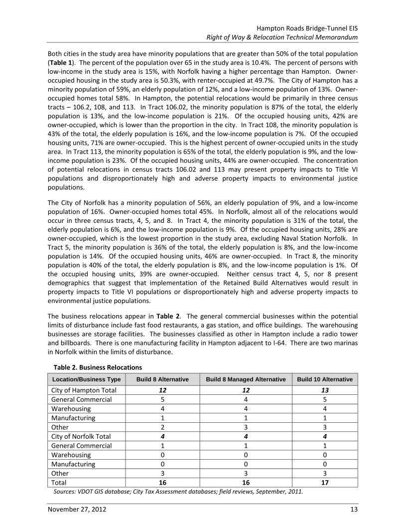
The business relocations appear in Table 2. The general commercial businesses within the potential limits of disturbance include fast food restaurants, a gas station, and office buildings. The warehousing businesses are storage facilities. The businesses classified as other in Hampton include a radio tower and billboards. There is one manufacturing facility in Hampton adjacent to I-64. There are two marinas in Norfolk within the limits of disturbance.
Table 2. Business Relocations
Location/Business Type Build 8 Alternative Build 8 Managed Alternative Build 10 Alternative
City of Hampton Total 12 12 13 General Commercial 5 4 5 Warehousing 4 4 4 Manufacturing 1 1 1 Other 2 3 3 City of Norfolk Total 4 4 4 General Commercial 1 1 1 Warehousing 0 0 0 Manufacturing 0 0 0 Other 3 3 3 Total 16 16 17 Sources: VDOT GIS database; City Tax Assessment databases; field reviews, September, 2011.

Hampton Roads Bridge-Tunnel EIS Right of Way & Relocation Technical Memorandum
14 November 27, 2012
3. REPLACEMENT HOUSING/BUSINESS LOCATIONS
In Hampton, potential displacements would be within the 23663 and 23669 zip codes, which combined, had approximately 341 homes for sale in October 2012. Therefore, there appear to be adequate housing replacement sites within Hampton based on current real estate listings (www.trulia.com). In Norfolk, potential displacements would be within the 23503 zip code, which had approximately 164 homes for sale in October 2012. Based on the number of potential residential displacements, there would not be adequate housing replacement sites within the same zip code. However, in the entire city, there are over 250 sites for sale. There is a wide range of housing available in varying locations and at an array of prices within the respective cities. VDOT has the ability and, if necessary, is willing to provide housing of last resort, including the purchase of land or dwellings; repair of existing dwellings to meet decent, safe, and sanitary conditions; relocation or remodeling of dwellings purchased by VDOT; or construction of new dwellings. Assurance is given that all displaced families and individuals would be relocated to suitable replacement housing, and that all replacement housing would be fair housing available to all persons without regard to race, color, religion, sex, or national origin and would be within the financial means of the displacees. Each person would be given sufficient time to negotiate for and obtain possession of replacement housing. No residential occupants would be required to move from property needed for the Retained Build Alternatives until comparable decent, safe, and sanitary replacement dwellings have been made available to them.
In Hampton, in zip codes, 23663 and 23669, there were eleven commercial properties for sale in October 2012. Throughout the city, there were 25 commercial properties for sale. None of these were industrial manufacturing sites. Within Hampton, there are three industrial parks that would be able to provide leased space to the displaced manufacturing facility: Copeland Industrial Park, West Park, and Wythe Creek Park. In Norfolk, in zip code 23503, there were seven commercial properties for sale in October 2012. Throughout the city, there were over 50 commercial sites for sale. However, there were none that were potential marina sites to serve as relocations sites for the two marinas that would be relocated.
The acquisition of right-of-way and the relocation of displacees would be in accordance with the Uniform Relocation Assistance and Real Property Acquisition Policies Act of 1970, as amended. Assurance is given that relocation resources would be available to all residential, business, farm, and nonprofit displacees without discrimination.
4. COST OF DISPLACEMENTS
Table 3 summarizes the costs of acquiring those residences and businesses that would be relocated and the cost of acquiring vacant parcels. This is based on the current tax value of each individual parcel, including improvements (e.g., buildings). As noted previously, costs additional to fair market value could include:
• Administrative expenses for each property, consisting of a standard fee per parcel to cover fee appraisal, title examinations, negations, relocation computation and closing costs;
• Remediation costs for potential hazardous materials sites, at a set percentage per site, such as 15% of assessed value;
• Damage assessment to partial property acquisitions, at a set percentage per parcel, such as 25% of fair market value; and
• Condemnation costs, at a set percentage per parcel such as 25% of fair market value.
This is not the total cost, which would include the relocation cost for each resident (owners and renters), business, and non-profit organization, and cost per grave for reinterment of graves in affected cemeteries.

Hampton Roads Bridge-Tunnel EIS Right of Way & Relocation Technical Memorandum
November 27, 2012 15
Table 3. Estimated Value of Residential, Business, and Non-Profit Displacements Location Build 8 Alternative Build 8 Managed Alternative Build 10 Alternative
City of Hampton $47,958,591 $76,667,592 $69,212,371 City of Norfolk $74,265,357 $74,787,717 $82,518,638 Total $122,223,948 $151,455,309 $151,731,008 Source: City Tax Assessment Databases.
The estimates in Table 3 include minor amounts of right-of-way required from several large parcels: Forest Lawn Cemetery in Norfolk, and in Hampton, Y.H. Thomas School, Hampton University, and Veteran’s Administration Medical Center-Hampton. Therefore, the values of these parcels that are included in Table 3 are based on only the portion of the parcel to be acquired. The acreage to be acquired was calculated as a percentage of the total acreage of the individual parcel, and then this percentage was applied to the value of the parcel.
5. PROPERTY TAX REVENUE IMPACTS
The City of Hampton levied general property taxes in the amount of $156,614,772 in 2011. The City of Norfolk levied real estate taxes in the amount of $186,355,380 in 2011. Acquisition of property for construction of any of the Retained Build Alternatives would remove taxable land from the individual cities’ tax rolls. In Hampton, the real estate tax rate is $1.04 per $100.00 of assessed value (http://www.hampton.gov/assess_and_collect/real_estate_tax.html). In Norfolk, the current real estate tax rate is $1.11 per $100.00 of the assessed value. The business district tax rate is $1.27 per $100.00 of the assessed value (http://www.norfolk.gov/Treasurer/real_estate_tax.asp). The value of each parcel was multiplied by its current tax rate to estimate the amount of annual taxes in 2011 dollars that each city will no longer be able to collect if any of the Retained Build Alternatives were constructed (Table 4). Parcels currently owned by either city, the state, or the federal government were not included in the totals.
Table 4. Estimated Value of Annual Property Tax Revenue Losses (Dollar Amount and Percentage of Tax Revenue)
Location Build 8 Alternative Build 8 Managed Alternative Build 10 Alternative
City of Hampton $389,711 0.24% $414,180 0.26% $435,781 0.28% City of Norfolk $821,887 0.44% $833,785 0.45% $909,333 0.49% Total $1,211,598 0.35% $1,247,964 0.36% $1,345,114 0.39% Source: City Tax Assessment Databases.

Hampton Roads Bridge-Tunnel EIS Right of Way & Relocation Technical Memorandum
16 November 27, 2012
REFERENCES
City of Hampton
2012 Hampton, Virginia Real Estate Tax Rates. [Online] Accessed 9/7/2012. http://www.hampton. gov/assess_and_collect/real_estate_tax.html
City of Norfolk
2012 Norfolk, Virginia Real Estate Tax Rates. [Online] Accessed 9/7/2012. http://www.norfolk.gov/ Treasurer/real_estate_tax.asp
Federal Highway Administration
1987 FHWA Technical Advisory T6640.8A. Guidance for Preparing and Processing Environmental and Section 4(f) documents. Washington, DC.
2011 Guidance on Environmental Justice and NEPA. Washington DC.
2012 FHWA Technical Advisory T6640.23A. FHWA Actions to Address Environmental Justice in Minority Populations and Low-Income Populations. Washington, D.C.
Office of the President of the United States
1994 Executive Order 12898: Federal Actions to Address Environmental Justice in Minority Populations and Low-Income Populations. Washington, DC.
U.S. Census Bureau
2011 American Community Survey, 2010 5-Year Estimates, Tables B16001, B19013, S1701, accessed 12/8/2011.
2011 Decennial US Census, SF1, Tables DP-1, H13, and H16, accessed 10/20/2011. U.S. Department of Transportation
2012 Department of Transportation Order 5610.2(a): Final DOT Environmental Justice Order. Washington, DC.
Virginia Department of Transportation
2011 Right of Way Manual of Instructions. Richmond, VA.