right-of-way acquisition plan under the ... acquisition plan under the uniform act for the plains...
TRANSCRIPT

Page 1 01/05/14
RIGHT-OF-WAY ACQUISITION PLAN UNDER THE UNIFORM ACT FOR THE
PLAINS & EASTERN CLEAN LINE TRANSMISSION LINE PROJECT
Development of the Plains & Eastern Clean Line transmission line project (the “Project”) will
require the acquisition of property interests, which property interests shall primarily consist of
transmission line easements and, in some very limited instances, land purchased in fee such as for
the construction of converter stations. To the extent that the Department of Energy (“DOE”),
acting through the Southwestern Power Administration (“Southwestern”), participates in the
Project, the acquisition of such property interests may be subject to applicable provisions of the
Uniform Relocation Assistance and Real Property Acquisition for Federal and Federally-
Assistance Programs Act, as set forth in 49 CFR § 24 (the “Uniform Act”). The purpose of the
Uniform Act is (i) to ensure that owners of real property from which a property interest will be
acquired are treated fairly and consistently, (ii) to encourage and expedite acquisition by
agreements with such owners, (iii) to minimize litigation, and (iv) to promote public confidence
in the right-of-way acquisition process.
Plains and Eastern Clean Line LLC and Plains and Eastern Clean Line Oklahoma LLC (together,
“Clean Line”) are committed to coordinating with DOE and Southwestern to ensure that all
applicable and appropriate measures are followed in the acquisition of property interests
consistent with the requirements of the Uniform Act.1
The following materials set out the guidelines and procedures that Clean Line will follow for
acquisition of property interests in a manner that meets the requirements of the Uniform Act.
These materials are subject to further revision and refinement.
INDEX
I. Market Data Studies and Determination of Average Fair Market Per Acre Value
II. Notice to Landowners
III. Appraisal Waiver Valuation Review
IV. Determining Settlement Offers for Waiver Parcels
V. Appraisals
VI. Review Appraisal Process
VII. Landowner Negotiations
A. Landowner Negotiations—Waivers
B. Landowner Negotiations—Appraisals
1 This Plan primarily addresses the acquisition of easements, as the overwhelming majority of property interests acquired with respect to the Project will be transmission line easements; however Clean Line will employ a similar process and procedure of any other type of property interest, if applicable.
Page 2 01/05/14
VIII. Relocations
IX. Exhibits
Exhibit A – Land Offer Summary (sample)
Exhibit B – Valuation Memorandum (form)
Exhibit C – Technical Review Report (form)
Exhibit D – Technical Review Report (sample)
Exhibit E – Easement Calculation Worksheet-Waiver Parcels (form)
Exhibit F – Easement Calculation Worksheet-Appraisals (form)
Page 3 01/05/14
I. Market Data Studies and Determination of Average Fair Market Per Acre
Value
Market data studies, from a licensed certified real estate appraisal firm, either have been or will
be ordered during the course of the Project to assist in determining the current market value of
the land along the proposed route for the Project.
1. Clean Line has engaged Integra Realty Resources (“Integra”), a nationwide real estate
appraisal firm that specializes in linear infrastructure projects, to perform county-wide
market data studies, appraisals and other related tasks, all consistent with the standards
set forth in the Uniform Standards of Professional Appraisal Practice (“USPAP”). Clean
Line provided Integra with the list of counties traversed by the Project Area ROW (as
defined below). Integra was asked to provide property sales data within such counties to
establish fair market value of various land types for the parcels on which Clean Line would
like to pursue easement acquisition (the “Project Area ROW”).
2. Integra will review and compile all of the relevant recent property sales within the county,
for each county traversed by the Project Area ROW.
3. In addition to the sales data for each county, Integra will analyze the sales data to
determine property value “trends”. For example, in Texas County, Oklahoma, Integra
determined that land value trends were based not just on the land use, but also on land
parcel size.
4. Based on the sales data collection and analysis conducted by Integra, Clean Line and a
Contract Land Staff (“CLS”)2 employee will review all the data provided and determine
the average per acre value for specific land types within each county3. The CLS employee
will have sufficient understanding of real estate valuation in general, knowledge of the real
estate market within the geographic areas where the Project Area ROW is located in
particular, and experience with easement acquisition under the Uniform Act. Generally
CLS will review only the sales data for the most recent 12 months, unless there is
insufficient data for that period, in which case CLS will review the sales data for the most
recent three years to determine the average historical per acre value.4 Once an average
2 Contract Land Staff is a national right-of-way acquisition firm with experience in acquiring right-of-way for linear infrastructure projects throughout the United States and Canada, including several projects that involved right-of-way acquisition under the Uniform Act. Clean Line has engaged Contract Land Staff to manage the right-of-way acquisition on the Project under the direction of Clean Line’s Director of Land Services. 3 Land types may differ in each county (depending on the terrain and typical uses of land within the county) but some examples of typical land use types encountered are crop, pasture, timber, residential, hobby farm, etc. 4 When reviewing sales data for both the previous 12 months and 36 months, CLS will compare the averages of sales within each such period and will use the average value that is higher.

Page 4 01/05/14
historical per acre value is determined for each land use type in the county, those per
acre values will be increased by ten percent (10%). The resulting per acre value will be
used as the average fair market value for each land use type within each county (the
“Average Fair Market Per Acre Value”).
5. For example, in Major County, Oklahoma there were 12 sales of crop land in 2013, as
follows:
Acreage Sales Date Sales Price Price/Acre Land Use
41.7 8/28/2013 $ 82,000 $ 1,966 Crop
80 4/3/2013 $ 176,700 $ 2,209 Crop
80 8/7/2013 $ 140,000 $ 1,750 Crop
80 4/8/2013 $ 122,000 $ 1,525 Crop
80.69 3/28/2013 $ 116,500 $ 1,444 Crop
155.32 8/30/2013 $ 253,000 $ 1,629 Crop
160 3/14/2013 $ 530,000 $ 3,313 Crop
160 5/29/2013 $ 340,000 $ 2,125 Crop
160 5/3/2013 $ 327,500 $ 2,047 Crop
160 8/27/2013 $ 250,000 $ 1,563 Crop
160 5/3/2013 $ 240,000 $ 1,500 Crop
200 9/25/2013 $ 413,000 $ 2,065 Crop
Based on this most recent sales data, the average per acre sales price for crop land in
Major County is $1,928/acre. After adding a ten percent (10%) increase to this number,
the county-wide Average Fair Market Per Acre Value for crop land in Major County is
$2,121. The same methodology for determining the Average Fair Market Per Acre Value
is used for each land use type in each county.
6. The Average Fair Market Per Acre Value for each land use type within in each county will
be used as part of the process of determining which parcels crossed by the Project Area
ROW may qualify as Waiver Parcels, as described in Section III below.

Page 5 01/05/14
II. Initial Notice to Landowners
Consistent with § 24.102(b) of the Uniform Act, Clean Line will notify potentially affected
landowners in writing of its interest in acquiring an easement.5
1. Prior to the initiation of formal negotiations with landowners, Clean Line will provide
notice of its intent to acquire an easement (the “Formal Notice Letter”); such notification
will also include a summary of the basic protections provided to the landowner under the
Uniform Act (the “Landowner Brochure”). The Formal Notice and Landowner Brochure
will either be hand delivered to the landowner by land agents (the “Land Agent”) of CLS
or mailed via certified mail, return receipt requested, or mailed via registered mail. Once
delivered, a copy of the Formal Notice Letter will be placed in the office file for the
landowner tract.
2. The Formal Notice Letter will be written in English in plain, understandable language and
will include the name and telephone number of a person who may be contacted for
answers to questions or if additional assistance is needed.
3. As part of each Formal Notice Letter, Clean Line will offer foreign-speaking landowners
and any other landowners requiring special assistance, appropriate resources to enable
the landowner to read and understand the Formal Notice Letter, as well as any
subsequent communications and proposed easement terms. If a Land Agent determines
upon first contact with a landowner that the landowner does not speak or read English,
or requires any other form of special assistance, the Land Agent will notify Clean Line,
and Clean Line will ensure that a trained agent or employee is available to assist the
landowner as needed.
5 Clean Line will also take appropriate steps, consistent with the Uniform Act, to notify and engage with tenants where acquisition of the easement would affect any tenant rights or tenant-owned property.
Page 6 01/05/14
III. Appraisal Waiver - Valuation Review
The Uniform Act provides that an appraisal is not required for parcels that: (i) have an anticipated
easement acquisition cost of $10,000 or less, and (ii) for which the valuation analysis is
uncomplicated. If both criteria are met, the parcel will be deemed a “Waiver Parcel”.
Clean Line will review the parcels within the Project Area ROW to determine if any such parcels
meet the criteria for waiving an appraisal (“Waiver Valuation Review”). The Waiver Valuation
Review will be performed by an employee of CLS (the “Valuation Reviewer”). The Valuation
Reviewer will have sufficient understanding of real estate valuation in general, knowledge of the
real estate market within the geographic areas where the Project Area ROW is located, and
experience with waiver valuation under the Uniform Act. The Waiver Valuation Review process
and criteria for designation of a Waiver Parcel is further described below.
1. Determination of easement compensation of $10,000 or less.
a. The Valuation Reviewer will first determine whether any individual tax parcels
within the Project Area ROW should be combined or merged into a single parcel
for purposes of the Waiver Valuation Review. This process will be performed by
utilizing the CLSLiNK6 mail merge function. The mail merge function groups
multiple tax parcels owned by the same person (by name and address) within the
same county into one larger single tract. For example, in Texas County, Oklahoma
there are 59 individual tax parcel tracts within the Project Area ROW. However,
when combining or merging tracts that are owned by the same party, the total
number of tracts is reduced to 20 larger tracts.
b. Next, the Valuation Reviewer will review aerial imagery maps to determine if
multiple tax parcels in common ownership are also in common use (i.e., being
farmed as one contiguous parcel). If the Valuation Reviewer has determined that
multiple tax parcels are in both common ownership and common use, then the
multiple tax parcels will be combined into one parcel for the purpose of evaluating
whether such parcel meets the $10,000 threshold for a Waiver Parcel.
c. Finally, the Valuation Reviewer will multiply the total acreage of the easement
sought over the newly combined parcel by the county Average Fair Market Per
Acre Value for the parcel’s land type to determine if the total fair market value for
the easement over such parcel is $10,000 or less. If the value is $10,000 or less,
6 CLSLiNK is the database that CLS and Clean Line use to track the status and activity of parcels along and near the right-of-way for the Project. The database is used to track, among many other things, names, addresses, tax parcel numbers, contacts, statuses, activity notes, etc., for each of the parcels within the Project Area ROW.
Page 7 01/05/14
then the parcel will have met the first of the two requirements to be treated as a
Waiver Parcel.
2. Determination if the valuation analysis is uncomplicated. The Valuation Reviewer will
consider the following criteria to determine if the valuation analysis is uncomplicated:
a. Is the acquisition of the parcel simple (i.e., a fee purchase vs. an easement
purchase)?
b. What are the damages, if any, to the remainder of the landowner’s property?
c. Are there any buildings, structures or improvements located in the easement area?
d. Will the acquisition involve any relocation?
If the valuation analysis is determined to be not complicated, then the parcel has met
the second requirement to be treated as a Waiver Parcel.
3. Once the Valuation Reviewer determines that a parcel has met the two requirements for
a Waiver Parcel, the Valuation Reviewer will indicate that the parcel is qualified as a
Waiver Parcel on the Land Offer Summary spreadsheet, which is described in further
detail in Section IV below.

Page 8 01/05/14
IV. Determining Settlement Offer Amounts for Waiver Parcels
1. CLS and the Valuation Reviewer will create a spreadsheet, entitled the “Land Offer
Summary”, for each county which provides the following information for each parcel
or the merged or combined parcels:
a. Tract Name
b. Tax ID Numbers
c. Owner Name
d. Width and Length of the Easement Area
e. Total Acres within the Easement Area
f. Average Fair Market Per Acre Value for the applicable land use type (100%—
representing the fair market value for fee title)
g. Average Fair Market Per Acre Value for the applicable land use type (60%—
representing the fair market value for an easement)
h. Settlement Offer (see below)
i. Notation as to whether the parcel qualifies as a Waiver Parcel
2. The “Settlement Offer” for each parcel or merged or combined parcel will be derived
by multiplying the total acreage of the easement area by the applicable portion of the
Average Fair Market Per Acre Value as follows:
Length (in feet) x Width (in feet) / 43,560 (square feet per acre) x Average Fair
Market Per Acre Value = Settlement Offer7
An example of a Land Offer Summary for Texas County, Oklahoma is attached
hereto as Exhibit A.
3. The Valuation Reviewer will prepare a memorandum to file for each county (the
“Valuation Memorandum”) certifying that the Valuation Reviewer has reviewed the
Land Offer Summary and all other relevant background data. The Valuation
Memorandum will include at a minimum the following documents:
a. A description of the Project as it pertains to the specific county
b. The market data study for the county
c. Land Offer Summary
7 Clean Line has elected to base a Settlement Offer on 100% of fee market value for the subject parcel, even though the acquisition of easement rights are traditionally valued by appraisers between 40 – 75% of fee.
Page 9 01/05/14
For each Waiver Parcel, the Valuation Reviewer will certify in the Valuation
Memorandum that, based on his or her review of the relevant data, (i) the
proposed Settlement Offer represents just compensation for the subject
easement and (ii) an appraisal is unnecessary because the valuation is
uncomplicated and the anticipated value of the proposed acquisition is estimated
at $10,000 or less, based on a review of available data. See Exhibit B attached
hereto for a sample of a Valuation Memorandum.
4. The Director of Land Services for Clean Line, will review the findings as determined
by the Valuation Reviewer and will sign the Valuation Memorandum to confirm his or
her approval of such findings. Upon approval, a status of “Meets Waiver
Requirements” will be entered for each Waiver Parcel in the CLSLiNK database.8
5. An appraisal will be ordered for any parcel which does not qualify as a Waiver Parcel,
as discussed in Section V below.
8 CLSLiNK is the database to be used for the digital record keeping and tracking of parcels within the Project Area ROW. CLS has created a list of “statuses” within CLSLiNK in order to easily identify or track parcels that may fall within the same type of category (i.e., “Survey Permission Granted”, “Meets Waiver Requirements”, “Easement Signed”, etc.).

Page 10 01/05/14
V. Appraisals
Parcels that do not qualify as a Waiver Parcel will require a full appraisal by a certified independent
real estate appraiser (the “Appraiser”), qualified to conduct appraisals in accordance with the
requirements of the Uniform Act. The Appraiser shall not have an interest, direct or indirect, in
the property being evaluated. Clean Line anticipates that Integra will be the Appraiser.
1. An appraisal will be ordered for each parcel or the merged or combined parcel that does
not qualify as a Waiver Parcel (the “Appraisal”). Once an appraisal is ordered, a status of
“Appraisal Ordered” will be entered into the CLSLiNK database for the relevant parcel.
2. The Land Agent will contact the landowner to determine if the landowner would like to
accompany the Appraiser during the site inspection of the property that is required to
complete the Appraisal. The landowner will be given opportunity to present information
and material for consideration by the Appraiser that the landowner believes is relevant
to determining the value of the easement property. All such information and material
received from the landowner by Clean Line, the Land Agent or other CLS employees will
be provided to the Appraiser for consideration.
3. Integra will be informed by either a representative of Clean Line or a representative of
CLS (the “CLS Appraisal Coordinator”) as to whether the landowner wants to be present
during the Appraiser’s site inspection of the property.
4. Integra will provide Appraisals that are prepared according to and consistent with the
requirements of the USPAP and relevant state and local requirements. Integra will be
provided with the following information before beginning the appraisal process for each
parcel or merged or combined parcel:
a. Name, address and phone number(s) of the landowner
i. Integra will contact the landowner if it was determined that the landowner
wants to be present during the inspection.
ii. In the event the landowner cannot be reached via phone or via mail, Integra
will contact CLS, and CLS will communicate with the landowner to
determine if the landowner wishes to be present. CLS will communicate
its findings to Integra in an expeditious manner.
b. Vesting deeds or title report, if available
c. Sketch of the proposed easement area
d. Sample Easement Agreement
Page 11 01/05/14
5. Upon completion of the Appraisal, an electronic copy of the Appraisal will be delivered
to Clean Line, the CLS Appraisal Coordinator and to the CLS Review Appraiser (as
defined in Section VI below) and a status will be entered into the CLSLiNK database of
“Appraisal Received.”

Page 12 01/05/14
VI. Review Appraisal Process
A review appraiser (“Review Appraiser”) is an appraiser who examines the reports of other
appraisers to ascertain whether their conclusions are consistent with the data reports and with
other generally known information about the parcel. The Review Appraiser will review and
analyze the relevant facts assembled by the Appraiser using reason and judgment and review of
supporting documentation and drawings in order to form an opinion or conclusion with respect
to the findings contained in the Appraisal.
1. CLS, in consultation with Clean Line, will either designate a qualified internal CLS
employee, or will subcontract with an outside qualified appraiser to act as the Review
Appraiser for the Project. The Review Appraiser will (a) be a state-certified general
appraiser who has past experience and knowledge of appraisals and USPAP guidelines, (b)
be familiar with the Project, appraisal reports and the real estate market for the area, and
(c) not have any interest, direct or indirect, in the property being evaluated for the
easement. The Review Appraiser will do a desk review property inspection of the
property covered by the Appraisal.
2. At a minimum, in the evaluation of the Appraisal, the Review Appraiser will:
a. Read the report in its entirety, taking notes on items which may require further
evaluation
b. Review the current alignment of the subject parcel and legal description
c. Review and analyze the appraised value in light of comparable sales data used in
the analysis
d. Review aerial maps of the property
e. Check calculations in the report for accuracy
f. Evaluate appraisal principle application and techniques
g. Determine if the facts cited in the Appraisal are correct and the approaches and
sales data that were used to determine value are reasonable
h. Determine if the appraiser appropriately applied the tests of highest and best use,
i. Ensure that the Appraisal follows USPAP requirements and other applicable
requirements, including, to the extent appropriate, the Uniform Appraisal
Standards for Federal Land Acquisition (“UASFLA”)
j. Understand and ensure that any special valuation peculiarities are identified and
that they are justified and reasonable
k. Ensure compliance with Clean Line’s policies and requirements

Page 13 01/05/14
3. Upon conclusion of the detailed review, the Review Appraiser will sign a statement
certifying that (a) he or she made a thorough and detailed analysis of the Appraisal, (b) he
or she either agrees or disagrees with the content and facts and (c) the Appraisal is in
compliance with USPAP and other applicable standards. If the Review Appraiser requires
corrections or revisions, they will be outlined in the Technical Review Report (as defined
below). Finally, the Review Appraiser will either accept the contents and comments of
the Appraisal or will disapprove the Appraisal. The three possible conclusions of the
Review Appraiser are:
a. Approval
i. Approves the Appraisal as written.
b. Disapproval
i. The Appraisal does not meet with the acceptable standards for a specific
reason(s) such as content, valuation or other conditions as delineated in a
Technical Review Report.
c. Review Appraiser Becomes the Appraiser
i. In certain situations the Review Appraiser may provide his or her own
opinion of value and this value may differ from the cited value from the
Appraisal. In this approach the Review Appraiser may rely on data
contained in the original Appraisal and may use other data available to him
or her in the determination of value.
4. The Review Appraiser will prepare a “Technical Review Report” and document the
validity and findings of the Appraisal. The format for such a Technical Review Report is
attached hereto as Exhibit C, and an example of a prepared Technical Review Report is
attached hereto as Exhibit D.
5. A status in the CLSLiNK database will be entered of either “Review Appraisal Approved”
or “Review Appraisal Denied”.
6. In the event that the Review Appraiser rejects the Appraisal, either:
a. The Appraisal will be sent back to the original Appraiser for revisions based on
the appraisal review and then resubmitted through the review process as outlined
above; or
b. A meeting with be held by the Appraiser and Review Appraiser to gather more
facts regarding the subject parcel to formalize a joint appraisal analysis.

Page 14 01/05/14
VII. Landowner Negotiations
Landowners will be treated fairly and consistently across the Project when negotiating for
easement rights that affect their property.
A. Landowner Negotiations—Waiver Parcels
1. Land Agents will personally contact landowners whenever possible to discuss the Project
and how it may impact their property. If any landowner cannot be contacted personally,
the Land Agent will deliver the information via First Class Mail (and with respect to the
Formal Notice Letter and any final Settlement Offer, via Certified Mail or registered first-
class mail—return receipt requested).
2. Following delivery of the Formal Notice Letter, as described in Section II above, Land
Agents will contact the landowner to provide the following information:
a. The proposed form of Easement Agreement
b. A sketch of the easement area on the landowner’s property
c. A Construction Questionnaire, which is a document designed to obtain
information about the property, such as land uses, irrigation, utilities, structures,
gates and fences, etc. Clean Line endeavors to obtain this information early in the
development process so that it can be taken into consideration during
construction planning.
d. A Survey Permission Form that allows Clean Line to perform surveys (if the
landowner had not previously granted Clean Line survey access rights)
e. An Easement Calculation Worksheet, which provides (i) a description and location
of the easement on the property, (ii) the Settlement Offer, and (iii) how such
Settlement Offer was calculated in accordance with Waiver Valuation Review.
The form of Easement Calculation Worksheet for Waiver Parcels is attached
hereto as Exhibit E.
f. A Structure and Damages Calculation Worksheet
g. A copy of Clean Line’s Code of Conduct
h. In Texas, the Landowner Bill of Rights
i. In Oklahoma, a full and complete copy of (i) the Private Rights Settlement
Agreement dated January 14, 2011, and (ii) the Oklahoma Corporation
Commission’s October 28, 2011 order approving Plains and Eastern’s application
to conduct business as a public utility in Oklahoma

Page 15 01/05/14
3. When meeting with a landowner, Land Agent will make every reasonable effort to: (a)
discuss the Settlement Offer, including explanations as to the basis for the Settlement
Offer, (b) explain the Project, (c) explain Clean Line’s policies and procedures (including
payment of incidental expenses when applicable), and (d) generally be available to answer
any questions or concerns expressed by the landowner. The landowner will be given
reasonable opportunity to consider the Settlement Offer and present material which the
landowner believes relevant to determining the value of the easement property and to
suggest modifications in the proposed terms and conditions of the easement. Land Agents
and Clean Line will give full and fair consideration to landowner’s comments and
suggestions. Land Agents will not use coercive action to induce an agreement on price
or terms. Land Agents will exhaust all reasonable negotiations with landowners and will
strive to come to voluntary agreement with all landowners.
4. In the event that Clean Line or the Land Agent determines that there is a tenant on the
property, the Land Agent will contact the tenant to discuss tenant-related issues and will
ensure that the tenant is compensated for crops or other tenant-owned property as
required under the Uniform Act.
5. When the landowner accepts the Settlement Offer, the landowner and Clean Line will
execute the following documents:
a. Easement Agreement
b. Easement Calculation Worksheet
c. Structure and Damages Calculation Worksheet
6. Land Agents will document into the CLSLiNK database, a summary of all contacts and
interactions made with landowners, tenants and other interested parties with respect to
each parcel or merged or combined parcel of land within the Project Area ROW.
7. Statuses will be entered into the CLSLiNK database to track the following information:
a. Date the offer was made to the landowner
b. Amount of the offer
c. Any landowner counter offers
d. Date the easement agreement was signed by the landowner
e. Amount of the check written for the 30% initial offer
f. Amount of the balance payment due
g. Date that the balance payment is due
Page 16 01/05/14
B. Landowner Negotiations—Appraisal Parcels
1. Land Agents will personally contact landowners whenever possible to discuss the Project
and how it may impact their property. If any landowner cannot be contacted personally,
the Land Agent will deliver the information via First Class Mail (and with respect to the
Formal Notice Letter and any final Settlement Offer, via Certified Mail or registered first-
class mail —return receipt requested).
2. Following delivery of the Formal Notice Letter, as described in Section II above, Land
Agents will contact the landowner to provide the following information:
a. The proposed form of Easement Agreement
b. A sketch of the easement area on the landowner’s property
c. A Construction Questionnaire, which is a document designed to obtain
information about the property, such as land uses, irrigation, utilities, structures,
gates and fences, etc. Clean Line endeavors to obtain this information early in the
development process so that it can be taken into consideration during
construction planning.
d. A Survey Permission Form that allows Clean Line to perform surveys (if the
landowner had not previously granted Clean Line survey access rights)
e. A Structure and Damages Calculation Worksheet
f. A copy of Clean Line’s Code of Conduct
g. In Texas, the Landowner Bill of Rights
h. In Oklahoma, a full and complete copy of (i) the Private Rights Settlement
Agreement dated January 14, 2011, and (ii) the Oklahoma Corporation
Commission’s October 28, 2011 order approving Plains and Eastern’s application
to conduct business as a public utility in Oklahoma.
3. The Land Agent will ask the landowner if they want to be present during any on-site
inspections of the property with the Appraiser. The Land Agent will document in the
CLSLiNK database the requirement of either “Wishes to Accompany the Appraiser” or
“Does Not Wish to be Present for Appraisal On-site Inspections”. If the landowner does
not wish to be present for any on-site inspections, the Land Agent will request that the
landowner sign another Survey Permission form that acknowledges that they have waivedthis right to accompany the Appraiser.
4. In the event the landowner wishes to be present during the Appraisal, the Appraiser will
notify the landowner of the date and time of the site inspection. The Appraisal is
performed on the property by a certified licensed Appraiser (refer to Section V above for
more detail).
Page 17 01/05/14
5. When the Appraisal is completed the Land Agent meets with the landowner and will
present the following documents:
a. Copy of the Appraisal
b. An Easement Calculation Worksheet, which provides (a) a description and
location of the easement on the property, (b) the Settlement Offer, and (c) how
the Settlement Offer was calculated based on the Appraisal. The form of Easement
Calculation Worksheet for Appraisal parcels is attached hereto as Exhibit F.
6. When meeting with a landowner, Land Agent will make every reasonable effort to: (a)
discuss the Settlement Offer, including explanations as to the basis for the Settlement
Offer of just compensation, (b) explain the Project, (c) explain Clean Line’s policies and
procedures (including payment of incidental expenses when applicable) and (d) generally
be available to answer any questions or concerns expressed by the landowner. The
landowner will be given reasonable opportunity to consider the Settlement Offer and
present material which the landowner believes relevant to determining the value of the
easement property and to suggest modifications in the proposed terms and conditions of
the easement. Land Agents and Clean Line will give full and fair consideration to
landowner’s comments and suggestions. Land Agents will not use coercive action to
induce an agreement on price or terms. Land Agents will exhaust all reasonable
negotiations with landowners and will strive to come to voluntary agreement with all
landowners.
7. In the event that Clean Line or the Land Agent determines that there is a tenant on the
property, the Land Agent will contact the tenant to discuss any crops or other tenant-
owned property and will ensure that the tenant is compensated for crops or other tenant-
owned property as required under the Uniform Act.
8. When the landowner accepts the Settlement Offer, the landowner and Clean Line will
execute the following documents:
a. Easement Agreement
b. Easement Calculation Worksheet
c. Structure and Damages Calculation Worksheet
9. Land Agents will document, into the CLSLiNK database, a summary of all contacts and
interactions made with landowners, tenants and other interested parties with respect to
each parcel or merged or combined parcel of land within the Project Area ROW.
10. Statuses will be entered into the CLSLiNK database to track the following information:
Page 18 01/05/14
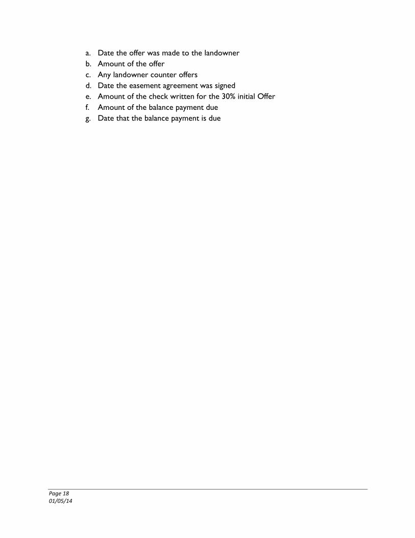
a. Date the offer was made to the landowner
b. Amount of the offer
c. Any landowner counter offers
d. Date the easement agreement was signed
e. Amount of the check written for the 30% initial Offer
f. Amount of the balance payment due
g. Date that the balance payment is due

Page 19 01/05/14
VIII. RELOCATIONS
At this time Clean Line does not anticipate that any residences or persons will be relocated as a
result of the Project. In the event circumstances change and relocation is required Clean Line
will draft policies and procedures that follow the Uniform Act for this process.

Page 20 01/05/14
IX. EXHIBITS
Exhibit A – Land Offer Summary (sample)
Exhibit B – Valuation Memorandum (form)
Exhibit C – Technical Review Report (form)
Exhibit D – Technical Review Report (sample)
Exhibit E – Easement Calculation Worksheet-Waiver Parcels (form)
Exhibit F – Easement Calculation Worksheet-Appraisals (form)
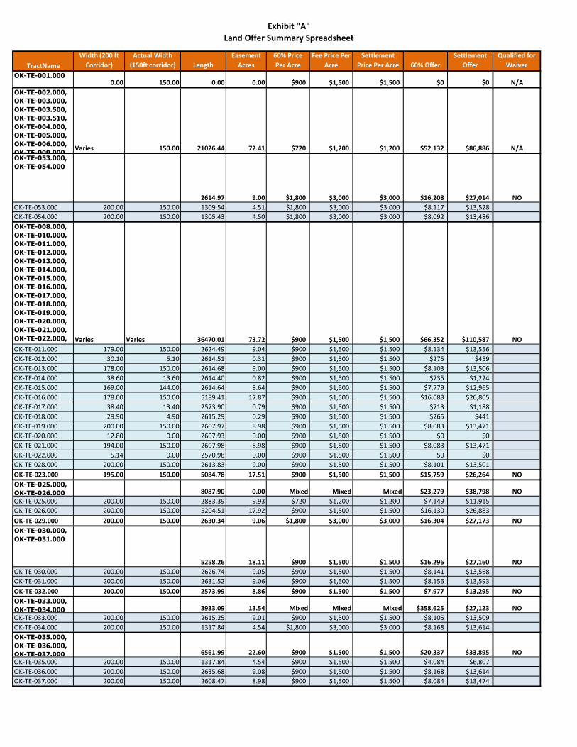
Exhibit "A"
Land Offer Summary Spreadsheet
TractName
Width (200 ft
Corridor)
Actual Width
(150ft corridor) Length
Easement
Acres
60% Price
Per Acre
Fee Price Per
Acre
Settlement
Price Per Acre 60% Offer
Settlement
Offer
Qualified for
Waiver
OK-TE-001.0000.00 150.00 0.00 0.00 $900 $1,500 $1,500 $0 $0 N/A
OK-TE-002.000,
OK-TE-003.000,
OK-TE-003.500,
OK-TE-003.510,
OK-TE-004.000,
OK-TE-005.000,
OK-TE-006.000,
OK-TE-009.000Varies 150.00 21026.44 72.41 $720 $1,200 $1,200 $52,132 $86,886 N/A
OK-TE-053.000,
OK-TE-054.000
2614.97 9.00 $1,800 $3,000 $3,000 $16,208 $27,014 NO
OK-TE-053.000 200.00 150.00 1309.54 4.51 $1,800 $3,000 $3,000 $8,117 $13,528
OK-TE-054.000 200.00 150.00 1305.43 4.50 $1,800 $3,000 $3,000 $8,092 $13,486
OK-TE-008.000,
OK-TE-010.000,
OK-TE-011.000,
OK-TE-012.000,
OK-TE-013.000,
OK-TE-014.000,
OK-TE-015.000,
OK-TE-016.000,
OK-TE-017.000,
OK-TE-018.000,
OK-TE-019.000,
OK-TE-020.000,
OK-TE-021.000,
OK-TE-022.000,
OK-TE-028.000Varies Varies 36470.01 73.72 $900 $1,500 $1,500 $66,352 $110,587 NO
OK-TE-011.000 179.00 150.00 2624.49 9.04 $900 $1,500 $1,500 $8,134 $13,556
OK-TE-012.000 30.10 5.10 2614.51 0.31 $900 $1,500 $1,500 $275 $459
OK-TE-013.000 178.00 150.00 2614.68 9.00 $900 $1,500 $1,500 $8,103 $13,506
OK-TE-014.000 38.60 13.60 2614.40 0.82 $900 $1,500 $1,500 $735 $1,224
OK-TE-015.000 169.00 144.00 2614.64 8.64 $900 $1,500 $1,500 $7,779 $12,965
OK-TE-016.000 178.00 150.00 5189.41 17.87 $900 $1,500 $1,500 $16,083 $26,805
OK-TE-017.000 38.40 13.40 2573.90 0.79 $900 $1,500 $1,500 $713 $1,188
OK-TE-018.000 29.90 4.90 2615.29 0.29 $900 $1,500 $1,500 $265 $441
OK-TE-019.000 200.00 150.00 2607.97 8.98 $900 $1,500 $1,500 $8,083 $13,471
OK-TE-020.000 12.80 0.00 2607.93 0.00 $900 $1,500 $1,500 $0 $0
OK-TE-021.000 194.00 150.00 2607.98 8.98 $900 $1,500 $1,500 $8,083 $13,471
OK-TE-022.000 5.14 0.00 2570.98 0.00 $900 $1,500 $1,500 $0 $0
OK-TE-028.000 200.00 150.00 2613.83 9.00 $900 $1,500 $1,500 $8,101 $13,501
OK-TE-023.000 195.00 150.00 5084.78 17.51 $900 $1,500 $1,500 $15,759 $26,264 NO
OK-TE-025.000,
OK-TE-026.000 8087.90 0.00 Mixed Mixed Mixed $23,279 $38,798 NO
OK-TE-025.000 200.00 150.00 2883.39 9.93 $720 $1,200 $1,200 $7,149 $11,915
OK-TE-026.000 200.00 150.00 5204.51 17.92 $900 $1,500 $1,500 $16,130 $26,883
OK-TE-029.000 200.00 150.00 2630.34 9.06 $1,800 $3,000 $3,000 $16,304 $27,173 NO
OK-TE-030.000,
OK-TE-031.000
5258.26 18.11 $900 $1,500 $1,500 $16,296 $27,160 NO
OK-TE-030.000 200.00 150.00 2626.74 9.05 $900 $1,500 $1,500 $8,141 $13,568
OK-TE-031.000 200.00 150.00 2631.52 9.06 $900 $1,500 $1,500 $8,156 $13,593
OK-TE-032.000 200.00 150.00 2573.99 8.86 $900 $1,500 $1,500 $7,977 $13,295 NO
OK-TE-033.000,
OK-TE-034.000 3933.09 13.54 Mixed Mixed Mixed $358,625 $27,123 NO
OK-TE-033.000 200.00 150.00 2615.25 9.01 $900 $1,500 $1,500 $8,105 $13,509
OK-TE-034.000 200.00 150.00 1317.84 4.54 $1,800 $3,000 $3,000 $8,168 $13,614
OK-TE-035.000,
OK-TE-036.000,
OK-TE-037.000 6561.99 22.60 $900 $1,500 $1,500 $20,337 $33,895 NO
OK-TE-035.000 200.00 150.00 1317.84 4.54 $900 $1,500 $1,500 $4,084 $6,807
OK-TE-036.000 200.00 150.00 2635.68 9.08 $900 $1,500 $1,500 $8,168 $13,614
OK-TE-037.000 200.00 150.00 2608.47 8.98 $900 $1,500 $1,500 $8,084 $13,474

Exhibit "A"
Land Offer Summary Spreadsheet
TractName
Width (200 ft
Corridor)
Actual Width
(150ft corridor) Length
Easement
Acres
60% Price
Per Acre
Fee Price Per
Acre
Settlement
Price Per Acre 60% Offer
Settlement
Offer
Qualified for
Waiver
OK-TE-038.000,
OK-TE-042.000,
OK-TE-043.000,
OK-TE-045.000,
OK-TE-046.000 10442.29 35.96 $900 $1,500 $1,500 $32,362 $53,937 NO
OK-TE-038.000 200.00 150.00 2608.44 8.98 $900 $1,500 $1,500 $8,084 $13,473
OK-TE-042.000 200.00 150.00 2609.29 8.99 $900 $1,500 $1,500 $8,087 $13,478
OK-TE-043.000 200.00 150.00 2609.30 8.99 $900 $1,500 $1,500 $8,087 $13,478
OK-TE-045.000 200.00 150.00 1307.63 4.50 $900 $1,500 $1,500 $4,053 $6,754
OK-TE-046.000 200.00 150.00 1307.63 4.50 $900 $1,500 $1,500 $4,053 $6,754
OK-TE-039.000,
OK-TE-040.000,
OK-TE-041.000 10438.59 35.95 Mixed Mixed Mixed $29,123 $48,538 NO
OK-TE-039.000 200.00 150.00 5207.70 17.93 $720 $1,200 $1,200 $12,912 $21,519
OK-TE-040.000 200.00 150.00 2615.43 9.01 $900 $1,500 $1,500 $8,106 $13,509
OK-TE-041.000 200.00 150.00 2615.46 9.01 $900 $1,500 $1,500 $8,106 $13,510
OK-TE-044.000,
OK-TE-047.000 3947.27 0.00 $1,800 $3,000 $3,000 $24,467 $40,778 NO
OK-TE-044.000 200.00 150.00 2633.74 9.07 $1,800 $3,000 $3,000 $16,325 $27,208
OK-TE-047.000 200.00 150.00 1313.53 4.52 $1,800 $3,000 $3,000 $8,142 $13,570
OK-TE-048.000 200.00 150.00 2627.05 9.05 $900 $1,500 $1,500 $8,142 $13,569 NO
OK-TE-049.000,
OK-TE-052.000
5242.26 18.05 Mixed Mixed Mixed $20,318 $33,863 NO
OK-TE-049.000 200.00 150.00 1313.52 4.52 $1,800 $3,000 $3,000 $8,142 $13,569
OK-TE-052.000 200.00 150.00 3928.74 13.53 $900 $1,500 $1,500 $12,176 $20,293
OK-TE-050.000,
OK-TE-051.000 5248.71 18.07 $900 $1,500 $1,500 $16,267 $27,111 NO
OK-TE-050.000 200.00 150.00 2624.36 9.04 $900 $1,500 $1,500 $8,133 $13,556
OK-TE-051.000 200.00 150.00 2624.35 9.04 $900 $1,500 $1,500 $8,133 $13,556
OK-TE-055.000,
OK-TE-056.000
6514.64 22.43 $900 $1,500 $1,500 $20,190 $33,650 NO
OK-TE-055.000 200.00 150.00 3915.92 13.48 $900 $1,500 $1,500 $12,136 $20,227
OK-TE-056.000 200.00 150.00 2598.72 8.95 $900 $1,500 $1,500 $8,054 $13,423
OK-TE-057.000 200.00 150.00 2608.34 8.98 $900 $1,500 $1,500 $8,084 $13,473 NO

Exhibit “B”
VALUATION MEMORANDUM
State of ________, _______ County Waiver Valuation Analysis
WWW.PLAINSANDEASTERNCLEANLINE.COM
To: Deann Lanz
From: Nick Anitsakis
Date: __________________, 20_____
RE: Compensation Valuation Review of Parcels in [County], [State]
The Plains and Eastern project is a linear DC electric transmission line that will cross the county
approximately ______ miles. The project will seek 150 - 200 foot wide easements in which to
construct, operate and maintain the proposed transmission system. A desktop review of aerial
imagery and other available geo-referenced data available by public sources along with the Market
Data Study, prepared by Integra Realty Resources, was utilized in the evaluation of determining
and establishing Settlement Offer compensation.
Attached to this document are the following documents to establish and document the
methodology and logic of the Settlement Offers.
Market Data Study of Comparable Sales
Land Offer Summary
I hereby certify that based on my review of the data, the proposed Settlement Offer for Waiver
Parcels set forth in the Land Offer Summary is fair and just compensation and recommend that
no appraisal be required for such Waiver Parcels.
Valuation Reviewer:
By: Nick Anitsakis
Date:
Approved:
By: Deann Lanz
Date:

Exhibit “C”
TECHNICAL REVIEW REPORT
Tract #:
Tax ID #:
Owners of Record:
I am in receipt of that certain appraisal report dated ___________ (the “Appraisal”), prepared
by _______________ of Integra Realty Resources (the “Appraiser”) for the property located
in [Section/Township/Range] (the “Property”), as substantially shown as Exhibit ______ in the
Appraisal. The Appraisal was prepared for and on behalf of the Plains and Eastern Clean Line LLC (“Clean Line”) to utilize and rely on for purposes of negotiating with landowners for
easements of DC electric transmission lines.
Appraisal Summary:
Size of the taking for the easement area
Highest and best uses and the before and after taking
Any improvements
Date of the valuation and the valuation
Value of the total property or larger parcel and include major items such as timber,
improvements and damages
Scope of Review:
I have made a thorough review of the Appraisal and my opinions are based on the
materials submitted in the Appraisal, discussions with the Appraiser and discussions with
Clean Line (and any other individuals that are pertinent to the review) and my personal
knowledge of the local real estate markets. As the Review Appraiser I performed a
desk review only of the Appraisal.
Property Data Summary:
Brief description of the size, location of the easement and anything that has influences
on the value of the easement. State the current use of the Property and summarize the
adequacy of the highest and best use analysis.
Area Appraised:
Define the easement and easement area to be taken

Valuation:
Include approaches to value, last sale of the subject Property, number of sales, factors
that influence value, Appraiser’s analysis and value opinions.
Comments and Recommendations:
Comments on overall quality of the Appraisal and market support for conclusions. Cite
high and low points, if applicable. Recommend/approve the opinion of value, or if
appropriate, disapprove or provide a different valuation and your basis of the change.
Certification:
Include a signed certification in compliance with the standards under which the appraisal
review report was prepared.
Conclusion:
A short section on what your actions were in regards to the Appraisal reviewed.
Review Appraiser
Appraisal Certification #
Date

EXHIBIT “D”
TECHNICAL REVIEW REPORT
1. IDENTIFICATION:
Report reviewed: By Mr. Stephen C. Walton, MAI, CCIM, Oklahoma Certified General
Appraiser No. 11392CGA and Mr. Michael F. Smith, Oklahoma Certified General
Appraiser No. 12692CGA both appraisers employed with Valbridge Property advisors/
Walton Property Services, LLC.
Real estate and real property interest being appraised: a contiguous tract owned by Robert
E. & Lynette S. Lee with 435,144sf or 9.99 ac. gross or 413,364sf or 9.49 ac. net being
appraised at full fee value. The Legal Description is NE/4NE/4NE/4 of Sec. 24,
Township 19 N. R. 1 E. Payne County, Oklahoma. The property address is 616 South
Range Road, Stillwater, OK 74074 and Identified as Parcel#A-001. The property interest
appraised is partial fee value for the utility and temporary easements.
Effective date of Report: September 12, 2014 signed by Messrs. Walton and Smith on
October 3, 2014.
Effective date for review: November 21, 2014.
Intended use and purpose of the review: To express an opinion as to the appropriateness
and validity of the appraisers’ reports, including their techniques, analysis and
conclusions.
2. EXTENT OF THE REVIEW PROCESS:
The reviewer conducted a desk and field review of the appraisal report. The appraisal is
being reviewed for its completeness of content, supporting data and analysis to
sufficiently support the appraisers’ values and conclusions and appropriateness of the
techniques used by the appraisers. The report is also being reviewed for its compliance
with the Uniform Standards of Professional Appraisal Practice (USPAP) and the Scope of
Services provided by the client, which is essentially the same as required by the
regulations of the Uniform Relocation Act as embodies in 49CFR 24 and Titles 17 and 69
of the Oklahoma State Statutes regarding valuation for eminent domain.
3. ASSUMPTIONS AND LIMITING CONDITIONS:
The reviewer did not make an independent search of applicable market, cost and income
data and assumes that the data provided by the appraiser is a true, accurate and complete
representation of the data available for the valuation of the subject property under this
review.
The review performed is a desk review. A personal inspection of the subject was not
performed. A comparable sales or independent verification of the cost and market data
was not performed. This review will only accept or reconcile the appraisers’ final
valuation to recommend compensation based on the appraisals.
The reviewer will assume that the title and legal description provided by the appraisers
are accurate.
The reviewer assumes that all pictorial images of the subject and the comparable sales are
accurate.
The appraisal report is of a partial taking of utility easements rather than in full fee title.
Therefore, the reviewer will assume that all aspects of the compensation will be
considered as damages except for those items that cannot be relocated or replaced.
4. ADEQUACY AND RELEVANCE OF THE DATA AND APPROPRIATENESS OF
THE ADJUSTMENTS:
The appraisers have sufficient data with 4 vacant land sales. The sales are all located
west of Stillwater with frontage on or near SH-51. The sales therefore, bear a locational
similarity to the subject and are relevant to use in the subject’s valuation. The sales are
moderately inferior and superior to the subject so that the appraisers made only small
adjustments to arrive at a value between the extremes of the comparable sales. To
bracket the subject with sales that are inferior and superior is an appropriate and relevant
technique. The appraisers logically adjusted their high sales downward and the low sales
upward. The improvements were valued by using Marshall & Swift Valuation Service, a
national data source of improvement values that do not usually sell in the open market.
Given the age and condition of the buildings, the use of Marshall& Swift was appropriate.
As for the fencing, the reviewer would have preferred a quote from a local fencing
contractor, but Marshall& Swift is adequate. Ideally, the appraiser would have cited the
Section and Page used from Marshall& Swift when valuing the improvements. However,
given the detail of the Marshall& Swift work-up in the addenda section of the report, the
use of the source had to be legitimate. While the land data is of sufficient quantity and
highly relevant with appropriate adjustments, the improvement data is only adequate in
the absence of market and local contractors. Therefore, the market of the appraisers is
adequate and appropriately adjusted.
5. COMPLETENESS OF THE REPORTS:
To a sufficient extent, the appraisal report contains a sufficient degree of completeness to
meet the summary requirements under USPAP Standard 2-2(b). The appraisal report has
comparable sales sheets completed with deed and verification data. The Master Addenda
has the locator maps and the comp sale photos so that the report with the master addenda
is complete as regards the presentation of the data. The report clearly defines the subject
being appraised, the rights to be appraised and the definition of the value to be appraised.
The report has a relevant scope of work, a description of the subject and the subject
neighborhood and an analysis and proper conclusion to the highest and best use of the
subject. Both appraisers accompanied their presentation of their data with an analysis
before arriving at a conclusion of value. The report has sufficient photos of the subject in
both the take area and affected improvements. There are sketches of the improvements
affected, but not an overall site sketch. Finally there are the required signed certificates
and addenda sections that complete the documentation of both reports. Therefore, the
report has a sufficient degree of completeness.
6. APPROPRIATENESS OF APPRAISAL TECHNIQUES AND METHODS:
Both appraisers used a conventional and totally appropriate method to value the subject.
The sales selected were on the basis of similarity and direct comparison with the subject.
In addition, the appraisers included sales that are slightly inferior and superior to the
subject to allow for some bracketing of the sales with the subject also. Bracketing is an
appropriate technique, especially if very similar sales for the subject cannot be found. In
this case the bracketing is in support of the similar sales that the appraiser were able to
make a direct comparison. The use of local contractors is preferable to the use of
Marshall& Swift and only for the landscaping/tree was a local contractor used. This
method is considered appropriate though; the accuracy of this method diminishes if the
quality of the improvements require a large adjustment for depreciation. Given the nature
of the improvements that do not sell on the open market, the appraisers had no choice but
to use a cost service with a large depreciation factor. It is somewhat surprising that the
fencing could not get a local contractor bid. However, it may be possible that no local
fencing contractor was available to provide a timely bid within the project time frame.
The comparable sales are appropriate by the time frame, location and similarity in
features and use to the subject for bracketing or direct comparison. The photos and
exhibits also have a sufficient degree of appropriateness, quantity and quality.
7. VALIDITY OF ANALYSIS, OPINIONS AND CONCLUSIONS OF VALUE:
From the above, the reviewer has established that both appraisers have obtained sufficient
data and used it appropriately to value the subject. The correct application of appropriate
and sufficient data will be reflected in the analysis of the appraisers. The appraisers used
a detailed point-by point comparative analysis section supported by a detailed grid
showing adjustments to the sales. The appraisers decided on a value towards the upper
end of their comparable sales. The basis for this analysis is that the subject has SH-51
frontage with a corner onto Country Club Road. Therefore, the opinion of value logically
flows from this analysis and the conclusion of value is valid. The valuation of the
improvements is well documented and accepted. The contractor has revised the easement
to avoid the shed and residence as well as reduce the area of taking. The appraiser’s
compensation will be reduced significantly as a result of this revision. Therefore, the
recommended value will be set on the following page:

RECOMMEND VALUE AS ACCEPTED MOSTLY IN THE REPORT:
Indicated Value of Subject: =$1,306,170
Damages:
Land; Utility E’smnt, 21,056sf. @ $3.12/sf.X60% =$ 39,417
Temporary Easement, 10,756sf.
@ $3.12/sf. X 10% =$ 3,359
Improvements; Replace Metal Gate, =$ 500
Replace Fence, 785lf. @ $5.13/lf. =$ 4,028
Sub-Total Damages: =$ 47,304
Non- Damages (items acquired)
Pecan tree =$ 300
Barn =$ 5,097
Sub-Total Non-Damages: =$ 5,397
Total Compensation: =$ 52,701
Say: =$ 52,700
The effective date of the appraisal review of the subject property is November 21, 2014.
Jared Sahlsteen
Review Appraiser
Owner, Sahlsteen Group, LLC
OREAB#10489CGA
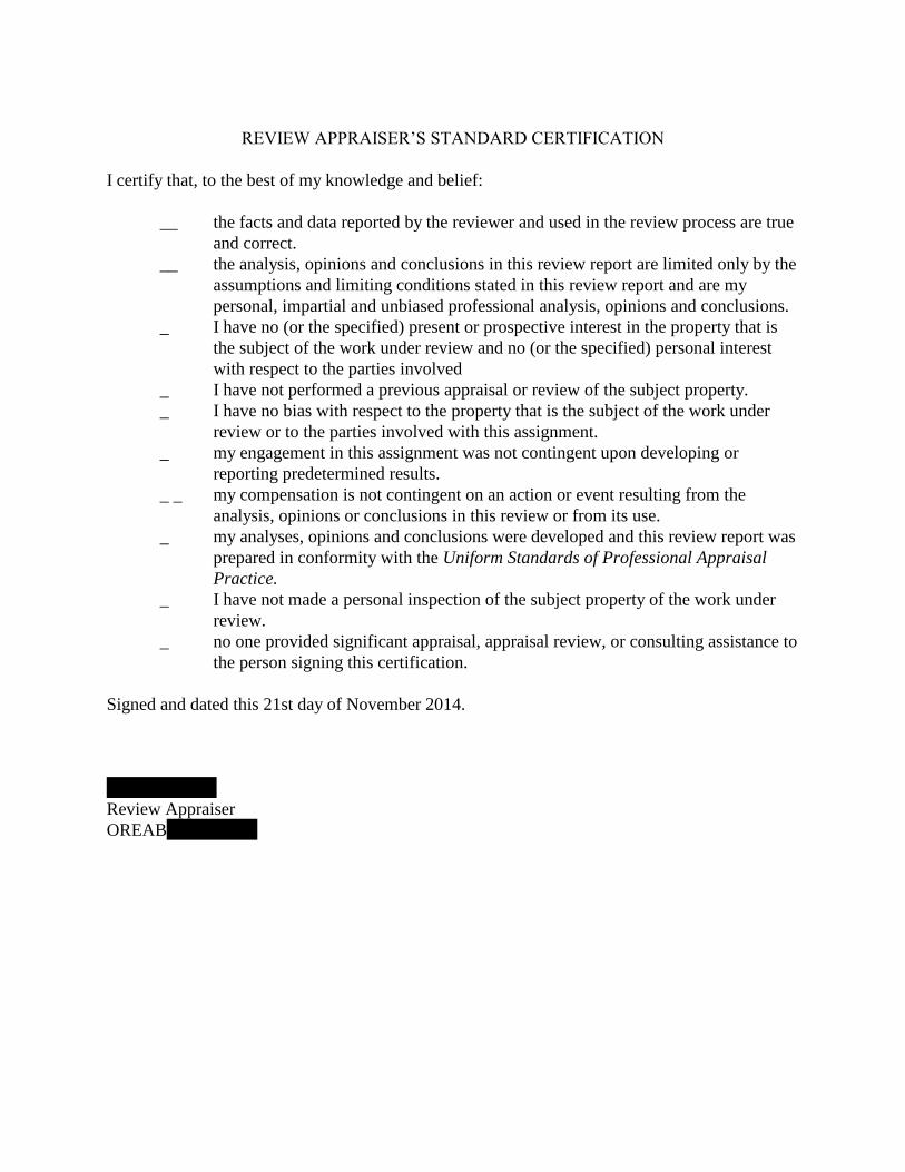
REVIEW APPRAISER’S STANDARD CERTIFICATION
I certify that, to the best of my knowledge and belief:
__ the facts and data reported by the reviewer and used in the review process are true
and correct.
__ the analysis, opinions and conclusions in this review report are limited only by the
assumptions and limiting conditions stated in this review report and are my
personal, impartial and unbiased professional analysis, opinions and conclusions.
_ I have no (or the specified) present or prospective interest in the property that is
the subject of the work under review and no (or the specified) personal interest
with respect to the parties involved
_ I have not performed a previous appraisal or review of the subject property.
_ I have no bias with respect to the property that is the subject of the work under
review or to the parties involved with this assignment.
_ my engagement in this assignment was not contingent upon developing or
reporting predetermined results.
_ _ my compensation is not contingent on an action or event resulting from the
analysis, opinions or conclusions in this review or from its use.
_ my analyses, opinions and conclusions were developed and this review report was
prepared in conformity with the Uniform Standards of Professional Appraisal
Practice.
_ I have not made a personal inspection of the subject property of the work under
review.
_ no one provided significant appraisal, appraisal review, or consulting assistance to
the person signing this certification.
Signed and dated this 21st day of November 2014.
Jared Sahlsteen
Review Appraiser
OREAB#10489CGA

Tract Number: Date :
Landowner Name:
Permanent Easement Width: 150 ft. (+/-) Length: 0 ft. (+/-)
Market Data Study 60% of Fee for Easement Rights
0 0.000000 (+/- acres) X =
0 0.000000 (+/- acres) X =
100% of Market Data Study Valuation
0 0.000000 (+/- acres) X =
0 0.000000 (+/- acres) X =
The Total Easement Consideration shall be paid as follows:
AND
Easement Agreement Extension
∆ Initial Payment is paid at time of grant of the Easement Agreement.
∆
∆
∆
LANDOWNER: DATE:
Plains and Eastern: DATE:
If, based on the final legal description, it is determined that the Permanent Easement width is greater or less than 150' and/or the
linear footage is greater or less than as shown above, Plains and Eastern shall adjust the Balance Due such that the Total Easement
Consideration is based on actual footage and width and calculated using the same formulas as set forth on this Easement
Calculation Sheet.
Acceptance:
____________________________
Landowner acknowledges and agrees that Plains and Eastern is under no obligation to pay the Balance Due portion of the Total
Easement Consideration and that if Plains and Eastern fails to do so on or before the Easement Compensation Deadline, subject to
the cure provision in the Easement Agreement, the Easement Agreement shall terminate. Upon such a termination, Landowner shall
retain the Initial Payment and any Extension Payment (if applicable), and Plains and Eastern shall have no further obligation or
other liability to Landowner.
$0.00 $0.00
$0.00
Easement Compensation Deadline may be extended for two additional one-year
periods (with 10% of the Total Easement Consideration due by 12-31-2016 for
the first extension and due by 12-31-2017 for the second extension) ("Extension
Payment "). Extension Payment(s) shall not be credited towards the Balance Due.
Plains and Eastern has the right to extend the Easement Compensation Deadline for two additional one-year periods by payment of
the Extension Payment to Landowner prior to the Easement Compensation Deadline. All sums paid by Plains and Eastern for such
extension shall be retained by Landowner and are non-refundable, and will not be credited towards the Balance Due.
$0.00
$0.00 $0.00
Easement 60% of Fee $0.00
Exhibit "E"
Plains and Eastern Clean Line Oklahoma LLC
EASEMENT CALCULATION SHEET
This Easement Calculation Sheet is made a part of that certain Transmission Line Easement Agreement ("Easement Agreement")
between Landowner and Plains and Eastern Clean Line Oklahoma LLC ("Plains and Eastern").
(A) Initial Payment (30% of the Total Easement Consideration)
$0.00 $0.00
"Total Easement Consideration" $0.00
SETTLEMENT OFFER
$0.00
(B) Balance Due prior to the earlier of
(1) the date construction crews access the property to install structures or wires,
or (2) 12-31-2016, (such date, as may be extended pursuant to the Easement
Agreement Extension, the "Easement Compensation Deadline")$0.00
$0.00

Tract Number: Date :
Landowner Name:
Permanent Easement Width: 150 ft. (+/-) Length: 0 ft. (+/-)
Appraisal Per Acre Value for Easement Area
0 0.000000 (+/- acres) X =
0 0.000000 (+/- acres) X =
Appraisal Value at 100% of Property Fee Value
0 0.000000 (+/- acres) X =
0 0.000000 (+/- acres) X =
The Total Easement Consideration shall be paid as follows:
AND
Easement Agreement Extension
∆ Initial Payment is paid at time of grant of the Easement Agreement.
∆
∆
∆
LANDOWNER: DATE:
Plains and Eastern: DATE:
Exhibit "F"
Plains and Eastern Clean Line Oklahoma LLC
EASEMENT CALCULATION SHEET
This Easement Calculation Sheet is made a part of that certain Transmission Line Easement Agreement ("Easement Agreement")
between Landowner and Plains and Eastern Clean Line Oklahoma LLC ("Plains and Eastern").
(A) Initial Payment (30% of the Total Easement Consideration)
$0.00 $0.00
"Total Easement Consideration" $0.00
SETTLEMENT OFFER
$0.00
(B) Balance Due prior to the earlier of
(1) the date construction crews access the property to install structures or wires,
or (2) 12-31-2016, (such date, as may be extended pursuant to the Easement
Agreement Extension, the "Easement Compensation Deadline")$0.00
$0.00
If, based on the final legal description, it is determined that the Permanent Easement width is greater or less than 150' and/or the
linear footage is greater or less than as shown above, Plains and Eastern shall adjust the Balance Due such that the Total Easement
Consideration is based on actual footage and width and calculated using the same formulas as set forth on this Easement
Calculation Sheet.
Acceptance
____________________________
Landowner acknowledges and agrees that Plains and Eastern is under no obligation to pay the Balance Due portion of the Total
Easement Consideration and that if Plains and Eastern fails to do so on or before the Easement Compensation Deadline, subject to
the cure provision in the Easement Agreement, the Easement Agreement shall terminate. Upon such a termination, Landowner shall
retain the Initial Payment and any Extension Payment (if applicable), and Plains and Eastern shall have no further obligation or
other liability to Landowner.
$0.00 $0.00
$0.00
Easement Compensation Deadline may be extended for two additional one-year
periods (with 10% of the Total Easement Consideration due by 12-31-2016 for
the first extension and due by 12-31-2017 for the second extension) ("Extension
Payment "). Extension Payment(s) shall not be credited towards the Balance Due.
Plains and Eastern has the right to extend the Easement Compensation Deadline for two additional one-year periods by payment of
the Extension Payment to Landowner prior to the Easement Compensation Deadline. All sums paid by Plains and Eastern for such
extension shall be retained by Landowner and are non-refundable, and will not be credited towards the Balance Due.
$0.00
$0.00 $0.00
Easement 60% of Fee $0.00