rheem creek - adapting to rising tides · 2015-12-08 · rheem creek (tidal reach estimated from...
TRANSCRIPT
Asset Profile Sheet Contra Costa County Adapting to Rising Tides Project
DECEMBER 2015 1
FLOOD CONTROL
RHEEM CREEK (Tidal reach estimated from the mouth to Goodrick Ave.) Key Issue Statement
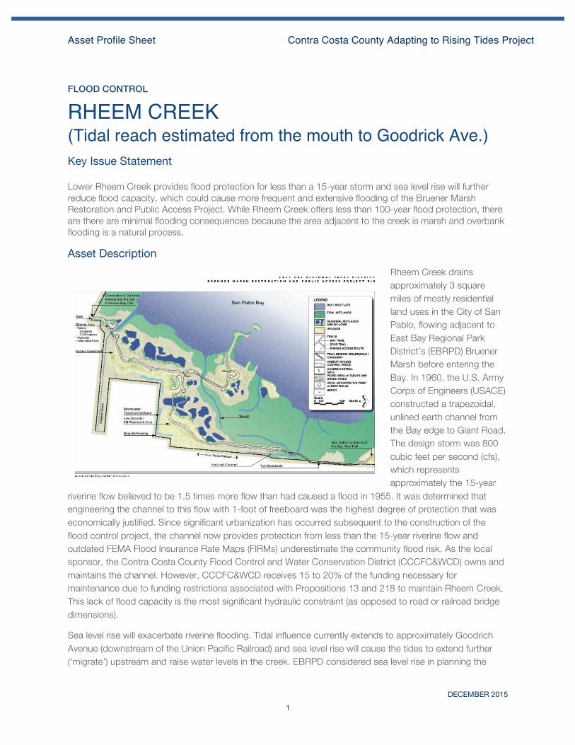
Photo: ART project Lower Rheem Creek provides flood protection for less than a 15-year storm and sea level rise will further reduce flood capacity, which could cause more frequent and extensive flooding of the Bruener Marsh Restoration and Public Access Project. While Rheem Creek offers less than 100-year flood protection, there are there are minimal flooding consequences because the area adjacent to the creek is marsh and overbank flooding is a natural process.
Asset Description Rheem Creek drains approximately 3 square miles of mostly residential land uses in the City of San Pablo, flowing adjacent to East Bay Regional Park District’s (EBRPD) Bruener Marsh before entering the Bay. In 1960, the U.S. Army Corps of Engineers (USACE) constructed a trapezoidal, unlined earth channel from the Bay edge to Giant Road. The design storm was 800 cubic feet per second (cfs), which represents approximately the 15-year
riverine flow believed to be 1.5 times more flow than had caused a flood in 1955. It was determined that engineering the channel to this flow with 1-foot of freeboard was the highest degree of protection that was economically justified. Since significant urbanization has occurred subsequent to the construction of the flood control project, the channel now provides protection from less than the 15-year riverine flow and outdated FEMA Flood Insurance Rate Maps (FIRMs) underestimate the community flood risk. As the local sponsor, the Contra Costa County Flood Control and Water Conservation District (CCCFC&WCD) owns and maintains the channel. However, CCCFC&WCD receives 15 to 20% of the funding necessary for maintenance due to funding restrictions associated with Propositions 13 and 218 to maintain Rheem Creek. This lack of flood capacity is the most significant hydraulic constraint (as opposed to road or railroad bridge dimensions).
Sea level rise will exacerbate riverine flooding. Tidal influence currently extends to approximately Goodrich Avenue (downstream of the Union Pacific Railroad) and sea level rise will cause the tides to extend further (‘migrate’) upstream and raise water levels in the creek. EBRPD considered sea level rise in planning the

Asset Profile Sheet Contra Costa County Adapting to Rising Tides Project
DECEMBER 2015 2
Bruener Marsh Restoration and Public Access Project – the restoration will establish gradual transition zones to accommodate marsh migration as sea level rises and public access improvements were designed to be resilient to mid-century and adaptable to end-of-century. Sea level rise will progressively reduce the capacity of the creek to discharge flood flows, such that smaller, more frequent storms will cause overbank flooding. However, unlike urbanized lower Pinole and Rodeo Creeks, the area adjacent to lower Rheem Creek is marsh and overbank flooding is a natural process.1 EBRPD considered lowering the level of the north bank of Rheem Creek to allow tidal flooding and increase flood capacity, but ultimately decided not to pursue this project element because changes to Rheem Creek as a federal facility must be consistent with USACE requirements, e.g., Section 408 of the Rivers and Harbors Act.
Exposure to Flooding While overlaying FEMA FIRMs and sea level rise inundation maps depicts potential joint coastal-riverine flooding, watershed-scale hydraulic modeling is needed to quantify the combinations of Bay water levels, sea level rise, and riverine flows that cause flooding. Without this joint coastal-riverine flood modeling, the potential for an increase in flood risk in the current 100-year floodplain due to sea level rises may be underestimated. Furthermore, this modeling may reveal new areas at risk that were not exposed by simply overlaying FEMA FIRMs and sea level rise inundation maps.
Vulnerabilities INFO: FEMA FIRMs do not factor in sea level rise, which make it difficult for flood managers and communities to prepare for future flooding. Furthermore, FEMA FIRMs show the overlay of the 100-year riverine and coastal floodplains, whereby the 100-year riverine flow sets the upstream and the 100-year tidal condition sets the downstream flood extent. The joint probability of riverine and coastal events likely increases the elevation and extent of the 100-year floodplain, but FEMA FIRMs depict riverine and coastal flooding as independent events and use the higher of the two flood elevations where riverine and coastal floodplains overlap.
1 Overbank flooding will likely cause sediment-laden water to flow over the marsh and cause sediment deposition to occur as the floodwaters recede.
Asset Profile Sheet Contra Costa County Adapting to Rising Tides Project
DECEMBER 2015 3
GOV1: CCCFC&WCD does not have adequate maintenance funding to address maintenance, capital improvement, and long-range flood management planning needs in Rheem Creek.
GOV2: Since Rheem Creek is a federal facility, improvements must be consistent with USACE policy to remain eligible for federal disaster relief. This requirement does not incentivize reconnecting marshes and creeks to improve habitat quality and flood capacity.
Consequences Society and Equity: Since EBRPD intends, and its BCDC permit requires, that it maintain, modify, or replace public access improvements in response to actual sea level rise, there are minimal flooding consequences to Bay Trail access and connectivity.
Environment: Endangered rail and saltmarsh harvest mouse populations will need to seek high tide refuge during flood events, which was the basis for EBRPD’s restoration design including transition zones. Contamination consequences will also likely be minimal because sources have already been identified and remediated, e.g., American Standard Products waste disposal area on the bank of the creek.
Economy: Since the reach exposed to sea level rise is within the EBRPD Point Pinole Regional Shoreline, there are minimal flooding consequences to the local and regional economy.