review sola suite of applications
TRANSCRIPT

DECEMBER 2018
FOOD AND AGRICULTURE ORGANISATION OF THE UNITED NATIONS (FAO)
REVIEW SOLA SUITE OF APPLICATIONS FINAL REPORT

DECEMBER 2018
FOOD AND AGRICULTURE ORGANISATION OF THE UNITED NATIONS (FAO)
REVIEW SOLA SUITE OF APPLICATIONS FINAL REPORT
ADDRESS COWI A/S
Parallelvej 2
2800 Kongens Lyngby
Denmark
TEL +45 56 40 00 00
FAX +45 56 40 99 99
WWW cowi.com
PROJECT NO. DOCUMENT NO.
GCP/INT/328/UK
A116394
1
VERSION DATE OF ISSUE DESCRIPTION PREPARED CHECKED APPROVED
4 21-12-2018 Report of reviewing SOLA
applications and the future
options
Jan van
Bennekom-
Minnema (COWI) [email protected]
Lars Bagge-
Hommel Nielsen
(COWI) [email protected]
Lars Bagge-
Hommel Nielsen
(COWI)

REVIEW SOLA SUITE OF APPLICATIONS 3
Review SOLA Suite of Applications
CONTENTS
SUMMARY ................................................................................... 5
1 FUNCTIONAL SCOPE OF THE SOLA SUITE OF APPLICATIONS . 8
1.1 ARCHITECTURE ....................................................................... 9
1.1.1 Separate Review of SOLA Architecture ............................. 11
1.2 FUNCTIONAL SCOPE ................................................................ 14
1.2.1 SOLA Functional Scope .................................................. 14
1.2.2 SOLA System Qualities .................................................. 15
1.2.3 SOLA Registry (SOLA R) ................................................ 16
1.2.4 SOLA Systematic Registration (SOLA SR) ......................... 17
1.2.5 SOLA State Land (SOLA SL) ........................................... 17
1.2.6 SOLA Open Tenure (SOLA OT) ........................................ 18
1.2.7 Comparative Solutions ................................................... 21
1.2.8 Mobile Applications to Secure Tenure (MAST) ................... 23
1.2.9 Cadasta ....................................................................... 25
1.2.10 Social Tenure Domain Model (STDM) ............................ 27
1.2.11 Open Data Kit (ODK) .................................................. 28
1.3 DATA MODEL AND LADM COMPLIANCE ......................................... 30
1.3.1 SOLA Registry .............................................................. 30
1.3.2 SOLA Systematic Registration ......................................... 31
1.3.3 SOLA State Land ........................................................... 31
1.3.4 SOLA Open Tenure / Community Server .......................... 31
1.4 IMPLEMENTATIONS ................................................................. 32
1.4.1 Project Phases .............................................................. 32
1.4.2 Project Roles ................................................................ 34
1.4.3 Customisation vs Configuration ....................................... 35
1.4.4 SOLA Registry in Lesotho ............................................... 38
1.4.5 SOLA OT in Myanmar .................................................... 38
1.4.6 Open Source Community ............................................... 39
2 SOLA ROAD MAP .................................................................. 41
2.1 INFORMATION SYSTEM DEVELOPMENT ........................................... 41
2.2 FIELD COLLECTION OF LAND TENURE DATA .................................... 42
2.3 GOVERNANCE BY FAO ............................................................. 43

REVIEW SOLA SUITE OF APPLICATIONS 4
Review SOLA Suite of Applications
2.4 GOVERNANCE BY PROFESSIONAL BODY ......................................... 44
2.4.1 Global Land Tool Network (GLTN) ................................... 44
2.5 GOVERNANCE BY CONSULTANT ................................................... 45
2.6 GOVERNANCE BY OPEN SOURCE COMMUNITY .................................. 46
2.6.1 Open Source Geospatial Foundation (OSGeo) ................... 46
2.7 DISCONTINUE SOLA PROJECT .................................................... 49
2.8 SOLA QUICK GUIDE ............................................................... 50
Appendix A Work Plan
Appendix B Abbreviations and Terminology
Appendix C Documentation on SOLA
Appendix D List of Countries / Communities working with SOLA applications
Appendix E Conformance to LADM
Appendix F SOLA Data models
Appendix G SOLA Functional Scope
Appendix H Competitive Solutions
Appendix I Implementation
Appendix J Presentation Slides (19th of December 2018)

REVIEW SOLA SUITE OF APPLICATIONS 5
Review SOLA Suite of Applications
Summary
The SOLA applications have been reviewed in terms of architecture, data model,
functionality, and implementations. The SOLA applications are land information
systems being used in two situations:
› The development and deployment of a land information system on behalf of
a beneficiary in developing countries (i.e. SOLA Registry for land registry
offices).
› Assist beneficiaries in developing countries with the field collection of tenure
data (e.g. SOLA Open Tenure on mobile devices and SOLA Community
Server for communities, CSO's, and customary groups).
The SOLA applications are based on java open source components which make
up a comprehensive, robust architecture, which requires specialist expertise to
customise, deploy and maintain these. Various recommendations on improving
the architecture, source code, and documentation have been made, which,
dependent on the chosen future option for SOLA applications, may be addressed
partly or whole. A separate review on architecture, source code, and
documentation is incomplete and could not be used as the basis of additional
recommendations on the quality of SOLA architecture and source code.
The data maintained by SOLA applications is compliant (Level 1) with the Land
Administration Domain Model (LADM), and the SOLA data model has significant
extensions to LADM (e.g. with regard to workflow and processes).
SOLA Registry has the functionality to support typical registration and cadastral
offices, offering support for managing property rights and right holders;
geospatial information; searching, retrieve, view and generate reports on
alphanumerical and geospatial data; workflow and progress; digital/scanned
evidence documents. Non-functional system qualities are implemented for
authorisation and authentication; system administration; support multiple
languages; flexibility and parametrisation.
SOLA Open Tenure facilitates the collection of land tenure data with (offline)
mobile devices, where the SOLA Community Server facilitates the central
storage and moderation of the field collected land tenure records.
SOLA Applications:
Land information system
Registry
Systematic Registration
State Land
Field tenure data collection
Open Tenure
Community Server
Architecture
Level 1 Complaint with
LADM
Functionality
SOLA Registry
Functionality
SOLA Open Tenure

REVIEW SOLA SUITE OF APPLICATIONS 6
Review SOLA Suite of Applications
A number of applications (i.e. ODK, Cadasta, STDM, and MAST), with
functionality comparable to SOLA Open Tenure / Community Server (SOLA
OT/CS), have been reviewed in the context of field data collection:
› Flexibility, i.e. the level of parametrisation and suitability for different
purposes in ODK, Cadasta, and STDM is higher than SOLA OT/CS (with
dynamic forms).
› STDM, MAST, and SOLA OT/CS require specialist expertise to deploy the
server on behalf of a community.
› Cadasta is moving away from open source tools and will be based on
proprietary software (ESRI); Cadasta takes care of hosting/managing one
(1) dedicated server for clients/partners.
› STDM operates on desktop computers via a QGIS plugin, while ODK,
Cadasta, MAST and SOLA OT operate on mobile (android) devices.
› MAST does not have installable software and requires software developer
expertise to compile and deploy the applications and server software.
› ODK is very flexible, but offers limited support for moderation of the records
on a central server, custom development is required to address that.
Deployments of SOLA Registry applications involved considerable customisation,
i.e. custom development or modification of source code, requiring international
developers (i.e. FAO/SOLA staff). Local software development expertise to assist
and maintain the deployed system is required and at the same time has proven
to be difficult/impossible to obtain in developing countries (with consequences
for system sustainability). SOLA OT deployments could suffice with
configuration, i.e. fine-tuning of system parameters (i.e. by SOLA staff), but
have comprised of customisation exercises as well.
A different approach to consider in deploying SOLA Registry is to minimise
custom development instead of stimulating this before initial land information
system deployment; for example through increasing the flexibility of SOLA: e.g.
configurable workflow, business rules, reports, reference tables.
The flexibility of SOLA Open Tenure could be increased as well (e.g. with regard
to workflow, and data to-be-captured), which, together with hosting one (1)
community server on behalf of all clients (e.g. various communities with
different information needs, similar to the Cadasta platform), could offer a good
option for community projects; deployable with little (customisation or
configuration) effort and training.
The majority of deployments have been done by international FAO/SOLA project
staff, most of which are no longer employed. Development has stopped for SOLA
Registry, only SOLA Open Tenure/Community Server is being maintained at a
low ebb. The SOLA open source (OS) community is not active. Revitalising it
would require funding and governance, to improve functionality and
architecture, documentation, and training, as well as for managing and
communication/outreach to the SOLA OS community.
Applications comparable to
SOLA Open Tenure
Customisation vs
Configuration
Limit customisation for
SOLA Registry
Host one SOLA Community
Server
SOLA Open Source (OS)
Community

REVIEW SOLA SUITE OF APPLICATIONS 7
Review SOLA Suite of Applications
The options for FAO with regard to a sustainable future of the SOLA project are
to:
› continue governance of the SOLA project by FAO (requiring hiring a
software development team);
› to transfer the project over to external entities, for example to a
professional body or a private company (requiring improvement of
development and deployment documentation and tools before handover);
› or handover to an open source community (requiring the above mentioned
improvement of documentation and tools as well as funding for the open
source community activities); or
› to discontinue the SOLA project (requiring careful communication to SOLA
users).
The most feasible and cost effective option seems to be to transfer the project to
an open source community, external to FAO, such as OSGeo, but this needs
further discussion and deliberation.
This option, like most others, requires funding and governance to revitalise the
OS community, and also to satisfy requirements that the OS community may
have (e.g. accepting contributions, direction by the community instead of FAO,
visible activity in the community).
A checklist for has been defined to assist FAO in responding to the queries with
regard to the deployment of SOLA applications. This checklist will create
awareness and assist in assessing key factors, to facilitate a successful
implementation and long-term sustainability of the deployments of SOLA
applications.
In the following sections, SOLA applications will be reflected upon in terms of the
functional scope of SOLA and comparable applications; SOLA implementations,
customisations and configurations; current SOLA open source community,
options for the future of SOLA.
The draft report of this review has been presented at FAO's premises in Rome on
the 19th of December, 2018 (see Appendix J for the presentation slides). The
comments made before and during this presentation have been incorporated in
this final report on the review of the SOLA Suite of Applications.
Options for future SOLA
Governance & funding
Response to SOLA queries
Jan van Bennekom-Minnema
COWI A/S Denmark

REVIEW SOLA SUITE OF APPLICATIONS 8
Review SOLA Suite of Applications
1 Functional Scope of the SOLA Suite of
Applications
In this chapter the SOLA applications are reviewed in terms of architecture,
functionality, data model, competitive solutions and implementations:
› SOLA Registry is a land information system "for land administration
agencies that require a secure, robust and transparent tenure registration
solution"1; also referred to as SOLA R.
› SOLA State Land is a land information system that "assists governments to
manage land and property that is owned, occupied or controlled by the
state", also referred to as SOLA SL.
› SOLA Systematic Registration is a land information system that "supports
systematic registration activities where tenure information is collected for
the first time", also referred to as SOLA SR.
› SOLA Open Tenure is a mobile device application that supports "in-the-field
capture of tenure rights by communities and individuals using mobile
devices", which will be synchronised with SOLA Community Server which
provides "web access to community collected tenure data and manages the
processes leading to the community recognition of tenure rights" also
referred to as SOLA OT and SOLA CS.
Note that the SOLA Web Admin application provides system administration and
configuration functions for all SOLA software applications [except SOLA OT]).
1 http://www.flossola.org/

REVIEW SOLA SUITE OF APPLICATIONS 9
Review SOLA Suite of Applications
1.1 Architecture
The architecture of SOLA Registry, State Land, Systematic Registration and
Community Server are all based on similar components, except for the SOLA OT
application on mobile devices (see Figure 1).
Figure 1: SOLA Architectural Elements
SOLA R, SR, SL, CS SOLA OT
(Mobile Devices)
Application Server Glassfish (JAVA EE
specification)
Apache HTTP client for API
interaction and maps
download
Database PostgreSQL with PostGIS
spatial extension
H2 database with JTS spatial
extension
GIS server Geoserver (WMS services) GoogleMaps SDK for Android
Reports Jasper reports Claim report
Security Model JEE 7 Security Model, Glassfish
and Metro.
Android platform + data
encryption
Version Control GitHub GitHub
Figure 2: SOLA Architecture

REVIEW SOLA SUITE OF APPLICATIONS 10
Review SOLA Suite of Applications
The following observations were made with regard to the architecture:
› Initially, system administration was performed through "SOLA Admin
Desktop", but this has been replaced by SOLA Web Admin (system
administration for all SOLA software applications [i.e. SOLA R, SR, SL, and
CS]).
› SOLA OT for mobile devices supported both Android and iOS operating
systems; it has now been decided to discontinue development on iOS so
only mobile devices with Android can run the latest SOLA OT. Considering
the use of SOLA OT in developing countries, this may have less effect, since
usually more expensive iOS devices are not as widely used.
› SOLA OT (and SOLA CS) have been developed in a separate setup, instead
of re-using the existing SOLA Registry setup, database and components,
and use only the necessary business rules (i.e. a stripped down version of
SOLA R/SR). For example, instead of (re-)using components Case
Management, Application, Administrative for handling claims, parties and
rights, a decision was made for creating separate components to handle
these. Migration of data from SOLA OT to SOLA R is affected. This is partly
explained because SOLA CS in its concept is a web application (and not
desktop based) used by communities, receiving collected data from mobile
devices running SOLA OT.
› Various reports were made on the (disputed) need for maintaining different
SOLA applications and architectures, and recommendations were made with
regard to changing and merging the SOLA applications into a modular
integrated web-based system, that can be deployed fully or partially as the
need arises. This would faciltiate easier deployment, configuration and use
of the SOLA Suite.
› During the requirements and design phases of SOLA OT, Open Data Kit
(ODK) was considered as an option to provide the functionality of the SOLA
OT dynamic forms. The conclusion was that ODK has limitations: "form
based surveys have little flexibility when the number and type of fields and
attachments is not known at form design time. Overcoming these
limitations would require a development effort reducing the advantage of
using an existing framework". Another limitation of ODK is related to a
global view of collected data, allowing the mobile device user to see the
parcel being collected in the context of other, neighbouring, collected
parcels. The spatial data editor in ODK (at the time of conceptualising SOLA
OT) had limited functionality (which meanwhile has been improved in ODK
and GeoODK Collect apps). As a result, the functionality around dynamic
forms was developed from scratch into SOLA OT/CS.
› The architecture of SOLA R, SR, SL and CS is comprehensive, based on
many proven components which make up a robust architecture (for
example components for hosting applications, database, GIS/Geo server,
report server, etc.). This strength of the architecture also means that
deployment, configuration, maintenance and especially customisation
Merge SOLA applications
into a modular integrated
web-based system

REVIEW SOLA SUITE OF APPLICATIONS 11
Review SOLA Suite of Applications
(custom development) will require specialists, experienced and skilled in all
these components. It has proven difficult to find and/or train local
specialists to perform these functions with regard to SOLA software.
› The support (by Oracle) for one of the architectural components for
application server (i.e. Glassfish) has become an issue, so a Payara
Application Server is being considered to replace that architectural element.
There may be other architectural elements that will no longer supported in
the near future.
› A SOLA Community Server can only handle one survey purpose; e.g.
multiple CSOs for example cannot use the same server (if the survey
form/questionnaire needs are different). Only one dynamic form template
can be used at a time. To support different CSOs and communities with
different data collection needs, multiple physical servers (or multiple virtual
servers on one physical server) need to be deployed.
› Development has stopped for SOLA R, SR, and SL (last update 2016); the
development of SOLA OT/CS is ongoing, last update in August 2018.
› Consider creating, updating or improving documentation on how to setup
development environment, as relevant, to assist the open source
community.
› Installers for the SOLA apps maybe considered for setting up operational
and even development environment; see for example the STDM installer
taking care of the installation of apache applications server, the geoserver,
and the PostgreSQL database, etc.).
1.1.1 Separate Review of SOLA Architecture
A separate technical quality review has been conducted on the systems
architecture, the source code, and the existing documentation on SOLA; a final
report (i.e. a PowerPoint presentation in pdf format) was delivered beginning
December2. The main summary was a slide "Assessment Output" (Figure 3) in
which the following source code characteristics were evaluated:
› Source code complexity; relevant to ease of maintenance of the source
code.
› Hard coding; changes to "hard coded" elements would require
customisation of software instead of configuration3.
› Error handling; handle and communicate run time errors.
› Security
› Source code comments4
› Unit test coverage; assisting in (automatically) testing all elements of the
source code.
2 www.zensar.com 3 https://stackoverflow.com/questions/1895789/what-does-hard-coded-mean 4 https://medium.freecodecamp.org/code-comments-the-good-the-bad-and-the-ugly-be9cc65fbf83
Review lifecycle of SOLA
architectural components
Support developers with
development environment
setup instructions
Support users and
developers with SOLA
installers

REVIEW SOLA SUITE OF APPLICATIONS 12
Review SOLA Suite of Applications
› Issues reported by Sonar5; the result of automatic code analysis.
› Duplication of source code6; copy-and-paste development, also relevant to
ease of maintenance.
› Critical issues; possibly the outcome of Sonar automatic analysis.
› Overall source code quality.
› Technical debts; relating to the number of resources / person days to
correct the all issues.
Figure 3: Assessment Output
SOLA R SOLA
SR
SOLA SL SOLA
CS
SOLA
OT
SOLA
WA
(web
admin)
Source code complexity High Medium Medium Low High Medium
Hard coding High High High High High High
Error handling Medium Medium Medium Medium Medium Medium
Security Medium Medium Medium Medium Medium Medium
Source code comments Low Low Low Low Low Low
Unit test coverage Low Low Low Low Low Low
Issues - sonar 2000+ 2000+ 2000+ 1699 2000+ 1019
Duplication of source code High Medium High Low High Low
Critical issues 25 25 26 15 50+ 14
Overall source code quality Low Medium Medium Medium Low Medium
Technical debts High Medium High High Medium Medium
Source: Adapted from Sola Suite Final Assessment Report.pdf (5-12-2018, ZenSar)
The technical quality review outlines an alarming condition of the SOLA
architecture; the overall source code quality of SOLA is low/medium, and that all
SOLA applications require architectural changes. Two recommended approaches
are provided and detailed with the technical quality reviewer's resource planning
and resources:
1 Technical quality improvement (622 Person Days).
2 Convert to new architecture based on micro services (1100 Person Days).
The conclusions of the technical quality review are not or insufficiently justified,
for example the review mentions 150 critical issues, but does not provide details
about these critical issues, nor are they classified to allow for some prioritisation.
The review also generated many critical comments with regard to compliance to
the relevant ToR, completeness, correctness & evidence, usefulness,
understanding the SOLA application context, original and impartial advice.
Therefore, this "Review of the SOLA Suite of Applications" cannot base or adjust
its recommendations on the outcome of the technical quality review (in its
current form).
5 http://www.sonarsource.org 6 https://solidsourceit.wordpress.com/2012/08/03/does-source-code-duplication-matter/
Improve SOLA architecture
and source code (extent
unconfirmed)

REVIEW SOLA SUITE OF APPLICATIONS 13
Review SOLA Suite of Applications
Remarks on documentation
› The technical quality review was expected to assess and provide
recommendations for SOLA technical documentation, which seemed to have
been limited to architecture documents and installation guides.
› Documentation, especially for SOLA R, SR, and SL is found to be a bit
sketchy, inconsistent, or too extensive with no clear summary at times:
consider the enhancement of the documentation.
› Documentation on SOLA OT / CS is more developed / comprehensive than
SOLA R, SR, SL, the focus of SOLA team has been on SOLA OT.
Improve documentation:
requirements, architecture,
design, development,
installation, system
administration, user
manual
REVIEW SOLA SUITE OF APPLICATIONS 14
Review SOLA Suite of Applications
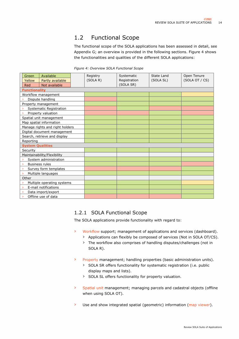
1.2 Functional Scope
The functional scope of the SOLA applications has been assessed in detail, see
Appendix G; an overview is provided in the following sections. Figure 4 shows
the functionalities and qualities of the different SOLA applications:
Figure 4: Overview SOLA Functional Scope
Green Available
Yellow Partly available
Red Not available
Registry
(SOLA R)
Systematic
Registration
(SOLA SR)
State Land
(SOLA SL)
Open Tenure
(SOLA OT / CS)
Functionality
Workflow management
› Dispute handling
Property management
› Systematic Registration
› Property valuation
Spatial unit management
Map spatial information
Manage rights and right holders
Digital document management
Search, retrieve and display
Reporting
System Qualities
Security
Maintainability/Flexibility
› System administration
› Business rules
› Survey form templates
› Multiple languages
Other
› Multiple operating systems
› E-mail notifications
› Data import/export
› Offline use of data
1.2.1 SOLA Functional Scope
The SOLA applications provide functionality with regard to:
› Workflow support; management of applications and services (dashboard).
› Applications can flexibly be composed of services (Not in SOLA OT/CS).
› The workflow also comprises of handling disputes/challenges (not in
SOLA R).
› Property management; handling properties (basic administration units).
› SOLA SR offers functionality for systematic registration (i.e. public
display maps and lists).
› SOLA SL offers functionality for property valuation.
› Spatial unit management; managing parcels and cadastral objects (offline
when using SOLA OT).
› Use and show integrated spatial (geometric) information (map viewer).

REVIEW SOLA SUITE OF APPLICATIONS 15
Review SOLA Suite of Applications
› Manage rights, restrictions, responsibilities and right holders.
› Digital document management; scanned documents, images, photos,
categorised and attached to workflow.
› Search, retrieve and display land administration records (on server and
mobile device for SOLA OT).
› Reporting; various pre-fined report formats to assist workflow.
1.2.2 SOLA System Qualities
SOLA provides functionality with regard to system qualities:
› Security; Authorisation, user authentication & management, record
security, auditing and logging, backup.
› Maintainability/Flexibility; system administration, maintain reference data
(lists of standards values), localisation support (multiple languages),
parametrisable business rules (Not in SOLA OT/CS), flexibility survey form
templates for capturing (Only in SOLA OT/CS).
› Other system qualities:
› Server capable of sending e-mail notifications.
› Support for multiple operating systems (Linux, MS Windows Server,
Android [support for SOLA OT on Apple's iOS has been discontinued]).
› (Bulk) data import/export in various formats.
› Help function.
› SOLA OT is capable of downloading off-line data on mobile device
(existing claims, attachments, raster and vector data). Syncing and
using imagery and vector data is an important capability for developing
countries where access to Internet and/or affordable Internet services
are an issue.
Observations
› The workflow (for example application status) is not configurable; the
workflow setup is not flexible in the sense that workflow (steps) cannot be
altered without source code changes. Flexibility in this section (of all SOLA
applications) could address variations in local customs and regulations via
configuration (limiting the need for customisation, see section 1.4.3).
› As indicated in section 1.1, limited current development is carried out on
SOLA R, SR and SL, only SOLA OT is being currently used and developed.
The majority of SOLA software architects and developers are no longer
employed by FAO. Some updates funded by local initiatives have been
done, e.g. SOLA R and SR in Nigeria and Sierra Leone. Futher development
with regard to SOLA R and SOLA OT has been requested in Kenya, and with
regard to SOLA R in Tonga.

REVIEW SOLA SUITE OF APPLICATIONS 16
Review SOLA Suite of Applications
› Flexible / configurable Business Rules ("separate business rules from
application code via a Rules interface") could be a way to increase
flexibility/configurability and adjustment to local situations. Configurable (as
opposed to customisable) business rules are and could be a great
(improved) feature for SOLA (from SOLA R to CS/OT). Note that in the
current setup (SOLA Web Admin), the system administrator has to know
the SOLA database structure and must have Standard Query Language
(SQL7) skills to be able to configure business rules.
Figure 5: Impression SOLA Registry
1.2.3 SOLA Registry (SOLA R)
SOLA Registry is one of the most robust SOLA applications, providing the rigour
and completeness required for formal property registration and cadastral
functions (and has been tested in a considerable number of projects). The SOLA
R and SR functionality is considerable/extensive, estimated at covering 70-80%
of the needs of a land registry/cadastre office. SOLA Registry is still operational
in a number of deployments, and received positive reviews.
7 https://en.wikipedia.org/wiki/SQL

REVIEW SOLA SUITE OF APPLICATIONS 17
Review SOLA Suite of Applications
Initially, a SOLA Web Application was envisioned to support deployment as a
public counter service available from land administration offices. During the last
years, e-governance (electronic governance) has been promoted and supported
in some developing countries (e.g. Rwanda). Electronic governance is
understood as the online delivery of government services (e.g. application for
land registry transactions); exchange of information; integration of various
stand-alone systems and services, in a convenient, efficient and transparent
manner.
The option of having a link to eGovernment services, citizen One-Stop-Shop
services centres (e.g. citizens requesting information or starting
applications/transactions via internet) is becoming increasingly popular in
developing countries, this could be considered as a future development for SOLA
Registry (and perhaps SOLA CS). Note that the architecture of SOLA R with
Service Oriented Architecture would support eGovernment Portals and services,
which, although mentioned in the original approach of SOLA, has not been
developed. Future scaling-up needs with regard to eGovernment services added
to SOLA functions could be detailed when considering the merging the SOLA
applications into a modular integrated web-based system (section 1.1).
1.2.4 SOLA Systematic Registration (SOLA SR)
SOLA Systematic Registration has only been deployed once where considerable
customisations have been realised. The overlap in data and functionality
between SOLA R and SR is considerable, for example the SOLA R and SR
applications are reported to work on identical databases. SOLA SR could be used
by companies or institutions engaged in systematic adjudication and registration
of field collected land tenure data
SOLA SR, initially did not operate with mobile devices used in the field for data
collection, nor with offline data. All functionality is offered in a central system
capable of (bulk) loading of external survey data and scanned documents to
support the adjudication records. It was found that elements of SOLA OT
(section 1.2.6) would improve the value of SOLA SR, for example the use of
mobile devices to capture field data. Nowadays, it is unlikely, that systematic
registration projects are designed around paper based tenure data collection, or
that the use of mobile devices is not being considered. In Nigeria, a "bridge" was
created between SOLA SR and SOLA OT, so that mobile devices can be used in
the context of SOLA SR. A real integration would be facilitated by transforming
SOLA SR into a web based system (see section 1.1).
1.2.5 SOLA State Land (SOLA SL)
SOLA State Land has not once been implemented. SOLA State Land was
developed because of an anticipated (funding of a) project in Ethiopia,
considering rural state land. Considering very tight deadlines, the development
was started before an official agreement between the relevant parties was
reached. When it was clear the agreement would not be made, SOLA SL was
fully developed.
Consider e-governance:
online delivery of
government services

REVIEW SOLA SUITE OF APPLICATIONS 18
Review SOLA Suite of Applications
1.2.6 SOLA Open Tenure (SOLA OT)
SOLA Open Tenure8 is a system for field data collection, focused at parcel based
tenure right claims. SOLA OT is designed for communities to do their own
community/customary tenure recording and mapping. The architecture consists
of a (Cloud) server (SOLA CS, Community Server) which receives information
collected (offline) in the field with mobile devices, based on a questionnaire/form
(see Figure 6).
Figure 6: overview of architecture for field data collection
Website
Mobile devices
Wireless Access Point / Internet
Server
Online access- supervision- moderation- quality control
Upload of collected dataDownload of server data
The main components are a data collection app and a central server.
› A data collection app (SOLA OT), is running on a mobile device (mobile
phone or tablet), to be used in data collection (the first collection and entry
of claims). The data collection app is able to work offline under conditions
where internet connectivity and speed are limited. The mobile devices will
have supporting offline spatial data available, such as google earth imagery,
other ortho(aerial) photos, supporting vector information, such as
downloaded open street map data.
› A server, which hosts a central repository (i.e. a PostgreSQL database) with
all collected data. The central repository will contain the definition of the
information elements and attributes to be used in the field data collection.
The server also hosts a web application (SOLA CS): a web site, allowing
further handling of the claim, supervision and monitoring, quality control,
updates, and management of template forms.
8 http://www.fao.org/fileadmin/user_upload/nr/land_tenure/OPEN_TENURE.pdf

REVIEW SOLA SUITE OF APPLICATIONS 19
Review SOLA Suite of Applications
Figure 7: Impression SOLA Open Tenure
› Open Tenure is designed for parcel based tenure right data collection
process. The claim form of the Open Tenure app is split into a static part,
with "hard-coded"/standard information controlling the logic of the
application, and a dynamic part (i.e. dynamic forms), which offers flexibility
with regard to specifying other information that should be captured, for a
specific purpose or project. With these dynamic forms, the structure of the
survey form for the claim can be configured, without the need for changing
the source code of either the mobile application or the community server
(i.e. customisation). This ability to configure additional information to be
captured is common to several data collection applications/toolkits, offered
in varying degrees of flexibility.
› The flow of a questionnaire (to guide SOLA OT users in using the form)
cannot be enforced in SOLA OT, especially around the dynamic forms.
Validation of forms and tabs/sections in the app (field validation on out-of-
field navigation, and record validation at save actions) could be improved.
Improve guidance and
validation for SOLA OT
forms

REVIEW SOLA SUITE OF APPLICATIONS 20
Review SOLA Suite of Applications
Figure 8: Impression SOLA Community Server
› SOLA OT is parcel based. The process starts with a parcel for which a claim
with details of the claimant must be entered. If a claimant claims multiple
parcels, claimant data will have to be entered, redundantly, multiple times.
Alternatively, the claimant could be taken as starting point and then
entering one or more parcels, all claimed by claimant.
› The above mentioned static part makes assumptions about the information
that always needs to be captured. For example, in SOLA OT, the name of a
person consists of FirstName and LastName. When MiddleName (or
OtherNames) need to be captured, this requires the definition and entry of
this element in the dynamic part (in another part of the app). The option to
place dynamic information elements inside the static sections could be
considered, instead of only in dynamic sections.
› SOLA OT cannot specify tuple rules / constraints. The content of one field
cannot be made dependant on what was entered in other fields (of the
same record) previously. For example, when the user in one field selects
one of the regions, the next dropdown list cannot be limited to only show
the districts within the selected region.
› Default values for fields are not possible in Open Tenure, for example
setting that the gender of a homestead head is male by default.
Consider SOLA OT
functionality with regard to
claims for multiple parcels
by one claimant
Consider dynamic
information elements inside
the static sections
Consider tuple rules
Consider default field
values

REVIEW SOLA SUITE OF APPLICATIONS 21
Review SOLA Suite of Applications
The workflow for handling claims is "hard coded". Making the workflow
configurable to a certain degree would limit the need for customisation of
workflow each and every implementation (see section 1.4.3).
› SOLA OT running under Android 8.1.0 (downloaded 26-10-2018) crashed
several times (e.g. at navigating main menu items), which suggest that
additional testing could be done, as well as improved exception handling in
the source code.
› The dynamic forms of SOLA OT is a good start towards
configurability/flexibility of the application, but could be improved to bring it
to the same level as offered by Cadasta & ODK (see next section 1.2.7 ).
› Marketing in an open source context is relevant; marketing materials and
efforts have been developed and executed for SOLA OT/CS, aimed at land
administration and LIS professionals and communities, but less for SOLA
R/SR.
1.2.7 Comparative Solutions
The following applications, comparative to SOLA applications (i.e. SOLA OT/CS),
have been reviewed:
› Mobile Applications to Secure Tenure (MAST).
› Cadasta.
› Social Tenure Domain Model (STDM).
› Open Data Kit (ODK).
Improve source code
exception handling
Improve SOLA OT flexibility
and capability of "dynamic
forms"

REVIEW SOLA SUITE OF APPLICATIONS 22
Review SOLA Suite of Applications
Figure 9 shows the functionalities and qualities of the different applications for
tenure data collection:
Figure 9: Overview Comparative Solutions
Green Available
Yellow Partly available
Red Not available
SOLA OT Cadasta MAST STDM ODK
Functionality
Workflow management
› Dispute handling
Property management
› Systematic Registration
Spatial unit management
Map spatial information
Manage rights and right holders
Digital document management
Search, retrieve and display
Reporting
System Qualities
Security
Maintainability/Flexibility
› System administration
› Survey form templates
› Multiple languages
Other
› Multiple operating systems
› E-mail notifications
› Data import/export
› Offline use of data
› Downloadable Installers
› Host Web data server
› Support
› MAST, CADASTA, ODK and SOLA OT perform similar functions based on a
similar architecture (server – mobile device synchronisation). STDM offers
similar functions but on different platforms and devices (Desktop based).
› SOLA OT has a more sophisticated architecture than MAST and STDM, with
much better security and more advanced mapping tools available in the
mobile application.
› Cadasta, Mast and STDM describe the use of survey grade GPS receivers
connected to a mobile device to improve accuracy of measured coordinates,
which are less affordable by communities.
› STDM, MAST and to a certain degree SOLA OT require/rely on a project
office and on GIS expertise to advance the data collection work; there is a
need for specialists and trainers to set the data collection project and team
up.
› Cadasta is hosting one (1) server for all client/partners.
› SOLA, Cadasta and STDM are capable of providing support and training.

REVIEW SOLA SUITE OF APPLICATIONS 23
Review SOLA Suite of Applications
1.2.8 Mobile Applications to Secure Tenure (MAST)
Mobile Applications to Secure Tenure (MAST9) is an USAID development for tools
that use mobile devices and a participatory approach to map and document land
and resource rights (see Appendix H.1).
Figure 10 Impression MAST10
› MAST software is not available via downloadable installation programs, no
demo environment is available. Software developers will always be required
to deploy MAST; the sources11 need to be compiled (for server and mobile
app), which requires (senior) software developer knowledge of several
technologies (e.g. java IDE, Maven, Android SDK etc.). "Without knowledge
of these it would be difficult for the user to setup the source code and
configure to work in debug environment". The information and instructions
on GitHub are limited.
› MAST also provides a simple registration module to administer land records
after they have been formalized through a community mapping process:
e.g. registration transactions including sales, leases, mortgages, gift, and
parcel splits. This registration module is called TRUST, developed for district
land offices to manage collected records produced by MAST. Trust is not
available in MAST source code on GitHub, it is unclear whether it is
available as open source.
9 https://www.land-links.org/tool-resource/mast-technology/ 10source http://ansaf.or.tz/wp-content/uploads/2016/05/MAST-PROJECT-FOR-AG-POLICY-2-23-2016.pdf 11 https://github.com/Mastusaid

REVIEW SOLA SUITE OF APPLICATIONS 24
Review SOLA Suite of Applications
› MAST was developed originally for specific project in Tanzania. It was not
developed as a generic solution as for example SOLA OT was. Deployments
from this version to other countries are based on this Tanzania version. The
software architecture has been reported to have issues.
› If a project requires higher GPS accuracy than is available on board a
mobile device, MAST can use external GPS devices to capture coordinate
locations with more precision; note that this comes with a cost for these
external GPS devices.
› MAST is published as open source, but seems to have been just “dumped
on the internet”.

REVIEW SOLA SUITE OF APPLICATIONS 25
Review SOLA Suite of Applications
1.2.9 Cadasta
Since 2015, the Cadasta Foundation develops and promotes the use of simple
digital tools and technology to capture, analyse and share land and resource
rights information, using a full open source stack with tools such as ODK /
GeoODK Collect Mobile Application (data collection), QGIS (Desktop GIS) and
plugins, PostgreSQL (database). This is labelled the Cadasta Platform 1.0, see
Appendix H.2 for a copied description of the Cadasta platform 1.0 elements.
Figure 11: Cadasta Platform12
› Since mid-2018, Cadasta 2.0 is introduced, based on the ESRI13 platform
and tools: "Key learnings from the past two years of working with partners
have highlighted a number of needed improvements. To most efficiently
address these limitations, we are partnering with Esri…", and: "The Cadasta
team will be working to onboard all new and existing partners to the
Cadasta Platform 2.0 as we begin to transition over to the Esri
environment". Cadasta reported to be currently (November 2018) halfway
in making this transition.
› In the context of an approach based on open source tools and open source
communities, Cadasta concluded that large scale solutions (e.g. a data
collection exercise with hundreds of data collectors) cannot properly be
supported by a platform based on open source tools. The uptake,
contribution and support by an open source community didn't really
materialise (see section 1.4.6).
12source https://cadasta.org/platform 13 https://www.esri.com

REVIEW SOLA SUITE OF APPLICATIONS 26
Review SOLA Suite of Applications
› Cadasta issued an RFP to identify a partner for the elements/software for
platform 2.0 and consequently selected ESRI. Concerns with regard to data
privacy, security, control in ESRIs cloud-based services, have been handled
in the agreement between Cadasta and ESRI; the data remains to be the
sole property of the relevant partners.
› A license pricing was negotiated with ESRI for their products and services
as part of platform 2.0. Cadasta's commitment is to ensure that
communities, local NGOs, and customary groups (usually lacking funds)
managing less than 10,000 parcels will retain free access and use of the
platform. Grants are available to support these groups with training,
configuration and customisation services. Organisations with larger datasets
and (commercial) project setups, will be billed for a cost recovery of the
data storage, and services will be billed at a daily rate.
› Cadasta is available via Google Play store (last update September 2017);
technical information14 last updated July 2017.
› Cadasta is hosting a dedicated webserver15, physically at Cadasta's
premises, offering cloud services for organizations collecting land and
resource rights of individuals and communities, and will continue doing that
based on the following tools offered (i.e. software as a service [SaaS]):
› Data Collection Tools:
› ESRI Survey 12316
- ODK based, only point geometry, white labelled17
› ESRI Data Collector18
- all geometry types, require more advanced mapping skills
› Use of base maps:
› Esri Basemaps.
› Digital Globe satellite imagery.
› OpenStreetMap.
› Esri StreetMaps.
› Project Manager, a web application providing functionality with regard to
workflow, data review, quality control, map viewing, digitising, reporting,
and exporting data.
› Operations Dashboard.
› Advocacy, storytelling on the data with story and thematic maps.
› New developments with regard to workflow/workforce management and
geo-tagged photos is rolled out.
› Cadasta offers support during Cadasta platform project setup and
definitions, e.g. training, configuration, special reports, as well as custom
development.
14 https://docs.cadasta.org 15 https://platform.cadasta.org/dashboard/ 16 https://survey123.arcgis.com/ 17i.e. branded as Cadasta product 18 https://doc.arcgis.com/en/collector/

REVIEW SOLA SUITE OF APPLICATIONS 27
Review SOLA Suite of Applications
1.2.10 Social Tenure Domain Model (STDM)
The Social Tenure Domain Model (STDM19) is an information tool, developed and
maintained by Global Land Tool Network (GLTN20) as part of their GLTN land
tools, "to bridge the gap between formally registered land and land that is not
registered. It is a pro-poor, participatory and affordable land tool for
representing a person-to-land relationship along the land rights continuum" (see
Appendix H.3 for more details).
Figure 12: impression STDM21, a QGIS Desktop GIS plugin
› STDM operates on "client" computers (laptop, desktop) as a plugin to
QGIS22 Desktop GIS (running on operating systems Windows, Mac OS x,
Linux); it does not operate on mobile devices.
› STDM data is meant to operate on "client" computers with local PostgreSQL
database. A central database could be used, but is not part of the standard
vision.
› Being a QGIS plugin, STDM is developed in Python program language23.
Currently, STDM only works on the before last release of QGIS (before
version 3); GLTN is working on STDM 2.0 which is a major upgrade that will
work QGIS 3.
› A significant degree of flexibility/configurability is offered in STDM.
› Offline data collection is provided through the Open Data Kit (ODK)
technology on mobile devices (one of the additions to the latest version).
› Access to external GPS devices is also being considered.
› Activity by open source community seems to be limited.
19 https://stdm.gltn.net/ 20https://www.gltn.net/ 21https://stdm.gltn.net/features/ 22https://www.qgis.org/en/site/ 23 https://www.python.org/

REVIEW SOLA SUITE OF APPLICATIONS 28
Review SOLA Suite of Applications
1.2.11 Open Data Kit (ODK24)
Open Data Kit (ODK25) is a set of tools developed/maintained by University of
Washington and a large community of developers, implementers and users. The
tools help organizations author, field, and manage mobile data collection
solutions. The architecture consists of a server (ODK aggregate server) which
receives information collected (offline) in the field with mobile devices, based on
a questionnaire/form:
› ODK is based on (multiple) XLSForms26 and XForms, an open form
standard, to define forms/questionnaires for use in in web and mobile data
collection platforms. XForms offer a considerable flexibility in the definition
of questionnaire, its questions and their sequence, rules and constraints,
default values, and other features that guide and at same time constrain
the enumerator.
› ODK is mainly focused at collection of individual questionnaires and offers
more flexibility in that than SOLA OT and MAST, Cadasta is partly based on
ODK. ODK is a set of tools that can support many distinct use cases, SOLA
OT/CS is tailored towards one specific use case: the parcel based field data
collection and moderation.
› ODK primarily has a focus on initial, first registration (moderation
capabilities in ODK are limited). However, the open source community
seems to be heading towards a full bi-directional information exchange
between server and mobile devices.
› The training of enumerators, operating the mobile devices in the field, is
minimal (because of flexibility in designing guiding forms/questionnaires).
› Specialist expertise in setting up the environment (hosting server,
database, edit environment) and defining the questionnaires (in XLS and
XForm format) is required.
ODK tools are only supported on mobile devices with Android operating
system.
› ODK has a large, seemingly active, open source community, used in many
products and projects (e.g. in STDM, Cadasta, ESRI's Survey 123, FAO's
Pan Africa Bean Research Alliance (PABRA) program27).
24 https://docs.opendatakit.org/collect-intro/ 25 https://opendatakit.org/ 26 http://xlsform.org/en 27 http://www.fao.org/3/I9162EN/i9162en.pdf

REVIEW SOLA SUITE OF APPLICATIONS 29
Review SOLA Suite of Applications
Figure 13: Impression ODK and GeoODK Collect (Eswatini/Swaziland)
Example ODK implementation
In Eswatini (Swaziland) a deployment of open source ODK tools was done to
collect data on the basis of a questionnaire with 6 sections and 50 information
elements on homesteads and households, with several geometries (points and
polygons) on homestead fields and community areas. The mobile devices,
deployed with GeoODK and ODK Collect (operated by local field teams) are
synchronising field collected data with a central server (i.e. an ODK Aggregate
web application using a PostgreSQL database). The data clean-up and quality
control was performed by local GIS operators, with QGIS Desktop GIS operating
on the PostgreSQL database:
› The complete (specialist) setup and deployment of ODK tools was done with
2-3 weeks setup (involving customisation and configuration of
questionnaires by senior international IT expert), and 2 weeks
guidance/maintenance of the architecture.
› Both ODK and SOLA OT were evaluated by the client, and a choice was
made for ODK, mainly because ODK was found to be more flexible to
exactly implement the client's requirements.

REVIEW SOLA SUITE OF APPLICATIONS 30
Review SOLA Suite of Applications
1.3 Data Model and LADM Compliance
The data models of the SOLA applications have been assessed in the context of
the Land Administration Domain Model (LADM, ISO 19152:2012). The SOLA
data models are all at least Level 1 Compliant with LADM. Some of the packages
are Level 2 or Level 3 compliant (see Figure 14 below). The details of this
assessment are provided in Appendix E.
Figure 14: SOLA applications' compliance with LADM packages
Compliance
'Registry'
Compliance
'Systematic
Registration'
Compliance
'State
Land'
Compliance
'Open
Tenure'
Party Package Level 1 Level 1 Level 1 Level 1
Administrative Package Level 3 Level 3 Level 3 Level 1
Spatial Unit Package Level 2 Level 2 Level 2 Level 1
Surveying and Representation
Sub package Level 1 Level 1 Level 1 Level 1
› SOLA is Level 1 Compliant with LADM.
› The SOLA implementation of the LADM has added and extended the LADM
significantly.
› Data models for the different SOLA applications seem to have inherited,
elements of other SOLA applications, in other words there is large overlap
in different data specifications (see Appendix F). For example, the data
model for SOLA registry contains sections (schemas) for administrative,
application, cadastre, document, party, transaction, but also for
opentenure. The data model for Community Server (Open Tenure) contains
fields that are intended for systematic registrations. This may be related to
manner in which SchemaSpy28 software was used to document the
database. Scrutinizing the data model in the context of the individual SOLA
apps is not straightforward with the provided data models. The
documentation on data could be improved with additional information on
how the data is maintained and used by which SOLA applications.
1.3.1 SOLA Registry
› It should be noted that SOLA has added and extended the LADM
significantly, especially in the area of workflow, applications, transactions
and services, (digital) documents, system & bulk operations. SOLA has
defined (alternative) data model implementations in the SOLA database; for
example the implementation of party (right holders) members and groups
of parties involved in rights.
28 http://schemaspy.org/
Consider increasing LADM
compliancy for Party
Package
Merge and improve data
models (and improve
documentation) to support
merging of SOLA
applications
REVIEW SOLA SUITE OF APPLICATIONS 31
Review SOLA Suite of Applications
› Modelling processes and transactions was considered outside the scope of
the LADM Edition I (2012), because they were considered to be country
specific, and generic processes were expected to be too difficult to model. It
should be noted that the authors of LADM are now reconsidering this view
given developments as Fit-For-Purpose land administration, mobile device
apps and block chain29. Standardised administrative and technical update
processes, are envisioned to be addressed LADM Edition II.
› Some of the entities, are labelled to indicate an implementation of/link with
a certain LADM class, and at the same time indicate that this SOLA entity is
"Not used by SOLA" (for example group_party, party_member,
building_unit_type, legal_space_utility_network, spatial_source_type).
Those classes/tables and their relationships were generally created and left
initially unpopulated and without associated software in case, in future
customisations they would be required. In modelling SOLA, the most
generic form of implementation has been used (level 1). In assessing LADM
compliance these tables were not assessed as Conformant.
1.3.2 SOLA Systematic Registration
› SOLA Systematic Registration is reported to work on exactly the same data
model as SOLA Registry.
1.3.3 SOLA State Land
› The data model for SOLA State Land resembles the SOLA Registry
datamodel, but has considerable additions in the application area (related to
public display, notifications, and disputes). Unlike registry data model, there
is no schema for opentenure.
1.3.4 SOLA Open Tenure / Community Server
› For SOLA Open Tenure / Community Server, a separate, different structure
has been setup for open tenure (schema opentenure) where elements of
SOLA registry could have been used (re-using data, functionality, and
business rules), avoiding the need of data migration, for example from
Open Tenure to SOLA Registry (see section 1.1 on architecture on the
same).
› While at application level a distinction is made between Open Tenure Mobile
App and Community Server, this distinction at data model level is not clear.
› The data model Community Server contains the schema "opentenure" but
also the schemas known from SOLA Registry and Systematic Registration
(administrative, application, cadastre, document, etc.).
29 Lemmen CHJ, Unger EM, van Oosterom PJM, Kalantari M. Exploring Options for Standardisation of Processes and Transactions in
Land Administration. 2018. Paper presented at 19th Annual World Bank Conference on Land and Poverty 2018, Washington, United
States.

REVIEW SOLA SUITE OF APPLICATIONS 32
Review SOLA Suite of Applications
1.4 Implementations
The implementations of SOLA applications (and customisation vs. configuration)
will be discussed in this chapter; focusing at the use cases and types of projects
that the SOLA applications facilitate:
› SOLA Registry. To perform core, sporadic cadastre and property registration
processes.
› SOLA Systematic Registration. To perform systematic first registration
processes to collect, publish and confirm land rights and right holders.
› SOLA State Land. To perform mass valuation and State Land administration
processes.
› SOLA Open Tenure. To perform tenure claim data collection on (online and
offline operated) mobile devices, which will be synchronised with the SOLA
Community Server; facilitating community access, review, editing of field
collected claim data.
The SOLA applications are land information systems (LIS) being used in two
types of projects:
› Information System Development. The development and deployment of a
land information system on behalf of a beneficiary in developing countries,
e.g. SOLA Registry for land registry offices.
› Field collection tenure data. Assist beneficiaries in developing countries with
the field collection of parcel based land tenure data in target areas, with
help of a land information system, e.g. SOLA OT & CS for communities,
local CSOs, and customary groups.
1.4.1 Project Phases
There are many ways (based on Information System Development Methods,
ISDMs) in which information system development and deployment projects can
be structured and described; for the purposes of this review, the following
phases will be considered in assessing the deployment of the SOLA applications
for both of the above mentioned types of projects: information system
development and field tenure data collection.
As input to assessing cost effectiveness and feasibility, an indication of the
resources and tasks required for implementing SOLA applications and the
selected comparative solutions (see section 1.2.7) has been provided in
Appendix I for each of the considered project phases: project orientation,
project definition, design and development (customisation), deployment
(configuration), and sustained operation.

REVIEW SOLA SUITE OF APPLICATIONS 33
Review SOLA Suite of Applications
Orientation
A phase in which the feasibility of investing in a land information system
development project or performing an field data collection effort is being
assessed; establishing needs and availability of budget, funding, involvement of
institutions, organisations and individuals, local laws and regulations, other
resources. This phase would typically result in a feasibility report and initial
terms of references.
Definition
Following or part of a feasibility study, the (functional and non-functional)
requirements for the land information system or for the field data collection
effort are specified as well as an estimation (and allocation) of the required
resources to implement those requirements. This will describe equipment,
responsibilities of local institutions, but also involvement and training of local
specialists (e.g. software developers, data collectors/enumerators).
Development
Based on the requirements and available resources, the design and development
of the land information system is performed. For example, a well-designed data
structure of the data to be captured and/or maintained. The development may
consist of customisation (i.e. custom development of source code) and/or of
configuration / parametrisation of parts of the system without the need for
changing and compiling source code. When deploying an LIS, customisation is
likely to consume a considerable part of budget; when deploying a system for
field data collection, the focus (and budget) will be more on configuration than
on customisation.
Deployment
The deployment phase will comprise of activities to prepare for operation:
testing and fine-tuning, conversion of existing data, prepare base data (e.g.
imagery), possibly parallel / shadow run of new and legacy LIS, initial and
scaled-up installation, training LIS users, data enumerators, and system
administrators as needed, outreach / communication to users, citizens,
beneficiaries.
Sustained operation
After successfully performing the deployment activities, with LIS projects, a
phase of maintenance and support will start during which activities with regard
to quality control, maintenance, defect/"bug" fixing and change requests may be
performed. In field data collection, this will be the most significant phase, in
terms of resources and duration, in which the deployed data collection system
(server and mobile devices) will be used to collect tenure records, and make
these subject to the defined data collection workflow including quality control.

REVIEW SOLA SUITE OF APPLICATIONS 34
Review SOLA Suite of Applications
1.4.2 Project Roles
During implementation of land information systems and field tenure data
collection, the following roles may be relevant:
› Private sector. International and /or local companies (and individuals).
› Responding to (international) tenders to implements comprehensive
IT/LIS (land information system) solutions: The SOLA applications
Registry and State Land are typically implemented within government,
for example in Land Offices under a responsible ministry. The
implementation of such systems often occurs with help of private sector:
private sector companies take on the responsibility for the complete
system integration.
› Private sector involved in consultancy in specific information system
development phases: conducting (smaller) assignments to provide
expertise, advice and services with regard to LIS development, in one or
more of the phases: orientation, definition (e.g. feasibility study, ToR),
development (e.g. QA/QC for IT architecture, software testing),
deployment (e.g. training. hosting servers for web applications).
› Private sector managing (commercial) projects and project offices
dedicated to field collection of land tenure data, possibly with SOLA
applications (e.g. SOLA OT, CS, SR).
› Civil Society Organisations. Usually local, often voluntary organisations
without significant government controlled participation, pursuing interests in
the public domain, for example community based organisations with an
interest in environmental issues, gender rights, and land tenure rights.
› Assisting local communities in documenting customary rights, i.e. field
collection of land tenure data, with "fit-for-purpose" information
systems, possibly with SOLA applications (e.g. SOLA OT, CS). Typically
with limited budget for resources and high participation of local
community members (relatively lower computer literacy) to perform
data collection tasks.
› Governmental institutions. For example land offices/agencies responsible
for management of land and property registration, cadastre information.
› Subject to the implementation of a comprehensive LIS solutions to
establish formal registries.
› Recipient of field collected and moderated tenure data deliver by
dedicated project offices, either the result of law based systematic first
registration or of a special data collection exercise.
› Recipient of community collected and approved customary tenure data,
to be considered in formal systems.

REVIEW SOLA SUITE OF APPLICATIONS 35
Review SOLA Suite of Applications
› Universities. Providing education and training with regard to technologies
and activities with relevance to SOLA applications.
› For example: open source technologies (system development, java
programming, application/report/geo server), project management, etc.
1.4.3 Customisation vs Configuration
During the project phases development and deployment (section 1.4.1), two
types of adjustment of the land information system to the requirements occur:
customisation and configuration:
› Customisation. The creation (programming), modification and compilation
of source code, requiring software developers' expertise.
› Configuration. The configuration of system parameters, without the need
for changing and compiling source code, however, requiring knowledge of
the (administrative parts of the) system.
With SOLA Registry implementations, customisation of software; i.e. the
creation, modification and compilation of SOLA source code has been
encouraged, supported and executed by the SOLA development team. SOLA
Registry software customisation was deemed inevitable because each country
has different legislation for registration and cadastre etc. and a different legacy
of land records to be dealt with.
Customisation requires international software developers to lead the source code
modification, as well as to train local software developers; these developers
would execute part of the source code development and would maintain the
system when in operation.
For SOLA Registry & SOLA Systematic Registration, the (rough) estimated
average custom development ranged from 5 – 10 working months for local
software developers and an average involvement of 1 working months of an
international SOLA developer, aimed at custom development of:
› Digital capture of certificates, integration with Open Tenure, digitalization of
existing paper based maps, customized certificates (Nigeria).
› Integrated Cadastre & Registration system with Digital Archive (Samoa).
› Include Lease management (Lesotho).
› Lease applications, land grants (Tonga).
› Customized Survey Plan, support for coordinate systems (colonial, UTM 28,
UTM 29), manual data entry, map viewer switching between different
coordinate systems (Sierra Leone).
› Flexible workflow, additional checklists to verify the completion of
application and services (Ghana).
› Nepali language, Nepali calendar (Nepal).
› Improvement of generic SOLA source code.

REVIEW SOLA SUITE OF APPLICATIONS 36
Review SOLA Suite of Applications
SOLA Open Tenure implementations, usually comprise of system configuration,
during which configuration / parameterisation of the OT and CS options are
being fine-tuned, for example with regard to geoserver layers of available
information, standard reference lists and the dynamic forms for specifying extra
attributes.
SOLA Open Tenure typically operates in situations where software
development/deployment expertise is unlikely/unavailable (for example in
communities); this system configuration is usually conducted by SOLA staff
during project definition/deployment. However, there have been SOLA OT
implementations which also involved customisations.
For SOLA OT/CS, the (rough) estimated average for custom development ranged
from 1 working month for local software developers and an average involvement
of 5 working months of an international SOLA developer, aimed at for example:
› Migration of data from SOLA OT to SOLA R and SR (Nigeria).
› Administrative boundaries demarcation, print maps at different
administrative levels (Sierra Leone).
› Customized certificates and reports (Uganda).
› Alternative workflows management (Angola).
Comments SOLA R
In almost all SOLA reviews and implementations it is made clear that
availability, commitment and funding of local software developers, capable of
customising SOLA and maintain the software over time is key to the success of
the SOLA R/SR implementations. Unfortunately, qualified/skilled (java)
developers of a certain, required, calibre are hard to find, allocate (afford) and
retain, and therefore most implementations depend on international SOLA
developers' input. A conclusion is that this local support during development,
deployment and operation is critical to sustainability of the land information
system, and should be condition sine qua non to deployment of SOLA registry.
With regard to SOLA R implementations, the goal to customise a system 100%
to the local requirements, processes and regulations, at first deployment, should
be reconsidered in future implementations. Typically a deployment of an LIS
occurs in situations where users are not used to digital information systems and
software, they have no experience is drawing up requirements for a LIS.
Beneficiaries are used to ways of working (their business processes) which are
based on analogue methods, which will change or even be obsolete when a
digital system is deployed. Attempting to holistically specify requirements to
address all (existing) business processes and perform customisations to
implement all of these, at the beginning of the project, bears the risk that
beneficiaries and users, gaining experience with digital systems, will see the
need to change the requirements during operation or even during customisation:
Reconsider the approach to
customise a system 100%
of the local requirements
before deployment: deploy
SOLA as is

REVIEW SOLA SUITE OF APPLICATIONS 37
Review SOLA Suite of Applications
› Consider improving SOLA Registry to cover 70-80% of expected (fit-for-
purpose) functionality and focus at deploying SOLA R as is (e.g. limit the
customisations). Define a certain period of operation and then after this
period do a requirements specification (now that users are more
knowledgeable), a business process redesign and determine if a
customisation is required and feasible. See also the comments on LADM
Edition II (section 1.3.1).
› Consider improvement with regard to the workflow engine (applications,
services, tasks, claims, statuses, etc.) as well as the business rules in terms
of making these flexible and configurable. This could increase the flexibility
to adapt/configure to the local processes and regulations, and decrease the
need for customisation.
› Some of the customisation by SOLA international staff was related to
customised certificates and other reports. These could have been done with
local experts with knowledge of SOLA data model and Jasper Reports30?
› As future improvements, the integration of the SOLA applications could be
considered: SOLA OT/CS could, in a standard configuration, be made to
work together with SOLA R/SR. possibly with a bi-directional
message/migration tool to exchange data. SOLA OT, running on mobile
apps, for collecting initial data, then linking it to SOLA Registry to continue
maintenance of property rights. The maintenance of community records
after initial collection and moderation could be offered through SOLA R
(light). This would be similar to what MAST is offering (section 1.2.8): to
have a simple light registration system to maintain data after initial
collection. Consider also comments made in the context of architecture with
regard to merging SOLA applications into a modular integrated web-based
system.
Comments SOLA OT/CS
The SOLA OT app can be used by local communities after some training,
however, hosting and maintaining a server would in most cases be not feasible
/sustainable; support by SOLA in hosting these community servers would
facilitate (and stimulate) the use of SOLA OT: Consider adapting the SOLA
community server to allow the hosting of one (1) community server serving
multiple communities with different information needs (one server deployed, for
example hosted within FAO IT environment or on third party servers). Thus, only
one server would need to be maintained, facilitating many different communities
with different information needs. This setup could also be feasible for private
sector / land offices engaging in field data collection exercises of a considerable
size. During the presentation of this review to FAO staff, comments were made
stating that this would already now be possible with limited or no customisation.
30 https://www.youtube.com/watch?v=yRLvJgz9Dxk
Improve with flexible
workflow and business
rules
Merge SOLA applications
Host one (1) community
server serving multiple
purposes

REVIEW SOLA SUITE OF APPLICATIONS 38
Review SOLA Suite of Applications
This approach is used by Cadasta (see section 1.2.9) and by many others.
Another similar example, used for field (spatial) data collection in Malawi is
Gis4Mobile31. Gis4Mobile allows clients to setup their questionnaires and user
profiles in a flexible but simple manner, and then, with the app on mobile
devices in off-line mode, data can be collected and then uploaded to the Cloud
server, physical located in Denmark. Data can be viewed on the webserver and
downloaded to other systems and databases.
1.4.4 SOLA Registry in Lesotho
In 2012, the Land Administration Authority of Lesotho, required a land
administration system, particularly to handle records that where delivered by
several systematic registration projects. SOLA was considered for a "lease
management system" and it was found that 60% of the specified local
requirements was offered through the standard functionality of SOLA Registry
(requiring only configuration). Of the remaining 40% of specified requirements,
20% would require customisation of existing functions and 20% would require
new source code development. According to the Director General involved in this
deployment, beginning 2013, SOLA had been installed and customized to fully
meet LAA’s lease management needs, with the help of FAO oversight and a team
of 4 local contract software developers, and functioning successfully and
satisfactory in an operating environment.
1.4.5 SOLA OT in Myanmar
SOLA OT was also used for data collection in 8 rural communities in Myanmar
(2016), managed by a local non-governmental organization called Tharthi Myay
Foundation (Peaceful Land, the Myanmar office of Partners Asia32). This was
done with support by former SOLA team members aimed at workshops, training
(e.g. user, system admin), localisation to the Burmese language, and remote e-
mail based support. This support was limited in size, compared to other SOLA
OT implementations (section 1.4.3), with no large customisations; due to a NGO
that was reported to be providing good management and well-prepared
guidance during the deployment and operation of SOLA OT.
31 http://gis4mobile.dk/en 32 https://partnersasia.org/grantee-highlights/commitment-to-local-leadership/

REVIEW SOLA SUITE OF APPLICATIONS 39
Review SOLA Suite of Applications
1.4.6 Open Source Community
FAO has attempted to build an open source community for the SOLA
applications, with limited result. The case study report "Community Engagement
Strategy (CES) for the Sola Open Source Software" [2018, Andrew McDowell
(one of the SOLA developers)] summarises that "Unfortunately, the open source
community supporting SOLA never flourished and with insufficient sponsorship,
the viability of the project is now under threat unless the OS community can be
inspired to intervene".
SOLA has never experienced significant contributions by developers to its open
source project. This does not necessarily mean it is unsuccessful; it may indicate
that the SOLA applications are mature and satisfy the requirements of the
institutions that have deployed SOLA. However, if the number of deployments
have decreased significantly, this could indicate that interest is fading, and even
that the open source project is dead in the water. This seems to be the case for
SOLA Registry, and may be the case for SOLA Open Tenure.
The CES describes recommendations to energize and grow the SOLA open
source community. These recommendations can be summarised as:
1 Simplify the SOLA architecture with light weight components to facilitate
development and deployment.
2 Engage and communicate with open source community through social
media.
3 Encourage universities to adopt SOLA applications in their land
administration curriculum.
4 Offer online accessible SOLA training for development, deployment and
operation.
5 Improve SOLA documentation for development, deployment, operation,
support and promotion.
6 Increase visibility of SOLA open source community and applications at land
administration related events.
7 Establish governance of the SOLA open source community/project.
8 Ensure funding for open source community/project (e.g. FAO, corporate
sponsors).
The CES identifies the transfer of the project to OSGeo (which was the original
intention of FAO) where recommendation 7 and 8 on governance, sponsorship
and funding are deemed to be key in a first viability stage to the likelihood of
the SOLA project enduring (and capable of transferring to OSGeo). Stage 2
would focus at other listed recommendations, and could start if stage 1 is
successful.
Consider CES stage 1
recommendations on
governance, sponsorship,
funding
Consider CES stage 2
recommendations on
simplifying architecture,
improve communication,
training, documentation
REVIEW SOLA SUITE OF APPLICATIONS 40
Review SOLA Suite of Applications
An important consequence of bringing the SOLA project under OSGeo is
highlighted in the CES which would be that the community would decide on the
direction and enhancements of SOLA (for example put all focus and energy in
only one of the SOLA applications), and this should be seen as a sign of a
healthy open source community doing its work.
Internet research reveals a lot of information on the topic of successful open
source software communities; no academic research has been done into these
as part of this review, however, it is clear that most open source projects are
not successful and will be abandoned; a few key factors seem to be dominant,
for example to consider whether a community should be further
supported/funded. A phrase often encountered/copied "Software development is
hard. Running a large open source project is even harder":
› Funding foundations and companies are significant in the success of open
source communities.
› A vision and clear objectives and structure for the open source project and
effective communication (marketing) though websites, forums, training,
documentation, active bug-tracking system are key for success.
› Modular software architecture to facilitate normalizing and simplifying
development tasks.
› Development should be inspired by focusing at user needs.
› The user/installed base does not have to be large, as long there is a clear
need for the software by a clear group of users.
› Involvement of a group of developers interested in continuing the use and
development, with open source experience.
› Larger communities are more responsive e.g. with regard to fixing bugs,
adding new features, etc.
Consider key factors for
successful open source
software communities

REVIEW SOLA SUITE OF APPLICATIONS 41
Review SOLA Suite of Applications
2 SOLA Road Map
In this section the options for the future business/service model for the SOLA
applications are discussed (section 2.3 to 2.7):
› Governance by FAO.
› Governance by Professional Body.
› Governance by Consultant.
› Governance by Open Source Community.
› Discontinue SOLA project.
In describing these options, a distinction is made between the two types of
projects (i.e. addressing the 2 categories of use cases) that deploy SOLA
applications, as mentioned in section 1.4:
› Information System Development (section 2.1).
› Field Collection of Land Tenure Data (section 2.2).
Section 2.1 and 2.2 will describe elements that will have to be considered,
regardless of the chosen option: governance by FAO, professional body,
consultant, open source community.
2.1 Information System Development
The SOLA application SOLA Registry (and possibly SOLA SR, SL) will be
customised and deployed for land registry offices to support management of
land tenure records, in information system development projects with
considerable customisation and other services (project management, feasibility
studies, training, etc.).
Remarks
› Reviews and initial responses with regard to SOLA open source (which in
the beginning comprised of SOLA R, SR, SL) were positive, SOLA had a
great momentum, but interest from the professional field seems to have
died out. The open source community is currently not active; SOLA has not
been implemented by others than by (previous) members of the FAO
development team, and no ongoing projects or indication of interest in the
future deployments.
› Previously, SOLA knowledge was solely available within the SOLA project
team. Development resources would have to be allocated and possibly
trained as part any of the below options.
› Software developers (java, etc.).
› System administrators (i.e. the various server components in use).
› SOLA architecture and sources may also have to be improved to assist
other developers to contribute (note that the technical quality review of did
not provide a final and accepted conclusion on the state of the architecture,
source codes and documentation: section 1.1.1).

REVIEW SOLA SUITE OF APPLICATIONS 42
Review SOLA Suite of Applications
› Fixing known bugs.
› Improving documentation.
› Improving source code (and inline documentation).
› Develop functionality (installers).
› SOLA architecture and functionality may also have to be improved
(simplified) to promote and stimulate uptake of SOLA by users and
developers, for example:
› No-customisation "as is" configurable deployments.
› Merge & modularise SOLA applications.
› Hosting 1 core community server.
› Make workflow configurable.
› Local development resources are a condition for deployment and
maintenance of the LIS during operation.
› Software developers.
› System administrators.
2.2 Field Collection of Land Tenure Data
The SOLA applications SOLA OT & CS, configured and deployed for communities
and local CSOs, are deployed to support collection of (customary) field data.
This includes hosting of a community server on behalf of community servers,
and limited or no customisation, but with services with regard to hosting,
training, configuration, and support.
Remarks
› A hosting environment is required for the community server.
› Server running database and website(s).
› Resources need to be available and trained.
› System administrator required to maintain server and applications.
› Trainers / team leaders to train SOLA OT users.
› In case of customisation; trained software developers are required.
› Interest for SOLA OT seems to be higher than for SOLA R, SR, SL,
addressing increasingly popular focus on pro-poor, fit-for-purpose, open &
transparent land information tools.
Improve / simplify SOLA
architecture

REVIEW SOLA SUITE OF APPLICATIONS 43
Review SOLA Suite of Applications
2.3 Governance by FAO
Since 2010, the SOLA project has been under governance the Land Tenure and
Management Unit (NLRA) of the Food and Agriculture Organisation of the United
Nations (FAO). Funding for the initial open source project, and the subsequent
implementations was provided by various sources, e.g. the Finnish Government
for initial project, and the UK Department for International Development (DfID),
Millennium Challenge Corporation (MCC) for country implementations and
customisations). FAO could decide on providing continued/renewed support and
governance of the SOLA project, addressing the following remarks on
governance, funding and resources.
Remarks on Information System Development (section 2.1)
› SOLA developers are currently not employed/available.
› Funding to provide for sustaining the support of SOLA has been indicated as
essential. E.g. hiring minimum (part-time) development team to fix bugs,
improvement of documentation, enhancement of functionality (routine
software maintenance and support), promotional support, web sites (demo
server / flossola), etc. Note that various sources reported insufficient
funding of the SOLA project in the past years as partly explaining the
"unfinished" state that the source code, user interface, manuals and
documentation of SOLA are in.
› FAO has demonstrated it is possible to develop open source tools for land
administration and field data collection as perhaps a UN agency should be
demonstrating; however FAO's core business and organisation are not
focused at information system development in the context of open source
communities.
› Instead of managing turn-key information system development projects on
the basis of SOLA, FAO may opt for providing (smaller) consultancy in
specific phases of these projects, for example feasibility studies or
requirements phases. Resources would have to be trained to provide these
services in the context of SOLA.
› There may be a reluctance / reduced interest by professional community to
participate in open source community because of FAO's (tight) control of
the opportunities in the past.
› Reports have been made with regard to insufficient promotion and
communication on SOLA applications, e.g. in land related conferences,
workshops, white papers, publications, actively approaching professionals in
the field, universities. etc.
Remarks on Field Tenure Fata Collection (section 2.2)
› SOLA infrastructure (demo server and flossola website) including hosting
community server could done by within FAO by Information Technology
Division (CIO). Note that earlier attempts seem to have failed,

REVIEW SOLA SUITE OF APPLICATIONS 44
Review SOLA Suite of Applications
presumably/reportedly on account of flexibility of hosting environment to
SOLA parameters and tools.
› Currently the Demo Server33 and the SOLA Website34 (latest news 2016)
are being operated and funded on a voluntary basis by former SOLA staff,
through third party hosting providers (external to FAO), these websites will
expire beginning of 2019.
› Funding for sustaining the support of SOLA (i.e. hosting/development team)
is essential; the issue of such funding is a recurring report received during
this review.
Note that the CIO, FAOs Information Technology Division, has made a
recommendation to take ownership over the SOLA software intellectual property,
lifecycle, support and maintenance, which also includes the software quality
improvement as suggested by the technical quality review (see section 1.1.1);
Appendix J, slide 80-81 of the presentation provides a summary).
2.4 Governance by Professional Body
Another option would be to consider the handover of the SOLA project to an
organisation that is more equipped and can rely on staff with the right skills and
experiences with regard to technologies used in SOLA. This could be considered
for SOLA R, SR, and SL (Information System Development, section 2.1) as well
as for SOLA OT/CS applications (Field Collection of Land Tenure Data, section
2.2).
Before a handover of responsibility for governance of SOLA applications to a
professional body (or a private company or open source community, see next
sections) an investment is required to implement recommendations: fixing bugs,
improvement of documentation for developers, installers for SOLA applications,
critical issues, etc.
2.4.1 Global Land Tool Network (GLTN)
The Global Land Tool Network (GLTN, see section 1.2.10) is an alliance of
international partners35 with an interest in land and tenure security. GLTN
develops land tools contributing to "land reform, good land governance,
inclusive land administration, sustainable land management, and functional land
sector coordination"; FAO, USAID (MAST36 ), OSGeo, as well as Cadasta37 are
partners in the Global Land Tool Network.
33 https://demo.opentenure.org 34 http://www.flossola.org 35 https://gltn.net/gltn-partners-3/ 36https://gltn.net/2018/11/15/securing-land-tenure-with-smartphones 37https://gltn.net/2017/05/04/gltn-welcomes-the-cadasta-foundation-as-its-78th-partner/

REVIEW SOLA SUITE OF APPLICATIONS 45
Review SOLA Suite of Applications
The GLTN partners, representing represent global and regional institutions,
organizations or networks, commit to join the network for non-commercial
purposes and engage in scale-able land tool development. The STDM38,39 is one
of the flagship land tools; GLTN land tools are pro-poor and gender responsive;
the following features should be provided by the land tools that GLTN hosts:
› Affordable. To the poor and institution managing the tool.
› Equitable and gender-responsive. Address needs fair and equal.
› Pro-poor. Aim to reduce poverty.
› Sustainable. Implementable without large-scale external inputs.
› Systematic, large scale. Usable at district or even national level.
› Governance. Address local decision-making and conflict resolution on land.
› Subsidiarity. Sensitive to local situations, needs and capability.
Remarks
› SOLA R, SR, SL may not qualify as sustainable since their implementation,
currently, is rarely happening without considerable, large-scale external
inputs.
› SOLA OT, maybe considered as land tools that satisfies the features above,
however STDM is being expanded with ODK based tools which would
provide similar functions. There may be no interest within GLTN to host
SOLA OT/CS alongside with STDM.
› Finding a suitable professional body may be challenging, since interest in
SOLA has diminished, and the development knowledge is in other areas
(e.g. Python vs Java programming language).
2.5 Governance by Consultant
A private company may be interested to create a set of services around SOLA,
on the one hand around SOLA Registry (section 2.1), on the other hand around
field data collection (section 2.2).
Remarks
› Previously, SOLA projects and pilots included the responsibility of
identifying, hiring and training personnel, such as software developers,
system administrators, trainers. Private (local) companies in the business of
providing information system development, with sufficient resources might
be better able to manage and oversee these development projects and
hired experts.
› As the case study report "Community Engagement Strategy (CES) for the
Sola Open Source Software" also mentions, it may be difficult to find a java
development consultant who wants to take the risks involved with investing
in SOLA, with a very small open source community.
38https://gltn.net/2018/09/25/improving-tenure-security-on-customary-lands-in-zambia/ 39https://gltn.net/job/part-time-consultants-python-developers-for-the-social-tenure-domain-model/

REVIEW SOLA SUITE OF APPLICATIONS 46
Review SOLA Suite of Applications
2.6 Governance by Open Source Community
The responsibility for the SOLA project and its applications could also be handed
over to an open source community, for example as one of the projects in
OSGeo. This could be considered for SOLA R, SR, and SL, or for SOLA OT/CS
applications as well. See section 1.4.6 on recommendations for SOLA open
source project and key factors for successful open source communities.
2.6.1 Open Source Geospatial Foundation (OSGeo)
Should FAO wish to leave/transfer the SOLA project, it would preferable to hand
it over to (other) developers and users who care about and will continue it. FAO
could consider SOLA to become part of an open source community such as
OSGeo which would increase promotion and visibility of the SOLA applications.
The Open Source Geospatial Foundation (OSGeo40) is a "not-for-profit
organization whose mission is to foster global adoption of open geospatial
technology" which brings open source users, developers, and other open source
web mapping community participants together in providing links to events,
documentation, websites, and other information. OSGeo manages so called
OSGeo Projects in different technical fields, stable and widely used:
› Content Management Systems (e.g. GeoNode).
› Metadata Catalogs (related Spatial Data Infrastructure).
› Desktop Applications (e.g. QGIS).
› Spatial Database (PostgreSQL's extension PostGIS).
› Geospatial Libraries (e.g. Geotools and GDAL(OGR).
› Web Mapping (e.g. GeoServer and Open Layers).
The OSGeo Projects have been subject to extensive mentorship and preparation
by OSGeo during an incubation phase. In addition, OSGeo hosts OSGeo
Community projects such as proj4 (transform geospatial data between
coordinate reference systems) and pgRouting (network/routing analysis of road
datasets).
SOLA may be eligible to join the Open Source Geospatial Foundation as a
community project (i.e. in the process of building the user and developer
community and establishing a governance structure) if the project has a
geospatial nature, an open source license, and is participatory, i.e. accepts
contributions (Figure 15).
Open source projects can also enter an incubation process, mentored by a
incubations committee41, to become an OSGeo Project, requiring much more, for
example: source code check, transparent communication and decision making
process, and active and healthy community with user and developer
collaboration, user and developer documentation (Figure 16 and the Project
Graduation Checklist42 [June 2014]).
40 https://www.osgeo.org 41https://www.osgeo.org/about/committees/incubation/incubation-process/ 42https://www.osgeo.org/wp-content/uploads/graduation_checklist.pdf

REVIEW SOLA SUITE OF APPLICATIONS 47
Review SOLA Suite of Applications
Figure 15: OSGeo Community
Source: OSGeo
Figure 16: OSGeo Project
OSGeo indicates to be sensitive to projects which are open-source in license but
do not have any developers. These may be published as open source, but are in
effect “dumped on the internet”, lacking any form of governance enabling
contributions. Lacking an active and healthy community is also addressed in the
CES in its recommendation B on considerations for joining the OSGeo
foundation:
The difficulty for SOLA will be attracting enough support to complete the
restructure necessary to comply with OSGeo requirements. …. As an interim
step, it may be necessary for SOLA to join OSGeo as a community project ….
This would require significantly less effort than incubating SOLA to become a full
OSGeo project but the issue of who would guide SOLA through this process
remains unanswered.
To avoid barriers for contributing, OSGeo does not impose membership fees on
its participants, members, or charter members43 , but works with supporters
who donate money to the Foundation. OSGeo reserves the right to have levels
of support and/or yearly subscriptions in the future.
Remarks
› Transferring the project to OSGeo will also require identifying, selecting and
setting up and (partly) subsidising a team that wants to continue and
maintain SOLA applications. Funding will be required to establish the SOLA
project as an OSGeo community or even OSGeo project: to perform the
incubation process, the activities of the project owner to manage
43https://www.osgeo.org/about/membership-rules/

REVIEW SOLA SUITE OF APPLICATIONS 48
Review SOLA Suite of Applications
community promotion; and improve SOLA applications and documentation,
as well as maintenance.
› Handing over the SOLA project to OSGEO would also mean allowing the
open source community to set the priorities within the SOLA project, which
should be seen and accepted as a consequence of a healthy open source
community. The CES states that the community decides on how OT, CS and
the other SOLA solutions develop. "Potentially the community will not see
any value in State Land, Registry, or Systematic Registration and will
choose not to support those solutions. If so, that should just be viewed as
the community in action".
› Support is provided through community participation, but also by service
providers who build a (profitable) service model around open source.
› Strengthening the community side of the SOLA project through establishing
more SOLA implementations is not expected to be enough. Many different
roles within an open source community need to be supported; the goal
should be to engage anyone that has a genuine interest in land and open
source land information systems.
› OSGeo has a focus on (and preference for) technical aspects of geospatial
open source projects, consider the more land tenure domain related
objectives of the Global Land Tool Network (GLTN).

REVIEW SOLA SUITE OF APPLICATIONS 49
Review SOLA Suite of Applications
2.7 Discontinue SOLA project
The most feasible option seems to be the transfer of the SOLA project to an
open source community, external to FAO, possibly as an OSGeo project. This
option, as all other options discussed in previous sections, requires funding for
governing the project, as well as for improving the documentation and tools for
developers and system administrators (before the actual handover).
If this funding cannot be made available, possibly inspired by the reflection on
the reasons for the open source project not picking up, discontinuing the SOLA
project should be considered. Part of this consideration should be the following:
Remarks
› Discontinuation should be handled with care also in the context of
preserving FAO's reputation as a responsible institution (with regard to the
existing institutions/users having deployed SOLA).
› In all matters with regard to closing down the SOLA project, clear
communication with the existing user community is required on FAO's
intentions and each step, to minimise the concerns of existing community
and its users. A smooth transition is preferable rather than just stopping it.
› The SOLA sources should be made available (e.g. on GitHub); the source
code(s) do not need to be removed but can remain in "read-only" mode.
Users would still be able to "fork" it into other (uncontrolled) development.
Other elements that may be part of the transfer / archiving may be the
documentation, the SOLA repository, wikis, websites, support
infrastructure.

REVIEW SOLA SUITE OF APPLICATIONS 50
Review SOLA Suite of Applications
2.8 SOLA Quick Guide
Many land administration modernisation projects have been carried out over the
last decades in developing countries with varying results. Big contracts seem to
have a lower success rate; whereas small contracts, piloting/prototyping,
modular/step-by-step approaches, in-house (home-grown) development are
relatively more successful, simple is better than initial “big bang” approaches.
Failing to align the system and IT with the business goals of the organisation,
underestimation of the complexity and size, and the failure to adequately plan
and manage the projects (beyond deployment), are often mention as reasons
for projects not providing sustainable results.
FAO receives requests with regard to the deployment of SOLA applications;
either with regard to the deployment and development of a land information
system (LIS), but in the past few years, more often addressing field collection of
land tenure data (Data Collection).
This checklist may be further influenced and adapted once a final choice for the
road map option for FAO on SOLAs future has been made. For example support
questions related to existing deployment could be referred to SOLA open source
community (section 2.6), should that be the pursued option.
As a first response to requests regarding future implementations of SOLA, the
below checklist (Figure 17) should be shared with the requesting institutions and
communities, requiring them to provide information in response to the questions
therein. The check are covering topics that should be considered to ensure a
successful implementation and long-term sustainability, and are grouped in:
› Strategy & Scope. Approach, business process, requirements.
› Governance and Leadership. Project management, institutional support.
› Funding.
› Resources. Staffing, services, equipment.
Along with the checklist, an initial specially compiled information package could
be created from the elements of the existing (improved) documentation, to
guide the institutions and communities.

REVIEW SOLA SUITE OF APPLICATIONS 51
Review SOLA Suite of Applications
Figure 17: Checklist for considering SOLA deployment
Strategy & Scope
Project Definition A clear description of the vision, project objectives,
needs and outcome, as well as and the
related/responsive high-level or initial (business and
information system) requirements must be created:
› LIS. Determine what the system will do, also to
assist in assessing the required customisation of
SOLA applications.
› OT. Determine what data will be captured, also to
assist in assessing the required configuration of
dynamic forms.
Spend enough time on
designing the project at
the beginning: the topics
with regard to project
strategy and scope should
be addressed, a feasibility
study may be executed to
bring clarity on these.
Project approach Is a clear approach and work planning defined or all
project phases, from orientation, definition, and
development to deployment and operation &
maintenance (section 1.4.1); short and long term
visions:
› LIS. Approach to operation & maintenance, often
"forgotten", should be described to ensure
sustainability.
› LIS. Approach to customisation and information
system deployment ("big bang" or incremental).
› Where is the system going to be implemented,
and when?
Agreed business process › LIS. Agreement on the system supported
business process(es). Which process will support
the objectives? Has a business process
reengineering (BPR) exercise been executed to
capture information on existing land registry and
cadastre processes and data, as well as defining
and agreeing on an alternative more efficient
system processes (as opposed to automation of
existing manual and paper-based processes.
Deployment of IT system
provide opportunities to
transform and improve
current processes.
Legacy Data › LIS. Agreement on data to be converted and
made available in the system.
Detailed requirements › LIS. Is there an agreement on detailed
requirements and customisation approach and
scope?
› Have key users been involved in defining
requirements?
› Have Non-functional requirements been defined:
performance, compatibility, usability, reliability,
security, maintainability, portability.
› Is it clear exactly how the system will provide
benefits for the receiving institution?
Clarity on the exact
requirements that SOLA
applications offer will be
essential. A scope can be
too ambitious.
Governance &
Leadership
Project Management Is project management defined/established? The project needs to be
planned, managed,
monitored, and evaluated
by a project manager.
Institutional support and
engagement
Involvement, commitment, approval by relevant
local stakeholders; institutions, organisations and
individuals; their advice with regard to local customs,
laws & regulations that may influence the project.

REVIEW SOLA SUITE OF APPLICATIONS 52
Review SOLA Suite of Applications
Project risks Have project risks and mitigations been
documented? Are project risks understood and
managed (avoided)?
› Lack of governance
› Poor management
› Development risk
› Deployment Risk
› Operational Risk
Funding
Capital planning Have cost estimations/calculations of all resources
been made for all phases (short / long term)?
Total Cost of Ownership:
The acquisition or
development cost is a part
of the TCO, but even more
significant are the scale-
up and maintenance costs.
Funding available Has funding been secured/allocated? Have
institutions and donors committed to the specified
budgets?
› LIS. Funding for services beyond deployment of
the system are essential for sustainability. The
notion that a LIS can be customised and
deployed once and then used without changing it,
is a misconception. Developing an LIS is a
continuous process rather than a one-time job.
After deployment, the need for new requirements
and additional functions will arise, especially
during successful operation of a system.
Resources
Staffing & Services
Has the team been setup and are all required skills
for development, deployment and sustained
operation identified?
Beneficiary's commitment Allocation of beneficiary's staff ("champion44"),
coordinator, product owner (scrum term) testers.
Allocation of office space for development and
deployment/operation.
Local specialists › LIS. Identification and recruitment of suitable
local specialists with the right skills and
experience: system development (e.g. Java,
PostGIS) and system administration
(JasperReports, Geoserver, Glassfish, etc.).
Availability of local company / subcontractor with
experience in system development. Availability
and commitment of local experienced software
developers should be a condition for successful
implementation and continued operation of SOLA
applications.
› OT. Local specialist managing field work.
Equipment
Is equipment available and has maintenance been
factored in? Hardware and software will need to be
upgraded, requiring time and effort.
LIS equipment › LIS. The system will be deployed in local
premises for at least a few years:
› Database & application server (backup
media).
› Computers, laptops.
› Printers, scanners, plotters & consumables.
44 http://www.businessdictionary.com/definition/champion.html
REVIEW SOLA SUITE OF APPLICATIONS 53
Review SOLA Suite of Applications
› Power supply. Sufficient/continuous electricity
available, UPSs.
› Local Area Network (switches, Wi-Fi, cabling,
network points).
› Existing Infrastructure sufficient for scaling
up?
› Development software (and licenses if
applicable).
OT equipment › OT. The system may be deployed for only a
limited period during field data collection:
› Mobile devices (phones, tables).
› Power supply (solar panels, power banks).
› Community server: either a physical server
purchased and hosted locally, or a third party
virtually hosted server (backup media).
› Reliability and availability of tele/Internet
communication; with consequence for server
setup.
› Printer for printing certificates & consumables.
› External GPS devices.
Other
Outreach to future users or affected communities?
For introducing IT systems for land records or field
work with regard to data collection.