review of lake agassiz history
TRANSCRIPT

55
REVIEW OF LAKE AGASSIZ HISTORY L. H. Thorleifson, Geological Survey of Canada, 601 Booth Street, Ottawa ON K1 A 0E8 ABSTRACT
Lake Agassiz research has been influenced over the past century by the consequences of the fact that Warren Upham did not recognize a major transgression of the lake. Johnston established that two high lake level phases had occurred, but efforts to defend Upham by claiming that the second high level, the Emerson Phase, only reached the Campbell level (the lowest level to drain to the Minnesota River) became entrenched. Alluvial fills in valleys to the west, and the elevation of sediments deposited in the Emerson Phase, indicate, however, that the Emerson limit is the Norcross level. Furthermore, it appears likely that drainage switched between the Minnesota River and outlets across the Mesabi Range during the first high-water period, the Lockhart Phase. The Moorhead Phase, a time of low lake level between 11 and 10 ka, was initiated by drainage to Lake Superior, was maintained by drainage to the Clearwater River in Saskatchewan, and was terminated by a major re-advance of the ice margin at about 10 ka. Following the Emerson Phase, the Morris Phase was a time of step-wise drainage to the Great Lakes and Lake Ojibway, culminating in eastward drainage to incipient Hudson Bay. INTRODUCTION
Lake Agassiz was an immense ice-dammed lake that formed in the Hudson Bay drainage of central North America during the last deglaciation (Upham, 1880, 1895), between about 12 and 8 ka BP (Clayton and Moran, 1982). Meltwater and nonglacial runoff from an area exceeding two million km2 were channeled through the lake. Morphological features and sediments downstream in the Mississippi, Great Lakes, and Mackenzie basins, as well as oceanic circulation, were influenced as Lake Agassiz discharge was redirected and as the volume of water stored in the basin fluctuated (Teller, 1987, 1990; Broecker et al., 1989; Fisher and Smith, 1994; Lewis et al., 1994).
The lake was initiated as the margin of the Laurentide Ice Sheet retreated from the Hudson Bay - Atlantic drainage divide, and land sloping to the north in the Red River valley was inundated up to the level of the lowest available outlet across the divide. Initial drainage to the Gulf of Mexico, mainly through the southern outlet at the Minnesota River valley, was interrupted whenever lower outlets to the Atlantic or the Arctic Ocean were uncovered by ice recession. The basin was tilted by differential postglacial isostatic rebound, so shorelines now rise in elevation to the northeast, and outlets in the north rose relative to those in the south during evolution of the lake. Lake Agassiz finally drained after the Laurentide Ice Sheet was breached by Hudson Bay.
Fluctuations in lake level are recorded in offshore stratigraphy. In North Dakota and Minnesota (Harris et al., 1974), a major fluctuation in water level is indicated by Sherack Formation clay, which is separated from underlying Brenna Formation clay by wood and other subaerial organic remains, dated about 11 to 10 ka. Along the western shore are large sandy subaqueous turbidity fans, including the Sheyenne and Pembina Deltas in North Dakota, and the extensive Assiniboine Delta, with its apex at Brandon, Manitoba. Partially filling the narrow valleys which were cut into these fans by the rivers at their heads

56
are fossiliferous valley fills which mark transgressions of the lake (Elson, 1956, 1967). Radiocarbon dates and fossils from these deposits indicate the timing and extent of major lake level fluctuations and the paleoecology of these episodes.
Shoreline features record a series of lake levels (Upham, 1895; Leverett, 1932; Johnston; 1946; Elson, 1967; Teller and Thorleifson, 1983). In Minnesota, east of and clearly connected to the southern outlet, four well developed shorelines are present near the towns, in descending order, of Herman, Norcross, Tintah, and Campbell (Upham, 1890). North of the southern outlet are discontinuous higher shorelines and multiple features whose correlation to these type localities is uncertain. Several more levels were drained by lower outlets. The position of these shorelines relative to outlets and ice margins, and the chronological implications of their degree of differential uplift, indicate the paleogeography of the lake.
Lake Agassiz has been examined over the past 170 years by scientific explorers, government geological surveys, and academic researchers. Much work by Warren Upham was summarized in a United States Geological Survey (USGS) Monograph (Upham, 1895). Additional work by the USGS was summarized by Leverett (1932) and work by the Geological Survey of Canada (GSC) culminated in a report by Johnston (1946). A Lake Agassiz conference held at the University of Manitoba in 1966 (Mayer-Oakes, ed., 1967) included a review of progress by Tamplin (1967) and led to a bibliography by Bannatyne et al. (1970). A Lake Agassiz symposium held at the Geological Association of Canada meeting in Winnipeg in 1982 (Teller and Clayton, eds., 1983) included a synthesis of progress (Elson, 1983). These symposia drew attention to the increasing role played by academic research as well as by provincial and state geological surveys. HISTORY OF LAKE AGASSIZ RESEARCH
The former existence of an extensive body of water in the Red River valley was first documented by scientific explorers. Winchell (1873), who initiated geological surveys for the state of Minnesota, was first to attribute the lake to glacial blockage of northward drainage.
The first major phase of research on Lake Agassiz began when Winchell hired Warren Upham. Following education and geological survey work in New Hampshire, Upham was employed by the Minnesota Geological Survey from 1879 to 1885 (Emmons, 1935). His first field season, in 1879, was directed at the geology of central and western Minnesota. A compelling aspect of his first report (Upham, 1880), is his meticulous presentation of the glacial theory. Due to the suggested close association of the lake which had filled the Red River valley with the retreating ice margin, the name Lake Agassiz was proposed in recognition of the first prominent advocate of the glacial theory. Upham subsequently conducted additional mapping for the Minnesota Survey, was then supported by USGS, and, in 1887, extended mapping into Manitoba as far north as Riding Mountain with the support of GSC. Upham (1895) summarized his work in the Lake Agassiz basin, south of Lakes Manitoba and Winnipeg, in a USGS monograph.
Upham made immense contributions to the advancement of science in general, and studies of Lake Agassiz in particular. It is important, however, to recognize his errors, and
57
to understand that the implications of these errors persist to the present:
1) The Sherack problem resulted from Upham's mistaken interpretation of at least the upper clay in the Red River valley as postglacial alluvium. Upham reasoned that the location of the deposits near the Red River, and not throughout the area of former inundation, and the presence of organic remains such as logs and turf deep within the sequence, indicated an alluvial origin. Upham therefore had no reason to suspect that Lake Agassiz did anything other than form and ebb, while enlarging northward, during a single episode of ice retreat, and it was to this model that his interpretations were fitted. Upham therefore did not recognize the second high phase of Lake Agassiz. 2) The Herman problem was recognized in print when Chamberlin (1895), Upham's supervisor, placed a dissenting chapter in his monograph. Chamberlin noted that the Herman beach is poorly developed and does not vary across moraines, and suggested that this feature formed by the limit of a transgression. These observations conflicted with Upham's view that the Herman formed during ice recession from South Dakota to Riding Mountain. Chamberlin suggested that crustal subsidence was not complete until after the early history of Lake Agassiz, causing a rise to the Herman.
Given Upham's earnest advocacy of the glacial theory, attribution of the filling of Lake
Agassiz to undetermined forces to the north would have hindered his cause. He did not relent, but Chamberlin's dissent was followed by the claim by Tyrrell (1896, 1898) that Lake Agassiz had formed by contact in northern Manitoba between a retreating western glacier and an advancing eastern glacier. Tyrrell had dismantled the concept of the Laurentide Ice Sheet, claiming instead that multiple ice sheets had formed in differing space and time. This concept was resisted by Upham (1913, 1914), but the concept of a single Laurentide Ice Sheet, with a synchronous margin from the Prairies to the Atlantic, was lost until its re-establishment by Flint (1943). Upham's legacy suffered additional erosion when Leverett (1912a, 1912b, 1932) concluded that Upham's glacial history required substantial revision.
The Johnston era of Lake Agassiz research established the concept of two periods of high lake level. Johnston (1914, 1915), who mapped the Rainy River district of Ontario for the GSC, solved the Sherack problem by arguing convincingly that thick, calcareous silt and clay well above the limit of fluvial action, and overlying organic material, must indicate the re-filling of Lake Agassiz. Johnston (1916) went on to attempt a solution to the Herman problem, adding to Chamberlin's concerns about the lack of boulders on the Herman shore, which supposedly formed in contact with the ice margin. After indicating that the upper clay reaches elevations slightly above the Campbell level, Johnston suggested that Lake Agassiz had re-filled to the Herman shoreline.
In response, Upham (1917) maintained that Johnston's views were in error, and he appealed for a defence of his monograph. In support of his model, he cited the abundant sediment of the deltas formed in the Herman level, which must largely have been contributed by a nearby ice margin to the west, and he suggested that rapid ablation had prevented the formation of bergs which would have distributed boulders. Leverett (1917),

58
in what seemed to be an attempt to cool tempers, suggested, in defiance of Johnston's reasoning, that it was probable that the southern outlet had been fully eroded by the early high lake phase, so Upham's model only required a supplementary chapter rather than a radical modification. Johnston (1921) appeared to acquiesce to Leverett's compromise, later stating that the Campbell shoreline probably marks the upper limit of the second stage of the lake.
The Elson era was marked by the advent of radiocarbon dating, aerial photographs, and topographic maps. Elson (1956, 1967), who built on work by Zoltai (e.g. 1965) and Prest (1963), added much detail to the Lake Agassiz model, and drew attention to valley fills at the Norcross and Campbell levels in the Pembina and Assiniboine valleys, features later reported for the Sheyenne River by Brophy (1967). A bewildering array of radiocarbon dates on various materials caused Elson (1967) to suggest that southern Manitoba had been deglaciated at about 13 ka, and that multiple oscillations of lake level had occurred. The Clayton and Moran era was a time of simplification. Dates on material other than wood were rejected by Clayton and Moran (1982), and a 'young chronology', with deglaciation of southern Lake Agassiz at about 11.7 ka, resulted. Their lake level reconstruction was more consistent with lithostratigraphy than Elson's model. Valley fills were, however, ignored, and complete erosion of the southern outlet in the first high level phase was maintained. Elson's rise to Norcross was forgotten, apparently due to the lack of radiocarbon confirmation for a rise above Campbell at -9.9 ka.
In summary, the most contentious issue in Lake Agassiz research has been the limit of the second high phase. That this should be an issue is remarkable, given that there is no evidence, nor has anyone ever claimed there is any evidence, indicating that the southern outlet was fully eroded in the first high-water phase, now known as the Lockhart Phase. At best, it can only be said that Warren Upham was able to fit his observations into a model with no transgressions above Campbell. This is not surprising, given his failure to correctly interpret the stratigraphy of fine-grained sediments in the Red River Valley. It must also be recalled that Upham's supervisor was so unconvinced that he placed a dissenting chapter in Upham's monograph. HISTORY OF LAKE AGASSIZ a. Ice margins
A series of ice marginal positions apparently uninterrupted by extensive readvances has been defined for Saskatchewan by Christiansen (1979) and Schreiner (1983). In contrast, major readvances and prolonged pauses occurred in the Red River and Superior basins. Ice margins in southern Saskatchewan were correlated to the Dakotas, southern Manitoba and Minnesota by Clayton and Moran (1982). Attig et al. (1985) correlated margins along the southern Superior basin, and the sequence of moraines in northwestern Ontario were summarized by Prest (1970). The late phases of Lake Agassiz were in contact with ice margins discussed by Schreiner (1983), Klassen (1983), and Dredge (1983). b. Shorelines
The lake level defined on foot by Warren Upham in the 1880's has not been

59
thoroughly reexamined since the advent of aerial photographs and topographic maps. Consequently, the model has been repeatedly challenged (e.g. Kupsch, 1967). Nevertheless, the compilation of data by Johnston (1946), and fragmentary reexamination by various authors, indicates that much of the model is reasonable. The isobases compiled by Teller and Thorleifson (1983; Figure 28) and a shoreline diagram which portrays the levels discussed here (Figure 29) are meant to be schematic portrayals which outline the broad structure of lake level variations. A full re-mapping of the shorelines, with definition of water planes on the basis of appropriately plotted data, is urgently required, but will require much effort.
The Alice level (Figure 28 and 29) mapped by Bluemle (1974) is here associated with northward drainage to Lake Koochiching in northern Minnesota, as discussed by Hobbs (1983), Fenton et al. (1983), and Clayton (1983). Correlations of northern Minnesota levels presented by Hobbs (1983) were modified using steeper water plane gradients. One level of an independent Lake Koochiching, the Mizpah level, is attributed to the time before Lake Agassiz merged with Lake Koochiching at the Trail level. A second major modification is the suggestion that many mapped berms, particularly in North Dakota, are subaqueous offshore bars, as proposed by Laird (1944, 1964) and Elson (1971). Consequently, significantly fewer levels are portrayed. Levels in the north represent a correlation to scattered data presented by Dredge (1983) and Klassen (1983), guided by the gradients of late shorelines in the Lake Ojibway basin at correlative isobases, as presented by Vincent and Hardy (1979) and Veillette (1994). Two schematic Moorhead Phase levels, early and late, are presented on the basis of a compilation by Warman (1991). The gradient of marine limit is also plotted in order to constrain speculation regarding the present gradient of late Lake Agassiz levels. c. Outlets
Several pathways of discharge are known with confidence, are inferred, or may have drained Lake Agassiz. These include the southern outlet, northern Minnesota outlets, Thunder Bay area outlets, eastern outlets to Lake Nipigon and directly to Lake Superior, northwestern outlets to the Arctic Ocean through the Clearwater spillway and possibly Wollaston Lake, and poorly known probable connections to Lake Ojibway and possibly to early Hudson Bay.
The southern outlet is a clearly defined spillway extending from the well developed shorelines of the Red River valley to the Mississippi River (Matsch and Wright, 1967; Matsch, 1983). This channel initially was cut by the downstream, ice marginal extension of the Sheyenne spillway (Baker, 1966).
The Embarrass and Prairie outlets across the Mesabi range in northern Minnesota, and the Mclntosh spillway extending from Lake Agassiz to northern Minnesota have been discussed by Hobbs (1983), Clayton (1983), and Fenton et al. (1983). These outlets were above the level of Lake Agassiz at the time of final ice retreat from northern Minnesota due to differential uplift.
Thunder Bay area outlets, in the Shebandowan and Savanne area where glaciolacustrine sediments have been observed to cross the drainage divide (Johnston,

60
1946), have been inferred by Elson (1967) and Teller and Thorleifson (1983). Thorleifson (1983) concluded that eastward drainage at the beginning of the Lockhart Phase took place in the vicinity of the Minnesota/Ontario border, at North Lake, Flatrock Lake, and Matawin River.
Eastern outlets to the Nipigon basin are a complex of channels located between the drainage divide and a former high level of Lake Nipigon confluent with the Superior basin (Antevs, 1931; Elson, 1957; Zoltai, 1967; Teller and Thorleifson, 1983). Additional possible Lake Agassiz outlets directly to Lake Superior are located at White Otter and Nagagami.
A single large channel in northwestern Saskatchewan, the Clearwater spillway, clearly carried an immense discharge from the Lake Agassiz drainage basin, possibly from Lake Agassiz itself, to the Arctic Ocean (Elson, 1967). A lack of clearly defined offshore sediments and shorelines connecting the main body of Lake Agassiz to the channel led Christiansen (1979) and Schreiner (1983) to conclude that the Clearwater channel was the outlet of a lake fed by meltwater derived from the nearby ice margin only. Smith and Fisher (1993) and Fisher and Smith (1994), however, have demonstrated a likely connection to Lake Agassiz. Another possible outlet to the Mackenzie River is located at Wollaston Lake in northern Saskatchewan.
Lake Agassiz probably was confluent with the Kinojévis levels of Lake Ojibway after a connection was permitted by retreat from the Agutua moraine (Teller and Thorleifson, 1983; Dyke and Prest, 1987; Lewis and Anderson, 1989). Drainage would have been controlled by outlets to the Ottawa River (Vincent and Hardy, 1979; Veillette, 1994). The Fidler level of Lake Agassiz reported by Klassen (1983) is lower than the lowest Ojibway outlets, so marine waters must have first entered James Bay, and Lake Agassiz must have been drained eastward to the sea. The Echoing spillway in northern Manitoba, on the Ontario border, is slightly below marine limit, but rapid final drainage of Lake Agassiz could have had sufficient head to scour to this depth. McDonald (1969) identified sediments probably related to this drainage on the upper Fawn River in Ontario. Klassen (1983) and Shoemaker (1992) have speculated that Lake Agassiz may have drained subglacially across Hudson Bay, but no observations call for this to have happened. d. Stratigraphy
There have been several particularly important observations about the stratigraphy in the Lake Agassiz basin that have contributed to our understanding of the history of the lake, namely (1) lacustrine clay is overlain by till north of the Edinburg moraine (Arndt, 1977), (2) subaerial organic material lies between offshore clay units in the southern Red River valley and Lake of the Woods region, (3) fossiliferous valley fills are graded to Norcross and lower Campbell strandlines in the Assiniboine, Pembina, and Sheyenne valleys, and (4) there are sequences of rhythmites of probable annual origin in northwestern Ontario (Antevs, 1951; Warman, 1991), which constrain dates for deglaciation as well as fluctuations in the rate and provenance of sedimentation. e. Geochronology
The age of inception of Lake Agassiz has been estimated at 11.7 ka by Clayton and

61
Moran (1982), on the basis of interpolation between an advance into South Dakota at 12.3 ka and the beginning of the Moorhead Phase at 10.9 ka. The final pre-Lake Agassiz advance in the Red River valley was correlated to the advance that overrode the Two Creeks forest bed in the Lake Michigan basin.
Wood dates from the unconformity of the southern Lake Agassiz basin extend from about 9.9 to 10.9 ka (Moran et al., 1973). The former limit is much better constrained than the latter. The upper alluvial fill of the western valleys is undated. Sediments correlative to the lower fill were dated at 9.5 ka by Teller (1989).
The varve record in Lake Superior (Teller and Mahnic, 1988; Thorleifson and Kristjansson, 1993) indicates enhanced sedimentation correlated to the construction of the Agutua-Nakina moraines at about 8.2 ka. The ensuing cessation of varve sedimentation in Lake Superior at 8.0 ka (Mothershill, 1988) is correlated to the diversion of outwash to Lake Ojibway, probably coinciding with the diversion of Lake Agassiz outflow to the Ottawa River. f. Proposed history
The western margin of Lake Agassiz indicates three major events: 1) spillway erosion and deposition of nonfossiliferous sediments as large subaqueous fans in the Herman level during deglaciation, 2) a major drop in lake level followed by a rise to about the 350 m or Norcross level in the Pembina and Assiniboine valleys, 3) another drop in lake level followed by a rise to 320 m in these valleys, the Campbell level. The stratigraphy of the southern Red River valley indicates: 1) sedimentation of fine-grained sediments during fluctuating ice retreat, 2) subaerial exposure, and 3) a transgression whose fine-grained deposits can be confidently traced at least up to the Campbell shoreline. The upper limit of Brenna sediments, which were at least in part deposited in a Herman level, indicates that clay sedimentation in Lake Agassiz did not occur in less than tens of metres of water depth. It therefore is far more reasonable to correlate the Sherack Formation with the upper or Norcross alluvial fill, rather than the lower. The lower fill may readily be correlated to a late Emerson Phase temporary opening of an eastern outlet which has been suggested by, for example, Johnston (1946).
An Emerson Phase maximum well above Campbell offers the following benefits: 1) unconvincing claims of clay sedimentation in negligible depth would no longer be required, 2) a satisfactory explanation for the upper alluvial fill in the western valleys, 3) a reasonable scenario for distribution of red clay across northwestern Ontario, 4) an explanation for glaciolacustrine sediments across the drainage divide east of Thunder Bay, and 5) an explanation for the gradient of the uplifted upper Campbell water plane, which is only slightly steeper than lower Campbell and is identical at correlative isobases to that of the post-l0-ka Duluth level in Lake Superior.
A solution to the Herman problem is proposed here (Figure 32). Temporary drainage to Lake Superior, followed by differential uplift and re-occupation of the southern outlet, would have produced the highest Herman beach on a landscape which had, slightly earlier, been underlain by much stagnant ice (Bluemle, 1974).

62
Because the Cass phase, as defined by, for example, Fenton et al. (1983), is insignificant
relative to Lake Agassiz history as a whole, this very early period of Lake Agassiz history is here combined with the Lockhart Phase (Figure 29). The southern outlet may have been intermittently abandoned late in the Lockhart Phase, so the Moorhead Phase is defined as the first drop in water level which desiccated the Fargo area. The Emerson Phase is marked by the reoccupation of the southern outlet until the abandonment of the lower Campbell shoreline. Drainage may have been routed to the Mackenzie River through Wollaston Lake during a portion of Post-Emerson time, so the term Morris Phase, introduced by Bjork and Keister (1983) and Bjork (1985), is used rather than Nipigon and Ojibway phases, introduced by Teller and Thorleifson (1983).
The Lockhart Phase (Figures 30 to 33), which began after about 12 ka, was a time in which the Minnesota River and Mesabi Range outlets drained the lake, the basin south of Winnipeg was deglaciated, large discharges from the west cut the Sheyenne, Pembina and Assiniboine spillways and deposited extensive subaqueous fans, and the Brenna Formation which makes up the majority of clay in the southern basin was deposited. The southern outlet was eroded 15 m, down to the Herman level, by the ice marginal Sheyenne River which flowed through Lake Agassiz.
The Moorhead Phase (Figures 34 and 35) began at about 10.9 ka as the ice margin retreated from the Steep Rock moraine at the Minnesota - Ontario border, initiating eastward drainage to Lake Superior. The Eagle-Finlayson moraine was deposited with its eastern extension reoriented, possibly by this drainage, to its Brule position (Zoltai, 1961, 1963, 1965, Prest, 1970). Continued ice retreat opened the Shebandowan outlet to Thunder Bay and lake level fell dramatically. Subaerial vegetation colonized the US part of the basin, southeastern Manitoba, and the Rainy River district. During a millennium of lowered lake level, differential uplift would have gradually raised lake level, but opening of the Clearwater outlet in late Moorhead time maintained low levels.
The Emerson Phase (Figures 36 and 37) began at about 9.9 ka as the Superior lobe dammed the Kaministikwia basin at the Marks moraine. Correlative ice advance to the Dog Lake and Lac Seul moraines and the Arran till limit in western Manitoba closed access to Clearwater and Lake Agassiz filled to the Norcross level, inaugurating the Emerson Phase. Lake Agassiz was confluent with Lake Kaministikwia and red clay was deposited in deep water across northwestern Ontario for two to three decades. Western rivers aggraded their lower courses and Sherack Formation silty clay was deposited offshore. The southern outlet was eroded to resistant bedrock and the strongly developed Campbell beach formed. Ice retreat opened the Kaiashk outlet but, after about two centuries, a readvance to the Sioux Lookout moraine raised Lake Agassiz to the lower Campbell level due to differential uplift. Western rivers deposited another valley fill.
The Morris Phase, the final chapter of Lake Agassiz (Figures 38 to 41) was initiated by retreat from the Sioux Lookout moraine. Final deglaciation of the Kaiashk outlet caused abandonment of the southern outlet. The Clearwater channel was now above Lake Agassiz. A succession of outlets to Lake Nipigon and later directly to Lake Superior were opened. Drainage to the Ottawa River through Lake Ojibway may have occurred before and after a readvance at about 8.2 ka to the Agutua moraine. Marine inundation of Hudson

63
Bay occurred as Lake Ojibway was abruptly drained northward, leaving brecciated clays in its wake (Skinner, 1973). A deep Lake Agassiz, mostly resting north of a nearly dry Lake Winnipeg, was held back in northern Manitoba, until rapid eastward drainage scoured the Echoing spillway, which carried water to early Hudson Bay. Postglacial uplift has reduced the area of Hudson Bay, but has greatly expanded the extent of Lake Winnipeg. SUMMARY
The principal points emphasized here are: 1) that the earliest levels of Lake Agassiz built shorelines on stagnant ice well above the Herman level, 2) that two outlets across the Mesabi Range controlled Lake Agassiz for a portion of its early history, 3) that the highest Herman shoreline was formed as outlets to the Superior basin were uplifted until the southern outlet to the Minnesota River was re-occupied, 4) that Lake Agassiz was lowered from the high level Lockhart Phase to the low Moorhead Phase by the opening of outlets to Thunder Bay and on to the Atlantic from 10.9 to about 10.3 ka, 5) that drainage to the Arctic Ocean via the Clearwater River in Saskatchewan maintained low levels from about 10.3 to 9.9 ka, 6) that a readvance at the start of the Emerson Phase at 9.9 ka, which blocked western and eastern outlets, returned drainage to the southern outlet and hence the Gulf of Mexico by raising Lake Agassiz to the Norcross level, at which time the upper fossiliferous fill of valleys along the western shore was deposited, 7) that the southern outlet was eroded to the Campbell level for the first time during the Emerson Phase, 8) that a brief episode of eastward outflow in late Emerson time ended with a rise to the lower Campbell shoreline and deposition of another alluvial fill, and 9) that the Morris Phase history of the lake, after final abandonment of the southern outlet, involved drainage to Lake Nipigon and, in the very late history of the lake at about 8 ka, a possible brief episode of northwestward drainage through Wollaston Lake, probable direct drainage to northeastern Lake Superior, confluence with Lake Ojibway, and final drainage eastward to Hudson Bay.
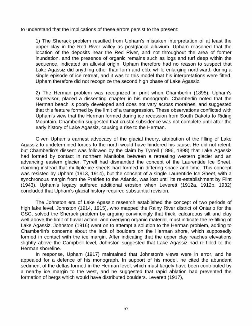
Figure 27. Maximum extent of Lake Agassiz (after Teller et al., 1983) and the late stages of Lake Ojibway (Vincent and Hardy, 1979; Veillette, 1994), with isobases showing mean trend of lines of equal postglacial uplift. Data were compiled by Teller and Thorleifson (1983) from the work of Johnston (1946), Walcott (1972), and Vincent and Hardy (1979). Isobases are speculative outside southern Lake Agassiz and Great Lakes region.
64

Figure 28. Schematic model for general configuration of Lake Agassiz shorelines, showing former water planes and outlets (vertical bars) projected onto a vertical plane orthogonal to the isobases depicted in Figure 27. Water planes are based on data from Johnston (1946), Bluemle (1974), Hobbs (1983), Dredge (1983), Klassen (1983), and Craig (1969). Dashed Moorhead Phase levels (Warman, 1991) are schematic approximations of shorelines which were inundated by the subsequent rise in lake level.
65
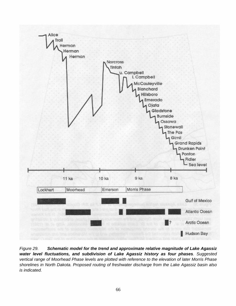
Figure 29. Schematic model for the trend and approximate relative magnitude of Lake Agassiz water level fluctuations, and subdivision of Lake Agassiz history as four phases. Suggested vertical range of Moorhead Phase levels are plotted with reference to the elevation of later Morris Phase shorelines in North Dakota. Proposed routing of freshwater discharge from the Lake Agassiz basin also is indicated.
66

Figure 30. Lake Agassiz region paleogeography at ~11.7 ka BP: Clayton and Moran (1982) correlated an advance to the Big Stone moraine, the final pre-Lake Agassiz margin in the Red River valley, to the Maxwelton margin defined for southern Saskatchewan by Parizek (1964), to the Kensal and North Viking phases in North Dakota, and the maximum or Alborn phase, or possibly a retreating margin (Attig et al., 1985), of the St. Louis sublobe in northern Minnesota. Attig et al. (1985) correlated this event to the second occupation of the Nickerson moraine of the southwestern Superior basin, which deposited the Barnum Formation, and to the Marenisco and late Athelstane margins in Wisconsin and adjacent Michigan which correlate to the over-riding of the Two Creeks forest bed. As ice retreated from the Big Stone moraine, flowing water and small bodies of standing water in the Lake Agassiz basin maintained a level of about 355 m, 30 m above the Herman level and graded to the crest of the moraine (Baker, 1966; Fenton et al., 1983; Clayton, 1983). Lake Agassiz formed, surrounded by stagnant ice, as ice retreated sufficiently from the Big Stone moraine for the lake to extend from the North Dakota to the Minnesota shores of the valley. The southern outlet was eroded to the Alice level (Bluemle, 1974), the highest shoreline here attributed to Lake Agassiz. As ice retreated in northern Minnesota, the Mizpah level of Lake Koochiching (Hobbs, 1983) was drained by both the Prairie and Embarrass spillways. A beach at 427 m(1400) at Mizpah reported by Hobbs (1983) is here correlated to the 436 m(1430) level at Togo and to the Norwood level at 443 m(1450) at the Embarrass outlet.
67

Figure 31. Lake Agassiz region paleogeography at ~11.5 ka BP: As the Wahpeton and Erskine moraines (Leverett, 1932) were built in the Alice level of Lake Agassiz and the Mizpah level of Lake Koochiching, the ice margin to the west formed the Weyburn and Souris lobes (Clayton and Moran, 1982). To the east, the St. Louis sublobe margin had retreated north of the Mesabi range and ice in the Superior basin had retreated from the Marenisco and correlative positions (Attig et al., 1985). As ice retreated from this position, floodwater cut the Sheyenne spillway (Brophy, 1967; Brophy and Bluemle, 1983; Kehew and Lord, 1986; Kehew and Teller, 1994) and deposited the Sheyenne fan in the Alice level at 335 m, 12 m above the Herman level (Fenton et al., 1983). A brief rise of Lake Agassiz during this flood may have caused the formation of the Mclntosh spillway, which extends from the Red River valley to northern Minnesota and which deposited a fan at 389 m(1275) in the Mizpah level of Lake Koochiching. Downcutting of the southern outlet to a water level of 323 m (1060), later to govern the Herman level, caused flow to reverse in the Mclntosh channel. Downcutting of the Mesabi outlets lowered Lake Koochiching. As ice continued to retreat, the southern outlet was abandoned as Lake Agassiz fell to become confluent with this lower level of Lake Koochiching. Differential uplift of the Mesabi outlets caused Lake Agassiz to transgress and re-occupy the southern outlet, culminating in a three-outlet Trail level, which formed several shorelines mapped by Hobbs (1983), including the 436 m (1430) terrace at Embarrass, a shoreline at 412 m(1350) at Gemmell, and the upper shoreline at Trail (381 m; 1250).
68
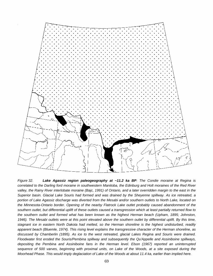
Figure 32. Lake Agassiz region paleogeography at ~11.2 ka BP: The Condie moraine at Regina is correlated to the Darling ford moraine in southwestern Manitoba, the Edinburg and Holt moraines of the Red River valley, the Rainy River interlobate moraine (Bajc, 1991) of Ontario, and a later overridden margin to the east in the Superior basin. Glacial Lake Souris had formed and was drained by the Sheyenne spillway. As ice retreated, a portion of Lake Agassiz discharge was diverted from the Mesabi and/or southern outlets to North Lake, located on the Minnesota-Ontario border. Opening of the nearby Flatrock Lake outlet probably caused abandonment of the southern outlet, but differential uplift of these outlets caused a transgression which at least partially returned flow to the southern outlet and formed what has been known as the highest Herman beach (Upham, 1895; Johnston, 1946). The Mesabi outlets were at this point elevated above the southern outlet by differential uplift. By this time, stagnant ice in eastern North Dakota had melted, so the Herman shoreline is the highest undisturbed, readily apparent beach (Bluemle, 1974). This rising level explains the transgressive character of the Herman shoreline, as discussed by Chamberlin (1895). As ice to the west retreated, glacial Lakes Regina and Souris were drained. Floodwater first eroded the Souris/Pembina spillway and subsequently the Qu'Appelle and Assiniboine spillways, depositing the Pembina and Assiniboine fans in the Herman level. Elson (1967) reported an uninterrupted sequence of 500 varves, beginning with proximal units, on Lake of the Woods, at a site exposed during the Moorhead Phase. This would imply deglaciation of Lake of the Woods at about 11.4 ka, earlier than implied here.
69

Figure 33. Lake Agassiz region paleogeography at ~11.1 ka BP: An ice margin between Saskatoon and Regina, defined by Christiansen (1979), is here correlated to later overridden margins in Manitoba and much of northwestern Ontario, to formation of the Steep Rock moraine on the Minnesota-Ontario border, and to the Porcupine phase of Lake Superior (Clayton, 1983; Clayton, 1984; Attig et al., 1985). The southern outlet was eroded to a water level at 317 m(1040'), producing a second Herman level.
70

Figure 34. Lake Agassiz region paleogeography at ~10.9 ka BP: An ice margin at Saskatoon (Christiansen, 1979) is correlated to a later overridden position in Manitoba and to the construction by enhanced glaciofluvial discharge (Sharpe and Cowan, 1990) of the Eagle-Finlayson and Brule moraines. In the Superior basin, the ice margin was retreating from the Porcupine maximum (Attig et al., 1985). At about this time, opening of drainage to Thunder Bay through the Shebandowan and Savanne area first caused abandonment of the southern outlet as water fell to a level portrayed here as a third Herman level (Figure 28), and subsequently caused a dramatic lowering of Lake Agassiz to initiate the Moorhead Phase. A water plane drawn a constant increment lower than the final Herman shoreline (Figure 28; Warman, 1991) defines a shoreline determined by eastward drainage and which accounts for the lowest Moorhead Phase level, in the Grand Forks area, defined by Arndt (1977). As discussed by Warman (1991) and Barnett (1992), there is no evidence for, and varve evidence against, a major readvance in northwestern Ontario, so the Savanne outlet probably was the northernmost eastern outlet available in the Moorhead Phase. The Clearwater outlet of Saskatchewan appears not to have been deglaciated in early Moorhead time, so drainage of Lake Agassiz was to Lake Superior, and, according to Clayton (1983), to the Atlantic at this time.
71

Figure 35. Lake Agassiz region paleogeography at ~10.4 ka BP: An ice margin north of Prince Albert, Saskatchewan (Christiansen, 1979) is correlated to a later overridden position in Manitoba, the construction of the Hartman moraine which was dated to 10.4 ka by Warman (1991) on the basis of 440 varves below the red clay marker at Dryden, and to an undetermined position north of Lake Superior. Differential uplift of the Savanne outlet caused Lake Agassiz to transgress from Grand Forks to south of Fargo. By late Moorhead time, differential uplift of the Thunder Bay outlets would have drowned sites in southeastern Manitoba which now yield subaerial organic material dated to late Moorhead time (Matile and Thorleifson, 1996). It therefore is apparent that the Clearwater spillway in western Saskatchewan must have been the late Moorhead outlet of Lake Agassiz, as suggested by Fisher and Smith (1994). Opening of this outlet again lowered Lake Agassiz, and a delta was deposited in the Fargo area at this time (Arndt, 1977; Fenton et al., 1983).
72

Figure 36. Lake Agassiz region paleogeography at ~9.9 ka BP: A major readvance at - 10 ka returned drainage to the southern outlet, causing deposition of Sherack Formation clay. The distribution of lacustrine sediments indicates that the rise reached the Norcross level, depositing fills in the Assiniboine, Pembina, and Sheyenne valleys. To permit a rise to Norcross, ice must have blocked access to the Clearwater spillway, but this feature was not overridden. The ice margin was at the southwestern limit of southwestward ice flow in Saskatchewan (Prest et al., 1968), the Arran limit in eastern Saskatchewan (Moran, 1969) and western Manitoba (Klassen, 1979), a buried moraine at Portage la Prairie, Manitoba (Fenton, 1970; Fenton and Anderson, 1971), the Lac Seul moraine in northwestern Ontario (Warman, 1991), the Marks moraine near Thunder Bay, and the Marquette maximum in Lake Superior (Hughes, 1978; Attig et al., 1985). The final Herman level was not reoccupied due to differential uplift. Lake Agassiz was confluent with Lake Kaministikwia in the Thunder Bay area, and glaciolacustrine sediments were deposited across the drainage divide. Red clay was transferred into Lake Agassiz from the Kaministikwia basin for two to three decades (Warman, 1991). As the southern outlet was eroded, the Norcross and Tintah shorelines were formed. As resistant Precambrian rocks were exposed in the floor of the outlet, Lake Agassiz stabilized at the Campbell level and slowly regressed due to differential uplift. Existence of the lower Campbell shoreline, which diverges from the upper Campbell northward, implies that the Kaiashk outlet near Lake Nipigon temporarily opened late in the Emerson Phase.
73

Figure 37. Lake Agassiz region paleogeography at ~9.3 ka BP: A retreating position of the ice margin in Saskatchewan is correlated to the Pas and George Island (Todd and Lewis, 1996) moraines in Manitoba, the Sioux Lookout moraine in northwestern Ontario, and the southern portion of the Nipigon moraine, and the North Shore ice margin of Lake Superior (Farrand, 1960). The advance to this margin at Sioux Lookout overrode varved clay (Hurst, 1933) and closed the Kaiashk outlet. Lake Agassiz rose to the southern outlet, which produced the lower Campbell shoreline due to differential uplift since abandonment of the Campbell. A fossiliferous valley fill was deposited by the Assiniboine, Pembina, and Sheyenne Rivers. Correlative fill at Rossendale was dated at 9.5 ka by Teller (1989). As ice retreated from the Sioux Lookout moraine, a succession of outlets that drained into Lake Nipigon, and which were described by Elson (1957), Zoltai (1967), and Teller and Thorleifson (1983), were opened. Lake Agassiz was lowered in step-wise manner, although every lowering was followed by slow transgression everywhere south of the outlet isobase due to differential uplift of the outlet. Consequently, these shorelines converge to the south.
74

Figure 38. Lake Agassiz region paleogeography at ~8.2 ka BP: The final major moraine-building episode occurred as the Cree Lake moraine in Saskatchewan (Schreiner, 1984), the Hargrave moraine in Manitoba (Klassen, 1983), and the Agutua-Nakina moraines in Ontario (Prest, 1963; 1970) were deposited. Deposition of the Agutua-Nakina moraines by enhanced glaciofluvial discharge was dated at about 8.2 ka by Thorleifson and Kristjansson (1993), on the basis of a Lake Superior varve record reported by Teller and Mahnic (1988). Construction of these moraines coincided with the final episode of discharge to Lake Nipigon, from the Pas and possibly Gimli levels of Lake Agassiz.
75

Figure 39. Lake Agassiz region paleogeography at ~8.0 ka BP: As the ice margin retreated from the 8.2 ka margin, no major moraines were built. In fact, the ice mass seems generally to have been stagnant, because eskers and lineated till features related to the 8.2 ka margin are virtually undisturbed. Small moraine segments were built at Sipiwesk in Manitoba (Klassen, 1983) and Big Beaverhouse in Ontario (Prest, 1963). As ice retreated in Ontario, discharge may have been diverted to outlets directly entering Lake Superior at White Otter and Nagagami, producing the Grand Rapids and Drunken Point shorelines of Lake Agassiz. If the ice margin in Saskatchewan was farther north than depicted here, or if the margin retreated and readvanced, it is possible that Lake Agassiz drained to the Arctic Ocean via Wollaston Lake, at about this time.
76

Figure 40. Lake Agassiz region paleogeography at ~7.8 ka BP: As the margin of the stagnant ice mass retreated by calving, to an undetermined retreat position, Lake Agassiz fell to the Ponton level, confluent with the late Kinojevis level of Lake Ojibway, which drained to the Ottawa River. Due to tilting of the basins, relative to present, the southern portions of major lakes with outlets to the north, such as Lake Winnipeg, Lake Manitoba, and Lake of the Woods, were dry. Lake Nipigon, with an outlet to the south, was more extensive than present.
77

Figure 41. Lake Agassiz region paleogeography at ~7.7 ka BP: The existence of the Fidler level of Lake Agassiz (Klassen, 1983), which is lower than the final outlet to the Ottawa River, indicates that Lake Ojibway must have drained to Hudson Bay, and marine water entered the James Bay Lowland, while Lake Agassiz was still in existence. Hence there must have been an outlet from the Fidler level to James Bay. As the ice retreated, Lake Agassiz was completely drained to the east. Due to the head available, the Echoing River channels were scoured to a depth below sea level. Sediments carried eastward and deposited along the upper Fawn River in Ontario by this discharge were dated at 7400 BP (GSC-877) by McDonald (1969).
78
79
REFERENCES CITED Antevs, E., 1931, Late-glacial correlations and ice recession in Manitoba. Geological Survey of
Canada. Memoir 168, 76 pp. Antevs, E., 1951, Glacial clay in Steep Rock Lake, Ontario, Canada. Geological Society of
America Bulletin, v. 62, p. 1223-1262. Arndt, B. M., 1977, Stratigraphy of offshore sediment, Lake Agassiz, North Dakota. North
Dakota Geological Survey, Report of Investigation 60, 58 pp. Attig, J. W., Clayton, L., and Mickelson, D. M., 1985, Correlation of late Wisconsin glacial
phases in the western Great Lakes area. Geological Society of America Bulletin, v. 96, p. 1585-1593.
Bajc, A. F., 1991, Glacial and glaciolacustrine history of the Fort Frances-Rainy River area, Ontario, Canada. University of Waterloo. Ph. D. 309 pp.
Baker, C. H., 1966, The Milnor Channel - an ice-marginal course of the Sheyenne River. United States Geological Survey Professional Paper 550-B, p. 77-79. Bannatyne, B. B., Zoltai, S. C. and Tamplin, M. J., 1970, Annotated bibliography of the
Quaternary in Manitoba and the adjacent Lake Agassiz region including Archeology of Manitoba, Manitoba Mines Branch. Manitoba Geological Survey Geological Paper 2/70, 142 pp.
Barnett, P. J., 1992, Quaternary geology of Ontario. In: Thurston, P. C., Williams, H. R., Sutcliffe, R. H. and Stott, G. M., (eds.) Geology of Ontario, pp. 1011-1088, Ontario Geological Survey Special Volume 4.
Bjork. S., 1985, Deglaciation chronology and revegetation in northwestern Ontario. Canadian Journal of Earth Sciences, v. 22, p. 850-871.
Bjork, S. and Keister, C. M., 1983, The Emerson Phase of Lake Agassiz, independently registered in northwestern Minnesota and northwestern Ontario. Canadian Journal of Earth Sciences, v. 20, p. 1536-1542.
Bluemle, J. P., 1974, Early history of Lake Agassiz in southwest North Dakota. Geological Society of America Bulletin, v. 85, p. 811-814.
Broecker, W. S., Kennett, J., Flower, B., Teller, J., Trumbore, S., Bonani, G. and Wolfli, W., 1989, Routing of meltwater from the Laurentide Ice Sheet during the Younger Dryas cold episode. Nature, v. 341, p. 318-321.
Brophy, J. A., 1967, Some aspects of the geological deposits of the south end of the Lake Agassiz basin. In: Mayer-Oakes, W. J. (ed.) Life, Land and Water, pp. 97-105, University of Manitoba Press, Winnipeg.
Brophy, J. A. and Bluemle, J. P., 1983, The Sheyenne River; its geological history and effects on Lake Agassiz. In: Teller, J. T. and Clayton, L. eds, Glacial Lake Agassiz, pp. 173-186, Geological Association of Canada Special Paper 26.
Chamberlin, T. C., 1895, Alternative interpretations. In: Upham, W. 1895, The Glacial Lake Agassiz. United States Geological Survey Monograph 25, p. 244-251. Christiansen, E. A., 1979, The Wisconsin deglaciation of southern Saskatchewan and adjacent areas. Canadian Journal of Earth Sciences, v. 16, p. 913-938.
Clayton, L., 1983, Chronology of Lake Agassiz drainage to Lake Superior. In: Teller, J. T. and Clayton, L. eds, Glacial Lake Agassiz, pp. 291-307, Geological Association of Canada Special Paper 26.
Clayton, L., 1984, Pleistocene geology of the Superior region, Wisconsin; Wisconsin Geological and Natural History Survey Information Circular 46, 40 pp.

80
Clayton, L. and Moran, S. R., 1982, Chronology of late-Wisconsinan glaciation in middle North
America. Quaternary Science Reviews, v. 1, p. 55-82. Craig, B. G., 1969, Late-glacial and postglacial history of the Hudson Bay region. In: Hood, P. J.
ed., Earth Science Symposium on Hudson Bay, Geological Survey of Canada Paper 68-53, p. 63-77.
Dredge, L. A., 1983, Character and development of northern Lake Agassiz and its relation to Keewatin and Hudsonian ice regimes. In: Teller, J. T. and Clayton, L. eds, Glacial Lake Agassiz, pp. 117-131, Geological Association of Canada Special Paper 26. Dyke, A. S. and Prest, V. K., 1987, Late Wisconsinan and Holocene history of the Laurentide Ice Sheet. Géographie physique et Quaternaire, v. 41, p. 237-263. Elson, J. A., 1956, Surficial geology of the Tiger Hills region, Manitoba. Yale University. Ph.D. thesis, 316 pp.
Elson, J. A., 1957, Lake Agassiz and the Mankato-Valders problem. Science, v. 126, p. 999-1002.
Elson, J. A., 1967, Geology of Glacial Lake Agassiz. In: Mayer-Oakes, W. J. (ed.) Life, Land and Water, pp. 36-95, University of Manitoba Press, Winnipeg.
Elson, J. A., 1971, Roundness of Glacial Lake Agassiz Beach Pebbles. In: Turnock, A. C. (ed.) Geoscience Studies in Manitoba, pp. 285-291, Geological Association of Canada Special Paper 9.
Elson, J. A., 1983, Lake Agassiz - Discovery and a Century of Research. In: Teller, J. T. and Clayton, L. eds, Glacial Lake Agassiz, pp. 21-41, Geological Association of Canada Special Paper 26.
Emmons, W. H., 1935, Memorial to Warren Upham. Geological Society of America Proceedings for 1934. p. 281-294.
Farrand, W. R., 1960, Former shorelines in western and northern Lake Superior basin. University of Michigan. Ph. D. 295 pp.
Fenton, M. M., 1970, The Pleistocene stratigraphy and surficial geology of the Assiniboine River to Lake Manitoba area, Manitoba. University of Manitoba. M. Sc. 121 pp.
Fenton, M. M. and Anderson, D., 1971, Pleistocene stratigraphy of the Portage la Prairie area, Manitoba. In: Turnock, A. C. (ed.) Geoscience Studies in Manitoba, pp. 271-276, Geological Association of Canada Special Paper 9.
Fenton, M. M., Moran, S. R., Teller, J. T. and Clayton, L., 1983, Quaternary stratigraphy and history in the southern part of the Lake Agassiz basin. In: Teller, J. T. and Clayton, L. eds, Glacial Lake Agassiz, pp. 49-74, Geological Association of Canada Special Paper 26.
Fisher, T. G. and Smith, D. G., 1994, Glacial Lake Agassiz: its northwest maximum extent and outlet in Saskatchewan Emerson Phase, Quaternary Science Reviews, v. 13. p. 845-858.
Flint, R. F., 1943, Growth of the North American ice sheet during the Wisconsin age. Geological Society of America Bulletin, v. 54, p. 325-362.
Harris, K. L., Moran, S. R. and Clayton, L., 1974, Late Quaternary stratigraphic nomenclature, Red River Valley, North Dakota and Minnesota. North Dakota Geological Survey Miscellaneous Series, v. 52, 47 pp.
Hobbs, H. C., 1983, Drainage relationship of Glacial Lake Aitkin and Upham and early Lake Agassiz in northeastern Minnesota. In: Teller, J. T. and Clayton, L. eds, Glacial Lake Agassiz, pp. 245-259, Geological Association of Canada Special Paper 26
81
Hughes, J. D., 1978, A post Two Creeks buried forest in Michigan's northern Peninsula;
Proceedings of the Institute on Lake Superior Geology, v. 24, p. 16. Hurst, M. E., 1933, Geology of the Sioux Lookout area. Ontario Department of Mines. 41. part
VI. p. 1-33. Johnston, W. A., 1914, The calcareous drift and lacustrine deposits in Rainy River District, Ontario. Geological Survey of Canada. Summary Report for 1913. p. 170-177. Johnston, W. A., 1915, Rainy River District, Ontario; surficial geology and soils. Geological
Survey of Canada, Memoir 82, 123 pp. Johnston, W. A., 1916, The genesis of Lake Agassiz: a confirmation. Journal of Geology, v. 24,
p. 625-638. Johnston, W. A., 1921, Winnipegosis and upper Whitemouth river areas, Manitoba, Pleistocene
and Recent Deposits. Geological Survey of Canada, Memoir 128, 42 PP. Johnston, W. A., 1946, Glacial Lake Agassiz with special reference to the mode of deformation
of the beaches. Geological Survey of Canada, Bulletin 7, 20 pp. Kehew, A. E. and Lord, M. L., 1986, Origin and large-scale erosion features of glacial-lake
spillways in the northern Great Plains. Geological Society of America Bulletin, v. 97, p. 162-177.
Kehew, A. E. and Teller, J. T., 1994, History of late glacial runoff along the southwestern margin of the Laurentide Ice Sheet. Quaternary Science Reviews. v. 13. p. 859-877.
Klassen, R. W., 1979, Pleistocene geology and geomorphology of the Riding Mountain and Duck Mountain area, Manitoba-Saskatchewan. Geological Survey of Canada, Memoir 396, 52 pp.
Klassen, R. W., 1983, Lake Agassiz and the late glacial history of northern Manitoba. In: Teller, J. T. and Clayton, L. eds, Glacial Lake Agassiz, pp. 97-115, Geological Association of Canada Special Paper 26.
Kupsch, W. 0., 1967, Postglacial uplift - a review. In: Mayer-Oakes, W. J. (ed.) Life, Land and Water, pp. 155-186, University of Manitoba Press, Winnipeg.
Laird, W. M., 1944, The geology and ground water resources of the Emerado quadrangle. North Dakota Geological Survey, Bulletin 17, 35 pp.
Laird, W. M., 1964, The problem of Lake Agassiz. Proceedings of the North Dakota Academy of Science, v. 18, p. 114-134.
Leverett, F., 1912 a, Glacial investigations in Minnesota in 1911. Science. v. 35. p. 315. Leverett, F., 1912 b, Glacial investigations in Minnesota in 1911. Geological Association of America Bulletin, v. 23, p. 732-735.
Leverett, F., 1917, Records of Lake Agassiz in southeastern Manitoba and adjacent parts of Ontario, Canada; Discussion. Geological Society of America Bulletin, v. 28, p. 146
Leverett, F., 1932, Quaternary geology of Minnesota and parts of adjacent states. United States Geological Survey. Professional Paper 161, 148 pp.
Lewis, C. F. M. and Anderson, T. W., 1989, Oscillations of levels and cool phases of the Laurentide Great Lakes caused by inflows from Lake Agassiz and Barlow-Ojibway. Journal of Paleolimnology, v. 2, p. 99-146.
Lewis, C. F. M., Moore, T. C., Jr., Rea, D. K., Dettman, D. L., Smith, A. M., and Mayer, L A., 1994, Lakes of the Huron Basin: their record of runoff from the Laurentide Ice Sheet. Quaternary Science Reviews. v. 13. p. 891-922.
Matile, G. L. D. and Thorleifson, L. H., 1996, Prairie NATMAP: Evidence for Lake Agassiz

82
lake level fluctuations from southeastern Manitoba. Geological Association of Canada/Mineralogical Association of Canada Abstracts with Programs.
Matsch, C. L., 1983, River Warren, the southern outlet to Glacial Lake Agassiz. In: Teller, J. T. and Clayton, L. eds, Glacial Lake Agassiz, pp. 231-244, Geological Association of Canada Special Paper 26.
Matsch, C. L. and Wright, H. E., 1967, The southern outlet of Lake Agassiz. In: Mayer-Oakes, W. J. (ed.) Life, Land and Water, pp. 121-140. University of Manitoba Press, Winnipeg.
Mayer-Oakes, W.J. (ed.), 1967, Life, Land, and Water: University of Manitoba Press, Winnipeg, 339 pp.
McDonald, B. G., 1969, Glacial and interglacial stratigraphy, Hudson Bay Lowlands. In: Hood, P. J. ed., Earth Science Symposium on Hudson Bay, Geological Survey of Canada Paper 68-53, p. 78-99.
Moran, S. R., Clayton, L., Scott, N. W. and Brophy, J. A., 1973, Catalog of North Dakota radiocarbon dates. North Dakota Geological Survey. Miscellaneous Series 53, 51 pp
Mothershill, J. S., 1988, Paleomagnetic dating of late glacial and postglacial sediments in Lake Superior; Canadian Journal of Earth Sciences, v. 25, p. 1791-1799. Parizek, R. R., 1964, Geology of the Willow Bunch Lake area, Saskatchewan. Saskatchewan Research Council. Research Division Report 4.
Prest, V. K., 1963, Red Lake-Lansdowne House area, northwestern Ontario. Geological Survey of Canada, Paper 63-6, 23 pp.
Prest, V. K., 1970, Quaternary geology of Canada. In: Douglas, R. J. W. ed, Geology and Economic minerals of Canada, pp. 676-758, Geological Survey of Canada Economic Geology Series, No. 1, 5th ed..
Prest, V. K., Grant, D. R., and Rampton, V. N., 1968, Glacial Map of Canada. Geological Survey of Canada, Map 1253A.
Schreiner, B. T., 1983, Lake Agassiz in Saskatchewan. In: Teller, J. T. and Clayton, L. eds, Glacial Lake Agassiz, pp. 75-96, Geological Association of Canada Special Paper 26.
Schreiner, B. T., 1984, Quaternary geology of the Precambrian shield, Saskatchewan. Saskatchewan Geological Survey. Report 221. 106 pp.
Sharpe, D. R. and Cowan, W. R., 1990, Moraine formation in northwestern Ontario: product of subglacial fluvial and glaciolacustrine sedimentation; Canadian Journal of Earth Sciences, v. 27, p. 1478-1486.
Shoemaker, E. M., 1992, Water sheet outburst floods from the Laurentide Ice Sheet. Canadian Journal of Earth Science. v. 29. p. 1250-1264.
Skinner, R. G., 1973, Quaternary stratigraphy of the Moose River Basin, Ontario. Geological Survey of Canada, Bulletin 225, 77 pp.
Smith, D. G. and Fisher, T. G., 1993, Glacial Lake Agassiz: the northwestern outlet and paleoflood. Geology, v. 21, p. 9-12.
Tamplin, M. J., 1967, A brief summary of Glacial Lake Agassiz Studies. In: Mayer-Oakes, W. J. (ed.) Life, Land and Water, p. 27-36, University of Manitoba Press, Winnipeg.
Teller, J. T., 1987, Proglacial lakes and the southern margin of the Laurentide Ice Sheet. In: Ruddiman, W. L. and Wright, H. E. (eds.) North America and adjacent oceans during the last deglaciation, p. 39-69. Geological Society of America, The Geology of North America, v. K-3.
Teller, J. T., 1989, Importance of the Rossendale Site in establishing a deglacial

83
chronology along the southwestern margin of the Laurentide Ice Sheet. Quaternary Research, v. 32, p. 12-23.
Teller, J. T., 1990, Volume and routing of late glacial runoff from the southern Laurentide Ice Sheet. Quaternary Research, v. 34. p. 12-23.
Teller, J.T. and Clayton, L., eds, 1983, Glacial Lake Agassiz: Geological Association of Canada Special Paper 26, 451 pp.
Teller, J. T. and Mahnic, P., 1988, History of sedimentation in the northwestern Lake Superior basin and its relation to Lake Agassiz overflow. Canadian Journal of Earth Sciences, v. 25, p. 1660-1673.
Teller, J. T. and Thorleifson, L. H., 1983, The Lake Agassiz - Lake Superior connection. In: Teller, J. T. and Clayton, L. eds, Glacial Lake Agassiz, pp. 261-290, Geological Association of Canada Special Paper 26.
Teller, J. T., Thorleifson, L. H., Dredge, L. A., Hobbs, H. C. and Schreiner, B. C., 1983, Maximum extent and major features of Lake Agassiz. In: Teller, J. T. and Clayton, L. eds, Glacial Lake Agassiz. Geological Association of Canada Special Paper 26. scale 1:3,000,000.
Thorleifson, L. H., 1983, The eastern outlets of Lake Agassiz. University of Manitoba. M. Sc. thesis, 87 pp.
Thorleifson, L. H. and Kristjansson, F. J., 1993, Quaternary geology and drift prospecting, Beardmore-Geraldton area, Ontario. Geological Survey of Canada, Memoir 435, 146 pp.
Todd, B. J. and Lewis, C. F. M., 1996, Seismostratigraphy of Lake Winnipeg sediments. In: Todd, B. J., Lewis, C. F. M., Thorleifson, L. H., and Nielsen, E. (eds.) Lake Winnipeg Project: cruise report and scientific results, pp. 79-117. Geological Survey of Canada Open File 3113.
Tyrrell, J. B., 1896, The genesis of Lake Agassiz. Journal of Geology, v. 4, p. 811-815. Tyrrell, J. B., 1898, The glaciation of north central Canada. Journal of Geology, v. 8, p. 147-160.
Upham, W., 1880, Preliminary report on the geology of central and western Minnesota. Geological and Natural History Survey of Minnesota. Eighth Annual Report, for 1879. p. 70-125.
Upham, W., 1890, Report of exploration of the glacial Lake Agassiz in Manitoba. Geological Survey of Canada. Annual Report 1888-89, part E, 156 pp.
Upham, W., 1895, The Glacial Lake Agassiz. United States Geological Survey, Monograph 25, 658 pp.
Upham, W., 1913, The relation of the Keewatin and Labrador areas of glaciation. Science, v. 37, p. 457.
Upham, W., 1914, Fields of outflow of the North American ice sheet. XII International Geological Congress (1913), Ottawa, p. 516-522.
Upham, W., 1917, Records of Lake Agassiz in southeastern Manitoba and adjacent parts of Ontario, Canada; Discussion. Geological Society of America Bulletin, v. 28, p. 146.
Veillette, J. J., 1994, Evolution and paleohydrology of glacial Lakes Barlow and Ojibway. Quaternary Science Reviews, v. 13. p. 945-971.
Vincent, J-S. and Hardy, L., 1979, The evolution of glacial lakes Barlow and Ojibway, Quebec and Ontario. Geological Survey of Canada, Bulletin 316, 18 pp.
Walcott, R. I., 1972, Quaternary vertical movements in eastern North America: quantitative evidence of glacio-isostatic rebound. Reviews of Geophysics and Space Physics,

84
v. 10, p. 849-884.
Warman, T. A., 1991, Sedimentology and history of deglaciation in the Dryden, Ontario area, and their bearing on the history of Lake Agassiz. University of Manitoba. M. Sc. thesis, 256 pp.
Winchell, N. H., 1873, First annual report, for 1872. Geological and Natural History Survey of Minnesota, p. 63.
Zoltai, S. C., 1961, Glacial history of part of northwestern Ontario. Geological Association of Canada Proceedings, v. 13, p. 61-83.
Zoltai, S. C., 1963, Glacial features of the Canadian Lakehead area. Canadian Geographer, v. 7, p. 101-115.
Zoltai, S. C., 1965, Glacial features of the Quetico-Nipigon area, Ontario; Canadian Journal of Earth Sciences, v. 2, p. 247-269.
Zoltai, S. C., 1967, Eastern outlets of Lake Agassiz. In: Mayer-Oakes, W. J. (ed.) Life, Land and Water, pp. 107-120, University of Manitoba Press, Winnipeg.