review of implementation of the environmental management ... · review of implementation of the...
TRANSCRIPT
Review of Implementation of the Environmental Management Plan for the Clarion-Clipperton Zone
Report to the International Seabed Authority
Final version
20 May 2014

Review of Implementation of the EMP for the Clarion Clipperton Zone: 20 May 2014
1
Executive summary This document presents a review of the Clarion Clipperton Zone Environmental Management Plan (CCZ-EMP) adopted by the International Seabed Authority in 2012. It confirms the ongoing appropriateness of the Plan’s vision, goals and strategic aims in the context of an evolving regulatory framework, and considers the Plan to be a model for other regional-scale areas to be explored and/or exploited. The scientifically-driven design of the CCZ-EMP produced a mosaic of protected areas alongside areas assigned for exploration and prospecting, with different objectives for Contractor areas and Areas of Potential Environmental Interest (APEIs). Data related deficiencies have been recognized as a constraint to implementing the Plan, requiring partnership approach solutions, and the Plan should be considered as part of efforts to improve global and regional marine governance.
The review of Operational and Management Objectives of the Plan highlights a number of solutions to improve implementation of the CCZ-EMP. Data and database development require attention to improve consistency and transparency. Guidance on determining Impact and Preservation Reference Areas will be needed in 2015. Contractors are obliged to apply the principles of ISO 14001 to the development of their site-specific EMPs and opportunities exist to collaborate with major research projects and to initiate capacity building.
The Legal and Technical Commission is required to review the location of the nine APEIs. This review has found nothing to suggest that positioning of the APEIs requires adjustment at this stage. However, options to obtain data in the APEIs should be explored. Priority actions assigned to the Secretariat have been influenced by progress made by Contractors. Specific sections of the Plan can now be updated.
The review recommends specific attention to be given to data collection and management; steps needed to prepare for and conduct the 2015 Workshop to provide guidance on Impact Reference Areas and Preservation Reference Areas; retaining the current configuration of APEIs for at least a further five-year period; applying lessons learned to other ocean areas; and engagement with the Convention on Biological Diversity process on Ecologically or Biologically Significant Areas.

Review of Implementation of the EMP for the Clarion Clipperton Zone: 20 May 2014
2
Contents
1. Background ................................................................................................................... 3
1.1 Introduction ................................................................................................................ 3 1.2 Rationale behind the CCZ-EMP ................................................................................. 3 1.3 Guidance .................................................................................................................... 4 1.4 Additional EMPs ......................................................................................................... 4
2. CCZ-EMP Content and context .................................................................................... 4
2.1 Content of the CCZ-EMP ........................................................................................... 4 2.2 Data ............................................................................................................................ 6 2.3 Global and regional context ....................................................................................... 7
3. Current status of the CCZ-EMP ................................................................................... 7
3.1 Operational Objectives ............................................................................................... 8 3.2 Management Objectives ............................................................................................ 9 3.3 Suggestions to improve implementation of the CCZ-EMP ....................................... 10
4. Actions expected of the Legal and Technical Commission ................................... 14
4.1 Review of the location of the nine APEIs ................................................................. 14 4.2 Next steps ................................................................................................................ 15
5. Actions expected of the Secretariat .......................................................................... 16
6. Conclusions and Recommendations ........................................................................ 17
6.1 Conclusions .............................................................................................................. 17 6.2 Recommendations ................................................................................................... 18
7. References ....................................................................................................................... 19

Review of Implementation of the EMP for the Clarion Clipperton Zone: 20 May 2014
3
Review of implementation of the Environmental Management Plan for the Clarion-Clipperton Zone
1. Background
1.1 Introduction
By the decision of 26 July 2012 as contained in the document ISBA/18/C/22, the ISA Council adopted an environmental management plan for the Clarion-Clipperton Zone (CCZ-EMP) in the Eastern Central Pacific as recommended by the Legal and Technical Commission (hereinafter the Commission) (ISBA/17/LTC/7). The decision recalled provisions of Articles 145, 16 and 165 of UNCLOS (1982) and UNGA Resolution 63/111 (2009).
As approved in 2012, the CCZ-EMP, including the designation, on a provisional basis, of a network of Areas of Particular Environmental Interest (APEIs), is to be implemented progressively over an initial three-year period so that it may be improved as more scientific, technical and environmental baseline and resource assessment data become available.
According to the operative paragraph 4 of the decision of the Council, the Legal and Technical Commission is required to report to the Council on the implementation of the CCZ-EMP. For that purpose, the ISA Secretariat is to provide a review report to facilitate the work of the Commission with the intention of updating the EMP at least two years in advance of the review of the plan in 2016. This report provides the background to that review.
1.2 Rationale behind the CCZ-EMP
The CCZ-EMP applies to an extensive region of the Pacific rich in polymetallic nodules, located beyond national jurisdiction at water depths of 4,000-6,000m. Under licensing arrangements with the Authority, exploration and exploitation mining Contractors are obliged to undertake environmental baseline studies and report progress annually. Contractors are also required to establish and carry out a programme to monitor and report on effects of their activities. There is a reasonable expectation that in time this will be formalised in Environmental Management and Monitoring Plans that will carry forward into the test mining and exploitation phases. The CCZ-EMP is the first regional-scale environmental management plan for the deep seabed. Its genesis was a proposal drawing, inter alia, upon the results of the Kaplan Project (2002-2007), a collaborative project undertaken by the Authority with the aim of assessing levels of biodiversity, species range and gene flow in the abyssal nodule provinces using molecular and morphological methods (Smith et al., 2008). An international workshop in 2010 brought together representatives of the scientific community and seabed mining industry to further refine the Authority’s proposals for the CCZ and draw up the basis of the EMP. This holistic approach has resulted in the present CCZ-EMP, of which the Vision, Goals and Strategic Aims remain appropriate and consistent with sustainable development.
Review of Implementation of the EMP for the Clarion Clipperton Zone: 20 May 2014
4
1.3 Guidance
Regulations have been adopted by the Authority for the prospecting and exploration for polymetallic nodules (as adopted in 2000 and updated in 2013 (ISBA/19/C/17)). Recommendations for the guidance of Contractors for the assessment of possible impacts arising from exploration are then issued by the Commission. Such guidance provides the framework needed for adaptive management, imposing a duty on each Contractor to “take necessary measures to prevent, reduce and control pollution and other hazards to the marine environment arising from its activities in the Area as far as reasonably possible, applying the precautionary approach and best environmental practices”. Revised and updated Recommendations take into account new knowledge, including the outcomes of workshops convened by the Authority, and set out the detailed observations and measurements that need to be made while performing specific activities and recommended data collection, reporting and archiving protocols (ISBA/19/LTC/8). These Recommendations underpin the implementation of the CCZ-EMP and have evolved since its adoption in 2012.
1.4 Additional EMPs
Other areas where Contractors are conducting exploration (Polymetallic Nodules and Polymetallic Sulphide Exploration Areas in the Indian Ocean; Polymetallic Sulphides Exploration Areas on the Mid-Atlantic Ridge), as well as future areas including exploration for cobalt crusts, would benefit from following a similar process: systematically collating relevant available scientific evidence (as achieved by the Kaplan Project) and developing quantitative conservation objectives; convening an expert workshop involving key stakeholders; and determining a balance of those areas to be explored and/or exploited for mining with areas to be protected. This would be consistent with the wishes of member States as expressed in UNGA Resolution 68/70 §51 that “invites the Authority to consider developing and approving environmental management plans in other international seabed area zones, in particular where there are currently exploration contracts”.
2. CCZ-EMP Content and context
2.1 Content of the CCZ-EMP
The CCZ-EMP is an expert-driven, proactive spatial management plan that anticipates mining exploitation. The Plan sets out the legal framework recalling appropriate obligations, responsibilities, rules, regulations and procedures. Its guiding principles are the common heritage of mankind; the precautionary approach; protection and preservation of the marine environment; prior environmental impact assessment; conservation and sustainable use of biodiversity; and transparency. §17 refers to exploration contracts let in 2012 and requires updating to reflect new contracts concluded and contracts awaiting signature. Research is ongoing to quantify the potential impacts of mining.
Section II of the EMP sets out relevant key environmental management concepts. Spatial variation of faunal communities determined a stratified pattern of biodiversity protection. Large areas with self-sustaining populations and a broad range of habitat variability were to be unaffected (directly or indirectly) by mining. Thus, the scientifically-driven process adopted

Review of Implementation of the EMP for the Clarion Clipperton Zone: 20 May 2014
5
relied on “well-established methods to document patterns of biodiversity, habitat distribution, [and] other critical physical attributes” (Wedding et al., 2013, p3). The importance of seamounts was highlighted as seamount communities in particular have high potential to be impacted by mid-water sediment plumes.
Accepted design principles underpinning the EMP include:
• Consensus for 30-50% of the total management area to be protected in order to protect minimum viable population sizes;
• The network of protected areas should capture the full range of habitats and communities in the CCZ. Nine CCZ sub-regions allow for biogeographic representation (based on three north-south and three east-west strata, reflecting strong productivity-driven gradients): hence representative reserves in each;
• Each protected area should be large enough to maintain minimum viable population sizes for species potentially restricted to a sub-region.
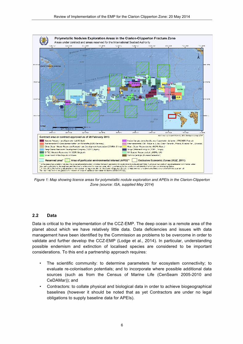
In applying these concepts the mosaic of protected areas alongside areas assigned for exploration and prospecting has become the most significant feature of the CCZ-EMP. As of May 2014 there are twelve Contractors licensed to explore a total of forty contract areas in the CCZ (Figure 1). In addition each contractor has provided an area of equal estimated commercial value to the ISA. These areas are termed the Reserved Area. Figure 1 shows the contract areas to be clustered between the Clarion and Clipperton fracture zones, respectively. The contract areas are in blocks, with each licence block covering up to a maximum of 75,000 km2 in area. The total area of the licence blocks together with the reserved area is 1,766,000 km2.
The EMP applies to the whole CCZ but recognises different objectives for Contractor areas and APEIs. For their licensed areas Contractors will be obliged to draw up site-specific EMPs that must include Impact Reference Areas within the seabed claim area actually mined, and Preservation Reference Areas (PRAs) removed from potential mining impacts. A provisional APEI has been determined for each of the nine biogeographic sub-regions, placed so as to stratify the network by biophysical gradients, to protect as many seamounts within a sub-region as possible and to avoid or minimise overlap with mining operations (Wedding et al., 2013).
Review of Implementation of the EMP for the Clarion Clipperton Zone: 20 May 2014
6
Figure 1: Map showing licence areas for polymetallic nodule exploration and APEIs in the Clarion-Clipperton
Zone (source: ISA, supplied May 2014)
2.2 Data
Data is critical to the implementation of the CCZ-EMP. The deep ocean is a remote area of the planet about which we have relatively little data. Data deficiencies and issues with data management have been identified by the Commission as problems to be overcome in order to validate and further develop the CCZ-EMP (Lodge et al., 2014). In particular, understanding possible endemism and extinction of localised species are considered to be important considerations. To this end a partnership approach requires:
• The scientific community: to determine parameters for ecosystem connectivity; to evaluate re-colonisation potentials; and to incorporate where possible additional data sources (such as from the Census of Marine Life (CenSeam 2005-2010 and CeDAMar)); and
• Contractors: to collate physical and biological data in order to achieve biogeographical baselines (however it should be noted that as yet Contractors are under no legal obligations to supply baseline data for APEIs).

Review of Implementation of the EMP for the Clarion Clipperton Zone: 20 May 2014
7
2.3 Global and regional context
The CCZ-EMP §12 notes that the Authority recognises the need to work in consultation with the many other international organisations and processes related to the protection of the marine environment. This review of the CCZ-EMP coincides with a number of ongoing processes relating to marine governance at the global and regional levels as follows:
• Ad Hoc Open-ended Informal Working Group of the General Assembly to study issues relating to the conservation and sustainable use of marine biological diversity beyond areas of national jurisdiction (BBNJ) – to which the Authority has made representation;
• The Convention on Biological Diversity Decision X/29 establishing a global process for describing ecologically or biologically significant areas (EBSAs) through the application of scientific criteria in Annex I of Decision IX/20. A series of Regional Workshops have synthesised the best available scientific and technical information to support expert scientific judgement. The latest results of this process will be presented to SBSTTA-18 in June 2014 and CBD COP12 in October 2014. This includes regional workshops whose geographical areas include or abut the CCZ, namely the Eastern Tropical and Temperate Pacific EBSA Workshop (August 2012) and the North Pacific EBSA Workshop (February 2013)1;
• United Nations Regular Process for Global Reporting and Assessment of the State of the Marine Environment, including Socio-Economic Aspects (Regular Process) – providing a commentary on the state of the global ocean;
• The process to develop Sustainable Development Goals (SDG) including the potential for an Ocean SDG, may have implications for the CCZ (UN Open Working Group on Sustainable Development Goals; UNGA A/67/L.48/rev.1); and
• Other large-scale area-based planning initiatives (e.g. OSPAR Commission’s network of High Seas MPAs (O’Leary et al., 2012, Freestone et al., 2014), Global Environment Facility FAO/UNEP ABNJ Project Component 4 and the Sargasso Sea Commission (Hamilton Declaration)) providing potential lessons learned in marine spatial planning and governance.
3. Current status of the CCZ-EMP
The EMP distinguishes between the entire CCZ, contract areas and Areas of Particular Environment Interest. Operational and management objectives were set for each. Progress against these objectives is summarised in the tables below and responses in bold are discussed further as suggestions to improve implementation of the EMP and in terms of action expected of the Commission.
1 An EBSA description for a ‘Clarion-Clipperton Zone Petrel Foraging Area’ was agreed at the Western South Pacific EBSA Workshop in November 2011.
Review of Implementation of the EMP for the Clarion Clipperton Zone: 20 May 2014
8
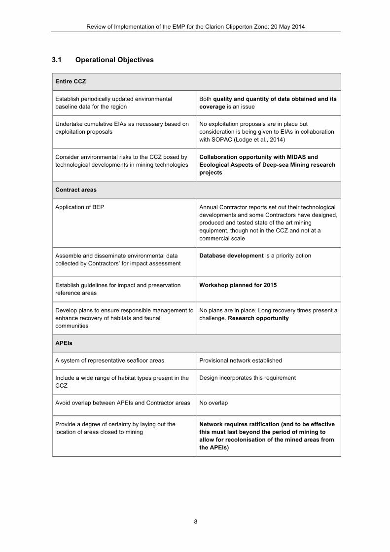
3.1 Operational Objectives
Entire CCZ
Establish periodically updated environmental baseline data for the region
Both quality and quantity of data obtained and its coverage is an issue
Undertake cumulative EIAs as necessary based on exploitation proposals
No exploitation proposals are in place but consideration is being given to EIAs in collaboration with SOPAC (Lodge et al., 2014)
Consider environmental risks to the CCZ posed by technological developments in mining technologies
Collaboration opportunity with MIDAS and Ecological Aspects of Deep-sea Mining research projects
Contract areas
Application of BEP Annual Contractor reports set out their technological developments and some Contractors have designed, produced and tested state of the art mining equipment, though not in the CCZ and not at a commercial scale
Assemble and disseminate environmental data collected by Contractors’ for impact assessment
Database development is a priority action
Establish guidelines for impact and preservation reference areas
Workshop planned for 2015
Develop plans to ensure responsible management to enhance recovery of habitats and faunal communities
No plans are in place. Long recovery times present a challenge. Research opportunity
APEIs
A system of representative seafloor areas Provisional network established
Include a wide range of habitat types present in the CCZ
Design incorporates this requirement
Avoid overlap between APEIs and Contractor areas No overlap
Provide a degree of certainty by laying out the location of areas closed to mining
Network requires ratification (and to be effective this must last beyond the period of mining to allow for recolonisation of the mined areas from the APEIs)

Review of Implementation of the EMP for the Clarion Clipperton Zone: 20 May 2014
9
3.2 Management Objectives
Entire CCZ
Collate information from EIAs No mining licences applied for so no EIAs undertaken yet
Consider cumulative impacts of mining and other human activities
Ongoing work in other forums. Research opportunity
Exchange information on new and developing technologies and their potential environmental impacts
Recent ‘mining summits’ have given some attention to this topic. Collaboration with research projects
Contract areas
Apply ISO14001 to site specific EMPs None yet proposed. Need to check Contractors are ISO 14001 ready
Annual data submissions to be made publically available by the Secretariat
Database development is a priority
Impact reference zones and preservation reference zones within site specific EMPs
To be informed by 2015 Workshop
Minimise potential impacts on established preservation zones
No mining licences applied for. The mining code, including EIA requirements is under development
Collaboration between Contractors and independent experts encouraged
To be informed by 2015 Workshop
Plans to maximise potential for recovery of biota within site specific EMPs
None yet proposed
APEIs
LTC to keep APEIs under review and hold a workshop to peer review and critique the existing proposal
Little or no new information. Revision of timeline needed
LTC to develop a recommendation for the ratification of APEIs
As above
Review of Implementation of the EMP for the Clarion Clipperton Zone: 20 May 2014
10
3.3 Suggestions to improve implementation of the CCZ-EMP
3.3.1 Data and database development
Progress towards the Contractors’ objectives is very variable, with some Contractors being extremely slow. The following data management issues were highlighted in the evaluation of annual Contractors reports in 2013 (ISBA/19/LTC/CRP.8):
• The quality and quantity of data collected by Contractors varies from good to poor; • The standard digital data submission template is only used by a minority of
Contractors; • The Authority needs to develop formal internal procedures to deal with data
submissions; • The Authority should set out which data will be made available or held in confidence.
The online central data repository of the Authority only contains data on the form and availability of data from 18 institutions worldwide. The database was last updated in 2008, and the most recent data set in the cruise section is a cruise that took place in 1988. It does not offer access to any data from any contractor. The reason for this is not clear. Environmental baseline data should not generally be regarded as confidential, especially since the Area is defined as being “the common heritage of mankind”. This lack of transparency makes it difficult to ascertain what has been achieved to date – for example, has the environmental data been submitted on an annual basis by the Contractors, and has it been added to a database within the ISA? For progress towards the granting of exploitation licences to occur within the CCZ, civil society will need to be convinced that appropriate work has been carried out and to a high standard. The benefits of making this data available and sharing it between Contractors and independent experts should be apparent to all. One option may be for the Authority to add its relevant data to the Ocean Biogeographic Information System (OBIS; www.iobis.org), which is a database of global marine animal and plant distributions. Discussions are currently underway with the IOC with whom the ISA has an MoU. More discussion between the Contractors themselves to put datasets together, discuss patterns and consider broader species distribution ranges is also to be encouraged.
3.3.2 A 2015 workshop on Impact and Preservation Reference Areas
As part of the licence procedure the Contractors are obliged to designate Impact and Preservation Reference Zones within their claim areas for the primary purposes of ensuring preservation and facilitating monitoring of biological communities impacted by mining activities (ISBA-17LTC-7). Impact Reference Zones should be designated to be within the seabed claim area actually mined and thus cannot be identified until mineable areas are licensed for exploitation.
Preservation Reference Zones should be designated to include some occurrence of polymetallic nodules in order to be as ecologically similar as possible to the Impact Reference Zone, and to be removed from potential mining impacts. In choosing the location of the Preservation Reference Zones, Contractors have been encouraged to provide environmental data to the Authority who will then organise it and make it publically available. Contractors
Review of Implementation of the EMP for the Clarion Clipperton Zone: 20 May 2014
11
have also been encouraged to collaborate with each other and with independent experts to identify guidelines for uniform application in the designation of reference zones. However, such collaboration is not explicitly required within 5-year work programmes.
In other areas of offshore exploitation such as the hydrocarbon industry in Europe, a regional Strategic Environmental Assessment (SEA) is carried out in advance of any activity to provide an overarching framework within which more detailed Environmental Impact Assessments can be made. The existing requirements placed on the Contractors could easily lead to such an overarching SEA for the CCZ. Contractors are obliged to submit environmental data on an annual basis to the Authority and this should be added to the Authority’s database and made publically available. Locating Preservation Reference Areas in each licence block in light of this collective data would be much more worthwhile than completing it for each block in isolation. For example, PRAs should be located a considerable distance away from mining activities, but if they were located close to the boundary of a block they may lie very close to active mining in an adjacent licence block.
There are many unanswered questions relating to the EMP within licence blocks such as:
1. What level of taxonomic study and sampling density is required to provide sufficient background information for an effective EIA?
2. How large should the Impact Reference Area be? 3. How large should the Preservation Reference Area be? 4. How distant from the mined area should the PRA be located (buffer zone)? 5. Should the PRA be located away from the boundaries of a block? 6. How can the interests of all stakeholders (ISA, UNCLOS, claim holders, NGOs, the
science community) be taken into account when defining PRAs? 7. Are there, as yet unidentified, unique ecosystems/habitats within the licence blocks
that may need protection? 8. Should PRAs in adjacent blocks be contiguous with each other? 8. Should the location of the PRAs be fixed for the whole duration of mining or should
they be revised as more information becomes available?
Any workshop to tackle these issues should build on previous work including the International Workshop on Environmental Management Needs for Exploration and Exploitation of Deep Sea Minerals (2011) that considered a draft template for an EIA of deep-sea mining. The function of the PRA is twofold: namely to provide an unaffected area for comparison of mining impacts and a refuge area, conserving biological populations, in relatively close proximity from which recolonisation can proceed. A concern is that the impacts of the mining may affect the whole Contractor area, including the PRA. In this case the APEIs, in addition to containing the full range of habitat types found within its sub-region, would also have a vital role to play in providing recolonisation opportunities. Adaptive management approaches will be needed during the exploitation phases to monitor the scale of impacts and to assess the effectiveness of mitigation (technological solutions and/or use of topography) in reducing plume affects.
Consideration could also be given to a more radical proposition, namely that the impact of mining within the Contractor areas may devalue the PRAs to such an extent that the Commission may decide to recommend to Council that the APEIs should become PRAs. In this case the nine APEIs would function as PRAs for the whole of the CCZ as currently designated. This could be part of a wider Strategic Environmental Assessment approved by the LTC under UNCLOS Article 165. Factors that would need to be taken into account during
Review of Implementation of the EMP for the Clarion Clipperton Zone: 20 May 2014
12
the SEA is the ability of the APEIs to provide recolonisation opportunities from such a great distance and that the APEIs contain all relevant species.
3.3.3 Discussions with Contractors re ISO 14001
§ 41 of the EMP includes a requirement that ‘Contractors will apply the principles of ISO 14001 2 to the development of their site-specific EMPs’. This is a means of reinforcing Contractors’ obligations to establish and implement programmes for monitoring and evaluating the impacts of their activities. As a first step the Secretariat will need to be reassured that Contractors are familiar with these principles and have mechanisms in place to achieve them. Registration for ISO 14001 is not obligatory (although it is perhaps preferable) but capacity building is likely to be needed and responsibilities for auditing Contractors’ environmental management systems should be allocated.
3.3.4 Collaboration with research projects
Two major research initiatives have been funded that will provide shiptime to visit the CCZ and carry out environmental research over the next 3 years.
The MIDAS project (www.eu-midas.net) is funded by the European Commission’s Framework 7 Programme for a period of 3 years, beginning on 1 November 2013. It has a contribution of 9M Euros from the EC, but also includes a number of research cruises funded by national agencies, making the total budget considerably larger. The project will investigate the environmental impact of deep-sea mineral and energy extraction: specifically, polymetallic sulphides, manganese nodules, cobalt-rich ferromanganese crusts and the potential mining of rare earth elements. The 32 MIDAS partners represent a unique combination of scientists, industry, social scientists, legal experts, non-governmental organisations and small and medium enterprises from across Europe. MIDAS is conducting research into the nature and scales of the potential impacts of mining including: 1) physical destruction of the seabed by mining, the creation of mine tailings; 2) the potential effects of particle-laden plumes in the water column, and 3) the possible toxic chemicals that might be released by the mining process. Key biological unknowns, such as connectivity between populations, impacts of the loss of biological diversity on ecosystem functioning, and how quickly the ecosystems will recover will all be addressed. The plan is to use this information to aid development of recommendations for best practice in the mining industry. A key component is the involvement of industry within the project and through stakeholder engagements to find feasible solutions. The project plans to work closely with European regulatory organisations to take these recommendations forward into legislation. A major element of MIDAS will be to develop methods and technologies for 1) preparing baseline assessments of biodiversity, and 2) monitoring activities remotely in the deep sea during and after exploitation, including ecosystem recovery. MIDAS has a cruise planned to the CCZ in 2015 and will participate in
2 It should be noted that ISO 14001 is in the process of being updated.

Review of Implementation of the EMP for the Clarion Clipperton Zone: 20 May 2014
13
two BGR cruises to the German licence block in 2014 and 2015. MIDAS is also involved in the JPI Oceans cruise (see below).
The MIDAS project was specifically set up to engage with policy makers and is thus open to working closely with the Authority. The Secretariat has a place on the MIDAS Advisory Board and will be invited to annual meetings and other events as appropriate. The MIDAS project would be willing to run joint workshops and to share its research results with the Authority. In addition, the MIDAS project in association with the Deep Ocean Stewardship Initiative (DOSI) is planning a meeting for 27-29 October 2014 to develop a strategic environmental assessment of the Mid-Atlantic Ridge. The title of this workshop is “Towards a Strategic Environmental Assessment of mineral mining along the Mid-Atlantic Ridge”. The Authority has been invited to participate on the Steering Committee of this workshop.
The project Ecological Aspects of Deep-sea Mining is an action of the pan-European JPI Oceans initiative. The project involves up to 90 days for on-site research on the German ship RV Sonne (plus an additional 18 days for vessel transit times) for a cruise in the Pacific in early 20153. Envisaged is a three-leg cruise to visit the DISCOL (DISturbance and re-COLonization experiment) area off the coast of Peru where a seafloor disturbance experiment was carried out in the 1980s, as well as to conduct research in the various claim areas of European countries in the Clarion-Clipperton Fracture Zone in the Pacific Ocean. The research will specifically focus on:
• Investigations of the direct bottom disturbance by collector systems, • Indirect influences through re-sedimentation of the plume, • Impact of discharge of waste waters from mining operations, • Long-term effects on species composition during and after re-colonisation.
This project will include several of the scientists involved in MIDAS and results will be worked up jointly.
3.3.5 Research opportunities and capacity building
In addition to collaboration with the projects mentioned above, specific actions could be taken by the Secretariat to promote and encourage the conduct of marine scientific research in the CCZ and the supply of available results to the Authority. The EMP specifically identifies the need for research on a) recovery management plans for habitats and deep-sea faunal communities, and b) cumulative impacts of mining and other human activities.
To date, studies on the former have tended to underestimate the intensity and disturbance of mining impacts and the timescales involved for recovery. Decades are envisaged for benthic soft sediment community structure to recover with recovery for nodule specialising fauna measured in millennia. Such studies are considered by this review as discrete research
3 IFREMER will participate in one of the three cruises to assess the impacts of pilot tests conducted by the consortium OMCO in 1978 in the current IFREMER exploration area.
Review of Implementation of the EMP for the Clarion Clipperton Zone: 20 May 2014
14
opportunities that could be funded and supervised by the Authority, however a workshop with all stakeholders (NGOs, Contractors, scientific institutions, network of the ISA Endowment Fund), to share information and discuss relevant research results would also be appropriate.
Furthermore, as new Contractors are licensed by the Authority, there is a need for some capacity building and oversight to ensure consistency of environmental sampling techniques. This could benefit all Contractors (both experienced and inexperienced) and would help subsequent efforts to integrate data. In addition, it is envisaged under UNCLOS that the Secretariat may take part in Contractors’ cruises, which should be welcomed by Contractors.
4. Actions expected of the Legal and Technical Commission
4.1 Review of the location of the nine APEIs
Lying to the north and south of the licence blocks and partially overlapping the fracture zones themselves, is the network of nine Areas of Particular Environmental Interest (APEIs). As stated earlier, each of the APEIs covers a core area of 200 x 200km plus a buffer zone of 100 km on each side making the total area of each APEI 400 x 400 km. In some cases the APEIs abut the licence blocks whilst in other areas there are gaps. However, the Authority continues to offer licences to new operators and thus the APEIs may abut more licence areas in the future. Reasonable assumptions concerning mining impacts, in terms of direct disturbance, likely mining patterns and sediment plumes, underpinned the design of the EMP. The 100 km buffer zones around APEI core areas were established to ensure that any mining activity adjacent to an APEI could not impact the core area. It is generally agreed that near-seabed plumes generated by the mining would not travel more than 100 km, although mid-water plumes can travel very long distances (Rolinski et al., 2001; Wedding et al., 2013).
Nine APEIs were chosen to reflect the biological variability in the area (Smith et al., 2007 and references therein), which is driven by strong north-south and east-west gradients in productivity across the Clarion-Clipperton Zone (Smith et al., 1997; Hannides & Smith, 2003). Between them the APEIs cover all habitat types in the CCZ including abyssal plains, abyssal hills, seamounts and fracture zones. The total area covered by the core areas of the nine APEIs is 360,000 km2 (1,440,000 km2 if the buffer zones are included). The location of the APEIs is based on the work of the Kaplan Project but their locations have been adjusted in comparison to the map produced in Smith et al. (2008). The most significant adjustment is to Box 6 of Smith et al. (2008), which was moved northwards, away from the area of densest nodules.
The authors of the Kaplan Project report (Pew Fellowship Group), on which the APEIs are based, have been consistent in calling for these areas to be designated as Marine Protected Areas (MPAs) (Smith et al., 2007; Smith et al., 2008). Wedding et al. (2013) used a systematic conservation planning approach to determine a very similar set of nine conservation areas in the CCZ, which they have called to be established as MPAs. They provide 3 scenarios for locating the boxes, with their first scenario closely resembling the APEI locations with the exception of one APEI box that is shifted to the northeast. None of these areas have so far been designated as MPAs and they were not considered in the Convention on Biological Diversity (CBD) process to describe Ecologically of Biologically Significant Areas (EBSAs) in
Review of Implementation of the EMP for the Clarion Clipperton Zone: 20 May 2014
15
2012. At present the environmental management plan, consisting of the nine APEIs, has been approved by the ISA Council (ISBA/18/C/22) for an initial period of 3 years from July 2012.
4.2 Next steps
The Decision of the Council (ISBA/18/C/22) determined that, for a period of at least five years, no application for exploration rights should be granted in the APEIs and in §3 requested the Commission to make recommendations, where appropriate, to the Council relating to the network of APEIs. Paragraph 42 of the EMP envisaged “a workshop of scientific/marine reserve/management specialists to peer review and critique the existing proposal and any new data and information from the contractors”. The intention was to validate and refine the results and assumptions of the Kaplan Project on the basis of new data. Whilst the taxonomic exchange workshop on megafauna (see Section 5 of this report) has helped to confirm some previous analyses (e.g. Tillot, 2006) an APEI Review Workshop is premature until significant additional data becomes available. As stated before, Contractors are under no obligation to collect data in APEIs, although COMRA sampled three APEIs in 2012, thus the timeline within the EMP for this action (and the consequent relevant Recommendation of the Commission to the Council) should be revisited.
The remoteness of the APEIs and their large size also impacts on the timeframe for the actions set out in §43 of the EMP. §8 of the Decision (ISBA/18/C/22) encourages the conduct of marine scientific research in the APEIs, but it is not clear in the framework of current contracts whether they can be amended to include any obligation for Contractors to devote ship time in APEIs. Possible options to obtain data in the APEIs, that might be incorporated within a revised EMP, include:
• Encouraging independent scientific research expeditions; • Providing incentives for Contractors to spend some effort in APEIs closest to their
claim area; and/or • Anticipating that the Authority will carry out work in APEIs in conjunction with future
exploration of Reserve Areas.
An alternative scenario, raised in the previous section, that envisages APEIs becoming the contractors PRAs, has the advantage that Contractors (either independently or collaboratively) would be required to gather baseline data within the nearest APEI to their claim area for comparative purposes. Such an arrangement could be agreed within exploitation licences, giving due consideration to logistical issues such as transit time between Contractor areas and the APEI.
Recolonisation is known to be a very slow process in the CCZ and thus consideration should be given to establishing both PRAs and APEIs for very long periods of several decades to centuries.

Review of Implementation of the EMP for the Clarion Clipperton Zone: 20 May 2014
16
5. Actions expected of the Secretariat
Section X of the CCZ-EMP lists a series of priority actions for the Contractors and the ISA Secretariat to ensure the proposed areas are kept under review. These are considered individually below.
§47: Working group or expert consultant group, including contractor experts to facilitate the establishment of environmental databases using Contractors’ and external data sources Informal consultations between Contractors and the Secretariat were held in January 2012 (IBSA/18/LTC/3). Here it was agreed that metadata sheets should be provided to Contractors to enable them to submit summaries of the raw data they had collected each year together with their annual reports. There was poor response to this initiative in the 2012 reports (ISBA/19/LTC/CRP.8). One of the key requirements for EMPs is taxonomic information. The quality and quantity of taxonomic data provided by Contractors varies considerably and it is not clear that all Contractors have engaged specialist taxonomists. This will be critical if data is to be compared from licence area to licence area across the whole CCZ. Taxonomic workshops for Contractors have been set up to try to address this issue but again it is not clear that each Contractor was able to send an appropriately qualified taxonomist and limited progress has been made towards realising the commitments made at the 2012 Contractors’ meeting.
§48: Standardise Contractors' data in a central database and review to assess biogeography Valuable data on the abiotic characteristics of the seafloor include measurements of continuous variables that influence biodiversity.
Very few Contractors have supplied good quality biological data to the central data repository (ISBA/19/LTC/CRP.8). There appear to be problems in adding data to the central data repository in a timely fashion. Guidance on what data should be made publically available is vague. Some data may be withheld pending publication, though this should not prevent it being added to a database where it could receive temporary restrictions on usage. Confidentiality issues should not be used to cover for scant data collection and poor taxonomic classification. Making the Authority a data node for the OBIS data repository would enable more open access and would create a synergy with an established data management system.
There is a need to develop a comprehensive environmental database that includes both integrated abiotic and biotic data from >80 Contractors' annual reports. The Authority is currently generating such a database and giving consideration to its validation.
§49: Retain consultants to facilitate standardization including taxonomic inter-calibration across contractor datasets and CCZ The Secretariat has initiated a taxonomic workshop series. The first of three workshops was held 9-15 June 2013 focusing on megafauna (www.isa.org.jm/en/scientific/workshops/2014). An ISA brief note report has been prepared and a digital atlas on biogeographic and taxonomic information has been produced. The next macrofauna workshop will take place in KIOST-Korea, 1-9 November 2014, and the meiofauna workshop will take place in 2015 (venue TBA). Lodge et al. (2014) noted the limitations of relying on visual interpretation of photographs of megafauna for species identification if adequate specimens for further laboratory analysis including DNA analyses are not available. Availability of specimens is

Review of Implementation of the EMP for the Clarion Clipperton Zone: 20 May 2014
17
considered even more critical in relation to macro and meiofauna. It is important to disseminate the results of these workshops in a timely manner.
§50: Workshop to produce guidelines for establishment of impact and preservation reference zones (2015) This workshop is considered essential to develop clear design guidelines and to ensure consistency amongst the different Contractors. Technical preparation in advance of such a workshop should consider a synthesis of existing data including biogeographic classifications (such as GOODS and MEOW), together with physical and biological data layers. Cross-fertilisation with the EBSA process (in partnership with CBD) would help this exercise, given that most of this external information has already been collated. The GRID-Arendal / CI geomorphology classification is one such data layer.
§51: Cumulative impact assessment. Evaluation of impacts of multiple mining operations Test mining operations are likely to provide the first information allowing the Secretariat to consider this action. As stated previously there is also an opportunity for collaboration with research projects.
§52: Periodic quality status report for the CCZ – publically available, every 5-10yrs This action is dependent on being able to measure change against an agreed baseline. Preliminary consideration should be given to appropriate indicators, which could be aligned to initiatives noted earlier (e.g. UN Regular Process and SDGs).
6. Conclusions and Recommendations
6.1 Conclusions
The CCZ-EMP is a global first. Its rationale is consistent with accepted conservation principles. As such its success or otherwise is of interest to those responsible for marine global governance processes in other international forums. Implementation of the Plan (and any others conceived for other ocean areas) will reflect on the credibility of the Authority.
The Authority has fostered a partnership between the scientific community and the nascent seabed mining industry. Impetus is needed in order for this to continue to be proactive. Stakeholder input will be helpful to continue to provide and refine guidance. Cooperation among Contractors is also key with the incentive to reduce costs and maximize results.
The CCZ-EMP model is relevant to other exploration areas. The Authority should foster discussions with relevant Contractors and note the relevance of other international processes (e.g. the Northwest Atlantic Regional EBSA Workshop described an EBSA for a selection of MAR hydrothermal vents).
This review of the operational and management objectives of the CCZ-EMP has highlighted issues that now need to be addressed. Several objectives relating specifically to site-specific EMPs, that can only be conceived in association with applications for mining licences, cannot yet be reviewed. The review suggests the CCZ-EMP can be improved by:
Review of Implementation of the EMP for the Clarion Clipperton Zone: 20 May 2014
18
• Addressing data shortcomings (and shortcomings in data management by the Authority);
• Planning and implementing a workshop in 2015 to provide guidance for Contractors’ EMPs and specifically the determination of impact areas and preservation reference areas;
• Initiating bilateral discussions between the Secretariat and Contractors regarding their preparedness for ISO 14001 (or equivalent);
• Collaborating with research projects likely to provide new relevant environmental data for the CCZ; and
• Capitalising on and/or initiating specific research opportunities in support of the EMP.
This review of the implementation of the CCZ-EMP has found nothing to suggest that positioning of the APEIs requires adjustment at this stage. The logic justifying their positioning has not changed. The distribution of APEIs within the current EMP is both scientifically defendable and a workable compromise with socio-economic interests. Very limited research into the biology of the APEIs has been carried out since the adoption of the EMP, hence the Commission is not currently in a position to make any Recommendation to Council regarding their formal implementation. On this basis the APEIs should remain in place as currently positioned, to be reviewed in a further 5 years’ time by which time further information may be available.
Priority actions assigned to the Secretariat have been influenced by progress made by Contractors. Further effort is needed to ensure a central database is fit for purpose, to prepare a workshop in 2015 to consider Contractors’ EMPs, and to update the CCZ-EMP as highlighted by this review.
6.2 Recommendations
This review recommends that:
1. The Commission recognises the continuing validity of the CCZ-EMP subject to updating as detailed by this review.
2. Urgent attention is given to improvement of data collection and management in the context of the CCZ-EMP, more specifically that the Authority:
a. resolves outstanding issues relating to satisfactory submission of data by Contractors, entry of this data into the central database, and public access to environmental data. The Authority should make provision for validating individual Contractors' annually reported data;
b. negotiates with OBIS to become a data node for biological data related to the CCZ; c. considers sponsoring a series of data comparison and intercalibration workshops
with the aim of producing overviews and synthesis papers for the CCZ. This would allow the Contractors with the support of the scientific community to put datasets together consistent with managing the CCZ as a whole; and
d. strengthens the compatibility of data collection and submissions for all Contractors through a training workshop on using environmental sampling apparatus.

Review of Implementation of the EMP for the Clarion Clipperton Zone: 20 May 2014
19
3. The Authority convenes a workshop in 2015 to provide guidance for Contractors on EMPs for their licence areas, including identification and delineation of Impact Reference Areas and Preservation Reference Areas. Informal consultations suggest such a workshop is anticipated and will be welcomed by both industry and science stakeholders.
4. The Commission recommends retaining the current configuration of APEIs for at least a further five-year period. However, in connection with the 2015 workshop (see 3 above) the Authority should consider giving further consideration to PRAs outside Contractor areas in APEIs, and on the basis of suggestions raised within this review, consider how to coordinate a scientific programme to characterise APEIs.
5. Consideration is given to co-sponsoring a workshop planned for October 2014 with the aim of initiating a process to develop an EMP for the Atlantic Ocean (MIDAS/DOSI, Azores).
6. The Authority engages with the CBD EBSA process where Regional EBSA Workshops consider or re-consider geographic areas of interest to seabed mining and where environmental data held by the Authority can contribute to evaluations of ecological or biological significance.
7. In updating the EMP as a result of this review the Secretariat should give attention to consistency of terminology e.g. in ISBA/17/LTC/7 the terms Preservation and Impact Reference Areas and Preservation and Impact Reference Zones are both used interchangeably.
7. References
Freestone, D., Johnson, D., Ardron, J., Killerlain Morrison, K., Unger, S. (in press) Can existing institutions protect biodiversity in areas beyond national jurisdiction? Experiences from two on-going processes. Marine Policy
Hannides, A., Smith, C. R. (2003) The northeast abyssal Pacific plain. In Biogeochemistry of Marine Systems, K. B. Black and G. B. Shimmield, eds., CRC Press, Boca Raton, Florida, 208-237.
International Seabed Authority (2011) Environmental Management Plan for the Clarion-Clipperton Zone. International Seabed Authority ISBA/17/LTC/7, Kingston, Jamaica.ISA
International Seabed Authority (2012) Decision of the Council relating to an environmental management plan for the Clarion-Clipperton Zone. ISBA/18/C/22
International Seabed Authority (2012) Report on informal consultations between contractors and the Secretariat, Kingston, 9-11 January 2012. ISBA/18/LTC/3
International Seabed Authority (2013) Recommendations for the guidance of contractors for the assessment of the possible environmental impacts arising from exploration for marine minerals in the Area. ISBA/19/LTC/8
International Seabed Authority (2013) ISBA/19/LTC/CRP.8
Review of Implementation of the EMP for the Clarion Clipperton Zone: 20 May 2014
20
International Seabed Authority (2013) Consolidated Regulations And Recommendations on Prospecting And Exploration ISBA/19/C/17
Lodge, M., Johnson, D., Le Gurun, G., Wengler, M., Weaver, P. and Gunn, V. (2014) Seabed mining: International Seabed Authority environmental management plan for the Clarion-Clipperton Zone. A partnership approach. Marine Policy 49, 66-72. DOI 10.1016/j.marpol.2014.04.006.
O’Leary, B.C., Brown, R.L., Johnson, D.E., von Nordheim, H., Ardron, J., and Packeiser, T. (2012) The first network of marine protected areas (MPAs) in the high seas: The process, the challenges and where next. Marine Policy 36: 598-605, Elsevier Science
Rolinski S, Segschneider J, Sundermann J. (2001) Long-term propagation of tailings from deep-sea mining under variable conditions by means of numerical simulations. Deep-Sea Res. II 48, 3469–3485. (doi:10.1016/S0967-0645(01)00053-4)
Smith, C. R., Berelson, W., DeMaster, D. J., Dobbs, F. C., Hammond, D., Hoover, D. J., Pope, R. H., Stephens, M., (1997) Latitudinal variations in benthic processes in the abyssal equatorial Pacific: Controls by biogenic particle flux. Deep-Sea Research II (44), 2295-2317.
Smith, C. R., Galeron, J., Gooday, A., Glover, A., Kitazato, H., Menot, L., Paterson, G., Lambshead, J., Rogers, A., Sibuet, M., Nozawa, F.,Ohkawara, N., Lunt, D., Floyd, R., Elce, B., Altamira, I., Dyal, P. (2007) Final report: Biodiversity, species ranges, and gene flow in the abyssal Pacific nodule province: predicting and managing the impacts of deep seabed mining. J. M. Kaplan Fund and the International Seabed Authority, 41 pp.
Smith, C.R., Galéron, J., Glover, A., Gooday, A., Kitazato, H., Lambshead, J., Menot, L., Paterson, G., Rogers, A. and Sibuet, M. (2008) Biodiversity, species ranges, and gene flow in the abyssal Pacific nodule province: Predicting and managing the impacts of deep seabed mining. ISA Technical Study no. 3, International Seabed Authority, Kingston, Jamaica.
Tilot, V. (2006) Biodiversity and distribution of megafauna. Vol. 1:The polymetallic nodule ecosystem of the Eastern Equatorial Pacific Ocean; Vol. 2 Annotated photographic atlas of the echinoderms of the Clarion-Clipperton fracture zone. Paris. UNESCO/IOC, 2006. IOC Technical Series 69.
UNCLOS (1982) United Nations Convention on the Law of the Sea of 10 December 1982, art. 192
United Nations General Assembly (2009) Oceans and the law of the sea: Resolution adopted by the General Assembly on 5 December 2008 A/RES/63/111
United Nations General Assembly (2013) Open Working Group of the General Assembly on Sustainable Development Goals 15 January 2013. UNGA A/67/L.48/rev.1)
United Nations General Assembly, (2014) Oceans and the law of the sea: Resolution adopted by the General Assembly on 9 December 2013 A/RES/68/70
Wedding LM, Friedlander JN, Kittinger L, Watling L, Gaines SD, Bennett M, Hardy SM and Smith CR (2013) From principles to practice: a spatial approach to systematic conservation planning in the deep sea. Proc. R. Soc. B 2013 280, 20131684, published 6 November 2013 doi:10.1098/rspb.2013.1684 1471-2954