review of environmental factors (revised)
TRANSCRIPT

M 0403 788365 | E [email protected] | 1/9 Narabang Way, Belrose
Review of Environmental Factors
(Revised)
Carpark
1078 Oxford Falls Road, Oxford Falls
Report prepared for
Oxford Falls Grammar School
April 2021
2 | P a g e
Table of Contents
1 Certification ................................................................................................................................................ 4
2 Introduction ................................................................................................................................................ 5
3 The Site, Setting and Background .......................................................................................................... 7 3.1 The Site ........................................................................................................................................7 3.2 Surrounding locality .................................................................................................................. 11 3.3 Past Approvals .......................................................................................................................... 15
4 The Proposal ........................................................................................................................................... 16
5 The Proponent ......................................................................................................................................... 18
6 Other approvals ...................................................................................................................................... 18
7 Justification ............................................................................................................................................. 18
8 Class of Activity ....................................................................................................................................... 19
9 LEGISLATIVE FRAMEWORK .................................................................................................................. 20 9.1 Environmental Planning and Assessment Act 1979 .............................................................. 20 9.2 State Environmental Planning Policy (Educational Establishments and Child Care Facilities)
2017 20 9.3 NSW Code of Practice for Part 5 Activities .............................................................................. 26 9.4 State Environmental Planning Policy No.55 – Remediation of Land .................................... 27 9.5 Warringah Local Environmental Plan 2011 ............................................................................ 28 9.6 Warringah Local Environmental Plan 2000 ............................................................................ 30
10 Consultation ............................................................................................................................................ 31
11 Environmental Impact Assessment .................................................................................................... 32 11.1 Clause 228 Consideration ................................................................................................... 32 11.2 Education SEPP Planning Principles ................................................................................... 34 11.3 Detailed Environmental Considerations .............................................................................. 37
11.3.1 Contamination .............................................................................................................. 37 11.3.2 Tree Removal ................................................................................................................ 39 11.3.3 Bushfire Protection Assessment .................................................................................. 39 11.3.4 Traffic and carpark design ........................................................................................... 41 11.3.5 Flood levels ................................................................................................................... 42 11.3.6 Biodiversity .................................................................................................................... 43 11.3.7 Aboriginal heritage ........................................................................................................ 44 11.3.8 European Heritage ........................................................................................................ 45
11.4 Other Considerations ............................................................................................................ 47 11.4.1 Geotechnical Investigation ........................................................................................... 47 11.4.2 Stormwater and erosion and sedimentation controls ................................................ 47 11.4.3 Visual impacts ............................................................................................................... 48 11.4.4 Energy Efficiency and Sustainability ............................................................................ 48
11.5 Construction impacts ........................................................................................................... 49 11.5.1 Construction Traffic ...................................................................................................... 50
12 Summary of Impacts ............................................................................................................................. 51
13 Mitigating measures, modifications or adaptions ............................................................................ 53
14 Conclusion ............................................................................................................................................... 60

3 | P a g e
List of Appendices
Appendix 1 Legal Advice
Appendix 2 Last Consent issued by Council DA2016/0662
Appendix 3 Site Survey
Appendix 4 Architectural Drawings
Appendix 5 Landscape Plans
Appendix 6 Preliminary Site Investigation
Appendix 7 Arboricultural Impact Assessment
Appendix 8 Bushfire Assessment Report
Appendix 9 Civil Engineering Statement
Appendix 10 Traffic Impact Assessment
Appendix 11 Biodiversity Assessment
Appendix 12 Flood Assessment
Appendix 13 Aboriginal Objects Due Diligence
Appendix 14 Historical Heritage Constraints Assessment
Appendix 15 Geotechnical Report
Appendix 16 Construction Management Plan
Appendix 17 Sustainability report
CONTACT:
All Rights Reserved. No material may be reproduced without prior permission of DM Planning Pty Ltd. While DM
Planning Pty Ltd working on this project has tried to ensure the accuracy of the information in this publication, it
accepts no responsibility or liability for any errors, omissions or resultant consequences including any loss or
damage arising from reliance in the information in this report. This report has relied on information provided in
good faith and accepts no responsibility or liability for any errors, omissions or resultant consequences including
any loss or damage arising from reliance in the information in this report.

4 | P a g e
1 Certification
This revised Review of Environmental Factors, prepared on behalf of Oxford Falls
Grammar School (OFGS), provides a true and fair review of the proposal in relation
to its potential effects on the environment. It addresses to the fullest extent
possible, all matters affecting or likely to affect the environment as a result of the
proposal. To the best of my knowledge, the information contained in this Review of
Environmental Factors is neither false nor misleading.
Name of the person(s) and who prepared the
REF:
Danielle Deegan
Position and Qualifications of the person(s) who
prepared the REF:
Director -D.M Planning Pty Ltd
Bachelor of Economics
Grad Dip Planning
Signature:
8 April 2021

5 | P a g e
2 Introduction
This revised Review of Environmental Factors (REF) has been prepared by DM
Planning Pty Ltd on behalf of Oxford Falls Grammar School (OFGS) for a proposed
carpark at 1078 Oxford Falls Road, Oxford Falls. It has been prepared in accordance
with the Environmental Assessment Code of Practice for Part 5 Activities, for non-
registered schools (the Code).
This revised REF is an update to a previous REF that covered a larger scope of
works and included a library, administration building and carpark (the ‘original
development’).
On 5 March 2020, the original development was approved by the issue of two
Decision Statements for the Administration Building and Carpark; and for the Library.
The School has decided to the amend the original development by reducing the scope
of works.
The school now intends to construct:
a) A carpark on the ground floor as development without consent under clause
36 of the State Environmental Planning Policy (Educational Establishments
and Child Care Facilities) 2017 (ESEPP);
b) Amenities, storage and landscaping/courtyard on the ground floor as exempt
development under clauses 18 and 38 of the ESEPP; and
c) Shade structures, outdoor sports courts, outdoor seating and associated
landscaping and a pedestrian bridge on the first floor as exempt development
under clauses 18 and 38 of the ESEPP.
This revised REF relates solely to the carpark on the ground floor and has been
prepared in accordance with Section 4.1 of the Code which includes provisions to
allow changes to a proposal.
Following the completion of this assessment, a further Decision Statement will be
issued that relates only to the carpark aspect of the original development. Section
4.2 of the Code allows a determination made under the Code to be altered by an
authorised person via the issue of a further Decision Statement.
While environmental impacts from the revised scheme will be equivalent to or less
than the original development (due to the reduced scope of works) for the sake
thoroughness, stage 2 (assessment) and stage 3 (documentation) have been
repeated in this revised REF.

6 | P a g e
The purpose of this revised REF is to reassess the nature, scale and extent of the
proposed carpark on the environment. This report will:
• Describe the existing site context;
• Identify and evaluate all matters affecting or likely to affect the environment
by reason of the activity;
• Assess the likely impacts of the proposed activity in accordance with Section
5.5 of the Environmental Planning and Assessment Act (EP&A Act) and
Clause 228 of the Environmental Planning and Assessment Regulation
(EP&A Regulation);
• Recommend mitigation measures.
This revised REF concludes that the proposed carpark is satisfactory when assessed
against all relevant requirements. The carpark will improve the school facilities and
make a positive contribution to the community. It is visually sympathetic to its semi-
rural setting and will not have any detrimental environmental or amenity impacts.
7 | P a g e
3 The Site, Setting and Background
3.1 The Site
The subject site is Oxford Falls Grammar School (OFGS) at 1078 Oxford Falls Road,
Oxford Falls. The site is legally described as Lot 100 in DP 1240806 (‘the OFGS site’).
The OFGS site is bound by Oxford Falls Road to the east, Dreadnought Road to the
south and Wakehurst Parkway to the west.
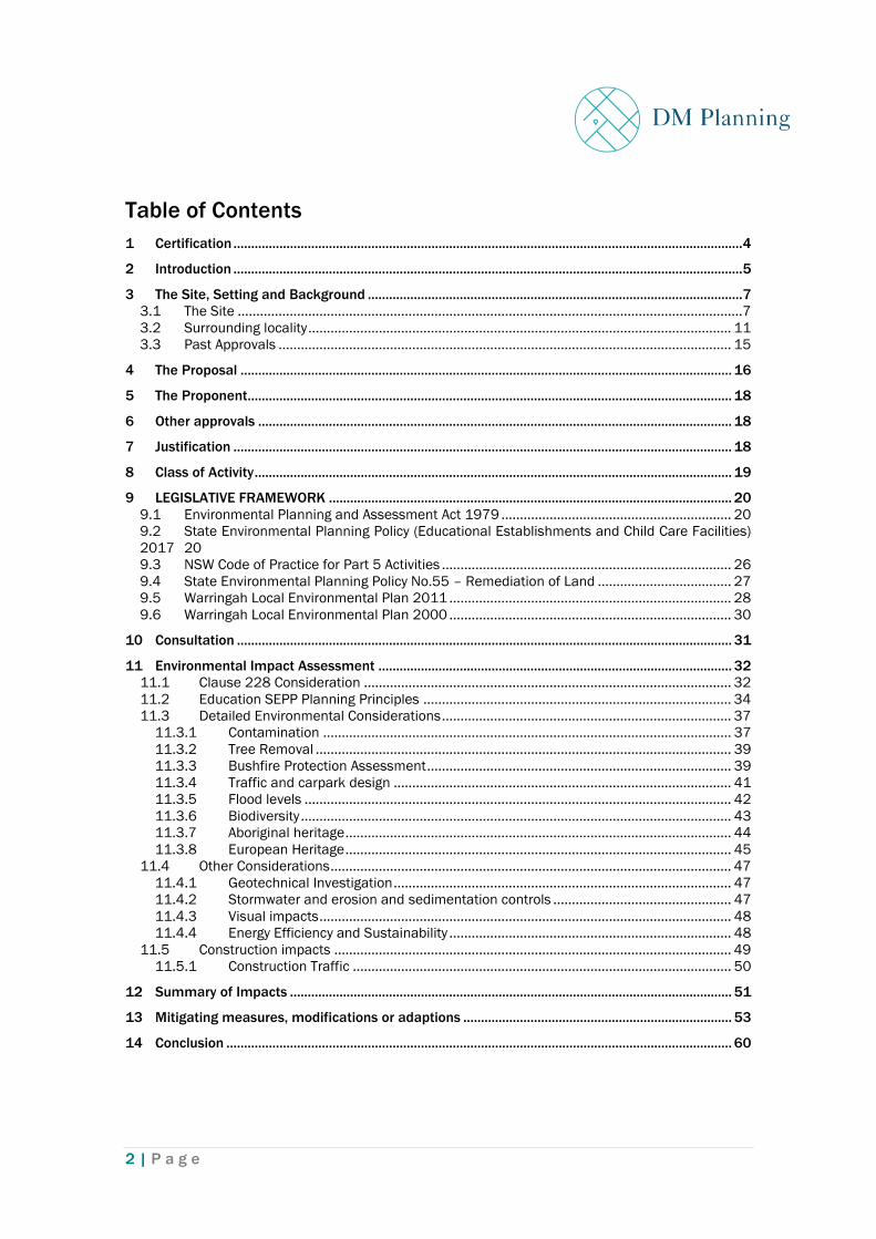
Figure 1. OFGS regional context with approximate location of Carpark shown with red cross
(Source: Google Maps)
A tributary of Middle Creek runs through the OFGS site in a north-westerly direction.
All school buildings are currently located to the north-east of the creek.
A sports field is located to the south-west of the creek. The sports field is relatively
flat and appears to have been levelled by a cut along the western edge and filling
along the eastern side, closer to the creek. Batters are present along the western
and north-western sides of the sports field.
There are numerous trees located on the OFGS site. These are primarily located
around the site perimeter and along the creek line.

8 | P a g e
Figure 2. Aerial view of the site and its immediate surround (Source: Northern Beaches
Council)
The OFGS site is classified as Bushfire Prone Land in the category of Vegetation
Buffer on the Northern Beaches Council Bush Fire Prone Land (BFPL) map.
The location of the proposed carpark, the ‘development site’, is to the south-west of
the creek, on a turfed area currently used as part of the playing field.
The OFGS site is detailed in the site survey contained at Appendix 3.
Photographs of the location of the development site are shown below.

9 | P a g e
Figure 3. View looking north-east at the development site
Figure 4. Existing driveway access from Dreadnought Road

10 | P a g e
Figure 5. View from Dreadnought Rd looking toward existing K Block
Figure 6. View of proposed walkway location, looking west from existing K Block

11 | P a g e
3.2 Surrounding locality
Oxford Falls contains various mixed uses reflecting its semi-rural character. Rural
residential properties are located to the south and east of the site.
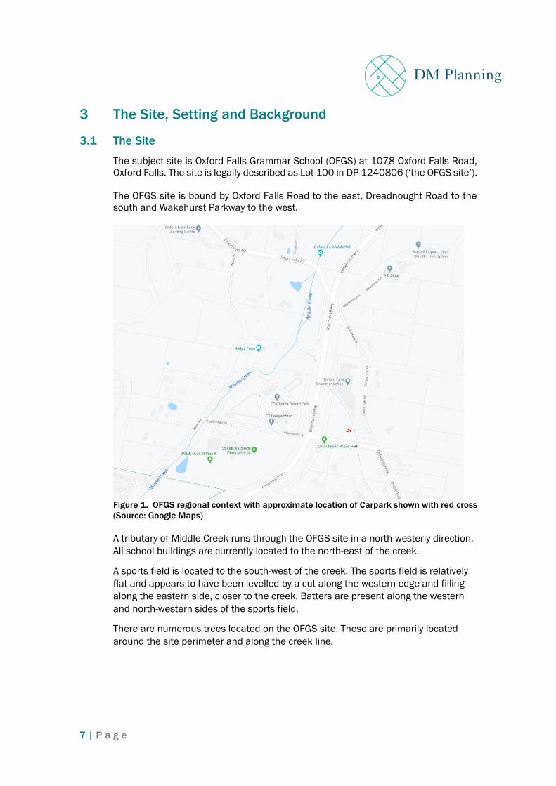
The Christian City Church is located to the west of the school, on the opposite side
of Wakehurst Parkway.
The St Pius College Playing Fields are to the south-west, diagonally opposite the
site.
Figure 7. Oxford Falls Peace Park (formerly Oxford Falls Public School)
There are no threatened species, populations or ecological communities likely to
occur in the area that will be affected by the proposal.
Figure 8. Informal gravel parking area adjoining the western boundary of the site
12 | P a g e
Figure 9. Christian City Church located to the west of the site, on the opposite side of
Wakehurst Parkway
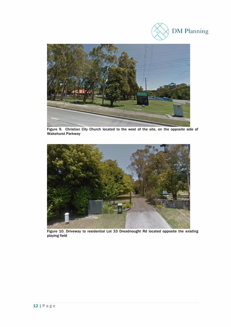
Figure 10. Driveway to residential Lot 33 Dreadnought Rd located opposite the existing
playing field

13 | P a g e
Figure 11. Entrance to residential 1100 Oxford Falls Road located opposite the site on
Dreadnought Rd
Figure 12. St Pius College Playing Fields located diagonally opposite the OFGS site to the
south-west

14 | P a g e
Figure 13 Driveway entrance to rural residential property at Portion 1083 Oxford Falls Rd

15 | P a g e
3.3 Past Approvals
The Northern Beaches Council website lists the following applications relating to the
site:
• On 21 October 2016, Development Application DA2016/0662 for the
subdivision of land adjacent to the site (Lot 21, DP 819277), was approved by
Northern Beaches Council.
• On 18 December 2017, Complying Development Certificate CDC2017/0834
was issued for Alterations and additions to the existing classroom block (Block
H) & erection of new classroom block (K)
• On 23 October 2015, Complying Development Certificate CDC2015/0574 was
issued for alteration & additions to create a new Science Block (Block E).
• On 18 June 2014, approval was issued by Warringah Council to Development
Application DA2014/0637 for the removal of a tree.
• On 4 June 2014, Complying Development Certificate CDC2014/0244 was
issued for Ancillary development - Administration block renovations and
additions.
• On 25 March 2010, Council was advised of Nation Building Project 10/0019 for
alterations and addition to Library, hall and first floor and walkway to block.
• On 7 December 2007, Development Consent DA2007/1123 was issued by
Council for the erection of two demountable buildings and fencing.
• On 21 December 2006, Development Application DA2006/1248 was issued by
Council for Construction of a New Staff Facility and Alterations and Additions to
Existing Buildings.
• On 24 February 2006, Development Application DA2006/0126 for the erection
of children’s play equipment in two stages was approved.
• On 21 June 2005, Modification Application MOD2004/0964/1 for Internal
Alterations to Plans Approved Under 2004/0964 DA Provide a Moveable
Dividing Wall and Two New Doors.
• On 28 July 2004, Development Application DA2004/0964 for the undercroft
Enclosure of an Existing Building was approved.
• In 1979, 3675/P1079-1080 was issued for the “erection of stages of a primary
and infants school comprising twelve classrooms, library, hall and
administration office, playing field, carpark and associated landscaping.
The most recent development consent issued by Northern Beaches Council (other
than a complying development certificate) that applies to any part of the school is
Development Application DA2016/0662 for the subdivision of land. This consent is
contained at Appendix 2. The proposed carpark does not contravene any conditions
of this consent.
On 7 January 2020, OFGS issued a Decision Statement for a sporting kiosk - a
small, single storey building, constructed from a retrofitted shipping container
located in the south-western corner of the site. The Decision Statement concluded
that the proposed kiosk may proceed subject to conditions.
On 5 March 2020, OFGS issued two Decision Statements for an ‘Administration
Building and Carpark’ and a ‘Library’. The Decision Statements concluded that the
proposed development may proceed subject to conditions.
16 | P a g e
4 The Proposal
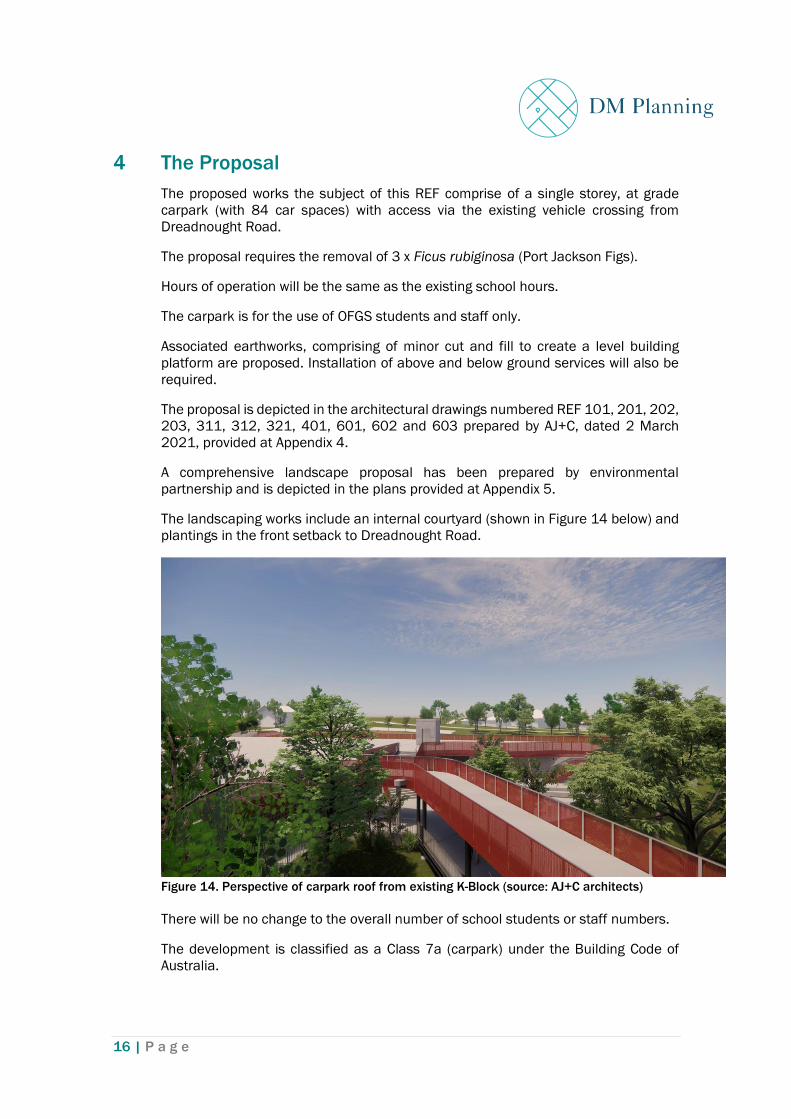
The proposed works the subject of this REF comprise of a single storey, at grade
carpark (with 84 car spaces) with access via the existing vehicle crossing from
Dreadnought Road.
The proposal requires the removal of 3 x Ficus rubiginosa (Port Jackson Figs).
Hours of operation will be the same as the existing school hours.
The carpark is for the use of OFGS students and staff only.
Associated earthworks, comprising of minor cut and fill to create a level building
platform are proposed. Installation of above and below ground services will also be
required.
The proposal is depicted in the architectural drawings numbered REF 101, 201, 202,
203, 311, 312, 321, 401, 601, 602 and 603 prepared by AJ+C, dated 2 March
2021, provided at Appendix 4.
A comprehensive landscape proposal has been prepared by environmental
partnership and is depicted in the plans provided at Appendix 5.
The landscaping works include an internal courtyard (shown in Figure 14 below) and
plantings in the front setback to Dreadnought Road.
Figure 14. Perspective of carpark roof from existing K-Block (source: AJ+C architects)
There will be no change to the overall number of school students or staff numbers.
The development is classified as a Class 7a (carpark) under the Building Code of
Australia.

17 | P a g e
The following works (which are indicated on the plans) are not the subject of the
revised REF:
• Associated amenities, storage and landscaping/courtyard on the ground floor
(these will be carried out as exempt development under clauses 18 and 38 of the
ESEPP); and
• Shade structures, outdoor sports courts, outdoor seating and associated
landscaping and a pedestrian bridge on the first floor (these will also be carried
out as exempt development under clauses 18 and 38 of the ESEPP).

18 | P a g e
5 The Proponent
The Proponent details are as follows:
Name: Oxford Falls Grammar School
Address: 1078 Oxford Falls Road, Oxford Falls
Contact: Mr Greg Morris
Position: Head of Operations
6 Other approvals
As the proposal involves works to a school, which is classified as a special fire
protection purpose, approval (i.e., a bush fire safety authority) is required from the
NSW Rural Fire Service pursuant to Section 100B of the Rural Fires Act 1997. On the
1 April 2021, general terms of approval and a bushfire safety authority were issued
by the NSW Rural Fire Service.
The development site is classified as ‘waterfront land’ due its’ location adjacent the
adjoining creek and riparian corridor. Consequently, the proposal will require a
‘controlled activity approval’ pursuant to the Water Management Act 2000, from the
Department of Primary Industries (Office of Water). On 19 May 2020, controlled
activity approval was granted by the Natural Resources Access Regulator. This
approval remains valid for the revised proposal.
7 Justification
The proposed carpark is needed to provide on-site carparking for students, staff and
visitors, in a suitable location, within the school site.
OFGS is an independent school that seeks to deliver excellence in education. An
important element in achieving this outcome is to provide a high standard of school
facilities.
The proposed increase in on-site car parking will provide allocated spaces to
dedicated staff, thereby improving the retention of excellent teachers in a very
competitive employment market. The additional car parking will also have a positive
impact on the amenity of the surrounding area by reducing on-street car parking.
An alternative is to do nothing and rely upon the current inadequate facilities and
street parking. This alternative is rejected on the basis that street parking results in
detrimental impacts on the surrounding activity. Such an outcome is inconsistent
with the obligation to provide adequate amenities to the student population.

19 | P a g e
8 Class of Activity
Under the NSW Code of Practice for Part 5 Activities (the Code), the proposed carpark
is classified as Class 1 – Other School Development Works. These are described in
the Code as follows:
Class 1 includes construction; operation or maintenance of school buildings
and additions to existing buildings, particularly those that are close to
residential boundaries, located within bushfire zones or affecting heritage
items)
As the proposal involves the construction of a new building located in a bushfire zone
and in proximity to a heritage item, the proposal is classified as Class 1.

20 | P a g e
9 LEGISLATIVE FRAMEWORK
9.1 Environmental Planning and Assessment Act 1979
The proposal is consistent with the objects of the Environmental Planning and
Assessment Act 1979 (EP&A Act) as it is considered to promote the orderly and
economic use and development of land without resulting in an adverse impact on the
environment.
This Review of Environmental Factors (REF) considers the requirements of Clause
228 of the Environmental Planning and Assessment Regulation 2000 and Section
5.5 of the EP&A Act 1979.
Section 5.5 of the EP&A Act 1979 states:
5.5 Duty to consider environmental impact (cf previous s 111)
(1) For the purpose of attaining the objects of this Act relating to the
protection and enhancement of the environment, a determining
authority in its consideration of an activity shall, notwithstanding any
other provisions of this Act or the provisions of any other Act or of any
instrument made under this or any other Act, examine and take into
account to the fullest extent possible all matters affecting or likely to
affect the environment by reason of that activity.
Comment: This REF will examine and take into account, to the fullest extent possible,
all matters affecting or likely to affect the environment. The REF concludes that the
proposal will have no adverse impacts.
(2) (Repealed)
(3) Without limiting subsection (1), a determining authority shall consider the
effect of an activity on any wilderness area (within the meaning of the
Wilderness Act 1987) in the locality in which the activity is intended to be
carried on.
Comment: The site of the proposed development is within a modified environment
being a developed area associated with an existing school. The land is not wilderness
area.
9.2 State Environmental Planning Policy (Educational Establishments and
Child Care Facilities) 2017
State Environmental Planning Policy (Educational Establishments and Child Care
Facilities) 2017 (the ESEPP) simplifies planning approvals for schools by
introducing exempt and complying development provisions, and development
without consent for facilities with low amenity impacts. The approval pathways

21 | P a g e
provided in the ESEPP include exempt development, complying development,
development without consent, and development permitted with consent.
Certain developments are permitted without a development consent from a
consent authority, provided an environmental assessment of the likely impacts of
the proposed activity in accordance with Part 5 of the EP&A Act is undertaken.
The proposed carpark is consistent with the types of development that are
permitted to be carried out without consent within the boundaries of existing
schools. These include single storey buildings for school purposes such as a
library, administration, classrooms, tuckshop, cafeteria or bookshop.
Clause 36 of the ESEPP outlines the requirements for development that may be
undertaken without consent. Clause 36 of the ESEPP states:
36 Schools—development permitted without consent
(1) Development for any of the following purposes may be carried out by or on
behalf of a public authority without development consent on land within the
boundaries of an existing school:
(a) construction, operation or maintenance, more than 5 metres from any property
boundary with land in a residential zone and more than 1 metre from any property
boundary with land in any other zone, of:
(i) a library or an administration building that is not more than 1 storey high, or
(ii) a portable classroom (including a modular or prefabricated classroom) that is
not more than 1 storey high, or
(iii) a permanent classroom that is not more than 1 storey high to replace an
existing portable classroom and that is used for substantially the same purpose as
the portable classroom, or
(iv) a library and administration building, cafeteria or bookshop for students and
staff that is not more than 1 storey high, or
(v) a car park that is not more than 1 storey high,
(b) minor alterations or additions, such as:
(i) internal fitouts, or
(ii) alterations or additions to address work health and safety requirements or to
provide access for people with a disability, or
(iii) alterations or additions to the external facade of a building that do not increase
the building envelope (for example, porticos, balcony enclosures or covered
walkways),
(c) restoration, replacement or repair of damaged buildings or structures,
(d) security measures, including fencing, lighting and security cameras,
(e) demolition of structures or buildings (unless a State heritage item or local
heritage item).
(2) However, subclause (1) applies only to development that:

22 | P a g e
(a) does not require an alteration of traffic arrangements (for example, a new
vehicular access point to the school or a change in location of an existing vehicular
access point to the school), or
(b) in the case of development referred to in subclause (1) (a)—does not allow for
an increase in:
(i) the number of students the school can accommodate, or
(ii) the number of staff employed at the school,
that is greater than 10% (compared with the average of each of those numbers for
the 12-month period immediately before the commencement of the development).
(3) Nothing in this clause authorises the carrying out of development in
contravention of any existing condition of the most recent development consent
(other than a complying development certificate) that applies to any part of the
school, relating to hours of operation, noise, car parking, vehicular movement,
traffic generation, loading, waste management, landscaping or student or staff
numbers.
(4) A reference in this clause to development for a purpose referred to in
subclause (1) (a), (b) or (c) includes a reference to development for the purpose of
construction works in connection with the purpose referred to in subclause (1) (a),
(b) or (c).
Note. Section 100B (3) of the Rural Fires Act 1997 requires a person to obtain a bush fire
safety authority under that Act before developing bush fire prone land for a special fire
protection purpose such as a school.
For the development to be carried out as development without consent pursuant
to clause 36 it needs to satisfy specific requirements. An explanation of how the
proposed development satisfies these requirements is provided in the table
below.
ESEPP requirement Compliance / comment Consistent
It must be within the
boundaries of the
existing School
The proposed development is to be carried out
within the boundaries of the existing School
Yes
It must be carried out
by or on behalf of a
public authority
For the purposes of clause 36, OFGS is a ‘public
authority’. This is discussed further below.
Yes
It must fall within a
category or categories
of development
identified in clause
36(1)(a)
The development consists of a carpark. Yes
It must satisfy the
setback and height
requirements in clause
36(1)(a);
The carpark is not more than one storey high.
The carpark is located 5m from the southern
boundary (although we note the land opposite is
zoned a “Deferred Matter” under the Warringah
Local Environmental Plan 2011 so it is not clear
as to whether the residential zoning
Yes

23 | P a g e
ESEPP requirement Compliance / comment Consistent
requirements apply to the Development).
Nevertheless, the use is residential so the 5m
setback has been adhered to.
It must not result in an
alteration of existing
traffic arrangements
Entry and exist to the carpark utilises an
existing vehicular crossing from Dreadnought
Rd, and therefore no alteration of traffic
arrangements is required.
Yes
It must not allow for an
increase in student or
staff numbers of more
than 10% over the
previous year’s levels
The proposed development will not result in any
increase in staff or student numbers and
therefore is consistent with clause 36(2)(b).
Yes
It must not contravene
certain existing
conditions of the most
recent development
consent that applies to
any part of the School
The proposed development does not
contravene any of the relevant conditions of the
most recent development consent, being
DA2016/0662 applying to any part of the
School relating to the matters listed in clause
36(3). There are 6 conditions of consent (see
Appendix 2) none of which relate to the matters
referred to in clause 36(3) relating to hours of
operation, noise, car parking, vehicular
movement, traffic generation, loading, waste
management, landscaping or student or staff
numbers.
Yes
Table 1. compliance with clause 36 of the ESEPP
For the purposes of clause 36, OFGS is a ‘public authority’. ‘Public authority’ is
defined in the EP&A Act to include a person prescribed by the regulations for the
purposes of this definition. The Environmental Planning and Assessment
Regulation 2000 (EP&A Regulation) includes a definition of ‘public authority’.
Under the EP&A Regulation, a registered non-government school (RNS) is
prescribed as a public authority so that the school can be treated as a public
authority for the purposes of clause 36 on land that is a prescribed zone within
the meaning of clause 33 of the ESEPP. Clause 277(6) of the EP&A Regulation
reads:
‘For the purpose of the definition of public authority in section 1.4(1) of the
Act, the proprietor of a registered non-government school is prescribed as a
public authority (subject to subclause (7)), but only so as:
(a) to enable the proprietor to be treated as a public authority in relation to
development in connection with the school that is exempt development
under clause 18 of the State Environmental Planning Policy (Educational
Establishments and Child Care Facilities) 2017, and
(b) to allow the proprietor to be a determining authority within the meaning
of Part 5 of the Act for development that is permitted without consent under

24 | P a g e
clause 36 of that Policy on land in a prescribed zone (within the meaning of
clause 33 of that Policy). ‘
Clause 33 of the ESEPP lists a number of different zones as ‘prescribed zones’.
The OFGS site is a “deferred matter” under the Warringah Local Environmental
Plan 2011 (WLEP 2011) and thus there is no particular zoning for the school site.
However, the fact that the OFGS site is not on land within a ‘prescribed zone’
within the meaning of clause 33 of the ESEPP does not prevent OFGS from being
classified as a public authority and carrying out development as development
without consent under clause 36 of the ESEPP. This is due to clause 5(6) of the
ESEPP.
(6) A reference in this Policy to a lot or to land in a named land use
zone is a reference—
(a) to land that, under an environmental planning instrument made
as provided by section 3.20(2) of the Act, is in a land use zone
specified in the Standard Instrument, and
(b) to land that, under an environmental planning instrument that is
not made as provided by section 3.20(2) of the Act, is in a land use
zone in which equivalent land uses are permitted to those permitted
in the named land use zone.
As outlined above, clause 5(6) applies where land has not been zoned as per the
Standard Instrument and provides that such land is to be taken as a reference to
a named land use zone where equivalent land uses are permitted on the land as
are permitted in the named land use zone.
As discussed above, the OFGS site is a deferred matter and therefore the
Warringah Local Environmental Plan 2000 (WLEP 2000) applies to the land. The
WLEP 2000 is an environmental planning instrument that was made prior to the
Standard Instrument and therefore has not been made as provided by section
3.20(2) of the EP&A Act. The WLEP 2000 refers to a number of localities within
the local government area where each locality has different approved uses. Under
the WLEP 2000, the OFGS site is located within Locality B2 Oxford Falls Valley.
There are no land uses listed in Category One in this locality.
The permitted land uses for ‘Category Two’ in this locality are:
• Agriculture
• Housing
• Housing for older people or people with disabilities
• Other buildings, works, places or land that are not prohibited or in Category
1 or 3.
The permitted land uses for ‘Category Three’ in this locality are:
• animal boarding or training establishment
• bulky goods shops
25 | P a g e
• business premises
• child care centres
• community facilities
• entertainment facilities
• further education
• health consulting rooms
• heliports
• hire establishments
• hospitals
• hotels
• industries
• medical centres
• motor showrooms
• offices
• places of worship
• primary schools
• recreation facilities
• registered clubs
• restaurants
• retail plant nurseries
• service stations
• shops
• short term accommodation
• vehicle repair stations
• veterinary hospitals
• warehouses
Development for the purpose of the following is prohibited within this locality:
• brothels
• extractive industries
• housing for older people or people with disabilities
• potentially hazardous industries
• potentially offensive industries
• vehicle body repair workshops
• canal estate development
The difference between Category One and Category Two development is that for
Category One development the consent authority must consider the desired
future character described in the relevant Locality Statement, and for Category
Two or Three, the consent authority must be satisfied that the development is
consistent with the desired future character described in the relevant Locality
Statement. The WLEP 2000 explains the differences as follows:
‘Category One development is development that is generally consistent with the
desired future character of the locality, Category Two development is development
that may be consistent with the desired future character of the locality, and
Category Three development is development that is generally inconsistent with the
desired future character of the locality.’

26 | P a g e
Based on the above, the permitted uses on the OFGS site are consistent with the
uses permitted under Zone RU2 Rural Landscape as contained in the Standard
Instrument. Under the RU2 zone extensive agriculture is permitted without
consent and dwellings are permitted with consent Therefore pursuant to clause
5(6) of the ESEPP, the OFGS site is considered to be in a land use zone with
equivalent land uses to Zone RU2 and therefore falls within this zone for the
purpose of clause 33 of the ESEPP.
Therefore, OFGS is a determining authority for the purposes of clause 36 of the
ESEPP and the carpark can be carried out as development without consent under
the ESEPP.
9.3 NSW Code of Practice for Part 5 Activities
The Environmental Assessment Code of Practice for Part 5 Activities (the Code) has
been developed to regulate how registered non-government schools (RNSs) carry
out the environmental assessment and determination of activities permitted
without consent by the ESEPP. RNSs are required (like other public authorities) to
undertake an environmental assessment under Part 5 of the EP&A Act before
carrying out the activity.
This REF has been prepared in accordance with the requirements of the Code.
RNSs must follow the assessment process outlined in Section 3 of the Code before
carrying out school development proposals that are identified as ‘development
without consent’ in the ESEPP.
The Code provides a five-stage assessment process for RNSs. These are:
• Stage 1 – Classification
Comment: As stated in section 7, the proposal is classified a Class 1: Other
school development works.
• Stage 2 – Assessment
Comment:
A detailed assessment of the proposal has been undertaken including, scoping,
assessment and consultation.
The Code also requires the REF to identify any other approvals that will be
required as part of Stage 2 (e.g. Bush fire safety authority and controlled activity
permit). These have been identified in Section 6.
• Stage 3 – Documentation
Comment: This REF represents Stage 3 – Documentation.

27 | P a g e
• Stage 4 – Determination
Comment: Determination will be undertaken by a person authorised by OFGS to
discharge their duty, as an RNS, to comply with the Code. A Decision Statement
to document the determination will be produced.
• Stage 5 – Implementation
Comment: Implementation includes obtaining other approvals (if required),
building certification and preparing management plans.
After Determination
Section 4 of the Code allows for changes to a proposal after determination. Section
4.2 requires stages 2 and 3 (above) to be repeated where the ‘proposed change to
the activity would have increased environmental impacts compared to the activity
the subject of the original Decision Statement’. While this is not the case here,
stages 2 and 3 have been repeated (in this revised REF) for the sake of
thoroughness. However, as the anticipated impacts are equal to or less than the
original development, further consultation was not required.
Section 4.2 of the code allows for a determination made previously under the Code
to be altered by an authorised person via the issue of a further Decision Statement.
A Decision Statement altering a determination should state the reasons for the
change and any conditions required as a result of those changes.
Should the authorised person concur with the assessment within this REF and finds
the amended proposal acceptable a further Decision Statement will be issued.
9.4 State Environmental Planning Policy No.55 – Remediation of Land
State Environmental Planning Policy No. 55 - Remediation of Land (SEPP 55) does
not technically apply to ‘development without consent’, applying only to
Development Applications.
However, for the sake of thoroughness, the proposal has been assessed against the
requirements of SEPP 55 below.
SEPP 55 applies to all land and aims to provide for a State-wide planning approach
to the remediation of contaminated land. A Preliminary Site Investigation (PSI) by
Martens consulting engineers, has been prepared of the proposed development.
Clause 7 of SEPP 55 requires consideration as to whether land is contaminated
prior to granting approval to carrying out of any development on that land. In this
regard, the PSI has identified areas of environmental concern (AEC) and
contaminants of potential concern (COPC).
Potential contamination sources are identified as:
• The entire investigation area has been filled to level the sports field.

28 | P a g e
• The former shed which occupied a small eastern portion within the
investigation area.
The AEC identified as ‘area A’, the potential for contamination arises from previous
landfill from unknown sources which could potentially include hydrocarbons, heavy
metals, pesticides and asbestos.
The AEC identified as ‘area B’ (former shed location) the potential for contamination
arises from pesticides and heavy metals that may have been used underneath the
shed for pest control. Building construction may have included PACM, zinc, treated
(galvanised metals), and lead based paints. The garage may have stored fuels, oils
and chemicals.
The PSI report concludes that the investigation area has a low risk of broadscale or
localised contamination and will be suitable for the development. The report notes:
“that past filling undertaken from unknown sources still has a risk of
contamination. This risk should be managed by implementing an
appropriately prepared unexpected finds protocol. This document should be
made available to all contractors working on the site and included as part
of the site induction process.”
The requirement for an unexpected finds protocol will form a condition of
determination (refer to mitigation measures listed in Section 12)
Contamination issues are discussed further in section 10 of this REF.
9.5 Warringah Local Environmental Plan 2011
The property is a Deferred Matter under the Warringah Local Environmental Plan
2011. As such, the Warringah Local Environmental Plan 2000 (LEP 2000) is
applicable to the property.
Under the LEP 2000 the property's is located within the B2 Oxford Falls Valley
Locality. The provisions of the Warringah Local Environmental Plan 2000 are
considered below.

29 | P a g e
Figure 15. WLEP 2011 zoning map extract (source: Northern Beaches Council)
Clause 5.10 – Heritage Conservation
The site is not a heritage item and is not in a heritage conservation area.
As shown in Figure 14 below, the OFGS site is located opposite the following
heritage item:
• Oxford Falls Public School, Corner of Dreadnought Road and Wakehurst Parkway
(known as the Oxford Falls Peace Park), Item No. l 116.
Figure 16. Extract from WLEP 2011 heritage map

30 | P a g e
The assessment undertaken in section 10 of this REF concludes that the proposed
carpark will not have any impacts on the heritage significance of this item.
9.6 Warringah Local Environmental Plan 2000
Warringah Local Environmental Plan 2000 (WLEP 2000) is the primary
environmental planning instrument applying to the land. Under WLEP 2000 the
subject site is within the B2 Oxford Falls Valley Locality.
The Desired Future Character Statement for the B2 locality states:
The present character of the Oxford Falls Valley locality will remain unchanged
except in circumstances specifically addressed as follows.
Future development will be limited to new detached style housing conforming with
the housing density standards set out below and low intensity, low impact uses.
There will be no new development on ridgetops or in places that will disrupt the
skyline when viewed from Narrabeen Lagoon and the Wakehurst Parkway.
The natural landscape including landforms and vegetation will be protected and,
where possible, enhanced. Buildings will be located and grouped in areas that will
minimise disturbance of vegetation and landforms whether as a result of the
buildings themselves or the associated works including access roads and services.
Buildings which are designed to blend with the colours and textures of the natural
landscape will be strongly encouraged.
A dense bushland buffer will be retained or established along Forest Way and
Wakehurst Parkway. Fencing is not to detract from the landscaped vista of the
streetscape.
Development in the locality will not create siltation or pollution of Narrabeen
Lagoon and its catchment and will ensure that ecological values of natural
watercourses are maintained.
The development is consistent with the desired future character for the Oxford Falls
Valley Locality. The proposal will continue the operation of the site for school
purposes. It will not be visible from Narrabeen Lagoon. The building has been
located to minimise disturbance to vegetation and landforms. The building will
blend with the colours and textures of the natural landscape. Appropriate
sedimentation controls will ensure no siltation or pollution impacts to Narrabeen
Lagoon. The Biodiversity Assessment (see Appendix 11) confirms that there will be
no detrimental ecological impacts.

31 | P a g e
10 Consultation
In accordance with the provisions of the Code, mandatory community consultation
for the original development was undertaken between 3 April 2020 and 5 May
2020. Written notice was provided to the relevant State Government agencies
being the NSW Rural Fire Service, Sydney Water, Ausgrid, the Department of
Primary Industries, the State Emergency Services and Northern Beaches Council as
well as the owners of neighbouring properties. These agencies and neighbours were
invited to provide response submissions on the proposed activity within 21
business days of the date of the correspondence.
The following two submissions were received:
• Response 2020/2377539 from Northern Beaches Council dated 1 May 2020
• Response SYD20/00404/01 from Transport for NSW (TfNSW) 15 May 2020.
Following further exchanges with Council, the School decided to amend the
proposed development.
As the amended proposal represents a reduced scope of works and therefore
reduced environmental impacts, further consultation is not required by the Code.

32 | P a g e
11 Environmental Impact Assessment
The proposed carpark is within the OFGS site. Environmental impacts have been
assessed as acceptable for the following reasons:
• The carpark are ancillary uses to the exiting school use.
• The proposal is compatible with the existing surrounding land uses.
• The proposal will not generate any increase in student numbers or vehicle
movements to the site.
• The proposal will largely eliminate the need for street parking.
• Any potential environmental impacts are proposed to be mitigated through
appropriate measures.
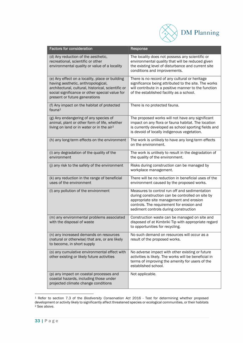
11.1 Clause 228 Consideration
Clause 228 of the Environmental Planning and Assessment Regulation 2000 (EP&A
Regulation) details factors which must be taken into account when assessing the
impact of an activity on the environment.
Table 1 below lists the factors requiring consideration under clause 228. A more
detailed analysis of environmental impacts are contained in section 10 and
mitigation measures are contained in section 12 of this REF.
Factors for consideration Response
(a) Any environmental impact on a
community
Construction impacts can be controlled by
workplace and construction site management. The
spatial separation of the proposal from
neighbouring dwellings and the main school
buildings indicates the works can be undertaken
with little impact or disruption to the amenity of the
neighbourhood or the function of the school.
The following planning principles provided in
Appendix C of the Code have been addressed in
Section 11.2 below:
• context
• built form
• adaptive learning spaces
• sustainability
• landscape
• amenity
• health and safety
(b) Any transformation of a locality The works provide for ancillary additions to the
established school facility within the school
grounds. The proposed development will not
transform the character of the locality given the
nature of the works.
(c) Any environmental impact on the
ecosystem of the locality
Nil
33 | P a g e
Factors for consideration Response
(d) Any reduction of the aesthetic,
recreational, scientific or other
environmental quality or value of a locality
The locality does not possess any scientific or
environmental quality that will be reduced given
the existing level of disturbance and current site
conditions and improvements.
(e) Any effect on a locality, place or building
having aesthetic, anthropological,
architectural, cultural, historical, scientific or
social significance or other special value for
present or future generations
There is no record of any cultural or heritage
significance being attributed to the site. The works
will contribute in a positive manner to the function
of the established facility as a school.
(f) Any impact on the habitat of protected
fauna1
There is no protected fauna.
(g) Any endangering of any species of
animal, plant or other form of life, whether
living on land or in water or in the air2
The proposed works will not have any significant
impact on any flora or fauna habitat. The location
is currently developed as school sporting fields and
is devoid of locally indigenous vegetation.
(h) any long-term effects on the environment The work is unlikely to have any long-term effects
on the environment.
(i) any degradation of the quality of the
environment
The work is unlikely to result in the degradation of
the quality of the environment.
(j) any risk to the safety of the environment Risks during construction can be managed by
workplace management.
(k) any reduction in the range of beneficial
uses of the environment
There will be no reduction in beneficial uses of the
environment caused by the proposed works.
(l) any pollution of the environment Measures to control run off and sedimentation
during construction can be controlled on site by
appropriate site management and erosion
controls. The requirement for erosion and
sediment controls during construction
(m) any environmental problems associated
with the disposal of waste
Construction waste can be managed on site and
disposed of at Kimbriki Tip with appropriate regard
to opportunities for recycling.
(n) any increased demands on resources
(natural or otherwise) that are, or are likely
to become, in short supply
No such demand on resources will occur as a
result of the proposed works.
(o) any cumulative environmental effect with
other existing or likely future activities
No adverse impact with other existing or future
activities is likely. The works will be beneficial in
terms of improving the amenity for users of the
established school.
(p) any impact on coastal processes and
coastal hazards, including those under
projected climate change conditions
Not applicable.
1 Refer to section 7.3 of the Biodiversity Conservation Act 2016 - Test for determining whether proposed
development or activity likely to significantly affect threatened species or ecological communities, or their habitats 2 See above.

34 | P a g e
Factors for consideration Response
(q) other factors/ impacts. None
Table 2. Factors for consideration under Clause 228 of the EP&A Regulation 2000
It is concluded that the factors for consideration in clause 228 of the EP&A
Regulation are satisfactorily addressed.
11.2 Education SEPP Planning Principles
The proposal has been designed to address the seven Planning Principles provided
in Appendix C of the Code to guide RNSs in their assessment of new school
development.
The table below demonstrates how the proposed development is consistent with
these Planning Principles.
ESEPP Planning Principles Proposal Consistent
Principle 1—context, built form and landscape
Schools should be designed to respond to and
enhance the positive qualities of their setting,
landscape and heritage, including Aboriginal
cultural heritage. The design and spatial
organisation of buildings and the spaces
between them should be informed by site
conditions such as topography, orientation and
climate.
Landscape should be integrated into the design
of school developments to enhance on-site
amenity, contribute to the streetscape and
mitigate negative impacts on neighbouring sites.
The proposed carpark has been
designed to integrate into the
layout of the existing school site.
It is located on a relatively flat
area currently occupied by a
sports field.
A comprehensive landscaping
scheme accompanies the
proposal which includes
additional screen planting to
assist in integrating the building
into the surround landscape.
Yes
Principle 2—sustainable, efficient and durable
Good design combines positive environmental,
social and economic outcomes. Schools and
school buildings should be designed to minimise
the consumption of energy, water and natural
resources and reduce waste and encourage
recycling.
Schools should be designed to be durable,
resilient, and adaptable, enabling them to evolve
over time to meet future requirements.
OFGS is commitment to
ecologically sustainable design.
The proposed carpark has been
designed to incorporate a
number of energy efficiency and
sustainability initiatives. These
are outlined in the report
prepared by JHA Services
(Appendix 17)
Yes

35 | P a g e
Principle 3—accessible and inclusive
School buildings and their grounds should
provide good wayfinding and be welcoming,
accessible and inclusive to people with differing
needs and capabilities. Schools should actively
seek opportunities for their facilities to be
shared with the community and cater for
activities outside of school hours.
The proposed carpark has been
inclusively designed to provide
safe and equal access for all.
Yes
Principle 4—health and safety
Good school development optimises health,
safety and security within its boundaries and the
surrounding public domain, and balances this
with the need to create a welcoming and
accessible environment.
The proposed carpark will
increase the range of facilities
available for students.
Crime Prevention Through
Environmental Design measures
will be incorporated into the
design and management of the
School to ensure a high level of
safety and security is upheld for
students and staff.
Yes
Principle 5—amenity
Schools should provide pleasant and engaging
spaces that are accessible for a wide range of
educational, informal and community activities,
while also considering the amenity of adjacent
development and the local neighbourhood.
Schools should include appropriate, efficient,
stage and age appropriate indoor and outdoor
learning and play spaces, access to sunlight,
natural ventilation, outlook, visual and acoustic
privacy, storage and service areas.
The proposed carpark represents
a state-of-the-art facility that
provides ancillary support
services.
The proposed design and colour
scheme will allow access to
sunlight and natural ventilation.
Numerous storage areas and
amenities have been included in
the design.
Yes
Principle 6—whole of life, flexible and adaptive
School design should consider future needs and
take a whole-of-life-cycle approach underpinned
by site wide strategic and spatial planning. Good
design for schools should deliver high
environmental performance, ease of adaptation
and maximise multi-use facilities.
The proposed carpark represents
a large, open plan building
providing flexibility and capability
for adaptation to cater for
various school uses.
Yes
Principle 7—aesthetics
School buildings and their landscape setting
should be aesthetically pleasing by achieving a
built form that has good proportions and a
balanced composition of elements. Schools
should respond to positive elements from the
site and surrounding neighbourhood and have a
The proposed carpark has been
designed by award winning
architects Alan Jack + Cottier.
An external colour palette,
consistent with the natural
Yes

36 | P a g e
positive impact on the quality and character of a
neighbourhood.
The built form should respond to the existing or
desired future context, particularly, positive
elements from the site and surrounding
neighbourhood, and have a positive impact on
the quality and sense of identity of the
neighbourhood.
environment, will be utilised in
order to integrate the proposal
into the surrounding landscape.
The built form is consistent with
the existing school campus and
will have a positive impact on the
surrounding neighbourhood.
Table 3. Education SEPP Planning Principles

37 | P a g e
11.3 Detailed Environmental Considerations
The following environmental considerations have been considered in more detail as
part of the assessment process:
• Potential Contamination
• Tree Removal
• Bushfire Protection Assessment
• Flood potential
• Biodiversity
• Heritage
• Traffic and parking impacts
11.3.1 Contamination
A Preliminary Site Investigation (PSI) prepared by Martens consulting engineers, has
been undertaken for the proposed development (Appendix 6).
The primary purpose of the PSI is to identify past or present potentially
contaminating activities at the site, identify the potential for site contamination and
assess the need for further investigation.
The PSI includes consideration of the following previous site assessments:
• A Stage 1 Environmental Site Assessment prepared by JK Environmental (report
reference E30807Brpt Rev2) for a proposed kiosk in the southwest portion of the
school site [November 2019] (JK, 2019).
• A geotechnical investigation prepared by JK Geotechnics for the proposed facility,
car park and playing field in the southern portion of the site [October 2017] (JK,
2017).
• A waste classification assessment and soil suitability analysis prepared by
Environmental Investigation Services (EIS) undertaken for the playing field in the
southwest portion of the site (November 2017). The testing undertaken as part
of the EIS (2017). The results and finding of this assessment are provide at
Attachment C to the Martens report.
The Martens PSI report identifies the following areas of environmental concern
(AEC) and contaminants of potential concern (COPC):
Table 4. Areas of Environmental concern and contaminants of potential concern

38 | P a g e
A review of aerial photographs reveals that the investigation area (IA) was cleared
prior to 1956, and a large shed constructed between 1961 and 1965. The large
shed was demolished between 1982 and 1991, and the current site conditions
were constructed between 1991 and 2005.
The PSI summarises the potential sources of contamination as:
• The entire IA which appears to be filled to level the sports field.
• Former shed which occupied a small eastern portion within the IA.
The subsurface soil investigation by JK (2017) indicated fill was observed up to 2.5
mbgl (BH4) and alluvium up to 5.5 mbgl (BH4).
The EIS (2017) documented a waste classification and soil suitability analysis which
covered the entire IA and preliminary AEC noted in the PSI. Samples were sent to a
laboratory and assessed against COPC.
Soil analysis indicated all samples to be below ASC NEPM (2013) Residential A
guidelines. In light of this, the fill across the entire IA and former shed AEC is not
considered to pose a risk of contamination and does not require further
investigation.
Based on the analysis of previous soil analysis which indicated that all samples to
be below residential guidelines, the fill across the entire IA and former shed AEC is
not considered to pose a risk of contamination and does not require further
investigation.
The PSI report concludes that the IA has a low risk of contamination and is suitable
for the development. The report notes, however, that;
“past filling undertaken from unknown sources still has a risk of
contamination. This risk should be managed by implementing an
appropriately prepared unexpected finds protocol. This document should be
made available to all contractors working on the site and included as part
of the site induction process.”
The PSI report recommends the following:
“An unexpected finds protocol is to be prepared prior to works commencing
on the site. If any unexpected finds (such as fibro material, odours or soil
staining) are encountered during site works, the unexpected find will
require assessment by MA to determine requirements for additional
investigation and / or remedial action.
If any soil material is removed from site, a formal waste classification
assessment shall be required in accordance with the NSW EPA Waste
Classification Guidelines (2014).”

39 | P a g e
The requirement for an unexpected finds protocol and formal waste classification
will form conditions of determination and are listed in section 13.
11.3.2 Tree Removal
An Arboricultural Impact Assessment (AIA), prepared by Tree Report, dated
15.03.2021, has been prepared in support of the proposal (Appendix 7).
The report notes that there are three trees, all Ficus rubiginosa also known as a
Port Jackson Fig (identified as trees 1-3), that will be affected by the proposed
development.
These trees are located wholly within the development footprint, cannot be
successfully retained and are therefore recommended for removal.
The AIA report recommends:
Offset replacement planting to compensate for the loss of trees as part of
this development should be such, that a net increase of canopy cover is
ascertained within a 5-year time period. Species selection should be in co-
ordination with Northern Beaches Council and consist of tree species which
are endemic to the local area and suited to the size of the area of which
they are planted.
This recommendation will form a condition of determination and is listed in section
13.
11.3.3 Bushfire Protection Assessment
The majority of the OFGS site is classified as Bushfire Prone Land (category:
Vegetation Buffer) on the Northern Beaches Council Bush Fire Prone Land (BFPL)
map as shown in Figure 16 below.
Figure 17. Warringah Bush Fire Prone Land Map excerpt (source: Northern Beaches Council)

40 | P a g e
A Bushfire Protection Assessment, by Building Code and Bushfire Hazard Solutions,
has been prepared in support of the proposed carpark (Appendix 8).
The vegetation identified as being the hazard is to the east of the proposed works
within vegetated private allotments and west of the subject site within Wakehurst
Parkway road reserve.
Northern Beaches Council’s Bushfire Prone Land Map identifies the subject
property as containing the 100-metre buffer zone from Category 1 Vegetation
therefore the application of Planning for Bush Fire Protection - 2019 (PBP) must
apply in this instance.
The report concludes:
Given that the property is deemed bushfire prone under Northern Beaches
Council’s Bushfire Prone Land Map any development would need to meet
the requirements of Planning for Bush Fire Protection – 2019 and of the
construction requirements of Australian Standard 3959 – 2018. The
determination of any bushfire hazard must be made on a site-specific basis
that includes an assessment of the local bushland area and its possible
impact to the subject property.
The development proposal relates to new building works within an existing
educational establishment known as Oxford Falls Grammar School. The
proposed works include the construction of a new carpark.
The vegetation identified as being the hazard is to the north within the
vegetated allotment (>200m), east within a private allotment and west of
the subject site within Wakehurst Parkway road reserve. The vegetation
posing a hazard to the east and west was determined to be Remnant.
The minimum required Asset Protection Zones for new SFPP development
were determined to be 38 metres to the east (close), 67 metres to the east
(far) and 47 metres to the west. The closest point of the proposed building
was found to be located 60 metres from the hazard to the east (close) and
west and >100 metres from any other hazard.
The proposed building works therefore exceed the minimum required Asset
Protection Zones for new Special Fire Protection Purpose development to all
aspects.
The highest Bushfire Attack Level to the proposed building works was
determined from Table A1.12.1 of PBP 19 to be ‘BAL 12.5’. The proposed
building works are required to comply with section 3 and BAL 12.5 section
5 under AS 3959 – 2018 and section 7.5 of PBP.
In accordance with the bushfire safety measures contained in this report,
and consideration of the site specific bushfire risk assessment it is our
opinion that when combined, they will provide a reasonable and
satisfactory level of bushfire protection to the subject development.

41 | P a g e
The report recommends conditions to ensure compliance with Planning for Bush
Fire Protection – 2019 and Australian Standard 3959 – 2018 ‘Construction of
buildings in bushfire-prone areas’. Additional recommendations are provided to
supplement these minimum requirements where considered necessary.
These additional requirements address landscaping, construction, bushfire
emergency management and water supply. They are listed as conditions of
determination in section 13 of this REF.
11.3.4 Traffic and carpark design
A Traffic Impact Assessment (TIA), prepared by Traffix, has been prepared in
support of the proposal (Appendix 10).
The proposal utilises the existing vehicular crossing in Dreadnought Road as the
access point to the proposed carpark.
The TIA notes that the site is ideally located within the main arterial road serving the
region, being the Wakehurst Parkway via Dreadnought Rd. In addition, Oxford Falls
Rd provides alternate route to the residential catchment in the south. As such,
traffic is able to be distributed effectively, thereby reducing traffic impacts.
The school currently provides 128 off-street carparking spaces comprising of;
• Eastern car park: 56 car parking spaces
• Northern car park: 72 car parking spaces
The TIA concludes that the additional 84 spaces proposed will result in a total of
212 on-site car parking spaces. As student and staff numbers remain unchanged,
this net increase in parking will provide opportunity to accommodate higher peak
demands more effectively and safely within the site. This is clearly a public benefit.:
The proposal will result in a redistribution of existing traffic movements associated
with 84 staff carparking spaces proposed at a new car park on Dreadnought Rd.
The TIA states this redistribution is acceptable for the following reasons:
The proposed development provides an additional 84 staff car parking
spaces, including a single accessible parking space at a new ground level
carpark off Dreadnought Road. These additional car parking spaces are
envisaged to better accommodate the current parking demands of the
school and in turn, provide a greater public benefit by increasing the
availability of on-street parking in the locality.
The proposal is anticipated to result in negligible traffic generation, given no
increase to staff and student numbers, with existing traffic being re-
distributed onto Dreadnought Road. This re-distribution is considered
acceptable given the various benefits as discussed.
The proposal is envisaged to have negligible impacts on the surrounding
road network, given the traffic generating potential of the school will be
unchanged. The traffic impacts of the proposed access on Dreadnought

42 | P a g e
Road has been conservatively assessed using SIDRA 8 intersection
modelling, resulting in a level of service ‘A’ during both the morning and
evening peak periods. As such, the proposal is anticipated to have
negligible traffic impacts, with no external improvements required.
The proposed development will enhance the safety and efficiency of the
school environment generally, with no adverse traffic planning impacts.
In summary, the TIA demonstrates that the development is supportable on traffic
planning grounds.
11.3.5 Flood levels
A Flood Statement, prepared by Taylor Thomson Whitting (NSW) Pty Ltd, has been
prepared in support of the proposal (Appendix 12).
The site falls within the Narrabeen Lagoon Flood Study (September 2013) produced
by BMT WBM. A copy of the flood model was obtained from Council. Unfortunately,
it was not possible to run the model due to various problems as explained in the
paragraph below taken from the report:
“it was not possible to run the model due to use of a MORPH module, which
is not commercially available, and numerous run errors. It was possible to
interrogate the results file which highlighted an anomaly in water levels
upstream of the Dreadnought Road culvert (refer Figure 3). This artificially
raised water levels diverting flow over the school sports field. It should be
noted that the online mapping tool for determining the Flood Risk Precinct,
available on the Northern Beaches Council website Planning Controls page,
is based on the Council flood model. Due to the water level error in the
model a site-specific flood model has been developed for the site to
determine flood planning levels.”
The site-specific flood study shows the development is within the Low Flood Risk
Precinct, with the exception of a portion of the stairs in the south east corner which
is within Medium Flood Risk Precinct. The Low Flood Risk Precinct is all flood prone
land (i.e., below the PMF) that is above the 1% AEP. The western side of the stairs
protrudes into the 1% AEP flood extents but is not subject to a high hydraulic
hazard, so is classified as a Medium Flood Risk Precinct. As the development is in
more than one precinct the controls for the Medium Flood Risk Precinct have been
adopted.
As an educational establishment the proposed Oxford Falls Grammar School
development falls under the ‘vulnerable uses’ land use category.
The Flood Statement concludes:
The proposed development has been assessed through the development of a site-
specific flood model. Below are the key recommendations that have been
incorporated into the design to ensure the flood criteria has been met:

43 | P a g e
• Habitable floor areas have been located on Level 1 (FFL 78.35m) above the PMF
in the proposed design;
• Non-habitable floor areas on ground level (74.75m) have been located above the
Flood Planning Level in the proposed design;
• There no adverse impact on flood levels including downstream and upstream
properties in the 1% AEP event; and
• ‘Shelter in place’ flood evacuation routes are provided to Level 1 above the PMF
and access to the adjacent school buildings is available via the second level
pedestrian bridge.
11.3.6 Biodiversity
A Biodiversity Assessment, prepared by Niche Environment and Heritage, dated 11
March 2021, has been prepared in support of the proposal (Appendix 11).
The assessment is based on field studies and includes a review of the biodiversity
constraints of the study area and an assessment of the impacts of the project on
threatened biodiversity. The survey involved identification of tree species and size,
vegetation condition, and presence and relative abundance of key habitat features
(e.g. tree hollows, nests and flowering resources).
The assessment finds that the proposed carpark is not likely to significantly affect
threatened species, populations, ecological communities or their habitats, and
therefore an SIS is not required.
Key results are:
Vegetation within the subject site consisted of five planted native trees and
an area of lawn. Trees consisted of five Port Jackson Figs (Ficus rubiginosa).
All five trees surveyed are greater than 5 m in height. The trees to be
removed are labelled 1 to 5 (Tree Report 2019, Figure 2).
No key habitat features such as hollows or nests were recorded during the
survey. No evidence of threatened species (such as flying fox scats) was
recorded within the subject site. The trees to be removed are unlikely to
produce large quantities of fruit or flowers. As such, the tree is considered
unlikely to provide important habitat for threatened species, such as
roosting or significant foraging habitat for Greyheaded Flying-foxes.
While the subject area was considered to provide potential habitat for a
number of threatened fauna, most of these would use such habitat rarely
and would not be reliant upon it for survival or important breeding habitat.
The waterway and riparian zone is a highly modified 1st order stream with
revegetated banks consisting of exotic and planted native species. The
channel is small with steep banks and a narrow Vegetated Riparian Zone
which is constrained by existing infrastructure. There is no significant
erosion or sedimentation present in the channel or banks.

44 | P a g e
The report concludes that the proposed development will result in the removal of
approximately 0.2 ha of vegetation (five trees and adjoining sporting field) within
OFGS. Additional potential impacts to the ecology, waterway and riparian zone are
likely to be negligible provided management of impacts are consistent with
recommendations outlined in the report.
The report makes recommendations to mitigate impacts which are listed as
conditions of determination in section 13.
11.3.7 Aboriginal heritage
An Aboriginal Objects Due Diligence Assessment, prepared by Niche Environment
and Heritage, dated 15 March 2021, has been prepared in support of the proposal
(Appendix 13).
The report concludes:
On the basis of this assessment, it is unlikely that Aboriginal objects have survived
within the Subject Area due to ground disturbances associated with de-vegetation,
landscaping, maintenance, the construction of buildings associated with OFGS and
decades of heavy pedestrian impact. No Aboriginal heritage constraints were
identified for the proposed works and no further investigation or impact
assessment is required.
The proposed activity may therefore proceed with caution without a further
Aboriginal Cultural Heritage Assessment (ACHA) or AHIP.
The report recommends the following Find Procedure should be put in place as a
minimum response in the unlikely event of the identification of artefacts within the
Subject Area:
• All site workers and contractors should be inducted to the area and informed
of their obligations under the National Parks and Wildlife Act 1974.
• In the unlikely event that any Aboriginal objects are found and cannot be
avoided, all activities with the potential to impact the objects must stop. A
temporary fence is to be erected around the Aboriginal cultural heritage site,
with a buffer zone of at least 10 metres around the known edge of the
Aboriginal cultural heritage site. An appropriately qualified archaeologist is
to be engaged to assess the findings, and notification is provided to the BCD.
Should the material be confirmed as an Aboriginal object or archaeological
site, Facilitate, in cooperation with the appropriate authorities and the local
Aboriginal community:
o The recording and assessment of the finds.
o Compliance with any legal requirements and BCD directions.
o The development and implementation of appropriate management
strategies based on an assessment of significance of the finds.
o Recommencement of ground disturbance works may only resume
once legal requirements are fulfilled. An Aboriginal Heritage Impact
Permit will be required.

45 | P a g e
• In the unlikely event that suspected human remains are encountered during
construction, all work in the area that may cause further impact, must cease
immediately and:
o The location, including a 20 m curtilage, should be secured using
barrier fencing to avoid further harm.
o The NSW Police must be contacted immediately.
o No further action is to be undertaken until the NSW Police provide
written notification to EPM Projects.
o If the skeletal remains are identified as Aboriginal, EPM Projects or
their agent must contact: The Biodiversity and Conservation Division
((BCD), of the DPIE, previously known as the Office of Environment
and Heritage (OEH)) Enviroline on 131 555; and Representatives of
the Registered Aboriginal Parties (RAPs).
o No works are to continue until the BCD provides written notification
to the proponent or their Agent.
These recommendations will form conditions of determination and are listed as in
section 13.
11.3.8 European Heritage
A Preliminary Historical Heritage Assessment (PHHA), prepared by Niche
Environment and Heritage, dated 15 March 2021, has been prepared in support of
the proposal (Appendix 14).
There are no items of heritage significance identified within the subject area. As
previously noted in section 8 of this REF, an item of local heritage significance listed
under the Warringah LEP 2011 has been identified within the vicinity of the subject
area.
This heritage item is the Oxford Falls Public School (now known as the Oxford Falls
Peace Park). It was built between 1926 and 1950 and is a single storey school
building of timber weatherboards with gabled corrugated metal roof and brick
chimney in front gable. There is a verandah along its northern side enclosed by fibro
and glazing. Brick piers and a skillion roofed have been added on the eastern side
in the late 1940s.
The school is a representative small inter-war school building. It displays high
integrity with much original fabric. It historically provides evidence of the extent of
development in the inter-war period and was also the last single teacher school in
Sydney when it closed.
The PHHA concludes that the proposal will not directly impact any known items of
heritage significance. This is based on the following considerations:
An item of local heritage significance listed under the Warringah LEP 2011
has been identified within the vicinity of the Activity Area (see Figure 3). The
proposed works are located 50m diagonally to the north-east of the Peace
Park containing this item. This evaluation has concluded that the use,

46 | P a g e
fabric, or archaeological potential of the OFPS is will not be impacted as a
result of the proposed works.
This PHHA has identified that the proposed works would cause a non-
significant visual impact to the OFPS Item #I116. This impact encompasses
the introduction of a new structure’s façade into the periphery of the Peace
Park’s visual catchment and the temporary visual disruption caused by
construction. However, these non-significant impacts can be mitigated with
the various circumstances and measures discussed in Table 4.
The PHHA makes the following recommendations:
1. During construction, and machinery, material and related infrastructure be
placed as far away as possible from the OFPS (ID #I116 – currently a Peace
Park), and that, through consultation with the Peace Park’s administration,
consideration be given to important dates where this site will be in use.
2. That the design of the carpark’s façade, landscaping measures and the colours
used are chosen to complement the existing natural features of the site,
especially as viewed from the Peace Park, towards the ridgeline behind. In
addition, that consideration be given to replacing the existing chain-link fencing
with another, less intrusive fencing type to further integrate the new structure
with its surrounds.
3. In the unlikely event that historical archaeological remains are discovered, works
must cease, and specialist services of Heritage NSW must be informed
immediately. A qualified archaeologist should be engaged to assess the remains
by means of the unexpected finds procedure, in consultation with Heritage NSW.
These recommendations will form conditions of determination and are listed in
section 13.

47 | P a g e
11.4 Other Considerations
11.4.1 Geotechnical Investigation
A Geotechnical Investigation report, prepared by JK Geotechnics, dated 17 March
2021, has been prepared in support of the proposal (Appendix 15). This report
presents the results of a geotechnical investigation comprised of auger drilling 21
boreholes on the development site.
The report notes that the proposal involves the following associated earthworks:
• Minor cut and fill works to achieve the required bulk excavation level.
Approximately 0.6m of cut and 0.4m of fill is proposed over the building footprint.
• Excavation for a proposed stormwater tank will occur in the north-west corner of
the site resulting in excavations approximately 2m deep.
The report makes comments and recommendation regarding excavation, retention,
earthworks, footings, pavements, soil aggression and the stability of the creek
bank. The Geotechnical Investigation report will form part of the determination
documents.
The report considers that as part of the detailed design stages of the proposed
development, the following additional geotechnical investigation will be required
after the initial structural design has been completed:
• Review of this report once structural drawings are available.
• Completion of proof rolling of the subgrade in the presence of an experienced
geotechnical engineer or geotechnician where engineered fill or pavements are
to be placed.
• Earthworks testing to confirm that the earthworks specification is complied with.
• Inspections during piling to provide greater confidence that the piles are founded
on the appropriate materials.
These recommendations will form a condition of determination and is listed in
section 13.
11.4.2 Stormwater and erosion and sedimentation controls
A Civil Engineering report, prepared by Taylor Thomson Whitting, dated 11 March
2021, has been prepared in support of the proposal (Appendix 9). The report
concludes:
• Provision of 40m3 of OSD to limit stormwater flows from the site to the pre-
development scenario up to the 1 in 20 year ARI;
• Installation of a 250m3 rainwater tank and Gross Pollutant Trap to treat
stormwater prior to discharge to the natural watercourse within the site;
• Erosion and sediment controls proposed during construction works to
prevent sediment laden stormwater from leaving the site; and
• Minor works within the Riparian Zone to be submitted to and approved by
Department of Primary Industries.

48 | P a g e
These recommendations will form conditions of determination and are listed in
section 13.
11.4.3 Visual impacts
The proposed development has been designed by award winning architects Alan
Jack + Cottier will have a positive visual impact on the character of the area..
The resulting development will be an appropriately located carpark for staff and
students and ancillary functions. Internally, space is practical, well-lit and easy to
navigate.
Externally, a colour palette, consistent with the natural environment, will be utilised
in order to integrate the proposal into the surrounding landscape.
Figure 18. Perspective of carpark from sports field (source: AJ&C Architects)
As seen in Figure 18 above, the proposal has a low profile design that integrates
well with the existing school campus and broader locality.
Visual and amenity impacts are addressed in further detail in the analysis of the
proposal against the ESEPP planning principles in section 11.2.
11.4.4 Energy Efficiency and Sustainability
An Energy Efficiency and Sustainability report, prepared by JHA Services dated 17
March 2021, has been prepared in support of the proposal (Appendix 17). The
report states:
“JHA recommends the following sustainability strategies for the proposed
school building development at Oxford Falls, NSW 2100 to achieve
improved energy efficiency and a more sustainable outcome.”

49 | P a g e
The strategies relate to environmental factors (water and energy), economy and
society and are reproduced below:
Table 5. Recommended sustainability strategies (source: JHA Services)
The Sustainability report will form part of the approved determination documents.
11.5 Construction impacts
A Construction Management Plan (CMP) has been prepared by EPM Projects, dated
11 March 2021, in support of the proposal. The report addresses the following key
construction matters:
• Noise and Dust
• Traffic Management
• Avoiding land use conflicts
• Waste Management
• Traffic Management

50 | P a g e
• Complaint Management
• Work Health Safety (WHS)
The CMP concludes:
An effective implemented CMP will safeguard that works are completed with
efficiency, in a timely order and safely. Minimal disruption will occur to both the
general public and the school’s operations. It will be the responsibility of the
engaged contractor/s to develop and maintain the necessary reporting to address
and monitor the abovementioned matters.
The CMP is contained at Appendix 16 and will form part of the determination
documentations.
11.5.1 Construction Traffic
A site-specific Traffic Management Plan (TMP) will be developed and monitored by
the engaged Contractor. The TMP will be in place prior to the commencement of any
construction works. The objective of the TMP is to ensure the safety of all workers,
road users and pedestrians within the proximity of the construction site. The
following are the primary objectives:
• To minimise the impact of the construction vehicular traffic, directly and
indirectly, on local roadways.
• To promote continuous, safe and efficient movement of traffic (Vehicular and
pedestrian) for both the general public, school staff and students, and
construction workers.
• Establishment of a safe pedestrian environment in the vicinity of the site.
• Vehicle access will remain in a safe and coordinated manner.
• The contractor is to obey road laws at all times.
• The Contractor is to establish a site perimeter fence with lockable vehicle
access along the existing driveway crossing / entry.
• If required, establishing cranage in appropriate and safe locations. The
Contractor will be responsible to implement and monitor relevant safe work
procedures.
Final details of traffic movement, which take into consideration all relevant safety
considerations, will be drafted and finalised by the Contractor prior to
construction.

51 | P a g e
12 Summary of Impacts
The proposed works are within the OFGS site and includes a carpark that will have
minimal impact on the environment.
Potential impacts assessed in this REF are:
• Contamination
• Biodiversity
• Bushfire
• Tree loss
• Impact on creek
• Visual impact on adjoining heritage items
• Possible discovery of aboriginal items
• Flood liable land
• Stormwater, sedimentation and erosion control
• Traffic and carparking
• Construction
This REF has examined and taken into account to the fullest extent possible all
matters affecting or likely to affect the environment as a result of the activity, as
listed above and has found that there are no unacceptable or unreasonable
impacts.
Potential contamination is found to be low risk. In the event that issues arise
during construction, mitigation measures have been included as conditions of
determination.
There is no threat to biodiversity.
Bushfire risks have been addressed by the use of appropriate construction
materials.
There is no loss of indigenous or significant trees. Replacement trees have been
incorporated into the landscape plan as well as being a requirement of
determination.
The Biodiversity Assessment has examined the potential impacts on the creek,
including the pedestrian bridge, and has found that there will be no unacceptable
impacts.
The spatial separation of the proposed development along with the sensitive design
will ensure no unacceptable visual impacts on the nearby heritage item at Peace
Park.
Flood modelling has been undertaken to determine appropriate flood levels and
design.
The Civil Engineering Statement recommends appropriate stormwater,
sedimentation, and erosion controls during construction.

52 | P a g e
Given the additional on-site parking provided as a result of the proposal, with no
additional traffic generated, the proposal will result in a net public benefit by
reducing parking in the surrounding street network.
A CMP has been prepared to minimise disruptions and amenity impacts on the
existing school functions and surrounding area, during construction.
Potential environmental impacts will be mitigated by the measures recommended
throughout this REF and listed as recommended conditions of determination in
Section 13 below.

53 | P a g e
13 Mitigating measures, modifications or adaptions
In order to mitigate any environmental impacts resulting from the proposal the
following conditions of determination are recommended:
CONDITIONS:
Approved Plans and documentation
1. The development shall take place in generally in accordance with the following plans
and documents, except as amended to comply with the conditions of this
determination:
Drawing Number Date Prepared By
Site Survey (11 sheets) 02.02.2020 Rygate Surveyors
REF101, Site Plan 02.03.2021 Allen Jack + Cottier
REF201, Ground level plan 02.03.2021 Allen Jack + Cottier
REF202, Level 1 Plan 02.03.2021 Allen Jack + Cottier
REF203, Roof Plan 02.03.2021 Allen Jack + Cottier
REF311, Elevations, sheet 1 02.03.2021 Allen Jack + Cottier
REF312, Elevations, sheet 2 02.03.2021 Allen Jack + Cottier
REF321, Sections 02.03.2021 Allen Jack + Cottier
REF401, Shadow Diagrams 02.03.2021 Allen Jack + Cottier
REF601, Perspective view 1 02.03.2021 Allen Jack + Cottier
REF601, Perspective view 2 02.03.2021 Allen Jack + Cottier
REF601, Perspective view 3 02.03.2021 Allen Jack + Cottier
Landscape Plan 3546-LD-G01 05.05.2020 Environmental
Partnership
Landscape Plan 3546-LD-G02 05.05.2020 Environmental
Partnership
Landscape Plan 3546-LD-G03 05.05.2020 Environmental
Partnership
Landscape Plan 3546-LD-PP02 05.05.2020 Environmental
Partnership
Landscape Plan 3546-LD-PP03 05.05.2020 Environmental
Partnership
Document Title Date Prepared by
Preliminary Site Investigation 17.03.2021 Martens consulting
engineer

54 | P a g e
Arboricultural Impact Assessment 15.03.2021 Tree Report
Bushfire Assessment Report 16.03.2021 Building Code and
Bushfire Hazard
Solutions Pty Ltd
Traffic Impact Assessment 17.03.2021 Traffix
Flood Statement 12.03.2021 Taylor Thompson Whitting
Civil Engineering Statement 11.03.2021 Taylor Thomson Whitting
Geotechnical Investigation 17.03.2021 JK Geotechnics
Biodiversity Assessment 12.03.2021 Niche Environment and
Heritage
Aboriginal Due Diligence Assessment 15.03.2021 Niche Environment and
Heritage
Preliminary Historical Heritage
Assessment
15.03.2021 Niche Environment and
Heritage
Construction Management Plan 11.03.2021 EPM Projects Pty Ltd
Sustainability Services 17.03.2021 JHA Services
Prior to construction – Civil engineering
1. Detailed civil engineering drawings are to be prepared and submitted to the
determining authority, detailing the following:
• Provision of 40m3 of OSD to limit stormwater flows from the site to the pre-
development scenario up to the 1 in 20 year ARI;
• Installation of a 250m3 rainwater tank and Gross Pollutant Trap to treat
stormwater prior to discharge to the natural watercourse within the site;
• Erosion and sediment controls to be installed during construction works to
prevent sediment laden stormwater from leaving the site; and
• Minor works within the Riparian Zone to be submitted to and approved by
Department of Primary Industries.
Prior to construction –Geotechnical Investigation review
2. In order to confirm that the recommendations contained in the Geotechnical
Investigation report, dated 17 March 2021, prepared by JK Geotechnics, are
correct, the report and its recommendations are to be reviewed after the initial
structural design has been completed. The revised report is to be submitted to the
determining authority.

55 | P a g e
Prior to construction – Further Geotechnical Investigation
3. As part of the detailed design stage of the proposed development, the following
additional geotechnical investigation and input will be required:
• Completion of proof rolling of the subgrade in the presence of an experienced
geotechnical engineer or geotechnician where engineered fill or pavements
are to be placed.
• Earthworks testing to confirm that the earthworks specification is complied
with.
• Inspections during piling to provide greater confidence that the piles are
founded on the appropriate materials.
Prior to construction – Unexpected finds protocol
4. In order to mitigate potential risks from past landfilling, undertaken from unknown
sources, an appropriately prepared Unexpected Finds Protocol (UFP) should be
prepared and implemented as per the recommendation contained in the
Preliminary Site Investigation, prepared by Martens consulting engineers, dated
March 2020. The UFP document should be made available to all contractors
working on the site and included as part of the site induction process.
Prior to Construction – Traffic Management Plan
5. In order to ensure the safety of all workers, road users and pedestrians within the
proximity of the construction site, a site-specific Traffic Management Plan is to be
developed and monitored by the engaged Contractor. This Traffic Management Plan
will be in place prior to the commencement of any construction works.
During Construction - Soil testing
6. If any soil material is removed from site, a formal waste classification assessment
shall be required in accordance with the NSW EPA Waste Classification Guidelines
(2014).
During Construction - Tree replacement
7. In order to offset the trees be removed, replacement trees are to be planted
elsewhere on the site. Species selection should be consistent with the typical
requirements of Northern Beaches Council and consist of a tree species which is
endemic to the local area and suited to the size of the area in which it is planted.
During Construction - Biodiversity
8. Vegetation clearing is to be restricted to the 0.2ha of native vegetation occurring
within the development footprint. Surrounding trees and bushland areas are not to

56 | P a g e
be impacted as part of proposed works. See arborist report (Tree Report 2021) and
Site Plan (AJ+C 2021) for detailed descriptions of works to be undertaken.
9. No vegetation is to be cleared from the Vegetated Riparian Zone.
10. If unexpected, threatened fauna or flora species are discovered, stop work
immediately and a qualified Ecologist should be notified to undertake further
assessment.
11. Waste materials as a result of the construction activities, other than vegetation and
tree mulch, are not to be left on site once the works have been completed.
12. To prevent the spread of weed seed, all weed material removed should be disposed
of in a suitable waste facility and not mulched on site. This is to avoid the
reintroduction and further spread of weeds in the area. Weed management should
be undertaken in accordance with Department of Primary Industries (DPI)
Biosecurity Act 2015.
o General Biosecurity Duty: All plants are regulated with a general
biosecurity duty to prevent, eliminate or minimise any biosecurity risk they
may pose. Any person who deals with any plant, who knows (or ought to
know) of any biosecurity risk, has a duty to ensure the risk is prevented,
eliminated or minimised, so far as is reasonably practicable.
Machinery should be washed following best practice hygiene protocols prior to
being brought to site to prevent the spread of weed seed, pathogens and fungi.
Hygiene protocols should be in accordance with DPI Biosecurity Act 2015.
13. If nests or other breeding structures within trees are found by the tree contractor
prior to clearing, works should not proceed until a project ecologist has been
contacted and has inspected and/or relocated any resident fauna.
14. If fauna are injured during tree felling, a project ecologist or WIRES should be
contacted immediately to tend to the injured animal. Injured fauna should be taken
to a local vet for treatment.
15. Erosion and sedimentation control measures should be implemented to limit
degradation of riparian zone and waterway. These measures are expected to be in
accordance with industry standards -Managing Urban Stormwater: Soils and
construction - Volume 1 (Landcom 2004).
Bushfire Protection
16. New landscaping is to comply with Appendix 4 ‘Asset Protection Zone
Requirements’ under Planning for Bush Fire Protection 2019.

57 | P a g e
17. The proposed development shall comply with section 5 (BAL 12.5) Australian
Standard AS3959-2018 ''Construction of buildings in bush fire-prone areas'' and
section 7.5 of Planning for Bush Fire Protection 2019.
18. The bushfire emergency / evacuation plan is to be updated consistent with the
NSW Rural Fire Service Guidelines for the Preparation of Emergency / Evacuation
Plan.
19. The new hydrant sizing, spacing and pressures must comply with AS2419.1 –
2005.
During Construction - Aboriginal Objects
20. All site workers and contractors should be inducted to the area and informed of
their obligations under the National Parks and Wildlife Act 1974.
21. In the unlikely event that any Aboriginal objects are found and cannot be avoided,
all activities with the potential to impact the objects must stop. A temporary fence is
to be erected around the Aboriginal cultural heritage site, with a buffer zone of at
least 10 metres around the known edge of the Aboriginal cultural heritage site. An
appropriately qualified archaeologist is to be engaged to assess the findings, and
notification is provided to the BCD.
22. Should the material be confirmed as an Aboriginal object or archaeological site,
Facilitate, in cooperation with the appropriate authorities and the local Aboriginal
community:
i. The recording and assessment of the finds.
ii. Compliance with any legal requirements and BCD directions.
iii. The development and implementation of appropriate management strategies
based on an assessment of significance of the finds.
iv. Recommencement of ground disturbance works may only resume once legal
requirements are fulfilled. An Aboriginal Heritage Impact Permit will be required.
23. In the unlikely event that suspected human remains are encountered during
construction, all work in the area that may cause further impact, must cease
immediately and:
i. The location, including a 20 m curtilage, should be secured using barrier fencing
to avoid further harm.
ii. The NSW Police must be contacted immediately.
iii. No further action is to be undertaken until the NSW Police provide written
notification to EPM Projects.
iv. If the skeletal remains are identified as Aboriginal, EPM Projects or their agent
must contact: OFGS or their representative.
58 | P a g e
v. No works are to continue until the BCD provides written notification to the
proponent or their Agent.
During Construction - Heritage
24. Machinery, material and related infrastructure be placed as far away as possible
from the heritage item known as the ‘Oxford Falls Peace Park’, and that, through
consultation with the Peace Park’s administration, consideration be given to
important dates where this site will be in use.
25. That the design of the carpark’s façade, landscaping measures and the colours
used are chosen to complement the existing natural features of the site, especially
as viewed from the Peace Park, towards the ridgeline behind. In addition, that
consideration be given to replacing the existing chain-link fencing with another, less
intrusive fencing type to further integrate the new structure with its surrounds.
26. In the unlikely event that historical archaeological remains are discovered, works
must cease, and specialist services of Heritage NSW must be informed
immediately. A qualified archaeologist should be engaged to assess the remains by
means of the unexpected finds procedure, in consultation with Heritage NSW.
During construction – noise
27. During the times below, noise should not be heard in a habitable room in a
neighbour's residence:
• Power tools and equipment
8pm–8am Sunday and public holidays
8pm–7am Monday –Saturday’
During construction – waste management
28. Prior to the commencement of construction, the Contractor will be responsible to
develop a Waste Management Plan for the OFGS’s review and agreement. As a
minimum the agreed Waste Management Plan will need to address:
• Legislative requirements.
• Ways in which the impact on landfill and local residents (i.e. avoiding litter) will
be minimised.
• Maximum recycling and / or reuse.
• Raise awareness among employees and subcontractors of their waste
management responsibilities.
• Provides details of the proposed waste streams.

59 | P a g e
During construction – Work Health Safety
29. The engaged Contractor are responsible for developing and managing a WHS
management plan, which will be required to consider the following as a minimum:
• Maintaining a safe working environment.
• Facilities for the welfare of all workers.
• Information, instruction, training and supervision needed to ensure that each
worker is safe from injury and risks to their health including contractors and
visitors.
• A commitment to continually improving performance through effective safety
management.
• Identify and maintenance of records necessary to ensure health and safety.
• Measurement and evaluation of our health and safety performance.
• Implements appropriate safety procedures, particularly for any large equipment,
including cranage.
Complaint Management
30. Any complaints that wish to be lodged can be done via the following:
Email: [email protected]
Phone: 1800 519 700
These complaints will be considered by relevant parties and actioned accordingly.

60 | P a g e
14 Conclusion
The assessment documented in this revised REF finds that the proposed carpark,
will not have any significant impacts on the environment or on threatened species,
populations, ecological communities or their habitats. Consequently, neither an
Environmental Impact Statement (EIS) nor a Species Impact Statement (SIS) are
required.
These conclusions are based on the detailed impact assessment documented in
the body of this REF which incorporates input from various expert consultants
(contained in Appendices 1-17).
The proposal is satisfactory when assessed against the requirements of Clause 228
of the EP&A Regulation and Section 5.5 of the EP&A Act. The carpark will improve
school amenities and make a positive contribution to the community. It is visually
sympathetic to its’ existing school setting and the broader semi-rural setting. The
proposed development will not result in any significant environmental or amenity
impacts.
The determining authority can be satisfied that this REF has been prepared in
accordance with the Code. The authorised person determining the assessment may
discharge OFGS’s duty to comply with the requirements of the Code
I, Danielle Deegan, (an agent of Oxford Falls Grammar School), certify that I have
prepared the contents of this REF and, to the best of my knowledge, it is in
accordance with the Code approved under clause 244N of the Environmental
Planning and Assessment Regulation 2000, and the information it contains is
neither false nor misleading.
Signed:
Name: Danielle Deegan
DM Planning Pty Ltd
Date: 8 April 2021

61 | P a g e
Appendix 1
Legal Advice dated 16 March 2021

62 | P a g e
Appendix 2
Last Consent issued by Council DA2016/0662

63 | P a g e
Appendix 3
Site Survey

64 | P a g e
Appendix 4
Architectural Drawings

65 | P a g e
Appendix 5
Landscape Plans

66 | P a g e
Appendix 6
Preliminary Site Investigation

67 | P a g e
Appendix 7
Arboricultural Impact Assessment and Comment

68 | P a g e
Appendix 8
Bushfire Assessment Report

69 | P a g e
Appendix 9
Civil Engineering Statement

70 | P a g e
Appendix 10
Traffic Impact Assessment

71 | P a g e
Appendix 11
Biodiversity Assessment

72 | P a g e
Appendix 12
Flood Assessment

73 | P a g e
Appendix 13
Aboriginal Objects Due Diligence

74 | P a g e
Appendix 14
Preliminary Historical Heritage Assessment

75 | P a g e
Appendix 15
Geotechnical Report

76 | P a g e
Appendix 16
Construction Management Plan

77 | P a g e
Appendix 17
Sustainability Report