review of 2007 summer floods · chairman’s foreword over 55,000 homes and businesses were flooded...
TRANSCRIPT
December 2007
Review of 2007 summer floods

We are the Environment Agency. It's our job to look after your environment and make it a better place - for you, and for future generations. Your environment is the air you breathe, the water you drink and the ground you walk on. Working with business, Government and society as a whole, we are making your environment cleaner and healthier. The Environment Agency. Out there, making your environment a better place. Published by: Environment Agency Rio House Waterside Drive, Aztec West Almondsbury, Bristol BS32 4UD Tel: 0870 8506506 Email: [email protected] www.environment-agency.gov.uk © Environment Agency All rights reserved. This document may be reproduced with prior permission of the Environment Agency.
Environment Agency Review of 2007 summer floods 1

Chairman’s Foreword Over 55,000 homes and businesses were flooded this summer as we experienced the
wettest May to July period in the last 250 years. It is important that we learn from our
experiences in this summer’s floods and act on what we learn.
Our review of the summer floods has identified what we and our partners did well and
some areas where we need to improve what we do to help people and reduce the impacts
of floods on property and the environment.
As climate change makes floods more frequent public bodies, businesses, communities,
families and individuals will all need to prepare to do their bit to respond to the threat of
floods. This year that threat has come from overwhelmed drains and sewers, our rivers
and the sea.
This summer’s floods tested our skill, adaptability and resources to the full. And we have
come through stronger and better equipped to deal with future events. I want to thank the
staff of the Environment Agency who went beyond reasonable expectations in their
commitment and effort to help the public.
We also need the help of Government to make strategic changes in how flood risk is
managed, and a long term strategy for investment in the context of a changing climate.
We need a clear co-ordinating framework to deal with flood risk from surface water drains
and sewers, which were the source of flooding for two-thirds of homes this summer. The
providers of critical public services, including electricity and water companies, need to
take their role in protecting their services from the consequences of flooding seriously.
Flood risk management is about us all doing our part.
Sir John Harman December 2007
Environment Agency Review of 2007 summer floods 2

Contents Page
Chairman’s foreword 2 Executive summary 4
1. Introduction 6
1.1 Environment Agency review 6 1.2 Government review 6
2. What happened and why? 6
2.1 Unusual weather conditions 6
2.2 Rainfall 7 2.3 River flows 7
2.4 Flood impacts 8
3. Review process 8
3.1 Introduction 8 3.2 Listening to others 8 3.3 Acting on lessons from previous reviews 9
4. Lessons identified and recommendations 9 4.1 Introduction 9 4.2 Flood risk management 10 4.3 Resilience of critical infrastructure 18 4.4 Emergency response 20 4.5 Transition to recovery 23
5. Conclusions 24
Annexe A Urban flood management and warning: a strategic approach 28 Case studies
- Tackling surface water flooding in Hull 33 - Investment and funding – a tale of two cities 37 - Impacts of flooding on Lincolnshire’s farmers 42 - Gloucestershire’s vital services under threat 46 - Reservoir safety – learning from Ulley 49 - Reducing the pressure on Sheffield’s floodplain 52
Environment Agency Review of 2007 summer floods 3

Executive summary Over 55,000 homes and businesses were flooded this summer. Many people are still facing several months away from their homes. The human impact is difficult to measure but insured losses are approaching £3 billion. Since rainfall records started to be collected in 1766 there has not been a wetter May to July period. Many locations were deluged with a month’s rainfall falling in a few hours. The wet May and early June meant that the ground was saturated and could no longer help absorb rainfall. Extreme rainfall in late June and late July caused flash flooding where it fell and then accumulated in rivers to extend the impact to the floodplain. These floods were different in scale and type from recent severe floods. In particular, a much higher proportion of the flooding than normal came from surface water rather than rivers. Surface water flooding was at its worst in cities such as Hull but many villages and individual properties also suffered across the country from Bristol to Newcastle. Two-thirds of the properties flooded this summer were affected because drains and sewers were overwhelmed. River flooding was extensive in the rivers Don, Severn and Thames and their tributaries. It would have been worse but for the protection given by our flood schemes. Effective warnings went directly to over 34,000 homes to help them cope with the floods. Some locations – notably on the river Severn between Tewkesbury and Gloucester, the Thames upstream of Oxford, and South Yorkshire suffered record breaking flood levels. Many flood defences were just overwhelmed. Over 140,000 homes in Gloucestershire lost water supplies for over a week. There was serious damage to many schools in Hull and the M1, M4, M5, M18, M40, and M50 were closed as were many railway stations and lines. The floods highlighted few new issues. What they did was bring known issues into sharper focus. We welcome the Government Review led by Sir Michael Pitt into the floods. Our review has looked at the things that went well and those where more needs to be done. It highlights three areas of policy where action is needed by Government:
Strategic overview of inland flooding
In line with the Government’s Making space for water strategy and its consultation on inland and urban flood risk management, the Environment Agency should be given a clear overview role for urban flooding from all sources which would provide the framework for local authorities and other partners to plan locally and work together to manage urban flood risk.
Critical infrastructure
Measures should be put in place to ensure that key utilities and public services take responsibility for climate change proofing critical infrastructure, facilities and services. All public authorities and private sector utilities that provide essential public services should have a duty under the forthcoming Climate Change Bill to take account of climate change impacts when providing their services.
Environment Agency Review of 2007 summer floods 4
Flood risk management investment
Future flood risk management investment needs to increase so that we can adapt to our changing climate.
It also recommends three key areas for us and our partners to act on:
Flood warning
This summer over 35,000 homes and businesses flooded from surface water for which there is no specific warning service. Our warning service on rivers was effective for the majority. But we were not able to provide 4,100 properties - mainly on rivers which reacted quickly to the rain - with warnings due to the technical limitations of flood forecasting systems. Specific warning to individual homes and properties about floods from surface water flooding is likely to be technically challenging and costly. We should examine with the Met Office what broader scale warnings about severe weather and potential floods can be provided to professional partners.
Flood event information and advice
The public, businesses including farmers, and our professional partners depend on the quality of our advice and information to make informed decisions and take action. We need to ensure that our advice, forecasts and warnings effectively trigger action by all of these groups. The extremely heavy demand on our services shows how people depend on our website (four million visits) and telephone (260,000 calls) systems. We need to ensure they offer clear, accurate and timely information which is readily accessible. We must work more closely with the media in the early stages of events
Incident response
Multi-agency incident response plans need to consider the possible impact on critical infrastructure more effectively. Our support to ‘Gold’ and ‘Silver’ control needs to be adequately skilled and resourced. We need to agree policy on temporary flood defences with our partners and consider responsibility for deploying them.
Environment Agency Review of 2007 summer floods 5

Environment Agency Review of 2007 summer floods 6
1. Introduction 1.1 Environment Agency review After major flooding events we review what happened to identify lessons and improve the way we operate. This summer’s floods were significantly larger than previous events in the last ten years. Ten times the number of properties and businesses were flooded this summer compared to Easter 1998 when Northampton and towns in the Midlands flooded, or winter 2005 when Carlisle was flooded. In winter 2000, flooding affected a wider geographical area, but the number of homes flooded was about a fifth of those affected this summer. We present our review of the summer floods in two parts:
• Our website contains facts and information on the floods. This provides over 100 pages of information. The link to our website is: www.environment-agency.gov.uk/2007summerfloods/
• This review describes the lessons identified and recommendations for action. A set of six case studies identifying strategic lessons and possible solutions accompanies the report.
1.2 Government review Sir Michael Pitt is leading the Government’s review of the floods. An interim report is due by the end of 2007, with a final report in mid-2008. We welcome the review and have responded to requests from Sir Michael Pitt and his team for data, information and briefings. The review is an opportunity to identify and implement actions that directly benefit the lives of those people at risk from surface water flooding and the widespread loss of electricity, water supply or other critical services. This summer showed how serious these issues are.
2. What happened and why? 2.1 Unusual weather conditions With 414 mm (16 inches) of rain, England and Wales has not seen a wetter May to July since records began in 1766. In this sense, we can genuinely describe the weather as unprecedented. The unusual weather was linked to the location and strength of the jet stream and unusually high Atlantic sea temperatures. The jet stream is a ribbon of strong winds which strongly influences where the weather systems that bring rain to the UK will develop and move. For much of this summer, the jet stream was further south and stronger than is typical, resulting in more rain bearing depressions crossing southern and central parts of the UK. The warmer sea temperatures created more rain clouds.

2.2 Rainfall Summer rainfall can often be very heavy but only last a short time. What was particularly unusual this year was the amount of heavy rain and the length of time it lasted. In May and early June the rain was partly absorbed by the dry ground. Once the ground became saturated by mid-June, the scene was set for future downpours to lead very quickly to localised and, if sustained, widespread river flooding. Many reservoirs that normally have some capacity to absorb run-off were also filled by the May and early June rain. In urban areas paved surfaces behave like saturated soil. If the rain is very heavy, the gullies and drains will not be able to cope. Excess water fills low-lying areas, rapidly causing flooding. In mid-June Yorkshire suffered heavy rain in the north and west of the county. On 24-25 June the worst rain was in Yorkshire, Humberside, Lincolnshire, Derbyshire and Worcestershire. Four times the June average fell in places on the North York Moors and in the South Pennines. At Emley Moor in the South Pennines the June rainfall was 294 mm (11.5 inches). From late on 19 July and throughout 20 July, extremely heavy rain moved northwards across the UK, with the heaviest rain falling in the south Midlands. At Pershore College in Worcestershire 157 mm (6 inches) of rain fell in just 48 hours compared with 252 mm (10 inches) over the month as a whole. Four times the July average rainfall fell locally in the south Midlands. More localised heavy rain caused flooding at other times throughout the early summer. 2.3 River flows The Environment Agency is responsible for managing flooding from rivers, but it is not our role to monitor flows of water in urban drainage systems or small ditches. However, this water invariably drains into the main rivers with extensive floodplains. It is on these rivers that we measure and record river levels and flows. Although the rainfall was very extreme, the amount of rain does not directly relate to river flooding. This is because rainfall varies with time and geography, and once it is on the ground it can travel through the network of drains, small ditches and eventually rivers in many different ways depending on the season, soil conditions and the nature of the floodplain. The floods of March 1947, which were the result of heavy rain and melting snow, are often referred to as benchmark events because they were so severe. On the upper reaches of the River Thames, the River Avon in Warwickshire and on the River Severn between Tewkesbury and upstream of Gloucester, flood levels were higher than in 1947. At Gloucester the river level was 1cm below the 1947 flood. At Tenbury Wells on the River Teme a record level was reached in June, only to be topped in July by a further 22 cm. Record levels were recorded across South Yorkshire, and at Sheffield and Rotherham the flood flows might only be exceeded once in 200 years. Unfortunately, this does not mean we have 200 years before the next flood, it is just that there is a less than one in 200 (0.5 per cent) chance of a flood of this size happening in any one year. Extreme floods can strike twice in the same place in a short period of time. Flooding in Cheltenham showed how uncertain the timing of extreme floods happening can be. In
Environment Agency Review of 2007 summer floods 7

Environment Agency Review of 2007 summer floods 8
June, the town suffered from a ‘one in 75 years on average’ flood on the River Chelt, only to be followed by a ‘one in 125 years on average’ flood the following month. 2.4 Flood impacts There were several deaths caused by the floods. Many thousands of people had their lives and livelihoods devastated by the events and are still having to cope with the traumatic consequences. We know that insurance claims from the homes and businesses flooded are approaching £3 billion. Other costs amount to around £1 billion. According to the emergency services, this summer saw the greatest number of search and rescue missions in the country since the Second World War - stretching resources to the limit. Critical infrastructure was damaged and many essential services disrupted. The flooding of Mythe water treatment works meant 140,000 homes were without normal water supplies for up to two weeks. Almost 300 schools across Yorkshire and Humberside suffered damage. Our website provides more details for individual locations at: www.environment-agency.gov.uk/2007summerfloods/
3. Review process
3.1 Introduction Our objectives for the review of the summer floods are to:
• record what happened, when and how; • understand what worked well, identify improvements and recommend changes; • present data and information for the public, our partners, and other reviews to
use, including the Government review led by Sir Michael Pitt. The review team asked for views from people across the organisation. They arranged debrief meetings to understand what went well and what can be improved. They analysed and reviewed data collected during the floods to provide firm evidence on performance. Our staff were involved in the debriefs held by regional and local resilience groups, which bring together the emergency services, local government, utilities and other partners involved in responding to flooding. We have taken part in scrutiny meetings organised by local authorities, as well as reviews organised by other organisations. We have also given evidence to the Environment Food and Rural Affairs Select Committee investigation into the floods. 3.2 Listening to others We have held over 60 flood surgeries and dealt with many thousands of telephone calls and written enquiries. The five issues that the general public raised most are:
• lack of maintenance (for example, gully cleaning) on drains;
• lack of maintenance (for example, dredging) on rivers; • too much development in the floodplain; • need to complete new flood defences quickly; and • confusion over responsibilities.
We have made sure that we have covered these issues in the review together with those our own internal assessment identified. Our regional flood defence committees and advisory committees have also given their views. 3.3 Acting on lessons from previous reviews A number of lessons from previous flood reviews are being tackled in the Government strategy for flood and coastal risk management called Making space for water. The strategy looks at how we will manage risk over the next 20 years and addresses all forms of flooding – river, sea, groundwater and surface water (such as flooding from drains, culverts, sewers and ditches). The strategy is overseen by a programme board comprising the Department of the Environment Food and Rural Affairs (Defra), the Department of Communities and Local Government (CLG), the Treasury, Local Government Association and the Environment Agency. Some of the work directly relates to the experiences and learning from the summer floods. The first report of March 2005 said that the Environment Agency should adopt a strategic overview of all flood risk management issues. This would provide a focal point for the public on all sources of flooding. New arrangements for sea flooding and coastal erosion were announced in June 2007. A consultation on an inland strategic overview was issued at the same time. In January 2007 fifteen integrated urban drainage pilot studies were launched. These projects are looking to develop ways of better preparing urban areas to cope with flood risk from overwhelmed drains and sewers. An extensive report on groundwater flooding has just been completed and the programme board will consider it with studies to investigate how we might map the level of risk from all sources of flooding. A linked project looking at the feasibility of extending our existing flood warning service for rivers and the sea to cover surface water, groundwater and sewer flooding produced an options report in April 2007. The Cabinet Office is overseeing the Flood Emergencies Capability programme which was agreed in March 2007. This includes a series of actions for the Government, Environment Agency and Resilience Forums to improve overall capability to respond to floods.
4. Lessons identified and recommendations 4.1 Introduction We have presented the lessons we identified and our recommendations following the objectives set for the Government Review:
• flood risk management, including the risk posed by surface water flooding (see Section 4.2);
• the vulnerability of critical infrastructure (see Section 4.3);
Environment Agency Review of 2007 summer floods 9

• the emergency response to the flooding (see Section 4.4); • issues arising during the transition period from the response to recovery
phases (see Section 4.5). The Environment Agency, Government and our professional partners (for example, the police, fire and rescue service, and local government) will need to act on these recommendations. 4.2 Flood risk management 4.2.1 Flood forecasting We constantly monitor rainfall, river and sea conditions. We also use information provided by the Met Office on rainfall and severe weather forecasts, weather radar, tide levels and wind conditions. Together with the Met Office, we have a development programme to look at ways of making rainfall forecasts more reliable, accurate and timely. Our staff spent time at the Met Office in Exeter and took part in daily telephone conferences before and during the flooding. This helped them to understand and act upon rain forecasts during the floods. Heavy rain in late June, and particularly late July, was well forecast. Other forecasts over the summer proved less accurate. This highlights how difficult it is to rely just on rain forecasts to predict the impact of flooding and to avoid raising false alarms too frequently since this could lead to people not taking action. We feed these data into our National Flood Forecasting System (NFFS), which predicts river and tide levels for certain places and allows us to warn people at risk and our professional partners. The computer models generally proved satisfactory at predicting river levels. Less accurate predictions on the timing of floods may have been due to the lack of data on such extreme summer floods in the past, as many rivers rose far quicker than during any previous flooding. River levels for Doncaster and Evesham were less accurate. In many cases, accurate forecasts were available 12 to 24 hours before levels were reached. Recommendation 1. We will review our flood forecasting development programme to make sure it reflects lessons identified from the summer floods and to see what scope there is to improve accuracy, reliability and timeliness. Recommendation 2. We will review ways of using rainfall forecasts in our flood forecasting system to provide more timely warnings in fast-responding catchments. The Met Office’s ‘probabilistic’ forecasting techniques (for example, ‘there is a 60 per cent chance of heavy rain’) and our ‘deterministic’ warning methods (for example, ‘it will/won’t flood’) may mean our professional partners do not fully understand how best to use the forecasts and warnings we provide. Recommendation 3. Together with the Met Office, we should look at the best way of presenting and explaining weather forecasts and flood warnings so that our professional partners and the public better understands them. We have limited numbers of flood forecasting staff. They were under intense pressure to provide advice during the flooding. Recommendation 4. We will review the resilience of our flood forecasting teams.
Environment Agency Review of 2007 summer floods 10

4.2.2 Flood warning 4.2.2.1 Performance of flood warning service Our flood warning service warns people about flooding from major rivers. The service does not cover the risk of flooding from sewers, drains, groundwater or ditches. We issue our flood warnings when monitored river or sea levels reach a threshold or trigger level, or when our forecasts show that high levels are imminent. We try to be as specific as possible about which areas will be affected before we issue a warning. But, we have to strike a balance between being accurate and alerting people soon enough so they can react appropriately. We aim to give at least two hours’ notice of flooding. But, in some places where catchments respond very quickly to rain, we cannot always do this. We issued over 500 flood warnings (‘flood’ and ‘severe flood’ warnings) during the summer. We believe 80 per cent of these gave two hours’ notice of flooding. Where we did not meet our aim to issue a warning at least two hours in advance of flooding, the main reason was the very quick response of rivers to the extreme rainfall. In a very few cases, problems with our river measuring gauges, such as at Cirencester, meant we did not issue a warning in good time. Radio broadcasts are the minimum standard of warning in areas where many people live and work. We also use loudhailers and sirens in some areas. People were confused about the purpose and role of sirens in Lincolnshire during the floods and also who operates them. In Sheffield routes that vehicle-mounted loudhailers planned to use were flooded by surface water and so were impassable. In many of the places affected by the summer floods, we provide a free service called Floodline Warnings Direct. This service lets people know about the risk of flooding through a telephone call, text or fax message. We estimate that 85 per cent of people who signed-up for this free service were sent a warning in good time, and over 73 per cent of people accepted the message. This difference is because people had not told us of changes to their contact information or when we called them their numbers were unobtainable. We are currently doing a survey to evaluate how people responded to our warnings and what action they took to reduce the impact of the floods. Recommendation 5. With our professional partners, we will review how sirens and loudhailers are used for flood warning. We will review our flood forecasting models and threshold levels where flooding was not forecast sufficiently in advance. 4.2.2.2 Flood warning take-up In England and Wales, only 41 per cent who could receive flood warnings by phone or text are signed up to receive them. These 276,000 registered customers represent a big step forward from the 79,000 registered before January 2006 when our new Floodline Warnings Direct system went live. In the areas flooded by rivers this summer, only 20 per cent of those who could have received flood warnings actually signed up to receive a direct warning by phone or text. The main reason people in flood warning areas did not receive a personal direct warning of river flooding this summer was simply because they had not signed up to our free
Environment Agency Review of 2007 summer floods 11
service. We regularly promote the service through national awareness campaigns and direct mailings to those people at risk. Pre-registering customers is known as the ‘opt-out approach’. This is because we use publicly available electoral roll and telephone number information to match with properties at risk, and then register people. They then have to opt-out if they don’t wish to receive this service. Using this approach we have been able to register 48,000 more people in the last year. Recommendation 6. The Government should help us to pre-register more people who could receive a flood warning by allowing us to use ex-directory numbers and the full electoral roll. 4.2.2.3 Computer and technology systems Our telemetry, flood forecasting and flood warning computer systems proved reliable even though they were used a great deal. One rainfall radar station was struck by lightning and temporarily could not be used, but other sites continued to provide information. In our Thames Region, we used a back-up telemetry system to maintain services. Our telemetry system collects real-time rainfall and river and ground water level data. It also makes sure that those people forecasting flooding and issuing warnings record and use this data. We used data from more than 2,400 rainfall, river level and groundwater sites to help manage the floods. Over 95 per cent of these sites worked continuously throughout the extreme event, and for most of the others repairs were made quickly to recover services. Our national flood forecasting system had its first real test and proved reliable. Floodline Warnings Direct is our computer system that sends out flood warnings and supports our recorded message service. It issued over 500 different warnings (‘flood warning’ and ‘severe flood warning’). The public can get recorded messages on the flooding situation by calling specific telephone numbers on our Floodline system. This system handled 206,000 requests for recorded messages without any significant problems with peaks of 16,000 requests on 25 June and 31,000 requests on 23 July. Our website also provides flood information. The demand for information was extremely high. At the height of the floods on 23 July people sought over 10.7 million pieces of information from our website. Overall, we handled over four million separate visits to the site without major problems. The site generally performed well, but a small number of people on certain days found that it performed slower. On 23 July our website received ten times the normal amount of requests for information. Around 200,000 attempts (two per cent of all requests) to get information took over six seconds, with 25,000 (about a quarter percent of all requests) taking over 60 seconds. To handle large numbers of customers on our website, we switch to an ‘essential information’ version, which increases our performance fourfold. We went over to this high volume capability site from 5pm on 25 June to 29 June and then again from 1pm on 20 July to 11am on 27 July. We need to review whether this approach best balances the need to maintain an accessible service under extreme demand, while providing enough advice to our customers.
Environment Agency Review of 2007 summer floods 12

There were some problems in the links between our computer systems. This meant that not all our website flood warning pages had the most up to date information on them as they were not updated swiftly enough during two short periods of high demand. We accept that these issues caused distress for those people who could not get the information they expected. By following pre-planned arrangements and using staff from the wider business, we were able to increase the number of people in our National Customer Contact Centre (NCCC), Floodline and operational offices to handle the major increase in calls. Inevitably, some people could not get through to us by phone. In total, our staff handled over 55,000 calls. Generally we managed to answer over 90 per cent of calls within 15 seconds throughout June and July. On 25 and 26 June this dropped to 78 per cent. On 23 July we had most pressure and 16 per cent of callers abandoned their calls to us. Recommendation 7. We will address the problems experienced in the floods by some of the public in obtaining an accurate picture of the flood situation on all our systems. Our waterways teams had to make sure that people on the river, including many holiday-makers, were warned about the situation. This generally worked well. Farmers depend on our warnings to move livestock to safety and whilst this generally worked satisfactorily there is room for improvement. Recommendation 8. We will work with the farming and boating communities and their representatives to find ways of improving advice and warning about flood flows. Many properties were flooded, firstly by surface water, and then by river water. Areas in Sheffield were examples of this, where pictures of the flooded city centre show rivers still within their banks hours before river flooding commenced. Residents and businesses that received an accurate and timely flood warning from us for river flooding when surface water flooding had already happened were confused and angry. Some people were confused when they received severe flood warnings, having already had a flood warning. Our professional partners have highlighted the need to be much clearer about the relationship between 'triggers' (for example, warnings and forecasts) and the related response (evacuation, distribution of resources). Issues include the amount of warning time professional partners need to take action and their willingness to accept that longer lead in times will lead to a higher level of false alarms and increased costs for their service. In a few cases, the language we use affected people’s response to our forecasts and warnings. Our communication of peak flood levels on the River Thames at Oxford and downstream confused people even though they were accurate. A glossary of flood-related terms that everyone can understand might help. Recommendation 9. We will review our professional partners’ specific needs, so that we and the Met Office provide forecasts and warnings which mean they can easily take action. The public has highlighted that there is confusion over who can best provide advice and information on floods. We have successfully carried out pilot studies with 29 local authorities to assess the practical issues for local government and utilities to use our Floodline system as a shared flood event call handling and advice service. We are now doing work to assess how the pilot study results could be extended on a phased basis across England and Wales. Funding will be an issue.
Environment Agency Review of 2007 summer floods 13

Recommendation 10. We and our professional partners should review the ways we co-ordinate the provision of advice and information on all aspects of flooding to the public. 4.2.2.4 Flood warning for surface water flooding We are not currently responsible for surface water flood risk. Our forecasting and warning systems therefore are not designed to deal with the widespread surface water flooding that occurred. Whether cost effective and reliable warning systems will be technically feasible or viable remains to be seen. Urban drainage systems are complex and dynamic, changing rapidly with development, and it would be a costly challenge to map and model these and provide detailed warnings. Research has been completed to develop a surface water flood alert system for our professional partners. This uses existing topographical data to identify susceptible locations. Contingency plans are then produced to ensure appropriate action is identified and practiced before alerts are given. The necessary rainfall alerts are currently not available on a routine basis but upgraded Met Office computers will create the capability needed in mid-2008. Further testing of this research system will be needed before it could be widely used. We do not believe the technology is sufficiently developed to provide public warnings at present. We should look at the feasibility of extending our current warning system to cover these forms of flooding as far as science and technology can reasonably allow. This would depend on the necessary resources being available. Recommendation 11. The Government should consider our proposals to develop surface water risk mapping and flood warning tools for our professional partners with a view to later wide scale application. 4.2.3 Inland flooding overview We are the lead organisation for flooding from rivers and the sea. Two-thirds of the 55,000 homes and businesses affected this summer were flooded because drains, culverts, sewers and ditches were overwhelmed. We call this ‘surface water flooding’ in this report. Local authorities, water companies, other utilities and the Highways Agency and landowners are the main organisations responsible for maintaining these facilities. In London, virtually all of the 1,400 properties flooded were due to surface water flooding. In the South-East and Yorkshire and Humberside regions, around 70 per cent of the properties flooded were from surface water. Just over half the properties flooded in the East and West Midlands and South-West regions were from surface water flooding. Understandably, people who are flooded are not necessarily concerned about what caused it, but rather what impact it has on them. At community flood surgeries we have held since the floods the public has shown that they are confused over who is responsible for surface water flooding, in particular. No one organisation has overall responsibility and there has not been enough attention on managing surface water flooding in a co-ordinated way.
Environment Agency Review of 2007 summer floods 14

People can find out from us if they are at risk of flooding from rivers and the sea and get access to a free flood warning system. This is not available to people at risk of surface water flooding. Surface water flooding problems are likely to increase with development pressures, climate change and ageing infrastructure. In early June, Defra launched a consultation on the role that we might play in helping to manage inland and urban flood risk management in a more strategic and integrated way. Defra are also reviewing policies for flood risk management through the Making Space for Water programme. The Welsh Assembly Government is carrying out similar work with their Environment strategy – new approaches programme. Our view is that we should take on the strategic overview role for all inland flooding. In this role we would define the tools and methodologies, regulate and supervise the system, and deliver where we have relevant assets or responsibilities. Local authorities should have the main responsibility for surface water planning and management – though with duties on others such as the Highways Agency, water companies and other infrastructure providers as appropriate. Annexe A contains more detail on how this system would work. Recommendation 12. The Government should act in line with its Making space for water programme, responses to its consultation on inland and urban flood risk management and the lessons learned from the summer floods to give the Environment Agency a strategic overview role for inland flood risks. We have produced a case study on the flooding in Hull to highlight what could be done. This case study is at the back of this report. 4.2.4 Standards of flood protection It is impossible to guarantee flood protection in all circumstances. It may not be technically possible, and there is always a risk that even where there is a flood defence there will be times when conditions are so severe that it is overwhelmed. Government policy recognises this, and looks to reduce flood risk where it is cost-effective, practical and environmentally appropriate. New surface water drainage systems are typically designed to cope with an event likely to happen once in 30 years on average. This compares with design standards of between one in 50 years and one in 100 years for new river flooding protection schemes. Many older surface water drainage and river flood defences have lower standards of protection. During the summer, about one fifth of the properties flooded by rivers suffered because flood defences were overwhelmed. People are becoming more at risk from all types of flooding because of climate change. Recommendation 13. The Government should review if flood risk protection standards for inland, coastal and surface water flooding are still appropriate in view of climate change. 4.2.5 Funding for flood risk management For every £1 spent on protecting homes and businesses and building in resistance and resilience, the cost of clean-up and repairs following a river flood can be reduced by up to £6 on average. The Government announced in July that it plans to increase overall funding in river and sea flood risk management from £600 million a year to £800 million a year by 2010/11.
Environment Agency Review of 2007 summer floods 15
Investment in work to improve the performance of surface water systems is mainly carried out by local government, water companies and developers from their funding streams. The Government’s Foresight report advised that an increase in spending of £30 million a year in real terms is needed just to contend with the best current predictions of the effects of climate change. The Statement of principles on the provision of flooding insurance agreed between the Association of British Insurers (ABI) and the Government states that the industry will continue to offer insurance for flood risk as long as Government investment in flood risk reduction measures continues. The ABI has called for flood risk management budgets to be increased by 10 per cent per year. We believe funding increases should ramp up steadily over the next six years by annual increments of £60 to £70 million. We are preparing a long term investment strategy to explain the relationship between need and funding in flood defence. Funding pressures for new schemes and possibly higher protection standards, together with existing needs in urban and rural communities, and the challenge of surface water flooding including the strategic overview role for inland flooding, bring difficult choices in providing resources to protect the public from flooding. Recommendation 14. The Government should consider whether investment in flood risk management for all sources of flooding is adequate. We have produced a case study on the investment needs for two cities, Leeds and Oxford, to highlight the scale of the funding challenges and the issues involved. This case study is at the back of this report. 4.2.6 Condition and performance of river flood defences Standards of protection available from flood defences (for example, walls, embankments, flood storage areas, pumping stations) in the areas flooded this summer varies widely, from undefended to defences protecting against flows expected only once in 100 years on average. Nine per cent (1,016 km) of England and Wales’ raised flood defence network was put under severe pressure by the summer floods. The defences, with very few exceptions, performed to their design standard of protection. In Cheltenham there is a question about whether part of the flood defence operated to its design standard. We have organised an independent review of the situation. However, about half (525 km) of the defences put under pressure were totally overwhelmed by the sheer scale of the floods, which were simply much greater than their design standard. This included recently completed schemes such as the one at Sedgeberrow in Worcestershire. In total, around 3,600 of the 19,000 properties that flooded from rivers were because defences were overwhelmed. Defences structurally failed at just nine sites, but in none of these cases did this make the flooding worse. At five of these sites embankments failed only after they were overtopped. In a few cases our flood defences did not perform as expected. We lost power supplies at six sites, but only after they had been overwhelmed. At Pool Quay, Welshpool we were in the middle of a project to improve a flood defence and a number of properties flooded.
Environment Agency Review of 2007 summer floods 16

At Upton-on-Severn and Worcester we could not use our temporary defences for 47 properties. We discuss the role of temporary defences further in Section 4.4.5. Responsibility for a number of watercourses has transferred in the last two years to us from local authorities, and we are still learning how these rivers react to flood situations. We regularly inspect the condition of flood defences to assess if they need maintenance work. The vast majority of defences were in ‘good’ or ‘fair’ condition before the summer floods, and still are now. We estimate overall repair costs will be £15 million. Less than 0.2 per cent of flood defences severely tested by the floods failed to perform as we expected. Historically we aimed to maintain all assets in a good or very good condition. Prior to this summer’s flooding we had started to re-assess what is ‘fit for purpose’ in relation to asset condition and concluded that most assets in low or medium risk systems would perform adequately during floods if they were in a fair condition. The summer floods have highlighted that it may be acceptable to maintain even more assets in a fair, rather than good condition. We estimate that our flood defences successfully protected over 100 000 homes and businesses this summer. Our overall conclusion is that defences were in generally sound condition and performed well under severe conditions. Recommendation 15. We will use information collected about the performance of flood defences to refine our asset management system. 4.2.7 River maintenance At flood surgeries we have been asked regularly about river maintenance. The general concern is that we are doing less of it, particularly dredging, and shifting our effort from rural rivers to urban rivers. This issue was often raised at the same time as concern over the lack of maintenance of road gullies, drains and sewers which are primarily the responsibility of local government, the Highways Agency and water companies. In rural areas in particular, we used to carry out river channel de-silting and dredging on a larger scale before the 1980s. Since this time, there has been a move away from this type of work because we found that it did little to increase the water carrying capacity of the channel in the long-run. River channels generally only convey water within their banks at low to medium flows. Above this, the river will flow onto the floodplain, which is a natural part of the river system. Widening or deepening rivers by dredging beyond their natural profile encourages erosion and deposition. These processes work to return the river to its natural profile. The result is that dredging only increases capacity for a short period, often at significant cost, and leads to greater downstream flood risk. We normally clear weeds from mid-June to mid-March to avoid disturbing nesting birds. Before the flooding we had only cut weeds on a few watercourses in areas such as Lincolnshire. However, we believe this only had a minor effect on overall flooding as the flood flows significantly exceeded the channel capacity. This view is not shared by many farmers and rural communities. With an increasing risk of flooding we may need to reconsider the timing and frequency of certain maintenance activities. In maintaining the 22,800 km of main river in England and Wales, we spend around £34 million on dredging, cutting weeds and grass, and removing trees and debris. We regularly assess our work programmes to make sure we spend maintenance funds where
Environment Agency Review of 2007 summer floods 17

they will reduce flood risk to people and property most. Generally, this has meant that maintenance in urban areas has increased and work in rural areas has decreased. Where removing vegetation and dredging is critical in reducing flood risk, we continue to carry out this type of maintenance work. Recommendation 16. We will review the timing and frequency of certain river maintenance activities and explain clearly the reasons for our approaches to river maintenance to affected communities. We have produced a case study on the flooding in Lincolnshire to illustrate the challenge of rural flood maintenance. This case study is at the back of this report. 4.3 Resilience of critical infrastructure 4.3.1 Resilience of Environment Agency assets Our flood defence assets provide protection for many communities. They performed well (see Section 4.2.6). We successfully introduced business continuity plans at our Leeds, Templeborough, Kettering and Tewkesbury offices to reduce potential flood related risks to our office based services. Our Lincoln office was close to being flooded. Some of our staff had great difficulty getting to work, but they were extremely committed and flexible, which meant that these issues did not affect our response. Recommendation 17. We will revisit our business continuity plans to make sure procedures are appropriate for the direct and indirect impacts of extreme floods. 4.3.2 Critical infrastructure resilience The extreme flooding in the summer showed just how poorly protected much of our vital public infrastructure, such as roads and railways, utilities, police and fire service premises, health care facilities and others is. Hull Police Station was flooded and access to Sheffield Police Station was difficult. Both needed to play a central role in the incident. Work was done during the event to assess the potential pollution and health risks from flooding of sewage treatment and industrial sites. It was clear that water and electricity supplies were particularly vulnerable. This questions just how effective the Civil Contingencies Act is in getting Category 2 responders (such as the utilities) to plan for and respond to flood incidents. Mandatory minimum standards to provide a base level of flood protection for critical infrastructure might need to be considered alongside regulatory incentives for critical infrastructure operators. The importance of this issue was highlighted in our review of the Carlisle floods in January 2005 when we recommended that: ‘The resilience of public infrastructure (electricity, water and sewerage), including the location of control centres and telephone exchanges, should be reviewed and, where practicable, made more resistant to flooding.’ The summer floods have highlighted that more needs to be done about this issue. Recommendation 18. We will raise the profile of critical infrastructure with resilience forums so they review how vulnerable critical infrastructure is to flood risk, and revise risk registers and plans. The pollution and health risks should be integrated into plans.
Environment Agency Review of 2007 summer floods 18

Recommendation 19. The Government should put measures in place to make sure that key utilities and public services take responsibility for protecting their assets and facilities appropriately. We propose that all public authorities and all private sector utilities that provide essential public services should have a duty under the forthcoming Climate Change Bill, in line with those for Category 1 and 2 responders under the Civil Contingencies Act, to take account of future climate change impacts when providing their services. Recommendation 20. We will review whether we can use our permitting systems more effectively to encourage industry to make sure that sites are capable of coping with flood events. We have produced a case study on the flooding in Gloucestershire to highlight what could be done. This case study is at the back of this report. 4.3.3 Reservoirs Ulley dam near Rotherham was the location of the most significant reservoir incident and concerns here led to the M1 being closed for 40 hours and a thousand people being evacuated. The emergency response at Ulley was copied on a smaller scale at a reservoir owned by Kimberley-Clark at Barton-upon-Humber. The performance of reservoirs was an issue highlighted by the summer events, and we believe that the Reservoirs Act needs updating. Ulley reservoir complied with the legislation, but still had significant problems. Recommendation 21. The Government should review the reservoirs legislation to improve the way it protects the public. We have produced a case study on the situation at Ulley reservoir to highlight what could be done to improve the Reservoirs Act. This case study is at the back of this report. 4.3.4 Development in the floodplain By definition all 19,000 homes flooded from rivers in the summer are in the floodplain. We do not routinely collect data on the age of property flooded by rivers. However, data we collected on a limited sample of 580 of the 19,000 properties indicates that around 28 per cent of these were built in the last 25 years. Floodplain development was one of the main concerns people raised at our flood surgeries. The Government’s planning policy on development in flood risk areas, PPS25, was updated in January 2007. Recommendation 22. It is essential that policy on development in the floodplain, PPS25 in England and TAN15 in Wales, is firmly applied. Where development does go ahead in areas of flood risk the developers must be responsible for achieving adequate flood risk management. We have produced a case study on the flooding in Sheffield to highlight this issue. This case study is at the back of this report.
Environment Agency Review of 2007 summer floods 19

4.4 Emergency response 4.4.1 Civil Contingencies Act The floods certainly tested whether emergency responders were ready and able to react effectively. In general, we believe the incident command system worked well. Our experience during the summer’s flooding showed just how valuable joint exercises and strong working relationships with our professional partners are. Carrying out more exercises together more often could improve the current system. But, we also need to consider, more specifically at the resilience forums, what extra preparation we need to make sure the risk of flooding is a high priority that we can all respond to effectively. Recommendation 23. Multi–agency emergency response plans should be reviewed to make sure that they are consistent with the Civil Contingencies Act, and that all professional partners have access to adequate resources for managing flood events. 4.4.2 COBRA and Defra lead department roles and Parliamentary links We were present at the Government’s incident centre COBRA (Cabinet Office Briefing Room A) and provided advice and information to inform decisions and help the Department of the Environment, Food and Rural Affairs (Defra) produce Ministerial briefings. Communications and relationships with Ministers were good and our links with MPs were effective and welcomed. Communication needs to begin early at the start of the event. The need to quality assure data, reformat information, and provide specific briefings highlighted that we need more efficient and effective ways of gathering and communicating information. Recommendation 24. We need to be clear about the information and data COBRA and Defra expect from us, and build these requirements into our systems and procedures. Government should consider the benefit of a web based system to share incident information. 4.4.3 Incident management response We maintained staffing in our own incident rooms at area, regional and national level and attended COBRA, Gold, Silver and Bronze controls, as required. In total, we opened 19 of our own incident rooms and supported 27 Gold and Silver controls set up by the Police. We shared skilled resources and equipment across our regions. In total over 1,200 flood risk management staff and 1,000 other staff from across our organisation gave a significant amount of their time to managing the incidents. We would not have been able to make such an important contribution had it not been for the transfer of people and equipment between our regional and national teams and Environment Agency Wales. As a result of roster pressures, our most expert staff were not always able to attend Gold and Silver controls. Providing support staff to help our lead officers would have helped at Gold controls. Roster management and rota changes proved more difficult than in previous incidents due to the scale and intensity of the flooding, although we still managed to provide cover.
Environment Agency Review of 2007 summer floods 20

The scale of the incident highlighted problems with the size and facilities at our existing incident rooms. Some teams used computer simulations using geographical and topographical data to provide information as to how to respond to the flooding. We can simulate the potential impact of breaches and overtopping of defences, but to do this we need to invest in staff skills and computer hardware. Our Operations Delivery teams worked tirelessly and succeeded in protecting key infrastructure, helping our professional partners, and providing pumps during and after the floods. They made perhaps the most valuable contribution at Walham electricity sub-station. Without our skilled staff and temporary defences, 500,000 people would have been without power. We sent our staff out to operate our assets, put up temporary defences, clear grids and observe flood levels. If we had not done this, flooding would have been more extensive. Our risk management when carrying out work was good and no incidents or injuries were reported. However, because we had to bring in large numbers of staff to help with the response, not all of them had ready access to all the personal protective equipment they needed. Our lone worker call handling system, Staffcall, needs to be more resilient. Due to the extreme nature of the floods and the strain placed on certain groups of skilled people, some individuals did work very long hours during the floods. Roster arrangements were not always ideal and the duration of the event meant that some staff had to work for many days without a break. Using welfare officers in some places helped to make sure we avoided these problems. Recommendation 25. We will review our capability to provide effective data management and computer simulations. We will also review our incident room facilities. Recommendation 26. We will widen our training and development programme to make sure we can provide appropriate support through effective roster arrangements to all levels of emergency incident management throughout events that last a long time. 4.4.4 Incident management procedures As a Category 1 responder we have well developed internal procedures and systems which worked effectively during the incident. However, this was the first time we had had to use the full range of support groups at all levels throughout the organisation alongside a number of Gold controls in a fast moving incident. We had to adapt some processes and at different stages in the events pressures on areas, regions or the whole organisation changed substantially. Our staff were flexible in coping with the demands. Maintaining the flow of accurate information and advice with interested groups, staff and the media proved time consuming and put pressure on different teams. We need to link our information management processes and systems with our partners’, particularly local resilience forums, Regional Government Offices and COBRA. Recommendation 27. We will review how we handle data and reporting during major incidents to reduce the risk of duplicated effort, help timely reporting and minimise the pressure to gather data after the event. We also need to consider introducing an event management computer system.
Environment Agency Review of 2007 summer floods 21

4.4.5 Temporary flood defences We have only recently used temporary defences as one of the ways in which we protect people and property from flooding. We put them up during flooding and remove them after the event. They can be used in different locations. ‘Demountable’ defences are different as they have permanent components and are used only in specific locations. We have used temporary defences as short-term measures, whilst permanent defences are repaired or new defences are being built. We have also used them in places where permanent defences are not cost effective. But, there can be a major risk in using them. We were unable to install them in time at Upton-upon-Severn and Worcester this summer because of severe flooding problems on the roads. This meant we could not transport the barriers from our depot in Kidderminster which had been chosen as the base for the defences after discussions with local communities. We now know that even if we had installed them, the barriers at Upton would have been overtopped by the unprecedented water levels. At Worcester, approximately 10 properties on Hylton Road were flooded because the barriers were not installed. Our temporary defences proved invaluable at Walham sub-station where electricity supplies for 500,000 people were under threat. If we had not intervened, the impact of the floods would have been far worse for many people in Gloucestershire and beyond. Temporary defences have proven to be useful and we now need to review with Government and professional partners who is best placed to own and deploy this equipment in future flooding situations. Recommendation 28. We will review our policy on temporary flood defences. 4.4.6 Health and safety of the public Floods are dangerous and there were many occasions when the public, media and others put themselves at risk. The media did carry messages about this and we issued many press releases, but we do need to focus more on this issue to avoid unnecessary problems in the future. Recommendation 29. We and our professional partners should explore new ways to get the safety message across to the public and media. 4.4.7 Media coverage The floods generated extremely high levels of local, national and international media interest. We took part in more than 700 media interviews and responded to over 2,600 media enquiries. Overall, media coverage during the event was generally factual and balanced. However, some media did not seek advice from us before publishing. Many radio and television stations provided a good public service throughout the event. They broadcast frequent informative updates, sometimes including hourly interviews with incident staff. These broadcasts undoubtedly helped inform the public about the seriousness of the event, and measures they could take to help themselves.
Environment Agency Review of 2007 summer floods 22
The demand for interviews placed a significant pressure on staff already stretched by operational demands. This was especially the case in the early hours of both incidents. Although our priority must be to prepare flood forecasts, issue warnings and make sure flood defences are operating effectively, supporting the media in providing clear and consistent vital public information is essential. Recommendation 30. We will be more visible early in incidents to reassure the public and make sure we provide authoritative and consistent messages to the media. People need to know when we are on-site and in incident rooms. 4.5 Transition to recovery 4.5.1 Recovery groups It was very clear that we need to plan early to recover from flooding. We support recovery groups by providing advice on waste disposal matters and making sure that they deal with the impact the floods could have on potentially polluting businesses and processes. The flooding shut down many sewage treatment works and we worked with the water companies to minimise this impact and get treatment facilities back up and working as quickly as possible. Our environment protection staff supported the recovery and linked in early with the Health Protection Agency and local authorities. Recommendation 31. We should maintain and regularly update policy and operational guidance for the environmental management aspects of floods with the Health Protection Agency and Local Government Association. 4.5.2 Flood ambassadors and surgeries People welcomed and supported our flood ambassadors and post-event surgeries. Over 110 staff took on the role of flood ambassadors and went round to homes offering advice and listening to concerns. This is extremely useful as we learn first hand what is concerning people. Flood surgeries were especially successful when we linked in with our partners and held events quickly after the floods. The events allow people affected by flooding to share their experiences, ask questions, and allow us and our professional partners to listen, learn and explain. Attending these events after the floods, as well as responding to the very high level of ministerial, parliamentary, local government, business and customer queries, has been a considerable pressure. Recommendation 32. We need to revise our good practice guidance and share this with our partners, so that we effectively plan to include the work of flood ambassadors and flood surgeries in the response and recovery phase. 4.5.3 Flood resilience People and communities at risk need to be better prepared for flooding. It is reasonable to assume that the impacts of future flooding of the magnitude seen in 2007 could be reduced if properties were more resilient, and people were better prepared to protect their belongings and increase chances of rapid recovery.
Environment Agency Review of 2007 summer floods 23

The Government, Environment Agency, ABI and local government could all play a leading part in this work. Relevant parts of the building regulations could include measures for flood resistance (preventing water entering) and resilience (reducing damage if water does get in). Insurance companies could use conditions or vary premiums to encourage flood resistance and resilience as is done for home security. Recommendation 33. People need to be more aware of the risks of flooding and better prepared to protect themselves and their properties. We should promote more people signing up to our flood warning service, protecting their properties more by using door guards and air brick covers and other measures to protect them from the effects of flooding, and increasing the number of homes being built or restored to withstand flooding.
5. Conclusions The strategic lessons identified from the summer floods are not new. The confusion over who is responsible for surface water flooding and the lack of a strategic lead on the issue was identified in previous flood reviews. Our work on developing ideas for Government to tackle this issue is included in Annexe A. Similarly, the vulnerability of critical infrastructure has been highlighted before. Work is in progress on both matters and needs to be concluded and decisions put into action as swiftly as possible. We believe that our overall performance was satisfactory. However, we have identified lessons from the floods and made recommendations for those things we need to improve. We are committed to taking action on these recommendations. We will develop an action plan to take forward the recommendations in our control by February 2008. Our full list of recommendations is presented below. We have grouped them to provide clarity on who has lead responsibility for action. The most significant recommendations are presented in larger text. Generally the recommendations for Government are to ensure we have a solid framework to manage flood risk from all inland sources for the benefit of society in a changing climate. Recommendations for the Environment Agency focus on improving further our forecasting and warning service and learning how better to communicate and use the results with our professional partners, businesses including farmers and the public. The recommendations about working with others are about improving the services and advice provided by us and our partners so that others are well placed to deliver their incident response roles. Recommendations for Government Policy development priorities Recommendation 12. The Government should act in line with its Making space for water programme, responses to its consultation on inland and urban flood risk management and the lessons learned from the summer floods to give the Environment Agency a strategic overview role for inland flood risks.
Environment Agency Review of 2007 summer floods 24

Recommendation 19. The Government should put measures in place to make sure that key utilities and public services take responsibility for protecting their assets and facilities appropriately. We propose that all public authorities and all private sector utilities that provide essential public services should have a duty under the forthcoming Climate Change Bill, in line with those for Category 1 and 2 responders under the Civil Contingencies Act, to take account of future climate change impacts when providing their services. Areas for review and assistance Recommendation 14. The Government should consider whether investment in flood risk management for all sources of flooding is adequate. Recommendation 21. The Government should review the reservoirs legislation to improve the way it protects the public. Recommendation 6. The Government should help us to pre-register more people who could receive a flood warning by allowing us to use ex-directory numbers and the full electoral roll. Recommendation 11. The Government should consider our proposals to develop surface water risk mapping and flood warning tools for our professional partners with a view to later wide scale application. Recommendation 13. The Government should review if flood risk protection standards for inland, coastal and surface water flooding are still appropriate in view of climate change. Recommendation 24. We need to be clear about the information and data COBRA and Defra expect from us, and build these requirements into our systems and procedures. Government should consider the benefit of a web based system to share incident information. Recommendations for the Environment Agency Flood warning and flood event information and advice Recommendation 9. We will review our professional partners’ specific needs, so that we and the Met Office provide forecasts and warnings which mean they can easily take action. Recommendation 2. We will review ways of using rainfall forecasts in our flood forecasting system to provide more timely warnings in fast-responding catchments. Recommendation 7. We will address the problems experienced in the floods by some of the public in obtaining an accurate picture of the flood situation on all our systems. Recommendation 5. We will review our flood forecasting models and threshold levels where flooding was not forecast sufficiently in advance.
Environment Agency Review of 2007 summer floods 25

Recommendation 8. We will work with the farming and boating communities and their representatives to find ways of improving advice and warning about flood flows. Recommendation 4. We will review the resilience of our flood forecasting teams. Recommendation 1. We will review our flood forecasting development programme to make sure it reflects lessons identified from the summer floods and to see what scope there is to improve accuracy, reliability and timeliness. Incident Response Recommendation 26. We will widen our training and development programme to make sure we can provide appropriate support through effective roster arrangements to all levels of emergency incident management throughout events that last a long time. Recommendation 18. We will raise the profile of critical infrastructure with resilience forums so they review how vulnerable critical infrastructure is to flood risk, and revise risk registers and plans. The pollution and health risks should be integrated into plans. Recommendation 30. We will be more visible early in incidents to reassure the public and make sure we provide authoritative and consistent messages to the media. People need to know when we are on-site and in incident rooms. Recommendation 28. We will review our policy on temporary flood defences. Recommendation 25. We will review our capability to provide effective data management and computer simulations. We will also review our incident room facilities. Recommendation 27. We will review how we handle data and reporting during major incidents to reduce the risk of duplicated effort, help timely reporting and minimise the pressure to gather data after the event. We also need to consider introducing an event management computer system. Recommendation 17. We will revisit our business continuity plans to make sure procedures are appropriate for the direct and indirect impacts of extreme floods. Flood risk management Recommendation 15. We will use information collected about the performance of flood defences to refine our asset management system. Recommendation 16. We will review the timing and frequency of certain river maintenance activities and explain clearly the reasons for our approaches to river maintenance to affected communities. Recommendation 20. We will review whether we can use our permitting systems more effectively to encourage industry to make sure that sites are capable of coping with flood events.
Environment Agency Review of 2007 summer floods 26
Recommendations for working with others Flood warning and flood event information and advice Recommendation 3. Together with the Met Office, we should look at the best way of presenting and explaining weather forecasts and flood warnings so that our professional partners and the public better understands them. Recommendation 10. We and our professional partners should review the ways we co-ordinate the provision of advice and information on all aspects of flooding to the public. Recommendation 5. With our professional partners, we will review how sirens and loudhailers are used for flood warning. Incident management Recommendation 23. Multi–agency emergency response plans should be reviewed to make sure that they are consistent with the Civil Contingencies Act, and that all professional partners have access to adequate resources for managing flood events. Recommendation 29. We and our professional partners should explore new ways to get the safety message across to the public and media. Recommendation 31. We should maintain and regularly update policy and operational guidance for the environmental management aspects of floods with the Health Protection Agency and Local Government Association. Recommendation 32. We need to revise our good practice guidance and share this with our partners, so that we effectively plan to include the work of flood ambassadors and flood surgeries in the response and recovery phase. Flood risk management Recommendation 22. It is essential that policy on development in the floodplain, PPS25 in England and TAN15 in Wales, is firmly applied. Where development does go ahead in areas of flood risk the developers must be responsible for achieving adequate flood risk management. Recommendation 33. People need to be more aware of the risks of flooding and better prepared to protect themselves and their properties. We should promote more people signing up to our flood warning service, protecting their properties more by using door guards and air brick covers and other measures to protect them from the effects of flooding, and increasing the number of homes being built or restored to withstand flooding.
Environment Agency Review of 2007 summer floods 27

Annexe A Urban flood management and warning: a strategic approach 1.0 Background and introduction 1.1 Defra’s Making space for water programme promotes the Environment Agency as the
sole body capable of taking on the strategic overview of all inland flooding. 1.2 We agree that there is a need for one organisation to take a strategic overview,
provided appropriate powers and resources come with the new responsibilities, and that local authority and utility company responsibilities are made clear. We believe that the Environment Agency should be that organisation. This annexe sets out a mechanism through which we can take a strategic overview of urban flooding and quality assurance of key processes supporting management of all inland flood risks.
1.3 Two key issues need to be addressed in order to effectively and strategically control
urban flooding. Firstly, there must be an assessment of risk posed by all forms of flooding that is shared by all key operators. This is critical to identify where risks are greatest and intervention most urgent. Secondly, a common action-planning process that can coordinate responses and investments across the broad range of organisations involved, but which has sanctions to ensure compliance and standards of output, needs to be agreed.
1.4 We do not seek a significant delivery role, and see local authorities being best placed to
co-ordinate planning and delivery. This is because:
• they operate the planning system – a major lever in the management of the urban environment;
• they are a key stakeholder;
• the scale of response will be at the local level; and
• they represent the communities and individuals affected. 2.0 A shared assessment of risk 2.1 Under PPS25 (and TAN15 in Wales), Strategic Flood Risk Assessments (SFRAs) are
required for all areas. They are currently variable in quality, often not providing a good assessment of the risk from surface water and other forms of flooding. This is principally due to use of inappropriate methodology and lack of suitable data and information on some forms of flooding – either because it does not exist or it has not been provided by others, such as water utility companies.
2.2 We propose that the Environment Agency takes responsibility for developing an industry
standard toolkit of methods for preparing SFRAs, that would require the provision of data and models held by water utility companies. The Environment Agency should determine the approach to mapping, forecasting and warning for surface water planning as part of the toolkit. The Environment Agency should be able to object to Local Development Frameworks (LDFs) that are not accompanied by a SFRA that is fit for
Environment Agency Review of 2007 summer floods 28

purpose. We understand that this approach is broadly supported by CLG and Defra officials and representatives of Water UK.
2.3 Water utility companies may need to be compelled to share their data and models
required to make a proper assessment of the overall flood risk. We are exploring how this might be achieved with Defra, CLG, Ofwat and Water UK.
3.0 Mapping, forecasting and warning for surface water flooding 3.1 The technical and practical challenges of mapping where flooding from surface water
and run-off may happen are much greater than for flooding from rivers and the sea. To achieve an accurate result will rely substantially on data, information and models being provided by water utility companies, the Environment Agency, local authorities and others. However, even with this data available, local conditions as seemingly trivial as street furniture location, kerb height or new buildings can have significant impact on local flow, depth and longevity of urban flooding.
3.2 However a rapid, geographical information system based national topographic
screening technique has been developed and tested in four locations over the last two months by the Environment Agency with the Met Office. It demonstrates that it is possible to identify the most susceptible locations where there is potential for surface water to collect and cause flooding problems.
3.3 We are currently assessing the feasibility and potential costs of applying this approach
more widely to give a rudimentary national picture of susceptibility to flooding from extreme rainfall. But to be fully effective, such an approach would need also to incorporate information about the drainage infrastructure, overland flood routes and other routes water could take. We see the Surface Water Management Plan (SWMP) as the driving force to ensure these data are incorporated in locations where the risk is greatest. The need for such plans would be identified by Environment Agency Catchment Flood Management Plans (CFMPs) which by 2009 will cover all of England. CFMPs in turn inform SFRAs, which will trigger Surface Water Management Plans (SWMPs) and local area action.
3.4 Early warning systems can help reduce the impact of flooding, provided they trigger an
effective response, either by people or in key emergency response organisations, but we are currently unable to provide meaningful warnings for imminent surface water flooding.
3.5 It is difficult to predict accurately where the heavy rainfall that would cause severe
surface water flooding will actually fall. While the current Met Office severe weather warnings are helpful in raising awareness, the majority of areas issued with heavy rainfall warnings by the Met Office in June and July 2007 did not experience the rainfall forecast.
3.6 We support early conclusions from the summer floods that a form of warning service for
surface water flooding (see Recommendation 11) caused by very heavy rainfall should be available to our professional partners. However the difficulty of achieving a high degree of accuracy of rainfall quantity, location, timing and impact cannot be over estimated.
3.7 A joint Defra / Environment Agency study considering the technical feasibility for such a
system was completed shortly after the summer 2007 floods. It concluded that a form of warning service was technically feasible for flooding from groundwater and very heavy rainfall, but it raised a number of questions which are currently under further
Environment Agency Review of 2007 summer floods 29
investigation, regarding forecasting, surface water flooding, run-off in different rainfall levels, and drainage infrastructure conditions.
3.8 Early proposals include a rudimentary service that could provide an early warning of
problem rainfall. To be effective, such a system would rely on triggering different stages in previously agreed emergency plans. The need for such plans would be identified in the SWMP process and delivered as part of Area Action Plans (an integral part of the land use planning process) or our own flood warning plans. This approach could offer a more effective response by professional partners in highest risk areas, but - in the short and medium term at least - would be subject to a much greater degree of uncertainty than the current system for river and coastal flooding.
3.9 It must be appreciated however, that in order to provide warnings that give people at
household, street or community level the time required to take appropriate action, much finer spatial scale weather forecasts will be required from the Met Office. The case still has to be made that more precise forecasts that could come with more computer power would provide the level of resolution required, and translate into better warnings of surface water flooding and result in effective action by people and authorities. It is therefore unlikely that a household-level warning system for flooding caused by run-off from heavy rainfall will be practical in the near future.
3.10 In any case, to be effective, warnings would need to be received by a more informed
and aware public who are prepared to take action, but who tolerate a high false alarm rate. The challenges of effectively delivering such a system should not be underestimated. For example despite substantial investment over several years to promote it, only 41% of people are signed up to our Floodline Warning Direct service, and only around 75% of those receiving a warning take appropriate action. In order to be effective, significant effort to promote such schemes and the expected response will be required.
4.0 Planning for mitigation 4.1 PPS25 technical guidance allows for the preparation of SWMPs in areas where urban
drainage is a critical problem. They are considered by CLG to be an important new planning document that would become part of the Local Development Framework.
4.2 SWMPs are the mechanism by which stakeholders should agree responsibility for
different elements of urban flooding, and the actions to tackle it. It is expected that they would inform local authorities’ Area Action Plans, as well as the investment strategies of the stakeholders involved.
4.3 We propose that SWMPs are prepared by local authorities. Locations where they are
required would be identified by the improved SFRA process, and through our own CFMPs which are developed in discussions with local authorities and other key stakeholders.
4.4 The Environment Agency’s sanction would be through objection to a local authority’s
Local Development Framework if it were not accompanied by an appropriate SWMP. 5.0 Clarifying responsibilities 5.1 It will need to be broadly accepted that SFRAs should cover all forms of flooding and
that water utilities companies (and others) will be required to share data and models to
Environment Agency Review of 2007 summer floods 30

ensure they are fit for purpose. This could be achieved through PPS25 technical guidance. A requirement for water companies to share data and models could be delivered through Ofwat guidance and PR09, and subsequent water price rounds.
5.2 For any sanction of objecting to a local development framework to be effective, we will
need the support of the Planning Inspectorate and the Secretary of State. It will also need to be made clear that SFRAs and SWMPs must cover existing as well as new development and that the intentions of PPS25 in restricting new flood plain development are fulfilled.
5.3 Other quality control and monitoring options could be considered through the extended
role of the National Audit Commission given its ability to investigate local authority activity, although we have not investigated this option fully to date.
5.4 We believe that there is a clear and logical extension to the existing system of flood
management and warning developed and operated by the Environment Agency. Flood mapping, modelling and data analysis, coupled with risk assessments, should be carried out or facilitated by the Environment Agency where currently most expertise lies. Strategic plans, such as CFMPs, inform the planning process and associated plans developed by tiers of local authorities, and would trigger planning and management actions. The roles of other operators and their responsibilities have to be made clear.
5.5 Flood warning in urban areas prone to localised flooding remains difficult and further
work is required to establish whether technological advances both in rainfall forecasting and in on-the-ground flow modelling pioneered by the Environment Agency make this possible.
6.0 Funding and resources 6.1 To be successful, the SWMP will require effective influence over the investment and
operational plans of a range of organisations. Whilst the specifics will differ between areas with different problems to be tackled, we expect that the key organisations would include local authorities, water utility companies (including sewerage undertakers), the Environment Agency, the Highways Agency, Regional Development Agencies, developers and major landowners (for example key non-governmental organisations, the National Health Service, and the Ministry of Defence).
6.2 It will be important that the key players in a particular location are involved in the
planning process from an early stage, and that the recommendations in the SWMP can be delivered through changes to their respective activities. In extreme cases this could include re-design and replacement of sewer systems to higher standards, or changed management of public green spaces to protect them as overland flood routes.
6.3 Funding and resource requirements to deliver this approach will be a hurdle. The
approach outlined in this paper requires local authorities to take on a body of work which has to date been given little attention, even though the mechanisms for strategic plan production are in place. The practical action then required on the ground could also give rise to significant costs but these could be spread across the Environment Agency, local authorities, developers, Regional Development Agencies, water companies, the Highways Agency and others, depending on location and response. Local authorities would be expected to coordinate these, given that other operators would need to be made compliant through legislation or existing planning or pricing routes.
6.4 Costs could also be significant for the Environment Agency. Developing and
maintaining a toolkit of flood risk assessment methods, and providing advice on their
Environment Agency Review of 2007 summer floods 31

use would require technical staff and investment in science and technology to support it. We are carrying out work now to estimate the level of resource such a duty would require.
7.0 Conclusions 7.1 The approach proposed would allow more strategic management of inland flood risk,
led by the Environment Agency but in partnership with local authorities, water utility companies and others. It locates operation in the hands of local authorities and others, whilst giving the Environment Agency sanction over quality and output through the land use planning system and PPS25.
7.2 To be successful, the approach would require local authorities to take flood risk
management seriously, and for it to be supported by Government as a fundamental part of the planning system and its examination. It requires other operators such as the utilities to share data, and take responsibility for action. This in turn will require the support of regulators and Government. It would also require significant investment in better forecasting, more detailed urban flood mapping and a new approach to flood warning. The Environment Agency is the key player in this area and would welcome the opportunity to help the local authorities and others develop this new approach.
Environment Agency Review of 2007 summer floods 32
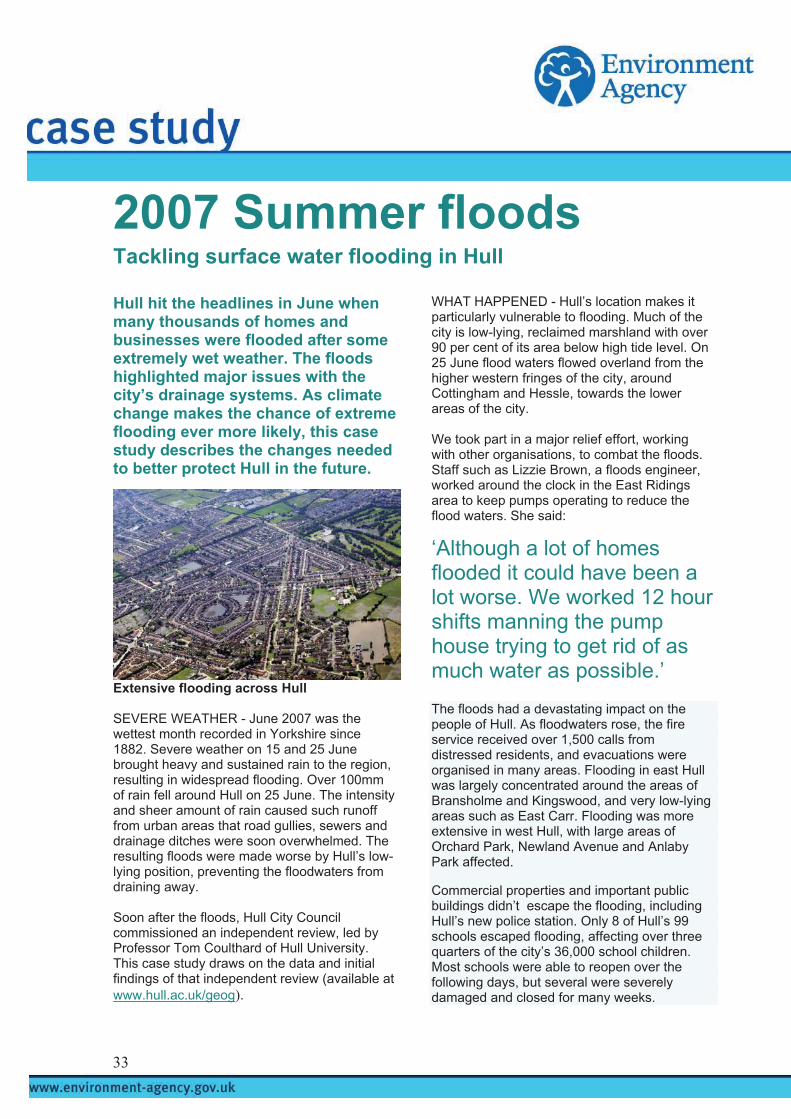
3
2007 Summer floods
Tackling surface water flooding in Hull
Hull hit the headlines in June when many thousands of homes and businesses were flooded after some extremely wet weather. The floods highlighted major issues with the city’s drainage systems. As climate change makes the chance of extreme flooding ever more likely, this case study describes the changes needed to better protect Hull in the future.
Extensive flooding across Hull SEVERE WEATHER - June 2007 was the wettest month recorded in Yorkshire since 1882. Severe weather on 15 and 25 June brought heavy and sustained rain to the region, resulting in widespread flooding. Over 100mm of rain fell around Hull on 25 June. The intensity and sheer amount of rain caused such runoff from urban areas that road gullies, sewers and drainage ditches were soon overwhelmed. The resulting floods were made worse by Hull’s low-lying position, preventing the floodwaters from draining away. Soon after the floods, Hull City Council commissioned an independent review, led by Professor Tom Coulthard of Hull University. This case study draws on the data and initial findings of that independent review (available at www.hull.ac.uk/geog).
WHAT HAPPENED - Hull’s location makes it particularly vulnerable to flooding. Much of the city is low-lying, reclaimed marshland with over 90 per cent of its area below high tide level. On 25 June flood waters flowed overland from the higher western fringes of the city, around Cottingham and Hessle, towards the lower areas of the city. We took part in a major relief effort, working with other organisations, to combat the floods. Staff such as Lizzie Brown, a floods engineer, worked around the clock in the East Ridings area to keep pumps operating to reduce the flood waters. She said:
‘Although a lot of homes flooded it could have been a lot worse. We worked 12 hour shifts manning the pump house trying to get rid of as much water as possible.’
The floods had a devastating impact on the people of Hull. As floodwaters rose, the fire service received over 1,500 calls from distressed residents, and evacuations were organised in many areas. Flooding in east Hull was largely concentrated around the areas of Bransholme and Kingswood, and very low-lying areas such as East Carr. Flooding was more extensive in west Hull, with large areas of Orchard Park, Newland Avenue and Anlaby Park affected.
Commercial properties and important public buildings didn’t escape the flooding, including Hull’s new police station. Only 8 of Hull’s 99 schools escaped flooding, affecting over three quarters of the city’s 36,000 school children. Most schools were able to reopen over the following days, but several were severely damaged and closed for many weeks.
3

Flood damage to Hull City Council properties, including schools and council houses, is estimated to exceed £200 million. Initial confusion over estimates of properties flooded put the number at 14,000. Floodwaters took several days to retreat and large areas of standing water remained in many of the city’s parks and open areas for weeks. We now believe that over 8,600 homes and 1,300 businesses were flooded and tragically one person died in the events of 25 June. CAUSE AND EFFECT - The flooding was a result of the city’s drainage network being totally overwhelmed by heavy and prolonged rain. Hull is at particular risk from surface water flooding, as it is low-lying with limited natural drainage. Whilst localised flooding might be expected from such extreme events, the scale of the June floods raises important questions over the adequacy and performance of Hull’s drainage system. In some cases the flooding and relief efforts were hampered by system failures, as shown when Bransholme pumping station was flooded and stopped working on 26 June. This delayed efforts to drain away the flood waters, increasing the misery for residents. Relying on pumping makes the city even more vulnerable.
Main features of Hull’s drainage system © Crown copyright. All rights reserved Environment Agency. 100026380. 2007 Hull’s low-lying position also makes it vulnerable to tidal and river flooding, although tides and river levels did not have a significant impact on the June floods. Tidal water levels in the River Humber were not at their peak on 25 June, and water levels in the River Hull, although high, did not threaten to overtop the banks and cause further flooding. Had the heavy rains fallen on the river catchment upstream of Hull, however, the position might have been different. PROBLEMS ROOTED IN THE PAST - Hull’s drainage system has developed significantly over the last 50 years and past decisions had a considerable impact on this summer’s floods.
Before the 1950s, Hull was drained by a network of open channels and ditches that flowed into the River Humber at low tide. Tidal gates were closed at high tide to prevent flooding. As the city grew, there was a major overhaul of the drainage system and many open channels were either filled in or replaced with underground sewers. These sewers collect both storm and waste water, taking the flows to two large pumping stations at West and East Hull. Filling in the open channels and combining storm and waste flows means there is little space for flood water to be managed above ground, leaving Hull with an inadequate drainage system. In the 1990s Yorkshire Water carried out major improvements to the drainage system through the ‘Humber Care’ project. They built a 10km sewer between the West and East Hull pumping stations, taking flows to a new treatment works to the east of the city at Saltend. Here all of the city’s waste water flows are treated. When storms hit, the pumps at East and West Hull take over and pump storm waters into the river. The recent investment has not solved the root causes of flooding, such as the loss of drainage capacity and the combining of storm and waste flows. Only one area of the city, Bransholme, has separate storm and waste water systems. New approaches and new solutions are needed to improve the city’s drainage system. WHO’S IN CHARGE? - Many organisations are responsible for different parts of the drainage system and this makes overall management difficult. This was highlighted by the Independent Review Board who said: ‘In short no single agency accepts responsibility for any elements outside their terms of reference. This is a recurring theme - one of inadequate consultation, co-operation and unity between the agencies. These practices must end.’ We manage the open channels and infrastructure that form part of the main river network, including the river and tidal flood defences for the rivers Hull and Humber. We are also responsible for providing effective forecasts and warnings for river and sea flooding, and have an important emergency response role. Yorkshire Water is largely
34

responsible for underground drainage, culverts and sewers. They also manage the main pumping stations and treatment works. Feeding into the sewers at street level are gullies and drains that are either the responsibility of the local authority, Hull City Council, or private landowners. The overlap of responsibilities is confusing and makes it very difficult to manage the drainage system in a coordinated way. A NEW APPROACH - The dramatic events in June clearly show the need for a more co-ordinated approach to flooding in Hull. We believe that one organisation, taking a strategic overview of inland flooding, will improve how we plan, fund and manage flooding that takes account of the challenges of climate change in the future. The Independent Review Board for Hull also recommended this approach. We welcome this and believe we are best placed to take on this role. To effectively control urban flooding at a strategic level, we need to address two main issues. Firstly, there must be an assessment of risk from all types of flooding that is shared by all key organisations. This is critical if we are to identify where the greatest risks are and therefore where intervention is most urgently needed. Secondly, we need to agree a common planning process that can coordinate responses and investments across the many organisations involved, but which also has sanctions to make sure everyone complies and standards are maintained. We do not seek a significant delivery role, and see that local authorities are best placed to coordinate planning and delivery.
Urban floods need an integrated response We would expect a strategic role to have three parts. As an advisor on strategic flood assessments, as a regulator on plans to manage flood risk, and continuing as a provider of flood risk management, forecasts, and warnings for river and sea flooding.
GIVING ADVICE - We propose that we take responsibility for developing an industry standard toolkit of methods for preparing strategic flood risk assessments (SFRAs). This would require the provision of data and models held by water utility companies. We should determine the approach to mapping, forecasting and warning for surface water planning as part of the toolkit. We should be able to object to Local Development Frameworks (LDFs) that are not accompanied by an SFRA that is fit for purpose. We understand this approach is broadly supported by Government and representatives of the water industry. REGULATING OTHERS - It is likely that a voluntary, collaborative approach would be successful in Hull, given the momentum generated by the June floods. In other cases however, we may need to adopt a tougher approach to make sure the right choices are made. Our role could include advising owners and operators of critical national infrastructure on flood risk issues. The need for this was highlighted in Hull when Yorkshire Water’s Bransholme pumping station was out of action due to flooding. This issue was highlighted by the Independent Review Board who felt it was unacceptable that there were no contingency plans in place for pump failure, or protection from flood water, at this key site. Since the event, Yorkshire Water has committed to carrying out urgent short-term work to protect the pump station and is considering longer-term improvements. We welcome this approach. PROVIDING EXPERTISE - Together with our advisory and legal duties, a key part of our strategic role would still be to provide flood forecasting, warning and mapping services. We would not expect to significantly increase our role in planning and managing urban flood risk, as local authorities are best placed to take the lead role in this area. We would explore further if developing a new flood forecast and warning service for surface water flooding is feasible. Our work to date has shown that urban systems are complex. Providing the same service as for rivers and the sea may not be possible. Developing an integrated plan for managing all forms of flooding in Hull is a priority. We are looking forward to working with Hull City Council and Yorkshire Water to reduce flood risk in the city. We are already successfully doing this elsewhere, working closely with United Utilities in Carlisle to address both the surface water and river flooding issues in a co-ordinated way. Hull needs this same approach.
35

SUMMARY - The dramatic events in Hull this summer were caused by the extreme weather, but the scale of flooding was influenced by weaknesses in the drainage system and the lack of a strategic approach to reducing risk. Thousands of homes and businesses in Hull remain at risk of flooding from extreme events, which may become more frequent with climate change. Whilst Hull is particularly vulnerable, many other UK cities are also at risk. All flood risk management organisations need to work together to find integrated and sustainable ways of reducing flood risk. We have a major role to play and welcome a future strategic role.
2007 Summer floods For more information go to: www.environment-agency.gov.uk/2007summerfloods/
36

s
3
2007 Summer flood
The summer floods in June and July 2007 highlighted the high levels of flood risk many people throughout the country face. Oxford and Leeds are just two cities that were affected. Although they face different challenges to provide sustainable flood risk management, they both need significant investment. This case study explains the stories of these two cities and highlights the need for increased investment to address flood risk.
Floods in Leeds city centre in 2000 FUNDING FOR FLOOD RISK - The severe flooding that affected much of the country in June and July followed what we now know to be the wettest May to July since records began in 1766. Whilst thousands of homes and businesses were flooded across the country, many communities were protected by our flood defences, some for the first time following recent investments. Across England and Wales, our flood defences include over 17,400 structures and 22,800 kilometres of coast and riverbank defences. Over the last five years our capital investment programme has reduced the risk of coastal and river flooding to a further 155,000 properties. With over two million properties at risk of flooding, considerable challenges remain.
Investment and funding – a tale of two cities
We have permissive powers to provide flood defences in England and Wales. This means that whilst we invest significant amounts of money in managing flood risk each year, by law we do not have to provide protection to a given standard, or at all. Typical standards of protection refer to the chance of a particular flood event being exceeded in any one year. These are expressed as either a ratio (1 in 100) or a percentage (one per cent). Current policy gives indicative standards of protection from river flooding of between 1 in 50 and 1 in 200 for urban areas. Government funding for flood risk management has increased over the last three spending reviews, doubling since 2000. Need has also grown and with funding limited by annual budgets, we have to prioritise our investment in areas of greatest flood risk. We also have to carefully assess potential schemes on their technical merits, their costs and benefits, and wider impacts on the environment. As highlighted this summer, Leeds and Oxford face significant flood risk, but both compete for limited national funds. Here we tell their stories. LEEDS A HISTORY OF FLOODING - On 25 June 2007 heavy rain fell in the Leeds area, with many places receiving an average month’s rain in just 24 hours. Wyke Beck in Leeds, along with many other rivers and watercourses across the region, were unable to cope and overtopped their banks, flooding properties in the Halton area. The River Aire overtopped its banks in central Leeds and property in the Calls and Brewery Wharf areas was flooded. Leeds has flooded in the past. In 2000, isolated parts of Leeds flooded and the city came close to experiencing widespread flooding. Over 250 houses and 50 businesses flooded despite the peak flood levels having a relatively low return period, around a 1 in 25 (or four per cent)
7

chance of flooding. Leeds has flooded nine times since 1768. The biggest flood ‘The Great Flood of Leeds’ in 1866 claimed twenty lives. FUTURE CHALLENGES - We have identified that there are around 2,000 houses and over 1,000 businesses at risk of flooding from a 1 in 200 (0.5 per cent) flood event. There are no formal flood defences through Leeds, and we do not know if the existing informal defences would provide adequate protection during less extreme events. In 2000 we introduced temporary measures to reinforce the informal defences. In some places the standard of protection is less than a 1 in 5 (20 per cent) chance of flooding. We do operate a flood warning system for the city, but we are only able to provide a few hours warning due to the speed of flood flows from the upstream catchment. Leeds is a major economic centre in the North of England and significant flooding in the city centre would be catastrophic. It could affect the economic regeneration of the city. Potential changes in our climate and weather patterns, as a result of climate change, look likely to cause more severe storms and heavier rains. Based on our work to date, this could increase peak flood levels through the city by over half a metre, in the longer term. This could put many homes and businesses in the city at greater risk of flooding. If we do nothing, the financial effects of climate change will be significant. The leader of Leeds City Council, Mark Harris recognises the need for a flood defence scheme. He said in the Yorkshire Post:
‘We understand that the Environment Agency does have enormous pressures from around the country for flood defences, with limited funds, but at the same time we believe the situation in Leeds is very serious and needs immediate attention’. OUR PLANS - A study of potential schemes to reduce the flood risk in Leeds is currently underway. The floods in 2000 highlighted the scale of the problem facing the city. Since then, we have carried out extensive studies to better understand and find solutions to flooding from the River Aire. We built a computer model of the river system around Leeds and have used this
to assess the different ways of reducing flood risk. In 2004 we started work on a flood risk management strategy for the area, which recommended investment in the city’s flood defences. We are currently assessing the different ways of reducing flood risk. This includes reviewing in detail the costs and benefits of the different options, as well as their technical and wider social and environmental merits. We expect to finalise our plans for a flood risk management scheme for Leeds in 2009. Budget constraints have slowed progress on the Leeds scheme in the past. Investment decisions are currently based on a ‘priority score’ process that ranks schemes around the country by a range of factors, to target spending where it is needed most. For the last few years, the priority score for Leeds has been below the national threshold for major investment. Looking forward, we are likely to conclude that raised defences are needed though the city centre together with upstream storage to cope with the effects of climate change. Managing flood risk in Leeds is vital for social, environmental and economic sustainability. We anticipate this will cost £80 million and, if funding is approved, construction could start by 2011. FUNDING OUR PLANS - Given the risk to Leeds and the economy of Yorkshire as a whole, we will need to seek funding from a number of sources. We will seek much of the cost from Government, and we will need to spread construction out over several years. Funding also depends on Leeds achieving the threshold priority score for investment. We will need to work closely with Leeds City Council, the Regional Development Agency Yorkshire Forward and developers to secure other funding, since the defences will protect much of the commercial heart of the city. However, defences in the city centre alone may cost £50 million, which will mean everyone involved will need to make a major commitment. Further investment to increase upstream flood storage will be needed to secure the city against future climate change. A scheme of this size places heavy pressure on the overall flood risk management budget. OXFORD A HISTORY OF FLOODING - On Thursday 19 July heavy rain fell over large areas of central and southern England, becoming even heavier the following day over Oxfordshire. The rain swelled smaller rivers and streams in the catchment above Oxford, and water levels in
38

the rivers Thames and Cherwell rose as a result, overtopping their banks. A total of 168 properties were flooded in Oxford, Osney, Binsey, Botley Road and Wolvercote. Other properties were affected, and people living in the Osney Island area were evacuated. Major roads and the London to Oxford railway were closed for more than five days. This had a significant effect on many local businesses.
Flooding in Oxford in 2007 Paul Smith of our waterways team helped co-ordinate events and saw first hand how our lock keepers and staff worked closely with the emergency services, to keep people safe and informed during the floods. In one example our staff helped local pharmacist Pupinder Ghatora deliver essential medicines to vulnerable members of the community. He said:
‘By coming to our aid, the Environment Agency helped to save lives, and it helped us keep the business going. The floods really hit us hard - we are only just getting back on our feet now.’ Oxford flooded in December 2000, when 160 properties were affected, and again in January 2003, when 123 properties flooded. Both of these floods resulted from relatively low return period events, with around a 1 in 15 (seven per cent) chance of flooding in any one year. The worst flooding in recent history was in March 1947, when more than 3,000 properties were flooded. At present, areas in Oxford suffer from a high level of flood risk. The current minimum standard of protection provided in Oxford is around a 1 in 5 (20 per cent) chance of flooding.
FUTURE CHALLENGES - Oxford city centre is situated on relatively high ground between the major rivers, but there are several urban areas that encroach into the floodplain. This puts over 3,000 properties at risk. Flooding is caused by groundwater, run off from urban areas and man made restrictions in the floodplain. The large number of minor watercourses to the west of the city also causes flooding during high flows. The potential for climate change to cause more severe storms and heavier rains could raise flood levels and put homes and businesses in the city at a greater risk of flooding. Developing a flood risk management solution for Oxford will not be easy. The area is very environmentally sensitive in terms of its ecological, archaeological, heritage and landscape value. The floodplain is criss-crossed by numerous secondary watercourses, both natural and man-made, which provide an environment rich in wildlife. There are several locally, nationally and internationally designated environmental sites. Developing a flood risk management approach that preserves and enhances these features is a major challenge. OUR PLANS - To understand the causes of flood risk in the Upper Thames area and to recommend the best ways of managing this risk in the longer term, we have developed a Catchment Flood Management Plan (CFMP). This identifies Oxford as a major flood risk area and recommends that we should look at ways of better managing flood risk in the city. Since 2002 we have been working on a flood risk management strategy for the city, and have carried out extensive studies and assessments. These studies are costly and time-consuming but are vital in getting the right, sustainable solution for managing flood risk in Oxford. Our studies show that there is a sound business case for reducing flood risk, based on increasing the conveyance capacity of the floodplain to the west of Oxford. We are testing this option on technical merit, economic and environmental grounds. We are now also assessing a wide range of other flood risk management measures, including upstream storage, land use management change and flood resilience. These measures are likely to be aimed at reducing the impacts of climate change. We expect to finalise our plans for a strategic flood risk management scheme by 2009. However, we recognise that we will need a public inquiry because of the potential constraints, sensitivities and high cost of the scheme. On this basis, construction may not start until 2015.
39

FUNDING OUR PLANS - The potential cost of a strategic scheme for Oxford could be as much as £150 million. Oxford currently falls short of the priority score threshold for major capital investment in the near future. The scale of investment needed would represent a major proportion of the flood risk management capital budget and commitments from partners in Oxford would also be required. NATIONAL FUNDING ISSUES GROWING DEMANDS - In England and Wales, around 11 per cent of land, some 1.7 million hectares and over two million properties could flood from rivers or the sea. Of these, up to half a million households face a significant risk of flooding. Leeds and Oxford are just two places that are competing for funding. Availability of funding is a major factor in taking these schemes forward. Studies for both cities have identified high cost solutions that could be feasible within the next ten years. However, under existing funding scenarios, there will be considerable competition for funding. We face many other challenging investment decisions. As well as competing flood risk management schemes, there are a number of other funding pressures. We spend £150 million each year on maintaining the main rivers we are responsible for. We are currently assessing the level of investment needed to bring our assets up to a fit for purpose standard. FUTURE CHALLENGES - As well as tackling current levels of flood risk, we must also consider how climate change will affect us in the longer term. These questions were tackled in the Government’s Foresight Future Flooding report. The report predicts that climate change will be an important factor in increasing flood risk, and that both the number of people at risk from flooding and the costs of flood damage will rise significantly. It concludes that we must spend more on flood and coastal defence to protect against the impacts of climate change. We must also continue to invest in and provide flood defences for properties in areas at high risk of flooding as part of the Government’s agreement with the insurance industry. THE WAY FORWARD - With greater pressure on flood risk management funds, we need to consider new approaches. Building new flood defences is not the only answer. We are also considering alternatives that tackle flood risk for individual properties and businesses at a more local level. Measures such as improved flood
resilience may provide a cost effective way of reducing flood risk, but they are currently more difficult to appraise and implement. We need to improve the way that flood risk management funding is prioritised. We are working with Defra to introduce new outcome measures, which have a broader set of measures than the current priority scoring system. These should make it clearer what benefits Government would like to see from investment in the flood and coastal erosion risk management programme. They will provide a more consistent and fair approach between different types of risk, locations and operating authorities. Outcome measures will therefore, help determine investment decisions. We also need to plan our flood risk management investments more strategically. With a limited supply of money to fund flood risk management activities in any one year, we need a fair system to agree how and where money should be allocated. We have a number of tools to do this. We use the National Flood Risk Assessment on a strategic level to determine where flood risk is greatest and where we need to intervene most. We carry out more detailed assessments of flood risk for rivers under Catchment Flood Management Plans and for the sea under Shoreline Management Plans. These plans help define where and when investment will be most effective. To implement these plans we need to be sure that future funding will be available . BRIGHT FUTURE - In July, Environment Secretary Hilary Benn announced budgets that would reach at least £650 million in 2008, increasing to £700 million in 2009 and eventually reaching £800 million by 2010. We warmly welcome these increases. We recommend that such increases should continue through the next spending review, reaching over £1 billion a year. We are currently assessing our longer term investment needs. With typical returns on capital investments on flood risk management projects at a ratio of 6:1, there is strong incentive for this level of public spending. SUMMARY - The severe flooding our country experienced during June and July this year is a stark reminder of the high level of flood risk that many people face. Climate change looks set to increase this risk, affecting more people and damaging more property.
40

Cities such as Leeds and Oxford, amongst many others, face increasing flood risk. Major investment is needed to reduce flood risk to make these places sustainable in economic, social and environmental terms. Flood risk management investment has grown consistently since 2000 and recent Government commitments go further. Increases in funding need to be maintained to effectively tackle rising flood risk in the future.
2007 Summer floods For more information go to: www.environment-agency.gov.uk/2007summerfloods/
41

2007 Summer floods
Impacts of flooding on Lincolnshire’s farmers
The severe flooding in June and July left thousands of hectares of farmland under water, damaging crops and soil, and hitting farmers in some areas hard. Lincolnshire was badly affected in June when flood waters overwhelmed defences and flooded many fields. This case study describes what happened and the changes needed to make sure farmers and rural communities are better prepared for flooding and climate change in the future.
Flooded fields in Lincolnshire RISING WATERS - Heavy and prolonged wet weather in the early summer led to a series of dramatic floods across the east of England. More rain fell between May and July than at any time since records began in 1766. The heavy rain led to flooding on three separate occasions. On 14 and 15 June the rains caused localised flooding, but events on 24 and 25 June and 19 and 20 July were much worse, affecting large parts of Lincolnshire and many other rural areas across the country. Lincolnshire was affected most by the heavy rain between 24 and 25 June, where a month’s rain fell in less than 24 hours. In one place in the area, 65mm of rain fell in one day,
compared to an average for June of 53mm. Rain falling onto land, which was already waterlogged, rapidly filled the drains and river systems. Despite the extreme weather, Lincoln was successfully protected by its flood defences. But, some farmers were not as fortunate, as large areas of their farmland flooded and they lost part of their crops and some livestock. Early estimates indicate 50 square kilometres of land were flooded across the east of England, with damages running into millions of pounds. DRAMATIC EVENTS - Lincoln sits astride the River Witham, where the rivers Till and Brant and the Fossdyke Canal meet. Lincoln developed rapidly in the early nineteenth century with the coming of the railway. Today, almost 7,000 homes and businesses depend on the city’s flood defences. Two large flood storage areas or washlands, built in the 1980s on farmland upstream of the city, are vital to these defences.
© Environment Agency 2007
As the rain fell on 25 June, our staff monitored the rising river levels and, after warning the farmers affected, put the washlands into action. The River Till washland to the north of the city took the bulk of the floodwater, reaching 80 per cent full and storing over three million cubic metres of water. The Witham washland to the south of the city reached 10 per cent full, storing up to 700,000 cubic metres of water. With Lincoln successfully protected, both washlands were safely emptied by 9 July.
More rain fell between May and July than at any time since records began in 1766. Whilst farmland in the washlands was flooded in a controlled way, other rural areas suffered flooding when defences were overwhelmed by high flood water levels. Much of the land around
42

Lincoln is low-lying floodplain and agriculture relies on a historic drainage network that collects and pumps water into the main river system. Flood banks help keep floodwaters in the rivers during stormy periods, but these only provide a certain level of protection. High water levels in June exceeded the design capacity of some floodbanks and fields flooded as a result. Five sections of floodbank were damaged and collapsed when they were overwhelmed, including a 10 metre section on Winterton Beck which flooded over 30 hectares of farmland.
Areas at risk of flooding around Lincoln © Crown copyright. All rights reserved Environment Agency. 100026380. 2007 In most cases land behind these banks was already flooded, and the collapses did not make the flooding significantly worse. Two homes on the Waddingham Catchwater did flood when floodbanks collapsed but it is thought that these would have flooded from overtopping too. All of these banks were over 50 years old. As river levels fell, our staff worked hard to successfully repair the collapsed banks. NATIONAL PICTURE - Experiences of the farming community in Lincolnshire were repeated across the country in areas affected by the summer floods. Across England and Wales much of our agriculture depends on drainage and ongoing flood defence. Government figures indicate that in England alone over 1.3 million hectares of agricultural land, including over half of the highest grades of productive land, are in the floodplain. Farmers lost crops and animals as thousands of hectares of farmland were flooded. Wheat, barley and fodder crops were most affected, and, in some cases, sheep and cattle were trapped as the floodwaters rose. After the floods, the Government commissioned ADAS (formerly the Agriculture Development Advisory Service) to carry out a review of the impacts of the summer floods on agriculture.
This study will be published by the end of 2007. Two factors directly affected the losses farmers suffered. Firstly, the floods followed a wet start to the summer, where some farmers had already lost crops due to waterlogged soil. Secondly, flooding tends to hit farmers harder in the summer than in the winter as, crops are less likely to have been harvested and livestock are out on summer grazing. After the floods, farmers raised a number of issues they thought had made the flooding worse. EXPLORING THE ISSUES - Farmers in Lincolnshire felt that they did not receive enough warning about the floods. Although warnings cannot reduce the amount of crops damaged, they can give farmers vital time to protect their animals. Currently, we only issue flood warnings on a best endeavours basis to those people that ask for them. Where they are available we want to encourage more farmers to receive warnings. Farmers also felt that once floods hit, farmland was flooded on purpose to protect urban areas. In some areas we do use low lying agricultural land for flood storage, such as the Lincoln washlands. In such cases we have long term agreements and pay farmers compensation, as we need to control the timing, depth and duration of flooding on their land, to control flood flows downstream. We cannot protect all farmland and under Government guidance we offer a lower standard of protection to rural locations than to urban locations. Much low lying agricultural land is in the floodplain, and in these areas land use and market prices often reflect the level of flood risk. These areas form a key part of the river system in times of flooding, storing floodwater that could otherwise cause serious flooding downstream.
In England alone over 1.3 million hectares of agricultural land, including over half of the highest grades of productive land, are in the floodplain. Farmers are concerned that we do not spend enough money on maintaining our rural defences and keeping silt levels down in the channels. Although we do work within tight budgets, we currently spend £34 million a year on dredging, cutting weeds and grass and removing trees and debris to keep our flood defences operating safely. Almost all our defences performed well during the summer
43
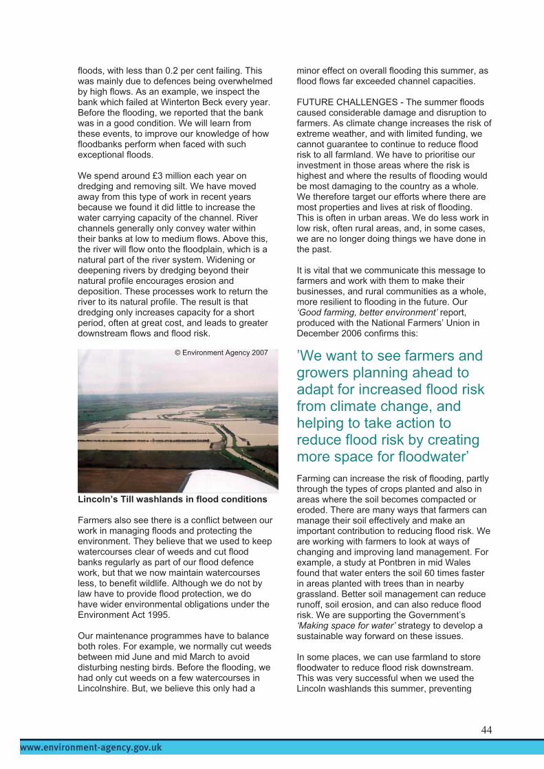
floods, with less than 0.2 per cent failing. This was mainly due to defences being overwhelmed by high flows. As an example, we inspect the bank which failed at Winterton Beck every year. Before the flooding, we reported that the bank was in a good condition. We will learn from these events, to improve our knowledge of how floodbanks perform when faced with such exceptional floods. We spend around £3 million each year on dredging and removing silt. We have moved away from this type of work in recent years because we found it did little to increase the water carrying capacity of the channel. River channels generally only convey water within their banks at low to medium flows. Above this, the river will flow onto the floodplain, which is a natural part of the river system. Widening or deepening rivers by dredging beyond their natural profile encourages erosion and deposition. These processes work to return the river to its natural profile. The result is that dredging only increases capacity for a short period, often at great cost, and leads to greater downstream flows and flood risk.
Lincoln’s Till washlands in flood conditions Farmers also see there is a conflict between our work in managing floods and protecting the environment. They believe that we used to keep watercourses clear of weeds and cut flood banks regularly as part of our flood defence work, but that we now maintain watercourses less, to benefit wildlife. Although we do not by law have to provide flood protection, we do have wider environmental obligations under the Environment Act 1995. Our maintenance programmes have to balance both roles. For example, we normally cut weeds between mid June and mid March to avoid disturbing nesting birds. Before the flooding, we had only cut weeds on a few watercourses in Lincolnshire. But, we believe this only had a
minor effect on overall flooding this summer, as flood flows far exceeded channel capacities. FUTURE CHALLENGES - The summer floods caused considerable damage and disruption to farmers. As climate change increases the risk of extreme weather, and with limited funding, we cannot guarantee to continue to reduce flood risk to all farmland. We have to prioritise our investment in those areas where the risk is highest and where the results of flooding would be most damaging to the country as a whole. We therefore target our efforts where there are most properties and lives at risk of flooding. This is often in urban areas. We do less work in low risk, often rural areas, and, in some cases, we are no longer doing things we have done in the past. It is vital that we communicate this message to farmers and work with them to make their businesses, and rural communities as a whole, more resilient to flooding in the future. Our ‘Good farming, better environment’ report, produced with the National Farmers’ Union in December 2006 confirms this:
’We want to see farmers and growers planning ahead to adapt for increased flood risk from climate change, and helping to take action to reduce flood risk by creating more space for floodwater’
© Environment Agency 2007
Farming can increase the risk of flooding, partly through the types of crops planted and also in areas where the soil becomes compacted or eroded. There are many ways that farmers can manage their soil effectively and make an important contribution to reducing flood risk. We are working with farmers to look at ways of changing and improving land management. For example, a study at Pontbren in mid Wales found that water enters the soil 60 times faster in areas planted with trees than in nearby grassland. Better soil management can reduce runoff, soil erosion, and can also reduce flood risk. We are supporting the Government’s ‘Making space for water’ strategy to develop a sustainable way forward on these issues. In some places, we can use farmland to store floodwater to reduce flood risk downstream. This was very successful when we used the Lincoln washlands this summer, preventing
44

many thousands of homes in the city from flooding. Creating washlands and wetlands, realigning river channels and re-connecting rivers with the floodplain can all help store and slow water to reduce flooding downstream. Where these schemes are introduced, farmers may receive compensation, but agreements can be difficult to secure. We are promoting other washland schemes on the River Ancholme to protect Brigg and the River Bain to protect Horncastle. Finding suitable sites for these schemes and agreeing compensation payments is difficult and takes time. In future, we must work more closely with farmers and rural communities as a whole to help them adapt to increasing flood risk and climate change. SUMMARY - The summer floods were a stark reminder of the extent of vulnerable farmland in the floodplain. Our climate is changing and we will have to adapt to more frequent extreme weather, including drought, as well as the increased risk of flooding. Land managers, who act as caretakers of 80 per cent of our land, have a vital part to play. Farmers need to prepare for the impacts of flooding, to secure their farms for the future. We can help farmers by providing warnings and advice and want to work closely with them to help manage the risks of flooding.
2007 Summer floods For more information go to: www.environment-agency.gov.uk/2007summerfloods/
45
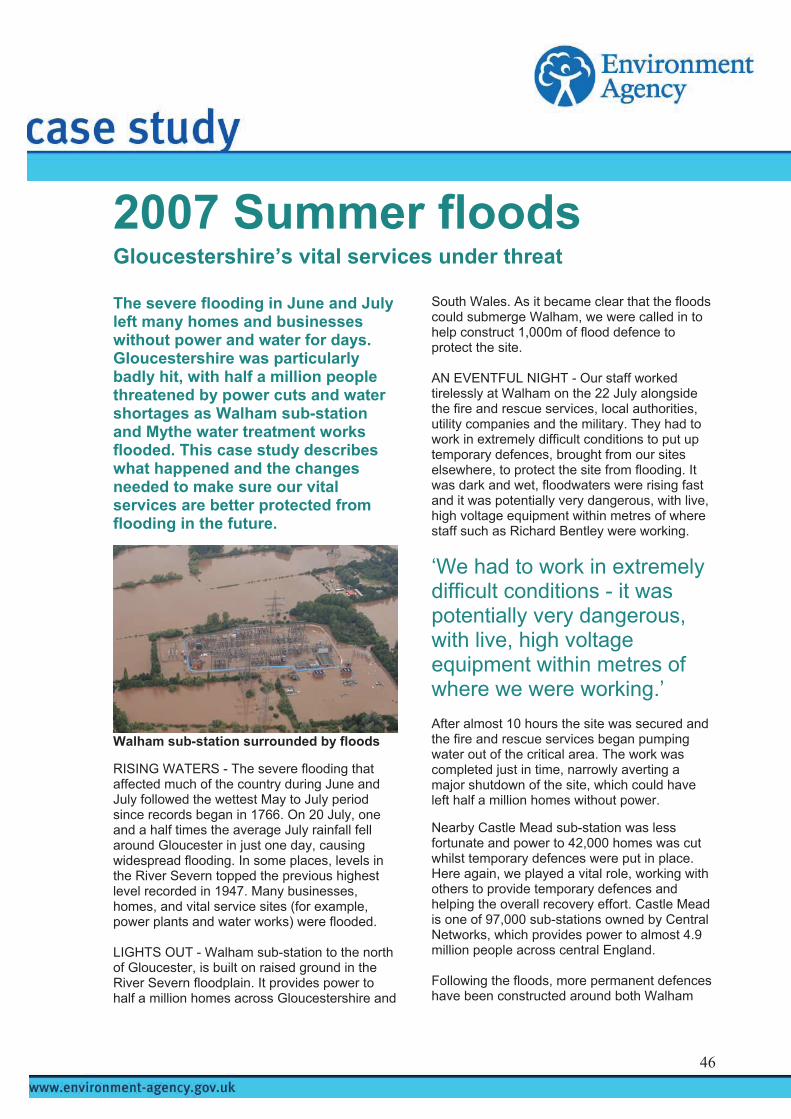
s
2007 Summer flood
The severe flooding in June and July left many homes and businesses without power and water for days. Gloucestershire was particularly badly hit, with half a million people threatened by power cuts and water shortages as Walham sub-station and Mythe water treatment works flooded. This case study describes what happened and the changes needed to make sure our vital services are better protected from flooding in the future.
Walham sub-station surrounded by floods RISING WATERS - The severe flooding that affected much of the country during June and July followed the wettest May to July period since records began in 1766. On 20 July, one and a half times the average July rainfall fell around Gloucester in just one day, causing widespread flooding. In some places, levels in the River Severn topped the previous highest level recorded in 1947. Many businesses, homes, and vital service sites (for example, power plants and water works) were flooded. LIGHTS OUT - Walham sub-station to the north of Gloucester, is built on raised ground in the River Severn floodplain. It provides power to half a million homes across Gloucestershire and
Gloucestershire’s vital services under threat
South Wales. As it became clear that the floods could submerge Walham, we were called in to help construct 1,000m of flood defence to protect the site. AN EVENTFUL NIGHT - Our staff worked tirelessly at Walham on the 22 July alongside the fire and rescue services, local authorities, utility companies and the military. They had to work in extremely difficult conditions to put up temporary defences, brought from our sites elsewhere, to protect the site from flooding. It was dark and wet, floodwaters were rising fast and it was potentially very dangerous, with live, high voltage equipment within metres of where staff such as Richard Bentley were working.
‘We had to work in extremely difficult conditions - it was potentially very dangerous, with live, high voltage equipment within metres of where we were working.’ After almost 10 hours the site was secured and the fire and rescue services began pumping water out of the critical area. The work was completed just in time, narrowly averting a major shutdown of the site, which could have left half a million homes without power. Nearby Castle Mead sub-station was less fortunate and power to 42,000 homes was cut whilst temporary defences were put in place. Here again, we played a vital role, working with others to provide temporary defences and helping the overall recovery effort. Castle Mead is one of 97,000 sub-stations owned by Central Networks, which provides power to almost 4.9 million people across central England. Following the floods, more permanent defences have been constructed around both Walham
46
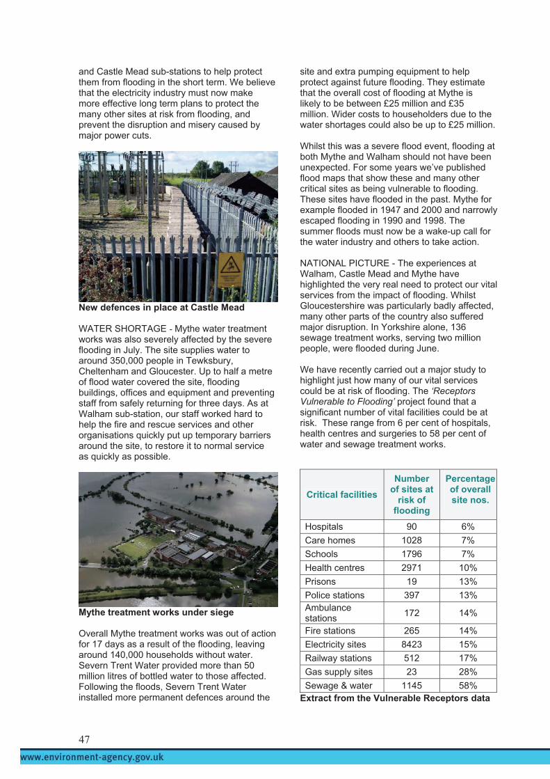
and Castle Mead sub-stations to help protect them from flooding in the short term. We believe that the electricity industry must now make more effective long term plans to protect the many other sites at risk from flooding, and prevent the disruption and misery caused by major power cuts.
New defences in place at Castle Mead WATER SHORTAGE - Mythe water treatment works was also severely affected by the severe flooding in July. The site supplies water to around 350,000 people in Tewksbury, Cheltenham and Gloucester. Up to half a metre of flood water covered the site, flooding buildings, offices and equipment and preventing staff from safely returning for three days. As at Walham sub-station, our staff worked hard to help the fire and rescue services and other organisations quickly put up temporary barriers around the site, to restore it to normal service as quickly as possible.
Mythe treatment works under siege Overall Mythe treatment works was out of action for 17 days as a result of the flooding, leaving around 140,000 households without water. Severn Trent Water provided more than 50 million litres of bottled water to those affected. Following the floods, Severn Trent Water installed more permanent defences around the
site and extra pumping equipment to help protect against future flooding. They estimate that the overall cost of flooding at Mythe is likely to be between £25 million and £35 million. Wider costs to householders due to the water shortages could also be up to £25 million. Whilst this was a severe flood event, flooding at both Mythe and Walham should not have been unexpected. For some years we’ve published flood maps that show these and many other critical sites as being vulnerable to flooding. These sites have flooded in the past. Mythe for example flooded in 1947 and 2000 and narrowly escaped flooding in 1990 and 1998. The summer floods must now be a wake-up call for the water industry and others to take action. NATIONAL PICTURE - The experiences at Walham, Castle Mead and Mythe have highlighted the very real need to protect our vital services from the impact of flooding. Whilst Gloucestershire was particularly badly affected, many other parts of the country also suffered major disruption. In Yorkshire alone, 136 sewage treatment works, serving two million people, were flooded during June. We have recently carried out a major study to highlight just how many of our vital services could be at risk of flooding. The ‘Receptors Vulnerable to Flooding’ project found that a significant number of vital facilities could be at risk. These range from 6 per cent of hospitals, health centres and surgeries to 58 per cent of water and sewage treatment works.
Critical facilities Number
of sites at risk of
flooding
Percentage of overall site nos.
Hospitals 90 6% Care homes 1028 7% Schools 1796 7% Health centres 2971 10% Prisons 19 13% Police stations 397 13% Ambulance stations 172 14%
Fire stations 265 14% Electricity sites 8423 15% Railway stations 512 17% Gas supply sites 23 28% Sewage & water 1145 58%
Extract from the Vulnerable Receptors data
47
This simple scoping exercise highlights the scale of the problem and the need for action from those responsible. Given this level of flood risk, we believe that public and private bodies must act now to secure these critical sites.
The Government has already asked the electricity industry to review how resilient its electricity sub-stations are to flooding. Ofwat, the water industry regulation body, has also asked water companies to consider reducing flood risk as part of their forward planning. Regina Finn, Chief Executive of Ofwat recognises the need to plan for the impacts of climate change and said:
‘Climate change may mean that such storms happen more often and cause more floods. This makes long-term planning essential and we must look hard at how to protect all crucial infrastructure, not just that of the water industry.’ MOVING FORWARD - We believe the Government needs to take the lead in ensuring better protection for our vital services from the effects of flooding. The Climate Change Bill presents opportunities to strengthen the nation’s response to the risk of climate change. We recommend that the Bill should place a duty on all public bodies to take into account future climate change impacts when exercising their functions. The Secretary of State should also take a power to require specific bodies, such as those responsible for managing critical services (utilities, local authorities, primary healthcare trusts, highways and telecommunications) to undertake a climate change risk assessment for their planning and investments, and to identify an action plan to address the risks. This would effectively apply the concepts of the Civil Contingencies Act to cover climate change risks. Regulations accompanying the Bill should set out what the requirements will be for utility companies. We are also encouraging utility companies to review their business continuity plans to address all the potential impacts of flooding,
particularly in light of this summer’s severe events. This would help better protect us all from the effects of flooding in the future. SUMMARY - The severe flooding our country has experienced during June and July this year is a stark reminder of the need to better protect our vital services from the potentially devastating effects of flooding and climate change generally. As climate change makes extreme weather and flooding ever more likely, it is essential that public organisations and private companies act now to prevent major disruption and misery in the future.
2007 Summer floods For more information go to: www.environment-agency.gov.uk/2007summerfloods/
48

levels in the river
2007 Summer floods
Reservoir safety – learning from Ulley part because of high flood
Ulley reservoir hit the headlines inJune when flood waters caused significant structural damage and threatened to flood large areas downstream. The reservoir near Sheffield was made safe thanks to the tremendous efforts of many organisations working together. This case study describes what happened and the changes we feel are needed to make sure reservoirs operate more safely in future.
Aerial view of Ulley reservoir WHAT HAPPENED? - Between 24 and 25 June some of the heaviest rainfall on record fell, with more than 90mm of rain falling in just 18 hours. With the reservoir full, a torrent of water spilled out, causing significant structural damage to the masonry channel walls and the dam itself. Early the next day, a specialist reservoir engineer (known as a ‘panel engineer’) inspected the damage and advised the reservoir’s owner, Rotherham Metropolitan Borough Council (MBC), to take emergency action to prevent major flooding downstream. The council acted quickly; the M1 was closed and 1,000 people in the villages of Catcliffe, Whiston and Treeton were evacuated from their homes by the emergency services. This was in
downstream of the reservoir, and in part due to the threat of dam failure. Emergency efforts focused on lowering the water level in the reservoir, and repairing the flood damage. Emergency work to stabilise the dam continued until it was finally considered safe to reopen the M1, some 40 hours later. Longer-term plans to make sure the reservoir operates safely again are now being urgently considered. OUR ROLE – Reservoir owners, operators and users (known as reservoir undertakers) are responsible for making sure that their reservoirs operate safely and are properly managed. It is our job to enforce the Reservoirs Act 1975, which is the safety legislation for the largest 2,100 reservoirs in England and Wales. We were involved throughout the incident at Ulley, with staff such as Mark Chapman, our local reservoirs coordinator, playing an important role. Mark said of his role:
www.petersmith.com
‘I was called to Ulley at short notice. We all worked very well together. It was frantic but all our planning for this type of incident paid off.’ After the events at Ulley we commissioned an investigation to discover why the damage was caused, and what actions must now be taken by both engineers and undertakers to avoid a similar incident in the future. Early findings point to the failure of the masonry spillway but we feel there are important wider causes to address. UNDERSTANDING THE RISKS - The events in June highlighted the very real risks to life and property should reservoirs fail. Ulley was one of 18 reservoirs affected by the summer floods. Reservoirs are classified on a consequence of failure basis, where A has highest consequence and D has negligible risk to life and little risk to property. Ulley dam was previously classified as
49

Category C, thought to pose little risk to life and property downstream. But the summer flooding, evacuations and major disruptions suggest that the reservoir classification needs urgent review. We believe the incidents at Ulley and elsewhere this summer demonstrate that we need a better risk-based approach to reservoir safety. This means focusing on those reservoirs that pose the greatest risk to the public, even if they’re not currently covered by the regulations. Dam Category
Potential consequence of reservoir failure
A At least 10 lives at risk and extensive property damage
B Fewer than 10 lives at risk or extensive property damage
C Negligible risk to human life but some property damage
D Negligible risk to human life and very limited property damage
Definition of dam categories This issue was highlighted by a similar incident on a reservoir in Barton on Humber owned by Kimberly Clark Ltd. Flood damage to this reservoir, not covered by the regulations, also put downstream properties at major risk. At present the Reservoirs Act only applies to reservoirs based on their size, regardless of the risks they pose. We want the Act to be changed to remove the legal burden from remote, low consequence reservoirs, tightening controls on those that pose significant risks to the public. IMPROVING INSPECTIONS - Undertakers have to carry out regular inspections to make sure that their reservoir is properly looked after in the interests of safety. We believe the incident at Ulley highlights the need for more comprehensive inspections in some instances. Also that the quality of inspection reports would improve if some were independently reviewed. This would improve the overall consistency and quality of reports and drive further improvement in reservoir safety. Jonathon Hinks, an All Reservoirs Panel Engineer agrees: ‘Since 1930 the key to reservoir safety in the UK has been the 10 yearly inspection reports, everything possible must be done to ensure the highest quality for these reports.’
Also, at present, there is no legal requirement for us to receive the majority of inspection reports. We want the Reservoirs Act to be changed so that reservoir undertakers have to provide us with copies of all inspection reports. BETTER PLANNING - Another valuable lesson we learned from Ulley was the need to forward plan better for the possible impacts of major flood events. Information on risks to people and property downstream, and access routes for emergency services and evacuation plans had to be put together very quickly during the event. Currently undertakers are not legally required to prepare reservoir flood plans. Under the Water Act 2003, from Spring 2009 it is intended that we will have powers to ensure that all undertakers prepare these. Effective plans are essential to highlight what’s at risk downstream should a reservoir fail, and we want to encourage undertakers to prepare them now.
www.petersmith.com
Damage to the masonry channel and dam SHARING LESSONS LEARNED - The incident at Ulley was successfully managed thanks to the effort of a number of organisations and the responsible actions of the reservoir’s owner, Rotherham MBC. Sharing lessons learned will help many other undertakers to avoid similar incidents in future. But currently, post-incident reporting is only voluntary and some undertakers have not reported incidents. We believe that mandatory post-incident reporting is needed to improve reservoir safety. SUMMARY - The incidents at Ulley are a stark reminder of the need to manage reservoir safety effectively. The events cost Rotherham MBC over £1million, and over £4million will likely be needed to secure the reservoir in the long term.
50

Meanwhile, many thousands of people saw their lives disrupted, as their homes, businesses and major road networks were affected. Closing the M1 for 40 hours cost an estimated £2.3 million. The reservoir did not fail and that is thanks to the swift and professional response of the public and emergency services. Strengthening the regulation of our reservoirs will help minimise the chance of such events happening in future.
2007 Summer floods For more information go to: www.environment-agency.gov.uk/2007summerfloods/
51
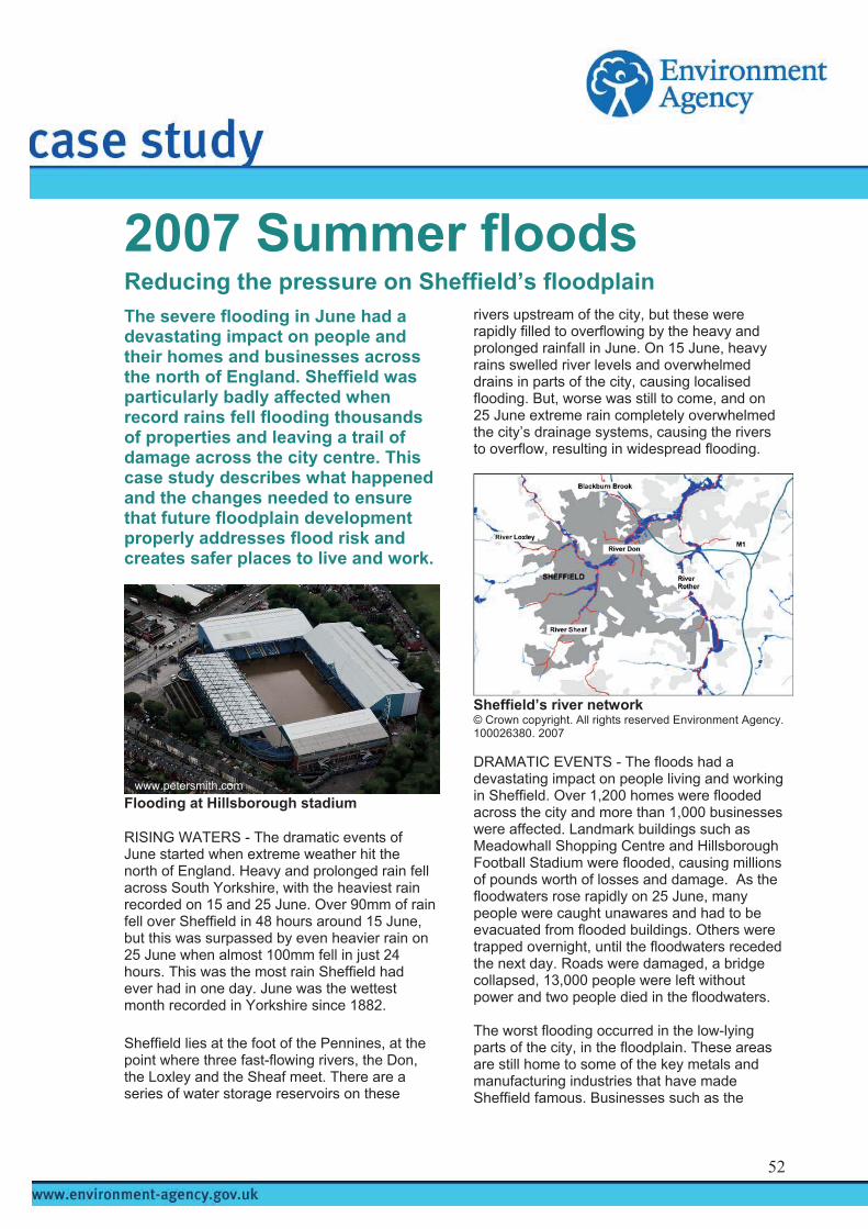
s
2007 Summer flood
The severe flooding in June had a devastating impact on people and their homes and businesses across the north of England. Sheffield was particularly badly affected when record rains fell flooding thousands of properties and leaving a trail of damage across the city centre. This case study describes what happened and the changes needed to ensure that future floodplain development properly addresses flood risk and creates safer places to live and work.
Flooding at Hillsborough stadium
RISING WATERS - The dramatic events of June started when extreme weather hit the north of England. Heavy and prolonged rain fell across South Yorkshire, with the heaviest rain recorded on 15 and 25 June. Over 90mm of rain fell over Sheffield in 48 hours around 15 June, but this was surpassed by even heavier rain on 25 June when almost 100mm fell in just 24 hours. This was the most rain Sheffield had ever had in one day. June was the wettest month recorded in Yorkshire since 1882. Sheffield lies at the foot of the Pennines, at the point where three fast-flowing rivers, the Don, the Loxley and the Sheaf meet. There are a series of water storage reservoirs on these
Reducing the pressure on Sheffield’s floodplain
rivers upstream of the city, but these were rapidly filled to overflowing by the heavy and prolonged rainfall in June. On 15 June, heavy rains swelled river levels and overwhelmed drains in parts of the city, causing localised flooding. But, worse was still to come, and on 25 June extreme rain completely overwhelmed the city’s drainage systems, causing the rivers to overflow, resulting in widespread flooding.
Sheffield’s river network © Crown copyright. All rights reserved Environment Agency. 100026380. 2007 DRAMATIC EVENTS - The floods had a devastating impact on people living and working in Sheffield. Over 1,200 homes were flooded across the city and more than 1,000 businesses were affected. Landmark buildings such as Meadowhall Shopping Centre and Hillsborough Football Stadium were flooded, causing millions of pounds worth of losses and damage. As the floodwaters rose rapidly on 25 June, many people were caught unawares and had to be evacuated from flooded buildings. Others were trapped overnight, until the floodwaters receded the next day. Roads were damaged, a bridge collapsed, 13,000 people were left without power and two people died in the floodwaters.
www.petersmith.com
The worst flooding occurred in the low-lying parts of the city, in the floodplain. These areas are still home to some of the key metals and manufacturing industries that have made Sheffield famous. Businesses such as the
52

toolmaker Clarkson Osborn were devastated by the floods which caused over £15million worth of damage to their works. Other major firms such as Sheffield Forgemasters International and Cadbury Trebor Bassett, were equally devastated and faced massive clean-up operations and costs running into tens of millions of pounds. FLOODPLAIN SQUEEZE - So, just why were the floods so devastating? This was because although the flooding was mainly caused by extreme weather, a large number of homes and businesses are built on the river’s natural floodplains. As a result, the River Don and its tributaries have been squeezed into channels and culverts across the city with little space to expand during flooding.
Putting the squeeze on the River Don The city of Sheffield has grown and developed over centuries, using its rivers to provide power, water and transport. The river floodplains, in the past home to Sheffield’s steel industry, continue to be re-developed for housing and commerce. Sheffield’s vulnerability to flooding is not new; most areas that flooded in June were already shown on our Flood Map. With more extreme events possible with climate change, the threat of flooding looks likely to increase. We cannot change the past, but we can manage flood risk better and help make Sheffield more resilient in the future. Sheffield City Council has a key role, with our help, in controlling new development in the floodplain. The flooding at Jessop Riverside in the Brightside area of Sheffield proved just how important this role is. In 2006 a proposal was made to change office space into a children’s nursery. As the site was in an area at high risk of river flooding, we objected in principle to the proposal and Sheffield City Council refused planning permission. During the June floods, the building was flooded and cut-off by flood
waters up to 1.5m deep. If the nursery proposal had gone ahead the effects could have been much more catastrophic. Many of the buildings that did flood, such as those around Kelham Island, had just been built and now face massive repair costs. Flood risk was looked at when these were built and measures were taken, but the scale of the June floods overwhelmed them. The floods show that flood risk assessments for new developments must be improved to provide a sound basis for making better development decisions in the future. There is, however, still intense pressure to re-develop Sheffield’s floodplains. Our objections on flood risk grounds are not always upheld when other factors such as housing and job creation take priority. The devastating floods this summer are a stark reminder that managing flood risk must be a central part of the city’s growth programme. NATIONAL CHALLENGES - The delicate balance between flood risk management and development in Sheffield is mirrored in towns and cities around the country. Whilst we cannot prevent flooding completely, we can avoid and reduce its effects through good planning and management. Local planning authorities consult us before deciding on all but the smallest planning applications in areas of medium and high flood risk, and for large developments in low risk areas. We provide expert advice on flood risk to local planning authorities and developers, and check how successful we’ve been in influencing planning decisions. Between April 2006 and March 2007 we reviewed 10,850 planning applications around the country, objecting to over 40 per cent, as flood risk issues had not been properly addressed. We only know the final outcome for around half of the cases where we objected, but our advice was taken in most cases. However, of 277 major schemes we reviewed, 13 were still approved against our advice. This shows there is still considerable room for improvement.
13 major schemes were approved against our advice around the country between April 2006 and March 2007; there is still considerable room for improvement
53

Recent changes in planning policy provide a major opportunity to manage development in the floodplain better. The policy is already having a positive impact on making people more aware of how important it is to consider flood risk in all planning decisions. There is growing recognition that flood risk is one of the few planning considerations that can endanger lives if it is not properly addressed. Under the policy, planning authorities have to carry out various tests to steer development to areas of lower flood risk, to fully and clearly justify developments in the floodplain and to make sure that people and properties are safe for the lifetime of a development, taking into account climate change. The Government can now intervene if planning decisions on major applications are taken against our advice. We now have a framework in place to manage flood risk better, but planning authorities must stick to this if we are to be truly effective. BUILDING OUT OF HARMS WAY - The new planning framework provides real opportunities to guide future development and to work more closely with planning authorities to manage flood risk in a sustainable way. Whilst there is no better way of reducing future flood risk than building out side the floodplain, sound planning can help. Flood risk from all sources, including from drains and sewers, needs to be mapped, managed and mitigated. Since December 2006, local authorities have to prepare Strategic Flood Risk Assessments (SFRAs), which look at all forms of flooding across a district, taking into account the possible impacts of climate change. Sheffield City Council, amongst others, has started to prepare strategic assessments. These should give strong guidance on new developments and cover flood risk to existing people and property. Sheffield’s preliminary SFRA published in December 2006, needs further review to include lessons from the June floods and the latest planning policy. We also believe that the city’s growth strategy, the Local Development Framework (LDF) should include flood risk as a key strategic issue.
The city’s growth strategy, the LDF should include flood risk as a major strategic issue These strategic plans and assessments are vital tools in making sound and sustainable decisions on avoiding and managing flood risk.
They also have a key role to play in managing floods better when they happen. New developments should avoid flood risk areas wherever possible. Where they do go ahead flood risk must be thoroughly assessed and buildings must be designed to be safe to live and work in, taking climate change into account. Developers have a key role and are responsible for making sure that flood risk is managed and mitigated on their sites, and for making a positive contribution to reducing overall flood risk. They must, therefore, ensure that the layout and design of their development minimises the need for flood risk management measures. Where needed, these should be provided and funded by the developer. Meadowhall Shopping Centre in Sheffield already has its own defences, providing protection against a flood event with a 1 in 100 (one per cent) chance of happening in any year. Even here, the June floods demonstrated that flood defences can be overwhelmed in extreme events, when flooding shut the centre for a week, costing millions of pounds in lost trade.
www.petersmith.com
Meadowhall under siege from floodwaters Cases like this show that flood defences are not a complete solution. The resistance and resilience of existing buildings in the floodplain must also be improved, unless they can be relocated to safer locations. We want the Building Regulations extended to require new buildings to be properly flood-proofed. We also believe insurers should insist on reinstating flooded buildings using flood resilient materials. These changes are vital if the nation is to prepare and adapt to flooding in the future. SUMMARY - The severe flooding our country experienced during June and July this year is a stark reminder of the need to steer development away from floodplains, to reduce the potentially devastating effects of flooding.
54

As climate change makes extreme weather and flooding ever more likely, floodplains will be needed more and more. It is essential that local authorities and developers act now to prevent major disruption and misery in the future. Flood risk needs to be considered at all stages of the planning and development process and the Government’s policy rigorously applied.
2007 Summer floods For more information go to: www.environment-agency.gov.uk/2007summerfloods/
55

Environment Agency Review of 2007 summer floods 56

Environment Agency Review of 2007 summer floods 57

Environment Agency Review of 2007 summer floods 58

Would you like to find out more about us, or about your environment? Then call us on 08708 506 506 (Mon-Fri 8-6) email [email protected] or visit our website www.environment-agency.gov.uk incident hotline 0800 80 70 60 (24hrs) floodline 0845 988 1188 Environment first: This publication is printed on paper made from 100 per cent previously used waste. By-products from making the pulp and paper are used for composting and fertiliser, for making cement and for generating energy. GEHO1107BNMI-E-P