rethinking anglo-saxon shrines · of wider anglo-saxon society and its ‘underlying...
TRANSCRIPT

Rethinking Anglo-Saxon Shrinesa cosmological and topographical view of hohs and hlaws
second edition
Bob Trubshaw
Heart of Albion
The Twilight Age
Volume Five

The Twilight Age series
Volume 1: Continuity of Worldviews in Anglo-Saxon England
Volume 2: Souls, Spirits and Deities: Continuity frompaganism in early Christianity
Volume 3: Continuity of Anglo-Saxon Iconography
Volume 4: Minsters and Valleys: A topographicalcomparison of seventh and eighth century landuse in Leicestershire and Wiltshire
Volume 5: Rethinking Anglo-Saxon Shrines: A cosmologicaland topographical view of hohs and hlaws
About The Twilight Age series
Not that many decades ago English history betweenthe fifth the eleventh centuries was deemed the
‘Dark Ages’, largely because of the lack of evidence.Much has changed, and scholarship has shed
considerable light on the later centuries. Howeverby then many parts of Britain were evolving into
Anglo-Scandinavian culture.
Evidence for the Anglo-Germanic fifth and sixthcenturies is still scarce and difficult to interpret, sothe epithet ‘Dark Ages’ is still apt. The years in
between occupy a comparative ‘twilight zone’,fascinating because of numerous social changes, notleast the various cultural transitions which ultimately
led to Christianity being the dominant religion.
The period spanning the seventh and eighthcenturies and, sometimes, the decades either side
can be thought of as the ‘Twilight Age’. This seriesof publications combines available evidence fromarchaeologists, historians and place-name scholars.This evidence is combined with a broader mix of
paradigms than those usually adopted by earlymedievalists, including topography, cosmology,
iconography and ethnography – especially currentapproaches to comparative religion.
For details of other titles in The Twilight Age seriesplease visit www.hoap.co.uk
Rethinking Anglo-Saxon Shrines
A cosmological and topographical view of hohs and hlaws
The Twilight Age Volume Five
Bob Trubshaw
Cover illustration The Long Man of Wilmington, Sussex.
© Copyright R.N. Trubshaw 2016
Second edition 2018
The moral rights of the author and illustrator(s) have been asserted.All rights reserved. No part of this book may be reproduced
in any form or by any means without prior writtenpermission from Heart of Albion, except for
brief passages quoted in reviews.
Published byHeart of Albion
2 Cross Hill Close, WymeswoldLoughborough, LE12 6UJ
www.hoap.co.uk
‘The past is never dead. It’s not even past.’
William Faulkner
Requiem for a Nun (1951) Act 1 Scene 3

ContentsPreface to first edition iv
Preface to second edition v
What is a hoh? 1
Hohsand boundaries 3
Hohsand the Leicestershire-Nottinghamshire boundary 4
Hose Hill and the Holygate 7
Hohs and the Framland boundary 8
Counting hohs 8
Leicestershire and Rutland 'minor' hohs 11
Hoh as a functional as well as descriptive name 16
Provisional ideas about hohs as boundary shrines 17
Roman shrines on boundaries 17
Arduuina 19
‘By Toutatis’ 19
Toot hills 20
Examples of toot hills 20
Toot and Toutatis 24
Possible personifications of toot 25
The deity on her mound 26
When is a shrine not a shrine? 27
Stapols 32
The little-known ealhs 34
More than a shrine 36
Triangles and gars 38
Initial observations about boundaries 42
Rethinking heargs 43
Open air meeting places 46
Turf rituals 46
Why a hearg here? 49
On higher ground 49
Ringed by the far horizons 51
Constantly evolving religious and administrative open-air meeting places 54
Place-names and boundaries – methodological musings 54
Blurring boundaries 55
Giants in the landscape 56
Sacrificial altars not burial mounds 61
Munds and beorgs 63
Categorical confusions 64
From protecting dead to intercessionary saints 64
Cults of the dead and deities before the conversion 66
Ethnographical parallels 68
The broader cosmological context 68
The excluded paradigms 69
Venturing into interdisciplinary oceans 71
Summary 72
Acknowledgements 74
Sources 75
Preface to first editionBack in 1981, when the first light of dawn was beginning to shine on theDark Ages, Audrey Meaney’s study of Anglo-Saxon amulets and curingstones was not simply aimed at a better understanding of these objects. Abetter understanding of the amulets would also aid the understanding ofwider Anglo-Saxon society. But, as Meaney herself recognised, tounderstand the amulets it was necessary to have a good comprehension ofwider society.
This present study is also another instance of looking at a specific topic fromthe perspective of wider society and also trying to understand that widersociety better by looking afresh at the specific topic. Dr Meaney also madethe comment ‘It is in the nature of a pioneer investigation of this kind thatconjectures are many, conclusions few.’ (1981: 239) In this study alsoconclusions are largely absent, although conjectures abound.
The specific topic around which this study pivots is the place-name elementhoh, generally accepted as a word used to describe a specific shape ofpromontory. However the locations of these hohs suggests there was also afunctional aspect to the name.
The opening sections of this study explore hohs in detail, and then discuss anumber of associated words, including an extended section on hlaw (‘burialmound’). My approach puts geographical and topographical aspects ofnaming to the fore and also situates these names in the ‘worldviews’ orcosmologies of Anglo-Saxon culture. Here the parallels with Meaney areclosest, as these place-names cannot be fully understood withoutconsidering such worldviews, while the names shed light on plausiblecosmologies.
This study was written thirty-five years after Dr Meaney’s research waspublished. In the intervening years considerable light has been brought tobear on the ‘early medieval era’, to the extent that disparaging comparisonsto a Dark Age no longer seem fitting. My skills do not match those of thehighly-experienced historians, linguists, place-name scholars, archaeologistsand art historians whose skills have illuminated the ever-evolving sixhundred years leading up to the Norman Conquest. What I am aware of isthe absence – at least from published papers and books – of perspectivesbased on cosmology and ontology, especially a perspective whichrecognises that the implicit assumptions or ‘world view’ of post-ReformationChristianity and its secularised successors are entirely inappropriate. In thelast thirty-or-so years non-ethnocentric perspectives have becomefundamental to comparative studies of religions. However, the scantevidence for pre-conversion Anglo-Saxon religion means, quiteunderstandably, this has not been a research topic for religious studiesspecialists. The result has been that conversion-era England has largely beendiscussed from within distinctly ethnocentric perspectives (Dooley-Fairchild2012).
Attempting to understand underlying cosmological assumptions of anysociety requires a wide viewpoint. By looking at words such as hoh, hlaw,weoh and stapol from a suitably wide perspective I hope to understand theirmeaning and significance better, and also greatly increase our understandingof wider Anglo-Saxon society and its ‘underlying assumptions’. This is apioneering study. There is much that will be wonky. By all means let meknow if I’ve got some of the finer details wrong. But if you look only at thedirt under my fingernails you will miss what that finger is pointing towards.
Avebury January 2016

Preface to second edition
No sooner had I published the first edition than further examples of hohsbegan to come to my attention. Some serious distractions during spring of2016 – including moving back to the Leicestershire:Nottinghamshire borderarea which is discussed in detail – prevented me from making any furtherprogress. However during that summer and autumn I visited as many of the'Hoe Hills' and other hoh places as possible. This revised editionincorporates all the new examples. In particular I have 'trawled' through alleight volumes of Barrie Cox's studies of Leicestershire and Rutland place-names.
Despite all these additions, there was no need to revise the interpretationsand speculations as the new information simply supported my initialthinking; in the case of the Leicestershire and Rutland examples this supportincluded a high correlation of hohs with the boundaries of two hundreds andRutland (a 'hundred-sized county'). Nevertheless I am sure this edition is along way from being a definitive study of hohs, simply because it is such awide-distributed element in minor toponyms with vastly more examples thanin the names associated with settlements.
In the first edition I refer several times to living in Avebury. Although that isno longer the case I have left these remarks as written. However I haveavoided referring to my current place of residence in a similar manner, toavoid confusing the reader.
I have attempted to correct the rather large number of typos in the firstedition, although I have no doubt missed some – and probably introducedfurther instances in the new text. My apologies.
Wymeswold 2018

Hoh and related place-names straddling the Leicestershire-Nottinghamshire border
Map based on contour shading generated by topographic-map.com

What is a hoh?The Old English word hoh appears in a number of place-names. There arevillages called Houghton, Hooton and Hutton in several counties and aHoton in Leicestershire. Not far from Hoton there is a village called Hose,the plural of hoh. In between, although just across the boundary inNottinghamshire, is Wysall which, despite the modern spelling, mayoriginally have been the weoh hoh – the 'shrine' or 'idol' on the hoh.Nearby is Roehoe Wood, in all probability the ruh hoh or ‘boundary hoh’.
Hoh is however found in names of places that are not settlements, such asPlymouth Hoe (Devon), Sutton Hoo (Suffolk) and Lancing Hoe (Sussex). Thevillages of Upper, Middle and Lower Tysoe (Warwickshire) take their namefrom Tysoe Hill, which forms the skyline to the east. Numerous hills are nowknown as Hoe Hill, The Hoo, and variants thereof.
The one thing that such hohs have in common is that they are situated on ahill that looks like a human heel. Or at least the heel when seen whensomeone the size of a large giant is lying face down – the sketch shouldmake this clearer.
This understanding of hoh originates with the work of Margaret Gelling(Gelling 1984; Gelling and Cole 2000), Recently Terhi Nurminen hasdemonstrated that the term hoh refers not only to heel-shaped hills but alsoto hill-spurs which occupy a triangular area of land, and even to low ridgeswhich do not otherwise conform to these specific shapes (Nurminen 2011:70–1).
Above right: Plymough Hoe. The modern day ‘shrines’ include a statue ofSir Francis Drake and a war memorial. The lighthouse makes a third ‘stapol-shaped’ monument!
Right: The characteristic 'heel-shape' of a hoh.
1

Not all heel-shaped hills now have hoh-derived names. Colborough Hill, tothe east of Tilton on the Hill, Leicestershire, is almost a perfect hoh shape butthe name of the hill suggests an origin in a personal name plus beorg (thereare no early records so this is speculation). Whether it ever was known as orthought of as a hoh is simply unprovable but, equally, cannot be disproved.We simply have to accept that not all places once known as a hoh have leftrecognisable evidence in modern names, and similarly not all places thatlook like a hoh were necessarily known as such.
Where hoh has become part of a settlement name then, inevitably, modernbuildings usually obscure the topography. Much can be revealed from the
Hoton church sits on raised ground which drops away sharply to the north.
Wysall church – possibly the successor to the weoh hoh. The church issituated in a circular churchyard and the land falls away sharply to the west.The earliest known record of the village is in the Domesday Book, where itappears as Wisoc. This is at least four hundred years after a name like weohhoh would have begun to lose its meaning, and steadily become corrupted.
Rethinking Anglo-Saxon Shrines
The hoh-like profile of Colborough Hill, Leicestershire.
2

contour lines on OS maps and from a visit to the area most probably oncethe hoh. Such an approach confirms that the parish churches at Wysall andHoton are probably situated on a hoh.
Hohs on major boundariesBut is hoh only a descriptive name? Was there something about suchdistinctive hills that made them more than merely landmarks? Well somehohs seem to have been sea marks: Cliffe at Hoo and Hoo St Werburg (bothon the north Kent coast), Hooton and Thornton Hough (both on the Wirral),Lancing Hoe (Sussex), Mortehoe (Devon), Plymouth Hoe (Devon),Samphire Hoe (Dover, Kent), Sutton Hoo (Suffolk), together with a cluster ofhohs in Essex just inland from Mersea Island: Fingrinhoe, Langenhoe andWivenhoe. Curiously there is a Rowhedge just north of Fingrinhoe which,like Roehoe Wood, may incorporate the Scandinavian ruh, 'boundary'. (Theearly forms of Mersea Island are meres ig 'island of the pool', not maere ei‘boundary river’ as with the River Mersey which forms the boundarybetween Cheshire and Lancashire. However the mere was not so much apool as a vast expanse of tidal salt marsh.)
Sea marks by definition fall on the boundary between land and sea. But itseems that hohs also demark county boundaries. While counties werecreated many centuries after the word hoh was first incorporated into place-names, these counties were made up of administrative hundreds. These toowere more recent than the initial use of hoh but in many cases there isevidence that they followed ancient boundaries. Such evidence is often inthe form of topographical features: more typically hill ridges and watershedsbut sometimes watercourses.
Top right: Roehoe Wood as shown on the 1899 one inch to one mileOrdnance Survey map.
Right: Roehoe Wood photographed from the south-west in November 2016.The distinctive hoh profile is not especially pronounced (perhaps because ofmodern trees) and only apparent when viewed from the west and south-west.
Rethinking Anglo-Saxon Shrines
3

Aynho overlooks the Oxfordshire-Northamptonshire boundary, Tysoe is onthe Oxfordshire-Warwickshire boundary, Luton Hoo overlooks theBedfordshire-Hertfordshire boundary. Furthermore, Ivinghoe Beacon andBuckland Hoo are both near the Buckinghamshire-Hertfordshire boundary,as too is Hastoe, which is on the Ridgeway close to the Anglo-Saxonboundary earthworks known as Grim’s Ditch. Wixhoe is just on the Suffolkside of the boundary with Essex, demarked by the River Stour. Stirtloe isclose to the former Cambridgeshire-Huntingdonshire border.
Staploe and Duloe are in Bedfordshire immediately adjacent to the modernCambridgeshire border, although until 1974 this was to the south. Southoe isa few miles to the north and has always been in Cambrideshire. A record of1340 refers to a landmarehowe in Cambridgeshire, although the location isnot now known. This name clearly derives from the Old English land-gemære hoh or ‘land boundary hoh’ (Jepson 2011: 72). Possibly theprominent hoh was used as a convenient land mark for a newly-inventedland division. Given the other examples of hohs on boundaries then moreprobably the boundary goes back to at least the early Anglo-Saxon era.
Rethinking Anglo-Saxon Shrines
Hohsand the Leicestershire-NottinghamshireboundaryAs shown on the map which forms the frontispiece of this study (andreproduced smaller overleaf) there are no less than four place-names withthe element hoh sitting on the high ground associated with theLeicestershire-Nottinghamshire boundary: Hoton, Wysall (originally weohhoh i.e. 'shrine/idol hoh'), Roehoe (probably 'boundary hoh') Wood andHose. These form an arc which, if extended to the south-west takes in Hobyand if extended to the south-east takes in Wyfordby, Stapleford (neither arehohs though another example of a weoh and a stapol) and Hose Hill.
These hohs have something else in common apart from their names. Thehoh-like aspect is only apparent when approaching from outside the arc, notfrom inside. Remarkably, too, all these places (including, more predictably,the two fords) have a modern road through them. These routes take thetraveller towards Six Hills. Six Hills (a plateau-like area shown as Seggs Hillon eighteenth century maps) was the location of the Goscote Hundred mootsite.
To the west is the medieval Arrow Field and River Arrow, plus a post-Enclosure Harrow Farm, and there is a minor hilltop (now surmounted by anIndian restaurant and a mobile phone transmission mast) which conformswith the topography of 'harrowdown hills' (hearg don). Furthermore a vernemeton ('great or especially sacred grove') is commemorated in the nameof the Roman small town of Vernemetum which is to the north of Six Hills,closer to Roehoe Wood (see Trubshaw 2012).
In the parishes of Wymeswold and Burton on the Wolds, two of the eightparishes which come together like slices of a pie at Six Hills, there are threeunlocated field names: Ballow Woulds, Goscoreho and Segehishou (Cox2004: 318), although as is typical for Leicestershire there is no way ofdistinguishing between hoh and haugr (Cox 2014: 233; 366). Segehishou isclearly the precursor to the name Seggs Hll, while Goscoreho providesconfirmation that this ballow (ball-shaped hoh or haugr) was the meetingplace of the hundred.
Ayno is situated on a steep hillock. This view was taken looking south-east,about a mile after crossing into Northamptonshire from Oxfordshire.
4

Rethinking Anglo-Saxon Shrines
Vermenetum and Roehoe Wood are on the western side of the Fosse Way,the Roman road from Devon up through Cirencester to Leicester and on toLincoln. At Six Hills a local Roman road connects Barrow on Soar to the IronAge and Roman iron-working sites at Goadby Marwood, following thedramatic escarpment which overlooks the Leicestershire-Nottinghamshireborder. There is every reason to suppose that this was an Iron Age tribalboundary.
Note that the county boundary does not follow the escarpment itself, andseemingly did not do so when created in the late ninth or tenth century.Instead the parishes occupying the steep north-facing slope and theassociated part of the Vale of Belvoir (pronounced 'beever') are in
Leicestershire, with the county boundary having no clear topographicalmarker.
The Fosse Way seemingly was within the Corieltauvian territory in Iron Ageand Roman times but the Fosse Way in Leicestershire seems to have becomean east-west boundary by the late ninth century as Scandinavian place-nameelements are dominant to the east while being largely absent to the west.This made Roehoe Wood doubly liminal as it sits on both the tribal boundarywhich evolved into the county border and the east-west divide associatedwith Scandinavian settlement. Interestingly there is a Hoe Hill betweenCropwell Bishop and Cropwell Butler which overlooks the Fosse Way fromthe eastern side.
Although Roehoe Wood might be a hill frequented by roe deer, theDomesday spelling of Rolow raises the possibility of this being ruh or ra(Jepson 2011: 167). Both these elements are Scandinavian and would have
The Durham Ox Inn at Six Hills in the 1950s.
Hoh and related place-names straddling the Leicestershire-Nottinghamshireborder. See frontispiece for larger version. Map based on contour shadinggenerated by topographic-map.com
5

Rethinking Anglo-Saxon Shrines
Roehoe Wood seen from the south-west.
the sense of ‘boundary hill’. Boel Jepson discusses many other examples ofEnglish place-names with the element ra, and some of their Scandinaviancounterparts (Jepson 2011: 159–76) and this Scandinavian word does seemto become widely used to refer to boundaries.
More enigmatic is the village of Hose. This takes its name from the plural ofhoh. But the village itself is on flat ground in the Vale of Belvoir. Not even the
church seems to be situated on a hoh-like mound. But as the name is nothabitative – in other words not a Hoton or Hoby – then presumably it takes itsname from a distinctive nearby landmark. The most obvious place to look forthe eponymous hohs would be on the ironstone escarpment to the south.However extensive but discontinuous modern woodland makes it difficult todiscern the underlying topography, compounded by the construction of adeep cutting for a now-abandoned railway which served the ironstoneextraction quarries.
However the lane running north from the village of Hose up this escarpmentruns between two promontories which show clearly on OS maps; one ofthese is now the location of the various buildings associated with BrockhillHall Farm. At the summit of Brock Hill the lane forms a crossroads with thethe former Roman road running along the escarpment (although the roadgoing due south to Melton Mowbray is now a bridleway). This road junctionis also the meeting place of three parishes. I have been informed that it wasonce a local meeting place in the more literal sense.
The Fosse Way, now the A46, looking north. The site of the Roman smalltown of Vernemetum occupied the south-facing slope to the left of themodern road. The shallow 'S'-bend follows the Anglo-Saxon 'bypass'created when an inhumation cemetery was created straddling the Romanroad.
The skyline marks the post-1974 county boundary of Leicestershire andNottinghamshire (although previously Nottinghamshire extended down theline of the Fosse Way i.e. before 1974 the road divided Nottinghamshire (tothe left) from Leicestershire (to the right). About 3 km beyond the skyline isRoehoe Wood,
6

Rethinking Anglo-Saxon Shrines
While direct evidence is lacking, there seems to be no better candidate forthe hohs which gave Hose its name. To the east is a natural valley known asPiper Hole which, at least by the later nineteenth century, was associatedwith a version of the widely-distributed legend of a musician who disappearsunderground, never to be seen again (the same legend was also recordedelsewhere in England, including Piper Wood near Shepshed, Leicestershire).Early forms of Piper Hole are not available but just possibly 'hole' is acorruption of an older word originating in hoh. However I do not think thesides of the valley known as Piper Hole are sufficiently hoh-like to have beenthe hohs of Hose.
Hose Hill and the HolygateTwo or more hohs also gave their name to a hill to the south-east of MeltonMowbray south-west of Stapleford. This Hose Hill is overlooked from thesouth-west by the ridge which includes the Iron Age hill fort at Burrough onthe Hill.
Hose Hill is now part of extensive arable farming and there is little to suggestthe location of the epnonymous hohs. However the road along the ridge
passes along an almost-level stretch which forms distinct promontories ateach end.
More curiously the road running east-west parallel to the north of Hose Hillwas once known as Holygate (with 'gate' here following its Scandinavianorigins and typical Leicestershire usage to denote 'way'). The best evidence isHolygate Farm to the north-east of Hose Hill.
Why this route was deemed a ‘holy way’ is unclear, still less when the namegained currency. Apart from parish churches, there are no obvious Christianor pilgrimage sites along the route, least of all at places to the west or east.But nevertheless it may once have been a customary route towardsWalsingham. It was presumably used as a salt way as two similar nearbyroutes run parallel (Cox 2009: xii; 17).
To the east Holygate appears to become the route through Wymondham,crossing the Sewstern Drift just north of the Roman town and temple atThistleton, then crossing Ermine Street at South Witham , thence to CastleBytham, Little Bytham, Witham on the Hill, Manthorpe and Thurlby beforepetering out in the Fens. Plausibly the route went to Croyland, although nomodern routes go direct to there from Thurlby (prior to early moderndrainage Croyland would have been accessed by water not land).
Alternatively the route may have turned slightly to the north-east and endedat Bourne, just two miles north of Thurlby, then headed on to Spalding.
The Belvoir escarpment seen from the direction of Hose. Brock Hill is to theright of this photograph.
Hose Hill seen from the southwest. Stapleford is over the skyline.
7

The western end of Holygate appears to be Hoby, although further west isBarrow on Soar (although no surviving routes connect Hoby and Barrowdirectly), Barrow taking its name from bearu ‘sacred grove’ as well as beingan important trading and pottery production site by the Middle Saxonperiod. Slight deviations from the east-west route allow alternative westerntermini at Six Hills (with its putative hearg and to the south of the Romantown of Vernemetum) or Rothley, one of the most important early medievalestate centres in the region.
Hohs and the Framland boundaryHoton, Wysall and Roehoe Wood form an arc around the west and north-west of Six Hills. Hoby, to the south-east of Six Hills, is also on the peripheryof the Leicestershire Wolds. As I discuss later, these Wolds just might haveonce been known as the weoh mund wald, with mund being used in itsearlier sense of 'protection' rather than of '(protective) mound'. These weohsmay have been on one or more mounds at the centre. But more plausibly theweohs were protecting the periphery of the wald. If so they wouldpresumably have been located at the hohs which partially encircle theWolds. I will discuss this in more detail towards the end, in the section called'Munds and beorgs'.
All the other hohs to the east of the Fosse Way, along with Wyfordby andStapleford, are linked with a different boundary – that of the original hundredof Framland (although the modern administrative unit of Melton BoroughCouncil includes a 'pan handle' extending north-east to Bottesford and theeastern half of the Leicestershire Wolds, with the Fosse Way marking theboundary).
The original bounds of Framland follow hill ridges running east-west. Thenorthern boundary is associated with an especially dramatic ironstoneescarpment, while the southern boundary includes the equally dramaticlocation of the Iron Age hill fort at Burrough on the Hill. To the west is theLeicestershire Wolds, clearly once a distinct unit of land, though later slicedup like a pie into eight parishes. To the east is heathland straddling theboundary with Rutland.
Rethinking Anglo-Saxon Shrines
The original extent of Framland has almost the same number of square milesas Rutland, implying that these two areas of excellent farmland were bothearly Anglo-Saxon kingdoms, with the place-name element 'land' originallyhaving a restricted meaning denoting such minor 'kingdoms'. Rutland wasnamed after Rota and Framland was plausibly named after Franni ('nn' to 'm'is a common scribal error).
In the geographical centre of Framland is Melton Mowbray whose namemeans 'central settlement', with the inference of an 'important place'.Curiously the Latin words nemeton and nimidas are synonymous and AlbyStone has suggested that that nemeton/nimidas represent a compound ofdescendants of IE *nemos and *medhyos (‘middle’, ‘centre’) and refer to the‘central sacred space’ of a particular community (Stone pers. comm. Nov2016).
The hearg to the west of Six Hills and the nemeton associated withVernemetum form the epicentre of the more westerly hohs, while Melton isthe epicentre of the eastern arc of hoh, weoh and stapol place-names. Aspreviously noted all these places have a road through them (or, in the case ofHose Hill, over it). These roads take the traveller either towards Six Hills orto Melton Mowbray. Furthermore, the distinctive hoh-like shape of thesehills is only visible when approaching from outside.
Counting hohsSo far as I am aware no one has produced a complete list of place-namesincorporating hoh (although Mills 1993: 180 and Cameron 1996: 184–5provide two partially-overlapping lists).
Part of the problem is that the word hoh readily corrupts. Wysall, alreadydiscussed, is one example. Another is Sacriston in County Durham. In 1311this was Le Segrestayneheuh, the sacristant'shoh. However subsequently thehoh was dropped and the -steyne ending corrupted to -tun (Whaley 2014:17). (A sacristant was responsible for the sacristy, a room for keeping clericalvestments, sacred vessels used in liturgical rites, other church furnishingsand parish records. Presumably this particular sacristant owned or otherwise
8

benefited from the hoh’s grazing rights. Note that this place-name cannotpredate the Norman Conquest and the introduction of the word sacristant.But was there a established tradition for a ‘priest’ to have the benefit of theland?)
So far my list of hoh place-names includes:
Aynho (Northamptonshire) – Ega's hoh
Belsay (Northumberland) – Bill's hoh
Bengeo (Hertfordshire) – the hoh of the dwellers of the River Beane
Cliffe at Hoo [now just Cliffe] (Kent)
Cogenhoe (Northamptonshire) – Cugga's hoh
Cranoe ‘crow hoh’ (Leicestershire)
Duloe (Bedfordshire, adjacent to Staploe) – possibly two hohs or twohlaws
Farthinghoe(Northamptonshire)
Fingrinhoe (Essex) – seemingly the dwellers on the finger-shaped hoh
Flecknoe (Warwickshire) – probably Flecca's hoh
Hastoe (Hertfordshire) – probably Hæsta's hoh
Hoby (Leicestershire) – hoh and the Scandinavian suffix -by
Hoo St Werburg (Kent) – a more obvious personal name + hoh!
Hooton (one in Cheshire and three in South Yorkshire)
Hose (Leicestershire) – two (or more?) hohs
Hothorpe (Leicestershire) – hoh thorpe (‘subsiduary settlement by/ona hoh’)
Hough (two in Cheshire)
Houghton (twenty examples [Gelling 1984] including two inBedfordshire and one a piece in Cambridgeshire, County Durham,Cumbria, Hampshire, Leicestershire, Norfolk, Northamptonshire,Tyne and Wear, and West Sussex)
Icanho (Shropshire; once the 'mother church' for Wenlock (Sims-
Rethinking Anglo-Saxon Shrines
The newly-constructed back garden of 19 Salcombe Drive, Glenfield,looking north at the back of properties on Glenfield Frith Drive, on theslopes of Tysoe Hill. Photograph taken by Geoffrey Trubshaw circa 1961.
Between the ages of seven and twelve I lived here, and this was the viewfrom my bedroom. However, not until the age of fifty-nine did I realise thatthe street name Tysoe Hill commemorated the name of this promontory, asother street names, such as Clovelly, Salcome, Tredington andWellesbourne, implied that Tysoe was also a reference to a distant place.
9

Williams 1990: 63; 117); also older spelling of Iken, Suffolk)
Ingoe (Northumberland) – very unclear origin but just maybe the hohof the deity Ing (cf. Tysoe)
Lancing Hoe (Sussex) – the hoh of Wlanc's people
Langenhoe (Essex) – the long hoh
Llanveynoe (Herefordshire) – older spellings reveal the hoh suffix tothe otherwise Welsh elements
Lubenham (Leicestershire) (Lobenho in 1086) – personal name + hoh
Mortehoe (Devon) – perhaps from 'stump hoh'
Piddinghoe (Sussex) – the hoh of Pydda's people
Pinhoe (Exeter, Devon) – from Celtic penn 'head'
Sharpenhow (Bedfordshire) – the sharp or steep hoh
Sharow (Yorkshire) – the boundary (scearu) hoh
Staploe and Upper Staploe (Bedfordshire) – stapol hoh
Stenigot (Lincolnshire) – corruption of 'pool hoh'
Southoe (Cambridgeshire) – south hoh
Tysoe (Warkwickshire) – the hoh of the god Tiw
Wadenhoe (Northamptonshire) – either Wadda's hoh or from weohdon hoh 'the hoh near the idol/shrine hill' (cf. Waden Hill,Wiltshire)
Watnall (Nottinghamshire) – Wata's hoh
Wellow (Lincolnshire) – the hoh with a spring
Wivenhoe (Essex) – Wifa's hoh (the alternative, 'wives' hoh', has noparallels so is unlikely)
Wixhoe (Suffolk) – Widuc's hoh
Wysall (Nottinghamshire) (Wisoc in 1068) – the 'shrine or idol'(weoh) hoh
Stirtloe (Cambridgeshire) is somewhat obscure. The first element ispresumable styre ('clearing') but the second could be either hoh or hlaw.
Note that Houghton le Spring, Tyne and Wear, is not a hoh with a spring as'le Spring' is the surname of a thirteenth century landowner, while Great andLittle Houghton (South Yorkshire) are from halh ('hall') not hoh, and Houghon the Hill, Lincolnshire, is seemingly derived from haga ('enclosure').
Omitted from this list of settlement names are hohs that are not settlements:
Ivinghoe (Buckinghamshire) – the hoh of Ifa's people
Luton Hoo (Bedfordshire)
Plymouth Hoe – the hoh on the Plym estuary
Samphire Hoe (Dover, Kent)
Sutton Hoo (Suffolk) – the hoh of the southern settlement (i.e. on thesouth side of the Deben estuary)
Rethinking Anglo-Saxon Shrines
Piddinghoe church, Sussex.
10

In addition to these comparatively well-known hohs there are numerousminor toponyms containing hoh. Hoe Hill, Hose Hill and The Hoo arecomparatively commonplace. Just a small selection from Leicestershirereveals some of other forms: Hoe Close (Belton), Hofurlong (Quorn), HooAsh Farm (Ravenstone), Hooborough Brook (Donisthrope), Hough Hill(between Swannington and Donisthrope), House Hill Leys (Quorn), HowMarsh (Hemington), Howe Lane (Rothley), Howhill (Castle Donington),Huberstsoue (Coleorton), Pottershoue (Coleorton) and Tysoe Hill (Glenfield;discussed below).
And then there are the more 'disguised' modern spellings. Examples includeHouback (possibly the earlier name from Robin-a-Tiptoe Hill, Leicestershire(Meadows 1995: 11)) and View Edge (Shropshire) – 'view' is a corruption ofweoh hoh.
Hoh also survives in places which are no longer shown on maps.Sparkenhoe Hundred in Leicestershire takes its name from a hoh. The hohending is not in doubt but the 'sparken-' part is less obvious. Barrie Cox hassuggested it could be a corruption of either 'brushwood', 'brown' or'speech'; a hundred at the 'speech hoh' seems most probable (Cox 2014: 1–5). Interestingly there is a Cattow Farm in the hundred. Early forms areindistinguishable from the Scandinavian word haugr, in other words a hlawor burial mound. So Cattow Farm is possibly on the site of Catta's hlaw,
although Cox prefers a hoh frequented by cats (presumably wild, or at leastferal, rather than domestic).
Interestingly, also in Sparkenhoe Hundred is a Tysoe Hill, a hoh named afterthe god Tiw (as with the better-known Tysoe Hill on the Oxfordshire-Warwickshire border). In medieval times the distinctive promontory markedthe boundary of the New Park on the west limit of the borough of Leicester(the parkland became a housing estate in the 1950s) and the parish ofGlenfield. About 1960 Tysoe Hill also became part of a housing estate,although a modern street name still marks the summit of the hoh (seephotograph and caption on page 9).Neither Cattlow nor Tysoe Hill were theplaces where Sparkenhoe Hundred met. Barrie Cox has identified this asUpton – even though modern names no longer refer to a hoh (Cox 2014,261).
Hoe Hill, Normanton on the Wolds, Nottinghamshire seen from the south-east.
Rethinking Anglo-Saxon Shrines
Leicestershire and Rutland's 'minor' hohsThanks to Barrie Cox’s meticulous work a reliable survey of hoh names inLeicestershire and Rutland in possible. (The place-name studies for mostother English counties were either published without systematic surveys ofminor toponyms, such as field names, or have yet to be completelypublished.) There are at least 78 place-names referring to hohs inLeicestershire and Rutland. The exact count is difficult for two reasons.Firstly many of the references are to unlocated fieldnames so more than onename containing hoh in the same parish may or may not refer to the samehoh. Secondly nearly two-thirds of these hohs are in parishes adjacent tohundred boundaries. Plausibly field names in adjacent parishes might referto the same hoh.
There are seven settlements with the element hoh:
Cranoe ‘crow hoh’ (Gartree) (Cox 2009: 31)
Hoby (East Goscote) (Cox 2004: 113)
Hose (Framland) (Cox 2002: 99)
Hothorpe (Gartree) (Cox 2009: 273)
11

Rethinking Anglo-Saxon Shrines
Hoton (East Goscote) (Cox 2004: 318)
Houghton on the Hill (Gartree) (Cox 2009: 109)
Lubenham (Gartree) Lobenho in 1086 ‘Lub(b)a’s hoh’ (note that thedative plural of hoh is hom) (Cox 2009: 163).
Cox is cautious about whether Hothorpe contains hoh but the liminallocation supports this interpretation. Hothorpe is part of Theddingworthparish, straddling the River Welland (here barely a stream), the watercoursewhich defines the historic Leicestershire-Northamptonshire border. Theeponymous hoh was presumably on part of the Hothorpe Hills to the southof Hothorpe Hall and would have been conspicuous to anyone leavingLeicestershire and entering Northamptonshire on the Sibbertoft road.
Cranoe is not adjacent to the Leicestershire-Northamptonshire boundary butis on the ridge of high ground which overlooks the border. Furthermore it iswhere a north-south track from Great Bowden to Tilton on the Hill andMelton Mowbray (now the Midshires Way) crosses the Roman Gartree Roadfrom Leicester to Medbourne and beyond to Wadenhoe (another hoh) besidethe River Nene, which here forms the Cambridgeshire-Northamptonshireboundary.
Houghton on the Hill is close to the hundred boundary. A route (now partlya bridleway) from Great Glen to Melton Mowbray passes through Houghton.Passing to the side of the historic village core is the road from Leicester toUppingham (the modern A47). To the south Houghton ‘overlooks’ theGartree road.
In addition to these settlement names there are a substantial number of fieldand woodland names in Leicestershire and Rutland containing hoh.
Remarkably all but one of these seven hoh names in Rutland are in parishesadjacent the county boundary. Clearly Rutland is a small county so more ofthe parishes are adjacent to the borders, but its area is similar to that of thefive hundreds of Leicestershire considered below, so is directly comparable.
Ayston (overlooks Rutland-Leicestershire border): martines hó (pers.name. + hoh) (Cox 1994: 174, 348); possible now Castle Hill (next toWardley, presumably the ‘warden’s clearing’ i.e. a look out)
Bisbrooke: hotoft (Cox 1994: 242, 348); next to Seaton [qv.] butotherwise not near the county boundaries
Hooby Lodge on Stretton-Thistleton boundary to west of Ermine Street;also ‘Hooby Hedge’ recorded in 1652 (Cox 1994: 38–9, 348)
Seaton (on Rutland-Northamptonshire border): Bottingeshowes (prob.pers. n. plus hoh) and Sandhowes (‘sand hohs’) (Cox 1994: 297, 348)
Tickencote (on Rutland-Lincolnshire border): Hocroft (Cox 1994: 348)
Tixover (on Rutland-Northamptonshire border): Caleweho (‘bald or barehoh’); (Cox 1994: 348)
In Framland Hundred there are thirteen possible hohs of which two are inparishes adjacent to the hundred boundary and seven are close to the countyboundary (i.e. sixty-nine percent neighbouring boundaries). However threeof these hoh names are more likely to be hearg or haugr, reducing the total tonine and increasing the percentage on boundaries to ninety-two percent. IfTodhow is also a haugr (‘fox howe’) then all the hohs in this hundred are inliminal parishes.
Buckminster (on Leicestershire-Lincolnshire boundary): Hoe Hill (Cox2002: 56)
Eaton: ?The Hows (Cox 2002: 120); an origin from hohs or haugrs isequally plausible
Great Dalby: Hubbuck Close (variant forms reveal this to be the hohbekkr ‘stream’) (Cox 2002: 80)
Harston (on Leicestershire-Lincolnshire boundary): Dunesho [Dunn’shoh] (Cox 2002: 12)
Hose (on Leicestershire-Nottinghamshire boundary): hohs (Cox 2002:99)
Leesthorpe (on hundred boundary): (part of Somerby): litelho(Cox 2002: 240)
Normanton(on Leicestershire-Lincolnshire-Nottinghamshireboundary):?Howong (more probably haugr than hoh) (Cox 2002: 43)
12

Rethinking Anglo-Saxon Shrines
Pickwell (part of Somerby): Longhoe (Cox 2002: 243); (on hundredboundary; Pickwell is the ‘peak well’ i.e. a distinctive-shaped hill)
Redmile (on Leicestershire-Nottinghamshire boundary): michelho ‘bighoh’ (Cox 2002: 198)
Scalford: ?Harrowe either hearg or har hoh ‘boundary hoh’ (Cox 2002:214–5, 343) (This is most probably a reference to Great FramlandWood, the meeting place of the Framland Hundred and a plausiblehearg.)
Somerby (on Leicestershire-Rutland boundary): Shutoe Close (poss.‘south hoh’] (Cox 2002: 228, 343)
Stathern (on Leicestershire-Nottinghamshire boundary):?Cranor variantforms suggest ‘crow hoh’ (cf. Cranoe) (Cox 2002: 263, 343)
Waltham on the Wolds: Todhow, possibly ’fox hoh’ but maybe ‘foxhaugr’ (Cox 2002: 343)
Goscote Hundred was not split into separate east and west hundreds untillong after the coining of most place-names. In the combined hundred thereare fourteen identifiable hohs (assuming the Burton on the Wolds andWymeswold names refer to the same hoh) of which six are in parishesadjacent to the hundred boundary (ignoring the boundary between East andWest hundreds) and six are close to the county boundary (i.e. eighty-fivepercent neighbouring boundaries). Presumably Charnwood Forest was notoriginally part of this hundred, so I have noted that a couple of parishes(Belton and Quorn) whose boundaries are close to the well-definedgeological inlier on with the Forest is located.
Asfordby (on hundred boundary): Wakoe [possibly ‘watch or loo outhoh’; c.f. Saxelby], Wiggo [Cox suggests pers. name or ’less likely’OE wigga ‘beetle’ but wig or weoh hoh should perhaps also beconsidered] (Cox 2004: 14, 318)
Barkby: Gosecoteho, ?Howesgate [presumably route to Mothowe],?Mothowes [‘moot hohs’] (Cox 2004: 27, 318). These are associatedwith the meeting place of the East Goscote Hundred, now marked bythe Moody Bush Stone (Trubshaw 2016b).
Beeby (on hundred boundary): hoobarrow (Cox 2004: 318)
Belton (on border of Charnwood Forest): Hoe Close (Cox 2016: 322)
Burton on the Wolds (part of parish on Leicestershire-Nottinghamshireboundary): ?Crackhole (Cox 2004: 57, 318), Seghishou [pers. name.+ hoh ?] (Cox 2004: 57, 318) Note that Seghishou is presumably theorigin of Seggs Hill, the name for Six Hills before the later formappeared on Ordnance Survey maps.
Castle Donington (on Leicestershire-Nottinghamshire border): ?Howhill(Cox 2016: 322)
Colerorton: Hubertsoue, Pottershoue (Cox 2016: 322)
Gaddesby (small part of parish on hundred boundary): Steynho (Cox2004: 104, 318)
Hemington (on Leicestershire-Nottinghamshire border): ?The How Marsh(Cox 2016: 322)
Hoby (on hundred boundary): note the late formation of this name fromthe Scandinavian –by (Cox 2004: 113)
Hoton (on hundred boundary) (Cox 2004: 318)
Lockington (on Leicestershire-Nottinghamshire border): Hoo Ash Farm,Hooborough Brook, Hough Hill, Howe Lane, Snarrow’s Farm,Gildoustry (Cox 2016: 322)
Quorn (on boundary between East and West Goscote Hundreds; also onborder of Charnwood Forest): Hofurlong, House Hill Leys (Cox 2016:322)
Saxelby: Wakah Wong (possibly ‘watch or look out hoh’; cf. Asfordby)(Cox 2004: 318)
Skeffington (on hundred boundary): Caluero [‘calf hoh’] (Cox 2004: 318)
Wymeswold (on Leicestershire-Nottinghamshire boundary): BalllowWolds (from OE ball ‘a rounded hill’, ‘a mound of earth set up as aboundary marker’ (Cox 2004: 278, 286). This is plausibly the same asSeghishou, in Burton on the Wolds, as these two parishes (and six
13
Rethinking Anglo-Saxon Shrines
others) come together like slices of a pie at Six Hills, formerly SeggsHill.
Gartree Hundred has thirty identifiable hohs of which eight are in parishesadjacent to the hundred boundary and eleven are close to the countyboundary (i.e. sixty-three percent neighbouring boundaries).
Billesdon (on hundred boundary): Starter, Strutthou, Trumpeshou (Cox2009: 335)
Burton Overy: Watho, Worthohyll
Cranoe: ‘crow hoh’ (Cox 2009: 31)
Drayton (on hundred boundary): Houwisgate, Howeslonde, Howes(Cox 2009: 335)
East Langton: Redow (Cox 2009: 335)
Fleckney (on hundred boundary): Hobrook Field, ?Stainer (Cox 2009:335)
Foxton: Galhou (Cox 2009: 335) This seems to be the original name for'Gallow Hill' i.e. the name is not a reference to judicial executions.Gallow Hill is now a cutting on the B6047 running north from MarketHarborough.
Frisby: hose wey (Cox 2009: 335)
Glooston (close to hundred boundary): Hoo Baulk (Cox 2009: 335)
Great Easton (on hundred boundary): ?houdale, Howse, Onhou (Cox2009: 335)
Great Bowden (on hundred boundary): Gallow Close (plausibly thesame Galhou noted above under Foxton), Onowh (Cox 2009: 335)
Hallaton (on hundred boundary): le houe (Cox 2009: 335)
Horninghold (on hundred boundary): Hoeback Spinney (Cox 2009:106)
Hothorpe (‘wrong side’ of county boundary) (Cox 2009: 273)
Houghton on the Hill (on hundred boundary): Pissowe (Cox 2009: 109,335)
Kibworth Harcourt: Hobrinckes (Cox 2009: 335)
Little Bowden (on hundred boundary): High Howe (Cox 2009: 335)
Lubenham (on county boundary) Lobenho in 1086 ‘Lub(b)a’s hoh’(dative plural hom) (Cox 2009: 163)
Medbourne (on hundred boundary): Houbrinkes (Cox 2009: 335)
Mowsley (on hundred boundary): Lytulho, Rynksho (Cox 2009: 335)
Nevill Holt: Wignell Hill ‘Wiga’s (gen. sing. Wigan) hoh (Cox 2009:204, 335)
Owston (on hundred boundary): Wakoe (Cox 2009: 335)
Saddington (on hundred boundary): ?Ringshill, Seueshouhille (Cox2009: 335)
Shangton: Mathelou, Stapilhouhill (Cox 2009: 335)
Stonton Wyville: ?Howgate (Cox 2009: 335)
Guthlaxton Hundred has thirteen identifiable hohs of which seven are inparishes adjacent to the hundred boundary and one is close to the countyboundary (i.e. sixty-one percent neighbouring boundaries).
Ashby Magna: ?Wartou (Cox 2011: 269)
Aylestone (on hundred boundary): Hodale (Cox 2011: 269)
Bitteswell (close to Leicestershire-Warwickshire boundary):Littleclarouhull (Cox 2011: 269)
Broughton Astley (on hundred boundary): ?Larow Hill (Cox 2011: 269)
Cosby (on hundred boundary): ?Brachou, Branhowstyes, ?Hechow,Marlhowey, Wadders (Cox 2011: 269)
Gilmorton: ?homedow (Cox 2011: 269)
Kimcote; Herningho (Cox 2011: 269)
Littlethorpe (adjacent to Narborough and Whetstone, both on hundredboundary): Mowshow (Cox 2011: 269)
North Kilworth banthowe, The Wassal, Westmisso, Wooder Meadow(Cox 2011: 269)
14

Rethinking Anglo-Saxon Shrines
Shearsby (on hundred boundary): Hyngnoe, Rinksoe (Cox 2011: 269)
Westrill and Starmore (on hundred boundary): Filleshou, Henhou (Cox2011: 269)
Whetstone (on hundred boundary): howgates furlong, Long oho, underhow (Cox 2011: 269)
Wigston Magna (on hundred boundary): ?Mokithow, Moseho (Cox2011: 269)
Sparkenhoe Hundred has thirteen identifiable hohs of which seven are inparishes adjacent to the hundred boundary and one is close to the countyboundary (i.e. sixy-two percent neighbouring boundaries).
Barlestone: Hoofield (Cox 2014: 366)
Glenfield: Tysoe Hill (on hundred boundary) (Cox 2014: 93)
Narborough (on hundred boundary): Long Caddoe (Cox 2014: 366)
Sapcote (on hundred boundary): Blodowe (Cox 2014: 366)
Shackerstone (on hundred boundary): The Hoofe End, the Howbydon’,Howes meyre (Cox 2014: 366); Cattow Farm (Early forms areindistinguishable from the Scandinavian word haugr, in other wordsa hlaw or burial mound. So Cattow Farm is possibly on the site ofCatta's hlaw, although Cox prefers a hoh frequented by cats(presumably wild, or at least feral, rather than domestic.) (Cox 2014:233)
Snarestone (on hundred boundary): The Hoe (Cox 2014: 366)
Stanton under Bardon (on hundred boundary): Hornow (Cox 2014:366)
Sutton Cheney: Little Hoof (Cox 2014: 366)
Thurlaston: Hoofield (Cox 2014: 366)
Upton (near to Fenny Drayton, close to the Leicestershire-Warwickshireboundary) Sparkenhoe Farm. This may takes its name from the hohwhere the Sparkenhoe hundred met (Cox 2014: 261). Plausibly this isthe same hoh as the Hoofield in Wellsborough.
Two Leicestershire hohs overlooking the Welland valley andNorthamptonshire to the south, both photographed looking north-east.
Top: Mill Hill, to the north of Lubenham (which derives from ‘Lub(b)a’shoh’).
Bottom: A dramatic hoh-like promontory immediately to the south-east ofCranoe.
15

Rethinking Anglo-Saxon Shrines
Near Wellsborough (now part of Sheepy Parva) there is a Hoo HillsFarmwith views over the Leicestershire-Warwickshire boundary anda 'lost' field name, Hoofield (Cox 2014: 366)
In contrast to the hundreds, there is just two hoh names recorded for theborough of Leicester: Howfurlong and le Redehoo (Cox 1998: 240) butneither can be located. But note that Tysoe Hill, discussed above as part ofGlenfield, is on the western boundary of the borough.
In Rutland, Framland and Goscote the correlation with parishesneighbouring boundaries is exceptionally high. In the other three hundredsthere is an almost identical proportion (61, 62 and 63 percent). Despiteusually not knowing where within the parishes the hoh names refer to, thisalso seems to be a significant correlation.
This very ‘tight’ bimodal relationship of hoh place-names to boundaries (viz.circa 95 percent and circa 62 percent) bears no relationship the number ofparishes in the hundreds which are on boundaries. The proportion ofparishes in a hundred which are liminal has a wide distribution (55, 58, 67,68 and 83 percent). Whatever the relationship of hohs to boundaries itseems not to be related to the actual number or proportion of parishesadjoining the borders.
The correlation with boundaries would increase if at least some of the infra-hundred hohs were located on other land units within these hundreds (suchas estates based on Roman or older territories). More probably there mayhave been reasons for setting up ‘wayside shrines’ in locations which werenot liminal; this would be paralleled by later Christian customs.
While Barrie Cox's exhaustive survey of Leicestershire and Rutland place-name elements suggests some correlation of hoh in minor place-names withhundredal boundaries, at the same time this supposed correlation alsosuggests that in the early Anglo-Saxon era some areas of land (such as theLeicestershire Wolds and Charnwood Forest) were outside of the land unitswhich subsequently evolved into hundreds. Without a greaterunderstanding of pre-hundredal land units the location of this minority of
Hoh as a functional as well as descriptivenameI am not the first to suggest that hoh may be a ‘functional’ name. In his bookSurrey Place-names Gavin Smith wrote:
Personally I suspect hoh may relate not (as Gelling and Colesuggest) simply to 'heel-shaped (hills)', but perhaps to the lop-sidedprofile of the typical ancestral long barrow (though few survive inSurrey), or to a ramped moot mound (one possible candidate being'The Mount' at Barrow Green in Tandridge Hundred). My reason?The stand-alone name Hoe (hoh) occurs in Surrey only in the ingasparishes of Godalming (where there is also a Munstead, whichcould be a related name 'mount place'), Woking and Dorking andnear Gomshall (for all of which see below) but elsewhere at Hoo inKent and more famously at the Germanic burial site of Sutton Hooin Raedwald territory. Was hoh, with ingas, the first Germanic termapplied to hundred foci in west Surrey? (Smith 2005)
Unlike Smith I do not think that hohs have any intrinsic relationship tohundredal meeting places, although as both are often located at boundariesthere may well be some such overlap. Smith's association between hohsand hundreds may be specific to Surrey as the hundreds there are formedmuch later than in most other counties. Certainly the shape and arrangementof Surrey's hundreds are far more neat and tidy than elsewhere, suggestingthat traditional administrative land units were deliberately replaced aftereither eastwards expansion of Sussex or westwards expansion of Kent.
My own knowledge of Leicestershire and several other counties provides noobvious links between hohs and the foci of hundreds, and Barrie Cox’s
hohs may or may not be liminal. Until complete surveys of minor place-names are available for a significant number of other English counties thenthis uncertainty must remain.
16

discussion of Sparkenhoe, summarised above, is confirmation that there isno neat-and-tidy relationship between an eponymous hoh and its moot site.Indeed, as suggested for the hohs on the Leicestershire-Nottinghamshireborders, their location seems to be peripheral to hundreds rather thancentral. More research should reveal whether hohs are typically associatedwith the centre, the periphery, or neither.
I happily acknowledge that Gavin Smith’s remarks first alerted me to thepossibility of hoh being a functional name, but in almost all other respectsmy approach and inferences differ from his. I also wish to stress thatexploring functional meanings for hoh does not require dismissingdescriptive uses of the name.
Provisional ideas about hohs as boundaryshrinesThe rest of the this work discusses a variety of reasons why we mightconsider hoh to be both a descriptive term and also a functional one.Because of the diversity of these ideas I am briefly going to summarise whereall this seems to be heading. Forgive me for putting the proverbial cart beforethe horse and saving the reasons for the following suggestions till later.
First of all the blindingly obvious. Hoh has the fundamental sense of 'high'. Ifhohs are indeed shrines then they are 'high shrines' in distinction to 'lowshrines' (for example, those at fords). While this may seem an odd dualism tomodern sensibilities, it would make perfect sense to the millions of people inChina, where just such a distinction between shrines is axiomatic (Paper1995: 169)
While we know little about what a pre-conversion shrine looked like, wecan say that they were not especially conspicuous. Indeed woodland grovesby definition must be surrounded by trees so were largely invisible from anydistance away. And yet if Anglo-Saxons had some sense of boundary shrinesthen presumably travellers would have felt the need to pay their respects andseek protection at such shrines. Such practices seem to be associated withweoh fords and stapol fords. But how could they be located if such shrineswere neither architectural nor monumental?
Old English has a surprising number of non-synonymous words for differentshapes of hill, revealing that Anglo-Saxons were accustomed to usingtopographical clues as landmarks. So if an especially distinctive shape of hill– such as a hoh – was customarily used for boundary shrines then it wouldmake it easier for people to locate. We still do the same today. In most ruralvillages the easiest way to locate the parish church is to look around for thespire or tower.
The one thing which place-name experts all agree on is that most hohs are adistinctive shape. Perhaps not quite as remarkable to modern minds aschurch steeples, but seemingly distinctive enough to Anglo-Saxonmentalities. Note that places called hoh usually only reveal the distinctiveshape when approached from one direction – and that direction seems to befrom 'outside' the territory.
What happens after Christian conversion? Well the need for 'boundaryshrines' as such evolves. Some will become wayside crosses or evenchapels, while others evolve into parish churches. By the very nature ofthings some will simply be abandoned. I don't think I'm stretching my neckout too far to suggest that the 'functional' associations of hoh (i.e. as thelocation of boundary shrines) become lost. What is left is left is thedescriptive term (i.e. a specific shape of hill). This neatly explains the manyHoe Hills (and the Hose Hill) as by definition these are comparative modernnames (on the basis that hoh and hyll are oxymoronic in Old English).
This is also consistent with Scandinavian elements being used with hoh (e.g.Hoby and Roehoe) as these names cannot predate the later ninth century – atime when we can be fairly sure than pre-conversion shrines are lost tomemory.
But is there any other evidence to support this linguistic shift? Very much so– and most of the rest of this study is devoted to examining suchcorroboration. However we need to move away from linguistics, and evenhistorical and archaeological approaches. To understand pre-conversionways of thinking we need to establish the cosmological and ontological'world views' which the Anglo-Saxons inherited and adapted.
Rethinking Anglo-Saxon Shrines
17

Roman shrines on boundariesIf hohs are predominately on boundaries then this raises the obviousquestion: ‘Why?’ Given the propensity for hohs to evolve into villages withchurches, were they pre-conversion ‘cult sites’ of some kind? Wysall and thetwo Tysoes suggest so. Wysall is from weoh hoh which can be understood asthe ‘shrine or idol hoh’, while Tysoe is from Tew’s hoh – Tew being theeponymous deity of Tuesdays and Tesco’s.
Roman temples on boundaries are common in Gaul, and there is plausibleevidence of such shrines in other English place-names, such as Teffont(Wiltshire), the funta on a boundary. The Latin loan-word funta evolves into‘fount’ and denotes some sort of spring or well (perhaps reusing a Romanlead cistern). Indeed, a fast-flowing stream rises to the north of Teffont Magna
Top right: The hilltop church of St Mary in Arden, Market Harborough.
Right: The twelfth century doorway with beaked head decoration now insidethe south porch.
Teffont. as shown on the 1899 one inch to one mile Ordnance Survey map.

and runs for about a mile through the main street of Teffont Magna andTeffont Evia before flowing into the River Nadder. The first element is OldEnglish teo, derived from the Old Frisian tia, meaning a boundary orboundary line’. Teffont is indeed on the boundary of two hundreds, butlinguistically the name must predate the formation of hundreds by severalcenturies (Glover et al 1939: 193–4). Interestingly, Bruce Eagles hassuggested that the wood on nearby high ground may have been a pre-Christian shrine site (Eagles 2015).
ArduuinaOn the top of a hill overlooking Market Harborough, Leicestershire, and theRiver Welland – the historic boundary with Northamptonshire – stands theruins of a small church known as St Mary in Arden (see photographs onprevious page). The oldest surviving part is a twelfth century south doorway,complete with beaked heads.
The origin of ‘Arden’ seems to be from Arduuina 'the place of a deity knownas the high or exalted one’. Antiquarians discovered Bronze Age cremationurns, many Roman coins, and fragments of Anglo-Saxon horse harnessnearby. This church went into decline after the planting of MarketHarborough in the early thirteenth century and the construction of a towncentre chapel (only later the parish church) of St Dionysius. This has nochurchyard so burials continued at St Mary in Arden. Dionysius is acorruption of St Denis, who is especially associated with fairs on countyboundaries. We can reasonably assume that Harborough’s Lent horse fair,known from the fifteenth century and by the seventeenth century alsofamous for cattle and sheep, is the successor to an Iron Age seasonalgathering held, as these so often were, on a tribal boundary. Graham Joneshas drawn attention to the holdings of the ‘mother parish’, the royal soke ofGreat Bowden, to the south of the Welland in Studfold Hundred, implying astud of royal horses (Jones 2007 208–10). While falling short of being directevidence for Iron Age horse breeding, this remains a clear possibility. Theproximity to the presumed limits of navigation for the River Welland (see
Trubshaw 2015) would enable Iron Age and later horse breeders to readilytransport the animals to the rest of Britain and the Continent.
‘By Toutatis’Arduuina is only one of a number of deities who seem to be associated withboundaries. Unlike Anglo-Saxon shrines, those of Classical Greece wereoften built of stone and so have survived for archaeological investigation.Susan Cole looked specifically at the temples to Artemis and their location inthe landscape (Cole 2004). Cole notes that many of Artemis’s sanctuaries areon boundaries, including coastal borders.
Susan Cole identified several overlapping 'functions' served by Artemisianshrines. Artemis is principally the protector of boundaries, and also theprotector of people travelling past the boundaries of their own polis; fairlypredictably her sanctuaries are close to routes over the watersheds betweenterritories. Significantly, Artemis is not associated with mountain peaks, butwith the passes in between. Her protection of 'dangerous passages' extendsseawards – major shrines dedicated to her are found in harbours. Theparallels with the location of hohs are striking.
Rethinking Anglo-Saxon Shrines
19
Political boundaries, in Greece as in England and elsewhere, often followwatersheds (see also Trubshaw 2012: 59–64). By definition there will besprings fairly close to the summits of the watersheds, and these will beregarded as the sources of larger streams and rivers. For merely practicalreasons alone sanctuaries need to be situated near to reliable springs. Thewater at the shrines to Artemis was thought to be especially efficacious forchildbirth and children. This was in part because Artemis was the goddess of'transitions' – whether travel or significant stages in the human life cycle.
Northern Europe and parts of Britain also had a ‘boundary deity’, known asToutatis. The name means 'tribal protector', from the Latin tutelarius, 'aguardian'. The root word in Latin is tutela, ‘protection’, which also gives theEnglish word 'tutelary'. Tutela is also the origin of ‘tutor’ which, until the latesixteenth century, had the sense of a guardian or protector rather thanteacher.
In recent years metal detectorists have discovered over eighty metal ringsinscribed with the letters 'TOT'. These are seemingly votive offerings toToutatis. These rings are mostly made from silver, although a couple are goldand about a dozen are bronze or a similar copper-alloy. They date to thesecond or third century AD, but the designs of the rings are closer to Iron Ageprecedents than Roman styles of the time. To put this is perspective, theeighty-or-so inscriptions to Toutatis outnumber the inscriptions on Romano-British jewellery to all other deities combined (Daubney 2010).
These rings were all found in or near the tribal territory of the Corieltauvi – inother words Lincolnshire, Leicestershire and parts of adjoining counties.Indeed the distribution of the finds suggests they were deliberately placed atshrines near the boundaries of the territory (Daubney 2010). While Toutatisseems to be a male deity – there is an inscription from a silver votive offeringat a shrine in Barkway, near Royston in Hertfordshire, which is shared withMars – both his function and the location of the shrines in the landscapeseem closely related to the Artemis cult of Greece.
There is no evidence that the cult of Toutatis survived into the post-Romanperiod. For example, no English place-names clearly derive from his name.
But the concept of 'tribal protection' and shrines on boundaries would havecontinued. There are overlaps between Toutais and Artemis, and evengreater overlaps between the location of hohs and sanctuaries dedicated toArtemis. Local tutelary deities – such as that commemorated as Arduuina –seem to have been at the heart of north European paganism so we should notbe surprised to see place-names that reflect such cults. What is surprising isthat hoh has not hitherto been included in such considerations. Which raisesthe possibility that further examples may be discovered if we look in the rightsort of places.
Toot hillsPossibly there is more such evidence. Which does involve keeping a lookout. Literally. Furthermore it involves a place-name element which is bothdescriptive and functional.
Although the place-name elements 'toot' and 'tut' have been looked at by anumber of investigators, to my knowledge there is not a comprehensive list.The general consensus is that it denotes a 'a hill of observation', a look-outplace. The word derives from the Old English totian, 'to peep, look out, spy'.In Middle English ‘to tote’ is 'to watch, to look out', while ‘toten’ has thesense of projecting or sticking out. John Wycliffe’s translation of the Biblehas 'Up on the toothil of the Lord I am stondethe… ' which the King Jamesversion renders as ‘Go, set a watchman.' (Isaiah 21:6) ‘Tote’ evolved intoModern English 'tout', which – until recently – meant a spy or lookout man.
Presumably at least some of these toot hills were artificial moundssurmounted by watch towers. This links to a whole group of Germanicwords which can be traced back to the Old High German word tutta or tuta,meaning 'nipple'. In Old Norse tuta extends its meaning to 'a teat-likeprominence'. Medieval Dutch tote means 'apex, point' (giving the modernDutch tuit, 'spout or nozzle'). Likewise, modern German tute means a 'cone-shaped container' (although, at least in Swiss-German, the sense haswidened to include conventionally-shaped plastic carrier bags).
Rethinking Anglo-Saxon Shrines
20

Examples of toot hillsArguably the most auspicious toot hill was the one at Westminster, London.Westminster Abbey and the Houses of Parliament are the most-recent of asuccession of churches and palaces on the site. The locality was known formany centuries as Thorney Island, being an area of relatively solid groundamid the marshes bordering the Thames. Additionally, there was an artificialmound, known as Tot Hill. This still stood in Queen Elizabeth I's time, asNordon, the topographer of Westminster, wrote 'Tootehill Street, lying in thewest part of the city, takes the name of a hill near it which is called TooteHill, in the great field near the street.' (Gordon 1925). Toot Hill is indeedshown on a 1746 map by Rocques by a bend in Horseferry Road roughlywhere Regency Palace now stands (TQ 298795). The name survived inTothill Fields, the old tournament ground now part of the playing field forWestminster School in Vincent Square, and Tothill Street, which aligns withthe northern transept of Westminster Abbey.
Not all ‘toot’-like place-names are necessarily from toot hills. The earliestrecord of Tetbury, Gloucestershire, (circa 900) is Tettanbryg, suggesting thiswas the fortified place of a woman called Tette. Tutbury, Staffordshire, maytherefore be the stronghold of a man called Tutte. In this case the earliestrecord is rather late, from the Domesday book, where it appears asToteberie. Both these settlements have castles on prominent mounds, bothare burhs – indicating a defensive function, presumably predating theestablishment of burh tons by King Alfred in the ninth century, and both areclose to modern county boundaries and important routeways (Tetbury isclose to the Fosse Way and Tutbury is adjacent to the River Dove). Howeverburh place-names are most often associated with personal names so it seemsunlikely that the original form was ‘toot’ (but see below regarding King Sil).
Only one ‘toot’ is directly linked to a hoh, Tottenhoe in Bedfordshire. Earlyforms reveal this was the toot aern hoh, 'the look-out house hoh'. A Normanmotte and bailey still survives. Not far away to the north-east is HoughtonRegis, so the ‘toot’ prefix would have been necessary to distinguish the two
nearby hohs. They are located either side of Watling Street, with Tottenhoelooking out to Buckinghamshire and Hertfordshire to the south and west,while Houghton Regis looks out north. Dunstable – the stapol on the ‘dune’or heath – is immediately to the east of Tottenhoe at the crossing of WatlingStreet and the Ickneild Way.
Many of the other examples of toot hills are also close to boundaries. Totley,six miles south of Sheffield, has commanding views of the frontier betweenMercia and Northumbria. Tuters Hill on the outskirts of Pattingham is closeto Totters Bank; both are in Staffordshire but close to the border withShropshire.
Other ‘toot’ names include:
Toot Hill, Alton, Derbyshire. Overlooks the Churnet valley, not farfrom the confluence with the Dove.
Tettenhall, Wolverhampton. Early forms of the place-name suggest'toot hill in the meadow'. Indeed, the nineteenth centurytopography is of village in a meadow ascending a lofty sandstoneridge which has extensive views.
Tutnell or Totenhull in Tardebigge, Warkwickshire.
Toot Hill just outside Bingham, Nottinghamshire – a promontorywith excellent views over the Trent valley to the west and the Valeof Belvoir to the south. The modern A52 climbs up to Toot Hill justto the east of the junction with the Fosse Way (A46).
Totterdown occurs as an early field name in Bucklebury, Berkshireand an air photograph has revealed an enclosed earthwork.
Totterdown, near Chieveley, also in Berkshire.
Totters Bank, Chesterton, near Worfield, Shropshire.
Totterton Hall near Lydbury North, Shropshire.
Old and New Totterdown to the north-west of Malborough inWiltshire lie at the end of a ridge which appears to have an ancientearthwork on the crest.
Rethinking Anglo-Saxon Shrines
21

Tatteredge Hill (shown as Totteredge Hill on early OS maps) issouth-east of Leintwardine in Herefordshire.
Tot Hill survives as the name of a lane off the A34 near Highclere,Buckinghamshire.
Tot Hill to the west of Newbury became one of the biggest treecamps during the protests prior to the construction of the A34bypass in January 1996. It is now a service area with a hotel. Thisseems to make it the only minor toponym containing the element tutgraced with a McDonald's.
Wimble Toot is the name of a tumulus near Babcary in Somerset.
These examples are mostly from the second edition of Signposts to the PastGelling 1988).
Barrie Cox’s detailed survey of minor names in Leicestershire (Cox 2002–2014) provides a good indication of how often ‘toot’ appears in field namesand the like. Toot Field, Sapcote, is the site of a Norman castle. Toot Hill,Loughborough, survives as a street name near the church. The town's namepossibly derives from 'Luhhede's burh' so is a strong possibility that 'toothill'is an alternative appellation for the same (or a closely related) earthwork.Toot Hill, Groby, is shown to the west of the modern village on old OS mapsand, presumably, superseded by the Norman castle. Cox identified toot hillfield names in the parishes of Arnesby, Aylestone, Groby, Mowsley,Quenby, Sapcote and Sproxton. He also recognises ‘toot’ as the possibleorigin of Tooley Park and Tooley Farm, Peckleton; Twitch Hill, Riddlington;Tirtle Meare, Morcott and Turtle Slade, Wardley.
If nothing else Cox’s detailed survey of field names and other minortoponyms in Leicestershire and Rutland reveals that toot hills onceabounded, although sometimes corrupted into some unlikely variants. Abroader survey would presumably reveal many more examples. A non-academic attempt to survey these names in the early 1980s listed thefollowing places:
Toot Baldon, Oxfordshire
Toot Farm, Oxfordshire,
Tote Hill, Hampshire and Sussex
Tothill, Lincolnshire
Totland, Isle of Wight
Totnes, Devon
Totton, Hampshire
Todber, Dorset
Todhills, Durham and Cumbria
Toddington, Bedfordshire, Glocestershire and Sussex
Todhead Point, Grampian
Todmore, West Yorkshire
Todwick, South Yorkshire
Tudhoe, Durham
Tudhope Hill, Dumfries
Tud River, Norfolk
Tuddenham, Suffolk
Tudweiliog, Gwynnedd
Tudworth Green, Yorkshire
Tutnall, Hereford and Worcestershire
Tutshill, Gloucestershire
Tutthill, Kent
Tuttington, Norfolk
Tutts Clump, Berkshire
Twt Hill, Clwyd
Tydd Gate, Lincolnshire
Tydd St Giles, Cambridgeshire
Tydd St Mary, Norfolk
Rethinking Anglo-Saxon Shrines
22

Totman's Low, Derbyshire
Tutman's Hole, Cumbria
(A. McGeoch cited in Drayton 1994)
However these need treating with caution. As McGeogh gives no locationsfor the minor place-names it is not possible to quickly establish if there arepossible look-out mounds or hills. More crucially he seems not to havechecked the earliest recorded forms of these place-names to establish if the'toot' derivation is reliable. The last five on his list are almost certainly notfrom ‘toot’, and the whole list is reproduced here more as an illustration ofhow uncritical enthusiasm quickly becomes a muddle.
Penny Drayton’s equally non-academic survey of 1994 is available onlineand has attracted a number of additional suggestions via email.
Toothill, North Baddesley, Hampshire.
Toot Hill, Pirton, Bedfordshire; now a motte and bailey.
Toot Hill, Swindon.
Toot Hill, Healing (near Grimsby), Lincolnshire.
Toot Hill, Great Coates, Lincolnshire.
Toothill Farm near Hathersage, Derbyshire
Oldbury Toot, Oldbury-Upon-Severn, a small island by the RiverSevern.
Toot Hill at Macclesfield Forest, Cheshire with earthworks on thetop, supposedly a Roman camp or lookout post.
Cleeve Toot, an Iron age hillfort in Somerset.
Toot Rock, Pett Level, East Sussex TN35 4EW (OSGR TQ893138) isan outlier of the sandstone ridge which runs through Pett. It standsout on the marsh and was formerly an island. Its lookout status haspersisted into recent times with the construction of CoastguardCottages there in 1900 and watchtowers/gun emplacements in1940.
Two modern street names also suggest the commemoration of now-lostexamples:
Toot Hill Close, Shenley, Milton Keynes MK5 6LH
Toot Hill Butts, Oxford, OX3 8LB
None of these attempts to list ‘toot’ names seem to be comprehensive.Nevertheless there are two clear correlations. Firstly, the name is oftenassociated with Norman motte and baileys. Clearly these are the successorsto the less substantially-constructed Anglo-Saxon ‘watchtowers’. Secondly,there is an even greater correlation with Iron Age hill forts. Sometimes, aswith Cleeve Toot in Somerset, the name has transferred to the hill fort itself.But more commonly the ‘toot hill’ is nearby. This suggests that the Anglo-Saxons simply gave a new name to an optimum look-out place.
Graham Gower has suggested that the toot hill names along the line of StaneStreet, from Chichester to London, could have operated as a signallingsystem. (Gower 2002). This would be entirely consistent with more general‘look out duties’ and also narrow down the options for places which couldfunction in this manner.
Warden Point, Isle of Sheppey. Rapid rates of erosion mean that it lookedvery different in Anglo-Saxon times.
Rethinking Anglo-Saxon Shrines
23

However research into the distribution of toot hills needs to also considerplace-names akin to ‘weard don’ , which also has the sense of ‘watcher’shill’, or the hill of the ‘wardens’ or ‘guardians’. Such weard dons can befound in a number of appropriate places. The most dramatic is Warden Pointon the eastern end of the Isle of Sheppey. Other settlement names whoseearly forms indicate waerd don are Warden, Northumberland; ChippingWarden, Northamptonshire, and Old Warden, Bedfordshire. In CumbriaScandinavian influences give Warcop instead, but with the same meaning.There are also weard hylls which become the two Wardles in the north-west,one in Cheshire and the other in Greater Manchester. Warborough,Oxfordshire, and Wardlow, Derbyshire, are other variants.
Wardleychurch. Wardley (the warden’s wood or clearing) to the west of Uppingham inRutland looks out over the Eye Brook, the county boundary withLeicestershire, so seemingly offers an excellent example. As previouslynoted, in Wardley is the minor toponym Turtle Slade which Barrie Coxsuggests might derive from ‘toot’. If so this may be an alternative name for thewaerd leah.
I am not aware of any attempt to identify all weard names in England so thepossible overlaps – or otherwise – with toot names remains an openquestion.
Toot and ToutatisEtymologists can demonstrate convincingly that the name of Toutatis has adifferent origin from ‘toot’. However, if the Romano-British rings areanything to go by then he was commonly known as ‘Toot’. Even thoughthese rings are inscribed ‘Tot’ there is no reason to suppose the ‘o’ waspronounced short, as in the Modern English word ‘tot’. Instead, hadRomano-British metalworkers been aware of the diacriticals favoured bylater linguists they may have inscribed ‘Tot’ with a dash over the 'o'.
We can say with complete confidence that Anglo-Saxon soldiers wereneither skilled etymologists nor pedantic linguists. We do know, with a highdegree of confidence, that they revelled in word play and homonyms.Soldiers on look out duty would spend a great deal of time being bored and,if their modern successors are any indication, engaging in any number ofhumorous activities.
Such soldiers at look-out places would have been especially vulnerable tosurprise attacks by unwelcome foes, who would presumably plan to greatlyoutnumber the inevitably modest number of watchers with predictably fatalconsequences. Being assigned to duties at a toot hill would mean living witha sense that one's life was in the hands of the gods. While I suspect thatdirect evidence will always be elusive, in the pre-conversion era thosemanning a toot hill would almost certainly have created some sort of shrineto a protective deity, such as Toutatis or one known by a local name.
Rethinking Anglo-Saxon Shrines
24

While there is no evidence that veneration of Toutatis extends beyond theend of the Roman occupation, the very same look out hills that worked bestthen would work equally well in the early Anglo-Saxon era. Did ‘word play’(evoking a distorted folk memory of a by-then largely forgotten deity) meanthat ‘toot hill’ became the preferred term for these look out places, ratherthan names based on weard?
Possible personifications of tootSomewhat relevant to how folklore both preserves and distorts is theWiltshire legend of King Sil buried – in a full suit of golden armour – beneathSilbury Hill. At least, according to a legend first recorded in the nineteenthcentury. Silbury Hill is indeed a man-made monument, constructed in thelate Neolithic, although without any evidence of sepulchral use. The Romanroad from London to Bath bends around it, and a Roman town wasconstructed immediately to the south. In Anglo-Saxon times a look out ‘fort’was erected on the top. The name Silbury presumably dates to this time. Butplausibly it also known as the ‘king’s hill’. In the local pronunciation thatcould readily lead, several centuries later, to a legendary King Sil.
There is a slim chance that toot hylls in Gloucestershire and Staffordshirehad also undergone a similar legendary ‘anthropomorphism’, leading to theinvention of Tette and Tutte, who give their names to Tetbury and Tutbury.As burh place-names are predominately formed in conjunction withpersonal names there is little reason to think that there has been a directcorruption from toot burh. But an ‘intervening’ legendary person remains apossibility.
There are other parallels. The Neolithic chambered tomb known today asAdam's Grave, which sits prominently above the Vale of Pewsey inWiltshire, was known to Anglo-Saxons from at least as far back as the latesixth century as Woden's beorg. It is at the end of Woden’s dene which cutsthrough part of ‘Woden’s ditch’, the Wansdyke. A large number of suchlegendary figures populate the English landscape, with the practice being
Silbury Hill at sunset.
Woden's beorg, now known as Adam's Grave
Rethinking Anglo-Saxon Shrines
25

alive and well into the eighteenth century, when the Devil leaves his mark inthe toponyms of all parts of England (Harte 2010).
We often simply don’t know how real or otherwise the people are who arecommemorated in the personal names which dominate English toponyms.Presumably they are founders – but were such names given when people stillremembered the living person, or after they were essentially legendary? Theplace-names formed around the names people regarded as local saintsclearly persist as names mostly because of subsequent retelling (and,exceptionally, later documentation) of the saints’ legends. In oral culturesthere is no neat and tidy demarcation between memorates and legends,between what actually happened and legendary elaboration, includingconflation with legends of other individuals. ‘Founding fathers’ who areseemingly the origins of the many –ingas- and –ingham place-names werelikely to be remembered in ways which were as ‘legendary’ as foundingsaints. Indeed, as I will discuss later, we should not be in too much of a hurryto distinguish between the two customs.
Anglo-Saxon predilections for wordplay are in evidence throughout thesurviving Old English literature. A legendary protective hero-deity known as'Toot' being evoked at places known as ‘toot hills’ seems to be far moreprobable than not.
The deity on her moundIn keeping with the notion of double meanings, the fragmentary Old Englishpoem known to scholars as The Wife's Lament is also open to more than oneinterpretation. This work is conventionally thought to be theautobiographical perspective of an exiled noblewoman. However, as SarahSemple has suggested (Semple 1998), the text reads more convincingly asthe first-person viewpoint of a dead woman in a burial mound. But theidentity and even the status of that 'woman' is seemingly ambiguous.
The general mood of The Wife's Lament is gloomy, evoking a strong sense ofemptiness and loneliness. There is a reference to a ruined defensive site –
Above: Part of the seventh centuryFranks Casket with Hos on her moundto the left. The runes start herh ossitæþ, 'Here sits Os'. Most of thecasket is in the British Museum but thispanel is in the Museo Nazionale delBargello, Florence.
Right: 'Here sits Os'.
Rethinking Anglo-Saxon Shrines
26

both physically decayed and evocative of a now-lost era. The woman described as living in an 'earthcave' or an 'earth structure' – terms also used in Beowulf to describe the abode of the dragon – and,elsewhere in Old English literature, dragons are specifically stated to be the guardians of burialmounds. The passage in Beowulf reads:
I was bidden to dwell among a thicket of trees under an oak tree in this earthen dug-out.Ancient is this earthen abode – I am quite consumed by longing – the dales are dark, the hillshigh, the bastioned town grievously overgrown with briars, their habitations void of pleasures.
(translation Bradley 1995: 382–5)
She describes 'my friends, loved while they lived, are in earth, possessed by the grave.' (translationSemple 1998: 111)
This first-person account is seemingly that of a dead woman. Semple goes on to argue that this poemmay be the Christian euhemerising of legends regarding the goddess Hos sitting on the 'sorrow mound'.Her main evidence is the curious depiction on the Franks Casket of a human-like figure with a horse'shead and hooves sitting on a small mound – perhaps intended to be seen as a hlaw. The runes aroundthat panel of the casket start herh os sitæþ, 'Here sits Os' (Semple 1998: 110–11; 121–2).
If this interpretation is correct, then the apparently human posthumous viewpoint of The Wife's Lamentis not what it seems. It is a metaphor – an euhemerisation if you like – for a pagan deity 'exiled' by thechristianisation of late Anglo-Saxon culture.
If so, the poet is expressing the first-person viewpoint of a deity. And, bearing in mind how little OldEnglish poetry has come down to us, we must assume that the so-called Wife's Lament is the solesurvivor of a much more established literary tradition, one which has its roots deeply in the oral bardictraditions which preceded the literacy of the Church. There is evidence for just such a ‘worldview’,albeit in Old Irish not Old English, as the poem known as An Cailleach Bhéara (translated as ‘The Hagof Beare’ or ‘The Old Woman of Beare’) is also written in the first person (see Weir 1994 for atranslation).
Semple’s interpretation of the Franks Casket panel is intriguing for a number of reasons. If, as shesuggests, Hos is sitting on a hlaw then this is the only image of a deity with a mound so far recognised.As such it is the best – albeit not indubitable – evidence for there being an association between hlawsand other-than-human beings. If we suspend disbelief in this association then there is somethingremarkable about Hos. She is vastly bigger than the hlaw. She is giant-sized. But she is roughly inproportion to how a hlaw – and maybe even a hoh – would appear alongside a turf-cut hill figure (seemy discussions below about Wilmington Long Man and the now-lost Tysoe Red Horse).
Rethinking Anglo-Saxon Shrines
Catholic roadside shrine in Austria.
Courtesy of themadhat.co.za/
27

Left: Waden Hill from Google Earth, showing crop marks of ploughed-outBronze Age barrows, probably created around 2,200 BCE – and almostcertainly reused for burials by the Anglo-Saxons. Quite probably the eachmound had a weoh on top in Anglo-Saxon times, giving the name 'weohdon' to the hill. The 'dots' to the left of the image are some of the megalithsof the West Kennett Avenue, erected about 2,500BCE – maybe they toowere thought by the Anglo-Saxons to be weohs.
Bottom left: Waden Hill as it looks when standing in the bottom left cornerof the Google Earth image and looking towards the top right. The parallellines at the top of the Google Earth image are the field boundary whichforms the horizon of this photograph. The megaliths are two of the survivingstones from the Neolithic Avenue.
Below: How Waden Hill might look today if the the burial mounds had notbeen ploughed out and the becuns were still standing.
Rethinking Anglo-Saxon Shrines
28

When is a shrine not a shrine?While my evidence is so far somewhat tenuous, hohs, toot hills and weard dons areseemingly mounds, often near boundaries, with shrines to deities. However Old Englishhas two words which indicate pre-conversion ‘shrines’: weoh and hearg. Before I extendmy speculations into yet another common place-name element which may overlap withhohs and toot hills, I will briefly review current thinking about weoh and hearg (the latteralso spelt hearh and haerg).
Weoh is also spelt wig (pronounced like ‘why’) but for simplicity I will use just weoh.Weoh is found in settlement names such as Weeford, Wyfordby, Weoley and Willey.These tell us where a weoh once stood by a ford or in a woodland clearing (leah) Inaddition there is are several villages in Northamptonshire associated with a Weedon, therounded hill with a weoh dons, and various non-habitative weoh dons, such as WadenHill at Avebury.
Linguists tell us confidently that weoh denotes both a shrine and an idol. This is hardlyconfusing – think of any number of roadside shrines in Catholic countries with a smallstatue of the Virgin Mary or a locally-venerated saint. The words 'shrine' and 'statue' arealmost synonymous in this context. And, as John Wycliffe and other late-medievalLollards zealously preached, venerating such statues should be thought of as idolatry.Indeed, Catholic wayside shrines could be thought of as a direct continuation of weohs –although their appearance may well have changed greatly over the centuries.
And if you think this is taking an analogy too far, in Beowulf there is a mention ofwigwearthung which means 'worshipping of idols'. And when the pagan priest Coifidestroys his own temple, Bede specifically states that both the building and the wigbed –literally 'idol-table' but presumably a wooden altar – went up in the flames. We can onlypresume that the wigbed was carved and perhaps covered with elaborately decoratedtextiles. Bede omits to mention the wig which stood on the wigbed but this too waspresumably wooden.
Lincoln in 1948. The cathedral is marked in red while, to the south, the parish church of StMary Le Wigford is also marked in red. The location of the weoh ford, where the FosseWay crosses the River Witham, is also indicated in red.
Rethinking Anglo-Saxon Shrines
29

If we look to the cognate word in Greek, (w)eikon, this too describes an icon or 'powerful devotionalimage'. However in Classical Greek eikon shifts meaning to denote statues of people, while the wordagalma is introduced for statues of deities. There is also a third word, xonanon, which denotes aportable icon. Words of course shift meaning, and the later sense of eikon to denote a statue of a persondoes not diminish the shared origin with weoh . The ancient Greeks clearly felt the need to distinguishthree different types of 'devotional image' depending on both what was depicted and how the imagewas used – whether portable or too big to be moved. So we should not be surprised that that Anglo-Saxons made a distinction between weohs and stapols – even though we cannot be sure what thedistinction was! There are places called Stapleford just as there ones called Weeford. The generalunderstanding is that stapols were carved from wood and, presumably, larger than weohs.
One of the more remarkable weoh fords – at least from the perspective of post-weoh developments – isthe one which gave the name to the suburb of Lincoln south of the River Witham. The Wigford itselfwas where the Fosse Way crossed a small watercourse (now culverted and running under one of the
Wadenhoe church issituated at the side of alarge don-like hill. TheRiver Nene runsparallel with the left ofthe path. Could theconstruction of thechurch have levelled ahoh-like promontory tothe side of the don? Ifso then the nameWadenhoe would bederived from weoh donhoh.
The church at Wyville, Lincolnshire is situated onthe summit of a hill with two spring-fed pools atthe base. The pool in the lower part of thisphotograph is the smaller, more westerly, one.
Rethinking Anglo-Saxon Shrines
30

Left: Anglo-Saxongrave markers fromThurnby,Leicestershire.
Right: Royal arms ofJames I/VI.
streets in the centre of the city’s retail zone). A zebra crossing is the modernday successor to the eponymous weoh ford. While this may have been awayside shrine at a tricky crossing, it was also on a major routeway.Furthermore it is located at a clear topographical boundary at the base of thedramatic hill which now has both the castle and the cathedral on its summit.It is so dramatic that in all probability it would have been some sort of pre-Christian sanctuary.
Not all weohs at fords became known as Wyford. Wye in Kent is on theeastern bank of the Great Stour river, where the Pilgrims' Way crosses aRoman road. Presumably the eponymous weoh was at the crossroads ratherthan the ford.
Although the name of Wadenhoe in Northamptonshire is usually deemed tobe a personal name plus hoh there remains the possibility of it being acorrupted form of weoh don hoh. This possibility is consistent with thelocation of the distinctive mound at the side of the River Nene close to thestart of a Roman road running to Leicester, known as the Gartree Road (afterthe hundred through which it passes – indeed the hundredal moot site isknown to have been at the side of this road).
At least some weohs also seem to have had some sort of relationship withboundaries. The clearest example is Wyville, just to the east of the formerRoman road which still marks the Leicestershire-Lincolnshire boundary.Although a document of 1185 shows this as Wiuewelle, which has the senseof 'wive's well', this is presumably a corruption of weoh wella 'shrine well'.Two springs still feed into pools at the bottom of the steep hill, on top of
which is a nineteenth century church. While there is no evidence for hohplace-names, the relationship of spring and shrine may have once beentypical.
Archaeological evidence suggests that at least some Anglo-Saxon burialmounds had a central post hole in the top. Given the poor state ofpreservation of most such mounds there is no way of knowing if this wasexceptional or not. The Old English literature refers to such posts not asweohs but as becuns. This is the origin of the modern word ‘beacon’ but thenhad the sense of a ‘marker’.
From later in the Anglo-Saxon era a few stone gravemarkers have survived –see the illustration of examples from Thurnby, to the east of Leicester. Thesehave been inscribed with what I regard as somewhere between ‘proto-heraldry’ and ‘proto-tartans’ – non-representational ‘logos’ whichpresumably related to specific families or ‘clans’. It takes little imagination topresume that earlier wooden becuns were inscribed in similar ways which
Rethinking Anglo-Saxon Shrines
31

Rethinking Anglo-Saxon Shrines
Permanent maypoles atBelton, Leicestershire(far left) and Wellow,Nottinghamshire (left).
Right: Anglo-Saxoncross-shaft atStapleford,Nottinghamshire.
identified the lineage of those buried in the mound. Such marks may alsohave been geometric, although wood more readily allows the depiction ofzoomorphic motifs (which have their parallels in the rampant lions andunicorns of later heraldry).
How similar the decoration on becuns and weohs might have been is anunanswerable question but in all probability the same group of craftsmenwould have been commissioned to create both types, so we can reasonablyexpect some overlap. Equally unresolvable is whether becunswere regardedas a special type of weoh ( i.e. all becuns are weohs but not all weohs arebecuns) or whether becun and weoh were mutually exclusive concepts. If,as seems likely, there was physical similarity then I doubt if the terms
remained totally exclusive.
From the place-name evidence it seems that some weohs were quiteprominent landmarks. But these would have been only a small number of theweohs. So when we look at a weoh don, such as Waden Hill, we shouldimagine a large number of graves protected with either mounds or weohs orboth.
32

Right: Christian Malford church from the south-west.
Bottom right: Google Earth view of Christian Malford with the church ringedin red and the river highlighted in blue.
Rethinking Anglo-Saxon Shrines
StapolsWhat were stapols? Linguists inform us that they were large wooden carvings– something akin to North American ‘totem poles’ perhaps. Presumablystapols were bigger than weohs. The assumption is that there was somemutually-exclusive distinction between the two terms. My guess is that thestapols were too heavy to be easily transported and were ‘planted’ into theground, whereas weohs were light enough to be carried by a small numberof people – perhaps even just one person – in a manner akin to medievalstatues of saints. Whether they were often moved around is a moot point, asthe distinction may have been based on ‘principle’ rather than practice.
Four settlements in England are known as Stapleford – in Cambridgeshire,Leicestershire, Nottinghamshire and Lincolnshire . Until recent decadeslocals in both the latter places still pronounced the village name as 'stap-ul-fud' rather than 'stay-pull-ford'). There is also a Stapleton in Wiltshire. InBedfordshire there is Dunstable – the stapol on the 'dune' or heath whichpredated the medieval priory and subsequent market town. There was oncea hundred in Kent which met at a Thurstaple, the stapol dedicated to the godThor or Thunor. In Essex there is both Thurstable (Thunor's stapol) andBarstaple (the bearded one's stapol) (see Blair 1995 and Bintley 2015: 44–5).
Stapols were substantial wooden posts. They may have been as big as someof the permanent maypoles still surviving in England, such as Barwick inElmet, Yorkshire; Belton, Leicestershire and Linby and Wellow, both inNottinghamshire.
However unlike such maypoles, most or all stapols were carved – althoughhow they might have been carved is open to debate. In the churchyard atStapleford in Nottinghamshire there is a substantial fragment of a stonecross. Was this the successor to – or the final manifestation of – theeponymous stapol? The decoration is not explicitly Christian.
33

If you are thinking that seeing the stone cross at Stapleford as the successorto a pre-conversion stapol is a bit too radical then think of the Wiltshirevillage of Christian Malford. This derives its name from the ford with a Cristmael. Mael means 'mark' or 'marker' and is the origin of the modern word'mole' to describe a large freckle-like mark on the skin. Michael Bintleysuggests that at least some crist maels were a cross cut in a tree (Bintley2015: 46).
Indeed Christian Malford church is not in the centre of the village but insteadright by the banks of the River Avon at a place which is ideally suited tofording (although no doubt the river channel has been deepened andwidened in recent centuries to minimise flooding). Crist mael ford seems tobe a direct Christian counterpart to the various stapol fords, offering similarsupernatural protection at what might have been a tricky place to cross thewatercourse.
Intriguingly the church at Stapleford in Lincolnshire is – like Christian
Rethinking Anglo-Saxon Shrines
Malford – also by the side of the River Witham, and remote from the village.The river now runs in a deep channel and a concrete bridge provides accessfor farm vehicles. But formerly the river would have been wider andshallower, with sloping banks associated with fords. Almost certainly thisLincolnshire church occupies the site of the eponymous stapol.
(See Volume Three of The Twilight Age for more extended discussions ofweohs and stapols.)
The little-known ealhsMost discussions of Anglo-Saxon shrines consider hearg and weoh. Rarelyealh or alh gets a brief mention. The brevity is understandable – there seemsto be nothing much known about them. One person who has shed morelight than others is Stephen Pollington. He notes that:
The root of the word ealh lies in the cognate verb ealgian, ‘protect,ward off’ and the idea seems to have been a place which was keptinviolate and protected from inappropriate influences. The Gothiccognate alhs has a similar meaning.
(Pollington 2011: 111)
Ealh seemingly has the sense of 'temple, precinct, holy site', with theimplication that these are the sanctuaries of tutelary deities. Pollington citestwo examples in Kent: Alkham, ‘farm of the sanctuary’ and ealhfleot(‘sanctuary creek’) which connected Faversham to the sea. He also notesthat the personal names Alcuin and Ealhwine also incorporate ealh, as doesAlcis, the name of the Divine Twins (Pollington et al 2010: 459; Pollington2011: 111)
This sense of protection clearly resonates well with the function of hohs anddeities such as Toutatis. Given that Anglo-Saxon words are usuallysemantically distinct – for example about a dozen different words fordifferent shapes of hills – then there is no reason to suppose that hoh andealh are tautological. However as hohs seem to be associated withdistinctive shaped hills it leaves open the possibility that an ealh had similarprotective functions but was not located on a hoh-shaped promontory.
The church at Stapleford, Lincolnshire. The River Witham runs just beyondthe hedge to the right. The modern village is several hundred yards to thewest.
34

We simply do not have enough places namedafter ealh to understand the context of this name,even though to Pollington’s examples I can addtwo in Leicestershire. These are both inWymeswold where an Alfletford is recorded in1292 and Alfleethorn at some time in thethirteenth century (Cox 2004). Note that, as withKent, one of these is an ealhfleot or ‘sanctuarycreek’. Alfletford is comparable to Wyfordby,about twelve miles to the east.
There is only one watercourse in Wymeswoldparish, rather grandly called the River Mantle(although it is more of a brook usually onlyflowing after heavy rain). Its origin is near HarrowFarm and the putative hearg at Six Hills. Untilrecent centuries the upper reaches of the Mantlewere known as the Arrow, likely a corruption ofhearg and also the name of one of the pre-enclosure great fields adjacent to the watercourse.
Barrie Cox has recently suggested that Mantle is
from the Old English myned, derived from the OldWelsh minid (Cox 2016: 214). There are similarexamples of Mantle in Leicestershire from theadjoining parish of Burton on the Wolds and atBardon, Swannington and Wilson.
Cox also discovered a reference to a Cumberdalein Wymeswold (in a document of 1543) whichmust refer to the dale-like valley associated withthe Arrow/Mantle – this is especially interesting asthis is from Brittonic cymru, implying ‘Celtic’-speaking people living here into the Anglo-Saxonera. This is confirmed by the nearby parish ofWalton on the Wolds and several other Brittonicnames in adjoining parishes (notably in Seagrave;see Trubshaw 2012: 31). There can be little doubtthat the ealhfleot was in the Cumberdale andclose to what seems likely to have been a hearg.As previously noted, Wysall, Hoton and RoehoeWood are also nearby.
The complication with ealh names is that anotherword halh is fairly common in East Midlandsplace-names, notably Nottinghamshire (andWymeswold and Wysall straddle theNottinghamshire-Leicestershire boundary). Halhmeans a ‘jutting-out nook’ but, curiously, suchnooks are often near a parish boundary (PaulCullen, pers. comm.). Arnold, to the north ofNottingham, is from earn halh, the ‘eagle’s nook’.
Furthermore, in later Old English law codes theword frithgeard appears. The proclamations areusually along the lines of ‘if a frithgeard be onanyone’s land around a stone or tree or spring orany mockery of such kind.’ Clearly the sense offrithgeard is ‘sanctuary’. In Old Norse the word
The possible site of the Alfletford in Wymeswoldparish.
Top: The frith stool, Sprotborough, SouthYorkshire.
Above: The frith stool at Beverley Minster.
Rethinking Anglo-Saxon Shrines
35

stafgarthr denotes a sacred ‘precinct’ around a post. Presumably there wassuch an enclosure around the Irminsul (Pollington 2011: 121). The conceptof frith evolves into the later medieval concept on judicial sanctuary withinchurches, manifested as frith stools of which several still survive (see VolumeThree of The Twilight Age).
Whether or not some of the attributes and functions of an ealh transferred tothe sense of frithgeard is a wide open question. But, in my opinion, we needto be open-minded about this possibility given that ealh is seemingly ratherelusive.
More than a shrineAlthough ealh is often missing from academic discussions of pre-conversionAnglo-Saxon sanctuaries, linguists and historians have long recognised thatthe Old English words weoh and hearg denoted some sort of places wheredeities were venerated. Many books and web sites translate hearg as 'temple'and weoh as 'shrine' or 'idol'. The implication is that heargs are bigger thanweohs. This stands up to closer examination (e.g. Wilson 1985; 1992; seePollington 2011: 112 for a recent overview) – although thinking of heargs assynonymous with temples does not. Wilson’s list of about twelve hearg sitesshows a clear geographical correlation with the south midlands andproximity to Roman roads. Examples of hearg not known to Wilson (anddiscussed elsewhere in this study) share the same predilection for Romanroads, but extend the geographical area.
The Old English word hearg is closely linked to the Old Norse word hörg(r)which initially denoted a cairn of stones but acquired the broader sense of anopen-air sanctuary. However, as Stephen Pollington observed, thereferences to hearg in Beowulf suggest some sort of structure:
Sometimes they offered at harrow-shelters [haergtrafum]with idol-worshipping [wigweorthinga]Beowulf lines 175–6; translated by Pollington.
A traf or traef is a temporary shelter such as a pavilion or tent. The Danishroyal site at Lejre, known to be where sacrifices took place, is perhaps fromthe Gothic hleithra, ‘tent, tabernacle’ (Pollington 2011: 113). This puts inmind of the temporary shelters erected at hundred moot sites and, byimplication, at places where the Anglo-Saxon kings held court. Seemingly,trafs were used as shelters at various places of assembly used for ‘communalrites’.
This is presumably why hörg(r) also refers to wooden temples. However,temples are a comparatively late addition to Scandinavian paganism; indeedthey may have been introduced to emulate Christian churches. We can seethis complication more clearly in the way that hearg is used in Old Englishtranslations of Latin texts for words such as sacellum, lupercal, simulacrum,fanum and templum even though these words have the sense of ‘holy space’,‘sacred cave’, ‘effigy’, ‘shrine’ and ‘temple’, respectively (Pollington 2011:60). The underlying sense of hörgr is an open-air sanctuary, perhaps withtents or hustings. Which is how we should think of heargs, despite theconfusion caused by later Christian clerics’ imprecise appropriations.
Rethinking Anglo-Saxon Shrines
Harrow Hill, Long Compton, Warwickshire.
36

Rethinking Anglo-Saxon Shrines
Until recently the assumption was that the size of such sanctuaries probablycompared to Christian churchyards. After all, village churchyards predateparish churches by a few hundred years and are quite likely to emulate suchpagan places of worship. However Semple argued that heargs are typicallyaround forty hectares (approximately a hundred acres). We might reasonablyassume that the Roman town of Vernemetum, which takes its name from a‘great or especially sacred grove’, was associated with a nemeton and laterhearg which was considerably larger. Sites small enough to become villagechurchyards are seemingly too small to have been regarded as heargs,although they are consistent with the size of hohs.
One of the distinctive features of what seem to be genuine heargs is that theyare prominent hills. And these hills are often, though not always, of adistinctive 'beached whale' shape, as the photograph of Harrow Hill inWarwickshire shows. This Harrow Hill overlooks Long Compton and is tothe west of the village of Whichford, ‘the ford into the territory of theHwicce’. This hill adjoins three Anglo-Saxon estates – the boundary chartersof each refer to ‘turf mounds’ as the markers here – which subsequently areeach in a different hundred and then a different shire.
The extent of Hwiccian territory seemingly became ‘fossilised’ as the dioceseof Worcester, which spans Worcestershire, much of Gloucestershire andsouth Warwickshire (Yeates 2008). At least two other Harrow Hills were onthe boundaries of this territory, one at Cleve Prior, near Evesham, and theother at Langley, near Halesowen (although the latter survived only as a fieldname).
The Harrow Hill near Cleeve Prior is an Iron Age hill fort with evidence ofritual activity through to the seventh century AD. There is also a well, whichbecame Christianised as St Anne's Well (D. Cox 2015).
399. To the north-east of the Hwiccian kingdom is a cluster of namesincluding a now-lost Arrowfield Top (Harewmede around 1300 andHarrowfield about 1830), near an also lost Tyesmere (presumably ‘Tiw’smoor’ as this modern name Uffmoor is nearby, but possibly ‘Tiw’s boundary’or maybe 'Tiw's pool') (Sims-Williams 1990: 74). A Twiland Wood appearson modern OS maps to the south of the ruins of Halesowen Abbey (foundedin the thirteenth century) and is presumably related to the Tyesmere.
These places are a few miles west of Weoley (‘weoh in a clearing’), now partof suburban Birmingham and known only for the ruins of its castle. TysoeHill, already mentioned, is also on the boundary of the Hwicce (Sims-Williams 1990: 74).
In addition to Sims-Williams’ list of harrows on the boundaries of theHwiccian kingdom (and in direct contradiction of his statement that thereare none in Gloucestershire) we need to add Harrow Farm near ElmstoneHardwicke, to the south of Tewkesbury. All the usual caveats about HarrowFarm merely being a modern name are dismissed by the location, on aformer crossroads of a ridgeway (known locally, as in other places in thecounty, as ‘Rudgeway’) used in recent centuries as a droving road, and tothis day still used by members of the travelling communities. It is a classicexample of a ‘no man’s land’ between land units, the sort of location whichfrequently correlates with heargs.
Interestingly, although Sarah Semple stated that there is no occupationevidence associated with heargs, geophysical survey followed by trialtrenching adjacent to Harrow Farm in 2015 revealed clear evidence of atleast five Iron Age houses (Skinner 2015b). The family who have ownedHarrow Farm for several generations are aware of similar parch marks a few
Twiland Wood, looking north to the high ground around Dudley.
37

fields away, and evidence for what were presumably prehistoric burialmounds (pers. comm.).
There is a 'lost' Harrowdown in the parish of Birdbrook in Essex. Howeverthere is a large 'beached whale' shaped hill to the north-east of the village,with a road running along the 'spine'. From the summit the surroundinghorizon appears in a manner which is surprising, as the horizon is much lessvisible from any other roads in the vicinity; this is discussed later in thesection 'Ringed by the far horizons'. More relevant to the present discussionis that Birdbrook is to the south of the River Stour, the boundary betweenEssex and Suffolk. Just to the north of the river is Wixhoe. Could this be anintentional 'pairing' of hearg and hoh? Or, as seems more likely, were heargstypically in 'inter-tribal territories' so likely to be in proximity with boundaryshrines? Wixhoe and the Harrowdown near Birdbrook parallel the ring ofhohs around the hearg at Six Hills cose to the Leicestershire-Nottinghamshire border.
Triangles and garsTo the north-west of this Harrow Farm is a promontory known as The Hoo,which has given its name to Hoo Farm and several other properties nearby.Only when seen from the north does the distinctive hoh profile becomeapparent. To the south of The Hoo and west of Harrow Farm is DeerhurstWalton, located on a ridge above the River Avon, indicating a settlement ofBritish-speaking walhs. Stephen Pollington has suggested that hyrst denotesa sacred wood, rather than simply woodland on an eminence, althoughoffers no examples (Pollington 2011: 116).
This relationship of hearg, hoh and walh tun in Gloucestershire is matchedin north Leicestershire where the Harrow Farm to the west of Six Hills hasWalton on the Wolds to its west, with Hoton to the north of Walton (andWysall, Roehoe Wood and Hose somewhat further away to the north andnorth-east). I would be keen to hear from anyone who has local knowledgeof similar hearg, hoh and walh tun relationships.
Hohs, weohs and triangles seem to go together almost as inevitably as theconstituents of a full English breakfast. Roehoe Wood sits within a triangle
Approaching The Hoo from Treddington. Photograph from Google Earth.
Magnetometersurveyof land adjacent toHarrow Farm, nearElmstoneHardwicke.
Rethinking Anglo-Saxon Shrines
38

formed by the Fosse Way and another principal route from Melton Mowbrayto Nottingham. Willey (weoh leah) in north Warwickshire sits in a similartriangle alongside Watling Street; the third and shortest side of this triangle isthe Fosse Way about two miles to the west. The place-name Wigston Parva(early forms allow for the possibly this was the weoh stone, although otheretymologies are considered more probable (Cox 2011: 231)) is just the otherside of the crossing of the Fosse Way and Watling Street, known to theRomans as Venonis and for several centuries as High Cross.
Furthermore the location of the Staffordshire Hoard at Hammerwich is in asimilar triangle of roads alongside Watling Street. One of the more plausiblesuggestions for the hoard’s deposition is a ‘votive offering’ in thanks for asuccessful battle, inferring that the location was in some way sacred to adeity prior to the burying of the mangled goldwork.
Left: The triangular arrangement of place-names in Gloucestershire.
Above: The similar arrangement in north Leicestershire. Both mapsreproduced at the same scale. The River Soar is slightly nearer to Hotonthan the River Severn is to The Hoo (both approximately three kilometers))
After reading the first edition of this study Anthony Durham, who isresearching the earliest place names of Roman Britain place names ofRoman Britain, shared with me his thoughts about the earliest name ofWorcester, Weogorna, recorded from 691. He considers that this isseemingly from weoh gar. The triangle of land is perhaps the tongue of landat the confluence of the Teme with the Severn. For information the'established' explanations of Weogoma are a Celtic river name (Mills 1991)or an otherwise unattested Anglo-Saxon tribal name (Cameron 1996).Durham's suggestion at least makes sense, which is more than can be saidfor either Mills' or Cameron's suggestions.
Barrie Cox records a reference in 1322 to a Gerehow in the Leicestershireparish of Hoby. Given that Cox elsewhere observes that haugr, hlawand hohare difficult to distinguish in Leicestershire then possibly the original namewas geiri hoh. But even if this is not the case then it is significant that this
Rethinking Anglo-Saxon Shrines
39

Top left: Roehoe Woodin 1889.
Top right: Willey in1899.
Bottom left:Hammerwich in 1951.Note the abundance oftriangular roadarrangements withWatling Street (runningeast-west). As I am notsure the find spot forthe Staffordshire Hoardis public knowledge Ihave not indicated thelocation.
Bottom right: TheGartree Hundred mootsite in 1885 adjacent tothe Roman GartreeRoad running Leicesterto Medbourne andbeyond. A prehistoricridgeway from MeltonMowbray to MeltonMowbray forms thenorth-south side of thetriangular arrangementof roads. Note that thehamlet at the northernapex of this roadarrangement has theunusual appellation ofThree Gates.
Rethinking Anglo-Saxon Shrines
40

‘gere’ is in a parish named after the distinctive hoh on which the church issited.
Jeremy Harte noted that the thing which is commemorated in the name ofFingest (Buckinghamshire) was in a three-sided plot or gar (Harte 2015: 52).Another meeting site, this time in Leicestershire was once known as the'mæþel ('meeting') hoh' (Wood 2010: 2) although is much better known asthe moot site for the Gartree Hundred – sitting within a triangle of landdemarked by the prehistoric ridgeway running from Melton Mowbray toMarket Harborough (the modern B6047) and the Roman road running fromLeicester down towards Huntingdon, known as the Gartree Road; the thirdside is a local lane leading to Kibworth Harcourt (on the London to Leicesterroad now known as the A6 and the location chosen for a Norman castle, themotte of which still survives).
Several hundredal moot sites are in similar triangles of land, although I haveyet to form a comprehensive list. Keith Briggs has suggested that 'harrow'(hearg) may have denoted triangular areas of land (Briggs 2010: 59),although I am not aware of this suggestion having been picked up by otherresearchers. As there is no word in Old English corresponding to ‘triangle’then gar – ‘spear shaped’ – would seem to be a metaphor for such three-sided sites. (The use of 'delta' to refer to 'triangles', based on the shape of theGreek letter, can be traced to Herodotus but the earliest usage in English isfrom the 1550s. Interestingly the name 'delta' is itself a reference to triangles,as the etymology is from the Phoenician daleth, meaning 'tent door'.)
Some Classical deities, such as Hecate, were worshipped at three-lane ends,and British and north European folklore retains a sense of these being liminalplaces. Old English Christian(-ised) charms provide abundant evidence forthree-fold evocations to pre-conversion deities, while the Trinitariandoctrine within Christianity is plausibly an accommodation of these priorpractices.
The name 'gartree' can be interpreted variously as the 'damaged or goitredtree', 'the spear-shaped tree' or 'the tree of the spears'. The associationbetween spears and hundreds is entirely appropriate as only freemen couldattend a hundred, and only freemen could carry a spear. Indeed the Anglo-
Scandinavian name for a hundred is wapentake, the 'take (or count) ofweapons'. We can still see the same notion persist in the canton of Appenzelin Switzerland where only men wearing a sword can vote at the annual townmeeting (this custom of course long predates the rights of women to vote).My suspicion is that it was less a case of the person leading the mootrequesting 'All in favour raise their spears in the air… ' than leaving spearspropped up against the eponymous tree so that, should the discussionsbecome unduly heated, any arguments led merely to fisticuffs and not fatalinjuries. Quite possibly there was a count of spears to check everyoneeligible was present before proceedings got underway.
Bear in mind also there are two Old English words written treow, one ofwhich meant 'tree' and other which meant 'truth' or 'oath'. This makeshundred moot sites named after compounds of treow, such as 'Gartree',doubly meaningful, as hundred moots would have been the occasions whenoaths were made. Or are we not seeing the spears for the trees? Could it be
Hoby church is situated on a distinctive hoh. This photograph was takenlooking north-east.
41
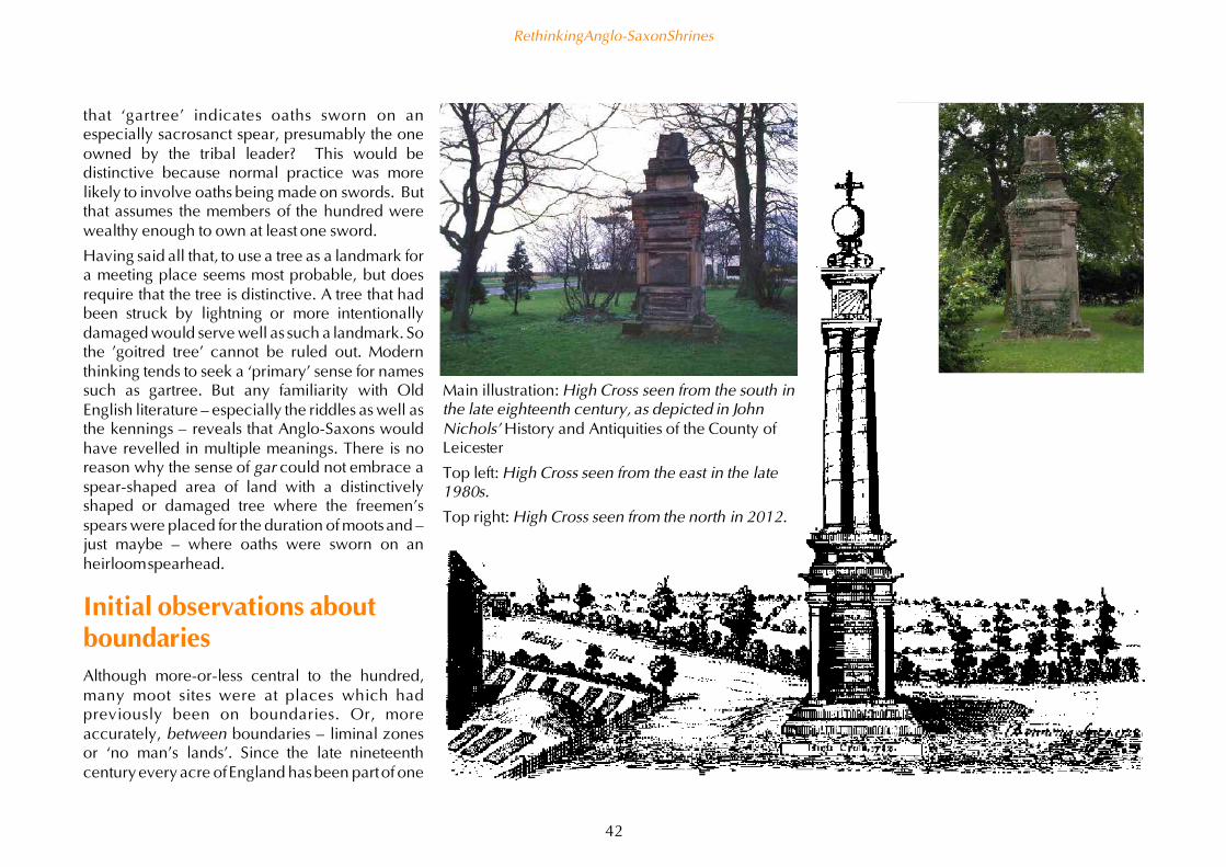
Main illustration: High Cross seen from the south inthe late eighteenth century, as depicted in JohnNichols' History and Antiquities of the County ofLeicester
Top left: High Cross seen from the east in the late1980s.
Top right: High Cross seen from the north in 2012.
that ‘gartree’ indicates oaths sworn on anespecially sacrosanct spear, presumably the oneowned by the tribal leader? This would bedistinctive because normal practice was morelikely to involve oaths being made on swords. Butthat assumes the members of the hundred werewealthy enough to own at least one sword.
Having said all that, to use a tree as a landmark fora meeting place seems most probable, but doesrequire that the tree is distinctive. A tree that hadbeen struck by lightning or more intentionallydamaged would serve well as such a landmark. Sothe 'goitred tree' cannot be ruled out. Modernthinking tends to seek a ‘primary’ sense for namessuch as gartree. But any familiarity with OldEnglish literature – especially the riddles as well asthe kennings – reveals that Anglo-Saxons wouldhave revelled in multiple meanings. There is noreason why the sense of gar could not embrace aspear-shaped area of land with a distinctivelyshaped or damaged tree where the freemen’sspears were placed for the duration of mootsand –just maybe – where oaths were sworn on anheirloom spearhead.
Initial observations aboutboundariesAlthough more-or-less central to the hundred,many moot sites were at places which hadpreviously been on boundaries. Or, moreaccurately, between boundaries – liminal zonesor ‘no man’s lands’. Since the late nineteenthcentury every acre of England has been part of one
Rethinking Anglo-Saxon Shrines
42

parish – and thus a county. County boundaries were also tidied up so thatthere were no detached parishes within adjoining counties. Prior to thatthere were still extra-parochial lands, and counties commonly includedplaces detached from the rest. I mention this only to emphasise that anyattempt to understand Anglo-Saxon boundaries will be wide of the mark ifwe try to impose neat and tidy modern concepts.
Many boundaries would have been ‘fuzzy’, as with inter-commonedwoodland, heathland or moorland. Such places may also have been inter-tribal meeting places, for seasonal fairs and associated rites. The mostdefined of boundaries were double-ditched earthworks. These seem to havebeen constructed by the two sides each digging out one of the ditches,leaving a linear liminal zone, presumably available for any travellers whopreferred not to enter either territory – or were simply unwelcome. Unlike
today, all boundaries seemingly once had a tangible ‘buffer zone’. Theubiquity of the place-name element ‘shaw’ (Old English sceage or scage), thename for woodland along a boundary (and cognate with ‘shore’ as in‘seashore’ and ‘shoreline’) provides direct confirmation for some of thesebetwix-and-betweenmargins.
Boundaries have two sides. Perceptions of those inside are different fromthose outside. And such perceptions differ depending on what was on theother side – friend, foe, sanctuary, liminal zone, inhospitable wilderness, orwhatever. To this day churchyards are carefully bounded with walls, hedgesor buildings. Even the dead – for some people, especially the dead – need tobe kept in their place. If such rich connotations are part of modern thinkingthen Anglo-Saxon concepts were almost certainly even more expansive.
I will return to boundaries again later. At this stage I simply want tosummarise my initial reading of the relationship of hohs and heargs. As Ihave already suggested, hohs seem to function as boundary shrines. Giventhat heargs seem to be placed at tribal boundaries the correlation of hohsand heargs should be unsurprising. It just might be that the hearg wasprotected – and defined – by a more-or-less complete ring of hohs orcomparable sites.
However my current thinking is that the opposite is more likely to be thecase. That is, the hohs protect each tribe’s territory, leaving the hearg in aliminal zone. This means that the hearg may appear to be ringed by hohs butthis is not the reason, simply that the hearg is ringed by tribal territories, eachof which needs one or more hohs. The examples of a ‘ring of hohs’ which Ihave identified so far are actually ‘arcs of hohs’ – encompassingapproximately one-third of the circumference. Assuming that furtherresearch does not reveal more hohs then the evidence is consistent with thehohs being recognised – at least to the extent of acquiring names with theelement hoh – by just one of the tribal regions bordering a hearg. Furtherwork on the evidence of hoh and hearg names may add more examples andthereby offer a clearer understanding, but for the moment I share this as atentative interpretation.
The Wansdyke looking towards the site of the lost village of Shaw.
Rethinking Anglo-Saxon Shrines
43

Rethinking heargsIf there is indeed a relationship between hohs and heargs then does this add anything to ourunderstanding of heargs? Compared to all other Anglo-Saxon words for pre-conversion sanctuaries,hearg has been the focus of considerable academic consideration. One of the more recent andthorough papers on this topic was published in 2007 by Sarah Semple. She concluded that:
What is profoundly apparent is that the concept of the hearg needs to be rethought – hearg wasnever applied to a Germanic or Anglo-Saxon pagan temple structure. The hearg seems to haveconstituted a naturally significant location that formed a place of gathering and ritual for manygenerations over a long period of time.
(Semple 2007: 383)
Based on the available archaeological evidence, Semple specifically argues that hearg sites are notcomparable to Christian churchyards – 'God's acre' – but, rather, typically spread over an area about ahundred times greater.
Although the name hearg itself clearly does not predate the Anglo-Saxons, there is more evidence athearg sites for Iron Age and Roman ritual activity than there is for Anglo-Saxon rites. This is probablybecause there were fewer Anglo-Saxons and also because the pagan depositions are associated with amaterial culture which is mostly or entirely organic so rarely survives for archaeologists to discover;while high-status items such as metal brooches may be found with burials but not as part of typicalhearg depositions.
Most significantly, all this ritual activity is within areas which Semple states are devoid of evidence foroccupation. That remark needs qualifying in light of the recent discoveries of Iron Age settlement atHarrow Farm near Elmstone Hardwicke but, nevertheless, seems to remain generally valid. (In myopinion odd exceptions do not invalidate general principles. Ironically, in recent decades some parishchurches have been converted into houses – interestingly two examples are at villages relevant to thetheme of this study, Hoton and Wyfordby, both in Leicestershire.)
Ken Dowden’s research on European paganism reveals that the Old High German word harugari had acounterpart in Old English, higweard. Both had the sense of 'hearg warden or guardian'. Interestingthere are also references to a weohward. (Dowden 2000: 242–4). These wardens presumably lived ‘onthe job’ so some evidence for occupation should be expected. Just possibly the houses revealed atElmstone Hardwicke were the home of Iron Age custodians of the sanctuary, precursors to Anglo-Saxon
Top: Hoton church, Leicestershire, shortly beforeconversion to a house
Above: Looking north into Nottinghamshire fromthe tower of Hoton church. Both photographstaken in the early 1980s by Philip White.
Rethinking Anglo-Saxon Shrines
44

higweards. This practice continued long after theconversion as priests commonly lived 'on the job'in a room above the chancel.
It is hard to imagine that the Anglo-Saxons werefully aware that these hallowed sites had beenused for well over a thousand years, although theywould of course recognise more substantially-built Roman shrines or such like. The Anglo-Saxons may have had little idea of how much'history' they were continuing, but they wouldhave fully recognised that these were the placeswhere the deities were thought to dwell, or bemore readily contacted. Along with the re-use ofBronze Age burial mounds for burials this was partof the ways in which the landscape of Englandwas 'read' according to the implicit worldviewsand more explicit myths established in while stilldwelling in their Continental homelands.
Interestingly, none of the place-names associatedwith hearg sites reveal a connection to anyspecific deity. So a hearg was not dedicated to,say, Odin, or Thor, or whoever. This is in contrastto Scandinavia where place-names such asOdense (Óðinn's ví) are common. This stronglyimplies that heargs were akin to Classicalpantheons, places where individual families orclans paid their respects to their own preferreddeity or deities, without any one deity taking prideof place overall. Based mostly on Continentalevidence then local deities – or local names formore ‘universal’ deities – seem to have been thefocus of family rites. Indeed, we should perhapssee them as ‘lineage deities’ as much as ‘local
Waden Hill seen from the site of a substantial early Anglo-Saxon settlement (now under the NationalTrust car park).
deities’. (I have attempted to provide a summary of Anglo-Saxon deities elsewhere – see Trubshaw2013.)
The assumption that a hearg is an inter-tribal cult centre is fairly inescapable from their location onboundaries. This infers that local cult centres which were not inter-tribal – such as those associated with–ing and –ingas ('the people of') place-names – will not have had hearg names. However caution isneeded. Harrow on the Hill, Middlesex, was once known as Gumeninga hearh ‘the sanctuary of theGumeningas tribe’ (Pollington 2011: 112).
One probable example of such a tribal cult centre is visible from my home here in Avebury: Waden Hillat Avebury. Andrew Reynolds has suggested that after the Romans departed the Canningas establishedcontrol of an area approximately twenty miles across. This putative territory had a western boundarynear the former town of Verlucio (now Sandy Lane near Calne), and eastern boundary near Cenutio(now Mildenhall – pronounced 'Mynull' – to the east of Marlborough). To the north the boundarywould have been marked by the dramatic ridge above the Thames valley associated with the villages ofChiseldon and Wroughton. Near the southern boundary are the eponymous villages of All Canningsand Bishops Cannings, near Devizes (which takes its name from the ‘divide’) (Reynolds 2004).
Waden Hill is both central to this area and immediately adjacent to the small Roman town recentlydiscovered near Silbury Hill, and there seems to be no better candidate for a ‘cult centre’ of theCanningas.
Rethinking Anglo-Saxon Shrines
45

The early records show Waden Hill is from weoh don (not, as so often stated,'Woden's hill'). However this weoh don is not completely distinct from ahearg as it shares the same 'beached whale' shape I previously noted forHarrow Hills. Presumably heargs would have one or more weohs associatedwith them, so a hearg and a weoh don may have looked somewhat similar,even if one was peripheral (and thus inter-tribal) and the other central (andpresumably infra-tribal).
The implication is that the Gumeninga hearh was peripheral – if anyonereading this can make any sensible suggestions about the extent of theGumeninga’s territory associated with Harrow on the Hill, I will be mostinterested.
Open air meeting placesSarah Semple revisited her 2007 ideas about hearg sites in her chapter inSignals of Belief (Carver et al 2010) which looks more broadly at Anglo-Saxon open air meeting places. These encompass natural places, groves andwoodland clearings and hilltops.
We know about these open air meeting places mostly because of their use inthe later Anglo-Saxon period as moot sites for administrative hundreds (theearly medieval counterpart to 'borough councils', although there were nocounties or county councils at that time). Some are also the venues for thehigher-level royal court which met as the king progressed endlessly aroundhis kingdom.
What is much less clear from the available evidence is the extent to whichthese meeting places had been hearg sites since 'time out of mind'. And,given that during these meetings various solemn oaths were sworn, to whatextent did all such meeting places take on some of the sanctity once given tohearg sites?
Turf ritualsAnd, to what extent did these meetings involve the ritual use of turf? There isfolkloric evidence of an early eighteenth century landowner atQueniborough, Leicestershire, requiring his tenant farmers to bring a turffrom their land and place it on top of a standing stone at the start of eachadministrative ‘court’. Only when all the turves were in place could the‘court’ commence. The stone is known as the Moody Bush Stone and seemsto have acquired this name when the East Goscote Hundred met there(presumably from the eleventh century as prior to the East and West split inthat hundred there was a different moot site).
While evidence for similar customs is absent, there are tantalising clues thattaking turves to ‘moots’ and such like was indeed once the norm. Theclearest evidence is from a metrical text in Old English called Æcerbot (‘fieldremedy’) and commonly referred to as the Land Ceremonies Charm andsometimes as the Unfruitful Land Charm. It is known from one survivingcopy (British Library MS Cotton Caligula A VII), probably written between1000 to 1025. It sets out a ritual which combines Christian liturgy andliturgical phrases with some actions and words which imply a pre-conversion origin.
How you can improve your fields if they will not flourish or if anyharmful effect has been produced by magic or witchcraft. By nightbefore it becomes dawn take four turves from the four sides of theland…
The rite then prescribes a poultice of yeast, honey, oil and milk mixed withparts of all the good herbs that grew, excluding buckwheat and woody plantswhich is applied to the roots.
… and then carry the turves to church and let the priest sing fourmasses over the turves; and one should turn the green side of theturves towards the altar and one should replace the turves wherethey came from before the setting of the sun…
Rethinking Anglo-Saxon Shrines
46
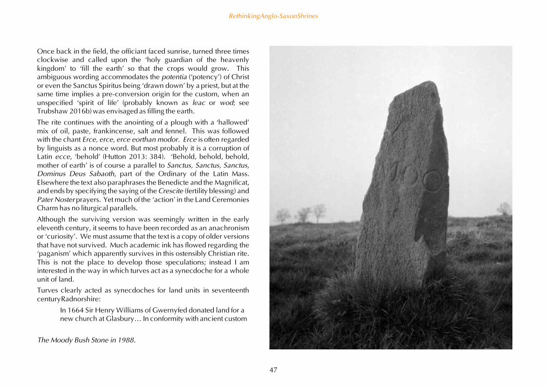
The Moody Bush Stone in 1988.
Once back in the field, the officiant faced sunrise, turned three timesclockwise and called upon the ‘holy guardian of the heavenlykingdom’ to ‘fill the earth’ so that the crops would grow. Thisambiguous wording accommodates the potentia (‘potency’) of Christor even the Sanctus Spiritus being ‘drawn down’ by a priest, but at thesame time implies a pre-conversion origin for the custom, when anunspecified ‘spirit of life’ (probably known as leac or wod; seeTrubshaw 2016b) was envisaged as filling the earth.
The rite continues with the anointing of a plough with a ‘hallowed’mix of oil, paste, frankincense, salt and fennel. This was followedwith the chant Erce, erce, erce eorthan modor. Erce is often regardedby linguists as a nonce word. But most probably it is a corruption ofLatin ecce, ‘behold’ (Hutton 2013: 384). ‘Behold, behold, behold,mother of earth’ is of course a parallel to Sanctus, Sanctus, Sanctus,Dominus Deus Sabaoth, part of the Ordinary of the Latin Mass.Elsewhere the text also paraphrases the Benedicte and the Magnificat,and ends by specifying the saying of the Crescite (fertility blessing) andPater Noster prayers. Yet much of the ‘action’ in the Land CeremoniesCharm has no liturgical parallels.
Although the surviving version was seemingly written in the earlyeleventh century, it seems to have been recorded as an anachronismor ‘curiosity’. We must assume that the text is a copy of older versionsthat have not survived. Much academic ink has flowed regarding the‘paganism’ which apparently survives in this ostensibly Christian rite.This is not the place to develop those speculations; instead I aminterested in the way in which turves act as a synecdoche for a wholeunit of land.
Turves clearly acted as synecdoches for land units in seventeenthcentury Radnorshire:
In 1664 Sir Henry Williams of Gwernyfed donated land for anew church at Glasbury… In conformity with ancient custom
Rethinking Anglo-Saxon Shrines
47

he had to demonstrate that he relinquished the land by cutting a turfwhich he placed in a fold of the bishop’s gown and said: ‘I resigneupp all my interest in this circuit of ground, to be a buringe-place forever for the dead of this parishe’.
(Palmer 2001: 143–4)
Roy Palmer continues by saying that
Such use of a turf may hark back to Saxon times, when a turf fromland being granted to a monastery was sent along with the deeds tothe archbishop for placing on the altar, as confirmation of the grant.
(Palmer 2001: 144)
Sadly he gives no source for this statement.
If you visit Scone in Scotland there is a good chance that you will be told thata flat-topped mound in the grounds, now with a chapel on top, was builtfrom the mud on the boots of the Scottish barons who came to visit the king.This is why it is known as Boot Hill.
Left: Glasbury in 1887.In 1664 the old churchnear the Wye had beendamaged by floodingand Sir Henry Williamsdonated the land forthe current parishchurch.
Top right: Boot Hill,Scone.
Bottom right: Tynwald,Isle of Man.
Rethinking Anglo-Saxon Shrines
48

A great example of how folklore mangles history! The name is a corruptionof Moot Hill and comprises the turves brought (seemingly in leather scrips or‘satchels’) so they could swear allegiance to the king while kneeling on theirown ground. This custom is known from the thirteenth century and ispresumably older. The barons would not have had much mud on their bootsas there were almost no roads and they needed to travel to Scone by boat.
Another example of a ‘moot mound’ which still acts as the ceremonial focusof kingship in northern Britain is known by the Scandinavian word‘Tynwald’. This is where Manx laws are still authorised every midsummer.It too seems to be a turf-built mound, although there is no record of wherethe turves came from. I assume each landowner eligible to attend the Manxparliament once brought one.
Palmer’s description of the Radnorshire land exchange and his backgroundinformation suggestion that there was once a widespread custom for turvesact as a synecdoche for a unit of land. Such ‘customary practices’ rarelyleave much record as they are unremarkable at the time. Based on theevidence from Scone and Tynwald we should not be surprised that suchsymbolic use of turves was especially linked with hundredal mootsand otheradministrative gatherings. We might imagine that there was some sort ofturf-built mound at every hundred moot site up and down the land.
Why a hearg here?After that digression into the ‘symbolic’ relationship with land which seemsto have been so commonplace in the Anglo-Saxon era as to be unremarkableI want to return to the sorts of places which would have been deemed‘numinous’ enough to be used for moots and, prior to that, as sanctuaries.
We must reasonably assume that Anglo-Saxon settlers ‘respected’ thesanctity of at least some of the sites where the Romano-British had – and, inall probability, still did – venerate their deities. These were the heargs. Theymay have looked ‘auspicious’, if only from the evidence of former rites andsacrifices, and at the very least conformed to the immigrants’ expectations ofwhat such ‘sanctuaries’ should be like. These ‘adopted’ sites may also haveinfluenced these expectations, but such ‘reflexivity’ defies recognition. But
what about sanctuaries which were not regarded as heargs? Did they sharesome of the expectations of heargs sites? Or were they, at least in somerespects, mutually exclusive?
Place-name evidence suggests that the Anglo-Saxons thought of thelandscape as containing any number of natural features which wereregarded, if not necessarily as 'sacred' or 'numinous', then at least placeswhere the supernatural was a little closer. Semple's list includes:
springs and wells
hollows and fissures
caves and openings
hilltops, knolls and natural barrow-shaped features
specific trees and shrubs
standing stones and stones with natural holes
Groves and open spaces seem more likely to be associated with specificdeities – there are various place-names where Woden, Thor and Tiw are allfound in combination with leah ('woodland clearing') or feld ('large openfield'). There are also a significant number of place-names which derive fromweoh leah 'shrine clearing' (see Bintley 2015: 118 for a recent overview).
We should imagine both woodland clearings and large open fields as placesused for pasturing animals – indeed as communal pasturing for all theanimals of a community. Using woodland for pasturing animals is now rarein western Europe but was necessary in the era before haymaking wasinvented to provide winter forage.
At the risk of distracting from the main discussion, note that over thecenturies the sense of leah seems to change from ‘clearing’ (leah may becognate with leoht 'light'; see Bintley 2015: 114–5) to ‘woodland’. I haveopted to gloss as ‘woodland clearing’ as this seems the only sensibleinterpretation of place-names formed from a god name followed by leah.Pedantically, leah should be glossed simply as ‘clearing’ because ‘woodlandclearing’ is tautological for exactly the same reasons there cannot be a holein a doughnut without a doughnut. I fully accept that other, presumablylater, names containing leah may refer solely to woodland.
Rethinking Anglo-Saxon Shrines
49

On higher groundThe accepted sense of hoh is a heel-shaped promontory. Hlaws and beorgstypically are situated on the apparent skyline when viewed from lowerground associated with settlements. The place-name elements hearg andweoh are most commonly found in such modern names as Harrow Hill,Weedon and other such descriptive terms which reveal that they occupiedelevated location.
I fully accept that there are also Weefords which clearly were not associatedwith the tops of hills, so the concept of a weoh embraced a variety oftopographical scenarios. As noted, Classical Greek and Roman sanctuariesdedicated to Artemis were similarly at conspicuously high as well as lower-lying locations; one of the unifying factors would seem to be ‘dangerouspassages’. Biblical sources provide copious evidence for Semiticassociations between God and high places – from Moses going to the top ofMount Sinia, any number of prophetic visions in high places, through to theSermon on the Mount, Golgotha, and Christ’s Ascension from Mount Olivet.While none of these Classical or Biblical sources would have been known topre-conversion Anglo-Saxons they have deeply influenced modern secularthinking. For example Stephen Pollington has written:
The elevated situation of the hearh may have emphasized the site’sspecial position between the worlds of gods and men, while thestrong vertical contour may have symbolizes the line extendingbetween the plane of gods, men and the dead. In those societieswhich adopted the barrow-building rite, the grave-moundsthemselves acted as cult centres, and it may be that the initial act ofdigging a circular ditch was part of the ritual preparation whichmade the site separate from the mundane, secular world, andtherefore capable of being made holy. A barrow and a hearh mayhave been expressions of similar ideas concerning an elevatedposition with separation from the mundane.
(Pollington 2011: 112)
Top: Each of these clumps of beech trees 'protects' one or more Bronze Ageburial mounds near the Ridgeway on Overton Hill. This photograph wastaken from the side of Waden Hill; the late Neolithic double stone rowknown as West Kennett Avenue can just be discerned running parallel withthe nearest hedge.
Above. Standing on the Ridgeway looking towards Waden Hill (in themiddle distance). Although these burial mounds are on the skyline whenseen from Avebury, they are in fact about three hundred metres away fromthe highest part of the ridge. They were clearly located to been seen fromthe lower ground around.
Rethinking Anglo-Saxon Shrines
50

Overall this seems to be an entirely plausible suggestion. However did theAnglo-Saxons really think about the gods being on a different ‘plane’ to theliving? After all the evidence we have for North European and Scandinaviandeities is that they ‘walked this earth’ – they were immanent, unlike thetranscendent deities of Semitic and Classical cultures (see Volume Two ofThe Twilight Age for a much more extended discussion). Based oncircumpolar myths about the role of swans and geese as psychopomps, moreprobably it was the souls of the dead which needed easy access to the sky. Inother words the elevated locations of ‘shrines’ placed them closer to the‘plane of the dead’ rather than the plane of the deities.
Our understanding of where Anglo-Saxon cemeteries are located has beendistorted by the high proportion discovered as a result of gravel extraction invalleys. However others are located in the same sort of locations as hilltopsanctuaries. In contrast, very few Anglo-Saxon burials have been found athearg sites. Extensive cemeteries seem to be distinct from heargs, but mayonly be a mile or so away. Based on Semple’s statements about the size ofheargs there is a possibility that such cemeteries are on the boundaries ofwhat was recognised as the hearg.
If the heargs were inter-tribal areas or ‘no man’s lands’ then this would meanthese cemeteries are also on the bounds of the recognised tribal territories.Such a ‘liminal’ location would be entirely consistent with where we mightexpect the dead to be buried and honoured, and for them to act asposthumous protectors just as they would have protected the tribe whilealive.
So, contrary to Pollington’s assumptions about elevated locations beingnearer to the gods, there seems to be a greater correlation with the ‘plane ofthe dead’ than with the ‘plane of the deities’. As indirect support note thatthe cult of the Archangel Michael is introduced to Britain around the ninthcentury. He is the first ‘saint’ who is not an apostle, martyr, missionary orconfessor. By the eleventh century Michael is principally associated withdragon-killing, a ‘personification’ of evil. But that is not how he was firstpopularised. Instead he was regarded as a psychopomp, someone who canhelp the souls of the dead in the afterlife. For this reason pre-Conquest
From an article by Lucy Ash about the reburial of Russian soldiers killed inthe Second World War near St Petersburg:
Young men dressed in Soviet-style army uniforms form a guard ofhonour. Visibly moved, as coffin after coffin is carried past to beburied, some of them look up to the sky. There is a belief that birdsflying overhead transport the souls of the dead.
www.bbc.co.uk/news/magazine-25589709
churches dedicated to Michael are on hilltops, giving the dead buried there a‘head start’ to Heaven (Bartlett 2013: 165–6).
Ringed by the far horizonsThese ontological quibbles do not undermine Pollington’s observationsabout using ditches – included in the broader sense of the word beorg – todefine ritual places. Which begs the question of just how big such a ditchshould be – and what happens when the concept of such an encompassing
Rethinking Anglo-Saxon Shrines
51

circle is far bigger than anything which could be constructed. And, justbecause the ditch survives to be discovered by archaeologists, was thatnecessarily more important than the bank made from the extracted soil?Clearly the mound made from the ditch surrounding a barrow was moreimportant than the ditch, without suggesting that the ditch was merely ameaningless ‘by-product’. Could the same have been true of the boundariesof heargs? The topography of heargs sheds more than a little light.
Semple discusses in some detail the variety of hill shapes associated withhearg place-names and other ritual meeting places. Although detailed herdiscussion is not exhaustive. For example, her examples of 'dramatic rises ofland which at a distance, however, are hidden from view' is not exclusive toheargs as Waden Hill at Avebury, most certainly fits that description too.Nevertheless her insight into visually dramatic sites which are to some extenthidden also provides clues to locate hearg sites which are known only fromplace-name evidence.
On-going personal research suggests that major prehistoric ‘sacred sites’ –from Neolithic henges to Anglo-Saxon heargs – are located at places wherethey appear high up but are ‘ringed’ by a higher horizon. Geographicalconstraints sometimes prevent a complete ring, but a minimum of threedifferent ridges of high ground in different directions seem to ‘define’ hengesand heargs.
Examples include several prehistoric henges as far apart as Avebury,Wiltshire, and Castlerigg, Cumbria. Other examples include the nemetons inDevon, and Vernemetum and Harrow Farm in north Leicestershire (alldiscussed in Trubshaw 2012). In this work have already mentioned theHarrowdown in Birdbrook parish, Essex, and the Harrow Farm nearElmstone Hardwicke. The latter is situated where the horizon comprisesseveral different ridges of hills, including the Malverns (to the north-west),the Cotswolds (to the south) and Harrow Hill near Long Compton (to theeast). I share this provisional research with readers in the hope that they willinform me of yet more examples of places which seemingly fit into thispattern.
There is a very pragmatic reason for wanting the horizon to be higher thanwhere one is standing, and that is to observe sunrises and sunsets. On levelground or ground higher than the east or west horizon then almost inevitablya distant bank of cloud obscures the sun at the time it is rising or setting.However just a few minutes later the sun rises above the cloud bank.
Where I live at Avebury the sunrise is delayed by the Marlborough Downs tothe north-east. Furthermore from within the henge the sun is only visibleabout five minutes later, by which time it is well above the typical cloudbank and ‘greets’ anyone watching with a spectacular brightness and castinglong but sharp shadows of the megaliths and people within the henge.Sunrise seen from within a henge is far more theatrical than from placesoutside. The most obvious comparison is with the sun shining through thestained glass east window of a church at about nine o’clock in the morning.But as few people attend Morning Prayer (which is often earlier in the day)then this is an experience which even church-goers rarely experience.
Suffice to say that neither churches nor henges can be understood simply byturning up in the middle of the day – they need to be experienced at differentseasons and all times of day and night. (Though I am especially privileged,living on the bank of the Avebury henge next door to the parish church… )None of this directly informs us about Anglo-Saxon practices, but theinherent conservatism of ritual practices means that continuity fromprehistory into the post-conversion era is entirely plausible. Indeed theopposite scenario – that missionaries ‘invented’ the requirement forchurches to face east – is not supported by any evidence and seemsconsiderably more difficult to propose than a scenario based aroundcontinuity of praxis.
Watching the sunrise and set from a henge, nemeton or hearg where thedistant horizon is higher minimises the opportunities for the sun to simply‘fizzle’ into a cloud bank. It simply makes for good theatre to have thehorizon ringed by higher ground.
Rethinking Anglo-Saxon Shrines
52

Top left: The first midwinter sunrise at Avebury. Photograph takenat the western end of the West Kennett Avenue, a few hundredmetres from the south entrance to the henge. Seen from here thesun rises in the beech tree clumps shown in the photographs onpage 36 – in other words, from a major group of Bronze Ageburial mounds and close to another group known to have beenused for Anglo-Saxon burials.
Bottom left: The second midwinter sunrise at Avebury. Takenfrom just inside the south entrance to the henge, about tenminutes after the previous photograph. The sun appears over thehenge bank much more dramatically as it has long since clearedthe almost-inevitable cloud bank in the far distance.
Below: Looking west – the bright sun casts dramatic sharpshadows.
Rethinking Anglo-Saxon Shrines
53
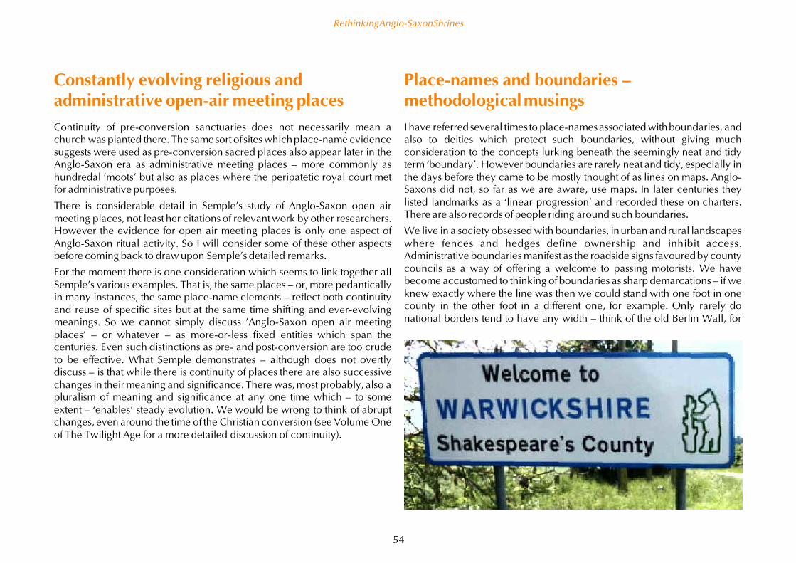
Constantly evolving religious andadministrative open-air meeting placesContinuity of pre-conversion sanctuaries does not necessarily mean achurch was planted there. The same sort of sites which place-name evidencesuggests were used as pre-conversion sacred places also appear later in theAnglo-Saxon era as administrative meeting places – more commonly ashundredal 'moots' but also as places where the peripatetic royal court metfor administrative purposes.
There is considerable detail in Semple's study of Anglo-Saxon open airmeeting places, not least her citations of relevant work by other researchers.However the evidence for open air meeting places is only one aspect ofAnglo-Saxon ritual activity. So I will consider some of these other aspectsbefore coming back to draw upon Semple's detailed remarks.
For the moment there is one consideration which seems to link together allSemple's various examples. That is, the same places – or, more pedanticallyin many instances, the same place-name elements – reflect both continuityand reuse of specific sites but at the same time shifting and ever-evolvingmeanings. So we cannot simply discuss 'Anglo-Saxon open air meetingplaces' – or whatever – as more-or-less fixed entities which span thecenturies. Even such distinctions as pre- and post-conversion are too crudeto be effective. What Semple demonstrates – although does not overtlydiscuss – is that while there is continuity of places there are also successivechanges in their meaning and significance. There was, most probably, also apluralism of meaning and significance at any one time which – to someextent – ‘enables’ steady evolution. We would be wrong to think of abruptchanges, even around the time of the Christian conversion (see Volume Oneof The Twilight Age for a more detailed discussion of continuity).
Place-names and boundaries –methodological musingsI have referred several times to place-names associated with boundaries, andalso to deities which protect such boundaries, without giving muchconsideration to the concepts lurking beneath the seemingly neat and tidyterm ‘boundary’. However boundaries are rarely neat and tidy, especially inthe days before they came to be mostly thought of as lines on maps. Anglo-Saxons did not, so far as we are aware, use maps. In later centuries theylisted landmarks as a ‘linear progression’ and recorded these on charters.There are also records of people riding around such boundaries.
We live in a society obsessed with boundaries, in urban and rural landscapeswhere fences and hedges define ownership and inhibit access.Administrative boundaries manifest as the roadside signs favoured by countycouncils as a way of offering a welcome to passing motorists. We havebecome accustomed to thinking of boundaries as sharp demarcations – if weknew exactly where the line was then we could stand with one foot in onecounty in the other foot in a different one, for example. Only rarely donational borders tend to have any width – think of the old Berlin Wall, for
Rethinking Anglo-Saxon Shrines
54

example, with a ‘no go’ zone in-between formal checkpoints. A similarsituation still exists in Nicosia, Cyprus, and between North and South Korea.
Traditionally, a liminal zone was characteristic of major boundaries. Thesemanifest as ridgeway routes which could be followed without entering theterritories of the tribes either side. This seems to be the origin of at least partsof the routes which became the Roman Watling Street and Fosse Way, asthese both follow watersheds but Iron Age hill forts are conspicuously absentfrom their course (although often sited a few miles away).
Boundaries have existed since ‘time out of mind’ – even when an astutehistorian can demonstrate they may only go back a few generations. It is inthe nature of boundaries that they need to remain fixed. There are biblicalprohibitions against moving boundary markers, reflected – with direpunishments – in Anglo-Saxon law codes.
Little wonder that the Old English adjective har refers unambiguously toboundaries (Jepson 2011: 181) in such compounds as har stan, ‘hoar stone’yet is also cognate with ‘hoary’, meaning ‘venerable, ancient’ as well as‘gray or white with age’ – the same sense as ‘hoar frost’. Hoar stones nodoubt acquired lichen, making them appear ‘hoary’. However, Jepsonconsiders that neither the sense of ‘venerable’ nor of ‘boundary’ is primary tothe word har, but has developed out of usage and association (Jepson 2011:221).
Har in place-names is inherently tricky because instead of har the name mayinstead be a corruption of hara (‘hare’), haer (‘heap of stones and/or burialcairn’), horu (‘dirt or mud’) or even here (army). As with toot, I am happy toaccept that Anglo-Saxon’s revelled in the overlapping meanings ofhomonyms, without any care for the confusion this might cause toacademics in the future. We need to understand har not as a phoneme with asingular semantic sensibility but instead as a word with both evolvingmeaning and usage and also as part of a ‘constellation’ of words.
Although there are plenty of har stans and almost as many har hlaws (Jespon2011: 189–92), har also frequently compounds with hill, ridge, specificspecies of trees, wood and grove. In addition there are rare examples of harused with well, stream and ‘cottage’ or shelter.
One of the 'hoary' stones at Avebury. This one is one of the few stillstanding from the northern inner circle and faces – quite literally – theeastern entrance.
So far as I am aware har does not appear in compounds with hoh, toot, ward,woeh, stapol or other Old English words which I have considered elsewherein this study. This is itself interesting – implying, for example, that a har stanmight have been distinct from a weoh stan. Har stans and har hlaws wereold, ‘hoary’ stones and burial mounds which may well have been used asboundary landmarks. However there seems to be nothing about the use ofhar in place-names which suggests that it denotes boundary shrines. Myassumption is that har is only used later in the Anglo-Saxon era, afterconversion, but I would be happy to be corrected by anyone who has givenany consideration to why this commonly-used adjective for boundariesseems not to occur in compounds with pre- or post-conversion religiousconnotations.
Rethinking Anglo-Saxon Shrines
55

Blurring boundariesBoundaries were often not so much marked as shared. This was as true ofwoodland as it is of heathland. In both areas there would have been somesort of ‘inter-commoning’ agreements in place. Only when these resourcesbecame of increasing value – and, presumably, less abundant – was there aneed to impose some sort of demarcation (see Pantos 2002; 2004). To thisextent place-names associated with heathland and woodland shouldpartially correlate with boundaries. Clearly the semantic relationship is notthat of maere, mearc and other words which explicitly refer to a boundary.But, nevertheless, the spatial distribution will help to reveal former ‘liminalzones’, especially when located at watersheds or other topographicalfeatures which also correlate well with boundaries.
Prehistoric burial mounds have long been recognised as indicators ofboundaries, and Anglo-Saxon naming practices correlate with this. Forexample, in north and south of Rutland are the settlements of Barrow andBarrowden. As Charles Phythian-Adams discerned, the modern boundariesof Rutland mostly reflect an Iron Age land unit (Phythian-Adams 1977; 1980)so the beorgs once overlooking these villages become their most distinctiveattribute. By this time the causal relationship between beorgs andboundaries is that of chickens and eggs, but the correlation between‘barrow’ place-names and boundaries is my point of interest.
If I seem to be somewhat labouring the manner in which some place-nameelements correlate with boundaries then this seems necessary. A major studyof English place-name elements relating to boundaries was prepared as aPhD thesis by Boel Jepson (Jepson 2011). However, for entirelyunderstandable reasons, Jepson takes as his starting point place-nameselements occurring on boundary charters, rather than starting out by asking‘Which elements correlate with plausible boundaries?’
By looking at the texts of boundary charters rather than the actual spatialdistribution of place-name elements risks missing place-names that onlyappear near (rather than actually on) the bounds. Furthermore, by startingfrom place-name elements appearing on boundary charters then the
chronology of naming has been narrowed down to those names thought byChristian clerics to be appropriate for marking boundaries. This raises thepossibility that older names, coined with a different ‘worldview’ orcosmological assumptions, are at risk of being overlooked.
These potential weaknesses in Jepson’s methodology become clear withhoh. As already noted, he identified a landmarehowe in Cambridgeshire,deriving from the Old English land-gemære hoh or ‘land boundary hoh’.Land-gemære occurs in many names associated with boundaries, includingcompounds with wood, well, hill and so forth. But this is only land-gemærehoh that Jespon discovered. However he also discusses a Hoham nearHutton Grange in Penwortham, near Preston, Lancashire. Hoham isassociated with a Rokar, which might be from the Old Norse ra, meaning aboundary or boundary mark (Jepson 2011: 72; 168). Hutton is in theconfluence of the Ribble and Asland (also known as the River Douglas),suggesting that this is another hoh associated with the boundary betweenland and water, with land demarcations only arising later. But these are verymuch incidental to Jepson’s study and he omits hoh from his list of place-name elements denoting boundaries. Further research is needed, not only toshed more light on the relationship of hohs to boundaries, but also toestablish if there are other place-name elements not hitherto regarded as partof the ‘corpus’ of elements associated with boundaries.
Overall Jepson’s study is hugely helpful and based on immense research andsolid linguistic skills. I am simply drawing attention to an underlyingmethodological weakness. This weakness is not specific to Jepson’s work buta seemingly an inevitable consequence of a discipline where linguistsgreatly outnumber geographers. I am not a geographer either, butnevertheless do not share these linguists’ categorical presumptions aboutwhat is – more strictly, perhaps, what is not – a boundary-denoting place-name element.
Two place-names derived from OE bord are on the historic county boundarybetween Warwickshire and Worcestershire: Bordesley and Balsall (earlyform Bordes healh) and there are three other examples of bord having thesense 'border' in charters. In addition there is Bordeshowe in Suffolk, 'aname well recorded from about 1200 onwards as an important landmark in
Rethinking Anglo-Saxon Shrines
56

the boundary of Ipswich', surviving in the corruption 'Boss Hall' (Briggs2017).
So-far unpublished research by Graham Aldred provisionally suggests that atleast some worths were intentionally created on boundaries, although thereason for this is open to debate (Aldred pers.com. 2017).
In summary, place-name specialists seem to have largely overlooked thepossibility that hoh, bord and worth have some correlation with boundaries.My suspicion is that other place-name elements may also reveal more aboutboundaries.
Giants in the landscapeSo far my discussions about hohs has focused on the name as functional aswell as descriptive. With that functional aspect in mind I now want to lookanew at the descriptive aspect. When used to describe places the word hohis a metaphor, as the principal sense is of ‘heel’. As I discussed right at thestart, Margaret Gelling deduced that as a place-name it referred to a heel-shaped promontory, imaging a giant lying face down.
Before villages and churches changed things, the rounded profile of a hohsitting on the skyline would have looked like a oversided hlaw or burialmound. It takes only a modicum of imagination – something the Anglo-Saxons certainly had more than a modicum of – to think that that hohs werethe burial places of tutelary giants – the thyrs and eoten of Old Englishliterature.
Apart from modern place-name scholars who invented the description ofhohs as being like the heel of a giant lying face down, there are otherparallels. The Neolithic long barrow known today as Adam's Grave whichsits prominently above the Vale of Pewsey in Wiltshire was known to Anglo-Saxons from at least as far back as the late sixth century as Woden's beorg.Woden was not strictly a giant but this somewhat hoh-like promontory hasall the right 'credentials' to the burial place of an important deity ormythological being.
Jeremy Harte identified a small number of place-names formed from a pagandeity’s name with hlaw and used as hundredal meeting places. Heconcludes that by the tenth century (when the hundred were formed)
... the old gods were still embedded in heroic language, thewordhoard which held earth and sky tree and stone, fire anddrink, and love and death; words which reminded them of themeaningful order of the world...(Harte 2015: 65)
In a word, 'cosmology'. And into that worldview hohs too once were part,though by the tenth century their cosmological 'function' had been longforgotten and so they survived only as a descriptive term.
The early Neolithic chamber tomb now known as Adam’s Grave, althoughbarely visible in this photograph, sits on the skyline above the modern whitehorse hill figure when seen from Alton Barnes in the Vale of Pewsey. Thehighest ground to the right of this photograph is Knapp Hill, with a well-preserved causewayed enclosure contemporary with the chamber tomb.
Perhaps it should come as no surprise that one of the best of the many turf-cut white horses in Wiltshire is to be found on the scarp slope leading up toAdam’s Grave. This horse was cut in 1812 and, so far as is known, is notthe successor to a hill figure a millennium or more older. But clearly thelocation lends itself to such ‘land art’ and we cannot assume there neverwas a figure of Woden ‘walking the earth’ at the southern end of the denewhich took his name.
Rethinking Anglo-Saxon Shrines
57

The liminal locations of at least some of the hohs would have been exactlythe sort of places where a tutelary deity – a guardian of the land – might beexpected to be buried. There are two examples of Tysoe Hill, one inLeicestershire and the more famous one on the Oxfordshire-Warwickshireborder, which are named after the god Tiw. There is also Inghoe inNorthumberland, which perhaps is the hoh associated with the deity Ing.Which perhaps makes Shaftoe, also in Northumbria – the 'shaft hoh' – acandidate for a hoh with a stapol-like shaft.
Thurs haugr is the Old Norse counterpart to thyrs hlaw and comes down tous in the corrupt form Thrushhowe, Cumbria. And there is an entan hlew –which uses eoten rather than thyrs as the word for giant – on an ænta dic,'giant's ditch' (sadly my source, Sproston 2011, does not state in whichcounty this gigantic earthwork is or was situated).
Surviving place-names seemingly provide no examples of thyrs hoh or eventhyrs hlaw, although such names may have later corrupted into namesinvoking Thor. Place-names incorporating Thor are in the parts of England
Above: The Uffington White Horse is well-known from aerial photographs –but difficult to see from the ground. However views from the figure (seebelow) are dramatic.
The rising sun at midsummer casts a clear shadow of a small clump of treesgrowing near the Ridgeway about a mile away onto the slope of WadenHill. The trees are associated with a Bronze Age burial mound.
Rethinking Anglo-Saxon Shrines
58

Several authors havediscussed the similaritiesbetween the Fingleshambuckle (shown in adrawing by Lindsay Kerr)and the hill figure knownas the Wilmington LongMan. Note especially thedepictions of the feet.
Rethinking Anglo-Saxon Shrines
59
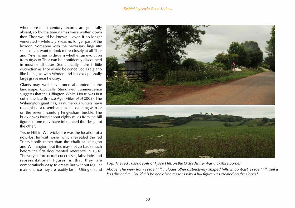
where pre-tenth century records are generallyabsent, so by the time names were written downthen Thor would be known – even if no longervenerated – while thyrs was no longer part of thelexicon. Someone with the necessary lingusiticskills might want to look more closely at all Thorand thyrs names to discern whether an evolutionfrom thyrs to Thor can be confidently discountedin most or all cases. Semantically there is littledistinction as Thor would be conceived as a giant-like being, as with Woden and his exceptionallylarge grave near Pewsey.
Giants may well have once abounded in thelandscape. Optically Stimulated Luminescencesuggests that the Uffington White Horse was firstcut in the late Bronze Age (Miles et al 2003). TheWilmington giant has, as numerous writers haverecognised, a resemblance to the dancing warrioron the seventh-century Finglesham buckle. Thebuckle was found about eighty miles from the hillfigure so one may have influenced the design ofthe other.
Tysoe Hill in Warwickshire was the location of anow-lost turf-cut horse (which revealed the redTriassic soils rather than the chalk at Uffingtonand Wilmington) but this may not go back muchbefore the first documented reference in 1607.The very nature of turf-cut crosses, labyrinths andrepresentational figures is that they arecomparatively easy to create but without regularmaintenance they are readily lost. If Uffington and
Top: The red Triassic soils of Tysoe Hill, on the Oxfordshire-Warwickshire border.
Above: The view from Tysoe Hill includes other distinctively-shaped hills. In contrast, Tysoe Hill itself isless distinctive. Could this be one of the reasons why a hill figure was created on the slopes?
Rethinking Anglo-Saxon Shrines
60

Wilmington were created – and, above all, maintained – in the Anglo-Saxonera then we must assume they were just two examples of a tradition whichones included tens or hundreds of other, now lost, examples. This wouldlead to an expectation that giants ‘occupied’ prominent hill slopes. Thyrs,Thor and Woden would indeed walk the earth. I have previously noted thatif the goddess Hos is shown on the Franks Casket sitting on a mound then sheis in the same proportion to the mound as a turf-cut hill figure might appear.
Were such giants thought of as weohs? On the face of things hill figures havelittle in common with carved wooden posts. But if the sense of weoh is asmuch functional as descriptive – viz. the word denoted an ‘icon’ of a deity –then they would have had much in common. We simply cannot rule out thepossibility that weoh dons took their name from one or more turf-cut figures
Could gigantic hillfigures once have beentypical on the sides ofheargs? Thisphotomontagecombines Hos on hermound (as shown onthe Franbks Casket)with Harrow Hill nearLong Compton.
on the sloping sides. The nearest I can offer as evidence is the way that oftrees on the skyline to the north-east of Waden Hill at Avebury cast crispshadows on the east-facing slope at midsummer sunrise (and almostcertainly during the weeks before and after although the necessarycombination of clear weather and crop-growth on Waden Hill has precludedpersonal observation). In other words, that side of Waden Hill comes alivefor a few minutes as the shadows are created and quite rapidly move,potentially interacting with putative turf-cut figures. The presence of the lateNeolithic double stone row known as the West Kennett Avenue parallel tothis side of Waden Hill adds extra ‘drama’ to the location. The soil is chalkyso would enable dramatic giant figures to be cut; indeed within a few milesare several turf-cut horses, all seemingly cut since 1722 (Edwards 2014).
Rethinking Anglo-Saxon Shrines
61
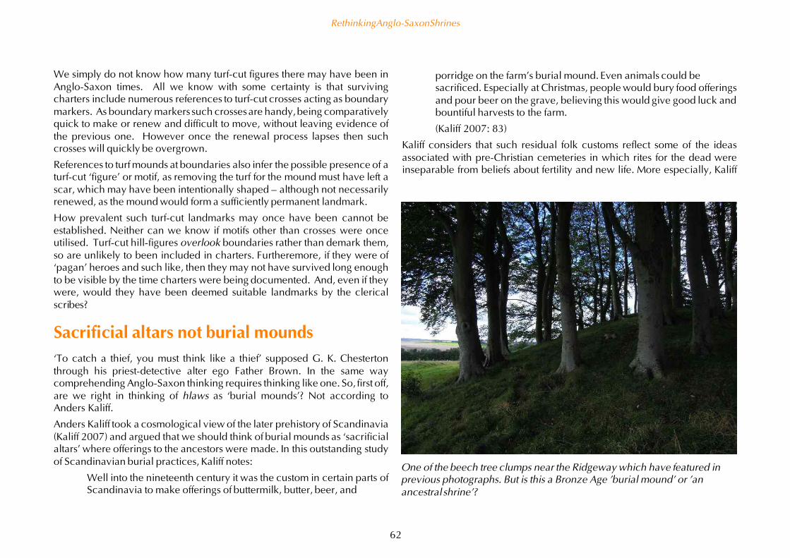
We simply do not know how many turf-cut figures there may have been inAnglo-Saxon times. All we know with some certainty is that survivingcharters include numerous references to turf-cut crosses acting as boundarymarkers. As boundary markers such crosses are handy, being comparativelyquick to make or renew and difficult to move, without leaving evidence ofthe previous one. However once the renewal process lapses then suchcrosses will quickly be overgrown.
References to turf mounds at boundaries also infer the possible presence of aturf-cut ‘figure’ or motif, as removing the turf for the mound must have left ascar, which may have been intentionally shaped – although not necessarilyrenewed, as the mound would form a sufficiently permanent landmark.
How prevalent such turf-cut landmarks may once have been cannot beestablished. Neither can we know if motifs other than crosses were onceutilised. Turf-cut hill-figures overlook boundaries rather than demark them,so are unlikely to been included in charters. Furtheremore, if they were of‘pagan’ heroes and such like, then they may not have survived long enoughto be visible by the time charters were being documented. And, even if theywere, would they have been deemed suitable landmarks by the clericalscribes?
Sacrificial altars not burial mounds‘To catch a thief, you must think like a thief’ supposed G. K. Chestertonthrough his priest-detective alter ego Father Brown. In the same waycomprehending Anglo-Saxon thinking requires thinking like one. So, first off,are we right in thinking of hlaws as ‘burial mounds’? Not according toAnders Kaliff.
Anders Kaliff took a cosmological view of the later prehistory of Scandinavia(Kaliff 2007) and argued that we should think of burial mounds as ‘sacrificialaltars’ where offerings to the ancestors were made. In this outstanding studyof Scandinavian burial practices, Kaliff notes:
Well into the nineteenth century it was the custom in certain parts ofScandinavia to make offerings of buttermilk, butter, beer, and
One of the beech tree clumps near the Ridgeway which have featured inprevious photographs. But is this a Bronze Age 'burial mound' or 'anancestral shrine'?
porridge on the farm's burial mound. Even animals could besacrificed. Especially at Christmas, people would bury food offeringsand pour beer on the grave, believing this would give good luck andbountiful harvests to the farm.
(Kaliff 2007: 83)
Kaliff considers that such residual folk customs reflect some of the ideasassociated with pre-Christian cemeteries in which rites for the dead wereinseparable from beliefs about fertility and new life. More especially, Kaliff
Rethinking Anglo-Saxon Shrines
62

considers that burial mounds were the places where animal sacrifices weremost likely to have occurred (and Scandinavian archaeological evidence ofanimals bones supports this suggestion). So, although modern thinkingdistinguishes sacrificial altars from burial places, pre-conversion worldviewsseem not to have made that separation. So, when we refer to hlaws as 'burialmounds' we should perhaps also think just as much of hlaws as sacrificialaltars.
Why would there have been sacrifices at graves? We have enoughbackground information to be fairly sure that in Scandinavia, Rome andChina – among many other cultures – the deal was simple. If the livinglooked after the ancestors with the traditional rites and offerings, then thedead would intercede with the gods on behalf of the living to make sureeverything went as well as possible. This seems a fairly sensible arrangement– and not that far removed from the local saints (i.e. deceased priests) of pre-Reformation Christianity interceding with Christ on behalf of anyone makingan offering at their shrine.
Forgive me for stating what might be blindingly obvious to some readers, butlate prehistory in Scandinavia is the same time period as Britain in theRoman and Anglo-Saxon periods. In other words, Scandinavia remained an‘Iron Age’ culture for another thousand years or so after western Europebecame part of the Roman empire. From this perspective Cnut (Canute) wasprince of a ‘late prehistoric’ Scandinavian country – Denmark – before hebecame king of Anglo-Saxon England in 1016 (and, subsequently, king ofDenmark and, later, Norway). If straddling two major cultures – one ‘post-Roman’ and the other ‘never Roman’ was not enough, he also acted to betterintegrate the Holy Roman Empire, which had ‘never not been Roman’ (eventhough it relocated to Byzantium), sustaining imperialist agendas byswapping missionaries for militia. It is the outcome of Cnut’s three-way mixof major cultures which is documented, albeit in a somewhat ‘snap shot’manner and from the viewpoint of Norman French officialdom (themselvesthe scion of late prehistoric Scandinavians who had assimilated the cultureof post-Roman Gaul), in the Domesday Book in 1086.
Right: A plan ofAvebury's burh. Theinternal plotboundaries are LateSaxon, and probablyolder than the sub-rectangular burh.(After Reynolds 2001.)Bottom right: Thesouth-eastern corner ofthe burh earthwork hasbecome the footpathconnecting theNational Trust car parkto the High Street.Photograph taken fromthe henge bank lookingnorth-west.
Rethinking Anglo-Saxon Shrines
63

Munds and beorgsReturning to burial mounds which we should not think of as ‘burial mounds’but as the places where customary sacrifices were made to honour theancestors. According to Victoria Thompson, the literary evidence supportsthe notion that hlaw and beorg both retained strong ‘pagan’ connotations, asthey are avoided by Christian writers – almost conspicuously so by Ælfric(circa 955 – circa 1010) (Thompson 2004: 106).
If we look at the etymology of the word ‘mound’ we see another level ofmeaning. Originally the Old English word mund meant ‘protection’, morespecifically the ‘king’s protection’ – and that seems to be ‘protection of theking’ rather than ‘protection by the king’. The personal name Osmund hasthe literal sense of ‘god protected’, by inference a ‘god-protected king’. Thepersonal name Wigmund (pronounced ‘Wymond’) has a parallel meaning –the ‘idol protected’ rather than the ‘idol mound’. By the twelfth centuryWigmund is a common personal name that presumably has lost its meaning.But as the late as the ninth century the king of Mercia, Wiglaf, had a soncalled Wigmund who in turn was father of Wistan. This suggests that wig orweoh element was not simply an alliterative affectation, but still retainedsome semantic sense.
By the end of the Anglo-Saxon era the sense of mund has shifted from beingadjectival (‘protection’) to a noun (‘mound’), the sense it has retained inModern English. The transition is clear enough as the mound protects thegraves. Clearly the Anglo-Saxon did think of ‘burial mounds’ as moundsbecause the word hlaw seems interchangeable with beorg (pronounced‘bury’). Beorg refers generally to earthworks so is an apt description ofBronze Age ‘burial mounds’, especially those where the ditch has not fullysilted up.
Beorg becomes burh and takes on a life of its own, becoming part ofnumerous settlement names, such as Avebury, Malmesbury andTewkesbury, all of which seem to be seventh or eighth century settlementswithin sub-rectangular defensive earthworks (see previous page). Thesesettlements often evolve into market towns so the sense of burh shifts from
‘earthwork’ to ‘market town’. Which means by the twelfth century, whenmarket towns are being ‘planted’ by manorial lords, they are often named-borough, as in Marlborough, Narbrough and at least two Harboroughs. Inother words, a descriptive name (referring to the distinctive defensiveearthworks) evolves into a functional one (referring to the role as a markettown). The transition between the two senses matched other examples ofplace-names which straddle appearance and function, such as Grafton andMoreton (with variant spellings). Anne Cole has suggested that these are notsimply settlements near ‘groves’ or ‘moors’ (but think of low-lying watermeadows) but ones with a specific function for providing firewood for saltextraction and fodder for travellers’ livestock (Cole 2013).
Although Anglo-Saxon descriptive names usually make fine distinctionsbetween near-synonyms (the classic examples are the variety of names fordifferent shapes of hills and valleys, or names for woodland) I am not awareof anyone discerning any semantic distinction between hlaw and beorg.They seem to be regional variations, although with an overlappingdistribution. In the absence of any obvious distinction I will treat beorg as asynonym for hlaw for convenience.
Categorical confusionsThese examples of shifting semantics are confusing enough, but can bepicked apart into the sort of progressive shifts which mark all livinglanguages. However, in addition there may be out-and-out confusion. Thisarises when the original sense of a word has been lost, perhaps because the‘what’ or ‘why’ has become obsolete.
The study of place-names revolves around the earliest documented forms ofthose names. In many cases the oldest written reference is in DomesdayBook or another late document. Although the dates when place-names arefirst coined is often debatable, we can reasonably infer that hoh and hlawnames predate the conversion to Christianity. This means that in many casesthese names have been used for at least three hundred years before theoldest surviving written form.
Rethinking Anglo-Saxon Shrines
64

In his detailed research into Leicestershire place-names Barrie Cox notes thatin the Danelaw the spellings the spellings hoh, hlaw and haugr seem to beused almost interchangeably (Cox 2014: 233; 366). I have alreadymentioned both Cattow Farm and its hundred, Sparkenhoe, as examples; thesame variant spellings arise with Roehoe Wood near Widmerpool inNottinghamshire, also discussed previously. However these are just three ofa much larger number of relevant examples.
On the face of things this is simply because hoh, hlaw and haugr soundsimilar and the original semantic distinctions became lost. This is just moreevidence for the way in which languages evolve, especially when – as in theDanelaw – there is a merging of Old English words (such as hoh and hlaw)with Old Scandinavian words (such as haugr or ‘howe’). In speech thedistinctions between these homophones would be lost. When hearing acertain sound we must assume that one Domesday scribe preferred thespelling ‘hoh’ and another the spelling ‘haugr’, and so forth. Much to thefrustration of place-name scholars this confuses the original sense, althoughthe archaeology or topography of the location may reveal evidence for ahlaw or hoh.
From protecting dead to intercessionarysaintsBut what if, as I have argued, hoh is not simply a descriptive name? What ifit functioned in similar ways to a hlaw? In other words it was an ‘ancestralshrine’? No, I hear your knees jerk in unison. Hohs were shrines to protectivedeities and hlaws were where the human dead were buried. There wouldhave been rites at both, but they would be distinct. To which I will simplyask: ‘Have you never heard of Christian saints?’
There is considerable debate about the personal names associated with bothhabitative elements – especially ham and tun – and also with hlaw andbeorg. On the face of things the place-name evidence suggests that a greatmany Anglo-Saxon settlements are named after a founder, and this name isthen retained over many generations before becoming ‘fossilised’ without
Two Radnorshire churches named after founding saints.
Top: St Harmon. Bottom: Llananno.
Rethinking Anglo-Saxon Shrines
65

any semantic sensibilities beyond being the name of a settlement. In acorrupted form, these make up a large proportion of modern day names ofEnglish villages and towns. What we seem to be seeing is how Anglo-Saxonculture readily elevated first settlers to 'cult status' after their death.
Which begs the question as to the difference between, say, Whittington andWhittingslow. One is clearly a ‘farm’ and the other a ‘burial mound’. Butsomeone with the name Hwita, or something similar, is seemingly the focusof a ‘cult’ at both places. We might reasonable assume that the funeralarrangements for the Hwita at Whittington did not involve the constructionof a hlaw, although not even this is certain.
Sarah Semple has recently revisted an observation first made by MartinWelch back in 1992 which reveals that named barrows are not named afteran early founder but instead of a later estate owner, possibly of the seventhcentury (Welch 1992: 322; Semple 2013: 161–2). I am not aware of anyplace-name researchers either critiquing Welch’s suggestions or sheddingmore light on the dates of the people commemorated by named barrows. Myown thinking is that because most if not all these names are monothematicthen they are most probably early. (Later Germanic personal names aremore commonly dithematic, i.e. formed from two elements. For example,King Æthelred derives from æthel (‘noble’) and ræd (‘counsel’.)
Leaving open the possibility of the naming of hlaws spanning more than justa few generations, the cultic important of founders has been dubbed 'theinvention of ancestry'. Clearly it was more deeply rooted in Anglo-Saxonsociety than just the naming of some hlaws after respected elders. Merelycommemorating the names of these people would be only one aspect – therewould be accounts of their more notable deeds, which would increasinglybecome more legendary in nature as the transmission of any such legendaryand genealogical traditions relied entirely on oral history. Presumably somelineages did maintain an accurate recollection, while others genuinelythought they had it right but hadn’t (as is typical of oral transmission), whilethose who needed to 'keep up with the Joneses' down the road might haveneeded to be a little more creative (also well-attested in traditional lore!).
Whatever the truth might have been, we can only look at the overalloutcome – and that most certainly meant that, concurrently with the activeconversion by the Roman church, an 'ancestor cult' was revived andenhanced, but this time honouring missionaries who quickly evolve intolocal saints. Welsh and Cornish naming practices, where llan-St Someonepredominate, can be clearly discerned in place-names of the Marches andthe West Country, even when the place-name elements are all English (forexample St Harmon in Radnorshire, a former county with numerousexamples of place-names starting with Llan-). Llan names are seeminglysemantic counterparts to the numerous –burh place-names starting with apersonal nams (such as Alderbury, Amesbury, Heytesbury, Malmesbury,Ramsbury and Tisbury – to name only examples in Wiltshire) in that the useof llan and burh in place-names denotes enclosures (although both wordshave a much more complex history).
In Wales and Cornwall, the name of the place is more likely to be derivedfrom a local saint who founded the church. While there seems to be adifference between apparently secular founders of English settlements andthe Christian founders of Welsh and Cornish settlements, this distinction maynot be that sound. I would suggest that 'first settlers' – whether seen assecular or not from the perspective of modern worldviews – generallybecame the ‘tutelary deities’ of the settlement. Christian hagiographersdevoted their attention to the founders who could be comfortablyaccommodated by the ideologies of the time as intercessionary saints, whileearlier generations of pre-conversion founders are now known only by theirnames. Ideological distinctions were important to the clergy, but suchniceties would have been of less concern to the laity, who would haveregarded this simply as continuity of customary practice.
Even ignoring continuity of cosmological presumptions, from the narrowperspective of 'material culture' then the burial of 'first settlers' and theirfamilies in hlaws is little different from early medieval churches where thealtar – with relics of the founding saint – is surrounded by high-status humanburials. Clearly the 'non-material culture’ – in this case Christian doctrines –is very different and, despite the indisputable sepulchral evidence, we do not
Rethinking Anglo-Saxon Shrines
66

think of churches as merely ‘ancestral shrines’. Firstly, the sacrificecommemorated at the altar is a one-off, historic event, rather than an annualintercessionary ‘bribe’. Secondly, the sharing of bread and wineconsecrated at the altar is not considered to be a sacrifice. But none of is thisis self-evident from the material culture.
The overlap between burials in prehistoric mounds and early saints couldsometimes be quite literal. For example, in 1199 the monks at Ludlow,Shropshire, removed a large barrow prior to enlarging the church. Notsurprisingly they discovered three human burials. They were considered tothe remains of Irish saints and re-interred in the church. Interestingly thismound may have been the one which gave the town its name (although thefirst part of the name is not a personal name but the word hlude, meaning a'rapid'). Similarly, around 1148 monks disturbed barrows near Redbourn,Hertfordshire, and the human remains were brought to St Albans Abbeywhere they were venerated as the relics of St Amphilbalus (amphibalus isLatin for 'cloak'). (Semple 2013: 127)
Trying to understand Christian churches from the archaeological evidencealone, without knowing the detailed – and ever-shifting – doctrines would bemost likely to miss most aspects of the meaning and significance of Christianpractices. We should similarly assume that archaeology fails to reveal thefull meaning and significances of pre-conversion practices. I am not alone asSarah Semple has reviewed all the relevant evidence and is happy toconclude that ancestors evolved into early saints (Semple 2013: 235).Semple also notes that Christian converts may have deliberately attempted tosanctify deceased ancestors to save them from damnation. There is no directevidence of this from Anglo-Saxon times but this matches contemporaryconcerns of the Mormon Church.
Cults of the dead and deities before theconversionIf the distinction between secular founding fathers and slightly later foundingsaints is not as clear as place-name experts generally infer then what about
Above: Tæppa's hlawin the churchyard atTaplow,Buckinghamshire.
Right: The silver mountof a drinking horn, oneof Tæppa's many 'high-status' grave goods.
Rethinking Anglo-Saxon Shrines
67

distinctions between secular founding fathers and pre-conversion deities?On the one hand we happily accept Tysoe as a god-name plus hoh. On theother hand place-names ending in hlaw are taken to be personal namesrather than the names of local deities.
At least some of these founding fathers became the focus of ‘cults’, as this isthe only reasonable interpretation of names including –ingas, meaning ‘thefollowers of’. The more recent parallel would be clan-names of Scotland andIreland. But, before the arrival of missionaries, these founding fathers wouldhave become reified as the posthumous protectors of the land belonging tothe ‘clan’. After all, they would have been warriors in real life – and mayhave died fighting to protect the land. It would be inconceivable that theywere not valorous warriors in the next life. By the time anyone who knewthem had themselves died then the founders would have become entirelylegendary figures; the same is equally true of local saints. Remembered onlyin legends, they would have become been little different from local tutelarydeities – and there are ethnographical parallels the world over for theblurring of distinctions between ancestors and tutelary beings, perhapsbecause the rites for honouring the protective dead and for the protectivedeities inevitably converge.
So when we come across the names of these men as prefixes to hlaw thenare we encountering the last vestiges of their ‘cult’? In Derbyshire alone hlawappears in over seventy place-names, of which over thirty have evidence forburial mounds. At least eleven of the thirty are comprised of a personal namefollowed by hlaw, for example, Bassa at Baslow, Eatta at Atlow, Hucca atHucklow and Tidi at Tidelow.
Outside Derbyshire there is Taplow, Buckinghamshire, where the church issituated by an Anglo-Saxon burial mound, presumably where Tæppa waslaid to rest among many splendid grave goods. In Shropshire personal nameplus hlaw is the origin of Beslow, Longslow, Munslow, Onslow, Peplow,Purslow and Whittingslow while in Herefordshire there is Wolferlow.
Ethnographical parallelsTerritorial chiefs or ‘kings’ as manifestations of genii loci – protective spiritsof place – is commonly encountered in the ethnographical literature. BrianMorris provides a detailed discussion of how Kongolese, Zambian andSouthern African chiefs embody ‘ancestral power’ and thereby both aid thefertility of the land and also enhance their ability to protect the kin group(Morris 2006: 155–6, 167, 179).
In Papua New Guinea a person maintains links with three or four ancestralplaces, and the associated burials. These are far more than mere points ofreference. 'They symbolize the core meaning of kinship and of being.Coming from the same place is the essence of sharing an identity not onlywith other people, but also with all the non-human resources of the place aswell.' (Rose 2001 [2002: 333]) based on Jane Goodale 1995: 115)
I have briefly discussed how Indo-European languages reveal this deep senseof association with ‘places of origin’ (typically river valleys) in Volume Fourof The Twilight Age. Anglo-Saxon society, with the tendency for tribalboundaries to follow watersheds, shares at least some aspects of the sameworldview. While the richness of meanings associated with ancestral placesin Anglo-Saxon minds are unlikely to be an exact match for the associationsof a Papua New Guinean person, there is no reason to suppose that the‘richness of meanings’ were not equally rich.
My suspicion is that ancestral places would have been especially rich foradult Anglo-Saxon women as the patrilocal marriage customs meant theywould be spending most of their lives in ‘alien territory’ with,understandably, some nostalgia for their female kin group, and its (probablyrarely-visited) territory, ancestral dead and tutelary beings.
While ethnographical parallels offer no direct evidence, the near-ubiquity ofhow tribal chiefs are, or were, perceived suggests that we can take this is the‘normal’ worldview for kingship and, unless there is clear evidence to thecontrary, assume that all such leaders had supernaturally-aided tutelaryroles. Given the wide range of ‘attributes’ associated with the Old Englishwords frea and dryhten (both having the sense of ‘war lord’) and the ‘hero-
Rethinking Anglo-Saxon Shrines
68

deity’ culture of the sagas, this does not seem implausible. (See Pollington2011: 242–3 for a detailed discussion of frea and dryhten in Old English.)
Clearly, because the accounts are written by Christian scribes, we cannotexpect to see direct reference to pre-conversion other-than-human tutelarybeings. But on the basis that dryhten ‘takes over’ as the term for Christ whilefrea drops out of usage then seemingly frea was in some way ‘contaminated’with unchristian associations.
The broader cosmological contextI have discussed overlaps between the ancestral dead and tutelary in VolumeTwo of The Twilight Age. Similarly Volume One of the series addsconsiderable depth to the brief mentions of such continuity in this study. Mykey point is that ‘worldviews’ are the ways of thinking which a societyadopts without being consciously aware of doing so. In academic-speak thisis the cosmology of a culture. Because members of a society are rarely, ifever, aware of the assumptions underpinning these worldviews they usuallychange only slowly, and often in contrary and syncretic ways rather than bysmooth synthesis.
Continuity of worldviews is also the underlying theme of a collection of overforty articles which appear on a website called Anglo-Saxon Twilight(www.indigogroup.co.uk/twilight/index.htm). These are written in an
accessible style and also seek feedback about more speculativeinterpretations. This study is a ‘tightened up’ version of some of thosearticles. Included in the Anglo-Saxon Twilight articles is one called‘Rethinking conversion’ (Trubshaw 2013–14a) which attempts to summarisecurrent academic thinking about such terms between ‘Christianisation’ and‘conversion’, and the supposed dualism between ‘pagans’ and Christians.Suffice to say that all these terms make sense only from the perspective ofpost-Reformation and post-Enlightenment academic study and do little tohelp understand what might have actually been happening in Britain aroundthe seventh century.
I have already quoted G.K. Chesterton’s advocacy of ‘thinking like a thief’. Ageneration or more later and the concept of ‘etic’ perspectives also began tobecome part of anthropological practices. But even within the humanitiesany research which smacks of the researcher ‘going native’ is dismissed in aknee-jerk manner (Bowie 2014). This is consistent with the praxis of earlymedieval studies operating within an etic worldview, with no evidence foremic approaches. Indeed, as Sira Dooley-Fairchild has described inconsiderable detail, early medieval archaeologists have yet to establishthemselves within a reflexive historiographic context (Dooley-Fairchild2012). The following quotation provides some indication of Dooley-Fairchild’sapproach:
It is indicative of the religious backgrounds of the scholars of thissubject that the focus has been, almost without exception, on themechanics of conversion rather than the reasons for it. In otherwords, the fact that the Conversion was (at least prior to 1950)almost exclusively studied by people from Christian backgrounds orcultural contexts led to a general lack of interest in why theConversion took place. Both Catholic and Protestant scholarsinstead saw the question as reversed and focused on why theConversion was such a slow process and what could keep peoplefrom converting. I argue that as individuals who were convinced, toa greater or lesser degree, of the literal truth of the Bible, the reasonswhy to convert were obvious to them. They shared a set of revealedtruths with their subjects, and as a consequence, these scholars were
Rethinking Anglo-Saxon Shrines
Left to right: Sira Dooley-Fairchild; David Petts; Howard Williams.
69

deaf to the most important and revealing questions that could beasked of the material.
(Dooley-Fairchild 2012: 238)
David Petts was the first to articulate the dualism between historical andarchaeological approaches to the early medieval period (Petts 2011).Unsurprisingly, this dualism is also discussed by Dooley-Fairchild as she andDavid Petts are at Durham University. However the similarity of approachof Petts and Dooley-Fairchild shares the same weakness – creating asimplistic dualism which recognises only the different academic approachesto texts and material culture. In doing so they omit the different paradigms oflinguists and place-name scholars. Among others, Alaric Hall hasdemonstrated that a careful study of language can shed considerable light onworldviews and cosmologies (Hall 2005; 2007a). Place-name studies alsoapproach the early medieval era in a manner distinct from historians andarchaeologists, while inevitably having considerable common ground withlinguists.
The excluded paradigmsFurthermore the ‘Durham school of early medieval historiography’established by Petts and Dooley-Fairchild fails to look at what is excludedfrom the history-archaeology dualism. This is even more surprising because,since Howard Williams seminal paper on the reuse of prehistoricmonuments as Anglo-Saxon burial sites (Williams 1997), there has beenseveral attempts to look at early medieval era from geographical andtopographical perspectives.
In particular Michael Costen’s study of Anglo-Saxon Somerset (Costen 2011)offers considerable insights into both specific aspects of that county and thewider regional contexts. Costen’s approach owes much to the landscapearchaeology approach pioneered by Mick Aston (which has been criticisedfor being under-theorised; see Fleming 2012: 64–6). A group of notablemedievalists, including Andrew Fleming, ran a three-year project entitled‘Landscapes of Governance’ to investigate fifth to eleventh century assembly
sites. Although the two main publications are still forthcoming (Baker et aland Carroll et al) place-names and topography appear to be to the fore (asubstantial list of papers already published is online atwww.ucl.ac.uk/archaeology/research/projects/assembly/publications_papers)
However there are still major gaps. For example, the fundamentalimportance of waterborne transport rarely gets more than a brief remark,rather along the lines of a ‘given’ rather than a field of necessary study in itsown right. (See Trubshaw 2015 and Volume Four of The Twilight Age forremarks which, if nothing else, establish the absence of an adequateunderstanding of the role of rivers and estuaries in the locations of earlyminsters and ‘trading places’.)
Although superficially this may seem to be a study of place-names, my coreinterest is topographical not onamastic. At the risk of over-simplifying, myapproach is to places which, among other ‘attributes’, have names – indistinction to studying names which, as it were, ‘have’ places (or, morecorrectly, denote places). In other words, looking at toponyms from theother end of a metaphorical telescope conventionally associated with place-name studies. Furthermore, I am specifically interested in how places –both their topography and their names – reveal underlying cosmologies andontologies.
Rethinking Anglo-Saxon Shrines
70

Geographical and topographical approaches to Anglo-Saxon studies do notsimply add different 'paradigms' to the methodological mix. Far moreimportantly they access evidence of the Anglo-Saxon era which has survivedin a manner which historians and archaeologists can only dream about. Forcertain there have been changes to the landscape over the last 1,000 to1,500 years. But, either in specifics or generalisations, these can usually beunderstood. Indeed, apart from changes to coastlines, most of the moresignificant changes have taken place since detailed maps were surveyed inthe second half of the nineteenth century.
The landscape endures in a way that documents and artefacts rarely do. Ofcourse places within the landscape evolve – and that is as true of the earlymedieval era as of recent centuries. In contrast to early medievalarchaeology which, of necessity, informs us more about funerary practices,the landscape is where people lived. The way the landscape looks is the sumtotal of the efforts of generations of planning and toil.
Place-names are part of the collective memories of these communities. Thenames are ‘mini memorates’, ‘narrative fragments’ evoking a greaternarrative of functions, topography and social history. But that is just thesurface. How a society conceptualises both specific places and the widerlandscape is a a key part of the cosmology and ontology of that culture.Trying to understand specific historical or archaeological aspects withoutfirst making some attempt to understand the cosmology risks building castleson clouds. However to understand ontologies and comsologies it isnecessary to look at specifics – the same two-way process recognised byAudrey Meaney nearly forty years ago.
This is not the place to set out a methodology, even if I had the abilities to doso. My approach can only be a provisional and pragmatic one.Underpinning my approach is the assumption that Anglo-Saxon ‘culturalmeanings’ and ontologies are unlikely to be the same as modern dayassumptions about the meanings and significances of landscape. Noteespecially that I use these terms in the plural – there is no evidence to suggestthat at any point in the past cosmologies were singularities or immutable.
Venturing into interdisciplinary oceansAll this this is not some sort of ‘topographical turn’ which merely addsanother layer of icing to an already multi-layed cake. ‘Landscape theory’ isfar from a homogenous or coherent epistemology which can be imposed ontop of an essentially linguistic worldview.
In part this is because – as Christopher Tilley cogently observed back in 1994– ‘landscape’ had come to mean something different for historians,archaeologists and geographers (Tilley 1994: 8). What these differentepistemologies shared, however, was a sense of landscape as somethingwhich could be understood by mapping and measuring. Tilley was the firstacademic to insist that there was something irreducibly ‘experiential’ aboutthe landscape which could not be reduced to Cartesian co-ordinates,although this insight was developed by others, including Professor RichardBradley and various postgraduates of the school of archaeology at theUniversity of Reading.
However even though ‘experiential’ or ‘phenomenological’ approaches tolandscape have enriched archaeologists’ concepts of landscape there is nosuch thing as direct experience. We can only experience the landscapethrough underlying cosmologies, ontologies and more consciously-held‘cultural meanings’. There has been little attempt to distinguish betweenmodern assumptions and those which might have appertained at differenttimes in the past – although the reductionist ‘economic models’ of humaninteraction with habitat are thankfully less often encountered in academicwritings.
Until archaeologists situate themselves in a worldview which is notconceived of as simplistic dualism with historians then there is still a longway to go. An informed understanding of how cosmologies and‘worldviews’ are distinct from ‘beliefs’ (a largely anachronistic conceptbefore the Reformation) is absent from an otherwise interesting collection ofpapers (Carver et al 2010). Similarly place-name research is only slowlyexpanding from linguistic approaches towards ones which put ‘places’ into
Rethinking Anglo-Saxon Shrines
71
place-names as, despite the pioneering work of Margaret Gelling and AnnCole, the emphasis still remains on onamastic paradigms rather thantopographical ones.
Reflexively situating myself in this remark risks merely casting a largeshadow, so I will instead observe that until now any topographicalapproaches to English place-name elements required vast amounts of timereading the many county-by-county volumes, then identifying and plottingthe locations. However that is about to change with the ongoing digitisationof the corpus of place-names under the auspices of the Centre for EnglishName-Studies at the University of Nottingham. The potential for researchwhich this database offers makes metaphors about floodgates opening seemexceptionally understated.
As for awareness of current thinking in comparative religion or cosmology,the complete absence of references to such works in the published works ofearly medieval researchers reveals that none can claim to be adopting eventhe most vestigial of interdisciplinary approaches. This has long been true ofalmost all British archaeologists, for whom since the 1990s‘interdisciplinary’ means citing other archaeologists who have made anattempt to summarise other archaeologists who have written summaries ofextra-disciplinary fields of study. The clearest example arose with woefullyout of date misunderstandings of ‘shamanism’ with respect to prehistoricrock art, but lesser examples are endemic in British archaeology. ‘Never goback to the source when you can cite a colleague’ seems to be the rule inarchaeological writing, while ‘interdisciplinary’ means inviting otherdisciplines to the party but retaining the archaeological paradigm as the onewhich ‘frames’ any discussions. Whoa!
This study of Anglo-Saxon ‘shrines’ attempts to show that even theapproaches of cognitive archaeology are not sufficiently well-equipped. Thedominant paradigms need to be those of cosmologists and topographers, asonly from these viewpoints can archaeological evidence be moreappropriately understood. Above all archaeologists, just as much ashistorians, need to be more fully aware of the historiography of their owndiscipline. Only then can early medieval studies venture effectively intointerdisciplinary oceans.
Such voyages of discovery are, of course, fraught with dangers – but offerinsights which have yet to be even dreamed. Those who think that we areclose to knowing everything that can be known about early medieval Britain,apart from filling in a few more details, seem to living in a cosy illusion. Frommy perspective early medieval studies seem about to open out onto wholenew landscapes – and the topographical metaphor may well be apt. Acosmological metaphor may have been even more appropriate.
As I stated at the beginning, almost everything in this short study requiresmuch more research. I fully expect that further research will reveal that atleast some of these remarks are unduly speculative. But please do not look atthe specific weaknesses – look at the underlying approach and to where thatis pointing. A clearer understanding of Anglo-Saxon shrines are just oneaspect.
SummaryI am fully aware that this study attempts to offer some insights into Anglo-Saxon shrines by straddling an unusually wide range of sources. Allow meto summarise the key points.
A surprisingly high proportion of surviving hoh place-names are either onthe land-sea boundary or on county boundaries. Especially remarkable is agroup of hoh, weoh and stapol names forming an arc around theLeicestershire Wolds and the adjoining Framland hundred.
To fully understand the putative relationship between hohs and boundariesrequires (a) a complete corpus of hoh in English place-names (b) a betterunderstanding of the 'hows' and 'whys' of boundaries in the early andmiddle Anglo-Saxon periods. Both of these require considerable researchand are beyond the scope of this study.
By looking at relevant Romano-British and Germanic shrines there is adistinct possibility that the concept of 'boundary shrines' was widespread.This in turn raises questions about other boundary-related place-names,such as har, 'toot', and compounds of ward which suggest 'look out' places.
I have proposed that hohs originated as topographically-distinct hills whichwould allow people to locate 'boundary shrines' with comparative ease, in
Rethinking Anglo-Saxon Shrines
72

much the same way a parish church is visually distinctive. An understandingof of hohs as some sort of shrine requires comparison with the three OldEnglish words known to denote shrines, idols and such like: weoh, hearg and(e)alh. There is some overlap between weoh and hoh (e.g. Wysall,Nottinghamshire, originally weoh hoh) and some hohs are in proximity toweohs and stapols (e.g. Hose Hills, Leicestershire is near Wyfordby andStapleford). However, without a comprehensive corpus of these place-nameelements it is not possible to establish whether such 'overlaps' arecoincidental or not.
A number of weohs and hundredal moot sites are known to have occupiedtriangular areas of land. This might be the primary sense of gar, literally'spear-shaped' but having the same semantic sense as Modern English'triangular'. Once again further work to identify all instances of gar isnecessary before this suggestion can be fully appraised.
Modern spellings of place-names often confuse hoh, hlaw and haugr. ButAnglo-Saxons would have been aware of these near-homonyms andintentional 'puns' could well have been made. Hohs look like giant-sizedhlaws and could well have been thought of as the graves of legendary giantsor even deities (as with Tysoe and perhaps Ingoe), plausibly 'guardians of theland' or such like. Such supernatural (or, more accurately, preternatural)giants would be entirely consistent with the idea of tutelary 'spirits'. Justpossibly turf-cut hill figures such as the Long Man of Wilmington and thenow-lost Red Horse of Tysoe Hill are another aspect of such gigantic geniiloci.
After the conversion to Christianity the original sense of hoh as a distinctive-shaped hill with a shrine becomes lost and the word becomes purelydescriptive. This allows for compounds with Scandinavian elements toappear (almost certainly not earlier than the late ninth century) such as Hobyand Roehoe Wood. Probably later still comes the formation of the numerousHoe Hill minor toponyms and the associated Hose Hill (on the basis that inOld English hoh and hyll would be oxymorons – i.e. describing differentshaped hills – so 'Hoe Hill' as a name cannot predate the use of 'hill' as ageneralised term rather than a specific).
There is something more to attempting to understand whether or not hohscan be considered as 'boundary shrines' than re-evaluating such place-nameelements as weoh, stapol, hearg, hlaw and gar. Such re-evaluations need toplace the linguistic evidence within paradigms which are primarilytopographic and ontological. This requires methodologies which are distinctfrom established archaeological, historical and onamastic approaches.
~~~~~~~~~~
73

AcknowledgementsThe list of sources reveals the substantial number of researchers whose ideashave, in some way or another, informed my thinking. The published work ofAudrey Meaney, Sarah Semple and Margaret Gelling has, in quite differentways, provided inspiration and insight. Friendship with Jill Bourn overseveral decades has brought to my awareness many aspects of place-namestudies and poured cold water on a number of overly-speculativesuggestions. However none of these people would necessarily agree witheither my overall approach or particular suggestions.
Several people have assisted with specific aspects. Boel Jepson's PhD thesison English place-name elements relating to boundaries was of itself hugelyhelpful, and also provided the stimulus to look from, as it were, the oppositeend of the telescope.
Gavin Smith’s suggestion that hoh was functional as well as descriptivestarted this ball rolling. Adam Daubney kindly confirmed the distribution ofTOT rings. Poppy Palin drew my attention to Hooton and Thornton Hough,both on the Wirral. Mark Valentine, unwittingly, did the same for Mortehoe.A conversation with Sophie Voyce and her family at Harrow Farm, ElmstoneHardwicke, Gloucestershire, towards the end of 2015 was both enjoyableand informative.
Mark Orridge spotted the unfortunate omission of Hoby from the first editionand drew my attention to the Gerehow mentioned by Barrie Cox. Alby Stonegenerously shared his insights into nemetona. Jeremy Harte's posting to theEnglish Place-Name Society email list on 9th August 2013 drew my attentionto the 1185 form of Wyville, Lincolnshire. I am especially grateful to
Anthony Durham for sharing this thoughts on the origins of the name ofWorcester and also for informing me that the first element of Stenigot doesnot mean 'stone' but 'pool' (the name is shown as Stangehou in theDomesday book and the first element is related to modern French étang).Keith Briggs kindly drew my attention to his paper on 'harrow'.
Graham Aldred generously took an interest in the first edition of this workand shared his tentative understand of worth names in Leicestershire andelsewhere; in addition he brought to my attention Hoo Hills farm nearBosworth.
Apologies to anyone who sees their ideas in print without credit, doubly so ifI have mangled them. Please let me know if either is the case and I willamend accordingly. For anyone who wishes to comment on the contents ofthis study I am only as far away as an email ([email protected]).
74

SourcesDryden, Alice (ed), 1911, Memorials of Old Leicestershire, G. Allen and
Sons.
Hutton, Ronald, 2013, Pagan Britain, Yale UP.
Palmer, Roy, 2001, The Folklore of Radnorshire, Logaston.
Palmer, Roy, 2002, Folklore of Leicestershire and Rutland, 2nd edn,Tempus.
Baker, J., S.J. Brookes, and A. Reynolds, forthcoming, Landscapes ofGovernance: Legal geographies and political order in Anglo-SaxonEngland, AD 400–1066.
Bagge, S. and S.W. Nordeide, 2007, 'The kingdom of Norway', in NoraBerend (ed), Christianisation and the Rise of Christian Monarchy,Cambridge UP.
Bartlett, Robert , 2013, Why Can the Dead Do Such Great Things? Saintsand worshippers from the martyrs to the Reformation, Princeton UP.
Berend, Nora (ed), 2007, Christianisation and the Rise of ChristianMonarchy, Cambridge UP.
Bintley, Michael D.J., 2015, Trees in the Religions of Early MedievalEngland, Boydell and Brewer.
Blair, John (ed), 1988, Minsters and Parish Churches: The Local Church inTransition, 950–1200, Oxford University School of Archaeology.
Blair, John, 1995, 'Anglo-Saxon shrines and their prototypes', Anglo-SaxonStudies in Archaeology and History, Vol.8, p1–25.
Blair, John, 2005, The Church in Anglo-Saxon Society, Oxford UP.
Bourne, Jill, 2011, Kingston: the place-name and its context’; unpublishedPhD thesis, University of Nottingham.
Bourne, Jill, 2012, ‘Kingston: the place-name and its context’, in R. Jonesand S. Semple (eds), Sense of place in Anglo-Saxon England, ShaunTyas.
Bourne, Jill, 2017, The Place-name Kingston and Royal Power in MiddleAnglo-Saxon England: Patterns, possibilities and purpose, BAR.
Bowie, Fiona, 2014, ‘Believing impossible things: scepticism andethnographic enquiry’, in J. Hunter and D. Luke, Talking with theSpirits: Ethnographies from between the worlds, Daily Grail.
Bradley, S.A.J., 1995, Anglo-Saxon Poetry, Everyman.
Briggs, Keith, 2010, 'Harrow', Journal of the English Place-Name Society,Vol. 42 (published 2011), p43–62.
Briggs, Keith, 2017, 'OE bord in PNs', English Place-Name Soceity emaillist, 25 Jan.
Cameron, Kenneth, 1996, English Place Names (2nd edn), Batsford.
Carroll, Jayne, and David N. Parsons (eds), 2013, Perceptions of Place,English Place-Name Society.
Carroll, J., A. Reynolds and B. Yorke, B. (eds), forthcoming, Power and Placein Early Medieval Europe. Proceedings of the British Academy.
Carver, Martin, Alex Sanmark and Sarah Semple (eds), 2010, Signals ofBelief in Early England: Anglo-Saxon paganism revisited, Oxbow.
Cole, Ann, 2007, The Place-name Evidence for a Routeway Network inEarly Medieval England (2 vols), unpublished PhD thesis, KellogCollege, University of Oxford; online atora.ox.ac.uk/objects/uuid:f098ff71-7f78-45a8-b8a2-efd9c0e26345
Cole, Ann, 2013, The Place-Name Evidence for a Routeway Network inEarly Medieval England. British Archaeological Reports British Series.
Cole, Susan Guettel, 2004, Landscapes, Gender, and Ritual Space: TheAncient Greek Experience, University of California Press.
Costen, Michael, 2011, Anglo-Saxon Somerset, Oxbow Books.
Cox, Barrie, 19944, The Place-names of Rutland, English Place-NameSociety.
Cox, Barrie, 2002, The Place-names of Leicestershire: Part Two FramlandHundred, English Place-Name Society.
Rethinking Anglo-Saxon Shrines
75

Cox, Barrie, 2004, The Place-names of Leicestershire: Part Three EastGoscote Hundred, English Place-Name Society.
Cox, Barrie, 2009, The Place-names of Leicestershire: Part Four GartreeHundred, English Place-Name Society.
Cox, Barrie, 2011, The Place-names of Leicestershire: Part Five GuthlaxtonHundred, English Place-Name Society.
Cox, Barrie, 2014, The Place-names of Leicestershire: Part Six SparkenhoeHundred, English Place-Name Society.
Cox, Barrie, 2016, The Place-names of Leicestershire: Part Seven WestGoscote Hundred, English Place-Name Society.
Cox, David, 2015, The Church and Vale of Evesham 700–1215: Lordship,landscape and prayer, Boydeland Brewer.
Daubney, Adam, 2010, 'The cult of Totatis: evidence for tribal identity inmid Roman Britain', in S. Worrell (ed), A Decade of Discovery:Proceedings of the Portable Antiquities Scheme Conference 2007, BARBritish Series No. 520.
Dooley-Fairchild, Sira Madalena, 2012, Material Belief: A critical history ofarchaeological approaches to religious change in Anglo-Saxon England,PhD thesis Durham University; online atetheses.dur.ac.uk/5899/1/Sira_PhD.pdf?DDD6+
Dowden, Ken, 2000, European Paganism: The realities of cult from antiquityto the Middle Ages, Routledge.
Drayton, Penny, 1994, ‘Toot hills’, Mercian Mysteries No.21; online atwww.indigogroup.co.uk/edge/Toothill.htm
Dryden, Alice (ed), 1911, Memorials of Old Leicestershire, G. Allen andSons.
Eagles, Bruce, 2015, ‘Romans, Britons and Saxons: Wessex in the fifthcentury’, lecture at Wiltshire Museum 21 March.
Edwards, Brian, 2014, ‘Mounds, Giants and White Horses 1605–1892’,lecture Alton Barnes, 18 September.
Fleming, Andrew, 2011, ‘Landscape archaeology and British prehistory:questions of heuristic value’, in A.M. Jones, J. Pollard, M.J. Allen &J. Gardiner (eds), Image, Memory and Monumentality: Archaeologicalengagements with the material world,. (Prehistoric Society ResearchPaper 5), Oxbow Books.
Gardiner, M. and S. Ripon (eds), 2007, Medieval Landscapes (Landscapehistory after Hoskins Vol. 2), Windgather.
Gelling, Margaret, 1978, Signposts to the Past: Place-names and the historyof England, Dent; second edition 1988.
Gelling, Margaret, 1984, Place-Names in the Landscape: The GeographicalRoots of Britain's Place-names, Dent.
Gelling, Margaret and Ann Cole, 2000, The Landscape of Place-names,Shaun Tyas.
Goodale, Jane, 1995, To Sing with Pigs is Human: The concept of person inPapua New Guinea, University of Washington Press.
Gordon, E.O., 1925, Prehistoric London, Covenant.
Glover, J.E.B., Allen Mawer and F.M. Stenton, 1939, The Place-Names ofWiltshire, English Place-Name Society.
Gower, Graham, 2002, 'A suggested Anglo-Saxon signalling systembetween Chichester and London', London Archaeologist No.10, p59–63.
Hall, Alaric, 2005, 'The Meanings of Elf, and Elves, in Medieval England'(PhD thesis); online at www.alarichall.org.uk/phd.php
Hall, Alaric, 2007a, Elves in Anglo-Saxon England: Matters of belief, health,gender and identity, Boydell and Brewer.
Hall, Alaric, 2007b, 'Constructing Anglo-Saxon sanctity' in D. Strickland(ed), Images of Sanctity, Brill.
Harte, Jeremy, 2010, ‘The Devil’s chapels: fiends, fear and folklore atprehistoric sites’, in J. Parker (ed), Written On Stone: The culturalreception of prehistoric monuments, Cambridge Scholars Publishing2010.
Rethinking Anglo-Saxon Shrines
76
Harte, Jeremy, 2013, email to English Place-Name Society list, 9th August.
Harte, Jeremy, 2015, ‘Language, law and landscape in the Anglo-Saxonworld’, Time and Mind, 8:1, 51–67.
Harvey, Graham (ed), 2002, Readings in Indigenous Religions, Continuum.
Hooke, Della, 1985, The Anglo-Saxon Landscape: the kingdom of theHwicce, Manchester UP.
Hutton, Ronald, 2013, Pagan Britain, Yale UP.
Jepson, Boel, 2011, English Place-Name Elements Relating to Boundaries,PhD thesis, Lund University; online atlup.lub.lu.se/record/2167199/file/2167202.pdf
Jones, Graham. 2007, Saints in the Landscape, Tempus.
Jones, Richard and Semple, Sarah (eds), 2012, Sense of Place in Anglo-Saxon England. Shaun Tyas.
Kaliff, Anders, 2007, Fire, Water, Heaven and Earth: Ritual practice andcosmology in ancient Scandinavia: an Indo-European perspective,Riksantikvarieämbetet.
Kerkhof, Peter Alexander, 2017, 'Rediscovery of heathen temples in theNetherlands; the case of Old Dutch harag', Brill Language andLinguistics, 19 Feb; online atbrill.linguistlist.org/uncategorized/rediscovery-of-heathen-temples-in-the-netherlands-the-case-of-old-dutch-harag/
Meadows, Jack, 1995, Leicestershire: Some legends and stories, publishedby author.
Meaney, Audrey L., 1981, Anglo-Saxon Amulets and Curing Stones, BARBritish series 96.
Miles, D., S. Palmer, G. Lock, C. Gosden and A.M. Cromarty, 2003,Uffington White Horse Hill and its Landscape: investigations at WhiteHorse Hill, Uffington, 1989-95 and Tower Hill, Ashbury, 1993-4(Thames Valley Landscapes Monograph 18), Oxford Archaeology.
Mills, A.D., 1993, English Place-Names, Oxford UP.
Morris, Brian, 2006, Religion and Anthropology: A critical introduction,Cambridge UP.
Nurminen, Terhi, 2011, 'Testing the Gelling hypothesis: Old English hill-terms in the place-names of Northumberland and County Durham',Nomina Vol.34, p51–90.
Palmer, Roy, 2001, The Folklore of Radnorshire, Logaston.
Palmer, Roy, 2002, Folklore of Leicestershire and Rutland, 2nd edn,Tempus.
Pantos, Aliki, 2002, ‘”On the edge of things”: the boundary location ofAnglo-Saxon assembly sites,'' in Anglo-Saxon Studies in Archaeologyand History Vol.12 38–49.
Pantos, Aliki, 2004, 'The location and form of Anglo-Saxon assembly-places: Some “moot points”', in A. Pantos and S. Semple (eds),Assembly Places and Practices in Medieval Europe, Four Courts.
Paper, Jordan, 1995, The Spirits are Drunk: Comparative approaches toChinese religion, University of New York Press.
Petts, David, 2011, Pagan and Christian: Religious change in early medievalEurope, Bristol Classical Press.
Phythian-Adams, Charles, 1977, 'Rutland reconsidered' in Ann Dornier(ed), Mercian Studies, Leicester University Press.
Phythian-Adams, Charles, 1980, 'The emergence of Rutland and the makingof the realm', Rutland Record, 1, 5–12.
Pollington, Stephen, 2011, The Elder Gods: The Otherworld of EarlyEngland, Anglo-Saxon Books.
Pollington, Stephen, Lindsay Kerr and Brett Hammond, 2010, Wayland'sWork: Anglo-Saxon Art, Myth and Material Culture 4th-7th Century,Anglo-Saxon Books.
Reynolds, Andrew, 2001, 'Avebury: a late Anglo-Saxon burh?', Antiquity,Vol.75, p29–30.
Rethinking Anglo-Saxon Shrines
77

Rose, Deborah Bird, 2001, 'Sacred site, ancestral clearing, andenvironmental ethics', in A. Rumsey and J.F. Weiner (eds), EmpalcedMyth: Space, narrative, and knowledge in Aboriginal Australia andPapua New Guinea, University of Hawai'i Press; reprinted G. Harvey(ed), 2002, Readings in Indigenous Religions, Continuum.
Rumble, A.R., 2011, 'The landscape of place-name studies', in N. Highamand M.J. Ryan (eds), Place-Names, Language, and the Anglo-SaxonLandscape, Boydell.
Semple, Sarah, 1998, 'A fear of the past: the place of the prehistoric burialmound in the ideology of middle and later Anglo-Saxon England',World Archaeology, Vol. 30:1, 109–126.
Semple, Sarah, 2007, 'Defining the OE hearg: a preliminary archaeologicaland topographic examination of hearg place names and theirhinterlands', Early Medieval Europe Vol. 15:4, 364–85.
Semple, Sarah, 2010, 'In the open air', in Carver, M., A. Sanmark and S.Semple (eds), Signals of Belief in Early England: Anglo-Saxon paganismrevisited, Oxbow.
Semple, Sarah, 2013, Perceptions of the Prehistoric in Anglo-SaxonEngland, Oxford UP.
Semple, Sarah, and Howard Williams (eds), 2007, Anglo-Saxon Studies inArchaeology and History: Early Medieval Mortuary Practices: EarlyMedieval Mortuary Practices - New Perspectives v. 14 (Anglo-SaxonStudies in Archaeology & History), Oxford UP. [Pages 143 to 160 areespecially relevant to this study.]
Sims-Williams, Patrick, 1990, Religion and Literature in Western England600–900, Cambridge UP.
Skinner, Robert, 2015a, Cursey Lane Solar Farm, Elmstone-Hardwicke,Gloucestershire, Heritage Desk-Based Assessment; online atpublicaccess.tewkesbury.gov.uk/online-applications/files/B2FD9C33C555F374201739E97258407A/pdf/15_00801_FUL-HERITAGE_DESK-BASED_ASSESSMENT-482050.pdf
Skinner, Robert, 2015b, Cursey Lane Solar Farm, Elmstone-Hardwicke,Gloucestershire, Heritage Statement; online atpublicaccess.tewkesbury.gov.uk/online-applications/files/0563C932FAAD074A34D465B8FEA049A9/pdf/15_00801_FUL-COTSWOLD_ARCHAEOLOGY_-_HERITAGE_STATEMENT-482085.pdf
Smith, Gavin, 2005, Surrey Place-names, Heart of Albion.
Sproston, Edward, 2011, ‘Pagan and supranormal elements in English place-names’; online in 2015 but since deleted.
Sugg, Richard, 2011, Mummies, Cannibals and Vampires: The history ofcorpse medicine from the Renaissance to the Victorians, Routledge.
Thacker, A.T. and R. Sharpe (eds), 2003, Local Saints and Local Churches inthe Early Medieval West, Oxford UP.
Thompson, Victoria, 2004, Dying and Death in Later Anglo-Saxon England,Boydell Press.
Tilley, Christopher, 1994, A Phenomenology of Landscape, Berg.
Trubshaw, Bob, 2011, Singing Up the Country: The songlines of Aveburyand beyond, Heart of Albion.
Trubshaw, Bob, 2012, The Especially Sacred Grove: Six Hills andVernemetum, Leicestershire, Heart of Albion; online atwww.hoap.co.uk/localhis.htm#sixhills
Trubshaw, Bob, 2013b, ‘The deities of the Anglo-Saxons’; online atwww.indigigroup.co.uk/ twilight/ast0130.htm
Trubshaw, Bob, 2013–14a, ‘Rethinking conversion’; online atwww.indigogroup.co.uk/twilight/ast0110.htm
Trubshaw, Bob, 2013–14b, ‘The queen of the valley’; online atwww.indigogroup.co.uk/twilight/ast0340.htm
Trubshaw, Bob, 2014, ‘The Gods who walk the Earth. And the ones whotravel to Otherworlds’; online atwww.indigogroup.co.uk/twilight/ast0460.htm
Rethinking Anglo-Saxon Shrines
78

Trubshaw, Bob, 2015, ‘Leicestershire: a county of inland ports',Leicestershire Historian, No.51 p43–7.
Trubshaw, Bob, 2016a, Continuity of Worldviews in Anglo-Saxon England(The Twilight Age Volume One), Heart of Albion; online atwww.hoap.co.uk/general.htm#aswv
Trubshaw, Bob, 2016b, Souls, Spirits and Deities: Continuity from paganismin early Christianity (The Twilight Age Volume Two), Heart of Albion;online at www.hoap.co.uk/general.htm#ssd
Trubshaw, Bob, 2016c, Continuity of Anglo-Saxon Iconography, Heart ofAlbion; online at www.hoap.co.uk/general.htm#coasi
Trubshaw, Bob, 2016d, Minsters and Valleys: A topographical comparisonof seventh and eighth century land use in Leicestershire and Wiltshire,Heart of Albion; online at www.hoap.co.uk/general.htm#m&v
Trubshaw, Bob, 2017a, ‘The Anglo-Saxon boundary shrines of theLeicestershire Wolds’ in B. Trubshaw (ed), Discovering the Wolds,Wolds Historical Organisation.
Trubshaw, Bob, 2017b, ‘Ruminations from Elsewhere: Putting place-namesin their place', Northern Earth, No.151 p9–12
Trubshaw, Bob, forthcoming (a), ‘Ruminations from Elsewhere: To catch athief… ’, Northern Earth, No.152.
Trubshaw, Bob, forthcoming (b), ‘Ruminations from Elsewhere: Places makesense and senses make place', Northern Earth, No.153.
Weir, Anthony, 1994, ‘The Earth Mother’s Lamentation’; online atwww.beyond-the-pale.co.uk/lament.htm and also included inwww.indigogroup.co.uk/twilight/ast0420.htm
Welch, Martin G., 1992, Anglo-Saxon England, Batsford.
Whaley, Diana, 2014, ‘The other millennium: English place-naming afterthe Norman Conquest’, Journal of the English Place-Name Society, Vol.46.
Williams, Howard, 1997, ‘Ancient landscapes and the dead: The reuse ofprehistoric and Roman monuments as early Anglo-Saxon burial sites’,Medieval Archaeology, Vol.41, p1–32.
Wilson, David M., 1985, ‘Note on the OE hearg and weoh as place-nameelements representing different types of pagan Saxon worship sites’,Anglo-Saxon Studies in Archaeology and History, Vol.4, p179–83
Wilson, David M., 1992, Anglo-Saxon Paganism, Routledge.
Wood, Michael, 2010, The Story of England, Viking.
Yates, Stephen James, 2008, The Tribe of Witches: The religion of theDobunni and Hwicce, Oxbow.
Rethinking Anglo-Saxon Shrines
79