results from an informal demonstration of a buried-uxo
TRANSCRIPT

May 2021Approved for public release;
distribution is unlimited.
IDA Document NS D-22666Log: H 21-000174
INSTITUTE FOR DEFENSE ANALYSES4850 Mark Center Drive
Alexandria, Virginia 22311-1882
I N S T I T U T E F O R D E F E N S E A N A L Y S E S
Results from an Informal Demonstration of a Buried-UXO Detection, Classification,
Geo-Location System
(Presentation)
Kevin WilliamsTimothy MarstonDana Woodruff
Shelley M. Cazares
About This Publication
This work was conducted by the Institute for Defense Analyses (IDA) under contract HQ0034-19-D-0001, Project AM-2-1528, “Assessment of Traditional and Emerging Approaches to the Detection and Classification of Surface and Buried Unexploded Ordnance (UXO),” for the Director, Environmental Security Technology Certification Program (ESTCP) and Strategic Environmental Research and Development Program (SERDP), under the Deputy Assistant Secretary of Defense (Environment & Energy Resilience). The views, opinions, and findings should not be construed as representing the official position of either the Department of Defense or the sponsoring organization.
For More Information
Shelley M. Cazares, Project [email protected], 703-845-6792
Leonard J. Buckley, Director, Science and Technology Division [email protected], 703-578-2800
Copyright Notice
© 2021 Institute for Defense Analyses 4850 Mark Center Drive, Alexandria, Virginia 22311-1882 • (703) 845-2000.
This material may be reproduced by or for the U.S. Government pursuant to the copyright license under the clause at DFARS 252.227-7013 (Feb. 2014).
The Institute for Defense Analyses is a nonprofit corporation that operates three Federally Funded Research and Development Centers. Its mission is to answer the most challenging U.S. security and science policy questions with objective analysis, leveraging extraordinary scientific, technical, and analytic expertise.

iii
Executive Summary
The Applied Physics Laboratory of the University of Washington (APL-UW) has built a Multi-Sensor Towbody (MuST) based on a MacArtney FOCUS3 towbody. The first sensors to be integrated on to the towbody are two EdgeTech sonars: a high resolution sidescan sonar and a novel sub-bottom synthetic aperture sonar that generates high-resolution 3D imagery and has been designed to detect and classify buried objects. An informal demonstration of MuST was carried out in Sequim Bay, WA in September of 2020. An UXO testbed was put in place by the Pacific Northwest National Laboratory (PNNL) Marine and Coastal Research Laboratory (MCRL). The testbed, located in the north end of the bay, contained an assortment of inert UXO of various sizes and shapes. The distributed UXO ranged in size from 81 millimeter mortar shells to 155 millimeter Howitzer shells. The UXO were positioned by divers in various orientations and burial states ranging from proud to fully buried. Non-UXO items consisting of crab pots, SCUBA tanks, cement blocks, etc. were distributed in the survey region to act as additional clutter and potential false alarms over and above the natural and manmade clutter already present at the testbed site. MuST operations were carried out over a training region where known targets were at known locations and in a blind survey area where further examples of the same targets (UXO and clutter) were deployed in locations unknown to the MuST team. Classification results were generated via a combination of expert user and convolutional neural network strategies. In carrying out the classification effort both acoustic frequency/angle data and acoustic image data for each target at a variety of approach angles and ranges were used. Detection, geolocation, and classification results obtained were subsequently compared to ground-truth by the Institute for Defense Analyses (IDA). Seven of the nine UXO were correctly detected and classified with two false alarms and a geolocation accuracy of about 2.5 meters. [Work supported by SERDP and ESTCP].


Results from an informal demonstration of a buried-UXO detection, classification, geo-location system
• Kevin Williams, Tim MarstonApplied Physics Laboratory,University of Washington
• Dana WoodruffPacific Northwest National Laboratory, Marine and Coastal Research Laboratory
• Shelley CazaresInstitute for Defense Analyses
1

We summarize the effort in four parts:
• The Sensing System – the Multi-Sensor Towbody (MuST)
• The Targets – the munitions and clutter items used
• The Demonstration – where, when, and how
• Data products used in classification study
• Results for detection, classification and geolocation
Outline
2

Multi-Sensor Towbody (MuST) Major Mechanical Components
MuST is deployed from a 50-foot ship via A-frame or crane
In-Water MuST Systems:• Towbody• Acoustic Sensors• Guest Sensor Ports
Shipboard MuST Systems:• Ship Navigation• Towbody Geo-location• Towbody Handling• Towbody Command and Control• Data Processing
3

MuST Functional Block Diagram
ShipboardEquipment
In-WaterEquipment
4
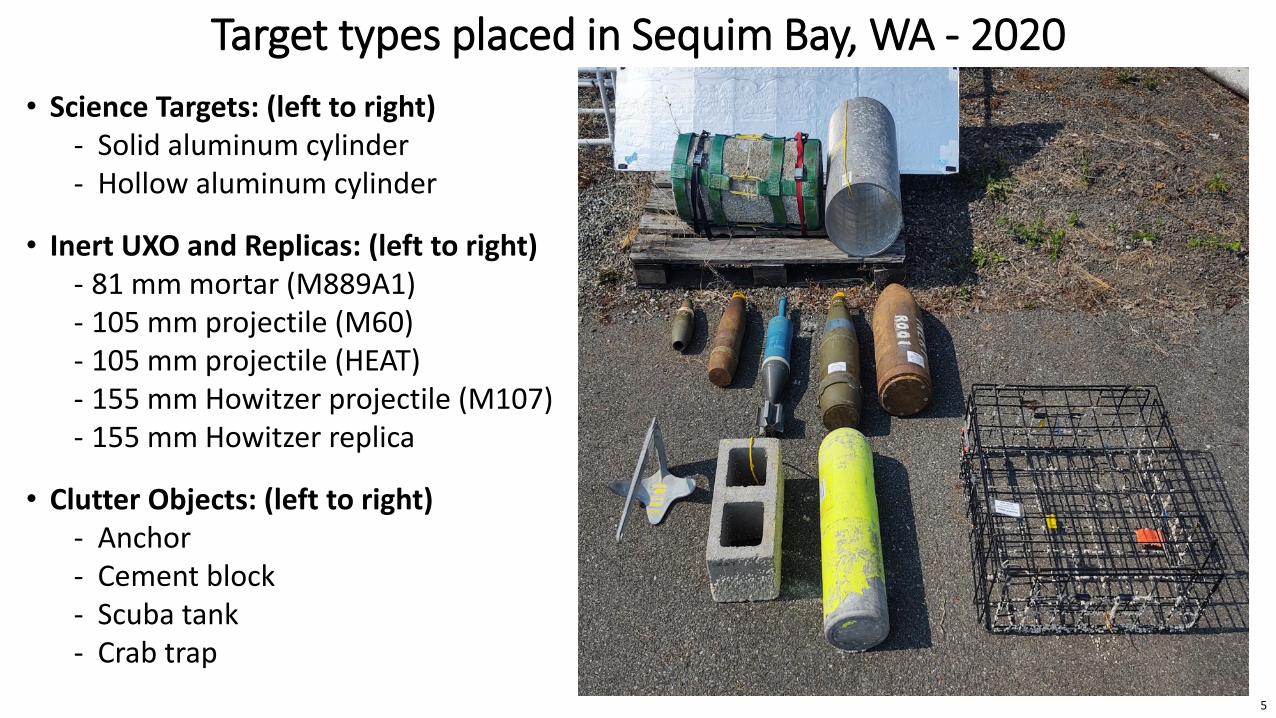
• Science Targets: (left to right)- Solid aluminum cylinder- Hollow aluminum cylinder
• Inert UXO and Replicas: (left to right)- 81 mm mortar (M889A1)- 105 mm projectile (M60)- 105 mm projectile (HEAT)- 155 mm Howitzer projectile (M107)- 155 mm Howitzer replica
• Clutter Objects: (left to right)- Anchor- Cement block- Scuba tank- Crab trap
Target types placed in Sequim Bay, WA - 2020
5
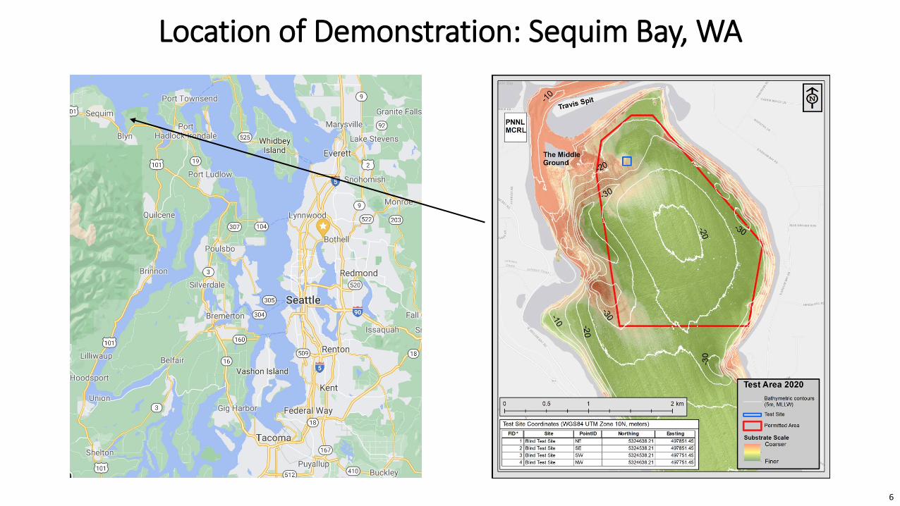
Location of Demonstration: Sequim Bay, WA
6

Test Area Geometry
Blind Test Area
Calibration Line
7

Calibration Line Target Locations
8

Operations
• Main test over 4 days
• Survey lines shown – 3 approach angles into blind and calibration areas
• Lead into areas generally from the south
• Long lead-ins to get towbody GPS position and stable flying altitude
• GPS fix also at end of each run
9

• Close up of areas showing survey lines
• Green diamonds show ground truth GPS locations of targets in calibration line, independently measured by PNNL testbed management team
• Red dots show end points of calibration lines and corners of blind test area
Operations
10

11
• Maximum Intensity Projections (MIPs)• Proud target image and acoustic color indicate it is the hollow Aluminum cylinder
Initial Detection/Geolocation Effort
11

3UTM estimates:
497775.79 5324549.78497776.32 5324554.61497778.87 5324558.53497835.44 5324557.32497836.07 5324560.54497845.84 5324563.36497835.12 5324569.99497790.33 5324593.53497798.40 5324598.96497786.94 5324624.70497781.95 5324628.72497780.57 5324628.62
• Red dots were corners of test area• Magenta circles were initial calls as TOIs (Targets of Interest) from each pass• Black diamonds were intermediate calls as TOIs after consolidating passes
Initial Detection/Geolocation Effort
12

Post-Processing Code (by Tim Marston)• Mosaic of all data, all directions – click on potential target, shows all survey files with
data at that location found and the location imaged9 survey files found that have data at location indicated by yellow asterisk
Maximum Intensity Projections (MIPs) calculated
Filtered Phi MIPS (bottom two lines) are the data products used in classification
AC = acoustic color13

Classification for Targets in Blind Test AreaVertical red lines separate targets – horizontal separation of lines indicative of the number of times a target was detected
Designated Target Number in Classification Analysis
Human expert class assessments for each detectionAcoustic color scores for each detectionAcoustic image scores for each detectionAverage of acoustic color and acoustic image scores for each detectionAverage of over all detections of that target
Procedure: Train on calibration line data 25 times. For each trained classifier, test on the blind data. Average test score was derived from each trained classifier to get the acoustic color and acoustic image scores for each detection.
14
Clas
sific
atio
n sc
ores 1 = UXO class
Threshold used to separate classes
0 = non-UXO class
Detections

Detection Halo Radius: R = 2.5 m
15
(Circles in plot have a radius of HALF the detection halo radius R so two markers are <=R if their circles touch or intersect)
2 False Negatives (FNs) i.e., missed UXOs:• U015 (81mm)• U017 (81mm)
Detection/Classification/Geolocation Results vs. Ground Truth

• Research level operation successfully demonstrated
• Better Inertial Navigation System has been integrated into MuST
• On-going Development :- Better detection algorithms- Automated classification algorithms
• Sequim Bay 2021 test in September- More targets- Greater variety of targets
Summary
Initial tests in Lake Washington can be seen here:
https://www.youtube.com/watch?v=4UKmavb1TPY
16
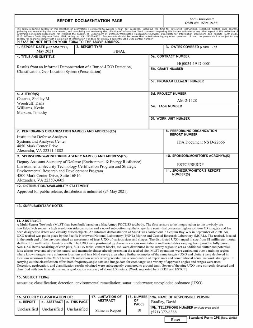
REPORT DOCUMENTATION PAGE Form Approved OMB No. 0704-0188
The public reporting burden for this collection of information is estimated to average 1 hour per response, including the time for reviewing instructions, searching existing data sources, gathering and maintaining the data needed, and completing and reviewing the collection of information. Send comments regarding this burden estimate or any other aspect of this collection of information, including suggestions for reducing the burden, to Department of Defense, Washington Headquarters Services, Directorate for Information Operations and Reports (0704-0188), 1215 Jefferson Davis Highway, Suite 1204, Arlington, VA 22202-4302. Respondents should be aware that notwithstanding any other provision of law, no person shall be subject to any penalty for failing to comply with a collection of information if it does not display a currently valid OMB control number. PLEASE DO NOT RETURN YOUR FORM TO THE ABOVE ADDRESS. 1. REPORT DATE (DD-MM-YYYY)
May 2021 2. REPORT TYPE
FINAL 3. DATES COVERED (From - To)
4. TITLE AND SUBTITLE
Results from an Informal Demonstration of a Buried-UXO Detection, Classification, Geo-Location System (Presentation)
5a. CONTRACT NUMBER
HQ0034-19-D-0001 5b. GRANT NUMBER
5c. PROGRAM ELEMENT NUMBER
6. AUTHOR(S)Cazares, Shelley M. Woodruff, DanaWilliams, KevinMarston, Timothy
5d. PROJECT NUMBER
AM-2-1528 5e. TASK NUMBER
5f. WORK UNIT NUMBER
7. PERFORMING ORGANIZATION NAME(S) AND ADDRESS(ES)
Institute for Defense AnalysesSystems and Analyses Center 4850 Mark Center Drive Alexandra, VA 22311-1882
8. PERFORMING ORGANIZATIONREPORT NUMBER
IDA Document NS D-22666
9. SPONSORING/MONITORING AGENCY NAME(S) AND ADDRESS(ES)
Deputy Assistant Secretary of Defense (Environment & Energy Resilience) Environmental Security Technology Certification Program and Strategic Environmental Research and Development Program4800 Mark Center Drive, Suite 16F16 Alexandria, VA 22350-3605
10. SPONSOR/MONITOR'S ACRONYM(S)
ESTCP/SERDP 11. SPONSOR/MONITOR'S REPORT
NUMBER(S)
12. DISTRIBUTION/AVAILABILITY STATEMENT
Approved for public release; distribution is unlimited (24 May 2021).
13. SUPPLEMENTARY NOTES
14. ABSTRACTA Multi-Sensor Towbody (MuST) has been built based on a MacArtney FOCUS3 towbody. The first sensors to be integrated on to the towbody aretwo EdgeTech sonars: a high resolution sidescan sonar and a novel sub-bottom synthetic aperture sonar that generates high-resolution 3D imagery and hasbeen designed to detect and classify buried objects. An informal demonstration of MuST was carried out in Sequim Bay,WA in September of 2020. AnUXO testbed was put in place by the Pacific Northwest National Laboratory (PNNL) Marine and Coastal Research Laboratory (MCRL). The testbed, locatedin the north end of the bay, contained an assortment of inert UXO of various sizes and shapes. The distributed UXO ranged in size from 81 millimeter mortarshells to 155 millimeter Howitzer shells. The UXO were positioned by divers in various orientations and burial states ranging from proud to fully buried.Non-UXO items consisting of crab pots, SCUBA tanks, cement blocks, etc. were distributed in the survey region to act as additional clutter and potentialfalse alarms over and above the natural and manmade clutter already present at the testbed site. MuST operations were carried out over a training regionwhere known targets were at known locations and in a blind survey area where further examples of the same targets (UXO and clutter) were deployed inlocations unknown to the MuST team. Classification scores were generated via a combination of expert user and convolutional neural network strategies. Incarrying out the classification effort both frequency/angle data and image data for each target at a variety of approach angles and ranges were used.Detection, geolocation, and classification results obtained were subsequently compared to ground-truth. Seven of the nine UXO were correctly detected andclassified with two false alarms and a geolocation accuracy of about 2.5 meters. [Work supported by SERDP and ESTCP].
15. SUBJECT TERMS
acoustics; classification; detection; environmental remediation; sonar; underwater; unexploded ordnance (UXO)
16. SECURITY CLASSIFICATION OF: 17. LIMITATION OFABSTRACT
Same as Report
18. NUMBEROFPAGES
19a. NAME OF RESPONSIBLE PERSON Bradley, David a. REPORT
Unclassified
b. ABSTRACT
Unclassified
c. THIS PAGE
Unclassified 19b. TELEPHONE NUMBER (Include area code)
(571) 372-6388Standard Form 298 (Rev. 8/98) Reset
19