restoring the ponds in roger williams park: executive summary
TRANSCRIPT

Restoring the Ponds in Roger Williams Park: Executive Summary
October 2013
Horsley Witten Group
Land & Coastal Services
Loon Environmental
Narragansett Bay Estuary Program
Providence Parks & Recreation

Project Team
Project Investigation and Plan Report
Horsley Witten Group
Rich Claytor, P.E. Brian Kuchar, P.E., L.A. Michelle West, P.E.
Loon Environmental—Marie Evans Esten
Project Coordination, Project Management, & Public Outreach
U.S. Environmental Protection Agency, Region 1—Mark Spinale
Narragansett Bay Estuary Program
Tom Ardito Leslie Lambert
Land & Coastal Services—Laura Ernst
Providence Parks & Recreation—Robert McMahon
Storm Water Retrofit, Design, Construction & Construction Management
Horsley Witten Group—Brian Kuchar
Gardner + Gerrish, LLC—Tim Gerrish, L.A.
Providence Parks & Recreation
Joel Boodon, L.A. Ed Sanchez, L.A. Joe Salem
Yardworks, Inc.
SUMCO, Inc.
Project Signage & Graphics
Narragansett Bay Estuary Program—Leslie Lambert
Bryan Jones Design—Bryan Jones
Providence Park & Recreation—Joel Boodon

Geese Management
Animal & Plant Health Inspection Services, U.S. Department of Agriculture—Tim Cozine
Eastern Rhode Island Conservation District—Jessica Blackledge
Water Quality Sampling/Pond Characterization
U.S. Environmental Protection Agency, Atlantic Ecology Division
Charlie Strobel Donald Cobb
University of Rhode Island Watershed Watch
Linda Green Elizabeth Herron Bryan Cordeiro
Fish Tissue Analysis
U.S. Environmental Protection Agency, Atlantic Ecology Division—James Lake
Fish & Wildlife, Rhode Island Department of Environmental Management—Alan Libby
Technical Review & Advisory Services
Elizabeth Scott, Office of Water Resources, Rhode Island Department of Environmental Management Scott Ribas, Office of Water Resources, Rhode Island Department of Environmental Management Bernie Boudreau, Serve RI Judy Colauca, Save the Lakes Holly Ewald, Urban Pond Procession Wenley Ferguson, Save the Bay David Gregg, Rhode Island Natural History Survey Alison Hamel, Rhode Island Department of Transportation Jimmy Johnson, Rhode Island Bass Federation Karen Marcotte, Save the Lakes Bob Nero, Pawtuxet River Watershed Association Margherita Pryor, U.S. Environmental Protection Agency, Region 1 Richard Ribb, Narragansett Bay Esturary Program Amelia Rose, Environmental Justice League of RI Kate Venturini, University of Rhode Island Outreach Center Vanessa Venturini, University of Rhode Island Outreach Center
Cover Photo Phil McKendall

Table of Contents
Page 1.0 Introduction……………………………………………………………………………….…..1
2.0 The Roger Williams Park Pond System………………………………………….…3
3.0 The Park Ponds Are in Trouble Today……………………………………………...5
4.0 What Can Be Done: Best Management Practices
4.1 Structural Storm Water System Changes………………………………10 4.2 Non Structural Practices……………………………………………………….12 4.3 In-Pond Options……………………………………………………………………15 4.4 Mashapaug Pond Flow Into the Park: Options……………………..16
5.0 What Can Be Done: Recommendations & Actions…………………… …..18
Appendix A: DEM Priority Outfalls in Roger Williams Park……..…………… …20

1.0 Introduction Since the first plan for Roger Williams Park was developed in 1878 by landscape architect Horace Cleveland, the Park ponds have been essential visual and recreational elements in the Park’s design. Over the years, the ponds have provided boating opportunities, a place to fish, a home for wildlife, and a visual refuge for urban dwellers looking for relief from crowded city streets.
The Park ponds, however, suffer from algae, aquatic weeds, and road sand sedimentation. In 1982 Park officials dredged three of the ponds in the Park, but it didn’t solve the water quality problems, as phosphorous-laden storm water and road sand continued to flow into the ponds.
The ponds were first listed in the Rhode Island Department of Environmental Management’s (RIDEM) impaired water bodies list in 1992. The algae and aquatic weed problems in the ponds have gotten worse in the last 10 years. In 2007 RIDEM released a report, Total Maximum Daily Load Report (TMDL), analyzing nine ponds in Rhode Island with the most challenging phosphorous problems. The Roger Williams Park pond system was highlighted by RIDEM for its deteriorating water quality.
In 2010 in cooperation of the Narragansett Bay Estuary Program (NBEP), the Parks Department applied for and received an EPA Region 1 matching grant to examine the pond’s pollution problems, to suggest remedies, and to provide a plan for restoring the ponds’ water quality.
With the assistance of a Technical Steering Committee, a team of consultants lead by Horsley-Witten Group (HW) was selected to develop a Water Quality Management Plan (WQMP) for the Park ponds. The Committee has helped guide the work of HW which began in July 2011.
1
The Steering Committee established the following goals for the project:
Roger Williams Park Ponds Project Goals
Water quality restoration is central to the project’s success. The team of consultants undertook extensive investigations and completed a water quality model and draft management plan. As a result of this work, it became clear that a significant reduction in phosphorus pollution entering the ponds is necessary to achieve water quality improvement. The City and Technical Steering Committee established the following targets for phosphorus pollution reduction in the Ponds, to improve water quality, pond habitat, and Park aesthetics:
Water Quality Restoration—Phosphorus Reduction Targets
2
Roger Williams Park Ponds Restoration Project
Technical Steering Committee Providence Parks &
Recreation
Narragansett Bay Estuary Program
U.S. EPA, Region 1
US EPA Atlantic Ecology Division
RI Coastal Resources Management Council
RI Department of Health
RI Department of Environmental Management
RI Department of Transportation
Save the Bay
Save the Lakes
US Fish & Wildlife Service
USDA Natural Resources Conservation Service
University of Rhode Island Watershed Watch
RI Bass Federation
Environmental Justice League of Rhode Island
Serve Rhode Island
Pawtuxet River Authority
RI Natural History Survey
Urban Ponds Procession
Improve water quality, habitat, and biodiversity within the ponds
Improve the overall environmental quality and user experience of the Park
Identify health risks associated with fish consumption; increase public awareness as warranted
Foster watershed awareness and environmental stewardship among Park users and surrounding residents through a public outreach campaign
Reduce phosphorous in the ponds by 20% in five years
Reduce phosphorous loadings in the ponds by 40% in ten years
Over the long term continue to work towards the reduction of phosphorus loadings by up to 70%, a reduction which RI Department of Environmental Management suggests would allow the Park ponds to achieve a water quality that would significantly reduce seasonal algae and aquatic weed growth.

2.0 The Roger Williams Park Pond System With the exception of Deep Spring Lake, the Park pond system is man-made, and consists of a series of interconnected ponds. As the Park was developed in the latter years of the 19th century, Mashapaug Brook that ran from Mashapaug Pond was used as the primary water source to create the Park ponds. This former location of the Brook in the area that now is the Park is shown in the accompanying graphic.
The Brook was dammed near present day Park Avenue at the southern end of what is now Elm Pond. In conjunction with considerable dredging done in the 19th century, several of the ponds were literally carved out of the landscape. Bridges were built to allow the ponds to flow continuously from one to the other. The general pattern of flow through the Park ponds is from the southern end of Roosevelt Lake, where a 48 inch diameter pipe from Mashapaug Pond is located, to the dam at the southern end of Elm Pond. As the water leaves the Park, it flows into Bellefont Brook, to the Pawtuxet River, and to Narragansett Bay.
Inflow pipe into Roosevelt Pond from Mashapaug Pond Outflow waterfall at Elm Pond leading to Bellefont Brook
3
Approximate location of the former Mashapaug Brook before the Ponds were formed

Roger Williams Park Ponds Characteristics Pond Average Depth Area Direction of Flow (feet) (Acres)
Roosevelt 1.3 3.8 West to East then North to South Willow 2.0 3.4 South to North and North to South Polo 2.3 3.6 South to North Pleasure 2.6 18.6 West to East Edgewood 3.0 19.3 North to South Cunliff 4.3 32.3 North to South Elm 4.3 21.7 North to South
4
Roger Williams Park Pond System

3.0 The Park Ponds are in Trouble Today For six months each year the Park ponds are free of algae and weeds and reasonably normal in color and clarity. But those six months are from November to April when the ponds are not actively used, and there are fewer Park visitors.
Beginning in May every year, the shallow ponds begin to heat up and turn a pea soup green color culminating with floating algae and acres of weeds in July-October, this is known as eutrophic or hypereutrophic conditions.
Scientists typically look at a few key parameters to help assess water quality conditions, including Chlorophyll a, total phosphorus concentration, and Secchi dish depth (a
measure of water clarity). As seen below, water quality data reflect the extent of water quality degradation in the ponds.
Summary of Water Quality Data for Roger Williams Park Ponds (URI Watershed Watch 1993-2012) Water Quality
Parameter
Typical Threshold
for Eutrophic Conditions
Average Value in Ponds by Year Pleasure Lake Roosevelt Lake Cunliff
Lake Elm Lake
1993
1994
2001
2002
2005
2012
1993
1994
2012
2003
2012
2005
2012
Chlorophyll a (ppm)
7.2 to 30 22 28 20 46 57 55 17 26 31 54 55 56 58
Total P (ppm)
25 to 65 85 105 76 64 140 100 65 69 76 120 87 97 82
Secchi Depth (ft)
6.5 to 2.5 5.2 4.6 3.0 2.0 1.6 2.6 5.2 5.2 1.6 2.3 2.6 2.0 3.0
Italic font = value exceeds outside range of Eutrophic Threshold
5

Why should we care about the poor water quality in the Park ponds?
The degraded water quality condition of the ponds is troublesome for many reasons:
The boating experience on the ponds is diminished Biodiversity, particularly fish species, in the ponds is reduced Shoreline activities, such as picnicking and gatherings, are unpleasant The overall perception of the park as an enjoyable family place to visit is negative Finally, Roger Williams Park is the primary recreational area for thousands of Providence
families who do not have access to the state’s beaches, and the restoration of the Park’s water resources is a matter of environmental justice.
What is causing the water quality problems in the Park ponds?
The answer to that question is both simple and complex. To understand what is happening to the ponds, we should remember that the ponds are man-made and shallow. They are not natural, geologically-formed deep lakes such as those that exist in other parts of Rhode Island. And because the Park ponds are shallow, they heat up quickly during the warm weather months of the summer.
When initially constructed in the 1880’s and 1890’s, the ponds did not exhibit today’s water quality problems. The Park at that time was at the southern end of Providence largely surrounded by vacant land. As the city’s population grew, the areas around the park were developed into dense residential neighborhoods. Hundreds of acres of vacant land became houses, businesses, streets, sidewalks, driveways, and parking lots.
City engineers provided these nearby neighborhoods with storm drainage systems with storm water outfalls, many of which drained into the Park ponds. Even the Park’s principal source of flow—the Mashapaug Brook—was channeled into a large storm pipe before it entered Roosevelt Pond. Throughout the 20th century, engineers also drained Park roads and parking lots into a storm drainage system which today flows into the Park ponds through many outfall pipes.
6

Not only did the areas around the Park develop, but the area around Mashapaug Pond (and its feeder ponds: Spectacle Pond and Tongue Pond) also was built up. Mashapaug Pond was relatively pristine when its outflow, Mashapaug Brook, was used to form the Park ponds. Indeed, as late as the early 20th century, Mashapaug Pond was a source of block ice for hundreds of Providence homes.
The accompanying aerial photograph shows the Park’s two main watershed areas—these are the sources of storm water flowing into the Park ponds. The extent of development in the two watersheds is dramatic. The graphic below illustrates the relationship of the Park ponds to its watersheds.
Upper Watershed (977 acres)
Lower Watershed
(649 acres)
Once dependent solely on the clean water of Mashapaug Brook, the Park ponds have become convenient receptacles for storm water from hundreds of acres of two nearby watersheds. Every time it rains, this polluted storm water drains into the Park ponds. Anything on the impervious surfaces that drains into the Park ponds—dirt, bird waste, pet waste, car chemicals, fertilizer, trash—is carried by the storm water into the Park ponds.
7
Tongue Pond Watershed
Water
Spectacle Pond Watershed
Mashapaug Pond Watershed
Tongue Pond
Spectacle Pond
Mashapaug
Pond
Roger Williams Park Ponds
Park Property Watershed
Adjacent Neighborhood
Watershed

Roger Williams Park Ponds Watersheds
Upper Watershed (977 acres)
Lower Watershed (649 acres)
Phosphorous is a major concern in the storm water flowing into the Park ponds. A modest increase in phosphorous in a shallow pond can, under the right conditions, set off a chain of undesirable biological events that can accelerate algal blooms, undesirable plant growth, depletion of dissolved oxygen, and the death of oxygen dependent fish. This process is called eutrophication. This process may take centuries to occur in undeveloped areas, but in the Park ponds eutrophication is accelerated by the storm water entering the ponds after every rain event. The shallow warm Park ponds provide a perfect situation for phosphorus to stimulate algal blooms and plant growth. See graphic below for the sources of phosphorous in the Park ponds.
8
Cranston/Providence Boundary

Estimated Annual Amounts and Sources of Phosphorous in the Roger Williams Park Ponds
Source: Horsley Witten Group, 2013
Storm water flowing over impervious surfaces is the major source of phosphorous in the ponds. But there are two other significant source of phosphorous: 1) the number of resident Canada geese in the Park. As the resident geese population increased, park visitors unfortunately began to feed them throughout the year. While well-intentioned, public feeding of the geese in the Park is misguided and as recently as July 2012 there were over 600 resident geese living in the Park. Unknown to most of the Park visitors, the gaggles of geese in the Park have been an environmental and public health disaster because of the sheer volume of fecal matter produced by the geese on park lawns and in the park ponds. Park officials began a comprehensive geese management strategy in 2012, including signs instructing the public not to feed the geese.
2) A second major source of phosphorous within the park is the accumulated sediment in the Park ponds that has settled into the bottom of the ponds from decades of storm water runoff. This sediment is rich in phosphorous and is subject to a process called “internal cycling”. According to DEM, “it is entirely probable that sediments (in the Park ponds) release phosphorus into the water column” and that this release occurs in the summer months.
9
Upper Watershed Storm Water
(360 lbs/yr)
Roger Williams Park Ponds
Internal Cycling
(128 lbs/yr)
Atmospheric Deposition
(64 lbs/yr)
Lower Watershed Storm Water
(216 lbs/yr)
Roger Williams Park Waterfowl
(154 lbs/yr)
4.0 What Can Be Done: Best Management Practices The WQMP for the Park ponds developed scores of potential remedies to reduce phosphorous loadings entering the ponds. Outlined below are some of the principal categories of best management practices that potentially may improve the water quality of the Roger Williams Park ponds:
4.1 Structural Storm Water System Changes
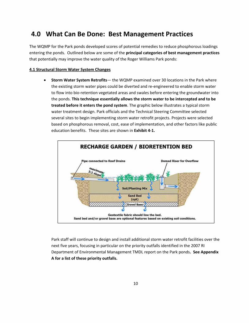
Storm Water System Retrofits— the WQMP examined over 30 locations in the Park where the existing storm water pipes could be diverted and re-engineered to enable storm water to flow into bio-retention vegetated areas and swales before entering the groundwater into the ponds. This technique essentially allows the storm water to be intercepted and to be treated before it enters the pond system. The graphic below illustrates a typical storm water treatment design. Park officials and the Technical Steering Committee selected several sites to begin implementing storm water retrofit projects. Projects were selected based on phosphorous removal, cost, ease of implementation, and other factors like public education benefits. These sites are shown in Exhibit 4-1.
Park staff will continue to design and install additional storm water retrofit facilities over the next five years, focusing in particular on the priority outfalls identified in the 2007 RI Department of Environmental Management TMDL report on the Park ponds. See Appendix A for a list of these priority outfalls.
10

Exhibit 4-1: 2012-13 Storm Water Retrofit Projects in Roger Williams Park
11
Site 3B: Carousel Parking Lot
Constructed bio retention garden to intercept and treat flows from a 1.4 acre area of the park. Site 6: Roosevelt Pond Removed 40,000 sf of road paving; installed walkway and rain gardens and shoreline planting to intercept and treat flows from 3.4 acres of the Park. Site 17/18: Polo Lake (DEM Priority site) Modified existing inlet structures and diverted storm flows to bio retention area to intercept and treat flows from 3.8 acres of the Park. Site 24: Cunliff Pond Removed 15,000 sf of road paving; intalled flumes directing storm water from 3.15 acres of the Park to a bio retention area. Site 28: Elm Lake at Edgwood Blvd. and FC Greene Memorial Blvd. (DEM priority site) Removed 15,000 sf of pavement and created a bio retention area and infiltration basin to intercept and treat flows from 22.2 acres from a residential area east of the Park.

Disconnecting Building Downspouts—Many of the Park buildings have downspouts which disconnect directly into the street drainage system. The roof areas in the Park total over 100,000 sq. ft. and they send storm water into the ponds. These downspouts can be disconnected relatively easily from the underground pipes and the downspouts can be altered to divert the storm water into adjacent planting areas. This has been successfully done in a demonstration at the Botanical Center already as seen in the accompanying photo at right. This practice also offers significant potential in the upper and lower watersheds where neighborhoods, according the WQMP, have generally 50-60% of houses with downspouts directly connected to underground storm water pipes that lead to water bodies.
4.2 Non Structural Practices
While some of the above structural practices will involve considerable capital costs, there are scores of nonstructural practices, much less costly, that can be implemented in the Park and in the nearby watersheds to reduce storm water loadings flowing into the Park ponds.
Park Operations and Maintenance Practices—Daily operations in Roger Williams Park and the abutting watersheds can be altered and adjusted to reduce storm water pollution. Here are the most significant practices that should be considered: --Catch Basin Cleaning: Catch basins in the street “catch” storm water flowing on the street and then discharge the storm water flows from the catch basin through a pipe into a nearby water body. As seen in the accompanying sketch, catch basins are designed to settle out solids before the storm water flows into the discharge pipe. Catch basins can potentially be a significant method for reducing storm water pollution flowing into the Park ponds, if the catch basins are periodically cleaned of the settled solids.
If the catch basin solids are not regularly cleaned, they eventually fill up the catch basin and storms will flush the solids into the discharge pipe into the nearby water body. Roger Williams Park has approximately 45 catch basins and there are several hundred in the upper and lower watersheds outside of the park. The Parks Department does not have its own vacuum truck to clean out catch basins—it depends on an already burdened Providence Department of Public Works (DPW) to periodically clean Park catch basins as well as the catch basins in the upper and lower watersheds. Catch basin cleaning does not consistently occur in the Park due to the City’s limited resources to maintain 20,000 catch basins in the city.
12

Park officials are examining how to develop an internal catch basin cleaning program within the Parks and Recreation Department. --Street Sweeping: One way to reduce the amount of solids and trash on Park and watershed streets from flowing into the storm water drainage system is to sweep the streets more frequently. The Parks Department does not own a street sweeper and depends on Providence DPW to sweep the 10 miles of roads in Roger Williams Park twice a year. Park officials need to determine how to supplement the DPW services with private vendors to ensure a minimum of 4 street sweepings/year in the Park and watershed. --Turf Mowing Operations: When the Park was designed in the late 19th century, Park design emphasized grass lawns coming right to the edge of the water. Several thousand feet of shoreline in the Park have shorelines with mowed grass. This design and practice presents an aesthetically pleasing appearance, but it is not a compatible water quality management practice: it allows geese to easily go between the ponds and the shoreline; it provides no natural vegetative buffer to absorb pond nutrients. Park officials need to commit to a “natural shoreline”. Willow Pond shoreline --Maintenance Operations “Hot Spots”: The WQMP identified several areas in Park maintenance areas where better housekeeping operations by Park staff will minimize pollution from entering the ponds after rain events. The Grounds Maintenance Yard and the Mounted Command facility on Noonan Island need to develop management practices to avoid pollutants from flowing into the ponds.
Pavement Reduction—This activity involves reducing storm water pollution in the ponds by reducing the area of impervious surfaces—primarily parking lots and roadways—in the Park. The Park has many wide roads that could be narrowed, but this type of structural change needs to consider parking and traffic issues very carefully. Thus, Park staff will examine where pavement can be reduced at a reasonable cost without affecting normal Park use. For example, the current storm water retrofit project along Roosevelt Pond also involves the removal of almost 40,000 sq. ft of road area.
13

Curb Removal—Roger Williams Park, unlike the large state parks in Rhode Island, has miles of curbing along its roads. This curbing is a legacy of work done by the Works Progress Administration in the 1930’s and was a well intentioned effort to channel storm water into catch basins to flow into the ponds. There are many opportunities in the Park to selectively remove curbing and to allow storm water to flow into existing grass areas and to be absorbed into groundwater.
Geese Management—As pointed out in Section 2, the resident Canada geese contribute to the phosphorous loads that are harming the Park ponds. In 2012 the first steps to manage comprehensively the resident geese were undertaken: addling all of the geese eggs in the Park nests; removing several hundred geese under contract with the US Department of Agriculture; installing “geese education signs” in key geese feeding areas of the Park; and public education of park visitors by summer high school interns. This comprehensive effort needs to continue for several years to keep the resident geese population in check.
Shoreline Buffer Planting—To accelerate natural vegetation along the shorelines, it will be useful to pro-actively plant native plant species along many of the Park shorelines. This will have many water quality management benefits as discussed above under “Mowing Operations”.
14
Steep Slope Stabilization—Most of the sediment that is in the Park ponds is the result of sand washed into the ponds from the upper and lower watershed storm drainage systems, a some pond sediment is from erosion of sloped lawn areas that have lost their grass cover for one reason or another. These steep slopes with bare soil should be re-seeded systematically with appropriate erosion control matting in September of each year.
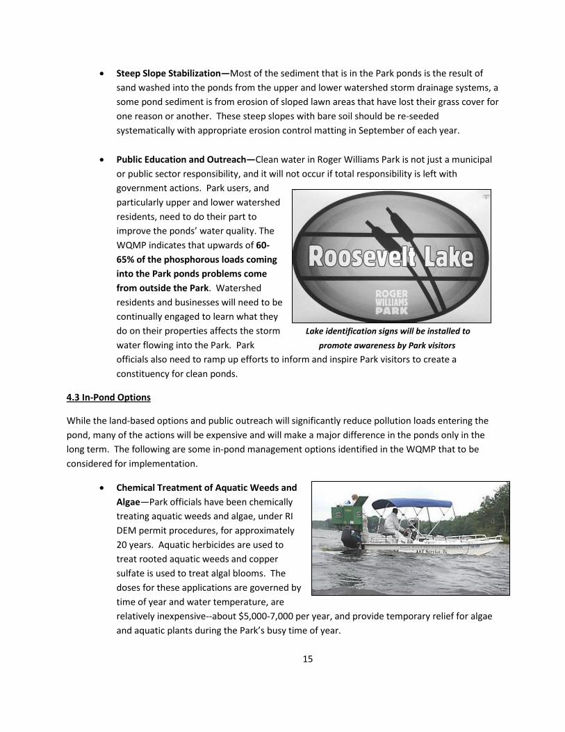
Public Education and Outreach—Clean water in Roger Williams Park is not just a municipal
or public sector responsibility, and it will not occur if total responsibility is left with government actions. Park users, and particularly upper and lower watershed residents, need to do their part to improve the ponds’ water quality. The WQMP indicates that upwards of 60-65% of the phosphorous loads coming into the Park ponds problems come from outside the Park. Watershed residents and businesses will need to be continually engaged to learn what they do on their properties affects the storm Lake identification signs will be installed to water flowing into the Park. Park promote awareness by Park visitors officials also need to ramp up efforts to inform and inspire Park visitors to create a constituency for clean ponds.
4.3 In-Pond Options
While the land-based options and public outreach will significantly reduce pollution loads entering the pond, many of the actions will be expensive and will make a major difference in the ponds only in the long term. The following are some in-pond management options identified in the WQMP that to be considered for implementation.
Chemical Treatment of Aquatic Weeds and Algae—Park officials have been chemically treating aquatic weeds and algae, under RI DEM permit procedures, for approximately 20 years. Aquatic herbicides are used to treat rooted aquatic weeds and copper sulfate is used to treat algal blooms. The doses for these applications are governed by time of year and water temperature, are relatively inexpensive--about $5,000-7,000 per year, and provide temporary relief for algae and aquatic plants during the Park’s busy time of year.
15

Dredging of Pond Sediment—In the early 1980’s Park officials dredged Roosevelt Pond, Willow Pond, and Polo Pond to address water quality problems that existed in the ponds at that time. While well-intentioned, dredging was a very expensive short-term solution. Because nothing was done to control the sediment and phosphorous coming in from the upper watershed into Roosevelt Pond, all three ponds have long since lost the pond depth that was achieved in 1982. In addition, Pleasure Pond has also lost considerable pond depth. The lesson from this early 1980’s dredging effort is that water quality improvements have to be sequenced properly or the benefit of these actions will be limited. Dredging will be needed again in at least 3 or 4 of the Park ponds, but land based efforts and upper watershed efforts need to be done first.
Chemical Treatment of Exiting Sediment in the Ponds—One of the issues unresolved by the WQMP is the extent to which existing sediment in the ponds releases phosphorous into the water column under certain depth and dissolved oxygen conditions. This phenomenon is called “internal recycling” and it may be a significant contributor to phosphorous in the Park’s deeper ponds, i.e., Cunliff, Elm and Edgewood. When existing phosphorous loads coming into those ponds from the lower watershed are substantially reduced, water quality testing will need to determine if internal recycling is an issue. At that point Park officials may consider treating the sediment with aluminum sulfate or sodium sulfate. This is a relatively expensive treatment—about $1,500/acre, however, and will require careful dosing to not harm existing fish in the ponds.
4.4 Mashapaug Pond Flow into the Park: Options
The WQMP recognized that the goal of reducing phosphorous in the Park ponds from the upper watershed that flows into the Park ponds from Mashapaug Pond will be daunting to achieve. Two cities are involved; three water bodies; scores of dense residential neighborhoods with no common identity or track record of working together; one industrial park; and hundreds of stand-alone businesses.
16

While all of the above discussed structural, non-structural, and public outreach efforts need to be started and pushed forward, the pace of implementation in the upper watershed will likely be far more challenging than the efforts in the lower watershed.
In the meantime, phosphorous loads from Mashapaug Pond—the major source of pollution for Roger Williams Park—will continue to limit the efforts in the lower watershed to reduce storm water pollution in the Park ponds. What can be done in the interim, before scores of pollution reduction actions are implemented in the upper watershed? The WQMP suggests three important small scale solutions that will need more study, but which appear to be promising.
Chemical Dosing Station—The 48” pipe that carries the Mashapaug Brook and the storm water flows from the upper watershed is essentially a point source of pollution for the Park ponds. The WQMP suggests chemical treatment of the water coming from this point source should be considered as an interim measure until long-term solutions in the upper watershed to reduce pollution are implemented. The suggestion: a dosing station that would treat the phosphorous and suspended solids.
One or more aluminum compounds would be fed into the storm pipe during storm events, either at the discharge point in Roosevelt Pond or upstream of the Park and would bind up the phosphorous and suspended solids precipitating a floc that would fall out of the flow. Park officials recognize the need for extensive study to examine the permitting for such a dosing station, operational requirements, maintenance requirements, treatment protocol, and disposal of the precipitated floc.
Mashapaug Brook Weir Box Re-engineering—When Route 10 was constructed, some of the storm flows from Mashapaug Pond were altered to go through a weir box (just east of RT 10 and south of the Calart Building) into a 72” pipe that bypasses the Park ponds. Currently all of the low flows and smaller storm flows are directed towards the Park ponds through the 48” pipe into Roosevelt Pond. The WQMP indicates that if the weir box is modified to divert more of the storm events into the 72” pipe that bypasses the Park ponds that this may reduce the phosphorous loads that come into Roosevelt pond after storms. However, smaller storms with relative clean flow might then bypass entry into RWP ponds. A detailed engineering study to examine the desirability/feasibility of any weir box modification is needed. Finally, a hydrologic study should examine if sewer separation is warranted in the upper watershed to provide historic water flows to the park.
17

Chemical Treatment of Sediment in Mashapaug Pond—The RI Department of Environmental Management indicates in its 2007 report on Mashapaug Pond that “internal
recycling” of phosphorous in Mashapaug Pond maybe a a major contributor to the phosphorous loads originating from Mashapaug Pond and flowing into the Park ponds during the summer months. The conditions in Mashapaug Pond in the summer months—relatively deep pond, high water temperatures, and low dissolved oxygen levels—allow the release of phosphorous into the water column. Thus, treating portions of Mashapaug Pond sediment during summer
months with an aluminum or sodium sulfate compound may be able to inactivate phosphorous and bind it to the pond sediment impinging the ability of the phosphorus to be released. A detailed study of this treatment is needed since it may require several acres of Mashapaug Pond to be treated.
5.0 What Can Be Done: Recommendations & Actions The WQMP outlines an array of best management practices for reducing storm water pollution in the Park ponds. Some key findings and principles should guide Park officials in deciding how to proceed during the next eight to ten years.
A Long-Term Commitment to Managing the Water Quality in the Park Ponds Is Needed. A year-by-year set of cos- effective solutions for the next several years will be required that take advantage of available scarce resources. There are no quick and easy solutions. Park officials need to plug away each year targeting a sequence of activities to reduce storm water pollution entering the ponds.
Engineering Solutions Alone Will Not Clean Up the Park Ponds—Public Attitudes Need to be Changed. The WQMP looked at 35 structural storm water retrofit projects to address the storm water pollution from existing storm water outfalls in the Park (not including the pipe from Mashapaug Pond) and the total cost was estimated at around $1.8-2.0 million. The Park can’t simply buy its way out of the pollution problem in the ponds--first because these infrastructure projects are expensive, and secondly they will not address all of the phosphorous loads flowing into the ponds. Many of the sources of phosphorous coming into the Park ponds are the result of human behavior, such as feeding geese and residential fertilizer used in watershed areas near the Park. A consistent public outreach program is needed to change public behavior and attitudes about the Park ponds.
18

Water Quality Management Improvements Start at Home in the Parks Department. There are a number of operational and maintenance tasks that Park staff need to focus on to help reduce pond pollution, including:
o systematic catch basin cleaning o educating park visitors about geese feeding and littering o allowing and providing shoreline buffer vegetation o allowing leaves to remain in wooded hillside areas o diligently addressing slope erosion issues as they develop each year.
We Will Need Additional Study to Determine Long Term Solutions for Some of the Pond Water Quality Issues. We not only need to provide an annual water quality sampling program in the ponds to monitor the effectiveness of our on-going efforts, we also need to look at the following un-resolved and/or on-going storm water issues:
The following Roger Williams Park Pond restoration actions are recommended to be implemented during the 2013 – 2020 period. Depending on the number of actions implemented and the ability to reduce phosphorous from the Mashapaug Pond inflow into Roosevelt Pond, these actions will reduce the phosphorous loads into the Park ponds by 20 to 50% and significantly improve the water quality of the Park ponds. Recommendations are sorted by:
-- Roger Williams Park: LWP recommendations
--Lower Watershed outside of Roger Williams Park: LWN recommendations
--Upper Watershed: UW recommendations
19
1. Is it possible to treat the storm water coming into Roosevelt Pond from the Mashapaug Pond watershed to reduce phosphorous? What are the costs?
2. To what extent is the existing sediment that is in the Park ponds releasing phosphorous into the ponds and under what conditions? Is it cost-effective to selectively treat the sediment in some of the ponds?
3. What would it cost to dredge selective Park ponds and what will be the pollution reduction from such an effort?
4. Can some storm flows (and the resulting phosphorous loads) from Mashapaug Pond be diverted away from the 48” pipe entering Roosevelt Pond Would such a diversion have a positive impact or RWP pond water quality?
5. Is it feasible for the City to develop an overall Regional Storm Water Management District to fund city wide storm water flow and pollution reduction?

Appendix A: DEM Priority Outfalls in Roger Williams Park Identified in 2007 TMDL Report for Eutrophic Ponds
Table 4. 4 Priority Outfalls for Roger Williams Park
Ponds. Outfall ID
Diameter (in)
Location Ownership *
RWP-Q 48 Eastern end of Roosevelt Lake RIDOT/City of Providence/Cranston
RWP-S 48 Eastern shore of Willow Lake City of Providence RWP-V 74” x 24”
box culvert Eastern shore of Polo Lake City of Providence
RWP-H 30” x 42” oval culvert
Southern end of Edgewood Lake City of Providence
RWP-A 24 Northern end of Pleasure Lake City of Providence RWP-D 24 Eastern end of Pleasure Lake City of Providence RWP-I 24 Southern end of Edgewood Lake City of Providence RWP-U 24 Northern end of Polo Lake City of Providence
2013 Status of DEM Priority Outfalls
Outfall RWP-Q (977 acres watershed): This is the main City of Providence outfall in Roger Williams Park conducting storm water flows from Mashapaug Pond and the Upper Watershed. This water quality management plan for Roger Williams Park calls for a 20-year effort to reduce phosphorous loads in the upper watershed.
Outfall RWP-S: This is non-functioning storm water outfall and is no longer a priority.
Outfall RWP-V (3.8 acre watershed in RWP): A new bio retention area (Site 17/18) was built in 2013 to intercept and treat this storm water.
Outfall RWP-H (22.2 acre watershed east of RWP in Cranston): A new infiltration basin (Site 28) was built in 2013 to intercept and treat this storm water.
Outfall RWP-A (7.6 acre watershed in RWP): This outfall flow will be addressed in series of best management practices in the Museum of Natural History area in 2014.
Outfall RWP-D (28.5 acre watershed in RWP): This outfall will be treated via a Wet Vegetation Treatment System in 2015.
Outfall RWP-I (26.7 acre watershed east of RWP in Cranston): This watershed and outfall need further assessment scheduled for 2014.
Outfall RWP-U (24.9 acre watershed in RWP): This outfall will be addressed in a series of best management practices in 2016.
20

ROGER WILLIAMS PARK PONDS RESTORATION RECOMMENDATIONS: SUMMARY
Lower Watershed: Roger Williams Park Short-Term Mid-Term
# RECOMMENDATION Type1 2013 2014 2015 2016 2017 2018 2019 2020 2021 2022 COMMENTS
LWP-1 Water quality sampling M $4K $5K $5K $5K $5K $3K $3K $3k
LWP-2 Public Outreach PE $5K $10K $5K $5K $5K $10K $10K $10K Cash/ in-kind
LWP-4 Park Landscape NS
-New Master Plan
$5K $10K
-Revised Mowing Operations
-Shoreline Buffer Planting
$20K $20K $30K
Cash/ in-kind
-Parkwide Planting
$20K $20K $20K $20K $20K Cash/ in-kind -Erosion Control Actions
$10K $10K $5K $5K
LWP-5 RWP Conservancy PE
- Stratgegic Planning
$5K
-Organizational Development
$10K
-Advocacy and Fundraising
LWP-6 Chemically Treat: Weeds & Algae IP $10K $10K $10K $10K $5K $5K $5K
LWP-7 Operations & Maintenance NS
-Purchase Vacuum Truck
$15K $15K $15K $15K $15K
5-yr lease purchase -Ccatch basin cleaning
In-kind/park staff
-Enhanced street sweeping
$2.5K $2.5K $2.5K $2.5K $2.5K $2.5K
LWP-8 Curb and pavement removals NS
$20K $20K $20K $20K
LWP-9 Downspout Disconnections NS $10K $10K
LWP-10 Storm Water Retro-fits S
$75K $75K $75K
LWP-11 Dredging Studies AD
Cost to be determined
LWP-12 Selective In-Pond Sediment Treatment AD
Cost to be determined

Lower Watershed: Neighborhoods Adjacent to Roger Williams Park
# RECOMMENDATION 2013 2014 2015 2016 2017 2018 2019 2020 2021 2022 COMMENTS
LWN-1 Public Education PE $5K $10K $5K $5K $5K $10K $10K $10K Cash/ in-kind
LWN-2 Operations & Maintenance NS
-Purchase Vacuum Truck
SEE RWP-7
-Catch basin cleaning
In-kind/park staff -Enhanced street sweeping
$2.5K $2.5K $2.5K $2.5K $2.5K $2.5K $2.5K
LWN-3 Downspout Disconnections NS
$3K $3K $3K $3K $3K $3K
LWN-4 Environmental & Storm Water Reg. Enforcement
City staff
Upper Watershed
UW-1 Public Working Group
Crans./Prov.officials
UW-2 Tongue, Spectacle & Mashapaug Ponds Watersheds Plan AD
$10K
Match $ w/Cranston $
UW-3 Downspout Disconnection Program NS
Park staff/in-kind
UW-4 Watershed Public Education PE
$3K $3K $3K $3K $3K $3K $3K
UW-5 Industrial Park Working Group
UW-6 Design Services for Prototype S
Projects for Industrial Park and
$15K $15K $15K
Downspout Disconnections
UW-7 Additional Studies: Weir Box, AD
$20K $20K $20K
Mash. Pond Treatment Options
1Abbreviations:
S= Structural BMP IP= In -pond
M= Water Quality Monitoring NS= Non Structural BMP PE= Public Eductaion
AD= Additional Studies

LWP-1 RECOMMENDATION: Provide On-going Water Quality Sampling
PURPOSE: o To measure effectiveness of on-going water quality improvement actions
o To provide additional data on storm outfall pipe flows
o To provide data necessary for additional studies
DESCRIPTION: This activity should partner with Watershed Watch of URI and the EPA Region 1 laboratory
to develop an annual sampling program that will allow Park officials to evaluate water quality
changes and to make decisions on future strategies.
TIME FRAME: 2013 - 2020
ESTIMATED COSTS:
$5,000 per year
FUNDING:
Rental fees from Park paddleboat concession
LWP-2 RECOMMENDATION: Provide a Public Outreach Program in the Park PURPOSE: o To raise awareness of Park users about the ponds as an important aesthetic, recreational, and
ecological resource
o To instill respectful behavior from Park users towards the Ponds and the Park environment
DESCRIPTION: Park signage; social media; web site info on water quality; annual Parks Pond Festival.
TIME FRAME: 2013 - 2020
ESTIMATED COSTS: $5,000-10,000 per year + in-kind
FUNDING
Rental fees from Park permits

LWP-3 RECOMMENDATION: Continue Geese Management Program
PURPOSE: o To restrict number of permanent resident Canada geese in the Park to less than 75 geese
DESCRIPTION: Continue comprehensive program begun in 2012 to include geese egg
addling program, signage, park ranger enforcement of no feeding of geese.
Coordinate w/recommendation RWP-4 (shoreline buffer planting).
TIME FRAME: 2013 - 2020
ESTIMATED COSTS: $5,000-10,000 per year for 2013 - 2015;
FUNDING:
Rental fees from Park permits
LWP-4 RECOMMENDATION: Implement Park Landscape Changes
PURPOSE: o To revise Park mowing operations to conserve shoreline natural vegetation;
o To install annual plantings to enhance shoreline buffer areas, to prevent turf erosion, and to
enhance the park aesthetics
DESCRIPTION: Develop a new Parkwide Landscape Plan to guide landscape operations and plantings for the next
eight years. Utilize native plantings and trees for landscape plantings. Provide staff training
TIME FRAME: 2013 - 2020
ESTIMATED COSTS: Master Plan: $25,000;
Planting: $160,000; Erosion Control: $30,000
FUNDING:
Charles H. Smith Trust Fund

LWP-5 RECOMMENDATION: Develop a Roger Williams Park Conservancy
PURPOSE: o To develop and cultivate a non profit organization to promote and raise funds for the Park
o To develop a constituency to support the Park
o To network with in-Park and regional organizations to assist improvements in the Park
DESCRIPTION: Park officials should seek consultant services to develop and organize the Conservancy, including the
development of a strategic mission and plan for the organization. Starting in 2015, the RWP
Conservancy will hopefully be a partner organization providing advocacy and fundraising services.
TIME FRAME: Strategic planning and organizational development in 2013-14;
ESTIMATED COSTS: $15,000 for 2013-14;
FUNDING:
Grant funding supplemented by park permit fees
LWP-6 RECOMMENDATION: Chemically Treat Algae and Aquatic Weeds
PURPOSE: o To diminish and control annual algae and aquatic weed growth that occurs every summer
in the ponds
DESCRIPTION: Coordinate with RWP-1.
TIME FRAME: 2013 - 2020
ESTIMATED COSTS: $10,000/per year
FUNDING:
Rental fees from Park paddleboat concessions

LWP-7 RECOMMENDATION: Upgrade Operations and Maintenance
PURPOSE: o To prevent solids and debris from catch basins and roads from being washed into the Park
storm drains and into the Ponds after rain events
DESCRIPTION: Parks officials would lease purchase a trailer vacuum catch basin cleaner with a 6 cy capacity
and do its own catch basin cleaning without relying on DPW. Supplement DPW street sweeping with contracted services.
TIME FRAME: 2013 - 2020
ESTIMATED COSTS: $22,500/year for 2014-2018; $2.5K/year 2019-2020
FUNDING:
Lease purchase program for CB cleaner; park permit fees.
LWP-8 RECOMMENDATION: Remove Selected Curbs and Pavement
PURPOSE: o To reduce amount of storm water and related pollutants entering the Park ponds
from park roads
DESCRIPTION: Curb removal in the Park will be more cost effective than pavement removal.
This recommendation will focus on removing curb in areas where storm water
could flow on to existing vegetated areas.
TIME FRAME: 2014 - 2017.
ESTIMATED COSTS: $15,000-20,000/year from 2014 on
FUNDING:
Charles H. Smith Trust Fund

LWP-9 RECOMMENDATION: Disconnect Building Downspouts PURPOSE: o To reduce amount of storm water and related pollutants from Park building roofs
from entering the Park storm water system
DESCRIPTION: Develop alternative places for downspout rain water to go
without going into the Park storm system. This initiative
would target the main Park buildings.
TIME FRAME: 2013 - 2014.
ESTIMATED COSTS: $10,000/year for 2013-2014
FUNDING:
Charles H. Smith Trust Fund
LWP-10 RECOMMENDATION: Install Additional Storm Water Retro-fits
PURPOSE: o To intercept storm water and related pollutants from existing storm drainage system and
re-direct it to swales, rain gardens, and bio-retention areas for treatment
DESCRIPTION: The Park will complete 4 sites in 2013 that were begun
in 2012. Approximately 3 more high priority DEM sites will
be done in 2015-2017.
TIME FRAME: 2015 - 2017
ESTIMATED COSTS: $75,000/year for 3 years supplemented with in-kind.
FUNDING:
Charles H. Smith Trust Fund

LWP-11 RECOMMENDATION: Study Dredging in Selected Park Ponds
PURPOSE: o To restore pond depth in selected ponds to enhance recreational boating, to improve
pond aesthetics, and to diminish aquatic weed growth.
DESCRIPTION: A detailed study and permit application would be completed in 2018 if it appears that efforts to re-
duce road sand from getting into the inflow pipe in Roosevelt Pond have been successful. The ponds
to be dredged will be dependent on costs. Roosevelt Pond would be the highest priority.
TIME FRAME: 2018-2020
ESTIMATED COSTS: To be determined
FUNDING:
To be determined
LWP-12
RECOMMENDATION: Study Sediment Treatment in Selected Ponds
PURPOSE: o To prevent release of phosphorous in summer months when dissolved oxygen levels are low
DESCRIPTION: This action would be targeted to Elm Pond, Cunliff Pond, and Edgewood Pond after phosphorous loads
entering these ponds have been substantially reduced.
TIME FRAME: 2018-2020
ESTIMATED COSTS: $1,500 - $2,000 acre
FUNDING:
To be determined

LWN-1 RECOMMENDATION: Provide Public Outreach to Nearby Residents
about the Park Ponds
PURPOSE: o To raise awareness of Park neighbors about the ponds as an important resource
o To let Park neighbors know how they as homeowners can prevent pollution in the Park
DESCRIPTION: Fliers; door-to-door educational effort with student interns; invitations to Park events.
TIME FRAME: 2013 - 2020
ESTIMATED COSTS: $5,000-10,000/year
FUNDING:
Summer jobs program; park permits fees; in-kind
LWN-2 RECOMMENDATION: Provide Catch Basin Cleaning/Street Sweeping
in Neighborhood Watershed
PURPOSE: o To prevent solids and debris from catch basins and roads from being washed into the Park
storm drains into the Ponds after rain events from neighborhood streets adjacent to the Park
DESCRIPTION: Parks would supplement DPW street sweeping in selected adjacent neighborhood streets to ensure 2/year service. Parks
would do catch basin cleaning in selected streets adjacent to the Park.
TIME FRAME: 2014 - 2020
ESTIMATED COSTS: $2,500/year for street sweeping; catch basin cleaning would be done in-kind by park staff
FUNDING:
Park permits fees; in-kind

LWN-3 RECOMMENDATION: Develop and Provide Homeowner Downspout
Disconnection Program in Neighborhood Watershed
PURPOSE: o To reduce amount of storm water and related pollutants from homeowner building roofs
from entering the Park storm water system
DESCRIPTION: Park officials will develop a manual with a menu of downspout disconnect options for homeowners
with varying types of yard configurations. Annual demonstrations will be held on local streets.
Park officials will supply downspout diversion devices as needed.
TIME FRAME: 2014 - 2020
ESTIMATED COSTS: $3,000/year
FUNDING:
Park permits fees; in-kind
LWN-4 RECOMMENDATION: Advocate Enforcement of Environmental and
Site Design Regulations for Neighborhood Commercial Development
PURPOSE: o To ensure that businesses comply with environmental regulations for property conditions
o To ensure that businesses in the commercial area comply with site design regulations for storm
water when businesses seek re-design permits.
DESCRIPTION: Park officials will develop a data base of business property owners and develop a relationship with
DPW environmental officials and with the city Planning Department.
TIME FRAME: 2013 - 2020
ESTIMATED COSTS: in-kind/park staff

FUNDING:
in-kind
UW-1 RECOMMENDATION: Develop a Joint Cranston-Providence Working
Working Group on Storm Water Management in the Upper Watershed
PURPOSE:
o To develop and sustain a working relationship and coordinated effort to reduce storm water runoff
pollution in the Mashapaug Pond Watershed
DESCRIPTION: This working group will include Cranston DPW officials, Providence DPW officials, Providence Park
officials, and the Environmental Justice League of RI. Efforts will focus on drainage system analysis,
public education efforts, and municipal actions related to catch basin cleaning and street sweeping.
TIME FRAME: 2013 – 2020
ESTIMATED COSTS: in-kind/park staff
FUNDING:
in-kind
UW-2 RECOMMENDATION: Develop Storm Water Strategy for the Watershed PURPOSE: o To develop a priority schedule for te next 8 years for reducing storm water pollution in the
Watersheds
DESCRIPTION: A $20,000 engineering study would be completed to analyze the drainage system, to estimate
phosphorous loadings by sub-watershed, to recommend priority actions, and to estimate costs.
TIME FRAME: 2014
ESTIMATED COSTS: $20,000
FUNDING:
$10,000-Cranston; $10,000-Providence (source to be determined)

UW-3 RECOMMENDATION: Implement Downspout Disconnection Program
in the Watersheds
PURPOSE:
o To reduce amount of storm water and related pollutants from homeowner building roofs
from entering Tongue, Spectacle, and Mashapaug ponds
DESCRIPTION: The Working Group will develop a manual with a menu of downspout disconnect options
with varying types of yard configurations. Annual demonstrations will be held on local streets.
TIME FRAME: 2014 - 2020
ESTIMATED COSTS: in-kind
FUNDING:
in-kind
UW-4 RECOMMENDATION: Implement a Public Outreach Program for the
Watershed Property Owners
PURPOSE:
o To raise awareness of residents about the ponds as an important resource
o To let residents know how they as homeowners can prevent pollution in the ponds
DESCRIPTION: Fliers; door-to-door educational effort with student interns; other activities to be determined.
Coordinate with UW-1
TIME FRAME: 2014 - 2020
ESTIMATED COSTS: Annual costs: $3,000-Cranston; $3,000-Providence, supplemented by in-kind
FUNDING:
To be determined

UW-5 RECOMMENDATION: Help to Form a Huntington Industrial Park
Association
PURPOSE:
o To raise awareness of business about Mashapaug Pond as an important resource
o To let businesses know how they as property owners can prevent pollution in Mashapaug Pond
DESCRIPTION: Park officials have begun working with the City Department of Planning and the Environmental
Justice League of RI to re-activate an association. Park officials will focus on the storm water issue
and the cleanup of Mashapaug Pond
TIME FRAME: 2013 - 2020
ESTIMATED COSTS: in-kind, Park staff
FUNDING:
in-kind
UW-6 RECOMMENDATION: Develop Prototypical Designs for Managing
Storm Water on the Properties in the Huntington Industrial Park
o To provide engineering guidance, cost estimates, and typical design solutions to Industrial Park
property owners to stimulate action by individual property owners
DESCRIPTION: Park officials will hire an engineering firm to develop prototypical design solutions for a variety of existing properties in the industrial park
TIME FRAME: 2014 - 2016
ESTIMATED COSTS: $15,000/year for 3 years
FUNDING:
To be determined

UW-7 RECOMMENDATION: Implement Studies on Weir Box Re-engineering,
Sediment Treatment, and a Potential Chemical Dosing Station
PURPOSE:
o To determine the feasibility, advisability, and cost of Horsley Witten suggestions for major
reductions in phosphorous entering Roger Williams Park ponds from Mashapaug Pond
DESCRIPTION: Park officials will hire an engineering firm to perform these starting with the Weir Box Re-engineering
study.
TIME FRAME: 2014 - 2016
ESTIMATED COSTS: $20,000/year for 3 years
FUNDING:
To be determined
