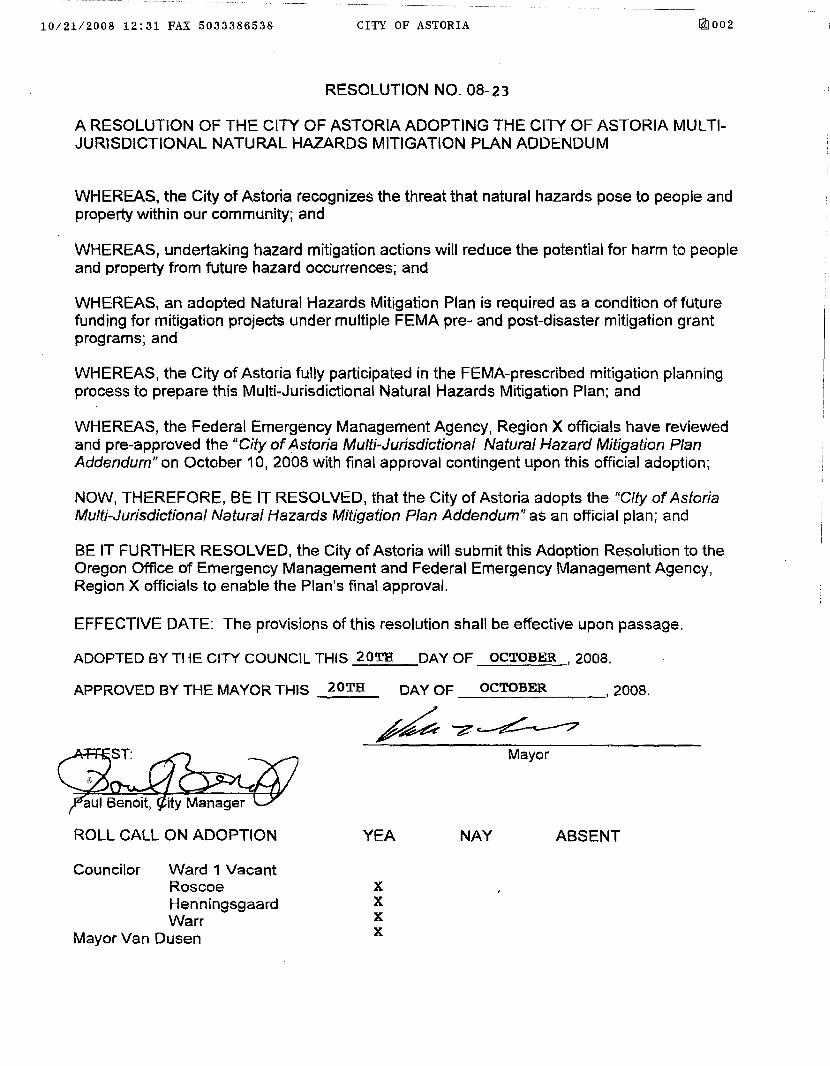
resolution no. 08-23 a resolution of the city of …
TRANSCRIPT
10/21/2008 12:31 FAX 5033386538 CITY OF ASTORIA I4i 002
RESOLUTION NO. 08-23
A RESOLUTION OF THE CITY OF ASTORIA ADOPTING THE CITY OF ASTORIA MULTIJURISDICTIONAL NATURAL HAZARDS MITIGATION PLAN ADDENDUM
WHEREAS, the City of Astoria recognizes the threat that natural hazards pose to people andproperty within our community; and
WHEREAS, undertaking hazard mitigation actions will reduce the potential for harm to peopleand property from future hazard occurrences; and
WHEREAS, an adopted Natural Hazards Mitigation Plan is required as a condition of futurefunding for mitigation projects under mUltiple FEMA pre- and post-disaster mitigation grantprograms; and
WHEREAS, the City of Astoria fUlly participated in the FEMA-prescribed mitigation planningprocess to prepare this Multi-Jurisdictional Natural Hazards Mitigation Plan; and
WHEREAS, the Federal Emergency Management Agency, Region X officials have reviewedand pre-approved the "City of Astoria Multi-Jurisdictional Natural Hazard Mitigation PlanAddendum" on October 10, 2008 with final approval contingent upon this official adoption;
NOW, THEREFORE, BE IT RESOLVED, that the City of Astoria adopts the "City of AstoriaMulti-Jurisdictional Natural Hazards Mitigation Plan Addendum" as an official plan; and
BE IT FURTHER RESOLVED. the City of Astoria will submit this Adoption Resolution to theOregon Office of Emergency Management and Federal Emergency Management Agency I
Region X officials to enable the Plan's final approval.
EFFECTIVE DATE: The prOVisions of this resolution shall be effective upon passage.
ADOPTED BY THE CITY COUNCIL THIS 20TH DAY OF OCTOBER I 2008.
APPROVED BY THE MAYOR THIS 20TH DAY OF OCTOBER ,2008.
Mayor
ROLL CALL ON ADOPTION
Councilor Ward 1 VacantRoscoeHenningsgaardWarr
Mayor Van Dusen
YEA
xxxx
NAY ABSENT
City of Astoria Addendum Page 1-1
Volume III: City Addendum City of Astoria
Overview
The City of Astoria developed this addendum to the Clatsop County Multi-jurisdictional Natural Hazards Mitigation Plan in an effort to increase the community’s resilience to natural hazards. The addendum focuses on the natural hazards that could affect Astoria, Oregon, which include: Coastal Erosion, Drought, Earthquake, Flood, Landslide, Tsunami, Volcano, Wildfire, Windstorm, and Winter Storm. It is impossible to predict exactly when disasters may occur, or the extent to which they will affect the City. However, with careful planning and collaboration among public agencies, private sector organizations, and citizens within the community, it is possible to minimize the losses that can result from natural hazards.
The addendum provides a set of actions that aim to reduce the risks posed by natural hazards through education and outreach programs, the development of partnerships, and the implementation of preventative activities such as land use or watershed management programs. The actions described in the addendum are intended to be implemented through existing plans and programs within the City.
The addendum is comprised of the following sections: 1) How was the Addendum Developed? 2) Community Overview; 3) Risk Assessment; 4) Action Items; 5) Supporting Documents.
How was the Addendum Developed? In Fall 2006, the Oregon Partnership for Disaster Resilience (OPDR) at the University of Oregon’s Community Service Center partnered with Oregon Emergency Management (OEM) and Clatsop and Lincoln Counties to develop a Pre-Disaster Mitigation Planning Grant proposal. Each county joined The Partnership by signing (through their County Commissions) a Memorandum of Understanding for this project. FEMA awarded the Oregon Coast Region a grant to support the development of multi-jurisdictional natural hazard mitigation plans for the two counties and the cities therein.
The Columbia River Estuary Studies Taskforce (CREST) was hired by Clatsop County to lead the development of the County’s Multi-Jurisdictional plan. A graduate student with OPDR assisted CREST with data collection and plan writing to support the development of the County’s Community Overview and Risk Assessment as well as similar components for the City addendums.

Page 1-2 Clatsop County Multi-Jurisdictional Natural Hazard Mitigation Plan
The City of Astoria’s Community Development Director served on the Countywide Steering Committee which helped guide the development of the County’s plan. A work session was held with City of Astoria staff on February 13, 2008 to develop this City-specific addendum. OPDR facilitated this work session to gather information for the City’s risk assessment. The following City departments were represented during this work session:
• Astoria Community Development Department;
• Astoria Public Works Department; and
• Astoria Fire Department.
Clatsop Community College also participated in the Countywide Steering Committee and attended the Astoria work sessions. Potential mitigation projects for the Community College will be included in this addendum.
The City of Astoria adopted the Clatsop County Multi-Jurisdictional Natural Hazard Mitigation Plan via resolution on October 20, 2008.
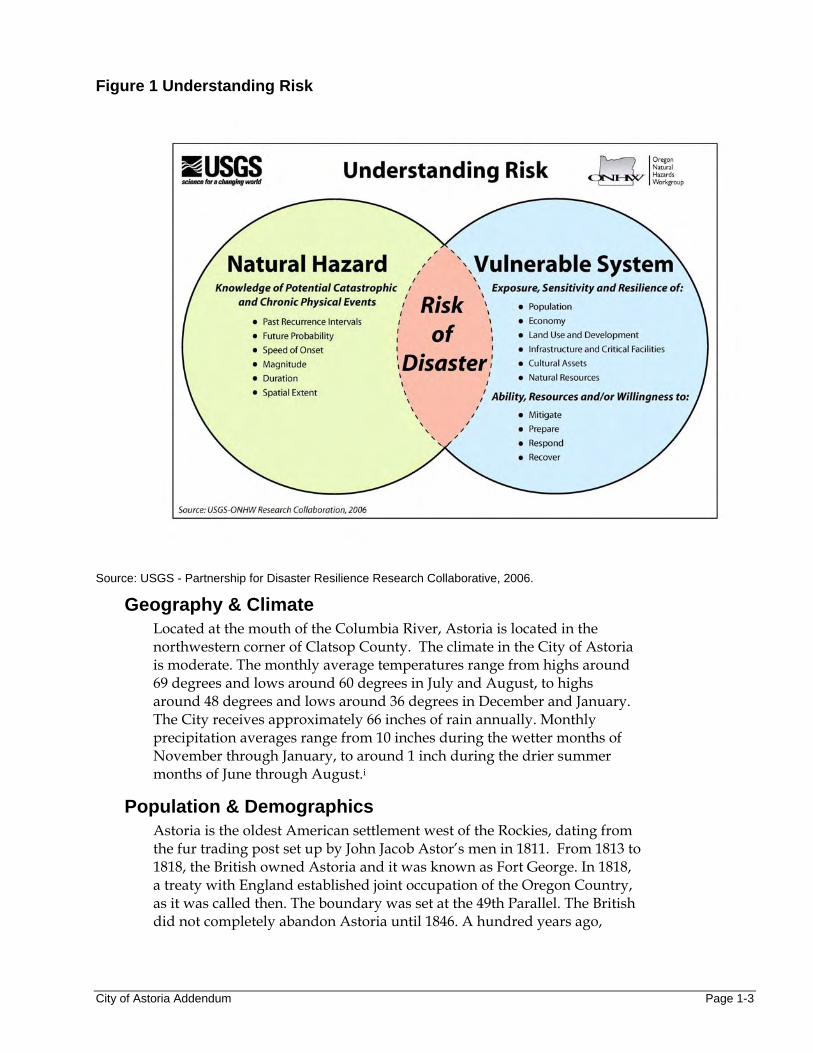
Community Overview The following section describes the City of Astoria from a number of perspectives in order to help define and understand the City’s sensitivity and resilience to natural hazards. Sensitivity factors can be defined as those community assets and characteristics that may be impacted by natural hazards, (e.g., special populations, economic factors, and historic and cultural resources). Community resilience factors can be defined as the community’s ability to manage risk and adapt to hazard event impacts (e.g., governmental structure, agency missions and directives, and plans, policies, and programs). The information in this section represents a snapshot in time of the current sensitivity and resilience factors in the City when the plan was developed. The information documented below, along with the hazard assessments located in the Hazard Summary, should be used as the local level rationale for the City’s risk reduction actions. The identification of actions that reduce the City’s sensitivity and increase its resilience assist in reducing overall risk, or the area of overlap in Figure 1 below.
City of Astoria Addendum Page 1-3
Figure 1 Understanding Risk
Source: USGS - Partnership for Disaster Resilience Research Collaborative, 2006.
Geography & Climate Located at the mouth of the Columbia River, Astoria is located in the northwestern corner of Clatsop County. The climate in the City of Astoria is moderate. The monthly average temperatures range from highs around 69 degrees and lows around 60 degrees in July and August, to highs around 48 degrees and lows around 36 degrees in December and January. The City receives approximately 66 inches of rain annually. Monthly precipitation averages range from 10 inches during the wetter months of November through January, to around 1 inch during the drier summer months of June through August.i
Population & Demographics Astoria is the oldest American settlement west of the Rockies, dating from the fur trading post set up by John Jacob Astor’s men in 1811. From 1813 to 1818, the British owned Astoria and it was known as Fort George. In 1818, a treaty with England established joint occupation of the Oregon Country, as it was called then. The boundary was set at the 49th Parallel. The British did not completely abandon Astoria until 1846. A hundred years ago,

Page 1-4 Clatsop County Multi-Jurisdictional Natural Hazard Mitigation Plan
Astoria was the second largest City in Oregon with a population of 8,975. The population now is just over 10,000.ii
In 2000, the City was home to 9,813 permanent residents, which makes up approximately 28% of Clatsop County’s total population.iii The City population has remained steady for most of its history, hovering around 10,000. Table 1 shows the City’s population since 1980.
Table 1 Population Growth, City of Astoria, 1980-2000 Census Population Percent Change
1980 9,998 --- 1990 10,069 0.70%2000 9,813 -2.50%
Source: US Census
Disaster impacts (in terms of loss and the ability to recover) vary among population groups following a disaster. Historically, 80% of the disaster burden falls on the public. Of this number, a disproportionate burden is placed upon special needs groups, particularly children, the elderly, the disabled, minorities, and low income persons. In Astoria, more than 8% of the City’s population speaks a language other than English as their primary language. In 2000, 15.9% of all individuals and 11.6% of families in the Astoria were living below the federal poverty level.vi More information on special needs populations is shown in Tables 2 through 4.
Table 2 Population by Age, City of Astoria, 2000 AgeUnder 5 years 6.4 %5 to 9 years 6.1 %10 to 14 years 7.2 %15 to 19 years 7.1 %20 to 24 years 6.3 %25 to 34 years 12.3 %35 to 44 years 14.1 %45 to 54 years 15.7 %55 to 59 years 5 %60 to 64 years 3.7 %65 to 74 years 7.4 %75 to 84 years 6 %85 years and over 2.5 %
Percent
Source: US Census, 2000
City of Astoria Addendum Page 1-5
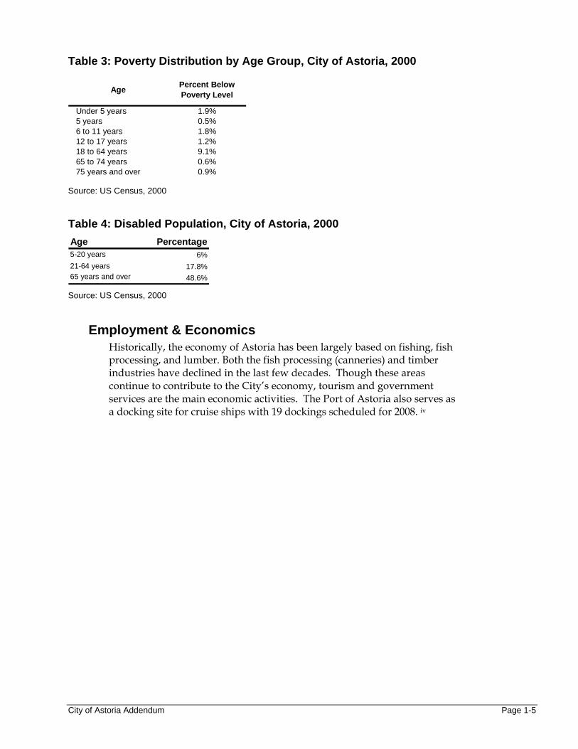
Table 3: Poverty Distribution by Age Group, City of Astoria, 2000
Age Percent Below Poverty Level
Under 5 years 1.9%5 years 0.5%6 to 11 years 1.8%12 to 17 years 1.2%18 to 64 years 9.1%65 to 74 years 0.6%75 years and over 0.9%
Source: US Census, 2000
Table 4: Disabled Population, City of Astoria, 2000 Age Percentage5-20 years 6%21-64 years 17.8%65 years and over 48.6% Source: US Census, 2000
Employment & Economics Historically, the economy of Astoria has been largely based on fishing, fish processing, and lumber. Both the fish processing (canneries) and timber industries have declined in the last few decades. Though these areas continue to contribute to the City’s economy, tourism and government services are the main economic activities. The Port of Astoria also serves as a docking site for cruise ships with 19 dockings scheduled for 2008. iv

Page 1-6 Clatsop County Multi-Jurisdictional Natural Hazard Mitigation Plan
Table 5 Employment by Industry, City of Astoria, 2000 INDUSTRY Percent
Educational, health and social services 22.0Retail trade 15.4Arts, entertainment, recreation, accommodation and food services 14.1Manufacturing 7.8Public administration 6.5Construction 6.3Finance, insurance, real estate, and rental and leasing 4.8Other services (except public administration) 4.8Professional, scientific, management, administrative, and waste management services 4.4Transportation and warehousing, and utilities 4.2Wholesale trade 3.3Agriculture, forestry, fishing and hunting, and mining 3.3Information 3.1 Source: US Census, 2000
Median income can be used as an indicator of the strength of the region’s economic stability. In 1999, the median household income in Astoria was $33,011.v This is almost $9,000 below the 1999 national median household income of $41,994, and around $3,000 below the $36,301 median household income for Clatsop County.vi Although it can be used to compare areas as a whole, this number does not reflect how income is divided among area residents.
Housing Housing type and age are important factors in mitigation planning. Certain housing types tend to be less disaster resistant and warrant special attention: mobile homes, for example, are generally more prone to wind and water damage than standard stick-built homes. Generally the older the home is, the greater the risk of damage from natural disasters. This is because stricter building codes have been developed following improved scientific understanding of plate tectonics and earthquake risk. For example, structures built after the late 1960s in the Northwest and California use earthquake resistant designs and construction techniques. In addition, FEMA began assisting communities with floodplain mapping during the 1970s, and communities developed ordinances that required homes in the floodplain to be elevated to one foot above Base Flood Elevation.
In 2000, Astoria had 4,860 housing units. Of those, 45% (2,187) were owner occupied, 42.2% (2,055) were renter occupied, and 12.8% were vacant.x Nearly 90% of the City’s housing stock was built prior to 1980, before
City of Astoria Addendum Page 1-7
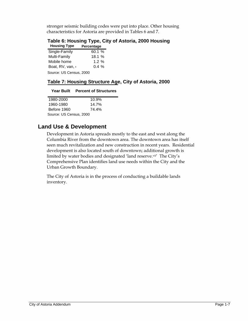
stronger seismic building codes were put into place. Other housing characteristics for Astoria are provided in Tables 6 and 7.
Table 6: Housing Type, City of Astoria, 2000 Housing Housing Type
Single-Family 60.1 %Multi-Family 18.1 %Mobile home 1.2 %Boat, RV, van, e 0.4 %
Percentage
Source: US Census, 2000
Table 7: Housing Structure Age, City of Astoria, 2000
Year Built Percent of Structures
1980-2000 10.9%1960-1980 14.7%Before 1960 74.4% Source: US Census, 2000
Land Use & Development Development in Astoria spreads mostly to the east and west along the Columbia River from the downtown area. The downtown area has itself seen much revitalization and new construction in recent years. Residential development is also located south of downtown; additional growth is limited by water bodies and designated ‘land reserve.vii’ The City’s Comprehensive Plan identifies land use needs within the City and the Urban Growth Boundary.
The City of Astoria is in the process of conducting a buildable lands inventory.

Page 1-8 Clatsop County Multi-Jurisdictional Natural Hazard Mitigation Plan
Figure 2 City of Astoria Zoning Map (1992)
Source: City of Astoria (http://www.astoria.or.us)
City of Astoria Addendum Page 1-9
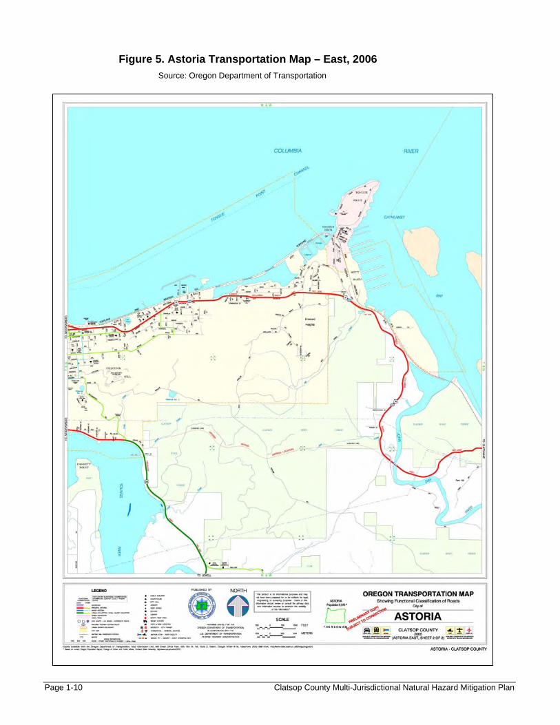
Transportation Two major transportation routes run through Astoria, Federal Highways 30 and 101. Highway 30 runs east to west and Highway 101 runs north and south over bridges leading into and out of Astoria over the Columbia River to the north and Young’s Bay to the south. State Highway 202 runs along the southern edge of the City.
Transportation is an important consideration when planning for emergency service provisions. Growth within the City will put pressure on both major and minor roads, especially if the main mode of travel is by single occupancy vehicles. Figures 5 and 6 are the Oregon Department of Transportation maps for Astoria.
Page 1-10 Clatsop County Multi-Jurisdictional Natural Hazard Mitigation Plan
Figure 5. Astoria Transportation Map – East, 2006 Source: Oregon Department of Transportation

City of Astoria Addendum Page 1-11
Figure 6. Astoria Transportation Map – West, 2006 Source: Oregon Department of Transportation

Page 1-12 Clatsop County Multi-Jurisdictional Natural Hazard Mitigation Plan
Critical Facilities & Infrastructure Critical facilities are those that support government and first responders’ ability to take action in an emergency. They are a top priority in any comprehensive hazard mitigation plan. Individual communities should inventory their critical facilities to include locally designated shelters and other essential assets, such as fire stations, public works shops, and water and waste water treatment facilities. Astoria has 2 fire stations, 1 hospital, 3 public elementary schools, 1 middle school, 1 high school, 1 community college and 1 private school.
Historic & Cultural Resources Historic and cultural resources such as historic structures and landmarks can help to define a community and may also be sources of tourism dollars. Because of their role in defining and supporting the community, protecting these resources from the impact of disasters is important.
The City’s Historic Inventory, dated January 2008, includes the following historic resources:
• 5 Museums;
• 40 places on the National Register of Historic Places;
• 2 National landmarks (Fort Astoria site & Lightship Columbia);
• 3 National Register Historic Districts (Uniontown-Alameda, Downtown, and Shively McClure).
• 6 Historic Sites (Taylor School; Shively Park; Tidal Rock (Local Landmark in DNRHD); First US Post Office West of the Rocky Mountains (Local Landmark in SMNRHD); Fort Astoria (also noted as National Landmark, DNRHD); 14th Street Ferry Landing (Local Landmark);
• 1 Historic Reconstruction (First US Customhouse West of the Rocky Mountains) and
• Local Historic Register including 90 individual designations and 748 historic properties.
Government Structure The City Council is the policy making body for the City of Astoria. Members of the Council serve as Council representatives on many boards and commissions of the City, other local governments, agencies, and the State. The Mayor appoints all City Boards and Commissions. The Mayor and Councilors appoint the City Manager, City Attorney, and Municipal Judge. The City Manager appoints all other City employees.
The City of Astoria currently has the following departmentsviii:
City of Astoria Addendum Page 1-13
City Manager’s Office: The City Manager is responsible for overall City administration and the supervision of seven department heads including: Finance, Community Development, Parks and Community Services, Library, Fire, Police and Public Works/Engineering. The City Manager is responsible to the City Council. The staff consists of the City Manager, an Executive Secretary, and a Human Resources Administrator.
Community Development Department: The Community Development Department is responsible for economic development, land use planning, zoning administration, building inspection, and historic preservation. The Department provides staff support to the Planning Commission (APC), the Historic Landmarks Commission (HLC), the Design Review Committee (DRC), and the Traffic Safety Advisory Committee (TSC). The Department administers both the City Comprehensive Plan and the Development Code. The Department also administers the City’s Building Inspection Program.
Public Works Department: The Public Works Department is the largest department within the City of Astoria. Major areas of responsibility include: water treatment and distribution; waste water collection and treatment; street maintenance; engineering services; sanitation/recycling services; fleet maintenance for all City vehicles; forestry management; City facility maintenance; railroad maintenance; and mapping with Geographic Information Systems (GIS).
Finance Department: The Finance Department offers a wide variety of services to the general public and to other departments of the City. The major activities include: utility billing, cashiering, accounts receivable, payroll, purchasing, accounts payable, data processing, financial planning, budget preparation, cash management, parking control, and maintenance of official City records.
Fire Department: The Astoria Fire Department is responsible for fire suppression and emergency medical response, which is coordinated with the local ambulance service (Medix). The department also contracts with the Tongue Point Job Corps Center, Coast Guard property at Tongue Point along with USCG cutters Alert and Steadfast to offer fire suppression and emergency medical services.
Police Department: The Astoria Police Department provides law enforcement services for the City's residents and visitors 24 hours every day and places particular emphasis on responding to the community’s calls for service, investigating crimes and traffic enforcement. In addition, the Police Department also includes 911 and dispatch services.
Parks and Community Services Department: The Parks and Community Services Department oversees parks and recreation activities for the City. The City has six historic sites, one caretaker home, three community halls, one maritime memorial park, six general use parks, one senior center, one indoor aquatic center, five public restroom buildings, three tennis courts,
Page 1-14 Clatsop County Multi-Jurisdictional Natural Hazard Mitigation Plan
eight playgrounds, ten ball fields, four basketball courts, one boat launch ramp/fishing dock, and seven miscellaneous locations, all of which are maintained by this department.
Astoria Public Library: The Astoria Public Library collects, preserves, and administers organized collections of books and related materials, promotes their efficient use, provides a public meeting place for discussion and reading, and extends the cultural life of the community. The Library Advisory Board, appointed by the Mayor, assists with the development of library policies. The City Council approves these policies and the library staff implements them.
Existing Plans, Policies and Community Organizations Communities often have existing plans and policies that guide and influence land use, land development, and population growth. Such existing plans and policies can include comprehensive plans, zoning ordinances, and technical reports or studies. Plans and policies already in existence have support from local residents, businesses and policy makers. Many land-use, comprehensive, and strategic plans get updated regularly, and can adapt easily to changing conditions and needs.ix
The City of Astoria’s Natural Hazards Mitigation Plan Addendum includes a range of recommended action items that, when implemented, will reduce the City’s vulnerability to natural hazards. Many of these recommendations are consistent with the goals and objectives of the county’s existing plans and policies. Linking existing plans and policies to the Natural Hazards Mitigation Plan helps identify what resources already exist that can be used to implement the action items identified in the Plan. Implementing the natural hazards mitigation plan’s action items through existing plans and policies increases their likelihood of being supported and getting updated, and maximizes the City’s resources.
The following table documents the plans and policies already in place in Astoria.

City of Astoria Addendum Page 1-15
Table 8 Existing Plans, City of Astoria
The following are excerpts from the City’s Comprehensive Plan that describe actions related to natural hazard vulnerability and risk.
• CP.400 Geologic and Flood Hazard Policies
1. The City will take reasonable precautions to protect life and property from natural hazards or disasters, through the use of the City Flood Hazards Ordinance (Ord.78-06), the Uniform Building Code, and the policies for the management of geologic hazard areas.

Page 1-16 Clatsop County Multi-Jurisdictional Natural Hazard Mitigation Plan
2. Where it appears a landslide, or other earth movement hazard may be present, the approval of the City Engineer and/or Planning Commission may require a site investigation and report by a City approved licensed engineering geologist or soils engineer in such cases.
3. Land divisions in areas of steep slopes, unstable soils, weak foundation soils, or landslide potential will be permitted only after a favorable site investigation report has been completed. …
4. . . . Detailed drainage plans showing the location of proposed storm water disposal will be a part of building permit or land division applications.
5. Clustering of development on steep or less steep portions of sites is encouraged in order to maintain steeper slopes in their natural condition.
6. General development policies for areas of steep slopes will be as follows:
7. Construction excavation will be held to a minimum necessary to build footings efficiently
8. Removal of vegetation will be kept to the minimum necessary for the placement of roads, utilities, and structures. Erosion control measures as required by the City Engineer will be employed during and after construction.
9. Access roads and driveways will be constructed with a minimum amount of grading.
10. No development will be allowed to block stream drainages in any area or divert storm water across adjacent property.
11. … Where necessary, the City Engineer may require certification by a professional engineer or architect to accompany building plans.
Community Organizations and Programs Social systems can be defined as community organizations and programs that provide social and community-based services, such as health care or housing assistance, to the public. In planning for natural hazard mitigation, it is important to know what social systems exist within the community because of their existing connections to the public. Often, actions identified by the plan involve communicating with the public or specific subgroups within the population (e.g. elderly, children, low income). The County and its cities can use existing social systems as resources for implementing such communication-related activities because these service providers already work directly with the public on a number
City of Astoria Addendum Page 1-17
of issues, one of which could be natural hazard preparedness and mitigation.
The County-wide Community Organizations and Programs table can be found in Section 2: Community Overview of the Clatsop County Multi-Jurisdictional Natural Hazard Mitigation Plan. The table highlights organizations that are active within the County and may be potential partners for implementing mitigation actions.
Existing Mitigation Activities Existing mitigation activities include current mitigation programs and activities that are being implemented by the community in an effort to reduce the community’s overall risk to natural hazards. Documenting these efforts can assist participating jurisdictions better understand risk and can assist in documenting successes.
• MULTI-HAZARD – Astoria Builders Supply Co. designed their new building to be resistant to both flood and windstorms by elevating the building and utilizing hurricane building design concepts.
• MULTI-HAZARD - Current Oregon Codes / International Codes adopted for seismic and wind resistance requirements.
• MULTI-HAZARD - Public awareness and education efforts.
• MULTI-HAZARD - Community Emergency Response Team training for neighborhood disaster readiness and personal/home structural and non-structural mitigation efforts.
• MULTI-HAZARD – Columbia Memorial Hospital has placed a trailer on-site at the Middle School for storage of non-invasive medical supplies. In addition, the hospital purchased two generators. These generators would provide minimum emergency power if needed.
• EARTHQUAKE – Clatsop Community College’s Jerome Avenue campus has completed renovations to the Student Services Center and subject to grant funding, will be renovating Towler Hall to bring the buildings to current seismic codes.
• EARTHQUAKE – Lewis and Clark Elementary School was built in 2002 and conformed to seismic building codes in place at that time. Projects at the high school included construction of a new gymnasium and student commons built to current seismic codes. Astor Elementary and Gray Elementary were renovated to bring the buildings into compliance with current building codes.
• FLOOD - Special Design Consideration of storm drains to minimize blockage. Public Works proactively checks storm basins and keeps them clean of debris to help minimize urban flooding. In addition,

Page 1-18 Clatsop County Multi-Jurisdictional Natural Hazard Mitigation Plan
they’ve installed stormwater drains with cow catcher shaped grills that help divert debris out of the way.
Figure 5. Stormwater drains – Astoria, Oregon
Source: City of Astoria Public Works
• FLOOD – The City of Astoria has adopted a Flood Hazard Overlay Zone that regulates the use of those areas subject to periodic flooding, to promote public health, safety and general welfare and to minimize public and private losses due to flood conditions.
• FLOOD - Many residential structures in low areas of town built to be flood resistant with unoccupied/unfinished first floors and main living area on 2nd and 3rd floor.
• FLOOD - Requirements for down-spouts/rain water to be directed to streets and storm drains to help control ground saturation.
• LANDSLIDE – The City has drafted a Geologic Hazard and Hillside Development Ordinance which will guide development related to earthquakes and landslides. The ordinance has yet to be adopted. The City also has requirements for comprehensive geo-technical reports prior to construction. The City has also purchased lands associated with historic landslides and is using them as parks and open space. A map showing past slides can be found within City records as well.
• WINDSTORM – New roofs were placed on Astor Elementary, Gray Elementary and the high school. The new roofs were rated for 100 mph winds and have a 20 year life.
• WILDFIRE – Significant upgrades were made to the electrical and lighting systems at the Middle School. Lewis and Clark Elementary and Gray Elementary were completely sprinkled while upgrades to the fire alarm systems were made at other schools.
City of Astoria Addendum Page 1-19
• WILDFIRE – The City is participating in the development of a county-wide Community Wildfire Protection Plan to address the risks posed by wildfire.
Risk Assessment The following hazards have been addressed in the Clatsop County Multi-Jurisdictional Natural Hazard Mitigation Plan. The City of Astoria reviewed the County’s plan during a work session on February 12, 2008 and assessed how Astoria’s risks vary from the risks facing the entire planning area.
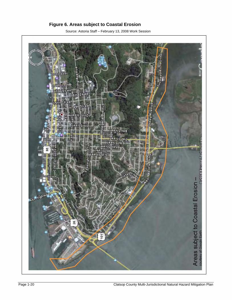
Coastal Erosion Astoria’s location on Young’s Bay makes it susceptible to coastal erosion. City of Astoria staff indicated that the extent of the coastal erosion hazard is limited to those lands directly adjacent to Young’s Bay on the south side of town. These locations are highlighted in Figure 6 below.
Little data exists for previous occurrences of coastal erosion in Astoria. Significant erosion events took place along the Oregon coast during: El Nino events in 1982-1983 and 1997-1998 and winter storm events in 1998-1999. These events have been cited as the most significant examples of coastal retreat in the last three decades. x The Clatsop County Multi-Jurisdictional Natural Hazard Mitigation Plan did not rank the vulnerability or probability of coastal erosion.
According to a brochure developed by CREST, erosion can have the following community impacts:
• Loss of property;
• Threatens near shore buildings and other structures;
• Degrades aquatic and riparian habitats;
• Reduces water clarity, light penetration and plant productivity;
• Causes warming of the stream/river;
• Releases nutrients which could stimulate undesirable plant and algae growth;
• Affects fish feeding, spawning, and gill function; and
• Changes bottom substrate, reduces channel capacities, increases flooding.
Page 1-20 Clatsop County Multi-Jurisdictional Natural Hazard Mitigation Plan
Figure 6. Areas subject to Coastal Erosion Source: Astoria Staff – February 13, 2008 Work Session
City of Astoria Addendum Page 1-21
Drought The Clatsop County Multi-Jurisdictional Natural Hazard Mitigation Plan adequately addresses the drought hazard for the City of Astoria. The location, extent, previous occurrences, vulnerability, and probability for drought in Astoria are the same as the County. City staff did indicate that the most significant community issue would be a lack of water, but that the City does have adequate storage capabilities. Staff also indicated that in the 1980’s a drought prompted the City to implement voluntary water restrictions. In addition, drought conditions can also increase the probability of wildfires.
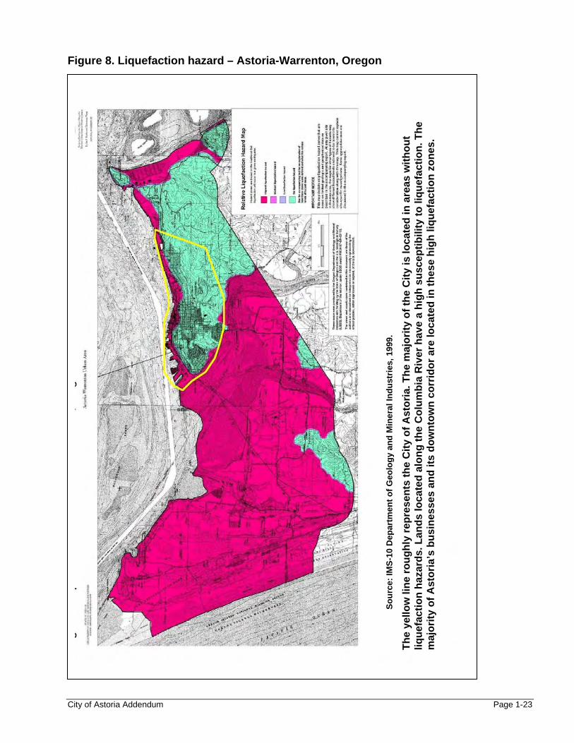
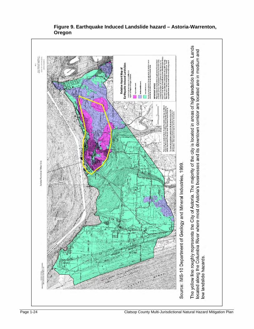
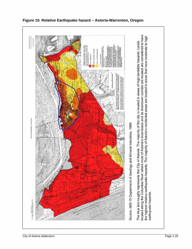
Earthquake Astoria’s location along the Oregon Coast makes it susceptible to earthquakes, especially a Cascadia Subduction Zone earthquake. The extent of the earthquake hazard includes the entire community of Astoria, although damage from an earthquake may be more severe in the downtown area where buildings are old and sit on fill that has liquefaction potential.
The following earthquake hazard maps were developed by the Department of Geology and Mineral Industries. The figures illustrate the location of the amplification, liquefaction, earthquake induced landslide, and relative earthquake hazards in both Astoria and Warrenton.

Page 1-22 Clatsop County Multi-Jurisdictional Natural Hazard Mitigation Plan
Figure 7. Amplification hazard – Astoria-Warrenton, Oregon
Source: IMS-10 Department of Geology and Mineral Industries, 1999.
The yellow line roughly represents the City of Astoria. The majority of the City is located in areas of low amplification hazards. Lands located immediately adjacent to the Columbia River and Young’s Bay have a moderate or high risk of amplification
City of Astoria Addendum Page 1-23
Figure 8. Liquefaction hazard – Astoria-Warrenton, Oregon Source: IMS-10 Department of Geology and Mineral Industries, 1999.
The yellow line roughly represents the City of Astoria. The majority of the City is located in areas without liquefaction hazards. Lands located along the Columbia River have a high susceptibility to liquefaction. The majority of Astoria’s businesses and its downtown corridor are located in these high liquefaction zones.
Source: IMS-10 Department of Geology and Mineral Industries, 1999.
The yellow line roughly represents the City of Astoria. The majority of the City is located in areas without liquefaction hazards. Lands located along the Columbia River have a high susceptibility to liquefaction. The majority of Astoria’s businesses and its downtown corridor are located in these high liquefaction zones. Source: IMS-10 Department of Geology and Mineral Industries, 1999.
The yellow line roughly represents the City of Astoria. The majority of the City is located in areas without liquefaction hazards. Lands located along the Columbia River have a high susceptibility to liquefaction. The majority of Astoria’s businesses and its downtown corridor are located in these high liquefaction zones.
Sour
ce: I
MS-
10 D
epar
tmen
t of G
eolo
gy a
nd M
iner
al In
dust
ries,
199
9.
The
yello
w li
ne ro
ughl
y re
pres
ents
the
City
of A
stor
ia. T
he m
ajor
ity o
f the
City
is lo
cate
d in
are
as w
ithou
t liq
uefa
ctio
n ha
zard
s. L
ands
loca
ted
alon
g th
e C
olum
bia
Riv
er h
ave
a hi
gh s
usce
ptib
ility
to li
quef
actio
n. T
he
maj
ority
of A
stor
ia’s
bus
ines
ses
and
its d
ownt
own
corr
idor
are
loca
ted
in th
ese
high
liqu
efac
tion
zone
s.
Page 1-24 Clatsop County Multi-Jurisdictional Natural Hazard Mitigation Plan
Figure 9. Earthquake Induced Landslide hazard – Astoria-Warrenton, Oregon
City of Astoria Addendum Page 1-25
Figure 10. Relative Earthquake hazard – Astoria-Warrenton, Oregon
Page 1-26 Clatsop County Multi-Jurisdictional Natural Hazard Mitigation Plan
The Clatsop County Multi-Jurisdictional Natural Hazard Mitigation Plan adequately identifies the previous occurrences of earthquakes for the City of Astoria. The Clatsop County Multi-Jurisdictional Natural Hazard Mitigation Plan ranked the vulnerability of earthquakes as high. The County plan also indicates that the probability of earthquakes is high. These scores would be representative of Astoria as well.
City staff identified the following potential community impacts or concerns about the earthquake hazard:
• City’s reservoirs are water sources for both drinking water and fire suppression and are likely at risk due to age. City staff also identified the importance of Bear Creek Dam as a critical facility.
• Staff had concerns about the City's water distribution system pipe infrastructure which is comprised of mostly older materials - cast iron for water and vitrified clay and terra cotta for sanitary and storm sewer and the potential for loss of fire suppression water.
• The downtown area of Astoria was rebuilt following a catastrophic fire in 1922. The fire destroyed 32 blocks, 40 acres and 33 buildings. Reconstruction efforts involved chair-wall construction which created concrete tunnels for water and gas lines. The area around the chair walls was filled in with dredge sands during reconstruction.xi The majority of downtown is located on areas of high liquefaction risk. A large earthquake will have significant impacts on Astoria’s economy.
• Only the newest buildings in the City have been built to earthquake standards. The majority of buildings, especially those located downtown, were built prior to the implementation of stricter building codes.
• Downtown’s reconstruction using chair walls results in poor access to utilities located underground.
• Staff identified the vulnerability of the Tongue Point area specifically its location in areas of high liquefaction potential.
• The hospital is located on a site filled with dredge materials.
• Staff has concerns about the wastewater system and lift stations around town being damaged and leading to public health emergencies following an earthquake. In addition, the water distribution system would likely be heavily damaged, preventing the delivery of water for fire suppression and domestic use.
• The Astoria Column is an important historic and cultural resource and would like suffer damage from a large earthquake.
City of Astoria Addendum Page 1-27
• The City owns three bridges in town that are likely at risk – however, the City will be replacing one of them (Franklin Bridge) in the next 3-4 years. The loss of bridges may cut off certain areas of the community.
• Chair-wall construction downtown creating common spaces over large area that can complicate flooding impact and problems due to the ease of travel for natural gas, smoke, fire, etc. between buildings and over a large area.
• Vulnerability and wide ranging hazards from gas and electric utility infrastructure.
• Effect on most road surfaces that will complicate access, evacuation, and emergency response.
• DOGAMI, in consultation with project partners developed a statewide seismic needs assessment that includes seismic safety surveys of K-12 public school buildings. According to this assessment the following school buildings in Astoria were rated with a high collapse potential and should receive further evaluation:
• Astor Elementary School
• Astoria Senior High School
• Gray Elementary School
• Clatsop Community College’s MERTS campus is built to earthquake standard 3, but is subject to liquefaction and has only one way in and out.
• Clatsop Community College’s Jerome Avenue campus has completed renovations and seismic upgrades to the Student Services Center. The College is in need of addressing life safety issues at Towler Hall. Towler Hall has severe seismic deficiencies, has very high seismic risk, and is a high priority to the community and requires mitigation. The College will be constructing a new building, and replacing Patriot and Fertig Halls. The Library and Art Building were rated fair for seismic performance by a structural engineer and there are no anticipated renovations expected to these buildings.
Flood Astoria is at risk of flooding from three main sources: the Columbia River, Young’s Bay, and urban flooding from storm water coming off the slopes of the City’s hillsides. Because of the prevalence of urban flooding, the extent of the flood hazard includes most of the City, with the exception of those residences located at the top of the hill in town. The City’s Flood Insurance Rate Maps highlights the location of the flood hazard in Astoria.
Page 1-28 Clatsop County Multi-Jurisdictional Natural Hazard Mitigation Plan
The City’s current effective date for the Flood Insurance Rate Map is August 1, 1978. Flood maps are currently under review by FEMA.
The Clatsop County Multi-Jurisdictional Natural Hazard Mitigation Plan adequately identifies the previous occurrences of floods for the City of Astoria. The Clatsop County Multi-Jurisdictional Natural Hazard Mitigation Plan ranked the vulnerability of floods as moderate. The County plan also indicates that the probability of floods is high. These scores would be representative of Astoria’s risk as well.
The City of Astoria is a participant in the National Flood Insurance Program. The City has a total of 41 policies under the NFIP, only 20 of which are located in A zones. The total coverage for the City under the NFIP is $9,759,500. There have only been four claims since 1978, with nothing paid on those claims. The last Community Assistance Visit (CAV) was conducted on April 21, 2000.
Using the existing FEMA Flood map and a visual review of aerial photographs of the City dated 2002, the Community Development Department estimates the following number of structures in the floodplain:
• Commercial/Industrial – 24 plus 2 mooring basins
• Residential – 50 plus several vessels at mooring basins
• Infrastructure – 16 facilities plus sewer outfalls.
o Trolley trestles in Uniontown – 2
o 7th Street trestle
o 9th Street trestle
o 6th Street trestle
o Transient moorage at 17th
o City sewer outfalls
o 14th Street RiverPark
o Trolley trestles in Alderbrook – 2
o City sewer pump station 1
o City sewer lagoon
o Maritime Memorial Park
o Mill Pond weir and trestle
o 10th & 11th Street extensions
o Alderbrook ball field
City of Astoria Addendum Page 1-29
City staff identified the following potential community impacts or concerns about the flood hazard:
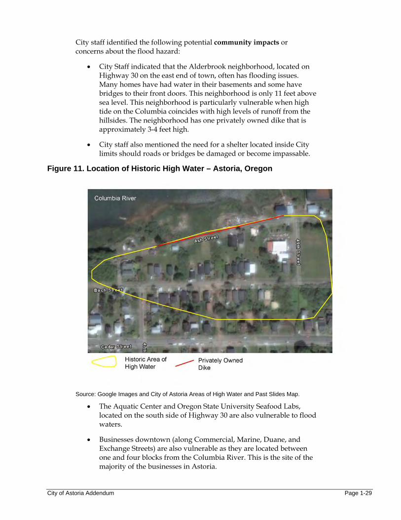
• City Staff indicated that the Alderbrook neighborhood, located on Highway 30 on the east end of town, often has flooding issues. Many homes have had water in their basements and some have bridges to their front doors. This neighborhood is only 11 feet above sea level. This neighborhood is particularly vulnerable when high tide on the Columbia coincides with high levels of runoff from the hillsides. The neighborhood has one privately owned dike that is approximately 3-4 feet high.
• City staff also mentioned the need for a shelter located inside City limits should roads or bridges be damaged or become impassable.
Figure 11. Location of Historic High Water – Astoria, Oregon
Source: Google Images and City of Astoria Areas of High Water and Past Slides Map.
• The Aquatic Center and Oregon State University Seafood Labs, located on the south side of Highway 30 are also vulnerable to flood waters.
• Businesses downtown (along Commercial, Marine, Duane, and Exchange Streets) are also vulnerable as they are located between one and four blocks from the Columbia River. This is the site of the majority of the businesses in Astoria.

Page 1-30 Clatsop County Multi-Jurisdictional Natural Hazard Mitigation Plan
• Houses located adjacent to streams are also vulnerable to frequent flooding. Public Works indicates that several times a year homes are pumping water out of their basements.
• The embankment along the River, which is located adjacent to the Columbia River, could be considered a flood protection device.
• There are flooding issues on Highway 202 on Young’s Bay on the south west side of town as well.
• Clatsop Community College’s MERTS campus is vulnerable to floods during dike breaches, high tides, or extensive rainfall. This location has only one evacuation route.
• Clatsop Community College leases a facility in the South County on Highway 101 that could be vulnerable to floods during high tides and storms.
Landslide Astoria is at risk of landslides because of its location on the hillside above the Columbia River and Young’s Bay. The extent of the landslide hazard includes most of the residential portions of the City. The City is in the process of completing a LiDAR study with the Department of Geology and Mineral Industries that will identify the location of potential landslide hazards in Astoria.
The City of Astoria Areas of High Water and Past Slides map originally developed in 1974 and updated as recently as 2008 identifies the previous occurrences, location and extent of earth movement in the City of Astoria. Those previous occurrences are summarized below. Note that landslide events are summarized by corresponding map sections A-K:
• Map Section A – a total of 7 slide areas
• Map Section B – a total of 9 small slide areas – the most recent in 1998
• Map Section C – 6 small to medium slides and two large slides.
• One of the large slides, known as the Bond Street slide occurred originally in 1954, and was triggered again in January 2007. This slide continued to move during the development of the Clatsop County Multi-Jurisdictional Natural Hazard Mitigation Plan. Mitigation of the landslide area and infrastructure is a top priority of the City. See Figure 12.
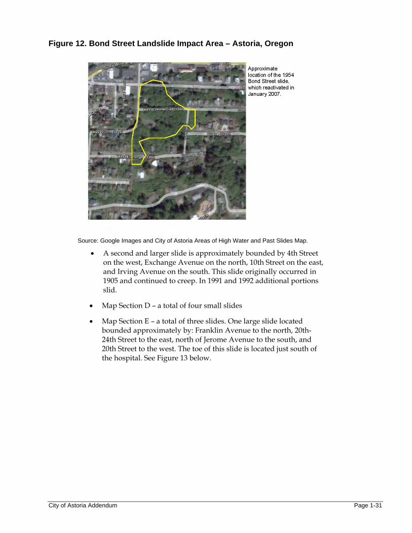
City of Astoria Addendum Page 1-31
Figure 12. Bond Street Landslide Impact Area – Astoria, Oregon
Source: Google Images and City of Astoria Areas of High Water and Past Slides Map.
• A second and larger slide is approximately bounded by 4th Street on the west, Exchange Avenue on the north, 10th Street on the east, and Irving Avenue on the south. This slide originally occurred in 1905 and continued to creep. In 1991 and 1992 additional portions slid.
• Map Section D – a total of four small slides
• Map Section E – a total of three slides. One large slide located bounded approximately by: Franklin Avenue to the north, 20th-24th Street to the east, north of Jerome Avenue to the south, and 20th Street to the west. The toe of this slide is located just south of the hospital. See Figure 13 below.

Page 1-32 Clatsop County Multi-Jurisdictional Natural Hazard Mitigation Plan
Figure 13. Historic Landslide Impact Area – Astoria, Oregon
Source: Google Images and City of Astoria Areas of High Water and Past Slides Map.
• Map Section F – a total of four slides.
• Map Section G – a total of six slides including the Uppertown earth movement dated May 2004 on the map. This slide is approximately bounded by: Lief Erikson Drive to the north, 34th Street to the east, Harrison Avenue to the south, and 31st Street to the west.
• Map Section H – a total of three small slides
• Map Section I – no slides indicated
• Map Section J – one slide located at the intersection of Highway 30 and 53rd Street.
The Clatsop County Multi-Jurisdictional Natural Hazard Mitigation Plan ranked the vulnerability of landslides as moderate. The City of Astoria’s vulnerability to landslides, however, is high due to location of critical facilities and residential development within landslide prone areas. The County plan also indicates that the probability of landslides is high. This probability score would be representative of Astoria as well.

City of Astoria Addendum Page 1-33
City staff identified the following potential community impacts or concerns about the landslide hazard:
• City staff was concerned about water and transportation infrastructure related to the landslide hazard. The re-activation of the Bond Street slide disrupted water infrastructure. The water distribution system is the only water supply for fire protection. Many streets are located along the sides of hills within the City. These streets function as major arteries and also house water and sewer lines. This creates potential risk that could result in the inability to provide effective emergency services.
• As is illustrated in Figure X above, Columbia Memorial Hospital is located at the foot of a historic slide.
• Public Works also indicated that areas near the intersection of 38th Street and Franklin Avenue are somewhat unstable.
• Staff indicated that when the City receives multiple days of heavy rain that the excess precipitation can lead to earth movement.
• Stabilization measures have been undertaken along Highway 30 around Tongue Point to help reduce the vulnerability of a slide cutting off Highway 30, which is the major east-west connection between Astoria and Portland.
• Clatsop Community College and City staff indicated that the eastern portions of the Community College may be at risk from landslides.
• Astoria Middle School may also be at risk to landslides.
• City staff suggested a potential mitigation action to improve the storm drainage system in the forested areas on the ridge in Astoria.
• The following issues have been identified in the City’s proposed Geologic Hazard and Hillside Development Ordinance:
1. Since 1950, it is estimated that sixty to seventy homes have been seriously damaged by earth movement. The resulting cost to the various owners is estimated to be between $500,000 and $1,000,000. Cost of street and utility repairs is estimated to be over $2,000,000.
2. Geological information indicates that the bedding planes under Astoria generally dip toward the south, and that the landslide potential on the south slope (which is mostly undeveloped at present) could be considerable as development increases. Great care should be taken to insure this area does not experience the same problems encountered on the north slope of the City.
Page 1-34 Clatsop County Multi-Jurisdictional Natural Hazard Mitigation Plan
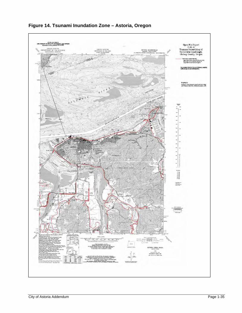
Tsunami Astoria’s location along the Oregon Coast makes it susceptible to tsunamis from both near shore (following a Cascadia Subduction Zone earthquake) and distant tsunamis. The extent of the tsunami hazard is limited to those areas adjacent to either the Columbia River or Young’s Bay.
The following tsunami inundation map illustrates the location of the tsunami hazard. This map was developed by the Department of Geology and Mineral Industries in 1995.
City of Astoria Addendum Page 1-35
Figure 14. Tsunami Inundation Zone – Astoria, Oregon
Page 1-36 Clatsop County Multi-Jurisdictional Natural Hazard Mitigation Plan
The Clatsop County Multi-Jurisdictional Natural Hazard Mitigation Plan ranked the vulnerability of tsunami as high. The County plan indicates that the probability of tsunami is moderate. These scores would be representative of Astoria’s risk as well.
City staff identified the following potential community impacts or concerns about the tsunami hazard:
• City staff had concerns about community assets (including Police, Fire and Public Works facilities) located to the north of Marine Drive. Tsunami inundation maps indicate that this area is vulnerable to tsunami impact.
• The Fire Department indicated that further studies were needed to better assess the tsunami inundation zone given new technology and wave height modeling software now available.
• The City’s tourist based economy and population density are significant issues related to the tsunami hazard.
• Clatsop Community College’s South County Center is located in the tsunami inundation zone.
Volcano The Clatsop County Multi-Jurisdictional Natural Hazard Mitigation Plan does an adequate job of describing the location, extent, history, probability, vulnerability, and community impacts of volcanoes in Astoria. The City of Astoria experienced ashfall and debris in the Columbia River as a result of the Mt. St. Helens eruption in 1980. Please refer to the County’s plan for additional information on the volcano hazard.
Wildfire The City of Astoria has urban forests. The urban forest is adjacent to State, County, and private forest that extends for miles east of the City limits. This creates the potential for wildland-urban interface and makes the City vulnerable to wildfire. Also at risk is the City’s watershed which is made up of 3,700 acres (Wickiup Mountain) that serves as the City’s water source. Clatsop County is currently in the process of developing a Community Wildfire Protection Plan (CWPP) that will further delineate the location, extent, previous occurrences, probability, vulnerability, and community impacts of wildfires in Astoria.
Based on the best available data, the location of the wildfire hazard in Astoria is the large urban forest located within the City and extending beyond the City limits to the east. The City of Astoria was listed as a Community at Risk during the State Wildfire Assessment. The extent of the wildfire hazard is likely limited to the interface areas along Irving Avenue to the north and following the crest of the hillside around to 9th Street on
City of Astoria Addendum Page 1-37
the western side of town. A wildfire could travel from the urban forest into the neighborhoods on the hillsides.
Since June 2005, Astoria Fire has responded to 36 wildfires: 14 natural vegetation fires, 12 brush fires, 5 files in cultivated vegetation, 4 forest or wooded fires, and one grass fire.
The Clatsop County Multi-Jurisdictional Natural Hazard Mitigation Plan ranked the vulnerability of wildfire as moderate. The County plan indicates that the probability of wildfire is high. For the City of Astoria, the vulnerability of wildfire is high and the probability is moderate.
City staff identified the following potential community impacts or concerns about the wildfire hazard:
• City staff had concerns about a wildfire impacting the 3,700 acre watershed that is home to the City’s water supply and located 12 miles east.
• The east end of the City is a large urban forest that creates the potential for interface fires.
• During August, September, and January, east winds can blow fires into the City.
• The urban interface has not yet been delineated, but will be completed s the County develops its CWPP.
• Clatsop Community College’s MERTS campus is located in a heavily forested area and has a single evacuation route. Buildings at this campus have been sprinkled.
• Clatsop Community College’s Jerome Avenue campus is located in a forested area and new and renovated buildings will be sprinkled.
Wind and Winter Storms The Clatsop County Multi-Jurisdictional Natural Hazard Mitigation Plan addresses wind and winter storms together.
Windstorm Astoria’s location at the mouth of the Columbia River, and close to the Oregon Coast, makes it susceptible to windstorms. The County’s plan accurately describes the location, extent, and previous occurrences of windstorms in Astoria. The Clatsop County Multi-Jurisdictional Natural Hazard Mitigation Plan ranked the vulnerability of windstorm as high. The County plan indicates that the probability of windstorm is high. These scores accurately reflect the vulnerability and probability of windstorms in the City of Astoria.
City staff identified the following potential community impacts or concerns about the windstorm hazard:

Page 1-38 Clatsop County Multi-Jurisdictional Natural Hazard Mitigation Plan
• City staff indicated that the south slope of the City is more vulnerable than other areas to high winds.
• The urban forest located to the east of the City is also vulnerable to wind damage.
• Pharmacies are an underrated asset following windstorms. Many of the residents of the December 2007 wind storm needed medications and may not have been able to get to the pharmacy.
• Staff raised concerns about emergency power for critical facilities such as shelters, schools, and the community college.
• The City frequently loses power several times each winter. Staff is also concerned about the resiliency of the City’s power infrastructure to windstorms and suggested placing portions of the infrastructure underground as a potential mitigation action.
• Emergency notification and communication are always an issue when communication systems are down and the power is out. Lack of redundancy created a lack of communication during the December 2007 wind event.
• Downed trees can block transportation routes and impede the provision of emergency services and can also damage public and private property.
• New construction is being built according to model national building codes. A wind screen at the Hotel Elliot downtown survived the December 2007 windstorm as did new awnings recently installed at the Sears downtown.
• Clatsop Community College’s MERTS campus may be vulnerable during a windstorm due to tree blow down across the single evacuation route.
Clatsop Community College’s Jerome Avenue campus may be impacted by downed trees. Proposed plans include minimal emergency back-up systems and replacing overhead utilities with underground utilities.
Winter Storm Astoria’s location on both the Oregon Coast makes it susceptible to winter storms. The County’s plan accurately describes the location, extent, and previous occurrences of winter storms in Astoria. The Clatsop County Multi-Jurisdictional Natural Hazard Mitigation Plan did not rank the vulnerability or probability of winter storm. City of Astoria staff indicated that the probability and vulnerability for winter storms is high.
City staff identified the following potential community impacts or concerns about the winter storm hazard:
City of Astoria Addendum Page 1-39
• Travel along the City’s steep streets becomes difficult during ice storms.
• Elderly residents may be more directly impacted than other residents during winter storms because of their inability to travel safely to get medications.
• During extended freeze situations, water service lines connected to individual homes can freeze because they are not laid very deep in the ground.
• Staff indicated that there is a need for heated emergency shelters that are available during extended cold weather events.
• Staff is also concerned about the resiliency of the City’s power infrastructure to windstorms and suggested placing portions of the infrastructure underground as a potential mitigation action.
• Clatsop Community College’s MERTS campus is vulnerable due to its single evacuation route.
• Clatsop Community College’s Jerome Avenue campus is replacing aggregate sidewalks with heavily brushed surfaces to reduce the likelihood of slipping.
Action Items Multi-hazard Requirement §201.6(c)(3)(iv): For multi-jurisdictional plans, there must be identifiable action items specific to the jurisdiction requesting FEMA approval or credit of the plan.
If the City’s risk to a hazard (or hazards) is greater than the County’s, then the City must create at least one action item to mitigate that hazard’s effects.
The following action items are detailed recommendations for activities that local departments, citizens, and others could engage in to reduce risk. See full action item forms for more information. The starred(***) action items below are the City’s top priorities for mitigation actions.
• Ensure continued compliance in the National Flood Insurance Program (NFIP) through enforcement of local floodplain management ordinances.
• Address repetitive flood loss properties not covered by the National Flood Insurance Program
• Determine feasibility of becoming a participant in the NFIP’s Community Ratings System
• Evaluate flood hazards in the Alderbrook Neighborhood

Page 1-40 Clatsop County Multi-Jurisdictional Natural Hazard Mitigation Plan
• Conduct a seismic and flood vulnerability assessment of all critical facilities and infrastructure in the City
• Continue efforts to replace aged bridges with newer structures.
• Re-map the tsunami inundation hazard for the City of Astoria
• Determine needs and issues related to tsunami warning systems.
• Implement an all-hazards education and outreach campaign
• Identify areas where undergrounding utilities may be appropriate
• ***Complete LiDAR study to further delineate landslide hazards in Astoria
• Improve drainage in forested areas in higher elevations above the City to help reduce the potential for landslides
• Evaluate the vulnerabilities of the water system (including the water pipes and dam) and mitigate to ensure disaster resiliency.
• Maintain and enhance efforts around Community Emergency Response Teams (CERT).
• Identify shelter locations and adequate equipment and supplies in town.
• Conduct fuel reduction in the City’s watershed and urban forest
• Minimize risk in the City’s wildland-urban interface.
• Reduce erosion on along Columbia River near the Aquatic Center and Seafood Center
• ***Strengthen the high risk seismic deficiencies at Clatsop Community College’s Towler Hall.
• Assess seismic vulnerability to hazardous materials sites
• Relocate Public Work’s Facilities
• Improve public communication infrastructure so that it is less vulnerable
• Acquire a Fire Boat
• Relocate Astoria Fire Department
See Action Item Appendix for detailed action item forms.
City of Astoria Addendum Page 1-41
Plan Implementation & Maintenance The City will utilize the same prioritization process as the County [See Section 4: Plan Implementation and Maintenance of the Clatsop County Multi-Jurisdictional Natural Hazard Mitigation Plan and Appendix D: Economic Analysis of Natural Hazard Mitigation Projects].
The City of Astoria Community Development Department will serve as the convener for the City of Astoria Natural Hazard Mitigation Plan Addendum. The Community Development Department will be responsible for convening the plan committee on a yearly basis to identify new risk assessment data, review status of mitigation actions, identify new actions, and seek funding to implement mitigation actions. The City of Astoria Natural Hazard Mitigation Plan Addendum will be updated every five years.
i National Weather Service Forecast Office. 2007. < http://www.wrh.noaa.gov/pqr/climate/ast_clisummary.php> ii City of Astoria. http://www.astoria.or.us/History/AstoriaHistory/tabid/4009/Default.aspx and Portland State University Population Projections.
iii United States Census Bureau. 2000. Fact Sheet: Astoria, Oregon. <www.census.gov>
iv Port of Astoria. 2007. <http://www.portofastoria.com/portfacilities/cruise/cruiseinformation/cruiseschedule.html>
v United States Census Bureau. 2000. Fact Sheet: Astoria, Oregon. <www.census.gov>.
vi United States Census Bureau. 2000. Fact Sheet: Clatsop County, Oregon. <www.census.gov>. vii City of Astoria. 1992. Land Use and Zoning Map. <http://www.astoria.or.us/LinkClick.aspx?fileticket=2CTb0n2N43o%3d&tabid=4040&mid=9832> viii City of Astoria. Departments/Contacts < http://www.astoria.or.us>
x Allan, J. et al. 2005. Dynamic Revetments for Coastal Erosion in Oregon. http://www.oregon.gov/ODOT/TD/TP_RES/docs/Reports/DynamicRevetments.pdf xi Astoria’s history along the tracks - http://homepage.mac.com/cearl/trolley/ahistory.html

City of Astoria Page A-1
Appendix A: City of Astoria Action Items
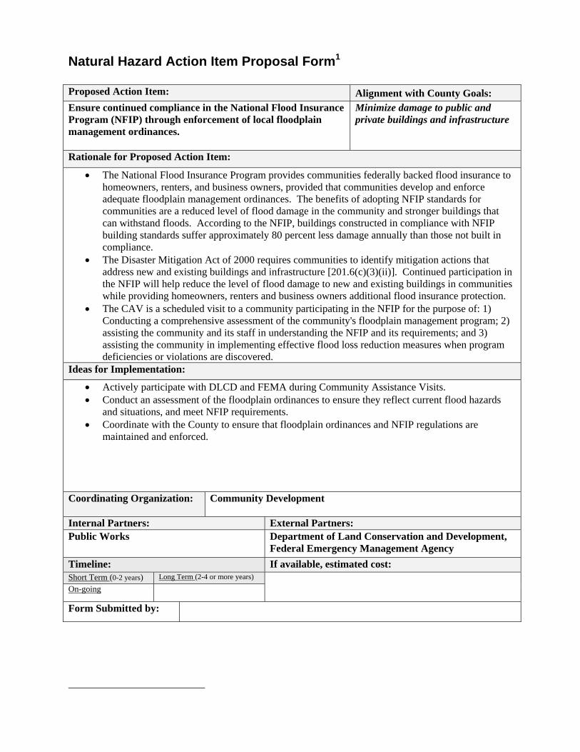
Natural Hazard Action Item Proposal Form1 Proposed Action Item: Alignment with County Goals: Ensure continued compliance in the National Flood Insurance Program (NFIP) through enforcement of local floodplain management ordinances.
Minimize damage to public and private buildings and infrastructure
Rationale for Proposed Action Item:
• The National Flood Insurance Program provides communities federally backed flood insurance to homeowners, renters, and business owners, provided that communities develop and enforce adequate floodplain management ordinances. The benefits of adopting NFIP standards for communities are a reduced level of flood damage in the community and stronger buildings that can withstand floods. According to the NFIP, buildings constructed in compliance with NFIP building standards suffer approximately 80 percent less damage annually than those not built in compliance.
• The Disaster Mitigation Act of 2000 requires communities to identify mitigation actions that address new and existing buildings and infrastructure [201.6(c)(3)(ii)]. Continued participation in the NFIP will help reduce the level of flood damage to new and existing buildings in communities while providing homeowners, renters and business owners additional flood insurance protection.
• The CAV is a scheduled visit to a community participating in the NFIP for the purpose of: 1) Conducting a comprehensive assessment of the community's floodplain management program; 2) assisting the community and its staff in understanding the NFIP and its requirements; and 3) assisting the community in implementing effective flood loss reduction measures when program deficiencies or violations are discovered.
Ideas for Implementation:
• Actively participate with DLCD and FEMA during Community Assistance Visits. • Conduct an assessment of the floodplain ordinances to ensure they reflect current flood hazards
and situations, and meet NFIP requirements. • Coordinate with the County to ensure that floodplain ordinances and NFIP regulations are
maintained and enforced.
Coordinating Organization: Community Development
Internal Partners: External Partners: Public Works Department of Land Conservation and Development,
Federal Emergency Management Agency Timeline: If available, estimated cost: Short Term (0-2 years) Long Term (2-4 or more years) On-going
Form Submitted by:
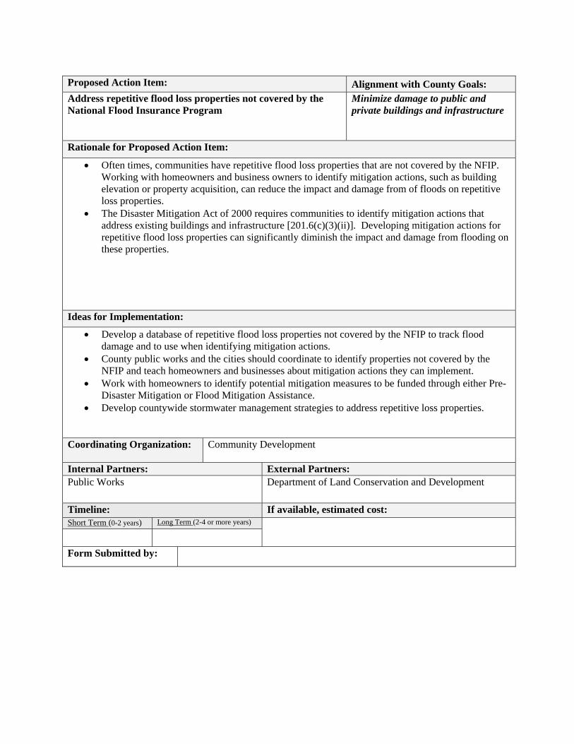
Proposed Action Item: Alignment with County Goals: Address repetitive flood loss properties not covered by the National Flood Insurance Program
Minimize damage to public and private buildings and infrastructure
Rationale for Proposed Action Item:
• Often times, communities have repetitive flood loss properties that are not covered by the NFIP. Working with homeowners and business owners to identify mitigation actions, such as building elevation or property acquisition, can reduce the impact and damage from of floods on repetitive loss properties.
• The Disaster Mitigation Act of 2000 requires communities to identify mitigation actions that address existing buildings and infrastructure [201.6(c)(3)(ii)]. Developing mitigation actions for repetitive flood loss properties can significantly diminish the impact and damage from flooding on these properties.
Ideas for Implementation:
• Develop a database of repetitive flood loss properties not covered by the NFIP to track flood damage and to use when identifying mitigation actions.
• County public works and the cities should coordinate to identify properties not covered by the NFIP and teach homeowners and businesses about mitigation actions they can implement.
• Work with homeowners to identify potential mitigation measures to be funded through either Pre-Disaster Mitigation or Flood Mitigation Assistance.
• Develop countywide stormwater management strategies to address repetitive loss properties.
Coordinating Organization: Community Development
Internal Partners: External Partners: Public Works Department of Land Conservation and Development
Timeline: If available, estimated cost: Short Term (0-2 years) Long Term (2-4 or more years)
Form Submitted by:
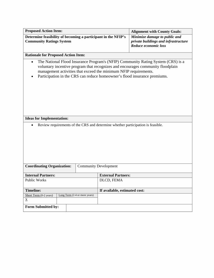
Proposed Action Item: Alignment with County Goals: Determine feasibility of becoming a participant in the NFIP’s Community Ratings System
Minimize damage to public and private buildings and infrastructure Reduce economic loss
Rationale for Proposed Action Item:
• The National Flood Insurance Program's (NFIP) Community Rating System (CRS) is a voluntary incentive program that recognizes and encourages community floodplain management activities that exceed the minimum NFIP requirements.
• Participation in the CRS can reduce homeowner’s flood insurance premiums.
Ideas for Implementation:
• Review requirements of the CRS and determine whether participation is feasible.
Coordinating Organization: Community Development
Internal Partners: External Partners: Public Works DLCD, FEMA
Timeline: If available, estimated cost: Short Term (0-2 years) Long Term (2-4 or more years) X
Form Submitted by:
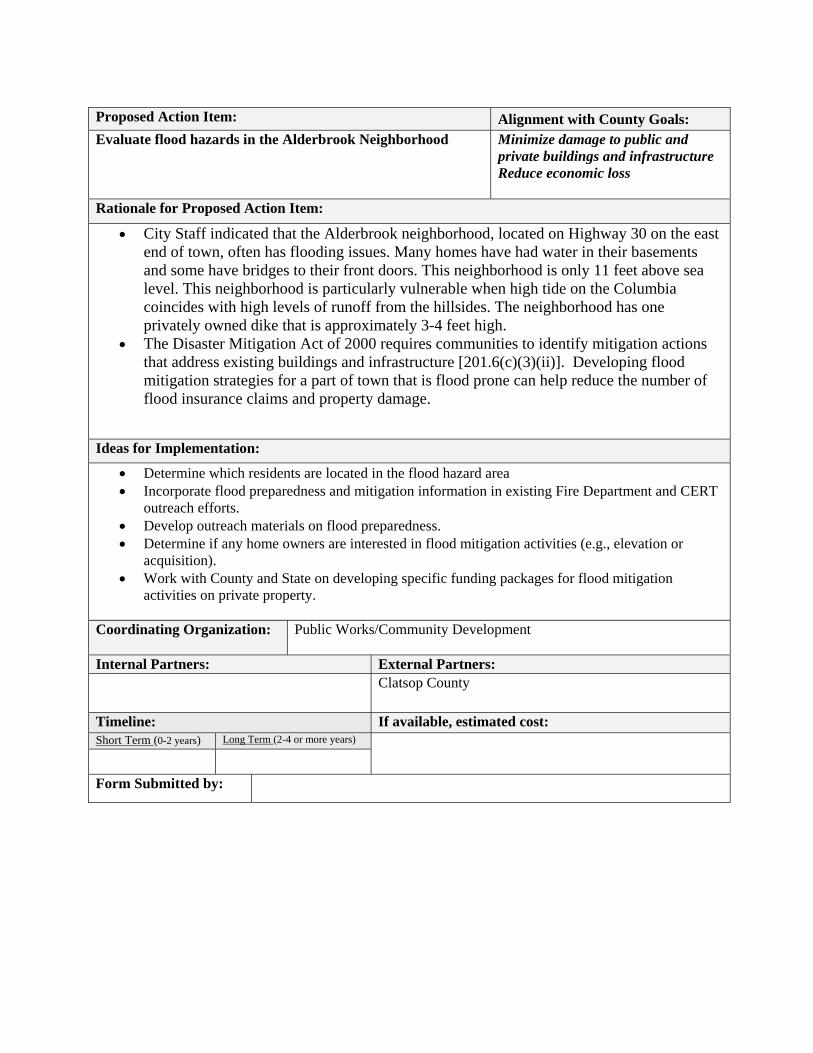
Proposed Action Item: Alignment with County Goals: Evaluate flood hazards in the Alderbrook Neighborhood Minimize damage to public and
private buildings and infrastructure Reduce economic loss
Rationale for Proposed Action Item:
• City Staff indicated that the Alderbrook neighborhood, located on Highway 30 on the east end of town, often has flooding issues. Many homes have had water in their basements and some have bridges to their front doors. This neighborhood is only 11 feet above sea level. This neighborhood is particularly vulnerable when high tide on the Columbia coincides with high levels of runoff from the hillsides. The neighborhood has one privately owned dike that is approximately 3-4 feet high.
• The Disaster Mitigation Act of 2000 requires communities to identify mitigation actions that address existing buildings and infrastructure [201.6(c)(3)(ii)]. Developing flood mitigation strategies for a part of town that is flood prone can help reduce the number of flood insurance claims and property damage.
Ideas for Implementation:
• Determine which residents are located in the flood hazard area • Incorporate flood preparedness and mitigation information in existing Fire Department and CERT
outreach efforts. • Develop outreach materials on flood preparedness. • Determine if any home owners are interested in flood mitigation activities (e.g., elevation or
acquisition). • Work with County and State on developing specific funding packages for flood mitigation
activities on private property.
Coordinating Organization: Public Works/Community Development
Internal Partners: External Partners: Clatsop County
Timeline: If available, estimated cost: Short Term (0-2 years) Long Term (2-4 or more years)
Form Submitted by:
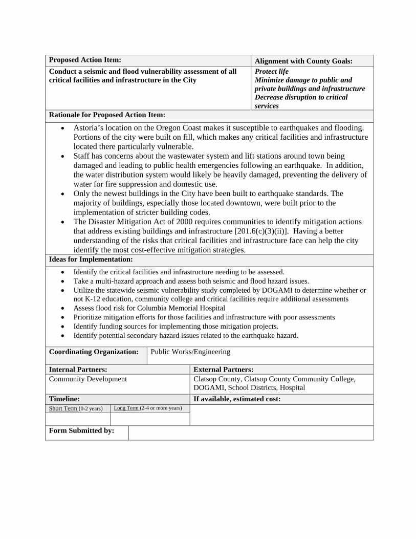
Proposed Action Item: Alignment with County Goals: Conduct a seismic and flood vulnerability assessment of all critical facilities and infrastructure in the City
Protect life Minimize damage to public and private buildings and infrastructure Decrease disruption to critical services
Rationale for Proposed Action Item:
• Astoria’s location on the Oregon Coast makes it susceptible to earthquakes and flooding. Portions of the city were built on fill, which makes any critical facilities and infrastructure located there particularly vulnerable.
• Staff has concerns about the wastewater system and lift stations around town being damaged and leading to public health emergencies following an earthquake. In addition, the water distribution system would likely be heavily damaged, preventing the delivery of water for fire suppression and domestic use.
• Only the newest buildings in the City have been built to earthquake standards. The majority of buildings, especially those located downtown, were built prior to the implementation of stricter building codes.
• The Disaster Mitigation Act of 2000 requires communities to identify mitigation actions that address existing buildings and infrastructure [201.6(c)(3)(ii)]. Having a better understanding of the risks that critical facilities and infrastructure face can help the city identify the most cost-effective mitigation strategies.
Ideas for Implementation:
• Identify the critical facilities and infrastructure needing to be assessed. • Take a multi-hazard approach and assess both seismic and flood hazard issues. • Utilize the statewide seismic vulnerability study completed by DOGAMI to determine whether or
not K-12 education, community college and critical facilities require additional assessments • Assess flood risk for Columbia Memorial Hospital • Prioritize mitigation efforts for those facilities and infrastructure with poor assessments • Identify funding sources for implementing those mitigation projects. • Identify potential secondary hazard issues related to the earthquake hazard.
Coordinating Organization: Public Works/Engineering
Internal Partners: External Partners: Community Development Clatsop County, Clatsop County Community College,
DOGAMI, School Districts, Hospital Timeline: If available, estimated cost: Short Term (0-2 years) Long Term (2-4 or more years)
Form Submitted by:

Proposed Action Item: Alignment with County Goals: Continue efforts to replace aged bridges with newer structures.
Minimize damage to public and private buildings and infrastructure Decrease disruption to critical services
Rationale for Proposed Action Item:
• Astoria’s location on the Oregon Coast makes it susceptible to earthquakes. Damage to bridges would impact transportation within the City. The City has taken efforts to replace aged bridges.
• The Disaster Mitigation Act of 2000 requires communities to identify mitigation actions that address existing buildings and infrastructure [201.6(c)(3)(ii)]. Developing mitigation actions for bridges can help ensure that vital transportation networks will be available for emergency services following a disaster.
• The City owns three bridges in town that are likely at risk – however, the City will be replacing one of them (Franklin Bridge) in the next 3-4 years. The loss of bridges may cut off certain areas of the community.
• Astoria is slated to replace the Franklin bridge in 2009 and the 19th and Irving bridge in 2013.
Ideas for Implementation:
• Continue bridge replacement efforts through Capital Improvements and other funding opportunities.
• Seek grant funding for local match. • Explore opportunities for historic preservation funding for historic bridges •
Coordinating Organization: Public Works
Internal Partners: External Partners: Community Development Clatsop County, Federal Highway Administration, Oregon
Department of Transportation, State Historic Preservation Office.
Timeline: If available, estimated cost: Short Term (0-2 years) Long Term (2-4 or more years) On-going
Form Submitted by:
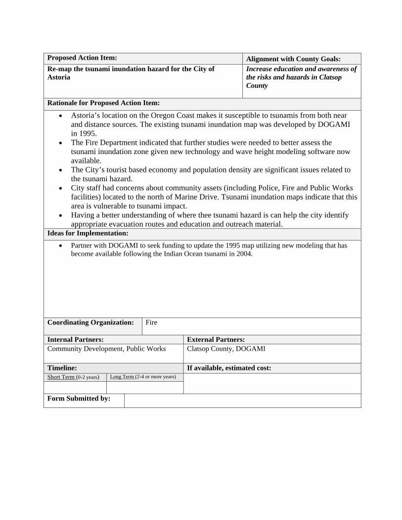
Proposed Action Item: Alignment with County Goals: Re-map the tsunami inundation hazard for the City of Astoria
Increase education and awareness of the risks and hazards in Clatsop County
Rationale for Proposed Action Item:
• Astoria’s location on the Oregon Coast makes it susceptible to tsunamis from both near and distance sources. The existing tsunami inundation map was developed by DOGAMI in 1995.
• The Fire Department indicated that further studies were needed to better assess the tsunami inundation zone given new technology and wave height modeling software now available.
• The City’s tourist based economy and population density are significant issues related to the tsunami hazard.
• City staff had concerns about community assets (including Police, Fire and Public Works facilities) located to the north of Marine Drive. Tsunami inundation maps indicate that this area is vulnerable to tsunami impact.
• Having a better understanding of where thee tsunami hazard is can help the city identify appropriate evacuation routes and education and outreach material.
Ideas for Implementation:
• Partner with DOGAMI to seek funding to update the 1995 map utilizing new modeling that has become available following the Indian Ocean tsunami in 2004.
Coordinating Organization: Fire
Internal Partners: External Partners: Community Development, Public Works Clatsop County, DOGAMI
Timeline: If available, estimated cost: Short Term (0-2 years) Long Term (2-4 or more years)
Form Submitted by:
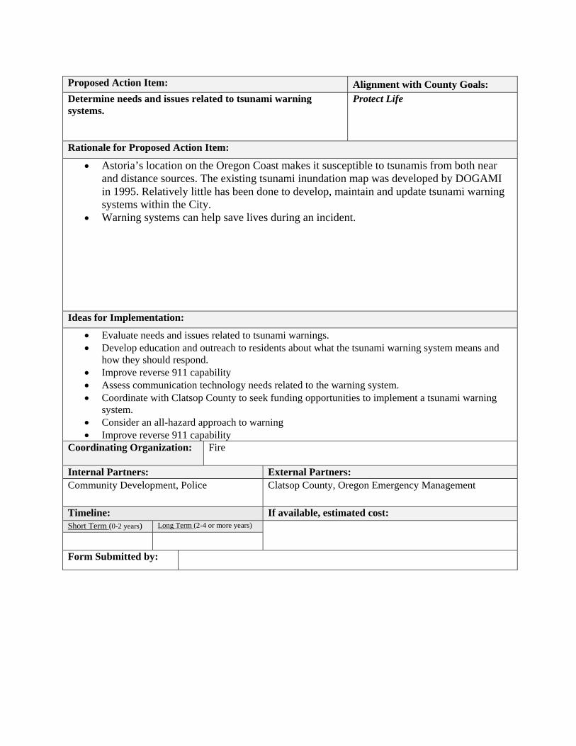
Proposed Action Item: Alignment with County Goals: Determine needs and issues related to tsunami warning systems.
Protect Life
Rationale for Proposed Action Item:
• Astoria’s location on the Oregon Coast makes it susceptible to tsunamis from both near and distance sources. The existing tsunami inundation map was developed by DOGAMI in 1995. Relatively little has been done to develop, maintain and update tsunami warning systems within the City.
• Warning systems can help save lives during an incident.
Ideas for Implementation:
• Evaluate needs and issues related to tsunami warnings. • Develop education and outreach to residents about what the tsunami warning system means and
how they should respond. • Improve reverse 911 capability • Assess communication technology needs related to the warning system. • Coordinate with Clatsop County to seek funding opportunities to implement a tsunami warning
system. • Consider an all-hazard approach to warning • Improve reverse 911 capability
Coordinating Organization: Fire
Internal Partners: External Partners: Community Development, Police Clatsop County, Oregon Emergency Management
Timeline: If available, estimated cost: Short Term (0-2 years) Long Term (2-4 or more years)
Form Submitted by:

Proposed Action Item: Alignment with County Goals: Implement an all-hazards education and outreach campaign Increase education and awareness of
the risks and hazards in Clatsop County
Rationale for Proposed Action Item:
• Astoria is at risk to a number of hazards that have the potential to impact people and property. Conducting education and outreach can help reduce the impact of these events on residents.
• On average, the City of Astoria loses power at least once a winter. Power outages can impact residents especially the elderly, who rely on electricity for heat and to power medical equipment.
• The Disaster Mitigation Act of 2000 requires communities to identify a comprehensive range of mitigation actions. Education and outreach can be an effective mitigation strategy.
Ideas for Implementation:
• Continue to use CERT to inform the public about natural hazards • Provide literature through Community Development when residents pull building permits • Utilize existing community events to disseminate information – Community Safety Fairs, Home &
Garden Shows, etc.
Coordinating Organization: Fire
Internal Partners: External Partners: Community Development Clatsop County, Oregon Emergency Management
Timeline: If available, estimated cost: Short Term (0-2 years) Long Term (2-4 or more years)
Form Submitted by:
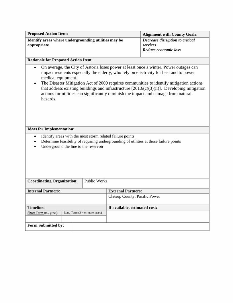
Proposed Action Item: Alignment with County Goals: Identify areas where undergrounding utilities may be appropriate
Decrease disruption to critical services Reduce economic loss
Rationale for Proposed Action Item:
• On average, the City of Astoria loses power at least once a winter. Power outages can impact residents especially the elderly, who rely on electricity for heat and to power medical equipment.
• The Disaster Mitigation Act of 2000 requires communities to identify mitigation actions that address existing buildings and infrastructure [201.6(c)(3)(ii)]. Developing mitigation actions for utilities can significantly diminish the impact and damage from natural hazards.
Ideas for Implementation:
• Identify areas with the most storm related failure points • Determine feasibility of requiring undergrounding of utilities at those failure points • Underground the line to the reservoir
Coordinating Organization: Public Works
Internal Partners: External Partners: Clatsop County, Pacific Power
Timeline: If available, estimated cost: Short Term (0-2 years) Long Term (2-4 or more years)
Form Submitted by:
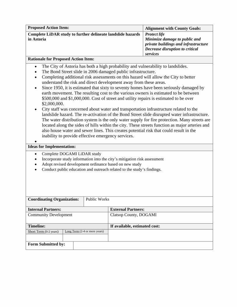
Proposed Action Item: Alignment with County Goals: Complete LiDAR study to further delineate landslide hazards in Astoria
Protect life Minimize damage to public and private buildings and infrastructure Decrease disruption to critical services
Rationale for Proposed Action Item:
• The City of Astoria has both a high probability and vulnerability to landslides. • The Bond Street slide in 2006 damaged public infrastructure. • Completing additional risk assessments on this hazard will allow the City to better
understand the risk and direct development away from these areas. • Since 1950, it is estimated that sixty to seventy homes have been seriously damaged by
earth movement. The resulting cost to the various owners is estimated to be between $500,000 and $1,000,000. Cost of street and utility repairs is estimated to be over $2,000,000.
• City staff was concerned about water and transportation infrastructure related to the landslide hazard. The re-activation of the Bond Street slide disrupted water infrastructure. The water distribution system is the only water supply for fire protection. Many streets are located along the sides of hills within the city. These streets function as major arteries and also house water and sewer lines. This creates potential risk that could result in the inability to provide effective emergency services.
• Ideas for Implementation:
• Complete DOGAMI LiDAR study • Incorporate study information into the city’s mitigation risk assessment • Adopt revised development ordinance based on new study • Conduct public education and outreach related to the study’s findings.
Coordinating Organization: Public Works
Internal Partners: External Partners: Community Development Clatsop County, DOGAMI
Timeline: If available, estimated cost: Short Term (0-2 years) Long Term (2-4 or more years)
Form Submitted by:
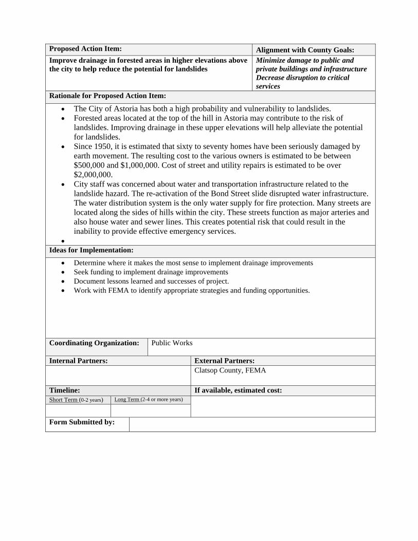
Proposed Action Item: Alignment with County Goals: Improve drainage in forested areas in higher elevations above the city to help reduce the potential for landslides
Minimize damage to public and private buildings and infrastructure Decrease disruption to critical services
Rationale for Proposed Action Item:
• The City of Astoria has both a high probability and vulnerability to landslides. • Forested areas located at the top of the hill in Astoria may contribute to the risk of
landslides. Improving drainage in these upper elevations will help alleviate the potential for landslides.
• Since 1950, it is estimated that sixty to seventy homes have been seriously damaged by earth movement. The resulting cost to the various owners is estimated to be between $500,000 and $1,000,000. Cost of street and utility repairs is estimated to be over $2,000,000.
• City staff was concerned about water and transportation infrastructure related to the landslide hazard. The re-activation of the Bond Street slide disrupted water infrastructure. The water distribution system is the only water supply for fire protection. Many streets are located along the sides of hills within the city. These streets function as major arteries and also house water and sewer lines. This creates potential risk that could result in the inability to provide effective emergency services.
• Ideas for Implementation:
• Determine where it makes the most sense to implement drainage improvements • Seek funding to implement drainage improvements • Document lessons learned and successes of project. • Work with FEMA to identify appropriate strategies and funding opportunities.
Coordinating Organization: Public Works
Internal Partners: External Partners: Clatsop County, FEMA
Timeline: If available, estimated cost: Short Term (0-2 years) Long Term (2-4 or more years)
Form Submitted by:
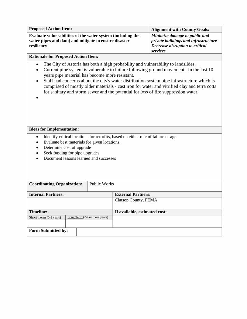
Proposed Action Item: Alignment with County Goals: Evaluate vulnerabilities of the water system (including the water pipes and dam) and mitigate to ensure disaster resiliency
Minimize damage to public and private buildings and infrastructure Decrease disruption to critical services
Rationale for Proposed Action Item:
• The City of Astoria has both a high probability and vulnerability to landslides. • Current pipe system is vulnerable to failure following ground movement. In the last 10
years pipe material has become more resistant. • Staff had concerns about the city's water distribution system pipe infrastructure which is
comprised of mostly older materials - cast iron for water and vitrified clay and terra cotta for sanitary and storm sewer and the potential for loss of fire suppression water.
•
Ideas for Implementation:
• Identify critical locations for retrofits, based on either rate of failure or age. • Evaluate best materials for given locations. • Determine cost of upgrade • Seek funding for pipe upgrades • Document lessons learned and successes
Coordinating Organization: Public Works
Internal Partners: External Partners: Clatsop County, FEMA
Timeline: If available, estimated cost: Short Term (0-2 years) Long Term (2-4 or more years)
Form Submitted by:

Proposed Action Item: Alignment with County Goals: Maintain and enhance efforts around Community Emergency Response Teams (CERT).
Protect life Increase education and awareness of the risks and hazards in Clatsop County
Rationale for Proposed Action Item:
• The City of Astoria has an active CERT program. • CERT can be an important resource before, during and after an incident. • During the December 2007 storm, CERT was instrumental in getting out into the
community to do damage reports. They also put a face to the City.
Ideas for Implementation:
• Increase CERT class offerings • Increase recruitment of team members • Seek funding to expand the program • Target school and college staff to participate
Coordinating Organization: Fire
Internal Partners: External Partners: Clatsop County, Community College
Timeline: If available, estimated cost: Short Term (0-2 years) Long Term (2-4 or more years)
Form Submitted by:

Proposed Action Item: Alignment with County Goals: Identify shelter locations and adequate equipment and supplies in town.
Protect life
Rationale for Proposed Action Item:
• The City of Astoria does not have an emergency shelter located in town. • The Middle School has been used, but it is also a back-up for the Hospital. • Camp Rilea is the closest shelter, but requires Astoria residents to cross several bridges,
which may not be useable. • Staff raised concerns about emergency power for critical facilities such as shelters,
schools, and the community college. • Staff indicated that there is a need for heated emergency shelters that are available during
extended cold weather events. •
Ideas for Implementation:
• Partner with the American Red Cross to identify potential shelter locations. • Talk with churches to gauge their interest in serving as a community shelter. • Seek funding for backup power sources (also include costs for maintenance) • Identify necessary shelter resources – back-up power, food, supplies, kitchen facilities, etc. • Conduct education and outreach with the public to make them aware of shelter options in town. • Develop a plan to distribute food
Coordinating Organization: Fire
Internal Partners: External Partners: Community Development Clatsop County, Red Cross, Clatsop Community Action
Team, Oregon Emergency Management, Public Schools, Churches
Timeline: If available, estimated cost: Short Term (0-2 years) Long Term (2-4 or more years)
Form Submitted by:
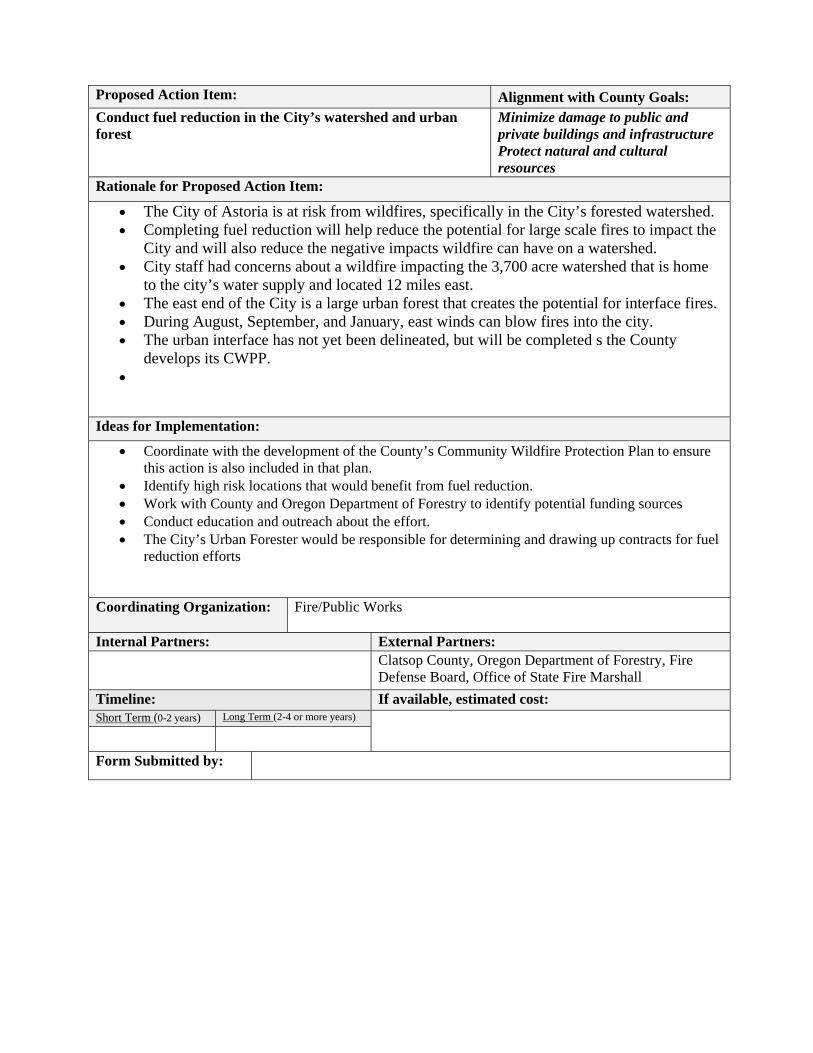
Proposed Action Item: Alignment with County Goals: Conduct fuel reduction in the City’s watershed and urban forest
Minimize damage to public and private buildings and infrastructure Protect natural and cultural resources
Rationale for Proposed Action Item:
• The City of Astoria is at risk from wildfires, specifically in the City’s forested watershed. • Completing fuel reduction will help reduce the potential for large scale fires to impact the
City and will also reduce the negative impacts wildfire can have on a watershed. • City staff had concerns about a wildfire impacting the 3,700 acre watershed that is home
to the city’s water supply and located 12 miles east. • The east end of the City is a large urban forest that creates the potential for interface fires. • During August, September, and January, east winds can blow fires into the city. • The urban interface has not yet been delineated, but will be completed s the County
develops its CWPP. •
Ideas for Implementation:
• Coordinate with the development of the County’s Community Wildfire Protection Plan to ensure this action is also included in that plan.
• Identify high risk locations that would benefit from fuel reduction. • Work with County and Oregon Department of Forestry to identify potential funding sources • Conduct education and outreach about the effort. • The City’s Urban Forester would be responsible for determining and drawing up contracts for fuel
reduction efforts
Coordinating Organization: Fire/Public Works
Internal Partners: External Partners: Clatsop County, Oregon Department of Forestry, Fire
Defense Board, Office of State Fire Marshall Timeline: If available, estimated cost: Short Term (0-2 years) Long Term (2-4 or more years)
Form Submitted by:

Proposed Action Item: Alignment with County Goals: Minimize risk in the City’s wildland-urban interface. Minimize damage to public and
private buildings and infrastructure Protect natural and cultural resources
Rationale for Proposed Action Item:
• The City of Astoria is at risk from wildfires, specifically in the City’s forested watershed. • City staff had concerns about a wildfire impacting the 3,700 acre watershed that is home
to the city’s water supply and located 12 miles east. • The east end of the City is a large urban forest that creates the potential for interface fires. • During August, September, and January, east winds can blow fires into the city. • The urban interface has not yet been delineated, but will be completed s the County
develops its CWPP.
Ideas for Implementation:
• Coordinate with the development of the County’s Community Wildfire Protection Plan to ensure this action is also included in that plan.
• Identify wildland urban interface locations within and adjacent to the city limits. • Conduct education and outreach about the effort. • Work with homeowners to encourage fire resistant building practices.
Coordinating Organization: Fire
Internal Partners: External Partners: Public Works, Community Development Clatsop County, Oregon Department of Forestry, Fire
Defense Board, Office of State Fire Marshall Timeline: If available, estimated cost: Short Term (0-2 years) Long Term (2-4 or more years)
Form Submitted by:

Proposed Action Item: Alignment with County Goals: Reduce erosion on along Columbia River near the Aquatic Center and Seafood Center
Minimize damage to public and private buildings and infrastructure Reduce economic loss
Rationale for Proposed Action Item:
• Astoria’s location on the Oregon Coast makes it susceptible to flooding. Portions of the city were built on fill, which makes any critical facilities and infrastructure located there particularly vulnerable.
• The Aquatic Center and Oregon State University Seafood Labs, located on the south side of Highway 30 are also vulnerable to flood waters.
• The Disaster Mitigation Act of 2000 requires communities to identify mitigation actions that address existing buildings and infrastructure [201.6(c)(3)(ii)]. Developing mitigation actions for flood hazards can significantly diminish the impact and damage from flooding on these properties.
Ideas for Implementation:
• Continue Public Work’s annual maintenance of rip rap along seawall.
Coordinating Organization: Public Works/Engineering
Internal Partners: External Partners:
Timeline: If available, estimated cost: Short Term (0-2 years) Long Term (2-4 or more years)
Form Submitted by:

Proposed Action Item: Alignment with County Goals: Strengthen the high risk seismic deficiencies at Clatsop Community College’s Towler Hall.
Protect life Minimize damage to public and private buildings and infrastructure Decrease disruption to critical services
Rationale for Proposed Action Item:
• Towler Hall is critical to the campus history, operations and the community. • Towler Hall has severe seismic deficiencies, has very high seismic risk, and is a high priority to
the community and requires mitigation. • Towler Hall is a 41,433 gross square foot building centrally located within the City of Astoria at
an elevation of 271 feet. • The building could serve as a coordinating point for services in the event of a disaster given its
central location and elevation above sea level.
Ideas for Implementation:
• Plans include a complete renovation of this facility. Specific seismic strengthening would include new shear walls with foundations, floors and roof tied to exterior walls, drag struts at floors and roof to transfer seismic forces from the diaphragms to shear walls and addition of plywood sheathing to strengthen roof diaphragm and attic below.
• Exterior access to the building will be improved.
Coordinating Organization: Clatsop Community College
Internal Partners: External Partners: City of Astoria (Community Development, Emergency Services, Public
Works), Clatsop County, Oregon Emergency Management, Federal Emergency Management Agency, DOGAMI
Timeline: If available, estimated cost: Short Term (0-2 years) Long Term (2-4 or more years) 0-1.5 years, expected start date 2010
Form Submitted by:

Proposed Action Item: Alignment with County Goals: Assess seismic vulnerability to hazardous materials sites Minimize damage to public and
private buildings and infrastructure Decrease disruption to critical services
Rationale for Proposed Action Item:
• Astoria’s location on the Oregon Coast makes it susceptible to earthquakes. Portions of the city were built on fill, which makes hazardous materials storage facilities vulnerable for secondary hazards following an earthquake.
• Within the city, 8 private properties have hazardous materials on-site. • Public Works has three sites • The Disaster Mitigation Act of 2000 requires communities to identify mitigation actions
that address existing buildings and infrastructure [201.6(c)(3)(ii)]. Addressing hazardous materials locations can help minimize secondary hazards following a disaster.
Ideas for Implementation:
• Complete seismic vulnerability assessments on hazardous materials storage sites to identify potential mitigation strategies.
•
Coordinating Organization: Fire
Internal Partners: External Partners: Public Works Office of State Fire Marshall
Timeline: If available, estimated cost: Short Term (0-2 years) Long Term (2-4 or more years)
Form Submitted by:
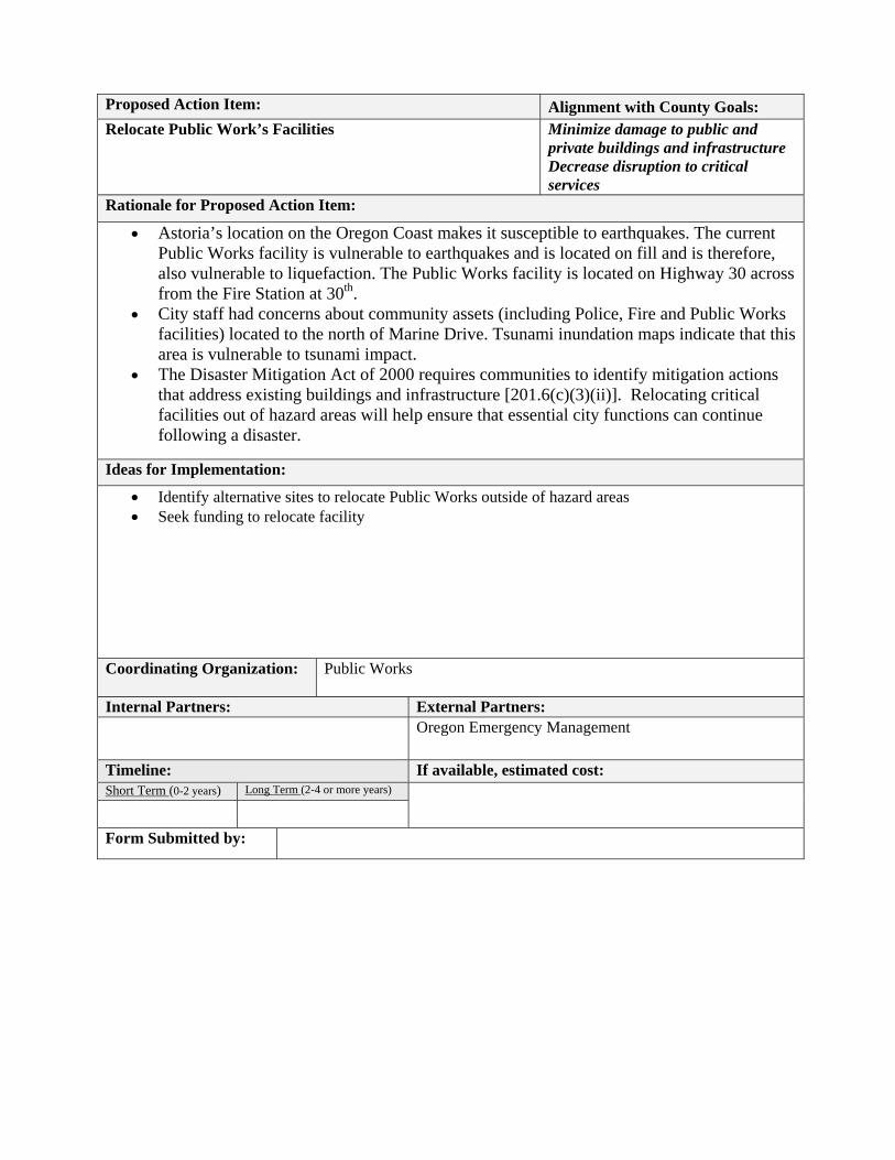
Proposed Action Item: Alignment with County Goals: Relocate Public Work’s Facilities Minimize damage to public and
private buildings and infrastructure Decrease disruption to critical services
Rationale for Proposed Action Item:
• Astoria’s location on the Oregon Coast makes it susceptible to earthquakes. The current Public Works facility is vulnerable to earthquakes and is located on fill and is therefore, also vulnerable to liquefaction. The Public Works facility is located on Highway 30 across from the Fire Station at 30th.
• City staff had concerns about community assets (including Police, Fire and Public Works facilities) located to the north of Marine Drive. Tsunami inundation maps indicate that this area is vulnerable to tsunami impact.
• The Disaster Mitigation Act of 2000 requires communities to identify mitigation actions that address existing buildings and infrastructure [201.6(c)(3)(ii)]. Relocating critical facilities out of hazard areas will help ensure that essential city functions can continue following a disaster.
Ideas for Implementation:
• Identify alternative sites to relocate Public Works outside of hazard areas • Seek funding to relocate facility
Coordinating Organization: Public Works
Internal Partners: External Partners: Oregon Emergency Management
Timeline: If available, estimated cost: Short Term (0-2 years) Long Term (2-4 or more years)
Form Submitted by:
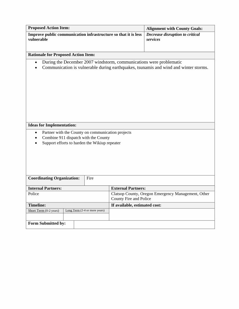
Proposed Action Item: Alignment with County Goals: Improve public communication infrastructure so that it is less vulnerable
Decrease disruption to critical services
Rationale for Proposed Action Item:
• During the December 2007 windstorm, communications were problematic • Communication is vulnerable during earthquakes, tsunamis and wind and winter storms.
Ideas for Implementation:
• Partner with the County on communication projects • Combine 911 dispatch with the County • Support efforts to harden the Wikiup repeater
Coordinating Organization: Fire
Internal Partners: External Partners: Police Clatsop County, Oregon Emergency Management, Other
County Fire and Police Timeline: If available, estimated cost: Short Term (0-2 years) Long Term (2-4 or more years)
Form Submitted by:
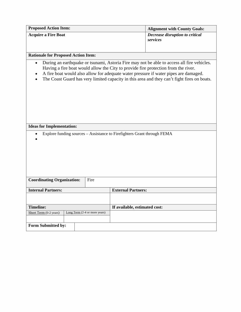
Proposed Action Item: Alignment with County Goals: Acquire a Fire Boat Decrease disruption to critical
services
Rationale for Proposed Action Item:
• During an earthquake or tsunami, Astoria Fire may not be able to access all fire vehicles. Having a fire boat would allow the City to provide fire protection from the river.
• A fire boat would also allow for adequate water pressure if water pipes are damaged. • The Coast Guard has very limited capacity in this area and they can’t fight fires on boats.
Ideas for Implementation:
• Explore funding sources – Assistance to Firefighters Grant through FEMA •
Coordinating Organization: Fire
Internal Partners: External Partners:
Timeline: If available, estimated cost: Short Term (0-2 years) Long Term (2-4 or more years)
Form Submitted by:
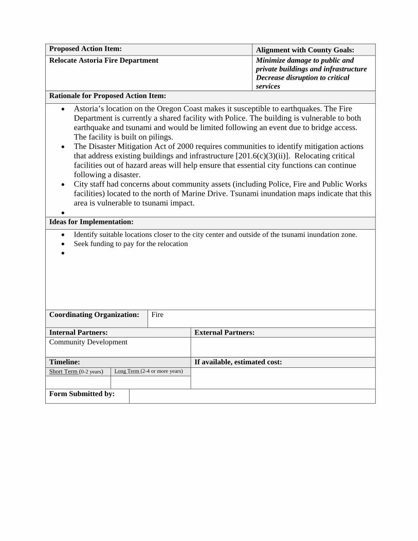
Proposed Action Item: Alignment with County Goals: Relocate Astoria Fire Department Minimize damage to public and
private buildings and infrastructure Decrease disruption to critical services
Rationale for Proposed Action Item:
• Astoria’s location on the Oregon Coast makes it susceptible to earthquakes. The Fire Department is currently a shared facility with Police. The building is vulnerable to both earthquake and tsunami and would be limited following an event due to bridge access. The facility is built on pilings.
• The Disaster Mitigation Act of 2000 requires communities to identify mitigation actions that address existing buildings and infrastructure [201.6(c)(3)(ii)]. Relocating critical facilities out of hazard areas will help ensure that essential city functions can continue following a disaster.
• City staff had concerns about community assets (including Police, Fire and Public Works facilities) located to the north of Marine Drive. Tsunami inundation maps indicate that this area is vulnerable to tsunami impact.
• Ideas for Implementation:
• Identify suitable locations closer to the city center and outside of the tsunami inundation zone. • Seek funding to pay for the relocation •
Coordinating Organization: Fire
Internal Partners: External Partners: Community Development
Timeline: If available, estimated cost: Short Term (0-2 years) Long Term (2-4 or more years)
Form Submitted by: