resilience building and the crisis informatics …palen/palen_papers/... · soden, et al....
TRANSCRIPT

Soden, et al. Resilience-Building and the Crisis Informatics Agenda
Proceedings of the 11th International ISCRAM Conference – University Park, Pennsylvania, USA, May 2014 S.R. Hiltz, M.S. Pfaff, L. Plotnick, and A.C. Robinson, eds.
Resilience-Building and the Crisis Informatics Agenda: Lessons Learned
from Open Cities Kathmandu
Robert Soden Computer Science, Project EPIC University of Colorado Boulder
Nama Budhathoki Kathmandu Living Labs
Leysia Palen Computer Science, Project EPIC University of Colorado Boulder
ABSTRACT
Information systems that support crisis responders and disaster risk management efforts are complex socio-technical phenomena comprised of human capacities and relationships, data and software tools. Research in crisis informatics has highlighted the ways in which emergent groups of digital volunteers, or volunteer technical communities, have mobilized during disaster events to support information management efforts. This paper describes an action research project to support the creation of an ex ante volunteer technical community from among the potentially affected population in Kathmandu, Nepal, one of the most seismically at-risk cities in the world. In exploring this case, we argue that projects that attempt to create local open data ecosystems can be valuable but require investment in their design, execution and on-going maintenance.
Keywords
Action research, community mapping, crisis informatics, geospatial data, open data, openstreetmap, participatory design, resilience
INTRODUCTION
Information systems designed for emergencies are usually targeted at assisting professionals and the public during the emergency period—the warning, impact and immediate response of disasters. Indeed, it is important that society builds its information capacities to support such critical periods of response. However, just as robust community emergency management plans need to include activities in the periods between disasters to effectively mitigate future risk, so too must the obligations of information systems research and development also extend to the long periods prior to disasters.
Such thinking is in line with the notion of community resilience, the multivariate capacities that enable all aspects of communities to better anticipate, mitigate, respond to and recover from the hazards that will eventually strike (Norris et al 2008). How to build such capacities is a salient matter to practitioners and researchers of emergency management and the disciplines that are close kin, including for example urban planning and medical work. This paper is a response to the implied, but comparatively rarely researched, obligation that the technology development and information systems research sectors also consider what role they play in building resilient capacities to mitigate the potential impacts of hazards. Information access and how such access supports planning and coordination across all aspects of society are central to resilience objectives— and therefore we argue central to crisis informatics research.
This paper comes at the problem of information systems for community resilience from the point of view of innovative approaches to geospatial data creation and use. Geospatial data have always been important to disaster planning and response: to be in an emergency operation center or a Red Cross headquarters during a response is to be utterly surrounded by maps that indicate damage, road closure, sheltering options, staff deployment, and other information that contains a spatial component. Geospatial data are critical in the

Soden, et al. Resilience-Building and the Crisis Informatics Agenda
Proceedings of the 11th International ISCRAM Conference – University Park, Pennsylvania, USA, May 2014 S.R. Hiltz, M.S. Pfaff, L. Plotnick, and A.C. Robinson, eds.
preparation and resilience-building phase to be able to assess where resources are located—to plan to protect populations and the built environment one must know their locations. To understand how to weigh various options for mitigating the effects of coastal flooding or storm surge, communities must have access to high-resolution geospatial data describing the potential hazards as well as the people and infrastructure at risk. Where critical geospatial data of this sort does exist, they are often proprietary or considered sensitive, complicating humanitarian efforts to build resilience in the world’s vulnerable places. This paper therefore brings together a number of threads in a new problem space in the crisis informatics agenda: increasing the capacities for resilience through information and communication technology where geospatial data are central to such socio-technical goals.
Investigative Approach & Aims
We report on a World Bank-supported project in which two of the paper authors were key figures. As a scholarly offering, it considers this project as an important real-world case and natural experiment for how to build long-lasting socio-technical capacities for community resilience. Importantly, it is an instance of action research (Greenwood and Levin 2007) with links to its participatory design kin (Büscher et al. 2004, Greenbaum and Kyng 1991). The approach that such research subscribes to is rooted in values of participation, collaborative investigation and practical intervention, rather than the more commonly accepted—but still ideological—models of positivist scientific inquiry. It is important to also appreciate that notions of resilience are simultaneously rooted in community participation—it is in this way that participatory design of socio-technical systems and resilience building are tied conceptually in this effort.
We describe efforts to contribute to community seismic resilience through development of an active ecosystem of geographic data contributors and consumers within the Kathmandu Valley. In line with current thinking of the action research community, which views situated and practical action as “a means for developing knowledge” (Hayes 2011: 15:7), we seek to ensure that our description does not sacrifice context, history or local meaning in favor of generalizability. Within the action research tradition, the critical metrics of scientific validity is “workability”—or the degree to which “actions that arise from it solve real problems and increase participants’ control over their own situations” (Greenwood and Levin 2007: 63)..Transferable knowledge is produced through detailed accounting of and reflection upon these actions. While many of the details of this work should be of interest to scholars and practitioners operating in other environments, and we seek to highlight these in the discussion below, the emphasis of Open Cities Kathmandu has been to generate useful insight that will inform future action by participants in future stages of the project and other work by the communities involved.
Key elements of the project were implemented using the OpenStreetMap (OSM) platform. OSM, the “wikipedia of maps,” was built on the premise that geospatial data should be created by and openly accessible to those who reside in the geographies that maps represent. OSM has been employed in a number of emergencies, the highest profile being the 2010 Haiti Earthquake (Soden and Palen 2014); researchers have argued that OSM has the potential to play a significant role within robust and actionable information management systems for disaster response (Goolsby 2010, Roche et al 2013). There is significant activity within the OSM community towards this end, but there is also opportunity to explore the benefits of participatory and open geospatial data in mitigating disaster in the first place. The Kathmandu project—supported by the World Bank and the OSM community—was an effort to develop an approach for such a goal to be realized, and to learn from the lessons the in situ effort taught. This paper reports on the lessons learned in this project, and how the effort was conducted in collaboration with local communities.
KATHMANDU: A CITY AT RISK
Nepal’s Kathmandu Valley consists of the most parts of Kathmandu, Lalitpur, and Bhaktapur districts. The capitol city of Kathmandu and other two major cities—Patan and Bhaktapur—fall within Kathmandu Valley, which is home to ~2.5M people over 900 square km. It is considered one of the most seismically at-risk places in the world in terms of the size of the potentially affected population by a highly probable major earthquake. Reports estimate that in a major event, 60% of the building stock would be affected, at least 40,000 fatalities would occur, and almost a million people would be displaced (NSET 2011). As much as 95% of water pipes could be damaged, leaving many citizens without access to drinking water. Response operations will be particularly difficult to execute given that the airport and several major bridges and roads into and out of the city would likely be damaged or destroyed (NSET 2011).
In 2012, the World Bank and Global Facility for Disaster Reduction and Recovery (GFDRR) in partnership with the Government of Nepal launched a project to build seismic resilience in the education and health infrastructure

Soden, et al. Resilience-Building and the Crisis Informatics Agenda
Proceedings of the 11th International ISCRAM Conference – University Park, Pennsylvania, USA, May 2014 S.R. Hiltz, M.S. Pfaff, L. Plotnick, and A.C. Robinson, eds.
of the Kathmandu Valley. The first step of this process was the creation of a disaster risk model to determine relative vulnerability of the buildings in which such facilities were housed. Upon completion, this model will be used to prioritize plans for subsequent building retrofits of schools and health facilities to improve structural integrity in the face of earthquake. At the launch of the project, there was no complete database of these structures for the Kathmandu Valley that included geographic coordinates as well as information about construction type and material—all necessary data for the risk model. The World Bank launched a year-long project called Open Cities Kathmandu in November 2012 with the primary purpose of collecting school and health facility data for use in risk modeling activities.
Project Design: Building Upon Prior OSM-Related Successes
The design of the Open Cities project was influenced by experiences with disaster-related OpenStreetMap work in Haiti and Indonesia. In the aftermath of the 2010 Haiti earthquake, over 600 volunteers from the global OpenStreetMap community worked to create a detailed map of the affected area. They collaborated using mailing lists, wikis and IRC as well as in-person work at “Crisis Camps” organized by the World Bank and other groups. The road network, damaged buildings, and internally displaced persons (IDP) camps were identified from aerial imagery made available by a number of providers. With the support of an NGO called the Humanitarian OpenStreetMap Team (HOT), this effort was sustained as a localized community-mapping project in Haiti that continues to attract volunteers and map the country with greater coverage and detail (Soden and Palen, 2014).
In Indonesia, a subsequent HOT project launched in March 2011 mobilized students, local government officials and civil society groups to create a detailed map of critical facilities in Jakarta to support contingency planning efforts for flood response. With continued support from the Australia Agency for International Development (AusAID) and the Indonesian government, the OSM Indonesia project has since expanded to include a number of areas outside the capitol to collect data related to disaster risk reduction and preparedness. To date, over 1 million buildings have been mapped in Indonesia through HOT's work (Chapman 2013).
In contrast to how traditional risk assessment efforts are often conducted, where outside contractors survey a situation for short periods and produce highly technical documents consumable by only a few, a central element of the Open Cities project was to include a broad section of the public in its activities. Such an approach not only has the potential to incorporate local knowledge into the understanding of risk but also helps ensure that results are accessible, trusted and meaningful to the at-risk communities themselves.
The Open Cities Kathmandu team began by drawing from former experiences as well as experience with other technology projects supported by the World Bank to develop the design strategies that would inform the project:
• First, the team felt that there had to be a concrete and immediate first need for the geospatial data to compel that it be created in the first place. They felt this was important to motivate the inception of the project as well as demonstrate the value of the participatory and open data approach to potential partners who would in the future be needed to sustain the effort.
• Second, the team wanted to create the social infrastructure necessary for sustaining OSM—and for creating the human capacities for resilience. This for them meant the development of a local OSM community that could continue to maintain and improve the dataset for other purposes after the close of the initial project.
• Third, it was assumed that people would most likely contribute to OpenStreetMap if they had a particular use for the data it contains; to these ends they felt it critical to understand and help define potential partners and incentives for getting participants involved.
• Fourth, the team recognized that at the outset of the project, there was still a large degree of uncertainty about how best to accomplish all of its goals. They were therefore committed to an approach that emphasized experimentation and iteration.
Based on these principles, Open Cities Kathmandu crafted a strategy to guide the implementation of the project.
OSM KATHMANDU PROJECT IMPLEMENTATION
Recruitment of Employees & Volunteers
In November 2012, World Bank staff and consultants began the year-long project by assembling a team of

Soden, et al. Resilience-Building and the Crisis Informatics Agenda
Proceedings of the 11th International ISCRAM Conference – University Park, Pennsylvania, USA, May 2014 S.R. Hiltz, M.S. Pfaff, L. Plotnick, and A.C. Robinson, eds.
mappers and community mobilizers. The team was responsible for a wide variety of tasks including field surveying and software development to providing training and giving presentations in OSM to the public and participating in a range of community-building activities. The 4-person core team, later expanded to 6, was comprised of university graduates from Kathmandu University who were recruited based on their prior contribution to Nepal’s then-nascent OSM community. These core members were paid full-time salaries at rates commensurate with the local salary structure for recent graduates in technical disciplines.
In addition, the project recruited 6 part-time interns from Kathmandu University and 11 volunteers from Tribhuvan University. The interns and volunteers helped the core team survey the schools and health facilities. The interns maintained regular office hours for 3 days a week. When possible, volunteers were assigned areas around their homes to work on for the project. This eased the burdens of travel and leveraged their knowledge of their own communities. In terms of expertise, the members of the core team had the most OSM knowledge, the interns who reported to them had fairly good command, and the many volunteers who typically only mapped for a matter of hours or days had the least technical knowledge and required assistance from the core team to upload and edit OSM data.
Organization of Work and Division of Labor
The Open Cities Kathmandu team worked six days a week, the typical workweek in Nepal. In addition, mapping parties and introductory presentations were held on eight weekends and four public holidays over the project’s year-long lifespan. Many of the team members also spent significant time online interacting with and engaging OSM community members outside office hours. The project’s office space was strategically located within a shared co-working space that gave the team access to meeting rooms, reliable connections to the internet and opportunities to interact with other technologists and entrepreneurs, some of whom would later themselves become active in OpenStreetMap.
The main deliverable of Open Cities Kathmandu was a detailed survey of schools and health facilities in the Kathmandu Valley that included location and information related to building age, construction type, usage and occupancy. At the inception of the project, it was unclear how to approach this task. There was no complete list or map of schools and health clinics in Kathmandu Valley. The communities that the project was partnering with were not engineers and lacked training in structural assessment. The project began by engaging in four months of consultations with technical experts, university researchers and local government to gain support for the project and learn from their experience. During this period the team also began conducting basic mapping activities and outreach efforts related to OpenStreetMap to gain practical experience surveying in Kathmandu and a better understanding of what they would encounter in the field. Several approaches to the mapping were discussed and tested. The process described below is the result of these early consultations and experiments.
The project began with available datasets, all of which were either incomplete, lacking geographic information, or out of date. To organize the surveying activities, the Kathmandu Valley was divided into different zones, each consisting of adjacent wards. Each zone was assigned a leader from the core team and a group of additional surveyors from the part-time and volunteer staff. Each team would further divide the area into smaller sections. Teams were assembled in part based on where the surveyors were from; the idea was that they would know the lay of the land much better, have a social network they could use to learn about school and health facilities, and, critically, feel some ownership of the data once produced. Each team of surveyors received a geo-referenced printout of OpenStreetMap data for the area and the list of known schools and health facilities. Prior to the fieldwork, they would also be responsible for digitizing building footprints for their zones using aerial imagery provided by Microsoft Bing and the US State Department’s “Imagery to the Crowd” Initiative.
Locating Schools. Open Cities Kathmandu obtained a spreadsheet containing an incomplete list of 1701 schools in the Kathmandu Valley from the Department of Education (DOE), which was then used as a starting point for the survey. The list did not provide the exact location of schools, just the wards in which they were located. The mapping teams used what might be described as a snowball approach to find locations of the schools. They began with what location data were available through other sources, or by using their personal knowledge and social networks. They then talked with locals, school officials and health facilities personnel to locate remaining schools as well as ascertain the existence of schools not on their list. As a result of requests from school officials, the team also began carrying and distributing pamphlets and posters that provided basic information on earthquake preparedness and safety.
Locating Health Facilities. For health facilities, Open Cities Kathmandu used three sources to generate a reference list of hospitals, health posts, and polyclinics: a list of 100 private and community hospitals received unofficially from the Ministry of Health and Population (MOHP), a list of 205 medical centers approved by MOHP that is accessible through the official website of the MOHP, and the names of 70 hospitals and 27

Soden, et al. Resilience-Building and the Crisis Informatics Agenda
Proceedings of the 11th International ISCRAM Conference – University Park, Pennsylvania, USA, May 2014 S.R. Hiltz, M.S. Pfaff, L. Plotnick, and A.C. Robinson, eds.
polyclinics from a private-sector health organization in Kathmandu. Together, these provided a list of over 400 unique health service providers that the team worked to locate and survey using a similar approach.
While on-site in either schools or health facilities, surveyors worked with the printouts of OSM data to verify that building footprints for the facilities had been entered correctly. Necessary adjustments were drawn by hand and then updated in OSM upon return to the office. The survey solicited structural information including construction type, number of floors, and number of occupants from staff and management of the facilities. Mappers carried a letter of support from the Nepal Department of Education and badges from the World Bank that identified them as project participants to gain access to the managers and facility administrators they interviewed to collect the data that could not be visually assessed.
Ensuring Data Quality and Acceptance
The team took a number of steps to ensure that data collected during the project were accurate and that they would be trusted by the wider group of stakeholders involved in disaster risk reduction in Nepal. First, the project was carried out with explicit support of Nepal's Department of Education and the World Bank, two institutions with credible reputations in the country. Second, the team consulted frequently on engineering matters with The National Society for Earthquake Technologies (NSET), a well-recognized entity in disaster community in Nepal. NSET Engineers helped design the survey and provided training. The project also provided OSM training to a wide range of individuals from government, donor, and NGO community to build awareness of and comfort with the platform and approach. Finally, NSET conducted quality assessment of OSM data regularly during the surveying process.
Through the involvement of NSET in Open Cities Kathmandu, the team regularly made quality assessments of the survey to both identify problems as they occurred and also to be able to assess the data collected in full at the project’s completion. Of particular concern was the building structure surveying, which required training from NSET for the mapping team and volunteers to survey correctly. The first field verification was performed immediately after the first training and some initial in-field practice. The accuracy of the data for building structural system was 50% during this period. Given this result, NSET provided a “refreshers” training to the surveyors. Following this second training, the accuracy of the structural data increased collected by the mappers rose to 100% (NSET 2013).
Building the OSM Community
In addition to data collection, Open Cities Kathmandu worked to build the OSM community in Nepal to help ensure that the collected data would continue to be updated and maintained in the future. The project targeted a variety of sectors including government and civil society organizations, but focused efforts on universities and local technology communities. These groups had both the technical capacity to contribute to OSM and were best placed to make immediate use of OSM data and were therefore seen as being most likely to continue participation in OSM after the initial phase of the project.
The team used different approaches to bring new participants into the OSM community. Introductory presentations, which usually last between 30–60 minutes, were used to provide a general introduction to the OSM platform, community and underlying philosophy. Since the launch of the project in November 2012, the team gave 27 of these presentations, reaching over 1600 people. In addition, the team ran “mapping parties.” Mapping parties, which are an established practice in the wider OSM community, run for about 4 hours and cover the basics of data collection and map editing. Participants create OSM user accounts and learn how to participate in the mapping community through email lists, social media, and the website. To date, the Kathmandu project has organized 26 mapping parties with nearly 700 total participants, several of whom were later recruited to be volunteer surveyors for the project. The team also ran a weekly OSM Clinic to offer drop-in assistance. In addition, the project conducted outreach through blogging and social media activity via the OSM Nepal Twitter and Facebook accounts, the latter of which had grown to over 370 members by the conclusion of the project.
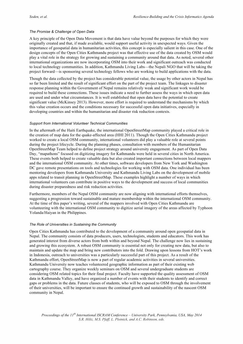
The project also organized and participated in a number of events to conduct specific outreach to technical communities. Figure 1 below shows members of the Open Cities Kathmandu team staffing the OSM booth at a networking event in April 2013 called Tech Mash-Up. The team also helped organize Nepal’s first Open Data Day in partnership with Kathmandu University, Institute of Engineering, Nepal Engineering College, Amrit Science College, Free and Open Source Software Nepal Community, Wikimedia Nepal and the Mozilla Foundation. The event was timed to coincide with International Open Data Day and featured a hackathon, a number of mapping events and presentations on issues related to Open Data in Nepal. As part of Open Data Day, additional mapping events were also organized with OpenStreetMap communities in Washington DC and

Soden, et al. Resilience-Building and the Crisis Informatics Agenda
Proceedings of the 11th International ISCRAM Conference – University Park, Pennsylvania, USA, May 2014 S.R. Hiltz, M.S. Pfaff, L. Plotnick, and A.C. Robinson, eds.
New York City, with all groups working together to digitize building footprints in the Kathmandu Valley. To help build capacity within the tech communities of Kathmandu to work with OSM data, the project organized a Developers’ Meetup that was attended by over 50 people and featured presentations and trainings on topics such as interacting with the OSM API, approaches for incorporating OSM into mobile applications and software for creating web mapping tools using OSM data.
Figure 1: A crowded OSM booth during a Tech Mash-Up event in Kathmandu. The team tried to create awareness of OSM effort with the goal of building a larger Nepal OSM community.
Project Contribution
Open Cities Kathmandu surveyed 2,256 schools and 350 health facilities in the Kathmandu Valley1. In addition to collecting a comprehensive list of health and school facilities structural data, the team worked to create a comprehensive base-map of the valley by digitizing building footprints, mapping the road network, and collecting other major points of interest. Table 1 presents the outputs of the project as reported on November 12, 2013 in three categories: general data creation, the structural surveying and community building.
General Mapping
Buildings digitized 126,105
Number of features mapped e.g. restaurant, shop, temple, bridge, park 131,768
Road network mapped 3,716 km
Structural Survey
Number of schools surveyed 2,256
Number of health facilities surveyed 350
Total number of individual buildings surveyed 7,353
Community Building
Number of mapping parties 26
Number of introductory presentations 27
Total number of attendees 2,352
Table 1. Project Contributions to OpenStreetMap Kathmandu
1 Of the 411health service providers in the initial list compiled by the project, several were already surveyed by another effort that was focused specifically on hospitals. Others facilities were primarily pharmacies and thus not critical components of the Valley’s health infrastructure.
Soden, et al. Resilience-Building and the Crisis Informatics Agenda
Proceedings of the 11th International ISCRAM Conference – University Park, Pennsylvania, USA, May 2014 S.R. Hiltz, M.S. Pfaff, L. Plotnick, and A.C. Robinson, eds.
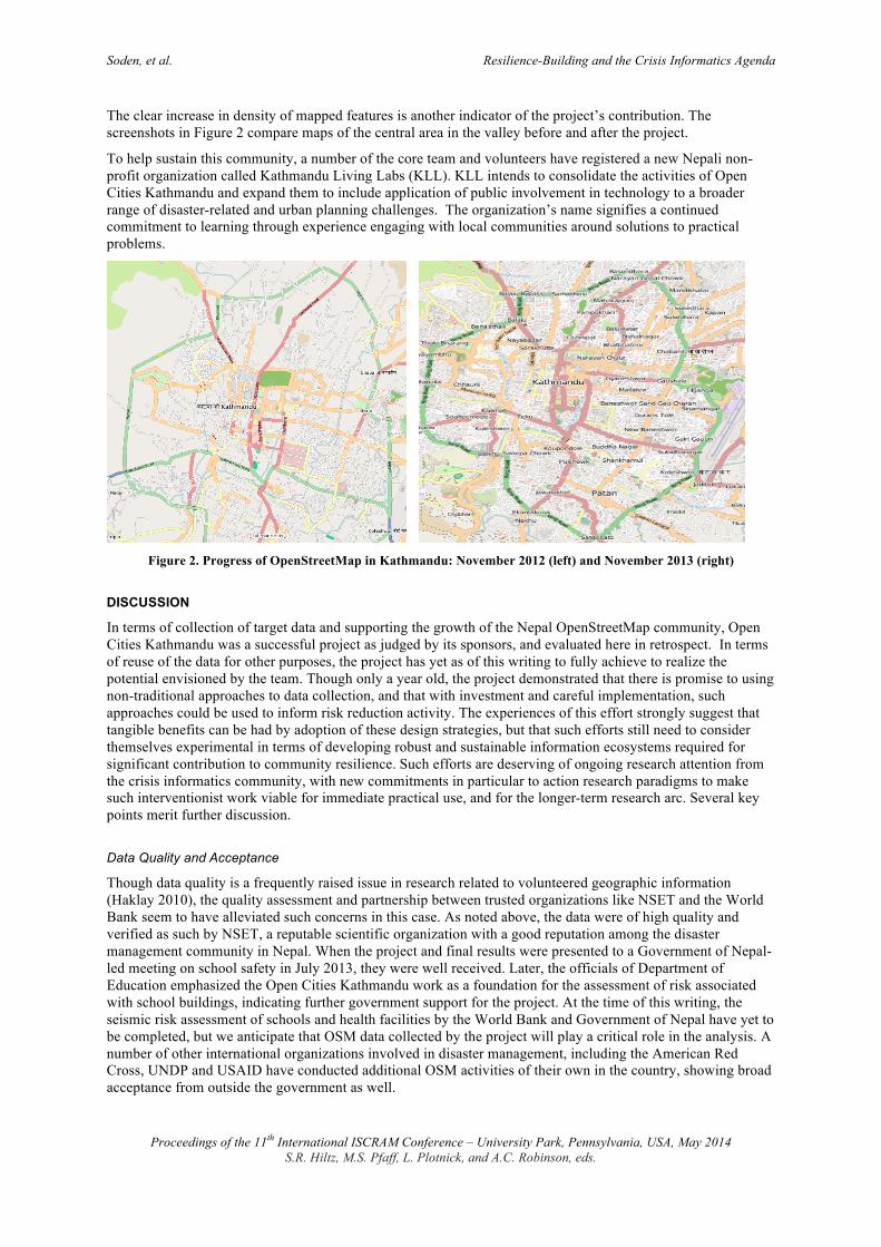
The clear increase in density of mapped features is another indicator of the project’s contribution. The screenshots in Figure 2 compare maps of the central area in the valley before and after the project.
To help sustain this community, a number of the core team and volunteers have registered a new Nepali non-profit organization called Kathmandu Living Labs (KLL). KLL intends to consolidate the activities of Open Cities Kathmandu and expand them to include application of public involvement in technology to a broader range of disaster-related and urban planning challenges. The organization’s name signifies a continued commitment to learning through experience engaging with local communities around solutions to practical problems.
Figure 2. Progress of OpenStreetMap in Kathmandu: November 2012 (left) and November 2013 (right)
DISCUSSION
In terms of collection of target data and supporting the growth of the Nepal OpenStreetMap community, Open Cities Kathmandu was a successful project as judged by its sponsors, and evaluated here in retrospect. In terms of reuse of the data for other purposes, the project has yet as of this writing to fully achieve to realize the potential envisioned by the team. Though only a year old, the project demonstrated that there is promise to using non-traditional approaches to data collection, and that with investment and careful implementation, such approaches could be used to inform risk reduction activity. The experiences of this effort strongly suggest that tangible benefits can be had by adoption of these design strategies, but that such efforts still need to consider themselves experimental in terms of developing robust and sustainable information ecosystems required for significant contribution to community resilience. Such efforts are deserving of ongoing research attention from the crisis informatics community, with new commitments in particular to action research paradigms to make such interventionist work viable for immediate practical use, and for the longer-term research arc. Several key points merit further discussion.
Data Quality and Acceptance
Though data quality is a frequently raised issue in research related to volunteered geographic information (Haklay 2010), the quality assessment and partnership between trusted organizations like NSET and the World Bank seem to have alleviated such concerns in this case. As noted above, the data were of high quality and verified as such by NSET, a reputable scientific organization with a good reputation among the disaster management community in Nepal. When the project and final results were presented to a Government of Nepal-led meeting on school safety in July 2013, they were well received. Later, the officials of Department of Education emphasized the Open Cities Kathmandu work as a foundation for the assessment of risk associated with school buildings, indicating further government support for the project. At the time of this writing, the seismic risk assessment of schools and health facilities by the World Bank and Government of Nepal have yet to be completed, but we anticipate that OSM data collected by the project will play a critical role in the analysis. A number of other international organizations involved in disaster management, including the American Red Cross, UNDP and USAID have conducted additional OSM activities of their own in the country, showing broad acceptance from outside the government as well.
Soden, et al. Resilience-Building and the Crisis Informatics Agenda
Proceedings of the 11th International ISCRAM Conference – University Park, Pennsylvania, USA, May 2014 S.R. Hiltz, M.S. Pfaff, L. Plotnick, and A.C. Robinson, eds.
The Promise & Challenge of Open Data
A key principle of the Open Data Movement is that data have value beyond the purposes for which they were originally created and that, if made available, would support useful activity in unexpected ways. Given the importance of geospatial data in humanitarian activities, this concept is especially salient in this case. One of the design concepts of the Open Cities Kathmandu project was that effective use of the data created by OSM would play a vital role in the strategy for growing and sustaining a community around that data. As noted, several other international organizations are now incorporating OSM into their work and significant outreach was conducted to local technology communities. In addition, Kathmandu Living Labs—the Nepali NGO that will be taking the project forward—is sponsoring several technology fellows who are working to build applications with the data.
Though the data collected by the project has considerable potential value, the usage by other actors in Nepal has so far been limited and the result of significant effort on the part of the project team. The linkages to disaster response planning within the Government of Nepal remains relatively weak and significant work would be required to build these connections. These issues indicate a need to further assess the ways in which open data are used and under what circumstances. It is well established that open data have the potential to create significant value (McKinsey 2013). However, more effort is required to understand the mechanisms by which this value creation occurs and the conditions necessary for successful open data initiatives, especially in developing countries and within the humanitarian and disaster risk reduction contexts.
Support from International Volunteer Technical Communities
In the aftermath of the Haiti Earthquake, the international OpenStreetMap community played a critical role in the creation of map data for the quake-affected area (HHI 2011). Though the Open Cities Kathmandu project worked to create a local OSM community, international volunteers did play a valuable role at several points during the project lifecycle. During the planning phases, consultation with members of the Humanitarian OpenStreetMap Team helped to define project strategy around university engagement. As part of Open Data Day, “mapathons” focused on digitizing imagery for Kathmandu were held in several cities in North America. These events both helped to create valuable data but also created important connections between local mappers and the international OSM community. At other times, software developers from New York and Washington DC gave remote presentations on tools and technologies for working with OSM data. One individual has been mentoring developers from Kathmandu University and Kathmandu Living Labs on the development of mobile apps related to transit planning in OpenStreetMap. These examples highlight a number of ways in which international volunteers can contribute in positive ways to the development and success of local communities during disaster preparedness and risk reduction activities.
Furthermore, members of the Nepal OSM community are now aligning with international efforts themselves, suggesting a progression toward sustainable and mature membership within the international OSM community. At the time of this paper’s writing, several of the mappers involved with Open Cities Kathmandu are volunteering with the international OSM community to digitize aerial imagery of the areas affected by Typhoon Yolanda/Haiyan in the Philippines.
The Role of Universities in Sustaining the Community
Open Cities Kathmandu has contributed to the development of a community around open geospatial data in Nepal. The community consists of data producers, users, technologists, students and educators. This work has generated interest from diverse actors from both within and beyond Nepal. The challenge now lies in sustaining and growing this ecosystem. A robust OSM community is essential not only for creating new data, but also to maintain and update the map and bring new contributors into the fold. Drawing upon lessons from HOT’s work in Indonesia, outreach to universities was a particularly successful part of this project. As a result of the Kathmandu effort, OpenStreetMap is now a part of regular academic activities in several universities. Kathmandu University now teaches volunteered geographic information as part of their existing web cartography course. They organize weekly seminars on OSM and several undergraduate students are considering OSM related topics for their final project. Faculty have supported the quality assessment of OSM data in Kathmandu Valley, and have organized a number of events with their students to identify and correct gaps or problems in the data. Future classes of students, who will be exposed to OSM through the involvement of their universities, will be important to ensure the continued growth and sustainability of the nascent OSM community in Nepal.

Soden, et al. Resilience-Building and the Crisis Informatics Agenda
Proceedings of the 11th International ISCRAM Conference – University Park, Pennsylvania, USA, May 2014 S.R. Hiltz, M.S. Pfaff, L. Plotnick, and A.C. Robinson, eds.
Sustained Engagement
Finally, an important aspect of this study was the importance of sustained engagement. Too often technology and data projects of this sort are discrete and short-term endeavors. A workshop or a weeklong training is simply not enough time to affect the kinds of shifts that those who embrace participatory projects hope to support. Action research is “a continuous and participative learning process, not … a short term-intervention” (Greenwood and Levin 2007:17). Although OpenStreetMap makes mapping more accessible to non-specialists, it does not change the fact that collecting and interacting with geographic information is a complex technical undertaking and requires significant training. Building technical communities of OSM mappers and software developers familiar enough with the platform to comfortably deploy it in their own tools and applications also takes time but is an important part of sustainability for such resilience-building efforts. It also takes time for these technical communities to establish relationships and trust with relevant government and civil society counterparts who are important stakeholders in civic technology projects. When planning these kinds of projects it is important that the parties involved understand and commit to sustained investment in their success.
FUTURES: RESILIENCE, ACTION RESEARCH, AND CRISIS INFORMATICS
This work sits well within the crisis informatics literature, which seeks to engage with socio-technical phenomena throughout the entire disaster cycle, from preparedness to response and long-term reconstruction. The role of volunteers in providing usable information for situational awareness during emergencies has been explored in the crisis informatics research (Palen and Liu 2007). To date, much of this work has been concerned with naturalistic studies of spontaneous and non-local volunteer responses (Liu and Palen 2010, Starbird and Palen 2011, Sarcevic et al. 2012). We believe that an eye towards the growth and sustainment of local communities before disasters strike enables us to address critical opportunities in articulating volunteer efforts by populations who are at risk for future hazards. Members from affected populations are the first responders during any emergency, but those local populations are also involved in the everyday decisions and longer-term policies that are central to community resilience and disaster mitigation in the first place.
Drawing upon past projects, Open Cities Kathmandu has developed and implemented a successful approach to geographic data collection and community building. Future work should continue to consider the design and implementation of participatory open data initiatives for effective use of risk and crisis information. The practical, collaborative and iterative approach to knowledge generation offered by action research has a great deal in common with contemporary literature around community resilience. We believe that further in-field case studies of this sort could help develop a valuable body of literature upon which scholars and practitioners can draw to inform the design of their own work.
ACKNOWLEDGMENTS
We thank GFDRR, the World Bank, Government of Nepal, Open Cities Kathmandu project team members and OSM Nepal community members. US NSF Grant IIS-0910586 supported the writing of this manuscript.
REFERENCES
1. Indreboe, A.M., and H.P. Larrauri (2012). “Building Resilience Through Crisis Mapping, Community Engagement and Recovery Planning in Sudan.” Proceedings of the 9th International ISCRAM Conference, Vancouver, Canada.
2. Büscher, M, M.A. Eriksen, J.F. Kristensen, and P. H. Mogensen (2004). Ways of grounding imagination. In Proceedings of the eighth conference on Participatory design: Artful integration: interweaving media, materials and practices, ACM, New York, NY, USA, 193-203.
3. Chapman, K. (2013). OpenStreetMap in Traditional Humanitarian and Development Organizations, Presentation at State of the Map 2013. Birmingham, UK.
4. Crampton, J. (2010). Mapping: A Critical Introduction to Cartography and GIS. Wiley. 5. Goolsby, R. (2010). Social media as crisis platform: The future of community maps/crisis maps. ACM
Trans. Intelligent Systems Technology, 1, 1, Article 7. 6. Greenbaum, J. and, M. Kyng (1991). Design at Work: Cooperative Design of Computer Systems.
Routledge. 7. Greenwood, D. and M. Levin (2007). Introduction to Action Research: Social Research for Social Change.
Sage.
Soden, et al. Resilience-Building and the Crisis Informatics Agenda
Proceedings of the 11th International ISCRAM Conference – University Park, Pennsylvania, USA, May 2014 S.R. Hiltz, M.S. Pfaff, L. Plotnick, and A.C. Robinson, eds.
8. Haklay, M. (2010). How good is volunteered geographical information? A comparative study of OpenStreetMap & Ordnance Survey datasets. Environment & Planning B: Planning & Design 37.4: 682.
9. Hayes, G. (2011). The Relationship of Action Research to Human-Computer Interaction. ACM Transactions on Computer-Human Interaction, Vol 18, No. 3, Article 15.
10. Harvard Humanitarian Initiative (HHI) (2011). Disaster Relief 2.0: The Future of Information Sharing in Humanitarian Emergencies. Washington, D.C. and Berkshire, UK: UN Foundation & Vodafone Foundation Technology Partnership.
11. Liu, S., and L. Palen (2010). The new cartographers: Crisis map mashups and the emergence of neogeographic practice. Cartography and Geographic Information Science, 37(1), 69–90.
12. McKinsey Global Institute (2013). Open data: Unlocking innovation and performance with liquid information. McKinsey.
13. Norris, F. H., S.P. Stevens, B. Pfefferbaum, K.F. Wyche, and R.L. Pfefferbaum (2008). Community resilience as a metaphor, theory, set of capacities, and strategy for disaster readiness. American journal of community psychology, 41(1-2), 127-150.
14. National Society for Earthquake Technology (NSET) (2011). Nepal Disaster Report. 15. National Society for Earthquake Technology (NSET) (2013). Interim report on Kathmandu OpenDRI
Scientific Support: Building Assessment with focus on public schools, health clinics and national government buildings.
16. Palen, L. and S. Liu (2007). Citizen communications in crisis: anticipating a future of ICT-supported public participation. In Proceedings of the ACM Conference on Human Factors in Computing Systems, pp. 727-736.
17. Roche, S., E. Propeck-Zimmermann, and B. Mericskay (2013). GeoWeb and crisis management: Issues and perspectives of volunteered geographic information. GeoJournal, 78(1), 21-40.
18. Sarcevic, A, L. Palen, J. White, M. Bagdouri, K. Starbird, K.M. Anderson (2012). “Beacons of Hope” in Decentralized Coordination: Learning from On-the-Ground Medical Twitterers During the 2010 Haiti Earthquake Proceedings of the ACM Conference on Computer Supported Cooperative Work, pp. 47-56.
19. Soden, R. and L. Palen (2014) From Crowdsourced Mapping to Community Mapping: The Post-Earthquake Work of OpenStreetMap Haiti. To appear in the 11th International Conference on the Design of Cooperative Systems (COOP 2014), Nice, France.
20. Starbird, K. and L. Palen (2011). “Voluntweeters:” Self-Organizing by Digital Volunteers in Times of Crisis. ACM 2011 Conference on Computer Human Interaction (CHI 2011), Vancouver, BC, Canada, pp 1071-1080.