research priorities for the, study of aeolian activities and … · research priorities for the,...
TRANSCRIPT

Annals of Arid Zone 35(3) : 281-300, 1996
Research Priorities for the, Study of Aeolian Activities and Sand DuneReclamation
Monique MainguetI Laboratoire de Geographic Zona/e, Universite de Reims Champagne-Ardenne,
57, me Pierre Taittinger, Reims, France
Abstract : Rapidly increasing population in the dryland ecosystems and consequentshortages of agricultural land, climate-related threats to food security, especiallyin Africa, preference given to the strategy for food self-sufficiency and the compulsionof cultivating vulnerable aeolian areas like semi-fIXeddunes, sand sheets and loessblankets increase the necessity of research on aeolian activities and sand dune reclama-tion. The detrimental effects of wind erosion on global environment are not yetwell appreciated, because the processes are still not well understood and the initialsymptoms are difficult to detec\. The human impact on the wind action systemis also not fully appreciated. This paper provides a brief history of aeolian researchand then identifies the topics which require more studies and verification, likerelationship among sand deposits, climate and vegetation cover, development ofsand seas in relation to topography, dune orientation, dune building episodes andthe concept of sediment balance. Finally, the paper discusses why wind erosionis so difficult to combat, and what knowledge-base is needed for the control measures.
Key words: Aeolian research, wind erosion, sand seas, sediment balance, bedforms,Global Wind Action System, control measures.
Aeolian sand covers 6% of the global landsurface. About 97% of it is accumulated ~nthe dry lands (defined as receiving an annualrainfall < 600 mm). On an average, about20% of the world's arid zones are coveredby aeolian sand (20% in North America, 20%in Sahara, >30% in Australia and >45%in Central Asia; (Pye and Tsoar, 1990). Thesemi-arid zones can be as rich and even richerin sand than the arid areas themselves, ashas been found in the Sahara-Sahel region(Fig. 1).
In arid regions with act'ivedunes and semi-arid regions with fixed and vegetated edifices,the sandy soils carry a denser vegetation thanother terrains, because of their good capacityto retain available water, and are thereforeattractive as grazing areas for nomads andas cultivated areas when precipitation is morethan 300 mm/yr. With less capillarity these
soils are less prone to salinization than theheavier silty, clayey soils.
Because of continuously increasing landdegradation in the dry lands and becausewind erosion isone of the most drastic physicalprocesses of land degradation and desertifica-tion, research priority should be given to abetter understanding of aeolian dynamics atdifferent scales. This will help to combat winderosion more efficiently and to find simpleand cheaper sand dune reclamation methods.
Droughts and human activities make theaeolian deposits more vulnerable to winderosion. Three types of areas are particularlysensitive. These are the loess areas like thoseof China, the desert margins where man in-teracts with the arable sandy land (Kaul, 1985)and the coastal dune fields.
In the dry land ecosystems, the rapid in-crease in population, and therefore the limita-

282 MAINGUEf
A TODAY
o 3.000km0·---EO UA TORIALSCALE
B 18,OOOBP
90·
--..J Ice caps • Sand-dune areas
oO·EO UA TORIALSCALE
-----
150· 90· 30· O· ' 3'0· '90~"~1S(iO~~eO. - .----- ---- - -------.-. 0-'''-----..--"-.J'~~-------_ ",- .." -->""'"
.'.{: ~..~:~,40~'\
!,I
__ •••. ~. '1
1
,i-~]
dY/90· -30~.-.O·----~~~:::.~~_...2.~O_~ .//
Fig. 1. Major sand seas today and during the last glacial maximwn 18 000 yr.BP; (After Pye and Tsoar. 1990).
tion of agricultural space, climatic threats to and the necessity for cultivation of vulnerablefood security, as in Africa, the preference semi-fixed dunes, sand sheets and loessgiven to the strategy for food self- sufficiency blankets (all being:aeolian deposits), increase

AEOLIAN RESEARCH. PRIORITIES 283
the necessity of research on aeolian activitiesand sand dune reclamation. The Thar desertis presently the most populated desert in theworld. -
The fIrst part of this paper aiins to showthe birth and evolution of research on windactions, while the second part will try to takestock of the numerous questions which remainto be solved in the areas of aeolian deposits,including sand dunes. Finally, an attempt will
. be made to summarize what should be donefor better sand dune reclamation.
Birth of aeolian research and its evolutionin the Twentieth Century
Research on aeolian processes began 150years ago when Ehrenberg (1847) describedthe airborne dust transported from Africato Europe. Blake (1855, in Pye and Tsoar,1990) was one of the first few to recognizethe abundance of aeolian and rocky wind-corroded landscapes in dry lands.
In the seventies and eighties of the lastcentury studies were carried out on airbornedust, known as aerosol. The dust storms consistof small particles of clay, silt and fme sand.The aerosol size distribution indicates a max-imum between 0.06 and 0.08 micrometer (D'Almedia and Schultz, 1983). After this periodof discovery, there was almost no notableresearch on wind activities in the second partof the 19th century and the first three decades
I of the 20th century, except for Udden (1894)who understood tbe efficiency of.wind actionand began to study the aeolian particles duringtbe transition from tbe 19th to tbe 20th century.
The Dust Bowl of the 1930's in theAmerican Great Plains, which is the bestknown historical environmental aeolian dis-aster in dry lands, provided impetus to wind
'erosion research. Pioneering farmers beganI to plough tbe sandy grasslands of the GreatPlains in the late 1870's for wheat cultivation,without regard to climatic and pedological
compatibility of tbe region for wheat farming.BetWeen 1914 and 1930 many new settler:sploughed ever larger areas of tbe grassland.Tbis development occurred simultaneouslywitb a tragic drought in 1931, "resulting inan unprecedented large scale wind erosion.By 1937 the US Soil Conservation Serviceestimated tbat 43% of tbe 6.5 million ha inthe heart of tbe Dust Bowl bad been seriouslydamaged by wind erosion" (Thomas and Mid-dleton, 1994).
The Dust Bowl also resulted in migrationof 3.5 million ecological refugees (Worster,1979) and had a signifIcant effect on science,putting man-induced wind erosion in theforefront witb tbe research of Chepil (1941,1945, 1951), Cbepil and Milne (1941), Chepiland Woodruff (1963) and Woodruff and Sid-doway (1965).
The work of Bagnold (1941) and Cbepilon aeolian mecbanisms for soil erosion revivedthe interest in aeolian studies. Simultaneously,French scientists and the Saharan camelers
.officers, became interested in wind activitiesin the Sahara and began to observe tbedunes and the sand seas of that desert(Aufrere, 1931 and Chudeau, 1920).
After 10 years of research Meigs (1953,1961) proposed to UNESCO his useful mapof arid zones. This map became the basefor all attempts of mapping desertifIcationfrom the seventies. In the seventies, researcbesin the new oil provinces and the appearanceof satellite imagery provided another impetusfor geomorpbological and sedimentologicalstudies on sand seas and all other kinds ofaeolian deposits. Earth Resources Satelliteimagery became a good help for aeolian re-search. Mainguet (1972) described fromBorku, north of the Republic of Cbad, a hugesystem of kaluts which does not have itsequivalent on the planet Earth, even in Iran.McCauleyet al. (1977) described similar cor-rasion landscape from other parts of the world.

284 MAINGUET
In 1979 McKee published his Study of GlobalSand Seas in cooperation with the NASA.It was based on systematic use of Landsatimages to analyse the dune types and theirdistribution in the desert sand seas.
Drought and soil loss by dust storms inthe seventies were comparable to those inthe thirties (Lockeretz, 1978). Purvis (1977)pointed out th.at "Perhaps the worst singledust storm event occurred after two yearsof drought, in the Portales Valley area ofeastern New Mexico in late February, 1977.The dust falls were tracked on satellite im-agery, obscuring 400,000 sq. km of groundsurface of south central USA, and out overthe Atlantic Ocean" .
Small dust size particles of organic ormineral origin can be lifted far away fromthe source area by a vertical gust andtransported over long distances without con-tact with the surface. This transport modeis traditionally called suspension. When thespeed of rising air current is greater thanthe speed of the descending dust particle,the latter remains suspended even when thewind speed has decreased.
An extreme example of suspension is theoccurrence of dust storms, called simoon inthe Middle East and haboob in the Sudan,by which dust may be launched by turbulenteddies and transported up to altitudes of be-tween 200 and 2,500 metres and at speedsup to 20 m s·l
The most efficient way in which silt andclay-size particles are blown upwards is ina spiralling dust devil which may carry thedust up to a height of several kilometres.Dust devils are particularly common on spar-sely vegetated surfaces where obstacles liketrees and bushes, which slow down or breakup the vortex, are absent. Around the marginsof salt lakes and playas in Kenya we haveseen strings of dust devils in areas of degradedsavannah woodlands, despite the presence of
trees. This is the result of a phenomenonknown asSalzprengwzg bywhich the prevalenceof airborne salts from the lake causes completebreak down of the soil structure and evenrock fragments. A fine powder is producedwhich is particularly susceptible to winderosion. This phenomenon is also commonin the Aral lake basin.
Dust storms were studied quantitativelyin the eighties. All continents experience them.The more powerful have plumes 500-600 kmwide and 2,500 km long (Pewe, 1981). Dustis carried thousands of kilometres by the wind:from the Sahara towards northern and centralEurope and even towards Kazakhstan in theformer USSR. Mineral dust is also transportedfrom arid regions of North Africa into thetropical North Atlantic in summer months.The dust often moves 5-7 km up into theatmosphere and spreads over hundreds ofkilometres, extending to the Caribbean Seaand the southeast United States. In the winter,large volume of dust is transported primarilyto South America (Prospero et al., 1981).The mass of Saharan dust transported annuallyover the North Atlantic Ocean is estimatedto be 260 million tons.
The Chinese scientists have demonstratedthat the abundant deposition of loess in Chinaresulted from a longdistance aeolian transport.The source areas of these particles are theChinese deserts. "North to the Kunlun-Qilian-Qinling mountains line, Quaternary loess andloess-like deposits are widely distributed onplateaus, mountain slopes, intermontanebasins and piedmont plains, comprising a totalarea of more than 600,000sq. km. The depositsvary in thickness from a few metres to 100to 200 m. The loess plateau is defined onits western margin by the Wushao Mountain(eastern tip of the Qilian mountains), on itseastern margin by the Taihang Mountains,and in the south and north by the QinlingMountains and the Great Wall, respectively.

AEOLIAN RESEARCH PRIORITIES 285
It has an area of about 300,000sq. km. Withinit, loess and loess-like deposits are extensivelyand thickly distributed. It is probably the mostcharacteristic area in the world for loesslandforms" (Zhao Sunqiao, 1986).
The Russian studies in Central Asia haveshown that "dust storms in the dry areasof the former USSR may occur year-round.The greatest number of days with dust stormswas observed in the Central Kara Kum(Cheshme : 113 days in 1948, Repetek : 106days in 1939), in the Kopet-Dag piedmontareas (Molla-Kara : 146 days in 1939), aswell as on the northern and southern shoresof the Aral Sea (Muinak : 121 days in 1958,the Aral Sea: 92 days in 1952). The averagefigure for Central Asia in general is as largeas 250 days a year. In the Kara Kum, thedust storms mostly occur in spring as a resultof quick soil drying and the increased windspeed; in the Kyzyl Kum the peak in therecurrence of dust storms is in summer dueto considerable wind speed; in the piedmontareas of the Kopet-Dag - in autumn, in theKopet-Dag Mountains-in winter" (Romanov,1974).
"Dust storms mostly last not more thanthree hours. In the west and utmost south-eastof Turkmenia and in some regions of theCentral Kara Kum the longest dust stormswere recorded, lasting more than 24 hoursin over 5% of cases. In May, 1950, in Nebit-Dag the dust storm was as long as 73 hoursand in November, 1951, in Aidin-over 70hours" (Orlovsky, 1982).
The interest for dust storm increased withthe severe drought currently afflicting theSudan-Sahelian zone to the south of the SaharaDesert from 1968 to 1985. The drought hasbeen suggested to be instrumental in producingan increased input of soil-derived aerosolsinto the atmosphere from the region. Duringthe very dry periods, 1972-74 and 1976-1984,
the African Dust Plume increased the meanaerosol concentrations at Barbados, West In-dies, by three times that of the pre-droughtlevels. A marked increase in the frequencyof severe dust storms in northern Nigeriawas also noted during 1972 and 1973. Datafrom selected meteorological stations showthat dust storm activity in the east and westof the Sudano-Sahelian belt dramatically in-creased during the drought years, by a factorof 6 in Mauritania and up to a factor of5 in Sudan (Middeleton, 1985).
The seventies and eighties witnessed a sig-nificant growth of interest for soil and nutrientsloss in the soil.The clearing of land for agricul-ture is one cause for the loss of topsoil bydeflation. All areas, seasonally or permanentlyvegetation-free or nearly vegetation-free inthe arid and semi-arid regions, are the poten-tial source areas for dust, silt and sand. Inthe semi-arid regions all devegetated dunesand sand sheets are also vulnerable. An ex-ample is the overgrazed vegetated red dunesystem of the Sahel which stretches fromSenegal to Mali, Niger, Chad and Sudan andhas become, as a result of desertification,a new source of sand and dust.
It is also to be recognised that desertdust can be, on the contrary, responsible forthe origin and fertility of many soils. It maybe deposited on the margins of deserts orfurther afield. For example, the soils of thetropical rain forests along the Gulf of Guineaand along the Nile Valley owe their fertilitylargely to wind deposition and not just tosilt deposition by the Nile River. Accordingto my observations from NOAA satellite im-agery the Juba forest in Sudan receives dustfrom Kenya via the low corridor separating.the Ethiopian Highlands in the north fromthe Kenya Highlands in the south. Theevergreen forest in the Guinean zone of Africareceives probably a great part of its nutrientsfrom the wind flows which are winnowing
286 MAINGUET
the Sahara-Sahel surface (Mainguet andDumay, in press).
Knottnerus and Peerikamp (1972) ob-served a soil consisting of loose sand particlesof 100-500 micrometres', highly susceptible towind erosion, and demonstrated thatreclaimed high moore soils are not susceptibleif 15% of the organic matter is colloidal,nor are sandy soils containing 7% colloidalhumus. Soils low in humus are not susceptibleif the clay content exceeds 10%. In all, about21 % of 2-3 mm aggregates in soils is essentialtp prevent erosion. Wind erosion starts insusceptible soils at wind speeds exceeding8 m sec-Iwhere the air humidity is 55%or lower.
Airborne dust sampled by Zobeck andFryrear (1985) at 7 heights above the soilsurface and analyzed for particle and aggregatesize distributions and nutrient content hasshown that the nutrient content of the dustwas always greater than the parent soil andwas, in general, equally well wrrelated tothe sand, silt or clay content of the dustsamples.
The influence of wind erosion on soilminerals, especially the total, water-soluble,exchangeable, and non-exchangeable potassi-um, was analysed by Petrova (1981) for cal-careous Chernozem proftles differing in thecontent of wind erosion. It revealed that withthe increasing erosion, all forms of potassiumand the mobility of exchangeable potassiumdecrease. Wind erosion also depleted thehumus and total nitrogen content of calcareouschernozems, as measured by Merva and Peter-son (1983). In the humus of eroded soilsthe proportion of fuIvic acids increased andamong the humic acids the fraction linkedto calcium predominated. Due to erosion theC/N ratio and the nitrification capacity ofthe soils decreased (Petrova, 1982). Totalphosphorus analyses of the eroded materialindicated that high levels of phosphorus are
moved during wind erosion. Dust stormsdescribed by Vasil'yev et al. (1978) developedon Cis-Caucasian coarse clay loam cher-nozems containing more than 50% of aggre-gates 1 mm in diameter in their upper 5cm, and at wind speeds of not less than 10M sec·I at 50 cm above the soil surface. Thesize of transported soil particles ranges from .1 mm at wind speeds of 9-12 m sec·I to2-3 rom at wind speeds of 15 m sec·I. Thetransport of soil particles begins when theirmoisture content falls to 5-7%. Loss of thehumus layer averages 1.0 to 2.3 cm yr.I.
Atmospheric dust collected by Sidhu(1977) at Ludhiana, Punjab, was calcareousand mainly composed of silt-sized particle.Nevertheless, quartz was the major com-ponent. The mineralogy and physico-chemicalproperties were very similar to those of theThar desert surface materials. During the pre-monsoon summer months when aeolian ac-tivity was maximum, the top 0.05 cm of 20soils in Punjab, Himachal Pradesh andHaryana were high in carbonates and solublesalts, compared to the soil below 1.5cm depth.The rate of accretion of aeolian carbonatesdecreased away from the Thar desert towardsthe Himalayas. This proves the transport ofdust from the Thar desert towards theHimalayas with decreasing carbonate content.
Soil-derived aerosol was sampled at 3.5m depth by Delany and Zenchelsky (1976)during the dust storm in spring, in the southernHigh Plains of Texas. This aerosol, togetherwith a sample of the soil from which it wasderived, was subdivided, using sonicallyagitated microsieves, and the percentage oforganic content of each fraction was deter-mined by a methoq involvingautoclave oxida-tion and measurement of the C02 produced.The mass distribution of the aerosol exhibitedthe expected shift towards smaller sizes andthe percentage of organic carbon increasedin all size ranges, although particularly in

AEOUAN RESEARCH PRIORITIES 287
the 10-100micrometres size range. The contentof organic C in the aerosol was twenty timesgreater than in the soil itself. Microscopicexamination of the aerosol fractions showedthe presence of typically elongated and lowdensity vegetative residual material.
Wind-blown soil aerosol, generated duringthree dust storms in March, 1974,wascollectedby Delany and Zenchelsky (1976) at 1.5 mabove the surface in High Plains, Texas, duringperiods of three different wind velocities. Themass distribution of TOC (Total OrganicCarbon) in the aerosol decreased with in-creasing particle size at all the three wind
, velocities studied (7.3, 9.3 and 11.4 m sec-I).The percentage of TOC in each size fractiondecreased with increasing wind velocity.Moreover, the aerosol was enriched in TOCcompared with the bulk parent soil, the amountof enrichment being greatest for the·smallestparticle size. The enrichment factor, integratedover all ~izes,varied between 1and 10,depend-ing upon the wind velocity. These data areconsistent with results obtained at 3.5 m, usinga different sampling and sizing method. Micro-scopic examination of the aerosol revealedvegetative residue in all fractions, althoughits contribution to the TOC appeared to besmall. '
Millions of .tons of topsoil can be removedby a single dust storm or by the repeatedwinnowing of fme material. This fine materialcontains the majority of soil nutrients andis able to retain soil moisture. Therefore,despite chemical fer!ilizers, soil productivit~drops continuously in areas that experienceregular dust storms (Fryrear, 1981).However,man does have the ability to use certain controlmeasures against dust and sand erosion bywind.
As we noted earlier, after a period ofgood rainfall in the fifties, the Sahel entereda phase of severe drought in the lite sixties.It continued till the middle of the eighties.
With the drought, the overuse' of the en-vironment and the famine, wind erosion be-came an enemy of the farmers. UNEP, workingon desertification, tried to assess the status,rate, risk, and to propose indicators definingthe degrees of wind erosion. But, wind erosionwas never well understood in its complexityand the attempt was more or less abandonedwhen in the eighties socio-economic factorswere considered as the major triggering causesof desertification.
Despite intensive work on the physics ofblown sand, wind velocity profIle, genesis ofaeolian landscape and soil conservation tech-niques in the last decade, the impressive re-search ofFryrear (1994) on a new wind erosionequation is showing that the numerous factorsresponsible for wind erosion are not ade-quately known for control measures.
According to Fryrear (1994), "The es-timates of soil erosion' will be influenced bythe limits of the soils, crop, and rainfall dataand the relationships of these variables andsoil erosion losses. Calculation of soil erosionwith RWEO are centered around theequation:
Ox = Qinf(1-e(-x2/s2)
where,
Ox is quantity of soil beingtransported by the wind in a ver-tical plane !m wide and 2 mhigh (kg m-) at any field length"x"
Oinf is theoretical maximumtransport cap'acity for this windover this soil surface' at this time
X . is length of field where Ox ismeasured
s is length of field where windhas attained 63% of its maxi-mum transport capacity.
This equation expresses soil movement asa function of field· length that has a 'flat 5'shape, the terms Oinf and s were determined

288 MAINGUET
using standard nonlinear statistical regressionanalysis techniques.
From the field validation sites data wereavailable on wind force (WF) for erosion event,soil roughness (K'), vegetative term (V) in-cluding flat and standing residues and cropcanopy, erodible fraction of soil (EF), andsoil crust factor (SCF). These values wereused to generate the equation
Qinf = 8,295 (W*K'*V*EF*SCF).
The same data and parameters were usedto compute the relationships with S. Fromthe statistical analysis the relationships werereduced to
S = (5441,37 + «11993985 In(Qinf))O.5/Qin~".
In the nineties, a team of mathematiciansof the University of Aarhus (Denmark),Anderson et al. (1990), redefined the modesof aeolian particle transport: suspension, rep-tation, saltation and creep, introducing be-tween suspension and saltation the notion ofreptation, which is a mechanism of sand move-ment by small jumps without floating andshorter than in saltation.
Thus, at the end of the twentieth centurymany questions on wind erosion still remainunresolved. In the next section we shall tryto identify the assertions concerning wind ac-tion which are not acceptable.
Many assertions concerning aeolian sanddeposit need a relook
Among the factors which control majordune building episodes, some are confirmed,but others seem to be wrong or not at allverified. We shall propose those which aremost doubtful.
Relationship between sand deposits, climateand vegetation cover
Dune building episodes are consideredmost likely to take place' during dry periods.This statement should be discussed. The asser-
tion that in arid lands peak dune formationcorresponds to droughts should also be sub-mitted to scientific criticism. The periods ofincreasing aridity and drought coincide, infact, with increasing wind speeds, as provedby wind measurement in Niger during thedrought of 1968-1975, and increasing windactivity. Export and nol accumulation of par-ticles is the result in the arid zones (Fig.2). Therefore, the areas of dominant aeoliandeposition do not systematically correspondto arid periods less prone to accumulation,but to the semi-arid ones.
Only one-fifth of the Sahara desert is nowcovered by sand. On the contrary, the deepestand most continuous sand cover is in theSahel south of the Sahara. It appears as ifthe increased vegetation cover in the semi-aridzone south of the wind action system of Saharacan explain the increased roughness whichleads to a decrease in the boundary layerwinds. Increased density of the vegetationcover and the high accumulation of aeolianparticles due to increased roughness at thesoil surface are to be discussed.
Relationship between the regional changesin atmospheric pressure fields, aeolian erosion,aeolian transport and aeolian sand depositare almost unknown and should be analysedthrough scientific measures, as also the viewthat the periods of persistent high wind fre-quency magnitude and aeolian deposits aresimultaneous. Frank and Kocurek (1994) pointout the "lack of significant data to quantifythe effects of atmospheric conditions onairflow profiles, from which sand transportrates are calculated".
Development of sand seas in relation to topog-raphy
Why accumulation may result in a sandveneer or a sand sheet or the isolated dunesand the dunefields is still not adequately ex-plained. Many uncertainties still exist around

I! AEOLIAN RESEARCH PRIORITIES 289
c.••.•• .,ItIII,
I., ,
TAHOUA 1966 ·1975
D 1966-1975Deccnnul average
[~~-J1968-1973Dry years
Fig. 2. MOlllhly wind Ol Tahoua, olle of the 5)'1lOptic weather stOlions of Niger.All the measures of wind in the tweh'e synoptic weather stations of Nigerhal'e sho~71 an increase of wind acth'ity during the drought between 1968and 1975.

290 MAINGUET
I ---. 1
ES3 2
4 ~ 3
[U.~
4
IT[]14 5{J EJ 6
~IJ 7
'l~'''1
••"l•Wi
-fA';l~
"i "I."/1
o 500 mL--....J
Fig. 3. A barchanic lrelUl is not dismrbed by topographic escarpmf:/lts of C\'t:n50 m hdght. 1. Dominant wind direction; 2. Escarpmt:nt; 3. Sandstoneplateau; 4. Barchan; 5. Degraded barchan; 6. Sdf (linear dunes); and 7.Barchanic flow.
the mechanism of dune and dunefield in-itiation, on the rates of sediment transportover dunes, dunefields and sand seas, as wellas on the influence of wind regime and topog-raphy. We have observed that when on aflat surface the dominant trend is to formthe barchans, the natural and ?rtificialobstacles tend to disturb the shape of thesedunes, but as soon as the dunes cross theobstacle, barchans reappear (Fig. 3).
According to many authors, the locationof the largest sand seas is preferab~ in basins(Wilson, 1973). This opinion i~ verified forthe intermontane basins in Asia, especiallyTaklamakan which is the most convincing ex-ample, but is not verified for the Aral basinsand seas of Kara Kum and Kyzyl Kum, tothe east and south of the Aral lake, whichare on a gently climbing slope. So are theGrand Erg Occidental and the Grand Erg

AEOLIAN RESEARCH PRIORITIES 291
Oriental in the north of Sahara. The sandseas in the Chad basin are at an altitudehigher than the Bodele depression north-eastof lake Chad, itself the second lowest pointof the Chad basin.
Sediment balance and aeolian bedforms
The concept of sediment balance
Different dune building episodes wereidentified, referring to dune orientations. Thisidentification is totally uncertain because theconcept of sediment balance is not systemati-cally taken into account.
An area which has a positive sedimentbalance (SB +) is a system receiving mmesand than it can export. It represents a phaseof sand accumulation. In general, the dunesare at right angle to the main wind direction.If the export of sand is higher than the importin the wind action system (WAS) then thereis a negative sediment balance (SB-), andthe dunes are mainly parallel to the mainwind direction. Both can coexist in one sandsea as in the Grand Erg Oriental of southTunisia (Mainguet and Jacqueminet, 1985).
The diagnosis of the sediment balance isobtained by the genetic analysis of the sandyedifices of the area. Transverse dunes andbarchans are the indicators of SB+. Lineardunes (seifs), oblique to the dominant wind,are also an indicator of SB + .On the contrary,the erosion dunes, like the parabolic andlongitudinal dunes, are indicators of SB-.
In the areas with a SB +, the risks ofsand accumulation are severe as soon as thehuman activities (buildings, roads, railways)create obstacles or increase the roughness(agriculture, lines of communication). AlI newmanagement practices must foresee a freecirculation of the sand, avoiding blocking ofthe particles. To check sand accumulationin the existing human infrastructures twostrategies are possible: to stimulate accumu-
lation upwind, but ata considerable distancefrom the human settlements, or to inducedispersion of the deposits.
In the areas with SB-, export is dominant.and tli~rule should be to avoid building humansettlements on the leeward side. The SB- areasthemselves should be protected from soilerosion through any kind of existing system.
Aeolian bedforms have a complex genesis;but the most common error is' to considerthem as resulting from accumulation alone.Many aeolian bedforms are residual and mustbe considered as forms of erosion. They canindeed result from accumulation or fromerosion.
Accumulation bedfomls : The dunesdeveloped by accumulation are crescentic(barchans) or linear (seif dunes), which aremost difficult to control. When barchans arecoalesced and aligned at rigllt angle to thewind, they are called transverse chains ortranverse dunes. Linear dunes (also calledseif) are another type of accumulation' bed-form.
Wind is also responsible for the wholesalemovement of dunes. The most mobile dunesare the barchans, which can move in isolation,or in an organized manner like that of duck-flights or in sand-flows (Fig. 4). The besteXaDlples are from Mauritania.
Both barchans and seifs are the edifices. where sand arrives at the upwind end and
departs from the downwind end. The wholebody of a barchan moves forward togetherand can invade all human settlements, whilethe seif evolvesby elongation and can threatenhuman structures through that manner.
Other initial accumulations may occur :In (a) the lee of an obstacle as a fallingdune, upwards of the obstacle as echo duneand climbing dune. The obstacle can be arock outcrop or a stone or a plant giving

292 MAINGUET
Fig. -I. Barchans arc orgall1scdlike a duck j1ight, offering minimum resisll1nce.1.Barchan crest; 2. Dune; 3. Sand accwnulmion wilhol/l organised dune;-I. Zibars (mega ripples); 5. GroOl'cswith co"asion; and 6. Dej1mion areawith sand.
a coppice dune (nebka, rebdou); and in (b)an area of reduced wind speed where theroughness of the surface is increased byvegetation cover or relief.
Deflation bedforms : Sand ripples visibleon the back of dunes or on sand sheets,and easily reproducible in wind tunnel, arethe smallest aeolian bedforms. Contrary tothe general opinion, these should be con-sidered as residual forms, which formed aslag deposits of coarser grains when winnowinghad swept away the finer particles.
The parabolic dunes, called by Watson(1990) as deflation dunes, are also erosionedifices. The most complex and typical arethose formed in the Thar desert where "thecompound parabolic dunes form the majorcomponent of the Thar dunefield" (Kar, 1993).This desert should now be considered as anarea of sand export with a negative sedimentbalance.
Too often confounded with linear dunes(the seif dunes which are oblique to the
main wind directions), the sand ridges areerosional aeolian bedforms. The most impres-sive ones are located in the central Saharain the erg Check, Iguidi and the Tenere, wherewe described and measured them (Mainguetand Callot, 1978).The ridges are aligned paral-lel to each other and parallel to the mainwind direction which justifies why these canbe called 'longitudinal'.
The paucity of sand in the sand seas com-posed of longitudinal dunes, and the negativesand balance can be quantified by the in-terdunal index (101):
IDI '= (WIC)/(WS)
where,WIC Width of an interdunal
corridor, andWS Width of a sand ridge.The term 'interdunal corridor' is proposed
because the genesis of longitudinal corridorsseparating longitudinal sand ridges result fromdeflation in a sand sheet. The sand ridgesare residual dunes between two deflation cor-ridors, where wind erosion is active.

AEOLIAN RESEARCH PRIORITIES
The value of IDI is maximum in the centralSahara sand seas. Measurement on theLandsat images of Erg Check and Erg Iguidishow that the width of the sand ridges reaches3 km. Both sand seas possess an increasingIDI in the wind direction.
In Egypt the WS reaches a maximumof 1,500 m between 2SO and 28°N and 24°and 27"E and the WIC reaches 4,000 m(Skharet al Amud dunes). Further east, inthe Abu Mingar sand ridges (25~0' -27°E)the maximum WS is 2,500m and the maximumWIC 2,000 m. Thus, the IDI decreases from2.4 in the west to 1.25 in the east.
Approaching the Sahel, south of theSahara-Sahelian strip of ergs, the IDI becomesnarrower and confirms the still positive sedi-ment balance or a less advanced negativeone. In Ouarane erg (22°N) the Space Labimage gives WS = 100 m, WIC = 250 to1500 m and an IDI varying from 0.4 to 1.In the Maqteir sand sea (21°50'N-ll035'W),IDI is < 1. North of Timbuktu (17°N, BOW)in the Azaouad and in Niger (south of Ergde Fachi Bilma), WS = 750 to 1000, WIC= 250 to 1500 and IDI < 1.
All these longitudinal edifices correspondto a negative sediment balance, meaning thatthey are in areas previously of 'depositionwith a positive sediment balance, but are nowin a phase of deflation. In these areas thedanger due to aeolian degradation lies in ex-port of the finest particles and loss of soiland soil structure.
This fundamental difference betweenaeolian bedforms resulting from accumulationand others resulting from deflation explainsthe existence of two schools of thought. Thefirst school believes that the shifting of dunesand the shifting over time of the dunefields
II
Latitude
29°
26°
Value of IDI
5
6
293
and the sand seas are the main effects ofwind erosion triggered by drought and man-induced land degradation. The second schoolis convinced that the general trend of pro-gressing dunes is more or less a legend. Thisdifference lies in the fact that the first havemade their observations in barchan-infestedareas with a positive sediment balance wherethe dunes are all mobile, whereas, the secondhave worked in areas of negative sedimentbalance in longitudinal dunefields where thedunes are not mobile, but neverthelessdangerous because even though not mobile,these dunes are sand reservoirs where sandparticles can be set in motion. These twosituations and diagnosis lead to two differentstrategies to combat wind erosion: the firstwhich must avoid encroaching sand; thesecond which must avoid soil loss.
Criteria. for wind erosion control
Combating wind erosion is an extremelydifficult task, probably more difficult thancombating water erosion. To explain this dif-ficulty several reasons appear.
Difficulty of detecting wind action in the firstphase of erosion
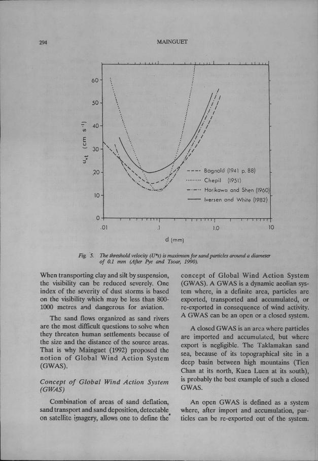
Wind is an invisible fluid, its action isdiffuse and hypocrite in the preliminaryphases, those which are the dangerous pro-dromes in the processes of land degradation.Wind can entrain particles of many sizes.The fine grained particles around 100micrometres are the most erodible (Fig. 5).
The entrainment of unconsolidated surfacematerial, its transport and redeposition arethe three main facets of wind erosion. Duringthe transport of the sand load by creep, sal-tation and reptation, other activities can takeplace, like corrasion on the aggregated soilsurface and rock, abrasion of natural andhuman- made structures, and physical damageto plant stems and leaves of the lowvegetation,thereby encouraging the spread of diseases.
294 MAINGUET
60
50
-0;- 40III
Eu
30.oJ•:l
,20
10
Bognold (1941 p. 88)
Chepil (1951)
Herikewo end Shen (1960)
Iversen end White (1982)
o,01 .1
d (mm)
1.0 10
Fig. '5. The threshold velocity (U·t) is macimum for sand panicles around a diameterof 0.1 mm (After Pye and Tsoar, 1990).
When transporting clay and silt by suspension,the visibility can be reduced severely. Oneindex of the severity of dust storms is basedon the visibility which may be less than 800-1000 metres a'ld dangerous for aviation.
The sand flows organized as sand riversare the most difficult questions to solve whenthey threaten human settlements because ofthe size and the distance of the source areas.That is why Mainguet (1992) proposed thenotion of Global Wind Action System(GWAS).
Concept of Global Wind Action System(GWAS)
Combination of areas of sand deflation,sand transport and sand deposition, detectableon satellite imagery, allows one to define the"
concept of Global Wind Action System(GWAS). A GWAS is a dynamic aeolian sys-tem where, in a definite area, particles areexported, transported and accumulated, orre-exported in consequence of wind activity.A GWAS can be an open or a closed system.
A closed GWAS is an area where particles.are imported and accumulatcd, but whereexport is negligible. The Taklamakan sandsea, because of its topographical site in adeep basin between high mountains (TienChan at its north, Kuen Luen at its south),is probably the best example of such a closedGWAS.
An open GWAS is defined as a systemwhere, after import and accumulation, par-ticles can be re-exported out of the system.

AEOLIAN RESEARCH PRIORITIES 295
The Sahara which exports its aerosols towardsthe north until Greenland, towards the eastuntil Kazakstan, towards the south until thetropical forest of )he Gulf of Guinea, andtOfards the west over the Atlantic Ocean,the Bermudas and the 'Nordeste (Brazil), isthe best example of an open GWAS. Thecorrelation between the Sahara and the Saheland how Sahara exports its sand particlestowards the Sahel have been demonstrated(Mainguet, 1992). The active Tenere sandsea in Niger, for example, is continued withoutinterruption by the fIXedHausa sand sea whichhas also received a part of its sand froma branch of a sand current which runs westof Air Massif and has loaded sand froJD.thealluvium accumulated by the dallols.
In a GWAS, there is not a simple jux-taposition of these three units: erosion,transport, deposition, but a GWAS is thejuxtaposition of multi-scale units. This multi-scale organisation should be answered by amulti-scale approach. Because of the complexnature of aeolian depositional processes, theinvestigation must be led at a multi-scale ap-proach which means to investigate at thesynoptic scale of the global wind action system;at a regional level in the area of the majorsand sea; at a local level of villages and allkinds of other human settlements, roads, n~il-ways, plantations and projects. Choosing theright techniques to control mobile sand andmoving dunes requires a knowledge of thewhole system and to appreciate in whichdynamical area· of the GWAS the problemarea is located, where sand control solutionsare to be applied.
Control of sand deflation, transport and ac-cumulation
Controlling wind action is often consideredas mainly a programme of dune stabilizationin its restricted sense, but it should also meancontrolling the mqvement of particles in thedifferent parts of a GWAS from the source
area towards the areas of transport and ac-cumulation ..
The strategies to combat wind-blown sandand migrating or encroaching dunes are dif-ferent. The effect of disturbance of dunesis not the same as the effects of disturbanceof migrating sand. Control of wind-blown sandmay have no effect on the rates of dunemovement.
Stabilization of mobile sand throughphysi-cal methods : In hyper-arid and arid ecosys-tems,with an almost limitless supply of sand·and with frequent and strong winds, managersface the danger of mobile dunes and driftingsand. Mauritana, where the sand flows com-posed of barchans threaten the human settle-}Dents (road and railways), is the mostsignificant example and probably the mostdifficult to control (Mainguet, 1991).
Blocking the sand in the source area andin the transfer area : The knowledge of thelocation, nature and extent of both the erosionarea and the sand migration area is necessary.To determine the location and the extent ofthe source area is a priority because, withouta knowledge of the size and the distanceof the source area it may be impossible orimpractical to solve the problem of sand anddune encroachment. In the Egyptian desertthe wind flow brings sand to the Kharga oasisfrom Quatara depression, 700km to the north-west. Along its way the transporting fluidtakes its load of grains which can be a mixtureof more or less autochthonous and/or alloch-thonous particles.
If the source area is too wide or too farfrom the areas which !"equire protectionagainst encroaching sand or still located inan arid ecosystem which can not allow theestablishment of a vegetative cover, economi-cally viable solution can not be proposed.In the more favourable cases, palisades ormechanical barriers should allow the creationofan artificial dune, but this requires a constant

296 MAINGUET
strategy of sand trapping until obtaining acontinuous vegetative cover, upwind of thisedifice.
Often it may be cheaper and more effectiveto take measures that will prevent the sandfrom being picked up in the source area,than to fix the dunes formed in the accumula-tion area. In the source areas, the objectiveis to protect the soil particles from entrainmentby:
• reducing wind speed through windbreaksof dry or preferably live vegetation, if per-mitted by rainfall, or available water; thestrategies are different according to thedegree of aridity;
• increasing the cohesion of soil particlesby planting vegetation;
• fIXing the soil using chemical adhesives,or covering the loose particles with plasticsheets, nets or dead vegetation.
The strategies to control aeolian damageslinked with drifting sand and mobile dunescan be summarized in two sets of action:blocking the shifting sand in the source areaor at any step of transport by palisades orbarriers with artificial material, plastic or or-ganic, creating an artificial dune or fIXingthe loose sand by chemical measures. Whenthe source area does not allow biologicalrehabilitation, blocking the sand may requirerepeated or permanent actions like stabilizingthe loose sand by biological measures. In thetransport area, the objective is to bring abouta reduction in wind speed by increasing theroughness of the land. The resulting turbulencecauses the airborne particles to settle. Deposi-tion of sand in preselected areas will reducethe threat to human settlements.
Watson (1990) summarized the approacheswhich have been employed to reduce driftingsand as: (i) promotion of the deposition ofdrifting sand by ditches and barriers; (ii) plan-tation of vegetation belts to trap the sand
moving away from source area; (iii) enhan-cement of sand transportation by shaping theland surface and treatment of the surface;and (iv) deflection of the sand stream.
The objective is to minimize the volumeof particles transported, so as to encourageaccumulation upwind of the area which re-quires protection. Nevertheless, to trap movingsand is a solution which needs an indefinitemaintenance. The excavation of deep ditchesupwind of human installations is based onsand entrapment and can bring temporaryprotection against encroaching sand. To beeffective the ditches built at right angle tothe main wind direction must be wider thanthe length of the jump of saltating grainsthat may reach 3-4 m (Watson, 1990). Theditch must have a depth which prevents aeoliandeflation from the floor and must be regularlycleared of the entrapped sand or doubledby parallel ditches.
When the; area of transport is underlainby unconsolidated material, techniques toreduce deflation should be applied, such asspreading coarse grained material over thesurface so as to obtain a kind of desert pave-ment. The protection must be continuous,to reduce the scouring of underlying material.Moreover, mulching is necessary to preventexcessive movement of particles. It involvesevenly covering of the sand, sand sheet ordune with natural or human-made materials.The objective of mulching is to break upthe smooth surface of bare field into a roughsurface which slows down with the speed andstabilizes the surface against wind erosion.Chemical methods of mulching can also beused and combined with biological methodsif the rainfall is sufficient. The sand-fIXinglayer formed by chemicals should be main-tained in good condition until the vegetationis established and takes over the controllingfunction of wind erosion.

AEOLIAN RESEARCH PRIORITIES 297
The accumulation area is characterizedby sand sheets, transverse dunes or dunefieldsand sand seas. The different shapes of dunesare related to sand supply, wind speed, theduration of wind, wind regime arid the localtopography.
During a long geological time the Sahelwas a huge vegetated accumulation area, southof the Saharan active sand-exporting windaction system. In the 1950's, with increasingpopulation and overgrazing, this vegetatedfIXed area with palaeosol began to be reac-tivated and the sand of the topsoil reworked.In the accumulation area, topsoil erosionshould be avoided, mainly in the cultivatedareas by shallow wind ridging, minimum tillage,pitting, covering the sand surface with clay,and creation of a checkerboard structure ofbarriers.
Mechanical stabilization is based on theuse of non-living, organic or inorganic materialto construct sand-binding barriers. Thismethod is not ideal because the effective lifespan of these structures is limited: three tofiveyears for the checkerboards in the Tenggerdesert in China. Sustainable stabilization ofdunes can onlybe achieved by thedevelopmentof a vegetation cover. Mechanical techniquesused for sand stabilization are essentiallydesigned for the protection of human set-tlements and villages, communication lines,transportation routes and precious agriculturalland. Sand blocking measures must be con-sidered to assist sand stabilization.
Biological stabilization of sand, sand sheetand dunes : In areas where rainfall reaches300 mm year-I, the biological stabilizationshould be favoured through a checkerboardpattern of low fences and development ofa natural or planted vegetation cover. In areasof continuous sand deposition, like in theChinese basin sand seas, the solutions aremore difficult and more expensive because
they are linked to mountainous geomorphol-ogy and a continuous sand supply. Permanentstabilization of sand, sand sh~et l\nd dunerequires the development of permanentvegetation cover. There are three possibilitiesfor rehabilitating the dry areas: naturalregeneration of the vegetation cover if rainfallis sufficient; semi-natural regeneration of thevegetation cover, or creation of a vegetationcover. To these methods can be added biologi-cal shelterbelts, windbreaks and wind barriers.
Green belts, formed of several rows oftrees or bushes, are a· classic technique inChina. The species are the locally adaptedones. In the oases, fruit trees like nut, apricotand mulberry are planted. In the oasis ofTurfan (South Taklimakan), 16,000 ha ofyineyard are surrounded and subdivided bygreen belts; 1130 ha were planted since 1964.Similar green belts were planted in Hetianto avoid a bidirectional wind regime.
To obtain the maximum decrease in windspeed, the ideal porosity is 50% and the idealspacing of barriers is five times the heightof the wind barrier. However, this optimumspacing maynot be compatible with agricultureor land tenure in the area. There is no generalrule to predict the most efficient spacing.If the wind is very turbulent, for examplein areas with varying topography, in valleysswept by local winds, or in corridor-cuttingescarpments, the spacing must be reducedto 5 times the height of the barrier. Thespacing of wind barriers depends on thetopography of the windward slope where thewind streams are compressed and the windspeed is accelerated. When the belts arealigned at 4SOto the eroding wind, and alsoon slopes exposed to the wind, the distancebetween the shelterbelts should be reduced.On the contrary, on the leeward slope, where.the wind streams are expanded and the wind

MAINGUb
speed is slower, the density of the Windbarriercan be decreased.
Other biological techniques like intercrop-ping or micro-crop shelterbelt consisting, forexample, of three rows of tall-growing pearlmillet planted across the prevailing wind direc-tion by Central Arid Zone Research Institute(Anon., 1985) was found to be instrumentalin increasing the water-use efficiency and pro-ductivity of summer-grown vegetables likelady's finger and cowpea. The pearl milletcrop for micro-crop shelterbelt have to besown about a fortnight earlier to the actualsowing of vegetable crops for providing theshelter effect.
Control of mobile dunes
According to Watson (1985) the problemof moving dunes can be tackled in three ways:removal, dissipation and immobilization. Thequestion is not so simple. All the techniquesto combat migrating dunes have their negativefaces. Removal of the dunes is very expensive.Dissipation of a mobile dune by trenching,surface treatment (complete or strips) andtransformation of the dune in shifting sandis feasible only in areas where shifting sandis not a .disturbance for human activities.Reshe.ping of mobile dunes into a mobilesand mound is temporary; the sand moundwill evolve very quickly towards the optimumaerodynamic form. Therefore, for permanencethe surface of the reshaped dune must bevegetated.
To stop the dunes, digging ditches to theleeward of the edifices is useless. Physicalbarriers leeward of the edifices are also useless.Vegetative stabilization requires rainfall orirrigation and the question of cost becomesa priority. Techniques of reshaping the dunes(reduce the height, or the volume) can ag-gravate the problem by increasing the speedof the dunes.
Free movement of sand must be a basicrule, the presence of human installations dis-rupting the sand flow should be avoided sincethese stimulate sand accumulation. If theobstructions are unavoidable these should beaerodynamically streamlined. A fundamentalobligation is that all linear installations (roads,railways, pipelines) should run parallel to thedirection of the dominant sand flow. Thefacilities should be located in areas wherethe dominant sand-moving winds blow overgently rising ground. On a windward risingslope the ground level wind speed is increasedand results in sand transport rather than ac-cumulation.
Conclusion
The increasing human and livestockpopulation in most parts of arid lands haveled to an increasing use of sand dunes, loessareas and areas ofwind erosion risk for grazing,agriculture, urban and industrial development.All these activities accelerate wind erosion.
Two main strategies need considerationfor combating wind activities: the vertical oneslike wind barriers, palisades, wind break, etc.,and the horizontal defence which consist ofcheckerboard and trials to rehabilitate avegetation cover.
The scarcity of information on winddynamics, aeolian action and behaviour ofsandy soils in the dry lands have made thecontrol of wind erosion difficult. Secondly,the strategies for development in dry landsare more aimed towards development of irriga-tion than for rainfed agriculture. The costof development of irrigation is very high, butcomparable amount of money is not spentto, control wind erosion. Can we suggest achange in the mind of the decision makers?
References
Anderson, RS., Sorensen, M. and Willetts, B.B. 1990.A Review of Recent Progress in Our Understanding

AEOLIAN RESEARCH PRIORITIES 299
of Aeolian Sediment Transport. Department ofTheoretical Statistics, University of Aarhus, Re-search report 213, 48p.
Anonymous, 1985. CAZRl Research Highlights, 1959·84.Central Arid Zone Research Institute, Jodhpur,153 p.
Aufrere, L 1931. Le cycle morphologoque des dunes.Annales de Geographie 40: 362·385.
Dagnold, R.A 1941. The Physics of Blown Sand andDesen Dunes. Methuen, London.
Chepil, W.S. 1941. Relation of wind to the dI)' aggregatestructure of soil. Scientific Agriculture 21: 488-507.
Chepil, W.S. 1945. Dynamics of wind erosion: I. Natureof movement of soil bywind. Soil Science 60:305-320.
Chepil, W.S. 1951. Properties of soil which influencewind erosion: IV. State of dI)' aggregate structure.Soil Science 72: 387-401.
Chepil, W.S. and Milne, R.A 1941. Wind erosion ofsoils in relation to size and nature of the exposedarea. Scientific Agriculture 21: 479-487.
Chepil, W.S. and Woodruff, N.P. 1963. The physics ofwind erosion and its control. Advances in Agronomy15: 211-302.
Chudeau, R.G. 1920. L'etude sur les dunes sahariennes.Annales des Geographie 29: P. 334-351.
D'Almedia, G.A and Schultz, L 1983. Number, massand volume distribution of mineral aerosol andsoils of the Sahara. Journal of Climate and AppliedMeteorology 22: 233-243.
Delany, Ae. and Zenchelsk')', S. 1976.The organic com-ponent of wind-erosion-generated soil-derivedaerosol. Soil Science 121: 146-155.
Ehrenberg, e.G. 1847. The Sirocco dust that fell atGenoa on the 16th May 1846. Quanerly Joumalof Geological Society, London 3: 25-26.
Frank, A and Kocurek, G. 1944. Effects of atmosphericconditions on wind profiles and aeolIan sandtransport with an example from White Sands Na-tional Monument. Earth Surface Processes andLandfonns 19: 735-745.
FI)'fear, D.W. 1981.Management of blank rows in dI)'landskip-row cotton. Transactions of the ASAE 24: 988-990.
Horikawa, K and Shen, H.W. 1960. Sand Movementby Wind Action. US Army Corps of EngineersTechnical Memoir 119.
Iversen, J.D. and White, B.R. 1982. Saltation thresholdon earth, mars and venus. Sedimentology 29: 111-119.
Kar, A 1993. Aeolian processes and bedforms in theThar desert. Journal of Arid Em'ironments 25:83-95.
Kaul, R.N. 1985. Sand dune fIXation and afforestation- Traditional procedures for dune fIXation : Thehedge system. In : Sand Dune Stabilization, Shd-terbdts and Afforestation in Arid Zones. FAO Con-
servation Guide 10,Food and Agriculture Organiza-tion of United Nations, Rome, pp. 87-95.
Knottnerus, D.J.e. and Peerikamp, P.K. 1972. Winderosion. What can be done about it? Bedrijfontwik-keling 3: 175-179.
Lockeretz, W. 1978. The lessons of the dust bowl.American Scientists 66: 560-569.
Mainguet, M. 1972. Le Modele des Gres. Problemesgrneraux. Institute Geographique National. 637 p.
Mainguet, M. 1991.Desenification : Natural Backgroundand Human Mismanagement. Springer-Verlag, Ber-lin, 306 p.
Mainguet, M. 1992.A Global Open Wind Action System: the Sahara and the Sahel. In, The FirstInternationalConference on Geology of the Arab World, (Ed.A Sadek). Le Caire, vol. 2, pp. 33-42.
Mainguet, M. and Callot, Y. 1978. L'erg de Fachi·Bilma(Tchad-Niger). Contribution a la connaissance dela dynamique des ergset des dulles des zones arideschaudes. Memoires et Documents. CNRS, Paris,Vol. 19, 184 p.
Mainguet, M. and Jacqueminet, e. 1985. Le Grand ErgOccidental et Ie Grand Erg Oriental. Classificationdes dunes, balance sedimentaire et dynamiqued'ensemble. Travaux de I'lnstitute de geographic deReims 59-60: 29-48.
Mainguet, M. and Dumay, F. 1995. Transsaharan windflows analysed on Meteosat 4 satellite imageI)' (inpress).
McCauley, J.F., Grolier, M.J. and Breed, e.S. 19n. Yar-dangs of Peru alld other Desen Regions. US Dept.of the Interior, Geological Survey, Flagstaff, 2255No, Gemini Dr. A.Z. 86001, 177 p. (preliminaI)'report).
McKee, E.D. (ed.). 1979.A Study of Global Sand Seas.U.S. Geological Survey Professional' Paper 1052,429 p.
Meigs, P. 1953.World distribution of arid and semi-aridhomoclimates. In, Reviews of Research on Arid ZoneHydrology. UNESCO Arid Zone Programme 1:203-210, Paris.
Meigs, P. 1961. Map of Arid Zone. UNESCO, Paris.Merva, G.E. and Peterson, G. 1983. Wind erosion sam-
pling in the north central region. Paper, AmericanSociety of Agricultural Engilleers 83: 21-33..
Middeleton, N.J. 1985.Effect of drought on dust produc-tion in the Sahel. Nature 316 (6027):, 431-434.
Orlovsky, N.S. 1982. Natural conditions of deserts inthe USSR and desertification processes. In, Com-bating Desenification ill the USSR : Problelns alldErperience. Center of International Projects, Mos-cow, UNEPCOM, 120 p. (Second edition).
-Petrova, AV. 1981. The content of various forms ofpotassium in eroded calcareous chernozems of theKrasnodar Krai. Agrokhimiya 7: 31-36.
300 MAINGUEf
Petrova, A.V. 1992. Changes in humus and nitrogencontents in calcareous chernozems caused by winderosion. Agrokhimiya 8: 76-80.
Pewe, T.L 1981. Desert dust: an overview. Geological. Society of America, Special Paper 186: 1-10.Prospero, J.M., Glaccum, RA. and Nees, RT. 1981.
Atmospheric transport of soil dust from Africato South America. Nature 289: 570-572.
Purvis, J.e. 1977. Satellite Photos Help in Dust Episodein South Carolina. Information Note 77/8, US Na-tional Weather Service. Natural Environment Satel-lite Service, Satellite Applications.
Pye, K and Tsoar, H. 1990. Aeolian Sand and SandDunes. Unwin Hyman, London, 3% p.
Romanov, N.N. 1974. Sandstorms in Central Asia. Tr.Tash GU 1960: 178.
Sidhu, P.S. 1977, Aeolian additions to the soils of north-west India. Pedology 27: 323-336.
,Thomas, D.S.G. and Middleton, NJ. 1994.Desenification: Exploding the Myth. Wiley, Chichester, 194 p.
Udden, J.A. 1894. Erosion, transportation and sedimen-tation performed by the atmosphere. Joumal ofGeology 2: 318-331.
Vasil'yev, G.I., Bulgakov, D.S., Gaavrilenko, LN. andKalinichenko, A.S. 1978. Conditions under whichdust storms develop in the northern Caucasus. SovietSoil Science 10: 60-69.
Watson, A. 1985. The control of wind blown sand andmoving dunes : a review of the methods of sandcontrol in deserts with observations from SaudiArabia.' Quanerly Journal of Engineering' Geology,London 18: 237-252.
Watson, A. 1990. The Control of blowing sand andmobile desert dunes. In Techniques for DesertReclamation (Ed. A.S. Goudie), pp. 35-85, JohnWiley, Chichester.
Wilson, I.G. 1973. Ergs. Sedimentary Geology 10: 77-106.
Woodruff, N.P. and Siddoway, F.H. 1965.A wind erosionequation. Soil Science Society of America, Proceed-ings 29: 602-608.
Worster, D. 1979. Dust Bowl. Oxford University Press,New York.
Zingg, A.W. 1953.Quelques caracteristiques due mouve-ment eolien du sable par Ie processus de saltation.Editions du Centre National de la Recherche Scien-tifique 13: 197-208.
Zhao Sunqiao. 1986. Physical Geography of China.Science Press, Beijing and John Wiley and Sons,New York, 209 p.
Zobeck, T.M. and FI)Tear, D.W. 1985. Chemical andphysical characteristics of windblown sediment.Paper, American Society of Agricultural Engineers,2539.