research 1970 - alaska
TRANSCRIPT

GEOLOGICAL SURVEY RESEARCH 1970 Chapter B
GEOLOGICAL SURVEY PROFESSIONAL PAPER 700-8
Scientific notes and summaries of investigations in geology, hydrology, and related fields
UNITED STATES GOVERNMENT PRINTING OFFICE, WASHINGTON: 1970

UNITED STATES DEPARTMENT OF THE INTERIOR
WALTER J. HICKEL, Secretary
GEOLOGICAL SURVEY
William T. Pecora, Director
For sale by the Superintendent of Documents, U.S. Government Printing Office Washington, D.C. 20402 - Price $3.25

CONTENTS
GEOLOGIC STUDIES
Petrology and petrography
Page
Copper in biotite from igneous rocks in southern Arizona as an ore indicator, by T. G. Lovering, J. R. Cooper, Harald Drewes, and G. C. Cone . . . . . . . . . . . . . . . . . . . . . . . . . . . . . . . . . . . . . B1
Relation of carbon dioxide content of apatite of the Phosphoria Formation to regional facies, by R. A. Gulbrandsen---- 9 Extensive zeolitization associated with hot springs in central Colorado, by W. N. Sharp . . . . . . . . . . . . . . . . . . . . . . . . . . . . 14 Mafic and ultramafic rocks from a layered pluton a t Mount Fairweather, Alaska, by George Plafker and E. M. MacKevett,
J r - - - - - - - - - - - - - - - - - - - - - - - - - - - - - - - - - - - - - - - - - 21 Authigenic kaolinite in sand of the Wilcox Formation, Jackson Purchase region, Kentucky, by J. D. Sims- - - - - - - - - - - - 27
2 Blueschist and related greenschist facies rocks of the Seward Peninsula, Alaska, by C. L. Sainsbury, R. G. Coleman, and Reuben Kachadoorian . . . . . . . . . . . . . . . . . . . . . . . . . . . . . . . . . . . . . . . . . . . . . . . . . . . . . . . . . . . . 33
Structural geology
Allochthonous Paleozoic blocks in the Tertiary San Luis-Upper Arkansas graben, Colorado, by R. E. Van Alstine- - - - - 43
Geophysics
Calculated in situ bulk densities from subsurface gravity observations and density logs, Nevada Test Site and Hot Creek Valley, Nye County, Nev., by D. L. Healey - - - - - - - - - - - - - _,- A - - - - - - - - - - - - - - - - - - - - - - - - - - 52
Geologic and gravity evidence for a buried pluton, Little Belt Mountains, central Montana, by I. J. Witkind, M. D. Kleinkopf, and W. R. Keefer . . . . . . . . . . . . . . . . . . . . . . . . . . . . . . . . . . . . . 63
Aeromagnetic and gravity features of the western Franciscan and Salinian basement terranes between Cape San Martin and San Luis Obispo, Calif., by W. F. Hanna ---_----- . .----------------------------------------------------- 66
Reconnaissance geophysical studies of the Trinidad quadrangle, south-central Colorado, by M. D. Kleinkopf, D. L. Peterson, and R. B. Johnson . . . . . . . . . . . . . . . . . . . . . . . . . . . . . . . . . . . . . 78
Geochronology
Whole-rock Rb-Sr age of the Pikes Peak batholith, Colorado, by C. E. Hedge- - - - - - - - - .. - - - - - - - - - - - - - - - - - - - - - - - - - - - 86 Distribution of uranium in uranium-series dated fossil shells and bones shown by fission tracks, by B. J. Szabo, J. R.
Dooley, Jr., R. B. Taylor, and J. N. Rosholt . . . . . . . . . . . . . . . . . . . . . . . . . . . . . . . . . . . . . . . . . . . . . . . . . . . . . . . . . . . . . . . . 90
Economic geology
Iron deposits of the Estes Creek area, Lawrence County, S. Dak., by R. W. Bayley----- - .. ------ - - - - - - - - - - - - - - - - - - - 93 High-calcium limestone deposits in Lancaster County, southeastern Pennsylvania, by A. E. Becher and Harold Meisler- - 102 Geology and mineral potential of the Adobe Range, Elko Hills, and adjacent areas, Elko County, Nev., by K. B. Ketner- - 105
Paleontology
Early Permian plants from the Cutler Formation in Monument Valley, Utah, by S. H. Mamay and W. J. Breed- - - - - - 109 Stratigraphic micropaleontology of the type locality of the White Knob Limestone (Mississippian), Custer County, Idaho,
byBettySkippandB.L.Mamet . . . . . . . . . . . . . . . . . . . . . . . . . . . . . . . . . . . . . . . . . . . . . - 118 Triassic conodonts from Israel, by J. W. Huddle--- - - - - - - - - - - - - - - - - - - - - - - - - - - - - - - - - - - - - - - - - - - - - - - 124 Middle Pleistocene Leporidae from the San Pedro Valley, Aria., by J. S. Downey - - - - - - - - - - - - - - - - - - - - - - - - - - - - - - - - - - 131 New discoveries of Pleistocene bisons and peccaries in Colorado, by G. E. Lewis-- - - - - - - - - - - - - - - - - - - - - - - - - - - - - - - - - - 137
Stratigraphy
Geology of new occurrences of Pleistocene bisons and peccaries in Colorado, by G. R. Scott and R. M. Lindvall- - - - - - - - 141 Clay mineralogy of selected samples from the middle Miocene formations of southern Maryland, by Karl Stefansson and
J.P.Owens . . . . . . . . . . . . . . . . . . . . . . . . . . . . . . . . . . . . . . . . . . - - 150 The Gardiners Clay of eastern Long Island, N. Y.-A reexamination, by J . E. Upson---- - - - - - - - - - - - - - - - - - - - - - - - - - - - 157
111

IV CONTENTS
Sedimentation Page
B161 Settling velocity of grains of quartz and other minerals in sea water versus pure water, by C. I. Winegard- - _ - - - - - - - - -
Geomorphology
The glaciated shelf off northeastern United States, by R. N. Oldale and Elazar Uchupi . . . . . . . . . . . . . . . . . . . . . . . . . . . .
Analytical methods
Determination of cobalt in geologic materials by solvent extraction and atomic absorption spectrometry, by Wayne Mountjoy-----------------------------------------------------------------------------------------------
A field method for the determination of cold-extractable nickel in stream sediments and soils, by G. A. Nowlan-------- The fluorimetric method-Its use and precision for determination of uranium in the ash of plants, by Claude Huffman,
Jr.,and L. B. Riley-------------------------------------------------------------------------------------- Chemical extraction of an organic material from a uranium ore, by M. L. Jacobs, C. G. Warren, and H. C. Granger- - - A die for pelletizing samples for X-ray fluorescence analysis, by B. P. Fabbi . . . . . . . . . . . . . . . . . . . . . . . . . . . . . . . . . . . . . . .
HYDROLOGIC STUDIES Ground-water recharge
Transmissivity and storage coefficient of aquifers in the Fox Hills Sandstone and the Hell Creek Formation, Mercer and Oliver Counties, N. Dak., by M. G. Croft and E. A. Wesolowski . . . . . . . . . . . . . . . . . . . . . . . . . . . . . . . . . . . . . . . . . . . . . .
Preliminary analysis of rate of movement of storm runoff through the zone of aeration beneath a recharge basin on Long Island, N.Y.,by G. E.Seaburn------------------------------_------------------------ ,-------------------
Ground-water inflow toward Jordan Valley from Utah Valley through valley fill near the Jordan Narrows, Utah, by R. W. Mower-------------------------------------------------------------------------------------------------
Ground-water contamination
Waterborne styrene in a crystalline bedrock aquifer in the Gales Ferry area, Ledyard, southeastern Connecticut, by I. G. Grossman . . . . . . . . . . . . . . . . . . . . . . . . . . . . . . . . . . . . . . . . . . . . . . . . . . . . . . . . . . . . . . . . . . . . . . . . . . . . . . . . . . . . . . . . . .
Surface water
Meandering of the Arkansas River since 1833 near Bent's Old Fort, Colo., by F. A. Swenson . . . . . . . . . . . . . . . . . . . . . . . . Trends in runoff, by P. H. Carrigan, Jr., and E. D. Cobb . . . . . . . . . . . . . . . . . . . . . . . . . . . . . . . . . . . . . . . . . . . . . . . . . . . . . . . . . .
Relation between ground water and surface water
Ground water-surface water relation during periods of overland flow, by J. F. Daniel, L. W. Cable, and R. J. Wolf---- The relationship between surface water and ground water in Ship Creek near Anchorage, Alaska, by J . B. Weeks-- - - - - Prairie potholes and the water table, by C. E. Sloan . . . . . . . . . . . . . . . . . . . . . . . . . . . . . . . . . . . . . . . . . . . . . . . . . . . . . . . . . . .
Erosion and sedimentation
Hydrologic and biotic effects of grazing versus nongrazing near Grand Junction, Colo., by G. C. Lusby- - - - - - - - - - - - - Sandbar development and movement in an alluvial channel, Rio Grande near Bernardo, N. Mex., by J . K. Culbertson
and C. H. S c o t t - - - - - - - - - - - - - - - - - - - - - - - - - - - - - - - - - - - - - - - - - - - - - - - - - - - - - - - - - - - - - - - - - - - - - - - - - - - - - - - - - - - - - - - -
Geochemistry of water
Spectrochemical determination of microgram quantities of germanium in natural water containing high concentrations of heavy metals, by A. E. Dong . . . . . . . . . . . . . . . . . . . . . . . . . . . . . . . . . . . . . . . . . . . . . . . . . . . . . . . . . . . . . . . . . . . . . . . - -
Hydrologic techniques
Evaluation of a method far estimating sediment yield, by L. M. Shown- - - - - - - - - - - - - - - - - - - - - - - - - - - - - - - - - - - - - - - - - - . Dosage requirements for slug injections of Rhodamine BA and WT dyes, by F. A. Kilpatrick- - - - - - - - - - - - - - - - - - - - - - -
Comparison of a propeller flowmeter with a hot-film anemometer in measuring turbulence in movable-boundary open- channel flows, by J. P. Bennett and R. S. McQuivey . . . . . . . . . . . . . . . . . . . . . . . . . . . . . . . . . . . . . . . . . . . .
INDEXES
Subject- .................................................................................. 263 Author . . . . . . . . . . . . . . . . . . . . . . . . . . . . . . . . . . 267

GEOLOGICAL SURVEY RESEARCH 1970
This collection of 46 short papers is the first published chapter of "Geological Survey Research 1970." The papers report on scientific and economic results of current work by mem- bers of the Geologic and Water Resources Divisions of the U.S. Geological Survey.
Chapter A, to be published later in the year, will present a summary of significant results of work done in fiscal year 1970, together with lists of investigatio~ls in progress, reports pub- lished, cooperating agencies, and Geological Survey offices.
"Geological Survey Research 1970" is the eleventh volume of the annual series Geological Survey Research. The ten volumes already published are listed below, with their series desig- nations.
Geological Survey Research Prof. Paper
1 9 6 0 - - - - - - - - - - - - - - - _ _ - - - - - - - - - - - - - - - - - - - 400 1 9 6 1 - - - - - - - - - - - - - - - _ _ - - - - - - - - - - - - - - - - - - - 424 1 9 6 2 - - - - - - - - - - - - - - - _ _ - - - - - - - - - - - - - - - - - - - - - 450 1 9 6 3 - - - - - - - - - - - - - - - - - - - - - - - - - - - - - - - - - - - - 475 1 9 6 4 - - - - - - - - - - - - - - - - - - - - - - - - - - - - - - - - - - 501 1 9 6 5 - - - - - - - - - - - - - - - - - - - - - - - - - - - - - - - - - - - 525 1 9 6 6 - - - - - - - - - - - - - - - - - - - - - - - - - - - - - - - - - - - 550
575 1 9 6 8 - - - - - - - - - - - - - - - - - - - - - - - - - - - - - - - - - - - 600 1 9 6 9 - - - - - - - - - - - - - - - - - - - - - - - - - - - - - - - - - - - 650


GEOLOGICAL SURVEY RESEARCH 1970
MAFlC AND ULTRAMAFIC ROCKS FROM A LAYERED PLUTON
AT MOUNT FAIRWEATHER, ALASKA
By GEORGE PLAFKER and E. M. MacKEVETT, JR., Menlo Park, Calif.
Abstract.-Reconnaissance mapping in the Fairweather Range of southeastern Alaska has revealed that a layered mafic and ultramafic pluton, the Fairweather pluton, underlies much of the Mount Fairweather area. The mafic rocks, which constitute most of the pluton, are magnetite- and ilmenite-bearing two- pyroxene gabbros and clinopyroxene-olivine gabbros. The ultra- mafic rocks consist mainly of sulfide- and chromite-bearing wehrlite, pyroxenite, and dunite, and locally contain significant concentrations of chromium, cobalt, copper, nickel, and plati- num-group elements. The pluton is probably a source for ilmen- ite, magnetite, platinum, and other heavy minerals that have been found a s placer beach deposits along the adjacent Gulf of Alaska coast.
During a geochemical sampling program in the Yakutat quadrangle and adjacent areas in 1968, the authors traced float of mafic and ultramafic rocks in glacial moraines to a previously undescribed small layered pluton at Mount Fairweather (fig. 1). The discovery is noteworthy because it extends the known area of a belt of layered mafic plutons in the Fair- weather Range some 20 miles northwestward, and be- cause the pluton contains ultramafic rocks with con- centrations of chromite, nickel, copper, and platinum- group metals. Ultramafic rocks have possible economic importance at the one other locality in the Fairweather Range where they have been found. The purpose of this paper is to outline the general setting of the Fair- weather pluton, as determined from a brief aerial re- connaissance, and to present the results of petrologic and chemical analyses of some samples of float rock that were derived from the pluton.
The Fairweather pluton is the most northerly of three layered mafic intrusives that lie roughly along the axis of the northwest-trending Fairweather Range (fig. 1). I ts existence in the general vicinity of Mount Fairweather was correctly inferred by Rossman (1963, p. F11) from float of gabbroic rocks found in the moraines of Fairweather Glacier. However. the loca-
tion of the source pluton was not known, and no ultra- mafic rocks were reported in the float. The belt of layered intrusives extends southeastward through Yakobi Island and western Chichagof Island where several smaller bodies of gabbroic rock similar in com- position to those of the Fairweather Range are exposed (Rossman, 1963, p. F11). Other than at the Pair- weather pluton, ultramafic rocks in the range have been found only in small isolated nunataks at the Brady Glacier nickel-copper prospect (fig. I ) , which is be- lieved to lie near the margin of the Crillon-La Perouse pluton (Cornwall, 1967).
SETTING
The Fairweather pluton probably underlies an area of more than 15 square miles along the southwest flank of Mount Fairweather between the trunk stream of Fairweather Glacier and Sea Otter Glacier (fig. 1). Its general configuration and its relation to the adja- cent metamorphic and granitic rocks were deduced by close observation from a helicopter. Our knowledge of the lithology of rocks in the pluton and inferences re- garding the distribution of ultramafic rocks within it are based entirely on examination of moraines, of the glaciers that drain toward the west and southwest from the Mount Fairweather area. The combination of rugged terrain and high altitude precluded landings within the pluton (fig. 2). Technical mountaineering capabilities would be required for a ground study. Virtually all of the pluton, except for the extreme northwestern end, is within the Glacier Bay National Monument.
The Fairweather pluton appears to be at least 6 miles long and 31/2 miles wide, the long axis trending approximately northwestward. It is elongated parallel to the structural grain of the adjacent foliated country rocks, which are mainly steeply dipping amphibolite
U.S. GEOL. SURVEY PROF. PAPER 700-B, PAGES B21-B26
B21
B22 PETROLOGY AND PETROGRAPHY
FIGURE 1.-Index map showing the approximate lacation of the Fairweather pluton and other layered mafic plutms in the Fairwe"ather Range. Orillon-La Perause and Astralabe-De Langle plutone after Rossman (1963).

PLAFKER AND MACREVETT B23
FIGURE 2.-Aedal view olf the westem part d the Fairneather plutnn (location shown on fig. 1). Dashed line indicates the inferred slo~lthwest contact. The cmspic~~ously banded racks in the foreground a re probably inltertofnguing metavcllcanic and metasedimentary country rocks. Photograph by Auskin Post.
and mica schist cut by granitic stocks and sills. Dark, Tlie layered igneous rocks on the southwest flank of layered nlafic and ultramafic rocks are exposed in sheer RIol~nt Fairweather appear to dip northeast at a mod- cirque walls and knife-edged argtes along the south- erate angle. The nortlleastern contact of the pluton is west margin of the pluton from an altitude between largely concealed beneath the extensive snow and ice '7,000 and 10,000 feet, to the general vicinity of the cover on the highest part of the mountain; the contact summit, which rises 15,300 feet above sea level (fig. 2). shown on figure 1 is inferred from the distribution of

B24 PETROLOGY AND PETROGRAPHY
schistose country rock a t lower elevations. Massive, blocky, light-colored rocks in part border the layered rocks on the southwest in a zone as much as 2 miles wide, and locally seem to crosscut the darker layered rocks. It was not possible to tell from the air whether the light-gray unit represented a felsic granitic intru- sive or a relatively nonlayered leucocratic gabbro. However, the general scarcity of felsic rocks in the moraines of glaciers draining this part of the mountain favor the latter alternative, and the light-gray zone was tentatively mapped as part of the pluton.
No data are available on the age of the pluton or of the adjacent foliated rocks. Rossman (1963, p. F10) correlated the schistose rocks of the Fairweather Range with units of Mesozoic a ie on Chichagof Island. Samples of gabbro from the compositionally and struc- turally similar Crillon-La Perouse pluton, which have been submitted for radiometric dating (D. A. Brew, oral commun., April 1969), may provide information on the time of intrusion of the layered rocks.
DESCRIPTION' OF THE ROCKS
The compositional layering, textures, and mineral- ogy of the Fairweather pluton are broadly comparable to those of the layered igneous rocks elsewhere in the Fairweather Range (Rossman, 1957) and in many well-known localities throughout the world such as the Skaergaard, Stillwater, and Bushveld Complexes (Wager and Brown, 1968). Such rocks are generally considered to result from fractional crystallization and crystal settling in a magma originally of basaltic com- position.
Ultramafic rocks of the Fairweather pluton are re-
stricted to moraines on the south side of Sea Otter Glacier and on the unnamed glacier between Sea Otter and Fairweather Glaciers; gabbroic rocks are abundant in these moraines and in the lateral moraine along the north side of Fairweather Glacier (fig. 1). The distribution of ultramafic float suggests that its source is in the northern part of the pluton in the general area due west of Mount Fairweather.
Samples of float from the Fairweather pluton are composed primarily of virtually unaltered plagioclase, clinopyroxene, olivine, and orthopyroxene. Accessory constituents include sulfides, spinel-group minerals, ilmenite, hornblende, and traces of rutile and apatite. Detailed compositional studies have not been made, but the optical properties suggest that the plagioclase is mostly labradorite (An,,-,o), the clinopyroxene is probably augite, the olivine has a forsterite content of about 80 percent, and the orthopyroxene is magnesian hypersthene (Ens5). Augite characteristically is twin- ned and exhibits schiller structure; the hypersthene contains rare exsolution lamellae and blebs of clinopy- roxene. The rock compositions vary from anorthosite or leucocratic gabbr; to pyroxeiite, wehrlite, and dunite. Chemical analyses of samples of the various rock types are presented in table 1.
Gabbroic rocks are by far the most abundant in the moraines, and probably constitute the great bulk of the pluton. They are leucocratic to melanocratic rocks in which the layering results from variations in the pro- portions of plagioclase and ferromagnesian minerals. Individual layers in float on the moraines range from a fraction of an inch to several feet in thickness. The rocks that were collected are fine- to medium-grained
TABLE 1.-Chemical analyses, i n weight percent, of six rock samples from the Fairweather pluton [Samples analyzed by methods similar to those described in U.8. Oeol. Survey Bull. 1144-A, supplemented by atomic absorption. Analysts, Lowell Art&, O. W. Chloe, P. L.
Elmore, John Glenn, James Kelsey, and H. Smith]
Rock type- -.-....-.. .. ......---------------- .. . . . . . . . . . . . . . . . . . . . . . . . . . . . . . . . . . . . Dunite Wehrlite Two-pyroxene gabbm Clinopyroxene Dunite olivine aabbro (sheared)
Lab No ..-...--.....-.-.---------------------------------------------------..----- MI08 MI06 MI06 MI06 MlOe MI06 872W 873W 874W 876W 876W 877W
Field No ---....--.--.------------------------------------------.------------------ 68 APr 68 APr 68 APr 68 APr 88 APr 68 APr 101 A1 100 C2 101 A2 101 A3 101 A4 101 A6
PLAFKER AND MACKEVETT B25
two-pyroxene gabbro and clinopyroxene-olivine gab- bro with xenomorphic to hypidiomorphic granular tex- tures. Plagioclase in crystals up to 3.5 mm in length constitutes 10-60 percent of the gabbros analyzed. Ruti- larted plagioclase makes up an wkirnsvted 85 percent of a variant that had a decidedly purplish cast in the hand specimen, and the composition borders on anor- thosite. The ferromagnesian minerals are as much as 2.5 mm in size.
The ratio of clinopyroxene to orthopyroxene in the two-pyroxene gabbro is variable, and either mineral may predominate in a given rock. Irregular masses of magnetite and ilmenite(1) in grains 1.5 mm or smaller constitute as much as 10 percent of one sample (68 APr 101 A2). The iron ores occur both interstitially and enclosed within the pyroxenes. The clinopyroxene- olivine gabbro (68 APr 101 A4) is composed mainly of clinopyroxene and olivine in grains as much as 2.5 mm across ; the grains contain about 10 percent plagioclase and a few percent interstitial hypersthene. Opaque minerals make up as much as 5 percent of the rock. The predominant ore mineral is interstitial chalcopy- rite in grains of less than 0.5 mm. Other accessory minerals in the gabbros are generally less than 0.5 mrn in size and include brown hornblende, green spinel, and rare cubanite, pyrrhotite, magnetite, chromite( I ) , and pentlandite ( ? ) .
The float of the ultramafic rock consists of black, greenish-black, and olivine-green crystal cumulates with a faintly layered structure. One sample of dunite (68 APr 101 A l ) consists of more than 90 percent fresh euhedral to anhedral olivine in grains ranging from 0.2 to 4.5 mm in size. Some of the grains exhibit twinning and protoclastic textures. The remainder of the rock is composed of euhedral to subhedral chromite crystals 0.1 to 0.5 rnm across, a few crystals of pent- landite less than 0.05 mm in size, and minor amounts of interstitial clinopyroxene and hornblende. One sheared dunite specimen (68 APr 101 A5) was cut by cross-fiber serpentine in closely spaced veinlets less than 0.02 mm wide that make up as much as 20 percent of the rock. The essential mineral of a pyroxenite sample (68 APr 100 C1) is anhedral clinopyroxene in grains 0.5 to 3.0 mm across with about 25 percent anhe- dral to subhedral hypersthene that is less than 1.0 mm in size. A sample of wehrlite (68 APr 100 C2) consists of about equal amounts of subhedral and anhedral olivine in grains as much as 2.5 mrn across and an- hedral, partially poikilitic clinopyroxene as much as 5.0 mrn. The clinopyroxene is commonly altered along grain boundaries and cracks to a mixture of fibrous green actinolite and antigorite. The pyroxenite and wehrlite contain as much as 15 percent interstitial sul-
fides and minor scattered crystals of chromite and spinel from a few microns to 1 rnrn in size. The sulfide minerals, which occur in irregular scatibred masises and microveinlets, are cubainite intergrown wihh ahalco- pyrite and pyrrhotite. Some pentlandite is intergrown with chalcopyrite or cubanite, or, more rarely, it occurs in isolated masses.
SPECTROGRAPHIC ANALYSES
Seven isolated float samples were analyzed for total metals by semiquantitative spectrographic methods, and of these, five ultramafic rocks and one gabbro were analyzed for platinum-group elements by quantitative spectrographic methods (table 2). The rocks analyzed include all the lithologic types described in the pre- ceding section, and some of them had the highest con- tent of disseminated opaque minerals found in the float. With the exception of the pyroxenite (68 APr 100 C l ) , chemical analyses are given for these same rocks in table 2.
The analyses indicate concentrations of titanium (2 percent) and vanadium (2,000 ppm) in the magnetite- and ilmenite-bearing two-pyroxene gabbro that are not unusual for rocks of this type. As much as 5,000 pprn chromium, 5,000 pprn copper, and 5,000 pprn nickel are present in the richest samples of sulfide- and chromite- bearing pyroxenite and wehrlite, as much as 5,000 pprn chromium, and 3,000 pprn nickel, in the chromite-bear- ing dunite. Noteworthy amounts of cobalt and platinum- group elements were also found in the ultramafic rocks and, to a lesser extent, in the gabbros. The largest amounts of these elements, which were in the sheared dunite (68 APr 101 A5), totaled 200 pprn cobalt and 0.184 pprn palladium, 0.171 pprn platinum, and detect- able rhodium (0.004 pprn).
Disseminated opaque minerals occur in all the float collected from the Fairweather pluton. These minerals are mainly magnetite, ilmenite, sulfides, and chromite, which undoubtedly account for the anomalous metal content of these rocks. Combined magnetite and ilmen- ite constitute as much as 10 percent by volume of some gabbros. The wehrlite and p~roxenite contain up to 15 percent sulfides with minor chromite, and some dunites contain a few percent of chromite with minor sulfides. The sulfides identified in polished sec- tion include cubanite, chalcopyrite, p~rrhotite, and pentlandite. No chromitites or massive sulfides were found. The nickel and copper content of the highest grade rocks sampled is about 0.5 percent each. This may be compared with a content of 1.5 percent nickel and 2 percent copper in selected samples of ultramafic rocks from the Brady Glacier prospect which is cur-

B26 PETROLOGY AND PETROGRAPHY
TABLE 2.-Spectrographio analyses of selected float tcltramalic and mafic roclcs from the Fairtoeather ptuton
[Asterisk indicates quantitative analysis A. F. Dorrzapf and Marian Schnepfe analysts' all other analyses are semiquantitative, Chris Heropoulos analyst. Q major mu- stituents greater than 10 percent; N, not'detected. Other elements looked for b6t not fouhd: As, Au, B, Be, Bi, Cd, La, Mo, Nb, Pb, Sb, Sn, Te, U: W, Zn, Zr , '~e , Qe, Hf, In, Li, Re, Ta, Th, TI, Eu]
Rock type Dunite Dunite Wehrlite Clinopyroxene Two-pyroxene Two-pyroxene Pyroxenite (sheared) olivine gabbro gabbro gabbro
Field No ...................................... 68 APr 101 A1 68 APr 101 A5 68 APr 100 C2 68 APr 101 A4 68 APr 101 A3 68 APr 101 A2 68 APr 100 C1 Laboratory No.. . -.......-.-...-.. .- - - - - - .... M4949 M4949 M4949 M4949
M106892W M106877W M106873W M106876W M106875W M106874W - --
Weight percent
Par& per million
1 Average of two analyses. 2 Average of three analyses.
rently being actively explored by the Newmont Min- ing Co. (Cornwall, 1967, p. 153, table 15).
The Fairweather pluton is probably a major source for magnetite, ilmenite, platinum, and other heavy minerals that occur in association with placer gold in beach deposits along the adjacent Gulf of Alaska coast (Rossman, 1957, 1963; Thomas and Berryhill, 1962).
REFERENCES
Cornwall, H. R., 1967, Brady Glacier prospect, in MacKevett, E. M., Jr., Brew, D. A., Hawley, C. C., Huff, L. C., and
Smith, J. G., Mineral resources of Glacier Bay National Monument: U.S. Geol. Survey opendle report, July 14, 1967, p. 153-158.
Rossman, D. L., 1957, Ilmenite-bearing beach sands near Lituya Bay, Alaska: U.S. Geol. Survey open-file report, June 29, 1957, 10 p., 1 pl., 2 tables.
1963, Geology and petrology of two stocks of layered gabbro in the Fairweather Range, Alaska: U.S. Geol. Sur- vey Bull. 1121-F, p. F1-F50.
Thomas, B. I., and Berryhill, R. V., 1962, Reconnaissance stud- ies of Alaskan beach sands, eastern Gulf of Alaska: U.S. Bur. Mines Rept. Inv. 5986, 40 p.
Wager, L. R., and Brown, G. M., 1968, Layered igneous rocks: Edinburgh and London, Oliver and Boyd, Ltd., 588 p.

GPOLOGICAL SURVEY RESEARCH 1970
BLUESCHIST AND RELATED GREENSCHIST FACIES ROCKS
OF THE SEWARD PENINSULA, ALASKA
By C. L. SAINSBURY; R. G. COLEMAN, and REUBEN KACHADOORIAN, Denver, Colo.; Menlo Park, Calif.
Abstract.-Blueschist facies rocks of Precambrian age a re exposed in thrust slices over an area of more than 10,000 square miles of the Seaward Peninsula, Alaska. Rocks with mineral assemblages characteristic of high-grade blueschist facies and retrograde blueschist facies occur juxtaposed against low-rank metamorphic pelitic and carbonate rocks, possibly because of thrust faults. From west to east over the Seward Peninsula, progressive regional metamorphism of Cretaceous ( ?) age and extensive overthrust faulting of pre-mid-Cretaceous age have complicated the metamorphic assemblages. Field evidence proves that the blueschist rocks represent metavolcanic rocks and metamorphosed mafic rocks of late Precambrian age. Mineral assemblages are strongly influenced by the original chemical composition of the rocks.
Glaucophane-bearing rocks have long been known in the south-central Seward Peninsula (Smith, 1910; Moffit, 1913) ; mapping by the senior author from 1960 to 1968 has shown that similar rocks are exposed over much of the central and eastern Seward Peninsula. I n view of the intense current interest in such rocks and problems of interpretation of their origin (Essene and others, 1965 ; Ernst, 1963 ; Coleman, 1967 ; Miyashiro, 1961), this preliminary report describes the general field relations of the Seward Peninsula rocks, sum- marizes the tectonic setting, and briefly describes the mineralogy and metamorphic classification of some of the rocks collected at widely scattered localities. Be- cause of the importance of assigning the blueschist rocks to the Precambrian - blueschist rocks are un- common in Precambrian rocks-the discussion of the stratigraphy and age relations of rocks of the Seward Peninsula is rather complete. The Precambrian rocks are similar to those of the Soviet Arctic (Rabkin and Ravich, 1961).
REGIONAL GEOLOGY
Except for small areas near Nome, which were mapped in detail by Smith (1910) and Moffit (1913),
the geology of Seward Peninsula has been imperfectly known. Since 1960, mapping by the senior author, assisted in 1967-68 by Kachadoorian, has clarified the stratigraphy and structural setting. The stratigraphy is merely summarized here and is depicted in broad outline on figure 1.
Older Precambrian rocks
Rocks of Precambrian age form the cores of the Higluaik and Bendeleben Mountains and crop out over wide areas elsewhere on the Seward Peninsula. The oldest rocks, exposed in the Kigluaik arch which trends east along the axis of the range, consist of plagioclase- orthoclas~-quartz-biotite-hornblende paragneisses with local beds of calc-silicate rock. These paragneisses grade upward into marble gneisses with forsterite, monticellite, and muscovite, which are formed by chemical reconstitution of the impurities. Because of intense flowage and deformation, the marble gneiss varies greatly in thickness; where best exposed in the Kigluaik arch, it locally exceeds 700 feet, but it thins rapidly by tectonic squeezing. The marble gneiss is transitional with the overlying biotite-orthoclase- plagioclase-quartz paragneiss; this paragneiss is sev- eral hundred feet thick and is interbedded with thin layers of calc-silicate rocks. These upper gneisses, which have been dated by Carl Hedge (oral commun., 1969) by the whole-rock rubidium-strontium method as 750 m.y. (million ears), the probable age of the metamorphism, grade upward into andalusite-garnet schists, locally gneissic, and thence into biotite-garnet schists and intercalated marble and calc-silicate rocks. Rocks equivalent to. these upper schists extend con- tinuously from the east end of the Kigluaik Mountains (fig. 1) and form the bedrock of the western and central Bendeleben Mountains. These rocks were in-
U.S. GEOL. SURVEY PROF. PAPER 700-B, PAGES B33-B42 B33
PETROLOGY AND PETROGRAPHY
[ ; i :?; . . . . .
Unconsolidated deposits
Volcanic rocks
Granitic intmsives
Graywacke, conglomerate, and andesite
E X P L A N A T I O N
> Slate, graphitic siltite, and quartz-
Limestone, dolomite, and marble ]i Includes local areas of older rocks ' 2
a
mica schist
Nome G G ~ Garnet-glaucop hane-epidote-chlori te
schists and schistose marble
L + + + I Kigluaik Group
High-rank m e t a m o r p h i c s , inc lud ing biotite-andalusite schists, orthogneiss and paragne i s s , calc-si l icate rocks, and marble
n - Undifferentiated rocks of Paleozoic
and Precambrian age
Contact Approximately located
*8 Sample locality and number
FIGURE 1.--Generalized geologic map of the Seward Peninsula, Alaska, showing sample lwalities. Geology modified by C. L. Sainsbury from Dutro and Payne (1957). Geology will 'be modified further when current work has ibeen completed.

SAINSBURY, OOLEMAN, AND KACHADOORIAN B35
cluded in the Kigluaik Group by Moffit (1913), and this name is retained in this report.
All the metamorphic rocks described above are in- truded by biotite-orthoclase-quartz orthogneiss, which forms extensive masses in the Kigluaik Mountains, and by gneissic biotite granite, which is cataclastic in texture and which is associated with numerous coarse- grained pegmatites. All these intrusive rocks are be- lieved to {be of Precambrian age, principally because they are not known to have intruded younger Pre- cambrian rocks.
Younger Precambrian rocks
Younger rocks which represent metamorphosed volcanic rocks, including tuff aceous sediments and mafic intrusives probably related to the volcanics, and a thick sequence of graphitic pelitic rocks crop out widely over the Seward Peninsula both in thrust slices and as wide expanses of bedrock that exceed hundreds of square miles in area. The older metavolcanic rocks are of principal interest to this report, for they include the blueschist facies rocks; they have been called the Nome Group by Brooks, Richardson, and Collier (1901), by Collier (1902), by Moffit (1913), and by Smibh (1910). Albhough Dhe Nome Group was generally considered to be of Paleozoic age, certain puzzling features of it (principally the wide disparity in meta- morphic rank in rocks close to each other) have led some workers (for example, Moffit, 1913, p. 23) to believe that rock of Precambrian age may be included therein.
The younger graphitic rocks have been called the slate of the York region on the western Seward Pen- insula by Collier (1902) and by Knopf (1908), and the Kuzitrin Series in the Kigluaik Mountains area by Brooks, Richardson, and Collier (1901) ; they are probably correlative with the Hurrah SIate and Puck- mummie Schist (Smith, 1910) in the Solomon and Casadepaga areas east of Nome. Although several vari- ants are well established, these graphitic or slaty rocks wherever seen exhibit the common characteristic of being composed principally of silt-size quartz grains in a graphitic matrix. The percentages of quartz, graphite, carbonate, and less common albite, chlorite, and muscovite vary from place to place, but in general appearance the rocks are remarkably similar. I n con- trast to the older Nome Group rocks, which everywhere are intensely deformed into recumbent isoclinal folds, sheared, and completely recrystallized, the paphitic slates not deformed by thrust faulting commonly ex- hibit a clearly definable clastic texture with angular quartz grains of silt size. Tectonism, thermal meta- morphism, and hydrothermal alteration quickly obliter- ate the sedimentary texture. Nevertheless, the siliceous
composition of the slates of the York region is always apparent. Although the normal contact with the Nome Group rocks has not been observed, the disparity in degree of deformation between Nome Group rocks and the slates of the York region suggests that the slates are unconformable above the Nome Group rocks. An unconformable relation is suggested, too, by the fact that Nome Group rocks are intruded by intensely de- formed mafic dikes, as well as by the gabbros which alone intrude the slates.
Latest Precambrian rocks
I n the York Mountains of the western Seward Pen- insula, detailed mapping by Sainsbury (1965, 196913) has demonstrated that the slates of the York region are overlain by more than 2,300 feet of thin-bedded argil- laceous and dolomitic limestone, which is completely unmetamorphosed and utterly devoid of fossils. The contact between slate and limestone in at least one locality appears to be gradational and conformable; elsewhere over wide areas it is definitely a thrust-fault contact. These limestones are not delineated separately on the geologic map (fig. 1). At other places on the Seward Peninsula, a thick sequence of thin- to medium- bedded limestones, argillaceous limestone, and dolo- mitic limestone devoid of fossils overlies the thin- bedded dolomitic limestone. All these carbonate rocks are clearly of pre-Ordovician age (Sainsbury, 1965). Because they are not intruded by any of the numerous gabbros that intrude the slate of the York region, they are unquestionably younger than the slates and are, therefore, probably of latest Precambrian age.
Paleozoic rocks
Detailed and reconnaissance geologic mapping in the Teller, Bendeleben, and Solomon 1 :250,000 quadran- gles has shown that carbonate rocks of tremendous thickness were deposited on the Seward Peninsula without a major lithologic change from Early Ordo- vician at least tihrough Mimimimian tim. The paleo- stratigraphy has been deciphered from disconnected exposures in thrust plates at widely scattered localities and hence is incomplete. Nevertheless, abundant fossil collections have firmly established that the Ordovician, Silurian, Devonian, and Mississippian Systems are rep- resented by aarbonate rocks throughout 'the Sewad Peninsula. I t can be stated emphatically that no fos- siliferons noncarbonate rocks of early or middle Paleo- zoic age are known on the Seward Peninsula and, moreover, that the known stratigraphy allows no ap- preciable time for deposition of noncarbonate rocks from Ordovician through Mississippian time. No rocks of late Paleozoic age are known on the Seward Peninsula.

B36 PETROLOGY AND PETROGRAPHY
Post- Paleozoic rocks
Throughout most of the Seward Peninsula, rocks of post-Paleozoic age consist mainly of intrusive rocks, which comprise biotite granites of middle to Late Cretaceous age and granitic and mafic dikes (includ- ing lamprophyres) of Late Cretaceous to early Ter- tiary age. The geologic map of Alaska (Dutro and Payne, 1957) shows rocks of Triassic age on the Sew- ard Peninsula; this age assignment is erroneous, for these rocks are the slates of the York region, which are of pre-Ordovician age. During the Tertiary, small local basins were filled, giving rise to coal-bearing beds; and during the Quaternary, extensive lava fields were formed in the Imuruk Basin and lowlands. East of the Seward Peninsula, volcanic rocks and eugeo- synclinal graywackes of Jurassic and Cretaceous age filled the subsiding Yukon-Koyukuk basin (Miller and others, 1959). The Mesozoic rocks extended west only to the Darby Mountains, east of the main Seward Peninsula areas where blueschist facies rocks were studied by the senior author. Some Afesozoic volcanic rocks occur west of the Tubutulik River, where blue- schist rocks occur.
Summary of age relations
The above discussion shows clearly that the rocks of the Nome Group, which contain the glaucophane- bearing rocks to be discussed, are intensely deformed and underlie unmetamorphosed pre-Ordovician lime- stones. The field relations and stratigraphy allow but one conclusion : the Nome Group rocks are considerably older than the slates of the York region, which them- selves are older than the pre-Ordovician limestones. Hence, it is concluded that the blueschist facies rocks are of Precambrian age.
STRUCTURE
Throughout the Seward Peninsula, the geologic structure is dominated by thrust sheets. Thrusting was first inferred by Collier (1902, p. 18), and proved in the Nome area by Moffit (1913) and Smith (1910). De- tailed mapping by Sainsbury (1965, 1969a, b) in the York Mountains showed the great extent of the thrust- ing and demonstrated the existence of imbricate thrust faults as the dominant structure of the western Sew- ard Peninsula. Reconnaissance mapping to the east for 150 miles and low-level aerial reconnaissance and spot ground ehscks as far e t as Norton Bay have demon- strated that rocks of the entire Seward Peninsula are involved in thrust sheets of tremendous extent and complexity. This thrust belt has been named the Collier thrust belt (Sainsbury, 1969b), to honor A. J. Collier, who first recognized that the limestones of the York
Mountains were not in normal stratigraphic position above the older rocks (Collier, 1902, p. 18).
I n the York Mountains of the western Seward Peninsula, the thrusts mainly are horizontal or dip gently south, and the Paleozoic rocks are completely unmetamorphosed. Eastward from the York Moun- tains, the thrusting becomes more complex, thrusts are folded, and a weak regional metamorphism begins near the American River (fig. 1) and becomes pro- gressively stronger eastward and southward. East of the Rougarok River, imbricate thrust sheets are in- tricately folded, and the Paleozoic carbonate rocks are recrystallized to sugary-textured marble in which bed- ding is largely obliterated. I n this area, thrust sheets involve the Precambrian rocks as well as the Paleozoic, fold axes generally trend northward, and thrusting was eastward. Mapping in 1969 by Sainsbury has shown that the York Mountains thrust sheets, where thrusting was northward, are succeeded to the west by thrust sheets with intensely folded limestones of Mis- sissippian age. The Mississippian rocks are thrust northeastward. Seemingly, then, two distinct cycles of thrusting are represented ; the earlier was characterized by intense folding and eastward transport, the younger was characterized by imbricate thrusting without major folding and by northward transport.
Because the thrust sheets have been intruded by granite stocks of middle to Late Cretaceous age, the thrusting is earlier than middle Cretaceous. As the thrust belt is probably buried by the Cretaceous rocks of the Yukon-Koyukuk basin, the thrusting is ap- parently of pre-mid-Cretaceous age, for the Jurassic and Lower Cretaceous rocks are intimately folded. No upper Paleozoic or lower Mesozoic rocks being known in the thrust belt, the thrusting cannot be dated more precisely than post-Mississippian and pre-Late Cre- taceous, although it most likely is of Early Cretaceous age. The regional thermal metamorphism impressed upon the thrust sheets in the eastern Seward Peninsula is probably related to the intrusion of large batholiths and stocks of granite and related syenites, which have been dated as of mid-Cretaceous age (Miller and others, 1966). Biotite separated from Precambrian schists in the Kougarok River area, where Paleozoic limestones of thrust sheets are metamorphosed to marble, gave a "re-set" age date of 100 m.y., on the basis of the potassium-argon method (J . D. Obrado- vich, oral commun., 1969). Apparently, regional meta- morphism and intrusion of granitic batholiths were related and occurred generally in the Cretaceous. This regional thermal metamorphism probably caused the marked retrograde metamorphism of the blueschist facies rocks.

SAINSBURY, OLEMAN, AND KACHADOORIAN B37
BLUESCHIST ROCKS eastern Seward P~ninsula 'are described b~riefly, and
The blueschist and related rocks to be described were sampled at widely scattered localities on the Seward Peninsula-all samples, however, came from rocks be- longing to the Nome Group (p. B35). Wherever seen, the Nome Group rocks consist of greenish schistis and intercalated beds of schistose marble. Locally, dark-green rocks intrude both the limestones and the schists and are themselves locally converted to blue- schist rocks. Where exposures are good, color banding and lithologic variations in the Nome Group rocks suggest that the Nome Group represents old volcanic rocks, tuffs, and tuffaceous limestones. Locally, as in the Nome River valley, where samples 68-ASn-566 to 566H (p. B41) were collected, irre,dar masas of rock related to the blueschist facies are isolated with- in schistose marble (fig. 2 ) , thus showing unquestion- able contemporaneity of calcareous muds and material most logically interpreted as tuff or volcanic bombs. Similar relations have been observed in southeastern Alaska (Sainsbury, 1961, p. 315), where pyritized volcanic bombs are encased in unaltered limestone. For comparison with the blueschist rocks, altered mafic intrusive rocks from west of the main blueschist belt are described. All sample localities are shown on figure 1.
Petrography
For this preliminary report, Coleman has classified rocks collected by Sainsbury in 1967, and determined to be glaucophane-bearing, into four ,groups that are correlative with types originally defined by Co'lenlan and Lee (1963) in the Cazadero area, California. Rocks collected by F. H. Moffit from the Solomon area and by W. C. Mendenhall from the Darby Mountains on the
-
and color. Sphene is common, generally forming an- hedral masses--euhedra are very rare. The ruhile occurs within the sphene masses and may be retrograding to sphene. Some of the minor chlorite may be retrograde, but much of it is intergrown with glaucophane and probably is in equilibrium with it. The sparse white mica may be phengitic. The small amount of quartz commonly occurs in the pressure shadows behind garnets. Apatilte is a minor accessory; small opaque grains associated with rutile may be ilmenite.
The textures (fig. 3) and mineral assemblages are nearly identical with those of the LLhigh-grade" type I V blueschists from California and New Caledonia (Cole- man, 1967). However, these Se~vard Peninsula glauco-
reference is made to probable blueschist rocks discussed by Smith (1910). The suite of related rocks (group 6) from a small area in t.he Salmon Lake area (fig. 1) was classified by Sainsbury.
Five groups of rocks are recognized : (1) glaucophane schists, (2) retrograde glaucopha.ue schists, ( 3 ) meta- sedimentary rocks, (4) metagabbros not converted to blueschist rocks, and (5) metagabbros or metavolcallic rocks intrusive into Precambrian limestones and belong- ing to the blueschist facies. The detailed collection local- ities of all the samples to be described are given in table 1.
Group 1 rocks represent the following mineral assemblages :
Field No. Description
67-ASN-264 ------- Glaucophane-actinolite-ehlorite-epidote- garnet-sphene-white mica-quartz.
67-ASn-264A ------- Glaucophane-epidote-garnet-sphene- rutile-chlorite.
67-ASn-503 -------- Glaucophane-epidotegarnet-chlorite- sphene-white mica-quartz-rutile.
67-ASn-595 -------- Glaucophane-garnet-sphene-white mica.
These m k s are foliated because of orientation of the platy minerals; garnets are euhedral t'o subhedral por- phyroblasb (nonhelical) , whiclh contain abundant in- clusions of the other minerals that make up the rest of the rock. The blue anlphibole was identified as glauco- phane on the basis of the follo~ving optical constants : 2V=3040° ( - ), Z / / C less than To, x=colorless, y= purple, and z = blue. I n sample 67-ASn-264, the actino- lite coexists with the glaucophane and is not retrograde. The epidote forms anhedral masses, and individual grains have iron-rich cores as deduced by birefringence
B'IQURE ~ . - P o ~ s (P) of rock related to the blueschist facies in phane schists lack omphacite, which is common in type schistose marble of the Nome Group? I V blueschists of California (Coleman and Lee, 1963).

B38 PETROLOGY AND PETROGRAPHY
TABLE 1.-Local.lties and descriptions of samples referred to in this report
Group Field No.
(None)- - - 22
(None)--- 23
(None) - - - 24
68-ASn-566B 68-ASn-566C 68-ASn-566D 68-ASn-566E 68-ASn-566F 68-ASn-566G 68-ASn-566H Moffit's (1913)
area. Smith's (1910)
area. Mendenhall's
(190l)area.
Locality Latitude (N.) Longitude (W.) General description of sampled rock body
West of Kougarok River- 65'26'20" 164°55'30" Frost-riven massive boulders on surface of tundra-covered ridge.
_- - - -do - - - - - - - - - - - - - - - - 65'26'20" 164°55'30" Schistose frost-riven boulders surrounding 67-ASn-264.
- - - - -do- - - - - - - - - - - - - - - - - 65'24'20" 164'54'30" Frost-riven massive boulders on surfaces of tundra-covered ridge.
West headwaters of 65'42'20" 164'59'50" Float boulders in creek bed, surrounded by Kougarok River. tundra-covered hills.
West of Kougarok River- 65'30'35" 164'55'50'' Frost-riven boulders on tundra-covered ridgeline.
Bed of Kougarok River.. - 65'28' 164°42'30" Small outcrop on east bank of river, mas- sive-appearing blueschist.
- - - - -do-- - - - -_- - - - - - - - - - 65'29' 164'43' Outcrop on west bank of River, relatively sheared, pyrrhotite noticeable.
North of Grantley 65'19' 166°06'30" Graphitic slate band in chloritic schist, Harbor. float on ridgeline.
East of Kougarok River, 65'37'30" 164'33'40" Thrust "xenolith" in marble. top of Harris Dome.
West headwaters of 65'44' 164'58' Outcrop of calcareous, lineated slate. Kougarok River, north bank of Washington Creek.
West fork of Kougarok 65'44'20'' 164'52' Outcrop of sheared calcareous slate. River, north bank of Washington Creek.
Northeast shoulder, 65'33' 167'04' Outcrop, siliceous graphitic bed with Brooks Mountain. numerous quartz pods.
West bank, Kanauguk 65'32' 167°31'30" Outcrop in creek bed, graphitic siltite. River.
North shore, Imuruk 65'11'40" 165'46'30" Outcrop a t beach level, gray-green mafic Basin. dike, sheared.
South of Grantley 65'12' 166'12' Frost-riven rubble of mafic intrusive. Harbor.
Southeast of Gantley 65°08'30'f 166'22' Altered gabbro body intrusive into lime- Harbor. stone and slate.
East bank, Goodhope 65'53' 164'03' Altered gabbro dike intrusive into chloritic River. schist.
Headwaters of Nome 64'50'12" 165'12'20'' Sheared gabbro intruding limestone schist. River.
Southeast of Salmon 64'52' 165'10' Lenticular body (tuff?) in limestone schist. Lake.
Northeast of Salmon 64'57'30'' 164°50'20" Mafic inclusion in limestone schist. Lake.
Southeast of Salmon 64'52'04'' 165'10' Well-exposed outcrop of chloritic schist, Lake. faint color banding.
-----do----------------------do----------do----- Do. -----do----------------------do----------do----- Do. -----do----------------------do---------do Do. -----do----------------------do----------do----- Do. -----do-----------_----------do----------do----- Do. - - - - - d o - - - - - - - - - - - _ - - - - - - - - - - d o - d o Do. - - - _ - d o - - - - - - - - - - - - - - - - - - - - - - d o - - d o Do. Between Nome and . . . . . . . . . . . . . . . . . . . . . . . . Chloritic schist of the Nome Group, es-
Solomon. pecially intrusives in marble. Northeast of Solomon - - _ - _ _ _ - _ - _ - _ _ - _ - - - - - - - - - - - - "Greenstones" and chloritic schists of the
Nome Group. Tubutulik River, eastern . . . . . . . . . . . . . . . . . . . . . . . . Chloritic schist within or beneath thrust
Seward Peninsula. slices of marble.
The absence of lawsonite and aragonite in the Alaskan Fleld No. Description - rocks indicates that these rocks are not similar to the 67-tLSn373 -------- Chlwite-actinolite-white mica-albite-
garnet-epidote-sphene- (aragonite?). lower grade ' Y P ~ 111 rocks of the Cazadero area, where 67-ASnA3g -------- Albite-chlorite-actinoGte-garnet- the mineral assemblage is ~lauco~hane-lawsonite-chlo- epidote-sphene. - "
rite& phengite f aragonite f jadetic pyroxene-sphene. 67-ASn439 -------- AlbitechZorite-actinolI.teepidote- garnet-sphene-glaucophane-calite.
Group 2 rocks clearly are retrograde blueschists. These rocks clearly show a strong retrogression to
'pecimens and msemblages are listed below, greenschist facies under conditions; some original with the unusual minerals in italic : foliation remains but is not inherited by the retrograde

SAINSBURY, OOLEMm ; AWD KACHADOORIAN B39
I FIGUR~ 3.-Phobomicrograph of typical coarse-grained garnet- glaucophane rock from the Kougarok River drainage; gl, glaucophane; gn, garnet; S, sphene; xgn, garnet with glauco- phane in fractures. Plain light. Photomicrograph by Ernest Krier, U.S. Geological Survey.
minerals. The apparent original blueschist minerals are glaucophane-epidote-garnet-sphene; of these, glau- cophane and garnet have been most altered, glauco- phane being virtually absent. The glaucophane relicts are being replaced and surrounded by a pale-green
i amphibole, which is set in a matrix of chlorite and albite. The new amphibole looks like actinolite but with detailed study may prove to be common horn- blende. A possible reaction for this retrogression is as follows :
I ~ ~ ( H z N ~ z M ~ ~ A I z S ~ ~ O ~ ~ ) +6(HCaTA13Si3013) +7(Si02) + 14H20-+
I glaucophane + epidote + quartz + water
1 50(NaA1Si308) + ~ ( H ~ M ~ A I z S ~ ~ O I ~ ) + ~ ( H z C ~ Z M ~ S S ~ ~ O ~ ~ ) .
i albite + chlorite + actinolite
Although chlorite and actinolite occur in rocks of the first group, they are intergrown with glaucophane and are not clearly retrograde as in the second group. Retrograde rocks have been identified at other local- ities on the Seward Peninsula, and apparently an initial period of blueschist metamorphism was fol- lowed by at least one period of static heating or loss of high pressure with concomitant change to greenschist or epidote-amphibolite facies. As vill be shown in the final part of this report, the dynamic metamorphism that produced the blneschist rocks was probably of Precambrian age; hence, the blueschists have gone through a major thrust cycle, which produced no regional metamorphism, as well as a younger regional metamorphism in Cretaceous time that made marble of limestone. I n addition, local hydrothermal altera-
tion has further modified some of the blueschist rocks. The retrograde metamorphism recorded by the rocks of group 2 cannot as yet be definitely correlated with the Cretaceous thermal event, principally because blue- schist rocks have not been found outside the zone of regional thermal metamorphism. However, massive garnet-glaucophane rocks of group 1 and retrograde rocks of group 2 occur within a few miles of one an- other, showing that retrogression was not regional in scope.
Group 3 rocks consist of metapelitic rocks equiva- lent to 611e slate of the York region; these racks are younger than the Nome Group rocks of groups 1 and 2. They were examined principally to see if they con- tained aragonite, for some contain appreciable carbon- ate. All are from rocks believed to be younger than the Nome Group, which contain the blueschists here de- scribed ; afid all represent mildly mekamorphosed pelitic rocks, which were originally composed principally of silt-size quartz grains, minor clay minerals, carbonace- ous matter, and carbonate. The samples studied are glistening black phyllites with veinlets of white quartz. Two distinct S-planes are visible, an S-1 plane \vhich represents the main foliation, and an S-2 plane which consists of a strong crinkling of the S-1 planes. Indi- vidual samples and their mineral assemblages are as follows :
Field No. D e s ~ t i o n
67-ASn-137--------- Quartz-mica-graphite-chlorite-albite. 67-ASn-326--------- Quartz-mica-carbonate-chlorite-
graphite. 67-ASn-36@--------- Quartz-albite-mica-chlorite-
carbonate-graphite. 67-ASn-434--------- Quartz-albite-chlorit+mica-
carbonate-graphite. 62-ASn-652D-------. Quartz-albite-white mica-carbonate-
graphite.
Present textures of these rocks are metamorphic and markedly schistose. The albite (indices less than for Canada balsam) forms irregular porphyroblasts that contain numerous inclusions of graphite; carbonate occurs as irregular porphyroblasts. The mica is mainly white (phengitic?) and is concentrated along folia; locally, chlorite is interleaved with the white mica. Opaque clots are mostly graphite, but some rutile needles were observed.
These graphitic metapelitic rocks probably belong to the greenschist facies-a. classification which agrees wit11 the impression given by field mapping. ,4lthough in places the rocks are so completely recrystallized that quartz grains are much larger and graphite is com- pletely clotted, temperatures were so low that quartz

B40 PETROLOGY AND PETROGRAPHY
did not react with calcite to form calc-silicate rocks. There is no hint of blueschist-facies metamorphism in any of the rocks examined.
Group 4 rocks represent selected specimens of meta- gabbros and related mafic dikes that intruded rocks as young as the slate of tlie York region at many places throughout the Sew-ard Peninsula. These mafic dikes are compositionally close to volcanic rocks and might have been expected to become blueschists, if they had gone through the blueschist metamorphic event. All have gone through the thrust cycles. Selected speci- mens were collected progressively from west to east across the Seward Peninsula (fig. 1, table I ) , from outside tlie zone of blueschist facies into the Bougarok River area where blueschist rocks are common. The following is a list of these rocks and their mineral assemblages :
F4eld No. Description
61-ASn477--------- Augite-titaniferous magnetite- leucoxene-labradorite-serpentine- sideritic carbonate.
67-hSn-65---------- Actinolite-epidote-chlorite-albite- augite ( ?)-white mica.
67-ASn-l35E_------. Titaniferoufl augiteilmenite-leucoxene- white mica-chlorite-actinolite epidote.
67-ASn-242--------- Augite-actinolite-epidote-albite- leucoxene-titaniferous magnetite ( ?) - chlorite.
calated in the blueschists of the Nome Group. These rocks and their mineral assemblages are listed below:
Field No. Deacrlption
67-ASn-41---------- Garnet-quartz-epidote-apatite~sphene- albite-chlorite-calciteblue-green amphibole.
68-8Sn-567--------- Garnet-white mica-epidote-quartz- calcite-sphene-apatite-magnetite- hematite.
6%ASn-444--------_ Garnet-albite-epidot~hlorite-sphene- quartz-calcite.
These rocks are unlxslxal in that they contain garnet, are obviously schistose, and lack glaucophane. The mafic material which occurs in the limestone lacks amphibole entirely, whereas i t commonly contains wliite mica. Garnets are subhedral to anhedral, and most contain numerous inclusions. There is no clear evidence that these rocks ever contained glaucophane. The limestone shown in figure 3, which surrounds the material represented by 68-ASn-567, is schistose and contains rounded quartz grains and wliite mica. The quartz grains have not reacted with the carbonate. The schistosity, complete mineralogical reconstitution, and lack of relict igneous textures and minerals show that this group of rocks, though in part definitely intrusive, has passed through a regional metamorphism in a high-stress environment which did not affect the meta- gabbros of group 4. Hence, i t is concluded that the
68-ASn-136--------- Augite-actinolite-leucoxene-epidote- bluescllist metamorphism occurred between the intru- chlorite-plagioclase. sion of the two different mafic-dike suites that are
These rocks, though containing minerals such as represented by rocks of grouPs 4 and 57 and must, there-
epidote, chlorite, and actinolite, which are often found fore, be of late I'rcxambrian age. in the retrograde blueschists, differ markedly from the of variant.i blueschist rocks in several respects: (1) primary angite remains, (2) zoned high-calcic plagioclase remains, (3) A suite of samples (group B, from a ~ ~ ~ ~ ~ - ~ ~ p ~ ~ ~ ~
opaque iron ores remain and are altering to leucoxene, of Nome Group lolueschist (fig- 4, was
(4) the relict igneous texture is clearly visible, and (5) none contain garnets. The textures, shearing, and meta- morphic minerals are possibly related to the thrust cycles and to the younger regional static thermal meta- morphism; clearly, ho~vever, none of these rocks have been completely reconstituted and made scliistose as has happened to chemically similar blueschist rocks. Rever- theless, the most altered of these rocks resemble the retrograde blueschists somewhat, although they are readily distinguislied in thin section. The rocks of this group intruded the upper Precambrian slates, but not the younger carbonate rocks, and are probably of late or latest Precambrian age.
Group 5 rocks represent mafic dikes that cut lime- stone schists in the Nome Group of Precambriall age, - and altered mafic material occurring as ]ellticnlar beds FIGURE 4.-Photograph of outcrop of retrograde bluechist rocks,
showing location of closely spaced samples. All sample num. (fig. 2) and isolated clots in limestone schists inter- hers are preceded by CIg-LSn.
SAINSBURY, OOLEMAN, AND RACHADOORIAN B41
studied to determine the mineralogical variations with- I t should be stated, however, that although some of the felds- u
in a restricted area. Individual samples and mineral -
assemblages as determined by Sainsbury are listed below :
Field No. Description
68-ASn-566--------- Garnet-white mica-chlorite-sphene- calcite-quartz-blue-green amphibole- epidote-py rite.
68-ASn-WB------- Quartlcwhite mica-garnet-epidote- sphene-minor blue-green amphibole- apatite.
68-ASn-566C-------. Quartz-albite-white mica-garnet-
pathic schists were undoubtedly formed from rocks similar in composition to the greenstones, a part of the greenstones a re later than these schists, for they show but slight evidences of having been subjected to the same amount of metamorphism.
Smith did not describe individual mineral assem- blages of single rock specimens. He noted, however, that most contain garnet, green to blue soda amphibole, chlorite, sphene, quartz, and albite; this mineralogy relates them to the blueschist facies. The rocks de- scribed by Smith belong to the Nome Group.
Mendenhall ( 1901) collected chloritic rocks in the calcite-sphene-epidote-apatite. Darby RIountains of the southeastern Seward Penin-
68-ASn-566D------- Quartz-albite-white mica-hlorite- garnet. sula (area 24, fig. 1). Two thin sections representing
68-ASn-5WE------- Calcite-white mica-quartz-epidote- two of these rocks were reexamined in 1969 by T. P. sphene-garnet in calcite-rich layer; and quartz-calcite-white mica- sphene-chlorite-apatite-pyrrhotite in quartz-rich part.
68-ASn-5WF------- Quartz-albite-white mica-chlorite- garnet-magnetite-bihte-apatite- biotite.
68-ASn-566G------- Quartz-albite-white mica-garnet- chlorite-magnetite-biotite-apatite.
68-ASn-566H------- Quartlcalbite-white mica-chlorite- epidote-magnetite-calcite.
These rocks are clearly retrograde garnebbearing rocks, but the mineral assemblages are controlled by the bulk composition of the rock. Where quartz, albite, or calcite predominates, blue amphibole and sphene are virtually absent. I n quartz-albite-rich rocks, garnet is poorly developed, forming a net that surrounds quartz and albite grains; in the rock that contains amphibole, garnet is subhedral. Chlorite is retrograde from white mica. The development of bits of biotite in 68-ASn-566F suggests that a thermal event has been impressed upon the retrograde rocks. This event is probably correlative with the intrusion of granite stocks in the Kigluaik Mountains.
Miller (written commun., 1969), who reported that one rock is a glaucophane schist. The mineral assem- blage reported by Miller is chlorite-albite-epidote- sphene-glaucophane; the rock is foliated. The second sample, collected 500 feet away, has relict clinopy- roxene associated with colorless amphibole. The min- eral assemblages in these two rocks are similar to those of groups 1 and 4 of this report and are the basis for inference by the senior author that the rock containing clinopyroxene is a later intrusive into blueschist-facies rocks of the Nome Group ; such a relationship is com- mon far to the west.
CONCLUSIONS
All the blueschist rocks herein described are believed to belong to a metamorphosed sequence of Precambrian age-the Nome Group. The original rocks probably contained varying amounts of mafic volcanic material that included lavas, tuffs, and dikes related to the vol- canism. Numerous interbedded limestones suggest that the depositional environment was marine. After depo- sition of the Noine Group rocks, an intense regional dvnamic metamorphism was impressed upon Nome
Other areas of blueschist rocks Oroup rocks over thousands of sqiare miles of the Sea-
Blueschist-facies rocks were reported by Moffit (1913, p. 32-33) east of Nome at Osborn and Buster Creeks (area 22, fig. I ) , where they are in part intrusive into schistose limestone of the Nome Group. The mineral assemblage reported by Moffit (1913) is garnet-glauco- phane-chlorite-epidote-titanite-albite ; locally, iron ores, pyrite, rutile, quartz, and calcite occur. Moffit noted that the rocks intrusive into limestone are less schistose than the surrounded blueschists. Smith (1910, p. 76-83) discussed glaucophane-bearing rocks in the Solomon area (area 23, fig. 1) ; he stated that some are unquestionably intrusive into limestone (see photo- graph on p. 76 of Smith, 1910), and that two ages of mafic intrusives are represented :
ward Peninsula, creating blueschist-facies rocks. After the dynamic metamorphism, a carbona~mous siltite wias deposited over much of the Seward Peninsula; the siltite was then intruded by numerous dikes, sills, and bosses of gabbro. All these rocks are believed to be of late Precambrian age. I n latest Precambrian time, im- pure thin-bedded limestones were deposited over much of the Sem-ard Peninsula and are completely unmeta- morphosed in the area from Teller west. During Cam- brian time, the Setvard Peninsula probably was a positive area, for no rocks of this age are known. From Early Ordovician through Alississippian time, carbon- ate rocks were deposited over the Seward Peninsula. After deposition of the Mississippian limestone and prior to the injection of granitic rocks in the mid-

B42 PETROLOGY AND PETROGRAPIFY
Cretaceous, rocks of the entire Seward Peninsula were fields of Seward Peninsula, Alaska, in 1900, p. 1-185 L involved in intensive thrust faulting, which juxtaposed Precambrian schists and clastic rocks against Paleozoic carbonate rocks. This juxtaposition led to the puzzling age relations that baffled early workers and led them to conclude that the Nome Group rocks were of Pre- cambrian and Paleozoic age. After the thrusting, granitic rocks were emplaced and formed isolated stocks on the western Seward Peninsula and large batholiths on the eastern Seward Peninsula. The heat- ing associated with the intrusion of granitic rocks probably accounts for the great increase in the meta- morphosis of the Paleozoic carbonate of the thrust sheets from west to east. The west-to-east increase in the size of the intrusives-and, concomitantly, in the amount of heat introduced-probably caused the cor- responding great increase in the metamorphism of the Paleozoic c a ~ r h a t e s of hhe hhrust sheets.
The blueschist rocks are confined to units older than gabbros of latest Precambrian age. Glaucophane-bear- ing rocks occur near retrograde blueschist rocks be- onuse of tectonic transport by bhru~ting land by local factors, such as hydrothermal alteration, nearness to younger granites, and proximity to thrust faults. The metamorphic fabric of the blueschist rocks clearly shows two periods of deformation, the second of which probably corresponds to the thrust cycle. Blueschist facies rocks often occur in polymetamorphic terranes (Zwart, 1967) or are juxtaposed against lower grade rocks (Coleman, 1967) in a way that leads to enig- matic geologic situations, and the blueschists of the Seward Peninsula conform to that general pattern. However, it should be emphasized that the Seward Peninsula is not part of the circum-Pacific tectonic belt which contains the well-studied blueschist rocks of late Mesozoic age, but rather represents a well-pre- served area of Precambrian blueschist rocks.
This preliminary report records the results of studies made as a very minor part of a regional mapping pro- gram, and important relaitions may be g l d over. The blueschist-facies terrane here discussed offers geo- logic conditions, such as intense thrusting and later progressive mertamorphism, which are not everywhere found. It is hoped that this report ~wrill lead to detailed studies by geologists and mineralogists interested in the formation and destruction of blueschist-facies rocks.
REFERENCES
Brooks, A. H., assisted by Richardson, G. B., and Collier, A. J., 1901, A reconnaissance of the Cape Nome and adjacent gold
Reconnaissances in the Cape Nome and Norton Bay regions, Alaska, in 1900: U.S. Geol. Survey Spec. Pub., 222 p.
Coleman, R. G., 1967, Glaucophane schists from California and New Caledonia, in Age and nature of the circum-Pacific: Tectonophysics, v. 4, no. 4-6, spec. issue, p. 479-498.
Coleman, R. G., and Lee, D. E., 1963, Glaucophane-bearing meta- morphic rock types of the Cazadero area, California: Jour. Petrology, v. 4, no. 2, p. 2W301.
Collier, A. J.. 1902, A reconnaissance of the northwestern por- tion of Seward Peninsula, Alaska: U.S. Geol. Survey Prof. Paper 2, 70 p.
Dutro, J. T., Jr., and Payne, T. G., 1957, Geologic map of Alaska : U.S. Geol. Survey.
Ernst, W. G., 1963, Petrogenesis of glaucophane schists: Jour. Petrology, v. 4, no. 1, p. 1-30.
Essene, E. J., Fyfe, W. S., and Turner, F. J., 1965, Petrogenesis of Franciscan glaucophane schists and associated meta- morphic rocks, California: Beitr. Mineralogie u. Petro- graphie, v. 11, no. 7, p. 695-704.
Knopf, Adolph, 1908, Geology of the Seward Peninsula tin de- posits, Alaska : U.S. Geol. Survey Bull. 358, 71 p.
Mendenhall, W. C., 1901, A reconnaissance in the Norton Bay region, Alaska, in 1900, p. 187-218 in Reconnaissances in the Cape Nome and Norton Bay regions, Alaska, in 1900: U.S. Geol. Survey Spec. Pub., 222 p.
Miller, D. J., Payne, T. G., and Gryc, George, 1959, Geology of possible petroleum provinces in Alaska, with an Annotated bibliography, by E. H. Cobb: U.S. Geol. Survey Bull. 1904, 131 p.
Miller, T. P., Patton, W. W., Jr., and Lanphere, M. A., 1966, Preliminary report on a plutonic belt in west-central Alaska, in Geological Survey Research 1966: U.S. Geol. Survey Prof. Paper 550-D, p. D158-D162.
Miyashiro, A., 1961, Evolution of metamorphic belts: Jour. Pe- trology, c. 2, no. 3, p. 277-311.
Moat, F. H., 1913, Geology of the Nome and Grand Central quadrangles, Alaska : U.S. Geol. Survey Bull. 533, 140 p.
Rabkin, M. I., and Ravich, M. G., 1961, The Precambrian of the Soviet Arctic, p. 18-30 in Raasch, G. O., ed., Geology of the Arctic, v. 1 : Toronto Univ. Press, 732 p.
Sainsbury, C. L., 1961, Geology of part of the Craig 6 2 quad- rangle and adjoining areas, Prince of Wales Island, south- eastern Alaska : U.R. Geol. Survey Bull. 1058-H, p. 299-362.
1965, Geology and ore deposits of the central York Mountains, western Seward Peninsula, Alaska : U.S. Geol. Survey open-file report, 150 p., and Stanford Univ. Ph.D. thesis.
1969a, Geologic map of the Teller B 4 and southern part of the Teller C 4 quadrangles, western Seward Peninsula, Alaska: U.S. Geol. Survey Misc. Geol. Inv. Map 1-572.
1969b, Geology and ore deposits of the central York Mountains, western Seward Peninsula, Alaska : U.S. Geol. Survey Bull. 1287, 101 p. [I9701
Smith, P. S., 1910, Geology and mineral resources of the Solomon and Casadepage quadrangles, Seward Peninsula, Alaska : U.S. Geol. Survey Bull. 433, 234 p.
Zwart, H. J., 1967, The duality of orogenic belts: Geologie en Mijnbouw, v. 46, no. 8, p. 283-309.

GEOLOGICAL SURVEY RESEAaRCH 1970
THE RELATIONSHIP BETWEEN SURFACE WATER AND GROUND WATER
IN SHIP CREEK NEAR ANCHORAGE, ALASKA
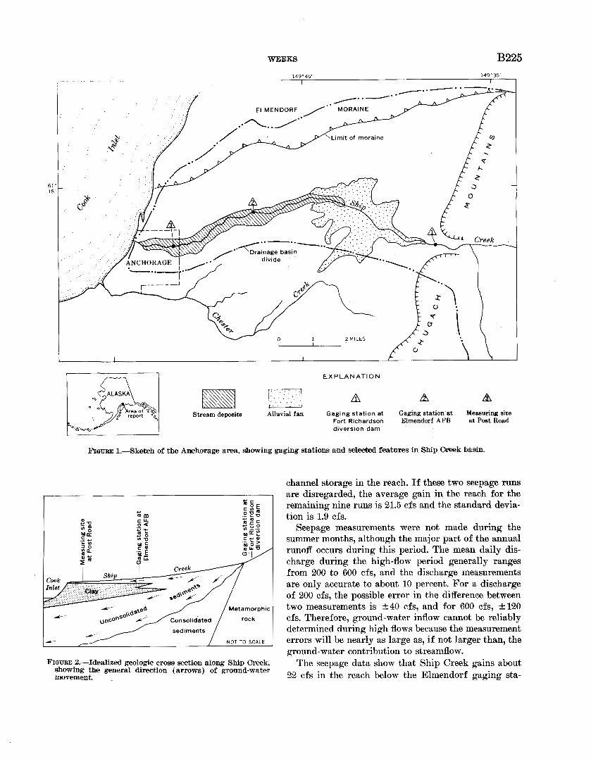
By JOHN B. WEEKS, Anchorage, Alaska
lVork done in cocrperation with tha city of Anchorage and the
Greater Anchorage Area Borou~h
Abstract.-Ship Creek drainage basin is an important re- station, Ship Creek at Elmendorf AFB, is located charge area for the Anchorage artesian aquifer. Discharge rec- downstream from the alluvial fan and %bout 4 miles ords show Ship Creek loses an average of 25 cfs in the recharg- ing area and gains about 22 cfs in the reach below the recharge
above the mouth of the stream. '
area. A water-budget analysis demonstrates that of this gain Discharge that for the period of record at least 11 cfs is ground-water return flow from the recharge the mean annual flow over the diversion dam is 150 area. cubic feet per second and that 6 miles downstream at
Elmendorf the discharge is 125 cfs. Previous investiga-
Ship Creek has its headwaters in the Chugach Moun- tors (Cederstrom and others, 1964; Waller, 1964; Som-
tains and discharges into Cook Inlet near downtown mers and Marcher, 1965) recognized that this reach of
Anchorage, Alaska. Its stream course traverses 10 miles Ship Creek was a losing reach. A recent investigation
of alluvial gravel and glacial outwash deposits in the by the author has show11 that part of this loss returns
lowlands and foothills. Since the last glaciation, Ship to the stream below the Elmendorf gaging station.
Creek has built an extensive alluvial fan at the foot of A series of seepage measurements was made to deter-
the Chugach Mountains (fig. 1) . This fan provides mine the relationship between surface water and
about one-fourth of the total recharge to the artesian ground water in Ship Creek basin. Concurrent dis-
aquifer system which underlies the city of Anchorage. charge measurements were made at the Elmendorf
The geology of the Anchorage area has been de- gaging station and at Post Road near the mouth of
scribed by Trainer (in Cederstrom and others, 1964) Ship Creek (fig. 1). The measurements were made dur-
and Miller and Dobrovolny (1959). As schematically ing periods of steady stage and no local surface runoff.
shown in figure 2, the surficial gravels in the reach of The discharge measurements near the mouth were
Ship Creek basin below the gaging station at Elmen- made above the tide-affected reach so that drainage
dorf Air Base are underlain by a clay bed which from bank storage did not contribute to the measured
is exposed at the moutll of ship creek. This clay discharge. Under these conditions, any increase in dis-
stratum forms the confining layer of the underlying charge downstream must be due to ground-water in-
artesian aquifer and the lower boundary of the uncon- flow. Table 1 tabulates the measurement data as well
fined aquifer in Ship Creek basin downstream froln us^^ seepage data.
the Elmendorf gage. Two of the previously existing seepage runs were T~~ gaging stations are operated on Ship Creek. disregarded because they were made under conditions
Continuous discharge records have been obtained since which did not conform to the above measuring cribria. 1946 at the Fort Richardson diversion dam, and are Climatologic records show that the seepage run on published as Ship Creek near Anchorage. This station April 27, 1959, was made while surface runoff from is located on exposures of metamorphic rock upstream snowmelt was contributing to streamflow. The seepage from the alluvial fan. Six miles downstream, the sec- run on May 16, 1967, was made during a period of ond gaging station has been operated since 1963. This rising stage so that the measured gain was affected by
U S GEOL. SURVEY PROF. PAPER 706B. PAGES B224-B228
B224

WEEKS B225
FI . . . . . ' . . . . . A A A
Stream deposits Alluvial fan Gaging station at Gaging station at Measuring site Fort Richardson Elmendorf AFB at Post Road diversion dam
FIOUBE 1.-Sketch of the Anchorage area, &wing g a a stations and sd-d features in S8hip Cheek basin.
iii = 4-
. n: 0 u ;: z k U B o
i4 g 4- - ;sE d b ME e o
Metamorphic Y
NOT TO SCALE
channel storage in the reach. If these two seepage runs are disregarded, the average gain in the reach for the remaining nine runs is 21.5 cfs and the standard devia- tion is 1.9 cfs.
Seepage measurements were not made during the summer months, although the major part of the annual runoff occurs during this period. The mean daily dis- charge during the high-flow period generally ranges from 200 to 600 cfs, and the discharge measurements are only accurate to about 10 percent. For a discharge of 200 cfs, the possible error in the difference between two measurements is 2 4 0 cfs, and for 600 cfs, rt-120 cfs. Therefore, ground-water inflow cannot be reliably determined during high flows because the measurement errors will be nearly as large as, if not larger than, the ground-water contribution to streamflow.
FIGURD 2.-Idealized geologic cross section along Ship Greek, The seepage data show that Ship Creek gains about showing the general direction (arrows) of ground-water movement. 22 cfs in the reach below the Elmendorf gaging sta-

B226 RELATION BETWEEN GROUND
TABLE 1.-Ship Creek seepage measurements made at the Elmendorf Air Force Base gage and near Post Road, i n cubic feet per second.
Discharge measurements Date 8eepsge
Elmendorf Post Road g m Ewe
Apr. 27, 1959 - - - - - - - - - - - - - - - 28.3 80. 8 52. 5 Apr. 26, 1960 - - - - - - - - - - - - - - - 20.4 44. 6 24. 2 Oct. 26, 1960 - - - - - - - - - - - - - - - - 172 193 21. 0 Mar. 13, 1961 .-------------- 19.2 40. 8 21. 6 May 16,1967 - - - - - - - - - - - - - - 182 191 9. 0 Sept. 12, 1968-- - - - - - - - - - - - - - - 75.0 97. 0 22. 0 Nov. 8, 1968 - - - - - - - - - - - - - - - -_ 17.6 41. 6 24. 0 Nov. 15, 1968 - - - - - - - - - - - - - - - - 2. 8 24. 0 21. 2 Jan.3, 1969------------------ 2. 3 21. 3 19. 0 Jan. 30, 1969 - - - - - - - - - - - - - - - - - 1. 4 23. 3 21. 9 Mar.26, 1969-- - - - - - - -+- - - - - - 1. 3 19. 9 18. 6
1 Data collected prior to this study.
tion during the low-flow period. Because the ground- water levels are higher in the summer than in the winter, the ground-water contribution to streamflow is likely to be greater during the high-flow period than during the low-flow period. Thus, it can be concluded that the mean annual gain is at least 22 cfs and pos- sibly more. This discharge is supplied is part by ground-water inflow from the recharge area above the Elmendorf gage. This can be shown by the following analysis of the unconfined aquifer in the reach of Ship Creek basin below Elmendorf.
The clay bed underlying Anchorage is exposed along the coastline and forms a ground-water dam which prevents discharge from the unconfined aquifier to Cook Inlet except through Ship Creek. Field observa- tions have located only minor seeps from the bluffs along the coast. The glacial deposits of the Elmendorf moraine (fig. 1) form a barrier to ground-water move- ment to the north, and a topographic high forms an unconfined ground-water divide to the south. Thus, except for vertical leakage through the clay, the only sources of recharge to the unconfined aquifer are in- filtration of precipitation and ground-water inflow from the recharge area above the Elmendorf gage.
The average annual precipitation ait Anchorage is 15.14 inches for the 25 years of record, and the area tributary to Ship Creek in the reach below Elmendorf is about 10 square miles. This average precipitation on the tributary area is equivalent to only about 11 cfs per year. Because direct runoff and evapotranspiration losses reduce the amount of precipitation available for recharge, the recharge to the unconfined aquifer must be less than 11 cfs. Therefore, if changes in storage are neglected, at least 11 cfs must be ground-water in- flow to account for the 22-cfs gain in Ship Creek.
Potentiometric levels in the reach of Ship Creek basin below Elmendorf have dropped approximately 25 feet in the last 10 years. The seepage data indicate that no significant change in the gain has occurred dur-
WATER AND SURFACE WATER
149'55'
0 1 2 MILES - 1 61" 15'
Measuring site at Post Road
FIGURE 3.-Sketch ehowing ehange in area of Ship Creek basin where artesian po~tentiom&ric levels were above land surface in 1958 and 1968, as indicated by patterns
ing this period (standard deviation of 1.9 cfs), and field observations have disclosed that most of the gain occurs in the first half mile below the Elmendorf gage. Because the present potentiometric surface is below stream level in this reach (fig. 3) , vertical leakage through the clay cannot contribute to streamflow. The 11-cfs gain must come from the recharge area above the Elmendorf gaging station. Consequently, any esti- mate of recharge to the aquifer system from the area of Ship Creek basin between the diversion dam and the gage at Elmendorf must account for this return flow.
The presence of recent stream deposits along Ship Creek (fig. 1) suggests that the 11-cfs return flow may be largely in the form of underflow. That is, about half of the 25 cfs that is lost in the upper reach of Ship Creek actually recharges the aquifer system, and the remaining half moves through the highly permeable gravels under and adjacent to the stream down- gradient.
REFERENCES Cederstrom, D. J., Trainer, F. W., and Waller, R. M., 1964, Geol-
ogy and ground-water resources of the Anchorage area, Alaska : U.S. Geol. Survey Water-Supply Paper 1773, 108 p.
Miller, R. D., and Dobrovolny, Ernest, 1959, Surficial geology of Anchorage and vicinity, Alaska : U.S. Geol. Survey Bull. 1093, 128 p.
Sommers, D. A., and Marcher, M. V., 1965, Water resources ap- praisal of the Anchorage area, Alaska: U.S. Geol. Survey open-file report, 34 p.
Waller, R. M., 1964, Hydrology and the effects of increased ground-water pumping in the Anchorage area, Alaska: U.S. Geol. Survey Water-Supply Paper 1779-D, 36 p.
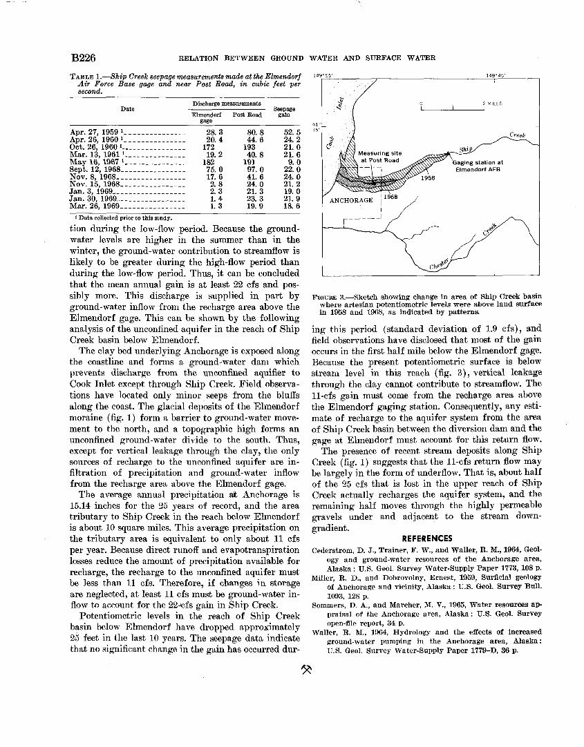
B226 RELATION BETWEEN GROUND
TABLE 1.-Ship Creek seepage measurements made at the Elmendorf Air Force Base gage and near Post Road, i n cubic feet per second.
Discharge measurements Date 8eepsge
Elmendorf Post Road g m Ewe
Apr. 27, 1959 - - - - - - - - - - - - - - - 28.3 80. 8 52. 5 Apr. 26, 1960 - - - - - - - - - - - - - - - 20.4 44. 6 24. 2 Oct. 26, 1960 - - - - - - - - - - - - - - - - 172 193 21. 0 Mar. 13, 1961 .-------------- 19.2 40. 8 21. 6 May 16,1967 - - - - - - - - - - - - - - 182 191 9. 0 Sept. 12, 1968-- - - - - - - - - - - - - - - 75.0 97. 0 22. 0 Nov. 8, 1968 - - - - - - - - - - - - - - - -_ 17.6 41. 6 24. 0 Nov. 15, 1968 - - - - - - - - - - - - - - - - 2. 8 24. 0 21. 2 Jan.3, 1969------------------ 2. 3 21. 3 19. 0 Jan. 30, 1969 - - - - - - - - - - - - - - - - - 1. 4 23. 3 21. 9 Mar.26, 1969-- - - - - - - -+- - - - - - 1. 3 19. 9 18. 6
1 Data collected prior to this study.
tion during the low-flow period. Because the ground- water levels are higher in the summer than in the winter, the ground-water contribution to streamflow is likely to be greater during the high-flow period than during the low-flow period. Thus, it can be concluded that the mean annual gain is at least 22 cfs and pos- sibly more. This discharge is supplied is part by ground-water inflow from the recharge area above the Elmendorf gage. This can be shown by the following analysis of the unconfined aquifer in the reach of Ship Creek basin below Elmendorf.
The clay bed underlying Anchorage is exposed along the coastline and forms a ground-water dam which prevents discharge from the unconfined aquifier to Cook Inlet except through Ship Creek. Field observa- tions have located only minor seeps from the bluffs along the coast. The glacial deposits of the Elmendorf moraine (fig. 1) form a barrier to ground-water move- ment to the north, and a topographic high forms an unconfined ground-water divide to the south. Thus, except for vertical leakage through the clay, the only sources of recharge to the unconfined aquifer are in- filtration of precipitation and ground-water inflow from the recharge area above the Elmendorf gage.
The average annual precipitation & Anchorage is 15.14 inches for the 25 years of record, and the area tributary to Ship Creek in the reach below Elmendorf is about 10 square miles. This average precipitation on the tributary area is equivalent to only about 11 cfs per year. Because direct runoff and evapotranspiration losses reduce the amount of precipitation available for recharge, the recharge to the unconfined aquifer must be less than 11 cfs. Therefore, if changes in storage are neglected, at least 11 cfs must be ground-water in- flow to account for the 22-cfs gain in Ship Creek.
Potentiometric levels in the reach of Ship Creek basin below Elmendorf have dropped approximately 25 feet in the last 10 years. The seepage data indicate that no significant change in the gain has occurred dur-
WATER AND SURFACE WATER
149'55'
0 1 2 MILES - 1 61" 15'
Measuring site at Post Road
~ G U R E 3.-Sketch ehowing ehange in area of Ship Creek basin where artesian po~tentiom&ric levels were above land surface in 1958 and 1968, as indicated by patterns
ing this period (standard deviation of 1.9 cfs), and field observations have disclosed that most of the gain occurs in the first half mile below the Elmendorf gage. Because the present potentiometric surface is below stream level in this reach (fig. 3) , vertical leakage through the clay cannot contribute to streamflow. The 11-cfs gain must come from the recharge area above the Elmendorf gaging station. Consequently, any esti- mate of recharge to the aquifer system from the area of Ship Creek basin between the diversion dam and the gage at Elmendorf must account for this return flow.
The presence of recent stream deposits along Ship Creek (fig. 1) suggests that the 11-cfs return flow may be largely in the form of underflow. That is, about half of the 25 cfs that is lost in the upper reach of Ship Creek actually recharges the aquifer system, and the remaining half moves through the highly permeable gravels under and adjacent to the stream down- gradient.
REFERENCES Cederstrom, D. J., Trainer, F. W., and Waller, R. M., 1964, Geol-
ogy and ground-water resources of the Anchorage area, Alaska : U.S. Geol. Survey Water-Supply Paper 1773, 108 p.
Miller, R. D., and Dobrovolny, Ernest, 1959, Surficial geology of Anchorage and vicinity, Alaska : U.S. Geol. Survey Bull. 1093, 128 p.
Sommers, D. A., and Marcher, M. V., 1965, Water resources ap- praisal of the Anchorage area, Alaska: U.S. Geol. Survey open-file report, 34 p.
Waller, R. M., 1964, Hydrology and the effects of increased ground-water pumping in the Anchorage area, Alaska: U.S. Geol. Survey Water-Supply Paper 1779-D, 36 p.