republic of guinea-bissau - unfcccunfccc.int/resource/docs/napa/gnb01.pdf · republic of...
TRANSCRIPT
REPUBLIC OF GUINEA-BISSAU
National Programme of Action ofAdaptation to Climate Changes
MMiinniissttrryy ooff NNaattuurraall RReessoouurrcceess aanndd EEnnvvrroonnnnmmeennttGGoovveerrnnmmeenntt ooff GGuuiinneeaa--BBiissssaauu
DDeecc eemm bb eerr 22000066
NAPA GUINEA-BISSAU
PPRREEFFAACCEE
CCCClimate changes constitute nowadays the greatest threat against life on earth and theyare intimately related to the existence of poverty. Their impact varies according todifferent geographical zones. The least developed countries (LDCs), among which
Guinea-Bissau, are the most affected ones due to their geo-climatic conditions, high reliance onnatural resources and their limited capacity to adapt themselves to the negative impact of thosechanges.
Like many regions of the planet, and West Africa in particular, the country has witnessed inthe last years a significant disruption in its rainfall and hydrometric patterns. Rainfall shortfall,coastal erosion and salt invasion area have as their main consequences an accentuated aridityof soils, a significant reduction in major humid zones and the disappearance of some rivers andlakes. Torrential rains and extreme temperatures are also climate phenomena that prove anddemonstrate our country’s vulnerability.
Guinea-Bissau is thus exposed to the negative effects of climate changes in almostall productive sectors of national life, particularly as regards its population and naturalecosystems. Among the foreseen consequences, we single out a fall in agricultural, forest andgrazing production, loss of human lives arising from malnutrition and food insecurity, risk ofendemic disease such as diarrhoea, cholera, typhoid fever, tuberculosis, etc.
In such a context, the preparation and finalisation of the National Programme of Action ofAdaptation to Negative Effects of Climate Changes (NAPA), financed by the Global EnvironmentFacility (GEF), under the country’s joining of the Framework Convention on Climate Changesand the Kyoto Protocol, aimed at assessing the country’s vulnerability to the above-mentionedphenomena and proposing steps and priority activities aiming at reducing and/or mitigatingthe negative effects of climate changes and implementing early warning and forecastingmeasures enabling a response to future catastrophes.
PANA preparation had as its focus the integration of the environmental dimension intosector strategies of the fight against poverty and national development. This exercise will leadto the identifying of the agrarian, water supply, health and coastal area sectors as the priorityones in the adoption of immediate adaptation steps and actions, representing an overallfinancial effort estimated at around US$ 6.300,000, for whose materialisation Guinea-Bissaucounts on the international community’s invaluable support and solidarity.
Bissau 18 July 2007.
The Minister of Natural Resources and Environment
Soares SAMBU
Nacional Programme of Action of Adaptation to Climate Changes
Página 5

LLIISSTT OOFF CCOONNTTEENNTTSSpp.
PREFACE ........................................................................................................................................................................................ 5ABBREVIATIONS AND ACRONYMS .......................................................................................................................................... 7LIST OF FIGURES AND TABLES .................................................................................................................................................. 9EXECUTIVE SUMMARY.............................................................................................................................................................. 111. BACKGROUND ...................................................................................................................................................................... 132. INTRODUCTION AND PARAMETERS................................................................................................................................... 14Figure no. 1 Superposing of isohyets of normal rainfall figures ...........................................................................................14GEOGRAPHICAL SITUATION.................................................................................................................................................... 173. COUNTRY’S BROAD CHARACTERIZATION.........................................................................................................................173.1- GEOGRAPHICAL SITUATION.............................................................................................................................................173.2 METEOROLOGICAL AND CLIMATE PROFILE ...................................................................................................................17Figure no. 2: Distribution of minimum temperatures (ºC), 1950-1994 .............................................................................17Figure no. 3: Distribution of minimum temperatures (ºC), 1950-1994 ..............................................................................183.3 GEOMORPHOLOGY ............................................................................................................................................................18Figure no. 4: Spot Image of Guinea-Bissau Coastal Area (Source: J. Biai, 2005).................................................................18 3.4 SOILS AND HYDROGRAPHIC BASINS ...............................................................................................................................19Figure no. 5: - Soil occupancy by different vegetation formations........................................................................................193.5 FAUNA AND FLORA ............................................................................................................................................................20Figure no. 5: Sub-humid forest, dry savannah and natural palm-tree plantation ..............................................................203.6 COASTAL EROSION .............................................................................................................................................................20Figure no. 6 Coastal Erosion in Guinea-Bissau’s northwest (Varela beach)..........................................................................21Figure no. 7 Coast with mangrove ........................................................................................................................................... 21Figure no. 8 Rocky coast with escarpment, Carache island (from C. Pennober, 1999).......................................................223.7 EXCEPTIONAL EVENTS ........................................................................................................................................................223.7.1 CATASTROPHES.................................................................................................................................................................223.8 ANTHROPIC PRESSURE ON NATURAL RESOURCES..........................................................................................................223.8.1. AGRARIAN SECTOR .........................................................................................................................................................22UPLAND ECOSYSTEM ............................................................................................................................................................... 22MANGROVE ECOSYSTEM ........................................................................................................................................................ 23SMALL VALLEYS’ ECOSYSTEM ................................................................................................................................................. 243.8.2 FORESTS ............................................................................................................................................................................ 24Table no. 1 – Forest resources developments during 1978-1985........................................................................................ 24Table no. 2................................................................................................................................................................................... 243.8.3 LIVESTOCK........................................................................................................................................................................ 26Table no. 3 –NATIONAL LIVESTOCK OVERALL NUMBER...................................................................................................... 263.8.4. WATER SECTOR .............................................................................................................................................................. 263.8.5 FISHING RESOURCES....................................................................................................................................................... 284. SOCIO-ECONOMIC SITUATION ......................................................................................................................................... 295. INFLUENCE OF CLIMATE CHANGE AND VARIABILITY IN WEATHER PATTERNS ON BIOPHYSICAL PROCESSES AND KEY SECTORS ............................................................................................ 305.1 HISTORIC FINDINGS ...........................................................................................................................................................30Figure n.º 9: Bed of Bidigor river............................................................................................................................................ 315.1.1 INFLUENCE OF CLIMATE AND VARIABILITY IN WEATHERPATTERNS ON BIOPHYSICAL PROCESSES................................................................................................................................ 315.2 IMPACT ON KEY SECTORS .................................................................................................................................................325.2.1. AGRICULTURE .................................................................................................................................................................325.2.2. Forests............................................................................................................................................................................... 32Figure n.º 10. Upland Agriculture-South of the Country (Photo: A. Cabral, 2006)............................................................. 325.2.3 LIVESTOCK........................................................................................................................................................................ 33Figure n.º 11. Transhumance from the east to the south of the country (Picture Alexandre Cabral, 2006)....................335.2.4 FISHERIES ......................................................................................................................................................................... 345.2.5 WATER RESOURCES......................................................................................................................................................... 345.2.6 HEALTH............................................................................................................................................................................. 356. FRAMEWORK OF ADAPTATION PROGRAMME ................................................................................................................. 35
Nacional Programme of Action of Adaptation to Climate Changes
Página 3

6.1 PROJECTED WEATHER PATTERNS VARIABILITIES AND CLIMATE CHANGES ............................................................... 356.2 VARIABILITY OF WEATHER PATTERNS AND PROJECTED CLIMATE CHANGES ........................................................... 357. POTENTIAL IMPACTS OF CLIMATE CHAGES .................................................................................................................... 367.1 POTENTIAL IMPACTS ..........................................................................................................................................................367.2 POTENTIAL IMPACTS THAT WILL AFFECT POPULATIONS THE MOST ....................................................................... 37Table no. 4: POTENTIAL IMPACTS .......................................................................................................................................... 37Table no. 5 – ESSENTIAL NEEDS IN TERMS OF ADAPTATION AND THEIR ........................................................................ 38 ARTICULATION WITH NATIONAL POLICIES AND PLANS8. SYHTHESIS OF RISKS AND POTENTIAL IMPACTS ............................................................................................................. 42Table no. 6: Survey of risks and potential impacts ................................................................................................................ 439. SENSITIVITY ANALYSIS ON RESOURCES, SECTORS, ZONES ANDMOST VULNERABLE HUMAN GROUPS ................................................................................................................................. 45Table no. 7: Hypothetical Sensitivity Matrix ........................................................................................................................... 4510. TYPOLOGY OF PARTICULARLY VULNERABLE GROUPS ................................................................................................. 46Table no. 8: MOST VULNERABLE POPULATION SEGMENTS ............................................................................................... 4611. NAPA IMPLEMENTATION STRATEGY................................................................................................................................ 4612. COORDINATION AND INSTITUTIONAL ARRANGEMENTS ON ADAPTATION .............................................................4612.1 COMMITTEE COMPOSITION ..........................................................................................................................................4612.2 ADAPTATION COMMUNICATION STRATEGY............................................................................................................... 4712.2.1 SURVEY OF ADAPTATION OPTIONS .......................................................................................................................... 4713. CRITERIA FOR SELECTION OF ADAPTATION OPTIONS ..................................................................................................47SCALE: 1 to 5 ............................................................................................................................................................................. 4714. PRIORITIZATION OF ADAPTATION OPTIONS ................................................................................................................ 48Table no. 9 – Options resulting from the analysis of multiple criteria: 1 level of significance of impact; 2 poverty reduction; 3 synergy with AMA; 4 costs; 5 gender; 6 beneficiaries .........................................................................................................................49Table no. 10 – The following project sorting was obtained as a result of theexercise performed, and location and costs are presented on the table below ..................................................................50
15. METHODOLOGICAL PROCESS FOR PREPARATION OF NATIONAL ADAPTATION PROGRAMME – NAPA ...............5116. METHODOLOGICAL PROCESS FOR PREPARATION OF NATIONAL ADAPTATION PROGRAMME – NAPA ..............5217. NAPA’S RELATION WITH DEVELOPMENT PROGRAMMES MULTILATERAL AGREEMENTS ON ENVIRONMENT ............................................................................................................ 53Table 11 List of Projects relating to NAPA .............................................................................................................................. 5318. OBSTACLES TO IMPLEMENTATION .................................................................................................................................. 5419. MEASURES IMPLEMENTED TO TACKLE CLIMATE CHANGES ....................................................................................... 54AGRARIAN SECTOR: .................................................................................................................................................................. 54Environmental Sector ................................................................................................................................................................ 55Structural Reforms......................................................................................................................................................................55Actions carried out by NGOs .................................................................................................................................................... 56ANNEXES .................................................................................................................................................................................... 57PROJECT FILE No. 1.................................................................................................................................................................... 59PROJECT FILE No. 2.................................................................................................................................................................... 61PROJECT FILE No. 3.....................................................................................................................................................................63PROJECT FILE No. 4.................................................................................................................................................................... 65PROJECT FILE No. 5.....................................................................................................................................................................68PROJECT FILE No. 6.....................................................................................................................................................................70PROJECT FILE No. 7.....................................................................................................................................................................72PROJECT FILE No. 8.....................................................................................................................................................................74PROJECT FILE No. 9.....................................................................................................................................................................76PROJECT FILE No. 10...................................................................................................................................................................78PROJECT FILE No. 11...................................................................................................................................................................80PROJECT FILE No. 12...................................................................................................................................................................82PROJECT FILE No. 13...................................................................................................................................................................83PROJECT FILE No.14....................................................................................................................................................................85
Nacional Programme of Action of Adaptation to Climate Changes
Página 4
AABBBBRREEVVIIAATTIIOONNSS AANNDD AACCRROONNYYMMSS
AIA Environmental Impact EvaluationAIDS Acquired Immunodeficiency SyndromeAMA Multilateral Agreements on the EnvironmentCIMA Water Inter-ministerial Committee CN NAPA NAPA National CommitteeCAN National Water CommitteeCNI Initial National Communication on Climatic ChangesCO2 Carbon DioxideCPDA Letter on Agrarian Development PolicyCR NAPA NAPA Regional CommitteeCTA Water Technical CommitteeCTA Centre of Agrarian Technical AssistanceDENARP Poverty Reduction Strategy PaperDGA Directorate-general of EnvironmentDGADR Directorate-general of Agriculture and Rural DevelopmentDGFC Directorate-general of Forests and HuntingDGRH Directorate-general of Human ResourcesDP Development PlanEPAN-DB Strategy and National Plan of Action for Biological DiversityEEZ Exclusive Economic ZoneEU European UnionG.B. Guinea-BissauGEF Global Environment FundGOGB Government of Guinea-BissauHDI Human Development IndexHIV Human Immunodeficiency VirusIA/Portugal Environment InstituteIBAP Institute of Biodiversity and Protected AreasIFAD International Fund on Agricultural DevelopmentINA National Environment InstituteIUCN International Union for Conservation of NatureLDCs Least Developed CountriesLVIA Italian Non-Governmental OrganizationMADR Ministry of Agriculture and Rural DevelopmentME Ministry of EconomyMF Ministry of FinanceMINSAP Ministry of Public HealthMRN Ministry of Natural ResourcesNAPA National Programme of Action for Adaptation to Climate Changes NGO Non-Governmental OrganisationOMVG Gambia River Basin Development OrganisationPAC Common Agricultural PolicyPGBZCGB Biodiversity and Coast Management ProjectPIB Gross Domestic ProductPNGA Environmental Management National PlanRT Registered Tonnage2SN Second National Communication SPV Vegetation Protection ServiceWAEMU West African Economic and Monetary UnionWB World Bank
Nacional Programme of Action of Adaptation to Climate Changes
Página 7

LLIISSTT OOFF FFIIGGUURREESS
FFiigguurree nn..ºº 11 :: SSuuppeerrppoossiinngg ooff iissoohhyyeettss ooff nnoorrmmaall rraaiinnffaall ll ffiigguurreess.............................................10
FFiigguurree nn.. ºº 22:: DDiissttrriibbuuttiioonn ooff mmiinniimmuumm tteemmppeerraattuurreess ((ººCC)),, 11995500--11999944..Erro! Marcador não
definido.3
FFiigguurree nnºº 33 DDiissttrriibbuuttiioonn ooff mmiinniimmuumm tteemmppeerraattuurreess ((ººCC)),, 11995500--11999944...Erro! Marcador não
definido.3
FFiigguurree 44::-- SSppoott IImmaaggee ooff GGuuiinneeaa--BBiissssaauu ccooaassttaall aarreeaa........................Erro! Marcador não definido.
FFiigguurree nn..ºº 55 –– SSooiill ooccccuuppaannccyy bbyy ddiiffffeerreenntt vveeggeettaattiioonn ffoorrmmaattiioonnss..........Erro! Marcador não
definido.
FFiigguurree 66:: SSuubb--hhuummiidd ffoorreesstt,, ddrryy ssaavvaannnnaahh aanndd nnaattuurraall ppaallmm ttrreeee ffoorreesstt....Erro! Marcador não
definido.
FFiigguurree nnºº77::CCooaassttaall eerroossiioonn oonn GGuuiinneeaa--BBiissssaauu ffaarr nnoorrtthhwweesstt ,, VVaarreellaa bbeeaacchh.......Erro! Marcador
não definido.
FFiigguurree nnºº 88:: CCooaasstt wwiitthh mmaannggrroovveess ((PPhhoottoo ooff JJuussttiinnoo BBiiaaii)).............Erro! Marcador não definido.
FFiigguurree nn..ºº 99 :: RRoocckkyy ccooaasstt wwiitthh sstteeeepp ssllooppee.. CCaarraacchhee iissllaanndd............Erro! Marcador não definido.
FFiigguurree nn..ºº 1100:: UUppllaanndd aaggrriiccuullttuurree –– SSoouutthh ooff tthhee CCoouunnttrryy .............Erro! Marcador não definido.
FFiigguurree nn..ºº 1111:: TTrraannsshhuummaannccee ffrroomm tthhee EEaasstt ttoo tthhee SSoouutthh ooff tthhee CCoouunnttrryy.............Erro!
Marcador não definido.
FFiigguurree nn..ºº 1133:: GGrraapphhiicc ooff rraaiinnffaall ll//ssuurrffaaccee--wwaatteerr ff lloowwaaggee rreellaattiioonn ……........................…...…..
Nacional Programme of Action of Adaptation to Climate Changes
Página 9

LLIISSTT OOFF TTAABBLLEESS
TTaabbllee nn..ºº 11-- EEvvoolluuttiioonn ooff ffoorreesstt rreessoouurrcceess ,, 11997788--11998855....................Erro! Marcador não definido.
TTaabbllee nn..ºº 22 :: EEsstt iimmaatteess ooff wwoooodd pprroodduuccttiioonn ppeerr ttyyppee ooff ffoorreesstt.......Erro! Marcador não definido.
TTaabbllee nn..ºº 33 :: OOvveerraallll nnuummbbeerr ooff ll iivveessttoocckk nnaattiioonnwwiiddee.......................Erro! Marcador não definido.
TTaabbllee nn.. ºº 44:: PPootteennttiiaall IImmppaaccttss:.....................................................................Erro! Marcador não definido.
TTaabbllee nn..ºº 55 –– LLiinnkkiinngg ooff eesssseennttiiaall aaddaappttaattiioonn nneeeeddss wwiitthh
nnaattiioonnaall ddeevveellooppmmeenntt ppoolliicciieess aanndd ppllaannss .....................................…..Erro! Marcador não definido.
TTaabbllee nn..ºº 66:: IInnvveennttoorryy ooff ppootteennttiiaall rriisskkss aanndd iimmppaaccttss:......................Erro! Marcador não definido.
TTaabbllee nn..ºº 77:: HHyyppootthheettiiccaall SSeennssiitt iivviittyy MMaattrriixx.........................................Erro! Marcador não definido.
TTaabbllee nn..ºº 88:: MMoosstt VVuullnneerraabbllee PPooppuullaatt iioonn SSeeggmmeennttss......................................................................... 40
TTaabbllee nn..ºº 99 –– OOppttiioonnss rreessuulltt iinngg ffrroomm tthhee aapppplliiccaattiioonn ooff mmuulltt iippllee
aannaallyyssiiss ccrriitteerriiaa...............................................................................................................................................42
TTaabbllee nn..ºº 1100 –– SSoorrttiinngg aanndd ccoossttss ooff ooppttiioonnss//pprroojjeeccttss........................Erro! Marcador não definido.
TTaabbllee nn..ºº 1111:: LLiisstt iinngg ooff PPAARRAA--rreellaatteedd mmoobbiill iisseedd pprroojjeeccttss.................Erro! Marcador não definido.
Nacional Programme of Action of Adaptation to Climate Changes
Página 10

EEXXEECCUUTTIIVVEE SSUUMMMMAARRYY
Participatory evaluations on vulnerability and adaptation carried out under NAPA on thebasis of various studies and sector consultations already made, revealed that the sectors thatensure the subsistence of the overwhelming majority of Guinean households and constitutethe country’s economic basis are the most vulnerable ones to climate change: the agrariansector (agriculture, forests and livestock), the sector of water resources and the fishing sec-tor. Anthropic pressure on natural resources, with increasingly onerous and worryingimpacts, aggravates this vulnerability.
It is obvious that climate changes and variability in weather patterns may seriously affectthe economic growth of countries with scarce resources and hence exacerbate poverty andsocial inequity.
In Guinea-Bissau the impact of those changes were already being felt in the economy forsome time, especially due to a diminishing rainfall and the gradual rise in temperature. Interms of water resources, this can be seen in aquifers that have decreasing quantities of waterand are more easily flooded by salt water, ground waters increasingly deeper and dried-uplakes; concerning the agrarian sector, production of Guinean staple food (rice), has dimi-nished markedly, also due to the salinity and acidity of hydromorphous soils and the floo-ding of rice fields. Air temperature is higher as a result of a considerable rise in the sea leveland, consequently, high tides increase in frequency and are more powerful; the dry seasonlasts longer, especially in the hinterland (eastern regions); and the surface belonging tohumid zones has decreased.
Guinea-Bissau is one of the poorest countries in the world and it lack means to tackleproblems arising from climate changes. Thus this programme aims at defining priorityactions to be implemented with assistance from multilateral and bilateral partners and/ordomestic partners with a view to meeting their requirements and concerns regarding adap-tation to the nefarious effects of those changes.
A number of priority strategic actions were defined, through a widely participatory exer-cise, to deal with concerns felt by the most vulnerable groups relative to climate changes.Those actions aim essentially at enhancing the level of rural populations’ food security so asto reinforce their adaptation capabilities, reduce pressure on forest and fishing resources andimprove access to potable water for human consumption and livestock, because climatechanges exert a negative influence on the quality and quality of water resources through areduction in rainfall. 14 projects were chosen in order to achieve these strategic objectivesnamely: (i) Diversification of Food Production; (ii) Improvement in the Supply of PotableWater in Rural Areas; (iii) Reinforcement of Preventive Capacity and Protection of MangroveRice Fields against High Tides; (iv) Observatory for Mangrove Monitoring and Evaluation; (v)Follow up of Erosion on Coastal Zones; (vi) Evaluation of Climate Changes Impact inProductive Sectors; (vii) Promotion of Small scale Irrigation on Embankments of Geba andCorubal rivers; (viii) Prevention of Natural Catastrophes (ix) Protection, Conservation andEnhancement of Fishing and Coastal Resources; (x) Integrated System of Information on Food
Nacional Programme of Action of Adaptation to Climate Changes
Página 11

Security (SISA); (xi) Environmental Education and Communication on the coastal zone; (xii)Rehabilitation of Small Perimeters of Mangrove Soils for Rice- Growing in Tombali, Quinara,Bafatá and Oio; (xiii) Support to Production of Short-Cycle Animals; (xiv) Reforesting ofDegraded Zones.
The criteria adopted for the selection and sorting of the above-mentioned options are asfollows: (1) level of significance of impacts; (2) contribution for poverty relief; (3) synergywith multilateral agreements on the environment (AMA); (4) costs; (5) gender; (6) numberof beneficiaries.
This programme does not constitute an isolated initiative but it is rather integrated in a setof sector-wide development programmes as well as in the decision processes and nationalplanning.
Nacional Programme of Action of Adaptation to Climate Changes
Página 12

11.. BBAACCKKGGRROOUUNNDD
It is recognized by science and the community of nations that climate changes that occurin our planet constitute a threat to life and mankind. There is a strong probability that thosechanges will have dramatic consequences on least developed countries (LDCs), particularlyconcerning losses of human lives and negative effects on the economy and investment. Thestarting assumption is that LDCs’ vulnerability may be dictated by the following factors:
• Their geographical situation and climate conditions• The extreme dependency of their populations on natural resources• Their backwardness and economic frailty• Their limited capacity to adapt to negative climate developments.
Climate changes and variability in weather patterns may affect the rate of economicgrowth, exacerbate poverty and social inequalities, and jeopardise chances of success ofdevelopment policies meant to fight poverty.
As an unequivocal way to address this situation, the Conference of Parties to the UnitedNations Framework Convention on Climate Changes approved in 2001 the preparation ofNational Programmes of Action for Adaptation to Climate Changes (NAPA) for LDCs. NAPA’srole consists in proposing immediate and urgent activities that are to be implemented inorder to raise capacity of adaptation, and as result, of resistance to current and futurenegative effects of climate changes and extreme meteorological phenomena. Guidelines onNAPA’s preparation process were defined in this Conference (Directive 28/C.P.7). ThisDirective asserts that the approach behind NAPA’s preparation will be underpinned on (i)complementary aspects based on existing national development plans and programmeswith a view to advancing broader objectives aimed at poverty reduction and sustainabledevelopment, and (ii) search for synergies between NAPA and Multilateral Agreements on theEnvironment focusing on adaptation and capacity building. The present NAPA was preparedunder the framework towards the enactment of this Directive. The aim is to have NAPA notas an isolated occasional action but rather as part of a set of development sector programmesand an integral part of decision-making and planning processes at the national level. Itconstitutes a first stage of Guinea-Bissau efforts towards the implementation of initiativesgeared at the implementation of initiatives seeking adaptation to long term climate changesand variability in weather patterns.
Starting from the reality that Guinea-Bissau lacks sufficient means to fight problemsarising from climate changes, NAPA should allow Guinea-Bissau to define and implementpriority actions hereby identified, so as to meet its needs and deal with its concerns in thefield of adaptation to the effects of those changes.
Nacional Programme of Action of Adaptation to Climate Changes
Página 13
22.. IINNTTRROODDUUCCTTIIOONN AANNDD PPAARRAAMMEETTEERRSS
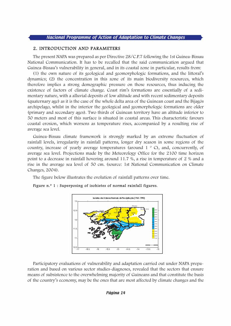
The present NAPA was prepared as per Directive 28/C.P.7 following the 1st Guinea-BissauNational Communication. It has to be recalled that the said communication argued thatGuinea-Bissau’s vulnerability in general, and in its coastal zone in particular, results from:
(1) the own nature of its geological and geomorphologic formations, and the littoral’sdynamics; (2) the concentration in this zone of its main biodiversity resources, whichtherefore implies a strong demographic pressure on those resources, thus inducing theexistence of factors of climate change. Coast rim’s formations are essentially of a sedi-mentary nature, with a alluvial deposits of low altitude and with recent sedimentary deposits(quaternary age) as it is the case of the whole delta area of the Guinean coast and the Bijagósarchipelago, whilst in the interior the geological and geomorphologic formations are older(primary and secondary ages). Two thirds of Guinean territory have an altitude inferior to50 meters and most of this surface is situated in coastal areas. This characteristic favourscoastal erosion, which worsens as temperature rises, accompanied by a resulting rise ofaverage sea level.
Guinea-Bissau climate framework is strongly marked by an extreme fluctuation ofrainfall levels, irregularity in rainfall patterns, longer dry season in some regions of thecountry, increase of yearly average temperatures (around 1 º C), and, concurrently, ofaverage sea level. Projections made by the Meteorology Office for the 2100 time horizonpoint to a decrease in rainfall hovering around 11.7 %, a rise in temperature of 2 % and arise in the average sea level of 50 cm. (source: 1st National Communication on ClimateChanges, 2004).
The figure below illustrates the evolution of rainfall patterns over time.
FFiigguurree nn..ºº 11 :: SSuuppeerrppoossiinngg ooff iissoohhiieetteess ooff nnoorrmmaall rraaiinnffaall ll ff iigguurreess.
Participatory evaluations of vulnerability and adaptation carried out under NAPA prepa-ration and based on various sector studies-diagnoses, revealed that the sectors that ensuremeans of subsistence to the overwhelming majority of Guineans and that constitute the basisof the country’s economy, may be the ones that are most affected by climate changes and the
Nacional Programme of Action of Adaptation to Climate Changes
Página 14
-17 -16.5 -16 -15.5 -15 -14.5 -14 -13.5 -1310.5
11
11.5
12
12.5
13
Bafatá
Bis/AeroBis/Obs
Bissorã
Bolama Buba
Bubaque
Bula
Buruntuma
Cacheu
Cacine
Cantchungo
Catió
Farim
Fulacunda
GabúIngore
Madina Boé
Mansaba
Nhacra
Pirada
SonacoVarela
1100
1200
1300
1400
1500
1600
1700
1800
1900
2000
2100
2200
2300
Isoietas dos Valores Normais de Precipitação (1961-1990)
0 0 .5 1 1 .5

variability in weather patterns, namely: the agrarian sector (agriculture, forests andlivestock), water resources, fisheries and public health.
This finding, supported by technical data provided in reports on sector studies, PRSP andothers (cf. bibliography), arises from the fact that (i) the economy is largely dependent onagriculture, whose activity relies on rainfall intensity and regularity, and where cashew is thepredominant crop, contributing with 62.6% for the GDP in 2004, against a share of only12.2% for industry and 25.2% for services in the same year; (ii) a large part of population isconcentrated on the coastal zone (80%) and depends vitally on the direct exploration ofnatural resources for its survival, (iii) infrastructure being highly concentrated on coastalareas, (iv) difficult economic and social conditions, characterised by extreme poverty andhigh unemployment rate, (v) very fragile soils, exposed to rain-driven and coastal erosion (vi)expansion of agricultural production associated to forest felling and slash-and-burnpractices (itinerant agriculture), (vii) bad soil occupancy, due to a lack of agriculturalzoning, (viii) an accelerated destruction of forests, estimated at 30,000-60,000 ha/year, withnegative effects on current sequestration capacity estimated at 11,288,401 atmospheric CO2,(ix) a relatively high rate of population growth (2.05% nationwide, and 4% in the capital,Bissau), (x) water-related problems, (xi) outdated and/or ill applied legislation, or evennot applied legislation, (xii) weak or non existent intervention capacity on the part ofinstitutions, (xiii) absence of protection rules and norms against climate risks linked to theconstruction of infrastructure, (xiv) the very precarious nature of traditional housing (madeof mud and covered with straw).
The country has survived, at a painful cost for its populations, to cycles of chronic crises,characterized by a worsening of access to water for agricultural purposes, human andanimal consumption; a marked fall in agricultural production, staple food items (rice inparticular); a rise in costs of some foodstuff, particularly in urban and semi-urban centres, adeterioration in prices of cashew and cotton and a increase in food insecurity.
Potential impacts of this evolution, especially due to decreasing levels of rainfall and a risein average temperatures, are already empirically noticeable in many areas. Here are someexamples:
In terms of water resources, we see aquifers with less water and more easily penetratedby salt water in coastal zones, increasingly deeper ground waters and dried-up lakes; in theagrarian sector, the production of populations’ main staple food (rice) had markedlydecreased, due also to salinity and acidification of hydromorphous soils, destruction ofprotective dykes, flooding of rice fields, abandonment of degraded land, erosion and others;
Greater pressure on uplands, with the consequent deforesting arising from uplandagriculture and timber exploration; higher air temperatures), higher average sea levels,resulting in more frequent and impetuous high tides; narrower river beds due to silting;longer dry season, particularly in countryside regions (eastern part of the country), leadingto the displacement of whole villages; longer cattle transhumance involving a larger numberof animals (especially cattle and goats); smaller humid zones surfaces; existence of a greaternumber of areas of ecological reduction of some aquatic species, fish in particular that are
Nacional Programme of Action of Adaptation to Climate Changes
Página 15
changed/affected or even destroyed; increasing trends of HIV/AIDS and hepatitis were addedto traditionally endemic diseases (malaria and tuberculosis).
It is our belief that both actual and potential impacts of foreseen climate changes mayaffect adversely the country’s development efforts made along many decades, especially asregards the fight against poverty towards a sustainable development.
Aware of the urgent need to prepare the country to tackle the threats and challenges thatclimate changes represent to mankind and life on earth, the government decided, as a majorgoal, to commit itself to the preparation of a NAPA for Guinea-Bissau. It is a document axedon the country’s short-medium term development objectives, which concur for theattainment of adaptation objectives, and thus raise their effectiveness.
It is under such a perspective that priority actions were selected bearing in mind availableadaptation options to meet this new challenge. Meanwhile, NAPA implementation will callfor a great deal of solidarity from the international community taking into account thatGuinea-Bissau is a poor country that has a weak economy and, accordingly, very limitedfinancial resources and know how, NAPA implementation will require a great deal ofsolidarity from the international community.
Nacional Programme of Action of Adaptation to Climate Changes
Página 16

FFiigguurree nn..ºº 22 DDiissttrriibbuutt iioonn ooff mmiinniimmuumm tteemmppeerraattuurreess ((ººCC)),, 11995500--11999944
Nacional Programme of Action of Adaptation to Climate Changes
Página 17
-17 -16.5 -16 -15.5 -15 -14.5 -14 -13.5 -1310.5
11
11.5
12
12.5
13
Bafatá
Bis/AeroBis/Obs
Bissorã
Bolama Buba
Bubaque
Bula
Buruntuma
Cacheu
Cacine
Cantchungo
Catió
Farim
Fulacunda
GabúIngore
Madina Boé
Mansaba
Nhacra
Pirada
SonacoVare la
20
20.5
21
21.5
22
Distribuição da Temperatura Mínima (ºC); 1950-1994
0 0.5 1 1.5
GGEEOOGGRRAAPPHHIICCAALL SSIITTUUAATTIIOONN
33.. CCOOUUNNTTRRYY’’SS BBRROOAADD CCHHAARRAACCTTEERRIIZZAATTIIOONN
33.. 11-- GGEEOOGGRRAAPPHHIICCAALL SSIITTUUAATTIIOONN
Guinea-Bissau is situated on the West African coast (latitude 10º 59' N, between 13º 38´and 16º 43´ W meridians). It has a surface of 36,125 kmÇ, maximum latitude of 193 kmand a maximum longitude of 330 km. The country has common borders with Senegal to thenorth and Guinea-Conakry to the south and east, and has the Atlantic Ocean to the west. Itsterritory is divided into a continental zone and an insular one, the latter being constitutedof a contiguous chain of islands - Jeta, Pecixe, Areias, Caiar, Como e Melo and the Bijagósarchipelago, made up of 88 islands and islets of which only 21 are inhabited.
33..22 MMEETTEEOORROOLLOOGGIICC AANNDD CCLLIIMMAATTEE PPRROOFFIILLEE
There are two climate regions: the sub-Guinean humid tropical region and the Sudanesetropical one. The first one coincides with the coastal zone and is characterised by intenserains (1,500-2,500 mm/year), average temperature variations and heavy air humiditythroughout the year. The second region (Sudanese type), covering the country’s eastern half,is characterised by weak rainfall (1,000-1,500 mm/year), high temperature variations,heavy air humidity throughout the rainy season and light humidity over the dry season.
Average yearly temperature nationwide in Guinea-Bissau is 26.8° C and the low tem-perature variations (3-4 ºC). High temperatures are recorded in March-May (hot season),when maximum temperatures reach 32-39 ºC and coolest temperatures stand at 20-24 ºC.In the coolest time period of the year (December-February) top temperatures reach 25-30ºC and minimum ones vary between 16º and 20 ºC, whilst average relative humidity hoversaround 70 %.

FFiigguurree nn..ºº 33 DDiissttrriibbuutt iioonn ooff mmaaxxiimmuumm tteemmppeerraattuurreess ((ººCC)),, 11995500--11999944
Sunshine varies on average 8 hours per day. July-September are usually the months of theyear with fewer days of sunshine, since it is the time period with greater and more markednebulosity. Sunshine does not constitute a constraining factor on agricultural production.
Winds that predominate in the cooler parts of the year blow from the N and E quadrant,oscillating from the N to NE. the predominance of winds in the NW and WSW quadrants ismore marked during the first half of February. During the hot season, winds come mostlyfrom the N to W and S to W quadrants, with persistence on the WNW, W, SW and SSWdirections. Over the rainy season (monsoon), winds predominate on S to W, SSW, the time ofthe year where winds blow at their maximum speed. Concerning evaporation/ transpira-tion, potential figures (ETP), are high in the dry season, with variation between 2.7 and 5.9mm/day, due to the frequency of dry and hot winds, with predominance on N and NEquadrants, coinciding with the Harmattan period.
33..33 GGEEOOMMOORRPPHHOOLLOOGGYY
Low altitude predominates throughout the country. The highest spot does not go beyond300 m (Colinas de Boé, in the country’s south-eastern extreme). The geomorphologyis marked by a littoral of wide prairies that sprawl to the countryside where low altitudeuplands start to appear (30-40 m), on a gradual basis, up to the Fouta Djalon mountainchain. The coast is sliced recortada from north to south (see picture below) wheresedimentary and recent formations predominate.
Figure 4:- Spot Image of the Guinea-Bissau Coastal Zone(Source: J. Biai, 2005)
Nacional Programme of Action of Adaptation to Climate Changes
Página 18
Distri buição da Temperatura Máxima (ºC); 1950-1994
-17 -16. 5 -16 -15. 5 -15 -14. 5 -14 -13. 5 -1310.5
11
11.5
12
12.5
13
Bafat á
Bis/AeroBis/Obs
Bissorã
Bolama Buba
Bubaque
Bula
Buruntuma
Cacheu
Cacine
Cantchungo
Catió
Farim
Fulacunda
GabúIngore
Madina Boé
Mansaba
Nhacra
Pirada
SonacoVarela
31
31. 5
32
32. 5
33
33. 5
34
0 0.5 1 1.5

The sedimentary cover on the sandy littoral is not consolidated, in contrast to the man-grove type with recent deposits from the quaternary age. The escarpment-type littoral is rare,but there is nonetheless a coast marked by steep slopes in well defined segments in the coun-try’s northernmost (Varela) and in some islands in the Bijagós archipelago (Bubaque, JoãoVieira, Meio, Carache and Unhocomo).
33..44 SSOOIILLSS AANNDD HHYYDDRROOGGRRAAPPHHIICC BBAASSIINNSS
Around two million hectares may have an agricultural, grazing pastoral or forest vocation.If we exclude litho soils (22%), upland soils have an iron content (33% of overall surfaces).Hydromorphous soils (40% of the territory) comprise sweet-water bas-fonds (14%) andsea alluviums (26%). Phosphorus shortages are widespread. See below a graphical repre-sentation of soil occupancy in Guinea-Bissau:
FFiigguurree nn..ºº 55 –– SSooiill ooccccuuppaannccyy iinn ddiiffffeerreenntt vveeggeettaattiioonn ffoorrmmaattiioonnss
Hydrographical basins, ie., a set of land where rain waters flow into a large waterway, arepart of important coastal and continental ecosystems in Guinea-Bissau. The most importanthydrographic basins are those from Farim River (Surface em kmÇ), Geba (2,225 kmÇ) andCorubal (22.000 kmÇ). In the sub-regional context, Guinea-Bissau is part of theOrganisation for the Development of the Gambia River Basin (OMVG), possessing less than1% of the said river’s basin.
Ocupação dos Solos pelas diferentes formações vegetais
14%3%2%
63%
6%10% 2%
Terra cultivada
Palmeiras
dens as
Florest galerias,
palmeiras
Florestas
Savanas
Mangais
Outras
Nacional Programme of Action of Adaptation to Climate Changes
Página 19
Nacional Programme of Action of Adaptation to Climate Changes
Página 20
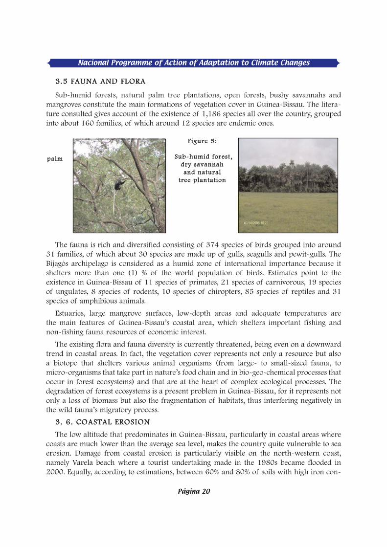
33..55 FFAAUUNNAA AANNDD FFLLOORRAA
Sub-humid forests, natural palm tree plantations, open forests, bushy savannahs andmangroves constitute the main formations of vegetation cover in Guinea-Bissau. The litera-ture consulted gives account of the existence of 1,186 species all over the country, groupedinto about 160 families, of which around 12 species are endemic ones.
The fauna is rich and diversified consisting of 374 species of birds grouped into around31 families, of which about 30 species are made up of gulls, seagulls and pewit-gulls. TheBijagós archipelago is considered as a humid zone of international importance because itshelters more than one (1) % of the world population of birds. Estimates point to theexistence in Guinea-Bissau of 11 species of primates, 21 species of carnivorous, 19 speciesof ungulates, 8 species of rodents, 10 species of chiropters, 85 species of reptiles and 31species of amphibious animals.
Estuaries, large mangrove surfaces, low-depth areas and adequate temperatures arethe main features of Guinea-Bissau’s coastal area, which shelters important fishing andnon-fishing fauna resources of economic interest.
The existing flora and fauna diversity is currently threatened, being even on a downwardtrend in coastal areas. In fact, the vegetation cover represents not only a resource but alsoa biotope that shelters various animal organisms (from large- to small-sized fauna, tomicro-organisms that take part in nature’s food chain and in bio-geo-chemical processes thatoccur in forest ecosystems) and that are at the heart of complex ecological processes. Thedegradation of forest ecosystems is a present problem in Guinea-Bissau, for it represents notonly a loss of biomass but also the fragmentation of habitats, thus interfering negatively inthe wild fauna’s migratory process.
33.. 66.. CCOOAASSTTAALL EERROOSSIIOONN
The low altitude that predominates in Guinea-Bissau, particularly in coastal areas wherecoasts are much lower than the average sea level, makes the country quite vulnerable to seaerosion. Damage from coastal erosion is particularly visible on the north-western coast,namely Varela beach where a tourist undertaking made in the 1980s became flooded in2000. Equally, according to estimations, between 60% and 80% of soils with high iron con-
ppaallmm
FFiigguurree 55::
SSuubb--hhuummiidd ffoorreesstt,,ddrryy ssaavvaannnnaahh aanndd nnaattuurraall
ttrreeee ppllaannttaattiioonn

tent as well as hydromorphic ones are exposed to: (i) erosion and compacting, with a rapidloss of fertility and decrease of the replenishment rate of shallow aquifers "; (ii) salinity dueto existing conditions on the territory’s waterways and decreases in rainfall. Effects areparticularly devastating in sandy littorals, whose sedimentary cover is little consolidatedcauses an intensive felling of palm trees and other forest species lined up along the coast;important quantities of sand on the beach and dunes are affected every year thus layingfossil layers bare and exposed to the phenomenon.
FFiigguurree nn..ºº 66::CCooaasstt eerroossiioonn iinn GGuuiinneeaa--BBiissssaauu nnoorrtthhwweesstt ((VVaarreellaa bbeeaacchh))
PPhhoottoo bbyy AAlleexxaannddrree CCaabbrraall,, 22000066
FFiigguurree nn..ºº 77:: CCooaasstt wwiitthh mmaannggrroovvee
The littoral is made up of mangrove and is a stable zone as compared to the sandy andsloped littoral. It is highly penetrated by tides and possesses recent deposits from the quater-nary age. This coast is constantly under the influence of tides and is subject to pressure fromartisan fishermen, settled in illegal encampments, who fell the mangrove for fish smokingand thus facilitate seawaters’ erosive action.
RRoocckkyy lliittttoorraall wwiitthh eessccaarrppmmeenntt, this type of coast is not predominant in Guinea-Bissau due to the country’s geological and geomorphologic characteristics. The highestaltitude does not exceed 300 metres. Average altitude in the coastal area does not go beyond20-25 metres. Meanwhile, we can find rocky coast with escarpment in well-defined seg-ments in Varela and the islands of Bubaque, João Vieira, Melo, Carache and Unhocomo. Thecoast is subject to coast and rain erosion. The erosion phenomenon is obvious in almost allthese places and localities.
Nacional Programme of Action of Adaptation to Climate Changes
Página 21

Nacional Programme of Action of Adaptation to Climate Changes
Página 22
FFiigguurree nn..ºº 88 :: RRoocckkyy ccooaasstt wwiitthh sstteeeepp ssllooppee.. CCaarraacchhee iissllaanndd ((iinn GG.. PPeennnnoobbeerr,, 11999999))
…… BBuubbaaqquuee iiss llaanndd
33..77.. EEXXCCEEPPTTIIOONNAALL EEVVEENNTTSS
33..77..11.. CCAATTAASSTTRROOPPHHEESS
Natural catastrophes are rare. Coastal area floods caused by high tides or torrential rains,(likes the ones in 2003, 2004 and 2005) are rather the norm. The Directorate General ofWater Services reported in those years that various localities in the country’s eastern regions(Bafatá and Gabú) were affected by foods that damaged infrastructure (bridges and makeshifthousing), and caused a loss of 63 ha of food production and troubles to hundreds of peopleforced to leave their villages on a temporary or definitive basis. Those floods were originatedat Geba River’s streams and shared streams of Koliba River (Guinea-Conakry) and CorubalRiver (Guinea-Bissau).
Five communities from the Bedanda/Cubucaré lost their paddy rice fields in 2005 due tosalt-water invasion in the wake of high tides in September, which destroyed protective dams.Rural engineering services calculated that around 3,015 ha became non productive forrice-growing and were pointed out as a direct source for the widespread hunger that hitpopulations.
33..88 AANNTTHHRROOPPIICC PPRREESSSSUURREESS OONN NNAATTUURRAALL RREESSOOUURRCCEESS
33..88..11 AAGGRRAARRIIAANN SSEECCTTOORR
According to estimates over half of the national territory, i.e., about 2.5 million hectares,have vocation for agriculture, forestry or grazing uses (SCET, 1978). Sources fromGAPLA/MADR (Agriculture Yearbook, 1997), state that ninety thousand (90,000)family-owned agricultural units are responsible for the production of 90% of overallagricultural production in the country. This production comes mostly from the so-called itin-erant agriculture, characterised by forest felling and slash-and-burn practices, utilization oftraditional methods and tools. The remaining 10% are produced by the commercial farming

sector and has some level of mechanisation, which is practised by 1,200 ponteiros (modernfarmers) who occupy 27% of available agricultural land and 9% of the country’s overallsurface. The average land surface per ponteiro is 136 hectares. Production in each of thecountry’s three agro-ecologic regions (East, North and South), is based on natural resourcesthat exist in the ecosystems we describe below:
UUPPLLAANNDD EECCOOSSYYSSTTEEMM
Among all ecosystems, the upland ecosystem is the one that suffers the heaviestanthropic pressure, particularly from itinerant agriculture and bad agricultural practicesthat facilitate the onset of literate and soil erosion. Intensive soil use and exploitation of thisecosystem’s resources have increased in parallel with the rise in population density and thedeterioration of some weather factors (rains), reflected in the drastic reduction of the fallowperiod of those soils lately: from 5 to 15 years in the 1950s and 1970s, it changed nowadaysto 2 to 3 years; the vegetative regeneration of fallow land has been retarded in some ofthe country’s regions (northern and eastern ones) due to the combined action of weatherfactors and a diminution of the fallow period. The non utilization of fertilizers and moreproductive agricultural techniques does not favour the maintenance, after the second year ofproduction, of soil natural fertility in those fields thus leading to the abandonment of thoselands and the utilization of new ones. Estimates point to 10,000 hectares being felled andburnt out every year for agricultural purposes in uplands, mostly for cereals (millet, rice andsorghum), leguminous plants (groundnuts and beans) and tubercles (cassava and yam).Upland rice (pampam) occupies 33.000 ha of the planted area and contributes with 15,000tonnes/year, i.e., 10.7% towards overall national production of this cereal. (Source: reporton rice production, PSRDP/WB, 2004)
Besides, the increment of cashew growing (134,000 hectares) and commercial fruitgrowing (… hectares), constitute nowadays another factor behind the acceleration of theclearing of the country’s humid and sub-humid forests.
MMAANNGGRROOVVEE EECCOOSSYYSSTTEEMM
In this ecosystem, communities of rice growers cut mangroves and leave soils exposed torains, which makes those lands lose their salt content. They then build dykes and anti-saltdams to impede salt-water invasion and afterward cultivate exclusively rice on those soils.Current estimations are that there exist 106,000 ha of mangrove soils with vocation for ricegrowing all over the country that were obtained, obviously, at the cost of losing an equal areacovered by mangrove and the destruction of an important natural habitat for crustaceansand fish. It should be stressed that out of the 106,000 ha of those soils with rice-growingvocation only 50,000 ha (47,1%) are utilised for agricultural purposes by a total of 18,661agricultural farms, accounting for an annual production of 115,000 tonnes of rice, i.e., 80%of 140,000 tonnes of the country’s overall production. (Source: Rui N. Djata et al, Report onrice production /PSRDP/WB, 2004)
Nacional Programme of Action of Adaptation to Climate Changes
Página 23

Nacional Programme of Action of Adaptation to Climate Changes
Página 24
SSMMAALLLL--VVAALLLLEEYY EECCOOSSYYSSTTEEMM
This ecosystem supports essentially production of rice and varied horticultural species. Itis made up of lands made out of flood depressions commonly denominated as small valleysor bas-fonds. They are continental hydromorphic soils, temporarily subject to flooding andsedimentation caused by rainwater. Current estimates point to the existence of 100,000 hawith agricultural vocation for the production of rice and horticultural produce in lowlandsand perennial plants in slopes. They are located essentially in the eastern (Bafatá and Gabu)and central (Oio) regions of the country. Women are the main users of this ecosystem; theyare estimated to have enhanced around half (50 mil hectares) of the overall area available.(Source: Aníbal Pereira et al, Report on Study of Agrarian Sector /NAPA, 2005)
Rice culture in this ecosystem occupies 29.369 ha distributed by 58.190 family-ownedagricultural units that produce an overall quantity of 10,000 tonnes/year, i.e., 7% oftotal rice production. The overall area utilised for horticultural production is calculated at xthousand ha, per y thousand women/year.
33..88..22 FFOORREESSTTSS According to Atlanta Consult (1985), forests covered 64 % of the country’s overall
surface. A preceding study by SCET International in 1978 pointed to a forest-covered area ofapproximately 74%. This presupposes that the country’s forest area decreased by around315,000 ha, i.e., an average of 45,000 ha/year between 1978 and 1985, due essentially toanthropic pressure, as shown in the table below.
TTaabbllee nn..ºº 11-- EEvvoolluuttiioonn ooff ffoorreesstt rreessoouurrcceess ffoorr tthhee 11997788--11998855 ttiimmee ssppaann
SSoouurrccee:: EElleemmeennttss dd'' uunn PPllaann DDiirreecctteeuurr dd'' AAmméénnaaggeemmeenntt eett ddee GGeessttiioonn ddee RReessssoouurrcceess NNaattuurreell lleess,, 11999922..
With an annual growth rate estimated at 1,500,000 m3/year, forest degradation isestimated at approximately 600,000 m3/year, excluding surfaces lost to the felling of treesin villages and farms and by slash-and-burn practises, evaluated at 30,000-60,000 ha/year(Study for support to the forest sector in Guinea-Bissau, 1997). One can notice thataccording to the 1985 forest survey, forests covered 2.1 million hectares and the woodreserve was 48,300,000 m3. Besides, the Agrarian Development Letter (1997) states that thedevastation of forests is translated into the degradation of (i) 30% of surfaces of sub-humidforests in the Tombali region, south of the country, (ii) 57% of surfaces of savannahs in theBafatá and Gabú regions (east), Oio (Centre) and northwest and (iii) 19% of surfaces ofmangrove forests (Silva e Vaz, 2001).
Types of forests SCET- International
Survey
1978 (ha)
Atlanta Consult
Survey
1985 (ha)
Difference
(ha)
Sub-humid forests 178,800 135,431 43,369
Dry forest 848,300 844,959 3,341
Gallery Forest 79,950 52,909 27,041
Savannah 1,237,900 996,985 240,915
Total 2,344,950 2,030,284 314,666

The overall forest area is thought to be suffering a current drastic reduction of 60,000ha/year.
National consumption of wood in 1992 was estimated at 1.2 million m3 corresponding toan increase of 8.3 % per year, equivalent to 81 % of firewood energy, 6 % of sawn wood and8 % of construction wood as per PAFT data in 1992. This corresponds to an annual cuttingof approximately of 132,000 ha of wood, i.e., 9 times more than the surface surveyed byDGFC in 1987. This consumption is in strong contrast with the average forest growth rate,which stands at around 0.3m3/ha/year. Yearly exploitation was estimated at 2,100,000m3/year in 1992 and national wood consumption was estimated at 4.000-5.000 m3/yearand the sawn wood production estimate was 3,000-20,000 m3/ano.
The wood industry registered in 1992 an overall number of ten saw-mills that had anobsolete technological equipment capable of processing a maximum of 40,000 m3 of roundwood into 20,000 m3/ano of sawn wood. This industry focus mainly on the exploitation ofPau de sangue (Pterocarpus einaceous), Pau de Conta (Afzelia africana) and Bissilão (Khayasenegalensis). Indicators of the annual impact of wood production are shown in the tablebelow.
TTaabbllee nn..ºº 22
SSoouurrccee:: FFDDFFNN,, 11999922;; AA..aa..aa.. == AAnnnnuuaall aavveerraaggee aaccccrruuaall
The current pressure exerted by the wood industry tends to be felt increasingly onsouthern forests, which are of capital importance for the maintenance of national ecologicalbalance because they are areas where large species, capable of regulating the country’srainfall and hydrological pattern are still plentiful (PNGA- May 2000).
As regards mangrove forests, data collected in 1953-1959 and 1976-1990, indicated thatbetween the two periods of time, the forest-felling level rose 2.000 ha/year to 3,830 ha/year(CIRAD/PAPT/DGFC, 1992).
Formation A.a.a.
(m3/ha
/year)
Area
(ha)
Overall annual wood
production
(m3/year)
Dry dense forest
Dense forest
Degraded forest
Transition forest
0.994
0.404
(0.404)
90,400
62,400
20,000
89,858
22,210
8,080
Open forest
Dense forest Degraded forest
0.474 0.288
189,600 747,200
89,870 170,362
Savannah
Palm tree forest Mangrove
“Ripícola” Forest
0.245
- -
(0.474)
926,000
80,000 248,400
93,200
226,870
pm not exploited
44,177
TOTAL 2,457,200 654,427
Nacional Programme of Action of Adaptation to Climate Changes
Página 25

Nacional Programme of Action of Adaptation to Climate Changes
Página 26
The pressure of forest resources is in an upward trend due to market demand and, on theother hand, it reflects survival needs of an extremely deprived population. Thus, the risingdemand for wood products and charcoal (for domestic use as a source of energy), cibes(wood for the construction of housing units) and wood (furniture industry) in the urban andsemi-urban market, has pushed an increasing number of Guineans into an unbridledexploitation of those resources for commercial purposes, hence causing irreparable damageto forests and the biodiversity. On the other hand, forests are still utilised permanentlyby populations as a source of various types of wild fruit, medicinal plants, hunting, honeyand wax, fibres for varied handicraft, etc. There are studies that shed enough light on thequantities and values that all these elements represent for the economy at household,community and national levels.
33..88..33 LLIIVVEESSTTOOCCKK
Livestock activity encompasses all production systems. The table that follows illustrates theoverall number estimated by Veterinary services in 2000:
TTaabbllee nn..ºº 33 –– OOvveerraallll nnaattiioonnaall ll iivveessttoocckk
SSoouurrccee:: VVeetteerriinnaarryy sseerrvviicceess
According to Veterinary services, the eastern zone has a cattle potential estimated at 74%,against 85% of lambs and 58% of goats. The northern zone, on its turn, has 49% of pigs,and the southern zone just 19% of this overall number. Poultry are evenly distributedthroughout the national territory.
Meanwhile the impact of livestock’s utilization of natural resources is still negligible dueto the relatively low number of animals nationwide.
33..88..44.. WWAATTEERR SSEECCTTOORR
The country has important water resources that are grouped into (1) rain water resources,(2) surface-water resources and (3) underground-water resources. The renewal of theseresources depends to a large extent on the intensity and regularity of the rainfall patterns,whose parameters have been decreasing. Overall, albeit on an indicative basis due to lack ofmore updated and reliable data, water resources are estimated at 14 billion m3/year (DGRHMaster Scheme, 1997), of which renewable resources from deep aquifers are assessedat 8-29 billion m3/and those of surface aquifers are estimated at hundreds of billionm3/year. Exploitation of surface waters of Geba and Corubal rivers in 1991 was estimatedat 1.5 million m3.
Ruminants Other species
Cattle 524,891
Lambs 311,521
Goats 267,456
Pigs 33,046
Poultry 478,476

Most of Guinea-Bissau populations live close to springs, water points or perennial andnon/perennial rivers to ensure their access to this vital resource that they utilise for (i) theirown consumption, (ii) consumption of productive animals (animal-production activity),(iii) agricultural production, etc. It should be stressed that potable-water access rate is only45.3% for populations residing in rural regions against 78.9% for city dwellers in Bissau, thecapital (Source: Azinhaga et al, Water Sector Report /NAPA, 2005; 1ª CNSMC, 2004)
The agricultural and services sectors are the main users of water resources. Rain watersare vital for agriculture and they depend totally on the rainfall. Surface-water resources areutilised for the supply of populations, grazing and irrigation whilst underground waters arerather utilised as a source of potable-water supply to populations (urban, semi-urbanand rural ones), in agriculture, cattle consumption and the irrigation of horticultural andfruticultural products.
Updated data on the utilization of the country’s water resources are unavailable, and alarge number of water points were constructed lately, especially in the main urban centresas a result of the increase in the number of inhabitants in some towns (Bissau and regionalcapitals). Both government and populations ordered the mentioned constructions. Boreholes,modern wells, traditional wells and spring-tapping are utilised to exploit undergroundwaters. There are over 2,500 boreholes and modern wells currently in use in rural hydraulicswhilst deep boreholes utilised for varied aims (urban supply, irrigation, etc.) hover around150, according to DGRH data produced in 1997.
The construction of water points without a prior technical study taking into account thecountry’s hydro-geological complexity faced some problems namely silting, the utilization ofmaterials that were ill adapted to water corrosion, wells exhaustion, salt-water invasion,pollution of ground water due to lack of isolation, and water quality not acceptable topopulations.
Efforts made both by government and private entities from 1975 to date, if we take as areference the numerous water points (boreholes, fountains and improved wells) that werebuilt, are indicators of the intense exploitation of the county’s underground water resources.Private investment in the construction of traditional and improved wells, without therequired preparatory work by the relevant technical services, has been growing since it is thekind of solution seen as the most affordable by the overwhelming majority of Guineans:each household has, at least, a traditional or improved well whose water quality is of aquestionable quality.
Water use for consumption and other purposes presupposes the need for renewalof quantities utilised in order to ensure the durability of this vital good. Despite the non-existence of data to measure the impact on underground water resources, there are fearsthat the concentration of the construction of water points in coastal areas may alter theflowing pattern of underground waters thus facilitating invasion by brackish oceanic water.Besides, common sense supports the assumption that the increasing use of undergroundwater resources implies the preservation of aquifers’ natural ability to renew themselves otherwise they will run dry at some stage. Well, as we saw earlier on, that renewal capacity in
Nacional Programme of Action of Adaptation to Climate Changes
Página 27

Nacional Programme of Action of Adaptation to Climate Changes
Página 28
Guinea-Bissau is greatly dependent on rainfall patterns and a rational use of water, plus thefact that a large part of rain waters being wasted into the sea, eroding soils on their journeywhilst at the same silting the beds of rivers and lakes.
33..88..55.. FFIISSHHIINNGG RREESSOOUURRCCEESS
The country possesses a broad coast, calculated at 22 235 KmÇ, which covers 61% ofnational territory and shelters 80% of the country’s population. Fishing is carried out againstthe backdrop of an important production potential favoured by the existence of a significantshallow continental platform, the breadth of the maritime front and the existence of a seadelta represented by the Bijagós archipelago. Fishing is focused on certain species relatedto the type of fishing: artisan or industrial fishing. These species represent a biomass thathovers around 1 300 000 tonnes, whose exploitable share stands at about 40%. Thiscatch potential encompasses 200 000 tonnes of shallow and deep water species of highcommercial vale and about 100 000 tonnes of "baliste" type species (species with loweconomic value and which are object of very little exploitation). Out of this total, about 34000 tonnes of high value shallow-water species and 110 000 tonnes of deep-sea species areaccessible to artisan fishing (Barros, I., Artisan Fishing, Bissau, 2001).
The same authors state that artisan fishing is dominated by the existence of non-mecha-nised pirogues. This type of fishing rose about 300% in 1989-1995, both in terms of thenumber of pirogues and the number of fishermen. As a result, catch levels have alsoincreased, to a level of 400 %, i.e., 10 000 tonnes in 1989 against 52 000 tonnes in 1995.Fishing authorities estimate that catch levels have risen significantly in the wake of thecropping up of illegal encampments of fishermen originating from the sub-region (12 weredetected in the Bolama/Bijagós Biosphere, in 2005, by IBAP) and illegal fishing in theartisan-fishing zone (within 12 miles). Additionally, fishermen from illegal encampmentsdevastate mangroves for fish smoking or for use as construction material, thus stripping thecoast and exposing it to sea erosion, coupled with perturbations on the natural habitatvarious sea species.
Effects of deforestation on upland soils is felt through the silting phenomenon and the nonnavigability of rivers and lakes, a reduction of fishing resources caused by sediments draggedaway by rain erosion from high lands to low lands.
Foreign fishing fleets carry out industrial fishing outside 12 nautical miles upon licensesgranted to them by the authorities. Available data (1st CNSMC, p. 34) indicate 115 kg/h asthe average catch per fishing unit in 1990-1996. Top catch levels occurred in fish-catchingfleets (370 kg/h) compared with only 71 kg/h for mollusc-catching fleets and about 14 kg/hfor shrimp-fishing units.
The levels of illegal fishing observed within Guinea-Bissau Exclusive Economic Zone (ZEE)lead us to think that unrecorded catch levels are far superior to those seen in 1990-1996.
In 2006 the Fishing Surveillance Services (FISCAP) arrested forty industrial-fishing boatsand 147 pirogues. This shows that illegal fishing levels may be extremely high and thepressure thus exerted on fishing stocks may endanger the existence of some fish species in
the long run. It should be stressed that shallow-water fishing, involving fish, molluscs andcrustaceans (shrimp) constitutes the bulk of industrial fishing, representing 80% of statedcatch (Barros, I., 2001).
To sum up, pressure on Guinea-Bissau’s fishing resources tends to rise not only as a resultof a growth of local population but also due to public treasury imperatives, whereby theissuance of licenses or multiyear fishing agreements are seen as an important source ofrevenues. According to data supplied by FISCAP, fines levies in 2006 amount to US$6,520,000 USD, a risible sum if compared to the ecological damage caused by the practise offorbidden fishing techniques.
44.. SSOOCCIIOO--EECCOONNOOMMIICC SSIITTUUAATTIIOONN::
Guinea-Bissau has a territory of 36,125kmÇ and a population estimated at slightly over1,300,000 inhabitants distributed over 9 regions. Its population density is approximately 34people/kmÇ and the average growth rate as per the latest population census (1991) is 2.2%.About 70 % of local population live in the rural world and have as their main socio-econo-mic activities the exploitation of renewable natural resources (agriculture, fisheries, forests,livestock and extraction). The country’s coast zone shelters 80% of the country’s overallpopulation and, compared to the countryside or continental zone, it is rich in biodiversity,being there that the country’s five Protected Areas are to be found.
According to data published in the Human Development Report, 2002, many importantsocial indicators in Guinea-Bissau are below the average in the African region. For instance,life expectancy in Guinea-Bissau was 45 years at the start of the millennium whilst theaverage figure for Africa was 48.9; child mortality was 145/1,000 and the African averagewas 105/1,000; maternal mortality was 1,310/100,000 and the African average was700/100,000. The situation in the education sector was as follows in the mentioned timespan: basic education expenses/overall budget, 3.5for Guinea-Bissau and 15.7% for Africanin general; the illiteracy rate was 63.2% and the African average was 41.5%. As for the healthsector, available data point to a sharp deterioration of the health personnel/population ratio;the relation health personnel and the number of inhabitants changed from 1/7,157 in 1991to 1/11,371 in 2.000.
The poverty rate is currently very high: 64.7 % of the population are classified as beingpoor and around 20.8 % as extremely poor (people that live with less than US$ 1 dollar perday), according to PRSP data extracted from the Light Inquiry on Poverty Evaluation, ILAP),2003.
In 2004, Guinea-Bissau’s active population was estimated at little over 46% of thecountry’s overall population. Women have a share of about 52% and children below 15represent 46%, thus revealing a mostly young population overall.
Existing information on domestic migratory movements is scarce but available data pointto a strong rural exodus. Bissau, the capital, has only 3% of territory but it shelters a quarterof the country’s population.
Nacional Programme of Action of Adaptation to Climate Changes
Página 29

Nacional Programme of Action of Adaptation to Climate Changes
Página 30
According to the 2006 Human Development Report, published by UNDP, Guinea-Bissauis part of the group of countries with the lowest human development indices in the world.Its HDI in 2006 was 0.349 (173rd spot out of a total of 177 countries).
The paralysis that hit the country from May 1998 to June 1999 due to the civil war hascontributed in a particular way for an additional deterioration of the already precarioussocial situation. Thus, lack of control and the malfunctioning of fiscal managementstructures worsened and this state of affairs greatly penalised social sectors. These factorscontributed significantly to an increase of local populations’ degree, particularly in the ruralworld, vis-à-vis climate changes.
Guinea-Bissau began the new millennium with a negative economic growth rate,standing at an average rate of –0.4% for the 2001-2005 timeframe.
As regards standards of living, the real GDP per inhabitant suffered a decrease en eachyear between 2001 and 2004, but it nevertheless rose slightly by 1% in 2005.
The agricultural sector, dominated by cashew, is the most important sector of thecountry’s economy, contributing with 62.6% for the GDP compared to 12. 2% for industryand 25.2% for the services sector.
The current fiscal situation is critical thus preventing the government from meeting itsobligations namely paying the wage bill, which has exceeded tax receipts since 2003(111.9%, 155.0% and 108.9% in 2003, 2004 and 2005 respectively), when, in fact it shouldnot be over 35% according to WAEMU convergence criteria. This reveals that Guinea-Bissauis incapable of financing with its own resources projects meant to adapt its most vulnerablesegments to climate changes.
55.. IINNFFLLUUEENNCCEE OOFF CCLLIIMMAATTEE CCHHAANNGGEESS AANNDD WWEEAATTHHEERR PPAATTTTEERRNN VVAARRIIAA--BBIILLIITTYY OONN BBIIOO--PPHHYYSSIICCAALL PPRROOCCEESSSSEESS AANNDD KKEEYY SSEECCTTOORRSS
55.. 11 HHIISSTTOORRIICC FFIINNDDIINNGGSS
During the survey we often heard statements that confirm the change of parametersrelated to rainfall, temperature, relative humidity, the sea level and water resources.Populations have noticed (i) a late start of the rainy season (mid June) as compared to theusual time (early May), (ii) a less regular distribution of rainfall compared to the past, (iii) ashortening of the time period with cooler temperatures, the so called "cold season ", fromthree months (December to February) to two months only (December and January), (iv) ahotter and drier environment, (v) frequents dust winds, (vi) higher frequency of high tides,which destroy dykes and rice fields, (vii) deterioration of water quality caused by salt-waterinvasion and infestation of water resources by waterborne plants, (viii) decrease in humidareas’ surfaces due to drought.

FFiigguurree nn..ºº 99:: BBeedd ooff BBiiddiiggoorr rriivveerr,, eeaasstt ooff tthhee ccoouunnttrryy
PPhhoottoo bbyy AAlleexxaannddrree CCaabbrraall,, 22000066
55..11..11 IINNFFLLUUEENNCCEE OOFF CCLLIIMMAATTEE CCHHAANNGGEESS AANNDD VVAARRIIAABBIILLIITTYY IINN WWEEAATTHHEERRPPAATTTTEERRNN OONN BBIIOO--PPHHYYSSIICCAALL PPRROOCCEESSSSEESS
Reflexes at various levels may be quoted in this regard: a) the vegetation cover ofGuinea-Bissau, especially in the western and northernmost areas, has also suffered degrada-tion because of the advancing Sahel zone, a process that has contributed to the change oftemperature and rainfall parameters. As a result, forests are receding and savannahsare advancing, accidental bush fires are much more frequent, rivers and lakes becomenarrower and have weaker streams, natural habitats are destroyed or highly disturbed,biological diversity is threatened, agriculture and the rearing of animals become harder orimpossible, large quantities of biomass are lost, and forced migration of wild fauna takesplace, etc.
High temperatures in abnormal periods of the year, associated to dust winds from theSahel that hit the country every year, have damaged the blossoming and ripping of many fruitspecies.
Locust plagues, helped by rises in temperature, have been frequent in the last five years,causing enormous damage to fruit- and vegetable-growing activities and the consequentabortive effect on plants and fall in production levels. It is known that when temperaturelevels are above cultures’ tolerance levels in a given area, they may lead to changes in theoverall framework of species grown in that area. This has happened in some areas of thecountry where sorghum and cassava are no longer grown due to the prolonged dry periodand the irregular rainfall patterns, and have been replaced by cultures that are less sensitiveto water shortage and are more tolerant to high temperatures.
Climate change developments have caused changes in habitats, fauna and flora, andaffected the fauna and flora diversity of an important number of species nationwide. Thedecrease in vegetation cover is due in part to a reduction in rainfall and its influence on thehydrological cycle and the regeneration ability of various plant species. This is notorious inmany locations in the country with lower rainfall indices and more prolonged dry season(eastern and north-westernmost areas).
Nacional Programme of Action of Adaptation to Climate Changes
Página 31
Nacional Programme of Action of Adaptation to Climate Changes
Página 32
Vegetation degradation due to the increasing sahelization of our climate reflects directlyon complex ecological processes because it is a biotope that shelters various animalorganisms (from large-sized to small-sized fauna, to micro-organisms that participate innature’s food chain and in bio-geo-chemical processes that occur in forest ecosystems).
55..22 IIMMPPAACCTTSS OONN KKEEYY SSEECCTTOORRSS
55..22..11 AAGGRRIICCUULLTTUURREE
Empirical data for the latest thirty years reveal that the volume of rainfall has beendecreasing in Guinea-Bissau and the rainy season is now limited to only five months( June-October), in contrast to before. Production of rice and other cereals in small valleysand uplands in the north and east of the country are affected by water shortage. The factthat rain now is frequently accompanied by strong winds causes a considerable loss ofproduction in –grain species in months when it rains heavily (August/September). Damagefrom flooding is significant in agricultural fields located in low lands (small valleys) and ricefields in mangrove hydromorphic soils.
Production in the south, centre and islands, where species are more demanding in termsof water supply, (rice, millet), is also affected by the concentration of rainfall and its bad timedistribution.
In the so-called mangrove soils and in small valleys, rain insufficiency and bad distri-bution have contributed to a rise in salinity and acidity levels, which in turn haverendered non-viable the practice of rice growing. This has led to a rise in the number ofdeteriorated rice fields and a rise in the number of deteriorated mangrove rice fields, forcingpeasants to abandon them; this happened in five villages in Cubucaré, south of the country,whose inhabitants were impeded from working 3,015 ha of bolanhas (rice fields) due to thedestruction of their dykes and the resulting loss of rice fields caused by the invasion of saltwater. Populations were thus forced to seek new lands, which they clear through the use ofslash-and-burning before they transform them into rice fields. Or, as it happens in thesouthern littoral, farmers migrate to the north of the neighbouring Republic of Guinea; alsoin the east, northwest and some locations in the south of country – regions more affected byrainfall deterioration. Migratory movements were also registered from uplands to lowlands(small valleys) or vice-versa.
55..22..22.. FFOORREESSTTSS
The increasing advance of the savannah-type vegetation is a visible impact, particularly inlonger dry periods, namely in northern, eastern and north-western areas where highertemperatures and drought and changes or deterioration of the vegetation cover led tomutations in the composition of a large part of forest species or even to the extinction ofsome of those species, and migration of animals.
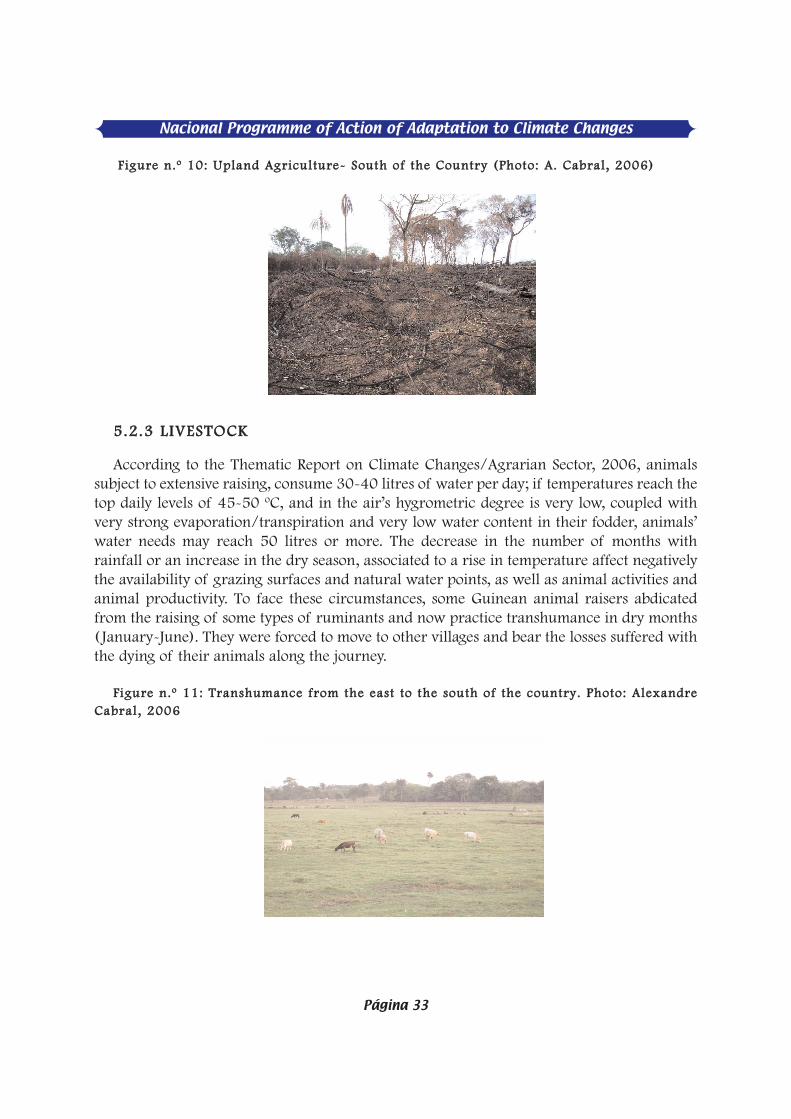
FFiigguurree nn..ºº 1100:: UUppllaanndd AAggrriiccuullttuurree-- SSoouutthh ooff tthhee CCoouunnttrryy ((PPhhoottoo:: AA.. CCaabbrraall,, 22000066))
55..22..33 LLIIVVEESSTTOOCCKK
According to the Thematic Report on Climate Changes/Agrarian Sector, 2006, animalssubject to extensive raising, consume 30-40 litres of water per day; if temperatures reach thetop daily levels of 45-50 ºC, and in the air’s hygrometric degree is very low, coupled withvery strong evaporation/transpiration and very low water content in their fodder, animals’water needs may reach 50 litres or more. The decrease in the number of months withrainfall or an increase in the dry season, associated to a rise in temperature affect negativelythe availability of grazing surfaces and natural water points, as well as animal activities andanimal productivity. To face these circumstances, some Guinean animal raisers abdicatedfrom the raising of some types of ruminants and now practice transhumance in dry months( January-June). They were forced to move to other villages and bear the losses suffered withthe dying of their animals along the journey.
FFiigguurree nn..ºº 1111:: TTrraannsshhuummaannccee ffrroomm tthhee eeaasstt ttoo tthhee ssoouutthh ooff tthhee ccoouunnttrryy.. PPhhoottoo:: AAlleexxaannddrreeCCaabbrraall ,, 22000066
Nacional Programme of Action of Adaptation to Climate Changes
Página 33
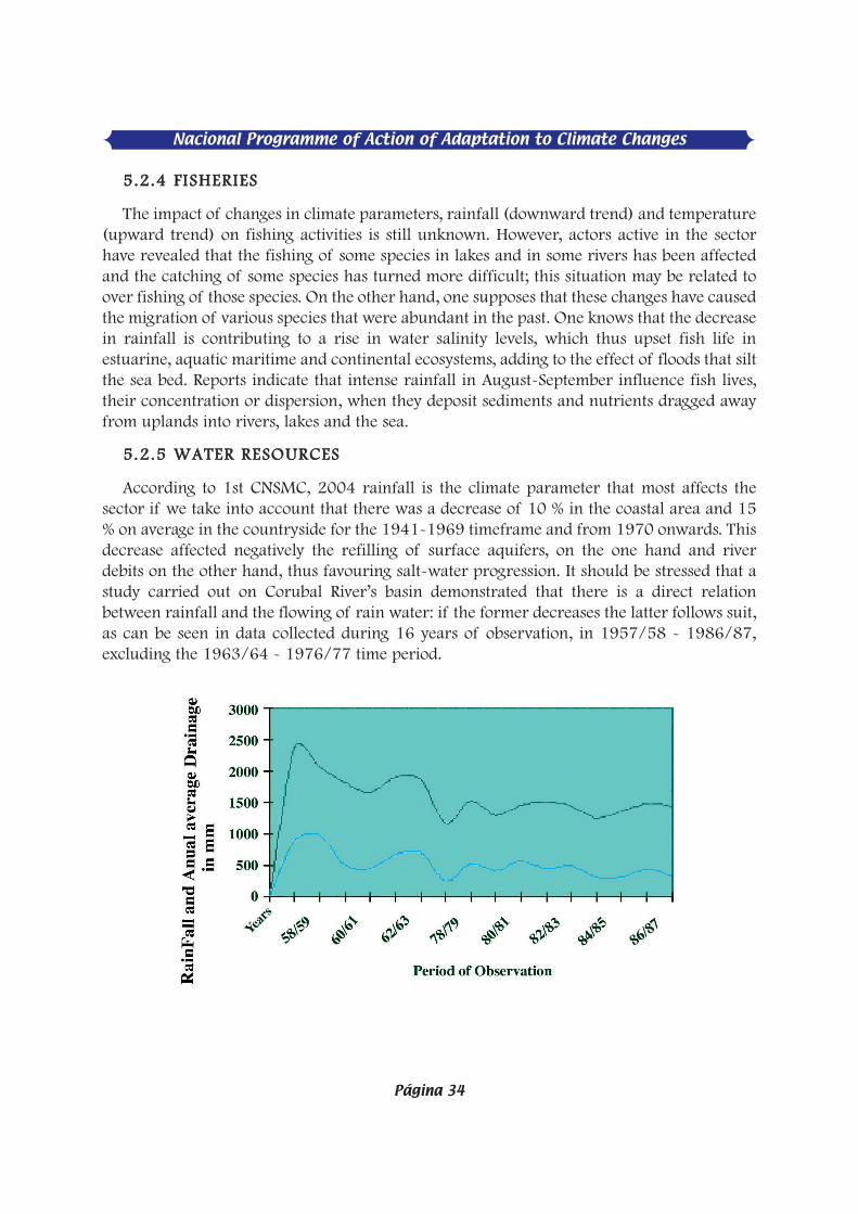
Nacional Programme of Action of Adaptation to Climate Changes
Página 34
55..22..44 FFIISSHHEERRIIEESS
The impact of changes in climate parameters, rainfall (downward trend) and temperature(upward trend) on fishing activities is still unknown. However, actors active in the sectorhave revealed that the fishing of some species in lakes and in some rivers has been affectedand the catching of some species has turned more difficult; this situation may be related toover fishing of those species. On the other hand, one supposes that these changes have causedthe migration of various species that were abundant in the past. One knows that the decreasein rainfall is contributing to a rise in water salinity levels, which thus upset fish life inestuarine, aquatic maritime and continental ecosystems, adding to the effect of floods that siltthe sea bed. Reports indicate that intense rainfall in August-September influence fish lives,their concentration or dispersion, when they deposit sediments and nutrients dragged awayfrom uplands into rivers, lakes and the sea.
55..22..55 WWAATTEERR RREESSOOUURRCCEESS
According to 1st CNSMC, 2004 rainfall is the climate parameter that most affects thesector if we take into account that there was a decrease of 10 % in the coastal area and 15% on average in the countryside for the 1941-1969 timeframe and from 1970 onwards. Thisdecrease affected negatively the refilling of surface aquifers, on the one hand and riverdebits on the other hand, thus favouring salt-water progression. It should be stressed that astudy carried out on Corubal River’s basin demonstrated that there is a direct relationbetween rainfall and the flowing of rain water: if the former decreases the latter follows suit,as can be seen in data collected during 16 years of observation, in 1957/58 - 1986/87,excluding the 1963/64 - 1976/77 time period.
55..22..66 HHEEAALLTTHH
Temperature and rainfall, associated to serious sanitation, are two parameters that havehad influence on the recrudescence of various diseases in the country, of which malaria(60% of appointments in hospital emergency cases), hepatitis, cholera, etc. In times ofgreater rain concentration and high temperatures, the number of Guineans with malariaproblems rises whilst diseases like measles and meningitis increase at times of less rain andstrong winds, e.g., meningitis in the eastern zone or bronchitis and other respiratory ailmentsobserve din dry periods, Namely January (Source: 1st CNSMC, 2004).
66.. FFRRAAMMEEWWOORRKK OOFF AADDAAPPTTAATTIIOONN PPRROOGGRRAAMMMMEE
66..11 VVAARRIIAABBIILLIITTYY IINN WWEEAATTHHEERR PPAATTTTEERRNNSS AANNDD CCLLIIMMAATTEE CCHHAANNGGEESSOOBBSSEERRVVEEDD
Empirical observation of rainfall developments in the latest 30 years (1961-1990) or evenin the latest 45 years (1954-2000) show a downward trend: in the south, 2,440 to 1,800mm; in the centre, 2,200 to 1,600 mm and in the north, 1,600 to 1,200 mm (Silva, C.quoted by Da Silva, A. O., 2001). For the 1953-1983 timeframe, a study shows that whilst inthe north, at the border with Senegal, average rainfall over a period of just 70 days was 1,300mm, average rainfall in the country’s southernmost area was over 3,000 mm during aperiod of over 120 days of rain. For 1961-1990 (Imbali, F. & Da Silva, A. 1997), the averagenumber of rainy days recorded was 162. In fact, we see an annual decrease in rainfall andits concentration in just five months ( June-October) contrary to what happened before(May-November). Nowadays rains are frequently accompanied by strong winds that causedamage to plantations and cultures. Reflexes of other climate parameters (temperature) canbe seen in floods caused by semi-daily tides, whose amplitude are among the highest in WestAfrica, namely in Porto-Gole and Buba, where it reaches 6.42 m during high tide. Otherexamples of amplitude known in the country are 1.97 m for Farim, 4,24 m for Bubaque,3,61m for Pecixe, 5,10 m for Bissau, 4,90 m for Bolama and 2.32 m for Varela ( J. P.Barusseau et al. in riviéres du sud, quoted by Da Silva, A. O., 2001). With almost two thirdsof its territory in the coastal zone, at below 50 metres of altitude, Guinea-Bissau is acountry that is prey of high tides and coast erosion, whose impact has been increasing in ademolishing way on the coast, agricultural land and coast ecosystems, presumably aided byclimate changes (longer dry season, higher sea temperature). Indeed, it is thought thaterosion effects may diminish the country’s overall surface from the current 36,125 kmÇ to28.000 kmÇ (Source: 1st CNSMC, 2004).
66..22 VVAARRIIAABBIILLIITTYY OOFF WWEEAATTHHEERR PPAATTTTEERRNNSS AANNDD PPRROOJJEECCTTEEDD CCLLIIMMAATTEECCHHAANNGGEESS
Forecasts contained in the 1st CNSMC 2004, developed according to the Magic Schengenmodel, predict that until 2100 temperature will rise 2%, rainfall will diminish by 11.7%, theprobability of cloud formation will rise by 3.3%, and the average seal level will rise 50cm.
Nacional Programme of Action of Adaptation to Climate Changes
Página 35
Nacional Programme of Action of Adaptation to Climate Changes
Página 36
77.. PPOOTTEENNTTIIAALL IIMMPPAACCTTSS OOFF CCLLIIMMAATTEE CCHHAANNGGEESS
77..11 PPOOTTEENNTTIIAALL IIMMPPAACCTTSS
Thematic reports on climate changes and the 1st CNSMC stress essentially the following:a rise in temperature and rainfall that surpasses the cultures’ tolerance limits will causesignificant changes in blossoming, yield, smell, taste, plague- and disease incidence, etc.,depending species and varieties. Based on current figures for maximum and minimum,varying between 32 ºand 39 ºC (March - May) and 20 º to 24 ºC, (December - February), arise of 2 ºC in the 2100 time horizon would lead to a rise of 34 ºto 41 ºC in hotter monthsand 22 º to 26 º in cooler ones.
In the above circumstances both cashew blossoming and harvest, which occur betweenMarch and May, as well as the production of horticultural species would be affected.
Torrential rain, concentrated in August and September, would worsen existing drainageproblems and complicate the growing, transplant and adaptability of varieties thatcurrently utilised. Broadly speaking, the danger for the agricultural sector stems essentiallyfrom the irregular rain pattern.
Other than the risks arising from pressure on forest resources, climate changes wouldaffect the vegetation cover, thus degrading and leading human settlements to movesuccessively from one vegetation formation to another. The sahelisation and desertificationprocess would thus be reinforced.
Concerning water resources, the decrease in rainfall may lead to a continuous diminutionof water resources and main rivers’ stream, an accentuation of water deficit in dry months,a decrease in rainwater to hydrographical networks, currently estimated at 45 billions ofcubic meters.
As regards livestock, taking aside the eastern regions, where the extension of the dryseason and the consequent reduced availability of grazing areas and water wells, coupledwith the practise of transhumance tend to be more accentuated, no major losses areexpected. The fisheries sector also is not greatly threatened in the 2100 horizon.Nevertheless, a rise in average sea level by 50 cm may endanger the reproduction of somespecies of sea mammals, e.g., turtles, due to the submersion of fish-spawning beaches. In fact,the rise in sea levels constitutes a latent and permanent risk if we take into account thepredominance of a low altitude and important coast prairies: even if we consider a rise insea level below 50 cm (stronger scenario until 2100), Guinea-Bissau would not be incondition to protect its coastal area. Phenomena like erosion, salt intrusion, gales and floodsmay be reinforced in the future in coastal areas. And if by then (2100) this fact is not dulytaken into account, physical processes (wave energy, tides and streams, transportationof sediments, etc.), causing considerable impacts, not only in coast ecosystems and itsmultiple types of production, functional regulations but also concerning biodiversityresources (fish, crustaceans, molluscs, forest essences etc.) and the type of use (tourism andsea transportation).

77..22.. PPOOTTEENNTTIIAALL IIMMPPAACCTTSS TTHHAATT WWIILLLL AAFFFFEECCTT PPOOPPUULLAATTIIOONNSS TTHHEE MMOOSSTT
TTaabbllee nn..ºº 44 bbeellooww sseeeekkss ttoo ssyynntthheessiizzee tthheessee iimmppaaccttss aass ffooll lloowwss::
Nature of Impacts Agriculture Loss of soils suitable for agriculture
(continental and m aritime hydromorphoussoils) due to salinity and acidification (rai n shortage) and invasion of sa lt water (rise in sea levels); 20-30% fall in yield of agricultural speciesaffecting especially horticultural products, cereals (rice and millet), groundnuts and cashew, due to drought, high t emperatures,bad distribution of rains and/or flood ing of low lands for prolonged time periods; a third (33%) of populations are submerged by foodinsecurity. Worsening of cereal deficit, especially rice,which will rise to 75,000 tonnes/year, and heavier country food depende ncy vis-à-vis imported rice. Deterioration of populations’ living conditions, rural ones in particular.
Livestock Worsening of (i) shortage of g razing andwater points for animals, due to extension of dry months, (ii) conflicts betw een animalraisers and farmers concerning th edelimitation of natural g razing corridors andwater points. Marked loss of annual revenues andproductivity due to nutrition deficiencies, water imbalance and physical efforts during transhumance.
Forests Increment of uncontrolled slash -and-burnpractices thus jeopardising populations and wild fauna Increased difficulty to collect/extractproducts from the forest for current consumption for multiple purpose s (food, health, ornamentation, handicraft, traditional ceremonies, etc.) due to accelerateddegradation of vegetation cover (from denseforest to open f orest and from open forest t o savannah, resulting from the accentuation of the sahelization and desertificatio n processes). Impossibility of hun ting some wild species because they become rare (due to migration)or extinct (the modified habitat is hostile to them)
Nacional Programme of Action of Adaptation to Climate Changes
Página 37

Nacional Programme of Action of Adaptation to Climate Changes
Página 38
PPlleeaassee sseeee tthhee bbeellooww mmaattrriixx,, ffrroomm tthhee 11sstt CCNNSSMMCC,, ccoonnttaaiinniinngg aann iiddeennttii ffiiccaattiioonn eexxeerrcciisseeffoorr aaddaappttaattiioonn mmeeaassuurreess aanndd tthheeiirr lliinnkkaaggee wwiitthh nnaatt iioonnaall ppooll iicciieess aanndd ppllaannss..
TTaabbllee nn..ºº 55 –– EESSSSEENNTTIIAALL AADDAAPPTTAATTIIOONN NNEEEEDDSS AANNDD TTHHEEIIRR LLIINNKKAAGGEE WWIITTHH NNAATTIIOONNAALLPPOOLLIICCIIEESS AANNDD PPLLAANNSS
Primary sector (agrarian)
Adaptation strategies and measures Linkages withnational policies andplans
Agriculture i) Extension of short-cycle seeds, ii) Greater dissemination of varieties less demanding in water and resis tant to prolonged drought periods; iii) Increase in hydraulic works, iv) Construction of micro dams and small dykes for water retention, v) Promotion of low-cost irrigation systems; vi) Production diversification
- The L etter of Agraria nDevelopment states as i tsobjectives the ensuring offood security and th ediversification of production; its plan ofaction contains measuresthat encompass thesestrategies. - PRSP takes theagricultural sector’sstrategies into account in itsfight against poverty.
Forests Launching of nationwide survey on forests; - Setting-up of conservation units , especially in important and fragile ecosystems; - Promotion of local initiatives focusing on conservation and development; - Supply of financial and technical means to technical services; - Introduction of commun ity-based management of forestsand their extension to the north and south of the country; - Selection of rapid-growth species p lants for energy purposes. - Reforesting of zones degrad ed and their restoring through theuse in e ach agro-ecological zone of local species; sustainablemanagement of tho se spec ies thus allowing their fu ture naturalregeneration
- The Forest Master Planand the Forest Law foreseeactions that contributetowards the implementationof adaptation measures; - Measures foreseen in thePRSP plan of action and inthe PAFI.

Livestock
- Utilization of agricultural sub-products namely sugar cane, ricestraw coated with urea and sugar-cane syrup, and, if possible, the use of cassava and other residue;
- Improving of grazing fields through the introduction ofplants with high nutr itional quality and greater productionpotential, especially leguminous species that contribute towards animprovement of animals’ diet and simultaneously on soil-enrichingwith nitrogen; - Promotion and strengthening of production of short -cycle animals(goats and sheep); residues;
- CPDA and its Plan ofPlano de Action analysedand foresaw measures thatfit well with the strategies inthe livestock domain ; - Measures foreseen in theDENARP plan of actionencompass these measures.
Fisheries 1. Preparation of an Integrated Management Programme ofCoastal Resources (PGIRC), and its respective Plan of Action on the Coast (PAC).
2. Acquisition of knowledge on intern al dynamics of populationsof sea resources in the area;
- Integrated management of those resources and respective zone;
- Appropriate legislation to ensure protection of resources,particularly regarding their access and assessment of local hydro-meteorological risks
Strateg ies and measuresenvisaged are reflected inthe Fisheries Master Planand PRSP
Secondary sector Water
a) Rehabilitation, renewal and extension of needed infrastructurefor a quan titative and qua litative improvement of water andsanitation resources;
b) Rehabilitation and i mplementation of infrastructure for theevacuation of rain water and the evacuation of residual water incritical locations in large urban centres;
c) Organization and sensitisation of popu lations for a change inmental attitudes (setting up of water-consumer associations); betterknowledge on water resour ces (hydro-geology and hydrology) and their functioning (Training); d) Effective protection of those resources and t heir tapping for supply purposes;
e) Effective and in tegrated management of different ways toutilise water. f) Institutional organization, reactivation of CTA, CIMA and CNA; g) Legislation updating.
- The W ater MasterScheme encompasses thesestrategies. - Measures under theDENARP plan of actionencompass these measures. - The Wa ter Code, alsoapproved by Government in1992 sets out the generalframework for water –resource management, utili-sation and conservation, anddetermines their institutionalframework; - The linkage is equallydone regarding the inte-grated management of hy-drographical basins andwater resources, namelywith OMVG and the AGIRproject but the terms ofreference should b e exten-ded to encompa ss a greatersub-regional synergy.
Costal Zone - A requ irement to guide traditional and modern techniques in research, experimenting and base studies for the exploitation of sea resources with a view to ensuring the sustainable use of stocks of commercial importance thus reducing pressure on those resources - In order to minimise its sea fauna vulnerability to climate changes, the country needs to define an efficientmanagement of its living sea resources aiming at: Making use of actors’ good sense when faced with shortage of scientific information; An immediate implementation of conservation measures before obtaining reliable data and reaching scientific consensus (which requires a long timeframe) on the status of sea resources; To promote experimental aquaculture in coastal areas
The Tourism Master Plan,when establishing the linkbetween tourism deve-lopment and biodiversityconservation and its risksfor the s ector, takes intoaccount the proposed s tra-tegies, especially when itenvisages the updating of this plan and its adaptationto climate changes in thefuture.
Nacional Programme of Action of Adaptation to Climate Changes
Página 39

Nacional Programme of Action of Adaptation to Climate Changes
Página 40
1. Fishing re-sources and m ari-time, estuarine and aquatic con-tinental biotopes
Vulnerable or very vulnerable to sedimentological dynamics and issues and the coastal dynamics generally resulting from anthropic actions and climate hazards - Identification through studies and research of zones most vulnerable to changes of sedimentological natureand that constitute a bottleneck in upstream ecological processes. - Identification through studies and research of zones most vulnerable to sea and coastal erosion phenomena and integrate these issues into a b roader search forsolutions (Sub-regional and international level). - Support and enhancement of the Mangrove Observatory project, so as to include the follow up of sedimentological dynamics, namely relating to thecontribution of the Corubal-Geba water system and thephysic-chemical composition of biotopes. - To ensure a natural transportation of sediments along waterways and carry out, on a joint basis with the Ministry, the dredging of rivers in critical points, orworks meant to deal with natural effects. Very vulnerable to rising salinity and episodic flooding, increases in NMM, and reduction of rivers’ debits and stream. - Guinea-Bissau joining of major international and sub-regional programmes on climate change as main factors behind this vulnerability (tides dynamics, "bombement" of continental platform, decrease in rainfall and rise in average sea level) needs global measures that surpass by far a State’s borders. - A better utilisation of rain water and, if needed, the carrying out of dredging works on hydrographical basins so as to increase the quantity of sweet water leading to a decrease in the level of salinity of surface water streams and aquifers, and soil salinity and acidification and consequently ensure, on a direct basis, a propitious biotope for mangrove and other coastal types of vegetation, and water and sea fauna and, indirectly, for users of fishing resources.
2. Coast Line, Mangrove and Coast Vegetation
- Promotion of scientific research with
The National Office on Coast Planning, as a forerunner of measures directed at conservation and sustainable deve-lopment of the coastal area in all its men-tioned aspects, n amely ecosystems, biodiversity, costal ero-sion and its causes, ecologic monitoring,demonstrates the exis-ting strong linkage be-tween proposed stra-tegies and national po-licies. The latter were recently consolidated through the approval of PNGA and EPAN-DB, in addition to t he Fra-mework Law for Pro-tected Areas and pros-pects relative to IBAP,INA e AIA.

The intervention of scientists and scholars on climate changes’
issues linked to the coastal zone and coastal ecosystems, - Mangrove prote ction bearing in mind that protection of thelittoral against coast erosion is one of that ecosystem’s attributes ; - Setting up of a Mangrove Observatory, based on t he projectalready exis ting at the Coast Planning Programme. - Based on agronomic research and experiment and base studies, toguide traditional techniques of land exploitation towardsrecovering and enhancing land for r ice-growing purposes,particularly in “bolanhas” (salt and sweet water), aiming atincreasing yield of cultivated areas. Rise of sea level - Research, intervention by scientists and scholars of climatechange linked to the coastal zone and coast ecosys tems, which, ifadequately equipped for their work, may end up proposing alternative techniques to tra ditional ones, r egarding the unbridledexploitation of mangrove for fish smoking; - Carrying out of base studi es, research, experimenting, extensionand technical assistance that may enable Guinea-Bissau to monitorrisks related to the sea level; - Adoption of settlement and infrastructure strategies that minimize potential risks, avoiding their placing close to the coast line; - Setting up of tide-monitoring stations and their geographical distribution; - Guinea-Bissau has a considerable coast zone and large swaths oflow lands; scientific research focusing on coast protection thus constitutes an urgent need. - Recovery and enhancement of land for agriculture, rice growingin bolanhas (salt- and sweet water), aiming at increasing the yieldof cultivated areas and hence relieve pressure on mangrove forests; - Setting up of national and natural parks;
2. Hydrographical soils and basins
- Sensitisation of population on the utilization of precocious fires; - Preparation of legislation on land slash-and-burning; - Use of ef ficien t agricultural techniques that are capable ofpreventing or decreasing the loss of surface layer
Nacional Programme of Action of Adaptation to Climate Changes
Página 41
3.

Nacional Programme of Action of Adaptation to Climate Changes
Página 42
88.. SSYYNNTTHHEESSIISS OOFF PPOOTTEENNTTIIAALL RRIISSKKSS AANNDD IIMMPPAACCTTSS
A survey of present and future climate risks was carried out on the basis of a par-ticipatory evaluation, facilitated by national experts. The survey allowed (i) an assessmentof resources, sectors, geographical zones and more vulnerable human groups, (ii) theidentification and setting out of vulnerable modes of existence. The matrix below illustratesthe respective outcomes.
Sanitation - Updating and implementation of code of behaviour of town councils and Master TownPlanning framework, which foresee the building of toilets for each house and type of ditch to be adopted; - To stimulate the building of latrines following some technological measures for protection of ground waters, especially in urban centres; - Setting up of rubbish depots and their respective treatment; - Preparation of a national strategy for management of urban residues; - Strengthening of programmes for public- education and sensitisation;
Linkage concerns arebroadly expressed inPRSP
Health - Building of disease-research centres; strengthening of
measures to fight and prevent the on-setting of diseasesamong populations. - Designing of a broader vision on the issues of climate-sensitive diseases. - Promotion of capacity building in research. - Strengthening of health-information system aiming atobtain ing global and complete data about theepidemiological situation.
Besides the PRSP,strategies herepresented in the fieldare part of a broaderand more completerange of measures andstrategies included inthe PRSP, and updatedin 2002.
Food security
- Setting up of national security stock; - Setting up of cereal banks (silos) by peasants toguarantee a food reserve in all regions; - Setting up of an Early Warning System against risks; - Strengthening of sensitisation campaign about th e importance of diversifying eating habits .
Both CPDA, in itsobjectives translatedinto the Plan of actionand DENARP are inline with the strategieshereby defined.

Table no. 6: Survey of Potential Risks and Impacts:
Loss ofhum
anlives
Area
Total
Economic
Impact
M
ortalityrate
Duration
Involved Frequency
Trend or
RISKS V
ULNERA
BILITY
%
Scale (1-5) SeasonalDrought
- Fall of agricultural yield 2
1 1
2 2
3
37%
- W
ater shortage
- Reduced economic yield
Acute Drought - More accentuated fall in agricultural yield
5 4
2 4
4 1
- W
orsening of water shortage
- W
idespread food security
67%
- Visible dependency on food imports
- Biodiversity losses
- Econom
ic risks
- Social crisis
- Hunger, diseases
- Rural exodus
Rise in - Reduction ofSea Biodiversity, reduction of proteinavailability
3 2
1 2
4 1
Ocean
- Decomposition of calcareous structure (shells)
Temperature
43%
Reduction in oceans’ capacity to retain carbon gas(C02)
Rise inatm
osphere - Fall in agricultural production; m
arked watershortage;
3 3
2 4
4 3
temperature
Rise in respiratory and heart diseases, malaria, skin
cancer,etc.
Fall in economic production and productivity
63%
Nacional Programme of Action of Adaptation to Climate Changes
Página 43

Nacional Programme of Action of Adaptation to Climate Changes
Página 44
Cyclones
- Health problem
s, losses of human lives
Coastal erosion
4 3
2 1
4 1
(Strongw
inds)
- Lossof arable land, salt invasion, econom
ic andbiodiversity losses; - Loss
of beaches, appearance and disappearanceof som
e islands R
eduction of fishing activities
50%
A.S
.L. - destruction of infrastructure in coastal areas,
5 3
1 2
4 1
Average sealevel
salt-invasion phenomenon, deterioration of sw
eetw
aters’ quality, coastal erosion,
disappearance of beaches, loss of land
53%
decrease
of fishing activities on the coast
loss of incom
e and displacement of populations from
oneplace to another;

99.. SSEENNSSIITTIIVVIITTYY AANNAALLYYSSIISS OONN MMOORREE VVUULLNNEERRAABBLLEE RREESSOOUURRCCEESS,, SSEECCTTOORRSS,,ZZOONNEESS AANNDD HHUUMMAANN GGRROOUUPPSS
The table below, developed through a participatory approach, shows the results of asensitivity analysis on climate risks facing vulnerable environment goods and services, activ-ity sectors and groups of actors.
Table no. 7: Hypothetical Sensitivity Matrix
CLIMATE RISKS
ExpositionIndicator
SeasonalDrought
AcuteDrought
IntenseRains
Increase in OceanTemperature
Increase inAtmosphere
Cyclones A.S.L.
in(%)
Temperature
(Strong Winds) AverageSea
Level
Environmental Goods and Services
Scale ( 1 to 5)
Soil Fertility 1
4 4
1 3
1 3
48%
Water Resources
3 5
5 3
4 1
4 60%
Biodiversity
2 5
2 3
3 3
5 66%
Arable land expositionto risks
2 5
4 1
3 3
4 63%
Sectors
Agriculture
2 5
4 1
3 3
2 57%
Livestock 3
5 3
1 4
2 1
54% Fisheries
2 4
1 4
2 1
4 51%
Infrastructure 1
2 3
1 1
4 4
46% Health
1 2
3 1
5 3
4 54%
Nacional Programme of Action of Adaptation to Climate Changes
Página 45

Nacional Programme of Action of Adaptation to Climate Changes
Página 46
1100.. TTYYPPOOLLOOGGYY OOFF PPAARRTTIICCUULLAARRLLYY VVUULLNNEERRAABBLLEE GGRROOUUPPSS
Vulnerability levels of different social groups were assessed on the basis of availablesocio-economic indicators, especially those supplied by the Light Inquiry on PovertyEvaluation (ILAP) and indications of impact of climate changes on activity sectors identifiedsector studies carried out under NAPA preparation. Thus, small subsistence constitute the 1stgroup (54%), cattle raisers the 2nd group (49%), resident paid workers living in main towncentres, the 3rd group (46%) and fishermen the 4th group (34%).
TTaabbllee nnoo.. 88:: PPOOPPUULLAATTIIOONNSS’’ MMOORREE VVUULLNNEERRAABBLLEE GGRROOUUPPSS
1111.. NNAAPPAA IIMMPPLLEEMMEENNTTAATTIIOONN SSTTRRAATTEEGGYY
The implementation will follow the envisaged strategy under sector policy letters in forceand the PRSP so as to ensure necessary linkages for a larger synergy and impact of plannedactivities. A participatory and complementary approach will take centre stage and will entaila full involvement of populations and different actors regarding the implementation of meas-ures adopted. The table denominated "Strategies and Adaptation Measures and theirArticulation with National Policies and Plans ", in Annex … provides details of this strategyand its degree of articulation with NAPA.
1122.. CCOOOORRDDIINNAATTIIOONN AANNDD IINNSSTTIITTUUTTIIOONNAALL AARRRRAANNGGEEMMEENNTTSS FFOORR AADDAAPP--TTAATTIIOONN
1122.. 11 CCOOMMMMIITTTTEEEE CCOOMMPPOOSSIITTIIOONN
The Environment Directorate General, upon proposal by the project National Coordinator,launched the process following the decree that set up the NAPA National Committee (NC).NAPA NC is composed of 15 institutes representing the public sector (9) and civil society (6).The choice fell on public technical institutions and civil society entities (non-governmental
Small farmers 3 5 4 1 2 2 2 60% 54%
Urban Workers 1 2 2 1 3 2 5
51% 46% Cattle raisers 51% 49%
Fishermen 1 1 2 2 1 3 2 37% 34%
Impact Indicator 38% 78% 54% 32% 37% 46% 48%

organizations) that operate in activity sectors deemed by the government as the mostvulnerable ones and are thus seen as priority ones under the preparatory process of NAPA inGuinea-Bissau.
1122.. 22 CCOOMMMMUUNNIICCAATTIIOONN SSTTRRAATTEEGGYY FFOORR AADDAAPPTTAATTIIOONN
Throughout this programme’s implementation stage, Regional Committees and theNational Committee will play an important role concerning the dissemination of NAPA-related information and targeted NGOs will prepare radio programmes to be broadcast incommunity radios since rural communities, among which small farmers and cattle raisers,constitute the most vulnerable segment of the population.
1122.. 22..11 SSUURRVVEEYY OOFF AADDAAPPTTAATTIIOONN OOPPTTIIOONNSS
1133.. CCRRIITTEERRIIAA FFOORR SSEELLEECCTTIIOONN OOFF AADDAAPPTTAATTIIOONN OOPPTTIIOONNSS
The criteria adopted for the selection and sorting of options are as follows: (1) the level ofseriousness of impacts, which estimates the degree of the sector’s vulnerability to climatechanges; (2) contribution to poverty relief, which estimates the level of impact of probableeffects of the adaptation option on improving populations’ living conditions; (3) synergy withAMA, which assesses the degree of linkage and complementariness of adaptation optionswith Agreements and International Protocols on environment; (4) costs, which classifiesadaptation options under a cost/benefit perspective; (5) gender, which assesses implicationsfor the most vulnerable segments, with emphasis on women and children; (6) the number ofbeneficiaries, which assesses the numerical and geographical comprehensiveness of theadaptation option.
The evaluation scale on the importance of each criterion relative to each option goes from1 to 5.
SSCCAALLEE:: 11 ttoo 55
1. Significance level of impacts:1 = Very weak; 2 = Weak; 3 = Average; 4 = Strong; 5 = Very strong
2. Poverty relief1 2 3 4 5
< 3% >3 % < 6% >6 % < 9% > 9%< 12% >12%
3. Synergy with AMA
1. Very weak 2 Weak 3 Average 4 Strong 5 Very strong
4. Costs (US$)
1 2 3 4 5> 500.000 > 400.000 < 500.000 >300.000 < 400.000 >200.000 < 300.000 < 200.000
Nacional Programme of Action of Adaptation to Climate Changes
Página 47

Nacional Programme of Action of Adaptation to Climate Changes
Página 48
5. Gender1 Very weak implication 2 – Weak implication 3- Average implication 4-Strong implication5 – Very strong implication
6. Beneficiaries1 2 3 4 5
< 20.000 > 20.000 < 60.000 >60.000 << 80.000 > 80.000 < 100.000 >100.000
1144.. PPRRIIOORRIITTIIZZAATTIIOONN OOFF AADDAAPPTTAATTIIOONN OOPPTTIIOONNSS
A group of representatives from different public agencies and civil society assembled in aworkshop identified particularly vulnerable sectors and population groups under theNational Strategy on Poverty Reduction and taking into consideration findings of sectorstudies on vulnerability and adaptation to effects of climate changes. Furthermore, a secondworkshop, based on the matrix below for analysis of multiple criteria arrived at thefollowing order of priority:
Estimates point to a degradation rate of forest capital of approximately 600,000 m3/yearagainst a backdrop of an annual growth rate of 1,500,000 m3/year, excluding losses ofsurface provoked by forest clearing in villages and farms by slash-and-burning, assessed in30,000-60,000 ha/year (Study for assistance to forest sector in Guinea-Bissau, 1997). Itshould be noted that according to the forest survey carried out in 1985 forests covered 2.1million hectares and the wood reserve was 48,300,000 m3. Furthermore, in accordancewith the Letter on Agrarian Development Policy (1997), forest felling translates into thedegradation of (i) 30% of sub-humid forests in the Tombali region, south of the country, (ii)57% of savannah surfaces in Bafatá and Gabú regions (east), Oio (Centre) and northeast (iii)19% of mangrove areas (Silva & Vaz, 2001).
Overall forest surface is currently estimated to be decreasing at a rate of 60,000 ha/year.
National consumption of wood in 1992 was estimated at 1.2 million m3, correspondingto an increase of 8.3 % per annum, which is equivalent to 81 % of firewood, 6 % of sawnwood and 8 % of service wood (construction) according to PAFT data in 1992. Thiscorresponds to an annual cutting down of approximately 132,000 ha of wood, i.e., anine-fold increase as compared to the forest surface surveyed by DGFC in 1987. Thisconsum-ption is in stark contrast with the average forest growth level, now estimated ataround 0.3m3/ha/year. The annual exploration rate was estimated at 2,100,000 m3/year in 1992, national consumption of wood at 4,000-5,000 m3/year and sawn woodproduction at 3,000-20,000 m3/year.
The wood industry was made up until 1992 of ten saw-mills that had an obsolete techno-logical park with capacity to process up to 40,000 m3 of round wood into 20,000 m3/yearof sawn wood. This industry is based mainly on the exploitation of Pau de sangue(Pterocarpus einaceous), Pau de Conta (Afzelia africana) and Bissilão (Khaya senegalensis).Indicators of the annual impact of wood production are presented in the table below. It issuitable to analyse annual production data as per type of forest:

TTaabbllee nn..ºº 99 –– OOppttiioonnss rreessuullttiinngg ffrroomm tthhee aannaallyyssiiss ooff mmuulltt iippllee ccrriitteerriiaa:: 11 lleevveell ooff sseerriioouussnneessssooff iimmppaaccttss ;; 22 ppoovveerrttyy rreedduucctt iioonn;; 33 ssyynneerrggyy wwiitthh AAMMAA;;44 ccoossttss ;; 55 ggeennddeerr;;66 bbeenneeffiicciiaarriieess
PROJECTS 1 2 3 4 5 6 TOTAL
Coastal Zone 1 (Protect ion, conservat ionand enhancement of fishingand coastal resources) 3 2 3 3 4 3 18 2 (Mangrove Observatory) 5 3 3 3 4 4 22 3 (Prevention of natural
catastrophes) 4 2 2 3 2 5 18 4 (Nat. Res. com..) 5 4 3 2 4 4 22 Water Resources 5 (Rural waters) 4 5 2 1 5 5 22 6 (DGGH Ins titutionalsupport) 4 3 2 2 2 4 17 Agriculture 7 (Integrated system of information on foodsecurity) 4 4 2 3 2 5 20 8 (Production Diversification). 5 5 3 2 5 5 25 9 (Alternative Energies) 4 3 4 4 4 4 23 10 (Promotion of smallirrigation schemes on Gebaand Corubal banks) 4 4 3 1 5 3 20 11 (Reforesting of degradedzones) 3 3 3 3 2 1 15 12 (Rehabilitation of smallperimeters of mangrove soils for rice growing) 4 4 2 2 3 3 18 13 (Production of short-cycle animals) 2 4 2 2 3 3 16
Nacional Programme of Action of Adaptation to Climate Changes
Página 49

Nacional Programme of Action of Adaptation to Climate Changes
Página 50
TTaabbllee nn..ºº 1100 –– TThhee ffooll lloowwiinngg ssoorrttiinngg ooff pprroojjeeccttss,, wwiitthh tthheeiirr llooccaatt iioonn aanndd ccoossttss ,, rreessuulltteedd ffrroommtthhee eexxeerrcciissee ccaarrrriieedd oouutt
Order of priorities
Project denomination Geographical Intervention Zone
Cost Estimates
1º Support to Diversi fication of Production and Food Di etProject
Southern Province (Quinara andTombali)
US$ 600,000
2º Improvement of W ater Supplyin Rural Zones Project
Southern Province (Quinara andTombali regions) Eastern Province (Bafatá and Gabúregions)
US$ 1.000,000
3º Capacity building in Preventionand Protection of MangroveBolanhas against High-TideInvasion Project
Southern Province (Quinara andTombali regions) Northern Province (Cacheu region)
US$ 600,000
4º Observatory for MangroveMonitoring and EvaluationProject
Northern Province (Cacheu region) Southern Province (Bolama/Bijagósregion)
US$ 800,000
5º Monitoring of Coastal AreaErosion
Northern Province (Cacheu region) Southern Province (Bolama/Bijagósregion)
US$ 400,000
6º Assessment of Impact ofClimate Changes in Produ cers’Sectors Project
Nationwide US$ 350,000
7º Promotion of Small-scaleIrrigation in Geba and Corubalrivers Pro ject
Eastern Province (Bafatá and Gabúregions) Northern Province (Oio region)
US$ 800,000
8º Prevention of NaturalCatastrophes Project
Nationwide US$ 300,000
9º Protection, Conservation andEnhancement of F ishing andCoastal Resources Project
Coastal Area (Northern and SouthernProvinces)
US$ 450,000
10º Integrated System ofInformation on Food S ecurityProject (SISA)
Nationwide US$ 300,000
11º Environmental Education andCommunication in CoastalAreas Project
Coastal Zone (Northern and SouthernProvinces)
US$ 200,000
12º Rehabilitation of SmallPerimeters of Mangrove Soilsfor Rice Growing in Tombali,Quinara, Bafatá and Oio Project
Eastern Province (Bafatá region) Northern Province (Oio region) Southern Province (Quinara andTombali regions)
US$ 500,000
13º Support to Produ ction of Short-Cycle Animals Pro ject
Eastern Province (Bafatá region) Northern Province (Oio region) Southern Province (Quinara andTombali regions)
US$ 400,000
14º Reforesting of Degraded AreasProject
Eastern Province (Bafatá region)
US$ 500,000
TOTAL US$ 6,300,000
These priorities aim essentially at augmenting rural populations’ food security levels witha view to strengthening their adaptation capabilities, reducing pressure on forest and searesources and improving access to potable water for human and animal consumption,taking into consideration the negative influence climate changes have on water resources’quality and quantity due to reductions in rainfall. The conservation and enhancement offishing and coastal resources, as well as the optimisation of the enormous agrarian potentialavailable are also concerns of no lesser importance.

It has to be recalled that, according to the Letter of Agrarian Development Policy (CPDA),the country cannot ensure its food security without a diversifying of its food production,including short-cycle animal production. The country is very dependent on rice. As internalrice production is not enough to cover the self-reliance cycle, most households in Guinea-Bissau use the income arising from cashew nuts’ sale, the main export product, essentially tocover the cereal deficit.
Other than the destruction of thousands hectares of mangrove rice fields through floodscaused by high tides during last year’s harvest, cashew nuts’ price decreased substantially inthe international market, thus reflecting negatively on producers’ price, which decreasedfrom CFAF 250 in 2005 to an average of CFAF 100 in 2006. This fall in producers’ price hasgreatly constrained the financial capacity of a large majority of rural populations in thecountry, a fact that has had consequences at various levels and increased the vulnerability ofhouseholds to hunger and/or malnutrition. Accounts by peasants from various regions in thecountry confirmed this situation, including anecdotic evidence that religious ceremonies tohonour the dead had to be postponed because relatives could not afford them (In Rádio SolMansi, rebroadcast by Rádio FM/Bombolom).
This choice goes in tandem with the need to keep synergies between this programme andother international conventions, and Guinea-Bissau’s plans and internal policies.
1155.. MMEETTOODDOOLLOOGGIICCAALL PPRROOCCEESSSS FFOORR TTHHEE PPRREEPPAARRAATTIIOONN OOFF TTHHEE NNAATTIIOONNAALLAADDAAPPTTAATTIIOONN PPLLAANN -- NNAAPPAA
It should be stressed that the criteria for the choice of sectors to be targeted under sectorstudy-diagnosis were set out taking as a reference CNI base lines.
According to the Letter on Agrarian Development Policy (CPDA), the country cannotensure its food security without a diversification of its food production, including short-cycleanimal production. The country is very dependent on rice. Since domestic production is notenough to cover local needs, most households in Guinea-Bissau utilize income from the saleof cashew nuts, the country’s main export, essentially to cover the grain shortfall.
Other than the destruction of thousands of hectares of mangrove rice fields throughfloods caused by high tides during the preceding harvest season, the international price ofcashew nuts fell substantially and thus reflected negatively on producer prices, from CFA 250in 2005 to an average of CFA 100 in 2006. This fall in producer price has greatly constrainedthe financial capacity of the overwhelming majority of rural populations in the country, afact that has had grave consequences at various levels and increased households vulnera-bility to hunger and/or malnutrition. Accounts from farmers coming from various regions inthe country have confirmed this situation. Even religious mourning ceremonies had to bepostponed because relatives lacked the required purchasing power (In Rádio Sol Mansi,rebroadcast by Rádio FM/Bombolom).
This choice is in line with the need to keep synergies between this programme and otherinternational conventions, plans and internal policies of Guinea-Bissau.
Nacional Programme of Action of Adaptation to Climate Changes
Página 51

Nacional Programme of Action of Adaptation to Climate Changes
Página 52
1166.. MMEETTHHOODDOOLLOOGGIICCAALL PPRROOCCEESSSS FFOORR NNAAPPAA PPRREEPPAARRAATTIIOONN
It need to be said that the choice of sectors to be covered by the sector study-diagnosis wasdone using as reference the CNI baselines. The communication included, among otheraspects, an exhaustive analysis of the country’s development priorities relating to climatechanges and the institutional framework, with incidence on key sectors deemed as poten-tially vulnerable to climate changes, namely: the agrarian sector (agriculture, forests andlivestock), fisheries, water resources, health and education.
NAPA CR supervised, fitted and facilitated at the local level the whole process entailing thecarrying out of sector studies and the sounding out of actors and local populations. In all thecountry’s administrative regions, both at regions’ capitals and in a significant numberof villages, workshops were held to allow the discussion and validation of sector reportsprepared by experienced national consultants, focusing on the analysis of both nationalproblems and problems specific to each region. Experts from NGOs specialised on ruralanimation were called upon to assist the consultants’ team to run those sessions asfacilitators of the whole process.
Following the validation of studies at three different levels (national, regional andcommunity), the NAPA document for Guinea-Bissau, itself also a subject of analysis andvalidation by representatives from Government, Parliament, civil society organisations andpopulations, was prepared.
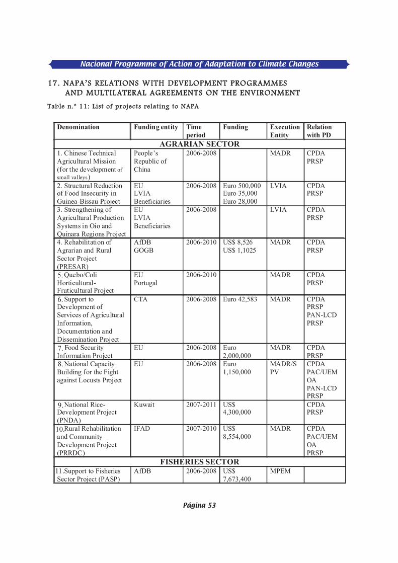
1177.. NNAAPPAA’’SS RREELLAATTIIOONNSS WWIITTHH DDEEVVEELLOOPPMMEENNTT PPRROOGGRRAAMMMMEESS AANNDD MMUULLTTIILLAATTEERRAALL AAGGRREEEEMMEENNTTSS OONN TTHHEE EENNVVIIRROONNMMEENNTT
TTaabbllee nn..ºº 1111:: LLiisstt ooff pprroojjeeccttss rreellaattiinngg ttoo NNAAPPAA
Denomination Funding entity Time period
Funding
Execution Entity
Relation with PD
AGRARIAN SECTOR 1. Chinese Technical Agricultural Mission (for the development ofsmall valleys)
People’s Republic of China
2006-2008 MADR CPDA PRSP
2. Structural Reduction of Food Insecurity in Guinea-Bissau Project
EU LVIA Beneficiaries
2006-2008 Euro 500,000 Euro 35,000 Euro 28,000
LVIA CPDA PRSP
3. Strengthening of Agricultural Production Systems in Oio and Quinara Regions Project
EU LVIA Beneficiaries
2006-2008 LVIA CPDA PRSP
4. Rehabilitation of Agrarian and Rural Sector Project (PRESAR)
AfDB GOGB
2006-2010 US$ 8,526 US$ 1,1025
MADR CPDA PRSP
4. Quebo/Coli Horticultural-Fruticultural Project
EU Portugal
2006-2010 MADR CPDA PRSP
5. Support to Development of Services of Agricultural Information,Documentation and Dissemination Project
CTA 2006-2008 Euro 42,583 MADR CPDA PRSP PAN-LCD PRSP
6. Food Security Information Project
EU 2006-2008 Euro2,000,000
MADR CPDA PRSP
7. National Capacity Building for the Fightagainst Locusts Project
EU 2006-2008 Euro1,150,000
MADR/SPV
CPDA PAC/UEMOA PAN-LCD PRSP
8. National Rice-Development Project(PNDA)
Kuwait 2007-2011 US$ 4,300,000
CPDA PRSP
9. Rural Rehabilitationand Community Development Project(PRRDC)
IFAD 2007-2010 US$ 8,554,000
MADR
CPDA PAC/UEMOA PRSP
FISHERIES SECTOR 9. Support to Fisheries Sector Project (PASP)
AfDB 2006-2008 US$ 7,673,400
MPEM
Nacional Programme of Action of Adaptation to Climate Changes
Página 53
5.
6.
7.
8.
9.
10.
11.

Nacional Programme of Action of Adaptation to Climate Changes
Página 54
The advance of the desert, particularly in the country’s eastern and northern regions,constitutes a current reason for concern to CILLS member countries. The Guinea-Bissaugovernment validated in December 2006 its National Plan of Action to Fight againstDesertification (PAN-LC), which proposes to invest US$ 27 million in the next 5 years inprojects to mitigate the effects of desertification on populations, particularly as regards soildegradation, loss of vegetation cover, decrease of humid areas and agrarian productivity.
1188.. OOBBSSTTAACCLLEESS TTOO IIMMPPLLEEMMEENNTTAATTIIOONN
Obstacles to implementation can be summarised as follows:
1. Key actors’ institutional weaknesses 2. Low level of knowledge on the part of populations and key actors on climate changes.3. Unpredictability of effects of climate changes.4. Possibilities to obtain sufficient resources for execution.5. Expected difficulties regarding change in populations’ attitudes and practices.
1199.. MMEEAASSUURREESS IIMMPPLLEEMMEENNTTEEDD TTOO DDEEAALL WWIITTHH CCLLIIMMAATTEE CCHHAANNGGEESS
The country pondered in the various development programmes it has implementedactions that had some bearing on mitigation efforts to climate change effects. The followingactions may be summarised per each sector:
AAGGRRAARRIIAANN SSEECCTTOORR::
1. Agrarian Zone 1 Integrated Rural Development Programme, 1983-1994, (NorthernZone). This programme executed a broad set of rural extension and research activities thatinvolved the collaboration of technical staff and producers and contributed to (i) setting upof a system of agricultural, grazing and forest production, (ii) construction of anti-salt dykesand/or recuperation of mangrove soils’ productive capacity, (iii) construction of rural wells,(v) intensifying of horticulture, (vi) adoption of precocious-fire techniques in contrast touncontrolled slash-and-burn practices, (vii) introduction of rapid-growth exotic forestessences as sources of firewood, and improved cookers, as a strategy to reduce firewoodconsumption, and (viii) granting of agricultural micro-credit (small agricultural tools,purchase of seeds and fertilizers).
2. Eastern Agrarian Zone’s Integrated Rural Development Programme (PDRL-2), 1983-1993, (Eastern Zone). This programme performed actions involving its technical staff andfarmers that helped to: (i) fight desertification through an extension of the agricultural,grazing and forest system, (ii) the fostering of horticulture, (iii) the use of large swaths of basfonds for rice growing and horticulture, (iv) forest resettlement of some degraded areas, (vii)the building of community fountains, (vi) purchase of diverse agricultural material andequipment.
3. Programme of Support to Boé Integrated Development (PADIB), implemented in 1990-1998. This programme provided farmers in the country’s easternmost area considerablesupport to their production efforts in the agricultural, fruticultural and horticultural fieldsand forest resources as well.
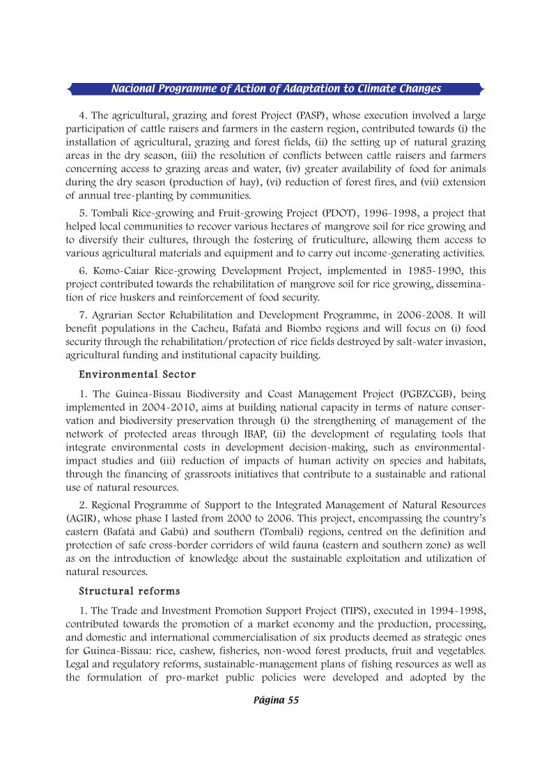
4. The agricultural, grazing and forest Project (PASP), whose execution involved a largeparticipation of cattle raisers and farmers in the eastern region, contributed towards (i) theinstallation of agricultural, grazing and forest fields, (ii) the setting up of natural grazingareas in the dry season, (iii) the resolution of conflicts between cattle raisers and farmersconcerning access to grazing areas and water, (iv) greater availability of food for animalsduring the dry season (production of hay), (vi) reduction of forest fires, and (vii) extensionof annual tree-planting by communities.
5. Tombali Rice-growing and Fruit-growing Project (PDOT), 1996-1998, a project thathelped local communities to recover various hectares of mangrove soil for rice growing andto diversify their cultures, through the fostering of fruticulture, allowing them access tovarious agricultural materials and equipment and to carry out income-generating activities.
6. Komo-Caiar Rice-growing Development Project, implemented in 1985-1990, thisproject contributed towards the rehabilitation of mangrove soil for rice growing, dissemina-tion of rice huskers and reinforcement of food security.
7. Agrarian Sector Rehabilitation and Development Programme, in 2006-2008. It willbenefit populations in the Cacheu, Bafatá and Biombo regions and will focus on (i) foodsecurity through the rehabilitation/protection of rice fields destroyed by salt-water invasion,agricultural funding and institutional capacity building.
EEnnvviirroonnmmeennttaall SSeeccttoorr
1. The Guinea-Bissau Biodiversity and Coast Management Project (PGBZCGB), beingimplemented in 2004-2010, aims at building national capacity in terms of nature conser-vation and biodiversity preservation through (i) the strengthening of management of thenetwork of protected areas through IBAP, (ii) the development of regulating tools thatintegrate environmental costs in development decision-making, such as environmental-impact studies and (iii) reduction of impacts of human activity on species and habitats,through the financing of grassroots initiatives that contribute to a sustainable and rationaluse of natural resources.
2. Regional Programme of Support to the Integrated Management of Natural Resources(AGIR), whose phase I lasted from 2000 to 2006. This project, encompassing the country’seastern (Bafatá and Gabú) and southern (Tombali) regions, centred on the definition andprotection of safe cross-border corridors of wild fauna (eastern and southern zone) as wellas on the introduction of knowledge about the sustainable exploitation and utilization ofnatural resources.
SSttrruuccttuurraall rreeffoorrmmss
1. The Trade and Investment Promotion Support Project (TIPS), executed in 1994-1998,contributed towards the promotion of a market economy and the production, processing,and domestic and international commercialisation of six products deemed as strategic onesfor Guinea-Bissau: rice, cashew, fisheries, non-wood forest products, fruit and vegetables.Legal and regulatory reforms, sustainable-management plans of fishing resources as well asthe formulation of pro-market public policies were developed and adopted by the
Nacional Programme of Action of Adaptation to Climate Changes
Página 55
Nacional Programme of Action of Adaptation to Climate Changes
Página 56
authorities; numerous private-sector associations were assisted to emerge and consolidatetheir organisation and institutional-management capabilities.
2. Private Sector Development Project, 2000-2007, which assisted in the preparation ofreform for the economic sector and in capacity building to the benefit of both private sectororganisations and those of the public sector in the area of legal reform and the creation ofan enabling environment to business.
3. National Good Governance Programme, implemented in 2002-2004 with the aim ofstrengthening governance capacity at different levels. For instance, it assisted in the formu-lation of the Environmental Management National Plan (PNGA).
AAccttiioonnss uunnddeerrttaakkeenn bbyy NNGGOOss
1. Other than these public programmes/projects, whose 90% of resources come fromexternal assistance (grants or credit), NGOs settled in the country (local and foreign ones),have also implemented various activities in the fields of community development,micro-credit, capacity building and the environment (nature conservation and biodiversitypreservation).

AANNNNEEXXEESS
Nacional Programme of Action of Adaptation to Climate Changes
Página 57

Nacional Programme of Action of Adaptation to Climate Changes
Página 59
PPRROOJJEECCTT FFIILLEE NN..ºº 11
PPrroojjeecctt TTiittllee:: Support to the Diversification of Production and Food Diet Project.
LLooccaattiioonn:: Quinara and Tombali regions
JJuussttiiffiiccaattiioonn::
Rice is the country’s main food crop. It is produced both in the mangrove productionsystem and in small valleys and uplands.
Despite being the country’s main food crop local production can only meet 50%-55 % ofnational needs. The difference between supply and demand is covered by importations. Themangrove rice’s production system (the country’s main type) has been steeply degradinglately due to structural and occasional problems. The downward trend seen on rainfallpatterns coupled with a rise in river waters’ levels, thus leading to penetration of rice fieldsby salt water and their consequent destruction, tends to worsen. The 2005/2006 harvestmay be quoted as an example to illustrate this point. Production in the south of the countrywas almost totally lost. This is was a very critical situation indeed but it also helped toawaken mangrove-rice growers (one-crop farmers) for the need to diversify production. Thefood shortage that set in led farmers to seek for alternatives themselves and we can see themcurrently growing cassava, sweet potato and yam. Despite being at a very reduced scale dieto the insufficiency of vegetation material, it is already an initiative that may be utilised tolaunch a broad programme to diversify production as an alternative for cases of insufficientrain bearing in mind that the initiative and interest came from the farmers themselves. Theproject thus appears as a relief to the food insecurity problem caused by lack of rain or waterpenetration of mangrove-rice fields.
Project actions (production, processing and commercialisation) will be designed in sucha way that beneficiaries will be responsible for their execution, and actions will havecontinuity after the project’s completion.
GGlloobbaall oobbjjeeccttiivvee:: Increase in food security
SSppeecciiffiicc oobbjjeeccttiivveess:: To foster the diversifying of production and consumption of foodstuff in the Quinará and
Tombali regions.
CCoommppoonneennttss::
- Production, processing and commercialisation of cereals;- Production, processing and commercialisation of fruit and vegetables;- Food and nutrition.
EExxppeecctteedd rreessuullttss::- A diversified consumption of local produce Production of vegetables in adequate
quantity and quality.- Populations become accustomed to consume a diversified mix of local produce with
higher nutritional value.

- Lower risk of food insecurity malnutrition.- Increase in households’ incomes through the commercialisation of surplus production
Beneficiaries:
Rural communities.
IInnssttiittuuttiioonnaall IImmpplleemmeennttaattiioonn FFrraammeewwoorrkk::
Ministry of Agriculture and Rural Development, DGA, DSER, Directorate of Producers’Service Support, Ministry of Public Health.
MMoonniittoorriinngg aanndd EEvvaalluuaattiioonn::
To be ensured by DGA, GAPLA, Directorate General of Environment and CAIA.
RRiisskkss aanndd BBaarrrriieerrss::
There are no risks and barriers that may jeopardise the project’s implementation.
PPrroojjeecctt dduurraattiioonn:: 3 years.
BBuuddggeett:: US$ 600,000
Nacional Programme of Action of Adaptation to Climate Changes
Página 60

Nacional Programme of Action of Adaptation to Climate Changes
Página 61
PPRROOJJEECCTT FFIILLEE NN..ºº 22
PPrroojjeecctt TTiittllee: Rural Zones Sanitation and Water-Supply Improvement Project
LLooccaattiioonn:: Southern Province (Bolama, Quinará and Tombali regions) Eastern Province(Bafatá and Gabú regions)
JJuussttiiffiiccaattiioonn::
Potable water supply and sanitation are domains that affect populations’ quality of life andpublic health. There is a need to increase the supply of potable water and sanitationservices in villages in order to decrease the risk of waterborne diseases that are, in general,much frequent in the rural world. It should be recalled that the latest cholera epidemic, in2005, registered about 25,000 cases and 400 fatalities (National Human DevelopmentReport, UNDP), due to bad sanitation conditions.
GGlloobbaall oobbjjeeccttiivvee::
To improve access to quality water and reduce the risk of contraction of waterborne- andinfectious diseases.
SSppeecciiffiicc oobbjjeeccttiivveess::
- To improve rates of access to quality water;- To eliminate conditions that contribute to the appearance of cholera outbreaks and other
diseases.
CCoommppoonneennttss::
- Sensitisation;
- Construction of latrines and environmental sanitation;
- Construction of improved wells and boreholes.EExxppeecctteedd rreessuullttss::
- 60 % of population have access to potable water;- Non-appearance of cholera epidemics and other diseases related to water consumption
and sanitation conditions.
BBeenneeffiicciiaarriieess::
Communities and schools
Institutional Implementation Framework:
The Directorate General of Water Resources will implement the “Construction of wells”component and components concerning sensitisation and the construction of latrines will beplaced under the Ministry of Public Health, which will benefit from support of some NGOs.
Monitoring and Evaluation:
Components’ supervising agencies and the donor, to whom the project managementwill be accountable and will submit reports for appraisal and approval, will ensure themonitoring of this project’s activities.

RRiisskkss aanndd BBaarrrriieerrss::
The main risk factors may arise form political instability and the mental attitude onthe part of populations. Therefore, special attention ought to be paid to populations’sensitisation.
DDuurraattiioonn:: 2 years
BBuuddggeett:: US$ 1.000,000
Nacional Programme of Action of Adaptation to Climate Changes
Página 62

Nacional Programme of Action of Adaptation to Climate Changes
Página 63
PPRROOJJEECCTT FFIILLEE NN..ºº 33
Project Title: Capacity Building in Prevention and Protection of Salt-Water Rice againstHigh-Tide Invasion Project
LLooccaattiioonn:: Country’s Coastal Zone (Mangrove rice fields)
JJuussttiiffiiccaattiioonn
Salt-water invasion, driven by high tides into mangrove rice fields, remains the main causeof decrease in rice production in the mentioned ecosystem. On the other hand, protection ofthose rice fields remains the main obstacle against those fields’ enhancement. In the last fewyears climate changes, especially man-made ones have accentuated worldwide resulting inglobal warming and a rise in average sea level. This latter aspect embodies concerns bylittoral populations regarding physical protection of their ecosystems and biodiversity.Mangrove rice fields are part of this ecosystem and require pressing solutions for its rehabil-itation and protection.
Almost every year high tides cause enormous damage to dykes and other infrastruc-ture built for the control and protection of rice fields against salt-water invasion. Thisphenomenon occurs usually at the end of the rainy season, in September-October, after thefinalisation of rice sowing and rice transplant. For that reason, any invasion of rice fields bysalt in that time of the year may kill the rice plant since the decrease in rainfall makes itdifficult to find enough additional water to wash off the salt thus introduced.
GGlloobbaall oobbjjeeccttiivvee::Improvement of the country’s food security
SSppeecciiffiicc oobbjjeeccttiivveess::
To improve rice production in mangrove rice fields thanks to the implementation ofpreventive and protective measures against high-tide invasion.
CCoommppoonneennttss::
- Rehabilitation of the country’s main meteorological stations;- Installation of PRESLOG automatic tide-level recording devices in different ports in the
country;- Training national technical staff in processing of meteorology, hydrology and hydro-
metrics data;- Systematic dissemination of information on rainfall, temperature and high tides in
coastal areas;- Technical studies (hydraulic and hydrologic) and designing of infrastructure for
protection against, and control of, high tides;- Execution of hydraulic works;
EExxppeecctteedd rreessuullttss::
1. Hydrologic and hygrometric information is collected and disseminated so as to allowfarmers to prepare each September and October (day and time) for the arrival of high tides.

2. Rice fields are protected from the invasion of high tides through the building ofenhanced dykes and the learning of new water control and management techniques.
3. Food insecurity associated to rupture in households’ rice stocks is reduced thanks to anincrease in mangrove-rice production levels (from 500-700kg/ha to 2500kg/ha).
BBeenneeffiicciiaarriieess::
Rural communities and Directorate General of Meteorology
IInnssttiittuuttiioonnaall IImmpplleemmeennttaattiioonn FFrraammeewwoorrkk::
A unit will be set up whose role will be to deal with the execution of project activities instrict collaboration with rural engineering services, INPA, regional offices of the Ministry ofAgriculture and Rural Development and NGOs.
MMoonniittoorriinngg aanndd EEvvaalluuaattiioonn::
Monitoring and evaluation will fall under the Ministries of Agriculture and RuralDevelopment, and Transportation and Communications as well as on donors.
RRiisskkss aanndd BBaarrrriieerrss::
PPrroojjeecctt dduurraattiioonn:: 2 years
BBuuddggeett:: US$ 600,000
Nacional Programme of Action of Adaptation to Climate Changes
Página 64
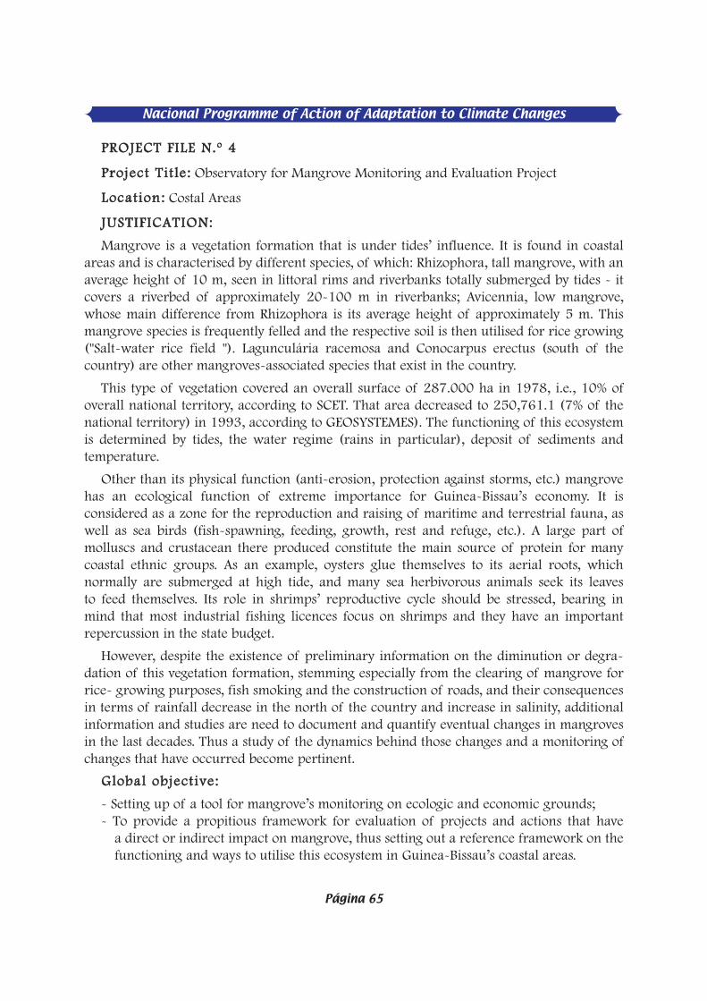
Nacional Programme of Action of Adaptation to Climate Changes
Página 65
PPRROOJJEECCTT FFIILLEE NN..ºº 44
PPrroojjeecctt TTiittllee:: Observatory for Mangrove Monitoring and Evaluation Project
LLooccaattiioonn:: Costal Areas
JJUUSSTTIIFFIICCAATTIIOONN::
Mangrove is a vegetation formation that is under tides’ influence. It is found in coastalareas and is characterised by different species, of which: Rhizophora, tall mangrove, with anaverage height of 10 m, seen in littoral rims and riverbanks totally submerged by tides - itcovers a riverbed of approximately 20-100 m in riverbanks; Avicennia, low mangrove,whose main difference from Rhizophora is its average height of approximately 5 m. Thismangrove species is frequently felled and the respective soil is then utilised for rice growing("Salt-water rice field "). Lagunculária racemosa and Conocarpus erectus (south of thecountry) are other mangroves-associated species that exist in the country.
This type of vegetation covered an overall surface of 287.000 ha in 1978, i.e., 10% ofoverall national territory, according to SCET. That area decreased to 250,761.1 (7% of thenational territory) in 1993, according to GEOSYSTEMES). The functioning of this ecosystemis determined by tides, the water regime (rains in particular), deposit of sediments andtemperature.
Other than its physical function (anti-erosion, protection against storms, etc.) mangrovehas an ecological function of extreme importance for Guinea-Bissau’s economy. It isconsidered as a zone for the reproduction and raising of maritime and terrestrial fauna, aswell as sea birds (fish-spawning, feeding, growth, rest and refuge, etc.). A large part ofmolluscs and crustacean there produced constitute the main source of protein for manycoastal ethnic groups. As an example, oysters glue themselves to its aerial roots, whichnormally are submerged at high tide, and many sea herbivorous animals seek its leavesto feed themselves. Its role in shrimps’ reproductive cycle should be stressed, bearing inmind that most industrial fishing licences focus on shrimps and they have an importantrepercussion in the state budget.
However, despite the existence of preliminary information on the diminution or degra-dation of this vegetation formation, stemming especially from the clearing of mangrove forrice- growing purposes, fish smoking and the construction of roads, and their consequencesin terms of rainfall decrease in the north of the country and increase in salinity, additionalinformation and studies are need to document and quantify eventual changes in mangrovesin the last decades. Thus a study of the dynamics behind those changes and a monitoring ofchanges that have occurred become pertinent.
GGlloobbaall oobbjjeeccttiivvee::
- Setting up of a tool for mangrove’s monitoring on ecologic and economic grounds;- To provide a propitious framework for evaluation of projects and actions that have
a direct or indirect impact on mangrove, thus setting out a reference framework on thefunctioning and ways to utilise this ecosystem in Guinea-Bissau’s coastal areas.

SSppeecciiffiicc oobbjjeeccttiivveess::
This project aims specifically at:
- Improving scientific knowledge on mangrove’s ecosystem and determining monitoringmodalities;
- Protecting habitats and ecological processes and stabilising the littoral;
- Contributing towards mangrove organisation through an enhancement of its products;
- Making available technical-scientific bases for evaluation of projects and actions withdirect and indirect impact on mangrove and proposing recovery measures for heavilydegraded zones.
EExxppeecctteedd rreessuullttss::
- Stations and Observatory office set up, equipped and endowed with qualified technicalstaff;
- Monitoring and research programmes are adopted on the basis of a strong institutionaland technical cum scientific partnership;
- A manual on mangrove’s protection and management measures, ecologic processes andlittoral stabilisation is prepared and disseminated;
- Specific legislation and data bank exist;
- Different actors and modus operandi in the production field are identified;
- A manual on techniques and micro-projects aimed at the enhancement of mangroveproducts is prepared;
- The data bank contains sufficient information for studies on environmental impact (EIA);
- Proposals for the recovery of degraded areas are prepared and presented to deci-sion-making entities.
BBeenneeffiicciiaarriieess::
The main beneficiaries of this project are the State, universities, research institutions, enti-ty in charge of coast planning, local government and local population.
IInnssttiittuuttiioonnaall IImmpplleemmeennttaattiioonn FFrraammeewwoorrkk::
The National Mangrove Observatory (ONM) will operate with the structures shown in theorganisation chart below.
ONM will be placed under the direct supervision of the Coast Planning Office. Itsmanagement will have a director, a coordinator for research programmes and monitoring,an administration and financial officer and a secretary. Its executive function will be toensure the observatory’s daily operations and management in its administrative, financial,personnel and programme area, as well as its relations with other peer institutions.
Nacional Programme of Action of Adaptation to Climate Changes
Página 66

Nacional Programme of Action of Adaptation to Climate Changes
Página 67
The Inter-institutional Scientific Council is made up of different institutions that developactivities linked to the mangrove ecosystem. Its role consists in taking major decisions on sci-entific matters (appraisal and approval of research and monitoring programmes, evaluationof scientific performance) and advising management as regards procedures leading to deci-sion taking by public authorities.
The following stations will be set up:- Cacheu, for the country’s northern and central areas- Iemberem, for the south- Orango, for the Bijagós archipelago
Each station will be run by a station head with research background and will have a tech-nical staff member, who will report to the ONM director and the programme coordinator.
MMOONNIITTOORRIINNGG AANNDD EEVVAALLUUAATTIIOONN::
Monitoring of ONM activities will be carried out by: (i) the supervising entity and donors,to whom the observatory will report through regular reports (ii) the scientific council,which, as earlier indicated, will be in charge of, inter alia, the validation of programmes, i.e.,proposed actions and outcomes, and (iii) national institutional partners and the populationat large, at regular restitution meetings, whose periodicity will be set out by the observatory’smanagement.
RRIISSKKSS AANNDD BBAARRRRIIEERRSS::
The observatory’s heavy dependence on external funding for the financing of activities,scientific research in particular. The second potential risk could be a conflict in projectexecution between institutions that work with mangroves, either directly or indirectly.
DDUURRAATTIIOONN:: 2 years
BBUUDDGGEETT:: US$ 800,000
PPRROOJJEECCTT FFIILLEE NN..ºº 55
PPrroojjeecctt TTiittllee:: Coastal-Areas Erosion Monitoring Project
LLooccaattiioonn:: Coastal Areas
JJUUSSTTIIFFIICCAATTIIOONN:
Guinea-Bissau has a coastal zone of approximately 270Km. That zone is characterised byan intense dynamics marked by accumulation and erosion spots along the coast and in someislands of the Bijagós archipelago. Some palpable examples may be quoted to illustrate thispoint. There is intense coast erosion in Varela beach, in the northwest, caused in part bydirect wave action on the coast and, on the other hand, by rainwater falling out a cliff facingthe coast. This phenomenon tends to worsen because of the increasing pressure of urbaniza-tion towards the coast. A plantation of ornamentation trees and some infrastructure that existon the coast have been disappearing gradually.
Another zone with a visible erosion phenomenon is located in the islands of Bubaque andJoão Vieira, in the Bijagós archipelago. Erosion in Bubaque is linked above all to direct seaaction (waves) on the coast and a stream of rainwater and water originating at HotelBubaque. This zone has an active escarpment whose erosion tendency is likely to last formany years. It is pertinent to underscore that part of the surrounding vegetation had alreadydisappeared due to this phenomenon. Erosion in João Vieira is linked especially to the impactof waves on the coast and part of the natural vegetation has already disappeared.
There is little systematised information and in-depth studies that explain the causes andconsequences of coastal erosion in Guinea-Bissau.
It is in such a perspective that a project for the monitoring (research-action) of coastalerosion should be seen, endeavouring to deepen knowledge about this phenomenonand its negative impact on the littoral in particular, and the environment in general, onGuinea-Bissau’s coastal zone.
GGlloobbaall oobbjjeeccttiivvee::
Production of a synthesis of multidisciplinary knowledge on coastal erosion and theworkings of the coastal environment with a view to finding a tool meant to help in decision-making.
SSppeecciiffiicc oobbjjeeccttiivveess::
- Follow up with the aid of modern methods of remote detection and fieldwork of thestatus of erosion in critical sites on the above-mentioned coastal zone;
- Dissemination of information and knowledge about coast erosion;
- Proposals to minimise the coast-erosion phenomenon in specific critical zones.
EExxppeecctteedd rreessuullttss::
- An easily accessible and usable data bank for involved local and international partnersis set up;
Nacional Programme of Action of Adaptation to Climate Changes
Página 68
Nacional Programme of Action of Adaptation to Climate Changes
Página 69
- An institution in charge of coast erosion monitoring and study is set up at a nationallevel, in consensus with other institutions;
- Small-scale works to provide protection against coast erosion are carried out in criticallocations;
BBeenneeffiicciiaarriieess::
State, universities, research institutions, entity responsible for coast planning, localgovernment and local population;
IInnssttiittuuttiioonnaall IImmpplleemmeennttaattiioonn FFrraammeewwoorrkk::
The Ministry of Agriculture and Rural Development will be in charge of this project’ssupervision and the Coast Planning Office will ensure its technical execution, in partnershipwith universities and research centres from countries in the North, the Directorate ofGeology and Mines and the Ministry of Public Works. In his context, universities, making useof students in training schemes or working on their thesis, will be in charge of the scientificmonitoring of coast erosion developments in predefined critical sites.
The Directorate of Geology and Mines and the Ministry of Public Works will providetechnical assistance, particularly as regards the proposal for the execution of small worksthat minimize the negative impact of erosion on the coast.
MMoonniittoorriinngg aanndd eevvaalluuaattiioonn::
The project will be subject to regular multidisciplinary and inter-ministerial evaluation inaccordance with policies and procedures set out by donors for the project’s supervision andexecution. Different reports will be prepared as per requirements set out by donors and theexecution agency.
External auditing will be done regularly.
RRiisskkss aanndd bbaarrrriieerrss::
The project’s reliance on external funding constitutes the main risk facing the project.Another risk relates to national universities; none of the two universities has hithertocurricula and courses on natural sciences and the environment. Such a fact may affect thescientific monitoring of activities and the setting up of a data bank as well as a knowledgebase on erosion and coast dynamics.
DDuurraattiioonn: 3 years
BBuuddggeett:: US$ 400,000 USD
PPRROOJJEECCTT FFiillee NN..ºº 66
PPrroojjeecctt TTiittllee:: Evaluation of Impact of Climate Changes in Productive Sectors’ Project
LLooccaattiioonn:: Nationwide (Guinea-Bissau)
JJuussttiiffiiccaattiioonn::
Guinea-Bissau is a country whose coastal area corresponds to 61% of the nationalterritory. Ecosystems in this zone are sensitive and vulnerable to nefarious effects of climatechanges.
Negative effects from anthropic actions constitute one of the main factors that accelerateclimate changes and, as result, increase natural resources’ degradation and deterioration.Factors behind climate changes are visible through the extinction of various species andvarious problems related to human health are evident.
After independence several programmes, projects and sector development plans wereimplemented without taking into account environmental and social aspects. As a result,significant infrastructure is at risk and various species, habitats and ecosystems are endan-gered and degraded.
The country has a serious prospect of finding and eventually exploiting important depositsof minerals (Bauxite, Phosphate and Oil), which justifies the setting up of an early alertsystem for the prevention and evaluation of risks and the negative effects these activities mayimply regarding the acceleration of climate changes.
Prevention is considered as the best way to protect, preserve and guarantee ecosystems’structural and functional equilibrium and related dynamics.
In this context, and aiming at reaching Millennium Development Goals and ensuring asustainable development as per commitments made both locally and at the internationallevel, the government set up in late 2004 a unit for the Evaluation of Environmental Impact(CAIA).
Through the creation of this unit the government aims at foreseeing, correcting,preventing, identifying and/or mitigating through environmental evaluation (environmentalaudits for projects being implemented and socio-environmental impact studies for projectsbeing designed, evaluation of risks and natural and anthropic catastrophes) negative effectsthat anthropic actions (projects, programmes, plans and policies) cause and/or may cause onthe environmental system.
This challenge requires awareness at all levels, an enormous availability of qualifiedtechnical and scientific capabilities, legal framework and norms and procedures as well asclear and well defined institutional aspects, material means and equipment.
This project fits into overall efforts to ensure technical, legal and institutional capacity atthe national level in terms of environmental evaluation, particularly as regards the impact ofclimate changes in productive sectors.
Nacional Programme of Action of Adaptation to Climate Changes
Página 70

Nacional Programme of Action of Adaptation to Climate Changes
Página 71
GGlloobbaall oobbjjeeccttiivvee::
- To ensure national capacity building in the field of environmental and social evaluationof negative effects of climate changes on development sectors and projects, pro-grammes, plans and sector development policies;
SSppeecciiffiicc oobbjjeeccttiivveess::
- Strengthening of technical capacity (sensitisation, training, empowerment and specia-lization) of national technical staff in environmental evaluation;
- Strengthening of a legal and institutional framework that is appropriate, acceptable,credible and stable;
- Setting up of an adequate mechanism for an environmental evaluation and monitoringof negative effects of changes before, during and after the implementation of projects,programmes, plans and policies.
EExxppeecctteedd rreessuullttss::
- Guinea-Bissau provided with a credible institution in terms of studies of assessment ofsocial and environmental impact;
- Sector guides, Guidelines and Manual of Procedures on environmental evaluationprepared, published and disseminated in all local mass media;
- Permanent mechanism for the monitoring and evaluation of negative effects of climatechanges and anthropic actions set up;
- Legal framework set up, published and disseminated in all local mass media;- Data bank set up and available for users.
BBeenneeffiicciiaarriieess::
National cadres and staff, the government, Guinean population, investors, local commu-nities and the international community will be the main beneficiaries
IInnssttiittuuttiioonnaall IImmpplleemmeennttaattiioonn FFrraammeewwoorrkk::
The body responsible for the implementation of this project is the unit for Evaluation ofEnvironmental Impact, in joint collaboration with development partners.
MMoonniittoorriinngg aanndd eevvaalluuaattiioonn::
The project will be subject to a regular evaluation in accordance with the policy andprocedures set by donors and the government for the project’s supervision and execution.The project head will submit each year a half yearly report and an annual synthesis. He willsubmit also a final report at the end of the project. The different reports will be sent to thegovernment, donors and the agency.
RRiisskkss aanndd BBaarrrriieerrss::
The main risk relates to the State’s dependence on projects financed from abroad.
DDUURRAATTIIOONN:: 2 years
BBUUDDGGEETT:: US$ 350. 000

PPRROOJJEECCTT FFIILLEE NN..ºº 77
Project Title: Project Promotion of Small-scale Irrigation Schemes in Geba and Corubalrivers’ Project
LLooccaattiioonn:: Bafatá, Gabú and Tombali regions.
JJuussttiiffiiccaattiioonn:
Guinean agriculture remains predominantly dependent on rainfall, which does not allowhigh yields in agricultural production. This situation is compounded by the influence ofclimate factors namely in years where there are long time intervals without rain. In the Gaburegion, Pitche and Pirada suffer from seed losses and populations are forced to sow againtheir seeds; production shortages losses and sudden rain stoppages do not allow cultures tocomplete their vegetative growing cycle.
Yet, there are considerable potentialities and actual water resources, particularly inCorubal River. This opportunity is far from being tapped. The use of water resources and theoptimisation of the use of lands in Geba and Corubal riverbanks for irrigation would be analternative in the search for solutions to diminish the risk of effects of low rainfall and watershortage for agriculture. Irrigated agriculture allows the employment of modern control andmanagement techniques, leading to high production yields.
GGlloobbaall oobbjjeeccttiivvee::
Increase in food security.
SSppeecciiffiicc oobbjjeeccttiivveess:
To increase agricultural production through the employment of efficient techniques forwater control and management.
CCoommppoonneennttss::
- Technical studies - Hydro-agricultural execution- Beneficiaries’ training and fitting.
EExxppeecctteedd rreessuullttss:
- Potential sites for agricultural development identified and surveyed.- Summarised ante-project files prepared in search for funding to enable projects’
expansion.- Hydro-agricultural and development works in a perimeter of approximately 100
hectares per year.
BBeenneeffiicciiaarriieess::
Farmers’ associations, rural communities, private sector.
IInnssttiittuuttiioonnaall IImmpplleemmeennttaattiioonn FFrraammeewwoorrkk::
Ministry of Agriculture and Rural Development, DGA, DSER.
Nacional Programme of Action of Adaptation to Climate Changes
Página 72

Nacional Programme of Action of Adaptation to Climate Changes
Página 73
MMoonniittoorriinngg aanndd EEvvaalluuaattiioonn::
Supervising entity (MDRA), Directorate General of Environment, CAIA, NGOs, farmers’organisations and partners.
RRiisskkss aanndd BBaarrrriieerrss::
Conflicts may arise on land tenure, cattle transhumance and other aspects that theproject needs to clarify. Steps will have to be taken at the outset to overcome existing risks.
DDuurraattiioonn:: 3 years
BBuuddggeett:: US$ 800,000

PPRROOJJEECCTT FFIILLEE NN..ºº 88
PPrroojjeecctt TTiittllee:: Natural-catastrophe Prevention Project
LLooccaattiioonn:: Nationwide
JJuussttiiffiiccaattiioonn::
Guinea-Bissau has a surface of 36 125 kmÇ. Its overall population is 1 200 000 inhabi-tants. The country is frequently hit by drought, floods and erosion like in other West Africancountries. Drought and the danger of accelerated desertification threaten a weak economyand lead to a population exodus towards the countryside.
The government, aware of the situation, has formulated a number of guidelines, of whichone relating to the prevention of catastrophes thanks to meteorological information.Unfortunately, meteorology and hydrology services are currently unable to provide aneffective contribution into a natural-catastrophe prevention system due to the existinginsufficiency in terms of specialised personnel for the application of new technologies andmethodology in this field.
On the other hand, lack of equipment and weak management means, coupled with theabsence of a national plan for situations of natural catastrophes, need to be taken intoconsideration under this project. A coherent training and specialisation programme is ofcapital importance and urgency.
GGlloobbaall oobbjjeeccttiivvee::
The project’s global objective is to contribute towards an improvement in populations’living conditions and the protection of the environment and production against effects ofnatural catastrophes, particularly those related to meteorological and hydrological pheno-mena through the setting up of an appropriate system of meteorological and hydrologicalprevention and the dissemination of warnings and advice to users in particular and thepopulation in general.
SSppeecciiffiicc oobbjjeeccttiivveess::
- To establish a national centre for meteorological and hydraulic prevention supplied withequipment and qualified personnel capable to ensure the operation of the mentionedcentre;
- To educate and sensitise populations on meteorological and hydrological phenomenalikely to provoke natural catastrophes;
- To provide meteorological and hydrological information and forecasts through thenational committee whilst improving at the same time aeronautical, maritime andfluvial forecasts.
EExxppeecctteedd rreessuullttss::
- Population sensitised and educated on meteorological and hydrological phenomenalikely to cause natural catastrophes;
Nacional Programme of Action of Adaptation to Climate Changes
Página 74

Nacional Programme of Action of Adaptation to Climate Changes
Página 75
- A group of meteorologists and hydrologists at the national meteorology centre,personnel from other services, including provincial officers involved in the fight againstnatural catastrophes, trained;
- Grade IV meteorology and hydrology personnel trained.
BBeenneeffiicciiaarriieess::
- National decision makers for the prevention, planning and the fight against naturalcatastrophes caused by meteorological and hydrological phenomena;
- Transporters (aeronautical, maritime and fluvial) and fishermen;
- Farmers.
IInnssttiittuuttiioonnaall IImmpplleemmeennttaattiioonn FFrraammeewwoorrkk::
The Directorate General of National Meteorology National (DGMN), Ministry ofTransportation. Taking into consideration contributions of activities relative tonatural-catastrophe prevention, all technical services from the Ministries of NaturalResources, Interior, Defence, Rural Development, Information and Communication will beassociated to the project’s implementation. A national project-monitoring project committeemay be set up with the participation of the Ministries of Planning and Public Health.
MMoonniittoorriinngg aanndd eevvaalluuaattiioonn::
The project will be subject to regular evaluation in accordance with the policy andprocedures set out by donors for the project’s supervision and execution. The project headwill submit a half-yearly report and a yearly synthesis report each year. He will also presenta final report at the end of the project. The different reports will be sent to the government,finding agencies and execution agency.
An overall evaluation of project outcomes will take place in the first and third years of itsexecution, according to procedures set out by financing agencies. Donors will organiseevaluation missions in collaboration with the execution agency and the respective outcomeswill be communicated to governmental entities.
RRiisskkss aanndd BBaarrrriieerrss::
The project’s main risk lies in the State dependence towards projects funded from abroad.Those projects may arrive to and end without assurances of continuity to actions started.Another risk relates to the creation of a budget line needed to ensure the employment oftrained cadres and effective outcomes on numbers and quality with a view to retaining thosecadres after the project’s completion. To deal with the risk, donors’ financial contributionwill be important throughout project implementation in order to allow a gradual transfer ofproject to national structures.
DDUURRAATTIIOONN:: 3 years
BBUUDDGGEETT:: US$ 300,000

PPRROOJJEECCTT FFIILLEE NN..ºº 99
PPrroojjeecctt TTiittllee:: Protection, Conservation and Enhacemenent of Fishing and CoastalResources Project
LLooccaattiioonn:: Nationwide
JJUUSSTTIIFFIICCAATTIIOONN::
Guinea-Bissau has one of the broader continental platforms in West Africa, with anapproximate surface of 53 000 KmÇ. Its maritime part, including the Bijagós archipelago ischaracterised by the existence of sand banks and shallow canals that may go 20 metres deep,thus making difficult navigation by large vessels. This zone is considered as one of repro-duction, growth and feeding to various sea species. This is justified by the quantity anddiversity of fishing and coastal resources found in the Guinean coast, without forgetting thecontribution of the ressurgency phenomenon that brings with it a large quantity of nutrientsto feed sea fauna.
This riches in fishing resources attracts fishermen from sub-region countries namely:Senegal, Guinea-Conakry, Sierra Leone and Ghana, who set themselves up in illegal fishingcamps in the islands or along the coast where they freely carry out their fishing activities.Fishing arts and types practised in many of these camps are inappropriate: they range fromthe use of forbidden nets to the cutting of sharks’ fins to the clearing of mangrove for fishsmoking.
This situation goes on at a time when Guinea-Bissau authorities lack means under acoherent surveillance policy for the artisan fishing carried out by foreign fishermen. Variousconflicts have taken place between local populations and foreign fishermen.
This project is part of the aim to ensure a participatory management of fishing resourcesto the benefit of Guinea-Bissau coastal communities through the appropriation of theirwater space and resources.
Special attention will be paid to local development initiatives, placing emphasis on arational exploitation of coastal fishing resources, the processing of fishing resources andtheir commercialisation with economic advantages for the local population.
GGlloobbaall oobbjjeeccttiivvee::
The project’s overall objective is to ensure the sustainable co-management and exploita-tion of fishing resources in coastal areas to the benefit of local populations.
SSppeecciiffiicc oobbjjeeccttiivveess::
- To seek viable solutions, in collaboration with all stakeholders in this production field,for a responsible management of sea and coastal resources and environment;
- To foster the sector’s sustainable development through catch enhancement, mangroveand sea products, thus contributing to the fight against poverty affecting involvedcommunities;
- Setting up of a durable institutional mechanism aiming at mediating conflicts around theutilisation of coastal fishing resources between users;
Nacional Programme of Action of Adaptation to Climate Changes
Página 76
Nacional Programme of Action of Adaptation to Climate Changes
Página 77
EExxppeecctteedd rreessuullttss::
- Fishing resources are well managed and a monitoring system makes available datadiscussed with partners (fishermen, managers and economic interest groups) to man-age and regulate annual exploitation of resources;
- Living conditions of fishing communities and other stakeholders are improved throughfish processing, conservation, and commercialisation activities;
- An effective fishing-surveillance system is set, implemented and appropriated byfishermen residing in pilot villages;
BBeenneeffiicciiaarriieess::
Local communities living in the coastal area, and those population segments that dependdirectly on fishing for their living are the main beneficiaries.
Institutional Implementation Framework:
The Ministry of Fishing and Sea Economy is the supervising agency and technicalexecution will be placed under the Directorate General of Artisan Fishing in partnership withlocal NGOs and grassroots associations;
MMOONNIITTOORRIINNGG AANNDD EEVVAALLUUAATTIIOONN::
The project will be subject to regular evaluation in accordance with the policy andprocedures set out by donors and the government for the project’s supervision andexecution. The project head will submit a half-yearly report and a yearly synthesis reporteach year. He will also present a final report at the end of the project. The different reportswill be sent to the government, finding agencies and execution agency.
RRiisskkss aanndd BBaarrrriieerrss::
The project’s main risk lies in the State dependence towards projects funded from abroad.The lack of commitment by local population towards the project may constitute animportant risk since Guineans are not traditional fishermen but rather farmers. Benefits maygo towards foreign fishermen.
DDUURRAATTIIOONN: 2 years
BBUUDDGGEETT:: US$ 450,000

PPRROOJJEECCTT FFIILLEE NN..ºº 1100
PPrroojjeecctt TTiittllee:: Integrated Food-Security Information System Project (SISA)
LLooccaattiioonn:: Nationwide
JJuussttiiffiiccaattiioonn::
Great disturbances have affected agricultural production lately as a result of the late startof the rainy season and bad rainfall distribution across time. This situation has led to aninsufficient supply of agricultural products to populations, rural ones in particular. Servicescharged with the monitoring of food production through the provision of information onrainfall, cultivated areas, expected income and production levels, animals’ and cultures’phytosanitary situation, foodstuff availability in markets, namely agricultural statistics,vegetation protection services, livestock and meteorology services are not operating well dueto lack of necessary and adequate means. Hence, it has not been possible to follow up onvulnerability and food security and the consequences translate into considerable delays andeven in the non-mobilization of necessary assistance for populations facing food shortage.The situation becomes more serious when the nutritional status of children, pregnant womenand elders is affected. This is due to lack of information to allow a rapid reaction based onreal data. This is the reason behind the SISA project, which aims at building the capacity ofunits dealing with the gathering, processing, analysis and dissemination of information aboutthe climate and availability, access and stability of food items, as well as information aboutthe market for those produce.
GGlloobbaall oobbjjeeccttiivvee::Increase in food security
SSppeecciiffiicc oobbjjeeccttiivveess::To ensure the availability of credible data about the different vulnerability, production
and food security parameters.
CCoommppoonneennttssThe early warning system (SAP EWS) and the market monitoring system (SIM MMS) are
the components of this project.
EExxppeecctteedd rreessuullttss: - Yearbooks on food production and bulletins on food and meteorology situation
published. - Market bulletins published. - Information available on a timely manner.
BBeenneeffiicciiaarriieess:: GAPLA, Vegetation Protection Services, Agricultural Statistics, Livestock Services,Meteorology and Food Security Office and populations.
Nacional Programme of Action of Adaptation to Climate Changes
Página 78

Nacional Programme of Action of Adaptation to Climate Changes
Página 79
IInnssttiittuuttiioonnaall IImmpplleemmeennttaattiioonn FFrraammeewwoorrkk:: GAPLA on behalf of the Ministry of Agriculture and Rural Development.
MMoonniittoorriinngg aanndd EEvvaalluuaattiioonn::GAPLA/DSSP
RRiisskkss aanndd BBaarrrriieerrss::Non-allocation of funds in state budget for services involved in SISA
DDuurraattiioonn:: 2 years.
BBuuddggeett:: US$ 300,000
PPRROOJJEECCTT FFIILLEE NN..ºº 1111
PPrroojjeecctt TTiittllee:: Environmental Education and Communication in Coastal Areas Project
LLooccaattiioonn:: All coastal areas in Guinea-Bissau
JJUUSSTTIIFFIICCAATTIIOONN::
Climate changes are pointed as one of the main threats against our country’s sustainabledevelopment. Pressure man has been exerting on natural resources to ensure his dailysubsistence; the existence of production systems directly associated to widespread povertysituations, which provoke land degradation, coast erosion, an indiscriminate cutting down oflarge trees for commercial purposes, shortage of potable water, an increasing reduction inunderground water, drought in the east and floods on rice fields in the south due to rises insea level show that Guinea-is very vulnerable to climate changes.
The present project is proposed bearing in mind the low level of awareness about theexisting risks and consequences arising from the above-mentioned environmentally-negativepractises and the degree of the country’s vulnerability to climate changes.
GGlloobbaall oobbjjeeccttiivvee::
To contribute towards raising environmental awareness among Guinean populations,particularly as regards impacts of climate changes on main sectors for the development ofeconomic activity.
SSppeecciiffiicc oobbjjeeccttiivveess::
- Strengthening of technical capacities and competences of target groups in adaptation toclimate changes through natural resources’ management and biodiversity conservation;
- To raise populations’ awareness through specific programmes on private and commu-nity radio stations focusing on climate changes through a rational management ofnatural resources and biodiversity.
CCOOMMPPOONNEENNTTSS:: Environmental education and communication on climate changes through a rational
management of natural resources and biodiversity under the fight against poverty.
EExxppeecctteedd rreessuullttss::
- Training and upgrading sessions held to the benefit of teachers and journalists fromprivate and community radio stations concerning climate changes through a rationalmanagement of natural resources and biodiversity;
- Workshops and studies organised aiming at the dissemination of the Convention onClimate Changes and Biodiversity and national communication on NAPA;
- Lectures organised in high schools, universities, training schools on climate changes ona rational management of natural resources and biodiversity;
- Radio debates organised at Environment and Culture Houses and among grassrootscommunities about climate changes on a rational management of natural resources andbiodiversity;
Nacional Programme of Action of Adaptation to Climate Changes
Página 80
Nacional Programme of Action of Adaptation to Climate Changes
Página 81
- Debates organised in private radio stations focusing on climate change on a rationalmanagement of natural resources and biodiversity;
- Programmes produced in private, public and community radio stations and national TVon climate changes and a rational management of natural resources and biodiversity;
- Advertisement spots and information magazines produced on climate changes and arational management of natural resources and biodiversity at Rádio Pindjiguiti;
- Photo exhibitions organised about the effects of climate changes on priority nationaldevelopment sectors at cultural centres, Environment Houses and in schools;
BBeenneeffiicciiaarriieess::Populations living in areas most vulnerable to climate changes
IInnssttiittuuttiioonnaall IImmpplleemmeennttaattiioonn FFrraammeewwoorrkk::ONG GAEC PALMEIRINHA
MMoonniittoorriinngg aanndd eevvaalluuaattiioonn::The PALMEIRINHA NGO, in close collaboration with the National Environment Institute,
will carry out project monitoring and evaluation.
RRiisskkss aanndd bbaarrrriieerrss::Political instability during the project’s implementation and late disbursing of funds after
the project’s approval.
DDUURRAATTIIOONN:: 3 (three) years
BBUUDDGGEETT:: US$ 200.000

PPRROOJJEECCTT FFIILLEE NN..ºº 1122
PPrroojjeecctt TTiittllee:: Rehabilitation of Small Perimeters of Mangrove Soils for growing of rice
LLooccaattiioonn:: Quinara, Tombali, Bafatá e Oio
JJuussttiiffiiccaattiioonn::
Potable water supply is a domain that affects populations’ life quality and public health.The aim is thus an increase in the supply of drinking water in order to decrease the risks ofcontracting waterborne diseases, which are frequent in the rural world. It should be recalledthat the latest cholera epidemic, in 2005, registered about 25,000 cases and 400 fatalities(National Human Development Report, UNDP), due to bad sanitation conditions.
GGlloobbaall oobbjjeeccttiivvee::
To improve access to quality water and reduce the risk of contraction of water- andinfectious diseases.
SSppeecciiffiicc oobbjjeeccttiivveess::
- To improve rates of access to quality water;- To eliminate conditions that contribute to the appearance of cholera outbreaks and other
diseases;
CCoommppoonneennttss:: - Reforestation;- Conservation and protection.
Expected Results: To increase vegetation cover with drought-resistant species. Improvedsoil constitution. Integrated management of land in villages by communities is strengthened.
BBeenneeffiicciiaarriieess:: Local populations, sector administrative services
IInnssttiittuuttiioonnaall IImmpplleemmeennttaattiioonn FFrraammeewwoorrkk::
The Directorate General of Water Resources will implement the “Wells building”component and components that relate to sensitisation and construction of latrines will beplaced under the Ministry of Public Health, with support from NGOs.
MMoonniittoorriinngg aanndd EEvvaalluuaattiioonn:
Supervising entities and the donor will monitor project activities and project managementwill be accountable and submit reports for their appraisal and approval.
RRiisskkss aanndd BBaarrrriieerrss::
Main risk factors may relate to political stability and lack of change in populations’ men-tal attitudes. Therefore special attention sought to be paid to sensitisation issues.
DDuurraattiioonn:: 2 years
BBuuddggeett:: US$ 500,000
Nacional Programme of Action of Adaptation to Climate Changes
Página 82

Nacional Programme of Action of Adaptation to Climate Changes
Página 83
PPRROOJJEECCTT FFIILLEE NN..ºº 1133
PPrroojjeecctt TTiittllee:: Support to Production of Short-Cycle Animals Project
LLooccaattiioonn:: Nationwide
JJuussttiiffiiccaattiioonn::
The short-cycle-animals’ raising project should be seen as a food security strategydesigned for rural and semi-urban communities. Climate changes lead to uncertainty in theproduction of vegetal foodstuffs and that calls for the seeking of other alternative sources offood, e.g., animal protein to feed our population. Guinea-Bissau has an enormous potentialin grazing land plus a population well experimented in raising animals, assets that need tobe optimised. Short-cycle livestock is a quick source of income, especially for women thatmay draw great benefits from it and hence improve their families’ living conditions, thuscontributing to poverty relief in the rural world. This project aims at augmenting productionof meat and animal proteins, and enhancing fishing and agricultural sub-products foranimal feeding culminating in an improvement in rural populations’ living conditions.
GGlloobbaall oobbjjeeccttiivvee::To increase food security.
SSppeecciiffiicc oobbjjeeccttiivveess:: To increase production and consumption of animal food items (meat, milk, eggs, etc.).
CCoommppoonneennttss::
- Production modernization;- Animal health;- Institutional support;- Training and fitting;
EExxppeecctteedd rreessuullttss::
- 10 pilot units for training and demonstration nationwide are set up;- Consumption of meat, milk, eggs and other produce from animal sources increases
nationwide;- Higher household incomes;
BBeenneeffiicciiaarriieess::
Animal raisers, NGOs, population and farmers’ organisations;
IInnssttiittuuttiioonnaall IImmpplleemmeennttaattiioonn FFrraammeewwoorrkk::Ministry of Agriculture and Rural Development (MADR) and Directorate General of
Livestock (DGP).
MMoonniittoorriinngg aanndd EEvvaalluuaattiioonn:
Monitoring and evaluation will be placed under DGP, GAPLA, Directorate General ofEnvironment, Environmental Impact Evaluation Unit.

RRiisskkss aanndd BBaarrrriieerrss::
- Lack of a master plan for livestock development- Non-approval by parliament of regulations governing the implementation of the Land
Law.
DDUURRAATTIIOONN:: 2 years.
BBUUDDGGEETT:: US$ 400.000 (Two hundred thousand dollars)
Nacional Programme of Action of Adaptation to Climate Changes
Página 84

Nacional Programme of Action of Adaptation to Climate Changes
Página 85
PPRROOJJEECCTT FFIILLEE NN..ºº 1144
PPrroojjeecctt TTiittllee:: Reforestation of Degraded Zones Project
LLooccaattiioonn:: Cambaju, Contuboel Sector (Bafatá region); Pitche, Sonaco (Gabú region)
JJuussttiiffiiccaattiioonn::
The marked disappearance of vegetation cover in areas in Cambaju due not only tonegative growing practises and the predominant growing of cotton and groundnuts added toan itinerant agriculture, associated to animal grazing and the intense exploitation ofresources by local populations, make easier not only the erosion and sedimentation of smallvalleys usable for agriculture but also the area’s desertification.
The degradation progresses and extends already further into the Contuboel sector. Thismeans that if it the situation is not addressed quickly through reforesting actions it maybecome soon an ecological disaster for the whole Gabú region, an area already arid andunder strong influence from the Sahel.
GGlloobbaall oobbjjeeccttiivvee:: Rational utilization of agricultural, grazing and forest resources;
SSppeecciiffiicc oobbjjeeccttiivveess:: To recover soils and increase forest cover in degraded areas;
CCoommppoonneennttss:: - Reforesting;- Conservation and protection;
EExxppeecctteedd rreessuullttss: - Larger area of vegetation cover, consisting of species that are adaptable to drought;- Improved soil constitution;- Better-integrated management of village lands by communities;
BBeenneeffiicciiaarriieess:: Local population, regional and sector administrative services;
IInnssttiittuuttiioonnaall IImmpplleemmeennttaattiioonn FFrraammeewwoorrkk:: Ministry of Agriculture and Rural Development through the Directorate General of
Forests and Fauna;
MMoonniittoorriinngg aanndd EEvvaalluuaattiioonn:: Directorate General of Forests and Fauna, GPPLA and IBAP;
RRiisskkss aanndd BBaarrrriieerrss:: Lack of rigour in the application of forest laws;
DDuurraattiioonn:: 2 years.
BBuuddggeett:: US$ 500,000

Nacional Programme of Action of Adaptation to Climate Changes
Página 86

Nacional Programme of Action of Adaptation to Climate Changes
Página 87
BBiibblliiooggrraapphhyy
((CCOOAASSTTAALL AARREEAA SSEECCTTOORR))
CCaabbrraall ,, AA.. ,, SSiillvvaa,, AA..,, ((22000055)):: Initial Guinea-Bissau National Communication onclimate changes.
CCUUQQ,, FF.. ,, GGOOUURRMMEELLOONN,, FF.. eett MMAADDEECC,, VV..,, ((11999933)).. Letter on soil occupancy inGuinea-Bissau at 1 :200 000. Guinea-Bissau Coast Planning. VVooll.. 22.. UUIICCNN//DDGGFFCC--MMDDRRAA..
CCUUQQ,, FF eedd.. ((22000011)).. Geographic Information System to Assist the IntegratedManagement of the Bolama Bijagós Archipelago (Guinea-Bissau). Géosystémes-CNRS.IUEM/UBO.87p.
MMDDRRAA--DDGGFFCC && IIUUCCNN ((11999933)) Coast Planning– Guinea-Bissau – TechnicalReport/Renato Maretti C.C. & collaborators, Bissau, 118p.
MMiinniissttrryy ooff NNaattuurraall RReessoouurrcceess aanndd EEnnvviirroonnmmeenntt ((22000011)).. National Strategy andPlan of Action on Biodiversity. (Draft.) 143p.
SSIIMMÃÃOO DDAA SSIILLVVAA.. AA.. ee RRAACCHHIIDD SSAAIIDD,, AA.. ((11999988)) Contribution to the Preparationof a Strategy and National Plan of Action on Biodiversity. DGA/UNDP. Bissau.
� PPRRSSPP� CCIIPPAA PPllaann ooff AAccttiioonn ((sseeee sseeccttiioonn oonn aaggrriiccuullttuurree,, ffoorreessttss aanndd lliivveessttoocckk))� LLCCDD pprrooppoosseedd ppllaann ooff aaccttiioonn � PPNNGGAA
BBiibblliiooggrraapphhyy
((WWaatteerr RReessoouurrcceess SSeeccttoorr))
11 .. Water and Sanitation Sector Master Scheme.Updated Version 1997
22 .. Water for XXI century, from vision to action for West Africa.
33 .. Studies on Guinea-Bissau Vulnerability and Adaptation to Nefarious Effects of ClimateChanges – Directorate General of Environment, GGBBSS//9977//GG//3333//GGEEFF//PPNNUUDDProject.
44 .. Water resources vis-à-vis climate changes in West Africa;What are the regional strategies to be implemented to optimise water availability. - RR.. .. MMaalloouu ((UUCCAADD))
Nacional Programme of Action of Adaptation to Climate Changes
Página 88

Nacional Programme of Action of Adaptation to Climate Changes
Página 89
55.. National Adaptation Programmes of Action, NAPA, - Publication UUNNFFCCCCCC LLEEGG--22000033..
66 .. Hydrological Evaluation of Sub-Saharan Africa, West African Countries, CountryReport: Guinea-Bissau, JJuullyy 11999922
77.. Guinea-Bissau National Plan of Action for Environmental Management, 2002 LLoouurreennççoo AA.. VVaazz,, CCaarrmmeenn PPeerreeiirraa,, MMáárriioo BBiiaagguuee
88 .. Poverty Reduction Strategy Paper ((PPRRSSPP)) AAuugguusstt 22000044
99 .. Workshop on Water, Humid Areas and Climate Change in West Africa. OverallSynthesis. BBaammaakkoo,, 2233--2255,, AApprriill 22000033
1100.. West African Conference on Plans of Action for Integrated Water ManagementSystems ((GGIIRREE))
1111.. Dictionary of Sustainable Development, IEPF Publication – 2004
1122.. Mission Report on Identification of Floodable Areas at Hydrographical Basins underOMVG Jurisdiction: Gambia, Kayanga/Geba and Koliba/Corubal Rivers. – PaulinhoSousa Azinhaga, OOccttoobbeerr 22000055
1133.. Courrier de la Planète nº 61 & Global Chance nº 14, special editions 2001
1144.. To reduce West Africa’s Vulnerability to Climate Impacts on Water Resources,Humid Areas and Desertification. – Elements of a Regional Preparation and
Adaptation Strategy. – Madiodio Nhasse, Abel Afouda & Abou Amane ((IIUUCCNN 22000044))
1155.. SSeeccttoorr RReeppoorrttss
aa .. Synthesis Report on the Agrarian Sectorbb .. Synthesis Report on the Water Sector cc .. Synthesis Report on the Coastal Areas and Fisheries Sector
1166.. 2004 HDI Report, UNDP, Guinea-Bissau1177.. 1ª National Communication, 20061188.. Letter on Agrarian Policy1199.. Health Development National Programme ((PPNNDDSS))2200.. Environmental Management National Plan ((PPNNGGAA))2211.. Water Master Scheme 2222.. Rice Sector Diagnosis, MMEEFF//PPRRDDPP,, DDaajjttaa,, ee aall ,, 22000044
Página 90
Nacional Programme of Action of Adaptation to Climate Changes
TTii tt llee :: National Programme of Action on Adaptation to Climate Changes - NAPA
AAuutthhoorrss:: The Base Documents were prepared by National Consultants from the following different sectors:
CCooaassttaall zzoonnee:: Dr. Aristides Ocante da Silva, Dr. Alfredo Simão da Silva and Dr. Justino Biai
AAggrraarriiaann SSeeccttoorr:: Eng.º Braima Djassi and Dr. Anibal Pereira
WWaatteerr RReessoouurrcceess:: Eng.º Seco Bua Baio, Eng.º Paulino de Sousa de Azinhaga
NNAAPPAA CCoommppiillaattiioonn aanndd SSyynntthheessiiss: Eng.º Dauda Sau and Dr. Aquino António Duarte
CCoooorrddiinnaattiioonn ooff TTeecchhnniiccaall WWoorrkkss:: Eng.º Alexandre Cabral
CCoommppoossiitt iioonn:: António Pansau Dafé
TTeexxtt rreevviissiioonn aanndd pprrooooff--rreeaaddiinngg:: Eng.º Dauda Sau and Eng.º Alexandre Cabral
PPaaggeess:: INACEP
PPiiccttuurreess:: Eng.º Alexandre Cabral
PPrriinntt iinngg aanndd eeddiittiinngg:: INACEP/2007

Nacional Programme of Action of Adaptation to Climate Changes
REPUBLIC OF GUINEA-BISSAU
National Programme of Action ofAdaptation to Climate Changes
MMiinniissttrryy ooff NNaattuurraall RReessoouurrcceess aanndd EEnnvvrroonnnnmmeennttGGoovveerrnnmmeenntt ooff GGuuiinneeaa--BBiissssaauu
December 2006