repton village history group · repton village history group newsletter ... november 15th alan...
TRANSCRIPT

Repton Village History Group Newsletter
Autumn 2016 (22 Sept 2016)
The Autumn Equinox is on 22nd September and so this newsletter is about due.
For various technical reasons this is not quite when day and night are of equal length.
For that we need the Equilux which is just a little later. But, recognising that Meteorologists are miles out by
choosing to use 1st September, this small discrepancy isn’t worth worrying about.
The ongoing programme of talks:
September 20th Members evening – Chris Pegg – “Wooden box part II “and Paul Heapy – “Two Fields”.
October 18th Richard Stone - “The River Trent” a water transport route.
November 15th Alan Hiley – “History of the Trent Motor Traction company”.
December 20th Colin Stewart “Calke from Medieval Priory to Elizabethan Mansion” followed by seasonal refreshments. 2017
January 17th Shirley Horton – “Street Names and Chimney Pots”
February 21st Lee Timmins – “The English Highwayman”
March 21st Member’s 10 minute talks
April 18th Arnold Burston “Robert Sherbourne, Bishop and Diplomat” local boy made good
May 16th Robert Mee “Bradshaw’s and an early railway tour” and our AGM
June 20th Archive evening/archaeology catch-up
July Visit – to be planned
August Visit – to be planned September 19th TBA
October 17th TBA
November 21st Colin Stewart – “Calke Park and estate - the archaeology”.
December 19th TBA
Meetings take place in the Village Hall (DE65 6GR) at 7.30pm.
All are welcome. Members £2.00, Visitors £3.00. Tea, coffee and biscuits included.
Catrine Jarman’s talk on the Viking Burial mound.
In June, we were fortunate to have Catrine Jarman directing the archaeological dig in the vicarage garden in
Repton and she generously gave us a talk on her research work on the bones and teeth found in Prof. Biddle’s
excavation of the Vicarage Burial Mound in 1982.
Silver coins found in the mound very closely dated the placing of the bones to the Viking
presence in 873/4 AD, but carbon dating of the bones revealed two principle date groups – one
dated to about the 873/4 time but others quite a lot earlier. In part, her aim was to establish if all
the bodies were contemporary with the Viking presence that winter. Another was to determine
if they were locals or Vikings and where they were likely to have come from.
Catrine’s isotope analysis of the teeth revealed that some were on a high marine diet, and it
turns out that fish absorb carbon that may have been in the sea for a very long time while plants
and animals absorb carbon that is relatively fresh. So a correction of about 400 years has to be made. This then
brought the dates of both groups into line with 873/4. We build up a signature in our teeth and bones that reveal
the minerals associated with the source of our drinking water. Through the isotope analyses, Catrine was able to
find locations where the geology matched the minerals identified and built up a picture of where the people had
originated. The vast majority came from Viking territory, but not one location. They came from a whole range of
Viking countries. This may imply that there were different customs and cultures among members of the Great
Heathen Army and could explain why some funerals were burials (at Repton) and others were cremations (at
Heath Wood).
Sadly there is no longer any evidence of the 9 feet tall giant found by Thomas Walker around 1690 who, it is
speculated, is the famous Viking leader Ivar the Boneless. However, now that we know that the occupants of the
mound were almost all Viking, the suggestion gains more credibility.
Our Summer Visits:
In July we visited Sinai Park House. With Roman and Saxon origins, there was a 13th century fortified
medieval manor of the De Schobenhales which was given to Burton Abbey, probably as a house of respite for
the Monks. It may well have been used for purposes such as recuperation from illness or recovery after procedures
such as blood-letting. It was replaced by a second-hand, timbered building probably from Burton and then
Parts of the coins found
& now in Derby Museum King Burgred 852 - 874

augmented by another second-hand building placed
parallel to it. It was gained by William Paget when the
abbey was closed by Henry 8th. A central building was
added to make it into a pseudo Elizabethan House and
hunting lodge.
Nearly 400 years later, an infamous cross-dressing
descendent later sold it to pay off debts and it had a
chequered life as a war time billet for the RAF, a farm, 6
cottages and lastly was used as a chicken run upstairs and
a piggery downstairs.
Acquired by the Murphys in the 1970s, one wing was
restored and is now their home. The others are steadily
deteriorating and for safety’s sake, the roof timbers have
had to be dismantled and stored, but a feasibility study for its total restoration is under way.
In the grounds is a plunge pool and the house is surrounded on two sides by a moat. Given that it is on top of
a hill, it is surprising that the water is available up there - indeed the cellars are wet enough to need pumps to
keep them useable. It seems that aquifers follow the underlying geological strata. Kate was a very good and
knowledgeable guide and it is good to see part of the house restored for use as a comfortable home.
In August, sixteen of us visited Catton Hall near Walton on Trent. Before the Conquest, it was owned by
Sinward, but was given to Nigel d’Albini by William the Conqueror and held by him till it was sold to the Horton
family whose descendants have owned it and lived there ever since.
Robin and Katie Nielson are the descendants of the Horton’s who bought the house in 1405 and it has been in
the family since then. Katie was our guide and very good too. She met us at the front door and took us into the
dining room to explain the history of the house and the families who have owned it. Ownership passed sometimes
by marriage and so the surname has changed several times over the years. At one point, Catton passed to a niece
(Anne-Beatrix Horton) who married Robert Wilmot of Osmaston in Derby and they adopted the name of Wilmot-
Horton – from which the Derby suburb of Wilmorton is named.
The house was rebuilt in the 1740s and has not been much changed since then. Internal changes have taken
place over the years including the ambitious removal in the 1820s of the pillars in the original entrance hall which
necessitated the suspension of the upper floor on cables.
We were given a tour of the ground floor of the house and of the gardens which are beside the River Trent and
which look out over the ha-ha across the estate. It is very much a family home and in fact, has been shared by
two generations of the family for many years. To comfortably accommodate two families, part of the service
wing (built in 1907) has been reorganised and the library partitioned to provide another kitchen. Robin and Katie’s
son was married in the little chapel just a couple of weeks ago and during our visit were on their honeymoon, but
will be living in part of the house. The house contains many
pictures by important artists and pieces of antique furniture -
including a chair used by Napoleon on St Helena. There are also
fascinating family connections with Lord Byron and the Duke of
Cumberland, George III’s brother. Robert Wilmot-Horton
introduced Anne-Beatrix to his cousin Byron who, after meeting
her at a Ball wearing a black dress covered in silver sequins, wrote
his well-known poem: “She walks in beauty, like the night” and
they have a copy of the manuscript in Byron’s own hand.
We finished in the small Victorian Chapel of Ease which
replaced an earlier Norman chapel. This was followed by very nice
afternoon tea and cakes. Agriculture will no longer sustain the
estate, and so the grounds are used extensively for a variety of
events. It is good to see the house has a secure future as a family home which we had been privileged to look
around. Try http://catton-hall.com/ for further information.
Medieval Tithe Barn:
Milton Road is where our researches into the Medieval Tithe Barn led us, but an archaeological test pit placed
over a resistivity hot-spot didn’t find any evidence of it. This wasn’t entirely surprising since on the compacted
gravels there, foundations would have been minimal and the stone lower level robbed out for re-use. However
there were areas of a hard surface just under the grass but with such high resistances due to the very dry weather,
Afternoon tea
Try: http://sinaiparkhouse.co.uk/
for further information

they had to be dropped out of the analysis. A bit of firkling around had turned up a small lump of a weak mortar
and now that the house has been demolished and is being re-
built, we have had an opportunity to go and have another
look. Once the scaffolding is removed, the back garden will
be landscaped and we will have an even better opportunity to
see what was there.
A small 1ft square test pit landed on clay – which shouldn’t
be on the site at all. Extending the pit in stages to, eventually,
a 6ft by 4ft trench revealed that under the turf was loose soil
and then a layer of pebbles and then the clay in which there
were no stones. We found the edge of the clay at the south of
the hole. About 25 cm deep, as we extended the trench
northwards, a patch of slightly bigger pebbles were identified
set in the clay and further extension found very large pebbles
and one rogue sandstone rock set in the surface of the clay.
Just possibly this is a working surface set in clay.
Martin had also been hunting for a remembered area in the
middle of the garden where he had hit on a hard object underground during the resistivity survey, and probing
again we found some good sized sandstone pieces which may be in a line. There were also a number of pieces of
glass, a couple of nails and other similar finds. Opening up this small pit by stages, revealed no clay at all, but a
lot of demolition rubble. Some broken brick, one or two pieces of quarry tile and lots of sandstone rocks – most
of which had mortar on them. They were sitting on the natural untouched
soil – or each other. Mixed in was a lot of small pieces of charcoal and
a number of nails of various sizes. There were a lot of sherds of glass –
mostly from bottles. Some very thick with a clear indication of a steeply
concave bottom and some from smaller beer type bottles. A few
fragments of thinner glass were found and one or two pieces of clear
glass.
Mixed into the soils above the rocks were the end of an electrical plug,
a piece of heavy duty hose and just south of the rocks, a nail file!
Another quick dig at the same depth a metre further up the garden
revealed only natural soil.
So our optimistic conclusion is that the rubble that we found is from the
collapse or demolition of wall or building of mortared sandstone and a
small amount of brick, where timbers have burned - releasing nails. The
only building known to have been in the area is the Tithe Barn. It is
possible that the stones set in clay in the first pit were part of a hard floor
or barnyard. The area was fields until Askew Grove was built and
footpaths passed right by the site, so it would not be surprising if it
became a bit of a dump – or somewhere for a surreptitious beer or two.
The first test pit showing the stones set in clay at
the north end. The clay finishes just near the
bottom of the picture
That nail file
Some of the sandstone – mostly with mortar on them
The last piece to come out - 55cm long.

Walks n Talks:
There is just one more historical ‘walk n talk’ to do – it’s as a raffle prize for the RYA sailability scheme at
Swarkestone Sailing Club. They offer unbelievable opportunities for the most handicapped of folk to sail (and
race) dinghies. There are still two talks to give during September - to the Derbyshire Wildlife Trust and to Etwall
and Burnaston History Group. If anyone would like to get involved in giving talks, please let a committee member
know.
Family History Enquiries:
Dawn Poxon had asked about her family and we have done some research for her. There is still some confusion
over her grandfather - who was undoubtedly Frank Poxon, but in the CE school admissions register the contact
was given as Edward in Mount Pleasant. However there was no one named Edward on the census in Mount
Pleasant. If anyone can shed light on this we would love to hear from you.
Dawn also wanted to know her grandparent’s dates of death for a tree in the memorial arboretum and a
memorial vase with their dates on by their grave in St Wystan’s churchyard has disappeared. So far we have
been unable to find records of their deaths. A planned trip to the DRO at Matlock may help us.
Some time ago, we had a phone call from Margaret Clamp who, in her 80s lives near Chesterfield. Her
Mother’s maiden name was Catherine Sabine and her Grandmother’s was Elizabeth Smedley. Margaret knew
that 4 of Elizabeth’s sisters (of the total of 12 children) retired in Repton. Three - Emily, Edith and Maud -
lived at Spring Cottage (with the curved railing around the window on Main St, opposite Broomhills Lane)
and Kitty lived at Tudor Lodge – all into the 1960s. Ivor Sandars lived next door in Morley’s yard in a cottage
owned by Edith and remembers, as a boy, taking the rent round to her.
Margaret’s great great grandfather Thomas, was a butcher in Newhall, and her grandfather John followed
in his footsteps - later moving to Coppiceside, Swadlincote. He brought the family to Spring Cottage in Repton
before the 1891 census but it’s assumed the shop was still in Coppiceside.
As well as tracing back to the great grandparents, we were able to trace all Elizabeth Smedley’s brothers
and sisters - including two who died very early - and follow them through their lives, locate many of their
graves, and finding a few newspaper articles featuring them.
There was another group of Smedley families living in Simney Lane (Burton Rd) not far from the Red Lion,
but we cannot at present link them to Margaret’s family. Margaret has made a few corrections to dates and
addresses, and when finished, it will all be included in the village archive.
The view over Burton from Sinai Park House, reminded one of our members of when she was a young girl
and, with her mother, was introduced, in Burton, to Edmund Nelson. He was a bit glamorous and she was
much taken with him at the time. He was reputedly related to Admiral Horatio Nelson of Trafalgar fame. She
knew he came from Holme in Norfolk and he was a Group Captain with a smart sports car in which she had a
ride. So we did some digging around and found it all to be true. He was born in 1913, joined the RAF before
the war and rose to become a Group Captain, gained the DFC, stood for parliament and later lived in Zimbabwe
where he married and stood for their parliament. He died in 1992 in Harare.
More recently, we were approached by Jim Gardner visiting from New Zealand who noticed the yellow road
sign to Hanson’s Reach. Given that Samuel Hanson (who was parish clerk in Repton for about 60 years) was
one of his forebears, he wondered if there was a connection. Hanson’s Reach is the housing and medical centre
development in Willington and with Alan Gifford’s help it was established that it was simply named by the
Developer after the company who had owned the land. In 1964, Yorkshire businessmen James Hanson and
Gordon White (later both Lords) formed the Hanson Trust and built one of the largest companies in the world
with major interest in aggregates. Jim suspects there is no connection.
However, Samuel Hanson was born in Repton in 1785 and married Elizabeth Thorp in 1813. He was a
founder member of the Royal Sussex Lodge of the Freemasons and was their Tyler for 49 years and was
Repton’s (St Wystan’s) Parish Clerk for over 60 years and for some time the Sexton. Widowered, he remarried
to Elizabeth Tatham in Repton in 1821 and died and was buried in Repton in 1867 aged 82.
Even more recently we were contacted by another New Zealander who was seeking information on his Draper
ancestors who were at Park Farm. We have found records about him and family graves in the church yard. But
it is still very much a work in progress. Although the parents – Jane Elizabeth and John Draper of Park Farm
are remembered on a grave stone, there is a sad reminder of the perils of those days as two of the other stones
that can be found are memorials to 3 of their 10 children who died aged 3 years 10 months, 38 weeks and 10
months.

Archive listing:
We have made very little progress with this - maybe more of a job for winter’s evenings. If anyone is prepared
to help, they will be very welcome. You just need a PC with Word for Windows or similar.
Derby Museum:
The museum was very helpful when, in 2014, we were putting together the display to go with the Staffordshire
Hoard exhibition. It turns out that although all Repton finds are stored and their locations known, the listing is
minimal or non-existent and there simply are not the funds to correct this. So a group of us have volunteered to
go on a regular basis to try to complete the work and have just had our initial education. At the time of writing,
the first session has yet to come but will include the inevitable H&S induction.
The Vicarage Garden: The dig by Bristol University was seriously hampered by sudden very
heavy showers and very difficult going due to the pebbly soils.
However they did get down a good 500cm and did make some
interesting finds. These are still being processed, analysed and
identified but include probable metallic Viking artefacts and medieval
and Anglo-Saxon items. The radar images that looked like a wall were
eventually revealed as parts of quern stones piled up. Amongst them
was another stone which could have been a marker of some sort and
around the site were a number of clear post holes. In all some 40 tons
of soil were scraped out, searched by metal detector and, at times,
sieved. At the end of the dig, a membrane was put down and the 40
tons put back and re-turfed. There is a good chance that they will be
back next year.
Chancel Loft:
Rusty nails in the chancel roof threaten the integrity of the tiles and so the laths are being replaced. In the
process, and thanks to the foreman and church wardens, it gave us access to the area that is behind the
enigmatic door above the chancel arch. Oddly, as the left hand picture shows, the bottom of that door is a
couple of feet below the level of the stonework behind it. It is a smaller door in a larger opening now filled in.
The builders and architect wonder if it was there for access for maintenance purposes. Once the tiles were on
the chancel roof, they were sealed to the laths with lime mortar on the inside of the roof and the workmen
would have needed an exit after completing that. However the position of the door argues that the chancel
ceiling may have been lower once and the stone work behind the door raised when the ceiling was raised. The
roof beams are of oak and are pegged together. They were probably made off-site and brought for reassembly
here as each joint is numbered. The Heritage Architect thought they were probably put in place in the 1700s.
The floor joists are massive and could easily have supported a floor.
Possibly part of an Anglo-Saxon
cross.

Medieval Tile Kiln:
In the previous issue of our newsletter we revealed that the resistivity hotspot seemed to indicate that there might
still be a void under Repton School’s upper paddock where we think the medieval ‘tile kiln’ was. Dr Pears,
recording the find in 1866, decided it wasn’t a kiln, but drying tunnels for the tiles before firing and that the kiln
would be elsewhere – but probably nearby. Not a view shared by modern historians. However, Henry Webber
from the Bristol University Dig in June, ran their magnetometry kit over the paddock and found no magnetic
anomaly at that point. This was surprising as burnt and fired materials have a significant magnetic signature. So
probably, Dr Pears was right. Henry did find a magnetic hotspot at another nearby location where we had found
a low resistance feature. Could this be the site of the kiln?
Pears school is here. North
Resistivity
survey on the
Upper Paddock

Medieval Priory Mill:
Henry Webber also helped by running their ground penetrating radar
over our best guess site for the Medieval Priory mill on the lower
paddock. It is buried under several feet of power station ash and the radar
should penetrate it much better than our resistance surveys. Capturing
the radar images is quick and simple, interpreting them is not and it will
be surprising if Henry (a busy Phd student) will find time to do this
processing. He did note, from the readout, that there are foundation-like
images down there, but we do know there was a ‘modern’ building there
until the 1950s. Our proposition is that it is built on the site of a much
earlier accommodation building, dating from the 1300s, beside the
medieval mill and we were hoping for earlier foundations to appear.
Thanks to Barbara and Keith Foster, we have continued with
resistance surveys during the school holidays. We pencilled in 6 dates with the school which looked OK to them
and fitted around our and the Foster’s availability. However we were only able to use 3 of them due to weather
and sports ground preparation work. We did two pseudo-sections right across the paddock - west to east - and
think we can see three distinct water channels.
Taking a line from where we believe the brook entered the Priory precincts, the west channel heads for the Priory
‘accommodation’ facilities – dormitory, refectory, kitchens and the Necesarium (Lavatory). The eastern channel
is much wider and is probably the fishponds – although in the first pseudo-section, it is a bit farther east than
expected from the 1829 map. The middle channel heads for the place where we feel the mill may have been. The
channels appear to have been filled in with soils but finally with hard core - which has a similar resistance to the
bedrock at the bottom of the section.
Below are the two pseudo-sections across the paddock. They represent what you would see if you dug a trench
across the field and looked at the side of it – not showing the geological or archaeological strata but the resistance
to electricity. From this we can guess at what is down there. At the bottom is very high resistance – reds and
purples – probably the sandstone bedrock. Then the layers go up through decreasing resistances which probably
represent soils with 2 or 3 channels filled in and pretty wet but getting drier near the top. We assume that there
were several infillings of the brook and fishponds over time as they settled. The last infill seems to be of rubble
as it is orange and similar to the bedrock. We do know that in the 1850s – before Pears School was built, an
archaeological study of the old Priory Church ruin was made and a lot of rubble cleared away, probably into the
ponds and channels.
3 possible channels
The section nearest the pavilion (the first we did).
The channels have moved in the second section
The section nearer the Old Trent (the second section we did).
The all-weather Keith Foster. Rain is only a
problem for the electronics.
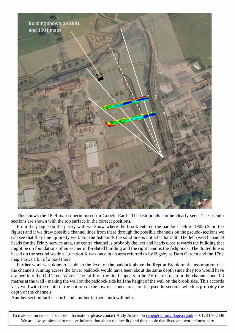
This shows the 1829 map superimposed on Google Earth. The fish ponds can be clearly seen. The pseudo
sections are shown with the top surface in the correct positions.
From the plaque on the priory wall we know where the brook entered the paddock before 1905 (X on the
figure) and if we draw possible channel lines from there through the possible channels on the pseudo-sections we
can see that they line up pretty well. For the fishponds the solid line is not a brilliant fit. The left (west) channel
heads for the Priory service area, the centre channel is probably the leet and heads close towards the building that
might be on foundations of an earlier mill-related building and the right hand is the fishponds. The dotted line is
based on the second section. Location X was once in an area referred to by Bigsby as Dam Garden and the 1762
map shows a bit of a pool there.
Further work was done to establish the level of the paddock above the Repton Brook on the assumption that
the channels running across the lower paddock would have been about the same depth since they too would have
drained into the Old Trent Water. The infill on the field appears to be 2.6 metres deep in the channels and 1.3
metres at the wall - making the wall on the paddock side half the height of the wall on the brook side. This accords
very well with the depth of the bottom of the low resistance areas on the pseudo-sections which is probably the
depth of the channels.
Another section farther north and another farther south will help.
To make comments or for more information, please contact Andy Austen on [email protected] or 01283 702448
We are always pleased to receive information about the locality and the people that lived and worked near here.