report to the maritime safety committee table … · report to the maritime safety committee table...
TRANSCRIPT

I:\NAV\58\14.doc
E
SUB-COMMITTEE ON SAFETY OF NAVIGATION 58th session Agenda item 14
NAV 58/1431 July 2012
Original: ENGLISH
REPORT TO THE MARITIME SAFETY COMMITTEE
Table of contents
Section Page No. 1 GENERAL 3 2 DECISIONS OF OTHER IMO BODIES 3 3 ROUTEING OF SHIPS, SHIP REPORTING AND RELATED MATTERS 3 4 AMENDMENTS TO THE GENERAL PROVISIONS ON SHIPS'
ROUTEING (RESOLUTION A.572(14), AS AMENDED)
12
5 ITU MATTERS, INCLUDING RADIOCOMMUNICATION ITU-R STUDY GROUP MATTERS
13
6 DEVELOPMENT OF AN E-NAVIGATION STRATEGY IMPLEMENTATION
PLAN 16
7 DEVELOPMENT OF POLICY AND NEW SYMBOLS FOR AIS AIDS TO
NAVIGATION 23
8 CASUALTY ANALYSIS 25 9 CONSIDERATION OF IACS UNIFIED INTERPRETATIONS 25 10 DEVELOPMENT OF PERFORMANCE STANDARDS FOR
INCLINOMETERS 26
11 BIENNIAL AGENDA AND PROVISIONAL AGENDA FOR NAV 59 28 12 ELECTION OF CHAIRMAN AND VICE-CHAIRMAN FOR 2013 30 13 ANY OTHER BUSINESS 31 14 ACTION REQUESTED OF THE COMMITTEE 38

NAV 58/14 Page 2
I:\NAV\58\14.doc
LIST OF ANNEXES ANNEX 1 NEW AND AMENDED TRAFFIC SEPARATION SCHEMES ANNEX 2 ROUTEING MEASURES OTHER THAN TRAFFIC SEPARATION
SCHEMES ANNEX 3 DRAFT RESOLUTION MSC.[...](91) – ADOPTION OF A NEW
MANDATORY SHIP REPORTING SYSTEM "IN THE BARENTS AREA (BARENTS SRS)"
ANNEX 4 DRAFT AMENDMENTS TO THE GENERAL PROVISIONS ON SHIPS'
ROUTEING (RESOLUTION A.572(14), AS AMENDED) ANNEX 5 LIAISON STATEMENT TO ITU-R WORKING PARTY 5B ON REVISION
OF RECOMMENDATION ITU-R M.1371-4 ANNEX 6 LIAISON STATEMENT TO ITU-R WORKING PARTY 5B ON WORLD
RADIOCOMMUNICATION CONFERENCE 2015 (WRC-15), AGENDA ITEM 1.16
ANNEX 7 FINAL LIST OF GAPS OF E-NAVIGATION ANNEX 8 DRAFT MSC CIRCULAR ON UNIFIED INTERPRETATIONS OF SOLAS
CHAPTER V ANNEX 9 DRAFT RESOLUTION MSC.[…](92) – ADOPTION OF PERFORMANCE
STANDARDS FOR ELECTRONIC INCLINOMETERS ANNEX 10 PROPOSED BIENNIAL AGENDA FOR THE 2012-2013 BIENNIUM ANNEX 11 PROVISIONAL AGENDA FOR NAV 59 ANNEX 12 REPORT ON THE STATUS OF PLANNED OUTPUTS FOR THE 2012-2013
BIENNIUM ANNEX 13 PROPOSED REVISIONS TO INTERPRETATION NOS. 22 AND 27 OF
APPENDIX 1 OF MSC.1/CIRC.1369 ANNEX 14 STATEMENT BY THE DELEGATION OF THE REPUBLIC OF KOREA

NAV 58/14 Page 3
I:\NAV\58\14.doc
REPORT TO THE MARITIME SAFEY COMMITTEE 1 GENERAL 1.1 The Sub-Committee on Safety of Navigation held its fifty-eighth session from 2 to 6 July 2012 under the Chairmanship of Mr. J.M. Sollosi (United States). The Vice-Chairman, Mr. K. Billiar (Ukraine), was also present. 1.2 The session was attended by delegations and observers from Member Governments, international organizations and non-governmental organizations in consultative status as listed in document NAV 58/INF.1. Secretary-General's opening address 1.3 The Secretary-General welcomed participants and delivered his opening address, the full text of which can be downloaded from the IMO website at the following link: http://www.imo.org/MediaCentre/SecretaryGeneral/Secretary-GeneralsSpeechesToMeetings. Chairman's remarks 1.4 In responding, the Chairman thanked the Secretary-General for his words of guidance and encouragement and assured the Secretary-General that his advice and requests would be given every consideration in the deliberations of the Sub-Committee and its working groups. Adoption of the agenda and related matters 1.5 The Sub-Committee adopted the agenda (NAV 58/1), and agreed, in general, that the work of the Sub-Committee should be guided by the annotations to the provisional agenda and timetable (NAV 58/1/1, as amended). 2 DECISIONS OF OTHER IMO BODIES 2.1 The Sub-Committee noted the decisions and comments pertaining to its work by MEPC 62, FAL 37, C/ES.26, A 27, DE 56, MEPC 63, COMSAR 16, FSI 20, STW 43 and MSC 90 (NAV 58/2, NAV 58/2/Corr.1, NAV 58/2/1 and NAV 58/2/2) and took them into account in its deliberations under the relevant agenda items. The Sub-Committee also noted that C 108 had noted and endorsed, for inclusion in the current High-level Action plan, the unplanned outputs relevant to the Sub-Committee as agreed by MSC 90. 3 ROUTEING OF SHIPS, SHIP REPORTING AND RELATED MATTERS 3.1 The Chairman recalled that NAV 51 had agreed that a preliminary assessment of ships' routeing proposals would be made by the Chairman in consultation with the Secretariat and the Chairman of the Ships' Routeing Working Group and disseminated as a working paper. Such a preliminary assessment would follow the general criteria in MSC/Circ.1060 and MSC.1/Circ.1060/Add.1 and would not address the technical aspects of the proposals. Accordingly, he had, in cooperation with the Secretariat and the Chairman of the working group, prepared document NAV 58/WP.2 outlining a preliminary assessment of the ships' routeing and ship reporting proposals. In general, the proposals were in conformity with the criteria outlined in MSC/Circ.1060 and MSC.1/Circ.1060/Add.1.

NAV 58/14 Page 4
I:\NAV\58\14.doc
General 3.2 The Sub-Committee noted that the Netherlands (NAV 58/3/2) had outlined the overall intent of the eight separate proposals to amend existing traffic measures and to establish new measures at different locations within the sea area between the North Hinder area and the traffic separation scheme "Off Texel" off the coast of the Netherlands. The Sub-Committee also noted the information provided by the Netherlands (NAV 58/INF.2) relating to the report on the safety assessments for the proposed route structure on the North Sea off the Coast of the Netherlands, which provided background information to amend existing and establish new routeing measures off the coast of the Netherlands (NAV 58/3/2 to NAV 58/3/10) and agreed that the Ships' Routeing Working Group should take this information into account when considering the various relevant proposals. New traffic separation schemes (TSSs) Establishment of new traffic separation schemes "In the Approaches to IJmuiden" 3.3 The Sub-Committee briefly considered a proposal by the Netherlands (NAV 58/3/3 and NAV 58/3/2 (paragraphs 22.2 and 22.16)) for establishing a new system of traffic separation schemes as part of establishing a new routeing system "In the approaches to IJmuiden". Amendments to existing traffic separation schemes (TSSs) Amendment to the existing traffic separation scheme "Off Texel" 3.4 The Sub-Committee briefly considered a proposal by the Netherlands (NAV 58/3/4 and Corr.1 including NAV 58/3/2 (paragraphs 22.5, 22.6 and 22.7)) to amend the existing traffic separation scheme "Off Texel". Amendments to the existing traffic separation schemes "In the Approaches to Hook of Holland and at North Hinder" 3.5 The Sub-Committee briefly considered a proposal by Belgium and the Netherlands (NAV 58/3/8 and NAV 58/3/2 (paragraphs 22.1, 22.9 and 22.10)) to amend the existing traffic separation schemes "Maas North", "Maas Northwest", "Maas West Inner", "Maas West Outer" and "North Hinder North" as part of the revision of the routeing system "In the Approaches to Hook of Holland and at North Hinder". Amendments to the existing traffic separation scheme "Off Rodsher Island" 3.6 The Sub-Committee briefly considered a proposal by the Russian Federation (NAV 58/3/13) to amend the existing traffic separation scheme "Off Rodsher Island" in the Gulf of Finland. Amendment to the existing traffic separation scheme "Off Ushant" 3.7 The Sub-Committee briefly considered a proposal by France (NAV 58/3/14) to amend the existing traffic separation scheme "Off Ushant" relating to a change in the use of the two-way traffic route including a consequential amendment to article 3 of SN/Circ.232. 3.8 The delegation of the Bahamas, supported by CLIA, expressed the view that the proposed two-way route would increase the risk of collision due to the placement and narrowing of the route and the increased volume and the incompatible mix of traffic it would create. They also expressed concern regarding the ability of vessels using the route to comply with rule 10(d) of COLREGs. Some other delegations expressed the view that the proposed measures were necessary.

NAV 58/14 Page 5
I:\NAV\58\14.doc
Amendment to the existing traffic separation scheme "In the Santa Barbara Channel" 3.9 The Sub-Committee briefly considered a proposal by the United States (NAV 58/3/16) to amend the existing traffic separation scheme (TSS) "In the Santa Barbara Channel", which should result in a significant reduction in the likelihood of ship strike deaths and serious injuries to blue whales and other whales, while maintaining and improving maritime safety. Amendment to the existing traffic separation scheme "Off San Francisco" 3.10 The Sub-Committee briefly considered a proposal by the United States (NAV 58/3/17) to amend the existing TSS "Off San Francisco", with a view to maintaining and improving maritime safety, as well as also protecting the marine environment. The proposed changes will move traffic away from areas of rich marine biodiversity and decrease the co-occurrence of commercial vessels and endangered blue, fin and humpback whales. Amendment to the existing traffic separation scheme "In the Approaches to Los Angeles – Long Beach" 3.11 The Sub-Committee briefly considered a proposal by the United States (NAV 58/3/18) to amend the existing TSS "In the Approaches to Los Angeles – Long Beach", with a view to significantly reducing the likelihood of ship strike deaths and serious injuries to blue whales and other whales, as well as maintaining and improving maritime safety. Routeing measures other than TSSs Establishment of a new mandatory No Anchoring Area for all ships and a new area to be avoided for ships of 300 GT or over (Associated Protective Measures for Saba Bank PSSA) 3.12 The Sub-Committee recalled that MEPC 62 had approved, in principle, designation of the Saba Bank as a Particularly Sensitive Sea Area as proposed by the Netherlands (MEPC 62/9). Consequently, MEPC 62 had invited the Netherlands to submit detailed proposals for Associated Protective Measures to NAV 58 for consideration. 3.13 In this context, the Sub-Committee briefly considered a proposal by the Netherlands (NAV 58/3) for the establishment of a new mandatory No Anchoring Area for all ships and a new area to be avoided for ships of 300 GT or over. Establishment of new routeing measures other than traffic separation schemes "In the Approaches to IJmuiden" 3.14 The Sub-Committee briefly considered a proposal by the Netherlands (NAV 58/3/5 and NAV 58/3/2 (paragraph 22.2)) for establishing two new precautionary areas and an area to be avoided as part of establishing a new routeing system "In the approaches to IJmuiden".

NAV 58/14 Page 6
I:\NAV\58\14.doc
Establishment of new routeing measures other than traffic separation schemes in the area "West of Rijnveld" 3.15 The Sub-Committee briefly considered a proposal by the Netherlands (NAV 58/3/6 and Corr.1 and NAV 58/3/2 (paragraphs 22.8, 22.15 and 22.17)) for establishing a new precautionary area, a new recommended route and a new area to be avoided, as part of establishing a new routeing system in the area "West of Rijnveld". Amendment to the existing deep-water route leading to IJmuiden 3.16 The Sub-Committee briefly considered a proposal by the Netherlands (NAV 58/3/6 and Corr.1 and NAV 58/3/2 (paragraphs 22.3 and 22.4)) to amend the existing "deep-water route leading to IJmuiden". Amendments to the existing routeing measures other than traffic separation schemes "In the Approaches to Hook of Holland and at North Hinder" 3.17 The Sub-Committee briefly considered a joint proposal by Belgium and the Netherlands (NAV 58/3/9 and NAV 58/3/2 (paragraphs 22.11, 22.12, 22.13 and 22.18)) to amend the existing routeing measures other than traffic separation schemes, as part of the revision of the routeing system "In the Approaches to Hook of Holland and at North Hinder". Amendments to the existing deep-water route leading to Europoort 3.18 The Sub-Committee briefly considered a joint proposal by Belgium and the Netherlands (NAV 58/3/10 and NAV 58/3/2 (paragraph 22.14)) to amend the existing deep-water route leading to Europoort, as part of the revision of the routeing system "In the Approaches to Hook of Holland and at North Hinder". Revocation of the existing deep-water route inside the borders of the Traffic separation schemes from Gogland Island to Rodsher Island 3.19 The Sub-Committee briefly considered the relevant part of the proposal by the Russian Federation (NAV 58/3/13) to revoke the existing deep-water route inside the borders of the traffic separation schemes from Gogland Island to Rodsher Island. Establishment of new recommended tracks and traffic separation line between the traffic separation schemes "Off Rodsher Island" and "Off Gogland Island" 3.20 The Sub-Committee briefly considered the relevant part of the proposal by the Russian Federation (NAV 58/3/13) to establish new recommended tracks and traffic separation line between the traffic separation schemes "Off Rodsher Island" and "Off Gogland Island". Recommended route in the Mozambique Channel 3.21 The Sub-Committee briefly considered a joint proposal by the Comoros, France, Madagascar, Mauritius, Mozambique, the Seychelles, South Africa and the United Republic of Tanzania (NAV 58/3/1 and Corr.1) for the establishment of a new recommended route for all ships in the Mozambique Channel. 3.22 Several delegations expressed the view that the proposal neither provided sufficient data on traffic flows, accidents or oil spills nor any compelling need for the proposed routeing measure. There were concerns that the proposal would narrow the route and concentrate the traffic, which could have implications for safety of navigation and ship security, including piracy threats.
NAV 58/14 Page 7
I:\NAV\58\14.doc
3.23 The delegation of South Africa, on behalf of the co-sponsors, clarified that the proposed routeing measure was of a recommendatory nature and the proposed route had been thoroughly surveyed at a cost of nearly US$2 million. Regarding the accident history, there had been minor spills; however, these could pose a risk to UNESCO heritage sites. In light of the above, South Africa and the co-sponsors, with the assistance of the World Bank, GEF and IOC had taken a proactive approach and developed the proposal. 3.24 The delegation of France expressed the view that these hydrographic surveys employed the latest techniques and enhanced the safety of navigation in an area where the charts were based on old and incomplete survey data. These hydrographic surveys covered also the approaches to the main ports. It was therefore pertinent that the Organization accepted this proposal as a recommendatory route to facilitate surveillance and intervention by coastal States. 3.25 However, the Sub-Committee, recognizing there were serious deficiencies in the proposal and noting that part of the hydrographic surveys had been done in deep waters, was of the view that the proposal should not be further considered by the Ships' Routeing Working Group. Accordingly, South Africa and the co-sponsors were advised to resubmit a revised proposal to NAV 59. 3.26 The IALA observer expressed the view that the Project had benefitted all aspects of safety of navigation and protection of the marine environment, including the refurbishment of numerous AtoN in the region. Establishment of a new recommendatory area to be avoided off the Ningaloo Coast, Western Australia 3.27 The Sub-Committee briefly considered a proposal by Australia (NAV 58/3/11) to establish a new recommendatory area to be avoided off the Ningaloo Coast, Western Australia, which had been listed as UNESCO's World Heritage region since 2011 with a view to mitigating the risk created by increasing shipping activity. Procedures for night signals to be displayed by vessels crossing the TSS in the Singapore Strait – Amendments to the "Rules for Vessels Navigating through the Straits of Malacca and Singapore" 3.28 The Sub-Committee briefly considered a joint proposal by Indonesia, Malaysia and Singapore (NAV 58/3/15) setting forth information on the survey results relating to the usefulness of night signals to be displayed by vessels crossing the TSS in the Singapore Strait. In addition, they had also proposed amendments to the "Rules for Vessels Navigating through the Straits of Malacca and Singapore" to make the display of the night signals a recommendatory measure in the Singapore Strait. 3.29 In the ensuing lengthy discussions, concerns were expressed: .1 with regard to the statistical significance and analysis of the data gathered
during the evaluation period; .2 whether there were implications for other TSSs with high density of traffic in
other parts of the world; and .3 whether other measures, such as AIS, had been considered.

NAV 58/14 Page 8
I:\NAV\58\14.doc
3.30 The Chairman reminded Members that NAV 56 had invited Contracting Parties to the Convention on the International Regulations for Preventing Collisions at Sea, 1972 (COLREGs), if they so wished, to propose amendments in relation to the procedures and carriage requirements for night signals to be displayed by vessels crossing TSSs, following the provisions of article VI of COLREG. Furthermore, NAV 56 had also confirmed that the approval of this interim recommendatory measure would have no impact on the statutory survey and certification regime in respect of navigation lights for cargo and passenger ships. Proposal for the establishment of two new areas to be avoided in waters off the Brazilian south-east coast 3.31 The Sub-Committee briefly considered a proposal by Brazil (NAV 58/3/19) for the establishment of two new areas to be avoided, in Brazil's Espírito Santo Basin region, in order to improve the safety of navigation and that of the offshore activities in the vicinity of Golfinho and Jubarte Fields. New mandatory ship reporting system Establishment of a new mandatory ship reporting system in the Barents Area 3.32 The Sub-Committee briefly considered a joint proposal by Norway and the Russian Federation (NAV 58/3/12) for the establishment of a new mandatory ship reporting system "in the Barents Area (Barents SRS)". Amendments to the existing mandatory Australian Ship Reporting System (AUSREP) 3.33 The Sub-Committee noted with appreciation the information provided by Australia (NAV 58/INF.9) on proposed amendments for reporting to the mandatory ship reporting system AUSREP in the Australian Search and Rescue Region (SRR), which were intended to introduce a more streamlined, automated approach. Review of adopted mandatory ship reporting systems 3.34 The Chairman recalled that: .1 since NAV 52, it had been brought to the attention of Member Governments
the need for carrying out a review of adopted mandatory ship reporting systems and that the Chairman had also on previous sessions appealed to Member Governments to undertake this exercise; and
.2 following the submission of its experiences to NAV 56, Denmark had
submitted to NAV 57 a relevant proposal to amend an existing mandatory ship reporting system in light of the experience gained.
3.35 Finally, the Chairman urged Member Governments to review the ships' reporting systems under their purview and adopted by the Organization at an early date to ensure that they were all up to date. Guidance on amendments to existing IMO-adopted ships' routeing systems 3.36 The Chairman invited the Sub-Committee's attention to paragraph 3.17 of the General Provisions on Ships' Routeing (resolution A.572(14)), as amended, that states: "A routeing system, when adopted by IMO, shall not be amended or suspended before consultation with an agreement by IMO unless local conditions or the urgency of the case

NAV 58/14 Page 9
I:\NAV\58\14.doc
require that earlier action be taken." The intention of this requirement was to ensure consistency and predictability in routeing measures and the charting of such measures, particularly with regard to TSSs. 3.37 The Chairman urged Member Governments to abide by this requirement and inform the Organization of any planned changes to an IMO-adopted routeing measure, so that the formal procedures for amendments were followed in line with the General Provisions on Ships' Routeing. Establishing the Ships' Routeing Working Group 3.38 After a preliminary discussion, as reported in paragraphs 3.1 to 3.20 and 3.27 to 3.32 above, the Sub-Committee re-established the Ships' Routeing Working Group and instructed it, taking into account any decisions of, and comments and proposals made in Plenary as well as relevant decisions of other IMO bodies (item 2), for consideration and approval by Plenary to:
.1 consider all documents submitted under agenda item 3 (except documents
NAV 58/3/1 and Corr.1; including document NAV 58/INF.9) regarding routeing of ships and related matters and prepare routeing and reporting measures, as appropriate and recommendations for consideration and approval by Plenary;
.2 consider document NAV 58/4 (Netherlands and United States) submitted
under agenda item 4 regarding proposed amendments to the General Provisions on Ships' Routeing (resolution A.572(14), as amended) and finalize the proposed amendments to section 6 of annex 1 to resolution A.572(14), as amended, to provide additional guidance for the design and description of ships' routeing systems, in particular of traffic separation schemes.
3.39 Having received and considered the Working Group's report (NAV 58/WP.4), the Sub-Committee approved it in general and, in particular (with reference to paragraphs 3.1 to 6.4 and annexes 1 to 20), took action as summarized in the ensuing paragraphs. New traffic separation schemes Establishment of new traffic separation scheme "In the Approaches to IJmuiden" 3.40 The Sub-Committee approved the proposed new traffic separation scheme as part of establishing a new routeing system "In the approaches to IJmuiden", as set out in annex 1, which the Committee is invited to adopt. Amendments to existing traffic separation schemes Amendments to the existing traffic separation scheme "Off Texel" 3.41 The Sub-Committee approved the amendments to the existing traffic separation scheme "Off Texel", as set out in annex 1, which the Committee is invited to adopt.

NAV 58/14 Page 10
I:\NAV\58\14.doc
Amendments to the existing traffic separation scheme "In the Approaches to Hook of Holland and at North Hinder" 3.42 The Sub-Committee approved the amendments to the existing traffic separation scheme "In the Approaches to Hook of Holland and at North Hinder", as set out in annex 1, which the Committee is invited to adopt. Amendments to the existing traffic separation scheme "Off Rodsher Island" 3.43 The Sub-Committee approved the amendments to the existing traffic separation scheme "Off Rodsher Island", as set out in annex 1, which the Committee is invited to adopt. Amendments to the existing traffic separation scheme "Off Ushant" 3.44 The Sub-Committee approved the amendments to the existing traffic separation scheme "Off Ushant", including article 3 of SN/Circ.232, as set out in annex 1, which the Committee is invited to adopt. Amendments to the existing traffic separation scheme "In the Santa Barbara Channel" 3.45 The Sub-Committee approved the amendments to the existing traffic separation scheme "In the Santa Barbara Channel", as set out in annex 1, which the Committee is invited to adopt. Amendments to the existing traffic separation scheme "Off San Francisco" 3.46 The Sub-Committee approved the amendments to the existing traffic separation scheme "Off San Francisco", as set out in annex 1, which the Committee is invited to adopt. Amendments to the existing traffic separation scheme "In the Approaches to Los Angeles – Long Beach" 3.47 The Sub-Committee approved the amendments to the existing traffic separation scheme "In the Approaches to Los Angeles – Long Beach", as set out in annex 1, which the Committee is invited to adopt. Routeing measures other than traffic separation schemes Establishment of new routeing measures other than traffic separation schemes, as Associated protective measures (APMs) for Saba Bank PSSA 3.48 The Sub-Committee approved the establishment of an area to be avoided for ships of 300 GT or over and a mandatory No Anchoring Area for all ships, as Associated Protective Measures (APMs) for Saba Bank PSSA, as set out in annex 2, which the Committee is invited to adopt, and instructed the Secretariat to inform the MEPC of the action taken. Establishment of new routeing measures other than traffic separation schemes "In the Approaches to IJmuiden" 3.49 The Sub-Committee approved the establishment of two new precautionary areas and an area to be avoided as part of establishing a new routeing system "In the approaches to IJmuiden", as set out in annex 2, which the Committee is invited to adopt.

NAV 58/14 Page 11
I:\NAV\58\14.doc
Establishment of new routeing measures other than traffic separation schemes in the area "West of Rijnveld" 3.50 The Sub-Committee approved the establishment of a new precautionary area, a new recommended route and a new area to be avoided as part of establishing a new routeing system in the area "West of Rijnveld", as set out in annex 2, which the Committee is invited to adopt. Amendment to the existing deep-water route leading to IJmuiden 3.51 The Sub-Committee approved the amendments to the existing "deep-water route leading to IJmuiden", as set out in annex 2, which the Committee is invited to adopt. Amendments to the routeing measures other than traffic separation schemes "In the Approaches to Hook of Holland and at North Hinder" 3.52 The Sub-Committee approved the amendments to the existing routeing measures other than traffic separation schemes, as part of the revision of the routeing system "In the Approaches to Hook of Holland and at North Hinder", as set out in annex 2, which the Committee is invited to adopt. Amendments to the existing deep-water route leading to Europoort 3.53 The Sub-Committee approved the amendments to the existing deep-water route leading to Europoort, as part of the revision of the routeing system "In the Approaches to Hook of Holland and at North Hinder", as set out in annex 2, which the Committee is invited to adopt. Establishment of a new recommendatory area to be avoided off the Ningaloo Coast, Western Australia 3.54 The Sub-Committee approved the establishment of a new recommendatory area to be avoided off the Ningaloo Coast, Western Australia, as set out in annex 2, which the Committee is invited to adopt. Recommendatory measure for vessels crossing the traffic separation scheme and precautionary areas in the Singapore Strait during hours of darkness 3.55 The Sub-Committee approved the recommendatory measure for vessels crossing the traffic separation scheme (TSS) and precautionary areas in the Singapore Strait during hours of darkness, as set out in annex 2, which the Committee is invited to adopt. 3.56 The Sub-Committee reconfirmed its opinion at NAV 56 (paragraph 3.40 refers) that the approval of this recommendatory measure would have no impact on the statutory survey and certification regime in respect of navigation lights for cargo and passenger ships. Establishment of two new areas to be avoided in waters off the Brazilian south-east coast 3.57 The Sub-Committee approved the establishment of two new areas to be avoided in waters off the Brazilian south-east coast, as set out in annex 2, which the Committee is invited to adopt.

NAV 58/14 Page 12
I:\NAV\58\14.doc
Revocation of the existing deep-water route inside the borders of the traffic separation schemes from Gogland Island to Rodsher Island 3.58 The Sub-Committee approved the revocation of the existing deep-water route inside the borders of the traffic separation schemes from Gogland Island to Rodsher Island, as set out in annex 2, which the Committee is invited to adopt. Establishment of new recommended tracks and traffic separation line between the traffic separation schemes "Off Rodsher Island" and "Off Gogland Island" 3.59 The Sub-Committee approved the establishment of new recommended tracks and traffic separation line between the traffic separation schemes "Off Rodsher Island" and "Off Gogland Island", as set out in annex 2, which the Committee is invited to adopt. Mandatory ship reporting system Mandatory ship reporting system in the Barents Area (Barents SRS) 3.60 The Sub-Committee approved the new mandatory ship reporting system "In the Barents Area (Barents SRS)", as set out in annex 3, which the Committee is invited to adopt. 4 AMENDMENTS TO THE GENERAL PROVISIONS ON SHIPS' ROUTEING
(RESOLUTION A.572(14), AS AMENDED) 4.1 The Sub-Committee recalled that MSC 89 had agreed to include, in the post-biennial agenda of the Committee, an output on "Amendments to the General Provisions on Ships' Routeing (resolution A.572(14), as amended)", with a target completion year of 2013, assigning the NAV Sub-Committee as the coordinating organ; and instructed the NAV Sub-Committee to include the output in the provisional agenda for NAV 58. 4.2 The Sub-Committee considered document NAV 58/4 (Netherlands and United States) proposing amendments to section 6 (Design Criteria), annex 1 to resolution A.572(14), as amended – General Provisions on Ships' Routeing, to provide additional guidance for the design and description of ships' routeing systems, in particular of traffic separation schemes. 4.3 The delegation of China, whilst supporting the proposed amendments to the General Provisions on Ships' Routeing, informed the Sub-Committee that they were in the process of revising the existing IMO-adopted traffic separation scheme "In the waters off Chengshan Jiao Promontory" and would be submitting a suitable proposal for consideration by the Sub-Committee in due course. 4.4 The delegation of the Russian Federation expressed the view that the proposed amendments should be reflected in documents MSC/Circ.1060 and MSC.1/Circ.1060/Add.1. In this context, the Secretariat clarified that the proposed amendments were intended for resolution A.572(14), as amended, because the General Provisions on Ships' Routeing are established pursuant to regulation V/10 (Ships' Routeing) of the SOLAS Convention. 4.5 After some discussion, the Sub-Committee referred the proposal to the Ships' Routeing Working Group for detailed consideration and advice.

NAV 58/14 Page 13
I:\NAV\58\14.doc
Report of the Ships' Routeing Working Group 4.6 Having received and considered the Working Group's report (NAV 58/WP.4), the Sub-Committee (with reference to paragraphs 7.1 and 7.2 and annex 21) approved the amendments to the General Provisions on Ships' Routeing (resolution A.572(14), as amended), as set out in annex 4, which the Committee is invited to adopt, subject to confirmation by the Assembly. 5 ITU MATTERS, INCLUDING RADIOCOMMUNICATION ITU-R STUDY GROUP
MATTERS 5.1 The Sub-Committee noted that MSC 90 had extended the target completion date of this agenda item to 2013. General 5.2 The Sub-Committee noted the information provided by the Secretariat (NAV 58/5 and NAV 58/5/2) relating to the progress made in ITU since NAV 57 with regard to issues of relevance, being the outcome of the November 2011 and May/June 2012 meetings of ITU-R Working Party 5B (WP 5B) and Study Group 5 (SG 5), and ITU's World Radiocommunication Conference (WRC-12). Revision of Recommendation ITU-R M.1371-4 on AIS 5.3 The Sub-Committee noted that, with regard to the revision of Recommendation ITU-R M.1371-4, WP 5B had submitted a liaison statement inviting the Sub-Committee to consider amendments related to the Navigational status parameters in Messages 1, 2 and 3 (annex 8, table 46 of the Recommendation) along with all other proposed amendments to Recommendation ITU-R M.1371-4, and revert with a liaison statement to WP 5B for consideration at its meeting in November 2012. 5.4 In this context, the Sub-Committee recalled that, with regard to the revision of Recommendation ITU-R M.1371-4, NAV 57 had considered the possible change in the use of some values of the navigational status parameter in AIS messages and agreed that further consideration was needed at this session of the Sub-Committee before liaising with ITU on IMO's position on this matter. 5.5 In light of the foregoing, the Sub-Committee referred the liaison statement on the proposed revision of Recommendation ITU-R M.1371-4 to the Technical Working Group for detailed consideration and the preparation of a liaison statement to Working Party 5B. Preparation of WRC-15 5.6 The Sub-Committee also noted that WP 5B had initiated studies for the WRC-15 agenda items under its responsibility, among others agenda item 1.16, which in accordance with resolution 360 (WRC-12) is to consider regulatory provisions and spectrum allocations to enable possible new Automatic Identification System (AIS) technology applications and possible new applications to improve maritime radiocommunication. Accordingly, WP 5B had sent a liaison statement on this matter requesting IMO to review the proposed initiatives on applications using AIS technology and provide comments on the draft conference preparatory meeting (CPM) text, including the annex containing the VHF Data Exchange concept developed by IALA.
NAV 58/14 Page 14
I:\NAV\58\14.doc
5.7 In light of the foregoing, the Sub-Committee referred the liaison statement on the preparation of WRC-15 to the Technical Working Group to review the proposed initiatives on applications using AIS technology, and provide comments and advice, as appropriate. "Man overboard" (MOB) and similar devices using AIS-SART technology 5.8 The Sub-Committee recalled that MSC 90 (MSC 90/28, paragraph 8.19) had instructed the Sub-Committee to develop draft guidance to seafarers, to be further considered and finalized by COMSAR 17, regarding the difficulties arising in interpreting the AIS-SART symbol, along with the established text message SART ACTIVE, when used for MOB and similar devices using AIS-SART technology. 5.9 The Sub-Committee considered the information along with proposed draft guidance to seafarers provided by Australia (NAV 58/5/1) to assist in the consideration of the concerns raised at COMSAR 16 regarding the difficulties arising in interpreting the AIS-SART symbol, along with the established text message SART ACTIVE, when used for MOB and similar devices using AIS-SART technology. 5.10 In this context, the Sub-Committee agreed that the issues raised regarding the AIS text messages should be addressed by the Technical Working Group when considering the liaison statement from ITU-R WP 5B concerning the draft revision of Recommendation ITU-R M.1371-4 (paragraphs 5.3 to 5.5 refer). 5.11 The Sub-Committee further noted that, because some Member Governments had licensed/accepted the use of these types of devices; and they were obtainable over the Internet, other Member Governments were unable to prevent their use. Unfortunately, this had taken place before seeking international harmonization on matters of concern. It would have been beneficial if harmonization on an international level had been debated at a much earlier stage in the process. 5.12 The delegation of the United Kingdom, supported by others, expressed the view that AIS-SART was intended for the location of a survival craft as part of a suite of communications to be deployed within the GMDSS in a search and rescue situation. They were of the view that there was a need to address the fundamental question whether AIS should be used for distress communications. If such devices were to be used for distress communications, then the necessary procedures should be followed in order to achieve an international acceptance of, and standards for, these devices including an understanding of any relevant actions that were incumbent on manufacturers, owner/operators, response authorities and at sea. Only after addressing these issues, consideration might be given to what might constitute an appropriate message text. 5.13 After a brief discussion, the Sub-Committee referred document NAV 58/5/1 (subparagraphs 17.4 and 17.5 and annex) to the Technical Working Group for the preparation of advice on the appropriate maritime identity of diver locating devices, including a draft SN circular providing guidance to seafarers regarding the difficulties arising in interpreting the AIS-SART symbol, along with the established text message SART ACTIVE, when used for MOB and similar devices using AIS-SART technology, to be further considered and finalized by COMSAR 17. Report of the Technical Working Group 5.14 Having received and considered the Technical Working Group's report (NAV 58/WP.5), the Sub-Committee, in particular (with reference to paragraphs 3.1 to 3.18 and annexes 1 to 3), took action as summarized in the ensuing paragraphs.

NAV 58/14 Page 15
I:\NAV\58\14.doc
Revision of Recommendation ITU-R M.1371-4 5.15 Having considered document NAV 58/5/2, annex 1, taking into account document NAV 58/5/1, paragraphs 17.1 to 17.3, the Sub-Committee approved a liaison statement to WP 5B, as set out in annex 5, instructed the Secretariat to forward it to ITU and invited the Committee to endorse this action. WRC-15, Agenda item 1.16 on possible new AIS technology applications and possible new applications to improve maritime radiocommunication 5.16 Having considered document NAV 58/5/2, annex 2, taking into account document NAV 58/6/7 on VHF Data Exchange (VDE), the Sub-Committee noted that modifications should not be required to existing AIS equipment on board existing vessels and that the integrity of the original operational purpose of AIS as the primary function on the existing AIS frequencies should be protected. 5.17 The Sub-Committee supported the further development of the plan for future VHF Data Communications as described in the annex to the draft CPM report and approved a liaison statement to WP 5B, as set out in annex 5. The Sub-Committee instructed the Secretariat to forward it to ITU and invited the Committee to endorse this action. 5.18 The Sub-Committee instructed the Joint IMO/ITU Experts Group to further consider issues related to WRC-15, Agenda item 1.16 at its next meeting, scheduled to be held from 8 to 12 October 2012, and to provide additional information to COMSAR 17 and ITU-R WP 5B, as appropriate. Man overboard (MOB) and similar devices using AIS-SART technology 5.19 In considering document NAV 58/5/1, paragraph 17.4, the Sub-Committee agreed that the maritime identity format for MOB devices would be appropriate for diver locating devices when using the frequencies AIS 1 and AIS 2 in a non-routine situation (NAV 58/WP.5, paragraph 3.4 refers). 5.20 The observer of ISAF stated that, instead of using the term "non-routine", the term "emergency" should be used. In this context, the delegation of the United Kingdom, supported by others, were of the view that the term "non-routine" should be used to clearly distinguish these Man overboard (MOB) locating devices from devices meant to be used for alerting. 5.21 The Sub-Committee endorsed a draft SN.1 circular providing information to seafarers on the display of AIS-SART, AIS MOB and EPIRB-AIS devices, as set out in document NAV 58/WP.5, annex 3, and forwarded it to COMSAR 17 for further consideration and finalization. 5.22 The Sub-Committee invited: .1 the COMSAR Sub-Committee to note that the draft circular contained
square brackets around the description of the MOB device involving a person floating in the water and also around the use of the AIS-SAR symbol with a MOB device and requested it to study these issues further;
.2 the COMSAR Sub-Committee to consider the development of further
guidance material for Administrations on the use of devices using AIS technology, taking into account the information provided in document NAV 58/WP.5, paragraph 3.17; and

NAV 58/14 Page 16
I:\NAV\58\14.doc
.3 the Committee to invite Member Governments to advise manufacturers to affix product labels to the equipment AIS-SART, EPIRB-AIS and AIS MOB, clearly indicating that these AIS devices must be regarded as location aids in emergency situations and not as distress alert systems.
5.23 The CIRM observer advised that ITU had chosen CIRM to issue the manufacturer identification (id) number to such AIS-based devices. Accordingly, CIRM would add this labelling information to the documentation circulated when manufacturers requested an id number, and would also inform all existing holders of id numbers of this requirement. 6 DEVELOPMENT OF AN E-NAVIGATION STRATEGY IMPLEMENTATION PLAN 6.1 The Sub-Committee recalled that: .1 NAV 55, NAV 56 and NAV 57 respectively had established a working
group, including a correspondence group to work intersessionally to progress the issue. MSC 87 and MSC 88 had noted the progress made to date; and
.2 STW 42 and COMSAR 15 had also considered the relevant reports of the
Correspondence Group established by the NAV Sub-Committee and provided their expert input to the development process of e-navigation.
6.2 The Sub-Committee noted that COMSAR 16 had endorsed the final draft list of gaps relevant to radiocommunications and search and rescue (COMSAR 16/WP.5/Rev.1, annex 3) and instructed the Secretariat to forward it to both STW 43, for further revision from the training perspective, and NAV 58, for final consideration. 6.3 The Sub-Committee noted further that STW 43 had commented that:
.1 some training elements, especially those that were in general covered by the STCW Convention and Code, might need to be reviewed in the future in light of the forthcoming developments on e-navigation; and
.2 the revision, updating or development of training elements should only be
considered in the future, after having a clear understanding of the potential technical, operational and regulatory e-navigation solutions that would be developed by the Organization.
6.4 Accordingly, STW 43 had instructed the Secretariat to issue a revised version of the report of the Working Group (STW 43/WP.3/Rev.1), in order to allow the NAV Sub-Committee to refer to the revised draft list of gaps as agreed by STW. Consequently, STW 43 had endorsed the final draft list of gaps relevant to training (STW 43/WP.3/Rev.1, annex) and instructed the Secretariat to forward it to NAV 58, for final consideration. 6.5 The Sub-Committee noted that MSC 90, as requested by NAV 57, had approved:
.1 current overarching e-navigation architecture; .2 proposed way forward for developing a Common Maritime Data Structure
(CMDS);

NAV 58/14 Page 17
I:\NAV\58\14.doc
.3 use of the IHO's S-100 standard as the baseline for creating a framework for data access and services under the scope of SOLAS; and
.4 proposed joint plan of work on e-navigation for the COMSAR, NAV and
STW Sub-Committees for the period 2012-2014, and had also agreed that, for the time being, no further action was required until future uses of the frequency band of 495-505 kHz were identified for e-navigation. MSC 90 had also authorized the establishment of an IMO/IHO Harmonization Group on data modelling and approved its terms of reference. 6.6 The Chairman recalled that: .1 the Secretary-General's opening remarks had underlined the importance of
remaining focused on finalizing the gap analysis and the cost-benefit and risk analyses. Other parallel developments should concentrate on guidelines for usability evaluation of navigational equipment, integrated position, navigation and timing system, software quality assurance and guidelines for test beds but without delaying the finalization of the Strategy Implementation Plan; and
.2 it was important to remain focused on the agreed work programme and to
not become distracted by tangential matters such as new technology. It was imperative that the Sub-Committee should now focus attention primarily on finalizing the gap analysis and the cost-benefit and risk analyses and adhere to the revised joint plan of work approved by MSC 90.
6.7 The Sub-Committee considered the report of the Correspondence Group (CG) on e-navigation (NAV 58/6) outlining the ongoing development of the detailed architecture on e-navigation, a proposal for a completed gap analysis for finalization, a procedure for identifying Risk Control Options, further development of the Maritime Service Portfolios, the development of guidelines for usability evaluation of navigational equipment, the development of guidelines for the harmonization of test beds, as well as a draft outline for the final Strategy Implementation Plan. 6.8 In this context, a few delegations including an industry observer were in favour of a rigorous assessment of the gap analysis with a view to a final refined list of high-level goals. 6.9 The Sub-Committee agreed that the report of the CG should be used as the basic document for further work during this session and to instruct the e-navigation working group, proposed to be established under this item, to undertake a thorough review of the report before the Sub-Committee could take the requested relevant actions. 6.10 The Sub-Committee considered documents NAV 58/6/1, NAV 58/6/2 and NAV 58/6/3 (Germany) relating to a resilient Integrated Position, Navigation and Timing System as part of the Integrated Navigation System (INS), which was intended to support meeting e-navigation user needs such as improvement and indication of reliability. 6.11 After a brief discussion, the Sub-Committee agreed that it was premature to consider Integrated Navigation Systems (INS) as a core element of e-navigation/carriage requirements of ECDIS means to e-navigation.

NAV 58/14 Page 18
I:\NAV\58\14.doc
6.12 After some discussion, the Sub-Committee referred documents NAV 58/6/1, NAV 58/6/2 and NAV 58/6/3 (Germany) to the e-navigation Working Group for consideration and advice. 6.13 The Sub-Committee considered document NAV 58/6/4 (Republic of Korea) outlining the need to include software quality assurance as part of the ongoing e-navigation gap and cost-benefit analysis process that has to be conducted. 6.14 A majority of delegations were of the view that software quality assurance should be part of the e-navigation discussion at this session of the Sub-Committee, whilst others were of the view that, recognizing the time constraints, this issue should be deferred to a later date. 6.15 After some discussions, the Sub-Committee referred document NAV 58/6/4 (Republic of Korea) to the e-navigation working group for consideration and advice, if time permitted. 6.16 The Sub-Committee noted with appreciation the information contained in document NAV 58/6/5 (IALA) providing comments on the report of the CG on e-navigation including some details of the ongoing IALA activities regarding the development of e-navigation. 6.17 The Sub-Committee considered documents NAV 58/6/6, NAV 58/INF.12 and NAV 58/INF.13 (Japan) proposing how to utilize usability guidelines to ensure practical and flexible assessment of navigational equipment, including draft interim Guidelines for usability evaluation of navigational equipment and the way to apply goal-based procedures for test task set-up (NAV 58/6/6, paragraph 5) by taking ECDIS as an example. 6.18 The delegation of Norway, supported by others, recognizing the time constraints in the working group, was in favour of delaying the discussion on the development of usability guidelines for navigational equipment to a later date. 6.19 After some discussions, the Sub-Committee referred documents NAV 58/6/6, NAV 58/INF.12 and NAV 58/INF.13 (Japan) to the e-navigation working group for consideration and advice, if time permitted. 6.20 The Sub-Committee considered document NAV 58/6/7 (Denmark and Norway) commenting on the report of the CG and providing information on future possibilities for exchanging data and information through VHF Data Exchange (VDE) functionalities rather than AIS. 6.21 The delegation of Norway clarified that there was no need to introduce a next generation AIS. This increased need could be met through VHF Data Exchange (VDE), especially since ITU had allocated frequencies for digital purposes in the VHF band. VDE was a means for a seamless and automatic exchange of information, including information for navigational safety purposes, leaving the watchkeeping navigator to more efficiently bring the ship safely from port A to port B when operating within the VHF coverage. The development of digital VHF (VDE) might be of benefit for the development of a single window system. This single window system was of great importance in IMO's work on reducing administrative burdens on board ships. If a next generation AIS was introduced, one of the consequences may be that existing AIS would need to be modified or replaced and the original operational purpose of AIS might be lost. Furthermore, Norway and Denmark were of the view that the integrity of the original operational purpose of AIS should be protected.

NAV 58/14 Page 19
I:\NAV\58\14.doc
6.22 After some discussion, the Sub-Committee referred document NAV 58/6/7 (Denmark and Norway) to the Technical Working Group for consideration and advice (paragraph 5.16 refers). 6.23 The Sub-Committee considered document NAV 58/6/8 (Republic of Korea) outlining a method for feedback to enable Member States to provide the outcomes of test-bed projects with clear reference to the navigation development process and/or elements of Strategy Implementation Plan.
6.24 The Sub-Committee referred document NAV 58/6/8 (Republic of Korea) to the e-navigation working group for consideration and advice, if time permitted. 6.25 The Sub-Committee noted with appreciation the information contained in document NAV 58/INF.3 (IMPA) providing observations on IMO's e-navigation strategy and stating that three considerations were of paramount importance, i.e. fostering consensus among key stakeholders and how they were applied; ensuring a pragmatic and flexible approach that took account of the complexity and diversity of the world's marine transportation system and maintained a realistic appreciation of the evolutionary nature of change to navigation systems. 6.26 The Sub-Committee noted with appreciation the information contained in document NAV 58/INF.4 (Norway) providing details on the outcome of a workshop held to demonstrate the use of the S-100 framework data standard which included information on results from other test beds as well as consideration of potential synergies between e-navigation and the Marine Electronic Highway project in the Straits of Malacca and Singapore. The Sub-Committee agreed that the information would be beneficial to the e-navigation working group and agreed to refer it to the working group. 6.27 The Sub-Committee noted with appreciation the information contained in document NAV 58/INF.5 (IALA) providing information on a modular and open concept of integrated Position, Navigation and Timing (PNT) data system, which could meet e-navigation user needs such as improvement and indication of reliability. 6.28 The Sub-Committee noted with appreciation the information contained in document NAV 58/INF.6 (the Nautical Institute) providing information on the results and recommendations of a workshop on usability evaluation of navigational equipment held by the Nautical Institute in Malmö, Sweden, during January 2012. 6.29 The Sub-Committee noted with appreciation the information contained in document NAV 58/INF.10 (Australia) providing details on the review and the application of the Human Element Analysing Process (HEAP) to the e-navigation gap analysis. 6.30 The Sub-Committee noted with appreciation the information contained in document NAV 58/INF.11 (Australia) providing details on the human element principles that support the application of HEAP within the e-navigation gap analysis. Analysis based on data from real-time observation of normal operations, along with risk mitigation strategies based on human error management theory, were considered relevant to the Organization's strategic plan for addressing the human element and the ISM Code. 6.31 In this context, the Sub-Committee referred: .1 document NAV 58/INF.10 to the e-navigation working group, for
consideration and advice; and .2 NAV 58/INF.11 to the STW Sub-Committee for its consideration.

NAV 58/14 Page 20
I:\NAV\58\14.doc
6.32 The Sub-Committee noted with appreciation the information contained in document NAV 58/INF.14 (Canada) providing details on the development of e-navigation that was occurring in Canada including Canada's vision for e-navigation, consideration of the national/international framework, identified mariner's needs, required services matrix, data gap analysis, experience in using web portals and lessons learned. 6.33 The Sub-Committee noted with appreciation the information contained in document NAV 58/INF.15 (Sweden) providing details on how AIS Application Specific Messages (ASM) could be used for services similar to future e-navigation services. Sweden was of the view that the capacity of the AIS VHF Data Link (VDL) was limited and the main function of AIS must not be jeopardized by transmission of ASMs. 6.34 The Sub-Committee noted with appreciation the information contained in document NAV 58/INF.17 (Bulgaria, France and Romania) providing details on the performance of a digital broadcasting system, named NAVDAT, including some applications of the system for digital broadcasting of maritime safety and security related information. Establishing the e-navigation working group 6.35 After a preliminary discussion, as reported in paragraphs 6.1 to 6.31, the Sub-Committee re-established the e-navigation working group and instructed it to consider the relevant documents submitted under agenda item 6 – in particular, NAV 58/6 (Norway), NAV 58/6/1, NAV 58/6/2, NAV 58/6/3 (Germany), NAV 58/6/4 (Republic of Korea), NAV 58/6/6 (Japan) and NAV 58/6/8 (Republic of Korea), and including the information provided in documents NAV 58/INF.4 (Norway), NAV 58/INF.10 (Australia), NAV 58/INF.12 and NAV 58/INF.13 (Japan), plus the outcome of NAV 57, STW 43 and COMSAR 16 – and, taking into account any decisions, comments and proposals made in Plenary, to undertake the following tasks:
.1 review the report of the Correspondence Group, taking into account documents NAV 58/6/1, NAV 58/6/2, NAV 58/6/3, NAV 58/INF.4 and NAV 58/INF.10 and provide comments and recommendations with respect to the actions requested in paragraphs 38.1 to 38.7 of document NAV 58/6;
.2 taking into account the priorities of its work, review and revise the terms of
reference for a correspondence group to progress work intersessionally for reporting to COMSAR 17, STW 44 and NAV 59, based on the revised joint plan of work approved by MSC 90;
.3 if time permits:
.1 consider document NAV 58/6/4 (Republic of Korea) with respect to the need to include software quality assurance as part of the ongoing e-navigation gap and cost-benefit analysis and provide comments and recommendations, as appropriate;
.2 consider documents NAV 58/6/6 and Corr.1, NAV 58/INF.12 and
NAV 58/INF.13 and Corr.1 (Japan) with respect to the draft guidelines for usability evaluation of navigational equipment and provide comments and recommendations, as appropriate; and
.3 consider document NAV 58/6/8 (Republic of Korea) outlining a
method for feedback to enable Member States to provide the outcomes of test-bed projects with clear reference to the

NAV 58/14 Page 21
I:\NAV\58\14.doc
e-navigation development process and/or elements of the Strategy Implementation Plan and provide comments and recommendations, as appropriate.
Report of the e-navigation working group 6.36 Having received and considered the e-navigation working group's report (NAV 58/WP.6), the Sub-Committee (with reference to paragraphs 5.5.1 to 5.1.8 and annexes 1 to 4) took action as summarized in the ensuing paragraphs. 6.37 The Sub-Committee noted the progress made with regard to the development of the detailed onboard e-navigation architecture and invited IALA, IHO and other relevant organizations to contribute to its further development. 6.38 In this context, the delegation of Cyprus expressed the view that all international organizations should respect the competence of the Organization and adhere to the decisions taken by its relevant bodies thereon. 6.39 The Sub-Committee also noted that the gap analysis had been completed and:
.1 approved the final list of gaps of e-navigation, as set out in annex 7; .2 endorsed the preliminary list of potential e-navigation solutions, as work in
progress, and agreed that the above list should be used as the basis for the further identification of Risk Control Options, as preparation for the Formal Safety Assessment (NAV 58/WP.6, annex 2); and
.3 endorsed the Methodology of the Human Element Analysing Process in
e-navigation (NAV 58/6, annex 3). 6.40 The Secretariat, with respect to the identified gap "Improved competence of installation and repair person for providing better reliability of systems and equipment", clarified that it was not within the remit of the Organization or any of the relevant Sub-Committees. Accordingly, the Sub-Committee agreed to insert a suitable footnote indicating that this was not within the purview of the Organization (NAV 58/WP.6/Rev.1, annex 1 refers). 6.41 The Sub-Committee also endorsed:
.1 the procedure for the Formal Safety Assessment methodology, including the identification of Risk Control Options (NAV 58/WP.6, annex 3); and
.2 the further development of Maritime Service Portfolios.
6.42 The Sub-Committee agreed with the further development of:
.1 Guidelines for usability evaluation of navigational equipment; and .2 Guidelines for the harmonization of test beds.
6.43 The delegation of Japan requested clarification relating to the completion date of the usability guidelines for navigational equipment. The Chairman of the e-navigation working group informed that a proposal on draft guidelines for usability evaluation of navigational equipment was planned to be presented in the proposal for a strategy implementation plan

NAV 58/14 Page 22
I:\NAV\58\14.doc
in 2014. He also informed that interested parties were considering organizing or requesting the organization of a workshop to progress the discussions on usability evaluation of navigational equipment, software quality assurance and human element issues, and that the outcome of such a workshop could be an important input to the further process of the development of guidelines for usability evaluation. 6.44 The Sub-Committed re-established the Correspondence Group on e-navigation under the coordination of Norway1 and instructed it, taking into account the revised joint plan of work for the COMSAR, NAV and STW Sub-Committees for the period 2012-2014, as approved by MSC 90:
.1 review the preliminary list of potential e-navigation solutions (NAV 58/WP.6, annex 2) and, if necessary, prepare additional potential e-navigation solutions in order to address all gaps identified in annex 1 to NAV 58/WP.6;
.2 finalize the Cost Benefit and Risk Analyses, with a view to final approval by
NAV 59, using as input documents, namely the final list of gaps and the preliminary list of potential e-navigation solutions that would cover all the identified gaps and taking into account the Formal Safety Assessment process and the Methodology of the Human Element Analysing Process (NAV 58/6, annex 3);
.3 further develop:
.1 the detailed ship and shore architecture; .2 the concept of Maritime Service Portfolios; and .3 the draft Strategy Implementation Plan;
.4 consider documents NAV 58/6/1 and NAV 58/6/3 (Germany) and provide
comments and recommendations, as appropriate; .5 consider the issue of software quality assurance, taking into account
document NAV 58/6/4 (Republic of Korea), and provide comments and recommendations, as appropriate;
.6 progress the development of draft Guidelines for usability evaluation of
navigational equipment and its harmonization with the HEAP, taking into account documents NAV 58/6/6 and Corr.1, NAV 58/INF.12 and NAV 58/INF.13 and Corr.1 (Japan) and NAV 58/INF.10 (Australia);
.7 progress the development of draft Guidelines for the harmonization of test
beds, taking into account document NAV 58/6/8 (Republic of Korea); .8 submit reports to COMSAR 17 and STW 44 raising specific questions, as
required, that should be addressed by the STW and COMSAR Sub-Committees; and
.9 submit a consolidated progress report to NAV 59.
1 Coordinator:
Mr. John Erik Hagen Regional Director, Norwegian Coastal Administration Norway Tel: +4752733249
E-mail: [email protected]

NAV 58/14 Page 23
I:\NAV\58\14.doc
6.45 The delegation of Australia expressed the view that document NAV 58/INF.6 (Nautical Institute) should also be referred to the Correspondence Group. 6.46 In this context, the Secretariat clarified that the key issues, which should be taken into account when developing usability guidelines for navigational equipment, were already in the report of the Correspondence Group to NAV 57. 7 DEVELOPMENT OF POLICY AND NEW SYMBOLS FOR AIS AIDS TO
NAVIGATION 7.1 The Sub-Commitee recalled that: .1 MSC 86 had agreed to include, in the work programme of the
NAV Sub-Committee, a high-priority item on "New symbols for AIS aids to navigation", with a target completion date of 2013;
.2 NAV 56 had agreed that it was premature to establish a correspondence
group on AIS AtoN symbology, as it was first imperative to have a policy in place before any major work was undertaken on this issue; and
.3 MSC 88 had agreed to expand the output to include performance
standards, guidance and policy on their use and, in view of the expansion, renamed the output "Development of policy and new symbols for AIS Aids to Navigation".
7.2 The Sub-Committee further recalled that NAV 57 had established a correspondence group to make progress on this issue intersessionally. The Correspondence Group was instructed to consider documents NAV 56/11 and NAV 57/8 (Japan) and NAV 57/8/2 (IALA), including comments made in Plenary and any other relevant information, and develop a first draft of a policy for AIS Aids to Navigation and submit a report for consideration and review by NAV 58. 7.3 The Sub-Committee considered the report of the CG (NAV 58/7), which contained the first draft of the IMO policy and new symbols for AIS Aids to Navigation (annex 1) including two alternatives (A and B) for improved AIS AtoN symbols (annex 2) for future consideration by the Sub-Committee subject to approval of the proposed draft policy. 7.4 The Sub-Committee also considered document NAV 58/7/1 (Australia) commenting on the report with respect to section 3 – Definition; sections 4.5 and 4.6 – Permanent application of virtual AIS AtoN; section 4.1.7 – use of AIS AtoN for voyage planning including the need to liaison with other international organizations, e.g. IALA and IEC with respect to symbols for AIS AtoN. 7.5 With regard to annex 1 of document NAV 58/7 on the proposed draft Policy on use of AIS Aids to Navigation and with reference to options 1 to 3 concerning the definition, a majority of delegations that spoke on the issue were in favour of option 2 and the Sub-Committee concurred with this. The Sub-Committee also discussed whether virtual AIS Aids to Navigation could be established on a permanent basis and was of the view that, as a general rule, virtual AIS AtoN should not be used on a permanent basis. 7.6 With respect to the development of new symbols for AIS AtoN (NAV 58/7, annex 2: alternative A and alternative B), the Sub-Committee was of the view that, at this moment in time, it was rather premature to consider the issue and it would be better addressed at NAV 59.

NAV 58/14 Page 24
I:\NAV\58\14.doc
7.7 The observer from ICS, supported by ITF and the Nautical Institute, was of the view that virtual Aids to Navigation had implications for safety of navigation and should not be used to replace physical aids to navigation to save costs. 7.8 After a preliminary discussion, as reported in paragraphs 7.5 to 7.7 above, the Sub-Committee established a drafting group and instructed it, in accordance with its decisions of, and comments and proposals made in plenary, to undertake the following tasks: .1 consider document NAV 58/7, annex 1, and review the draft Policy on use
of AIS Aids to Navigation and prepare a draft revised text; and .2 prepare draft revised terms of reference for the Correspondence Group on
Development of policy and new symbols for AIS Aids to Navigation to work intersessionally between NAV 58 and NAV 59.
Report of the Drafting Group 7.9 Having received and considered the Drafting Group's report (NAV 58/WP.7), the Sub-Committee, in particular (with reference to paragraphs 4.1 to 6 and annex), took action as summarized in the ensuing paragraphs. 7.10 The Sub-Committee agreed on the revised draft text of the policy on use of Aids to Navigation. 7.11 The Sub-Committee agreed with the opinion of the Drafting Group that further liaison was necessary to ensure standards developed by other international organizations, i.e. IHO, IEC and IALA align with this developing policy for AIS AtoN. 7.12 The Sub-Committee agreed with the opinion of the Drafting Group that AIS Application Specific Message (ASM) should be further considered in conjunction with developments of AIS AtoN policy in the future. 7.13 The Sub-Committee re-established the Correspondence Group on Development of policy and new symbols for AIS Aids to Navigation, under the coordination of Japan2 to progress work intersessionally, with the following terms of reference:
.1 consider documents NAV 58/7 and NAV 58/WP.7, including comments made in plenary and any other relevant information to further review from an editorial point of view and finalize a revised draft of a policy for AIS Aids to Navigation;
2 Coordinator:
Cdr. Hideki Noguchi Senior Engineering Officer Navigational Safety System Development Office Aids to Navigation Engineering Division Maritime Traffic Department Japan Coast Guard 2-1-3 Kasumigaseki, Chiyoda-ku Tokyo 100-8918, Japan E-mail: [email protected] Tel: +81-3-3591-6361 (ext. 6801) Fax: +81-3-3591-5468

NAV 58/14 Page 25
I:\NAV\58\14.doc
.2 develop symbols for AIS AtoN, taking into account the symbols contained in SN/Circ.243 and other relevant guidelines, standards and publications; and
.3 submit a report for consideration and review to NAV 59.
8 CASUALTY ANALYSIS 8.1 The Sub-Committee recalled that MSC 78 (MSC 78/26, paragraph 24.8) had decided that the item on "Casualty analysis" should remain on the work programme of the sub-committees. 8.2 The Sub-Committee noted that no documents had been either submitted for consideration or referred to by either the FSI Sub-Committee or any other technical body of the Organization for review, and consequently agreed to defer further consideration of the item to NAV 59. 9 CONSIDERATION OF IACS UNIFIED INTERPRETATIONS 9.1 The Sub-Committee recalled that, in order to expedite consideration of IACS unified interpretations being submitted to the Committee on a continuous basis, MSC 78 had decided that IACS should submit them directly and, as appropriate, to the sub-committees concerned. To this effect, MSC 78 had agreed to retain, on a continuous basis, the item on "Consideration of IACS unified interpretations" in the work programmes of the BLG, DE, FP, FSI, NAV and SLF Sub-Committees and to include it in the agenda for their next respective sessions. 9.2 The Sub-Committee also recalled that it had considered proposals for IACS unified interpretations at its fifty-second, fifty-third, fifty-fifth and fifty-seventh sessions. These were subsequently approved as MSC.1/Circ.1224 on Unified interpretations of SOLAS chapter V, MSC.1/Circ.1260 on Unified interpretations of COLREG, MSC.1/Circ.1350 on Unified interpretations of SOLAS regulation V/22.1.6 relating to navigation bridge visibility and MSC.1/Circ.1427 on Unified interpretations of COLREG 1972 during MSC 82, MSC 84, MSC 87 and MSC 90, respectively. 9.3 The Sub-Committee further recalled that NAV 50 had considered, on a preliminary basis, the proposal by IACS regarding unified interpretation relating to the use of cameras in order to meet bridge visibility requirements and invited Members to submit comments and detailed proposals on the matter for consideration at NAV 51. However, IACS did not resubmit SC 139 on bridge visibility to either NAV 53 or NAV 54. At NAV 55, IACS had informed the Sub-Committee that they would submit any further relevant IACS Unified interpretation proposals, including SC 139, to NAV 56. 9.4 The Sub-Committee finally recalled that, at NAV 56, IACS had updated the Sub-Committee on IACS Unified interpretation SC 139 and informed that Revision 1 of this IACS UI was available on the IACS website. Furthermore, due to insufficient time, IACS could not make a submission to NAV 56 regarding UI SC 139 that took due account of the final version of MSC.1/Circ.1350 approved by MSC 87, in particular, relating to a review of the scope of application of UI SC 139 and the use of remote camera applications. IACS had advised NAV 56 that it intended to review MSC.1/Circ.1350 and consider what, if any, consequences this had on the current version of UI SC 139 and advise NAV 57 accordingly. Furthermore, at NAV 57, IACS had informed the Sub-Committee that, with respect to UI SC 139, IACS was still in the process of reviewing MSC.1/Circ.1350 and therefore had been unable to meet the deadline for submission of documents.

NAV 58/14 Page 26
I:\NAV\58\14.doc
9.5 The Sub-Committee considered document NAV 58/9 (IACS) providing an update on the work it had undertaken relating to its interpretations relevant to SOLAS regulation V/22. IACS had reviewed both IACS UI SC 139 and UI SC 235 and had consolidated the interpretations into a single IACS UI. Accordingly, IACS UI SC 235 had been updated and IACS UI SC 139 had been deleted. 9.6 In light of the foregoing, the Sub-Committee agreed that there was a need to revise MSC.1/Circ.1350 with the addition of an extra paragraph 4 as reflected in the annex to document NAV 58/9. 9.7 Having considered NAV 58/WP.9, the Sub-Committee agreed to the revised MSC.1/Circ.1350 with minor amendments, as set out in annex 8 and invited the Committee to approve it. 10 DEVELOPMENT OF PERFORMANCE STANDARDS FOR INCLINOMETERS 10.1 The Sub-Committee recalled that MSC 88 had agreed to include, in the biennial agenda of the Sub-Committee and the provisional agenda for NAV 57, an unplanned output on "Development of performance standards for inclinometers", with a target completion year of 2012 (MSC 88/26, paragraph 23.24). 10.2 The Sub-Committee recalled also that NAV 57 agreed that further consideration was needed whether an electronic inclinometer:
.1 should provide an indication of the acceleration forces due to rolling that could be expected at the place of installation;
.2 might optionally provide a warning for parametric and/or synchronous roll
detection; .3 might optionally provide a warning for indicating that a set heel angle had
been exceeded; .4 should also be capable of operating from the ship's main and emergency
source of electrical power; and had invited Member Governments and international organizations to submit comments and proposals on the draft performance standards for electronic inclinometers (NAV 57/WP.5, annex 2) to NAV 58, with a view to finalizing the performance standards at that session. Furthermore, the Secretariat had been instructed to advise the SLF Sub-Committee of the work being undertaken by the Sub-Committee and request any advice on appropriate criteria for alarming functionality of inclinometers. It also recognized that it would have to address provisions in the draft performance standard relating to power supplies at NAV 58. 10.3 The Sub-Committee noted that, due to lack of time, the SLF Sub-Committee was unable to review the draft performance standards and would review them only at SLF 55 for formal adoption by MSC 92. 10.4 The Sub-Committee considered document NAV 58/10 (Germany) containing a revised draft performance standard for electronic inclinometers based on the draft developed at NAV 57.

NAV 58/14 Page 27
I:\NAV\58\14.doc
10.5 The Sub-Committee considered also document NAV 58/10/1 (Japan), proposing amendments to draft performance standards for electronic inclinometers to address practical problems in measuring heel angle of ships in motion, and exploring options for possible framework for the performance standards with respect to how to deal with acceleration forces. 10.6 The Sub-Committee considered further document NAV 58/10/2 (China) providing comments and proposals on the draft performance standards for electronic inclinometers in document NAV 57/WP.5, annex 2. 10.7 The delegation of the Netherlands was of the view that the revised draft performance standard for electronic inclinometers, as developed by Germany, should be used as the basic document and, in addition, sections 8.1 and 8.2 regarding parametric rolling and/or synchronous roll detection and heel angle warning should be retained. In addition, several other delegations supported the proposals submitted by Japan and China. 10.8 The ICS observer was of the opinion that the draft performance standard need not include a warning of parametric rolling and/or synchronous roll detection, whilst the IACS observer stated that the draft performance standard should also address the issue of emergency power. 10.9 Accordingly, the Sub-Committee agreed to use the annex to document NAV 58/10 as the basic document for consideration by the Technical Working Group to finalize the performance standards for electronic inclinometers. In this context, the Sub-Committee referred documents NAV 58/10, NAV 58/10/1 and NAV 58/10/2 to the Technical Working Group. Establishing the Technical Working Group 10.10 Having also considered agenda items 5, 6 and the sub-items under agenda item 13 relating to the draft Code for ships operating in polar waters (DE 56/WP.4, annexes 1 and 2) and the draft MSC resolution on Recommendation for the protection of the AIS VHF data link (COMSAR 16/17, annex 12), the Sub-Committee re-established the Technical Working Group and instructed it to consider all relevant documents submitted under agenda items 5, 10 and 13E and 13F and, taking into account any decisions of, and comments and proposals made in plenary, undertake the following tasks:
.1 consider document NAV 58/5/2, annex 1, in particular amendments related to the navigational status parameters in Messages 1, 2 and 3 (annex 8, table 46 of the Recommendation), taking into account document NAV 58/5/1, paragraphs 17.1 to 17.3, and further all other proposed amendments to Recommendation ITU-R M.1371-4, and prepare a liaison statement to WP 5B (agenda item 5);
.2 consider document NAV 58/5/2, annex 2, in particular the proposed
initiatives on applications using AIS technology and the annex to the Draft CPM text containing the VHF Data Exchange concept developed by IALA together with the comments made in document NAV 58/6/7 on VHF Data Exchange (VDE) and provide advice, as appropriate, as well as a liaison statement to WP 5B (agenda items 5 and 6);

NAV 58/14 Page 28
I:\NAV\58\14.doc
.3 consider document NAV 58/5/1, subparagraphs 17.4 and 17.5 and annex, and prepare advice on the appropriate maritime identity of diver locating devices including a draft SN.1 circular providing guidance to seafarers regarding the difficulties arising in interpreting the AIS-SART symbol, along with the established text message SART ACTIVE, when used for MOB and similar devices using AIS-SART technology, to be further considered and finalized by COMSAR 17 (agenda item 5);
.4 consider documents NAV 58/10, NAV 58/10/1 and NAV 58/10/2 and
finalize the performance standards for electronic Inclinometers (agenda item 10);
.5 consider chapter 9 of the draft Code for ships operating in polar waters
(DE 56/WP.4, annexes 1 and 2), which addresses navigational equipment requirements, and chapter 12 of the existing polar guidelines (resolution A.1024(26)), which include some recommendatory measures for which the DE Sub-Committee has not yet had the opportunity to discuss in depth and provide comments, as appropriate (agenda item 13); and
.6 consider the draft MSC resolution on Recommendation for the protection of
the AIS VHF data link (COMSAR 16/17, annex 12) and provide comments, as appropriate (agenda item 13).
Report of the Technical Working Group 10.11 Having received and considered the Technical Working Group's report (NAV 58/WP.5), the Sub-Committee (with reference to paragraphs 4.1. to 4.3 and annex 4) took action as summarized in the ensuing paragraphs. 10.12 The Sub-Committee endorsed the draft MSC resolution on the Performance standards for electronic inclinometers, as set out in annex 9 and forwarded it to SLF 55 for any advice on appropriate criteria for alarming functionality of inclinometers. 10.13 The delegation of the Marshall Islands expressed the view that the performance standards developed for electronic inclinometers should not be seen as leading to a new carriage requirement on ships for such equipment. 10.14 Accordingly, the Sub-Committee requested SLF 55 to forward the draft MSC resolution directly to MSC 92 for adoption. 11 BIENNIAL AGENDA AND PROVISIONAL AGENDA FOR NAV 59 11.1 The Sub-Committee noted that MSC 89 and MEPC 62 had approved the Revised Guidelines on the organization and method of work of the MSC and MEPC and their subsidiary bodies (MSC-MEPC.1/Circ.4/Rev.2) and urged all those concerned to strictly follow the Revised Guidelines. 11.2 The Sub-Committee noted also that MSC 90 had agreed amendments to the Committees' Guidelines (MSC-MEPC.1/Circ.4/Rev.2) to incorporate the checklist for identifying administrative requirements and burdens and noted that the amended provisions (MSC-MEPC.1/Circ.4/Rev.2) would be applicable to submissions to MSC 91 and all sub-committees' meetings thereafter.

NAV 58/14 Page 29
I:\NAV\58\14.doc
11.3 The Sub-Committee noted further that the Assembly, at its twenty-seventh session, approved the Strategic plan for the Organization (for the six-year period 2012 to 2017) (resolution A.1037(27)) and the High-level Action Plan of the Organization and priorities for the 2012-2013 biennium (resolution A.1038(27)). 11.4 The Sub-Committee observed that the Council, at its twenty-sixth extraordinary session, took the following decisions which have a bearing on the work of the Sub-Committee. In particular, it:
.1 requested all IMO organs to observe the objectives of the Guidelines on the
Application of the Strategic Plan contained in resolution A.1013(26); .2 on the labelling of planned outputs as being related to "mandatory" and
"non-mandatory" instruments, agreed that the practice should be discontinued in the future and that, instead, the specific instrument in question should be identified; and
.3 for outputs on which the Council, committees or sub-committees have not
undertaken work for an extended period, decided that the continuing relevance of those outputs should be reassessed following a methodology consistent with that for the consideration of unplanned outputs.
11.5 The Sub-Committee noted that MSC 90, after consideration of relevant documents, had agreed to include in the 2012-2013 biennial agenda of the NAV Sub-Committee the following planned/unplanned outputs:
.1 "Revision of the Guidelines for the onboard operational use of shipborne
automatic identification systems (AIS)", with a target completion year of 2013;
.2 "Review and modernization of the Global Maritime Distress and Safety
System (GMDSS)", with a target completion year of 2017; .3 "Review of general cargo ship safety" with a target completion year of 2013; .4 Revision of the information contained in the existing annexes to the
Recommendation on the use of adequately qualified deep-sea pilots in the North Sea, English Channel and Skagerrak (resolution A.486(XII)), with a target completion year of 2013;
.5 Revision of the information contained in the existing annexes to the
Recommendation on the use of adequately qualified deep-sea pilots in the Baltic (resolution A.480(XII)), with a target completion year of 2013;
.6 "Consolidation of ECDIS-related IMO circulars", with a target completion year
of 2014; and .7 "Development of explanatory footnotes to SOLAS regulations V/15, V/18,
V/19 and V/27", with a target completion year of 2014, and instructed the Sub-Committee to include them (except the unplanned output in subparagraph 11.5.2) in the provisional agenda for NAV 59. Furthermore, C 108 endorsed for inclusion in the current High-level Action Plan the unplanned outputs agreed by MSC 90.

NAV 58/14 Page 30
I:\NAV\58\14.doc
Biennial and post-biennial agendas including provisional agenda for NAV 59 11.6 Taking into account the progress made during this session, the Sub-Committee prepared its draft revised biennial agenda for the 2012-2013 biennium in SMART terms, including items on the Committee's post-biennial agenda under the purview of the Sub-Committee, and the provisional agenda for NAV 59 (NAV 58/WP.3), based on the biennial agenda approved by MSC 90, as set out in annexes 10 and 11, respectively, for approval by MSC 91. 11.7 The delegation of the United Kingdom supported by others was of the view that the issue of operating anomalies identified within ECDIS was very important. The carriage requirements for ECDIS for new ships had entered into force on 1 July 2012 and for existing ships it would be implemented as of 1 July 2014. Although at this session of the Sub-Committee, it had been taken up under the agenda item "Any Other Business", it was imperative that a suitable agenda item was identified so that proper consideration was given to the subject matter. Accordingly, the Sub-Committee agreed to invite Members Governments to submit an appropriate proposal to MSC 91 for an unplanned output on the Sub-Committee's agenda. Arrangements for the next session 11.8 The Sub-Committee anticipated that working and drafting groups on the following subjects might be established at NAV 59: .1 Ships' Routeing; .2 Technical matters; and
.3 e-navigation,
including a Drafting Group on Development of policy and new symbols for AIS Aids to Navigation. Status of planned outputs for the 2012-2013 biennium 11.9 The Sub-Committee prepared the report on the status of planned outputs of the High-level Action Plan of the Organization and priorities for the 2012-2013 biennium relevant to the Sub-Committee, as set out in annex 12, and invited the Committees to note the status. Date of the next session 11.10 The Sub-Committee noted that the fifty-ninth session of the Sub-Committee has been tentatively scheduled to be held from 2 to 6 September 2013 at IMO Headquarters. 12 ELECTION OF CHAIRMAN AND VICE-CHAIRMAN FOR 2013 12.1 In accordance with rule 16 of the Rules of Procedure of the Maritime Safety Committee, the Sub-Committee unanimously re-elected Mr. J.M. Sollosi (United States) as Chairman and Mr. Kostiantyn Billiar (Ukraine) as Vice-Chairman for 2013, respectively.

NAV 58/14 Page 31
I:\NAV\58\14.doc
13 ANY OTHER BUSINESS Casualty threshold, safe return to port and safe areas 13.1 The Sub-Committee recalled that MSC 87 had approved MSC.1/Circ.1369 on the Interim Explanatory Notes for the assessment of passenger ship systems' capabilities after a fire or flooding casualty to provide additional guidance for the uniform implementation of SOLAS regulations II-1/8-1, II-2/21 and II-2/22. 13.2 The Sub-Committee noted that neither NAV 56 nor NAV 57 was able to comment on the Interim Explanatory Notes and agreed that its input on Interpretation 22 and Interpretation 27 in appendix 1 of MSC.1/Circ.1369 was now required. 13.3 Having considered document NAV 58/13 (IACS) proposing revisions to interpretation Nos. 22 and 27 of appendix 1 to MSC.1/Circ.1369 (NAV 58/13, annex), the Sub-Committee agreed the proposal subject to the deletion of AIS and Daylight signalling lamp from the list of equipment essential for navigation, as set out in annex 13 and invited the Committee to approve it and issue an addendum to MSC.1/Circ.1369. 13.4 The observer from IACS thanked the Sub-Committee for its input and reminded Members of the implications of their decisions. Progress on standards development by the IEC 13.5 The Sub-Committee considered document NAV 58/13/1 (IEC) providing an update on the progress made in the development/revision of various standards, i.e. IEC 61996-1, IEC 61924-2 and IEC 62388. 13.6 The Sub-Committee noted that, in the course of revising IEC 62388, a conflict had been highlighted between the requirements of resolution MSC.192(79) and the availability of modern flat panel displays. Resolution MSC.192(79) had a requirement for a minimum display area of 195 x 195 mm, 270 x 270 mm and 340 x 340 mm for three cases, which was not always consistent with the design and availability of modern displays when embedded in standard bridge consoles. Such displays employed a different aspect ratio than the parameter considered when resolution MSC.192(79) was developed. Unlike resolution MSC.192(79), resolution MSC.191(79) does not specify additional requirements for the display area. Resolution MSC.191(79) specifically states, in case of a conflict, the performance standards take priority over presentation requirements of the individual performance standards adopted by the Organization. IEC, therefore, intended to follow this resolution and only include the requirements for the diameter of the operational display area in the revision to IEC 62388. Information regarding ice navigation training project 13.7 The Sub-Committee noted with appreciation the information provided in document NAV 58/INF.16 (The Nautical Institute) on their intention to develop international standards for ice navigation jointly with other industry partners. 13.8 In this context, the Sub-Committee recalled that the 2010 STCW Conference had adopted Guidance regarding training of masters and officers for ships operating in polar waters and the corresponding resolution 11 recommending that governments adopt measures conducive to ensuring that masters and officers of ships which operate in polar waters have appropriate training and experience. Furthermore, the Organization was developing a mandatory Polar Code for safety of life at sea and protection of the marine
NAV 58/14 Page 32
I:\NAV\58\14.doc
environment. The proposed Polar Code would comprehensively cover all aspects associated with ships operating in polar waters. Additionally, it had been accepted that IMO was the only body to develop international standards relating to safety, security and protection of the marine environment, and this was to be undertaken after a relevant proposal is submitted by a Member Government and approved either by the Maritime Safety Committee or MEPC, as appropriate. Accordingly, it would not be appropriate to develop standards independently of the existing mechanism and without the explicit approval of the Committee. Information on the development of the IALA World-Wide Academy 13.9 The Sub-Committee noted with appreciation the information provided in document NAV 58/INF.18 (IALA) on the recently created IALA World-Wide Academy, which aims to improve the safety of navigation worldwide on a harmonized basis. Development of a mandatory Code for ships operating in polar waters 13.10 The Sub-Committee recalled that DE 56 (DE 56/25, paragraph 10.25), having received the report of the working group (DE 56/WP.4), referred the corresponding chapters of the draft Code to COMSAR 16, FP 56, NAV 58, SLF 55 and STW 43, together with relevant explanatory comments (DE 56/WP.4, annex 2) and additional comments which would be included in part 2 of the report of the working group, requesting them to consider the parts of the Code under their respective remits and advise DE 57 on the outcome of their consideration, while noting some concerns that the comments included in annex 2 were too detailed and might exceed the remit of the Sub-Committee. 13.11 The Sub-Committee noted also that DE 56, through the Committee, had specifically requested NAV 58 to consider chapter 9 of the draft Code for ships operating in polar waters, which addressed navigational equipment requirements, and chapter 12 of the existing Polar Guidelines, in resolution A.1024(26), which included some recommendatory measures that DE Sub-Committee had not yet had the opportunity to discuss in depth. MSC 90 had concurred with the decision of DE 56. 13.12 After a preliminary discussion including a general review of the relevant information and recognition as to the urgency of the issue, the Sub-Committee agreed to refer the text of chapter 9 of the draft Code for ships operating in polar waters and chapter 12 on navigational equipment from the Guidelines for ships operating in polar waters (Assembly resolution A.1022(26)) to the Technical Working Group for consideration, comments and advice, as appropriate. Report of the Technical Working Group 13.13 Having received and considered the Technical Working Group's report (NAV 58/WP.5), the Sub-Committee, in particular (with reference to paragraphs 5.1 to 5.3 and annex 5), took action as summarized in the ensuing paragraphs. 13.14 The Sub-Committee considered chapter 9 of the draft Code for ships operating in Polar waters (DE 56/WP.4, annexes 1 and 2), providing means of safe navigation and included its comments in document NAV 58/WP.5, annex 5. It was noted that the comments referred to the current version of SOLAS chapter V (2002) and, therefore, may only be relevant to new ships. Additional considerations might be needed for existing ships. It was also noted that as the final definitions of categories A, B and C ships were not available, any resulting implications could not be considered.

NAV 58/14 Page 33
I:\NAV\58\14.doc
13.15 In considering the list of hazards specific to polar waters, as identified in document DE 56/WP.4, the Group noted that mitigating measures against hull damage could be for instance the detection of ice by radars and searchlights. The Sub-Committee agreed to advise to change the term "navigation aid" to "aids to navigation". 13.16 In considering paragraph 9.3.3 of the draft Polar Code, the Sub-Committee noted that the Organization had developed performance standards for AIS Class A equipment (resolution MSC.74(69), annex 3) and that no performance standards had been developed for the non-SOLAS AIS Class B equipment. Furthermore, criteria for AIS Class B equipment was set out in Recommendation ITU-R M.1371-4. 13.17 In considering paragraph 9.3.4 of the draft Polar Code and responding to a query from the Sub-Committee, it was clarified that, if a carriage requirement for equipment capable of receiving and displaying ice imagery was to be included, relevant performance standards would need to be developed. 13.18 The Sub-Committee instructed the Secretariat to bring document NAV 58/WP.5, paragraphs 5.1 to 5.3 and annex 5 to the attention of the DE Correspondence Group in preparation for the work of DE 57. Draft MSC resolution on recommendation for protection of the AIS VHF data link 13.19 The Sub-Committee recalled that COMSAR 16 had endorsed the draft MSC resolution on Recommendation for the protection of the AIS VHF data link (COMSAR 16/17, annex 12) and, subject to the concurrence by the Committee, agreed to bring it to the attention of the NAV Sub-Committee for comments, as appropriate, with the view to approval by MSC 91. MSC 90 had concurred with the decision of COMSAR 16 and instructed the Secretariat to bring it to the attention of the NAV Sub-Committee for comments, as appropriate, with a view to approval by MSC 91. 13.20 After a brief discussion, the Sub-Committee referred the draft MSC resolution on Recommendation for the protection of the AIS VHF data link (COMSAR 16/17, annex 12) to the Technical Working Group for consideration and comments, as appropriate. Report of the Technical Working Group 13.21 Having received and considered the Technical Working Group's report (NAV 58/WP.5), the Sub-Committee, in particular (with reference to paragraphs 5.4 and 5.5), took action as summarized in the ensuing paragraphs. 13.22 Having considered the draft MSC resolution on "Recommendation for the protection of the AIS VHF data link", the Sub-Committee agreed to inform the Committee that no further changes were required to the draft MSC resolution as given in COMSAR 16/17, annex 12. Guidance on ECDIS for ships calling at Australian ports 13.23 The Sub-Committee noted with appreciation the information provided in document FSI 20/INF.18 (Australia) on guidance for Australian PSCOs when inspecting ships fitted with Electronic Chart Display Information System (ECDIS), bearing in mind that the first phase of mandatory carriage requirements for ECDIS had entered into force on 1 July 2012.
NAV 58/14 Page 34
I:\NAV\58\14.doc
Operating anomalies identified within ECDIS 13.24 The Sub-Committee recalled: .1 MSC 88 had approved MSC.1/Circ.1391 on Operating anomalies identified
within ECDIS; and .2 the discussion and decision of MSC 89 on this issue, as set out in
paragraphs 24.6 to 24.9 of document MSC 89/25. 13.25 The Sub-Committee also recalled that NAV 57 had considered the issue on a preliminary basis being aware that COMSAR and STW still had to consider at the issue and provide their comments, recognizing that the consolidated comments of NAV, COMSAR and STW would enable MSC 90 to provide suitable guidance on the best way forward. 13.26 The Sub-Committee noted the discussions and decisions of COMSAR 16 (COMSAR 16/17, paragraphs 16.1 to 16.9) on this issue and that STW 43 had also considered the matter and updated/validated the ECDIS model training course accordingly. 13.27 The Sub-Committee further noted the discussion and decisions of MSC 90 as set out in paragraphs 10.22 to 10.27 of document MSC 90/28. 13.28 The Sub-Committee also noted that MSC 90 had agreed to bring this matter to the urgent attention of the NAV Sub-Committee for appropriate consideration during its forthcoming session, under the agenda item "Any other business", recognizing that at least two sessions would be necessary to complete the task in hand. Additionally, in order to ensure that any further guidance or information that became available could be issued forthwith to all concerned, MSC 90 had authorized the NAV Sub-Committee to circulate same and advise the Committee accordingly. 13.29 The observer from IHO provided an update on activities being undertaken including plans for an IHO workshop from 15 to 16 October 2012 at IMO headquarters. The workshop would comprise representatives from all the key stakeholders – including IMO and IHO Member States, data service providers, ECDIS manufacturers, type-testing authorities, seafarers' organisations and others, to consider what actions might still be required and which of the organisations represented was best placed to take forward any required actions. IHO also reported on the status of the data presentation check and noted that manufacturers were co-operating fully in this matter. In conclusion, it was highlighted that progress in resolving the outstanding issues with ECDIS operating anomalies was ongoing and generally positive and all the key stakeholders were engaged. However, work remained to be done, particularly to ensure that all ECDIS at sea conforms to the latest versions of the relevant underpinning IHO and other standards. This aspect was properly under the jurisdiction of IMO. The IHO, for its part, would continue to actively pursue ways to resolve the issues. Furthermore, the anomalies identified were only for the older ECDIS system. In this context, the manufacturers were well aware of this situation and working actively to resolve the issues at an early date. 13.30 The Secretariat, referring to the opening remarks of the Secretary-General, informed the Sub-Committee that the meeting with ECDIS producers to discuss the problems recently identified in order to provide appropriate guidance to shipping companies and seafarers was scheduled during the first half of September 2012.

NAV 58/14 Page 35
I:\NAV\58\14.doc
13.31 In the ensuing discussions, clarification was sought as to what was meant by the term "older" ECDIS systems and the availability of training materials and training institutes to impart training in the operation of ECDIS. 13.32 In this context, it was clarified that the term "older" ECDIS systems referred to systems that had been manufactured to the original ECDIS performance standards, namely resolution A.817(19), as amended by resolutions MSC.64(67) and MSC.86(70). With regard to training material, the Secretariat informed that the ECDIS Model Course had been updated and validated by STW 43, and would be published soon. 13.33 With regard to the availability of training institutes to impart training, the Sub-Committee was unable to provide any information as this information would only be available to the Maritime Administrations. 13.34 The observer from ICS reminded the Sub-Committee that they had proposed various means to resolve ECDIS anomalies to MSC 90 and that these proposals could be taken into account to resolve the issue. 13.35 One delegation was of the view that inviting feedback regarding ECDIS anomaly reports detected by appropriately trained officers would be a suitable system for collating ECDIS anomalies. 13.36 Following an in-depth discussion and taking into account the urgency of the situation, the Sub-Committee agreed that it was important that these issues were brought to the attention of seafarers. Accordingly, the Sub-Committee agreed to develop an SN circular based on the information contained in document MSC 90/10/3. 13.37 Having considered NAV 58/WP.8 and bearing in mind the instructions of MSC 90 (MSC 90/28, paragraph 10.27), the Sub-Committee approved SN.1/Circ.312 on Operating anomalies within ECDIS for dissemination to all concerned and invited the Committee to endorse the action taken. 13.38 In addition, the Sub-Committee invited Member Governments and international organizations to submit comments and proposals for consideration at NAV 59. Review of vague expressions in SOLAS regulation V/22 13.39 The Sub-Committe recalled that MSC 82 agreed to include, in the NAV Sub-Committee's work programme, a high-priority item on "Review of vague expressions in SOLAS regulation V/22". In this respect, the Committee noting the view that rather than developing amendments to the SOLAS Convention, guidance on the implementation of SOLAS regulation V/22 might be prepared, had agreed that it should be left to the Sub-Committee to decide on the best course of action to be taken when addressing the issue. 13.40 The Sub-Committee recalled also that NAV 54 and NAV 55 had considered the issue, and NAV 56 had established a Correspondence Group on vague expressions in SOLAS regulation V/22 to consider the issue intersessionally to review vague expressions in existing SOLAS regulation V/22 and submit a report for consideration and review by NAV 57. 13.41 The Sub-Committee recalled further that NAV 57 had endorsed the draft revised text of SOLAS regulation V/22 relating to vague expressions (NAV 57/15, annex 7) and forwarded it to the Committee for approval and adoption, as appropriate.

NAV 58/14 Page 36
I:\NAV\58\14.doc
13.42 The Sub-Committee noted that, at MSC 90, several delegations had expressed the view that there was a need for clarification on the application of SOLAS regulation V/22 and that there was no mandate for introducing a completely new exemption clause or new requirements, which allowed for flexible and changing blind sectors relating to Navigation bridge visibility including the stowage of containers forward of the wheelhouse above the line of visibility on a permanent basis, for which no justification or compelling need had been demonstrated. Furthermore, it was important that the vague expressions were fully clarified. In this context, the IACS observer had stated that clarification was needed with respect to the following four main issues: the height of the window lower edge was not defined and the upper edge requirements had been deleted from the revised regulation; requirements relating to the size of the framing between navigational bridge front windows were not defined; paragraph 5 of the draft revised regulation referred to the use of a computerized dynamic loading program but it was not clear as to what the requirements would be for such a program for the calculation of visibility including what "other methods" would be available; and, lastly, how the proposed revision of SOLAS regulation V/22 could be used in combination with SOLAS regulation V/15, including its reference to MSC/Circ.982. Accordingly, MSC 90 had referred the draft revised text of SOLAS regulation V/22 back to NAV 58 for reconsideration under the agenda item "Any other business". 13.43 In the ensuing discussions, the following views were expressed that:
.1 the Sub-Committee needed further guidance and clear instructions from the Committee as to how to proceed further in this matter. It was further noted that this agenda item was no longer included in the High-level Action Plan of the Organization and it needed to be re-instated; and
.2 whether, the Sub-Committee in its further review of regulation V/22 should
be limited to only vague expressions or should review the entire regulation and all other related instruments.
13.44 In this context, the Sub-Committee decided to focus on whether it was possible to address individual issues and any consequential effects on the remaining parts of the regulation, in particular SOLAS regulation V/153 and MSC/Circ.9824, which is directly linked to SOLAS regulation V/22. 13.45 A number of delegations spoke on the issue and were of the view that the regulation should be reviewed comprehensively based on a goal-based approach to resolve the issue from the root level. Some delegations supported revisiting only the four issues, as identified in paragraphs 1.8, 1.9, 1.10.2 and 5 of the draft SOLAS regulation V/22 developed by NAV 57 (NAV 57/15, annex 7). Others were of the opinion that a more proactive approach was needed with limitations on the extent and scope of the review. 13.46 After an in-depth discussion, the Sub-Committee agreed that, in order to address the issues raised once for all, it was necessary to have a proper output on the Sub-Committee's agenda and that the most appropriate way forward was for a Member Government to propose a new unplanned output for a full review of SOLAS regulation V/22, including identification of which parts of the regulation should be addressed and what, if any, new areas should be included in the review. The proposed unplanned output should also include an additional task to ensure that there was no inconsistency with other regulations and documentation.
3 Principles relating to bridge design, design and arrangement of navigational systems and equipment and
bridge procedures. 4 Guidelines on ergonomic criteria for bridge equipment and layout.

NAV 58/14 Page 37
I:\NAV\58\14.doc
13.47 In light of the foregoing, the Sub-Committee invited the Committee to concur with the view that the issues raised at MSC 90 could not be resolved without a proper unplanned output on the Sub-Committee's agenda and also invited Member Governments to submit an appropriate proposal to MSC 91. Caution on GNSS signal reception failure by radio interference 13.48 The delegation of the Republic of Korea made a statement providing information and a reminder of caution on GNSS signal reception failure by radio interference. The text of the statement is reproduced in annex 14. Regional marine electronic highway in the East Asian seas 13.49 Recalling that, at previous sessions, the Secretariat had provided an update on the key elements and expected outputs of the new project for the Development of a Regional Marine Electronic Highway (MEH) in the East Asian seas including the progress made, the Sub-Committee noted that the MEH Demonstration Project was in its sixth year of implementation. Following the 4th Project Steering Committee Meeting in October 2011, the World Bank had carried out an Implementation Evaluation on the Project in November 2011 and given a satisfactory mark based on the implementation of activities and deliverables. During the period from January to June 2012, the Project carried out the development of additional technical functionalities of the MEH IT system. In addition, data feed for the MEH IT System had been enhanced to include several remote stations in the Straits of Malacca and Singapore transmitting current, tides and wind data. Work on the development and integration of environment marine information overlays (E-MIOs) into the MEH was also carried out by the Project team. Training on the operation and use of the MEH IT system was held from 24 to 27 April 2012 and attended by IT personnel from the three littoral States. A Sea Trial involving 52 land and sea-based entities, of which 18 were from the shipping sector was conducted from 28 March to 4 May 2012 with the objectives to test the MEH IT system communication link and the relevance of information being provided by the MEH. The 5th Project Steering Committee Meeting was held in Jakarta, Indonesia, from 6 to 8 June 2012 and the main issues were the institutional sustainability of the MEH beyond the present Demonstration Phase, the handover of the MEH IT system in Batam to the Directorate General of Sea Transportation (DGST), Indonesia and the closure of the Project. The World Bank had approved the extension of the Project to 31 December 2012. During this final extension period, a second sea trial would be conducted. It was expected that the MEH IT system would be handed over to Indonesia (Directorate General of Sea Transportation) on 3 August 2012. Expressions of appreciation 13.50 The Sub-Committee expressed appreciation to the following delegates who had recently relinquished their duties, retired or were transferred to other duties or were about to, for their invaluable contribution to its work and wished them a long and happy retirement or, as the case might be, every success in their new duties:
- Captain Valentin Ruz Rodriguez and Cdr Roberto Annichini (Argentina) on their return home;
- Captain Douglas Bell (Bahamas) on his retirement; - Captain Ada Lorena Dimas Rodriguez (Mexico) on return home; - Mr. Kees Polderman (Netherlands) on his retirement;

NAV 58/14 Page 38
I:\NAV\58\14.doc
- Mr. Sigurd Gude (Norway) on his retirement; - Mr. Per Nordstrom (Sweden) on his retirement; - Ms. Anna Marie Sciberras (Malta); - Captain Hugo Gorziglia (IHO) on his retirement; - Mr. Steve Shipman (IHO) on his retirement; and - Vice Admiral Alexandros Maratos (IHO) on his retirement.
14 ACTION REQUESTED OF THE COMMITTEE 14.1 The Committee, at its ninetieth session, is invited to:
.1 in accordance with resolution A.858(20), adopt the proposed:
.1 new traffic separation scheme in "In the approaches to IJmuiden" (paragraph 3.40 and annex 1);
.2 amendments to the existing traffic separation scheme "Off Texel"
(paragraph 3.41 and annex 1); .3 amendments to the existing traffic separation scheme "In the
Approaches to Hook of Holland and at North Hinder" (paragraph 3.42 and annex 1);
.4 amendments to the existing traffic separation scheme "Off
Rodsher Island" (paragraph 3.43 and annex 1); .5 amendments to the existing traffic separation scheme "Off
Ushant", including article 3 of SN/Circ.232 (paragraph 3.44 and annex 1);
.6 amendments to the existing traffic separation scheme "In the
Santa Barbara Channel" (paragraph 3.45 and annex 1); .7 amendments to the existing traffic separation scheme "Off San
Francisco" (paragraph 3.46 and annex 1); .8 amendments to the existing traffic separation scheme "In the
Approaches to Los Angeles – Long Beach" (paragraph 3.47 and annex 1);
.9 new area to be avoided for ships of 300 GT or over and a
mandatory No Anchoring Area for all ships, as Associated protective measures (APMs) for Saba Bank PSSA (paragraph 3.48 and annex 2);
.10 two new precautionary areas and an area to be avoided as part of
establishing a new routeing system "In the approaches to IJmuiden" (paragraph 3.49 and annex 2);

NAV 58/14 Page 39
I:\NAV\58\14.doc
.11 new precautionary area, a new recommended route and a new area to be avoided as part of establishing a new routeing system in the area "West of Rijnveld" (paragraph 3.50 and annex 2);
.12 amendments to the existing "deep-water route leading to
IJmuiden" (paragraph 3.51 and annex 2); .13 amendments to the existing routeing measures other than traffic
separation schemes, as part of the revision of the routeing system "In the Approaches to Hook of Holland and at North Hinder" (paragraph 3.52 and annex 2);
.14 amendments to the existing deep-water route leading to
Europoort, as part of the revision of the routeing system "In the Approaches to Hook of Holland and at North Hinder" (paragraph 3.53 and annex 2);
.15 establishment of a new recommendatory area to be avoided off
the Ningaloo Coast, Western Australia (paragraph 3.54 and annex 2);
.16 recommendatory measure for vessels crossing the traffic
separation scheme (TSS) and precautionary areas in the Singapore Strait during hours of darkness (paragraph 3.55 and annex 2);
.17 two new areas to be avoided in waters off the Brazilian south-east
coast (paragraph 3.57 and annex 2); .18 new recommended tracks and traffic separation line between the
traffic separation schemes "Off Rodsher Island" and "Off Gogland Island" (paragraph 3.59 and annex 2); and
.19 new mandatory ship reporting system "In the Barents Area
(Barents SRS)" (paragraph 3.60 and annex 3);
.2 revoke the existing deep-water route inside the borders of the traffic separation schemes from Gogland Island to Rodsher Island (paragraph 3.58), respectively;
.3 adopt the amendments to the General Provisions on Ships' Routeing
(resolution A.572(14), as amended), subject to confirmation by the Assembly (paragraph 4.6 and annex 4);
.4 endorse the action by the Sub-Committee in instructing the Secretariat to
forward the liaison statement to ITU-R WP 5B, concerning the revision of Recommendation M.1371-4 (paragraph 5.15 and annex 5);
.5 endorse the action by the Sub-Committee in instructing the Secretariat to
forward the liaison statement to ITU-R WP 5B, concerning WRC-15, Agenda item 1.16 on possible new AIS technology applications and possible new applications to improve maritime radiocommunication (paragraph 5.17 and annex 6);
NAV 58/14 Page 40
I:\NAV\58\14.doc
.6 invite Member Governments to advise manufacturers to affix product labels to the equipment AIS-SART, EPIRB-AIS and AIS MOB, clearly indicating that these AIS devices must be regarded as location aids in emergency situations and not as distress alert systems (paragraph 5.22.3);
.7 note the progress in the development of an e-navigation strategy
implementation plan and the re-establishment of a Correspondence Group to progress the work intersessionally (paragraphs 6.37 to 6.47 and annex 7);
.8 note the progress in the development of the revised draft text of the policy
on use of Aids to Navigation and the re-establishment of a Correspondence Group to progress work intersessionally and finalize a revised draft of a policy for AIS Aids to Navigation and develop symbols for AIS AtoN, taking into account the symbols contained in SN/Circ.243 and other relevant guidelines, standards and publications (paragraphs 7.10 to 7.13);
.9 approve the draft revised MSC.1/Circ.1350 on Unified interpretations of
SOLAS regulation V/22.1.6 relating to navigation bridge visibility (paragraph 9.7 and annex 8);
.10 endorse the draft MSC resolution on the Performance standards for
electronic inclinometers with a view to adoption by MSC 92, (paragraphs 10.12 to 10.14 and annex 9);
.11 endorse the revisions to interpretation Nos. 22 and 27 of appendix of
MSC.1/Circ.1369 and issue an appropriate addendum (paragraph 13.3 and annex 13);
.12 bearing in mind the authorization of MSC 90, endorse the action of the
Sub-Committee in approving and disseminating SN.1/Circ.312 on operating anomalies within ECDIS (paragraph 13.37);
.13 noting the discussions relating to the review of vague expressions in
SOLAS regulation V/22, concur with the view that the issues raised at MSC 90 could not be resolved without a proper unplanned output on the Sub-Committee's agenda (paragraphs 13.39 to 13.47); and
.14 approve the report in general.
14.2 The Committee is also invited to review and approve the proposed biennial agenda for the 2012-2013 biennium of the Sub-Committee and the draft provisional agenda for NAV 59 (paragraph 11.6, annexes 10 and 11) and to endorse the report on the status of the Sub-Committee's planned outputs for the 2012-2013 biennium in the High-level Action Plan of the Organization (paragraph 11.10 and annex 12).
***

NAV 58/14 Annex 1, page 1
I:\NAV\58\14.doc
ANNEX 1
NEW AND AMENDED TRAFFIC SEPARATION SCHEMES "IN THE APPROACHES TO IJMUIDEN" Reference chart Netherlands 1631 (INT 1418 edition 3) Note: This chart is based on World Geodetic System 1984 datum (WGS 84) IJmuiden West Inner traffic separation scheme (a) A separation zone to the north of the IJmuiden-geul is bounded by a line connecting
the following geographical positions:
(1) 52º 29′.47 N 4º 20′.03 E (4) 52º 30′.90 N 4º 08′.55 E
(2) 52º 29′.76 N 4º 20′.12 E (5) 52º 30′.36 N 4º 08′.93 E
(3) 52º 30′.90 N 4º 10′.17 E (6) 52º 30′.38 N 4º 11′.84 E
(b) A triangular separation zone north of the IJmuiden-geul is bounded by a line connecting the following geographical positions:
(7) 52º 31′.50 N 4º 10′.60 E (9) 52º 32′.73 N 4º 07′.26 E
(8) 52º 31′.50 N 4º 08′.13 E
(c) A traffic lane for westbound traffic is established between the separation zones in paragraphs (a) and (b) above and a line connecting the following geographical positions:
(16) 52º 30′.52 N 4º 20′.35 E (17) 52º 31′.35 N 4º 13′.25 E (d) A separation zone to the south of the IJmuiden-geul is bounded by a line connecting
the following geographical positions:
(11) 52º 28′.70 N 4º 19′.80 E (14) 52º 30′.04 N 4º 09′.16 E
(12) 52º 29′.23 N 4º 19′.96 E (15) 52º 29′.87 N 4º 09′.28 E
(13) 52º 30′.06 N 4º 12′.50 E (e) A traffic lane for eastbound traffic is established between the separation zone in
paragraph (d) above and a line connecting the following geographical positions:
(20) 52º 27′.62 N 4º 19′.48 E (21) 52º 28′.58 N 4º 10′.85 E IJmuiden North traffic separation scheme (a) A separation line extending north north-west from the small triangular separation
zone in the IJmuiden Inner traffic separation scheme is established between the following geographical positions:
(9) 52º 32′.73 N 4º 07′.26 E (10) 52º 35′.72 N 4º 05′.15 E
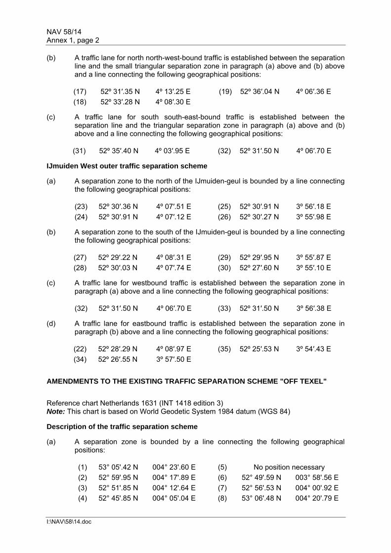
NAV 58/14 Annex 1, page 2
I:\NAV\58\14.doc
(b) A traffic lane for north north-west-bound traffic is established between the separation line and the small triangular separation zone in paragraph (a) above and (b) above and a line connecting the following geographical positions:
(17) 52º 31′.35 N 4º 13′.25 E (19) 52º 36′.04 N 4º 06′.36 E
(18) 52º 33′.28 N 4º 08′.30 E (c) A traffic lane for south south-east-bound traffic is established between the
separation line and the triangular separation zone in paragraph (a) above and (b) above and a line connecting the following geographical positions:
(31) 52º 35′.40 N 4º 03′.95 E (32) 52º 31′.50 N 4º 06′.70 E IJmuiden West outer traffic separation scheme (a) A separation zone to the north of the IJmuiden-geul is bounded by a line connecting
the following geographical positions:
(23) 52º 30′.36 N 4º 07′.51 E (25) 52º 30′.91 N 3º 56′.18 E
(24) 52º 30′.91 N 4º 07′.12 E (26) 52º 30′.27 N 3º 55′.98 E (b) A separation zone to the south of the IJmuiden-geul is bounded by a line connecting
the following geographical positions:
(27) 52º 29′.22 N 4º 08′.31 E (29) 52º 29′.95 N 3º 55′.87 E
(28) 52º 30′.03 N 4º 07′.74 E (30) 52º 27′.60 N 3º 55′.10 E (c) A traffic lane for westbound traffic is established between the separation zone in
paragraph (a) above and a line connecting the following geographical positions:
(32) 52º 31′.50 N 4º 06′.70 E (33) 52º 31′.50 N 3º 56′.38 E (d) A traffic lane for eastbound traffic is established between the separation zone in
paragraph (b) above and a line connecting the following geographical positions:
(22) 52º 28′.29 N 4º 08′.97 E (35) 52º 25′.53 N 3º 54′.43 E
(34) 52º 26′.55 N 3º 57′.50 E AMENDMENTS TO THE EXISTING TRAFFIC SEPARATION SCHEME "OFF TEXEL" Reference chart Netherlands 1631 (INT 1418 edition 3) Note: This chart is based on World Geodetic System 1984 datum (WGS 84) Description of the traffic separation scheme (a) A separation zone is bounded by a line connecting the following geographical
positions:
(1) 53° 05'.42 N 004° 23'.60 E (5) No position necessary
(2) 52° 59'.95 N 004° 17'.89 E (6) 52° 49'.59 N 003° 58'.56 E
(3) 52° 51'.85 N 004° 12'.64 E (7) 52° 56'.53 N 004° 00'.92 E
(4) 52° 45'.85 N 004° 05'.04 E (8) 53° 06'.48 N 004° 20'.79 E

NAV 58/14 Annex 1, page 3
I:\NAV\58\14.doc
(b) A traffic lane for north-eastbound traffic is established between the separation zone in paragraph (a) and a line connecting the following geographical positions:
(9) 53° 03'.82 N 004° 27'.80 E (11a) 52° 44'.60 N 004° 09'.90 E
(10) 52° 58'.60 N 004° 22'.34 E (11b) 52° 43'.48 N 004° 09'.14 E
(11) 52° 50'.38 N 004° 17'.01 E (c) A traffic lane for south-westbound traffic is established between the separation zone
in paragraph (a) and a line connecting the following geographical positions:
(12b) 52° 56'.67 N 003° 53'.44 E (13) 53° 08'.17 N 004° 16'.35 E (d) A separation zone west of the separation zone in paragraph (a) is established and
bounded by the following geographical positions:
(14) 52° 50'.60 N 003° 56'.80 E (16) 52° 54'.31 N 003° 56'.67 E
(15) 52° 55'.22 N 003° 58'.32 E (17) 52° 52'.31 N 003° 53'.83 E (e) A southbound traffic lane branching off from the main south-westbound traffic lane is
established between the separation zones in paragraphs (a) and (d) and the boundaries of the south-westbound traffic lane are extended, as described in paragraphs (f) and (g).
(f) The north-western boundary of the extended south-westbound traffic lane is formed
by a line connecting the following geographical positions:
(12a) 52° 35'.71 N 003° 25'.56 E (12b) 52° 56'.67 N 003° 53'.44 E (g) The south-eastern boundary of the extended south-westbound traffic lane is formed
by a line connecting the following geographical positions:
(17) 52° 52'.31 N 003° 53'.83 E (18) 52° 36'.04 N 003° 31'.02 E (h) A separation zone at the south-western end of the south-westbound traffic lane is
established and bounded by the following geographical positions:
(20) 52° 34'.34 N 003° 28'.65 E (22) 52° 31'.94 N 003° 28'.01 E
(21) 52° 32'.35 N 003° 26'.36 E (i) A traffic lane for south-westbound traffic is established between the separation zone
in paragraph (h) and a line connecting the following geographical positions:
(12) 52° 33'.71 N 003° 23'.17 E (12a) 52° 35'.71 N 003° 25'.56 E (j) A southbound traffic lane branching off from the main south-westbound traffic lane is
established between the separation zone in paragraph (h) and a line connecting the following geographical positions:
(18) 52° 36'.04 N 003° 31'.02 E (19) 52° 31'.76 N 003° 29'.87 E Note: The note is to remain unchanged.

NAV 58/14 Annex 1, page 4
I:\NAV\58\14.doc
AMENDMENTS TO THE EXISTING TRAFFIC SEPARATION SCHEMES "IN THE APPROACHES TO HOOK OF HOLLAND AND AT NORTH HINDER" Reference chart Netherlands 1630 (INT 1416), Edition 4/2010 Note: This chart is based on World Geodetic System 1984 datum (WGS 84) Maas North traffic separation scheme (a) A separation zone is bounded by a line connecting the following geographical
positions:
(1) 52° 22′.21 N 003° 51′.38 E (3) 52° 07′.14 N 003° 47′.10 E (1a) 52° 19′.17 N 003° 50′.38 E (4) 52° 17′.07 N 003° 47′.69 E (2) 52° 07′.17 N 003° 54′.08 E (5) 52° 22′.45 N 003° 49′.51 E
(b) A traffic lane for northbound traffic is established between the separation zone in
paragraph (a) above and a line connecting the following geographical positions:
(6) 52° 21′.97 N 003° 53′.28 E (7) 52° 07′.18 N 003° 55′.95 E (6a) 52° 19′.03 N 003° 52′.34 E
(c) A traffic lane for southbound traffic is established between the separation zone in
paragraph (a) above and a line connecting the following geographical positions:
(8) 52° 22′.68 N 003° 47′.73 E (10) 52° 07′.13 N 003° 44′.66 E (9) 52° 14′.02 N 003° 44′.96 E
Maas North-west traffic separation scheme (a) A separation zone is bounded by a line connecting the following geographical
positions:
(13) 52° 07′.98 N 003° 31′.54 E (15) 52° 05′.96 N 003° 36′.27 E (14) 52° 06′.17 N 003° 36′.64 E (16) 52° 07′.72 N 003° 31′.29 E
(b) A traffic lane for north-westbound traffic is established between the separation zone
in paragraph (a) above and a line connecting the following geographical positions:
(11) 52° 07′.09 N 003° 38′.25 E (12) 52° 09′.08 N 003° 32′.64 E (c) A traffic lane for south-eastbound traffic is established between the separation zone
in paragraph (a) above and a line connecting the following geographical positions:
(17) 52° 06′.62 N 003° 30′.19 E (18) 52° 05′.04 N 003° 34′.66 E Maas West inner traffic separation scheme (a) A separation zone to the north of the DW route is outwardly bounded by a line
connecting the following geographical positions:
(21) 52° 02′.12 N 003° 25′.73 E (23) 52° 00′.57 N 003° 35′.17 E (22) 52° 02′.56 N 003° 34′.94 E (24) 51° 59′.75 N 003° 25′.29 E

NAV 58/14 Annex 1, page 5
I:\NAV\58\14.doc
and inwardly bounded by a line connecting the following geographical positions:
(32) 52° 02′.15 N 003° 33′.36 E (34) 52° 00′.03 N 003° 27′.01 E (33) 52° 01′.89 N 003° 27′.31 E (35) 52° 00′.57 N 003° 33′.51 E
Note: The inside of the area in the separation zone to the north of the DW route, bounded by a line connecting the following geographical positions (32), (33), (34) and (35), is designated as an anchorage area. (b) A separation zone to the south of the DW route is outwardly bounded by a line
connecting the following geographical positions:
(25) 51° 59′.92 N 003° 35′.24 E (26) 51° 59′.09 N 003° 25′.17 E (25a) 51° 59′.89 N 003° 34′.87 E (27) 51° 56′.90 N 003° 24′.78 E (25b) 51° 58′.86 N 003° 33′.51 E (28) 51° 58′.25 N 003° 35′.44 E (25c) 51° 59′.47 N 003° 29′.78 E Positions 25a and 25b are connected by a circular arc centred on point "25d"
(see NAV 58/3/10, annex 3). (25d) 51° 59.56′ N 003° 33.82′ ERadius of the arc = 0.729 miles
(c) A traffic lane for westbound traffic is established between the separation zone in
paragraph (a) above and a line connecting the following geographical positions: (19) 52° 04′.74 N 003° 34′.69 E (20) 52° 04′.63 N 003° 26′.20 E
(d) A traffic lane for eastbound traffic is established between the separation zone in
paragraph (b) above and a line connecting the following geographical positions:
(29) 51° 54′.10 N 003° 24′.29 E (30) 51° 56′.26 N 003° 35′.66 E (e) A separation zone between the westbound traffic lane of TSS Maas West Inner and
the south-eastbound traffic lane of TSS Maas Northwest is bounded by a line connecting the following geographical positions:
(17) 52° 06′.62 N 003° 30′.19 E (19) 52° 04′.74 N 003° 34′.69 E (18) 52° 05′.04 N 003° 34′.66 E (19a) 52° 04′.66 N 003° 28′.25 E
Maas West outer traffic separation scheme (a) A separation zone to the north of the DW route is outwardly bounded by a line
connecting the following geographical positions:
(38) 52° 01′.26 N 003° 08′.37 E (40a)* 51° 58′.79 N 003° 13′.86 E (39) 52° 01′.77 N 003° 18′.81 E (40b)* 51° 59′.49 N 003° 12′.47 E (40) 51° 59′.15 N 003° 18′.13 E (41) 51° 59′.13 N 003° 08′.26 E * Positions 40a and 40b are connected by a circular arc centred on point "40c"
(see NAV 58/3/10, annex 3). (40c) 51° 58′.77 N 003° 12′.66 ERadius of the arc = 0.729 miles

NAV 58/14 Annex 1, page 6
I:\NAV\58\14.doc
and inwardly bounded by a line connecting the following geographical positions:
(42) 51° 59′.88 N 003° 13′.89 E (44) 52° 01′.05 N 003° 08′.36 E (43) 52° 01′.26 N 003° 12′.56 E (45) 51° 59′.40 N 003° 08′.28 E
Thus the created inside area in the separation zone is designated as anchor area. (b) A separation zone to the south of the DW route is outwardly bounded by a line
connecting the following geographical positions:
(46) 51° 58′.49 N 003° 17′.96 E (48) 51° 54′.77 N 003° 07′.49 E (47) 51° 57′.64 N 003° 08′.00 E (49) 51° 55′.99 N 003° 17′.31 E
and inwardly bounded by a line connecting the following geographical positions:
(52) 51° 55′.64 N 003° 12′.25 E (54) 51° 56′.89 N 003° 07′.87 E (53) 51° 57′.37 N 003° 13′.55 E (55) 51° 55′.06 N 003° 07′.54 E
Thus the created inside area in the separation zone is designated as anchor area. (c) A traffic lane for westbound traffic is established between the separation zone in
paragraph (a) above and a line connecting the following geographical positions:
(36) 52° 04′.54 N 003° 19′.53 E (37) 52° 04′.37 N 003° 08′.52 E (d) A traffic lane for eastbound traffic is established between the separation zone in
paragraph (b) above and a line connecting the following geographical positions:
(50) 51° 52′.59 N 003° 16′.43 E (51) 51° 50′.72 N 003° 06′.78 E Note: The inside of the area in the separation zone to the north of the Eurochannel, bounded by a line connecting the following geographical positions (42), (43), (44) and (45), and the inside of the area in the separation zone to the south of the Eurochannel, bounded by a line connecting the following geographical positions (52), (53), (54) and (55), are designated as anchorage areas. North Hinder North traffic separation scheme (a) A separation zone is bounded by a line connecting the following geographical
positions:
(61) 52° 07′.29 N 003° 03′.08 E (63) 52° 11′.51 N 003° 02′.62 E (62) 52° 09′.38 N 003° 06′.60 E (64) 52° 09′.03 N 002° 59′.83 E
(b) A traffic lane for south-westbound traffic is established between the separation zone
in (a) above and a line connecting the following geographical positions:
(65) 52° 13′.42 N 002° 59′.03 E (66) 52° 10′.99 N 002° 56′.16 E (c) A traffic lane for north-eastbound traffic is established between the separation zone
in (a) above and a line connecting the following geographical positions:
(67) 52° 05′.55 N 003° 06′.32 E (68) 52° 07′.72 N 003° 09′.70 E

NAV 58/14 Annex 1, page 7
I:\NAV\58\14.doc
AMENDMENTS TO THE EXISTING TRAFFIC SEPARATION SCHEME "OFF RODSHER ISLAND" Positions are based on World Geodetic System 1984 Datum (WGS 84). The Russian Federation reference chart #23004 (Pulkovo). For obtaining position in WGS datum charted positions should be moved 0'.14 (8''.3) westward. Amendments to the traffic separation scheme (a) A separation zone is bounded by a line connecting the following geographical
positions: .1 60º 00.43′ N, 026º 30.16′ E; .2 60º 01.05′ N, 026º 34.86′ E; .3 60º 00.35′ N, 026º 44.24′ E; .4 59º 59.85′ N, 026º 44.08′ E; .5 60º 00.15′ N, 026º 40.21′ E; and .6 59º 58.76′ N, 026º 30.16′ E. (b) A traffic lane, one mile wide, is established on each side of the separation zone. AMENDMENT TO THE EXISTING TRAFFIC SEPARATION SCHEME "OFF USHANT"
CHANGE IN THE USE OF THE TWO-WAY ROUTE
Amend existing paragraph (h) in the description of the traffic separation scheme "Off Ushant", as follows:
"The two-way route may be used by:
- passenger ships;
- ships of less than 6,000 gross tonnage, travelling from or towards a port
situated between Cape Finisterre and Cap de la Hague.
This authorization does not apply to ships carrying oils listed in appendix I, annex I of the International Convention for the Prevention of Pollution from Ships, 1973, as modified by the Protocol of 1978 relating thereto (MARPOL 73/78), ships carrying in bulk the substances classified in categories X and Y as defined in regulation 6, annex II of that convention, ships corresponding to the requirements of the International Code for the Construction and Equipment of ships Carrying Liquefied Gases in Bulk (IGC Code) and ships carrying fissile or irradiated materials."
Consequential amendments to SN/Circ.232: Replace existing article 3 with the following text:
"The two-way route may be used by:
- passenger ships;

NAV 58/14 Annex 1, page 8
I:\NAV\58\14.doc
- ships of less than 6,000 gross tonnage, travelling from or towards a port situated between Cape Finisterre and Cap de la Hague.
This authorization does not apply to ships carrying oils listed in appendix I, annex I of the International Convention for the Prevention of Pollution from Ships, 1973, as modified by the Protocol of 1978 relating thereto (MARPOL 73/78), ships carrying in bulk the substances classified in categories X and Y as defined in regulation 6, annex II of that convention, ships corresponding to the requirements of the International Code for the Construction and Equipment of ships Carrying Liquefied Gases in Bulk (IGC Code) and ships carrying fissile or irradiated materials."
AMENDMENTS TO THE EXISTING TRAFFIC SEPARATION SCHEME "IN THE SANTA BARBARA CHANNEL"
(Reference charts: United States 18700, 2003 edition; 18720, 2008 edition. Note: These charts are based on North American 1983 Datum which is equivalent to WGS 1984 datum.)
Description of the traffic separation scheme
The traffic separation scheme in the Santa Barbara Channel consists of two parts:
Part I Between Point Vicente and Point Conception
(a) A separation zone is bounded by a line connecting the following geographical positions:
(1) 34° 20′.84 N, 120° 30′.28 W (4) 33° 44′.06 N, 118° 36′.34 W (2) 34° 03′.87 N, 119° 15′.63 W (5) 34° 02′.94 N, 119° 16′.09 W (3) 33° 44′.93 N, 118° 35′.75 W (6) 34° 19′.88 N, 120° 30′.59 W
(b) A traffic lane for north-westbound traffic is established between the separation zone and a line connecting the following geographical positions:
(7) 34° 21′.80 N. 120° 29′.96 W (9) 33° 45′.80 N, 118° 35′.15 W (8) 34° 04′.80 N, 119° 15′.16 W
(c) A traffic lane for south-eastbound traffic is established between the separation zone and a line connecting the following geographical positions:
(10) 33° 43′.18 N, 118° 36′.94 W (12) 34° 18′.92 N, 120° 30′.91 W (11) 34° 02′.01 N, 119° 16′.56W
Note: Port Hueneme Fairway A safety fairway is established in the approach to Port Hueneme.
Part II Between Point Conception and Point Arguello
(a) A separation zone is bounded by a line connecting the following geographical positions:
(1) 34° 20′.84 N, 120° 30′.28 W (13) 34° 24′.76 N, 120° 52′.10 W (6) 34° 19′.88 N, 120° 30′.59 W (14) 34° 25′.72 N, 120° 51′.78 W

NAV 58/14 Annex 1, page 9
I:\NAV\58\14.doc
(b) A traffic lane for westbound traffic is established between the separation zone and a line connecting the following geographical positions:
(7) 34° 21′.80 N. 120° 29′.96 W (15) 34° 26′.68 N, 120° 51′.46 W
(c) A traffic lane for eastbound traffic is established between the separation zone and a line connecting the following geographical positions:
(12) 34° 18′.92 N, 120° 30′.91 W (16) 34° 23′.80 N, 120° 52′.42 W AMENDMENTS TO THE EXISTING TRAFFIC SEPARATION SCHEME "OFF SAN FRANCISCO"
(Reference charts: United States 18680, 2005 edition; 18645, 2008 edition. Note: These charts are based on North American 1983 Datum which is equivalent to WGS 1984 datum.) Description of the traffic separation scheme The traffic separation scheme Off San Francisco consists of four parts: Part I Northern approach (a) A separation zone is bounded by a line connecting the following geographical
positions:
(1) 37° 48′.52 N, 122° 47′.63 W (38) 38° 08′.03 N, 123° 21′.34 W. (2) 37° 58′.45 N, 123° 09′.49 W (3) 37° 57′.67 N, 123° 10′.31 W (37) 38° 09′.09 N, 123° 20′.82 W (4) 37° 47′.66 N, 122° 48′.29 W
(b) A traffic lane for north-westbound traffic is established between the separation zone
and a line connecting the following geographical positions:
(5) 37° 49′.29 N. 122° 46′.79 W (36) 38° 10′.14 N, 123° 20′.29 W (6) 37° 59′.22 N, 123° 08′.66 W
(c) A traffic lane for south-eastbound traffic is established between the separation zone
and a line connecting the following geographical positions:
(39) 38° 06′.92 N, 123° 21′.82 W (8) 37° 46′.72 N, 122° 48′.76 W (7) 37° 56′.89 N, 123° 11′.14 W
Part II Southern approach (a) A separation zone is bounded by a line connecting the following geographical
positions:
(9) 37° 39′.07 N, 122° 40′.40 W (11) 37° 18′.71 N, 122° 43′.00 W (10) 37° 18′.45 N, 122° 40′.40 W (12) 37° 39′.12 N, 122° 43′.00 W

NAV 58/14 Annex 1, page 10
I:\NAV\58\14.doc
(b) A traffic lane for northbound traffic is established between the separation zone and a line connecting the following geographical positions:
(13) 37° 39′.30 N. 122° 39′.14 W (14) 37° 18′.36 N, 122° 39′.14 W
(c) A traffic lane for southbound traffic is established between the separation zone and
a line connecting the following geographical positions:
(15) 37° 18′.89 N, 122° 44′.26 W (16) 37° 39′.41 N, 122° 44′.26 W Part III Western approach (a) A separation zone is bounded by a line connecting the following geographical
positions:
(17) 37° 41′.90 N, 122° 47′.99 W (19) 37° 34′.15 N, 123° 00′.37 W (18) 37° 33′.54 N, 123° 03′.79 W (20) 37° 41′.09 N, 122° 47′.25 W
(b) A traffic lane for south-westbound traffic is established between the separation zone
and a line connecting the following geographical positions:
(21) 37° 42′.81 N. 122° 48′.55 W (22) 37° 34′.37 N, 123° 04′.49 W (c) A traffic lane for north-eastbound traffic is established between the separation zone
and a line connecting the following geographical positions:
(23) 37° 31′.87 N, 123° 02′.40 W (24) 37° 40′.38 N, 122° 46′.33 W Part IV Main ship channel (a) A separation line connects the following geographical positions:
(25) 37° 45′.90 N, 122° 38′.00 W (27) 37° 48′.10 N, 122° 31′.00 W (26) 37° 47′.00 N, 122° 34′.30 W
(b) A traffic lane for eastbound traffic is established between the separation zone and a
line connecting the following geographical positions:
(28) 37° 45′.80 N. 122° 37′.70 W (29) 37° 47′.80 N, 122° 30′.80 W (c) A traffic lane for westbound traffic is established between the separation zone and a
line connecting the following geographical positions:
(30) 37° 46′.20 N, 122° 37′.90 W (32) 37° 48′.50 N, 122° 31′.30 W (31) 37° 46′.90 N, 122° 35′.30 W
Area to be avoided A circular area to be avoided, of radius half a mile, is centred upon geographical position:
(33) 37° 45′.00 N, 122° 41.50 W

NAV 58/14 Annex 1, page 11
I:\NAV\58\14.doc
Precautionary area A precautionary area is established bounded to the west by an arc of a circle of radius 6 miles centring upon geographic position (33) 37° 45′.00 N, 122° 41′.50 W and connecting with the following geographical positions:
(34) 37° 42′.70 N, 122° 34′.60 W (35) 37° 50′.30 N, 122° 38′.00 W The precautionary area is bounded to the east by a line connecting the following geographical positions:
(34) 37° 42′.70 N, 122° 34′.60 W (35) 37° 50′.30 N, 122° 38′.00 W (25) 37° 45′.90 N, 122° 38′.00 W
AMENDMENTS TO THE EXISTING TRAFFIC SEPARATION SCHEME "IN THE APPROACHES TO LOS ANGELES – LONG BEACH"
(A continuation of the Santa Barbara Channel scheme) (Reference Chart: United States 18746, 2009 edition. Note: These charts are based on North American 1983 Datum which is equivalent to WGS 1984 datum.) Description of the traffic separation scheme The traffic separation scheme "In the Approaches to Los Angeles – Long Beach" consists of three parts: Western approach (a) A separation zone is bounded by a line connecting the following geographical
positions:
(1) 33° 37′.70 N, 118° 17′.60 W (4) 33° 44′.06 N, 118° 36′.34 W (2) 33° 36′.50 N, 118° 17′.60 W (5) 33° 44′.93 N, 118° 35′.75 W (3) 33° 36′.50 N, 118° 20′.48 W (6) 33° 37′.70 N, 118° 20′.57 W
(b) A traffic lane for northbound coastwise traffic is established between the separation
zone and a line connecting the following geographical positions:
(7) 33° 38′.70 N, 118° 17′.60 W (9) 33° 45′.80 N, 118° 35′.15 W (8) 33° 38′.70 N, 118° 20′.24 W
(c) A traffic lane for southbound coastwise traffic is established between the separation
zone and a line connecting the following geographical positions:
(10) 33° 35′.50 N, 118° 17′.60 W (12) 33° 43′.18 N, 118° 36′.94 W (11) 33° 35′.50 N, 118° 20′.81 W

NAV 58/14 Annex 1, page 12
I:\NAV\58\14.doc
Southern approach (a) A separation zone is established bounded by a line connecting the following
geographic positions: (13) 33° 35′.50 N, 118° 10′.30 W (15) 33° 19′.00 N, 118° 05′.60 W (14) 33° 35′.50 N, 118° 12′.75 W (16) 33° 19′.70 N, 118° 03′.50 W
(b) A traffic lane for northbound traffic is established between the separation zone and a
line connecting the following geographical positions:
(17) 33° 35′.50 N, 118° 09′.00 W (18) 33° 20′.00 N, 118° 02′.30 W (c) A traffic lane for southbound traffic is established between the separation zone and
a line connecting the following geographical positions:
(19) 33° 35′.50 N, 118° 14′.00 W (20) 33° 18′.70 N, 118° 06′.75 W Precautionary area (a) The precautionary area consists of the water area enclosed by the
Los Angeles – Long Beach breakwater and a line connecting Point Fermin Light at 33° 42′.30N, 118° 17′.60W, with the following geographical positions:
(10) 33° 35′.50 N, 118° 17′.60 W (21) 33° 37′.70 N, 118° 06′.50 W (17) 33° 35′.50 N, 118° 09′.00 W (22) 33° 43′.40 N, 118° 10′.80 W
Note: Pilot boarding areas are located in the precautionary area. Due to heavy vessel traffic, mariners are advised not to anchor or linger in this precautionary area except to pick up or disembark a pilot.
***

NAV 58/14 Annex 2, page 1
I:\NAV\58\14.doc
ANNEX 2
ROUTEING MEASURES OTHER THAN TRAFFIC SEPARATION SCHEMES TWO NEW PRECAUTIONARY AREAS AND A NEW AREA TO BE AVOIDED (ATBA) "IN THE APPROACHES TO IJMUIDEN"
Reference chart Netherlands 1631 (INT 1418 edition 3) Note: This chart is based on World Geodetic System 1984 datum (WGS 84) IJmuiden Junction precautionary area (a) A precautionary area between the IJmuiden Inner and Outer traffic separation
schemes is bounded by a line connecting the following geographical positions:
(21) 52º 28'.58 N 004º 10'.85 E (8) 52º 31'.50 N 004º 08'.13 E
(22) 52º 28'.29 N 004º 08'.97 E (15) 52º 29'.87 N 004º 09'.28 E
(32) 52º 31'.50 N 004º 06'.70 E And back to 21 Area to be avoided "by IJmuiden northern approaches" (a) An area to be avoided for all ships is bounded by a line connecting the following
geographical positions:
(i) 52º 32'.15 N 004º 04'.82 E (iii) 52º 34'.65 N 004º 02'.22 E
(ii) 52º 34'.04 N 004º 04'.82 E (iv) 52º 32'.79 N 004º 02'.22 E
And back to (i) (b) The area to be avoided in paragraph (a) above is to be labelled "Amm. Dumps" IJmuiden Crossing precautionary area (a) A precautionary area immediately west of the IJmuiden West Outer traffic separation
scheme is established by a line connecting the following geographical positions:
(33) 52º 31'.50 N 003º 56'.38 E (36) 52º 25'.16 N 003º 48'.53 E
(35) 52º 25'.53 N 003º 54'.43 E (37) 52º 31'.50 N 003º 50'.57 E
And back to 33 Note: Cautions 1) (Near the buoyed deep-water channel route in the IJmuiden Junction and IJmuiden
Crossing precautionary areas) For ships that have to cross the deep-water route attention is drawn to rule 18(d)(i)
of the 1972 Collision Regulations. Mariners are, however, reminded that when risk of collision is deemed to exist, the 1972 Collision Regulations fully apply and, in particular, the rules of part B, sections II and III are of specific relevance to the crossing situation.
2) (By the entrance of the south-south-eastbound traffic lane of the IJmuiden North
traffic separation scheme (see section I of part D)) The area to be avoided on the western boundary of the IJmuiden North traffic
separation scheme's south-south-eastbound lane encloses an ammunition dump dating from the end of the Second World War. Mariners are warned not to enter this area and, in particular, not to anchor in it, even in an emergency.

NAV 58/14 Annex 2, page 2
I:\NAV\58\14.doc
NEW PRECAUTIONARY AREA, A NEW RECOMMENDED ROUTE AND A NEW AREA TO BE AVOIDED (ATBA) IN THE AREA "WEST OF RIJNVELD" Reference chart Netherlands 1630 (INT 1416), edition 4/2010 Note: This chart is based on World Geodetic System 1984 datum (WGS 84) And: Reference chart Netherlands 1631 (INT 1418), edition 3 Note: This chart is based on World Geodetic System 1984 datum (WGS 84) "Rijnveld" precautionary area A precautionary area is established off the entrance to the Rotterdam Waterway. The area is bounded by a line connecting the following geographical positions: (1) 52° 21′.54 N 003° 27′.14 E(4) 52° 07′.81 N 003° 26′.80 E (2) 52° 14′.47 N 003° 29′.38 E(5) 52° 12′.85 N 003° 12′.42 E (3) 52° 10′.15 N 003° 29′.58 E(6) 52° 20′.22 N 003° 24′.90 E And back to 1 Recommended southbound route
A recommended southbound traffic route is established from the southern end of the southbound traffic lane branching from the south-westbound lane of the Off Texel traffic separation scheme to the north end of the Rijnveld precautionary area. The route is marked by dashed outlined arrows which are placed in a direction of 189.2 degrees in between the following geographical positions: (6) 52° 20′.22 N 003° 24′.90 E (8) 52° 31′.76 N 003° 29′.87 E (7) 52° 31′.94 N 003° 28′.01 E (1) 52° 21′.54 N 003° 27′.14 E Area to be avoided "at De Ruyter" An area to be avoided for all ships, except authorized, around the De Ruyter offshore oil and gas installation is established and bounded by a line connecting the following geographical positions:
(i) 52° 21′.12 N 003° 19′.73 E (iii) 52° 22′.75 N 003° 22′.00 E (ii) 52° 22′.75 N 003° 19′.73 E (iv) 52° 21′.12 N 003° 22′.00 E
And back to i
Note: CAUTIONS 1) (Rijnveld West precautionary area)
Mariners are warned that in this precautionary area ships on routes to and from the traffic separation scheme "Off Texel", the River Scheldt and Europoort are merging or crossing.

NAV 58/14 Annex 2, page 3
I:\NAV\58\14.doc
AMENDMENT TO THE EXISTING DEEP-WATER ROUTE LEADING TO IJMUIDEN Reference chart Netherlands 1631 (INT 1418 edition 3) Note: This chart is based on World Geodetic System 1984 datum (WGS 84) Description of the amended deep-water route The deep-water route consists of a deep-water channel (IJ-Geul) and a deep-water approach area (IJ-Geul approach area). The deep-water channel (IJ-Geul) (a) The specific deep-water channel is bounded by a line connecting the following
geographical positions:
(1) 52° 28′.10 N 004° 32′.02 E (16) 52° 29′.94 N 003° 54′.91 E
(2)* 52° 29′.00 N 004° 24′.16 E (17) 52° 29′.95 N 003° 55′.87 E
(3)* 52° 29′.65 N 004° 23′.45 E (18) 52° 30′.03 N 004° 07′.74 E
(4) 52° 29′.39 N 004° 20′.73 E (19) 52° 30′.04 N 004° 09′.16 E
(5) 52° 30′.38 N 004° 11′.84 E (20) 52° 30′.06 N 004° 12′.50 E
(6) 52° 30′.36 N 004° 08′.93 E (21) 52° 29′.03 N 004° 21′.70 E
(7) 52° 30′.36 N 004° 07′.51 E (22)* 52° 28′.80 N 004° 23′.41 E
(8) 52° 30′.27 N 003° 55′.98 E (23)* 52° 28′.80 N 004° 23′.72 E
(9) 52° 30′.26 N 003° 54′.91 E (24) 52° 27′.81 N 004° 31′.95 E
* Geographical positions (2), (3), (22) and (23) are connected by an arc of a circle with a radius of 0.432 miles centred at geographical position (x) 52° 29′.22 N 004°23′.56 E
The deep-water approach area (IJ-Geul approach area) (b) The specific deep-water approach area is bounded by a line connecting the
following geographical positions:
(9) 52° 30′.26 N 003° 54′.91 E (13) 52° 27′.31 N 003° 40′.51 E
(10) 52° 31′.50 N 003° 54′.91 E (14) 52° 28′.07 N 003° 49′.47 E
(11) 52° 31′.50 N 003° 50′.57 E (15) 52° 28′.54 N 003° 54′.91 E
(12) 52° 31′.49 N 003° 47′.17 E (16) 52° 29′.94 N 003° 54′.91 E Notes: Notes 2.1 to 2.4 are to remain unchanged. Note 2.5, referring to the emergency turning basin, is to be removed.
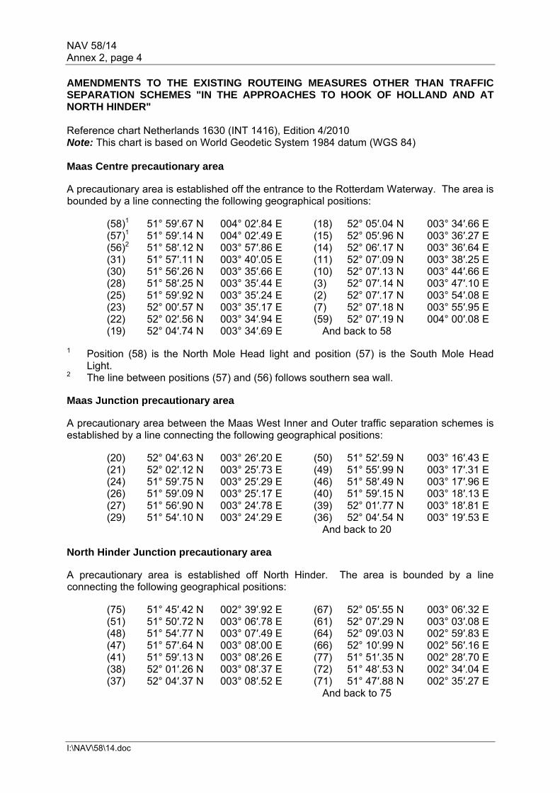
NAV 58/14 Annex 2, page 4
I:\NAV\58\14.doc
AMENDMENTS TO THE EXISTING ROUTEING MEASURES OTHER THAN TRAFFIC SEPARATION SCHEMES "IN THE APPROACHES TO HOOK OF HOLLAND AND AT NORTH HINDER" Reference chart Netherlands 1630 (INT 1416), Edition 4/2010 Note: This chart is based on World Geodetic System 1984 datum (WGS 84) Maas Centre precautionary area A precautionary area is established off the entrance to the Rotterdam Waterway. The area is bounded by a line connecting the following geographical positions: (58)1 51° 59′.67 N 004° 02′.84 E (18) 52° 05′.04 N 003° 34′.66 E (57)1 51° 59′.14 N 004° 02′.49 E (15) 52° 05′.96 N 003° 36′.27 E
(56)2 51° 58′.12 N 003° 57′.86 E (14) 52° 06′.17 N 003° 36′.64 E (31) 51° 57′.11 N 003° 40′.05 E (11) 52° 07′.09 N 003° 38′.25 E (30) 51° 56′.26 N 003° 35′.66 E (10) 52° 07′.13 N 003° 44′.66 E (28) 51° 58′.25 N 003° 35′.44 E (3) 52° 07′.14 N 003° 47′.10 E (25) 51° 59′.92 N 003° 35′.24 E (2) 52° 07′.17 N 003° 54′.08 E (23) 52° 00′.57 N 003° 35′.17 E (7) 52° 07′.18 N 003° 55′.95 E (22) 52° 02′.56 N 003° 34′.94 E (59) 52° 07′.19 N 004° 00′.08 E (19) 52° 04′.74 N 003° 34′.69 E And back to 58
1 Position (58) is the North Mole Head light and position (57) is the South Mole Head
Light. 2 The line between positions (57) and (56) follows southern sea wall. Maas Junction precautionary area A precautionary area between the Maas West Inner and Outer traffic separation schemes is established by a line connecting the following geographical positions:
(20) 52° 04′.63 N 003° 26′.20 E (50) 51° 52′.59 N 003° 16′.43 E (21) 52° 02′.12 N 003° 25′.73 E (49) 51° 55′.99 N 003° 17′.31 E (24) 51° 59′.75 N 003° 25′.29 E (46) 51° 58′.49 N 003° 17′.96 E (26) 51° 59′.09 N 003° 25′.17 E (40) 51° 59′.15 N 003° 18′.13 E (27) 51° 56′.90 N 003° 24′.78 E (39) 52° 01′.77 N 003° 18′.81 E (29) 51° 54′.10 N 003° 24′.29 E (36) 52° 04′.54 N 003° 19′.53 E
And back to 20 North Hinder Junction precautionary area A precautionary area is established off North Hinder. The area is bounded by a line connecting the following geographical positions:
(75) 51° 45′.42 N 002° 39′.92 E (67) 52° 05′.55 N 003° 06′.32 E (51) 51° 50′.72 N 003° 06′.78 E (61) 52° 07′.29 N 003° 03′.08 E (48) 51° 54′.77 N 003° 07′.49 E (64) 52° 09′.03 N 002° 59′.83 E (47) 51° 57′.64 N 003° 08′.00 E (66) 52° 10′.99 N 002° 56′.16 E (41) 51° 59′.13 N 003° 08′.26 E (77) 51° 51′.35 N 002° 28′.70 E (38) 52° 01′.26 N 003° 08′.37 E (72) 51° 48′.53 N 002° 34′.04 E (37) 52° 04′.37 N 003° 08′.52 E (71) 51° 47′.88 N 002° 35′.27 E
And back to 75

NAV 58/14 Annex 2, page 5
I:\NAV\58\14.doc
Inshore traffic zone An inshore traffic zone south of the Maas West Inner TSS and the Maas Centre is established between the coast and a line connecting the following geographical positions:
(60) 51° 34′.00 N 003° 30′.00 E (31) 51° 57′.11 N 003° 40′.05 E (29) 51° 54′.10 N 003° 24′.29 E (56) 51° 58′.12 N 003° 57′.86 E
Area to be avoided at Maas North An area to be avoided for all ships is established within the separation zone of the Maas North traffic separation scheme and is bounded by a line connecting the following geographical positions:
(i) 52° 15′.45 N 003° 51′.42 E (iii) 52° 12′.45 N 003° 48′.32 E (ii) 52° 12′.45 N 003° 51′.42 E (iv) 52° 15′.45 N 003° 48′.32 E
And back to (i) Note: CAUTIONS 1 (Maas Junction precautionary area between Maas West Outer traffic separation
scheme and Maas West Inner separation scheme) Mariners are warned that in this precautionary area ships on routes to and from the
traffic separation scheme "Off Texel", the River Scheldt and Europoort are merging or crossing.
2 (Off the seaward entrances to the "Maas West Inner", the "Maas Northwest" and the
"Maas North" traffic separation schemes) The precautionary area in the approaches to Hook of Holland should be avoided
by passing traffic which is not entering or leaving the adjacent ports.
3 (Near the deep-water route in the North Hinder Junction precautionary area and near the "deep-water route leading to Europoort" between the "Maas West Outer" and the "Maas West Inner" traffic separation schemes (see section I of part D)).
For ships that have to cross the deep-water route attention is drawn to rule 18(d)(i) of the 1972 Collision Regulations. Mariners are, however, reminded that, when risk of collision is deemed to exist, the 1972 Collision Regulations fully apply and, in particular, the rules of part B, sections II and III are of specific relevance to the crossing situation.
4 (In the Maas North separation zone below the area to be avoided) The area to be avoided within the Maas North separation zone encloses
two ammunition dumps. Mariners are warned not to enter this area and, in particular, not to anchor in it, even in an emergency.

NAV 58/14 Annex 2, page 6
I:\NAV\58\14.doc
AMENDMENTS TO THE EXISTING DEEP-WATER ROUTE LEADING TO EUROPOORT Reference chart Netherlands 1630 (INT 1416), Edition 4/2010 Note: This chart is based on World Geodetic System 1984 datum (WGS 84) The deep-water route is bounded by a line connecting the following geographical positions:
(1) 51° 59′.52 N 004° 02′.74 E (14) 51° 57′.28 N 002° 54′.68 E
(2) 51° 59′.94 N 004° 01′.32 E (19) 51° 56′.53 N 002° 55′.29 E
(3)* 52° 01′.03 N 003° 56′.91 E (20) 51° 57′.64 N 003° 08′.00 E
(4)* 52° 02′.33 N 003° 55′.89 E (21) 51° 58′.49 N 003° 17′.96 E
(5) 52° 02′.00 N 003° 53′.00 E (22) 51° 59′.09 N 003° 25′.17 E
(6) 52° 00′.57 N 003° 35′.17 E (23) 51° 59′.47 N 003° 29′.78 E
(7) 51° 59′.75 N 003° 25′.29 E (24)* 51° 58′.86 N 003° 33′.51 E
(8) 51° 59′.15 N 003° 18′.13 E (25)* 51° 59′.89 N 003° 34′.87 E
(9)* 51° 58′.79 N 003° 13′.86 E (26)* 52° 01′.35 N 003° 52′.98 E
(10)* 51° 59′.47 N 003° 12′.28 E (27)* 52° 01′.16 N 003° 55′.07 E
(11) 51° 59′.13 N 003° 08′.26 E (28) 51° 59′.66 N 004° 01′.12 E
(12)* 52° 00′.37 N 003° 01′.29 E (29) 51° 59′.26 N 004° 02′.57 E
(13)* 51° 58′.24 N 002° 57′.73 E
* These positions are connected by circular arcs centred about the following points:
Ref. Latitude Longitude Radius in nm Arc between points
(a) 52° 01′.65 N 3° 56′.28 E 0′.729 (3) & (4)
(b) 51° 58′.77 N 3° 12′.66 E 0′.729 (9) & (10)
(c) 51° 58′.73 N 3° 00′.42 E 1′.728 (12) & (13)
(d) 51° 59′.56 N 3° 33′.82 E 0′.729 (24) & (25)
(e) 51° 58′.59 N 3° 53′.40 E 2′.775 (26) & (27)
The mandatory one way deep-water approach route to Eurogeul for inbound vessels with the draught over 17.4 m from the south is bounded by a line connecting the following geographical positions:
(14) 51° 57′.28 N 002° 54′.68 E (17) 51° 50′.04 N 002° 41′.75 E
(15) 51° 54′.41 N 002° 45′.65 E (18) 51° 53′.17 N 002° 46′.62 E
(16) 51° 50′.94 N 002° 40′.25 E (19) 51° 56′.53 N 002° 55′.29 E Notes: 1 Least water depths
The limiting depths in the route should be ascertained by reference to the latest large-scale navigation charts of the area, noting that the charted depths are checked and maintained by frequent surveys and dredging.

NAV 58/14 Annex 2, page 7
I:\NAV\58\14.doc
2 Electronic navigational aids
(i) Uninterrupted differential GPS coverage is normally available in this area, so masters of deep draught ships equipped with GPS navigational systems can be informed continuously and highly accurately about the ship's deviation from and progress along the axis of the route.
(ii) Those ships which because of their draught are confined to the
mid-channel zone are strongly advised to make use of the above equipment.
ESTABLISHMENT OF A NEW RECOMMENDATORY AREA TO BE AVOIDED OFF THE NINGALOO COAST, WESTERN AUSTRALIA Reference charts Electronic Navigational Charts (ENC)
Number Scale Horizontal
Datum Vertical Datum Title Published
AU322113 90000 WG 84 LAT Western Australia – Jurabi Point to Low Point 2008
AU422114 180000 WG 84 LAT Western Australia – Thevenard Island to North West Cape 2008
AU323113 180000 WG 84 LAT Western Australia – Point Cloates 2008
AU230110 1500000 WG 84 LAT Australia – Port Hedland to Geraldton 2010
Paper Charts
Number Scale Horizontal
Datum Vertical Datum Title Published
AUS 72 50000 WG 84 LAT Norwegian bay and Point Cloates 2011
AUS 745 150000 WG 84 LAT North West Cape to Point Maud 1985 AUS 744 150000 WG 84 LAT Exmouth Gulf and Approaches 1984
AUS 329 300000 WG 84 LAT North West Cape to Point Cloates 1967
AUS 328 300000 WG 84 LAT Montebello Islands to North West Cape 1985
AUS 4725 1500000 WG 84 LAT North West Cape to Cape Leeuwin 2010
AX4723F 1500000 WG 84 LAT Java to North West Cape 2011
AUS 4723 1500000 WG 84 LAT Java to North West Cape 2010 Description of the area to be avoided The area lies off the western Australian coast between latitudes 21º 47′.00 S and 22º 50′ S, extending between 3 and 12 nm to seaward of the High Water line.

NAV 58/14 Annex 2, page 8
I:\NAV\58\14.doc
In order to reduce the risk of a marine casualty and resulting pollution and damage to the sensitive marine environment off the Ningaloo Coast, all ships over 150 gross tonnage and ships engaged in towing operations, regardless of size, should avoid the area bounded by a line joining the geographical positions listed below.
.1 21º 47′.00 S 114º 09′.75 E .6 21º 47′.00 S 113º 50′.00 E
.2 21º 47′.00 S 114º 12′.50 E .7 22º 40′.00 S 113º 29′.00 E
.3 21º 44′.00 S 114º 12′.50 E .8 22º 50′.00 S 113º 33′.80 E
.4 21º 42′.00 S 114º 10′.50 E .9 The coastline at 22º 50′.00 S
.5 21º 42′.00 S 114º 00′.00 E .10 Then along the coastline to (1) above NEW AREA TO BE AVOIDED FOR SHIPS OF 300 GT OR OVER AND A MANDATORY NO ANCHORING AREA FOR ALL SHIPS AS ASSOCIATED PROTECTIVE MEASURES (APMS) FOR SABA BANK PSSA Description of the mandatory no anchoring and an area to be avoided An area to be avoided by vessels of 300 GT and over and a mandatory no anchoring area for all ships is established in the area designated as a Particularly Sensitive Sea Area and bounded by a line connecting the following geographical positions: (Reference Chart: Netherlands 2020, Edition November 2007 Note: This chart is based on World Geodetic System 1984 (WGS 84))
1. 17° 27′.06 N 063° 56′.14 W 2. 17° 29′.00 N 063° 55′.09 W 3. 17° 27′.94 N 063° 43′.32 W 4. 17° 38′.03 N 063° 27′.41 W 5. 17° 43′.35 N 063° 32′.74 W 6. 17° 45′.98 N 063° 29′.98 W 7. 17° 40′.34 N 063° 21′.10 W 8. 17° 30′.88 N 063° 10′.92 W 9. 17° 23′.80 N 063° 11′.25 W 10. 17° 16′.27 N 063° 15′.85 W 11. 17° 13′.44 N 063° 26′.89 W 12. 17° 10′.55 N 063° 41′.81 W 13. 17° 20′.85 N 063° 49′.89 W
ESTABLISHMENT OF TWO NEW AREAS TO BE AVOIDED IN WATERS OFF THE BRAZILIAN SOUTH-EAST COAST (Reference charts: Brazil 22800, 2009 edition and Brazil 22900, 2008 edition; Note: These charts are based on WGS 84 datum.) Description of the areas to be avoided 1 Golfinho Field An area within the circle of 7 nautical miles radius centred on the following geographical position:
20º 00′ 10" S 039º 34′ 45" W

NAV 58/14 Annex 2, page 9
I:\NAV\58\14.doc
2 Jubarte Field An area within the circle of 7.5 nautical miles radius centred on the following geographical position:
21º 16′ 25" S 040º 01′ 54" W
Note: All vessels not engaged in offshore activities are requested to avoid these areas. REVOCATION OF THE DEEP-WATER ROUTE INSIDE THE BORDERS OF THE TRAFFIC SEPARATION SCHEME FROM GOGLAND ISLAND TO RODSHER ISLAND
Positions are based on World Geodetic System 1984 Datum (WGS 84). The Russian Federation reference chart #23004 (Pulkovo). For obtaining position in WGS datum charted positions should be moved 0'.14 (8''.3) westward. The deep-water route with established direction of traffic flow within the borders of the traffic separation scheme from Gogland Island to Rodsher Island intended for the passage of ships with a draught up to 15 m is revoked. NEW RECOMMENDED TRACKS AND TRAFFIC SEPARATION LINE BETWEEN THE TRAFFIC SEPARATION SCHEMES "OFF RODSHER ISLAND" AND "OFF GOGLAND ISLAND"
Positions are based on World Geodetic System 1984 Datum (WGS 84). The Russian Federation reference chart #23004 (Pulkovo). For obtaining position in WGS datum charted positions should be moved 0'.14 (8''.3) westward. New recommended tracks and traffic separation line between traffic separation schemes "Off Rodsher Island" and "Off Gogland Island" Recommended tracks are eastbound and westbound traffic lanes separated by a traffic separation line connecting the following geographical positions: 1) 60º 00.10′ N, 026º 44.16′ E; and 2) 59º 59.00′ N, 026º 57.26′ E.
The traffic lanes are 1.25 miles wide.

NAV 58/14 Annex 2, page 10
I:\NAV\58\14.doc
RECOMMENDATORY MEASURE FOR VESSELS CROSSING THE TRAFFIC SEPARATION SCHEME (TSS) AND PRECAUTIONARY AREAS IN THE SINGAPORE STRAIT DURING HOURS OF DARKNESS 1 Vessels are recommended to display, if carried, the night signals consisting of three all-round green lights* in a vertical line in the following situations:
(a) vessels departing from ports or anchorages when crossing the westbound or eastbound lane of the TSS or precautionary areas in the Singapore Strait to join the eastbound or westbound lane respectively; and
(b) eastbound or westbound vessels in the TSS or precautionary areas in the
Singapore Strait crossing to proceed to ports or anchorages in the Singapore Strait.
2 The night signals are recommended to be displayed by: (a) vessels of 300 gross tonnage and above; (b) vessels of 50 metres or more in length; and (c) vessels engaged in towing or pushing with a combined 300 gross tonnage
and above, or with a combined length of 50 metres or more. 3 Vessels crossing the TSS and precautionary areas in the Singapore Strait to proceed to or from ports or anchorages should comply with the following procedures:
(a) a vessel in the Singapore Strait which intends to cross the eastbound or westbound traffic lanes in the TSS or precautionary areas respectively should comply with the following:
(i) report to the VTIS to indicate its intention in advance, allowing
VTIS to alert ships in the vicinity of the crossing vessel;
(ii) display the signals consisting of three all-round green lights in a vertical line in ample time prior to crossing in order for other vessels to note the intention to cross the TSS or precautionary areas;
(iii) when traffic conditions are favourable make a large alteration of
course, if necessary, so as, to be readily apparent to other vessels in the vicinity observing visually or by radar and cross the traffic lane on a heading as nearly as practicable at right angles to the general direction of traffic flow; and
(iv) report to VTIS and switch off the night signals when it has safely
left/crossed or joined the appropriate traffic lane.
(b) displaying the night signals does not exempt the crossing vessel of its obligations to comply with the COLREG.
***
* The technical specifications of the lights used in the "three green lights" signal should, if possible, comply
closely with positioning and technical details of lights in annex I of COLREG.
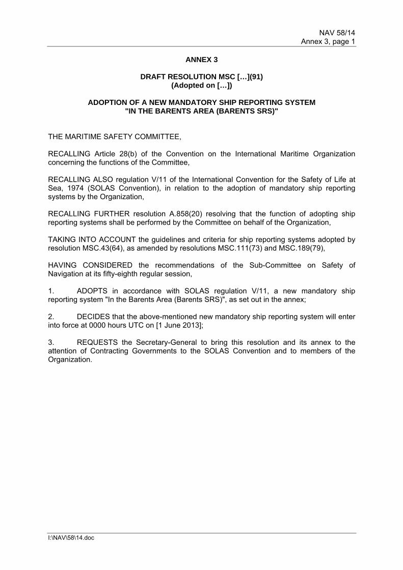
NAV 58/14 Annex 3, page 1
I:\NAV\58\14.doc
ANNEX 3
DRAFT RESOLUTION MSC […](91) (Adopted on […])
ADOPTION OF A NEW MANDATORY SHIP REPORTING SYSTEM
"IN THE BARENTS AREA (BARENTS SRS)" THE MARITIME SAFETY COMMITTEE, RECALLING Article 28(b) of the Convention on the International Maritime Organization concerning the functions of the Committee, RECALLING ALSO regulation V/11 of the International Convention for the Safety of Life at Sea, 1974 (SOLAS Convention), in relation to the adoption of mandatory ship reporting systems by the Organization, RECALLING FURTHER resolution A.858(20) resolving that the function of adopting ship reporting systems shall be performed by the Committee on behalf of the Organization, TAKING INTO ACCOUNT the guidelines and criteria for ship reporting systems adopted by resolution MSC.43(64), as amended by resolutions MSC.111(73) and MSC.189(79), HAVING CONSIDERED the recommendations of the Sub-Committee on Safety of Navigation at its fifty-eighth regular session, 1. ADOPTS in accordance with SOLAS regulation V/11, a new mandatory ship reporting system "In the Barents Area (Barents SRS)", as set out in the annex; 2. DECIDES that the above-mentioned new mandatory ship reporting system will enter into force at 0000 hours UTC on [1 June 2013]; 3. REQUESTS the Secretary-General to bring this resolution and its annex to the attention of Contracting Governments to the SOLAS Convention and to members of the Organization.

NAV 58/14 Annex 3, page 2
I:\NAV\58\14.doc
ANNEX
MANDATORY SHIP REPORTING SYSTEM "IN THE BARENTS AREA"
1 Categories of ships required to participate in the system 1.1 The following categories of ships passing through or proceeding to and from ports
and anchorages in the Barents SRS area are required to participate in the ship reporting system:
1.1.1 all ships with a gross tonnage of 5,000 and above; 1.1.2 all tankers; 1.1.3 all ships carrying hazardous cargoes (paragraph 1.2 refers); 1.1.4 a vessel towing when the length of the tow exceeds 200 metres; and 1.1.5 any ship not under command, restricted in their ability to manoeuvre or
having defective navigational aids.
1.2 The meaning of hazardous cargoes is as follows:
1.2.1 goods classified in the International Maritime Dangerous Goods (IMDG Code);
1.2.2 substances classified in chapter 17 of the International Code for the
Construction and Equipment of Ships Carrying Dangerous Chemicals in Bulk (IBC Code) and chapter 19 of the International Code for the Construction and Equipment of Ships Carrying Liquefied Gases in Bulk (IGC Code);
1.2.3 oils as defined in MARPOL Annex I; 1.2.4 noxious liquid substances as defined in MARPOL Annex II; 1.2.5 harmful substances as defined in MARPOL Annex III; and 1.2.6 radioactive materials specified in the Code for the Safe Carriage of
Irradiated Nuclear Fuel, Plutonium and High-Level Radioactive Wastes in Flasks on Board Ships (INF Code).
1.3 Ships not listed above may participate in the ship reporting system (SRS)
on a voluntary basis.

NAV 58/14 Annex 3, page 3
I:\NAV\58\14.doc
2 Geographical coverage of the system and the number and editions of the reference chart used for delineation of the system
2.1 The geographical area covered by the reporting system Barents SRS is defined within the following coordinates and is also shown in the chartlet attached at appendix 1.
Number Latitude Longitude
A - Norway 67º 10´.00 N Norwegian coast
B - Norway 67º 10´.00 N 008º 00´.00 E
C - Norway 68º 15´.00 N 009º 30´.00 E
D - Norway 71º 15´.00 N 019º 00´.00 E
E - Norway 71º 50´.00 N 024º 00´.00 E
F - Norway 71º 50´.00 N 028º 00´.00 E
G - the Russian Federation 71º 00´.00 N 033º 20´.00 E
H - the Russian Federation the Russian Federation coast 033º 20´.00 E
2.2 The reference charts, which include the operational area of Barents SRS, are:
2.2.1 Norwegian charts No. Title Scale Datum Edition 514 Barentshavet 1:2000000 WGS 84 2011 311 From Støtt to Andenes 1:350000 ED-50 1960 321 From Andenes to Grøtsund 1:200000 ED-50 1936 322 Fugløybanken-Lopphavet 1:200000 ED-50 1970 323 From Sørøya to Nordkapp 1:200000 ED-50 1962 324 From Nordkapp to Kjølnes 1:200000 ED-50 1959 325 From Slettnes to Grense Jakobselv 1:200000 ED-50 1929 Note: Position coordinates referred to the WGS 84 Datum should be plotted direct onto these charts, as the difference between the WGS 84 and ED 50 Datum is of no practical significance at the actual scale. The geographical positions, listed in the document are given in the WGS 84 Datum.
2.2.2 The Russian Federation charts No. Title Scale Datum Edition 10100 South part of Barents Sea 1:2000000 Pulkovo 1942 2002 11024 From North cape to Rybachyy inlet 1:500000 Pulkovo 1942 2003 11114 From Rybachyy inlet to Kanin Nos 1:500000 Pulkovo 1942 1999 12000 From Varde to cape Teriberskyy 1:200000 Pulkovo 1942 2002 12050 From cape Tsypnavolok to cape Voroniy 1:200000 Pulkovo 1942 2006 12100 From cape Kulneset to cape Tsypnavolok 1:200000 Pulkovo 1942 2004 Note: Position coordinates in WGS 84 datum should be moved 0.4 seconds southward and 11.3 seconds eastward to agree with these charts.

NAV 58/14 Annex 3, page 4
I:\NAV\58\14.doc
3 Format, content of reports, times and geographical positions for submitting reports, Authority to whom reports should be sent and available services
3.1 Procedures of reporting
3.1.1 All Barents SRS reports must be sent to either Vardø VTS centre or
Murmansk VTS centre. Ships within the Norwegian monitoring area report to Vardø VTS centre and ships within the Russian Federation monitoring area report to Murmansk VTS centre. Reports shall be given using AIS (Automatic Information System), Norwegian shiprep website, e-mail, fax, SATCom, mobile phone, VHF voice or by a combination of these communication means. Details are given in appendices 2 and 3.
3.1.2 The use of correct and updated AIS information can accomplish the
reporting requirements for designators A, B, C, E, F, I, O and W. Details are given in appendix 3.
3.2 Format
3.2.1 The mandatory ship report shall be drafted in accordance with the format
shown in appendix 3, as well as resolution A.851(20).
3.3 Content
3.3.1 A report from a ship to Barents SRS by AIS, non-verbal means or by voice communication or combinations thereof must contain the following information; details are given in appendix 3.
A Name of ship, call sign, IMO identification number and MMSI
B Date and time
C Position expressed in latitude and longitude
E True course
F Speed in knots
H Date, time (UTC) and point of entry into Barents SRS area
I Destination and ETA
O Maximum present draught
P Hazardous cargo, class and quantity
Q Brief details of defects or restrictions in maneuverability
T Contact information (shipowner and representative)
W Total number of persons on board
X Characteristics and total quantity of bunkers in metric tonnes
Note: The master of the ship must forthwith inform the Barents SRS VTS centre concerned of any change in navigational status or in previous information notified, particularly in relation to designator Q.
NAV 58/14 Annex 3, page 5
I:\NAV\58\14.doc
3.3.2 Proprietary information obtained as a requirement of the mandatory ship reporting system Barents SRS will be protected under this system consistent with the General Principles for ship reporting systems and ship reporting requirements, including guidelines for reporting incidents involving dangerous goods, harmful substances and/or marine pollutants (resolution A.851(20)). 3.4 Geographical position for submitting reports
3.4.1 Ships entering the Barents SRS operational area shall submit a report
when entering into the area or on departure from a port or anchorage within the operational area.
3.4.2 Reports forwarded prior to entering the area can be submitted at any time
after entering the Norwegian Economic Zone or the Russian Federation Exclusive Economic Zone and until one hour before entering the Barents SRS operational area. As the Vessel Traffic Services must be able to handle incoming prior reporting, it will not be possible to undertake pre-entry reports any later than one hour prior to entering the area.
3.4.3 Ships departing a port or leaving an anchorage within the Barents SRS
area, may also submit a pre-entry report for designators H, P, T, Q and X if transmitted one hour prior to departure.
3.5 Authority
3.5.1 The Federal Agency of Maritime and River Transport and the Norwegian
Coastal Administration are the VTS authorities for Murmansk VTS centre and Vardø VTS centre respectively which operate the Barents SRS Ship Reporting System.
4 Information to be provided to ships and procedures to be followed 4.1 Ships in the Barents SRS area are required to keep a continuous listening watch on
VHF channel 16. 4.2 If requested, the VTS centre concerned shall provide ships with information about
positioning, weather forecast, navigational warnings and other hazards in the ship reporting area, from broadcasting devices set up in the coastal States or by other available communication means concurred by involved participants.
4.3 If necessary, the VTS centre can provide individual information to a ship particularly
in relation to positioning or local conditions. 4.4 If a ship needs to anchor due to breakdown, low visibility, adverse weather, etc., the
VTS centre concerned can recommend suitable anchorages or other places of refuge within the operational area.
5 Communication required for the Barents SRS system 5.1 The language used for communication shall be English, using IMO Standard Marine
Communication Phrases, when deemed necessary by the VTS centre concerned. 5.2 Details of communication and contact information are given in appendix 2.
NAV 58/14 Annex 3, page 6
I:\NAV\58\14.doc
6 Rules, regulations and recommendations in force in the area of the system
6.1 Regulations for preventing collisions at sea The International Regulations for Preventing Collisions at Sea (COLREG) are
applicable throughout the operational area of Barents SRS. 6.2 Traffic separation schemes The traffic separation schemes off the coast of Norway from Vardø to Røst are in
the operational area of Barents SRS. They have been adopted by IMO and Rule 10 of the International Regulations for Preventing Collisions at Sea applies.
6.3 Hazardous cargo
6.3.1 The meaning of hazardous cargo is stated in paragraph 1.2 and in
resolution MSC.43(64), paragraph 1.4. 6.3.2 Ships carrying hazardous cargoes within the SRS operational area must
comply with international and national regulations. The SRS does not relieve ship masters of their responsibility to provide nationally required reports and information to customs authorities.
6.3.3 Discharges of oil and ship-generated waste are monitored jointly by the
Russian Federation and Norwegian Authorities. 7 Shore-based facilities to support the operation of the system
7.1 Sensors, System and communication facilities
7.1.1 Murmansk VTS centre and Vardø VTS centre are equipped with multiple
source information processing and retrieval systems, VHF radio, Automatic Identification System (AIS) and Long Range Identification and Tracking (LRIT) facilities.
7.1.2 Both centres have recording equipment to store information regarding a
ships transit. In case of an incident, the VTS Authority can use records as evidence.
7.2. Personnel qualifications and training 7.2.1 The Murmansk VTS centre and Vardø VTS centre are both operated by
trained and experienced personnel according to national requirements and recommendations by IMO.
7.3. Manning
7.3.1 Murmansk VTS centre and Vardø VTS centre are both manned 24 hours
per day, 365 (366) days per year.

NAV 58/14 Annex 3, page 7
I:\NAV\58\14.doc
8 Information concerning the applicable procedures if the communication facilities of the shore-based Authority fail
8.1 The Murmansk VTS centre and Vardø VTS centre are both designed with sufficient
system redundancy to cope with normal equipment failure. 8.2 If essential equipment suffers breakdown, and sufficient operational capability
cannot be maintained by backup systems, information on reduced operational capability will be given by the affected VTS centre as needed or broadcasted as a national navigational warning.
9 Measures to be taken if a ship fails to comply with the requirements of the
system
9.1 The main objective of the system is to facilitate the exchange of information between the ships and the shore in order to support safe navigation and protect the marine environment. The system will also contribute to providing information to relevant SAR authorities.
9.2 All means will be used to encourage and promote the full participation of ships
required to submit reports under SOLAS regulation V/11. If reports are not submitted and the offending ship can be positively identified, then information will be passed on to the relevant flag State Authorities for investigation and possible prosecution in accordance with national legislation. The mandatory ship reporting system Barents SRS is for the exchange of information only and does not provide any additional authority for mandating changes in the vessel's operations. The reporting system will be implemented consistent with UNCLOS, SOLAS and other relevant international instruments so that the reporting system will not provide the basis to impinge on a transiting vessel's passage through the Reporting Area.

NAV 58/14 Annex 3, page 8
I:\NAV\58\14.doc
Appendix 1
CHART OF THE BARENTS SRS OPERATIONAL AREA

NAV 58/14 Annex 3, page 9
I:\NAV\58\14.doc
Appendix 2
CONTACT INFORMATION AND OTHER RELEVANT INFORMATION IN RELATION TO THE VTS CENTRES TO WHICH THE REPORTS MUST BE SUBMITTED
1 Contact information 1.1 Murmansk VTS centre can be contacted by e-mail, VHF or fax VHF: Call "Murmansk Traffic" (channel 12) MMSI: 002734484 or 002734466 E-mail: [email protected] Fax: +7 8152 479026 1.2 Vardø VTS centre can be contacted by VHF, e-mail, fax or telephone VHF: Call Norwegian Coastal Radio Station and request "NOR VTS" (channel 16) MMSI: 002573550 E-mail: [email protected] Fax: +47 78 98 98 99 Telephone: +47 78 98 98 98
2 Submission of reports
2.1 Ships within the Russian Federation monitoring area or the Russian Federation Exclusive Economic Zone report to Murmansk VTS centre primarily by e-mail, fax and AIS, alternatively VHF or a combination of these communication means.
2.2 Ships within the Norwegian monitoring area or Norwegian Economic Zone report to
Vardø VTS centre primarily by the Norwegian Ship Reporting System at website: www.shiprep.no. Alternatively by AIS, e-mail, fax, telephone and VHF or a combination of these communication means.

NAV 58/14 Annex 3, page 10
I:\NAV\58\14.doc
Appendix 3
DRAFTING OF REPORTS TO THE MANDATORY SHIP REPORTING SYSTEM "BARENTS SRS"
Summary: Reporting can be done by non-verbal means by the use of AIS and pre-entry non verbal means as, for example, e-mail, fax or the website www.shiprep.no. If a ship is unable to make use of the non-verbal means or submit a report at least one hour prior to entering the area, reporting is to be done by VHF or by telephone (if outside VHF range).
• Correct and updated AIS information can accomplish reporting of designators A, B, C, E, F, I, O and W.
• Non-verbal means can accomplish reporting of designators A, H, P, Q, T and X.
The scheme below gives the preferred method of reporting combined by AIS, non-verbal means and VHF, as well as information required for each designator. Designator AIS Non-
verbal VHF Function Information required
A Yes Yes Yes Ship 1) Name of ship 2) MMSI number 3) Call sign and – when available – 4) IMO number 5) Additional contact information.
B Yes Date and time
A 6-digit group giving day of month and hours and minutes in Universal Coordinated Time (UTC).
C Yes Position A 5-digit group giving latitude in degrees and minutes, decimal, suffixed with N (north) and a 6-digit group giving longitude in degrees and minutes, decimal, suffixed with E (east) or W (west).
E Yes True course A 3-digit group.
F Yes Speed in knots and tenths of knots
A 3-digit group.

NAV 58/14 Annex 3, page 11
I:\NAV\58\14.doc
Designator AIS Non-verbal
VHF Function Information required
I Yes Destination and ETA
The name of next port of call given in UN LOCODE by AIS. For details and procedures see IMO SN/Circ.244 and www.unece.org/cefact/locode/service/main.htm. ETA date and time group expressed as in (B).
H Yes Date, time and point of entry into the Barents SRS area
This information is only required if reporting designators P, T and X are transmitted non-verbally (e.g. e-mail) prior to entry of the Barents SRS. Entry date and time expressed as in (B) and position expressed as in (C).
O Yes Maximum present draught in metres
A 2-digit or 3-digit group giving the present maximum draught in metres (e.g. 6.1 or 10.4).
P Yes Cargo on board
Cargo and, if hazardous goods present on board, quantity and IMO class (inclusive UN code). Hazardous goods information must be summarized in total tonnes per IMO class when transmitted.
Q Yes Defects and deficiencies
Q: Details of defects and deficiencies affecting the equipment of the ship or any other circumstances affecting normal navigation and manoeuvrability.
T Yes Ship's owner and represen- tative
Address and particulars from which detailed information on the cargo may be obtained.
W Yes Total number of persons on board
State number
X Yes Miscella-neous
Type and estimated quantity of bunker fuel in metric tonnes. Must be summarized in total tonnes per type when transmitted.
***


NAV 58/14 Annex 4, page 1
I:\NAV\58\14.doc
ANNEX 4
DRAFT AMENDMENTS TO THE GENERAL PROVISIONS ON SHIPS' ROUTEING (RESOLUTION A.572(14), AS AMENDED)
Amend annex 1 (resolution A.572(14), as amended)), as follows: Section 6 (Design criteria). Insert after existing paragraph 6.8, a new paragraph 6.9, as follows:
"6.9 A traffic separation scheme (TSS) may be part of a routeing system, including other routes or routeing measures. However, for compliance with the International Regulations for Preventing Collisions at Sea, 1972, as amended, it is essential to describe each TSS or part of TSS separately and under its own specific heading. Any other routeing measure or route forming part of a routeing system, including one or more traffic separation scheme(s), should also be described separately under its own specific heading.",
and renumber the following paragraphs accordingly.
***

NAV 58/14 Annex 5, page 1
I:\NAV\58\14.doc
ANNEX 5
LIAISON STATEMENT TO ITU-R WORKING PARTY 5B ON REVISION OF RECOMMENDATION ITU-R M.1371-4
Technical characteristics for an automatic identification system using
time-division multiple access in the VHF maritime mobile band 1 IMO would like to thank ITU-R WP 5B for the liaison statement as contained in annex 30 to document 5B/62, sent in June 2012, requesting IMO's Sub-Committee on Safety of Navigation (NAV) to consider the proposed amendments to Recommendation ITU-R M.1371-4. 2 The NAV Sub-Committee, at its fifty-eighth session from 2 to 6 July 2012, considered the liaison statement and agreed to inform ITU-R WP 5B as follows. 3 With regard to the proposed changes in annex 1, paragraph 2.1.6 concerning AIS-SART station, the NAV Sub-Committee considered that MOB and EPIRB-AIS devices should not be subsets of AIS-SART. This is because these devices do not conform with all the requirements and characteristics of an AIS-SART, for instance, battery life, etc. It was further noted that other devices than AIS-SART are not considered to be locating devices under the GMDSS. Therefore, the Sub-Committee suggests that paragraphs 2.1.6.1 and 2.1.6.2 should be renumbered as new headings such as 2.1.7 Man overboard devices (MOB) and 2.1.8. Emergency position indicating radio beacon – automatic identification system (EPIRB-AIS). The Sub-Committee further suggests that the description of these devices should not refer to an integrated AIS-SART transmitter but to a device using burst transmissions as described in annex 9 of the Recommendation. 4 The Sub-Committee discussed again the navigational status parameters in annex 8, table 46 (existing Table 45). The Sub-Committee concurred with the proposal to revise the definitions of the navigational status parameters 11 and 12 for regional use as follows:
- Parameter 11 to "power-driven vessel towing astern" and; - Parameter 12 to "power-driven vessel pushing ahead or towing alongside".
In considering the term "regional use", the Sub-Committee was of the understanding that visiting ships would not be required to use these navigational status parameters and that the relevant national maritime Authority would inform shipping about the use and interpretation of these parameters when in use. The Sub-Committee did not concur with the proposal to define navigational status parameter 13 to "requiring assistance" for regional use. This is because distress alerting using AIS has not yet been developed and is under consideration in reviewing the GMDSS. The Sub-Committee concurred with the proposed changes to the description of navigational status parameters 14 and 15 to be extended to include MOB and EPIRB-AIS.

NAV 58/14 Annex 5, page 2
I:\NAV\58\14.doc
5 In considering the proposed changes to paragraph 3.12 of annex 8, the Sub-Committee concurred with the proposed text in message 14 for MOB and EPIRB-AIS. 6 At this stage, the Sub-Committee had no further comments on the other proposed amendments. 7 Additionally, the Sub-Committee discussed the application of AIS to diver location devices and was of the view that frequencies AIS 1 and AIS 2 should only be used when a diver was in a non-routine situation. It was considered that in these cases the device was similar to a MOB device and that the parameter and appropriate message for MOB should apply. The Sub-Committee was of the view that these devices should not operate on the frequencies AIS 1 and AIS 2 for routine diver locating. 8 Noting that the draft revision would be further developed, the Sub-Committee requests WP 5B to liaise the updated version of Recommendation ITU-R M.1371-4 for consideration by the Sub-Committee at its next session, to be held in September 2013.
***

NAV 58/14 Annex 6, page 1
I:\NAV\58\14.doc
ANNEX 6
LIAISON STATEMENT TO ITU-R WORKING PARTY 5B ON WORLD RADIOCOMMUNICATION CONFERENCE 2015 (WRC-15),
AGENDA ITEM 1.16
to consider regulatory provisions and spectrum allocations to enable possible new Automatic Identification System (AIS) technology applications
and possible new applications to improve maritime radiocommunication in accordance with Resolution 360 (WRC-12)
1 IMO would like to thank ITU-R WP 5B for the liaison statement as contained in annex 29 to document 5B/62, sent in June 2012, inviting IMO to take note of the work plan and provide materials that may be relevant to the work on WRC-15 Agenda item 1.16. 2 The NAV Sub-Committee, at its fifty-eighth session from 2 to 6 July 2012, considered the liaison statement and agreed to inform ITU-R WP 5B as follows. 3 In considering the annex to the draft CPM text, the Sub-Committee was of the view that modifications should not be required to existing AIS equipment on board existing vessels, but rather allow for new e-navigation services to evolve, supported by communication primarily on the new frequencies identifed by WRC-12, while protecting the integrity of the original operational purpose of AIS as the primary function on the existing AIS frequencies. 4 The Sub-Committee, therefore, supported the further development of the plan for future VHF Data Communications described in the annex to the draft CPM report. 5 The Sub-Committee would request the Joint IMO/ITU Experts Group to further consider the matter and, in particular, the VHF Data Exchange (VDE) at its next meeting, scheduled to be held from 8 to 12 October 2012, and to provide additional information, as appropriate.
***


NAV 58/14 Annex 7, page 1
I:\NAV\58\14.doc
ANNEX 7
FINAL LIST OF GAPS OF E-NAVIGATION
Table 1 – Shipboard users
Identifier Gaps Competent Sub-Committee(s)
1 Information/data management
1.1 Common data structure/harmonized data formats
Technical
111-Gte01 Lack of harmonized data formats for the transfer of information received via communication equipment (e.g. Maritime Safety Information) to the navigational systems for presentation.
NAV/COMSAR
111-Gte02 There are no standardized data formats established for ship reporting.
NAV
111-Gte03 Lack of harmonized data formats for data requested from other systems, used to prepare other relevant documents on board.
NAV/COMSAR
111-Gte05 There are no means of processing or filtering the information exchanged via communication equipment.
NAV/COMSAR
111-Gte06 Lack of technical means to make information of vessels intentions available to relevant user stakeholders.
NAV
Regulatory
111-Gre02 Lack of interface standards for status of equipment. NAV/COMSAR
111-Gre03 No mapping of specific services in the Maritime Service Portfolio to specific regions, which would result in a requirement of the necessary infrastructure in specific regions.
NAV
Operational (no gaps identified)
Training (no gaps identified)
111-Gtr01 Deleted.
1.2 Improved reliability and indication of reliability
Technical
112-Gte01a Lack of effective and harmonized means for assessment and indication of the accuracy, levels of reliability and integrity of indicated information.
NAV/COMSAR
112-Gte01b Deleted.
Regulatory
112-Gre01 Lack of standardized regulations for determination (standardized algorithms) of accuracy and integrity to assess and quantify reliability based on unambiguous thresholds.
NAV/COMSAR

NAV 58/14 Annex 7, page 2
I:\NAV\58\14.doc
Identifier Gaps Competent Sub-Committee(s)
Operational
112-Gop01 Lack of assessments procedure to quantify reliability parameters (e.g. specific assessment of electronic position fixing systems).
NAV
Training
112-Gtr01 Improved competence of installation and repair person for providing better reliability of systems and equipment.
NAV∗
112-Gtr02 Deleted.
1.3 Nautical charts and publications
Technical (no gaps identified)
Regulatory
113-Gre01 Lack of standardized symbology of all information required to display on the navigational system (e.g. S-52 exist but lack of symbology for MIO elements).
NAV
Operational (no gaps identified)
Training
113-Gtr01 Familiarization to presentation and context of information such as metadata and all ancillary data to charts.
STW
2 Effective and robust voice communication and data transfer
Technical
120-Gte01 No reference to determine reliability of maritime communication. Insufficient reliability of data/voice communications (users require communication without interference, disruption and noise). Lack of reliability standards for communication technology.
COMSAR
120-Gte02 Possible lack of bandwidth and assignment of adequate bandwidth for potential e-navigation communication needs, including short range communication.
NAV/COMSAR
120-Gte03 Lack of systems for source and channel management for communication equipment. Lack of seamless communication means for exchanging navigation information (e.g. intention, alarm, etc.) between ships. Insufficient techniques and procedures for exchange of data between ship, shore and on board. Insufficient data protocols to support the exchange of reliability information describing data and system integrity.
NAV/COMSAR
∗ The identified gap is not within the remit of the Organization or any of the relevant Sub-Committees.
NAV 58/14 Annex 7, page 3
I:\NAV\58\14.doc
Identifier Gaps Competent Sub-Committee(s)
120-Gte04 Signal security, system security, input security as well as management of access/protocols is insufficient.
NAV/COMSAR
120-Gte05 Lack of integrated GMDSS equipment. NAV/COMSAR
120-Gte06 Deleted.
Regulatory
120-Gre01 Lack of regulations for new communication equipment and systems addressing the potential e-navigation communication needs.
NAV/COMSAR
120-Gre02 IMO requirements for navigation and communication are not harmonized.
NAV/COMSAR
120-Gre03 Absence of structured communication link to notify incorrect operation of both shipboard and/or shore-based e-navigation related systems.
NAV/COMSAR
Operational (no gaps identified)
120-Gop01 Deleted.
Training (no gaps identified)
120-Gtr01 Deleted.
3 Navigational bridge systems and equipment
3.1 Improved reliability and indication of reliability
Technical
132-Gte01 Insufficient reliability of position fixing systems. NAV
132-Gte02 Lack of self-checking functionality of the electronic equipment for improved reliability.
NAV
132-Gte03 Lack of automatic assessment functionalities to provide quantified reliability information.
NAV
132-Gte04 Lack of PNT relevant services for port operation and automatic docking.
NAV
Regulatory
132-Gre01 Lack of framework for resilient provision of PNT.
NAV
Operational (no gaps identified)
Training (no gaps identified)

NAV 58/14 Annex 7, page 4
I:\NAV\58\14.doc
Identifier Gaps Competent Sub-Committee(s)
3.2 Improved ergonomics, standardization and alert management
Technical
134-Gte01a Ergonomic problems of navigation equipment exist in a sense that there is a lack of intuitive human-machine interface for communication and navigation means. Bridge layouts, equipment and systems are seldom designed from an ergonomic and/or user-friendly perspective.
NAV/COMSAR/ STW
134-Gte01b Deleted.
134-Gte01c Deleted.
134-Gte03 Lack of harmonized symbology for whole potential e-navigation information.
NAV
134-Gte04 Lack in presentation of manoeuvring information/data (engine-room telegraphs) on navigational display.
NAV
Regulatory
134-Gre01 Deleted.
134-Gre02 Control (e.g. type approval) of software and hardware updates is not sufficient. Type approval procedure for navigation and communication equipment should become more flexible and progressive. Regulation of upgrading of navigation and communication equipment operating systems is missing. Lack of updating regime for software driven applications within e-navigation framework.
NAV/COMSAR
134-Gre03 Existing documents (performance standards, guidelines, etc.) with regard to ergonomics are missing harmonization and are seldom applied. Existing documents (performance standards, guidelines, etc.) with regard to ergonomics are not applied for communication equipment and systems (incl. GMDSS). Existing documents (performance standards, guidelines, etc.) for alert management are not applied.
NAV/COMSAR
134-Gre04 Currently, there are no guidelines or guidance for usability evaluation.
NAV/COMSAR
134-Gre05 Lack of standardization for operation of functions to observe the passage plan. Users require standardization on the level of function provided and the operating way of it, but not being restricted to future developments.
NAV
134-Gre06 Lack of performance standards for interoperability of systems and sensors (according to the modular concept).
NAV/COMSAR
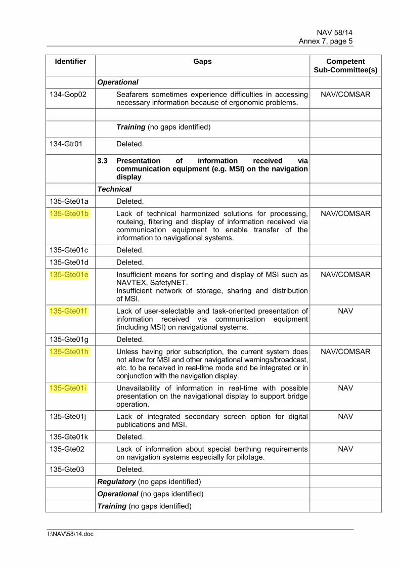
NAV 58/14 Annex 7, page 5
I:\NAV\58\14.doc
Identifier Gaps Competent Sub-Committee(s)
Operational
134-Gop02 Seafarers sometimes experience difficulties in accessing necessary information because of ergonomic problems.
NAV/COMSAR
Training (no gaps identified)
134-Gtr01 Deleted.
3.3 Presentation of information received via communication equipment (e.g. MSI) on the navigation display
Technical
135-Gte01a Deleted.
135-Gte01b Lack of technical harmonized solutions for processing, routeing, filtering and display of information received via communication equipment to enable transfer of the information to navigational systems.
NAV/COMSAR
135-Gte01c Deleted.
135-Gte01d Deleted.
135-Gte01e Insufficient means for sorting and display of MSI such as NAVTEX, SafetyNET. Insufficient network of storage, sharing and distribution of MSI.
NAV/COMSAR
135-Gte01f Lack of user-selectable and task-oriented presentation of information received via communication equipment (including MSI) on navigational systems.
NAV
135-Gte01g Deleted.
135-Gte01h Unless having prior subscription, the current system does not allow for MSI and other navigational warnings/broadcast, etc. to be received in real-time mode and be integrated or in conjunction with the navigation display.
NAV/COMSAR
135-Gte01i Unavailability of information in real-time with possible presentation on the navigational display to support bridge operation.
NAV
135-Gte01j Lack of integrated secondary screen option for digital publications and MSI.
NAV
135-Gte01k Deleted.
135-Gte02 Lack of information about special berthing requirements on navigation systems especially for pilotage.
NAV
135-Gte03 Deleted.
Regulatory (no gaps identified)
Operational (no gaps identified)
Training (no gaps identified)

NAV 58/14 Annex 7, page 6
I:\NAV\58\14.doc
Identifier Gaps Competent Sub-Committee(s)
3.4 Documents in electronic form and automated updates of information
Technical
136-Gte01a New equipment/system or task based on INS-task (functionality) concept resolution MSC.252(83) for management of information formerly available in printed format is necessary.
NAV
136-Gte01b Information may be difficult to localize in electronic documents (search function).
NAV
136-Gte01c Lack of automatic updating of documents. NAV
136-Gte01d Electronic systems can not automatically determine the status of available data and automatically retrieve the most current and comprehensive data.
NAV
136-Gte01e Regulations for new navigational display systems should be standardized.
NAV
Regulatory
136-Gre01 Legal aspects regarding access and usage rights of updating information are not solved.
NAV
136-Gre02 Documentation requirements possibly not allow for documentation in electronic form.
NAV
136-Gre03 Too many regulations are adding to the administrative burden of the mariner on board.
NAV
Operational
136-Gop01 Ineffective access to information. NAV
Training (no gaps identified)
4 Ship reporting
Technical
140-Gte01 140-Gte02
Lack of automated and standardized ship reporting function (e.g. FAL Convention documents, coastal State and additional port entry requirements as part of Ship Reporting Systems).
NAV/COMSAR
140-Gte03 Single-window and/or automated and single entry for any required reporting information into the system for it to be shared by authorized authorities without further intervention by the ship during and/or before navigation, except it has any relevance for navigational purposes (VTS/PILOT/HARBOUR/COLREGs).
NAV
140-Gte04 Automated entry of internal ship data for reporting (including updates of information) is not available.
NAV
140-Gte05 (Moved under shore-based users).
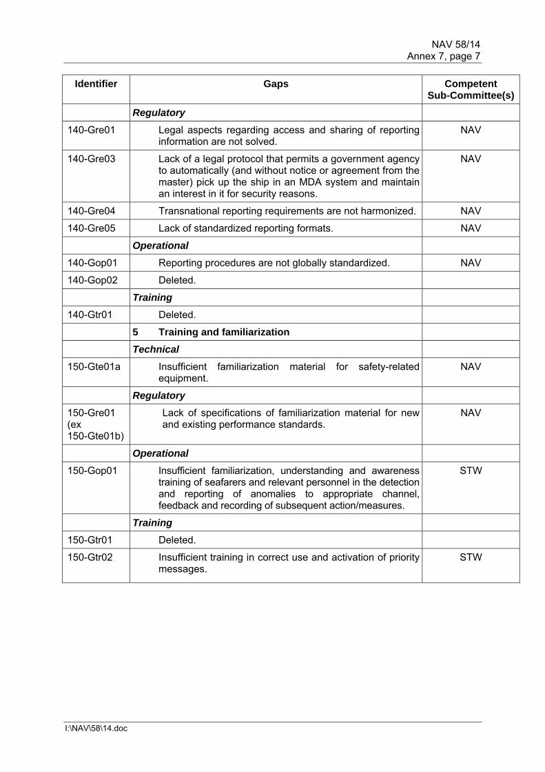
NAV 58/14 Annex 7, page 7
I:\NAV\58\14.doc
Identifier Gaps Competent Sub-Committee(s)
Regulatory
140-Gre01 Legal aspects regarding access and sharing of reporting information are not solved.
NAV
140-Gre03 Lack of a legal protocol that permits a government agency to automatically (and without notice or agreement from the master) pick up the ship in an MDA system and maintain an interest in it for security reasons.
NAV
140-Gre04 Transnational reporting requirements are not harmonized. NAV
140-Gre05 Lack of standardized reporting formats. NAV
Operational
140-Gop01 Reporting procedures are not globally standardized. NAV
140-Gop02 Deleted.
Training
140-Gtr01 Deleted.
5 Training and familiarization
Technical
150-Gte01a Insufficient familiarization material for safety-related equipment.
NAV
Regulatory
150-Gre01 (ex 150-Gte01b)
Lack of specifications of familiarization material for new and existing performance standards.
NAV
Operational
150-Gop01 Insufficient familiarization, understanding and awareness training of seafarers and relevant personnel in the detection and reporting of anomalies to appropriate channel, feedback and recording of subsequent action/measures.
STW
Training
150-Gtr01 Deleted.
150-Gtr02 Insufficient training in correct use and activation of priority messages.
STW

NAV 58/14 Annex 7, page 8
I:\NAV\58\14.doc
Table 2 – Shore-based users
Identifier Gaps Competent Sub-Committee(s)
1 Information/data management
1.1 Common data structure/harmonized data formats
Technical
211-Gte01 Lack of a common maritime information/data structure harmonizing the policies for the security and use of data. Insufficient identification of harmonization needs for standards, formats and protocols. Lack of protocols, formats and data structure that enable shore-based authorities to exchange information with other authorized shore-based users. No standardized format for data exchange between VTS centres and other e-nav stakeholders.
NAV
211-Gte02 There is a gap between information capability of current information management systems and those that will be required as volumes of information increases. Tools that have the capability to manage increased levels/volumes of information are not in use.
NAV
Regulatory
211-Gre01 Inconsistent rules that require some coastal States to maintain domain awareness. Insufficient collection of data required to establish accurate and reliable marine domain awareness.
NAV
Operational (no gaps identified)
Training (no gaps identified)
2 Effective and robust voice communication and data transfer
Technical (no gaps identified)
Regulatory (no gaps identified)
220-Gre01 Deleted.
Operational (no gaps identified)
Training
220-Gtr01 Lack of international guidance on security of data and its sharing.
NAV

NAV 58/14 Annex 7, page 9
I:\NAV\58\14.doc
Identifier Gaps Competent Sub-Committee(s)
3 Systems and equipment
3.1 Presentation of Information
Technical
235-Gte01 Insufficient delivery and presentation of maritime information that shore-based authorities are required to provide to ships. There are no standard data formats for onboard capture and presentation that cover the entire scope of information provided by a VTS.
NAV
Regulatory (no gaps identified)
Operational
235-Gop01 Lack of harmonized presentation of domain awareness to improve situational awareness for allied and other support services.
NAV
Training (no gaps identified)
4 Ship reporting
Technical
235-Gte01 (ex 140-Gte05)
Insufficient means for ship reporting on shoreside. NAV
Regulatory (no gaps identified)
Operational
240-Gop01 Deleted.
Training (no gaps identified)
5 Training and familiarization
Technical (no gaps identified)
Regulatory (no gaps identified)
Operational (no gaps identified)
Training
250-Gtr01 IALA VTS guidance may not be being developed in harmony with the concepts of e-navigation. VTS Operating procedures and guidelines should be harmonized with e-navigation.
NAV
250-Gtr02 Not only the shipboard users but also shore-based users (e.g. VTS operators, etc.) need to be appropriately trained in order to efficiently use and obtain the maximum benefit of e-navigation.
NAV

NAV 58/14 Annex 7, page 10
I:\NAV\58\14.doc
Identifier Gaps Competent Sub-Committee(s)
6 Traffic monitoring
Technical
260-Gte01 Traffic monitoring Tools that have the capability to manage increased levels/volumes of information are not in use.
NAV
260-Gte02 Current VTS infrastructure may not have the capacity for increased collection, integration, exchange, presentation, storage and analysis of data.
NAV
260-Gte03 Lack of procedures that enable shore-based authorities to monitor quality of navigation systems on board as well as quality of information and effectiveness of communication.
NAV
260-Gte04 Current VTS infrastructure may not have the capacity for real time display of vessels' track to provide a Navigational Assistance Service (NAS) or Traffic Organization Service (TOS).
NAV
260-Gte05a Some operating systems and software are no longer supported.
NAV
260-Gte05b In some VTSs, there is a problem of interoperability between applications.
NAV
260-Gte06a Bandwidth limitations shore/ship. Shortage of VHF marine frequencies.
NAV/COMSAR
260-Gte06b Deleted.
260-Gte07 There is a lack of effective measures to prevent the transmission of inaccurate AIS data.
NAV/COMSAR
Regulatory (no gaps identified)
Operational
260-Gop01 Lack of common understanding of the scope and evolving procedures of NAS and TOS internationally.
NAV
Training
260-Gtr01 Not all VTS Operators are trained to IALA V-103 model training courses. Not all VTS training organizations have accredited VTS training courses.
NAV
260-Gtr02 There is a lack of understanding by seafarers as to the type of VTS service being provided.
NAV

NAV 58/14 Annex 7, page 11
I:\NAV\58\14.doc
Table 3 – SAR users
Identifier Gaps Competent Sub-Committee(s)
1 Information/data management
Technical
310-Gte01 Lack of mechanisms to provide SAR (RCC) function with the full range of relevant e-navigation information in digital format.
COMSAR
Regulatory (no gaps identified)
Operational
310-Gop01 Insufficient access to and quality of information from ships in distress.
COMSAR
310-Gop02 Insufficient access to LRIT data to ships or units participating in SAR operations.
COMSAR
Training (no gaps identified)
2 Effective and robust voice communication and data transfer
Technical
320-Gte01 Lack of an automated data network connecting all stakeholders in SAR intervention, including improved communication between RCC and shore-, land-, sea- and air-based entities. Lack of access to the details of all relevant onboard communication and capabilities for SAR authorities. Limited resources for communication infrastructure in SAR operation.
COMSAR
Regulatory
320-Gre01 Deleted.
Operational
320-Gop01 Deleted.
Training
320-Gtr01 Deleted.
3 Systems and equipment
Technical (no gaps identified)
330-Gte01 Deleted.
Regulatory (no gaps identified)
Operational (no gaps identified)
Training (no gaps identified)
4 Operation (no gaps identified)
***


NAV 58/14 Annex 8, page 1
I:\NAV\58\14.doc
ANNEX 8
DRAFT MSC CIRCULAR ON UNIFIED INTERPRETATIONS OF SOLAS CHAPTER V
1 The Maritime Safety Committee, [at its ninety-first session (26 to 30 November 2012),] with a view to providing more specific guidance for vague expressions such as "The ship's side shall be visible from the bridge wing", which are open to different interpretations contained in IMO instruments, approved the revised unified interpretations of SOLAS chapter V prepared by the Sub-Committee on Safety of Navigation, as set out in the annex. 2 Member Governments are invited to use the annexed unified interpretations as guidance when applying relevant provisions of SOLAS chapter V to ships contracted for construction* on or after 1 January 2011 and to bring the unified interpretations to the attention of all parties concerned.
* * *
* The "contracted for construction" date means the date on which the contract to build the vessel is signed
between the prospective owner and the shipbuilder.

NAV 58/14 Annex 8, page 2
I:\NAV\58\14.doc
ANNEX
UNIFIED INTERPRETATIONS OF SOLAS CHAPTER V Regulation V/22.1.6 – Navigation bridge visibility 1 The requirements of SOLAS regulation V/22.1.6 are accomplished when:
.1 a view from the bridge wing plus a distance corresponding to a reasonable and safe distance of a seafarer leaning over the side of the bridge wing, which needs not to be more than 400 mm, to the location vertically right under the maximum beam of the ship at the lowest seagoing draught is not obscured; or
.2 the sea surface at the lowest seagoing draught and with a transverse
distance of 500 mm and more from the maximum beam throughout the ship's length is visible from the side of the bridge wing.
2 A schematic diagram depicting the unified interpretations is also attached
herewith. 3 For particular types of ships such as tug/tow boat, offshore supply vessel (OSV), rescue ship, work ship (e.g. floating crane), in meeting the requirements of SOLAS regulation V/22.1.6, the bridge wings should at least extend to a location from which the sea surface, at the lowest seagoing draught and at a transverse distance of 1,500 mm from the maximum beam throughout the ship's length, is visible. If this ship type is changed to a type other than those addressed in this paragraph then the interpretation in this paragraph would no longer apply. 4 The use of a remote camera system may be accepted for ships of unconventional design, other than those mentioned in paragraph 3 above, as means for achieving the view of the ship's side from the bridge wing, provided: - the installed remote camera system is to be redundant from the circuit breaker
to the camera and screen, including communication cables, i.e. the system is to provide on each side of the ship redundancy of:
• the power cables and circuit breakers from the main switchboard to the
camera and the screen; • the camera; • the screen; • the transmission lines from the camera to the display screen; and • the components associated with these lines and cables;
- the remote camera system is powered from the ship's main source of electrical
power and is not required to be powered by the emergency source of electrical power;
- the remote camera system is capable of continuous operation under
environmental conditions as per UR E10; - the view provided by the remote camera system complies with the requirements
of regulation V/22.1.6 and is also displayed at locations where the manoeuvring of the ship may take place;
- the upper edge of the ship's side abeam is directly visible by the observer from
locations where the manoeuvring of the ship may take place.

NAV 58/14 Annex 8, page 3
I:\NAV\58\14.doc
***


NAV 58/14 Annex 9, page 1
I:\NAV\58\14.doc
ANNEX 9
DRAFT RESOLUTION MSC.[…](92) (adopted on [... 2013])
ADOPTION OF PERFORMANCE STANDARDS FOR ELECTRONIC INCLINOMETERS
THE MARITIME SAFETY COMMITTEE, RECALLING Article 28(b) of the Convention on the International Maritime Organization concerning the functions of the Committee, RECALLING ALSO resolution A.886(21), by which the Assembly resolved that the function of adopting performance standards and technical specifications, as well as amendments thereto shall be performed by the Maritime Safety Committee and/or the Marine Environment Protection Committee, as appropriate, on behalf of the Organization, NOTING that in MSC.1/Circ.1228 on the Revised Guidance to the master for avoiding dangerous situations in adverse weather and sea conditions, information about heel angle and roll period is regarded as relevant for assessment of ship's stability situation in adverse weather and sea conditions, NOTING ALSO that, at its ninetieth session, it had adopted resolution MSC.333(90) on Revised Performance standards for shipborne voyage data recorders (VDRs), including the recommendation that, with regard to the rolling motion, a VDR should be connected to an Electronic inclinometer or, if not installed, be equipped with or connected to a suitable motion sensor with an equivalent measurement performance, NOTING FURTHER that, at its eighty-eighth session, instead of adding the requirement for an Electronic inclinometer to the performance standards for VDRs, it had decided to develop dedicated performance standards for inclinometers, RECOGNIZING the need to define minimum requirements for a heel angle and roll period measurement device to ensure that heeling information is provided in a reliable manner onboard ships to be used by the crew to assess the dynamic situation of the vessel and to be available for Marine casualty investigation, HAVING CONSIDERED, at its [ninety-second] session, the draft performance standards for Electronic inclinometers prepared by the Sub-Committee on Safety of Navigation, at its fifty-eighth session, 1. ADOPTS the performance standards for Electronic inclinometer set out in the annex to the present resolution; 2. RECOMMENDS Governments ensure that Electronic inclinometer installed on or after [1 July 2015], conform to performance standards not inferior to those specified in the annex to the present resolution.

NAV 58/14 Annex 9, page 2
I:\NAV\58\14.doc
ANNEX
PERFORMANCE STANDARDS FOR ELECTRONIC INCLINOMETERS
1 SCOPE 1.1 Electronic inclinometers are intended to support the decision-making process on board in order to avoid dangerous situations as well as assist in and facilitate Maritime Casualty Investigation by providing information about the roll period and the heel angle of the ship. 1.2 Electronic inclinometers should in a reliable form: - determine the actual heel angle with the required accuracy; - determine the roll amplitude with the required accuracy; - determine the roll period with the required accuracy; - present the information on a bridge display; and - provide a standardized interface to instantaneous heel angle to the VDR. 2 APPLICATION OF THESE STANDARDS 2.1 These performance standards should apply to all Electronic inclinometers intended to support the decision-making process on board in order to avoid dangerous situations as well as to assist in Maritime Casualty Investigation, if carried, on all ships1. 2.2 In addition to the general requirements set out in resolution A.694(17)2 and the presentation requirements set out in resolution MSC.191(79), Electronic inclinometers should meet the requirements of these standards and follow the relevant guidelines on ergonomic principles3 adopted by the Organization.
3 DEFINITIONS 3.1 For the purpose of these performance standards:
Rolling motion around the longitudinal axis of the ship
Actual heel angle momentary angle of roll referenced to a levelled ship to port or starboard side
Roll period time between two successive maximum values of heel angle on the same side of the ship
Roll amplitude maximum values of heel angle to port or starboard side
1 These performance standards do not apply to Electronic inclinometers installed for purposes which are
outside the scope of these guidelines, e.g. monitoring of cargo status. 2 Refer to IEC Publication 60945 – Maritime navigation and radiocommunication equipment and systems –
General requirements. 3 Guidelines on ergonomic criteria for bridge equipment and layout (MSC/Circ.982).

NAV 58/14 Annex 9, page 3
I:\NAV\58\14.doc
MODULE A – SENSOR
4 MEASUREMENT OF ACTUAL HEEL ANGLE 4.1 Electronic inclinometers should be capable of measuring the actual heel angle and determining the amplitude of the rolling oscillation of the ship over a range of ±90 degrees. 5 MEASUREMENT OF ROLL PERIOD 5.1 Electronic inclinometers should be capable of measuring the time between the maximum values of the rolling oscillation and determining the roll period over a minimum range of 4 to 40 seconds. 6 ACCURACY 6.1 Electronic inclinometers should provide the data with sufficient accuracy for a proper assessment of the ships dynamic situation. Minimum accuracy of the measurements should be 5% of reading or ± 1 degree whichever is the greater for angle measurements and 5% of reading or ± 1 second whichever is the greater for time measurements. 6.2 Actual heel angle and time measurement accuracy should not be unduly affected by other linear or rotational movements of the vessel (as e.g. surging, swaying, heaving, pitching, yawing) or by transverse acceleration ranging from -0.8g to +0.8g.
MODULE B – OPERATIONAL AND FUNCTIONAL REQUIREMENTS 7 DISPLAY REQUIREMENTS 7.1 Electronic inclinometers should display:
- the roll period with a minimum resolution of 1 second; and - the roll amplitude to both port and starboard side with a minimum resolution of 1
degree. 7.2 The actual heel angle to port or starboard should be indicated in an analogue form between the limits of ±45 degrees. 7.3 The display may be implemented as a dedicated display or integrated into other bridge systems. 8 OPERATIONAL ALERTS 8.1 Electronic inclinometers may optionally provide a warning for parametric roll4 and/or synchronous rolling detection. 8.2 Electronic inclinometers may optionally provide a warning for indicating that a set heel angle had been exceeded.
4 Refer to MSC.1/Circ.1228 on revised guidance to the Master for avoiding dangerous situations in adverse
weather conditions.

NAV 58/14 Annex 9, page 4
I:\NAV\58\14.doc
9 PERFORMANCE TESTS, MALFUNCTIONS AND INDICATIONS 9.1 Electronic inclinometers should internally check and indicate to the user if all components are operative and if the information provided is valid or not. MODULE C – INTERFACING AND INTEGRATION 10 CONNECTIONS TO OTHER EQUIPMENT 10.1 Electronic inclinometers should comprise a digital interface providing actual heel angle information to other systems like e.g. the voyage data recorder (VDR) with an update rate of at least 5 Hz. Electronic inclinometers should also comprise a digital interface providing the displayed information of roll period and roll amplitude (paragraph 7.1 refers). 10.2 Electronic inclinometers should have a bidirectional interface to facilitate communication, to transfer alerts from inclinometers to external systems and to acknowledge and silence alerts from external systems. 10.3 The digital interface should be compliant to the relevant international standards5. 11 INSTALLATION POSITION 11.1 The installation position of the sensors of the electronic inclinometer should be recorded and made available for the configuration of the voyage data recorder. 12 POWER SUPPLY 12.1 Electronic inclinometers should be powered from the ship's main source of electrical energy. In addition, it should be possible to operate the Electronic inclinometers from the ship's emergency source of electrical energy.
***
5 Refer to publication IEC 61162 – Maritime navigation and radiocommunication equipment and systems –
Digital interfaces.

NAV 58/14 Annex 10, page 1
I:\NAV\58\14.doc
ANNEX 10
PROPOSED BIENNIAL AGENDA FOR THE 2012-2013 BIENNIUM
SUB-COMMITTEE ON SAFETY OF NAVIGATION (NAV)∗
PLANNED OUTPUTS 2012-2013 (resolution A.1038(27)) Parent
organ(s) Coordinating
organ(s) Associated
organ(s)
Target completion
year Number Description
1.1.2.2 Consideration of IACS unified interpretations MSC NAV Continuous
1.1.2.12 Radiocommunication ITU-R Study Group matters MSC NAV 2013
1.1.2.19 ITU matters MSC NAV Continuous
5.2.1.7 Review of general cargo ship safety MSC DSC, FP, FSI, DE, SLF, STW, NAV
2013
5.2.1.17 Development of a mandatory Code for ships operating in polar waters MSC MEPC
DE COMSAR, FP, SLF, NAV, STW
2014
5.2.1.25 Development of guidelines for wing-in-ground craft MSC DE COMSAR, FP, SLFNAV, STW
2013
5.2.4 Amendments to resolution A.572(14), as amended MSC NAV Completed
5.2.4.1 Routeing of ships, ship reporting and related matters MSC NAV Ongoing
5.2.4.8 Development of policy and new symbols for AIS aids to navigation
MSC NAV 2013
5.2.4.9 Development of performance standards for inclinometers MSC NAV Completed
5.2.4.11** Revision of the information contained in the existing annexes to the Recommendation on the use of adequately qualified deep-sea pilots in the North Sea, English Channel and Skagerrak (resolution A.486(XII))
MSC NAV - 2013
∗ Items printed in bold letters have been selected for the provisional agenda of NAV 59. ** Unplanned output approved by MSC 90 to be included in the provisional agenda for NAV 59. C 108 has assigned an output number.

NAV 58/14 Annex 10, page 2
I:\NAV\58\14.doc
SUB-COMMITTEE ON SAFETY OF NAVIGATION (NAV)∗
PLANNED OUTPUTS 2012-2013 (resolution A.1038(27)) Parent
organ(s) Coordinating
organ(s) Associated
organ(s)
Target completion
year Number Description
5.2.4.13** Revision of the Guidelines for the onboard operational use of shipborne automatic identification systems (AIS)
MSC NAV COMSAR 2013
5.2.4.14** Consolidation of ECDIS-related IMO circulars MSC NAV - 2014
5.2.4.15** Development of explanatory footnotes to SOLAS regulations V/15, V/18, V/19 and V/27
MSC NAV - 2014
5.2.4.12** Revision of the information contained in the existing annexes to the Recommendation on the use of adequately qualified deep-sea pilots in the Baltic (resolution A.480(XII))
MSC NAV - 2013
5.2.5.7 Review and modernization of the Global Maritime Distress and Safety System (GMDSS)
MSC COMSAR NAV STW
2017
5.2.6.1 Development of an e-navigation strategy implementation plan MSC NAV COMSAR STW
2014
12.1.2.1 Casualty analysis MSC FSI NAV Continuous
***

NAV 58/WP.3 Annex 11, page 1
I:\NAV\58\14.doc
ANNEX 11
PROVISIONAL AGENDA FOR NAV 59
SUB-COMMITTEE ON SAFETY OF NAVIGATION (NAV) − 59TH SESSION∗ Opening of the session
1 Adoption of the agenda
2 Decisions of other IMO bodies
3 Routeing of ships, ship reporting and related matters
4 ITU matters, including Radiocommunication ITU-R Study Group matters
5 Development of an e-navigation strategy implementation plan
6 Development of policy and new symbols for AIS aids to navigation
7 Review of general cargo ship safety
8 Revision of the information contained in the existing annexes to the
Recommendation on the use of adequately qualified deep-sea pilots in the North Sea, English Channel and Skagerrak (resolution A.486(XII))
9 Revision of the Guidelines for the onboard operational use of shipborne automatic identification systems (AIS)
10 Consolidation of ECDIS-related IMO circulars
11 Development of explanatory footnotes to SOLAS regulations V/15, V/18, V/19 and V/27
12 Revision of the information contained in the existing annexes to the Recommendation on the use of adequately qualified deep-sea pilots in the Baltic (resolution A.480(XII))
13 Casualty analysis
14 Consideration of IACS unified interpretations
15 Biennial agenda and provisional agenda for NAV 60
16 Election of Chairman and Vice-Chairman for 2014
17 Any other business
18 Report to the Maritime Safety Committee
***
∗ Agenda item numbers do not necessarily indicate priority.


NAV 58/14 Annex 12, page 1
I:\NAV\58\14.doc
ANNEX 12
REPORT ON THE STATUS OF PLANNED OUTPUTS FOR THE 2012-2013 BIENNIUM
Planned output
number in the HLA Plan for
2012-2013
Description Target
completion year
Parent organ(s)
Coordinating organ(s)
Associated organ(s)
Status of output for
Year 1
Status of output for
Year 2 References
1.1.2.2 Consideration of IACS unified interpretations
Ongoing MSC
NAV NAV Continuous MSC 78/26, paragraph 22.12; NAV 58/14, section 9
1.1.2.12 Radiocommunication ITU-R Study Group matters
2011 MSC
NAV Continuous MSC 69/22, paragraphs 5.69 and 5.70; NAV 58/14, section 5
1.1.2.19 ITU matters Ongoing MSC NAV Continuous In progress
MSC 69/22, paragraphs 5.69 and 5.70; NAV 58/14, section 5
5.2.1.7 Review of general cargo ship safety
2013 MSC FP, COMSAR, NAV, SLF and STW
Continuous MSC 90/28, paragraph 25.20
5.2.1.17 Development of a mandatory Code for ships operating in polar waters
MSC MEPC
DE COMSAR FP, SLF NAV and
STW
Continuous MSC 86/26, paragraph 23.32
5.2.1.25 Development of guidelines for wing-in-ground craft
MSC DE COMSAR, FP, SLF NAV and
STW
– MSC 88/26, paragraph 23.30

NAV 58/14 Annex 12, page 2
I:\NAV\58\14.doc
Planned output
number in the HLA Plan for
2012-2013
Description Target
completion year
Parent organ(s)
Coordinating organ(s)
Associated organ(s)
Status of output for
Year 1
Status of output for
Year 2 References
5.2.4 Amendments to resolution A.572(14), as amended
MSC NAV Completed MSC 89/25, paragraph 22.20
5.2.4.1 Routeing of ships, ship reporting and related matters
MSC NAV Continuous MSC 72/23, paragraphs 10.69 to 10.71, 20.41 and 20.42; NAV 58/14, section 3
5.2.4.8 Development of policy and new symbols for AIS aids to navigation
MSC NAV Continuous MSC 86/26, paragraph 23.27; NAV 58/14, section 7
5.2.4.9 Development of performance standards for inclinometers
MSC NAV
Completed MSC 86/26, paragraph 23.28; NAV 58/14, section 10
5.2.4.11 Revision of the information contained in the existing annexes to the Recommendation on the use of adequately qualified deep-sea pilots in the North Sea, English Channel and Skagerrak (resolution A.486(XII))
MSC NAV – MSC 90/28, paragraph 25.22
5.2.4.13 Revision of the Guidelines for the onboard operational use of shipborne automatic identification systems (AIS)
MSC NAV COMSAR – MSC 90/28, paragraph 25.24

NAV 58/14 Annex 12, page 3
I:\NAV\58\14.doc
Planned output
number in the HLA Plan for
2012-2013
Description Target
completion year
Parent organ(s)
Coordinating organ(s)
Associated organ(s)
Status of output for
Year 1
Status of output for
Year 2 References
5.2.4.14 Consolidation of ECDIS-related IMO circulars
MSC NAV – MSC 90/28, paragraph 25.26;
5.2.4.15 Development of explanatory footnotes to SOLAS regulations V/15, V/18, V/19 and V/27
MSC NAV – MSC 90/28, paragraph 25.27;
5.2.4.12 Revision of the information contained in the existing annexes to the Recommendation on the use of adequately qualified deep-sea pilots in the Baltic (resolution A.480(XII))
MSC NAV – MSC 90/28, paragraph 25.23;
5.2.5.7 Review and modernization of the Global Maritime Distress and Safety System (GMDSS)
MSC COMSAR NAV and STW
– MSC 90/28, paragraph 25.21;
5.2.6.1 Development of an e-navigation strategy implementation plan
MSC NAV COMSAR and
STW
Continuous MSC 81/25, paragraph 23.34; NAV 58/14, section 6
12.1.2.1 Casualty analysis MSC FSI NAV Continuous MSC 70/23, paragraphs 9.17 and 20.4; NAV 58/14, section 8
***


NAV 58/14 Annex 13, page 1
I:\NAV\58\14.doc
ANNEX 13
PROPOSED REVISIONS TO INTERPRETATION Nos. 22 AND 27 OF APPENDIX 1 OF MSC.1/CIRC.1369
Changes shown in additions/deletions
Regulation Interpretations II-2/21.4.3 Navigational systems
Interpretation 22 Equipment essential for navigation, position fixing and detection of risk of collision should be available. The following equipment should be available as a minimum: a) a properly adjusted standard magnetic compass Compass
(magnetic) b) a Receiver for a global navigation satellite system or a
terrestrial radionavigation system c) a 9 GHz X-Band radar d) Electronic Chart display and information system (ECDIS) or an
appropriate folio of adequate portfolio of paper nautical charts and publications
e) Whistle f) Navigation lights g) Internal communications with engine control room and steering
gear h) a pelorus or Compass bearing device to take bearings j) Means of correcting heading and bearings to true at all times The ship should be capable of displaying the proper light configuration in compliance with the International Regulations for Preventing Collisions at Sea in force.
II-2/21.4.6 External communication
Interpretation 27 The ship should be capable of communicating via the GMDSS or the VHF Marine and Air Band distress frequencies, even if the main GMDSS equipment is lost. The external communication may be achieved by additional fixed means or portable means installed in same area as the navigation and manoeuvring equipment.
***


NAV 58/14 Annex 14, page 1
I:\NAV\58\14.doc
ANNEX 14
STATEMENT BY THE DELEGATION OF THE REPUBLIC OF KOREA AT THE 58TH SESSION OF THE SUB-COMMITTEE ON SAFETY OF NAVIGATION
Thank you Mr. Chairman,
This is a report and reminder of caution on GNSS signal reception failure by radio interference.
The Republic of Korea would like to report that there was a case of serious threats posed to hinder safe navigation, which was caused by GNSS signal reception failure by radio interference occurred recently in the Yellow Sea off the Republic of Korea.
According to Paragraph 2.1.6 of Rule 19, Chapter V of the SOLAS convention, all ships irrespective of size shall be required to be a receiver of a global navigation satellite system or a terrestrial radionavigation system, or other means, suitable for use at all times throughout the intended voyage to establish and update the ship's position by automatic means.
Consequently, a device for GNSS reception was recognized as one of the mandatory position-fixing equipment for Worldwide Radionavigation System (WWRNS) by Resolution A.915(22) adopted in 2001. A GNSS reception device has been recognized as useful and mandatory equipment for identifying a ship's position; therefore, GNSS has been recently installed on the majority of vessels.
In addition to the function to identify a ship's position, GNSS has been used for a wide range of navigation equipment, such as Automatic Identification System (AIS) and Electronic Chart Display and Information Systems (ECDIS). Furthermore, GNSS has been used for assisting emergency operations in conjunction with Long-Range identification and Tracking of ships (LRIT) and Ship Security Alert System (SSAS). In other words, GNSS is known as one of the most essential equipment for safe navigation.
However, the Government of the Republic of Korea received reports informing that merchant ships and airplanes in the Yellow Sea off the Republic of Korea, specifically in the waters off the Ports of Incheon, Pyeongtaek, and Daesan, had repeatedly failed to receive GNSS signals between some minutes to some hours from 07:49 April 28 to 20:47 May 13, 2012. As was stated in document NAV 57/6/2, submitted by the Republic of Korea, such GNSS signal interference had already occurred more than three times in August 2010.
The cause of this GNSS signal failure was attributed to a strong jamming (signal interference) directed toward the vessels and airplanes installed with GNSS reception devices. GNSS, receiving a signal from a satellite at about 20,000km above the ground level, is highly vulnerable to such a signal interference coming from the ground level.
The Yellow Sea off the Republic of Korea where the GNSS signal failure occurred is frequently used as a major route by more than 1,000 vessels a day navigating among such countries as the Republic of Korea, Japan, and China. Taking into account the heavy traffic load composed of large oil tankers and cruise ships in the region, it is not unreasonable to expect that GNSS signal interference would lead to serious marine accidents or pollution.
Therefore, the Republic of Korea would like to stress that, in view of the fact that GNSS is one of the most critical navigational systems; all stakeholders should take all the necessary actions to prevent GNSS signal interference that may lead to hamper safe navigation.
This delegation would like to request this Sub-Committee to reflect its statement in the draft report.
___________