report to stroud district council · report to stroud district council by stephen j pratt ba (hons)...
TRANSCRIPT

Report to Stroud District Council
by Stephen J Pratt BA (Hons) MRTPI
an Inspector appointed by the Secretary of State for Communities and Local Government
2nd November 2015
PLANNING AND COMPULSORY PURCHASE ACT 2004 (as amended)
SECTION 20
REPORT ON THE EXAMINATION OF THE STROUD DISTRICT LOCAL PLAN
Document submitted for examination on 18 December 2013
Examination hearings held on 1-3 April 2014, 12-14 May 2015 & 28 May – 12 June 2015
File Ref: PINS/C1625/429/5

Stroud District Council – Stroud District Local Plan - Inspector’s Report: November 2015
ABBREVIATIONS USED IN THIS REPORT
AONB Area of Outstanding Natural Beauty CBC Cheltenham Borough Council CIL Community Infrastructure Levy C&RT Canal & River Trust DCLG Department for Communities & Local Government DTC Duty to Co-operate dw/yr dwellings per year EA Environment Agency EH/HE English Heritage/Historic England ELS Employment Land Study GCC Gloucester City Council G&T Gypsy and Traveller GTAA Gypsy & Travellers Accommodation Assessment GVA Gross Added Value ha hectares HA Highway Authority HE Highways England (formerly Highways Agency) HCA Homes & Communities Agency HFR Household Formation Rates HRA Habitat Regulations Assessment IDP Infrastructure Delivery Plan JCS Gloucester, Cheltenham & Tewkesbury Joint Core Strategy LDS Local Development Scheme LEP Local Enterprise Partnership LTP Local Transport Plan MM Main Modification NE Natural England NPPF National Planning Policy Framework ¶/para paragraph PPG Planning Practice Guidance SA Sustainability Appraisal SAC Special Area of Conservation SCI Statement of Community Involvement SCS Sustainable Community Strategy SDC Stroud District Council SDLP Stroud District Local Plan SEA Strategic Environmental Assessment SEP Strategic Economic Plan SFRA Strategic Flood Risk Assessment SHLAA Strategic Housing Land Availability Assessment SHMA Strategic Housing Market Assessment SIDP Strategic Infrastructure Delivery Plan SOC Statement of Co-operation SOCG Statement of Common Ground SPA Special Protection Area SSSI Site of Special Scientific Interest SWRSS South-West Regional Spatial Strategy TBC Tewkesbury Borough Council UPC Unattributable Population Change WoS West of Stonehouse
Stroud District Council – Stroud District Local Plan - Inspector’s Report: November 2015
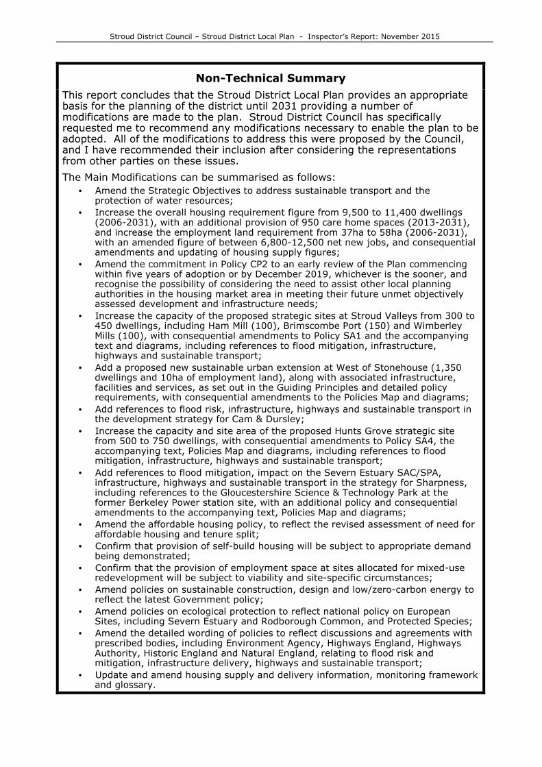
Non-Technical Summary
This report concludes that the Stroud District Local Plan provides an appropriate basis for the planning of the district until 2031 providing a number of modifications are made to the plan. Stroud District Council has specifically requested me to recommend any modifications necessary to enable the plan to be adopted. All of the modifications to address this were proposed by the Council, and I have recommended their inclusion after considering the representations from other parties on these issues.
The Main Modifications can be summarised as follows:
• Amend the Strategic Objectives to address sustainable transport and the protection of water resources;
• Increase the overall housing requirement figure from 9,500 to 11,400 dwellings (2006-2031), with an additional provision of 950 care home spaces (2013-2031), and increase the employment land requirement from 37ha to 58ha (2006-2031), with an amended figure of between 6,800-12,500 net new jobs, and consequential amendments and updating of housing supply figures;
• Amend the commitment in Policy CP2 to an early review of the Plan commencing within five years of adoption or by December 2019, whichever is the sooner, and recognise the possibility of considering the need to assist other local planning authorities in the housing market area in meeting their future unmet objectively assessed development and infrastructure needs;
• Increase the capacity of the proposed strategic sites at Stroud Valleys from 300 to 450 dwellings, including Ham Mill (100), Brimscombe Port (150) and Wimberley Mills (100), with consequential amendments to Policy SA1 and the accompanying text and diagrams, including references to flood mitigation, infrastructure, highways and sustainable transport;
• Add a proposed new sustainable urban extension at West of Stonehouse (1,350 dwellings and 10ha of employment land), along with associated infrastructure, facilities and services, as set out in the Guiding Principles and detailed policy requirements, with consequential amendments to the Policies Map and diagrams;
• Add references to flood risk, infrastructure, highways and sustainable transport in the development strategy for Cam & Dursley;
• Increase the capacity and site area of the proposed Hunts Grove strategic site from 500 to 750 dwellings, with consequential amendments to Policy SA4, the accompanying text, Policies Map and diagrams, including references to flood mitigation, infrastructure, highways and sustainable transport;
• Add references to flood mitigation, impact on the Severn Estuary SAC/SPA, infrastructure, highways and sustainable transport in the strategy for Sharpness, including references to the Gloucestershire Science & Technology Park at the former Berkeley Power station site, with an additional policy and consequential amendments to the accompanying text, Policies Map and diagrams;
• Amend the affordable housing policy, to reflect the revised assessment of need for affordable housing and tenure split;
• Confirm that provision of self-build housing will be subject to appropriate demand being demonstrated;
• Confirm that the provision of employment space at sites allocated for mixed-use redevelopment will be subject to viability and site-specific circumstances;
• Amend policies on sustainable construction, design and low/zero-carbon energy to reflect the latest Government policy;
• Amend policies on ecological protection to reflect national policy on European Sites, including Severn Estuary and Rodborough Common, and Protected Species;
• Amend the detailed wording of policies to reflect discussions and agreements with prescribed bodies, including Environment Agency, Highways England, Highways Authority, Historic England and Natural England, relating to flood risk and mitigation, infrastructure delivery, highways and sustainable transport;
• Update and amend housing supply and delivery information, monitoring framework and glossary.

Stroud District Council – Stroud District Local Plan - Inspector’s Report: November 2015
- 1 -
Introduction
1. This report contains my assessment of the Stroud District Local Plan (SDLP) in terms of Section 20(5) of the Planning & Compulsory Purchase Act 2004 (as amended). It considers first whether the Plan complies with the legal requirements, including the Duty to Co-operate, recognising that there is no scope to remedy any failure of the latter requirement. It then considers whether the Plan is sound in terms of the National Planning Policy Framework, which confirms that to be sound, a local plan should be positively prepared, justified, effective and consistent with national policy (NPPF; ¶ 182).
2. The starting point for the Examination is the assumption that the local planning authority has submitted what it considers to be a sound plan. The basis for the examination is the Stroud District Local Plan Submission Draft (December 2013) [CD/A1]. I have also had regard to the accompanying Schedule of Minor Modifications [CD/A5; Appx.5].
3. The examination was held in two stages; Stage 1 (April 2014) dealt with the legal requirements, including the Duty to Co-operate, and the objective assessment of housing need and employment land requirements. In June 2014, after these hearings had finished, my Interim Conclusions on Stage 1 of the Examination were issued [PSD/21]. These confirmed that the legal requirements of the Duty to Co-operate had been met, but concluded that Stroud District Council (SDC) had not properly undertaken an objective assessment of housing needs for the district, having regard to the close relationship between Stroud and Gloucester City and the wider housing market area. There were also some deficiencies in the justification for the economic and employment strategy of the Plan, and its relationship with the proposed level of housing provision and the wider economic strategy for Gloucestershire, and the guidance in the NPPF and Planning Practice Guidance (PPG). In addition, there were concerns about the lack of evidence to justify and support the strategy and the proposed allocations, particularly in terms of highways and transport assessments and the impact of proposed developments on the strategic road network. As a result, the examination was suspended in order for SDC to undertake further work on these matters.
4. In December 2014, after undertaking a revised assessment of housing and employment land requirements, SDC resolved to increase the overall level of housing provision and to allocate a further strategic housing site at West of Stonehouse [PS/E12]. Formal consultation was undertaken on these Post-Submission Proposed Changes in February-March 2015 [REX/B15a]. In February 2015, my Initial Views on the work undertaken during the suspension of the examination were issued [REX/A08], and in April 2015, the examination was resumed to review and assess this additional work. In May-June 2015, Stage 2 of the examination hearings dealt with the remaining policies and proposals in the Plan, including strategic site allocations and the Post-Submission Proposed Changes. Consultation on Further Post-Submission Proposed Changes [PS3/01]
was undertaken in August-September 2015.
5. This report deals with the Main Modifications needed to make the SDLP sound, as identified in bold in the report [MM]. In accordance with section 20(7C) of the 2004 Act, SDC has requested me to recommend any modifications needed to rectify matters that make the plan unsound or not legally compliant, and thus incapable of being adopted. These Main Modifications are set out in the accompanying Appendix. SDC also proposes to make other minor changes (“Additional Modifications”) to the Plan, which do not affect its overall soundness and do not need any positive recommendation from me.
6. The Main Modifications that are needed to ensure the SDLP is sound all relate to matters that were discussed at the examination hearings. All the Main Modifications were subject to sustainability appraisal and public consultation in two stages over 6-week periods, and I have taken account of the representations in coming to my conclusions.

Stroud District Council – Stroud District Local Plan - Inspector’s Report: November 2015
- 2 -
7. My approach to the Examination has been to work with SDC and other participants in a positive, pragmatic and supportive manner. In so doing, I have considered all the points made in the representations, statements and at the hearing sessions. However, the purpose of this report is to consider the legal compliance and soundness of the Plan, giving reasons for the recommended modifications, rather than responding to every point made in the representations and discussions. References to documentary sources are provided thus [ ].
Assessment of Legal Compliance
8. At the hearing sessions of the examination, some participants expressed concern about the Sustainability Appraisals (SA), particularly in terms of the nature and extent of public consultation undertaken and the consideration of alternative strategies and sites. SDC has responded to these concerns and I am generally satisfied with these responses [REX/D09a; PS2/D14b; PS3/09].
9. Section 19(5) of the Act requires local authorities to carry out a SA of their local plan, reflecting the SEA Directive/Regulations; further guidance is given in the NPPF (¶ 150-151; 165) and the PPG [ID-11], which has been confirmed and clarified by the Courts1. In essence, local authorities have to undertake SA at each stage of the local plan preparation process, along with public consultation; they also have to consider reasonable alternatives, which should be subjected to the same level of analysis as the preferred option, but they have discretion in identifying what are reasonable alternatives. Options may be rejected during plan preparation, and do not have to be reconsidered at every stage, provided that reasons for rejecting earlier options and selecting preferred options are given; an addendum to the SA is also capable of correcting defects in earlier SA work.
10. SDC published several SA reports during the course of preparing the SDLP [CD/A3-
A4a; CD/F4-F6; CD/F16-F18; PS/E18; REX/B15b; PS3/03-04]. Opportunities were available to comment on the SA work at all relevant stages, including at publication stage; relevant SA documents were published at the same time as the consultation documents of the SDLP. SDC notified all the prescribed and specific consultation bodies, made the SA documents available for inspection and made it clear that these documents were available for public consultation; this includes the SA Addendum published with the Post-Submission Proposed Changes in February 2015 [PS/E18]. SA work is an iterative process, and SDC confirms that the SA Addendum did not cover the methodology, since this had been set out in earlier SA reports and had been available for consultation at an earlier stage. Having considered all the evidence, I find that SDC has met the requirements of the Local Planning and SEA Regulations as regards consultation on the SA and its Addendum, in line with national advice in the NPPF & PPG [ID-11].
11. As for the factual content of the SA work, there is some dispute about whether the earlier assessments of the Whaddon site option correctly reflected the position in terms of accessibility to community facilities and flood risk. SDC explains that the earlier SA work was a broad-brush assessment, based on the information available at the time. At my request, SDC’s consultants undertook a further comparative assessment of site options at Hunts Grove and Whaddon, on the southern fringe of Gloucester, and this was included in the SA for the Further Post-Submission Proposed Changes [PS3/03]; this rectifies any deficiencies in the earlier assessment. When read as a whole, the SA work has assessed a broad range of reasonable and realistic options based on various levels of housing provision, including the figure endorsed by SDC at the Further Post-Submission Proposed Changes stage and the eventual recommended figure. Both the SA work and the Habitats Regulations Assessments have also fully addressed the impact of proposed developments on the Severn Estuary and Rodborough Common SAC/SPA. Since the SA identified likely significant effects on the baseline, it took account of the co-existence of new development with existing communities.
1 including Ashdown Forest Economic Development v Wealden DC (2014), Satnam Millennium v Warrington BC (2015) and Calverton PC v Nottingham CC (2015)

Stroud District Council – Stroud District Local Plan - Inspector’s Report: November 2015
- 3 -
12. Much of the concern about considering alternative strategies and sites focuses on potential development options within Stroud district on the southern fringe of Gloucester, including at Hardwicke and Whaddon. At the hearings, SDC outlined its approach to considering alternative strategies and site options, and responded to particular concerns following a specific High Court judgement [PS2/D14b]. SDC confirms that reasonable alternatives were identified, described and evaluated throughout the SA/SEA process, with the findings published, including the reasons for rejecting and selecting various options. The consideration of alternative strategies goes back to the Options stage, where concentrated and dispersed strategies based on the former SWRSS review were considered, including options to the south of Gloucester [CD/E2; CD/F15-F16]. At the Preferred Strategy and Submission stages, alternative site options were considered as part of developing a range of reasonable alternatives to inform the final Plan, including scenarios based on various housing numbers, with reasons for selecting the preferred approach [CD/F15-F18]. A further range of alternatives was considered to inform the Post-Submission Proposed Changes, including alternative growth scenarios and sites, focused on those which fell within the strategy of the Plan [PS/E18].
13. The SEA/SA regulations only require the identification and assessment of “reasonable” alternatives; i.e. those that reflect the objectives of the plan and are achievable, rather than every conceivable or possible option. Furthermore, since the SA process is an iterative approach, during which reasonable alternatives are refined [PPG; ID-11], once potential alternatives have been rejected, with the reasons for doing so, there is no requirement to keep going back to consider such alternatives throughout the plan-making process. SDC has not avoided its obligation to evaluate reasonable alternatives by unduly restricting the range of options assessed or rejecting earlier options without good reason. Although some of the SA reports could have been more explicit about the alternatives considered, when read as a whole, the requirements of the SEA/SA Regulations have been met, in line with national advice [PPG: ID-11].
14. As regards other aspects of legal compliance, there have been comments about the nature, adequacy and conduct of public consultation, but as far as I can see, all relevant bodies have been consulted and involved during the plan preparation process, and it fully complied with the procedures outlined in the Statement of Community Involvement and the requirements of the Local Planning Regulations.
15. My assessment of these and other aspects of legal compliance of the SDLP is summarised below, and confirms that it meets all the relevant legal requirements.
LEGAL REQUIREMENTS
Local Development Scheme (LDS)
The SDLP is identified within the approved LDS (2009)
[PS/B16], and its role and content comply with the LDS. It is also consistent with the current timetable of plan preparation [CD/F1].
Statement of Community Involvement (SCI) and relevant regulations
The SCI was adopted in November 2007 [CD/A8a], with an addendum in January 2009 [CD/A8b]. SDC has confirmed that all relevant evidence and documents were publicly available during the consultation period and at submission stage, and later documents were available in the examination library and included on the examination web-site. The plan-making and consultation processes met the minimum requirements of the Local Development Regulations and SDC’s adopted SCI, including consultation on Main Modifications.
Sustainability Appraisal (SA)
Adequate SA has been carried out at all stages during the preparation of the SDLP, including at the Pre-Submission and Main Modifications stages [CD/A3-A4a; CD/F4-F6; CD/F16-
F18; PS/E18; REX/B15b; PS3/03-04]. As outlined above, SDC has identified and assessed reasonable alternative strategies,
Stroud District Council – Stroud District Local Plan - Inspector’s Report: November 2015
- 4 -
growth and site options throughout the preparation of the plan, both for the overall level of housing and its spatial distribution, and undertaken consultation at each stage.
Appropriate Assessment
Habitats Regulations Assessment has been undertaken and updated [CD/A4b; CD/F13; PS/E20; PS3/02] to the satisfaction of Natural England [PS/D15a; REX/B04].
National Policy The SDLP is consistent with national policy, except where indicated and modifications are recommended.
2004 Act (as amended) and 2012 Regulations
The SDLP complies with the Act and the Local Planning Regulations.
Assessment of the Duty to Co-operate
16. Section 20(5)(c) of the 2004 Act requires me to consider whether the Council has complied with any duty imposed on them by s33A of the Act in relation to the preparation of the Plan. This requires SDC to co-operate in maximising the effectiveness of plan-making, and to engage constructively, actively and on an on-going basis with neighbouring planning authorities and prescribed bodies when preparing development plan documents with regard to a strategic matter. This is defined as sustainable development or use of land which has or would have a significant impact on at least two planning areas, including sustainable development or use of land for strategic infrastructure. This Duty (DTC) is closely related to the requirements in the NPPF (¶ 178-181), and the soundness tests which require plans to be positively prepared and effective (NPPF; ¶ 182). My Initial Conclusions on Stage 1 of the Examination [PSD/21] confirmed that SDC had met the legal requirements of the DTC, and this section of my report summarises and updates the main considerations and conclusions on this legal requirement.
17. SDC has submitted evidence outlining how it has engaged constructively, actively and on an ongoing basis with neighbouring authorities and prescribed bodies during the preparation of the Plan [CD/A6; PS/B11; PS/B23; REX/B09]. This has involved co-operating and engaging with neighbouring authorities, established groups and partnerships, identifying and discussing strategic and cross-boundary matters, including housing provision, and progressing specific projects and joint evidence; the outputs of co-operation are reflected in the submitted Plan and Statement of Co-operation (SOC) [REX/B09].
18. Established systems of co-operation exist between local planning authorities in Gloucestershire, for both officers and elected members, which help to co-ordinate strategic planning across the county. These culminated in a SOC between SDC, Gloucester City Council (GCC), Cheltenham Borough Council (CBC) and Tewkesbury Borough Council (TBC) (the “JCS” authorities, who are preparing their own Joint Core Strategy (JCS) for their area) [REX/B09]. There has been specific engagement and co-operation with the JCS authorities, as part of preparing the SDLP and the JCS, and separately with GCC. Joint working on evidence included Strategic Housing Market Assessments (SHMA), Gypsy & Traveller Accommodation Assessment (GTAA), Strategic Flood Risk Assessment (SFRA) and Strategic Infrastructure Delivery Plans (SIDP). Regular meetings have also been held with the GFirst Local Enterprise Partnership (LEP) and other relevant bodies and agencies, including Highways England (formerly the Highways Agency), the Highway Authority, Environment Agency, Natural England and Historic England (formerly English Heritage). SOCGs have been drawn up with all these bodies [REX/B02-B05].
19. SDC has identified the main strategic and cross-boundary priorities, including housing, employment, environment and infrastructure [CD/A6]. There has been some co-operation and discussion about the overall level of housing required for each of the authorities, and there is general agreement with the JCS and other neighbouring authorities about the overall level of housing proposed for Stroud.

Stroud District Council – Stroud District Local Plan - Inspector’s Report: November 2015
- 5 -
At the time of submitting the original plan, there was no commonly agreed approach to identifying the objective assessment of housing needs for the Gloucestershire strategic housing market as a whole, but following suspension of the examination, both SDC and the other Gloucestershire authorities have used the same consultants to undertake an objective assessment of housing needs for each area in a consistent manner over the wider strategic housing market area.
20. The results of co-operation have influenced the content and strategy of the SDLP. Development in Stroud district on the southern fringe of Gloucester has been limited to consolidating existing development at Hunts Grove and East Quedgeley (although GCC still objects to further expansion at Hunts Grove). A Local Plan review mechanism is now included in the SDLP to enable any future unmet needs to be met, with the detailed wording now agreed with GCC, CBC & TBC. A joint approach to the Aston Down employment site and complementary policy wording on canal restoration has been agreed with Cotswold District; and a joint county-wide approach to Allowable Solutions has been agreed.
21. The SOC between SDC, GCC, CBC & TBC [REX/B09] confirms that, currently, there is no specific requirement for SDC to meet the unmet housing or other needs of any other area and SDC does not require any other area to meet any of its needs. However, in August 2013, the JCS authorities alerted other authorities to the possibility that they may need to formally request assistance under the DTC if more housing is required to meet the needs of the JCS area, but at present, the scale of any possible future unmet needs has not been identified. However, SDC has included a mechanism to review the SDLP should any unmet needs arise in the future. In the current circumstances, this is about as far as SDC can go in the absence of any specific identified potential unmet requirement; it is a practical, pragmatic and reasonable approach.
22. During plan preparation and during the early stages of this examination, both CBC & TBC considered that SDC had not fully met the requirements of the DTC, particularly during the earlier stages of preparing the Plan when key elements of policy and the spatial distribution of development over the wider JCS/Stroud area, including land south of Gloucester, could have been considered. The historical position is complex [PS/D16ab], but the former draft SWRSS (Proposed Changes; 2008) included 3,500 dwellings within Stroud district to meet some of the housing needs of Gloucester and Cheltenham, to be identified through areas of search; however, the former SWRSS review process was never completed, following its revocation. Early drafts of the SDLP used the former draft RSS overall housing provision figure and assumed that housing would be delivered in these areas of search, but did not specifically carry forward any provision for Gloucester or Cheltenham; options for the emerging SDLP did not consider any provision to meet some of the housing needs from outside its area. When preparing the JCS, broad options were considered for meeting some of its housing needs in the Stroud area, but these were not pursued since the land was outside the JCS area. The JCS authorities assessed potential locations within Stroud district, but these did not perform well against sustainability objectives and highway infrastructure.
23. Although CBC & TBC have previously argued that land to the south of Gloucester (in Stroud) should be considered to help meet some of the housing needs of the JCS area, GCC maintains that this would conflict with the JCS strategy which seeks to focus growth elsewhere around Gloucester. There are clearly some differences of opinion on this matter, which reflect strategic pressures and raise issues about the relative merits of releasing Green Belt land around Gloucester or non-Green Belt land south of Gloucester in Stroud district; but it is essentially for the authorities concerned to determine the most appropriate strategy for their area. SDC did not seek to help meet the needs of Gloucester City within its area, since it was seeking to co-operate with GCC who wished to see those needs met elsewhere around Gloucester. SDC was never formally requested to assist in meeting any unmet housing needs from the JCS area during these earlier periods of plan preparation; it was not until August 2013 that the possibility of needing such assistance in the future was formally raised by the JCS authorities.

Stroud District Council – Stroud District Local Plan - Inspector’s Report: November 2015
- 6 -
24. This does not suggest any lack of willingness on SDC’s part to co-operate or consider the issue of meeting some of Gloucester’s need within the Stroud area, simply that GCC and the JCS authorities as a whole did not consider this was a sustainable or appropriate option. This background highlights the difficulties when some authorities have differences of opinion, but it is not necessarily a failure of the DTC process as far as SDC is concerned. Most importantly, all the JCS authorities now agree that SDC has met the DTC.
25. The timescales of plan preparation are not ideal, with the SDLP coming ahead of the JCS, but the latest guidance on the DTC [PPG: ID-9-017] clearly envisages this eventuality and suggests appropriate actions, which largely reflect the processes undertaken by SDC and the JCS authorities. Both plans are now subject to independent examination, but the SDLP is more advanced in the examination process, with public consultation on Main Modifications now completed.
26. During the preparation of the Plan, SDC has engaged with the prescribed bodies on other strategic priorities relating to the environment, infrastructure and employment. SDC has worked closely with the Environment Agency (EA) when preparing the SDLP, producing a Stage 1 & Stage 2 SFRA, Level 2 Addendum and the SIDP, and when drafting detailed wording of the SDLP’s policies; EA is now satisfied that amended wording would overcome any outstanding concerns and considers that SDC has met the DTC requirements [PS/B28b; PS/D14abc; REX/B02].
27. Both Natural England and the Local Nature Partnership have been involved in the preparation of the Plan, including the supporting evidence and Habitat Regulations Assessment; any outstanding concerns have now been addressed
[REX/B04]. Historic England has been consulted on the wording of several policies, and is satisfied that proposed amendments will address its concerns [REX/B03]. The LEP had some concerns about whether the SDLP would enable the emerging Strategic Economic Plan (SEP) to be delivered, but these concerns have now been overcome with the publication of the final SEP [REX/D13] and a review of the SDLP strategy against the key objectives and strategy of the LEP’s SEP.
28. On submission, there was some lack of highways and transport evidence, as highlighted in the Highways Agency’s representation, where they raised issues of DTC/legal compliance and soundness. However, during the preparation of the SDLP, there was extensive engagement with the Highways Authority (HA) and Highways Agency/ Highways England (HE); and since submitting the Plan, further meetings have been held and further transport work has been commissioned and completed, including transport and junction assessments. Both HE & HA are now satisfied that their concerns have been addressed and raise no objections to the Plan, either in relation to the DTC or soundness [REX/B05].
29. This indicates that, although some of the detailed assessments needed to support the strategy of the Plan and the strategic site allocations were not in place before the Plan was published and submitted, given the nature and extent of ongoing engagement with these prescribed bodies during the plan preparation period and suspension of the examination, and the fact that these issues are now resolved, this does not suggest fundamental shortcomings in the DTC process.
30. Consequently, having considered all the evidence, statements and discussions at the hearings, I conclude that SDC has met the legal requirements of the Duty to Co-operate in terms of maximising the effectiveness of the plan-making process and actively co-operating and engaging with relevant bodies on an ongoing basis.
Assessment of Soundness
Preamble
31. The SDLP establishes the strategic planning framework for Stroud district up to 2031, setting out the development strategy, with strategic site allocations, and establishing the principles and policy framework to guide development in the future. It sets the scene, with a vision for the future, leading to the development strategy, which sets out the key requirements for housing, employment and economic growth, concentrating development in the main settlements within the

Stroud District Council – Stroud District Local Plan - Inspector’s Report: November 2015
- 7 -
identified hierarchy. More detailed policies cover the sub-areas of the district, with strategic allocations, followed by other core policies and delivery policies covering homes and communities, economy and infrastructure, environment, delivery and monitoring. As such, it is a comprehensive, strategic local plan, accompanied by an extensive evidence base, including sustainability appraisals, supporting documents, background papers, technical reports and studies, along with further evidence/statements submitted to the examination.
32. Preparation of the SDLP began in 2009, with consultation on Key Issues [CD/E1], Alternative Strategies (2010) [CD/E2], Preferred Strategy (2012) [CD/E3], Policies document (2013) [CD/E4], and the final Submission Plan (2014) [CD/A1]. A wide range of discussion papers were produced and meetings were held with many organisations and stakeholders, including neighbouring local planning authorities. During its early stages, the preparation of the SDLP had regard to the strategic context provided by the SWRSS, including its review, but this was formally revoked in May 2013. However, the SDLP is supported and justified by its own locally-derived evidence which does not rely on previous evidence or strategies in the SWRSS. This includes updated assessments of housing need, employment land, town centres and retail capacity, viability, accommodation for gypsies and travellers, transport, highways and infrastructure. The DTC process has partly replaced the former mechanisms of regional planning, effectively addressing cross-boundary issues. There has also been close liaison between SDC, LEP and neighbouring local authorities to ensure consistency of approach and in addressing cross-boundary issues.
33. In considering the soundness of this plan, I have not only had regard to the NPPF & PPG, but also taken account of more recent Government and Ministerial statements relating to planning and plan-making, including amendments to the Planning Practice Guidance (PPG), to which SDC has responded and addressed.
Main Issues
34. Taking account of the representations, supporting evidence, written statements and discussion at the examination hearings, there are eight main matters and key issues upon which the soundness of the SDLP depends.
MATTER 1: VISION & STRATEGIC OBJECTIVES
Key issue – Are the Vision for Stroud district and the Strategic Objectives justified, effective, locally distinctive and appropriate, reflecting the Sustainable Community Strategy, community views and issues raised during the preparation of the plan, and do they provide a sound basis for the development strategy and strategic policies in the Plan?
35. The SDLP sets out a Vision for the future of Stroud district, along with a series of Strategic Objectives to provide a tangible and measurable way of implementing the Vision [PS2/B02a-B03a]. The Vision is further supplemented by a series of “mini-visions” for each sub-area of the district later in the Plan.
36. The Vision is drafted in a clear and positive manner, reflecting the three dimensions of sustainable development set out in the NPPF (¶ 7). By referring to local characteristics, including environmental, social, economic and cultural features and recognising the specific challenges for each area, it is locally distinct. It is justified with a comprehensive evidence base, which reflects key visions, priorities and issues in the Sustainable Community Strategy (SCS) and in Parish Plans and Community/Parish Design Statements. Linked to the strategic objectives and providing the context and framework for the core policies of the Plan, it is effective and positively prepared. Although partly descriptive, it sets out the aspirations of how the Plan will promote new sustainable development, supporting economic and housing growth, while keeping the best qualities of the district. The subsequent strategic policies contain measurable targets against which the success of the Plan in achieving the Vision can be assessed. The Vision evolved through the plan-making process in a collaborative way, and SDC has made minor changes to the wording of the Vision to address relevant concerns raised during plan preparation, consultation and engagement.

Stroud District Council – Stroud District Local Plan - Inspector’s Report: November 2015
- 8 -
37. Six Strategic Objectives identify the key strategic priorities in terms of homes and communities, economy and infrastructure, and environment and surroundings. They outline more specific and detailed ways in which the Vision will be taken forward, focusing on sustainable economic and housing growth, and providing the strategic framework for the development strategy and strategic policies that follow. They recognise the presumption in favour of sustainable development and are locally distinctive, reflecting the key issues identified for the district, including its particular environmental, social and economic qualities. They also reflect the different role, character and distinct identity of the settlements and parts of the district, in line with NPPF (¶ 17). However, amendments are needed to the detailed wording of two of the objectives, to reflect the requirements of statutory and prescribed bodies and ensure that they are sound [MM001-002].
38. With these proposed changes, the Vision and Strategic Objectives are locally distinctive and appropriate for Stroud district, reflect the priorities of the SCS and the views of local communities, and provide a sound and effective strategic framework for the development strategy and core strategic policies.
MATTER 2 – DEVELOPMENT STRATEGY
Key issue – Is the Development Strategy for Stroud district soundly based, effective, appropriate, locally distinctive and justified by robust, proportionate and credible evidence, particularly in terms of delivering the proposed amount of housing, employment and other development, and is it positively prepared and consistent with national policy?
39. Chapter 2 of the SDLP sets out the overall development strategy for managing growth and development across the district to 2031, including the scale of housing and employment development, strategic growth and development locations, settlement hierarchy, place-making, development principles for the strategic sites and infrastructure and developer contributions.
40. Core Policy CP1 effectively confirms the presumption in favour of sustainable development enshrined in the NPPF (¶ 10-16).
Overall levels of housing and employment development
41. Core Policy CP2 sets out the overall amount of housing and employment development for the Plan period, and lists the strategic development sites; it also sets out the strategy for developments other than at the strategic sites, and includes a commitment to review the SDLP. The overall amount of housing and employment development for Stroud district was extensively discussed at the examination hearings, both in the initial examination and at the resumed hearings after SDC had reviewed housing and employment land needs. The main issue is whether the revised assessments of housing and employment needs are based on sound and objective analysis of the relevant evidence, which takes full account of the demographic, housing and economic factors, including the various assumptions, figures and methodology, in line with the latest national guidance.
42. As submitted, the Plan proposed to provide at least 9,500 new dwellings and 6,200 new jobs between 2006-2031. However, following the initial examination hearings, my Interim Conclusions found that SDC had not properly undertaken an objective assessment of housing needs for the district, having regard to the close relationship between Stroud and Gloucester city and the wider housing market area; there were also some deficiencies in the justification for the economic and employment strategy of the Plan and its relationship with the proposed housing requirement figure. As a result, SDC reviewed its housing and employment land needs, and proposed 11,200 new dwellings, along with 950 additional care home bedspaces and 58ha of employment land (2006-2031); the housing requirement figure was subsequently increased to 11,400 dwellings following discussions at the resumed hearing sessions.
Stroud District Council – Stroud District Local Plan - Inspector’s Report: November 2015
- 9 -
Housing need
43. In order to significantly boost housing supply, the NPPF (¶ 47, 50, 159, 178-182) requires local plans to meet the full, objectively assessed needs for market and affordable housing in the housing market area, as far as is consistent with the policies set out in the NPPF. A Strategic Housing Market Assessment (SHMA) should assess the full housing need, working with neighbouring authorities where housing market areas cross administrative boundaries. The scale and mix of housing should meet household and population projections, taking account of migration and demographic change, address the need for all types of housing, including affordable housing, and cater for housing demand. Further guidance is given in the PPG [ID-2a], which confirms that DCLG household projections provide the starting point when estimating housing needs. There is no single method or data which determines the appropriate level of housing need; it is a matter of judgement based on an objective analysis of the available evidence, rather than on a forensic examination of each figure, estimate and assumption.
44. SDC has submitted detailed evidence and justification for its revised assessment of housing needs [PS/B10;B18b;E09-E10;E13-E14;E17; REX/B01;B06;B11;B13;B16;B19-B20;
REX/D04-D05;D11; PS2/D31-32;D17]. SDC’s consultants took the latest DCLG 2012-based household projections as the starting point, and made adjustments to the population figures to reflect 10-year migration flows and Unattributable Population Change (UPC). UPC may be less significant at national level, but can sometimes have more implications at the local level. However, for Stroud district, the assumptions behind both these adjustments make little difference to the final figure, but provide an approach consistent with that adopted for the adjoining JCS authorities. Since it is agreed that the appropriate strategic housing market area covers Gloucestershire, it is important to adopt a consistent approach when assessing future housing needs. Since most of the SHMA work [PS/B18; PS/E13]
covers the whole of Gloucestershire, this provides a comparable approach for each district.
45. Household formation rates (HFRs) are a key element in estimating future households and housing needs. SDC’s consultants initially adopted an approach that focused on the HFRs for the 25-34 age group, since this group is most affected by the changes between recent censuses, and assumed a partial return to the previous trends in the 2008-based household projections. However, the more recent 2012-based projections incorporate a higher rate of partial return to previous trends for this age group. Since the earlier 2008-based and interim 2011-based projections have been superseded by more recent projections, there is little reason to use the trends based on these earlier projections, particularly since, in Stroud, a full return to previous trends for all age groups under 65 would actually require fewer new homes and is considered unlikely in the short-medium term. The conversion ratio between new households and new dwellings is based on up-to-date evidence from DCLG and SDC [REX/D11]. On this basis, the latest assumptions and estimates [REX/B17] represent a reasonable and realistic approach for Stroud district, resulting in a demographic need for between 11,000-11,200 new houses (2006-2031), depending on which assumptions are used.
46. Both NPPF & PPG advise that other housing factors, including market signals, should also be taken into account. Earlier SHMAs [PS/B18] examined these factors and more recent reports [PS/E09b; PS2/D17] confirm that house prices in Stroud have moved in line with the rest of the county; average rents are slightly higher than the rest of the county, affordability ratios are little different, and overcrowding is lower than in Gloucestershire and England as a whole. Past delivery rates vary from 200-500 dw/yr, but this largely depends on the demand for and supply of housing, and there has been a significant “bank” of planning permissions over much of the period between 1990-2014; there is little evidence that the supply has been subject to particular planning constraints over this period. Some of the data only covers a 10-year period, but looking over a longer timeframe reveals that Stroud is little different from neighbouring authorities, including Gloucestershire. On this basis, market signals in Stroud are generally

Stroud District Council – Stroud District Local Plan - Inspector’s Report: November 2015
- 10 -
no better or worse than neighbouring areas, and so I can see no need for any specific uplift in the housing requirement figure to reflect these factors.
47. SDC has revised its estimates of affordable housing [REX/B17; PS2/D17], identifying a need for 446 affordable units/year based on the PPG [ID-2a] approach; an earlier approach which suggested adjusted figures of 110 units/year took account of eligibility for affordable housing/housing benefit and the role of the private rented sector, which is not in line with the PPG and is no longer advanced. The unadjusted figure is slightly less than the total annual rate of proposed housing provision, but it is important to note the committed supply of 723 affordable units and the policy requirement for some 30% of all new housing to be affordable. In addition, SDC has other proposals and initiatives to bring forward affordable housing through its own social housing programme, mortgage scheme, small sites review and rural exception sites, set out in the latest Housing Strategy [REX/D07]; Registered Providers and other specific schemes would also contribute to the supply of affordable housing.
48. The need for affordable housing is certainly a policy consideration that could influence housing targets, particularly in view of affordability issues, but it is distinct from the overall objective assessment of housing need, since the methodology and numbers are not compatible. Although a modest increase in the overall housing requirement could be considered, to seek to deliver all the affordable housing needed through the provision of market housing would result in unrealistic and undeliverable rates of housing development. Housing for the elderly has been considered separately, in line with the latest guidance in the PPG
[ID-2a-021], resulting in a specific provision for 950 additional Class C2 care home bedspaces (2013-2031) [PS/E09c]. Student accommodation is less relevant in Stroud district, and the SHMAs have fully addressed the mix of housing needed.
49. NPPF & PPG also advise that economic factors should be considered when assessing future housing needs. SDC has submitted further evidence on this matter, proposing an uplift to reflect economic factors, including jobs growth, and reconsidering the relationship between the housing and economic strategy
[REX/B17; PS/E15]. This evidence examined job numbers, unemployment, economic activity rates, the size and nature of the local population and the need for jobs generated by the increase in population and households. It also considered economic growth forecasts, with the range of jobs and GVA growth reflecting that projected in the LEP’s SEP. Although various data and timescales could be used, in terms of future estimates of economic and jobs growth, it is important to use readily available evidence in a proportionate, realistic and reasonable manner.
50. Initially, SDC’s consultants favoured a mid-way approach, based on the assumed contribution of homes and jobs from Stroud for the whole of Gloucestershire, but this was replaced by a more objective approach based on economic forecasts of job sectors [REX/B17]. These estimates, adjusted to reflect Stroud’s circumstances, range from 10,600-12,200 new homes needed to meet alternative job scenarios, the mid-point of which is 11,400 new homes. Several participants press for a figure of 12,200 new dwellings within the plan period. This figure lies at the top of the economic scenarios and would represent a significant increase above demographic needs; it would also have negative effects in SA terms, and require new greenfield allocations or extensions to proposed allocations, further delaying the plan-making process. Moreover, in addition to the overall housing requirement, a further 950 bedspaces (2013-2031) are to be provided for elderly persons, increasing the overall provision of residential accommodation. More recent population and migration figures have been issued since SDC reviewed its housing needs, but PPG [ID-2a-016] confirms that housing assessments do not become outdated every time new projections are issued, particularly given the uncertainties involved in these latest estimates and the relatively small differences they make in the context of Stroud district.

Stroud District Council – Stroud District Local Plan - Inspector’s Report: November 2015
- 11 -
51. In determining the objective assessment of housing need, much depends on the assumptions used for economic and jobs growth, but SDC has taken a balanced view, with an element of realism, practicality and pragmatism, looking at the pros and cons of the various forecasts. SDC originally considered that a figure of 11,200 new homes would represent the objective assessment of housing need, but agreed with me that that a slightly higher figure of 11,400 new homes (2006-2031) would better align with the economic growth strategy, reflecting the mid-point between the various job scenarios, as well as providing a modest uplift to the demographic need to reflect the need for affordable housing.
Housing requirement
52. Throughout the preparation of the SDLP, SDC has considered several alternative levels of housing provision, and assessed these through SA. Most recently, when considering the latest housing requirement, SDC assessed seven levels of housing provision, ranging from 9,900-13,200 new dwellings. This work found that the lowest provision levels could be accommodated by increasing the capacities of sites proposed in the original SDLP; the highest levels would have serious site-specific adverse effects and could not be accommodated within the current development strategy; but intermediate levels of 11,200-11,750 dwellings could be accommodated within the current strategy, with additional allocations, such as the West of Stonehouse site; all these options were tested through SA. SDC has fully assessed and considered a reasonable range of realistic growth options based on various levels of housing provision, and has selected a housing requirement figure of 11,400 dwellings, which fully meets the objectively assessed housing need.
53. Cross-boundary housing provision is an important issue, particularly when the housing market area crosses administrative boundaries. This matter is dealt with in more detail under the Duty to Co-operate, earlier in my report. However, at this stage, it is important to note that the appropriate strategic housing market area covers Gloucestershire, which is addressed in the SHMA work [PS/B18; PS/E13]. The assessment of housing need carried out for Stroud is comparable and consistent with the approach adopted for other areas, including the JCS authorities. This enables a county-wide view to be taken across the wider housing market area on the overall level of housing required to meet population and household needs and support economic growth, having considered issues such as commuting and the inter-relationship between the local housing markets.
54. Moreover, at present there is agreement between Stroud and the JCS authorities that each area should fully meet its own identified housing needs within its own area; there are currently no unmet needs from Stroud that have to be met elsewhere or from neighbouring authorities that have to be met within Stroud [REX/B09]. If the situation changes, then the commitment to review the SDLP in Policy CP2 comes into play; this would consider the nature and scale of any unmet needs and determine how and where they should be met, working together with the relevant authorities under the Duty to Co-operate.
55. I therefore consider that a housing requirement figure of 11,400 new homes (2006-2031) represents an objective, realistic and deliverable housing requirement figure, which meets demographic needs, reflects housing market signals, and includes a modest uplift to reflect the need for affordable housing, economic trends, local policy objectives and other relevant factors.
Housing supply
56. Turning to housing supply, recent 5-year land supply assessments [PS/E14]
indicate a deliverable supply of just over 7 years, including existing commitments and a realistic proportion of the contribution expected from the strategic sites proposed in the SDLP within the current 5-year period. These figures have been confirmed in the latest assessment [PS2/D32], which specifies a 5-year requirement of 2,674 dwellings, compared with a deliverable supply of 3,762 dwellings,

Stroud District Council – Stroud District Local Plan - Inspector’s Report: November 2015
- 12 -
equating to a current supply of 7.03 years. Although the detailed delivery of these sites may change, there is sufficient “headroom” in these figures to ensure that the 5-year housing land supply requirement can be met, supported by evidence in the SHLAA [CD/B4]. This figure includes a 5% buffer, as required by the NPPF (¶ 47), added after the shortfall in provision during the earlier years of the current plan period; it also includes a modest allowance for windfall sites, reflecting past rates of provision, an allowance for dwellings unlikely to be built, and a discount for small site permissions. Assuming that identified commitments and strategic sites come forward as anticipated, using realistic assumptions about timing, build-rates and delivery, I am satisfied that sufficient sites have been identified to meet a 5-year supply, in line with the guidance in the PPG [ID:3-033].
57. The latest evidence on past housing provision [REX/B06; REX/B13; PS/B10; PS/B13] does not suggest that there has been a persistent under-delivery of housing in Stroud which might justify a 20% buffer, as confirmed in my Initial Conclusions
[PS/D21]. Moreover, the proposed rate of housebuilding over the rest of the Plan period (473 dw/yr) would represent a significant (almost 20%) increase compared with average completion rates between 1991-2013 (382 dw/yr). The housing trajectory [REX/D05e] shows that housing delivery is “frontloaded”, with a surplus in provision to ensure that minimum housing targets can be met well before the end of the plan period. Taking account of completions within the current plan period, just over 7,560 new houses need to be built up to 2031, of which almost 4,000 are under construction, permitted or otherwise committed, leaving just over 3,600 to be provided, including those at the proposed strategic allocations [PS2/D31-D32]. This excludes any future windfalls on large sites and small-scale windfalls in the smaller settlements, as well as any provision from future neighbourhood plans, giving further flexibility. There is no specific phasing for housing development, but the housing trajectory uses reliable information, discussed with developers and taking account of lead-in times and build rates, to establish a realistic and deliverable programme of new housing development.
Economic strategy and employment land requirement
58. Following the suspension of the examination, SDC undertook further work on the SDLP’s economic strategy, including a revised assessment of employment land needs and economic forecasts [PS/E10; E15-E16; REX/B07; B14; B17; D04a; D08a]; this resulted in a revised provision of 58ha of employment land and between 6,800-12,500 new jobs (2006-2031) [MM009]. The main issues are whether these revised assessments reflect the latest economic forecasts, relate to the revised housing strategy and reflect the LEP’s economic strategy, and whether they are appropriate, effective, justified, positively prepared, soundly based and consistent with the latest national guidance.
59. In carrying out this work, SDC has updated its employment needs assessment, using historic rates of land take-up and drawing on recent economic forecasts, consistent with those used to establish the housing requirement figure, including employment growth projections, activity rates, labour supply, employment land needs and past and likely future take-up of employment land [PS/E15]; this approach is consistent with the guidance in the NPPF & PPG and is comparable with that adopted for the neighbouring JCS authorities. It has also reviewed current employment land availability, and reassessed future land needs, using various models and data, not only in quantitative and qualitative terms, but also reflecting business needs on both a sectoral and spatial basis; this ensures there is a spread of employment land across the district to meet market needs, whilst reflecting the LEP’s economic focus on the M5 corridor. Strategic mixed-use site allocations also help to ensure that new jobs are provided as housing progresses.
60. The SDLP proposes some 26ha of new employment land, which with existing commitments, would more than meet the future need for employment land based on historic take-up of land; it would also meet likely economic demand and meet both high and low economic forecasts. The proposed provision of employment land can be delivered within the current plan period, and provides a surplus

Stroud District Council – Stroud District Local Plan - Inspector’s Report: November 2015
- 13 -
against future needs. Although the current supply only includes a few larger sites, further proposed provision would increase this amount. The proposed increase in employment land and the wider range of jobs growth is a combination of factual updates and reflects the range of economic forecasts considered. I deal with specific employment sites later in my report.
61. The focus of the strategy in policy terms has shifted slightly, with an overall target of 58ha of employment land, rather than a specific number of new jobs. Given the difficulties of precisely estimating and providing the required number of new jobs, an approach which relies on the historic take-up of land and economic forecasts of future employment land needs is more reliable and appropriate for Stroud district. Hence, a range of possible jobs growth (6,800-12,500) is more appropriate than a specific figure, although the proposed amount of employment land could easily generate up to 12,500 new jobs [PS/E15]; a lower rate of jobs growth would not reflect the LEP’s SEP, and would merely continue past trends without boosting economic growth.
62. SDC’s revised economic assessment has regard to the wider economic area of Gloucestershire, including the LEP’s Functional Economic Market Area, and has considered cross-boundary factors such as commuting and the inter-relationship between jobs both within and outside Stroud district. SDC has also reassessed the relationship of the SDLP with the LEP’s SEP, in terms of economic growth forecasts and the spatial and sectoral provision of employment land; the SDLP is now fully aligned with the LEP’s economic objectives and growth forecasts set out in the latest SEP [PS/E15; PS/D6ab/D18a]. The level of jobs growth proposed in the SEP (0.8%) lies in the mid-range of the SDLP’s assumptions (0.63-1.16%), whilst GVA growth in Stroud is in line with that predicted in the SEP over the whole LEP area. The amount of employment land proposed would also comfortably meet, and probably exceed, jobs growth projected in the SEP, whilst providing a balance between jobs and new housing within Stroud district.
63. On this basis, the SDLP, as amended, is both aspirational and realistic in making provision for 58ha of employment land over the plan period, based on historic take-up and future trends; this reflects economic forecasts aligned with the housing requirement and wider LEP economic strategy, and could provide up to 12,500 new jobs, consistent with the overall housing and economic strategy. As such, it represents an appropriate, effective, positively prepared, justified and soundly based approach, which is consistent with the latest national guidance.
Other elements of Policy CP2
64. The strategic development allocations are also listed in Policy CP2, including the amendments to reflect the latest locations and capacities [MM007/013]; these are dealt with in the next section of my report.
65. Policy CP2 also sets out the strategy for development other than at the strategic sites, in line with the settlement hierarchy. This is a key element of the overall strategy, which aims to concentrate most new development at strategic locations with a mix of uses at the larger, more sustainable settlements; limiting the scale and location of other new development assists in achieving a sustainable pattern of development throughout the district. Other developments could take place within settlement limits and within designated employment areas and town centres, whilst appropriate development, such as rural exception sites and sites identified in neighbourhood plans, could take place outside settlement limits. Moreover, much development has already taken place or is committed at some of the smaller settlements, both before and during the current plan period, helping to meet future development needs; the strategic sites would represent less than 30% of the total future housing growth, with more than 70% taking place outside the strategic sites in accordance with the settlement hierarchy.

Stroud District Council – Stroud District Local Plan - Inspector’s Report: November 2015
- 14 -
66. This approach provides the flexibility to meet locally identified or unexpected future needs without preventing lower-tier settlements from achieving their roles within the hierarchy or undermining the overall development strategy; in the context of a local plan which fully meets the identified housing requirement, to allow unrestricted development outside existing settlement limits could undermine the established strategy of managing growth in the district. This approach also reflects the need to effectively manage patterns of growth and focus significant development in locations which are or can be made sustainable, in line with NPPF (¶ 14; 17); it is effective, fully justified, soundly based and consistent with national policy.
67. Another key element of Policy CP2 is the commitment to review the SDLP to consider the housing needs of neighbouring planning authorities; a similar policy is included in the submitted JCS. This review process has been prepared in discussion with the JCS authorities [REX/B09] and is an effective, justified and pragmatic contingency measure to address the possibility of future unmet development needs arising from outside or within Stroud district. This approach is supported by the Written Ministerial Statement of 21 July 2015, which confirms that a commitment to an early review may be an appropriate way of ensuring that a local plan is not unnecessarily delayed by seeking to resolve matters which are not critical to its soundness or legal competence as a whole; it also helps to ensure that the SDLP is in place at the earliest opportunity, another key element of ministerial guidance.
68. Although there is no specific timescale to complete the review, this provides a flexible and responsive approach with a firm commitment to commence the review of the SDLP within 5 years of adoption, without imposing rigid deadlines; it also recognises that the completion of the review may be out of SDC’s hands if it requires independent examination. At present, there is no need for an immediate review of the SDLP, but the approach provides a clear “trigger” for such a review. Alternative approaches, such as over-allocating land or identifying “reserve” sites, would delay the local plan process, introduce uncertainty and tend to draw the focus away from the overall development strategy. Amendments to this clause of the policy and the accompanying text [MM011/014] would ensure that it provides an effective and responsive commitment to this review.
Settlement hierarchy
69. Core Policy CP3 sets out the settlement hierarchy for the district, ranging from the larger Accessible Local Centres in the 1st tier (Stroud, Stonehouse, Cam & Dursley) and Local Service Centres (2nd tier) to Unclassified Settlements (5th tier). The main issue is whether this establishes an appropriate, effective, sustainable and soundly based settlement hierarchy which reflects the existing and future role of these settlements, helping to concentrate growth in those settlements that already have a wide range of services and good accessibility.
70. The settlement hierarchy is a key element of the development strategy, helping to provide the framework and determine the distribution of future growth across the district [PS2/B02b; PS/B10]. The identification and categorisation of individual settlements stems from an earlier Rural Settlements appraisal and the previous local plan, but this was reviewed in 2010 and updated in 2013 [CD/F11; PS/D8]; the final classification of settlements was confirmed in the 2014 Settlement Role & Function Study [PS/E21] and in later SA work.
71. First tier settlements include the district’s largest settlements, with a strong employment role and key strategic roles in providing retail and community facilities; they are some of the most accessible settlements and are suitable for strategic growth. 2nd tier settlements comprise the next largest settlements, which have important employment and service roles. 3rd tier settlements vary in size, but have a limited range of services and facilities, whilst 4th tier settlements have minimal facilities, with no strategic retail or community facilities; 5th tier settlements lack basic facilities to meet daily requirements. As such, the proposed settlement hierarchy is appropriate, effective and justified with up-to-

Stroud District Council – Stroud District Local Plan - Inspector’s Report: November 2015
- 15 -
date evidence, and reflects the existing role each settlement plays, as well as identifying the more sustainable and accessible settlements with the widest range of services where strategic growth should be concentrated.
72. The detailed categorisation of settlements involves some judgements. Five tiers of settlements could be seen as too many, but it helps to distinguish the roles the various settlements play in the hierarchy and identify those which are more appropriate for strategic growth. Some participants press for levels of growth to be apportioned to each settlement or tier of settlements. However, this would reduce flexibility, since the level of development depends more on the suitability, availability and developability of potential sites; many of these settlements have important constraints, including landscape, AONB, topography and infrastructure, which may preclude large-scale or strategic developments. The overall strategy focuses most large-scale and strategic development at the 1st-tier settlements, which inevitably results in settlements lower down the hierarchy being allocated less development. The hierarchy also recognises the future role that some expanding settlements will play, such as Hunts Grove and Stonehouse, where major strategic developments are proposed.
73. The hierarchy identifies the relative levels of growth, ranging from significant to very limited, with the flexibility to accommodate specific strategic allocations and other proposed developments. Moreover, the provision of development within each settlement does not rely on future allocations in subsequent plans (such as neighbourhood plans); the SDLP aims to fully meet the identified housing and employment land requirements. Some parties are concerned that the settlement hierarchy would unduly restrict development at the lower-tier settlements. The recommended amendment [MM015] would clarify the impression that no development is envisaged in these settlements by confirming that there may be scope for very limited development; this would reflect the general presumption in favour of sustainable development at all settlements.
74. As for specific settlements, since Stroud is by far the largest settlement in the district, there is a case to elevate it above other settlements in the hierarchy. However, given the physical, landscape, topographical and environmental constraints in and around the town, this could imply that the town should accommodate more strategic development in inappropriate peripheral locations. The SDLP acknowledges that Stroud is the principal settlement, providing a wide range of strategic facilities, but this role is shared by other settlements in this tier of the hierarchy; all satisfy the criteria for inclusion as 1st-tier settlements, and grouping them together provides flexibility in the spatial distribution of new development. The hierarchy is not simply based on population, but also relates to the role each settlement plays, including strategic employment, retail, community facilities, accessibility and overall sustainability.
75. Some parties argue that Gloucester should be referred to as a major city centre which serves a strategic role for Stroud district. The SDLP recognises the existence of Gloucester, but it is outside the plan area and the SDLP has little influence over its future role or potential to accommodate growth; this wider issue has been considered in the SA work [REX/B15b]. Hunts Grove is a committed large-scale development lying to the south of Gloucester, and the SDLP makes effective use of this existing allocation and its associated planned infrastructure and facilities, and consolidates the development area.
76. Some parties consider particular settlements, such as Berkeley, Frampton- on-Severn, Haresfield, Kingswood, Leonard/Kings Stanley, Minchinhampton, Nailsworth, Painswick and Wotton-under-Edge, should be included in higher or lower tiers of the hierarchy, or be allocated more strategic development. The identification of particular settlements within each level of the hierarchy is a matter of judgement, but SDC has adopted a consistent and logical approach, which is justified with up-to-date evidence based on the existing role of the settlements, the level of strategic and other services and facilities, accessibility and overall sustainability. In many cases, these settlements have already accommodated significant amounts of development in the past, including earlier

Stroud District Council – Stroud District Local Plan - Inspector’s Report: November 2015
- 16 -
within the current plan period [PS2/B03], and it is now appropriate to re-focus strategic development at the most appropriate and sustainable larger settlements. As an exception, strategic development is allocated at Sharpness to reflect the current proposals to regenerate the docks, which would enhance its accessibility and overall sustainability.
77. Overall, SDC has achieved a reasonable balance in terms of the settlement hierarchy, concentrating new development at those larger, more sustainable settlements which have the potential to accommodate strategic development. With the recommended amendment [MM015], Policy CP3 establishes an appropriate, effective, sustainable and soundly based settlement hierarchy which reflects the existing and future role of these settlements.
Other development strategy policies
78. Core Policy CP4 sets out the place-making requirements for new development, referring to the mini-visions and Guiding Principles for each sub-area. The main issue is whether the place-making and design criteria are sufficiently clear and effective, or unduly onerous. Policy CP4 expects development proposals to meet three main criteria relating to integrating into the neighbourhood, place-shaping and creating safe and legible spaces; these are not unexpected or onerous requirements, and reflect the NPPF (¶ 58). References to the Guiding Principles reflect policy requirements and objectives that appear in other policies in the SDLP; reference to the mini-visions ensures that development proposals help to contribute to the plan’s locally distinctive aspirations for each sub-area. Recommended amendments to the policy [MM016-017] would clarify its application of the policy, and ensure that it is clear and effective.
79. Core Policy CP5 outlines the development principles for strategic sites, setting out specific requirements for their siting, design and construction. The main issue is whether these specific requirements are appropriate, effective, fully justified and soundly based, including the need to produce a master-plan and a statement of construction principles. However, these requirements reflect many of the objectives of national policy (NPPF; ¶ 17, 37-37, 57-59, 66 & 93-98), as well as those set out in other policies in the SDLP. They are needed to assess the scale, character and likely impact of strategic developments, but provide the flexibility to apply them as appropriate to particular proposals, without adversely affecting deliverability or viability. Design and quality of development needs to be managed throughout the development process, and master-planning, design codes and sustainable construction techniques are established tools for creating high quality strategic developments. A recommended amendment [MM018] would clarify the transport and accessibility criterion, and ensure that the policy is effective, appropriate, fully justified and soundly based. More detailed aspects of design and construction are addressed under Policy ES11.
80. Core Policy CP6 sets out the framework for securing infrastructure and developer contributions. The main issue is whether this approach is appropriate, clear, effective, justified with evidence, reasonable, flexible and consistent with national policy. Policy CP6 confirms SDC’s commitment to work with developers and infrastructure providers to ensure that the necessary infrastructure is in place to meet the needs of development at the right time. The IDP [CD/C6; PS/E23]
identifies the critical elements of infrastructure required by the development strategy, whilst Policy CP6 provides the mechanism to ensure that strategic developments deliver such infrastructure, along with any necessary mitigation measures. The wording is flexible enough to take account of the CIL Charging Schedule when it is finalised. The Viability Study [CD/F19] assesses the impact of all policy requirements on the viability of development proposals in the SDLP, including infrastructure, and confirms that viability is not compromised. Recommended amendments [MM019-020] refer to other guidance and confirm that viability and site-specific circumstances will be considered when determining the scale and nature of infrastructure provision. With these amendments, the approach to securing developer contributions for infrastructure is appropriate, clear, effective, justified, reasonable, flexible and consistent with national policy.
Stroud District Council – Stroud District Local Plan - Inspector’s Report: November 2015
- 17 -
Flexibility and strategic guidance
81. The SDLP has several built-in elements that allow flexibility and responsiveness, including the review mechanism in Policy CP2, future development proposals likely to come forward from neighbourhood plans (of which 13 are now underway) to address locally identified needs and respond to changing circumstances, and future work to be undertaken on many of the specific site allocations in the SDLP. The housing and employment land requirements are “targets” rather than maximum figures, with terms such as “about” or “at least”; large-scale windfalls, small-scale windfalls at lower tier settlements and rural “exception” sites are excluded from the provision figures, and the number of new jobs is specified within a wide range (6,800-12,500). The SDLP also proposes more new housing than is needed to meet the identified requirement, providing further flexibility.
82. The SDLP provides sufficient strategic guidance to direct future development and inform development decisions, by specifying the scale, location, timing and implementation of new strategic developments, particularly in the place-making section of the Plan, as well as providing the policy framework for progressing developments and making development decisions. The Key Diagram and other sub-area diagrams, along with the Policies Map, specify the locational elements of policies and proposals, including the strategic allocations, settlement hierarchy and strategic transport network. Recommended amendments to the Key Diagram and other diagrams would update their content and ensure that they reflect the latest version of the SDLP [MM021-023; 039].
Alternative strategies, options and sites
83. The consideration of alternative strategies, options and sites featured regularly in the discussions at the hearing sessions. SDC has explained how alternative strategies, options and sites had been considered during the plan-making process [PS/B10]. Reasonable alternative strategy options were identified and assessed at the Key Issues stage [CD/E1], including concentration and dispersal options; at Alternative Strategies stage [CD/E2; CD/F6/F8], when 7 alternative growth scenarios were assessed using a combination of themed distribution options to identify the best performing scenario; at Preferred Strategy stage [CD/F15-F16; CD/D7; CD/E3], where alternative strategies to identify a preferred approach were assessed, including alternative site locations; and at Submission Plan stage [CD/F17-F18;
CD/A4a], where final appraisal, including alternative growth and distribution options were assessed. Alternative growth scenarios were also assessed when higher housing requirement figures were identified in 2014 [PS/E17-E18], along with specific site alternatives. As confirmed in the assessment of legal requirements, the consideration of alternative strategies, options and sites were assessed in SA reports, including at the later stages of plan-preparation.
84. These assessments have considered not only reasonable alternative strategies, but also alternative locations and spatial distributions of development, including in the south of Gloucester fringe and throughout the whole of Stroud district. SDC has considered all the alternative and additional sites put forward by landowners and developers at various stages of the plan-making process. In saying this, I particularly note the PPG guidance [ID:11] which does not require a specific set of alternatives to be considered at every stage of the process, providing reasons are given for selecting and rejecting particular alternatives. Having considered all the evidence, there is no doubt that SDC has considered all reasonable and realistic alternative strategies, scenarios, options and sites at various stages throughout the preparation of the SDLP, with a full assessment of their advantages of disadvantages and reasons for rejecting and selecting particular alternatives.
85. Consequently, as amended [MM001-021], the development strategy is effective, locally distinctive and appropriate for Stroud district. It is justified with robust, proportionate and credible evidence, particularly in terms of the proposed amount of housing and employment development. It is also positively prepared and consistent with national policy, and provides a soundly based framework for the strategic policies and proposals that follow. Similarly, the underlying strategy of

Stroud District Council – Stroud District Local Plan - Inspector’s Report: November 2015
- 18 -
concentrating most new development at strategic mixed-use developments focused on the larger, more sustainable settlements, represents an appropriate, effective, deliverable and soundly based strategy, resulting in a sustainable pattern of development, in line with national policy.
MATTER 3 – MAKING PLACES – STRATEGY FOR THE SUB-AREAS
Key issue – Is the development strategy for the sub-areas of Stroud Valleys, Stonehouse Cluster, Cam & Dursley, Gloucester Fringe, Berkeley Cluster, and the Severn Vale, Wotton and Cotswold Clusters appropriate, effective, deliverable, sustainable, viable, fully justified and soundly based, including the proposed strategic site allocations?
Stroud Valleys
86. The strategy for the Stroud Valleys focuses most new development at several brownfield sites within Stroud or along the Golden Valley, which are partly or mainly vacant, disused or underused [PS2/B02c; PS2/B03a-d/f]. In the submitted Plan, these sites were expected to provide 300 new dwellings, whilst maintaining jobs at the current level as part of mixed-use schemes. SDC has reviewed the capacity of these sites, and now proposes 450 new dwellings as part of mixed-use developments, subject to viability and site-specific considerations [MM024/026/ 029-030]. The main issue is whether the strategy for the Stroud Valleys is appropriate, effective, deliverable, viable, fully justified and soundly based.
87. Stroud is the largest of the first-tier settlements in the district, with an important strategic retail, community and employment role, and good accessibility, with bus services and a railway station. At first sight, an allocation of some 450 dwellings may seem somewhat modest, but it is important to recognise the physical and policy constraints within this area, including the landscape and topography of the valley in which Stroud lies and the proximity of the Cotswolds AONB [CD/D14]. It is also important to consider the practicality of redeveloping some of these brownfield sites, particularly where access, flood risk, viability and location are concerned. The SHLAA [CD/B4] identified a theoretical capacity of up to 1,000 dwellings on brownfield sites within the valley, but after considering site constraints and the need to retain a balance between housing, employment and other uses, this was reduced to 300 dwellings; following more detailed work and discussions with developers, this figure increased to 450 dwellings, reflecting the constraints and characteristics of the sites and the likely form of development.
88. In terms of the overall development strategy for the Stroud Valleys, SDC has achieved a reasonable balance between maximising the development capacity and the practicality of delivering the selected sites, whilst ensuring that the proposals help to meet housing needs and retain existing employment opportunities. The re-use and redevelopment of existing sites and buildings is an important policy objective, both at local and national level, which the SDLP sees as its main focus in the Stroud Valleys.
89. All the proposed sites have their own characteristics, opportunities and constraints, but most are being actively promoted by landowners or developers. Over 50% of the total number of dwellings proposed for the Stroud Valleys are currently being actively promoted through the planning system, with the rest being progressed through master-planning or coming forward later in the plan period. Although many of these sites have key challenges and constraints, there is little conclusive evidence to suggest that appropriate, deliverable and viable schemes, in line with the expectations of the policies, will not realistically come forward within the current plan period.
90. Many of these sites are subject to flood risk, but SDC has undertaken much work to meet the requirements of national policy and the EA [PS/E25; REX/B02; REX/C01]; amendments to the policies and the supporting text are necessary to ensure that these matters are properly addressed [MM025/027-028/031/033-037]. Wider strategic solutions for the River Frome floodplain are being considered, supported by the LEP and HCA [PS/E12]. Wastewater and sewerage issues are

Stroud District Council – Stroud District Local Plan - Inspector’s Report: November 2015
- 19 -
being addressed with the relevant bodies, with committed funding. The redevelopment of several of the proposed sites will help to provide the necessary infrastructure and mitigation measures. Restoration of the Stroudwater Canal is another benefit of these proposals. Some of the sites have important heritage and biodiversity constraints, but the evidence shows that these are capable of resolution or mitigation (including potential impact on the Rodborough Common SAC), and there are no outstanding objections from NE or EH/HE [REX/B03-B04].
91. The IDP [CD/C6; PS/E23] sets out the infrastructure requirements for these sites and does not indicate any particular deficiencies in terms of the capacities of schools or other services that cannot be addressed. The need to retain existing employment opportunities is an important element of the strategy, supported by the ELS [CD/C4; PS/E15], but amendments to Policy SA1 and Policies CP11 & EI2 are needed to provide sufficient flexibility to ensure that viability and site-specific aspects are properly considered [MM029/032/097/106].
92. In response to concerns about the impact of the proposed developments on the road and transport system, SDC has undertaken some further work, which identifies the necessary junction improvements [PS/E22; PS2/B06]. The housing trajectory recognises that some sites will not deliver housing until the mid-later parts of the plan period, and the latest evidence suggests that likely delivery is within the expected timescale. Viability studies [CD/F19] confirm that these are challenging sites, but developers seem keen to promote developments on most of them and external finance may be available to address critical constraints, such as flooding. These issues also have to be seen in the context of the importance of regenerating existing brownfield sites in the Stroud Valleys, including successful past performance in bringing forward former mill sites.
93. Turning to the individual sites, Land at Dudbridge (Policy SA1a) has planning permission for a new foodstore with ancillary uses, in line with the policy. Land at Cheapside (Policy SA1b) is proposed for 30 new dwellings, which reflects current discussions with landowners who confirm that a successful scheme can be delivered despite the acknowledged constraints of the site [PS2/B03c]. Land at Ham Mill (Policy SA1c) is now proposed for 100 new dwellings and employment uses, which reflects current discussions with landowners who envisage housing, offices, community facilities and light industrial/retail uses [PS2/B03f].
94. Brimscombe Mill (Policy SA1d) is proposed for 40 dwellings and employment uses; owners confirm that the site is available for redevelopment, with a viable scheme that could come forward within 2-3 years [PS2/B03d]. The key constraint is the need to identify an engineering solution for the canal and river flood alleviation scheme at Brimscombe Port, which could involve a cross-site solution. SDC manage the Brimscombe Port site (Policy SA1e) on behalf of its owners; this currently comprises a range of office, industrial, storage and leisure uses, most of which are on short-term leases. Feasibility work is underway, and engineering solutions for the canal and river flood alleviation scheme are being progressed, in line with the Flood Risk Sequential Test [PS/E25], with funding opportunities from the LEP & HCA. Although this is a challenging site, there is little evidence to suggest that it is not capable of delivering 150 new dwellings, with canal, tourism and employment uses towards the mid-latter part of the plan period.
95. Wimberley Mills (Policy SA1f) is proposed for 100 new dwellings and employment uses. The site has constraints, including issues relating to the River Frome and vehicular access, but these could be overcome. Current discussions focus on a residential-only scheme, without any employment or other uses. The developers maintain that a mixed-use scheme would not be viable, but there is sufficient flexibility within the revised policy framework to ensure that an appropriate scheme could come forward within the current plan period. Dockyard Works (Policy SA1g) is proposed for 30 dwellings and employment uses. The existing business uses are expected to continue, but continued commercial use and the release of land for residential purposes could come forward in the future. This is a longer term site, but there is little to suggest that the site could not come forward for development within the current plan period.
Stroud District Council – Stroud District Local Plan - Inspector’s Report: November 2015
- 20 -
96. Some developers consider more development should be allocated to the Stroud Valleys, particularly since Stroud is the largest of the first-tier settlements. SDC has considered various alternative strategies, growth scenarios and levels of development in the Stroud sub-area throughout the plan-making process, including at the latest stage when housing figures were increased. Given the existing constraints, it is difficult to identify sites that do not have some policy, physical or environmental constraints, including impact on the Cotswolds AONB.
97. Taking account of completions, commitments and proposed developments, the Stroud Valleys sub-area is expected to accommodate some 14-18% of the planned total housing supply, which is significantly less than the sub-area’s share of the population, but not much less than the current proportion of housing. This represents a reasonable balance between making the most effective use of brownfield sites, whilst recognising the practical constraints to their delivery and the need to retain their employment role, where possible. It also represents a realistic level of development, given that the strategy is focused on redeveloping brownfield sites within the valley. To increase the amount of development in the Stroud Valleys much further would undoubtedly require greenfield sites, which themselves have policy, physical and environmental constraints. As regards other settlements in the area, such as Nailsworth and Minchinhampton, these have landscape/AONB or other constraints, with limited opportunities for potential development. I consider sites outside the main area of the Stroud Valleys (including Aston Down) and specific “omission” sites later in my report.
98. Consequently, with the proposed amendments [MM024-037], the development strategy for the Stroud Valleys is appropriate, effective, deliverable, viable, fully justified and soundly based.
Stonehouse Cluster
99. In the submitted Plan, the strategy for the Stonehouse Cluster proposed new employment land (9.3ha) north of Stroudwater Industrial Estate. However, following the increase in the housing requirement, SDC now proposes a sustainable urban extension as a vibrant new community on land to the West of Stonehouse, including 1,350 new dwellings and 10ha of employment land, with a local centre, education and community facilities, open space, infrastructure, improved connectivity with Stonehouse town centre and contributions to bus and community services, off-site highway works and reopening of Stonehouse (Bristol Road) railway station, along with amendments to the mini-vision and the Guiding Principles [MM038-041/ 044-046] [PS2/B02d; B03g]. Locally, this is one of the most controversial proposals in the amended SDLP, and the main issue is whether the amended strategy for the Stonehouse Cluster, including the proposed urban extension at West of Stonehouse, is appropriate, effective, deliverable, sustainable, viable, positively prepared, fully justified and soundly based.
100. Stonehouse is a first-tier settlement, with 12% of the district’s population; it is a major employment centre, with a wide range of strategic and local retail, commercial and community facilities in the town centre, and good public transport links to Stroud and elsewhere, including a railway station. It is one of the most sustainable and accessible settlements, with a large economically active population. Although not far from the Cotswolds AONB, it is not affected by other significant policy, physical or environmental constraints, and is eminently suitable for some strategic growth. Potential development locations to the east and north are constrained by the proximity to the AONB, whilst the main A419 and canal/ river corridor constrain development to the south.
101. The proposal for a sustainable urban extension at West of Stonehouse (WoS) has been considered on several occasions both before and during the preparation of the SDLP. Indeed, WoS was proposed as a housing allocation in the Alternative Strategies in 2010 and Preferred Strategy in 2012 [CD/E2-E3; CD/F15], and subject to SA [CD/F6; CD/F16], but was removed from the submitted SDLP, since it was not needed to meet the housing requirement figure identified at that time. However, SDC reintroduced WoS into the Plan when the housing requirement was increased
Stroud District Council – Stroud District Local Plan - Inspector’s Report: November 2015
- 21 -
after the Plan was submitted and initially examined. The site performed well in the consideration of alternative strategies and options throughout the plan-preparation period [CD/F6; CD/F15-F16; REX/B15b], and in other studies [CD/D7].
102. The WoS proposal would deliver 15% of the district’s planned housing provision, commensurate with the existing population of Stonehouse and helping to provide a balanced distribution of housing across the district. It would fully accord with the overall development strategy, involving a large mixed-use urban extension to one of the district’s main settlements, delivering both employment and housing (including over 400 affordable homes), providing significant infrastructure to support and accommodate the development, along with associated facilities. The scale and mixed-use nature of the proposal provides the critical mass to create a viable sustainable urban extension, with its own essential services, whilst improving connectivity with Stonehouse town centre and its wider range of facilities would ensure that it is integrated with the existing settlement.
103. The WoS proposal is supported by developers, who are actively progressing the scheme through a planning application, masterplan, agreements and detailed assessments [PS2/B05]. As a large-scale greenfield development, it inevitably has a lead-in time for site preparation and infrastructure, but the latest evidence points to a realistic building rate that would see the development completed within the plan period. No fundamental site-specific or technical constraints have been identified to prevent or delay this proposal and both the Viability Study
[CD/F19] and the developers [PS2/C12c] confirm that it is viable and deliverable.
104. SDC has fully considered the environmental impact of the proposal, along with site constraints and infrastructure requirements. The Landscape Appraisal Study
[CD/D14] confirms that the site has a low-medium landscape sensitivity to change. Although the development would be visible from the nearby scarp on the edge of the Cotswolds AONB, it would be seen in the context of other existing developments, including Stonehouse, in the Severn Vale and on the southern fringe of Gloucester, without significantly affecting the setting of the AONB. The size and nature of the development site would enable landscape, conservation and heritage issues to be addressed in its detailed design and master-planning, including enhanced structural landscaping. The site is relatively unconstrained in terms of landscape, heritage and biodiversity, with opportunities to conserve the character of the small villages of Nastend and Nupend and enhance ecological networks [REX/B15b]. The HRA also confirms that the proposal would not adversely affect the Rodborough Common or Severn Estuary SPAs [PS/E20a]; neither NE nor EH/HE objects to the proposal [REX/B03-B04].
105. A small part of the site is subject to flood risk, but this could be mitigated in the detailed design of the development; EA does not object to the proposal [REX/B02]. Although there would be extra traffic along the M5/A38/A419, this is unlikely to breach current guidelines or lead to significant negative effects on overall air quality. There would be some loss of agricultural land, but other better quality land would remain; any archaeological interests could be recorded and mitigated. Recommended amendments to the detailed wording of Policy SA2 [MM044-045] would ensure that these and other detailed issues are properly addressed.
106. There is considerable local concern about the implications of the additional traffic that would be generated by this proposal. SDC has undertaken further work on this matter [PS/B26; PS2/B06], and further traffic and transport assessments would be undertaken by the developers. The latest Junction Capacity Assessment [PS/E22] confirms that no further improvements would be needed to the M5 (J13) and A419 junctions in addition to those already planned, some of which are already committed, programmed for completion in 2019, with funding supported by the LEP/SEP [PS/D6a; PS2/D10]; other off-site road improvements would be delivered and funded by the proposed development.

Stroud District Council – Stroud District Local Plan - Inspector’s Report: November 2015
- 22 -
107. The basis and methodology of the transport and traffic assessments, including traffic generation, distribution and future growth levels and impact on roads and junctions, have been undertaken in line with national guidance [PPG; ID:54] and endorsed by HE & HA, who now have no objections to the proposed development [REX/B05; PS2/C02]. The transport assessments assume a 6% trip rate modal shift from private car to public transport, to ensure sustainable transport, hence the need for contributions to bus services and rail infrastructure. There are no serious inconsistencies between this work and that carried out for the SA Addendum report [REX/B15b]. The impact of the proposed development on local roads and junctions would be addressed in more detailed transport and traffic assessments as part of the development process.
108. The existing railway lines to Stroud and Bristol provide a physical barrier to access to Stonehouse town and town centre from the WoS site, with a level crossing and narrow bridges. Significant improvements would be needed to improve pedestrian and transport connectivity, particularly to cross-railway links, but this is addressed by amended Policy SA2 [MM044]. The need for a new/re-opened railway station at Stonehouse (Bristol Road) features in the LTP and several studies, but there may be some doubts about its viability and feasibility in the short-term. Amendments to the policy requirements are needed to ensure that the proposal is subject to Network Rail’s plans [MM044]; there are no objections from Network Rail to the WoS proposal. The IDP [PS/E23] identifies the necessary infrastructure needed for the development, which would be provided as it progresses. However, there is insufficient justification to require contributions to the restoration of the Stroudwater Canal, apart from improvements to the canal towpath, since it is not directly affected by the proposed development.
109. Stonehouse is one of the major employment locations in the district, with a strong demand for office and business units, and the ELS supports the employment element of the proposal [CD/C4; PS/E15]. The site adjoins a successful business park, lies within the LEP/SEP growth zone along the M5 corridor, and improvements to the A419 corridor are proposed to safeguard the economic potential of this area. It also has excellent accessibility to Stroud and the M5, enabling people to live and work locally, as well as commuting to work.
110. Bringing forward the employment element is an integral part of the overall WoS proposal, including bridging a watercourse and overcoming topographical constraints. The current developers confirm that employment uses would form an important part of the development, both within the proposed employment site and at the local centre. The provision of Class B1, B2 & B8 uses would reflect the conclusions of the ELS and market demands. It is important to ensure that the employment element is delivered in parallel with the proposed new housing to ensure a comprehensive mixed-use development; this can be addressed in the detailed phasing and master-planning of the development. The new local centre will be included in Policy CP12 of the SDLP [MM099]; retail impact would be considered when a specific proposal comes forward.
111. Despite all the local opposition to the proposed WoS development, I consider this is an appropriate, effective, positively prepared and fully justified proposal, which would be sustainable, viable, deliverable and soundly based, without having an unacceptably adverse impact on the character and role of Stonehouse, the local environment and landscape, or on existing and future traffic conditions. It is an important development which would make a significant contribution to the provision of housing and employment land in the district, fully in accordance with the strategy of the SDLP, is fully supported by the prospective developers, and has a realistic prospect of completion within the current plan period.
112. SDC has fully assessed reasonable alternatives to the WoS proposal during the plan-making process, at Key Issues, Alternative Strategies, Preferred Strategy and Submission stages [PS/B10]. Alternative growth scenarios and alternative sites were also considered later in the process when the housing requirement figure was increased. At this stage, the Alternative M5 Catchment option (including the WoS proposal) was assessed as being the best performing scenario

Stroud District Council – Stroud District Local Plan - Inspector’s Report: November 2015
- 23 -
capable of delivering the higher housing growth levels [PS/E17], confirmed in the associated SA [PS/E18; REX/B15b]. Far from representing a fundamentally different strategy to that in the submitted SDLP, it is entirely in line with the proposed strategy, focused on a limited number of strategic mixed-used developments at the larger settlements in the district. Apart from the possibility of further development on the southern fringe of Gloucester, or in smaller settlements such as Kingswood or Berkeley, including a range of smaller sites, all of which would represent a fundamentally different strategy, no realistic alternatives to this proposal have been put forward by other parties; the scale of potential development at some of the smaller settlements in this sub-area, such as Eastington, would not be sufficient to replace the scale of development proposed at this major new urban extension.
113. As regards other settlements in this sub-area, Eastington, Kings/Leonard Stanley and Standish are relatively small settlements with limited strategic facilities, which are not suited to major/strategic growth. However, the strategy would allow local needs identified by the local communities, including local needs/affordable housing, community facilities, infrastructure and small businesses, to be addressed through neighbourhood plans, some of which are now emerging.
114. Consequently, with the recommended amendments [MM038-046], I conclude that the development strategy for the Stonehouse Cluster, including the proposed development at West of Stonehouse, is appropriate, effective, deliverable, sustainable, viable, positively prepared, fully justified and soundly based. Cam & Dursley
115. The strategy for Cam & Dursley sees these settlements as a focus for the district’s strategic growth, providing new housing and employment land, boosting their economic and employment role, and directly linking to the “mini-vision” for this sub-area [PS2/B02e/B03h]. A key feature is a modest urban extension on a site at North-East Cam (450 dwellings; 11.4ha of employment land). Appropriate development to sustain the roles of the smaller settlements of Coaley and Uley will also be supported. The main issue is whether the development strategy for Cam & Dursley is appropriate, effective, deliverable, sustainable, viable, fully justified and soundly based, including the amount and type of housing and employment land and associated infrastructure issues.
116. Cam & Dursley are significant sustainable settlements, making up the district’s second largest population centre and in the first tier of the settlement hierarchy, with an important strategic retail, community and employment role and with good accessibility, including bus services and a railway station [PS/E21]. This area has suffered in the past through the loss of a major employer, which the allocation of more employment land will help to offset, offering more local job opportunities; the ELS [CD/C4] also identifies a local demand for small business units in this area. Along with existing commitments, the proposed housing allocation would provide 15% of the district’s new housing (including 135 affordable units), increasing its dwelling stock by 28%, consistent with its existing population and place in the settlement hierarchy. The provision of around 1,500 new jobs would not be inconsistent with the overall population and total number of houses planned for these settlements, and would enable the provision of housing, jobs and infrastructure in a sustainable, balanced and timely manner.
117. As for the deliverability of the North-East Cam site, developers endorse the proposal and are actively drawing up detailed plans [PS2/C13]; planning permission has previously been granted for Class B1 & B8 business uses on the proposed employment site. The site would provide excellent links to the local centre of Cam and is near the railway station. A critical element of infrastructure is a bridge across the river, which this proposal will bring forward as part of a larger, viable mixed-use development. The IDP [CD/C6; PS/E23] has identified the infrastructure requirements for this proposal, and does not identify any physical, financial or timing constraints that would restrict or delay its delivery.

Stroud District Council – Stroud District Local Plan - Inspector’s Report: November 2015
- 24 -
118. Assessments of local traffic and junction capacity [PS/E22;PS2/B06] conclude that the proposed development can be accommodated on the existing highway network, although some junction improvements will be needed; neither HE nor HA have any objections to the proposal [REX/B05; PS2/C02]. A small part of the site, alongside the river, is subject to flood risk, but this can be accommodated in the layout of the development, and EA has no objections subject to some changes to the policy wording [MM052-055] [CD/D3; PS/E25; REX/B02]. Similarly, biodiversity can be enhanced along the river, as a landscaped corridor; keeping development below the 50m contour and providing structural landscaping would also help to minimise the impact of the development on the wider landscape [CD/C4a; CD/D14]. The development could commence after 2015/16 and would be completed within the current plan period. Minor amendments to the boundary of the development site, the detailed pattern and extent of land uses and site density could probably be addressed at the planning application stage; 450 dwellings is not intended to be a maximum figure. There is local support for the proposal, and based on all the evidence and discussions, this is soundly-based, appropriate and justified.
119. Some participants argue that Cam & Dursley should accommodate more development, including extending the proposed site and allocating other sites. Although there may be some scope to accommodate more development here in the future, the proposed allocation is consistent with the nature, scale and role of the existing settlements. SDC has tested higher housing growth levels at the North-East Cam site (of up to 750 dwellings), but this would require additional land, a proportionate increase in infrastructure and potentially a new primary school. Further development is not required to meet the identified housing requirement, but could be reconsidered when the Plan is next reviewed. I deal with other “omission” sites later in my report, but no other site promoted offers the benefits of bringing forward the proposed scale and mix of land uses, including both housing and employment, with such good links to the local centre.
120. In order to reflect consultations with prescribed bodies and points in the representations, amendments are needed to the Guiding Principles, supporting text and details of Policy SA3 [MM047-055]; these would make the Plan up- to-date, factually correct and ensure that important factors, such as flood risk, biodiversity and infrastructure are addressed. With these amendments, the development strategy for Cam & Dursley would be appropriate, effective, deliverable, sustainable, viable, fully justified and soundly based.
Gloucester Fringe
121. The strategy for the Gloucester Fringe focuses on an extension to existing development at Hunts Grove (with a further 500 dwellings) and an extension to the employment site at Quedgeley East (13ha) [PS2/B02f; PS2/B03e]. After considering the representations and discussions at the hearings, SDC agrees to increase the capacity of the Hunts Grove extension to 750 dwellings, with a small extension to the area. The main issue is whether the strategy for the Gloucester Fringe, including the Hunts Grove and Quedgeley East housing and employment allocations, is appropriate, effective, deliverable, sustainable, viable, positively prepared, fully justified and soundly based.
122. Hunts Grove is a major area of new development on the southern fringe of Gloucester city, allocated in the previous Local Plan as an urban extension to accommodate 1,750 new dwellings and 5.75ha of employment land, along with a local centre and other community and education facilities; the first phases of this new development are well underway [PS/B10]. Far from being an “irrational bolt-on”, the proposal would be a logical extension to an already planned mixed-use urban extension. It would also support the provision of the local centre and other social and community facilities, including improved public transport, and provide flexibility in the layout, access and phasing of the overall development; the further small extension would effectively complete the development of this large parcel of land. SDC has considered a range of alternative sites and options for the Gloucester Fringe, but this proposal would help to deliver over 25% of the district’s overall housing supply in an established and sustainable location, well

Stroud District Council – Stroud District Local Plan - Inspector’s Report: November 2015
- 25 -
related to both Stroud and existing development on the southern fringe of Gloucester, making effective use of available land and planned infrastructure. GCC does not support further development on the southern fringe of Gloucester within Stroud district, but this proposal is intended to help meet the housing needs of Stroud, rather than Gloucester, in a sustainable location where new strategic growth is already established.
123. The developers of Hunts Grove fully support the proposed extension and are actively progressing the proposal through master-planning and legal agreements, but now consider the capacity of the site could be increased to 750 dwellings by a modest increase in density [CD/F3; PS2/C10]. The adjoining landowners also suggest incorporating a small area of pasture land in the south-west corner of the site to round-off the development and provide flexibility in the design and layout of the scheme; it would also improve viability, deliverability and critical mass of the development; a SOCG confirms that this extension is acceptable to both parties [PS2/D07]. These amendments have been subject to SA, and require the policy and accompanying text to be updated, in order for it to be effective and sound [MM056/059/ 061-062/064-065].
124. The Viability Study [CD/F19] confirms that the proposal is viable and deliverable within the plan period, although with the increased overall scale of development at Hunts Grove (now 2,500 dwellings), the later phases might not be completed until the latter part of the current plan period. The completion of the overall development would require a significant uplift in current building rates, but with more outlets as new housing progresses, the current developers confirm that there is sufficient time for the development to be completed within the current plan period, with flexibility in delivery. A package of transport works is already agreed for the existing Hunts Grove development [CD/F3; PS2/C10], and a further highways assessment [PS/E22; PS2/B06] confirms that no further mitigation to existing junctions with the M5 motorway would be required for the proposed extension. Further transport assessment, including detailed access and junction design, will be carried out as the development proceeds, and there are no outstanding objections from HE or HA [REX/B05; PS2/C02].
125. The IDP [CD/C6; PS/E23] outlines the infrastructure required, and although the proposed extension might require a reassessment of the scale and nature of community, education and health facilities and further contributions to highway works, it did not identify any constraints that might restrict or delay the increased level of growth at Hunts Grove. The case for a new railway station is highlighted in the LTP. A small part of the proposed extension lies within the floodplain, but SDC has carried out flood risk assessments [CD/D3; PS/E25] which conclude that the sustainability benefits of growth at this location outweigh the limited flood risk, particularly since the affected areas could be used for open space or flood storage; EA has no outstanding objections to the proposed extension, subject to detailed changes to the text of Policy SA4 [REX/B02]. However, amendments to the policy and accompanying text are needed to ensure that flood risk and related issues, including transportation, infrastructure, access and master-planning, are properly addressed [MM057-061/063/066-068].
126. The additional employment land proposed at Quedgeley East is strongly supported by the ELS [CD/C4; PS/E15-E16] and by the developer, who is actively promoting the scheme. It is a logical extension to one of the main employment locations in the district, close to the M5 (J12), main A38 and other employment and residential areas. Further work on junction capacity [PS/E22; PS2/B06] confirms that no further mitigation or junction improvements are needed to accommodate the development, and further transport assessment will be undertaken as the development progresses; HE has no objections to the proposal [REX/B05; PS2/C02]. Issues regarding flood risk have been fully considered and addressed [PS/E25], and EA no longer has any objections to the proposal [REX/B02].
127. The Gloucestershire Waste Core Strategy (Policy WCS6) allocates nearby land at Javelin Park for a strategic waste recovery facility. This location is identified in the SDLP, whilst land to the north is committed for employment use and
Stroud District Council – Stroud District Local Plan - Inspector’s Report: November 2015
- 26 -
safeguarded under Policy EI1 of the SDLP; SDC proposes to amend Policy EI1 to clarify the situation [MM105]. The Energy from Waste facility now has planning permission, and there is no conflict between this scheme and the SDLP proposal.
128. Some parties consider more development should be allocated to the Gloucester Fringe. SDC has considered various strategic growth options and sites in the Gloucester fringe on several occasions during the course of preparing the SDLP, including initial assessment as part of the former SWRSS Review and later SA and other work [CD/E3; REX/B15b]. The proposed extension to Hunts Grove represents the most logical and sustainable option, and no other sites have the benefits that this extension would provide in making the best use of existing and proposed infrastructure and facilities in a sustainable and established location for strategic growth. I deal with other “omission” sites later in my report (including land at Hardwicke and Whaddon), but in general terms, most of the other options would involve commencing large-scale housing developments in new locations, rather than complementing, completing or supporting existing or planned developments.
129. In the wider context, further development on the southern edge of Gloucester would tend to shift the focus of strategic growth away from the main towns within Stroud district to a location which may be better placed to meet the needs of the adjoining housing market area, with consequent objections from adjoining local authorities. At present, further development in this location is not needed to meet the SDLP’s housing requirement figure; if further land is needed to meet the housing needs of Stroud or the adjoining districts, then strategic options for further development in the Gloucester fringe would be more appropriately assessed as part of the commitment to review the SDLP under Policy CP2.
130. Consequently, with the necessary amendments [MM056-068], the development strategy for the Gloucester Fringe, including the Hunts Grove extension and Quedgeley East employment allocation, is appropriate, effective, deliverable, sustainable, viable, fully justified and soundly based.
Berkeley Cluster
131. The strategy for the Berkeley cluster focuses on the regeneration of the Sharpness/Newtown area, with 300 new dwellings and 7ha of employment land at Sharpness Docks [PS2/B02g]. This allocation reflects current proposals of the Canal & River Trust (C&RT) for a mixed-use scheme to provide new housing, employment, leisure and other uses, along with the redevelopment of brownfield sites and a comprehensive regeneration of Sharpness Docks. The SDLP also proposes some 10ha of new employment land adjoining Severn Distribution Park and also now reflects current proposals for the Gloucestershire Science & Technology Park at the former Berkeley Nuclear Power Station site. The main issue is whether the strategy for the Berkeley Cluster, including Sharpness Docks, is appropriate, effective, deliverable, viable, fully justified and soundly based.
132. Sharpness/Newtown is not a first or second tier settlement, with relatively poor accessibility to the range of strategic facilities normally associated with a strategic development of this nature. However, the current proposal would assist in achieving sustainability objectives, with the benefits to the overall community and local economy of the comprehensive regeneration of Sharpness Docks. The scheme is being actively promoted by C&RT to take advantage of the opportunities that exist here, particularly its heritage, landscape and ecological assets, riverside/ canalside setting, leisure and tourism opportunities, as well as intensifying existing employment and dock-related uses. Overall, the proposal would achieve a sustainable development, bringing social and economic benefits, meeting the need for jobs and homes, with improved public transport, enhanced accessibility and facilities as a direct result of the development; it would also make effective use of under-used assets to create wealth, conserve and enhance conservation and the historic environment, and improve community well-being, in line with the NPPF. In essence, it is a special case to provide a bespoke solution to a unique opportunity to regenerate Sharpness Docks, which the Local Plan should reflect and support.

Stroud District Council – Stroud District Local Plan - Inspector’s Report: November 2015
- 27 -
133. The proposal is supported by the local community, C&RT, the dock company and other stakeholders. The IDP [PS/E23] does not identify any infrastructure constraints to the development and confirms that it would help to retain and support existing services in the Sharpness/Newtown area. The Junction Capacity Study [PS/E22; PS2/B06] outlines several road, bridge and junction improvements that will be required, some of which have attracted Government/LEP funding for improvements to transport infrastructure. The proposal would improve internal and external access arrangements, with contributions required to improve bus services, and there are no objections from HE or HA [REX/B05; PS2/C02].
134. The Flood Risk Sequential Test update [PS/E25] demonstrates that, whilst parts of the site fall within Flood Zones 2 & 3, most of the area lies within Flood Zone 1, and C&RT confirms that the design, layout and uses within the proposed scheme could mitigate and accommodate flood risk, with safe access; EA has no objections to the project, subject to amendments to Policies SA5/SA5a and the supporting text [MM071/073/ 075-079] [REX/B02]. The Viability Study [CD/F19]
indicates that the proposal is viable and deliverable, a view confirmed by C&RT who is actively progressing the project, anticipating development taking place at a modest rate between 2018-2029.
135. The extension to Severn Distribution Park would bring sustainability and employment benefits to the area, with the opportunity to expand industrial and logistics businesses; the ELS [CD/C4; PS/E15] supports the proposal, and the site is within the LEP/SEP Growth Zone. Evidence demonstrates that, although 60% of the site lies within Flood Zones 2 & 3, there is sufficient land within Flood Zone 1 to accommodate the proposed development, subject to appropriate mitigation, layout of buildings and safe access [CD/D3; PS/B2; PS/E24-E25]. Improvements to roads and junctions, both locally and along the route to the A38/M5, will ensure that access to the area is improved. The site is being actively promoted by landowners, with a planning application for employment uses. The proposal for a new science park at the former nuclear power station is addressed later in this report, under Policy EI2a, but needs to be referred to in this part of the Plan to ensure that it is up-to-date, effective and sound [MM070-072/108-109].
136. Since these sites are close to the Severn Estuary SAC/SPA/RAMSAR site, the impact of the proposed developments on the ecological importance of the designated area is a relevant issue. However, the updated HRA [PS/E20; PS3/02]
sets out recommendations for Sharpness Docks (Policy SA5), including the need for visitor and bird surveys, a management plan and other mitigation measures. Various surveys are underway, and NE & EA are now satisfied that ecological, habitat and water resources/quality concerns have been adequately addressed
[REX/B02; REX/B04], subject to the recommended amendments [MM076-079].
137. Some developers consider there should be more development in the Berkeley cluster sub-area, particularly at Berkeley itself, a market town and a second-tier settlement which could be expected to accommodate more growth. SDC confirms that Berkeley featured in several alternative strategies when the Plan was being prepared. Within the current plan period, with commitments and completions, Berkeley has experienced 9% growth, slightly less than other 2nd tier settlements. The SHLAA [CD/B4] assessed several potential sites within and outside Berkeley, but the peripheral greenfield sites were either not promoted through the local plan process or had environmental constraints (including impact on the setting of Berkeley Castle, with objections from English Heritage). I deal with specific “omission” sites later in my report. In the meantime, the SDLP strategy would allow appropriate development to boost Berkeley’s role as a Local Service Centre.
138. On this basis, with the proposed amendments [MM069-079], the strategy for the Berkeley cluster, including proposals for Sharpness/Newtown, Sharpness Docks and the Severn Distribution Park, is appropriate, effective, deliverable, viable, fully justified and soundly based.

Stroud District Council – Stroud District Local Plan - Inspector’s Report: November 2015
- 28 -
Severn Vale, Wotton Cluster and Cotswold Clusters
139. The Severn Vale, Wotton and Cotswold Clusters lie within the rural area of the district, focused on the Severn valley and Cotswolds AONB. The general principle is not to have any strategic development here, but to enable appropriate development that supports and sustains the roles of the key settlements
[PS2/B02h]. The main issue is whether the strategy for this area is fully justified, appropriate, effective, deliverable, sustainable, viable and soundly based.
140. The strategy for these rural areas is an integral part of the overall development strategy which seeks to prioritise growth at the more sustainable locations, in line with the settlement hierarchy, focusing most new development at several strategic locations where housing, jobs and infrastructure can be delivered together. The corollary is to restrict development elsewhere, whilst enabling these more rural settlements to meet their future development needs. Some of these rural settlements have already accommodated significant new development in the recent past, but it is now necessary to re-focus future development towards the more sustainable locations. Since there is sufficient evidence to justify this approach, including the delivery and viability of the main strategic allocations, this is an appropriate, soundly-based and effective element of the development strategy, which will help to ensure a sustainable pattern of development.
141. The term “appropriate development” could be considered too vague, but when read with the specific policies and Plan as a whole (including Policies CP3, HC1 & HC4), this refers to a range of land uses (eg. housing, employment, community and retail) which would support the role of the key settlements in these areas and help to meet local needs. Rather than preventing development, it would enable allocations in subsequent neighbourhood plans, rural “exception” sites, infill sites and development outside settlement limits meeting the criteria in Policy CP15. To clarify the position and make the Plan effective, amendments are needed to the criteria in the Guiding Principles, to address identified constraints and recommendations in the IDP [MM080/082-083], for consistency and soundness.
142. Turning to the specific areas, much of the Severn Vale is subject to flood risk, particularly along the Severn estuary, and the restriction on new development is fully in line with national policy (NPPF; ¶ 99-101; 106). Most of the settlements are relatively isolated and lie some way from the main transport corridors. The largest settlement, Frampton-on-Severn (2nd tier), only has a limited strategic role in providing services and facilities, essentially for the local area and nearby villages. It has poor transport links and environmental constraints, including its heritage assets and the nearby floodplain and Severn Estuary SPA/SAC, which limit its capacity to accommodate growth; but the strategy does allow limited development to boost its role as a Local Service Centre. Other settlements, like Whitminster, were considered as possible growth locations, but were ruled out, since other nearby settlements, such as Cam, Dursley and Stonehouse, are more sustainable and viable options [CD/F15;
CD/D7]. In any event, the strategy supports appropriate development which sustains Whitminster as a 3rd tier settlement with limited facilities. The strategy also supports the restoration of canals in this area, which provide the gateway to the Cotswold Canals. As such, the strategy provides an appropriate balance between protecting and conserving the local character of this area, whilst accommodating the local need for development in a sustainable manner.
143. Similarly, environmental constraints affect the Wotton Cluster, including the Cotswolds AONB, which covers much of this rural area. Wotton-under-Edge is acknowledged as the largest (2nd-tier) settlement in this cluster, with an important retail and community role as the main Local Service Centre for the area, as well as a significant employment role. Potential growth was considered here during the plan-making process, but was ruled out in favour of concentrating development at the more strategic and sustainable locations, such as nearby Cam & Dursley [CD/E2; CD/F6; CD/F8; CD/F16]. However, limited development could be accommodated both here and at 3rd tier settlements of Kingswood and North Nibley, to support and sustain their roles. Neighbourhood plans are also being

Stroud District Council – Stroud District Local Plan - Inspector’s Report: November 2015
- 29 -
considered for some of these settlements, which may provide further opportunities for development to meet local needs.
144. The Cotswold cluster of settlements is entirely within the Cotswolds AONB, which is a significant constraint to strategic growth. Painswick is the largest (3rd-tier) settlement in this area, and while it has an important retail and community role, with good accessibility, it occupies one of the more prominent and conspicuous locations within the AONB; with conservation and heritage assets, it has limited opportunities to accommodate growth. Potential growth here, and at Bisley, was considered during the plan-making process, but ruled out in favour of a more concentrated development strategy focused on more sustainable and strategic settlements outside the AONB, including Stroud and Stonehouse [CD/E2; CD/F6;
CD/F8; CD/F16]. Nevertheless, limited development could be accommodated at these settlements (along with Oakridge Lynch) to meet the future local needs of these communities.
145. Consequently, with the proposed amendments [MM080-083], the development strategy for these rural settlements, allowing some limited development to support and sustain these local centres and meet local needs, is appropriate, effective, deliverable, sustainable, viable, fully justified and soundly based.
MATTER 4 – HOMES & COMMUNITIES
Key issue – Does the Plan provide an appropriate, effective and soundly based framework for achieving healthy and inclusive communities, providing a mix of dwellings, including affordable housing and meeting the need for gypsy and traveller accommodation, and delivering residential development within urban areas, defined settlements and on strategic development sites, which is fully justified and consistent with national policy?
Lifetime Communities
146. Core Policy CP7 seeks to ensure that new housing development contributes to the provision of sustainable and inclusive communities. The main issues are how the policy will actually assist in achieving this objective and whether the requirements are justified, consistent with the latest national policy, or whether they are too inflexible, unrealistic and onerous.
147. The policy aims to ensure that demographic and social factors inform major housing schemes, helping to meet the housing needs of the local community, taking account of the mix of housing based on demographic trends and the needs of different groups in the community. This approach is in line with NPPF (¶ 50; 69), which seeks to deliver a wide choice of homes in order to create sustainable, inclusive and mixed communities. The policy is supported by evidence, including work on the assessment of housing need, SHMAs & SHLAAs, and further work has been undertaken to assess the needs of the district’s ageing population [PS/E09c].
148. The policy does not refer to specific housing standards and is flexible in its approach, taking account of deliverability and viability; the Viability Studies [CD/F19; PS/B6] have taken account of these policy requirements. The approach to addressing local needs, including Parish Needs Surveys, is clarified in Policy HC4 and, for clarity, SDC suggests including definitions of “lifetime communities” and “lifetime accommodation” in the glossary [PS2/B03i]. On this basis, Policy CP7 is justified, consistent with national policy, and would provide an effective and soundly based framework to ensure that new housing development contributes to the provision of sustainable and inclusive communities and reflects the housing needs of the local community, without being unduly onerous or inflexible.
149. Core Policy CP8 sets out the design criteria for new housing developments, bringing together a range of economic, social and environmental factors referred to in the strategic objectives and in other policies of the Plan. It reflects some of the core principles and policies in the NPPF (¶ 17; 56-66; 97), and will be used positively to guide the design and layout of new housing, without being unduly prescriptive or onerous. In terms of housing needs, including types, tenures and

Stroud District Council – Stroud District Local Plan - Inspector’s Report: November 2015
- 30 -
sizes of new housing, it is supported by the various SHMAs which have now been consolidated [PS2/D17]. The policy does not introduce irrelevant factors in terms of design, and its requirements have been considered in the viability studies. However, an amendment to the policy is needed to introduce a further element of flexibility relating to biodiversity [MM085] and ensure that the policy is effective and consistent with the CIL regulations. With this amendment, the policy is appropriate, justified, consistent with national policy and would provide an effective framework for considering the housing needs and design elements of new housing schemes.
Affordable housing
150. Core Policy CP9 sets out the approach to affordable housing, including thresholds and targets for provision. SDC initially proposed to amend the size of sites where affordable housing would be sought, in response to an amendment to national policy [PS2/B02i], but since this has now been withdrawn, the policy reverts to its previous thresholds in the submitted Plan [PS3/08]. The overall need for affordable housing (446 units/ year) has been referred to earlier in this report, and this figure needs to be included in Policy CP9 and the accompanying text [MM086-087]. The main issue is whether the approach to providing affordable housing is soundly based, appropriate for Stroud, justified with evidence, effective, deliverable, viable and consistent with national policy.
151. The final recommended version of Policy CP9 seeks a 30% proportion of affordable housing on all housing sites of at least 4 dwellings (0.16ha), where it is viable; for sites of less than 4 dwellings, it seeks a financial contribution towards the provision of affordable housing of at least 20% of total development value. This approach is justified by the evidence and overall level of need for affordable housing identified in the SHMA and updates [PS/B18; REX/B17; PS2/D17]; it also recognises that small sites constitute an important component of housing delivery in Stroud. For smaller sites, the 20% contribution towards affordable housing provision seems reasonable and proportionate, given that building costs are likely to be higher on such sites. The approach of the SHMAs addresses the need for affordable housing in a logical, transparent and comprehensive manner, in line with the PPG [ID-2a].
152. The Viability Studies [CD/F19; PS/B6] tested affordable housing scenarios for a range of housing sites, and confirm that an overall figure of 30% is generally viable, reasonable and deliverable, although it may not be achievable on a few brownfield sites with abnormal costs. This work remains robust, given that both building costs and development/land values have risen since the studies were undertaken, but will be soon updated as part of the CIL process. SDC has reviewed the situation following the 2015 Government budget, which may affect affordable housing rental values and tenure mix, but this does not affect the overall need for affordable housing. The viability studies remain broadly representative of the viability of development in Stroud and Policy CP9 confirms that provision will be subject to viability and site-specific circumstances, on a case-by-case basis, with flexibility in tenure mix, in line with the NPPF (¶ 173). I realise that the proposed thresholds may have implications for the viability and delivery of smaller housing sites, but developers will be able to negotiate lower levels of affordable housing provision or contributions on the grounds of viability.
153. The Housing Strategy [REX/D07] confirms that the provision of affordable housing is one of SDC’s corporate priorities. SDC accepts that the 30% target provision would not deliver all the affordable housing needed, but there are a range of other initiatives that would also make a significant contribution; these include SDC’s own social housing programme (150 units), mortgage scheme, small sites review and rural exception sites, along with Housing Associations, Registered Providers and other specific schemes [REX/B17; REX/D07]; local housing needs surveys will be undertaken regularly to ensure that local needs are identified and met. Moreover, the role and use of the private rented sector cannot be ignored, particularly where interventions are made to provide affordable accommodation from this source. SDC has addressed and updated the required mix of housing,
Stroud District Council – Stroud District Local Plan - Inspector’s Report: November 2015
- 31 -
including tenure, size and type of affordable housing, in the SHMA work [PS2/D17], seeking to reflect need, including a 50:50 mix of affordable rent/intermediate tenure, with flexibility to respond to specific schemes. Further guidance will be provided in SDC’s forthcoming Affordable Housing SPD.
154. Consequently, with the latest amendments to Core Policy CP9 and the supporting text [MM086-087], the proposed approach provides an effective and soundly based framework to ensure the provision of affordable housing reflecting the identified need, which is appropriate, justified with robust and reliable evidence, viable, deliverable and consistent with national policy.
Gypsies & Travellers
155. Core Policy CP10 sets out the approach to providing sites for gypsies, travellers and travelling showpeople, including a locally set target of 31 additional pitches for gypsies and travellers and 8 additional plots for travelling showpeople. It confirms that a 5-year supply of specific, deliverable sites will be maintained throughout the plan period, with a sequential approach to provision and criteria for additional sites if that need cannot be met at existing suitable sites. It is supported by a recent 2013 County-wide Gypsy & Traveller Accommodation Assessment (GTAA) [CD/B11], which identifies the need for gypsy and traveller (G&T) accommodation for each local authority over each 5-year period.
156. SDC has provided further evidence on G&T provision during the course of the examination [PS2/B02i-B03i; PS2/B10]. In Stroud, planning permission has already been granted for 20 G&T pitches, which would meet projected needs until at least 2023 and more than meet current 5-year requirements. The policy also indicates broad locations for future provision as part of the sequential approach, which will guide the provision of pitches in the longer term or when the Plan is reviewed; a recent call for sites has identified some potential extension sites at existing G&T sites. With permission already granted for 8 pitches for travelling showpeople, this would meet the projected needs throughout the period of the Plan. Permission has also been granted for 6 transit pitches, even though the GTAA does not identify a need for any further provision.
157. The GTAA assessed the cross-boundary implications of G&T provision, and confirms that there are no specific unmet G&T needs from adjoining authorities that have to be met within Stroud district. SDC has engaged proactively with the gypsy community on its approach to meeting G&T needs, and has a good track record of permitting new sites. The recent review of national policy for traveller sites does not require any amendments to the proposed approach. On this basis, Policy CP10 provides an appropriate and effective framework for making future provision for G&T accommodation needs, which is justified with evidence, consistent with national policy and soundly based.
Delivery policies
158. Policies HC1-HC8 provide more detail about the interpretation and application of the development strategy and core policies relating to homes and communities.
159. Policy HC1 sets out criteria for meeting small-scale housing need within the defined development limits of identified settlements, without precluding new development on the edge of such settlements, provided that the relevant criteria are met; the critical factors are the scale, location and design of the new development and its relationship to the form and character of the settlement. Other policies deal with development outside settlement boundaries.
160. The issue of settlement boundaries can be rather contentious, not only the principle of defining them, but also the detailed boundaries; this is addressed in more detail under Core Policy CP15. The approach of Policy HC1 stems from the previous local plan, and is a key element of the Plan’s strategy to direct most new development to sustainable locations at the higher-tier settlements; this helps to prevent uncontrolled expansion and coalescence of settlements and safeguard the countryside from encroachment. In the past, a consistent supply of windfall sites has come forward from within existing settlements, which this policy would allow

Stroud District Council – Stroud District Local Plan - Inspector’s Report: November 2015
- 32 -
to continue, including larger sites. However, the reference to small-scale development needs to be deleted in order for the policy to provide an appropriate, effective and soundly based framework to consider suitable proposals for residential development within the existing settlements [MM088].
161. Policy HC2 provides an appropriate, effective and soundly based framework for considering proposals to use the upper floors of shops and offices in town centres for residential purposes. This approach complies with NPPF (¶ 23), and is not inconsistent with recent changes to permitted development rights relating to changes of use of existing premises.
162. Policy HC3 supports self-build housing at the strategic sites, seeking at least 2% of such dwellings, amounting to a total of about 90 units. This approach accords with NPPF (¶ 50) & PPG [ID:2a-021] and other recent Government statements and initiatives. It is supported by evidence, including a specific survey of local residents and businesses, which demonstrates a demand and strong interest for self-build housing [PS2/B02i]. Such provision would not be discounted from affordable housing requirements, since it does not normally meet such needs. SDC confirms that the policy will be applied with some flexibility, subject to demand being identified and recognising site-specific and viability factors. With the recommended amendments [MM089-090], it provides a clear, effective and appropriate mechanism for supporting self-build schemes, which is justified with evidence, consistent with national policy and soundly based.
163. Policy HC4 sets out the approach to meeting local housing need through rural exception sites, both at the higher and lower tier settlements. It enables these needs to be met on sites as an exception to the usual policies of development constraint, with sufficient evidence of local need; it also allows some market housing if this is needed to cross-subsidise the affordable housing element, in line with the NPPF (¶ 54). However, some clarification is needed about the way the housing needs survey will be produced [MM091], in order to ensure that the policy is effective, consistent with national policy and sound.
164. Policies HC5-HC8 provide an appropriate, effective and justified framework for considering proposals for replacing and sub-dividing existing dwellings, annexes for dependents or carers, and extensions to existing dwellings. These policies are similar to those in the previous local plan, and provide sufficient flexibility without being unduly restrictive, setting out the criteria and factors that will be considered. They reflect key elements in the NPPF (¶ 55, 58-59; 60), and no changes are needed in the interests of soundness.
165. Consequently, with the recommended amendments [MM084-091], these policies provide an appropriate, effective and soundly based framework for achieving healthy and inclusive communities, providing a mix of dwellings, including affordable housing and gypsy and traveller accommodation, and delivering residential development within urban areas, defined settlements and on strategic development sites, which is fully justified and consistent with national policy.
MATTER 5 – ECONOMY & INFRASTRUCTURE
Key issue – Does the Plan set out a clear economic strategy which positively and proactively supports sustainable economic growth by delivering a range and mix of employment uses and sites in the most appropriate locations, supported by and integrated with housing and other community infrastructure, as well as protecting and bolstering the role of the town centres and other district/local centres, promoting sustainable transportation and managing the demand for travel, which is justified, effective, soundly based, appropriate for Stroud district and consistent with national policy?
New Employment Development
166. Core Policy CP11 confirms that new employment development will be provided through a range of sites and premises across the district, including allocating strategic employment sites, encouraging mixed-use developments and supporting the expansion of existing businesses and rural diversification. It also aims to

Stroud District Council – Stroud District Local Plan - Inspector’s Report: November 2015
- 33 -
safeguard existing employment sites and sets out the factors for permitting industrial/business developments, including expansion and intensification of existing businesses. The main issue is whether this policy provides an appropriate, effective and soundly based framework for delivering new employment development, including safeguarding existing employment sites, which is consistent with national policy.
167. This policy is central to promoting economic growth in Stroud, is founded on specific evidence on employment land supply in the ELS and its recent review
[CD/C2; CD/C4; PS/B19; PS/E15-E16], and the future needs of business and employment; it also takes account of the LEP’s Strategic Economic Plan and the relationship with the wider economic strategy for Gloucestershire [PS/D6ab]. The approach is consistent with the core planning principles and economic policies in the NPPF (¶ 18-22), and would help to support sustainable economic growth and the expansion of existing businesses. It applies to all forms of job growth, not only in traditional employment uses, but also in tourism, retailing, health-care, education and other uses. The possibility of adding a specific clause relating to ancillary uses would tend to weaken the thrust of the policy to secure job opportunities and reduce clarity by allowing the inclusion of non-employment uses. The specific criteria relating to alternative uses on existing employment sites enable flexibility to consider mixed-uses and other developments if the criteria are met. Similarly, the criteria for permitting new or expanded employment uses set a sound policy framework to consider such proposals.
168. In order to ensure that the policy is comprehensive and effective, a clause needs to be added to cover accessibility and sustainable transport infrastructure; a further amendment is also needed to confirm that the requirement to retain job opportunities on sites covered by this policy would be subject to viability and site-specific circumstances. With these recommended additions [MM097-098], the policy provides a sound and effective framework to deliver new employment development and safeguard existing employment sites, which is justified and consistent with national policy.
169. Policy EI1 aims to safeguard key employment sites in the district. It directly reflects the recommendations of the ELS [CD/C4; PS/E15] to retain and protect key existing employment (Class B) sites in the district, after reviewing their suitability for continued employment use, in line with NPPF (¶ 21). SDC confirms that such sites could include some ancillary employment uses associated with the primary employment use.
170. As for the specific employment sites safeguarded by the policy, some parties are concerned about intensification and incremental expansion of the Aston Down employment site (EK21), suggesting the need for a site-specific policy. Aston Down is a former military airfield, with a range of buildings and structures mainly dating from the wartime, now used for a variety of employment and storage uses. The ELS [CD/C4] recognises that the site makes a significant contribution to the economy and employment land supply of the district, but it lies within the AONB, is remote from any major settlement, and has sustainability, accessibility and public transport shortcomings. The site was the subject of a planning appeal in 2009, which established a detailed planning regime for the site, strictly controlling the uses of land and existing buildings. Any future proposals for development, intensification or changes of use at this site would need to have regard to this planning decision, as well as the significant policy constraints which apply in this area, including its location in the AONB and accessibility issues. In these circumstances, it is appropriate to identify this as a key employment site in the district, but there is no need for a site-specific policy in this Plan.
171. In order to reflect the specific proposal for the new Berkeley Centre at the former Berkeley Power Station, a new policy (Policy EI2a) and accompanying text is needed, along with a site-specific allocation on the Policies Map [MM104/108-109]. This proposal now has planning permission and these amendments will reflect the current position and provide a policy framework for the Gloucestershire Science & Technology Park, a major new proposal, which has the full support of

Stroud District Council – Stroud District Local Plan - Inspector’s Report: November 2015
- 34 -
the LEP and the developer [PS2/D04]. Additional wording in the text accompanying Policy EI1 is also needed to confirm the allocation of the Javelin Park strategic waste recovery site (EK14), included in the Gloucestershire Waste Core Strategy; the northern part of this site is not subject to the waste recovery allocation, and so could be used for a wider range of business purposes [MM105].
172. Policy EI2 aims to regenerate specific existing employment sites for mixed-use development, including employment-generating and other uses. It would facilitate a broader range of economic development, where a more intensive mixed-use redevelopment could benefit the local community in meeting local needs, rather than retaining the sites solely in employment use, reflecting the recommendations of the ELS. Many of these sites are former mills or under-used industrial areas, where regeneration by providing mixed-uses would enable more effective use of these brownfield sites. This approach is consistent with the NPPF (¶ 21), which requires flexibility to accommodate development needs, as well as identifying priority areas for economic regeneration.
173. However, by requiring all proposals for mixed-use development to retain an equivalent amount of jobs on site, the policy could be unduly prescriptive. Evidence provided with emerging proposals for some sites (such as Wimberley Mills) suggests that there could be viability issues about including some employment uses within these schemes. In response, SDC confirms that the retention of job opportunities would be subject to viability and site-specific circumstances; the recommended amendment [MM107] would ensure that the policy is effective and sound.
174. Policy EI3 aims to protect smaller employment sites, acknowledging their contribution to local employment and the local economy, reflecting evidence in the ELS. It also recognises that most employment sites in the district are less than 2ha in size, and reflects the apparent demand for small freehold plots for business use. The requirement to demonstrate “exceptional circumstances” to allow alternative uses reflects the need for a strong policy to protect such land for existing and future employment purposes, while providing some flexibility to allow alternative uses, in line with national policy.
175. Policies EI4 & EI5 set out the approach to development on existing employment sites in the countryside, along with farm enterprises and diversification; this helps to support thriving rural communities and economic growth in rural areas, in line with the NPPF (¶ 28). They recognise the need to enable job creation in rural areas, including the growing small-scale advanced manufacturing and high-tech businesses identified in the ELS. The policies provide a positive and effective framework that not only recognises the intrinsic character of the countryside, but also supports rural communities and thriving smaller-scale businesses, having regard to location, accessibility and sustainability, without being unduly prescriptive or restrictive. However, Policy EI4 needs to be brought into line with the supporting text [MM110], in order to be effective and soundly based.
Town Centres & Retailing
176. Core Policy CP12 seeks to protect and enhance the role of town centres in providing jobs and contributing to the local economy. It defines the main retail hierarchy of town, district and local centres and neighbourhood shops, with Stroud as the principal town centre, consistent with the settlement hierarchy in Policy CP3. It also sets out the approach to new local centres at the urban extension sites (including West of Stonehouse [MM099]), and directs retail and other uses to the centres in the hierarchy. This approach, including the sequential approach to locating retail and major town centre uses and the range of retail uses at and outside existing centres, is consistent with the NPPF (¶ 23-27) and is supported by evidence in the Retail & Town Centres Studies
[CD/C1; CD/C7]. With the proposed amendment, the policy provides an effective and soundly based framework for maintaining and enhancing the roles, functions, vitality and viability of the main town and local centres, which is justified and consistent with national policy.

Stroud District Council – Stroud District Local Plan - Inspector’s Report: November 2015
- 35 -
177. The approach to protecting existing village shops, public houses and community facilities set out in Policy EI6 is consistent with the NPPF (¶ 28) and other legislation relating to permitted development rights and Assets of Community Value. It helps to support thriving local communities and is soundly based. The approach to non-retail uses in primary and secondary shopping frontages set out in Policies EI7-EI8 is also appropriate, effective, soundly based and consistent with national policy. It is supported by the Retail & Town Centres Studies, with the designated frontages being shown on the Policies Map. The floorspace thresholds for retail impact assessments set out in Policy EI9 (500/ 1000 sq. m) are appropriate for Stroud district, given the relatively small scale of most of the district’s town and local centres and their potential vulnerability to the impact of larger-scale retail proposals; West of Stonehouse is to be added to the list of centres in this policy [MM111]. This approach is supported by the Retail & Town Centres Studies, is consistent with the NPPF (¶ 26) and is soundly based.
178. Policy EI10 sets out the approach to providing new tourism opportunities in the district. Tourism is important to the economy of Stroud, particularly in the attractive rural areas, and the policy positively supports sustainable rural tourism and leisure developments which benefit businesses in the rural areas. This approach is consistent with the NPPF (¶ 28) and is soundly based. Policy EI11 promotes sport, leisure and recreation, with specific criteria for such new developments. It is supported by evidence on outdoor play space and open space [CD/D1; CD/D13] and provides an appropriate, effective, justified and soundly based framework for considering proposals for new sport, leisure and recreation facilities. However, the policy needs to recognise any overriding environmental or other material planning constraints and, with this amendment [MM112], it is consistent with the NPPF (¶ 70-73) and sound.
Travel & Transport
179. Policy CP13 sets out the criteria for new developments in terms of travel and transport, addressing demand management and sustainable travel measures, as well as the strategic objectives. In formulating this policy, SDC has worked closely with HE & HA to produce robust evidence to support the travel and transport elements of this policy. SDC accepts that the initial transport evidence submitted with the original plan was inadequate, but has carried out further work. The policy is supported not only by the Sustainability Appraisal work and Carbon Footprint Study [CD/D7], but also by more recent Transport Impact Assessment [PS/B26], Sustainable Transport and Capacity Assessments and Junction Testing
[PS2/B06-B07; PS/E22], Viability Studies [CD/F19; PS/B6] and an updated Infrastructure Delivery Plan [PS/E23], which outlines infrastructure requirements for new developments, including timing and funding. Issues concerning the funding of key highway schemes (such as the A419 and motorway junction improvements) seem to be progressing satisfactorily with a realistic prospect of implementation at the appropriate time [PS2/D10]. Further transport assessments will be carried out as more detailed schemes emerge for the larger strategic development sites.
180. Amendments to the accompanying text are needed to fully address the concerns of HE & HA, including reference to the latest Local Transport Plan (LTP) [REX/B05] [MM100/102-103]; HE has commended SDC on the work undertaken, HA is satisfied with this work, and there are no outstanding issues. The approach is consistent with the NPPF (¶ 29-41) and SDC confirms that the policy and additional work undertaken fully meets the guidance in the PPG [ID:54], including baseline information, issues covered, approach and methodology [PS2/D01]. Other changes to the accompanying text have also been made to address air safety and airfield/ aerodrome operational issues [MM101]. With these amendments, Policy CP13 provides an appropriate, effective and soundly based framework for addressing demand management and sustainable travel measures, which is justified, consistent with the views of HE & HA, and in line with national policy.
181. Policy EI12 aims to promote transport choice and accessibility by delivering transport infrastructure, enhancing accessibility and applying parking standards. However, amendments are needed to clarify the approach to enhancing
Stroud District Council – Stroud District Local Plan - Inspector’s Report: November 2015
- 36 -
accessibility and reflect a recent ministerial statement about parking standards, whilst retaining references to long-standing County-wide parking standards [MM113-114]. This policy is also supported by the additional transport evidence now available in terms of assessing the quality and capacity of transport infrastructure. With the recommended amendments, the policy is appropriate, effective, justified, soundly based and consistent with the latest national policy.
182. Policies EI13-EI16 aim to protect and extend cycle routes, protect and provide railway stations, protect freight facilities at Sharpness Docks and provide public transport facilities. In preparing these policies, SDC has worked with local communities and other stakeholders, and has secured funding for improved cycle networks, including as part of canal restoration. The requirements of these policies have been considered in the viability studies, and the protection and regeneration of freight facilities at Sharpness Docks is supported by the ELS and LTP. Effective rail networks are important to the local economy, including freight, with improved access, stations and public transport facilities being a key objective in the LTP. SDC has provided further evidence on the justification for these policies [PS2/B02j], and their approach is appropriate, effective, soundly based and consistent with the NPPF (¶ 29-41) and LTP.
183. With these amendments [MM092-114], the policies for the economy and infrastructure set out a clear economic strategy which positively and proactively supports sustainable economic growth by delivering a range and mix of employment uses and sites in the most appropriate locations, supported by and integrated with housing and other community infrastructure. They also protect and bolster the role of the town centres and other district/local centres, promote sustainable transportation and manage the demand for travel. On this basis, the policies are justified, effective, soundly based, appropriate for Stroud district and consistent with national policy.
MATTER 6 – ENVIRONMENT & SURROUNDINGS
Key issue: Does the Plan provide an appropriate, effective and soundly based framework for protecting, maintaining and enhancing the high quality environment within Stroud district, including providing high quality sustainable development and maintaining a quality living and working countryside, adapting to climate change, maintaining quality of life, protecting the built and natural environment, and protecting existing and providing new open spaces, which is fully justified and consistent with national policy?
High quality sustainable development
184. Core Policy CP14 seeks to achieve high quality sustainable development, with a set of criteria indicating where development will be supported. The main issues are whether the development principles and criteria are appropriate, fully justified, proportionate, reasonable, comprehensive and consistent with the latest national policy, or whether they are unduly onerous and inflexible, adversely affecting the deliverability and viability of new development.
185. As drafted, the policy broadly reflects the core planning principles and design policies in the NPPF (¶ 17; 56-66; 97). Some elements of the criteria may be rather subjective and involve matters of judgement, but SDC confirms that a consistent approach will be adopted, reflecting the views of statutory bodies and technical experts. It provides an effective framework of relevant considerations, linked to the associated delivery policies, without being unduly prescriptive. Detailed requirements relating to crime prevention and safety, renewable and low-carbon energy, and Design & Access Standards are referred to in the NPPF (¶ 58-59; 97), PPG or in other legislation. SDC intends to take a proportionate approach, requesting further technical reports or studies only where necessary. The requirements are clearly set out, with flexibility to consider site-specific, viability and other circumstances.

Stroud District Council – Stroud District Local Plan - Inspector’s Report: November 2015
- 37 -
186. Delivery Policies ES1-ES5 & ES12-ES16 set out more detailed development requirements, covering sustainable construction techniques, renewable and low-carbon energy, environmental limits, water resources and flood risk, air quality, design of places, open space and public art contributions. The main issues are whether these requirements are unduly onerous or necessary, and whether they are consistent with the latest Government policy and ministerial statements, particularly relating to housing standards and zero-carbon homes.
187. In response, SDC has drafted a new Policy ES1 and amended supporting text to better accord with NPPF (¶ 95, 174, 177) and reflect the withdrawal of the Code for Sustainable Homes; a further amendment addresses energy efficiency and housing standards [MM118-119]. These amendments are needed to ensure that the policy is sound and consistent with the latest Government policy. Reference is also made to a “check-list”, to ensure that sustainable construction is addressed at the outset; these draft check-lists introduce nothing that is not required under current national legislation/Building Regulations.
188. Policy ES2 sets out the requirements for new development in terms of renewable or low-carbon energy generation, covering many of the aspects referred to in the NPPF (¶ 17; 93-98) & PPG [ID-5]. However, in order to reflect Ministerial statements about cumulative impact on the landscape and visual impact, particularly from on-shore wind farms, and ensure that the planning impacts identified by affected local communities have been fully addressed, amendments to the policy are needed [MM120-123]. SDC does not intend to identify suitable areas for renewable/low-carbon energy schemes, but sets out the criteria for considering such proposals, including their justification, impact on amenity and landscape, and engagement with local communities. With these amendments, Policy EC2 provides an appropriate framework for considering proposals for renewable and low-carbon energy generation, which is consistent with the latest national policy.
189. Policies ES3-ES5 set out criteria for new development to address environmental limits, water resources, flood risk and air and water quality. These policies have been discussed with the relevant statutory bodies, including the EA, and amendments are necessary to take into account recent Ministerial statements and amendments to the Flood Risk PPG [ID:7] about Sustainable Drainage Measures. They clearly set out how the policies will be applied, including explanations of more subjective terms such as “overbearing”. As amended [MM124-126], the policies are effective, consistent with NPPF (¶ 17; 95; 99-108; 110; 120; 123; 162; 165-167; 192) and soundly based.
190. Policy ES12 sets out criteria for new development covering design quality, broadly reflecting the NPPF (¶ 8-9; 56-66) & PPG [ID:26]. Good design is a key element of sustainable development, and the policy requirements are not inconsistent with the latest Government policy on housing standards, nor unduly prescriptive or onerous. Policies ES13-ES15 help to provide an appropriate framework for protecting existing open space, providing new greenspace and outdoor play space, and preparing a strategic framework for green infrastructure. They broadly reflect national policy in the NPPF (¶ 8-11; 73-76), have been drafted after discussions with NE, and are supported by evidence on standards and Outdoor Play Space [CD/D13]. To clarify the application of the policy, an amendment is needed to refer to a forthcoming district-wide Strategic Framework for green infrastructure [MM134]. With this amendment, the policies provide an appropriate and effective framework for the provision of green infrastructure and open space, which is justified by evidence, consistent with national policy and soundly based.
191. Policy ES16 could be seen as being unduly onerous in seeking contributions to public art. However, it relates to the need to establish a strong sense of place and promote cultural well-being (NPPF: ¶ 58; PPG: ID:26), is supported by the Public Realm Study [CD/D5], and reflects the particular historic, literary, cultural and artistic associations within Stroud district. The policy confirms that any contributions would be proportionate and relate only to larger scale proposals,

Stroud District Council – Stroud District Local Plan - Inspector’s Report: November 2015
- 38 -
and its requirements have been taken into account in the Viability Studies [CD/F19;
PS/B6]. Consequently, it is appropriate, effective, justified, soundly based and consistent with national policy.
A quality living and working countryside
192. Core Policy CP15 sets out the approach to development outside the identified limits of settlements. It is a key element of the strategy to concentrate most new development at the higher-order settlements, whilst enabling some development to come forward at the smaller settlements, including affordable housing and other uses to meet local needs. As such, it would help to promote sustainable patterns of development and sustainable communities in rural areas, helping to prevent the spread of development outside existing settlements. The main issues are whether the approach outlined in the policy would help to support sustainable development in the rural area, and whether the principle of establishing settlement limits and the approach to development outside such limits is appropriate, justified, effective and consistent with national policy.
193. NPPF (¶ 54-55) confirms that, in promoting sustainable development in rural areas, housing should be sited where it will enhance or maintain the vitality of rural communities, with further guidance in the PPG [ID:50]. By expecting new housing outside designated settlement limits to reflect local needs in a sustainable way, the policy is broadly consistent with national policy. It is also important to recognise the need to actively manage patterns of growth, focus development in the most sustainable locations and make the best use of existing facilities and public transport links. The policy positively addresses the balance between promoting sustainable development in rural areas and the need to protect the character, qualities and diversity of the countryside.
194. The issue of establishing development limits is often controversial, both for the local communities and developers and landowners, but it helps to manage growth and direct new development to the most sustainable locations. The principle was established in the previous local plan, and both the policy and the settlement boundaries have been reviewed during the preparation of the SDLP [PS2/B02k]. The detailed criteria in the policy broadly reflect the types of appropriate development referred to in the NPPF (¶ 54-55), and will enable development to meet local needs, including affordable housing, agricultural, economic and community uses. However, a further criterion is needed to ensure the policy is effective, covering enabling development to maintain a heritage asset [MM117].
195. The policy does not preclude all development outside the defined settlement boundaries, but limits it to development which would meet local needs or is appropriate to the rural area; such development could also come forward as a result of windfalls or proposals in neighbourhood plans. Few representations have been made about specific settlement boundaries, and SDC has made appropriate and sound judgements about these detailed boundaries, such as at Painswick
[PS2/B03k], some of which lie within the AONB. However, a further amendment is needed to ensure that the policy is effective, to clarify the circumstances where development will be permitted outside the defined settlement limits [MM117].
196. Policy ES6 sets out the approach to protect biodiversity and geodiversity, including European, national and local ecological sites. It has evolved following discussions with NE [REX/B04], and has regard to the various iterations of the HRA, along with national policy in the NPPF (¶ 109-119) & PPG [ID-8]. A key outstanding matter relates to the impact of new developments on the Rodborough Common and Severn Estuary SACs, but SDC has agreed an interim mitigation and avoidance strategy for Rodborough Common with NE for housing within an identified 3km catchment [PS2/D11]. Further detailed work will need to be undertaken, particularly for the development proposed at Sharpness, but this does not detract from the overall soundness of these allocations. On this basis, given the agreements with NE and the agreed changes to Policy ES6 and the supporting text [MM127-130], the approach is appropriate, effective, justified and in line with national policy.

Stroud District Council – Stroud District Local Plan - Inspector’s Report: November 2015
- 39 -
197. Policies ES7-ES8 address landscape character, trees, hedgerows and woodlands, and equestrian development. Policy ES7 sets out criteria against which development proposals will be considered, including within the Cotswolds AONB, in line with NPPF (¶ 113); the associated PPG [ID:8] confirms that this covers development proposals which might have an impact on the setting and implementation of the statutory purposes of protected areas, such as AONBs. Reference to Landscape Character Assessments helps to provide an objective and consistent way of assessing the impact of new developments on the landscape. Policy ES8 aims to enhance and expand the district’s tree and woodland resource and avoid the loss of important trees, hedgerows and woodlands, reflecting NPPF (¶ 118). Policy ES9 provides clear policy guidance on the keeping of horses for recreational purposes and equestrian development, which has an important economic role to play in the rural areas of Stroud, whilst recognising the impact on sensitive landscapes such as the Cotswolds AONB. These policies provide an appropriate, effective, justified and soundly based framework against which to consider the impact of development within the landscape of the area.
198. Policy ES10 sets out principles to preserve, protect or enhance the district’s historic environment, reflecting national policy (NPPF; ¶ 126, 133-135), and recognising the particular heritage assets within this district, including the many conservation areas, listed buildings, scheduled monuments and other historic buildings, parks, gardens and significant sites. The policy wording has evolved following discussions with EH/HE, and with the agreed changes [MM131-133], the policy is appropriate, justified, effective, soundly based and consistent with national policy.
199. Policy ES11 highlights the need to maintain, restore and regenerate the district’s canals, some of which are actively undergoing restoration, with some committed funding, including the Cotswold Canals. These canals are particularly important, not only as a recreational resource and heritage asset, contributing to economic and regeneration objectives, but also as a passive transport and biodiversity/ green infrastructure corridor. As such, the policy is entirely appropriate, effective, justified and soundly based.
200. With the proposed amendments [MM115-134], these policies provide an appropriate, effective and soundly based framework for protecting, maintaining and enhancing the environment within Stroud district, including providing high quality sustainable development and maintaining a quality living and working countryside, adapting to climate change, maintaining quality of life, protecting the built and natural environment, and protecting existing and providing new open spaces, which is fully justified and consistent with national policy.
MATTER 7 – DELIVERY & MONITORING
Key issue – Does the Plan provide an appropriate, effective and soundly based framework for the delivery of infrastructure, including the costing, funding, viability, deliverability and timing of critical infrastructure required to deliver the strategy, which is fully justified with evidence and consistent with national policy?
201. Section 7 of the Plan outlines the way in which the SDLP will be implemented, summarising the delivery mechanisms and introducing the Monitoring Framework (Appx 1). It confirms that the delivery of the development strategy will require a wide range of private, public and voluntary bodies working together, and recognises the role of Neighbourhood Plans. It also confirms that SDC will keep housing land supply under review to ensure that a 5-year supply is maintained throughout the plan period. The Monitoring Framework sets out targets (where appropriate) and indicators for each policy in the Plan. It is supported by key evidence, including the IDP [CD/C6; PS/E23], which sets out the critical elements of infrastructure, with timing, costing, bodies responsible and implementation.
Stroud District Council – Stroud District Local Plan - Inspector’s Report: November 2015
- 40 -
202. Although the Plan does not specifically include a phasing policy to manage development, the housing trajectory shows how housing supply is likely to come forward during the plan period, confirming that sufficient supply of deliverable and developable sites can be identified throughout the plan period. Strategic sites will need to be phased, to reflect the lead-time needed to prepare and develop such sites, and to ensure a balanced delivery of housing and employment development, but this will be achieved through master-planning, development briefs and planning conditions. Issues about 5-year housing supply, including the “buffer” and delivery rates, have been dealt with earlier in my report. A revised table and graph showing housing supply and delivery is to be added to this section of the Plan [PS2/D32] [MM135], making it effective and up-to-date.
203. SDC confirms that regular monitoring will take place, including annual assessments of housing and employment land availability, along with a new-style monitoring report outlining progress of preparing key planning documents and meeting key planning objectives, continuing to meet Duty to Co-operate requirements, and other relevant land-use and transport matters [PS2/B02l].
204. On this basis, the arrangements for monitoring the Plan’s policies are adequate, effective and comprehensive, with the framework aligned to the spatial vision, objectives and policies, including a range of key indicators to be regularly monitored. Delivery mechanisms, phasing and timescales for implementation are clearly set out, directly linked to the IDP, which will be regularly updated as part of the monitoring process. However, some detailed amendments to some of the targets and indicators, including those related to heritage assets, are needed to reflect the views of statutory bodies [MM136]; various amendments are also necessary to the glossary definitions and Policies Map [MM137-146].
205. The Plan and its policies also include sufficient flexibility to take account of unexpected circumstances, including achieving a significant boost in housing supply by setting a minimum “at least” overall requirement. This would provide flexibility to enable other sustainable developments to come forward, including windfall sites and proposals coming forward from neighbourhood plans, ensuring that housing supply is robust and meets local needs. Most importantly, Policy CP2 contains a mechanism for early review of the SDLP within five years of adoption to address any unmet needs that may be subsequently identified; this is supported by a SOC with adjoining authorities [REX/B09].
206. With the recommended amendments [MM135-146], the Plan provides an appropriate, effective and soundly based framework for monitoring and the delivery of infrastructure, which is fully justified and consistent with national policy.
MATTER 8 – OMISSION SITES
Key issue – If there is a need to identify additional or alternative sites for housing development to meet the identified housing requirement or replace proposed site allocations because they are undeliverable, unviable or otherwise unsound, which sites should be considered, and are such sites suitable, sustainable, available, deliverable, developable, viable and consistent with the development strategy?
207. Around 40 alternative or additional “omission” sites are promoted by developers or landowners. However, since the SDLP fully meets the identified housing requirement and none of the strategic sites have been found undeliverable, unviable or otherwise unsound, it is not necessary to consider these other sites in detail; none of these “omission” sites are needed to deliver the preferred strategy. SDC has considered all the other sites being promoted at various stages of the local plan preparation process [PS2/B02m/n], and none perform better in terms of overall sustainability appraisal than the proposed sites.
208. Many of these omission sites would not reflect the underlying strategy of the SDLP. Further large-scale housing developments in the south of Gloucester fringe (such as at Hardwicke or Whaddon) would shift the focus away from the main settlements in Stroud district and involve greenfield sites on the fringe of
Stroud District Council – Stroud District Local Plan - Inspector’s Report: November 2015
- 41 -
Gloucester city. These sites perform no better than SDC’s preferred site at Hunts Grove and would not have the benefits of consolidating committed development and utilising the new infrastructure being provided there. At Hardwicke, large-scale development of up to 1,500 dwellings could remove the distinct identity of Hardwicke village from the urban area of Gloucester. Land at Whaddon is essentially an area of search for up to 3,000 dwellings, but there is some uncertainty about the precise amount or extent of proposed development to meet Stroud’s needs in terms of a specific allocation; development here would also represent a major incursion into the countryside to the south of Gloucester. Whaddon also performed less well in comparison to the proposed strategic site at West of Stonehouse. Furthermore, GCC currently objects to any further development in the south of Gloucester fringe within Stroud district.
209. Many sites involve greenfield land outside settlements, particularly those lower in the hierarchy, without a full range of facilities and services; these sites would not fall within the SDLP’s strategy. Some sites are not well related to the size and character of the existing settlement, and many have landscape or heritage issues or specific constraints which might prevent or delay their development. These include sites at Chalford, Minchinhampton, Upton St Leonards, Kings Stanley, Painswick, Kingswood, Rodborough and Whitminster, some of which are ruled out due to their location within the Cotswolds AONB or proximity to Rodborough Common SAC. SDC has considered a specific site east of Berkeley as a possible allocation, but there are landscape and heritage issues, including impact on Berkeley Castle, with objections from EH/HE; a recent planning application was refused [PS2/D12]. Further development south of Sharpness might complement the new Science & Technology Park, but few details are available; the site would be some distance from strategic facilities and could have an adverse impact on the Severn Estuary SAC.
210. Alternative sites around Cam and Dursley, such as Elm Lodge, Lower Knapp Farm and land east of Dursley, would represent a significant intrusion into the surrounding countryside, with adverse impacts on the landscape and setting of the settlement. Alternative sites around Stonehouse raise issues of landscape, heritage and wildlife impact. Most of the alternative sites promoted around Stroud are within, or would have an adverse impact on, the Cotswolds AONB; others, like Dark Mill/Lewiston Mill, already have permission for new housing. Some sites, like Aston Down, are remote from the nearest settlement and lie within the AONB, whilst others have poor access. Some are too small to be considered as strategic allocations, and in some cases, the deliverability and developability has not been demonstrated.
211. In particular, none of the other sites promoted by developers would include a mix of uses, including employment uses, a key requirement of strategic site allocations in the SDLP’s strategy. Consequently, since there is no need to identify any additional or alternative sites to meet current housing requirements, and none of the suggested sites perform better than those proposed in the amended SDLP, it is not necessary to consider these as additional or alternative allocations.
Other matters
212. Other matters were raised in the representations and at the hearings which do not go to the heart of the soundness of the Plan or relate to more detailed matters concerning specific proposals or planning applications. In many cases, “improvements” to the Plan are suggested, particularly in terms of the clarity and coherence of the strategy and policies. In response, SDC proposes several minor changes to the wording of the policies and accompanying text as “Additional Modifications”, but these do not directly affect the overall soundness of the Plan. Having considered all the other points made in the representations and at the hearing sessions, including those relating to the Post-Submission and Further Post-Submission Proposed Changes, there are no further changes needed to ensure that the Plan is sound in terms of the NPPF and associated guidance.

Stroud District Council – Stroud District Local Plan - Inspector’s Report: November 2015
- 42 -
Overall Conclusion and Recommendation
213. The submitted Plan has a number of deficiencies in relation to soundness for the reasons set out above, which mean that I recommend that it is not adopted, in accordance with Section 20(7A) of the Act. These deficiencies have been explored in the main issues set out above.
214. The Council has requested me to recommend Main Modifications to make the Plan sound and legally compliant and capable of adoption. I conclude that with the recommended Main Modifications set out in the attached Appendix, the Stroud District Local Plan satisfies the requirements of Section 20(5) of the 2004 Act and meets the criteria for soundness in the National Planning Policy Framework.
Stephen J Pratt
Stephen J Pratt
Inspector
Appendix: Main Modifications required to make the plan sound and capable of adoption

Awww.stroud.gov.uk/consult
Stroud District Local Plan: Schedule of Main Modifications
September 2015

Stroud District Local Plan: Schedule of Main Modifications – September 2015
Page | 1
Schedule of all post-submission
proposed Main Modifications.
This schedule has been prepared at the Inspector’s request. It
brings together a complete list of all the post-submission proposed
changes to the Plan, sequenced in the order in which they would
appear in the Plan. Each change is identified with a numerical
reference, prefixed “MM” (“Main Modification”).
This schedule includes all the proposed changes that were subject
to public consultation in February/March of this year and all the
further proposed changes* that were subject to consultation in
July/August.
In a few instances, changes that were proposed in February/March
(identified with the prefix “PSC”) have been further modified or
superseded by changes that were proposed in July/August (prefixed
“MOD”). In such instances, the changes have been amalgamated
into a single ‘MM’ proposed change and the relevant ‘PSC’ and/or
‘MOD’ references are noted in the column alongside.
* This schedule also incorporates a small number of further minor
amendments to the further proposed changes (i.e. the “MOD”
changes). These minor amendments directly address matters that
were raised by respondents to the consultation (July/August 2015).
They are itemised and explained in the Council’s Statement of
Consultation (September 2015). In such instances, the changes are
described as “as amended”.

Stroud District Local Plan: Schedule of Main Modifications – September 2015
Page | 2
Schedule of Main Modifications
Change
number
Consultation
ref.
Paragraph /
Policy Proposed Change
Chapter 2: Making Places: The Development Strategy
MM
001
PSC 001 Paragraph 2.5
Strategic
Objective SO4
Amend SO4 to:
"Strategic Objective SO4: Transport and travel
Promoting healthier alternatives to the use of the private car and seeking to reduce CO2 emissions by using
new technologies, active travel and/or smarter choices working towards a more and encouraging an integrated
transport system to improve access to local goods and services."
MM
002
PSC 002
and
PSC 003
Paragraph 2.5
Strategic
Objective SO5
Add to SO5 bullet criteria:
Strategic Objective SO5: Climate Change and environmental limits
“Promoting a development strategy that mitigates global warming, adapts to climate change and respects our
environmental limits by:
• Securing energy efficiency through building design
• Maximising the re-use of buildings and recycling of building materials
• Minimising the amount of waste produced and seeking to recover energy
• Promoting the use of appropriately located brownfield land
• Supporting a pattern of development that facilitates the use of sustainable modes of transport
• Minimising and mitigating against future flood risks, and recycling water resources and protecting and
enhancing the quality of the District’s surface and groundwater resources.”
MM
003
MOD 01 Paragraphs 2.26
– 2.29 Amend paragraphs to reflect a revised Local Plan housing requirement, as follows:
“2.26 The chart below illustrates the A range of alternative projections which have been assessed, in order to
determine the most appropriate target for Stroud District.
2.27 You can find more information about the projection methodologies and the evidence that Council has

Stroud District Local Plan: Schedule of Main Modifications – September 2015
Page | 3
Change
number
Consultation
ref.
Paragraph /
Policy Proposed Change
considered through the evidence base section of our Local Plan website: www.stroud.gov.uk/core
2.28 The Council resolved in October 2012 to adopt a housing requirement target for Stroud District of a
minimum of 9,260 dwellings with reserve position for up to 11,500 dwellings. Following the publication of more
uptodate 2011 based household projections in April 2013, the Council received recommendations to reduce the
range to at least 9,260 dwellings and up to 10,500 dwellings.
2.29 This Plan identifies a target of at least 9,500 11,400 dwellings for up to the period between 2006-2031. The
evidence suggests that this figure will be sufficient to support the economic growth likely to take place within
the District and to provide a modest uplift to the demographically assessed housing need in order to reflect the
need for affordable housing. In addition to this figure, this Plan identifies a target of 950 additional bedspaces in
Class C2 care homes to meet the needs of elderly people.”
MM
004
MOD 02 Paragraph 2.30 Amend paragraph to reflect a revised Local Plan housing requirement, as follows:
“Many of these 9,500 11,400 dwellings have already been built or are firm “commitments” (i.e. they have been
given permission but are yet to be completed; or they are awaiting signing of legal agreements). This means
that the residual number of homes that the Local Plan must identify is actually around 2,400 at least 3,615
dwellings. The table below illustrates this.”

Stroud District Local Plan: Schedule of Main Modifications – September 2015
Page | 4
Change
number
Consultation
ref.
Paragraph /
Policy Proposed Change
MM
005
MOD 03
(as
amended)
Paragraph 2.30
(table)
Update table to reflect a revised Local Plan housing requirement, as follows:
Calculating our residual housing requirement up to 2031
Sup
ply
A Completions (1 April 2006 to 31 March 2012 2014) 2,379 3,264
B Completions between 1 April 2012 2014 and 31 March 2013 2015 408 573
C Total Completions ( = A + B) 2,787 3,837
D Large site commitments at 1 April 2013 2015 (10+ dwellings)
[sites with planning permission, including sites either not started or under construction]
3,674 3,307
E Small site commitments at 1 April 2013 2015 (1-9 dwellings)
[sites with planning permission, including sites either not started or under construction]
470 551
F Other firm commitments at 1 April 2013 2015
[sites subject to Section 106 legal agreement]
160 90
G Total Commitments ( = D + E + F) 4,304 3,948
H Total Completions and commitments ( = C + G) 7,091 7,785
Req
uire
men
t I Minimum Housing Requirement (1 April 2006 to 31 March 2031) 9,500 11,400
J
Minimum Residual Housing Requirement to 2031 ( = I – H) 2,409 3,615
MM
006
PSC 004 Paragraph 2.34 Add "at Stonehouse" after "at Stroud".

Stroud District Local Plan: Schedule of Main Modifications – September 2015
Page | 5
Change
number
Consultation
ref.
Paragraph /
Policy Proposed Change
MM
007
PSC 005
and
MOD 04
Paragraph 2.34
(table) Update table to reflect a revised Local Plan housing requirement, as follows:
Strategic Sites
Hunts Grove Extension 500 750
North East Cam 450
Sharpness 300
Stroud Valleys 300 450
West of Stonehouse 1,350
Non-site specific allowance
Council housing programme 150 Dispersal / windfall 750
Total At least 2,450 4,000 4,200
MM
008
PSC 006 Paragraph 2.41 Replace "Growth Plan" with "Strategic Economic Plan".
MM
009
MOD 05 Paragraph 2.42 Amend paragraph to reflect a revised Local Plan employment requirement, as follows:
“The latest forecasts suggest the need to plan for around 6,200 between 6,800 and 12,500 net new jobs (2006-
2031). A range of forecast models suggest that the District has a significant oversupply of employment land to
meet these requirements. However, these models take no account of pent up demand, failures in the property
market or the need for a range of sites and locations to provide for choice and continuum of supply beyond the
Plan period. Based upon past take-up rates, there is a need to provide about 37 ha 58 ha of additional
employment (B1-B8) land (2012 2006 to 2031).
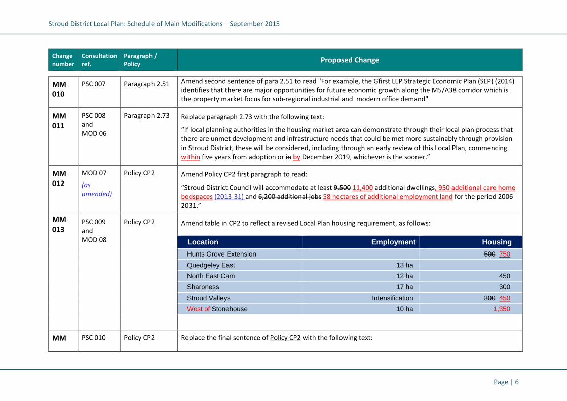
Stroud District Local Plan: Schedule of Main Modifications – September 2015
Page | 6
Change
number
Consultation
ref.
Paragraph /
Policy Proposed Change
MM
010
PSC 007 Paragraph 2.51 Amend second sentence of para 2.51 to read "For example, the Gfirst LEP Strategic Economic Plan (SEP) (2014)
identifies that there are major opportunities for future economic growth along the M5/A38 corridor which is
the property market focus for sub-regional industrial and modern office demand"
MM
011
PSC 008
and
MOD 06
Paragraph 2.73 Replace paragraph 2.73 with the following text:
“If local planning authorities in the housing market area can demonstrate through their local plan process that
there are unmet development and infrastructure needs that could be met more sustainably through provision
in Stroud District, these will be considered, including through an early review of this Local Plan, commencing
within five years from adoption or in by December 2019, whichever is the sooner.”
MM
012
MOD 07
(as
amended)
Policy CP2 Amend Policy CP2 first paragraph to read:
“Stroud District Council will accommodate at least 9,500 11,400 additional dwellings, 950 additional care home
bedspaces (2013-31) and 6,200 additional jobs 58 hectares of additional employment land for the period 2006-
2031.”
MM
013 PSC 009
and
MOD 08
Policy CP2 Amend table in CP2 to reflect a revised Local Plan housing requirement, as follows:
Location Employment Housing
Hunts Grove Extension 500 750
Quedgeley East 13 ha
North East Cam 12 ha 450
Sharpness 17 ha 300
Stroud Valleys Intensification 300 450
West of Stonehouse 10 ha 1,350
MM PSC 010 Policy CP2 Replace the final sentence of Policy CP2 with the following text:

Stroud District Local Plan: Schedule of Main Modifications – September 2015
Page | 7
Change
number
Consultation
ref.
Paragraph /
Policy Proposed Change
014 “Stroud District Council will give due consideration to the need to assist other local planning authorities in this
housing market area in meeting their unmet objectively assessed development and infrastructure needs,
including through an early review of this Local Plan, to ensure that any shortfalls that may arise in the delivery
of housing and employment growth (as identified through the other authority’s local plan process) are provided
for in sustainable locations.”
MM
015
MOD 09 Policy CP3 Amend Policy CP3 description of Fifth Tier settlements to read:
“These remaining settlements have a lack of basic facilities to meet day to day requirements. and no
development is envisaged. However, there could be scope for very limited development, should this be
required to meet a specific need identified by these communities in any Neighbourhood Plans.”
MM
016
MOD 10 Policy CP4 Amend Policy CP4 first paragraph to read:
“All development proposals shall accord with the Mini-Visions and have regard to the Guiding Principles for that
locality...”
MM
017
PSC 011 Policy CP4 Amend point 2 of Policy CP4 to:
"2. Place-shape and protect or enhance a sense of place (create a place with a locally-inspired or distinctive
character – whether historic, traditional or contemporary – using appropriate materials, textures and
colours, locally-distinctive architectural styles, working with the site topography, orientation and
landscape features; as well as conserve or enhance protecting or enhancing local biodiversity interest, the
historic environment and any heritage assets);”
MM
018
PSC 012 Policy CP5 Amend clause 3 criterion to:
"3. Be readily accessible by bus, bicycle and foot to shopping and employment opportunities, key services and
community facilities; and will contribute towards the provision of new sustainable transport infrastructure
to serve the area, in seeking to minimise the number and distance of single purpose journeys by private
cars."
MM MOD 11 Paragraph 2.92 “...In respect of legal agreements the Council anticipates producing a Supplementary Planning Document on the

Stroud District Local Plan: Schedule of Main Modifications – September 2015
Page | 8
Change
number
Consultation
ref.
Paragraph /
Policy Proposed Change
019 types of contributions that will be sought, triggers and how these will be calculated. The County Council has
also produced a Local Developer Guide to assist with discussions regarding developer contributions.”
MM
020
MOD 12 Policy CP6 Add to Policy CP6 the following final sentence:
“In determining the nature and scale of any provision, the Council will have regard to viability considerations
and specific site circumstances.”
MM
021
PSC 013 Key Diagram Add shape to show additional location for strategic housing growth to the west of Stonehouse.
Chapter 3: Making Places: Shaping the future of Stroud District
MM
022
PSC 014 Vision Diagram
1.0 Add shape to show additional location for strategic housing growth to the west of Stonehouse.
Chapter 3: Making Places: Shaping the future of the Stroud Valleys
MM
023
PSC 015 Vision Diagram
1.1 Add shape to show additional location for strategic housing growth to the west of Stonehouse.
MM
024
PSC 016 Paragraph 3.8 Guiding Principles for the Stroud Valleys: Amend "300" to "450".
MM
025
PSC 017 Paragraph 3.8 Guiding Principles for the Stroud Valleys: Add criterion 13:
"13. Address any identified constraints and recommendations referred to in the Stroud Infrastructure Delivery
Plan at this location."
MM
026
PSC 018 Paragraph 3.8 Opportunities, growth and key projects for the Stroud Valleys: Amend "300" to "450".

Stroud District Local Plan: Schedule of Main Modifications – September 2015
Page | 9
Change
number
Consultation
ref.
Paragraph /
Policy Proposed Change
MM
027
PSC 019 Paragraph 3.9 Opportunities, growth and key projects for the Stroud Valleys: Add bullet:
• "Habitat Regulations Assessment accompanying the Stroud District Local Plan and National Trust
‘Management Plan for Rodborough Common’"
MM
028
PSC 020 Paragraph 3.10 Key supporting evidence base for the Stroud Valleys: Add bullets for:
• “Strategic Flood Risk Assessment (Levels 1 and 2) and Flood Risk Sequential Test (2014)"
• "Stroud Infrastructure Delivery Plan (2014)"
MM
029
MOD 13 Policy SA1 Amend Policy SA1 first paragraph (further to PSC 021) to read:
Land within the Stroud Valleys at the following specific locations (as identified on the policies map) is allocated
for mixed use development, subject to viability and site specific circumstances, including at least 450
dwellings.”
MM
030
PSC 021 Policy SA1 Strategic Allocation Policy SA1 Stroud Valleys:
Amend "at least 300" to "at least 450".
Amend SA1c Ham Mill from "50" to "100".
Amend SA1d Brimscombe Port from "100" to "150".
Amend SA1f Wimberley Mills from "50" to "100".
MM
031
PSC 022 Policy SA1 Strategic Allocation Policy SA1 Stroud Valleys:
Amend criterion 5 by deleting "to meet the requirements of the Environment Agency".
Insert three additional criteria after criterion 5, to read:
"6. Adequate and timely infrastructure to tackle wastewater generated by that development in accordance
with the Infrastructure Delivery Plan and with agreement of the relevant water companies."
"7. Be supported by an acceptable Flood Risk Assessment, which also addresses the Flood Risk Sequential Test
document recommendations that accompanied this Local Plan."

Stroud District Local Plan: Schedule of Main Modifications – September 2015
Page | 10
Change
number
Consultation
ref.
Paragraph /
Policy Proposed Change
"8. Improvements to, and restoration of, the river corridor for biodiversity and flood risk enhancements."
(re-number remaining criteria)
MM
032
PSC 023 Policy SA1 Strategic Allocation Policy SA1 Stroud Valleys:
Amend former criterion 8 to read:
“8. 11. Contributions towards bus services to improve bus frequencies and quality, and to connect the
development with Stroud and adjoining settlements as part of a wider managed, safe and accessible
transport network.”
MM
033
PSC 024 Supporting text
for policy SA1:
Paragraph 3.13
Amend land at Dudbridge bullet:
• "Land at Dudbridge has potential, in addition to employment provision, for canal related tourism and retail
development provided it is compatible with the retail hierarchy. The site is significantly constrained by
functional floodplain and any redevelopment should not result in any net loss of flood storage. Safe and
emergency access considerations are paramount and will need to be fully resolved. A new access to the site
will be achieved from Dudbridge Road. There is potential to enhance significantly this gateway location into
the town and the setting of the canal."
MM
034
PSC 025 Supporting text
for policy SA1:
Paragraph 3.13
Amend Ham Mills bullet:
• "Ham Mills has potential for apartment housing and high quality office space, focussed on achieving the
conservation and adaptation of the historic mill and enhancement of its setting. No development should
take place in Flood Zones 3a and 3b at the south eastern end of the site. This area will act as a natural buffer
to the river. "
MM
035
PSC 026 Supporting text
for policy SA1:
Paragraph 3.13
Amend Brimscombe Mill bullet:
• “Brimscombe Mill has potential for both housing and employment redevelopment to achieve environmental
enhancements and to create a restored mill pond. The site should not be developed until the adjoining
Cotswold Canal has been reinstated from Brimscombe Port to Ocean Bridge, or until a site specific Flood
Risk Assessment demonstrates that the site can be safely developed, with more vulnerable development

Stroud District Local Plan: Schedule of Main Modifications – September 2015
Page | 11
Change
number
Consultation
ref.
Paragraph /
Policy Proposed Change
being located in Flood Zone 1 and without increasing flood risk on or off site."
MM
036
PSC 027
and
MOD 14
Supporting text
for policy SA1:
Paragraph 3.13
Amend Brimscombe Port bullet:
• "Brimscombe Port has opportunities to provide canal related facilities including moorings on a reinstated
stretch of water and port basin, enhancing listed buildings, providing new visitor facilities as well as housing
and high quality employment development. A new access from the A419 to the east of the site will be
achieved to improve site accessibility. The site should not be developed until the adjoining Cotswold Canal
has been reinstated from Brimscombe Port to Ocean Bridge, or until a site specific Flood Risk Assessment
demonstrates that the site can be safely developed without increasing flood risk on or off site."
MM
037
PSC 028 Supporting text
for policy SA1:
Paragraph 3.13
Amend Wimberley Mills and Dockyard Works bullet:
• "Wimberley Mills and Dockyard Works have potential, subject to the relocation of existing businesses, for
comprehensive redevelopment for housing and high quality employment space, including opportunities to
de-culvert the river. It is essential that development at Wimberley Mills de-culverts the River Frome to take
the site out of the floodplain. Development at Dockyard Works is expected to be phased after the
Wimberley development has been completed and to include de-culverting of the Toadsmoor Stream on-site
and reinstatement and maintenance of the adjacent Canal channel off site. These measures are to enable
development by reducing flood risk and improving river corridor functioning. Development will require a
comprehensive solution to achieve satisfactory access through Knapp Lane and Toadsmoor Road to the
A419."
Chapter 3: Making Places: Shaping the future of the Stonehouse cluster
MM
038
MOD 15 Vision 1.2
Stonehouse
Cluster
Amend the Stonehouse mini-vision (Vision 1.2) second paragraph as follows:
“Development to the west of Stonehouse will expand the existing Oldends/Stroudwater employment area, with
attendant transport and infrastructure improvements – including improved links to the town centre and
opportunities for all to make use of pleasant and safe ‘green links’ on foot or cycle. This will be a sustainable
workplace destination for the District, as well as a vibrant new community, served by its own local centre.”

Stroud District Local Plan: Schedule of Main Modifications – September 2015
Page | 12
Change
number
Consultation
ref.
Paragraph /
Policy Proposed Change
MM
039
PSC 029 Vision Diagram
1.2 Add shape to show additional location for strategic housing growth to the west of Stonehouse.
Amend label to read “West of Stonehouse: Major employment area and location for strategic housing and
employment growth over the plan period”
Add shape to show location for new local centre at the allocation West of Stonehouse. Amend map key to show
“Location for a new local centre (West of Stonehouse)”
MM
040
PSC 030 Paragraph 3.17 Guiding Principles for the Stonehouse cluster: Amend first criterion to read:
"1. This area will continue to be a major employment focus for the District. Land to the west of Stonehouse
will be a focus for the District's strategic growth, providing 1,350 homes and up to 2,000 jobs by 2031".
MM
041
PSC 031 Paragraph 3.17 Guiding Principles for the Stonehouse cluster: Add criterion 12:
"12. Address any identified constraints and recommendations referred to in the Stroud Infrastructure Delivery
Plan at this location."
MM
042
PSC 032 Paragraph 3.18 Opportunities, growth and key projects for the Stonehouse cluster: Replace first bullet point with:
• "1,350 new homes plus significant employment development (up to 2,000 jobs) on land to the west of
Stonehouse".
Add new bullet point:
• "Provision of a new primary school, local centre, community facilities and open space".
MM
043
PSC 033 Paragraph 3.19 Key supporting evidence base for the Stonehouse cluster: Add:
• "Strategic Flood Risk Assessment (Levels 1 and 2) and Flood Risk Sequential Test (2014)" and
• "Stroud Infrastructure Delivery Plan (2014)"
MM
044
PSC 034
and
New Policy SA2 Delete current Strategic Allocation Policy SA2 North of Stonehouse Industrial Estate and map. Replace with new
Policy SA2 West of Stonehouse:

Stroud District Local Plan: Schedule of Main Modifications – September 2015
Page | 13
Change
number
Consultation
ref.
Paragraph /
Policy Proposed Change
MOD 16
MOD 17
MOD 18
Policy SA2 West of Stonehouse
Land west of Stonehouse, as identified on the policies map, is allocated for a mixed use development including
residential, employment and community uses. A development brief incorporating a design vision and a
masterplan, to be approved by the District Council, will detail the way in which the land uses and infrastructure
will be developed in an integrated and co-ordinated manner. This will address the following:
1. 1350 dwellings, including at least 405 (30%) affordable dwellings, unless viability testing indicates
otherwise
2. 10 hectares of B1, B2 and B8 employment land
3. A local centre incorporating local retail and community uses to meet the needs of the development
4. A 2 form entry primary school and contributions to secondary school provision
5. Contributions to local community services
6. Accessible structural natural greenspace, allotments and formal public outdoor playing space including
sports pavilion/community building
7. Structural landscaping buffer around Nastend and to the east of Nupend incorporating existing hedgerows
and trees
8. Long term management and maintenance of open spaces to deliver local biodiversity targets
9. The acceptable management, maintenance and disposal of surface water including sustainable urban
drainage systems (SuDs)
10. Restored watercourse corridor that enhances biodiversity and water quality and improves flood storage
and flow routes
11. Adequate and timely infrastructure to tackle wastewater generated by development in agreement with
the relevant water companies.
12. Opportunities to improve transport connectivity with Stonehouse and Stonehouse town centre for
pedestrians, cyclists, public transport and private car
13. Cycle and pedestrian routes through the development connecting Nastend and Nupend with the town
centre, Stroudwater Industrial Estate and Oldends Lane and footpath links from the development to the
surrounding rural network, including improvements to the canal towpath
14. Primary vehicular access from A419 Chipmans Platt roundabout and additional vehicular access from
Brunel Way and Oldends Lane

Stroud District Local Plan: Schedule of Main Modifications – September 2015
Page | 14
Change
number
Consultation
ref.
Paragraph /
Policy Proposed Change
15. Traffic calming measures within the development and locality as approved by the Highways Authority
16. Bus stops and shelters at appropriate locations to serve the new development
17. Contributions towards bus services to improve bus frequencies and quality and to connect the
development with Stonehouse and Stonehouse the town centre
18. Contributions towards the provision of a new railway station at Stonehouse, subject to the plans of
Network Rail
19. Address any identified constraints and recommendations referred to in the Stroud Infrastructure Delivery
Plan in this location
20. Phasing arrangements to ensure that employment land is developed and completed in parallel with
housing land completions and community and retail provision is made in a timely manner.
MM
045
PSC 035
and
MOD 19
MOD 20
MOD 21
Paragraphs 3.20
- 3.21
Supporting text
to new Policy
SA2
Delete supporting text and replace with:
“Land west of Stonehouse is identified as a sustainable urban extension to Stonehouse, which will deliver a high
quality mixed use development including housing, employment, local centre and open space that meets the
day-to-day needs of its residents.
Land west of Stonehouse is located north of the A419 between the Chipmans Platt roundabout and the
Stroudwater Industrial Estate. The site comprises two parcels of land. Land to the south and west of Nastend
will be retained primarily in existing uses but offering opportunities for ecological enhancement. The remaining
land to the north and east of Nastend and the Industrial Estate will be developed for residential, employment
and community uses including landscaping and open space.
The site could accommodate 1350 dwellings, incorporating at least 30% affordable housing unless
independently scrutinised viability testing indicates otherwise, a local centre and 10 hectares of B1, B2 and B8
employment land.
Employment land should include high quality office space and opportunities should be explored for small,
incubator and grow on business units and for provision which facilitates industrial symbiosis. Phasing
arrangements will be put in place to ensure that employment land is developed and completed in parallel with
housing land completions.

Stroud District Local Plan: Schedule of Main Modifications – September 2015
Page | 15
Change
number
Consultation
ref.
Paragraph /
Policy Proposed Change
A local centre will be developed to incorporate local shopping, community uses and a 2 form entry primary
school to meet the needs of the development and will be phased to ensure the new community has access to
facilities in a timely manner. Contributions will also be required to secondary school provision and community
services, for example funding for a community development officer and for extending opening hours at
Stonehouse library or other library infrastructure improvements. Options for additional healthcare provision
will be investigated.
The site will deliver a high quality sustainable and distinctive mixed use development accommodated in a series
of interlinked neighbourhoods within an extensive landscape framework. The design vision and form and design
of the main perimeter elevations will be submitted to and agreed by the Council before reserved matters
applications can be considered. Subsequent applications will be required to demonstrate how they conform to
the design vision and masterplan. This will ensure that design quality is maintained through the build out of the
development.
The visual setting of Nastend Farm as generally experienced from Nastend Lane will be preserved and structural
landscaping around Nastend and to the east of Nupend will maintain the separate character of these
settlement areas. Accessible structural natural greenspace, allotments and formal public outdoor playing space
in accordance with local standards and to meet needs arising from the development will be provided on-site.
Long term management and maintenance of open spaces will be designed to deliver local biodiversity targets,
including for orchards, Great-crested Newts and Barn Owls.
The Council will seek opportunities to reduce the overall level of flood risk in the area through the layout and
form of the development. Development here will need to comply with habitats regulation assessment
recommendations and should include the appropriate application of sustainable drainage systems and create
space for flooding to occur by improving flood flow pathways and by identifying, allocating and safeguarding
open space for flood storage and biodiversity enhancements both on-site and off site.
An archaeological evaluation has been carried out on the site and provision will be made for a programme of
archaeological mitigation.
The site is situated 4.5km east of the Severn Estuary SPA/Ramsar site. Due to the size of the development it will
be necessary for the applicants to supply a report to inform a Habitat Regulations Assessment, which will

Stroud District Local Plan: Schedule of Main Modifications – September 2015
Page | 16
Change
number
Consultation
ref.
Paragraph /
Policy Proposed Change
specifically investigate the potential recreational impacts of the new dwellings on the bird populations of the
SPA/Ramsar site and consequently detail any measures that may be required to avoid a likely significant effect.
Measures could include avoiding an overall increase in usage of the paths along the Estuary by providing
alternative dog walking opportunities that would meet the local need, or by contributing to the emerging
impact avoidance strategy for the Severn Estuary SPA and Special Area of Conservation (SAC).
Vehicular access will be from A419 Chipmans Platt roundabout and from Oldends Lane. Opportunities to
improve transport connectivity with Stonehouse and Stonehouse town centre will be investigated in
accordance with a transport assessment to be submitted with the application. In addition, cycle and pedestrian
routes will be provided through the development to Stroudwater Industrial Estate and Oldends Lane and
footpaths will link the development to the surrounding rural network. Contributions will be made to ensure the
canal towpath between Eastington and Stonehouse can accommodate the predicted increase in usage.
Contributions towards improving the frequency and quality of local bus services to connect the development
with Stonehouse and Stonehouse the town centre will also be provided and towards the provision of a new
station at Stonehouse, subject to the plans of Network Rail.”
MM
046
PSC 036 New Policy SA2
Diagram
Insert new map showing the following site boundary for new allocation SA2 west of Stonehouse:

Stroud District Local Plan: Schedule of Main Modifications
Change
number
Consultation
ref.
Paragraph /
Policy
Chapter 3: Making Places: Shaping the future of Cam and Dursley
MM
047
PSC 037 Paragraph 3.22 Amend Paragraph 3.22:
“Cam and Dursley
Schedule of Main Modifications – September 2015
Proposed Change
Chapter 3: Making Places: Shaping the future of Cam and Dursley
Amend Paragraph 3.22:
“Cam and Dursley adjoin each other and make up the District’s second largest population (after the Stroud
Page | 17
adjoin each other and make up the District’s second largest population (after the Stroud

Stroud District Local Plan: Schedule of Main Modifications – September 2015
Page | 18
Change
number
Consultation
ref.
Paragraph /
Policy Proposed Change
Valleys). This large conurbation sits nestled at the foot of the Cotswold hills (the AONB covers the southern half
of this parish cluster area). The Cotswold Way runs through Dursley town centre, a conservation area which has
recently seen some public realm improvements, as well as a major new supermarket development. The former
historic market town has a population of over 6,500; whilst Cam has a small village centre, which has expanded
to serve its larger population of 8,000+”.
MM
048
PSC 038 Paragraph 3.23 Amend Paragraph 3.23:
"Both communities historically were a centre for cloth manufacturing. Other industries later boomed in Dursley
town, including engine manufacture, furniture production and pin-making. The area has suffered from a degree
of deprivation that has impacted on the local communities; according to 2011 census results, this is particularly
acute in the area of education, skills and training; while the emerging 2020 Cam and Dursley Community Plan*
highlights that businesses identify a local skills gap. A residents’ survey in 2007 showed long-term worklessness
was prevalent in the “Vale Vision” area, with 60.6% of workless respondents having been out of work for 2
years or more. (Vale Vision was formed to produce a community Strategic Plan and represents Cam, Dursley
and surrounding parishes, covering a population in excess of 18,000) (*Vale Vision Development Trust Ltd is a
community-led enterprise whose aims include improving and enhancing the quality of life for residents of Cam ,
Dursley and the surrounding parishes – a population in excess of 18,000. They were commissioned to prepare a
Community Strategic Plan for the area)."
MM
049
MOD 22 Paragraph 3.25 Amend Cam and Dursley Guiding Principles (para. 3.25, first point) to read:
“1. Cam and Dursley will be a focus for the District’s strategic growth, providing up to 450 homes and up to
1,500 new jobs over the plan period (up to 2031)...”
MM
050
PSC 039 Paragraph 3.25 Guiding Principles for Cam and Dursley: Add criterion:
"12. Address any identified constraints and recommendations referred to in the Stroud Infrastructure Delivery
Plan at this location."
MM
051
MOD 23 Paragraph 3.26 Amend Cam and Dursley Opportunities, growth and key projects (para. 3.26) to read:
• Up to 450 Homes plus significant employment development (up to 1500 jobs) to the north east of Cam”

Stroud District Local Plan: Schedule of Main Modifications – September 2015
Page | 19
Change
number
Consultation
ref.
Paragraph /
Policy Proposed Change
MM
052
PSC 040 Paragraph 3.27 Key supporting evidence base for Cam and Dursley: Add:
• "Strategic Flood Risk Assessment (Levels 1 and 2) and Flood Risk Sequential Test (2014)"
• "Stroud Infrastructure Delivery Plan (2014)"
MM
053
PSC 041 Policy SA3 Strategic Allocation Policy SA3: North East of Cam:
Amend criterion 4 by adding "and enhanced flood plain storage capacity."
Amend criterion 7 by deleting "to meet the requirements of the Environment Agency".
Add new criterion:
"Adequate and timely infrastructure to tackle wastewater generated by the development, in agreement with
the relevant water company, and including any other constraints referred to in the Stroud Infrastructure
Delivery Plan."
(Amend numbering of subsequent criteria).
MM
054
PSC 042 Paragraph 3.31
Add to supporting text "The Council will seek opportunities to reduce the overall level of flood risk in the area,
improve flood storage capacity and enhance biodiversity through the layout, use and form of the
development.”
MM
055
PSC 043 Paragraph 3.33 Amend first sentence of the paragraph to read:
“A linear landscaped park along the line of the river corridor with provide natural greenspace, increased flood
storage and adjacent public outdoor playing space, including changing rooms / community building.”
Chapter 3: Making Places: Shaping the future of the Gloucester fringe
MM
056
MOD 24 Paragraph 3.39 Amend Gloucester Fringe Guiding Principles (para. 3.39, first point) to read:
“1. Hunts Grove will continue to be a focus for the District’s strategic growth, providing a further 500750
homes through an extension to the development, bringing the total up to 2,2502,500 homes over the plan
period (up to 2031) and becoming effectively a “Local Service Centre” in our settlement hierarchy. The

Stroud District Local Plan: Schedule of Main Modifications – September 2015
Page | 20
Change
number
Consultation
ref.
Paragraph /
Policy Proposed Change
Hunts Grove Extension, together with adjacent Quedgely East, will represent a single key focus for
development allocation at on the Gloucester Fringe.”
MM
057
PSC 044 Paragraph 3.39 Guiding Principles for the Gloucester Fringe: Amend Criterion 6 to:
"6. Improve non-motorised connections between the City suburbs and the rural hinterland; enhance the
existing good transport links and movement corridors and allow good permeability through any new
development for walkers and cyclists. Development must not have a significant detrimental impact on the
safe and efficient operation of Junction 12 of the M5."
MM
058
PSC 045 Paragraph 3.39 Guiding Principles for the Gloucester Fringe: Add new criterion:
"11. Address any identified constraints and recommendations referred to in the Stroud Infrastructure Delivery
Plan at this location."
MM
059
MOD 25
(as
amended)
Paragraph 3.40 Amend Gloucester Fringe Opportunities, growth and key projects (para. 3.40) as follows:
• Utilise land to the south of the existing approved Hunts Grove development area (1,750 homes already
permitted under construction), as an extension to deliver 500750 more homes and supporting
infrastructure as an integral part of the whole Hunts Grove new community area. Through
comprehensive masterplanning demonstrate how the extension would complement the existing
development to deliver a cohesive, well-connected and accessible community with convenient access
to local services and facilities, including basic convenience shopping and community infrastructure a
new local centre as part of the development, to include basic convenience shopping and community
facilities; opportunity to provide a comprehensive masterplan for the whole Hunts Grove area
• A focus for employment growth and intensification at key employment sites near to Hunts Grove
including an additional 13 ha at Quedgeley East
• Increasing open space provision as there is a 3.7 ha current shortage in outdoor play space
• Land at Naas Lane (on the Hunts Grove development site) has been safeguarded as a location for a
potential new railway halt station. The land should continue to be safeguarded as part of any new

Stroud District Local Plan: Schedule of Main Modifications – September 2015
Page | 21
Change
number
Consultation
ref.
Paragraph /
Policy Proposed Change
masterplan proposals and appropriate Ccontributions sought from development towards the provision
of a railway station on the Gloucester-Bristol line, subject to the plans of Network Rail
• New M5 Motorway Service Area (at Ongers Farm, Brookthorpe parish)
• Land at Javelin Park is allocated in the Waste Core Strategy for a strategic residual recovery facility
MM
060
PSC 046 Paragraph 3.41 Key supporting evidence base for the Gloucester Fringe: Add:
• "Strategic Flood Risk Assessment (Levels 1 and 2) and Flood Risk Sequential Test (2014)"
• "Stroud Infrastructure Delivery Plan (2014)"
MM
061
MOD 26
and
PSC 047
PSC 048
Policy SA4 Amend Policy SA4 to read:
Hunts Grove Extension
The full extent of the Hunts Grove new community is outlined on the Policies Map. The extension to the
approved masterplan, on land to the south of Harsfield Lane, is also identified on the Policies Map. This is
allocated for housing and supporting infrastructure. The new community comprises the committed Hunts
Grove development area (1,750 dwellings and supporting infrastructure) and the Hunts Grove extension, on
land to the south of Haresfield Lane, which will deliver an additional 750 dwellings, including 225 affordable
dwellings (unless viability testing indicates otherwise).
The development proposals for the Hunts Grove extension should be accompanied by a comprehensive
masterplan, to be approved by the local planning authority, which demonstrates how the land uses and
proposed infrastructure forming part of the Hunts Grove extension will be delivered as an integrated and
compatible component of the overall Hunts Grove masterplan. The development proposals will address the
following: additional development will be integrated into the Hunts Grove new community and how the
following components will be delivered to ensure that the new community is delivered in a cohesive and
sustainable manner:
1. The provision of an additional 500 dwellings within the overall new community (to create an urban extension
of 2,250 dwellings) including 150 affordable dwellings, unless viability testing indicates otherwise
2. 1. A local centre of sufficient scale to meet the day-to-day needs of the Hunts Grove new community as a

Stroud District Local Plan: Schedule of Main Modifications – September 2015
Page | 22
Change
number
Consultation
ref.
Paragraph /
Policy Proposed Change
whole, incorporating local retail and community uses
3. 2. A primary school of sufficient scale to meet the needs of the development Hunts Grove new community
4. 3. Accessible natural greenspace and publicly accessible outdoor playing-space, with appropriately
scaled changing facilities
5. 4. Structural landscaping buffer around the southern and western boundaries of the development
incorporating existing hedgerows and trees, as appropriate
6. 5. The acceptable management and disposal of surface water including sustainable urban drainage
systems (SuDs) to meet the requirements of the Environment Agency
7. 6. Adequate and timely infrastructure to tackle wastewater generated by the development, in
agreement with the relevant water company.
8. 7. No built development will be located in Flood Zones 2, 3a or 3b. The Council will also seek
opportunities to reduce the overall level of flood risk in the area and improve flood storage capacity
through the layout, use and form of the development
7. 9.8. Cycle and pedestrian routes through the development connecting with Haresfield Lane and the
existing Hunts Grove development
8. 10.9. Primary vehicular access from the principal A38 junction serving the Hunts Grove new community,
with secondary access from Waterwells Drive, as part of a wider managed, safe and accessible
transport network, identified in the evidence base transport assessments
9. 11.10. Access arrangements within the site to encourage use of public and sustainable modes of transport
and to encourage lower vehicle speeds
10.12.11. Bus stops and shelters at appropriate locations to serve the new development
11.13.12. Contributions towards bus services to improve bus frequencies and quality; and
12.14.13. Safeguarding of land for the provision of a potential future railway station and Aappropriate
contributions towards the opening of the Hunts Grove railway station (subject to the plans of Network

Stroud District Local Plan: Schedule of Main Modifications – September 2015
Page | 23
Change
number
Consultation
ref.
Paragraph /
Policy Proposed Change
Rail).
MM
062
MOD 27 Supporting text
to Policy SA4:
Paragraph 3.42
Amend supporting paragraph 3.42, final sentence, to read:
“...The extension to Hunts Grove is intended to complete the development provide certainty about the ultimate
extent of development in this area and to provide further flexibility in delivering the required overall amount of
housing. It will also and support and extend the community infrastructure planned for in this location.”
MM
063
PSC 049
and
MOD 28
Supporting text
to Policy SA4:
Paragraph 3.43
Amend supporting paragraph to reflect revised site boundary:
“The Hunts Grove extension is located on land south of Haresfield Lane and north of the M5 junction 13. The
site comprises approximately 2634 hectares of land to be developed for residential, supporting infrastructure,
including landscaping and open space. Areas identified within flood zones 2, 3a and 3b will be kept as open
space.”
MM
064
MOD 29 Supporting text
to Policy SA4:
Paragraph 3.45
Amend supporting paragraph to reflect revised housing numbers on the site:
“The extension to the Hunts Grove masterplan will deliver a net increase of 500750 dwellings. When complete,
the new community will comprise 2,2502,500 dwellings together with the necessary supporting infrastructure,
employment, social, commercial and community uses, which will include a primary school of sufficient size to
meet the needs of the development.”
MM
065
MOD 30 Site Allocation
SA4 map
Delete map showing SA4 and replace with new map showing revised site boundary, to include a further area of
land to be allocated as part of the Hunts Grove Extension:

Stroud District Local Plan: Schedule of Main Modifications – September 2015
Page | 24
Change
number
Consultation
ref.
Paragraph /
Policy Proposed Change
MM
066
PSC 050 Policy SA4a Amend the second sentence of Strategic Allocation Policy SA4a (Quedgeley East) to read as follows:
“...The development of the site will provide contributions to off-site highway works including public transport,
pedestrian and cycle links to Gloucester city, Stonehouse and Stroud, in accordance with the recommendations
of the evidence base transport assessments.”
MM
067
PSC 051 Policy SA4a Add the following sentence at the end of Strategic Allocation Policy SA4a (Quedgeley East):
"...The development must help to reduce the flood risk to the adjacent M5 Motorway by providing floodplain
storage on site and keeping the floodplain and flow paths as open space."
SA4 Hunts Grove
Extension
Proposed revision
to site boundary
here
SA4 Existing
Hunts Grove Development

Stroud District Local Plan: Schedule of Main Modifications – September 2015
Page | 25
Change
number
Consultation
ref.
Paragraph /
Policy Proposed Change
MM
068
PSC 052 Supporting text
to Policy SA4a:
After 3.47
Insert a new paragraph which states:
"The Council will seek opportunities to reduce the overall level of flood risk in the area including flooding to the
M5 motorway, through the layout and form of the development, the appropriate application of sustainable
drainage systems and increased flood storage capacity. There will be no built development in flood zones 2, 3a
and 3b. If car parking cannot be avoided in flood risk locations it should only be allowed if appropriate
management plans are agreed and implemented. The plans must demonstrate appropriate flood resilience
measures including safe access and escape routes in the event of a flood. A site specific Flood Risk Assessment
will need to accompany any planning application to address the recommendations within the Sequential Test
Document and the SFRA Level 2."
Chapter 3: Making Places: Shaping the future of the Berkeley cluster
MM
069
MOD 31 Paragraph 3.48 Amend paragraph 3.48, final sentence, to read:
“The growth of Sharpness Docks with increased shipping has not progressed as envisaged in the previous Local
Plan: the former employment allocations have not been taken up ands accessibility is an issue. Whilst Sharpness
Docks is a thriving and busy Port, the former employment allocations have not been taken up as envisaged in
the 2005 Local Plan and accessibility remains an issue.”
MM
070
MOD 32 Vision 1.5
Berkeley Cluster Amend the mini vision for the parishes around Berkeley. Add the following wording to the second sentence
within the second paragraph:
“...Improvements to the working environment and leisure amenities at nearby Sharpness and proposals for the
Gloucestershire Science and Technology Park at the former Berkeley Nuclear Power Station site will provide a
local boost, and will act acting together with other attractions (including Berkeley Castle, Jenner Museum,
Slimbridge Wildfowl and Wetlands trust and several safe and attractive walking and cycling routes) to raise the
profile of this part of the District...”
MM
071
MOD 33
and
PSC 053
Paragraph 3.51 Amend Berkeley Cluster Guiding Principles as follows:
1. “A vision for the regeneration of Sharpness Docks will be progressed including up to 300 new homes
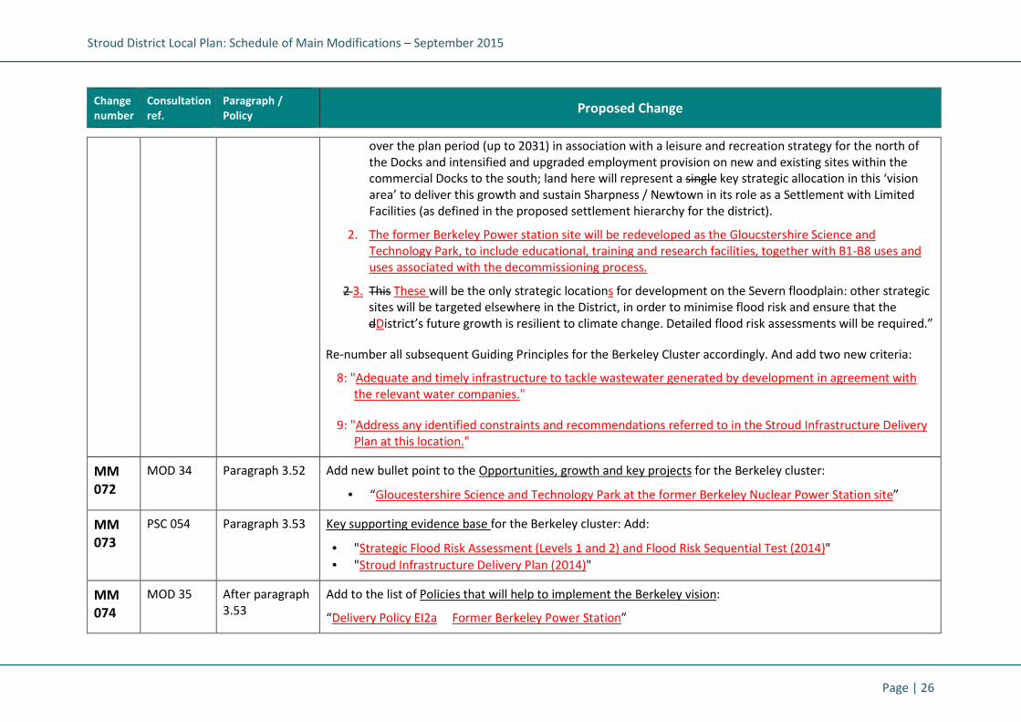
Stroud District Local Plan: Schedule of Main Modifications – September 2015
Page | 26
Change
number
Consultation
ref.
Paragraph /
Policy Proposed Change
over the plan period (up to 2031) in association with a leisure and recreation strategy for the north of
the Docks and intensified and upgraded employment provision on new and existing sites within the
commercial Docks to the south; land here will represent a single key strategic allocation in this ‘vision
area’ to deliver this growth and sustain Sharpness / Newtown in its role as a Settlement with Limited
Facilities (as defined in the proposed settlement hierarchy for the district).
2. The former Berkeley Power station site will be redeveloped as the Gloucstershire Science and
Technology Park, to include educational, training and research facilities, together with B1-B8 uses and
uses associated with the decommissioning process.
2 3. This These will be the only strategic locations for development on the Severn floodplain: other strategic
sites will be targeted elsewhere in the District, in order to minimise flood risk and ensure that the
dDistrict’s future growth is resilient to climate change. Detailed flood risk assessments will be required.”
Re-number all subsequent Guiding Principles for the Berkeley Cluster accordingly. And add two new criteria:
8: "Adequate and timely infrastructure to tackle wastewater generated by development in agreement with
the relevant water companies."
9: "Address any identified constraints and recommendations referred to in the Stroud Infrastructure Delivery
Plan at this location."
MM
072
MOD 34 Paragraph 3.52 Add new bullet point to the Opportunities, growth and key projects for the Berkeley cluster:
• “Gloucestershire Science and Technology Park at the former Berkeley Nuclear Power Station site”
MM
073
PSC 054 Paragraph 3.53 Key supporting evidence base for the Berkeley cluster: Add:
• "Strategic Flood Risk Assessment (Levels 1 and 2) and Flood Risk Sequential Test (2014)"
• "Stroud Infrastructure Delivery Plan (2014)"
MM
074
MOD 35 After paragraph
3.53
Add to the list of Policies that will help to implement the Berkeley vision:
“Delivery Policy EI2a Former Berkeley Power Station”

Stroud District Local Plan: Schedule of Main Modifications – September 2015
Page | 27
Change
number
Consultation
ref.
Paragraph /
Policy Proposed Change
MM
075
PSC 055
and
PSC 056
Policy SA5 Strategic Allocation Policy SA5: Sharpness Docks:
Amend criterion 7 by deleting "to meet the requirements of the Environment Agency".
Amend criterion 8 to "Adequate and timely contributions towards improvements to the wastewater and
sewerage network in agreement with the relevant Water Companies."
Amend criterion 10 by adding “including safe access and egress during flood events."
Add new criterion 14 "A sequential approach to site layout and flood risk, with more vulnerable development
being located within Flood Zone 1."
Insert the following text at the end of the policy:
"Planning applications for Sharpness Docks must ensure no adverse effect will occur on the integrity of the
Severn Estuary SAC/SPA/Ramsar site, otherwise planning permission will not be granted.”
MM
076
PSC 056 Supporting text
to Policy SA5:
after 3.55
Insert two new paragraphs to the supporting text for Policy SA5, after paragraph 3.55:
"The development must be laid out and designed in order to avoid adverse effects on the Severn Estuary
SAC/SPA/Ramsar site. New residential units will be located such that the Sharpness Ship Canal separates them
from the SAC/SPA/Ramsar site thus avoiding urban pressures such as fly tipping and cat predation. B Class
employment will be located wholly to the south of the Estate to maximise its separation from the
SAC/SPA/Ramsar site given the potential of this type of development to result in noise and other disturbance.
The ‘island site’ at the north-west of the estate on which up to 50 dwellings, fixed camping and the hotel and
holiday lodges will be situated must be delivered in such a way as to ensure that the hotel is adequately
screened from the SPA/Ramsar site and that no direct access is possible onto the foreshore from the island.
To demonstrate no adverse effect, planning applications for Sharpness Docks must include
• A visitor survey of the Severn Estuary SAC/SPA/Ramsar site within the vicinity of Sharpness Docks in order
to inform an evaluation of what increase in recreational activity in the SAC/SPA/Ramsar site would result
(from the presence of the hotel and campsite in addition to new housing), define management
interventions required to ensure no adverse effect and form a basis for future monitoring;
• A management plan for protecting the natural environment (focussed on the interest features of the

Stroud District Local Plan: Schedule of Main Modifications – September 2015
Page | 28
Change
number
Consultation
ref.
Paragraph /
Policy Proposed Change
SAC/SPA/Ramsar site), particularly with regard to recreational pressure;
• A non-breeding bird survey of the Sharpness Docks site in order to identify any parts of the site which
currently constitute important habitat for the SPA/Ramsar site bird populations and set out any necessary
mitigation; A management plan for protecting the natural environment (focussed on the interest features
of the SAC/SPA/Ramsar site), particularly with regard to recreational pressure;
• A non-breeding bird survey of the Sharpness Docks site in order to identify any parts of the site which
currently constitute important habitat for the SPA/Ramsar site bird populations and set out any necessary
mitigation;
• An analysis of construction and operational noise within the SAC/SPA/Ramsar site due to the Sharpness
Docks development compared to the current noise baseline and details of any mitigation measures (such
as seasonal restrictions on some activities, damping of pile-hammers, or use of close-board fencing during
construction) that will be deployed to ensure that disturbance of SPA/Ramsar site birds does not occur;
• Careful lighting design, both with regard to security lighting during construction and permanent lighting
during occupation, to ensure no increase in illumination of the SAC/SPA/Ramsar site. Lighting levels in the
site should not exceed levels above the ILP classification E1 (Natural Lighting Zone that is intrinsically dark)
for the Severn Estuary and its foreshore;
• Details of potential mitigation measures, such as identifying and securing bird refuge areas within or close
to the development area, and of potential on-site management (to mitigate both recreational pressure
during the non-breeding period and incidences of fly tipping) that would be undertaken to ensure no
adverse effect.
• A sediment contamination assessment as part of the marina planning application; and
• Landscaping to create appropriate visual and noise buffers between the development and the SPA/Ramsar
site.
MM
077
PSC 057 Supporting text
to Policy SA5:
Paragraph 3.56
Amend paragraph to read:
"Wastewater and sewerage infrastructure at Sharpness has constraints beyond 2020 and the development will
be expected to make contributions towards necessary improvements to the networks. The Level 2 SFRA
Addendum for Sharpness and the Council's Sequential Test document contain important flood risk advice for
developing the site. Key aspects will be ensuring development has safe access and egress in times of flood,

Stroud District Local Plan: Schedule of Main Modifications – September 2015
Page | 29
Change
number
Consultation
ref.
Paragraph /
Policy Proposed Change
locating development outside the floodplain and incorporating space for flood water to reduce flood risk."
MM
078
PSC 058 Policy SA5a Amend Strategic Allocation Policy SA5a (South of Severn Distribution Park) to:
"Land south of Severn Distribution Park (9.8 hectares), as identified on the proposals map, is allocated for B2-B8
employment uses. The development of the site will provide contributions to off-site highway works including
public transport, pedestrian and cycle links to Newtown, Berkeley and Dursley, and other infrastructure
including flood defences and biodiversity.
Development must be located towards the part of the site at lowest risk in the north eastern extent of the site
(Flood Zone 1). Wherever possible, identified hazard risk areas should be kept as open space, or the type of
development should be compatible with the risk areas. It must also be ensured that safe access to and egress
from the site can be achieved for the 1 in 200 year climate change scenario."
MM
079
PSC 059 Supporting text
to Policy SA5a:
After 3.59
Add new paragraph which states:
"The Council will seek opportunities to reduce the overall level of flood risk in the area through the layout and
form of the development and financial contributions towards the flood defences and their maintenance where
appropriate. Development here will need to comply with habitats regulation assessment recommendations and
should include the appropriate application of sustainable drainage systems and create space for flooding to
occur by improving flood flow pathways."
Chapter 3: Making Places: Shaping the future of the Severn Vale
MM
080
PSC 060 Paragraph 3.64 Guiding Principles for the Severn Vale:
Add criterion 7: "Address any identified constraints and recommendations referred to in the Stroud
Infrastructure Delivery Plan at this location."
MM
081
PSC 061 Paragraph 3.66 Key supporting evidence base for the Severn Vale: Add:
• "Strategic Flood Risk Assessment (Levels 1 and 2) and Flood Risk Sequential Test (2014)"
• "Stroud Infrastructure Delivery Plan (2014)"
Stroud District Local Plan: Schedule of Main Modifications – September 2015
Page | 30
Change
number
Consultation
ref.
Paragraph /
Policy Proposed Change
Chapter 3: Making Places: Shaping the future of the Wotton cluster
MM
082
PSC 062 Paragraph 3.71 Guiding Principles for the Wotton cluster: Add new criterion:
"Address any identified constraints and recommendations referred to in the Stroud Infrastructure Delivery Plan
at this location."
Chapter 3: Making Places: Shaping the future of the Cotswold cluster
MM
083
PSC 063 Paragraph 3.77 Guiding Principles for the Cotswold cluster: Add new criterion:
"Address any identified constraints and recommendations referred to in the Stroud Infrastructure Delivery Plan
at this location."
Chapter 5: Homes and Communities
MM
084
PSC 064 SO1
Fig.4 (map)
• Adjust key and re-colour the parishes of Eastington, Stroud, Brimscombe & Thrupp, Minchinhampton to
represent revised housing numbers at allocations SA1 and SA2.
• Add asterix shape to represent housing allocation SA2 at west of Stonehouse.
MM
085
MOD 36 Policy CP8 Amend Policy CP8, bullet point 6. To read:
“Major residential development proposals will be expected to enhance biodiversity on site and, where
appropriate, through a network of multi-functional green spaces, which support the natural and ecological
processes.”
MM
086
MOD 37 as
amended
Supporting text
to Policy CP9:
Paragraphs 4.15
– 4.18
Add to the original Submission Draft supporting text for Core Policy CP9 (paragraphs 4.15 – 4.18) with relevant
extracts from MOD 37, as follows:
Affordable housing
It is important that new residential development meets the identified housing needs in the District. This means
providing the right mix of dwelling sizes and tenures, including affordable housing. The Council undertakes

Stroud District Local Plan: Schedule of Main Modifications – September 2015
Page | 31
Change
number
Consultation
ref.
Paragraph /
Policy Proposed Change
Housing Needs Surveys on a five year cycle, alongside Strategic Housing Market Assessments which highlight
the need for affordable housing as well as for market housing. Affordable housing is defined as social rented,
affordable rented and intermediate housing, provided to eligible households whose needs are not met by the
market.
A SHMA update in 2015 identified an overall unadjusted need for affordable housing of 446 dwellings per
annum after taking into account the committed supply. In terms of tenure, the SHMA update indicated that the
majority of need for affordable housing is for affordable or social rented properties. However, viability evidence
indicates that a tenure split of 50% affordable rent and 50% intermediate tenure would be viable for the
majority of sites.
Affordability is expected to worsen over the next 20 years increasing the impetus for a greater supply of
affordable housing within the District. The Council believes that both the very high level of housing need and
the limited supply of land for housing justify a low threshold for affordable housing provision. Therefore the
Council will require at least 30% of dwellings to be affordable in all housing, including extra care, schemes
meeting the size threshold set out in the policy, unless unusually high costs associated with the development of
the site, or the realisation of other planning objectives which take priority, make this not viable.
Within developments of 11 dwellings or over, other than in exceptional circumstances, affordable housing
should be provided on site. This provision should be well integrated with the wider site and indistinguishable by
either design or location from the market housing. The Council will also support the buying of land, including
through compulsory purchase where necessary, on which affordable homes could be built.
Within the Cotswolds Area of Outstanding Natural Beauty sites capable of providing between 6 and 10
dwellings (net) will be required to make a financial contribution equal to the provision of at least 30%
affordable housing (where viable) which will be commuted until after completion of the dwellings within the
development. The sum will be calculated on the basis of each notional affordable housing unit being valued at
55% open market value of the market units, unless local circumstances justify an alternative amount.
Other than in exceptional circumstances, affordable housing should be provided on site. This provision should
be well integrated with the wider site and indistinguishable by either design or location from the market
housing. The Council will also support the buying of land, including through compulsory purchase where
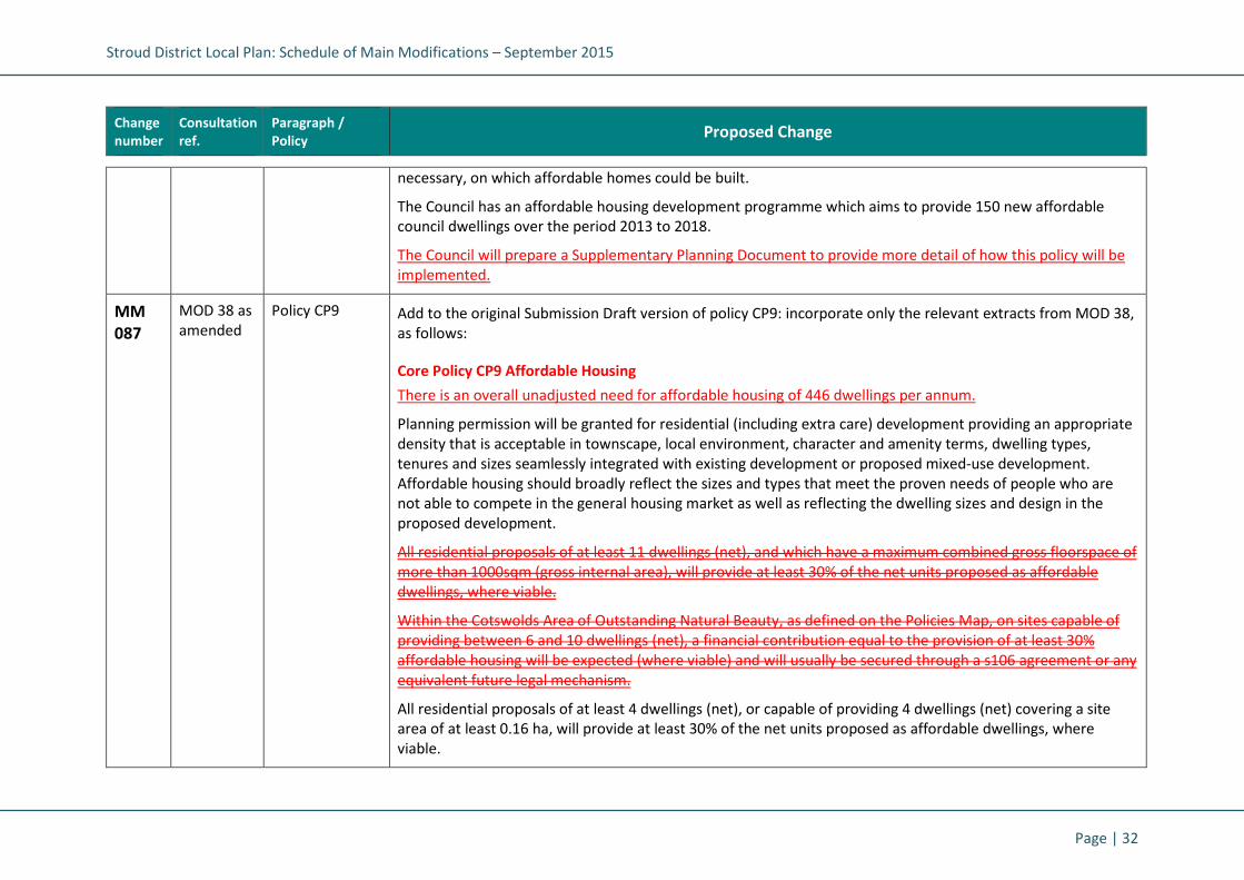
Stroud District Local Plan: Schedule of Main Modifications – September 2015
Page | 32
Change
number
Consultation
ref.
Paragraph /
Policy Proposed Change
necessary, on which affordable homes could be built.
The Council has an affordable housing development programme which aims to provide 150 new affordable
council dwellings over the period 2013 to 2018.
The Council will prepare a Supplementary Planning Document to provide more detail of how this policy will be
implemented.
MM
087
MOD 38 as
amended
Policy CP9 Add to the original Submission Draft version of policy CP9: incorporate only the relevant extracts from MOD 38,
as follows:
Core Policy CP9 Affordable Housing
There is an overall unadjusted need for affordable housing of 446 dwellings per annum.
Planning permission will be granted for residential (including extra care) development providing an appropriate
density that is acceptable in townscape, local environment, character and amenity terms, dwelling types,
tenures and sizes seamlessly integrated with existing development or proposed mixed-use development.
Affordable housing should broadly reflect the sizes and types that meet the proven needs of people who are
not able to compete in the general housing market as well as reflecting the dwelling sizes and design in the
proposed development.
All residential proposals of at least 11 dwellings (net), and which have a maximum combined gross floorspace of
more than 1000sqm (gross internal area), will provide at least 30% of the net units proposed as affordable
dwellings, where viable.
Within the Cotswolds Area of Outstanding Natural Beauty, as defined on the Policies Map, on sites capable of
providing between 6 and 10 dwellings (net), a financial contribution equal to the provision of at least 30%
affordable housing will be expected (where viable) and will usually be secured through a s106 agreement or any
equivalent future legal mechanism.
All residential proposals of at least 4 dwellings (net), or capable of providing 4 dwellings (net) covering a site
area of at least 0.16 ha, will provide at least 30% of the net units proposed as affordable dwellings, where
viable.

Stroud District Local Plan: Schedule of Main Modifications – September 2015
Page | 33
Change
number
Consultation
ref.
Paragraph /
Policy Proposed Change
On sites capable of providing less than four dwellings (net), a financial contribution to affordable housing of at
least 20% of the total development value will be expected (where viable) and will usually be secured through a
s106 agreement or any equivalent future legal mechanism.
The Council will negotiate the tenure, size and type of affordable units on a site by site basis having regard to
housing needs, site specifics and other factors.
MM
088
MOD 39 Supporting text
to Policy HC1:
Paragraph 4.28
Delete paragraph:
An application for a small scaled housing development is defined as:
• An application for the creation of fewer than 10 dwellings; or
• An outline application for residential development on a site of less than 0.5 hectares.
MM
089
MOD 40 Policy HC3 Amend first sentence of Policy HC3 to read:
“At strategic sites allocated within this Local Plan a minimum of 2% of the dwellings shall be to meet
Government aspirations to increase self build developments., subject to appropriate demand being identified.
In determining the nature and scale of any provision, the Council will have regard to viability considerations and
specific site circumstances.”
MM
090
MOD 41 Supporting text
to Policy HC3:
Paragraph 4.32
Amend paragraph 4.32 to read:
“This policy is intended as a mechanism for supporting self-build development in appropriate locations, as
sought in national policy. The Council will maintain a local register of self-builders who wish to acquire a
suitable plot of land to build their own home to evidence demand. The policy seeks to ensure that a genuinely
innovative design approach and a high sustainable construction standard is achieved.”
MM
091
MOD 42 Supporting text
to Policy HC4:
Paragraph 4.38
Amend paragraph 4.38, last sentence, to read:
“...A local Housing Needs Survey produced either by the Parish Council or by a housing provider using a
methodology agreed by the District Council provides evidence of the extent and nature of local housing need.”

Stroud District Local Plan: Schedule of Main Modifications – September 2015
Page | 34
Change
number
Consultation
ref.
Paragraph /
Policy Proposed Change
Chapter 5: Economy and Infrastructure
MM
092
PSC 065 Paragraph 5.4 Amend paragraph 5.4 to delete "potentially" in the last sentence.
MM
093
PSC 066 SO3
Fig.6 (map)
• Add pink dot shape to represent new local centre at the strategic allocation SA2, west of Stonehouse, and
amend key to make reference to it.
MM
094
PSC 067 Strategic
Objective SO4
Amend SO4 to:
"Strategic Objective SO4: Transport and travel
Promoting healthier alternatives to the use of the private car and seeking to reduce CO2 emissions by using
new technologies, active travel and/or smarter choices, and encouraging an working towards a more integrated
transport system to improve access to local goods and services."
MM
095
PSC 068 Paragraph 5.7 Amend first sentence to "The Local Plan will seek to deliver new and improved transport infrastructure,
maximising the use of potential links to rail, other public transport systems and the strategic road network
(managed by both the Highways Agency and the Highway Authority).
MM
096
PSC 069 SO4
Fig.7 (map)
• Add pink dot shape to represent new local centre at the strategic allocation SA2, west of Stonehouse, and
amend key to make reference to it.
MM
097
MOD 43
(as
amended)
Policy CP11 Amend Policy CP11, second paragraph, second sentence to read:
“In general, sSites allocated for mixed use redevelopment proposals on existing employment sites should aim to
provide for at least the same or an increase in the level of job opportunities as existed when the employment
space was previously used, subject to viability and site specific circumstances. above the level last employed on
site. and at least to a ratio of 1.2 jobs per residential unit provided on site.”
MM
098
PSC 070 Policy CP11 Amend criterion 2 of Policy CP11 to:
"2. Be readily accessible by public transport, bicycle and foot or contribute towards provision of new sustainable

Stroud District Local Plan: Schedule of Main Modifications – September 2015
Page | 35
Change
number
Consultation
ref.
Paragraph /
Policy Proposed Change
transport infrastructure to serve the area, in order to make the development accessible by those modes."
MM
099
PSC 071 Policy CP12 Policy CP12:
Add “west of Stonehouse (anticipated)” to the list of Local Centres, to reflect new strategic allocation SA2.
MM
100
PSC 072 Supporting text
to policy CP13.
After paragraph
5.23
Insert new paragraph:
"The Highways Agency operates, maintains and improves the strategic road network in England. The Local
Highway Authority (LHA) manages and maintains roads within Gloucestershire (outside the strategic road
network) and provides public transport and promotes safe and sustainable travel. In addition the Highways
Agency and LHA considers, and provides advice, on the impact that development may have on the highway. The
Council in cooperation with both the Highways Agency and Local Highway Authority produced Transport
Assessments in March & November 2014 to accompany the Local Plan. These reports considered the traffic
generation and distribution arising from the developments to determine the ability of the existing highway
network to accommodate additional traffic and whether junction mitigation is required. The results of this
assessment are important considerations in the policy here.”
MM
101
PSC 073 Supporting text
to policy CP13.
After paragraph
5.23
Insert new paragraph:
"There are currently two major gliding clubs within the District; The Cotswold Gliding Club (CGC) based at Aston
Down Airfield, and The Bristol and Gloucester Gliding Club (BGGC) based at Nympsfield. In addition there are
several hot air balloon and paragliding sites. The Gliding clubs generate 22500 aircraft movements per annum.
Ensuring the safety of such aircraft movements is therefore a consideration that can impact on the planning
process. The regulation and management of air safety in the United Kingdom is the responsibility of the CAA. In
addition gliding is further regulated by the British Gliding Association (BGA). These statutes, regulations and
advice prescribe the routes and heights that aircraft can use, both on route to, and in the vicinity of
aerodromes. The Council will seek to ensure that any risks between aircraft movements and proposed
developments are removed, both for the safety of the general public and aircrew alike. Both the CGC and BGGC
have agreed safeguarding areas. The Council will expect planning proposals to address any relevant potential air
safety and or aerodrome operation issues in the vicinity of these airfields."

Stroud District Local Plan: Schedule of Main Modifications – September 2015
Page | 36
Change
number
Consultation
ref.
Paragraph /
Policy Proposed Change
MM
102
PSC 074 Policy CP13 Amend first sentence of Policy CP13 to:
"Proposals for major schemes, as defined in the Town and Country Planning (Development Management
Procedure) (England) Order 2010, will be supported where they:"
MM
103
PSC 075 Policy CP13
Add further sentence to last paragraph of Policy CP13 :
“Development proposals shall be consistent with and contribute to the implementation of the agreed transport
strategy, set out in the Gloucestershire Local Transport Plan. Any transport assessment needs will be consistent
with the requirements set out in the Gloucestershire Local Transport Plan.”
MM
104
PSC 076 Policy EI1 Delete allocation EK2. (To be replaced by new policy EI2a: see PSC 077 below).
MM
105
MOD 44 Supporting text
to Policy EI1:
After paragraph
5.28
Add the following to supporting text after paragraph 5.28:
“The southern part of the Key Employment Site at Javelin Park (Site Reference EK14) is allocated as a strategic
waste site in the adopted Gloucestershire Waste Core Strategy under the provisions of Core Policy WCS6, and is
suitable for such purposes. Delivery of Policy EI1 does not preclude this proposed use from coming forward on
the southern part of the site in accordance with the provisions of Core Policy WCS6.”
MM
106
MOD 45
(as
amended)
Policy EI2 Amend Policy EI2, first paragraph, to read:
“Regeneration of existing employment land listed below will be permitted for mixed use development,
including employment-generating uses, provided there are demonstrable environmental and/or conservation
benefits and s Site rationalisation leads to investment that provides greater should aim to provide at least the
same employment opportunities for the local community as existed when the employment space was
previously used, subject to viability and site specific circumstances.”
MM
107
MOD 46 Supporting text
to policy EI2:
Paragraph 5.31
Amend paragraph 5.31, second sentence, to read:
“...The development should aim to provide at least the same employment opportunities as existed when the
employment space was previously used, subject to viability and site specific considerations.”

Stroud District Local Plan: Schedule of Main Modifications – September 2015
Page | 37
Change
number
Consultation
ref.
Paragraph /
Policy Proposed Change
MM
108
PSC 077
and
MOD 47
New Policy EI2a New policy and supporting text:
Policy EI2a: The Berkeley Centre Former Berkeley Power Station:
"The site will be retained for B1-B8 employment uses and for employment related training and education
purposes and for operations and uses associated with the decommissioning of the nuclear power station.
Redevelopment for unrelated alternative uses will not be permitted."
MM
109
PSC 078
and
MOD 48
Supporting text
to new Policy
EI2a:
Insert supporting text after new Policy EI2a, to read as follows:
“The former Berkeley Power Station site includes de-licensed office and laboratory accommodation currently
providing employment accommodation in a rural location by the River Severn. A major project to develop the
site to develop a GREEN Skills Centre to provide a training centre for STEM skills related to the renewable
energy, engineering and nuclear sectors to create the Gloucestershire Science and Technology Park (which will
include a range of educational, training and research facilities related to the renewable energy, engineering,
digital technologies, advanced manufacturing and nuclear sectors) has been promoted by the GFirst LEP.
Proposals for continued B1-B8 uses on the site or that develop the Skills Centre and education uses and
ancillary uses, or those associated with the decommissioning process, or those associated with the Science and
Technology Park (including forms of renewable and low carbon energy generation) will be supported.
Alternative uses will not be permitted in this rural location.”
MM
110
PSC 079 Policy EI4 Amend Policy EI4, criterion 3 by adding "or locality" at the end, to comply with the supporting text contained in
Paragraph 5.34.
MM
111
PSC 080 Policy EI9 Policy EI9:
Add “west of Stonehouse (anticipated)” to the list of Local Centres, to reflect new strategic allocation SA2.
MM
112
PSC 081 Policy EI11 Add criteria to Policy EI11, which states:
“it is not subject to any other over-riding environmental or other material planning constraints."
MM
113
PSC 082
and
Policy EI12 Amend Policy EI12:
Add to Enhancing Accessibility paragraph as follows:

Stroud District Local Plan: Schedule of Main Modifications – September 2015
Page | 38
Change
number
Consultation
ref.
Paragraph /
Policy Proposed Change
MOD 49 Amend first sentence to read: “All Ddevelopment proposals should have full regard to the traffic impact on the
local highway network.”
Amend second sentence to read: “Major development proposals, or those that are likely to have a significant
impact on the local transport network, will be required to submit a Transport Assessment as well as a Travel
Plan, to demonstrate that they have fully considered access by all modes of transport.”
Add to Parking Standards paragraph as follows:
“Vehicular parking standards for new development should be provided in accordance with adopted standards,
as set out in Appendix 2 of this Local Plan, or where the developer can adequately justify their own parking
provision with accompanying evidence with any planning application. This will need to demonstrate that the
level would not have a detrimental impact on the local road network.”
MM
114
MOD 50 Supporting text
to Policy EI12:
After paragraph
5.63
Add new paragraph after paragraph 5.63 to read:
“Where a developer seeks to justify a departure from the adopted parking standards any assessment should
take into account the individual merits of the development and the following:
• the accessibility of the development;
• the type, mix and use of development;
• the availability of and opportunities for public transport;
• local car ownership levels; and
• an overall need to reduce the use of high-emission vehicles.
as well as the capacity of the local road network to accommodate any displaced demand.”
Chapter 6: Our environment and surroundings
MM
115
PSC 083
and
PSC 084
Paragraph 2.5
Strategic
Objective SO5
Add to SO5 bullet criteria:
Strategic Objective SO5: Climate Change and environmental limits
Promoting a development strategy that mitigates global warming, adapts to climate change and respects our
environmental limits by:

Stroud District Local Plan: Schedule of Main Modifications – September 2015
Page | 39
Change
number
Consultation
ref.
Paragraph /
Policy Proposed Change
• Securing energy efficiency through building design
• Maximising the re-use of buildings and recycling of building materials
• Minimising the amount of waste produced and seeking to recover energy
• Promoting the use of appropriately located brownfield land
• Supporting a pattern of development that facilitates the use of sustainable modes of transport
• Minimising and mitigating against future flood risks, and recycling water resources and protecting and
enhancing the quality of the District’s surface and groundwater resources
MM
116
PSC 085 SO5
Fig.8 (map)
• Amend ‘key areas of growth’ shape to the west of Stonehouse, to represent the full extent of revised
strategic allocation SA2.
MM
117
PSC 086 Policy CP15 Amend Core Policy CP15 to read as follows:
"In order to protect the separate identity of settlements and the quality of the countryside (including its built
and natural heritage), proposals outside identified settlement development limits will not be permitted except
where these principles are complied with:
1. It is essential to the maintenance or enhancement of a sustainable farming or forestry enterprise within
the District; and/or
2. It is essential to be located there in order to promote public enjoyment of the countryside and support the
rural economy through employment, sport, leisure and tourism; and/or
3. In the case of It is a ‘rural exception sites’, where development is appropriate, sustainable, affordable and
meets an identified local need; and/or
4. It is demonstrated that the proposal is enabling development to maintain a heritage asset of
acknowledged importance.
Where development accords with any of the four principles listed above, development will only be permitted in
the countryside if:

Stroud District Local Plan: Schedule of Main Modifications – September 2015
Page | 40
Change
number
Consultation
ref.
Paragraph /
Policy Proposed Change
i. It does not have an adverse impact on heritage assets and their setting; and
ii. It does not lead to excessive encroachment or expansion of development away from the original buildings;
and
iii. It is contained within appropriately located buildings which It proposes to re-use an existing building or
buildings, where these are appropriately located and are capable and worthy of conversion. Any such
conversion will involve a building that positively contributes to an established local character and sense of
place. In the case of replacement buildings they must bring about environmental improvement; or
iv. In the case of extensions to buildings it does not result in inappropriate increases in the scale, form or
footprint of the original building; or
v. In the case of replacement dwellings the proposal must: Bbring about environmental improvements; and
Nnot result in inappropriate increases in the bulk, scale, form or footprint of the original building; or
vi. In the case of new buildings for essential community facilities, they cannot be accommodated within the
identified settlement development limits or through the re-use/replacement of an existing building."
MM
118
PSC 087
and
MOD 51
Policy ES1 Replace Delivery Policy ES1 Sustainable Construction and Energy Efficiency with:
"Delivery Policy ES1 - Sustainable Construction and Design
Sustainable design and construction will be integral to new development in Stroud District. All planning
applications should include evidence that the standardsmatters below will be addressed:
1. Maximising energy efficiency and integrating the use of renewable and low carbon energy (i.e. in the form
of an energy strategy);
2. Minimisation of waste and maximising of recycling of any waste generated during construction and in
operation;
3. Conserving water resources and minimising vulnerability to flooding;
4. Efficiency in materials use, including the type, life cycle and source of materials to be used;
5. Flexibility and adaptability, allowing future modification of use or layout, facilitating future refurbishment
and retrofitting;

Stroud District Local Plan: Schedule of Main Modifications – September 2015
Page | 41
Change
number
Consultation
ref.
Paragraph /
Policy Proposed Change
6. Consideration of climate change adaptation.
7. Applications for all development will need to be accompanied by a Stroud District Sustainable Construction
Checklist and shall be implemented to meet the agreed targets therein.
All development will be built in accordance with the approved plans and the Sustainable Construction
Checklist."
MM
119
PSC 088
and
MOD 52
(as
amended)
Supporting text
to Policy ES1:
paragraphs 6.13
- 6.18
Delete paragraphs 6.13 - 6.18 inclusive.
Replace with the following text, to support revised Policy ES1:
"The UK Government has set a timetable for tightening carbon standards in building regulations to achieve zero
carbon residential buildings by 2016 and it is the intention for non-residential buildings to be zero carbon by
2019. The Council will aim to produce an SPD in accordance with any targets or standards at that time. The UK
Government is seeking to meet the UK’s climate change commitments cost-effectively, including promoting
innovation to make a cost-effective transition to a low carbon economy. As part of its strategy, the Government
is keeping energy efficiency standards under review, recognising that existing measures to increase energy
efficiency of new buildings should be allowed time to become more established. Policy ES1 supports making
sustainable construction and design integral to new developments in Stroud District to assist with a cost
effective transition to a low carbon economy. The purpose of the checklist is to highlight sustainable
construction matters that developers can consider. It is not intended to duplicate the elements of sustainable
construction that are incorporated into the building regulations. It will demonstrate to the Council enable the
Council to assess which sustainable construction principles have been considered in development proposals for
new build and/or refurbishment of existing buildings but does not seek to prescribe a set standard or
requirement. The Council encourages a holistic approach where sustainable construction considerations are
taken fully into account from initial project thinking through to development completion. This approach should
achieve high quality sustainable development which is responsive to people’s needs and can help avoid
unnecessary project delay.”
MM
120
MOD 53 Policy ES2 Amend Policy ES2 first paragraph to read:
“The Council will support proposals that maximise the generation of energy from renewable or low carbon
sources, provided that the installation would not have significant adverse impact (either alone or cumulatively)

Stroud District Local Plan: Schedule of Main Modifications – September 2015
Page | 42
Change
number
Consultation
ref.
Paragraph /
Policy Proposed Change
and includes an impact statement that demonstrates the following factors:”
MM
121 MOD 54 Policy ES2 Add a new criterion 5, to read:
“5. Avoid the use of high quality best and most versatile agricultural land, unless justified by clear and
compelling evidence.”
MM
122 MOD 55 Supporting text
to Policy ES2:
paragraph 6.23
“The Council will encourage low or zero-carbon energy generating projects that contribute positively to the aim
of reducing CO2 emissions and to national targets for renewable electricity generation, provided that they meet
the criteria set out in Policy ES2: Renewable or Low Carbon Energy Generation. In the case of wind energy
development , the planning impacts identified by affected local communities should be fully addressed to
ensure that the proposal has their backing.“
MM
123 PSC 089
and
MOD 56
Supporting text
to Policy ES2:
paragraph 6.24
“Developers will be required to provide information on the justification for and likely impact of
proposals, including:
• the appropriateness of the location for the specific technology involved and what reasonable
alternatives have been considered;
• the nature and extent of early engagement with local communities and how this engagement
has informed the evolution of the proposal;
• local amenity implications and how an acceptable living environment will be maintained;
• information on noise and emissions generation;
• a visual impact assessment incorporating an analysis of landscape character and the
relationship to any significant heritage asset; and
• appropriate ecological surveys, following the most recent national guidance and best practice.;
and
• in the case of hydropower schemes, a Water Framework Directive Compliance Assessment and
evidence of discussions with the Environment Agency on requirements of the Environmental Permitting
Regulations.”

Stroud District Local Plan: Schedule of Main Modifications – September 2015
Page | 43
Change
number
Consultation
ref.
Paragraph /
Policy Proposed Change
MM
124
PSC 090
and
MOD 57
MOD 58
Policy ES4 Amend paragraph three of Policy ES4 to read as follows:
“New major developments, or those in areas of flood risk (zones 2 and 3), will be required to shall incorporate
Sustainable Drainage Measures (SuDs) in accordance with National Standards for Sustainable Drainage
Systems...”
Amend criterion 4 to:
"Discharge surface run-off, not collected for use, to one or more of the following, listed in order of priority:
a. discharge into the ground (infiltration); or where not reasonably practicable,
b. discharge to a surface water body; or where not reasonably practicable,
c. discharge to a surface water sewer, highway drain, or another drainage system; or where not reasonably
practicable,
d. discharge to a combined sewer”
Add new criterion 6 to read:
“6. Connect to the main foul sewer network where possible.”
MM
125
PSC 091
and
MOD 59
Supporting text
to Policy ES4:
Paragraph 6.34
Further to PSC 091, revert to original Submission Draft text, as follows:
“This is not a comprehensive list and applicants for major developments of ten or more dwellings, or those in
areas of flood risk, should identify the most appropriate scheme, or combination of schemes, to suit the
proposed development ...”
MM
126
MOD 60 Supporting text
to Policy ES4:
Paragraph 6.35
Modify the supporting text for Policy ES4, at paragraph 6.35:
“Consultation and discussion should take place with the Lead Local Flood Authoritiesy (LLFA) which is the
County Council in relation to assessing SuDS, and the pending SUDS Approval Bodies (SABs). Such discussions
should focus upon the run-off destination hierarchy set out in the National Standards for Sustainable Drainage
Systems.”
MM PSC 092 Policy ES6 Amend wording of Policy ES6:
Stroud District Local Plan: Schedule of Main Modifications – September 2015
Page | 44
Change
number
Consultation
ref.
Paragraph /
Policy Proposed Change
127 Alter RAMSAR in first sentence to “Ramsar”.
Add to European Sites Paragraph:
"The Council will expect development proposals to demonstrate and contribute to appropriate mitigation and
management measures to maintain the ecological integrity of the relevant European site(s). With specific
regard to recreational impacts the Council will use core catchment zones that identify potential impact areas
which extend beyond the relevant European site itself. Development proposals within such areas will take
account of any relevant published findings and recommendations. There will be further assessment work on the
Severn Estuary SPA and SAC that shall include recreational pressure."
Alter National Sites paragraph to read:
"Nationally important sites, including Sites of Special Scientific Interest (SSSI) and National Nature Reserves
(NNR), will be safeguarded from development, unless the benefits of the development can be demonstrated to
outweigh the identified national importance of the nature conservation interest or scientific interest of the
site."
Add to New Development and the Natural Environment paragraph:
"The District will have a number of undesignated sites which may still have rare species or valuable habitats.
Where a site is indicated to have such an interest, the applicant should observe the precautionary principle and
the Council will seek to ensure that the intrinsic value of the site for biodiversity and any community interest is
enhanced or at least maintained. Where an impact cannot be avoided or mitigated (including post development
management and monitoring), compensatory measures will be sought. The Council may, in exceptional
circumstances, allow for biodiversity offsets, to prevent net loss of biodiversity at the District scale. "
Alter Protected Species paragraph to read:
"Development proposals that would adversely affect European Protected Species (EPS) or Nationally Protected
Species will not be supported, unless appropriate safeguarding measures can be provided (which may include
brownfield sites or previously developed land (PDL) that can support priority habitats and/or be of value to
protected species).
The Council may, in exceptional circumstances, allow for biodiversity offsets, to prevent net loss of biodiversity

Stroud District Local Plan: Schedule of Main Modifications – September 2015
Page | 45
Change
number
Consultation
ref.
Paragraph /
Policy Proposed Change
at the District scale.”
MM
128
PSC 093 Supporting text
to Policy ES6:
After Paragraph
6.45
Additional wording after paragraph 6.45:
"The Council will work with neighbouring Severn Estuary authorities to monitor visitor activities and potential
disturbance in the Severn Estuary SPA, which may have implications for future environmental management
strategies. There is considerable existing evidence and guidance available that is likely to be relevant to green
infrastructure planning, including the Gloucestershire Nature Map developed by the Gloucestershire
Biodiversity Partnership, the Rights of Way Improvement Plan, town/landscape assessments, and Historic
Environment Records. Work currently being undertaken is likely to identify a core recreational catchment zone
around the Severn Estuary SAC/SPA/Ramsar site in which development proposals that involve a net increase in
housing may be required to contribute to the funding of mitigation measures. Due to its scale and relative
proximity to the SPA/SAC/Ramsar site the West of Stonehouse development has been specifically identified as
requiring application-level HRA, although it should be possible to provide avoidance and mitigation measures. ”
MM
129
PSC 094 Supporting text
to Policy ES6:
After Paragraph
6.45
Add new paragraph:
"The HRA of the Local Plan and discussion with Natural England and The National Trust have identified
measures that will be required on Rodborough Common over the Local Plan period to ensure no adverse effect
occurs on the SAC due to the expected population increase within the Stroud Valleys area and associated
increase in recreational activity. A consistent 3km core catchment zone has been defined around this SAC to
reflect the current patterns of activity based on settlements. The identified Rodborough SAC impacts result
from the proposed growth over the Plan period. In this context a small number of visitors from a particular
settlement for example will still make an overall contribution to the identified impacts in the HRA. Development
proposals within this core catchment zone will be required to contribute to mitigation measures. The Council
commits to working with partners to deliver improvements to Rodborough Common SAC through the delivery
of measures including installation of new cattle grids, better dog management measures (on site), alternative
dog walking opportunities (off site) grassland restoration on the lower slopes and maintenance of parking areas
in order to avoid an adverse effect on the integrity of the SAC associated with increased recreational activity
over the plan period. The initiatives will be funded through CIL and S106 contributions that contribute towards
a SAC Avoidance and Mitigation Strategy. This will identify measures that can include the potential to enhance

Stroud District Local Plan: Schedule of Main Modifications – September 2015
Page | 46
Change
number
Consultation
ref.
Paragraph /
Policy Proposed Change
open space(s) to deflect visits away from the SAC. A Supplementary Planning Document (SPD) will be prepared
to provide clarity for developers. Where instead of a bespoke solution, provision is made for contributions to be
paid and pooled towards implementing the Avoidance and Mitigation Strategy upon which Natural England has
been consulted), the District Council will not require an Appropriate Assessment of the planning application.
The SPD will be subject to regular monitoring and review to at least coincide with the Local Plan Review.”
MM
130
PSC 095 Supporting text
to Policy ES6:
After Paragraph
6.45
Add new paragraph:
"Where a development includes specific measures to avoid and mitigate its impact upon the SAC and/or SPA,
the District Council will in consultation with Natural England, undertake an Appropriate Assessment. This will
consider the effect of the proposal on the SAC or SPA and the avoidance and mitigation measures, including size
and location of any proposed semi-natural open space."
MM
131
PSC 096 Policy ES10 Amend points 2(A), 3 and 4 of Policy ES10 as follows:
"2. A. the 68 sites of Archaeological nationally-important national archaeological importance (which are
designated as Ancient Monuments), any undesignated archaeology of national significance, and the
many buildings that are Listed as having special architectural or historic interest”
“3. Proposals will be supported which preserve or protect and, where appropriate, enhance the heritage
significance and setting of locally identified heritage assets, such as buildings of local architectural or
historic interest, locally important archaeological sites and parks and gardens of local interest.”
“4. Proposals will be supported which preserve or protect and, where appropriate, enhance key views and
vistas, especially of the spires and towers of historic churches and mills.”
MM
132
PSC 097 Supporting text
to Policy ES10:
Paragraph 6.58
Amend Paragraph 6.58, breaking it into two paragraphs and adding new text towards the end of the first
paragraph, as follows:
"Stroud District has an important legacy of heritage and cultural assets, including over 4,500 listed buildings, 42
conservation areas, 14 registered historic parks and gardens and 68 scheduled monuments. There are a wide
range of undesignated historic buildings, archaeological sites and remains, and historic parks and gardens, as
well as places, areas and landscapes of historic interest. Information about heritage assets can be found in the

Stroud District Local Plan: Schedule of Main Modifications – September 2015
Page | 47
Change
number
Consultation
ref.
Paragraph /
Policy Proposed Change
Gloucestershire Historic Environment Record (HER). These assets make a significant contribution to the identity
of the locality in which they are set, helping to create a sense of place. The Council is committed to protecting
and enhancing the District’s historic environment and will produce a heritage strategy to supplement the Local
Plan. The strategy will positively address the issues and pressures that are facing our heritage assets, including
those identified in Chapter 1 of this Plan, and it will set out a programme for the appraisal and management of
our conservation areas and the monitoring of any heritage assets ‘at risk’.
Applications for development which affect heritage assets and their settings directly or indirectly will need to
describe the nature of the significance of the assets affected, and set out hoe development will maintain and
enhance heritage assets and their settings in a manner appropriate to that significance. New development
should seek opportunities to draw on the historic environment in order to maintain and enhance local character
and distinctiveness.”
MM
133
PSC 098 Supporting text
to Policy ES10:
Paragraph 6.60
Amend Paragraph 6.60 to read:
“Development proposals that involve any harm to or loss of a heritage asset would require clear and convincing
justification, in accordance with the NPPF. A development proposal will not be permitted where substantial
harm to an existing or potential heritage asset is likely to occur, unless there are substantial public benefits.”
MM
134
PSC 099 Supporting text
to Policy ES14:
After 6.70
Add new paragraph:
"Green Infrastructure (GI) provision is being discussed between all Gloucestershire district & county councils
with the aim of providing a district wide Strategic Framework for GI requirements. The Council will consider the
requirements for GI, in line with the emerging GI Framework, when determining planning applications."

Stroud District Local Plan: Schedule of Main Modifications – September 2015
Page | 48
Change
number
Consultation
ref.
Paragraph /
Policy Proposed Change
Chapter 7: Delivery and monitoring
MM
135
MOD 61
(NOTE: this
change
entirely
supersedes
PSC 100).
Paragraph 7.6 Update table showing housing supply and delivery (2006-2031) and add housing trajectory, reflecting the
revised Local Plan housing requirement:
Source of housing supply 2006 to
20132015
Projected Delivery of Allocations
20132015 - 2031 Total supply
1-5 years 6-10 years 11-15+
years
Completions 2,787 3,837 2,787 3,837
Commitments (20132015) 4,304 3,948
Undeliverable permissions
(2015)
-449
Stroud Valleys 130 170 100 260 70 20 300 450
West of Stonehouse 350 850 150 1,350
North East Cam 300 180 150 270 450
Hunts Grove Extension 132 140 579 360 39 500 750
Sharpness Docks North 45 80 125 116 130 104 300
Small sites windfall 250 115 250 290 250 345 750
Council Housing Programme 150 109 0 41 0 150
District Total 2,787 3,837 875 1136 765 2406 810 658 9,541 11,536

Stroud District Local Plan: Schedule of Main Modifications – September 2015
Page | 49
-400
-200
0
200
400
600
800
1000
2006
/07
2007
/08
2008
/09
2009
/10
2010
/11
2011
/12
2012
/13
2013
/14
2014
/15
2015
/16
2016
/17
2017
/18
2018
/19
2019
/20
2020
/21
2021
/22
2022
/23
2023
/24
2024
/25
2025
/26
2026
/27
2027
/28
2028
/29
2029
/30
2030
/31
Dwellings completed Identified for completion Target Managed Delivery Target
Change
number
Consultation
ref.
Paragraph /
Policy Proposed Change
“The following graph sets out how the total housing supply is anticipated to be delivered by 2031. As houses
are completed, the managed delivery target reduces to the point that the minimum housing requirement is
expected to be achieved by 2029.”
Chapter 8: Appendices and maps
MM
136
PSC 101 Appendix 1 Appendix 1: Monitoring Framework: table of targets and indicators
Insert target of ES10 to read "The completion of a Heritage Strategy"
Amend ES10 indicators to read:
• Number of listed buildings
• Number of heritage assets at risk
• Number of non-designated heritage assets (these can be, but are not always, "locally listed”)
• Number of conservation areas with an up to date appraisal and heritage at risk survey

Stroud District Local Plan: Schedule of Main Modifications – September 2015
Page | 50
Change
number
Consultation
ref.
Paragraph /
Policy Proposed Change
• Number of incidences of substantial harm to non designated heritage assets.
MM
137
PSC 102 Appendix 4
Glossary
Add:
"Design and Access Statements - A design and access (DAS) statement is a report accompanying and
supporting a planning application. They provide a framework for applicants to explain how a proposed
development is a suitable response to the site and its setting, and demonstrate that it can be adequately
accessed by prospective users. The access component of the DAS relates to access to the development and
does not extend to the internal treatment of individual buildings. It needs to cover both vehicular and
transport links and inclusive access. The statement should provide information on consultations carried out
such as with community groups or technical specialists including highway engineers or urban designers. The
DAS must explain relationships with the existing highway network including paths."
MM
138
PSC 103 Appendix 4
Glossary
Add:
"Heritage Asset - A building, monument, site, place, area or landscape identified as having a degree of
significance meriting consideration in planning decisions, because of its heritage interest. Heritage assets
include designated heritage assets and assets identified by the local planning authority (including local listing)."
MM
139
PSC 104 Appendix 4
Glossary
Add:
"Historic Environment - All aspects of the environment that result from the interaction between people and
places through time, including surviving physical remains of past human activity, whether visible, buried or
submerged, and landscape and planted or managed flora.
MM
140
PSC 105 Appendix 4
Glossary
Add:
"Strategic Road Network - The major road network is defined by the Department for Transport as the network
of motorways, trunk roads and principal roads that serve the country’s strategic transport needs. Motorways
and trunk roads (nationally significant A-roads) managed by the Highways Agency make up approximately 20%
of the national major road network. The remaining 80% of the major road network consists of principal
roads—other A-roads managed by local authorities. For the purposes of this Local Plan we have accepted this
definition which includes both major and principal roads."

Stroud District Local Plan: Schedule of Main Modifications – September 2015
Page | 51
Change
number
Consultation
ref.
Paragraph /
Policy Proposed Change
MM
141
PSC 106 Appendix 4
Glossary
Add:
"Transport Assessment - A Transport Assessment is a comprehensive review of all the potential transport
impacts of a proposed development or re-development, with an agreed plan to mitigate any adverse
consequences. The purpose of Transport Assessment is to provide enough information to understand how the
proposed development is likely to function in transport terms. Assessing the transport impacts in a systematic
manner contributes towards understanding how more sustainable travel patterns might be achieved through
changing travel behaviour. The preparation and detail of a Transport Assessment will vary depending on the
location, scale and nature of the proposed development. Transport Assessment should, where appropriate,
propose a package of measures designed to promote access to the site by walking, cycling and public
transport, while reducing the role of car access as much as possible."
MM
142
PSC 107 Appendix 4
Glossary
Replace definition of ‘Travel Plan’ as follows::
"Travel Plan - All developments which generate significant amounts of movement should be required to
provide a Travel Plan. A Travel Plan is a strategy for managing multi-modal access to a site or development,
focusing on promoting access by sustainable modes. The main objective of a travel plan is to reduce the
number of single occupant car trips to a site. A successful travel plan will give anyone travelling to or from a
business or organisation a choice of travel options and encourage them to use the more sustainable ones.
Travel plans can be used to ensure that infrastructure and transport services (e.g. buses/minibuses) are
provided as part of a development to ensure that the travel requirements of occupiers and visitors to a
development can be met. Effective travel plans will include measures to restrain and manage parking on the
site. The travel plan will include a set of agreed targets for the percentage of journeys to the site by car driver
alone and details of action to be taken if the travel plan fails to achieve its aims and objectives. Travel plans
benefit the community by helping to reduce traffic congestion and pollution for local residents. They can be
used to help identify problems that are occurring (e.g. commuter parking taking place on residential streets)
and include measures to address such problems. They benefit organisations by reducing the space that has to
be allocated on site to car parking, encouraging more healthy travel options for the workforce, widening the
range of travel options available to the site and improving access to the site for a wider range of users."

Stroud District Local Plan: Schedule of Main Modifications – September 2015
Page | 52
Change
number
Consultation
ref.
Paragraph /
Policy Proposed Change
The policies map:
MM
143
PSC 108 Policies Map
SA2
Delete strategic allocation SA2 North of Stroudwater Industrial Estate and replace with a new shape showing
SA2 West of Stonehouse.
MM
144
PSC 109 Policies Map
Local centre
Add new shape to show a local service centre at the site of SA2 West of Stonehouse.
MM
145
PSC 110
and
MOD 63
Policies Map
EK2 / EI2a
Delete shape showing key employment allocation EK2 Former Berkeley Power Station.
Replace with new shape showing allocation EI2a Former Berkeley Power Station:
MM
146
MOD 62 Polices Map:
Site Allocation
SA4
Delete outline showing SA4 and replace with new shape showing revised site boundary, to include a further
area of land to be allocated as part of the Hunts Grove Extension.