report st12 long lake switching - northland power fileof cochrane, ontario. the proponent is seeking...
TRANSCRIPT

Stage 1 and 2 Archaeological Assessment for Long Lake Solar Project – Solar Switching Station
Part of Lot 1 & 28, Concessions 8 & 9, Town of Calder,
District of Cochrane, Ontario
FIT Contract # FIT-FE8GSGA
Prepared by
Licensee: T. Keith Powers
Archaeological Consulting Licence P052 Project Information Number: P052-453-2013
THE ARCHAEOLOGISTS INC.
Original Report
September 16, 2013

Stage 1 and 2 Archaeological Assessment for Long Lake Solar Project – Solar Switching Station, Part of Lot 1 & 28, Concessions 8 & 9, Town of Calder, District of Cochrane, Ontario
i
EXECUTIVE SUMMARY The Archaeologists Inc. was contracted by Northland Power to conduct a Stage 1 and 2 archaeological assessment of lands for the Long Lake Solar Project, Part of Lots 1 and 28, Concessions 8 and 9, in the Town of Calder, now in the Town of Cochrane, District of Cochrane, Ontario. The proponent is seeking a Renewable energy Approval according to Ontario Regulation 359/09 issued under the Environmental Protection act, Sections 20, 21 and 22. The assessment was done in advance of a solar farm project. A Stage 1 background study of the subject property was conducted to provide information about the property’s geography, history, previous archaeological fieldwork and current land condition in order to evaluate and document in detail the property’s archaeological potential and to recommend appropriate strategies for Stage 2 survey. A Stage 2 property assessment was conducted to document all archaeological resources on the property, to determine whether the property contains archaeological resources requiring further assessment, and to recommend next steps. The characteristics of the property dictated that the Stage 2 survey be conducted by a test pit survey strategy for northern Ontario and on Canadian Shield terrain. The Stage 1 background study found that the subject property exhibits potential for the recovery of archaeological resources of cultural heritage value and concluded that the property requires a Stage 2 assessment. The Stage 2 property assessment, which consisted of a test pit survey strategy for northern Ontario and Canadian Shield terrain, did not result in the identification of archaeological resources. The Stage 1 background study concluded that the property exhibits archaeological potential. The Stage 2 property assessment did not identify any archaeological resources within the subject property. The report recommends that no further archaeological assessment of the subject property is required.

Stage 1 and 2 Archaeological Assessment for Long Lake Solar Project – Solar Switching Station, Part of Lot 1 & 28, Concessions 8 & 9, Town of Calder, District of Cochrane, Ontario
ii
TABLE OF CONTENTS
Executive Summary i Table of Contents ii Project Personnel iii 1.0 Project Context 1 1.1 Development Context 1.2 Historical Context 1.3 Archaeological Context
1 2 4
2.0 Field Methods 6 3.0 Record of Finds 8 4.0 Analysis and Conclusions 8 5.0 Recommendations 8 6.0 Advice on Compliance with Legislation 9 7.0 Bibliography and Sources 10 8.0 Images 11 9.0 Maps 13

Stage 1 and 2 Archaeological Assessment for Long Lake Solar Project – Solar Switching Station, Part of Lot 1 & 28, Concessions 8 & 9, Town of Calder, District of Cochrane, Ontario
iii
PROJECT PERSONNEL
Project and Field Director: Mr. T. Keith Powers (P052) Field Archaeologists Mr. Misha Stecyk Mr. Barclay Powers
Mr. Norbert Stanchly (R149)
Report Preparation: Mr. Norbert Stanchly (R149) Graphics Mrs. Karen Powers Mr. T. Keith Powers

Stage 1 and 2 Archaeological Assessment for Long Lake Solar Project – Solar Switching Station, Part of Lot 1 & 28, Concessions 8 & 9, Town of Calder, District of Cochrane, Ontario
1
INTRODUCTION The Ontario Heritage Act, R.S.O. 1990 c. O.18, requires anyone wishing to carry out archaeological fieldwork in Ontario to have a license from the Ministry of Tourism and Culture (MTC). All licensees are to file a report with the MTC containing details of the fieldwork that has been done for each project. Following standards and guidelines set out by the MTC is a condition of a licence to conduct archaeological fieldwork in Ontario. The Archaeologists Inc. confirms that this report meets ministry report requirements as set out in the 2011 Standards and Guidelines for Consultant Archaeologists, and is filed in fulfillment of the terms and conditions an archaeological license. 1.0 PROJECT CONTEXT (Section 7.5.5) This section of the report will provide the context for the archaeological fieldwork, including the development, historical and archaeological context. 1.1 Development Context (Section 7.5.6, Standards 1-3) Section 7.5.6, Standard 1 The Archaeologists Inc. was contracted by Northland Power to conduct a Stage 1 and 2 archaeological assessment for lands associated with a switching station associated with the Long Lake Solar Project, Part of Lots 1 and 28, Concessions 8 and 9, in the Town of Calder, now in the Town of Cochrane, District of Cochrane, Ontario. The proponent is seeking a Renewable energy Approval according to Ontario Regulation 359/09 issued under the Environmental Protection act, Sections 20, 21 and 22. The assessment was done in advance of a solar farm project. Northland Power Solar is proposing to develop a 10-megawatt (MW) solar photovoltaic (Solar PV) facility in the District of Cochrane for the Long Lake Solar Project. Northland is commencing with the Renewable Energy Approval (REA) process as required and described in Ontario Regulation 359/09 under the Environmental Protection Act. The proposed Projects are renewable energy generation facilities, which will use solar photovoltaic technology. Electricity generated by solar photovoltaic panels will be converted from dc to ac by an inverter, and subsequently stepped-up (via transformer) to 115 kV prior to being connected to the transmission system. The project is seeking a Renewable Energy Approval according to Ontario Regulation 359/09 issued under the Environmental Protection Act, Sections 20, 21 and 22. The projects have been awarded Feed-in-Tariff (FIT) contract number FIT Contract # FIT-FE8GSGA. Section 7.5.6, Standard 2 There is no additional development-related information relevant to understanding the choice of fieldwork strategy or recommendations made in the report.

Stage 1 and 2 Archaeological Assessment for Long Lake Solar Project – Solar Switching Station, Part of Lot 1 & 28, Concessions 8 & 9, Town of Calder, District of Cochrane, Ontario
2
Section 7.5.6, Standard 3 Permission to access the study area to conduct all required archaeological fieldwork activities, including the recovery of artifacts was given by the landowner and their representative. 1.2 Historical Context (Section 7.5.7, Standards 1-2) Section 7.5.7, Standard 1 In advance of the Stage 2 assessment, a Stage 1 background study of the subject property was conducted in order to document the property archaeological and land use history and present condition. Several sources were referenced to determine if features or characteristics indicating archaeological potential for pre-contact and post-contact resources exist. Characteristics indicating archaeological potential include the near-by presence of previously identified archaeological sites, primary and secondary water sources, features indicating past water sources, accessible or inaccessible shoreline, pockets of well-drained sandy soil, distinctive land formations that might have been special or spiritual places, such as waterfalls, rock outcrops, caverns, mounds, and promontories and their bases, resource areas, (including food or medicinal plants, scarce raw materials, early Euro-Canadian industry), areas of early Euro-Canadian settlement, early historical transportation routes, property listed on a municipal register or designated under the Ontario Heritage Act or that is a federal, provincial or municipal historic landmark or site, and property that local histories or informants have identified with possible archaeological sites, historical events, activities, or occupations. Archaeological potential can be determined not to be present for either the entire property or a part of it when the area under consideration has been subject to extensive and deep land alterations that have severely damaged the integrity of any archaeological resources. This is commonly referred to as ‘disturbed’ or ‘disturbance’, and may include: quarrying, major landscaping involving grading below topsoil, building footprints, and sewage and infrastructure development. Archaeological potential is not removed where there is documented potential for deeply buried intact archaeological resources beneath land alterations, or where it cannot be clearly demonstrated through background research and property inspection that there has been complete and intensive disturbance of an area. Where complete disturbance cannot be demonstrated in Stage 1, it will be necessary to undertake Stage 2 assessment. The background study determined that the following features or characteristics indicate archaeological potential for the subject property. The presence of nearby Syndicate Lake, Kennedy Lake, Fowler Lake, and several unnamed creekds would have been attractive areas for hunting or settlement for both precontact populations and European settlers. The subject property is located close to a historic transportation route, i.e. Calder Concession Road 8-9.

Stage 1 and 2 Archaeological Assessment for Long Lake Solar Project – Solar Switching Station, Part of Lot 1 & 28, Concessions 8 & 9, Town of Calder, District of Cochrane, Ontario
3
The District of Cochrane was formed in 1921. Previously it had been part of the Districts of Algoma and Nipissing. The earliest settlers began to arrive in the 1880s, and the majority settled at the head of Lake Temiskaming (Marwick 1950). These early settlers were largely isolated and their transportation routes were limited to the waterways, primarily Lake Temiskaming itself and the Ottawa River (ARA 2010a). In 1902 the construction of the Temiskaming and Northern Ontario railroad began in North Bay and by 1908 had reached the Town of Cochrane, which had been named after Frank Cochrane, former Mayor of Sudbury. With the arrival of the railway in 1908 Euro-Canadian settlement of the area began in earnest:
“The area was divided up into 160 acre farm lots which sold for $80 each. Only a quarter of the full price was required initially, with the balance to be paid in three yearly payments plus 6% interest. After four years, the settler could then obtain the patent to the lot…The first settlers began to arrive in 1909, taking the 22 to 24 hour ride from Toronto that could amount to $500 if livestock and furniture was also shipped…Upon arrival, each man obtained the number to his lot and was given directions to find the stakes. These settlers then set out, forcing their way through the bush with their provisions, axes and saws. Some went east towards the Abitibi River, following old tote roads, while others struck out into the unsettled north…Cochrane received its charter in January, 1910, and soon after it experienced its first disaster when its business sector burned to the ground in August of that same year.
Employment for these early settlers, aside from selling timber and agricultural goods, was focused on the continued construction of the Grand Trunk Pacific railway and the Temiskaming and Northern Ontario railway...Land needed to be cleared and steel needed to be laid, so many settlers would work on the railway in the winter and tend to their farms during the winter. On the settler‟s own lands, the majority of the early years were spent clearing the land in order to obtain their patent. They also sold firewood on the side of the road and pulpwood to the railroads. Early houses were generally tents or lean-tos, until the standard 16 x 20 foot shack could be built. The early years were the most difficult, as “everything had to start from scratch, and most of the settlers kept on scratching for years…
In anticipation of the great influx of settlers, the government began surveying the townships of the area in 1904. Typically, as fast as they were opened, the townships filled up ...In the vicinity of what would become the Town of Cochrane, four townships were opened for settlement by 1910. To the north were Glackmeyer Township and Chute Township, while Lamarche Township and Fournier Township were situated to the south…Further to the west, Calder Township, Colquhoun Township and Leitch Township would later be opened for settlement. In less than 30 years, roughly 200 organized townships were created in northern Ontario...Aside from the community at Cochrane itself, the French

Stage 1 and 2 Archaeological Assessment for Long Lake Solar Project – Solar Switching Station, Part of Lot 1 & 28, Concessions 8 & 9, Town of Calder, District of Cochrane, Ontario
4
Canadian settlement of Genier developed around Dora Lake to the north, while Hunta grew up in the vicinity of Hydro Lake to the west.” (ARA 2010a)
The Town of Cochrane, the seat of Cochrane District, was created in 2000 by the amalgamation of the Townships of Glackmeyer and Lamarche. In summary, the Stage 1 background study indicated the potential for the recovery of pre-contact and post-contact Euro-Canadian archaeological resources within the subject property. As it cannot be clearly demonstrated through the background study that there has been complete and intensive disturbance of the area, archaeological potential is not removed. There are areas within the subject property that have the potential for the recovery of archaeological resources. Section 7.5.7, Standard 2 The subject lands includes woodlot and low and wet areas, and ia located in northern Ontario and the Stage 2 property assessment of the subject property will employ the strategy of test pit survey, following the standards listed in Section 2.1.2 and 2.1.5 of the 2011 Standards and Guidelines for Consultant Archaeologists. 1.3 Archaeological Context (Section 7.5.8, Standards 1-7) Section 7.5.8, Standard 1 In order that an inventory of archaeological resources could be compiled for the study area, three sources of information were consulted: the site forms for registered sites housed at the Ministry of Tourism, Culture and Sport; published and unpublished documentary sources; and the files of The Archaeologists Inc. In Ontario, information concerning archaeological sites is stored in the Ontario Archaeological Sites Database (O.A.S.D.), an inventory of the documented archaeological record in Ontario. Information on the known archaeological sites in the vicinity of the study area was obtained form the Ministry of Tourism and Culture site database. There are no known archaeological sites located within the study area limits and no sites have been registered within a one-kilometre radius of the subject property. Section 7.5.8, Standard 2 The subject property consists of woodlot, bush and low and wet areas over fairly level terrain. The subject lands lie approximately 900 m north of Kennedy Lake, and adjacent to a number of unnamed creeks. Physiographically, the study area lies within the Superior Province of the Precambrian Canadian Shield (Davidson 1989). The soils in the study area belong to the Gleysolic soil order. These are heavy, wet non-saturating and non-organic soils that typically have dark surface horizons and gray subsoils. Orthic Gleysols are dominant in the vicinity of the

Stage 1 and 2 Archaeological Assessment for Long Lake Solar Project – Solar Switching Station, Part of Lot 1 & 28, Concessions 8 & 9, Town of Calder, District of Cochrane, Ontario
5
Town of Cochrane. These are characterized by dark-coloured A-horizons less than 10 cm thick (Hoffman 1989). Section 7.5.8, Standard 3 The Stage 2 archaeological fieldwork of the subject property was undertaken May 23, 2013. Section 7.5.8, Standard 4 Previous archaeological fieldwork was conducted in the vicinity of the subject property. A Stage 1 and 2 archaeological assessment was conducted on lands with the potential to be impacted by the proposed Long LakeSolar Project on Part Lots 2& 3, Concession 8 in the Township of Calder, District of Cochrane, Ontario. This work was completed under contract to Hatch Ltd.in advance of a Renewable Energy Approval (REA)application. The Stage 1 and 2 assessment was carried out by Archaeological Research Associates, Ltd. (ARA) in November of 2010 under PIF #P007-280-2010 (ARA 2010). Stage 1 research indicated a high potential for the presence of both Pre-Contact and Euro-Canadian archaeological sites in the study area. The Stage 2 assessment, identified 1 archaeological findspot (Findspot 1). Findspot 1 consisted of a large scatter of Euro-Canadian artifacts on the summit of a knoll near Concession Road 8-9. Our fieldwork is being conducted in order to complete the assessment of additional parcels of land to be incorporated into the overall solar projects. Section 7.5.8, Standard 5 The ARA reports make no recommendations relevant to the current stage of work, other than the fact that the background study indicates the subject property has potential for the recovery of archaeological resources. Section 7.5.8, Standard 6 There are no unusual physical features that may have affected fieldwork strategy decisions or the identification of artifacts or cultural features, except for the existing soils, which are heavy and saturated. Section 7.5.8, Standard 7 There is no additional archaeological information that may be relevant to understanding the choice of fieldwork techniques or the recommendations of this report.

Stage 1 and 2 Archaeological Assessment for Long Lake Solar Project – Solar Switching Station, Part of Lot 1 & 28, Concessions 8 & 9, Town of Calder, District of Cochrane, Ontario
6
2.0 FIELD METHODS (Section 7.8.1, Standards 1-3) Section 7.8.1, Standard 1 All of the subject property was assessed and approximately 50% was systematically surveyed. There were no exemptions with the exception of low and wet areas (ca. 50%). Section 7.8.1, Standard 2 As relevant, we provide detailed and explicit descriptions addressing Standards 2a and 2d. Section 7.8.1, Standard 2a - The general standards for property survey under Section 2.1 of the 2011 Standards and Guidelines for Consultant Archaeologists were addressed as follows:
• Section 2.1, S1 – All of those portions of the property exhibiting archaeological potential were surveyed.
• Section 2.1, S2a – Approximately 50% of the subject property consisted of low and wet (i.e. heavily saturated soils) lands of no or low potential due to physical features such as permanently wet areas.
• Section 2.1, S2b – There are no areas of no or low potential due to extensive and deep land alterations within our subject property.
• Section 2.1, S2c (lands recommended not to require Stage 2 assessment by a previous Stage 1 report where the ministry has accepted that Stage 1 into the register) - n/a
• Section 2.1, S2d (lands designated for forest management activity w/o potential for impacts to archaeological sites, as determined through Stage 1 forest management plans process) - n/a
• Section 2.1, S2e (lands formally prohibited from alterations) - n/a • Section 2.1, S2f ( lands confirmed to be transferred to a public land holding body,
etc) - n/a • Section 2.1, S3 - The Stage 2 survey was conducted when weather and lighting
conditions permitted excellent visibility of features. • Section 2.1, S4 - No GPS recordings were taken as no artifacts were found during
the Stage 2 assessment. There were also no fixed landmarks. • Section 2.1, S5 - All field activities were mapped in reference to survey stakes and
development markers as appropriate. • Section 2.1, S6 - See report section 8.0 Images for photo documentation of
examples of field conditions encountered. • Section 2.1, S7 - n/a
Section 7.8.1, Standard 2d -The subject property was subject to a modified test pit survey acceptable as alternative strategies for special survey conditions (i.e. northern Ontario

Stage 1 and 2 Archaeological Assessment for Long Lake Solar Project – Solar Switching Station, Part of Lot 1 & 28, Concessions 8 & 9, Town of Calder, District of Cochrane, Ontario
7
and Canadian Shield terrain), as per Section 2.1.5 of the 2011 Standards and Guidelines for Consultant Archaeologists.
• Section 2.1.5, S1 – The subject property is located within 50 metres of a modern source. Accordingly, test pits were initially to be spaced at maximum 10 metre intervals. However, given the limited size of the subject property we test pitted at 5 metre intervals.
• Section 2.1.5, S2 – n/a • Section 2.1.5, S3 – Initial test pitting at 5 metre intervals indicated that the
majority of the subject property consisted of low, wet saturated soils. •
Section 7.8.1, Standard 3 Approximately 50% of the property was surveyed at maximum 5 metre intervals. The other 50% was determined to be low and wet based on visible standing water and the physiographic characteristics of the subject lands.

Stage 1 and 2 Archaeological Assessment for Long Lake Solar Project – Solar Switching Station, Part of Lot 1 & 28, Concessions 8 & 9, Town of Calder, District of Cochrane, Ontario
8
3.0 RECORD OF FINDS (Section 7.8.2, Standards 1-3) This section documents all finds discovered as a result of the Stage 1 and 2 archaeological assessment of the subject property. Section 7.8.2, Standard 1 No archaeological resources or sites were identified in the Stage 2. Section 7.8.2, Standard 2 An inventory of the documentary record generated in the field is provided in Table 1.
Table 1: Inventory of Documentary Record Document Type Description Field Notes • This report constitutes the field notes for this
project Photographs • 8 digital photographs Maps • Mapping within this report constitutes all of the
maps generated in the field. Section 7.8.2, Standard 3 Information detailing exact site locations on the property is not submitted because no sites or archaeological resources were identified in the Stage 2 assessment. 4.0 ANALYSIS AND CONCLUSIONS (Section 7.8.3, Standards 1-2) Section 7.8.3, Standard 1 No archaeological sites were identified. Standard 2 is not addressed because no sites were identified. 5.0 RECOMMENDATIONS (Section 7.8.4, Standards 1-3) Section 7.8.4, Standard 1 This standard is not applicable as no sites were identified. Section 7.8.4, Standard 2 The report makes recommendations only regarding archaeological matters. Section 7.8.4, Standard 3 The Stage 2 survey did not identify any archaeological sites requiring further assessment or mitigation of impacts and it is recommended that no further archaeological assessment of the property be required.

Stage 1 and 2 Archaeological Assessment for Long Lake Solar Project – Solar Switching Station, Part of Lot 1 & 28, Concessions 8 & 9, Town of Calder, District of Cochrane, Ontario
9
6.0 ADVICE ON COMPLIANCE WITH LEGISLATION (Section 7.5.9, Standards 1-2) Section 7.5.9, Standard 1a This report is submitted to the Minister of Tourism and Culture as a condition of licensing in accordance with Part VI of the Ontario Heritage Act, R.S.O. 1990, c 0.18. The report is reviewed to ensure that it complies with the standards and guidelines that are issued by the Minister, and that the archaeological fieldwork and report recommendations ensure the conservation, protection and preservation of the cultural heritage of Ontario. When all matters relating to archaeological sites within the project area of a development proposal have been addressed to the satisfaction of the Ministry of Tourism and Culture, a letter will be issued by the ministry stating that there are no further concerns with regard to alterations to archaeological sites by the proposed development. Section 7.5.9, Standard 1b It is an offence under Sections 48 and 69 of the Ontario Heritage Act for any party other than a licensed archaeologist to make any alteration to a known archaeological site or to remove any artifact or other physical evidence of past human use or activity from the site, until such time as a licensed archaeologist has completed archaeological fieldwork on the site, submitted a report to the Minister stating that the site has no further cultural heritage value or interest, and the report has been filed in the Ontario Public Register of Archaeological Reports referred to in Section 65.1 of the Ontario Heritage Act. Section 7.5.9, Standard 1c Should previously undocumented archaeological resources be discovered, they may be a new archaeological site and therefore subject to Section 48 (1) of the Ontario Heritage Act. The proponent or person discovering the archaeological resources must cease alteration of the site immediately and engage a licensed consultant archaeologist to carry out archaeological fieldwork, in compliance with Section 48 (1) of the Ontario Heritage Act. Section 7.5.9, Standard 1d The Cemeteries Act, R.S.O, 1990 c. C.4 and the Funeral, Burial and Cremation Services Act, 2002, S.O. 2002, c.33 (when proclaimed in force) require that any person discovering human remains must notify the police or coroner and the Registrar of Cemeteries at the Ministry of Consumer Services. Section 7.5.9, Standard 2 Not applicable
Stage 1 and 2 Archaeological Assessment for Long Lake Solar Project – Solar Switching Station, Part of Lot 1 & 28, Concessions 8 & 9, Town of Calder, District of Cochrane, Ontario
10
7.0 BIBLIOGRAPHY AND SOURCES (Section 7.5.10, Standards 1) Archaeological Research Associates Ltd. 2010 Stage 1and 2 Archaeological Assessment Long Lake Solar Project
(FIT-FE8GSGA), Part Lots 2& 3, Concession 8, Township of Calder, District of Cochrane, Ontario
Davidson, R.J.
1989 Foundations of the Land Bedrock Geology. In The Natural History of Ontario, edited by J.B. Theberge, pp. 36-47. Toronto: McClelland and Stewart Inc.
Hatch Ltd.
2011 Long Lake Solar Project – Draft Project Description Report. Prepared for Northland Power.
Hoffman, D.
1989 Earthen Blanket: The Soils of Ontario. In The Natural History of Ontario, edited by J.B. Theberge, pp. 67-75. Toronto: McClelland and Stewart Inc.
Marwick, A.
1950 Northland Post: The Story of the Town of Cochrane. Cochrane: N.p. Ministry of Tourism and Culture
2011 Standards and Guidelines for Consultant Archaeologists.
Stage 1 and 2 Archaeological Assessment for Long Lake Solar Project – Solar Switching Station, Part of Lot 1 & 28, Concessions 8 & 9, Town of Calder, District of Cochrane, Ontario
11
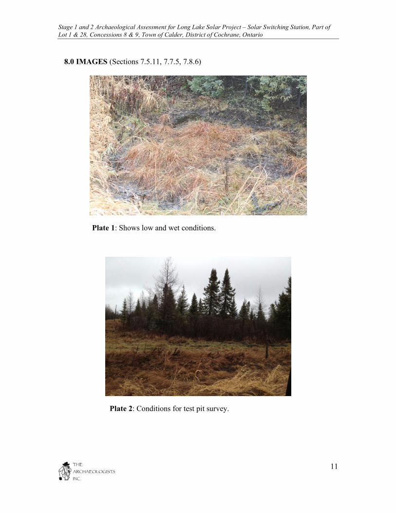
8.0 IMAGES (Sections 7.5.11, 7.7.5, 7.8.6)
Plate 1: Shows low and wet conditions.
Plate 2: Conditions for test pit survey.

Stage 1 and 2 Archaeological Assessment for Long Lake Solar Project – Solar Switching Station, Part of Lot 1 & 28, Concessions 8 & 9, Town of Calder, District of Cochrane, Ontario
12
Plate 3: Conditions for test pit survey.
Plate 4: Conditions for test pit survey.

Stage 1 and 2 Archaeological Assessment for Long Lake Solar Project – Solar Switching Station, Part of Lot 1 & 28, Concessions 8 & 9, Town of Calder, District of Cochrane, Ontario
13
9.0 MAPS (Section 7.5.12, 7.7.6, 7.8.7)
Map 1: General location of subject properties.

Stage 1 and 2 Archaeological Assessment for Long Lake Solar Project – Solar Switching Station, Part of Lot 1 & 28, Concessions 8 & 9, Town of Calder, District of Cochrane, Ontario
14
Map 2: Copy of development mapping provided by proponent (subject property in red).

Stage 1 and 2 Archaeological Assessment for Long Lake Solar Project – Solar Switching Station, Part of Lot 1 & 28, Concessions 8 & 9, Town of Calder, District of Cochrane, Ontario
15
Map 3: Results of Stage 1 and 2 archaeological assessment overlaid on development mapping.