report on the property of spooner mines 6 oils limited
TRANSCRIPT

2.2497 MATTHEWS LAKE 010
SEP ̂ 8 iy/,
MINING LANDS SECTION
REPORT ON THE PROPERTY
OF
SPOONER MINES 6 OILS LIMITED
ft ft ft ft ft ft ft ft ft ft ft ft ft ft ft ft ft ft ft ft ft ft ft ft ft ft ft ft
MATTHEWS LAKE
RED LAKE MINING DIV ISION
ONTARIO
Toron to, Ontario May 30, I977
Thomas Skimming, P.Eng

Location of
SPOONER MINES S OILS LIMITED
Property
Au,Zn,Cu, .Texmont M ine N l
Kirkland Lake * ' Vitginiatown Au Au,Fa,Cu
Sand and gravel, clay ana shale pits. Limestone and other quarries, oil and
s fields.
THOMAS SKIMMING S ASSOCIATES LIMITED
Property Location Map
Matthews Lake Property
SPOONER MINES S OILS LIMITED
Red Lake Mining Division, Ontario
May, 1977 Plan No. SMO-1

INTRODUCTION
A major exploration programme to assess the economic poten tial of the Stull Lake-Hanson River greenstone belt, was initiated by Sherritt Gordon Mines Limited in the summer of 1973- A large area within this belt, selected on the basis of favourable volcanic geology, was flown by Sherritt with their airborne electromagnetic and magnetic systems. As a result, a number of airborne electromagnetic anomalies was staked and investigated further by systematic ground geophysical surveys and diamond drilling.
One of the conductors drilled by Sherritt immediately south- east of Matthews Lake was found to be caused by a zone of massive and s t r inger-type sulphides containing significant quantities of copper, zinc and silver within an altered rhyolitic tuff. '
As a result of the Sherritt discovery, Spooner Mines and Oils Limited acquired the adjoining property and carried out systematic, ground magnetic and electromagnetic surveys to explore the possibility of a westerly extension to Sherritt's base metal sulphide zone.
This report reviews the results of the exploration programme conducted by Thomas Skimming 6 Associates Limited on behalf of Spooner Mines and Oils Limited on their property in the Matthews Lake area.
DESCRIPTION OF PROPERTY
The property of Spooner Mines and Oils Limited consists of
a group of 23 contiguous, unpatented mineral claims which encompass an area of approximately 900 acres. The claims are illustrated on Plan No. M. 2135 which is entitled: "Area of Matthews Lake, District of Kenora, Patricia Por tion, Red Lake Mining Division", and published by the Ontario Ministry of Natural Resources, Surveys and Mapping Branch .
The Spooner claims are follows:
KRL 419636 KRL 419637 KRL 419644 KRL 423897 KRL 423898KRL 423899 KRL 423900 KRL 423901
identified on Plan No. M. 2135 as
KRL KRL KRL KRL KRL KRL KRL KRL
423902 423903 430695 430696430697 430698 430699 430700
KRL KRL KRL KRL KRL KRL KRL
430704 430706 442464 448320 448321 448322 448323

-2-
These claims are outlined and coloured in yellow on a of Plan No. M.2135 which accompanies this report,
copy
LOCATION AND ACCESS
The property is located near the south end of Matthews Lake, approximately 5 miles north of the Sachigo River, a tribu tary of the Severn River. Fort Severn is located some 200 air miles to the northeast of Matthews Lake.
The property can be reached by float or ski-equipped charter aircraft from Red Lake, Ontario 2 ^6 m iles to the south- southwest. Charter aircraft service is also available at Big Trout Lake, 80 miles to the southeast of the property. The nearest centres of population are Bearskin Lake and Big Trout Lake, located *lO and 80 miles respectively to the southeast of the Spooner property.
TOPOGRAPHY AND VEGETATION
The property is characterized by an Intensely glaciated, flat terrain with local relief rarely exceeding 25 feet. During the summer months, the entire area remains wet from the melted winter snow.
The claim group is moderately well forested with mature, but stunted, black spruce. Some poplar, birch, and jack- pine are confined to the higher elevations. Tamarac and tag alders are found in the low, swampy areas and around the shores of most lakes. Exposures of bedrock are sparse.
HI STORY
Early geological mapping in Northwestern Ontario was carried out by J. B. Tyrrell In 1912 when he made a reconnaissance trip, by canoe, from Fort Severn at the mouth River to Trout (Fawn) Lake via the Severn and
of the Severn Fawn Rivers.
In 1937, the Sachigo River Exploration Company investigated a property in the area of Sherman and Foster Lakes. En couraging values in gold were intersected in drill holes which were located to test several gold showings associated with quartz veins. At the same time, this company is re ported to have staked some claims in the Baker Lake area, one mile east of Matthews Lake, to cover a gold occurrence.
More recently, in 1973, Sherrltt Gordon Mines Limited ini tiated a programme of airborne and ground assessment of a

-3-
large portion of the Stull Lake-Hansen River greenstone belt, As a result of this programme, significant base metal inter sections were discovered in diamond drilling on their property
located southeast of Matthews Lake.
The property of Spooner Mines and Oils is located immediately to the west of the claims encompassing Sherritt's discovery.
GENERAL GEOLOGY
The bedrock in the area of the Spooner property consists of Keewat in-type lavas and T i m i skaming-type sedl men t s-lntruded by granite batholiths. The Stull Lake-Hanson River green stone belt, which partially underlies the property, is appro ximately 2 miles wide in the vicinity of Matthews Lake. In general, the belt exhibits an east-west trend over its 50 mile length.
Diamond drilling carried out by Sherritt Gordon Mines Limited in 197** and 1975 encountered altered intermediate and acid vol canic rocks containing. concent rat Ions of approximately l0& base metal sulphide mineralization associated with pyrite and pyr- rot i te.
Outcrop exposure in the vicinity of the property is extremely limited and almost without exception, is confined to the shore lines of the larger lakes in the area. Overburden thickness varies from a few feet to as much as 100 feet or more.
Much of the geological structure is Inferred from aeromagnetic maps. These data suggest that a gabbro intrusive lies between Matthews Lake and the Sachigo River and assumes a roughly cir cular shape. Along the margins of this intrusive, considerable pyrite, pyrrhotite and graphite was encountered in the diamond drilling carried out by Sherritt Gordon Mines Limited to test a number of geophysical anomalies.
PRESENT WORK
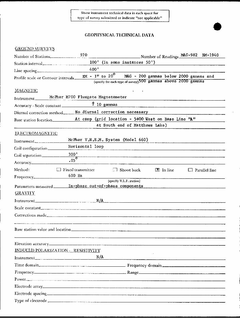
In March and April of 1977. Thomas Skimming 6 Associates Limited carried out a programme consisting of line cutting and geophysical surveying on behalf of Spooner Mines and Oils Limited. The geophysical work consisted of magnetic and elec' tromagnetic surveying employing a McPhar model M700 fluxgate magnetometer and a McPhar model 660 V.H.E.M. electromagnetic system in the horizontal mode using a frequency of 600 Hz and a coil separation of 300 feet. A detailed description of the equipment employed accompanies this report as Appendices "A" and "B".

The entire claim group was covered by geophysical prospecting on grid lines located at ^00 foot Intervals along a base line with an azimuth of 120 degrees. Pickets were located at 100 foot intervals on these lines. The orientation of the grid was determined principally from the attitude of Sherritt Gordon's massive sulphide zone and, to a lesser degree, from the attitudes exhibited in the outcrops of volcanic rocks in the general vicinity of Matthews Lake.
Prior to the commencement of the ground electromagnetic survey, an orientation survey was carried out over the Sherritt dis covery. This had a threefold purpose:
1) to calibrate and test the ground EM system being used over a known conductor to ensure optimum confidence in the elec tromagnetic survey to be carried out over the Spooner p roper ty
2) to compare the electrical response using the McPhar V.H.E.M. system to that obtained by Sherritt Gordon Mines Limited with a Geonics EM-17 system over the base metal sulphide zone
3) to determine the degree to which the control grid could be misaligned without seriously limiting the probability of detection of conductors on the Spooner property.
SUMMARY 6 CONCLUSIONS
In the orientation survey, the McPhar V.H.E.M. system in the horizontal mode outlined the sulphide zone on the Sherritt property with greater definition than the EM-17 survey carried out by Sherritt Gordon Mines Limited during the summer of 197**.
Even at low angle, oblique traverses to the strike of the sul phide zone on the Sherritt property, the zone was readily detected with the McPhar V.H.E.M. system, providing assurance that any conductors that may exist on the Spooner property could be detected even if the strike of the conductor was quite oblique to the geophysical control grid lines.
The results of the electromagnetic survey carried out by Thomas Skimming S Associates Limited over the entire Spooner property indicates that the base metal sulphide zone discovered by Sherritt Gordon Mines Limited does not extend westerly onto the Spooner property. The possibility exists that Sherritt's sulphide zone has a westerly plunge and extends onto the Spooner property at a depth greater than the detection capa bility of the geophysical equipment used; however, there is no evidence available at this time to suggest this to be the case.
-5-
Similarly, the results of the ground magnetic survey do not
indicate that any horizon with a magnetic signature similar
to that recorded over the Sherritt sulphide zone extends
westerly onto the Spooner property.
The geophysical surveys carried out both by Sherritt Gordon
Mines Limited and Thomas Skimming 6 Associates Limited indi
cated the base metal sulphide zone on the Sherritt property
to have a strike length of approximately 1,200 feet. Further,
both surveys clearly demonstrated that the conductor termi
nated ' abrupt l y at its west end approximately 2,500 feet from
the Spooner property.
RECOMMENDATIONS
In light of the results of the geophysical surveys carried out
by Thomas Skimming 6 Associates Limited, no further work on
the property is recommended at this time. Sufficient work has
been done to hold the claims for two years or more. This work
should be filed for assessment purposes in an attempt to keep
the ground in good standing until Sherritt Gordon makes a
decision on whether or not to continue work on their base meta
d i scovery.
Respectfully submitted,
Toronto, Ontario May 26, 1977 m a sSkimming, P . E ng^

.g. 2
o wen
GEOPHYSICAL - GEOLOGIC, TECHNICAL DATA
————————————————————————~~~~~——————"— 53J05SE0001 3.3497 MATTHEWS LAKE
TO BE ATTACHED AS AN APPENDIX . - ._.......... ...,. ~...FACTS SHOWN HERE NEED NOT BE REPEATED IN REPORT
TECHNICAL REPORT MUST CONTAIN INTERPRETATION, CONCLUSIONS ETC.
900
Type of Survey Ground EM Ground MAG
Township or A r™ Matthews Lake Area______________ Claim holder(s)_Robert J. Wright; Armand Aube ; Mervin J.
King; Henry King; Donald B. Cross
Author of Report.. Thomas Skimming, P.Eng.-———————
Address, Suite 1417, 52 Mabelle Ave., Islington, Ontario Covering Dates of Survey March 1 0 to April 15, 1977
(linccutting to office)21Total Miles of Line cut.
SPECIAL PROVISIONS CREDITS REQUESTED
ENTER 40 days (includes line cutting) for first survey.
ENTER 20 days for each additional survey using same grid.
Geophysical
- Electromagnetic.
DAYS per claim
- Radiometric
- Other ——^
Geological.
Geochemical.
AIRBORNE CREDITS (Special provision credits do not apply to ajrborne surveys)
___ RadiometricMagnetometer.
DATE: —
.Electromagnetic ———. (enter days per claim)
' SIGNATURE:.Author of Report or Agent
PROJECTS SECTION Res. Geol. Qualifications.
Previous Surveys —
Checked by. .date.
GEOLOGICAL BRANCH.
Approved by. .date.
GEO1X)GICAL BRANCH.
Approved by. -date.
MINING CLAIMS TRAVERSED List numerically
(prefix) (number)KRL419636 and KRL419637
KRL419644
KRL423897 to KRL423903 incl.
KRL430695 to KRL430700 incl.
KRL430704
KRL430706
KRL442484
KRL448320 to KRL448323 incl.
TOTAL CLAIMS-
Show instrument technical data in each space for type of survey submitted or indicate "not applicable"
GEOPHYSICAL TECHNICAL DATA
GROUND SURVEYSNumber of Stations __________ ?70 __________________ Number of R,aHings MAG-982 EM-1940 Station interval _______________ 100' (in some instances 50') _______^__^^_____
Line spacing _________________ ̂ __________________________________________Profile scale or Contour in.^,1. EM - l" to 2Q0 MAG - 200 gammas below 2000 gammas and
(specify for each type of survey (500 gammas above 2000 gammas
MAGNETICInstrument ____ McPhar M700 Fluxgate Magnetometer ̂ ^^^^^^^^^^^^^^^^^^^^^^^^^
Accuracy - Scale constant * 1 0 gammas
Diurnal correction rnpihnrl No diurnal correction necessary ———————---————-^Base station location _______ At camp (grid location - 5+00 West on Base Line "A" __________________________ at South end of Matthews Lake) ̂ ^^^^^^^^^^^^^
ELECTROMAGNETICInstrument __________ McPhar V.H.E.M. System (Model 660) -—————————^——-—-Coil rnnfig..ra iinn Horizontal loop
Coil separation _________ 300 ________________________^^_^___________^^_^_______Accuracy _____________ ! ̂ --~~—-—~^-—^---^--—---———--^—^^^---^^-----——^-^^-^^-——--^^^^ Method: d Fixed transmitter d Shoot back G9 Inline d Parallel lineFrequency ____________ 6 0Q Hz
(specify V.L.F. station)Parameters measured _____ In-phase out-of -phase components _________________^___GRAVITY
Instrument____________________N/AScale constant^———-—.—...—--———--—.————Corrections made.
Base station value and location.
Elevation accuracy—-———-——^———————. INDUCED POLARI/AU'ION RESISTIVITY
Instrument
Time domain___________________________ Frequency domain. Frequency________________________________ Range-——^—-—.—Po wcr^_-—^__^^.-^^_____--------^^_^____-__—-^-^.^^^^_____Electrode array^— Electrode spacing. Type of electrode.

-t he- w
.L. 'A
LEGEM
TO BE OFFICE OF T
DIVISION OF
AS* i 31978ICE OF f Hi
IDENT BED

O (J rt. S A/E OF SPOONER
C L A /M 5
LEGEND
MAP S*t?S3f Af T^S S3 J'S
DIVISION OF Ml
R̂ECEIV
CE OF THEGEOLOGIST
RED LAKE
THOMAS SKIMMING 6. ASSOCIATES LIMITED
/Zoo fait
53Ja5SE00C! 2 .2497 MATTHEWS LAKE 210
MIME'S AMD OILS L IMITED
Area of MatthtvJS Lak*
GROUND MAGNETIC SURVEY
(CONTOURMAG)
L a A: e Mirtino D fvis/on f
Aril Plan N?
ft J

vuV0
M ct-t-t
c
•*.-rt
\ -
Lr
LEGENID
; M 0 P/iocr V. M.C.K/t.
3tf-o -fturt: e-i-bt-* j S*?** M*.
. ^ \s^ — '
--*-; \ -;
DIVISION OF MIN RECEIV
53J05SE0a0l 2.2497 MATTHEWS LAKE 220
MOCIZ.ONTAL LOOP E.IV1 RESULTS
PL—---I MS

LEGEND
OF SPOONER
//s/ PHASE, PfcOFiut
C(.ea..-m post
' M c Phexr V. H.E.M. 660, hon'zonto-t
mod*, 3o*3 -F^ot cobLe, fe^o H-ZJ
CL^;m mdp M- ^135 Nf-TS. 53 J 5"
V 'V y V̂
T s*V
•f*\,
4 *
V
0 V v^
VTBjlt
JV
f*4Siaajj^&t^
&T tit*V
2.2497 MATTHEWS LAKE 230
THOMAS 3KIMM1K16 6- ASSOCIATES LIMITED
SPOONER MINE'S AND OILS LIMITED
A r aa of Matthtws
HORIZONTAL LOOP E.IW SURVEY
, Onto f t
1977 Plan N?