report on findings: slurry fine disposal sites
TRANSCRIPT

Proposed Slurry Fine Disposal Sites Matilija Dam Ecosystem Restoration Project
REPORT ON FINDINGS Page 1 of 33 September 2008
Report on Findings: Slurry Fine Disposal Sites This Report on Findings addresses slurry disposal sites that have been identified in the Ventura River channel for the disposal of sediment (slurry fines) removed from behind the Matilija Dam. Sediment that has accumulated behind the dam since its construction in 1948 would be removed in preparation for deconstruction of the Matilija Dam. Environmental impacts associated with deconstruction of Matilija Dam were addressed in the Environmental Impact Statement / Environmental Impact Report (EIS/EIR) for the Matilija Dam Ecosystem Restoration Project (2004 EIS/EIR), which was published by the U.S. Army Corps of Engineers (USACE) Los Angeles District in July of 2004 (USACE, 2004).
The 2004 EIS/EIR included review of the same geographic area that would be affected by the proposed slurry disposal sites. The purpose of this Report on Findings is to supplement existing information provided in the 2004 analysis and to provide additional site details that will assist the USACE, the Ventura County Watershed Protection District (VCWPD), and other stakeholders in selecting the most environmentally preferable slurry disposal site(s) to be used as part of the Matilija Dam Ecosystem Restoration Project. This Report on Findings includes discussion of the current environmental conditions relevant to each proposed slurry disposal area, as well as discussion of environmental impacts that could potentially occur through the use of each site for slurry disposal. This report is organized as follows:
• Section 1: Background and Approach. Section 1 provides a discussion of: previous documents prepared for the Matilija Dam Ecosystem Restoration Project; the purpose of this analysis of slurry fine disposal sites; and a brief methodology used to prepare this analysis.
• Section 2: Introduction. Section 2 includes an introductory description of the proposed slurry disposal sites, including location, size, present ownership, and other relevant descriptive information. This section includes Table 1 (Comparison of Slurry Disposal Sites), which provides a comparison of detailed site data for all proposed disposal areas.
• Section 3: Pros and Cons of Existing Site Conditions. Section 3 provides description of existing environmental conditions and potential environmental impacts associated with use of each of the MODA and BRDA sites. For each issue area discussed, Section 3 also identifies comparative benefits (pros) and constraints (cons) associated with use of each site.
• Section 4: Summary of Findings and Comparison of Sites. Section 4 provides a summary and comparison of the pros and cons identified for the MODA and BRDA sites.
1. Background and Approach Environmental impacts associated with the Matilija Dam Ecosystem Restoration Project, including slurry removal and disposal, have previously been addressed in the 2004 EIS/EIR (USACE, 2004). Sediment fines accumulated behind the dam require disposal prior to dam removal, thus necessitating receptor (disposal) areas for such sediments. Disposal of sediment from behind Matilija Dam was evaluated in the Matilija Dam Ecosystem Restoration Project Feasibility Study: Report on Slurry Fine Disposal/Habitat Restoration Sites, as published by the VCWPD in December of 2003 (VCWPD, 2003).

Proposed Slurry Fine Disposal Sites Matilija Dam Ecosystem Restoration Project
REPORT ON FINDINGS Page 2 of 33 September 2008
This Report on Findings provides a comparison between the identified slurry disposal sites using data gathered through the following means: reconnaissance surveys of adjacent land uses and existing environmental conditions (July – August, 2008); reconnaissance-level biological surveys (July – August, 2008); review of existing data and previous documents (EIS/EIR, Feasibility Study, etc.); and coordination with the USACE, VCWPD, and relevant stakeholders. The 2004 EIS/EIR included analysis of slurry removal and disposal; therefore, mitigation measures identified in the 2004 EIS/EIR would help to reduce environmental impacts associated with use of the proposed slurry disposal sites, which are described in detail below.
2. Introduction This Report on Findings provides an overall characterization of the two top candidate slurry disposal areas, as selected from the Report on Slurry Fine Disposal/Habitat Restoration Sites (VCWPD, 2003). The two candidate slurry disposal areas which are evaluated in this Report on Findings include the Meiners Oaks Disposal Area (MODA) and the Baldwin Road Disposal Areas (BRDA). Figure 1 (Proposed MODA and BRDA Slurry Disposal Sites) provides an overview of the project area and the proximity of proposed disposal sites. This section provides an introduction to the MODA and BRDA sites, with detailed descriptions and discussion of potential impacts provided in Section 3 (Pros and Cons of Existing Site Conditions). Table 1 (Comparison of Slurry Disposal Sites), which is presented at the end of this section, provides an initial comparison of site characteristics for the MODA and BRDA sites.
MODA. Figure 1 provides an overview of the location of the MODA site, and Figure 2 (West MODA and East MODA: Vegetation and Setting) provides a more detailed view of the configuration of MODA. Use of the MODA site would include disposal of slurry materials in two portions of the site, which are referred to in this report as West MODA and East MODA. West and East MODA are located adjacent to each other, with the existing Cozy Dell Creek alignment providing a natural divide between them. The MODA sites are located east of Rice Road and south of Fairview Road, on the east side of the Ventura River channel in Meiners Oaks, approximately 3.0 miles downstream of Matilija Dam. This disposal area is approximately 76 acres in size and has adequate capacity to accommodate the full disposal needs for this Project. Lands encompassed by the MODA site include three private parcels owned by separate parties, as well as one parcel owned by the Meiners Oaks Company Water District. The MODA site is located adjacent to the Ventura River / Rancho El Nido Preserve (Ventura River Preserve), which is managed by Ojai Valley Lands Conservancy (OVLC). The preserve lands adjacent to MODA are commonly visited by the public for passive recreation and general outdoor enjoyment.
BRDA. Figure 1 provides an overview of the location of the BRDA sub-sites, and Figures 3 through 6 provide more detailed views of the configuration of Sub-Sites 1 through 4, respectively. Use of the BRDA sites would include disposal of slurry materials at each of the identified sub-sites. The four BRDA sub-sites are numbered consecutively from north to south, with Sub-Site 1 being closest to Matilija Dam and Sub-Site 4 being the farthest downstream.
• BRDA Sub-Site 1 is located north of Highway 150 / Baldwin Road, on the east side of the Ventura River channel, approximately 4.6 miles downstream of Matilija Dam. This site is 50 acres in size and has an estimated sediment storage capacity of 800,000 cubic yards, or 496 acre-feet (VCWPD, 2003). BRDA Sub-Site 1 is currently under private ownership.

Proposed Slurry Fine Disposal Sites Matilija Dam Ecosystem Restoration Project
REPORT ON FINDINGS Page 3 of 33 September 2008
• BRDA Sub-Site 2 is located south of Highway 150 / Baldwin Road, on the east side of the Ventura River channel, approximately 5.3 miles downstream of Matilija Dam. This site is 25 acres in size and has an estimated sediment storage capacity of 500,000 cubic yards, or 310 acre-feet (Chitwood, 2008). BRDA Sub-Site 2 is owned by the County of Ventura.
• BRDA Sub-Site 3 is located east of Burnham Road and west of the active channel, approximately 6.5 miles downstream of Matilija Dam. The smallest of the four proposed BRDA sites, Sub-Site 3 is 11 acres in size and has an estimated sediment storage capacity of 240,000 cubic yards, or 149 acre-feet (VCWPD, 2003). BRDA Sub-Site 3 includes portions of four different parcels which are currently under private ownership.
• BRDA Sub-Site 4 is located east of Santa Ana Road, south of Santa Ana Blvd, and west of the active Ventura River channel, approximately 7.5 miles downstream of Matilija Dam. This site is 32 acres in size and has an estimated sediment storage capacity of 700,000 cubic yards, or 434 acre-feet (VCWPD, 2003). BRDA Sub-Site 4 includes portions of three different parcels which are currently under private ownership.
The estimated storage capacity of the combined BRDA sub-sites is approximately 2,240,000 cubic yards, or 1,388 acre-feet. As with the MODA site, the BRDA sub-sites have adequate storage capacity to accommodate the full disposal needs for this Project.
Table 1 (Comparison of Slurry Disposal Sites) provides a detailed comparison of the MODA site and the BRDA sub-sites. The purpose of Table 1 is to provide a direct comparison of relevant site details for each of the identified disposal areas.

Proposed Slurry Fine Disposal Sites Matilija Dam Ecosystem Restoration Project
REPORT ON FINDINGS Page 4 of 33 September 2008
Table 1. Comparison of Slurry Disposal Sites
Site MODA BRDA
West MODA East MODA Combined MODA Sub-Site 1 Sub-Site 2 Sub-Site 3 Sub-Site 4 Combined BRDA
Site Area (acres)
27 49 76 50 25 11 32 118
Pipeline Area1 (acres)
7.9 7.9 7.9 11.2 12.8 15.8 18.8 18.8
Total Area2 (acres) 34.9 56.9 83.9 61.2 37.8 26.8 50.8 135.8 Distance from Matilija Dam (approximate
miles)3
3.0 3.0 3.0 4.6 5.3 6.5 7.5 4.6 - 7.5
Storage Volume (cubic yards)4
671,000 1,667,000 2,339,000 800,000 500,000 240,000 700,000 2,240,000
Average Height of Mound (feet)5
15 35 15 – 35 6 15 13 14 6 – 15
Proximity to Active Channel
300+ feet to the east 700 feet to the east - Within the active channel
Within the active channel
Adjacent to the west 50 – 600 feet to the west
-
Is there an existing buffer to the active river
channel?
YES. Good quality native upland habitat present.
YES. Good quality native upland habitat present.
- NO. NO. NO. YES. Good quality native upland habitat present.
-
Slurry Disposal Site Containment
On-site native materials would be used to construct containment dikes for the stabilization of slurried sediments.
Same as West MODA around the exposed perimeter. Stabilization would not be required along the east bank, adjacent to bluff.
- Use of containment dikes similar to West MODA would be required. This site would also require riprap stone of approx 2-ft diameter outside dike slopes to provide 5-10 yr level of erosion protection during flood events.
Similar to West MODA. Some on-site boulders may be used for dike construction.
Similar to Sub-Site 2. Similar to Sub-Site 2. -
Site Visibility Visible from private property to the north and recreationists in the area.
Highly visible from the community of Meiners Oaks, to the north and east.
- Visible in the distance from homes on either bank of the river channel and from Hwy 150 to the south.
Visible from portions of private residences to the east and from Hwy 150 to the north.
Minimal visibility from properties to the east; high visibility from private equestrian property to the west.
Minimal public visibility, but high visibility from private home and equestrian property to the west.
-

Proposed Slurry Fine Disposal Sites Matilija Dam Ecosystem Restoration Project
REPORT ON FINDINGS Page 5 of 33 September 2008
Table 1. Comparison of Slurry Disposal Sites
Site MODA BRDA
West MODA East MODA Combined MODA Sub-Site 1 Sub-Site 2 Sub-Site 3 Sub-Site 4 Combined BRDA
Ambient Noise Source(s)
West MODA is buffered from traffic noise along Rice Road by the East MODA site. Sensitive noise receptors include recreationists who visit the Ventura River Preserve lands to the west and south for hiking, equestrian use, and general outdoor enjoyment.
East MODA is adjacent to the west of Rice Road, which produces ambient noise from consistent traffic in the form of passenger cars and large trucks with livestock trailers. Sensitive noise receptors include residents to the north, east, and south.
Existing ambient noise sources include traffic on roadways east and south of the site, and operational noise from the Ojai Valley Organics green waste recycling facility to the southeast (mostly noticeable from the southern portions of Sub-Site 1). Sensitive noise receptors include residents located near the northern-most portion of Sub-Site 1.
Existing ambient noise is produced by traffic along Highway 150 / Baldwin Road and is particularly noticeable in the northern portion of Sub-Site 2. The southern portion of Sub-Site 2, farther away from the roadway, experiences lower ambient noise from the traffic. Private residences to the east are considered sensitive noise receptors.
Existing ambient noise at Sub-Site 3 is low, and is primarily characterized by traffic on Burnham Road to the west. Sensitive noise receptors at Sub-Site 3 include a private equestrian property and horse-boarding facility (P bar H Ranch), as well as a raptor rescue center located adjacent to the west.
Existing ambient noise is characterized by traffic along Santa Ana Road to the west. Sub-Site 4 is currently used as a horse pasture and is located on a private equestrian property, which is considered to be a sensitive noise receptor.
Existing Land Use(s)
Natural floodway / floodplain; no existing development.
Site includes recreational trails maintained on private property by the Ojai Valley Lands Conservancy (OVLC), which has an easement for maintenance of the trails.
- Natural floodway / floodplain; no existing development.
Natural floodway / floodplain; no existing development.
Natural floodway / floodplain; no existing development.
Site is located on a private ranch / equestrian property and is currently used as an irrigated grazing / pasture area by the property owner.
-
Existing Recreational
Use(s)
Site is commonly used by local residents for river access and passive recreation (outdoor enjoyment, nature viewing, etc.).
Popular multi-use recreational trails are aligned on private property through the site and maintained under an easement by the OVLC. This area is regularly used by the public for passive recreation.
- n/a n/a Dispersed equestrian use may occur.
Site is active pasture, but some recreational equestrian uses may occur.
-

Proposed Slurry Fine Disposal Sites Matilija Dam Ecosystem Restoration Project
REPORT ON FINDINGS Page 6 of 33 September 2008
Table 1. Comparison of Slurry Disposal Sites
Site MODA BRDA
West MODA East MODA Combined MODA Sub-Site 1 Sub-Site 2 Sub-Site 3 Sub-Site 4 Combined BRDA
Adjacent Land Use(s)
• Open space, active channel, and Ventura River Preserve lands managed by the OVLC to the west and south
• Private homes and equestrian properties to the north
• Oso Equestrian Ranch to the North, access via Meyers Rd
• Private homes and equestrian properties to the north and east
• ~500 ft South of W El Roblar Dr on west side of S Rice Rd is a parking area used for access to OVLC trails
- • A trailer park is within 900 feet to the east, buffered from Site by vegetation, access road, and channel
• 14 homes to the east w/in 0.2 mile, along the west side of Moreno Dr
• Several large homes and tennis courts ~0.15 mile to the west
• Ojai Valley Organics green waste recycling facility to the southeast
• A small residential community to the east; several modular homes and one larger home with equestrian facilities (a large arena / corral) are adjacent to the site
• Active river channel adjacent to the west
• Private horse-boarding facility (P&H Ranch) is adjacent to the west of the central and southern portions of the Site
• A raptor rescue center is adjacent to the northwest
• Communities in Oak View along Puesta del Sol are 0.1 mile east of the southern portion of the Site
• Site is surrounding by private horse ranching property to the north, west, and south; surrounding area is actively used as pasture
• Active Ventura River channel to the east
-
Site Access Access through East MODA and the Meiners Oaks community to the north.
Access via Rice Rd to the east and Meyers Rd to the north (may require coordination with private property owners to the north).
Access is available from the south via Hwy 150, Old Baldwin Road, and a private access road through the Ojai Valley Organics green waste recycling facility. Access available to the east via an access road maintained by Ojai Valley Sanitary District.
Access is available via Hwy 150 / Baldwin Rd to the north.
Access via Burnham Rd to the west would require coordination with private property (P bar H Ranch) adjacent to the west.
Access via Santa Ana Rd to the west would require coordination with private ranch owners (site is located on the ranch).
-
Tree Removal (quantity / type)
• 28 Oak • 0 Walnut
• 104 Oak • 31 Walnut
• 132 Oak • 31 Walnut
• 44 Oak • 0 Walnut
• 57 Oak • 0 Walnut
• 8 Oak • 5 Walnut
• 19 Oak • 0 Walnut
• 128 Oak • 5 Walnut

Proposed Slurry Fine Disposal Sites Matilija Dam Ecosystem Restoration Project
REPORT ON FINDINGS Page 7 of 33 September 2008
Table 1. Comparison of Slurry Disposal Sites
Site MODA BRDA
West MODA East MODA Combined MODA Sub-Site 1 Sub-Site 2 Sub-Site 3 Sub-Site 4 Combined BRDA
Habitat Type(s) and Quantity
• 19 acres Venturan alluvial fan scrub
• 4.8 acres non-native annual grassland
• 4.9 acres Venturan alluvial fan scrub
• 27.6 acres non-native annual grassland
• 7.0 acres coastal sage scrub
• 7.8 acres oak woodland
• 0.3 acre ruderal • 3.3 acres active
channel / mulefat scrub
• 23.9 acres Venturan alluvial fan scrub
• 32.4 acres non-native annual grassland
• 3.3 acres active channel / mulefat scrub
• 7.0 acres coastal sage scrub
• 7.8 acres oak woodland
• 0.3 acre ruderal
• 15.5 acres Venturan alluvial fan scrub
• 5.2 acres non-native annual grassland
• 16.3 acres active channel (unvegetated)
• 5.1 acres mulefat scrub
• 5.7 acres coastal sage scrub
• 0.1 acre oak woodland
• 5.0 acres Venturan alluvial fan scrub
• 9.0 acres non-native annual grassland
• 1.3 acre active channel (unvegetated)
• 5.6 acres mulefat scrub
• 1.9 acres oak woodland
• 0.05 acre ruderal • 0.1 acre barren
• 8.6 acres Venturan alluvial fan scrub
• 0.7 acres non-native annual grassland
• 0.5 acres mulefat scrub
• 0.2 acres ruderal
• 0.4 acres mulefat scrub
• 0.8 acres oak woodland
• 22.0 acres ruderal
• 29.1 acres Venturan alluvial fan scrub
• 14.9 acres non-native annual grassland
• 17.6 active channel (unvegetated)
• 11.6 acres mulefat scrub
• 5.7 acres coastal sage scrub
• 2.8 acres oak woodland
• 22.3 acres ruderal
• 0.5 acre barren
Potential Sensitive Species Habitat
• Silvery legless lizard
• Coast horned lizard
• Coast patch-nosed snake
• Two-striped garter snake
• Loggerhead shrike
• San Diego desert woodrat
• Silvery legless lizard
• Coast horned lizard
• Coast patch-nosed snake
• Two-striped garter snake
• Loggerhead shrike
• San Diego desert woodrat
- • Southern steelhead – southern California ESU
• Silvery legless lizard
• Coast horned lizard
• Coast patch-nosed snake
• Loggerhead shrike
• San Diego desert woodrat
• Southern steelhead – southern California ESU
• Silvery legless lizard
• Coast horned lizard
• Coast patch-nosed snake
• Two-striped garter snake
• Loggerhead shrike
• Least Bell’s vireo • San Diego desert
woodrat
• Silvery legless lizard
• Coast horned lizard
• Coast patch-nosed snake
• Loggerhead shrike
• Least Bell’s vireo • San Diego desert
woodrat
• California red-legged frog
• Southwestern pond turtle
• Two-striped garter snake
• Yellow warbler
• White-tailed kite
• Yellow-breasted chat
• Loggerhead shrike
• Least Bell’s vireo • Pallid bat
-

Proposed Slurry Fine Disposal Sites Matilija Dam Ecosystem Restoration Project
REPORT ON FINDINGS Page 8 of 33 September 2008
Table 1. Comparison of Slurry Disposal Sites
Site MODA BRDA
West MODA East MODA Combined MODA Sub-Site 1 Sub-Site 2 Sub-Site 3 Sub-Site 4 Combined BRDA
1 The “pipeline area” is an estimate of temporary land disturbance associated with the slurry pipeline and access road (pipeline disturbance area would be a temporary construction impact). This estimate is based upon the assumption that a 20-foot wide swath of land would be required to accommodate the pipeline and road for the distance between the Matilija Dam and the southern-most border of each proposed slurry site location. Actual length of the slurry pipeline and access road may not be the same as the distance from the dam, depending upon final engineering design which will take into account factors such as slope and existing terrain. The total pipeline area for the BRDA Sub-Sites was estimated based upon the distance between Matilija Dam and the downstream border of Sub-Site 4 because it is assumed that one continuous slurry pipeline and access road area would be used for all four BRDA sub-sites. 2 The “total area” is an estimate of land disturbance associated with use of each proposed slurry disposal area. This estimate is a sum of the proposed site area and the pipeline area. As described for the pipeline area estimate, it is assumed that one continuous slurry pipeline and access road area would be used for either the Combined MODA or the Combined BRDA sites; therefore, the total area accounts for one 20-wide path from Matilija Dam to the downstream border of the disposal area which is farthest away (downstream) from the dam. 3 Distance reflects the approximate miles from Matilija Dam to the upstream-border of each site (in comparison with pipeline area, which is calculated using distance to downstream-site border). 4 Storage volume estimate for BRDA Sub-Site 2: Chitwood, 2008; Storage volume estimates for MODA and BRDA Sub-Sites 1, 3, and 4: VCWPD, 2003 5 VCWPD, 2003 [VCWPD (Ventura County Watershed Protection District), 2003. Matilija Dam Ecosystem Restoration Project Feasibility Study: Report on Slurry Fine Disposal / Habitat Restoration Sites. December. [Available online: http://www.matilijadam.org/reports.htm]]

Proposed Slurry Fine Disposal Sites Matilija Dam Ecosystem Restoration Project
REPORT ON FINDINGS Page 9 of 33 September 2008
3. Pros and Cons of Existing Site Conditions This section discusses the pros (comparative benefits) and cons (comparative constraints) associated with use of each of the identified sites for slurry disposal. Discussion of pros and cons is based upon comparison of expected environmental impacts that would occur through use of each site. The analysis of pros and cons presented in this section addresses environmental or resource issue areas considered most relevant with regards to the proposed slurry disposal activities at each site. Areas of analysis include the following, which are presented in order of assumed relevance for Project impacts: biological resources (Section 3.1); land use and recreation (Section 3.2); hydrology and water quality (Section 3.3); aesthetics (Section 3.4); noise (Section 3.5); traffic and transportation (Section 3.6).
3.1 Biological Resources This section presents a general discussion of biological resources relevant to the proposed MODA and BRDA sites. Table 2 (Biological Resources: Pros and Cons of the MODA and BRDA Sites) lists the pros (benefits) and cons (constraints) associated with use of each disposal area, as determined in comparison with each other and from the perspective of potential impacts to biological resources.
Table 2. Biological Resources: Pros and Cons of the MODA and BRDA Sites MODA BRDA
Pros • The use of adjacent disposal areas would result in more localized impacts.
• MODA is the closest disposal area to Matilija Dam which would result in less disturbance to native vegetation communities along the length of the slurry pipeline.
• An adequate buffer to main channel of Ventura River could be maintained with use of MODA.
• Supports fewer native vegetation communities and would affect a smaller area (fewer acres) of native vegetation.
• Access to site is available from existing roadways and would not result in disturbance of biological resources from road construction.
• Sub-Site 4 is dominated by ruderal vegetation, which provides low-quality habitat.
• Sub-Site 2 is dominated by non-native grassland and early seral-stage mulefat scrub indicating previous site disturbance.
• Fewer number of coast live oak (128 vs. 132) and California walnut (5 vs. 31) would be affected.
Cons • West MODA site supports extensive area of healthy, diverse Venturan alluvial scrub habitat.
• Slurry mound would potentially affect the present alignment of Cozy Dell Creek.
• Access limitations (particularly at Sub-Site 3) would require crossing either oak woodland or hundreds of yards of active river channel .
• Wetland habitat is present on a portion of Sub-Site 2.
• Greater potential for sensitive species impacts: San Diego woodrat (CSC*) nests identified at Sub-Site 3; Southwestern pond turtles (CSC*) known to occur at Sub-Site 4; Potential sensitive bird species habitat within riparian areas at Sub-Sites 2 & 4; Potential impacts to steelhead (FE*).
* CSC (California Species of Special Concern); FC (Federal Candidate); FE (Federal Endangered)
The following discussion of existing biological conditions and potential biological impacts of slurry disposal at the MODA and BRDA sites provides explanation of the pros and cons listed above in Table 2. The MODA and BRDA sites are located on current and historic stream terraces adjacent to the Ventura River

Proposed Slurry Fine Disposal Sites Matilija Dam Ecosystem Restoration Project
REPORT ON FINDINGS Page 10 of 33 September 2008
near the communities of Ojai, Miners Oaks, and Oak View in Ventura County, California. Figure 1 (Proposed MODA and BRDA Slurry Disposal Areas) provides an overview of the site locations and surrounding area. The disposal sites were identified and previously evaluated in the 2004 EIS/EIR for the Matilija Dam Ecosystem Restoration Project and the Matilija Dam Slurry Disposal Site Feasibility Report. In order to supplement the biological analyses provided in previous documents, this section specifically includes the following:
• A summary of the surveys completed to support the documentation of biological resources;
• The type and acreage of vegetation communities present at each of the slurry disposal sites;
• The number of oak resources and California black walnut trees present on the proposed sites;
• A concise evaluation of the potential for sensitive plants and wildlife to occur at each of the proposed slurry disposal sites; and
• A general discussion/comparison of the different impacts to each site.
Sections 3.1.1 (MODA) and 3.1.2 (BRDA) of this report each provide a description of the biological conditions present at the proposed MODA and BRDA sites, respectively. These sections also identify the types of plant and wildlife observed during surveys conducted in July and August of 2008.
Biological Surveys
Reconnaissance-level biological surveys were performed by Aspen Environmental Group (Aspen) in July and August 2008 to document the existing conditions present at the proposed disposal sites. These surveys included mapping vegetation communities, preparing an inventory of tree resources (native oak and California black walnut trees), and conducting a general evaluation of the existing biological resources that are present or have the potential to occur at each of the proposed sites. It should be noted that surveys were conducted during a time of year when many annual plants species are difficult or impossible to detect, and when some migratory species (including neo-tropical birds or species that require seasonal water) are difficult to detect. However, these surveys were not intended to document all the species that could occur and as such, they are sufficient to provide a concise overview of the biological resources at the proposed slurry disposal sites. Tables presented below summarize the acreage and type of habitat, the number and size of oak and California black walnut trees, and other relevant biological information documented during the field surveys.
Vegetation
Biological surveys focused on the documentation of the major vegetation communities and are generally classified according to Holland (1986). Vegetation communities identified within the proposed sites included: coast live oak woodland; mulefat scrub; coastal sage scrub; Venturan alluvial fan scrub; non-native annual grassland; active channel (which includes wetland waters); and ruderal habitat, which includes weed-dominated areas that may have some native components and pasture lands. In addition, some areas were devoid of vegetation due to intense grazing pressure or other anthropomorphic disturbances. Table 3 (Comparison of Slurry Site Habitat Type and Quantity) presents the type and acreages of vegetation for each site. The purpose of Table 3 is to provide a general description of the plant communities that occur within each slurry site.

Proposed Slurry Fine Disposal Sites Matilija Dam Ecosystem Restoration Project
REPORT ON FINDINGS Page 11 of 33 September 2008
Table 3. Comparison of Slurry Site Habitat Type and Quantity (acres)
Site MODA BRDA West East Combined Sub-Site 1 Sub-Site 2 Sub-Site 3 Sub-Site 4 Combined
Venturan alluvial fan scrub 19 4.8 23.7 15.5 5.0 8.6 0 29.1 Non-native annual grassland 4.8 27.6 32.4 5.2 9.0 0.7 0 14.9
Active channel 0 3.3 3.3 16.3 1.4 0 0 17.7 Mulefat scrub 0 0 0 5.1 5.8 0.5 0.4 11.8
Coastal sage scrub 0 7.0 7.0 5.7 0.7 0 0 6.4 Oak Woodland 0 7.9 7.9 0.1 1.9 0 0.8 2.8
Ruderal 0 0.3 0.3 0 0.04 0.2 23 23.3 Barren 0 0 0 0 0.07 0 0 0.07
The following vegetation maps reflect the location of habitat type and quantity described in Table 3: Figure 2 (MODA); Figure 3 (BRDA Sub-Site 1); Figure 4 (BRDA Sub-Site 2); Figure 5 (BRDA Sub-Site 3); and Figure 6 (BRDA Sub-Site 4).
Coast Live Oak and California Black Walnut Trees
The MODA site and the BRDA sub-sites support populations of coast live oak (Quercus agrifolia) trees and California black walnut (Juglans californica), which is a California Native Plant Society (CNPS) List 4 plant. According to the CNPS, List 4 species are plants of limited distribution and “while not “rare” from a State wide perspective [List 4 plants] are uncommon enough that their status should be monitored regularly”. Table 4 (Tree Resources at MODA and BRDA Sites) describes the quantity and size of coast live oak and California black walnut trees identified at each disposal area.
Table 4. Tree Resources at MODA and BRDA Sites
Proposed Slurry Site Coast Live Oak* California Walnut* 0-3” 3-7” 7-10” >10” 0-3” 3-7” 7-10” >10”
East MODA 14 14 14 62 10 10 6 5 West MODA - 8 6 14 - - - -
Subtotal 14 22 20 76 10 10 6 5 Total 132 31
BRDA Sub-Site 1 - - - 44 - - - - BRDA Sub-Site 2 6 4 9 38 - - - - BRDA Sub-Site 3 - - - 8 - 3 1 1 BRDA Sub-Site 4 - - 1 18 - - - -
Subtotal 6 4 10 108 - 3 1 1 Total 128 5
* Size in inches reflects the dbh (diameter at breast height).
As shown in Table 4, the MODA site (West MODA and East MODA combined) supports 132 coast live oak trees. Seventy six (76) of these trees are large mature oaks that are larger than ten inches in diameter at breast height (dbh). In comparison, the BRDA sub-sites (combined) support 128 coast live oak trees with approximately 108 that are larger than ten inches dbh. Large oak trees of this scale are likely well over one hundred years old and produce large quantities of acorns that support foraging for various species of wildlife. Large oak trees also provide important nesting and refuge areas for many species.
Sensitive Plants and Wildlife The variety of riparian and scrub habitats that occur in the slurry disposal sites can support a variety of resident and migratory wildlife use. The native plant communities present at each site can support a

Proposed Slurry Fine Disposal Sites Matilija Dam Ecosystem Restoration Project
REPORT ON FINDINGS Page 12 of 33 September 2008
variety of sensitive plants. In addition, California black walnut, which is a CNPS List 4 species, was identified on several of the disposal sites (see Table 4, above). Several other sensitive annual plants could also occur, including Davidson’s saltscale (Atriplex serenana var. davidsonii) and late-flowered mariposa lily (Calochortus weedii var. vestus), which are both CNPS List 1b plants. It is possible that additional sensitive annual plants could occur but were not detected during the 2008 surveys due to the timing of the surveys.
The Ventura River corridor is known to support a variety of sensitive wildlife species. Habitat on many of the slurry disposal sites consists of a mosaic of native and non-native vegetation communities, as depicted on the vegetation maps (see Figures 2 through 6). As such, these areas, along with the general project region, provide suitable habitat for a diverse variety of wildlife species. Areas dominated by mulefat scrub or coastal scrub communities provide potential nesting and foraging habitat for a number of migratory songbirds, native amphibians, reptiles, and mammals. In addition, numerous trees scattered throughout the sites provide potential perching and roosting habitat for a variety of raptor and bat species.
Wildlife observed at the MODA and BRDA sites in July and August of 2008 included a variety of reptiles, birds, and small mammals. Although not observed during the 2008 surveys, the following two California species of special concern have potential to occur in riparian habitat: southwestern pond turtle (Clemmys marmorata) and two-striped garter snake (Thamnophis hammondii). Several areas may also support habitat for southern steelhead (Oncorhynchus mykiss irideus) when flow is present. The steelhead population in this area is considered a federally endangered (FE) evolutionary significant unit (ESU).
Numerous sensitive bird species may use parts of the MODA and BRDA sites, including the following California species of special concern: rock wren (Salpinctes obsoletus), yellow warbler (Dendroica petechia brewsteri), and yellow-breasted chat (Icteria virens). In addition, the State- and federally-listed least Bell’s vireo (Vireo bellii pusillus) may occur in riparian habitat areas. Table 5 (Potential Habitat for Sensitive Species at the Proposed Slurry Disposal Sites) identifies potential habitat for sensitive wildlife species that occur at the MODA and BRDA sites, based on initial assessment of habitat characteristics.

Proposed Slurry Fine Disposal Sites Matilija Dam Ecosystem Restoration Project
REPORT ON FINDINGS Page 13 of 33 September 2008
Table 5. Potential Habitat for Sensitive Species at the Proposed Slurry Disposal Sites Scientific Name Common Name Status* West
MODA East
MODA BRDA
1 BRDA
2 BRDA
3 BRDA
4 Fish Oncorhynchus mykiss irideus
Southern steelhead – southern California ESU
FE, CSC X X
Amphibians Rana aurora draytonii California red-legged frog FT, CSC X Reptiles Actinemys marmorata pallid Southwestern pond turtle FC, CSC X
Anniella pulchra pulchra Silvery legless lizard CSC X X X X X Phrynosoma coronatum Coast horned lizard CSC X X X X X Salvadora hexilepis virgultea Coast patch-nosed snake CSC X X X X X
Thamnophis hammondii Two-striped garter snake CSC X X X X Birds Dendroica petechia Yellow warbler CSC X Elanus leucurus White-tailed kite FP X Icteria virens Yellow-breasted chat CSC X Lanius ludovicanus Loggerhead shrike CSC X X X X X X Vireo bellii pusillus Least Bell’s vireo FE, CE X X X Mammals Antrozous pallidus Pallid bat CSC X Neotoma lepida intermedia
San Diego desert woodrat
CSC X X X X X
* FE (Federally Endangered); CSC (California Species of Special Concern); CE (State Endangered); FP (State Fully Protected Species); FE (Federal Candidate)
Ecological Setting
The Ventura River drains 226 square miles of watershed from the interior portion of the Transverse Range to the Pacific Ocean. Biological resources located in this area are typical of plant and wildlife species encountered in the Transverse Ranges of southern California and are adapted to a Mediterranean climate with cool wet winters and hot dry summers. Rainfall occurs primarily between October and March, with the heaviest rainfall located on the steep mountain faces while beach areas receive substantially less rainfall.
This climatic condition provides for a variety of plant communities that support diverse and species-rich flora and fauna. Sage scrub and chaparral communities occur on many of the adjacent hillsides, while mixed riparian and alluvial scrub habitats occur along the lower sections of the Ventura River. Agricultural lands planted with citrus and avocado groves are intermixed with residential properties, horse stables, and parks along many sections of the river. In some areas development has encroached into the surrounding flood plain and adjacent habitat, removing much of the previous upland habitat and requiring the construction of a levee system. The vegetation communities described in the tables above exist within the Ventura River watershed and associated floodplain and uplands. As a result, vegetation communities within the watershed, particularly within active or secondary channels, are related to the hydrologic and geomorphic conditions at each site. For example, where gradients are relatively steep, water scouring has generally resulted in the removal of vegetation. This occurs as seasonal flows produce sediment-laden pulses that are capable of dislodging significant portions of riparian vegetation and altering existing stream channels.

Proposed Slurry Fine Disposal Sites Matilija Dam Ecosystem Restoration Project
REPORT ON FINDINGS Page 14 of 33 September 2008
The effects of natural hydrologic and geomorphic processes are evident throughout the active channel and small, tributary drainages located within or adjacent to each of the proposed sites. These areas are dominated by mulefat scrub, an early successional riparian community. Mature mixed-riparian scrub, typically dominated by willows and/or cottonwoods does not occur within any of the proposed sites. This is likely a result of flow regime intervals that have altered the existing channels and limited the establishment of these species or because the site is located within adjacent uplands where these species would not be expected to occur. Conversely, areas characterized by more gentle gradients are typically subjected to the deposition of alluvial materials. Consequently, these areas provide suitable conditions for the establishment and colonization of early seral-stage vegetation. In areas subject to less scour and flooding these areas transition to Venturan alluvial scrub communities. The uppermost terraces of the MODA and BRDA sites do not require a permanent or seasonal source of water. Vegetation communities in these areas generally include oak woodland, coastal sage scrub, and non-native grassland.
3.1.1 MODA
The MODA site includes West MODA and East MODA which have different biological resources and are therefore discussed separately here, although use of the MODA site would include both West and East MODA.
West MODA. This site is bordered on the south and east by Cozy Dell Creek and the Ventura River floodplain bluff, and on the west by more terrace and braided channels and ultimately the main channel of the Ventura River. The northern portions of this site include fenced pasture. The remainder of the site is dominated by older stream terraces that support well-developed Venturan alluvial scrub with small patches of non-native grassland. In areas where flooding has not occurred for many years, the vegetation is transitioning to more chaparral-like communities dominated by Laurel sumac (Malosma laurina), holly-leaf cherry (Prunus ilicifolia), California red-berry (Rhamnus ilicifolia), and mountain mahogany (Cercocarpus betuloides var. blancheae). Bush poppy (Dendromecon rigida var. rigida) is also present in some areas and non-native Spanish broom (Spartium junceum) occurs intermittingly across the site.
A series of small, braided tributary channels is interspersed among the terraces of West MODA. Vegetation in these channels, including Cozy Dell Creek, is dominated by mulefat scrub. The Ventura River, which lies approximately 300 feet west of the western edge of this site, is essentially devoid of vegetation in this area.
West MODA contains good quality scrub communities, and additionally supports 28 oak trees. Subsequently, this site provides suitable habitat for a variety of raptors and other birds that could utilize larger trees and shrubs for roosting. Generally, these trees occur within patches of non-native grassland located along the western and northern edges of the site.
The Venturan alluvial scrub that occurs at West MODA represents some of the highest quality habitat of this type relative to the other proposed disposal areas. As a result, wildlife observations at this site, and particularly within this habitat type, were diverse. Some of the species identified included Cooper’s hawk (Accipiter cooperii), red-tailed hawk (Buteo jamaicensis), barn owl (Tyto alba), dusky-footed woodrat (Neotoma fuscipes), coyote (Canis latrans), and mule deer (Odicoiles hemionus). Western fence lizard (Sceloporus occidentalis), side-blotched lizard (Uta stansburiana), striped skunk (Mephitis mephitis), and California ground squirrel (Spermophilus beecheyi) were also detected.
Construction access to West MODA is available on existing roadways and would result in limited effects to biological resources.

Proposed Slurry Fine Disposal Sites Matilija Dam Ecosystem Restoration Project
REPORT ON FINDINGS Page 15 of 33 September 2008
East MODA. This site is bordered on the west and north by Cozy Dell Creek and on the east by the Ventura River floodplain bluff. Dense coast live oak woodland with approximately 144 trees, with a chaparral understory, occurs along the slope of the floodplain bluff and grades into coast live oak woodland and non-native grassland along the toe of the slope. Several mature sycamores are present along the toe of the slope as well. In some areas a dense thicket of ceanothus (Ceanothus sp.) dominates the hillside. An abandoned orchard/vineyard covers a large portion in the center of this site. This area is dominated by non-native grassland and a variety of ruderal species. The predominant nonnative annual grasses identified in this area include slender brome grasses (Bromus spp.) wild oat (Avena barbata), cultivated oat (A. sativa), Mediterranean grass (Schismus barbatus) and foxtail fescue (Vulpia myuros). Native herbaceous species observed include western ragweed, evening primrose (Camissonia spp.), wild forget-me-not (Cryptantha spp.), dove weed (Eremocarpus setigerus), and telegraph weed (Heterotheca grandiflora), Non-native weedy species are common and dominated by summer mustard (Hirshfeldia incana), tocalote (Centaurea melitensis), and Russian thistle (Salsola tragus). Small patches of milk thistle (Silybum marianum), tree tobacco (Nicotiana glauca), and horehound (Marrubium vulgare) are also common.
In some areas of East MODA, remnants of coastal sage scrub and Venturan alluvial scrub vegetation are present, including the following: California buckwheat (Eriogonum fasciculatum var. fasciculatum), California sagebrush (Artemisia californica), scale broom (Lepidospartum squamatum), and California cudweed aster (Lessingia filaginifolia var. filaginifolia). At some locations there appears to be new recruitment of native species. Several coast live oaks (Quercus agrifolia) and western sycamores (Platanus racemosa) are scattered throughout portions of the abandoned orchard and integrate into more contiguous oak woodland towards the east. Extensive patches of mulefat (Baccharis salicifolia) scrub dominate the lower elevation, southern and western portions of the site and are associated with the tributary channels of the Ventura River and Cozy Dell Creek. White sweet clover (Melilotus alba) tree tobacco and brome grasses are common in these areas.
This area supports a large number of mature oak and sycamore trees. Most of these trees are associated with the oak woodland along the eastern edge of East MODA and large patches of non-native grassland that dominate the existing pastures to the north and the abandoned orchard at the center of the site. Wildlife species identified at West MODA include turkey vulture (Cathartes aura), western scrub-jay (Aphelocoma californica), western kingbird (Tyrannus verticalis), Botta’s pocket gopher (Thomomys bottae), and coyote. Black phoebe (Sayornis nigricans), common raven (Corvus corax), spotted towhee (Pipilo maculatus), western fence lizard (Sceloporus occidentalis), and California ground squirrel (Spermophilus beecheyii) were also detected.
As with West MODA, construction access to East MODA is available on existing roadways and would result in limited effects to biological resources.
3.1.2 BRDA
The BRDA site includes Sub-Sites 1 through 4, which have different biological resources and are therefore discussed separately here. The use of the BRDA site would include all four sub-sites for slurry disposal.
Sub-Site 1. This site is located just north of Highway 150. The western half of the Sub-Site 1 includes the main channel of the Ventura River as well as a braided series of river channels. The eastern half is characterized by mature stream terraces that support well-developed, species-rich shrub and tree vegetation with large patches of Venturan alluvial scrub and coastal sage scrub. Several mature coast live oak and western sycamore trees are scattered throughout the site, particularly in the northern half. Non-native brome grassland, with small patches of native, perennial bunchgrass (Nassella sp.) occurs intermixed among scrub

Proposed Slurry Fine Disposal Sites Matilija Dam Ecosystem Restoration Project
REPORT ON FINDINGS Page 16 of 33 September 2008
communities and beneath many of the large trees. The lower elevation terraces and tributary channels that occur at Sub-Site 1 support patches of mulefat scrub and early seral-stage Venturan alluvial scrub, which is primarily dominated by scale-broom.
BRDA Sub-Site 1 has historically been characterized as all terrace with oaks, but the site has eroded since the 1950s in part due to river sediment starvation resulting from the presence of Matilija Dam, as well as normal river meandering. The channels targeted for Slurry placement are relatively recent. This site now supports 44 mature coast live oak trees. The primary feature of this site is the active channel of the Ventura River that bisects the site from north to south. Much of this area is devoid or minimally concentrated with vegetation. The substrate along the channel is dominated by small boulders that allow for significant interstitial spacing. Desiccated algal matting (Chara sp.) blankets the rocks in many areas of the channel. During periods of seasonal flow, this area may provide suitable habitat for southern steelhead trout. Among the wildlife species identified at this site were mourning dove (Zenaida macroura), great blue heron (Ardea herodias), western scrub-jay, desert woodrat (Neotoma lepida), and side-blotched lizard.
Construction access to Sub-Site 1 could occur from an existing access road located east of the site which is maintained by the Ojai Valley Sanitation District; however, an existing flood control berm restricts access to much of the unvegetated Ventura River channel within this site and would require temporary road improvements.
Sub-Site 2. This site is bordered on the north by Highway 150, on the west by the active channel of the Ventura River, and on the east by a steep floodplain bluff. The site is comprised of high and low elevation terraces extending from the floodplain bluff westward towards the edge of the active channel of the Ventura River. The northern half of Sub-Site 2 is dominated by a mature terrace that supports extensive areas of non-native grassland and ruderal habitat. This area appears to have been subjected to infrequent grazing. Individual and small stands of mature coast live oak trees are scattered throughout this grassland area and are intergraded eastward into more contiguous coast live oak woodland along the toe and slope of the floodplain bluff. Extensive patches of mulefat scrub extend along the western edge of this grassland area and are associated with a series of braided channels that connect to the main channel of the Ventura River.
A small wetland occurs at the toe of the bluff along the eastern edge of the site. This area supports dense mulefat scrub with some scattered willows (Salix sp.) and other facultative wetland species such as sedges (Carex sp.) and cattails ( Typha sp.). Green willow herb (Epilobium sp.) and thick stands of stinging nettles (Urtica dioica ssp. holosericea) are also common in this wetland area. There are several small, mature stream terraces in the western and southwestern portions of the site, adjacent to the main active channel. These terraces support a large patch of well-developed Venturan alluvial scrub.
The BRDA Sub-Site 2 also supports a large concentration of oak and sycamore trees. Most of the 57 oak trees occur within the non-native grassland that dominates the northern half of the site and within the oak woodland that occurs along the eastern edge of the site. This same area also supports potential wetland habitat that may support a diverse assemblage of bird species. Dense, nearly impenetrable stands of mulefat scrub that occur along the central and western portions of the site provide suitable nesting habitat for least Bell’s vireo. Mature, undisturbed, upper stream terraces, which are becoming increasingly uncommon along the Ventura River, abut portions of the active channel along the western edge and southern portion of the site.
Bird diversity was relatively high at Sub-Site 2; species identified during surveys include the following: turkey vulture, red-tailed hawk, Say’s phoebe (S. saya), cliff swallow (Pterochelidon pyrrhonota), house finch (Carpocadus mexicanus), and bushtit (Psaltriparus minimus). Common raven, Anna’s hummingbird (Calypte anna), California towhee (P. crissalis), American goldfinch (Carduelis tristis), great-tailed grackle

Proposed Slurry Fine Disposal Sites Matilija Dam Ecosystem Restoration Project
REPORT ON FINDINGS Page 17 of 33 September 2008
(Quiscalus mexicanus), common yellowthroat (Geothlypis trichas), and Bewick’s wren (Thryomanes bewickii) were also detected. Other wildlife species observed or identified at this site include southern alligator lizard (Elgaria multicarinata), dusky-footed woodrat, striped skunk (Mephitis mephitis), and mule deer (Odocoileus hemionus).
Construction access to Sub-Site 2 could be gained from a small access road that connects with Highway 150, which is adjacent to the north;
Sub-Site 3. This site is bordered on the west by private residential properties with horse stables and on the east by the active channel of the Ventura River. The majority of this site consists of elevated stream terrace dominated by well-developed Venturan alluvial scrub and chaparral communities. Laurel sumac, holly-leaf cherry, California red-berry, and mountain mahogany are common within Sub-Site 3. Several black walnut trees are also present. Non-native grassland and ruderal vegetation occur at the far southern portion of this site. The northwestern and west-central portions of the site are separated from the higher western terrace by a tributary channel that supports mulefat scrub and appears to convey water annually.
Sub-Site 3 supports eight oak trees, which is the smallest oak population supported by one of the proposed slurry disposal sites. These trees are scattered randomly throughout the site and consist of mature coast live oaks. The active channel of the Ventura River immediately abuts the eastern edge of the site and may provide suitable habitat for southern steelhead trout during adequate flow events. Additionally, a raptor rehabilitation facility lies immediately adjacent to the western edge near the central portion of Sub-Site 3. Several hawks and one golden eagle were observed in a netted cage at this facility during surveys. San Diego woodrat (CSC) nests were detected within Venturan alluvial scrub habitat at several locations. Other wildlife species identified include western fence lizard, turkey vulture, western scrub-jay, California quail (Callipepla californica), and northern oriole (Icterus galbula). Western rattlesnake (Crotalus viridus), phainopepla (Phainopepla nitens), bobcat (Lynx rufus), brush rabbit (Sylvilagus bachmani), raccoon (Procyon lotor), and California ground squirrel were also detected.
Construction access to this Sub-Site 3 could occur through the adjacent residential / equestrian properties; however, if use of private property for construction access is not possible, it would be necessary for construction vehicles and equipment to either traverse oak woodland on the adjacent western terrace, or traverse hundreds of yards of active channel of the Ventura River in order to gain site access. As such, with use of Sub-Site 3, construction access could result in adverse biological impacts if use of adjacent private property is not agreed upon with the property owner(s).
Sub-Site 4. This site is dominated by a low elevation terrace and associated floodplain of the Ventura River, which borders the eastern edge of the site. Oak Creek, a small intermittent drainage, flows along the western border of Sub-Site 4. The main channel and tributaries that border this site support dense, mature mixed riparian woodland, including large coast live oak, western sycamore, and willow trees. Large patches of giant reed (Arundo donax) also occur scattered throughout these channels.
The entirety of Sub-Site 4 is currently used for horse pasture. Vegetation is dominated by ruderal species including ragweed (Ambrosia psilostachya var. californica), cocklebur (Xanthium strumarium), milk thistle (Silybum marianum), white sweet clover, mayweed (Anthemis cotula), chamomile (Chamomilla suaveolens), plantain (Plantago sp.), and summer mustard. Brome grasses, Bermuda grass (Cynodon dactylan), and red stem filaree (Erodium cicutarium) are also present. Several mature coast live oak and western sycamore trees occur scattered throughout the site and a dense stand of these trees occurs in the central portion of the site. The northern portion of the site is fenced and consists of livestock corrals and horse boarding facilities. This area is essentially devoid of shrub and ground vegetation and supports

Proposed Slurry Fine Disposal Sites Matilija Dam Ecosystem Restoration Project
REPORT ON FINDINGS Page 18 of 33 September 2008
scattered, mature coast live oaks and western sycamore trees. Several weedy invasive species including spiny cocklebur (Xanthium spinosum) occur at this site.
In some portions of Sub-Site 4, heavy watering and the proximity to the Oak Creek drainage have resulted in more mesic areas that support water-loving species including nut sedge (Cyperus sp.) and curly dock (Rumex sp.). Sub-Site 4 supports 19 coast live oak trees, most of which are concentrated in the northern and central portions of the site. Additionally, several large sycamores occur within these areas as well. Trees at and adjacent to this site provide high-quality perching and roosting sites for a variety of raptor and bat species. This may include pallid bat (Antrozous pallidus) a California species of special concern. Dense mixed riparian scrub borders the site on the eastern and western edges. These areas provide potential nesting and foraging habitat for a variety of sensitive bird species, including least Bell’s vireo (Vireo bellii pusillus), yellow warbler (Dendroica petechia), yellow-breasted chat (Icteria virens), loggerhead shrike (Lanius ludovicianus), and white-tailed kite (Elanus leucurus). Additionally, suitable habitat for California red-legged frog (Elanus leucurus) and two-striped garter snake (Thamnophis hammondii) also occurs in areas adjacent to Sub-Site 4.
Construction access to Sub-Site 4 is available on existing roadways (Santa Ana Rd / Santa Ana Blvd).. However, the slurry pipeline and access road for Sub-Site 4 would have a larger area of impact than the other proposed disposal sites and would likely result in the transitioning of large areas of mature riparian habitat from their current condition.
3.2 Land Use and Recreation This section presents discussion of land use and recreation relevant to the proposed MODA and BRDA sites. Table 6 lists pros and cons associated with use of each site. Following this table is a more detailed discussion of existing land use and recreation at and adjacent to the MODA sites (East MODA, West MODA) and the BRDA sites (Sub-Sites 1 through 4).
Table 6. Land Use and Recreation: Pros and Cons of the MODA and BRDA Sites
MODA BRDA Pro(s) • Due to the large storage capacity of the MODA
site (2,339,000 cy) the use of multiple disposal sites would not be required, thereby localizing land use and recreation impacts.
• Minimal recreational resources would be affected; potential recreational impacts are limited to Sub-Sites 3 and 4 and would apply to dispersed equestrian use (trail riding).
Con(s) • Multi-use recreational trails that cross through the MODA site would be temporarily relocated during the construction period (trails would be restored in current alignment post-construction).
• The use of multiple sites would distribute potential land use impacts across a larger geographic area.
• Sub-Site 4 is currently used as active pasture, which would be converted from use for the lifetime of the Project.
Land use and recreation impacts would occur if use of the selected disposal site(s) would prohibit existing or planned site uses to continue in the future. Future land use(s) of the selected disposal are not included in this analysis; however, as consistent with the 2004 EIS/EIR, mitigation measures for the Project would help to return the selected site(s) to existing conditions with regards to topography and vegetation and as such, it is expected that current land use and recreation at the site(s) would be able to continue in the future.
Use of either the MODA site or the BRDA Sub-Sites would have the potential to interrupt and/or prevent certain uses and recreational activities as a result of the specific site location, access road improvements, slurry pipeline positioning, and/or construction vehicle traffic. As discussed in Section 1 (Background and Approach), the 2004 EIS/EIR included analysis of slurry removal and disposal. Mitigation measures that

Proposed Slurry Fine Disposal Sites Matilija Dam Ecosystem Restoration Project
REPORT ON FINDINGS Page 19 of 33 September 2008
were identified in the 2004 EIS/EIR are applicable to slurry disposal activities. Therefore, all mitigation measures relevant to land use and recreation that were identified in the 2004 EIS/EIR would be applied at the selected slurry disposal area and would serve to avoid or minimize potential impacts related to land use and recreation. Also as consistent with the 2004 EIS/EIR, topographic changes that would occur at the selected disposal area would be temporary in nature and would not affect long-term land use or recreation at the site.
3.2.1 MODA
The MODA site is surrounded by the community of Meiners Oaks to the north and east and the Ventura River channel to the west and south. Private lands that are management by the OVLC as part of the Ventura River Preserve are adjacent to the west and south of MODA, but are not included as part of the slurry disposal area. The MODA site is commonly used by the public and particularly by local residents for recreational activities, including hiking, equestrian use, river access, wildlife viewing, and general outdoor enjoyment. The OVLC maintains a network of multi-use recreational trails in the Ventura River Preserve and some of these trails cross through private lands on the MODA site. The portion of trails that are currently aligned through the MODA site are not part of the Ventura River Preserve, but they are maintained by the OVLC under an easement for use of the land.
Use of this area for slurry disposal would result in temporary but long-term impacts to present land use and recreation. With use of the MODA site for slurry disposal, all current land use and recreational activities at the site would be temporarily disrupted. Any recreational trails that would be affected by use of the MODA site for slurry disposal would be relocated in the immediate vicinity of MODA during the construction period, and long-term access would be restored at current trail locations after the completion of construction. Construction traffic along Rice Road and Meyers Road would also have the potential to affect equestrian-related recreational activities in the area. Mitigation measures discussed in the 2004 EIS/EIR for the Matilija Dam Ecosystem Restoration Project would help to avoid or minimize potential impacts related to land use and recreation.
Land disturbance associated with the slurry pipeline between Matilija Dam and the MODA site is estimated to be approximately 7.9 acres (as listed in Table 1). This disturbance would occur in the existing channel, and would require ramps or another form of access to be installed. The area of disturbance associated with the slurry pipeline would be less for the MODA site than for the BRDA sub-sites. Existing conditions and potential land use and recreation impacts at West MODA and East MODA are discussed in further detail below.
West MODA. The area encompassed by West MODA includes three separate ownership parcels. The north half of West MODA is part of parcel #0110020135, the southern half of the site is part of parcel #0110030050, and the southern-most tip of West MODA is part of parcel #0110030060 (Meiners Oaks Company Water District). There is no present development on West MODA. Open space, active channel, and Ventura River Preserve lands owned and managed by the OVLC are adjacent to the west of West MODA. Rural homes and equestrian properties of the Meiners Oaks community are in close proximity to the north of West MODA. Recreational activities in the area generally consists of equestrian use (trail riding, arena training, etc.), hiking or walking, mountain biking, nature study, and general outdoor enjoyment.
The primary land use and recreation pros of using West MODA for slurry disposal is that no development is present and fewer recreational uses would be affected by Project activities. The primary land use and recreation constraint associated with using West MODA for slurry disposal is that the site is currently

Proposed Slurry Fine Disposal Sites Matilija Dam Ecosystem Restoration Project
REPORT ON FINDINGS Page 20 of 33 September 2008
undeveloped and natural in condition, so that use of the site would result in a temporarily dramatic conversion. Topography and vegetation at the site would be restored through mitigation consistent with the 2004 EIS/EIR.
East MODA. The area encompassed by East MODA includes four separate ownership parcels. The north and northeast portions of East MODA are part of parcel #0110020060, the central-northwest portion of the site is part of parcel #0110020135, roughly the southern two-thirds of the site area are part of parcel #0110030050, and the southern-most tip of East MODA is part of parcel #0110030060 (Meiners Oaks Company Water District). With the exception of recreational trails which are addressed below in Section 4.8 (Recreation), there is no present development on East MODA; however, as described in Section 3.1 (Existing Environmental Conditions: Adjacent Land Uses), adjacent land uses include multiple equestrian properties, which could be disturbed or otherwise affected by use of East MODA.
Oso Equestrian Ranch is adjacent to the North of East MODA, with other rural and equestrian properties in the area, between Meyers Rd (to the north) and Fairview Rd (to the south), west of N Rice Road (east of East MODA). Homes and residential lots are adjacent and within close proximity to the east of East MODA, along N Rice Road between Devereux Dr (to the south) and Fairview Ave (to the north). Adjacent to the southeast of East MODA, approximately 500 feet south of W El Roblar Drive on the west side of S Rice Road, is a parking area and trailheads maintained by the OVLC. Also in this area, on the east side of S Rice Road, is an equestrian property that stretches between W Lomita Ave (to the south) and W El Roblar Dr (to the north).
Access to the Ventura River Preserve is available through West MODA, from Riverview Trailhead and Rice Canyon Trailhead. These access points would be temporarily relocated with use of West MODA for slurry disposal. In addition, recreational trails that cross through the MODA site and are managed by the OVLC would be temporarily relocated during the construction period. This relocation would be necessary due to a variety of Project-related factors, including the following: direct slurry disposal, slurry pipeline alignment, and/or construction-related traffic and noise. Trails and trailheads would be restored in their current alignment following the construction period.
The main land use and recreation pros associated with use of East MODA for slurry disposal are that due to its large size (compared to other proposed sites), storage capacity would allow for the deposition of a large quantity of slurry material, thus eliminating the need to use multiple slurry disposal sites and distribute land use and recreation impacts across a larger geographic area than the site alone. Land use and recreation cons associated with use of West MODA for slurry disposal include the restriction and/or conversion of popular recreational resources and activities from use. In order to minimize recreation impacts resulting from use of the MODA site for slurry disposal, close coordination with managing agencies and parties would be required. Relocation of recreational resources such as trails would also be required, as appropriate.
3.2.2 BRDA
The BRDA sub-sites are located in or adjacent to the Ventura River channel, from just north of Highway 150 / Baldwin Road to just south of Santa Ana Blvd. Recreational activities at these site locations are minimal, and are limited to dispersed equestrian use, as described in further detail below. Use of the BRDA sub-sites for slurry disposal may result in some temporary impact to recreation; however, implementation of mitigation measures identified in the 2004 EIS/EIR would serve to avoid or minimize these impacts. Use of the BRDA sub-sites would have less of a potential to result in recreational impacts than would use of the MODA site and therefore, pros associated with slurry disposal at the BRDA sub-sites include the avoidance of recreational impacts. Land use and recreation constraints associated with slurry disposal at these sites

Proposed Slurry Fine Disposal Sites Matilija Dam Ecosystem Restoration Project
REPORT ON FINDINGS Page 21 of 33 September 2008
include the potential to affect a wider variety of private and residential properties adjacent to and/or in close proximity to the disposal activities.
The use of multiple sites under BRDA as opposed to MODA would affect land use in multiple areas and would result in a greater area of land disturbance from the slurry pipeline and access road. Land disturbance associated with the slurry pipeline between Matilija Dam and the BRDA sub-sites is estimated to be approximately 18.8 acres, in comparison with MODA’s 7.9 acres of disturbance, and accounts for the slurry pipeline extending to the downstream border of the most downstream disposal area at Sub-Site 4. The greater length of slurry pipeline required for use of the BRDA sites would also require additional ramps or other access features, and would increase the possibility of failure(s) or vandalism to occur along the length of the pipeline. For BRDA Sub-Sites 3 and 4, which are located on the west side of the channel, the pipeline would have to cross the Ventura River from its initial alignment on the east side of the channel, thus increasing the possibility for damage to occur to the pipeline during the winter flow season. Land use and recreation associated with each of the BRDA sub-sites is discussed in further detail below.
Sub-Site 1. BRDA Sub-Site 1 is located within parcel #0110070060. This sub-site is currently undeveloped and not immediately adjacent to residential property. A trailer park is located within roughly 0.17 mile to the east of Sub-Site 1; thirteen homes are situated along the western side of park, buffered from Sub-Site 1 by vegetation, an existing access road, and roughly 0.13 mile of the Ventura River channel. Fourteen homes are located to the east of Sub-Site 1, within 0.2 mile of the northern-most portion of the site, along the west side of Moreno Dr and between Ferrara Dr (to the north) and Alviria Dr (to the south). A dirt track that potentially offers recreational OHV opportunities is located between Sub-Site 1 and the homes along Moreno Drive, roughly 300 feet west of the site. Southwest of Sub-Site 1, several large homes and tennis courts are located approximately 0.15 mile across the Ventura River channel. Ojai Valley Organics green waste recycling facility is adjacent to the southeast of Sub-Site 1, with the Highway 150 / Baldwin Rd bridge located to the south. There are some multi-use trails managed by the OVLC along the eastern edge of Sub-Site 1. Alternate trailhead(s) and alignment for any affected trails would be provided prior to slurry disposal at Sub-Site 1.
Sub-Site 2. BRDA Sub-Site 2 is located within parcel #0320070070, which is owned by the County of Ventura. Sub-Site 2 has previously been used as a pasture or open grazing area and there is no development or current use at the site. This sub-site is adjacent to the south of Baldwin Rd, buffered by a steep embankment which is roughly 15 feet tall at its highest point. Active Ventura River channel is adjacent to the west and south of Sub-Site 2. Several modular buildings and equestrian facilities (including a large arena / corral) are immediately adjacent to the east of Sub-Site 2, on top of the existing embankment. The former Honor Farm Sheriff’s Facility, which is now converted to County and other business offices, is located to the east of the northern half of Sub-Site 2, situated approximately in the southwest corner of the intersection of Baldwin Road (to the north) and Rice Road (to the east).
Sub-Site 3. The southern half of Sub-Site 3 is part of parcel #0320202105, and the northern half of the area is part of two different private parcels. The smallest of the four BRDA Sub-Sites, Sub-Site 3 is also undeveloped and adjacent to a private equestrian property. Access to Sub-Site 3 during slurry disposal activities could potentially introduce issues related to access across private property that is currently used for equestrian purposes. If access issues result in an impact to land use, such an impact would be temporary in nature. Facilities owned and maintained by Casitas Municipal Water District are adjacent to the west of the northern portion of Sub-Site 3. A private horse-boarding facility (P&H Ranch) is adjacent to the west of the central and southern portions of Sub-Site 3. Communities along Puesta del Sol are roughly 600 feet east of

Proposed Slurry Fine Disposal Sites Matilija Dam Ecosystem Restoration Project
REPORT ON FINDINGS Page 22 of 33 September 2008
the southern portion of Sub-Site 3, on the opposite side of the Ventura River channel and buffered from Sub-Site 3 by vegetation.
Sub-Site 4. Approximately the southern two-thirds of Sub-Site 4 is part of parcel #0600180130, the northwest portion of this sub-site is part of parcel #0600180170, and the northeastern portion of Sub-Site 4 is part of parcel #0600180160. Sub-Site 4 is currently used as active pasture for horses and cattle. This site is located on a private ranching property which is actively used for equestrian purposes. The use of Sub-Site 4 as a pasture or for other equestrian purposes would be temporarily interrupted during Project construction activities. Private property surrounds Sub-Site 4 to the north, west, and south, with the active Ventura River channel located to the east.
3.3 Hydrology and Water Quality This section presents discussion of hydrology and water quality relevant to the proposed MODA and BRDA sites. Table 7 (Hydrology and Water Quality: Pros and Cons of the MODA and BRDA Sites) lists pros and cons associated with use of each site. Following this table is a more detailed discussion of existing hydrology and water quality at the MODA sites (East MODA, West MODA) and at the BRDA sites (Sub-Sites 1 through 4).
Table 7. Hydrology and Water Quality: Cons and Pros of the MODA and BRDA Sites MODA BRDA
Pro(s) • MODA is located at least 300 feet outside of the active channel, with an existing buffer between the site and the channel.
• Each BRDA sub-site is smaller in area than the MODA site and therefore, site-specific hydrology and/or water quality impacts resulting from area of disturbance would be of a lesser magnitude.
Con(s) • Cozy Dell Creek may be diverted upstream of MODA from its current alignment between West MODA and East MODA.
• Sub-Sites 1 and 2 are located within the active channel and have a greater potential to affect water quality.
Existing hydrology and water quality of the Ventura River, including the areas relevant to the MODA and BRDA sites, is discussed in the 2004 EIS/EIR for the Matilija Dam Ecosystem Restoration Project (USACE, 2004). The MODA and BRDA sites are located between approximately 3.0 miles and 7.6 miles downstream of Matilija Dam. In this area, the Ventura River system is generally braided as a result of active flow migration during storm events. Installation of flood protection structures as required at each site would have a localized affect on flow patterns, but would not disrupt the overall hydrology of the area. Specifics of required flood protection are discussed below.
As described in the 2004 EIS/EIR, planning and development of water quality monitoring programs for the Ventura River began in 1994 and monitoring of water quality in the Ventura River began in 2000. The Ventura County Flood Control District (VCFCD) has developed two programs for monitoring water quality of receiving waters throughout the County, both of which characterize water quality of the Ventura River and include areas relevant to the proposed MODA and BRDA sites: (1) the Ventura Countywide Stormwater Quality Management Program and (2) the Ventura River Watershed Monitoring Program (USACE, 2004). Distribution of slurry materials at the selected disposal site(s) would be designed to avoid or minimize potential water quality impacts associated with use of either the MODA site or BRDA Sub-Sites for slurry disposal.
3.3.1 MODA
The MODA site is located approximately 300 - 700 feet east of the active Ventura River channel, with an upland habitat buffer between the proposed site and the active channel. Cozy Dell Canyon Creek is an
Proposed Slurry Fine Disposal Sites Matilija Dam Ecosystem Restoration Project
REPORT ON FINDINGS Page 23 of 33 September 2008
intermittent channel of the Ventura River that routes through the Meiners Oaks community north of MODA, and bisects the West MODA and East MODA sites. With use of the MODA site for slurry disposal, two options are under consideration for Cozy Dell Canyon Creek. Either the creek would be diverted at the northwestern border of the MODA site (south of the Meiners Oaks community) to run in a westerly direction and re-join the active Ventura River channel west of MODA, or it would be allowed to remain in its current predominant alignment bisecting the West MODA and East MODA areas. During storm events, Meiners Oaks is regularly subject to flooding by Cozy Dell Canyon Creek; however, neither option proposed for the Cozy Dell Canyon Creek alignment would have an effect on existing flood patterns through the community (USACE, 2008).
The western portion of MODA is currently characterized as a natural floodway / floodplain, with no existing development; disposal of slurry materials in this area would include the use of on-site native material to construct containment dikes in order to protect slurry material from washing downstream during normal flow. Use of the East MODA site would have less potential to affect water quality than would use of the West MODA site, due to proximity to the active river channel and existing topography. As with West MODA, on-site native materials would be used at East MODA to stabilize slurry material around the exposed perimeter, with the exception of the east bank, which is already stabilized against the existing bluff.
The primary cons to using the MODA site for slurry disposal include potential effects on Cozy Dell Canyon Creek that may occur as a result of either altering the natural creek alignment to avoid the MODA site, or conducting slurry disposal activities along the existing (active) channel. Mitigation measures to protect Cozy Dell Canyon Creek from water quality impacts associated with conducting slurry disposal in the immediate vicinity of the active channel would be applied if it is decided that the creek’s existing alignment will be maintained. The primary benefit associated with using the MODA site for slurry disposal is that the distance between the active channel and the proposed slurry disposal area avoids the potential for disposed slurry materials to affect water quality during normal flow.
3.3.2 BRDA
As with the MODA site, the BRDA sub-sites are all located in the Ventura River channel, but they vary amongst each other in proximity to the active channel and in necessary improvements associated with slurry disposal within the river channel.
Sub-Site 1. This site encompasses part of the active Ventura River channel and would require the use of containment dikes, similar to what would be used at West MODA (see above) to protect from erosion during more frequent 2- to 5-year return period floods (VCWPD, 2003). Use of Sub-Site 1 would also require riprap stone of approximately two feet in diameter outside the dike slopes in order to provide a 5- to 10-year level of erosion protection during frequent flood events. These installations would alter localized flow patterns; however, as previously mentioned, the active channel in this area is generally braided and therefore, localized flow diversions would not substantially differ from natural conditions or alter hydrologic patterns. Additionally, the flood protection structures would help to avoid or minimize water quality impacts that may otherwise occur as a result of slurry material washing downstream during normal flow. Use of Sub-Site 1 would remove an existing habitat buffer between the disposal area and the active channel. The primary constraint of using Sub-Site 1 for slurry disposal is its location within the active channel.
Sub-Site 2. Sub-Site 2 also encompasses part of the active Ventura River channel and would require the use of containment dikes, similar to what would be used at West MODA (see above) to protect from erosion during more frequent 2- to 5-year return period floods. Use of Sub-Site 2 for slurry disposal and construction of the protection structure would result in localized flow changes, as with Sub-Site 1, but such

Proposed Slurry Fine Disposal Sites Matilija Dam Ecosystem Restoration Project
REPORT ON FINDINGS Page 24 of 33 September 2008
changes would not impact hydrologic patterns in the area. There is an existing natural buffer between Sub-Site 2 and the active channel; however only minimal buffer area would remain with use of Sub-Site 2 for slurry disposal. The primary constraint of Sub-Site 2 is its location within the active channel.
Sub-Site 3. The active Ventura River channel is directly adjacent to the east of Sub-Site 3, but is not encompassed by this disposal area. Improvement(s) required to protect disposed slurry material from erosion during 2- to 5-year return period floods would be similar to the improvements required at Sub-Site 2 (please see above). These improvements would have some minor affect in altering localized flow patterns but would protect the active Ventura River from potential water quality impacts of slurry material washing downstream during normal flow conditions. The disposal of slurry material at Sub-Site 3 would replace an existing vegetated flat floodplain terrace, which currently serves as a buffer to the active channel. As previously discussed, the mounds of dried and compacted fine materials associated with slurry disposal would be re-vegetated with natural vegetation following construction. As such, although use of Sub-Site 3 would remove an existing natural buffer between the disposal area and the active channel, the mound with vegetated material would serve as a replacement buffer.
Sub-Site 4. Sub-Site 4, which is currently used as active pasture land, is situated within approximately 50 to 600 feet west of the active Ventura River channel. Use of Sub-Site 4 would require improvements and flood protection similar to that required at Sub-Site 2 (please see above). There is an existing natural buffer of native upland habitat to the east of Sub-Site 4 that would remain intact with use of this site for slurry disposal.
3.4 Aesthetics This section presents discussion of Aesthetics relevant to the MODA and BRDA sites. Table 8 (Aesthetics: Pros and Cons of the MODA and BRDA Sites) lists aesthetic pros and cons associated with use of each disposal area. Following this table is a more detailed discussion of existing aesthetic conditions at the MODA sites (East MODA, West MODA) and at the BRDA sites (Sub-Sites 1 through 4).
Table 8. Aesthetics: Pros and Cons of the MODA and BRDA Sites MODA BRDA
Pro(s) • Aesthetic impacts would be concentrated at the site location, rather than distributed across multiple sites.
• Visual impacts to the public view-shed (from Rice Road to the east) would be minimal.
• Due to the difference in size, each BRDA sub-site is less visible than the MODA site and would have a less substantial effect on surrounding view-sheds.
Con(s) • The MODA site is highly visible from Meiners Oaks to the north; use of this site would have a substantial affect on the view-shed(s) from private residences in Meiners Oaks.
• The sub-sites are visible (in the distance) from more private residences than the MODA site.
Use of either of the identified slurry disposal areas would alter existing site aesthetics and introduce visual impacts from surrounding view-points. Following is a summary of how the alteration of existing site aesthetics would affect view-shed(s) from surrounding areas. View-shed alterations would sustain for the lifetime of the Project, but it is expected that site aesthetics would eventually return to conditions that are reasonably comparable to existing aesthetic conditions.
For the purposes of this site comparison, it is assumed that the dimensions of each mound of dried and compacted fine material (slurry disposal) would be approximately the same as the dimensions of each site and that the height of each mound would vary depending upon the site location, as indicated in Table 1 (Comparison of Slurry Disposal Sites) and noted below. The side-slopes of each mound would not exceed a

Proposed Slurry Fine Disposal Sites Matilija Dam Ecosystem Restoration Project
REPORT ON FINDINGS Page 25 of 33 September 2008
ratio of 7:1, which is considered to be a shallow slope. In addition, as consistent with the 2004 EIS/EIR, each disposal area would be re-vegetated with native plants after completion of the construction period. These revegetation efforts would return the site(s) to aesthetic conditions that are congruous with present conditions, thereby minimizing visual impacts of the mounds.
3.4.1 MODA
The MODA site includes West MODA and East MODA, which are visible from the following locations / receptors: private residences and equestrian properties in the community of Meiners Oaks (to the north); travelers along Rice Road on the east bluff above the Ventura River channel (to the east); public recreationists in the Ventura River Preserve (to the south and west). The existing aesthetics of both West and East MODA are dominated by undeveloped open space and use of this area for slurry disposal would have the potential to dramatically alter the present appearance. However, the proposed configuration of disposed slurry material at the MODA site, and particularly on East MODA, is designed to minimize potential visual effects.
The mound at West MODA would be approximately 15 feet high, while the mound at East MODA would be approximately 35 feet high, to create an elevation that is more comparable with the existing bluff adjacent to the west of Rice Road. The mound at East MODA would be within the view-shed from Rice Road, but due to the difference in mound height, West MODA would not be a substantial feature of the view-shed from Rice Road, and may not be visible at all from the east side of East MODA. From Rice Road, the aesthetics of the East MODA mound would be relatively consistent with the existing bluff and the pile itself is expected to look like an extension of the bluff, with a gradual (7:1) westerly slope at the Cozy Dell Canyon Creek alignment. As such, use of the MODA site for slurry disposal is not expected to result in substantial visual impacts to the public view-shed from Rice Road.
However, West MODA and East MODA are both prominent features of the view-sheds from private residences and equestrian properties to the north, in the community of Meiners Oaks, and use of this area for slurry disposal would substantially alter the existing view-shed from private properties to the north. As mentioned above, the side-slopes of the mounds would be shallow, thus minimizing potential visual effects. In addition, it is expected that site aesthetics would eventually return to conditions that are reasonably comparable to existing conditions and as such, any potential impacts to the view-shed from Meiners Oaks would be temporary in nature. In addition, all mitigation measures relevant to visual resources and aesthetic impacts that were introduced in the 2004 EIS/EIR would be implemented, as appropriate, during slurry disposal activities. These mitigation measures would serve to avoid or minimize potential visual impacts of the slurry mounds.
As mentioned above, the MODA mounds are also within the view-shed from private lands to the west and south of MODA that are managed by the OVLC as part of the Ventura River Preserve. The West and East MODA mounds would be visible to some recreationists within the Preserve. However, this view-shed alteration is not considered to be substantial because in this area, there are plentiful comparable opportunities available for outdoor enjoyment in areas where the view-shed would not be affected by slurry disposal. In addition, recreationists for whom the view-shed would change are not permanent visual receptors (compared to private residences in Meiners Oaks) and furthermore, the visual effects of the MODA mounds would be temporary.
3.4.2 BRDA
As described above, it is assumed that the dimensions of each mound would be approximately the same as the dimensions of each site, but that the height of each mound would vary depending upon the site location.

Proposed Slurry Fine Disposal Sites Matilija Dam Ecosystem Restoration Project
REPORT ON FINDINGS Page 26 of 33 September 2008
BRDA Sub-Sites 1 and 2 are within the view-shed from nearby private residences and from adjacent public roadways, while BRDA Sub-Sites 3 and 4 are also within the view-shed from private residences, but are less visible to the general public. Use of the BRDA sub-sites for slurry disposal would have a greater affect on the view-sheds from private residences (primary con) but each sub-site would have a lesser affect on public view-sheds (primary pro). Mitigation measures identified in the 2004 EIS/EIR would be implemented to minimize or avoid potential visual effects of the slurry mounds on existing view-sheds.
Sub-Site 1. The height of the mound at Sub-Site 1 would be approximately 6 – 10 feet (VCWPD, 2003). Installation of required flood protection structures as well as disposal of slurry material (mound) would alter the existing view-shed from private residences on both the west and the east banks of the Ventura River that are generally located within 0.25 mile of Sub-Site 1. As previously described, the mound would consume the entire site area and would have shallow slopes not exceeding a 7:1 ratio, thus minimizing potential visual effects from surrounding view-sheds. Mitigation measures identified in the 2004 EIS/EIR would help to avoid or minimize potential visual effects.
Sub-Site 2. The height of the mound at Sub-Site 2 would be approximately 15 feet (VCWPD, 2003). This site is currently visible from several private residences and equestrian properties located on a bluff along the northeastern border of the site, as well as from travelers along Baldwin Road, adjacent to the north of Sub-Site 2. The view-shed from nearby residences and from Baldwin Road would be altered through by the presence of a mound at Sub-Site 2. Mitigation measures identified in the 2004 EIS/EIR would help to avoid or minimize potential visual effects.
Sub-Site 3. The height of the mound at Sub-Site 3 would be approximately 13 feet (VCWPD, 2003). This site is less visible than Sub-Sites 1 and 2 because it is not located directly adjacent to a main roadway. However, Sub-Site 3 may be within the view-shed from private residences located on the bluff on the eastern side of the Ventura River. Use of Sub-Site 3 would alter the view-shed from private residences, as well as the view-shed form the eastern side of the P bar H Ranch, a private equestrian property and horse-boarding facility that is located adjacent to the west of Sub-Site 3. Mitigation measures identified in the 2004 EIS/EIR would help to avoid or minimize potential visual effects.
Sub-Site 4. The height of the mound at Sub-Site 4 would be approximately 14 feet (VCWPD, 2003). Sub-Site 4 is the least publicly-visible BRDA site because it is buffered from the main road by vegetation and private facilities; however, Sub-Site 4 is located on a private ranching / equestrian property and would require conversion from the site’s present use as a grazing pasture. Use of Sub-Site 4 would dramatically alter the existing view-shed from the private property on which the site is located. Mitigation measures identified in the 2004 EIS/EIR would help to avoid or minimize potential visual effects.
3.5 Noise This section presents discussion of noise relevant to the proposed MODA and BRDA sites. Table 9 (Noise: Pros and Cons of the MODA and BRDA Sites) lists pros and cons associated with use of each site. Following this table is a more detailed discussion of noise at the MODA sites (East MODA, West MODA) and at the BRDA sites (Sub-Sites 1 through 4).
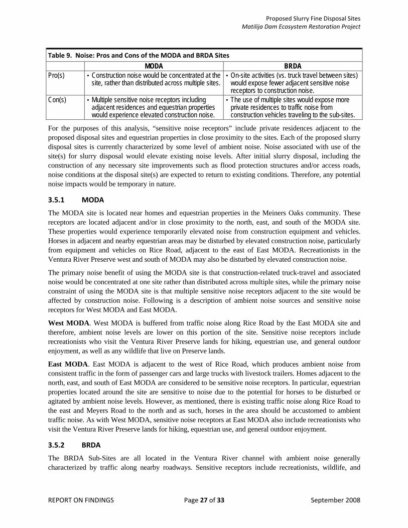
Proposed Slurry Fine Disposal Sites Matilija Dam Ecosystem Restoration Project
REPORT ON FINDINGS Page 27 of 33 September 2008
Table 9. Noise: Pros and Cons of the MODA and BRDA Sites MODA BRDA
Pro(s) • Construction noise would be concentrated at the site, rather than distributed across multiple sites.
• On-site activities (vs. truck travel between sites) would expose fewer adjacent sensitive noise receptors to construction noise.
Con(s) • Multiple sensitive noise receptors including adjacent residences and equestrian properties would experience elevated construction noise.
• The use of multiple sites would expose more private residences to traffic noise from construction vehicles traveling to the sub-sites.
For the purposes of this analysis, “sensitive noise receptors” include private residences adjacent to the proposed disposal sites and equestrian properties in close proximity to the sites. Each of the proposed slurry disposal sites is currently characterized by some level of ambient noise. Noise associated with use of the site(s) for slurry disposal would elevate existing noise levels. After initial slurry disposal, including the construction of any necessary site improvements such as flood protection structures and/or access roads, noise conditions at the disposal site(s) are expected to return to existing conditions. Therefore, any potential noise impacts would be temporary in nature.
3.5.1 MODA
The MODA site is located near homes and equestrian properties in the Meiners Oaks community. These receptors are located adjacent and/or in close proximity to the north, east, and south of the MODA site. These properties would experience temporarily elevated noise from construction equipment and vehicles. Horses in adjacent and nearby equestrian areas may be disturbed by elevated construction noise, particularly from equipment and vehicles on Rice Road, adjacent to the east of East MODA. Recreationists in the Ventura River Preserve west and south of MODA may also be disturbed by elevated construction noise.
The primary noise benefit of using the MODA site is that construction-related truck-travel and associated noise would be concentrated at one site rather than distributed across multiple sites, while the primary noise constraint of using the MODA site is that multiple sensitive noise receptors adjacent to the site would be affected by construction noise. Following is a description of ambient noise sources and sensitive noise receptors for West MODA and East MODA.
West MODA. West MODA is buffered from traffic noise along Rice Road by the East MODA site and therefore, ambient noise levels are lower on this portion of the site. Sensitive noise receptors include recreationists who visit the Ventura River Preserve lands for hiking, equestrian use, and general outdoor enjoyment, as well as any wildlife that live on Preserve lands.
East MODA. East MODA is adjacent to the west of Rice Road, which produces ambient noise from consistent traffic in the form of passenger cars and large trucks with livestock trailers. Homes adjacent to the north, east, and south of East MODA are considered to be sensitive noise receptors. In particular, equestrian properties located around the site are sensitive to noise due to the potential for horses to be disturbed or agitated by ambient noise levels. However, as mentioned, there is existing traffic noise along Rice Road to the east and Meyers Road to the north and as such, horses in the area should be accustomed to ambient traffic noise. As with West MODA, sensitive noise receptors at East MODA also include recreationists who visit the Ventura River Preserve lands for hiking, equestrian use, and general outdoor enjoyment.
3.5.2 BRDA
The BRDA Sub-Sites are all located in the Ventura River channel with ambient noise generally characterized by traffic along nearby roadways. Sensitive receptors include recreationists, wildlife, and

Proposed Slurry Fine Disposal Sites Matilija Dam Ecosystem Restoration Project
REPORT ON FINDINGS Page 28 of 33 September 2008
nearby residents. Ambient noise sources and sensitive receptors at each of the BRDA Sub-Sites are described below.
With use of the BRDA sub-sites for slurry disposal, pump stations would be required to transport the slurry materials and lift recycled water downstream of MODA (Chitwood, 2008). These pump stations would likely operate using diesel fuel and would introduce an additional noise source during the construction period. However, with consideration to the other types of vehicles and equipment that would be utilized during the construction period, the addition of pump stations for the BRDA sub-sites would not introduce a noise source that would substantially change overall construction noise for BRDA versus MODA.
In comparison with the MODA site, the primary noise benefit of using the BRDA sub-sites is that fewer sensitive noise receptors are located immediately adjacent to the areas where slurry disposal activities would occur, while the primary noise constraint of using the BRDA sub-sites is that construction-related truck-travel and associated noise would be distributed across multiple sites and would therefore have the potential to affect a geographically wider range of noise receptors. Following is a description of ambient noise sources and sensitive noise receptors for the BRDA sub-sites.
Sub-Site 1. Sensitive noise receptors include residents located near the northern-most portion of Sub-Site 1; in particular, the trailer park south of Alviria Drive is closest to the site. Existing ambient noise sources include traffic on roadways east and south of the site. These residences would likely experience elevated noise from Project activities, including the construction of dikes both upstream and downstream of the site. The Ojai Valley Organics green waste recycling facility, which is located to the southeast of Sub-Site 1, produces ambient noise through the use of heavy equipment and vehicles, mostly noticeable from the southern portions of Sub-Site 1; as a result of this existing noise source in the southern portion of Sub-Site 1, the effects of construction noise would be less substantial than in other portions of the site.
Sub-Site 2. Private residences and equestrian facilities along the eastern border of Sub-Site 2 are considered to be sensitive noise receptors. Existing ambient noise is produced by traffic along Highway 150 / Baldwin Road and is particularly noticeable in the northern portion of Sub-Site 2. The southern portion of Sub-Site 2, farther away from the roadway, experiences lower ambient noise from the traffic, but this portion of the site is also farther removed from the sensitive noise receptors mentioned above.
Sub-Site 3. Sensitive noise receptors at Sub-Site 3 include a private equestrian property and horse-boarding facility (P bar H Ranch), as well as a raptor rescue center located adjacent to the west of Sub-Site 3. Private residences on the east side of the Ventura River channel are separated from Sub-Site 3 by the majority of the channel area and are therefore not considered to be sensitive noise receptors. Existing ambient noise at Sub-Site 3 is low, and is primarily characterized by traffic on Burnham Road, to the west. Construction of necessary improvements at Sub-Site 3 would introduce temporary but possibly substantial levels of noise from construction vehicles and equipment, which would have the potential to disturb or otherwise affect adjacent noise receptors. Therefore, use of Sub-Site 3 would require coordination with surrounding property owners to minimize potential noise effects.
Sub-Site 4. Sub-Site 4 is currently used as a horse pasture and is located on a private equestrian property with existing ambient noise characterized by traffic along Santa Ana Road, located west of the site. Although this property is currently exposed to traffic noise along Santa Ana Road, elevated construction noise would have the potential to disturb or otherwise affect equestrian activities, particularly if access for construction vehicles and equipment is provided through the private property. Use of Sub-Site 4 would require coordination with surrounding property owners to minimize potential noise effects.

Proposed Slurry Fine Disposal Sites Matilija Dam Ecosystem Restoration Project
REPORT ON FINDINGS Page 29 of 33 September 2008
3.6 Traffic and Transportation This section presents discussion of traffic and transportation relevant to the proposed MODA and BRDA sites. Table 10 (Traffic and Transportation: Pros and Cons of the MODA and BRDA Sites) lists pros and cons associated with use of each site. Following this table is a more detailed discussion of traffic and transportation relevant to the MODA sites (East MODA, West MODA) and at the BRDA sites (Sub-Sites 1 through 4).
Table 10. Traffic and Transportation: Pros and Cons of the MODA and BRDA Sites MODA BRDA
Pro(s) • Existing access to the site is available from Rice Road and the construction of a new access road would not be required.
• Fewer vehicles and equipment would be required at each disposal area, thereby lowering the potential for notably increased traffic on roads surrounding each sub-site.
Con(s) • All construction vehicles for the project would have the same destination, thereby resulting in notably increased traffic on the surrounding roadways.
• Existing access on public roads is not available to Sub-Sites 1, 3, or 4; new roads and/or access through private property may be required.
Construction vehicles and equipment would utilize existing roadways for access to the selected slurry disposal site(s) to the maximum extent possible. Where it is not possible to use existing roads, new or improved access roads may be required. Use of any private roads would be coordinated with the appropriate parties prior to construction at the selected site(s). Any impacts related to traffic and transportation would be limited to the construction period and would therefore be temporary in nature.
3.6.1 MODA
Roadways immediately surrounding the MODA site are two lanes, paved, and generally narrow with minimal shoulder. Roadways including Rice Road, Meyers Road, Fairview Drive, and others in the area that would be required for access of large vehicles and equipment to the site; these roads normally experience low traffic volumes and would be subject to notably increased traffic from Project-related vehicles and equipment.
3.6.2 BRDA
The BRDA site includes Sub-Sites 1 through 4, which would be accessed using different roadways and are therefore discussed separately here. Because BRDA includes four separate disposal locations, truck and equipment traffic would not be concentrated at one site, as with MODA. However, as opposed to MODA, use of the BRDA would include slurry disposal activities at each of the four sub-sites, which would require access between the four sub-sites for the duration of project construction. This access would likely be provided along the same alignment as the slurry pipeline that would be installed during the construction period to transport slurry material to each sub-site. Maintaining access between all four sub-sites would result in traffic-related noise and visual effects between Sub-Site 1 and Sub-Site 4 during Project operations, as opposed to operational traffic effects being concentrated at one location, as with MODA. Following are descriptions of potential traffic and transportation effects associated with each BRDA sub-site.
Sub-Site 1. Access to BRDA Sub-Site 1 would be provided via Baldwin Road, Old Baldwin Road, and possibly a private access road through the Ojai Valley Organics green waste recycling facility to the Ventura River channel. An existing access road along the eastern border of Sub-Site 1 that is currently maintained by the Ojai Valley Sanitary District would also be used during the construction period. Use of private road(s) for access would require property owner coordination.

Proposed Slurry Fine Disposal Sites Matilija Dam Ecosystem Restoration Project
REPORT ON FINDINGS Page 30 of 33 September 2008
Sub-Site 2. Access to BRDA Sub-Site 2 would be provided via Baldwin Road, and an existing access road that is maintained by the Ojai Valley Sanitary District, which are both well-maintained and highly used by vehicles of all sizes. A new ramp would be constructed from the access road to the disposal area. During construction activities, traffic control would be implemented along Baldwin Road.
Sub-Site 3. Access to BRDA Sub-Site 3 would be provided via Burnham Road, which is two lanes and paved, but is narrow in some areas and includes some curves that would require trucks and equipment to travel more slowly than usual, thereby resulting in localized areas of notably increased traffic volume. In addition, a private equestrian property and horse-boarding facility is located between Sub-Site 3 (to the east) and Burnham Road (to the west). If access to Sub-Site 3 would be provided from Burnham Road as opposed to through the Ventura River channel, access through the private property would need to be coordinated in advance.
Sub-Site 4. Access to Sub-Site 4 would be provided via Santa Ana Road which is two lanes and paved, but is narrow in some areas and includes some curves that would require trucks and equipment to travel more slowly than usual and possibly result in localized areas of notably increased traffic volume. In addition, a private equestrian property is located between Sub-Site 4 (to the east) and Santa Ana Road (to the west). If access to Sub-Site 4 would be provided from Santa Ana Road as opposed to through the Ventura River channel, access through the private property would need to be coordinated in advance.
4. Summary of Findings and Site Comparison The preceding sections have characterized the proposed MODA and BRDA sites, discussed potential environmental impacts associated with the use of these sites for slurry disposal, and identified comparative benefits (pros) and constraints (cons) associated with use of each site. This section summarizes the findings presented in Section 2 (Introduction) and Section 3 (Pros and Cons of Existing Site Conditions).
Table 11 (Pros and Cons Associated with the Identified Slurry Disposal Sites) provide a direct comparison of pros and cons identified for the MODA and BRDA sites across all relevant issue areas. The purpose of this table is to assist the USACE, the VCWPD, and relevant stakeholders in selecting the most environmentally preferable slurry disposal option.

Proposed Slurry Fine Disposal Sites Matilija Dam Ecosystem Restoration Project
REPORT ON FINDINGS Page 31 of 33 September 2008
Table 11. Pros and Cons Associated with the Identified Slurry Disposal Sites MODA (West and East) BRDA (Sub-Sites 1, 2, 3, and 4)
Pro(s) • The use of adjacent disposal areas would result in more localized impacts. • MODA is the closest disposal area to Matilija Dam which would result in less
disturbance to native vegetation communities along the length of the slurry pipeline • An adequate buffer to main channel of Ventura River could be maintained. • Supports fewer native vegetation communities and would affect a smaller area
(fewer acres) of native vegetation. • Access to site is available from existing roadways and would not result in
disturbance of biological resources from road construction. • Due to the large storage capacity of the MODA site (2,339,000 cy) the use of
multiple disposal sites would not be required, thereby localizing land use and recreation impacts.
• MODA is located at least 300 feet outside of the active channel, with an existing buffer between the site and the channel.
• Aesthetic impacts would be concentrated at the site location, rather than distributed across multiple sites.
• Visual impacts to the public view-shed (from Rice Rd to the east) would be minimal. • Construction noise would be concentrated at the site, rather than distributed across
multiple sites. • Existing access to the site is available from Rice Road and the construction of a
new access road would not be required.
• Sub-Site 4 is dominated by ruderal vegetation, which provides low-quality habitat. • Sub-Site 2 is dominated by non-native grassland and early seral-stage mulefat
scrub indicating previous site disturbance. • Fewer number of coast live oak (128 vs. 132) and California walnut (5 vs. 31)
would be affected. • Minimal recreational resources would be affected; potential recreational impacts
are limited to Sub-Sites 3 and 4 and would apply to dispersed equestrian use (trail riding).
• Each BRDA sub-site is smaller in area than the MODA site and therefore, site-specific hydrology and/or water quality impacts resulting from area of disturbance would be of a lesser magnitude.
• Due to the difference in size, each BRDA sub-site is less visible than the MODA site and would have a less substantial effect on surrounding view-sheds.
• On-site activities (vs. truck travel between sites) would expose fewer adjacent sensitive noise receptors to construction noise.
• Fewer vehicles and equipment would be required at each disposal area, thereby lowering the potential for notably increased traffic on roads surrounding each sub-site.
Con(s) • West MODA supports an extensive area of healthy, diverse Venturan alluvial scrub habitat.
• Slurry mound would potentially affect the present alignment of Cozy Dell Creek. • Multi-use recreational trails that cross through the MODA site would be temporarily
relocated during the construction period (trails would be restored in current alignment post-construction).
• Cozy Dell Creek may be diverted upstream of MODA from its current alignment between West MODA and East MODA.
• The MODA site is highly visible from Meiners Oaks to the north; use of this site would have a substantial affect on the view-shed(s) from private residences in Meiners Oaks.
• Multiple sensitive noise receptors including adjacent residences and equestrian properties would experience elevated construction noise.
• All construction vehicles for the project would have the same destination, thereby resulting in notably increased traffic on the surrounding roadways.
• Access limitations (particularly at Sub-Site 3) would require crossing either oak woodland or hundreds of yards of active river channel.
• Wetland habitat is present on a portion of Sub-Site 2. • Greater potential for sensitive species impacts: San Diego woodrat (CSC) nests
identified at Sub-Site 3; Southwestern pond turtles (CSC) known to occur at Sub-Site 4; Potential sensitive bird species habitat within riparian areas at Sub-Sites 2 & 4; Potential impacts to steelhead (FE).
• The use of multiple sites would distribute potential land use impacts across a larger geographic area.
• Sub-Site 4 is currently used as active pasture, which would be converted from use for the lifetime of the Project.
• Sub-Sites 1 and 2 are located within the active channel and have a greater potential to affect water quality.
• The sub-sites are visible (in the distance) from more private residences than the MODA site.
• The use of multiple sites would expose more private residences to traffic noise from construction vehicles traveling to the sub-sites.
• Existing access on public roads is not available to Sub-Sites 1, 3, or 4; new roads and/or access through private property may be required.

Proposed Slurry Fine Disposal Sites Matilija Dam Ecosystem Restoration Project
REPORT ON FINDINGS Page 32 of 33 September 2008
As indicated by the identified pros and cons listed above in Table 11, the primary differences between the MODA site and the BRDA sub-sites are related to biological resources, land use and recreation, and the use of one large area for MODA versus multiple smaller areas for BRDA. For detailed descriptions of the pros and cons listed in Table 11, as well as additional site specifics, please see Section 2 (Introduction) and Section 3 (Pros and Cons of Existing Site Conditions) of this Report on Findings.

Proposed Slurry Fine Disposal Sites Matilija Dam Ecosystem Restoration Project
REPORT ON FINDINGS Page 33 of 33 September 2008
5. References Chitwood, Douglas. 2008. Personal communication via email from Douglas Chitwood of the USACE to
Shruti Chandra of Aspen Environmental Group. August 5.
USACE (United States Army Corps of Engineers), 2004. Environmental Impact Statement / Environmental Impact Report (F-4 Milestone) for the Matilija Dam Ecosystem Restoration Project. July. [Available online: http://www.matilijadam.org/reports.htm]
_____, 2008. Cozy Dell and McDonald Canyon Drainage, Draft Technical Memorandum. July.
VCWPD (Ventura County Watershed Protection District), 2003. Matilija Dam Ecosystem Restoration Project Feasibility Study: Report on Slurry Fine Disposal / Habitat Restoration Sites. December. [Available online: http://www.matilijadam.org/reports.htm]