report on archaeological reconnaissance of ol ari nyiro · form of cultural disturbance (small...
TRANSCRIPT

1
Report on archaeological
reconnaissance of Ol Ari Nyiro
Marta Mirazón Lahr
Robert A Foley
Leverhulme Centre for Human Evolutionary Studies
University of Cambridge
Introduction In December 2013, we carried out a brief archaeological reconnaissance of the Ol Ari Nyiro
Conservancy in Laikipia. The aim was to establish the extent of a visible archaeological
record, to record the distribution of some potentially important localities, and to provide a
basis for further research. Only a week was available for survey, so what is reported here is
a bare minimum of the evidence, given that the total area of the Conservancy is more than
400 square kilometres. For our survey we visited localities reported by the owner, Mrs Kuki
Galmann, to have either been areas where she had seen archaeological material, and/or
where earlier visits by staff of the National Museums of Kenya and Dr Karega Munene had
identified archaeological remains. No systematic survey was possible in the time available,
although some interesting spatial patterning can be observed between the eastern and
western parts of the land. The presence of any material was recorded and photographed,
and small specimen samples were collected. This were deposited in the museum that is
being developed for the Conservancy.
The focus of our survey was to establish whether there was evidence for Early and Middle
Stone Age occupation of the Laikipia plateau.
Previous work The previous archaeological work on the Ol Ari Nyiro Conservancy consisted of visits in the
period 2001 – 2011 by Dr Karega Munene, staff from the National Museums of Kenya, as
well as by Dr Ana Pinto, a Spanish geologist. The results of these studies remain
unpublished. However, they confirmed the presence of cairns, a possible platform similar to
others found in Kenya, an iron smelting site, and a place where haematite was mined. In
addition LSA and MSA stone tools were noted and some collected. A small excavation was
carried out at a cave. There have been no formal reports arising from this research, although
small collections of lithic artefacts, pottery sherds and animal bones were made and are
presently at the National Museum of Kenya and the Ol ari Nyiro Museum.

2
The Ol Ari Nyiro Nature Conservancy The Ol Ari Nyiro Nature Conservancy is an area of about 40,000 hectares (400 km2), situated
on the western edge of the Laikipia Plateau, and overlooking the Eastern Rift Valley and
Lake Baringo. It is an area of high relief and gorges in the west, where it forms the eastern
edge of the rift valley, and rises more gently to the east. Its elevation ranges from about 1000
to more than 2000 metres above sea level. It has an annual rainfall of 790 mm, distributed
normally in two seasons, March-April, and October-November (check). Annual maximum
and minimum temperatures are 30 and 14 degree respectively. It has a high level of
biodiversity, with indigenous forest, woodland, bushland, and occasional more open
grassland areas.
The area was developed originally as a cattle ranch, with a strong emphasis on the co-
existence of domestic and wild animals. Cattle ranching was abandoned at the turn of the
century, and the conservancy was devoted entirely to the maintenance of original habitats
and game. It supports a diverse set of habitats, and a wide range of plants and animals,
including elephant, lion, buffalo, and a variety of antelopes.
Ol Ari Nyiro is maintained as a natural conservancy, offering tourist, educational and
research facilities, and supporting community projects. It is run by the Gallmann Memorial
Foundation, devoted to the conservation of the environment in memory of the husband and
son of Kuki Gallman. It is an area of great natural beauty, an important and unique
biodiversity region, and a critical part of the conservation opportunities of the Laikipia
plateau.
Survey results In total, 14 localities were briefly visited; no excavation took place, and only a small number
of representative artefacts found on the surface were collected for more detailed description.
Here we briefly describe their main archaeological character.
I. Stone structures, mounds and circles on the eastern edge of the
Conservancy
1. Stone pillar/circle site (0.570578° N, 36.412353°E) Located near the eastern margin of the Conservancy, this archaeological locality has been
known for a long time. Structurally, it consists of at least two larger basaltic rocks,
surrounded by scattered smaller boulders. To the east these may take the shape of an
approximate curve,
while to the west
there is a straight
line of such
boulders. The line of
rock is ca. 22 m and
16 m respectively

3
from the two larger standing stones. There may have been further larger standing stones, as
well as more of the smaller ones, but these were taken for building works in earlier times.
The two larger stones are clearly deliberately placed, and appear to be the central focus of
the structure. The tallest one (ca. 2.2 m high, 1.1/1.2 m wide) is irregular and rounded. The
southern side may have been deliberately pecked. The other one is lower (ca. 0.7m high),
with a flat, squared off surface, and may have been deliberately shaped.
No associated lithics, pottery or other material was observed on the immediate surrounding
surface, but the area had a heavy grass cover, limiting visibility.
It is clear that this structure belongs to the family of standing
stone architecture which occurs in East Africa, and is known
from the Laikipia plateau. It has probably been depleted by
recent activities, so that a more elaborate and complex structure
may have existed. Satellite images (GoogleEarth) clearly show
two circles without vegetation around the pillars, suggesting
some underlying difference in the soil that may relate to some
form of cultural disturbance (small ditch, increased rockiness,
etc.). At the time of this survey, it was not possible to investigate the nature of these circles
without clearing some vegetation beforehand.
Future work should establish if there is an associated burial or burials, and whether there
was a clear pattern of design. It would also be relatively easy to source the stones, and so
determine the distance they were moved.
2. Bogani ya Dume (0.560060°N, 36.399742° E) Located ~1.8 km to SSW of the standing stones, near the area where the famous Highland
Games are held, this locality consists of a small hill promontory of ca. 120 m diameter, on
which there are a series of small cairns. These vary in size and shape (approximately 1 to 3
m wide), are low and scattered. They are constructed from a series of lava boulders, placed
irregularly, to form low-lying mounds. There are clearly a relatively large number of these
in the locality, and probably exist more widely. It can be assumed that these are comparable
to other cairns found in Kenya (and more widely), and can be associated with living
communities or prehistoric ones.

4
Future work should establish whether there are human remains interred under the cairns
(NMK staff reported finding human bones).
3. Bogani ya Lowato (0.545112° N, 36.397065° E) This locality, a further ~1.6 km to the SSW of the
previous one, is a large mound surrounded by an
open area towards the crest of a hill providing
excellent views across the landscape. Like the
previous one, the mound is also ~ 120 m
diameter, and within it there are cairns, similar to
those from Bogani ya Dume. They are low lying,
and variable in shape and size, made up of lava
boulders piled irregularly. At the time of the visit,
the amount of vegetation precluded a more
precise assessment of the shape and size of the
cairns (see photo), but several structures ranging from small (1.5 x 2 m) to medium (2 x 3 m)
size were observed.
As is the case with all these
structures, future work should
determine both their extent and
individual cairn characterisation,
whether they represent burial
sites, and penecontemporaneous
features.

5
A small box labelled ‘Bogani’ was found at the
Conservancy’s office with material collected
from one or both of the two localities described
above by previous archaeological work in the
area. This material consists of a set of pottery
sherds and a tooth of an alcelaphine bovid,
possibly Alcelaphus. The pottery sherds are
decorated.
4. Large circle, excavated by KNM (0.598851° N, 36.452540° E) This locality, ca. 5.5. km to the NE of the standing stones and ~ 1 km SW of the Haematite
quarry (Mlima Ndongo, described below), was recorded in satellite imagery as a large oval
feature along a NE/SW axis (500 x 350 m). The feature consists of two circular perimeters,
the inner one of which consists of a darker ring, possibly representing some sort of ditch
feature. The two circles denuded of vegetation are separated by 25- 50 m in an irregular
manner. The internal area is featureless. The area was excavated by KNM staff in the past
(possibly in 2002). Since then the area has become very overgrown, and no evidence of the
excavation remains other than a possible spoil heap. No evidence of human activity was
found on the ground.

6
At the Department of Archaeology of the National Museums of Kenya, a number of boxes of
archaeological remains recovered through NMK excavations at Ol ari Nyiro were identified.
The associated report was not located, and the time available precluded the detailed study
of the material. However, a few comments are possible. Three sites, labelled GnJj1, GnJj2,
and GnJj3 are described as consisting of mounds, likely representing the three localities
described above (Bogani ya Dume, Bogani ya Lowato, and this last large feature) were
explored. Excavations were carried out in two of these (GnJj2 and GnJj3), but none below
sub-surface (labels in bags suggest a maximum depth of 30 cm). A box of finds labelled
GnJj2 (Bogani ya Lowato?) contains a large amount of material, both surface and excavated,
consisting of pottery sherds, lithics (LSA), and bone, some of which may be human. At least
three boxes from GnJj3 represent the more substantial excavation and collection from that
site (the large feature above?). The material consists of pottery sherds, LSA lithics and bone,
while a box from GnJj1 contains surface archaeology from that locality. A detailed inventory
and comparative study of this material is clearly needed in order to contextualise culturally
and temporally the groups who lived in the area of Ol ari Nyiro in more recent periods.
5. Iron smelting site A large and virtually complete smelting kiln was reported to exist by Mrs Gallmann. This
was excavated and removed in the past by a museum team, and is presumably in the
Department of Archaeology of the NMK. The exact location of the site was not found,
although small pieces of iron slag occurred locally. Without further knowledge of the nature
of the kiln, it is impossible to be more precise about the age or nature of it, other than that it
must post-date the appearance of iron in the region, thought to be between 2500 – 1000 BP
(ie, from ~ 500 BC to 1000 AD). However, given the importance of well contextualised Iron
Age localities in Central Kenya, it is critical that the original remains are located in the
museum, and that the site from which it derives is studied more fully.
II. Distribution of LSA, MSA & ESA localities visited
6. Sediments exposed by river cut (0.552931° N, 36.399609° E) Located between the two Bogani mounds, this locality is a small river cut section. The
stream runs along a small ravine or gully cutting through some lava beds, outcropping
locally. This opens into a small swampy area, where the stream dissipates into a marshy
zone. To one side of the stream, over a distance of about 25 m, there is a section of reddish

7
sediments, cut by the river. These sediments, which must once have occurred more widely,
do not show on the other side. The sediments are mostly silts, with lenses of coarser
material. In one level, towards the base, much larger stones can be seen, but none of these
proved to be artefacts. A survey of the area around the section showed many lava pieces,
mostly highly weathered. A few of these may have been worked, but only one could be said
to be convincing. This was a large blade, triangular in shape, similar to those found in early
MSA or later Acheulean contexts.
This locality was visited because the NMK had carried out an excavation here, and reported
MSA lithics. There was little evidence for this, with the exception of the one lithic described
above, although an area close to the river section was under water when we visited, and this
may be where the lithics were originally found.
Future work is necessary to determine whether there really is an MSA locality here, and if
so, its relationship to the river-cut sediments. The nicely layered sediments exposed should
also be investigated for palaeoenvironmental information.
7. Boromoko (0.495788° N, 36.340388° E) Boromoko is a site at the southeastern end of
the Conservancy, consisting of an eroding low
scarp. Prehistoric artefacts are found on the
surface of the scarp slopes and the lower
ground, probably eroding from the edge of the
scarp. The scarp is up to 2 metres in height,
and comprises reddish/orangy silts, mostly
fine grained, but with larger clastic units in the
upper parts of the section. Gullying is leading to major scarp retreat, creating embayments,
and leaving a few isolated outcrops of the upper sediments. Clasts in the upper layers are

8
large, rounded, but not fully smooth. The surface below the scarp can be covered with a thin
layer of gravel, or with larger lava cobbles and boulders.
The scarp runs from north to south for ca. 1 km, curving towards the east along its northern
border; the southern end of the geomorphological feature was not investigated. The upper
and lower elements of the landscape are probably part of a terracing system of a stream that
occurs about 200 m to the east. It is likely that much of the colouration comes from diagenic
processes occurring during the weathering of sediments of volcanic origin.
The lithics at Boromoko are found extensively on the lower surface and represent two
different industries and periods of occupation of the area. One group are typical LSA
microliths, made on obsidian and other fine-grained raw materials. The other includes forms
which are macrolithic, with some diagnostic elements of the MSA – disc cores, facetted
platforms, etc. These are on weathered lava. Numerically, the latter are the most
predominant type of artefact. These are made on a form of
lava, and often water worn. The lava is of poor quality
(possibly phonolitic), often with feldspar intrusions. A smaller
number are made on a black basalt rock, and these tend to be
fresher. The level of weathering on some of the phonolitic
pieces found in the area is often so great that it can no longer
be determined if they are of anthropogenic origin, but it is
likely that they are as the rock does not occur locally. This MSA
assemblage is different from the others seen in the Conservancy. The artefacts are also
overall smaller. The assemblage is dominated by cores, made on coarse lava, and there may
be related to the ‘lava bombs’ found locally. The cores are largely polyhedral and
amorphous, but some disc cores exist. Facetted platforms occur, including a flake with a
clear dihedral platform, and one point was probably made on a more Levallois core.
The LSA material at the site is
also numerous, consisting
mainly of obsidian microlithic
pieces. Among the latter are
some formal tools, such as
retouched bladelets, as well as a
micro-core. There is an absence
9
of geometric forms , and only one backed piece made on chert, but many of the lithics show
edge damage or retouch, including notching. There is also one formal end scraper.
It was not possible to locate the exact level from which the material was eroding, as the
slopes covered the original stratigraphy; however, there are indications the MSA originates
from relatively high in the section. The LSA is draped on both the upper and lower surfaces,
suggesting deposition after the scarp/gullying formation process had begun.
This is an important and rich locality. Further investigations should survey the extent of the
site, expose the stratigraphy of the scarp, as well as an un-eroded section of the site.
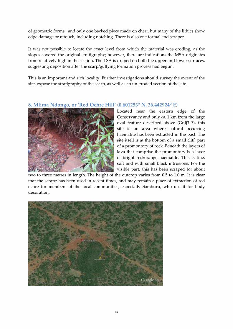
8. Mlima Ndongo, or ‘Red Ochre Hill’ (0.601253° N, 36.442924° E) Located near the eastern edge of the
Conservancy and only ca. 1 km from the large
oval feature described above (GnJj3 ?), this
site is an area where natural occurring
haematite has been extracted in the past. The
site itself is at the bottom of a small cliff, part
of a promontory of rock. Beneath the layers of
lava that comprise the promontory is a layer
of bright red/orange haematite. This is fine,
soft and with small black intrusions. For the
visible part, this has been scraped for about
two to three metres in length. The height of the outcrop varies from 0.5 to 1.0 m. It is clear
that the scrape has been used in recent times, and may remain a place of extraction of red
ochre for members of the local communities, especially Samburu, who use it for body
decoration.

10
There are no stone tools, pottery or other items
associated with the scrape. Further away, on the
level surface that surrounds the promontory,
there was a scatter of obsidian microliths and
artefacts. These are fresh, good quality obsidian,
and among them were numerous formal tools,
including a backed crescent, an endscraper, an
various other retouched and unretouched pieces.
In addition to these macrolithics, there is also a collection of 30 obsidian and quartz
microliths. The obsidian pieces are small flakes and chips, but often have edge
damage, or retouch. Four backed pieces, including a crescent, and a small scraper,
show a formal element.
Some of the obsidian artefacts at Mlima Ndongo are more
patinated than the rest. In particular, some lithics made on a
‘striped’ obsidian are usually associated with Middle Stone Age
assemblages elsewhere in the Central Rift Valley, and may
therefore, represent an earlier period of use of the site.
In addition, and in a slightly
different part of the site, there
were some larger, more
weathered lithics, made on lava (possibly phonolites).
These were largely undiagnostic). Among them was a
large (102 mm) cortical wedge, with damage or retouch
along the major longitudinal edge, and possibly further
invasive retouch. This might support a Mode 2
(Acheulean) interpretation for the earlier period of use of
the site, as there is also a large biface (120 mm), with crude
retouch on both sides. A disc core, and three flakes (one
with a facetted platform), on the other hand, might
indicate an MSA element, which is supported by the
patinated obsidian pieces mentioned above.

11
Therefore, the prehistoric lithics from Mlima Ndongo form a mixed assemblage, comprising
both larger, most probably ESA, MSA and LSA artefacts made on mostly different raw
materials.
9. The Quarry (0.552869° N, 36.430711° E) The quarry is the term given to a small hill, comprising lava
outcrops, rising to about 5 – 8 metres above the surrounding area.
Stone tools had been previously reported from here. A brief survey
of the area around the hill, and on the lower slopes of the hill itself,
revealed a small number of lithics. These appear to be large, and
likely to be characteristic of early MSA/ESA industries.
10. Mugongo ya Ngurue (0.617188° N, 36.349957° E) This locality, also known as ‘Kuki’s Point’ is a high promontory overlooking the Mukatan
Gorge, which runs down into Lake Baringo. The surface, particularly at the southern end,
has a moderately dense scattering of old lithics, worn flakes, blades and cores. There, were,
in addition, hand-axes and denticulate scrapers. It is clear that there is an extensive coverage
of ESA and perhaps early MSA lithics in this area, confirmed by finding them at various
points on the roads that run along the edge of the Rift escarpments and deep gorges. Of particular interest were a number of artefacts that could be confidently assigned technologically to the Middle Stone Age, including Levallois points, denticulated flakes with and without facetted platforms, etc.. The area is densely vegetated and it could not be ascertained whether the material originates from the immediate surface or has eroded from a particular exposure. The quality of the lithic artefacts, their nature and density in the immediate and general vicinity
certainly warrant further study.

12
11. Jangili Cave (0.598760° N, 36.364398° E) The existence of a cave in one of the gorges running into the Mukatan was well known, and
there had been a trial excavation by NMK staff in 2002. The scarcity of deep stratified caves
in East Africa makes this a priority location. Access was an issue, partly due to the steepness
of the terrain and the heavy bush cover, and partly because of the high level of the streams.

13
The cave is set about half way up the eastern side of a steep gorge. The overall height of the
gorge at this point is probably about 60 metres. The wall of the gorge is made up of igneous
rocks, and the cave is, in effect, part of a former lava tunnel, subsequently cut by the
formation of the gorge.
The mouth of the cave is about 6 m wide,
and 4 high. It narrows laterally and
vertically towards the back, which is
about 16 m from the cave entrance. The
floor of the cave at the mouth, and for
about 4 metres, is made up of broken
rock fall fragments, uncompacted. In
some parts there is scrubby vegetation.
The back 12 metres of the cave is covered
with a very fine, grey black powder, most
probably derived from bat guano (the
cave roof was home to a substantial bat
population at the time of the visit). The depth of this guano is not known.
At the mouth of the cave is a step,
about 1 m from the level of the
surface, which most probably
represents the bedrock depth of the
cave, at the least at the front.
However, it is impossible to say for
certain whether there is a deeper
stratigraphy further in the cave.
No lithics, pottery or faunal
material was observed on the
surface, and an examination of the very steep talus below the cave also revealed no material.
This was surprising, as the Museum excavations
had reported finds, and indeed these are stored in
the NMK. They consisted of obsidian microliths,
including crescents, undecorated coarse pottery,
and fauna that included microfauna, bats (?), and
fragments of bovid long bones and teeth. These
came from an area of about 6 metres, excavated in
three spits to a depth of 300 mm. A filled-in trench
could be observed (2 x 1 m), which did not seem to
be as large as inferred from the remains and notes
in the NMK.
There is no evidence in Jangili Cave for any human occupation earlier than the Later Stone
Age, and the finds from the excavations could not exclude there being no occupation prior

14
to the Pastoral Neolithic or Iron Age. One issue is the age of the cave itself, which may not
have been opened up until the relatively recent past. Only excavation of the rear portion of
the cave will determine the extent of prehistoric use.
12. Mukatan area and environment around Jangili Cave. In contrast to the absence of material from Jangili cave, the
surrounding area has a rich lithic record. The opposite side of
the gorge from Jangili cave, and the plateau above the cave
both contained numerous stone tools. These were large,
heavily worn flakes and cores, made on lava. Many of them
were undiagnostic beyond being simple flakes and cores, but
others were clearly weathered bifaces, large blades, etc.
Heavy vegetation made it impossible to ascertain the extent
of their distribution, but it is likely that the gorges are quarrying landscapes, and were used
by early hominins as sources of raw material.
13. Rift Valley scarps South of the Mukutan (0.557025°, 36.316294° E) A very brief survey was carried out of
an area along one of the Rift gorges to
the South of the Mukutan Gorge. Very
crude, early artefacts were observed,
including a very large biface which
was collected; its diagnosis as a hand-
axe is really only based on the shape,
which is very characteristic, as it is too
weathered to see individual faconnage
flake scars. A large polyhedral flake
was also collected. It was very simple,
with a single platform and two flake
scars. This area, lies ca. 6.5 km to the S
of the Mukutan, marked in the map as ESA artefacts. Its importance lies in providing further
evidence of the occupation of the Rift Valley landscape of Ol ari Nyiro by Acheulean
hominins.
14. Ol Ari Nyiro Spring (0.619135° N, 36.387198° E) This area, which gives its name to the whole Conservancy is a natural spring, which has
been modified for human use. It is located at the edge of the first cuts and gorges of the Rift
Valley wall, and the stream that run SSW from it feed into the Mukutan Gorge. The springs
are found within a long narrow valley, running from North to South. The exact location of
the spring was not determined on this survey, so it is not known whether there is tufa
present at the spring, making it potentially datable.

15
The south side of the valley is very steep, with an overgrown face of rock. There is clear
evidence for quarrying in recent times, presumably for farming activities in the last century.
The quarry face shows good quality lava, varying in colour from yellowy brown to black.
Some large blocks of the same material occur in the stream bed, and these may either have
rolled in or be part of the underlying bedrock. At least one of these blocks has been used as a
core, with a large flake struck off.
Two samples of lithics were collected, one from the
west side and one from the east side of the valley.
Lithics from the area around the stream are large, and
relatively crude, with few diagnostic features. The two
flakes from the south side that were collected are
simple, with plain platforms, one of which was blade-
like and triangular in section (cf ‘naturally backed
blade’ at Miharati Mbili). They were distinctive as, in
contrast to most of the lithics, they were made on a fine-
grained green lava.
The east side of the valley the slope is not as steep, and
has a denser occurrence of stone tools. The assemblage
consists of very large, eroded artefacts, made on a coarse, grey lava; some of the pieces are
retouched. The forms were very diverse, and often distinctive –
A large columnar piece (280 mm long) which has the appearance of a prismatic core.
A smaller side struck blade with denticulate damage or retouch.
A disc flake
A cortical flake with retouch

16
A polyhedral core with multidirectional flaking, possibly developing into a disc core.
The remainder were flakes, generally rather square in shape.
The large blade is again a diagnostic element. It can be found in the Acheulean, but is also
characteristic of the early MSA.
14. Miharati Mbili Spring (0.614867° N, 36.399366° E) Located in the centre of the Conservancy Miharati Mbili (also known as Ol Kisim) is also a
natural spring. It is set in a small valley, running NE-SW. This has been extensively
modified by the addition of drinking troughs for cattle in the past. The surrounding area is
swampy, and there is evidence of many rocks being moved to improve tracks and roads.
The northeastern side of the spring is a relatively
steep outcrop of lava boulders, rising about 4
metres. The slope leading to this is strewn with
very eroded lithics. These are large, and often
undiagnostic beyond the evidence for
anthropogenic origin. However, there are a
substantial number of cores, amorphous in form,
and also bifaces. The bifaces are crude, thick in
cross section, and often tending towards
trihedral forms. In addition, there are some
extremely large cores (<300 mm across) which are discoid. The presence of very large
artefacts may be indicative of a prehistoric quarry.
Miharati Mbili contained a very large number of possible lithics, and those collected
represented the most diagnostic of these. They are made on a fine basalt, black, patinated to
grey, and very weathered.
Two separate assemblages were collected. The first originates from the hill to the NE of the
spring. Two disc cores, four bifaces and two large blades were collected. The bifaces are very
variable. Two are very thick in cross section, and two are quite thin. The thinner pieces are
pear-shaped and ovate respectively. Retouch on the hand-axes was crude. The large blades
are ‘corner struck’, core fresheners or wedge shaped natural backed blades. The disk cores
were large, and thick in cross section, with crude flake removals around the platform. This
assemblage is probably Acheulean, on the basis of the hand-axes, although the large blades
are also reminiscent of the early Middle Stone Age.

17
The second assemblage came from the area around the troughs, at the bottom of the spring
area. The raw material was a slightly better quality. The diagnostic lithics collected included
a small biface (87 mm max length), a large flake, and a flake core.
Overall, Miharati Mbili Spring cannot be allocated to a particular phase, some of the lihtics
are indicative of Acheulean industries, although the biface found is small enough to be
characteristic or early MSA in other parts of Africa. The existence of an early landscape, of
which this was part, is perhaps indicated by the occurrence of similar artefacts on the edges
of the road leading to the Spring.
15. Area to the North of Rhino Springs (0.617191° N, 36.411437° E) Rhino Springs is a small spring, running SE-NW, set in a small basin formed by rocks, partly
natural, partly fallen in. There is a pool a water, and a small waterfall as the water crosses a
small faulted scarp that runs NE-SW. Along the eastern edge of this scarp, to the north of the
spring, there is a long, flat, open area, surrounded by bush.

18
At least two localised scatters of lithic artefacts were observed. Artefact density was lower
than in some other areas, but there were a small number of large lithics, weathered and
clearly modified. A large broken blade, small bifaces, a double-sided scraper, and
amorphous cores were found. All flakes had plain platforms. The material is probably MSA,
but more extensive survey and excavation should confirm this.
Conclusions Ol Ari Nyiro is a relatively unexplored area from an archaeological perspective, and this
brief survey indicates there is major potential for further research. Its context, on the
Laikipia Plateau and overlooking the Baringo Basin, would certainly lead one to expect very
significant remains. The former, with its rich record of cairns and pastoral activities, is a
distinctive ecosystem, which has been an attractive area to live for pastoralists in particular.

19
The latter, with evidence for early hominins, early Homo, and the earliest MSA, shows that
this part of the Rift Valley, was repeatedly occupied.
Earlier surveys and
excavations have
demonstrated the existence of
significant mid to late
Holocene sites. These include
the area of ochre exploitation,
the cairn fields, the iron
smelting works, and the
megalithic site. Our surveys
confirmed the existence of
these, and very preliminary
examination of satellite
imagery suggests the
existence of various other landscape features and structures worthy of study. Exploration of
this recent prehistory of Ol ari Nyiro should certainly result in rich exciting discoveries.
The current survey was also designed to see
whether there was an older record, stretching
back into the Pleistocene or even Pleistocene.
The existence of earlier artefacts was noted
before, and material of that age from the
Conservancy is part of the collection held at
the NMK. However, these earlier findings of
Palaeolithic artefacts are not contextualised in
detail and extent. The abundant distribution
of surface ESA and MSA lithics found in the
course of the present survey not only confirm
the presence of Pleistocene age stone tools at
Ol ari Nyiro, but suggest that these are numerous and widely distributed. There is every
reason to think that, with the abundant and high quality stone raw materials, Ol ari Nyiro
was an attractive place to occupy throughout time, and one can assume that water and game
would have been always abundant. Further research on the spatial distribution and
characterisation of raw materials would be an important step in confirming this.
In terms of lithic typology, localities on Ol ari Nyiro might come from the earliest phases of
the Acheulean (>1 Ma), the Middle Pleistocene, especially the period at the end of the
Acheulean and the beginnings of the MSA (~ 500 Ka to 200 Ka), and the Upper Pleistocene.
Only discovery of stratified contexts for the lithics will confirm this.
One must emphasise the limited time (one week) and the enormous size (400 km2) of Ol Ari
Nyiro, and so the limited nature of the survey carried out. Given these limitations, the
information recovered, the presence of remains from virtually all prehistoric periods, the
different geomorphological settings in which these are found, the existence of caves with at

20
least recent occupation, etc., make Ol ari Nyiro one of the potentially most important areas
for investigating earlier phases of prehistory in Laikipia.
Acknowledgements We thank Mrs Kuki Gallmann for inviting us to carry out this survey, for providing
accommodation and logistic support, and the incomparable hospitality of her family during
our stay.