report of the independent hearing and … · moolarben ihap report february 2007 summary of...
TRANSCRIPT

REPORT OF THE INDEPENDENT HEARING AND ASSESSMENT PANEL
for the
MOOLARBEN COAL PROJECT
Prepared for:
Director General Department of Planning
New South Wales
Prof JM Galvin (Chair) Mr C Mackie
Mr P Karantonis
February 2007

Moolarben IHAP Report February 2007
SUMMARY OF FINDINGS
The Process
On 21st August 2006, the Minister for Planning directed that an Independent Hearing and Assessment Panel (the ‘IHAP’) be constituted to assess subsidence, groundwater and noise impacts associated with the Moolarben Coal Project (MCP). This proposed development is located between the existing operations of Ulan Coal Mines Limited (UCML) and Wilpinjong Coal Pty Ltd (WCPL), about 40km NE of the township of Mudgee and comprises one underground mine and three open cut mines. Site inspections and the public hearing took place during the period 6th – 9th November. Over 500 individual submissions were received, with 32 organisations and persons presenting to the IHAP. The primary concerns expressed in the submissions related to:
• cumulative impacts of mining in the region on groundwater, noise, dust and traffic;
• a lack of accuracy in modelling and predictions in the MCP Environmental Assessment (EA);
• noise impacts on the village of Ulan, particularly in regards to the local school, and on properties adjoining the proposed mining operations;
• mine subsidence induced damage to the “The Great Dripping Wall” (the Drip), the Goulburn River Corner Gorge (Corner Gorge) and Aboriginal archaeological sites;
• impacts of changed groundwater conditions on the Triassic aquifer system, flows in local rivers and streams, the water supply to the Drip, and stock and domestic groundwater sources;
• impacts of the combination of the above factors on the local tourism industry. The IHAP also elected to hear a limited number of submissions on topics of concern to the community, albeit they were outside of the IHAP’s terms of reference, in the interests of bringing these to the attention of representatives of the Department of Planning (DoP) and the proponent, Moolarben Coal Mines Pty Limited (MCMPL). The IHAP advised at the end of the hearings that it was not in a position to conclude its assessments. It required time to review the additional information tabled during the hearing and to seek further information and clarification on a number of issues. These included:
• Noise: The need for a range of additional measurements, modelling and mitigation had been identified during the IHAP process.
• Archaeology: The EA had assessed surface features and subsidence impacts. However, limited consideration appeared to have been given (other than towards the conclusion of the hearing) to mitigating these impacts by modifying the mine layout. Consistent with the requirements of the DoP and the Department of Primary Industries (DPI) to seamlessly integrate the
i

Moolarben IHAP Report February 2007
approval process with the Subsidence Management Plan process, the mine plan ought to be modified at this stage of the process.
• The Drip and the Corner Gorge. The IHAP concluded that significant cultural, spiritual, historical, educational, tourism and recreational values were associated with these features and, therefore, they should be protected. Having inspected the area, the IHAP considered that a more robust assessment was required of protection measures, especially in regards to cliff falls and upsidence of the river bed.
• Height of fracturing. In particular, the IHAP was keen to know what the experiences of Ulan Coal Mines were in this regard.
• Groundwater. The IHAP still had outstanding concerns in respect of the groundwater modelling procedures.
• Subsidence mitigation measures. The EA relied extensively on monitoring as a subsidence mitigation measure. The IHAP requested more consideration be given to alternative mitigation measures, in particular, changes to the mine plan.
This process resulted in the proponent submitting a Preferred Project Report (PPR) as part of its response to submissions on 20th December 2006. The process has led to the strengthening of the rigour of some of the technical content, the addressing of some significant community concerns and a revision of the mine plan. The IHAP has assimilated all supplied information and has concluded the following. Subsidence The main subsidence concerns raised in the course of the IHAP process related to:
• the reliability of the model used to predict the height of sub-surface fracturing;
• the accuracy of the model used to predict ground subsidence effects on the surface;
• mitigation of subsidence impacts on significant sub-surface and surface features.
The proponent has responded by producing a revised mine layout in the PPR and by identifying the option to reduce mining height, if necessary, to mitigate sub-surface fracturing. The IHAP has drawn the following conclusions in the light of these revisions: Sub-surface Impacts of Subsidence
• The IHAP cannot make a determination at this stage as to the likely impact of longwall mining on the Triassic groundwater system.
• This is because the IHAP is not sufficiently confident of the accuracy of the model for predicting the height of continuous fracturing above the proposed longwall panels, and the extent to which discontinuous fracturing can also impact on groundwater inflow to the mine workings.
ii

Moolarben IHAP Report February 2007
• It would seem likely, however, that the Triassic groundwater system could be impacted upon at some locations if mining height and/or panel width are not reduced.
• Proposals to undertake monitoring of subsidence impacts on the Triassic strata early into the project in less sensitive locations, and to reduce mining height to 3m if necessary, are considered reasonable management responses.
• The impact of subsidence on fracturing of groundwater systems is only likely to be resolved on this occasion by the outcomes of studies currently in progress at Ulan Colliery, adjacent to the MCP, and/or monitoring over longwall panels in the MCP subject area.
Surface Impacts of Subsidence
• The empirical methodology for predicting the standard components of surface subsidence associated with the MCP would benefit from further development and calibration to the local conditions associated with the MCP.
• The initial longwall panels in the MCP provide the opportunity to validate the prediction methodology and to calibrate it to MCP site specific conditions without unduly jeopardising the integrity of significant surface features.
• In the meantime, the current surface subsidence predictions for the MCP are likely to be conservative.
• The revised mine plan is an appropriate response for managing the risk of subsidence damage to surface features and structures of significance in the vicinity of the proposed underground workings of the MCP.
• Nevertheless, ongoing monitoring is still required to confirm site specific subsidence behaviour and to refine the mine plan as necessary when Subsidence Management Plans (SMPs) are prepared in the future.
The IHAP consider that, if the project is approved, potential subsidence impacts can be managed by way of Conditions of Approval. Recommended approval conditions are presented in the main body of this report and relate to:
1. Monitoring over longwall panels 1 to 4 to validate the height of fracturing and its impact on groundwater.
2. Monitoring over longwall panels 1 to 4 to validate surface subsidence and its impacts on surface features.
3. Independent review of these outcomes at the completion of each of the longwall panels, with findings being taking into account when designing and approving future longwall panels.
iii

Moolarben IHAP Report February 2007
Groundwater The main groundwater related concerns raised in the course of the IHAP process were:
• loss of water supply in springs and bores located throughout the region;
• leakage and flow losses from the Goulburn River and tributary systems, resulting from sustained depressurisation of underlying strata;
• depressurisation/dewatering of the Triassic aquifer systems that host the Drip and other groundwater dependent ecosystems;
• surpluses or deficits in the management of water supply to the proposed operations, resulting in a need to discharge water or source additional water from neighbouring mines or from groundwater resources;
• leachate generation from waste rock and tailings. The IHAP acknowledges that a significant effort has been directed towards the evaluation of groundwater impacts. Nevertheless, the IHAP continues to have concerns regarding the predicted impacts of mining on regional groundwater systems. These concerns are driven largely by:
• a limited knowledge of the important Triassic aquifer system that interacts with the Goulburn River and hosts such local iconic features as the Drip. In view of the sensitivity of this system, the IHAP sought additional information from UCML. Further information was also provided by MCMPL. The IHAP has assimilated all information and is of the opinion that there is a potential for measurable depressurisation of groundwater systems within the Triassic aquifers. The extent to which this is likely to occur has not been adequately demonstrated by numerical modelling.
• a lack of confidence in the computer numerical models used to predict impacts. The validity of those predictions depends on how well the models approximate field conditions. The IHAP notes that field conditions appear to be poorly represented with respect to a number of model design elements. These include but are not limited to:
o unusual and/or unsupported distributions of regional hydraulic properties;
o a majority of models that exclude the subsidence failure regime associated with underground mining;
o inhibited vertical drainage from the subsidence zone (where it has been included) resulting in unreasonably low depressurisation of overlying strata;
o apparently restrictive extents to the model(s) domain causing unnatural depressurisation of strata.
In view of the numerous issues identified above, the IHAP is unable to determine with sufficient certainty, the magnitude and extent of impacts likely to prevail upon aquifer systems as a consequence of proposed longwall mining operations at MCMPL.
iv

Moolarben IHAP Report February 2007
Consequently the IHAP has serious reservations concerning the development of an underground mine until such time as impacts are predicted with increased certainty and are found to be acceptable. In respect of open cut mining, the IHAP considers the impacts on aquifer systems are likely to be limited in magnitude and extent. Such impacts are most likely to be associated with loss of yield in bores, springs and seeps located within a few kilometres of the open cut operations. MCMPL has stated a commitment to replace affected water supplies or to compensate affected landholders. Consequently, the IHAP sees no major impediment to open cut mining. Noise The main noise related concerns raised in the course of the IHAP process were:
1. adequacy of background and ambient noise monitoring;
2. designation of Project Specific Noise Levels (PSNLs) on the basis of both the amenity and intrusive criteria;
3. the appropriateness of using construction noise criteria;
4. determination of PSNLs for the Ulan Village;
5. determination of night-time intrusive noise level criteria;
6. modelling of various noise sources under different operational scenarios;
7. accuracy of noise modelling under different adverse meteorological conditions;
8. accuracy of traffic noise modelling and the impact on the surrounding road network of additional traffic due to the MCP in instances where noise levels from traffic unrelated to the MCP are already excessive;
9. several missing noise-sensitive receivers in the EA;
10. cumulative impacts east of the MCP;
11. whether or not there are any dwellings that are potentially affected by noise, which are not yet built but have development consent, or for which a development application has formally been submitted to the local government authority;
12. reference to the Industrial Noise Policy’s (INP) ‘Modifying Factor Corrections’, yet no clear discussion on the use of these corrections in the EA;
13. the adequacy of the sleep disturbance assessment; and
14. the adequacy of proposed noise mitigation measures.
Many of these concerns have been addressed to the satisfaction of the IHAP. Nevertheless, a number of matters remain unresolved or in need of further consideration. These relate to:
v

Moolarben IHAP Report February 2007
1. A significant discrepancy between the proponent’s proposed night-time LAeq(period) noise criteria of 33-38dB(A) and DEC’s proposed 30dB(A) in their IHAP submission.
2. A need for all local mines to work together to reduce ambient noise levels in the vicinity of Ulan Village.
3. The accuracy of some long-term noise monitoring results presented in the PPR, which has implications for the night-time ‘intrusive’ noise criteria set at two locations.
4. Uncertainty as to whether or not ‘modifying factor corrections’ have been applied in the PPR assessment.
5. The lack of a detailed sleep disturbance assessment in the PPR in respect of Pit 3 operations.
6. The procurement by the MCP of ‘quiet’ plant.
7. The feasibility of the MCP operating only during the daytime and evenings until mining activities progress to a sufficient depth and a sufficient distance from Ulan Village.
8. The appropriateness of using noise criteria for the construction of the bund for Pit 1 and uncertainty as to what noise criteria will apply after the bund is in place.
9. Additional monitoring, assessment and amelioration work relating to blasting.
10. Undertaking measurements of vibration levels from passing laden and unladen coal trains.
The IHAP consider that, if the project is approved, these and a number of other potential impacts can be addressed by way of Conditions of Approval. Recommended approval conditions are presented in the main body of this report and relate to:
• noise compliance monitoring;
• property acquisition, provision of building treatments and/or negotiated agreements for significantly affected properties;
• setting of mine, road, rail and blasting noise and vibration limits; and
• preparation of construction, operational, blast, road and rail noise/vibration management plans.
vi
Moolarben IHAP Report February 2007
TABLE OF CONTENTS
1. INTRODUCTION................................................................................................1
2. THE IHAP PROCESS.........................................................................................2
3. BACKGROUND INFORMATION ...................................................................4
4. SUBMISSIONS ....................................................................................................5
4.1. GENERALLY...................................................................................................5 4.2. PUBLIC HEARING...........................................................................................6 4.3. HEARING OUTCOMES....................................................................................9
5. SUBSIDENCE ....................................................................................................11
5.1. INTRODUCTION............................................................................................11 5.2. THE REVIEW PROCESS................................................................................12 5.3. DEFINITION OF SUBSIDENCE PARAMETERS................................................12 5.4. THE PREDICTION METHODOLOGY .............................................................13
5.4.1. Standard Surface Behaviour Predictions .............................................13 5.4.2. Special Surface Behaviour Parameters ................................................16 5.4.3. Height of Fracturing.............................................................................18
5.5. SUB-SURFACE IMPACTS...............................................................................20 5.6. SURFACE IMPACTS ......................................................................................20 5.7. CONCLUSIONS AND RECOMMENDATIONS...................................................22
6. GROUNDWATER.............................................................................................24
6.1. THE REVIEW PROCESS................................................................................24 6.2. OVERVIEW OF CONCEPTUALISATION OF AQUIFER SYSTEMS....................24 6.3. OVERVIEW OF COMPUTER SIMULATION FOR IMPACTS PREDICTION .......26 6.4. IDENTIFIED CONCERNS OF INTERESTED PARTIES .....................................27 6.5. PANEL ASSESSMENT OF GROUNDWATER STUDIES ....................................27
6.5.1. The Triassic Aquifer System ...............................................................28 6.5.2. Computer Numerical Modelling ..........................................................29
6.6. CONCLUSIONS AND RECOMMENDATIONS...................................................31
7. NOISE .................................................................................................................34
7.1. NOISE & VIBRATION CRITERIA ..................................................................34 7.1.1. Policies, Guidelines and Standards ......................................................34 7.1.2. Initial Daytime Construction Phase .....................................................35 7.1.3. 24-Hour Operational Phase..................................................................36 7.1.4. Sleep Disturbance ................................................................................38
7.2. EXISTING NOISE ENVIRONMENT ................................................................38 7.2.1. Long-Term Noise Monitoring..............................................................38 7.2.2. Short-Term Noise Monitoring .............................................................39
7.3. NOISE PREDICTIONS....................................................................................40 7.3.1. Methodology ........................................................................................40 7.3.2. Predicted Noise Results .......................................................................42
7.4. NOISE MITIGATION .....................................................................................43 7.4.1. General .................................................................................................43 7.4.2. Physical Noise Mitigation Measures ...................................................44
vii

Moolarben IHAP Report February 2007
7.4.3. Noise Management Measures ..............................................................45 7.5. CUMULATIVE NOISE LEVELS......................................................................45 7.6. BLASTING.....................................................................................................46 7.7. TRAIN NOISE & VIBRATION (OFF-SITE).....................................................47
7.7.1. Train Noise...........................................................................................47 7.7.2. Train Vibration.....................................................................................48
7.8. ROAD TRAFFIC NOISE (OFF-SITE) ..............................................................48 7.9. CONCLUSIONS AND RECOMMENDATIONS...................................................49
8. OVERALL CONCLUSIONS ...........................................................................56
APPENDIX I - SUMMARY OF ORAL SUBMISSIONS ......................................57
I.1 SPECIAL INTEREST GROUPS........................................................................58 I.2 INDIVIDUAL SUBMISSIONS...........................................................................60 I.3 AGENCIES ....................................................................................................68
APPENDIX II – KEY STEPS IN IHAP SUBSIDENCE ASSESSMENT PROCESS ...................................................................................................................75
APPENDIX III - SUMMARY OF SUBSIDENCE PARAMETERS ....................78
III.1 DEFINING SUBSIDENCE PARAMETERS ........................................................79 III.2 COMPUTING SURFACE SUBSIDENCE PARAMETERS....................................80
APPENDIX IV – KEY STEPS IN IHAP GROUNDWATER ASSESSMENT PROCESS ...................................................................................................................82
APPENDIX V – KEY STEPS IN IHAP NOISE & BLASTING ASSESSMENT PROCESS ...................................................................................................................84
viii

Moolarben IHAP Report February 2007
1. INTRODUCTION
On 21st August 2006, the Minister for Planning, Mr Frank Sartor, formally directed that a Panel of Experts be constituted under Section 75G(1)(a) of the Environmental Planning and Assessment (EP&A) Act 1979 in order to assess subsidence, groundwater and noise impacts associated with the Moolarben Coal Project (MCP). This project is located adjacent to the village of Ulan, about 40km NE of the township of Mudgee. Stage 1 proposes the construction of one underground mine and 3 open cut mines. The EP&A Act provides for the appointment of an Independent Hearing and Assessment Panel (the ‘IHAP’) to receive or hear submissions from interested persons and to submit a report to the Director General of the Department of Planning (DoP). The IHAP is to exercise its functions in accordance with the arrangements approved by the Minister, but the IHAP is not subject to the direction of the Minister on the findings or recommendations in its report. The IHAP for the project comprised:
• Emeritus Professor Jim Galvin (Chair), Subsidence Expert, Principal, Galvin and Associates.
• Mr Col Mackie, Groundwater Expert, Principal, Mackie Environmental Research.
• Mr Peter Karantonis, Noise Expert, Director and Principal, Renzo Tonin and Associates.
The Environmental Assessment (EA) for the MCP was put on public display on 18th September 2006. Submissions closed on the 23rd October and public hearings took place from 7th to 9th November 2006. The proponent, Moolarben Coal Mines Pty Limited (MCMPL), then submitted a Preferred Project Report (PPR) as part of the response to submissions in accordance with section 75H(6) of the EP&A Act. The PPR, submitted on 20th December 2006:
• outlined the proposed changes to the MCP to further minimise environmental impacts;
• contained responses by MCMPL to the issues raised in public submissions and by the IHAP;
• provided a revised Statement of Commitments for the MCP. This report presents the assessment by the IHAP members of the EA, the submissions and the PPR for the MCP, principally in respect of subsidence, groundwater and noise.
1

Moolarben IHAP Report February 2007
2. THE IHAP PROCESS
Table 1 summarises the key steps in the independent review process for the MCP. A range of other discussions and information exchanges, specific to technical issues within the relevant areas of expertise of Panel members, also occurred between individual Panel members and MCMPL and their consultants. These are summarised in appendices to this report. Table 1: Key steps in the IHAP process for the MCP.
18/9/06 – 23/10/06
• EA was on public display. • The public was invited to make written submissions
and afforded the opportunity to appear before the Independent Hearing and Assessment Panel.
• The IHAP received a briefing from the Department of Planning and a presentation from the proponent on the MCP.
9/10/06
• The IHAP undertook its own assessment of the adequacy and accuracy of the EA in respect of subsidence, groundwater and noise impacts. Each IHAP member raised a number of issues in writing and sought further clarification from the proponent. In the case of subsidence and groundwater, this resulted in meetings between the consultants acting for the proponent and the relevant IHAP member.
9/10/06 – 5/11/06
30/10/06 • Submissions provided to IHAP. • Site inspection by IHAP members, Prof Galvin and
Mr Mackie, of the area potentially impacted upon by underground mining. The inspection was led by MCMPL representatives. Some areas were inspected in the company of interest groups who had made submissions.
6/11/06
• Site inspection led by MCMPL representatives and focussed on areas potentially impacted upon by surface facilities and surface mining. The inspection was open to members of the general public and other interest groups.
7/11/06 - am
7/11/06 – 9/11/06 • Public hearings conducted in Mudgee, NSW. • Night time noise assessment by IHAP member,
Mr Karantonis.
2

Moolarben IHAP Report February 2007
9/11/06
• The IHAP reported that it required further information and clarification on a number of matters related to noise, groundwater and subsidence before it could conclude its assessment. In the meantime, it would prepare an interim report to the Director General of the Department of Planning.
• The IHAP was advised that an interim report was not necessary as the proponent had decided to prepare a PPR to address the matters raised by the IHAP.
Week of 12/11/06
• Response to Submissions including a PPR submitted to DoP. 20/12/06
The process was enhanced considerably by:
• The tour of the Drip and the Goulburn River Corner Gorge (Corner Gorge) on the 6th November 2006. This was led by local resident, Ms Julia Imrie, in the company of Mr Col Imrie and representatives of local aboriginal communities. It gave the IHAP members on this tour a much better understanding of the technical issues associated with these features and of their significance to the local community.
• The site tour on the 7th November 2006. Some 20 persons who were
presenting before the IHAP accompanied this tour. This provided valuable opportunities for these persons to draw the attention of the IHAP members to their areas of concern and for the IHAP members to better appreciate the significance of the concerns and to explore some of them in more detail with the affected persons.
Overall, the IHAP believes that the panel process has been successful as it has led to a strengthening of the rigour of some of the technical content, the addressing of some significant community concerns and a revision of the mine plan.
3

Moolarben IHAP Report February 2007
3. BACKGROUND INFORMATION
The MCP targets extraction of the Ulan ‘Seam’, which ranges in thickness from around 6m to about 13m. The Ulan Seam occurs at the base of a sequence of coal measures of mid to late Permian age which are known as the Illawarra Coal Measures and are generally 100m to 120m thick in the MCP subject area. In the northern part of the project area, the measures are overlain by up to 60m of Triassic sandstone of the Narrabeen Group. This has formed a plateau which is incised by a number of creek systems. In the southern and central western parts of the MCP area, erosion has largely removed the Triassic sandstones and upper parts of the Illawarra Coal Measures. Aquifer systems are associated with the Permian coal measures, the Triassic Narrabeen Group and unconsolidated deposits along and within various surface drainages. The proposed project comprises an underground mine in the northern portion of the subject area and three surface mines in the central and southern areas. The underground mine lies at a depth of 85m to 215m and is planned to extract a 4.2m section of the lower portion of the seam utilizing longwall mining. The mine is bordered to the west by the underground and surface workings of Ulan Coal Mines Limited (UCML), to the east by the Goulburn River National Park and to the north by “The Drip” Reserve. The Goulburn River runs through this reserve, which contains the Corner Gorge and the Drip. The Corner Gorge comprises steep or shear cliff faces. The overhanging cliff faces immediately upstream ‘weep’ ground water over a considerable distance and constitute the “Great Dripping Wall” (or the Drip). Other surface features in the vicinity of the underground mine include rock shelters, rock art, and axe grinding grooves, all of which have an association with Aboriginal heritage, a number of cliff faces between 5m and 30m high, water bores, and some residential and industrial structures. The MCMPL proposed surface mines are located on rural land on the flanks of Moolarben Creek to the south of the underground mine. The Ulan Seam outcrops in this area and dips to the north east at between 1 and 2 degrees. Open Cut 1 is immediately to the east of the village of Ulan, which comprises some 14 dwellings, 10 of which are non mine-owned, and a further 9 non mine-owned vacant allotments. Ulan Public School is one of the closest structures to this mine. Open Cuts 2 and 3 are located further south in the Moolarben Valley. They are bordered to the west by higher rural country and to the east by the Munghorn Gap Nature Reserve and the recently approved Wilpinjong Coal Project (WCP). The Moolarben Valley is used extensively for grazing sheep and cattle. Many of the issues associated with the EA for the MCP were also canvassed in the EA for the adjacent Wilpinjong Mine. Hence, there is an acute awareness of these issues within some sectors of the local community. Although the MCP is bounded by two existing mining operations, commercial considerations limit access to some information and experience from these operations that might be relevant in assessing the impacts of the MCP.
4

Moolarben IHAP Report February 2007
4. SUBMISSIONS
4.1. GENERALLY
More than 500 individuals, NGOs and government departments made submissions, generating over 600 items of correspondence. Appendix A5 of the PPR records the authors and the dates of the correspondence that preceded the hearings and the issues identified. MCMPL coded the issues under the following 21 headings:
1. Concerns relating to the Project Approval process
2. Social, economic and other general impacts on residents and community
3. Heritage and Archaeology
4. Air Quality Impacts
5. Noise and blasting issues
6. Traffic
7. Visual impacts
8. Water
9. Subsidence
10. Rail transportation
11. Flora and fauna impacts
12. (Not used)
13. Effects on Ulan Public School
14. Cumulative Impacts
15. Effects on Ulan Coal Mine
16. Rehabilitation
17. Construction of Power Station and UCC
18. Services
19. Greenhouse gas and climate change
20. Compliance and enforcement of DA conditions and EPL
21. Support for MCP Some potential impacts can be categorised under more than one of these headings. The proponent has responded to submissions in Appendix A6 of the PPR.
5

Moolarben IHAP Report February 2007
4.2. PUBLIC HEARING
A total of 32 organisations and persons made presentations to the IHAP. Many of the written submissions (initial and supplementary) that related to these presentations canvassed a number of matters outside of the terms of reference of the IHAP. Nevertheless, the IHAP decided to allow oral submissions on these other matters in the interests of alerting observers from MCMPL and the DoP to them. In so doing, the IHAP endeavoured to limit the number of detailed submissions on each topic to two, with a leaning towards those that were most affected or informed. The IHAP is satisfied that this approach was fair and effective. It led to the proponent addressing some of the matters during the course of the hearings. Appendix I summarises the presentations made to the IHAP. Whilst some submissions canvassed nearly all of the above potential impacts, the dominant areas of concern to special interest groups and individuals arising from the MCP are:
1. Inadequate assessment of cumulative and regional impacts associated with the mining operations of UCML (Ulan Colliery), Peabody Energy (Wilpinjong Mine) and MCMPL (Moolarben Coal Mines Pty Limited), particularly in respect of noise, dust, groundwater and road and rail traffic.
2. A lack of faith in the accuracy of the modelling and predictions contained in the EA, compounded by a lack of baseline data on which to base the predictions.
3. Mine subsidence induced damage to the Drip, the Corner Gorge and the Goulburn River, associated with:
• loss of water source for the Drip;
• cracking of the gorge;
• cracking of the river bed;
• collapse of cliffs, rock shelters and caves;
• loss of associated Aboriginal artwork, artefacts and cultural heritage;
• unsafe access to the Drip and the Corner Gorge.
4. Mine subsidence induced damage to a number of other features of Aboriginal, European, functional or aesthetic significance.
5. Loss of Aboriginal culture and heritage.
6. Noise impacts on local residences and Ulan school arising specifically from the MCP.
7. Dust impacts on local residences, Ulan school and farming activities arising specifically from the MCP.
8. Impacts on surface and groundwater systems arising specifically from the MCP. Areas of particular concern include:
• fracturing and loss of the Triassic aquifer system;
• reduced flow in the Goulburn River and associated creek systems;
6

Moolarben IHAP Report February 2007
• loss of water source for the Drip;
• loss of groundwater sources on rural properties;
• impacts on groundwater dependent ecosystems (GDEs);
• the validity of some input parameters in the numerical modelling of groundwater flow and the impact of the accuracy of these on outcomes;
• cumulative impacts on water sources currently used by Ulan Coal Mines.
9. A decline in road safety, especially in respect of school buses. Contributing factors were reported to be:
• shift change-over times corresponding with school bus times;
• an increase in the number of heavy, wide and abnormal loads on local roads since the opening of the Wilpinjong Mine;
• no lay-byes on country roads for school buses to pull into when boarding and alighting school children;
• mine related traffic failing to slow to 40kph when overtaking school buses on roads that have a posted speed limit of 100kph.
10. Adverse impacts on local residents, associated with factors such as:
• loss of peace and tranquillity;
• loss of life style;
• visual pollution;
• lack of tenure;
• devaluation of property.
• the lack of clear guidelines for purchasing the properties of affected persons.
11. Adverse impacts on the local tourism industry, particularly ecotourism, due to factors such as:
• subsidence and groundwater changes in the vicinity of the Drip, the Corner Gorge and the Goulburn River National Park.
• loss of tranquillity;
• loss of visual amenity;
• loss of night sky;
• subsidence damage to access roadways and services;
• loss of borewater to accommodation facilities.
12. The omission or incorrect locating of some residences, bores and other infrastructure in the EA.
13. The (lack of) capacity for government officers to adequately monitor, regulate and respond to complaints and impacts associated with the operation of a new mine.
7

Moolarben IHAP Report February 2007
14. Adverse social and economic impacts on the local community.
15. Adverse impacts on the existing operations of UCML.
16. The impacts of (possible) future stages of the MCP. Overall, the quality of submissions from individuals and NGOs was high and reflected the considerable time and effort that the interested parties had obviously put into their submissions. Some particular points of note include:
• the extensive, well-founded knowledge and history of local issues displayed by some presenters;
• the contribution of representatives of local indigenous communities to the IHAP process;
• a call by the Mudgee District Environment Group for a regional independent cumulative impact study of the Upper Goulburn River catchment;
• the engagement by Mr and Mrs Imrie of Dr Phillip Pells, a noted geotechnical engineer, to assist them in evaluating technical aspects of the subsidence and groundwater sections of the EA and to present to the IHAP;
• a number of calls for the minimum distance between the underground longwall panels and the Drip and the Corner Gorge to be increased from the proposed 180m to one (1) kilometre.
Four agencies presented to the IHAP. The Mid-Western Regional Council reiterated many of the concerns already noted and made a call for MCMPL to be more responsive to those persons impacted upon by the MCP. The Department of Environment and Conservation (DEC) identified the most significant environmental impacts to be related to noise, dust, loss of 65ha of an endangered ecological community and Aboriginal heritage. The presentation identified the need to clarify between the various stakeholders, current and future noise limits applying to Ulan village. The DEC expressed support for the MCP subject to the DoP seeking a range of amendments to the draft Statement of Commitments. The Department of Natural Resources (DNR) canvassed a wide range of issues. These related to both surface and sub-surface flows. The DNR concluded that significant uncertainties remain in respect of groundwater related impacts and that the acceptability of the proposal is dependent on the verification of a number of assessments and predictions made in the EA. The Department of Primary Industries (DPI) supports the MCP. It considers that the EA is generally adequate but identified cracking of the Triassic aquifers and damage to Aboriginal archaeological sites as issues that warrant attention and assessment during the current mine planning stage. The DPI stressed the need to have the broad mine design correct as part of the approval process, as serious problems are associated with trying to change layouts at the Subsidence Management Plan (SMP) approval stage. The IHAP concluded with presentations from representatives from MCMPL. Mr Ian Callow, Project Manager for the MCP stressed that MCMPL was making every effort
8

Moolarben IHAP Report February 2007
to consider the concerns of community and agencies. To this effect, MCMPL had already decided to modify the plan of the underground mine and its Statement of Commitments based on the IHAP outcomes at that point in time. MCMPL was prepared to:
• shorten longwall panels 13 and 14 in order to increase the buffer zone between mine workings, the Drip and the Corner Gorge;
• reduce the mining height from 4.2m down to 3m in a move designed to prevent fracturing of the Triassic aquifer;
• ameliorate noise and dust impacts at Ulan public school, contributing if necessary to the relocation of the school;
• be approached by landholders to purchase their properties if they are impacted upon by noise more than 5dB(A) above specified limits;
• replace water lost by the farming community where the loss could be directly attributable to the operations of the MCP;
• work with other local mining operations in plan sharing to protect the environment.
A presentation by Mr Giles Hamm, the proponent’s expert in Aboriginal archaeology, was particularly useful to the IHAP in clarifying and confirming the significance of the various Aboriginal archaeological sites potentially affected by surface subsidence associated with the underground mine workings. A total of 44 Aboriginal sites had been identified, 16 of which would be impacted by mine subsidence if the mine plan were not to change. Two of these 6 sites are considered of high scientific significance and one of medium scientific significance. Mr Giles assessment was not inconsistent with the value and emphasis placed on Aboriginal archaeological sites in other submissions. Presentations followed by the proponent’s key consultants in the areas being investigated under the IHAP’s terms of reference - Mr Neil Pennington (noise consultant), Mr Peter Dundon (groundwater consultant) and Mr Steve Ditton (subsidence consultant). The IHAP members asked a number of questions relating to their specific areas of expertise.
4.3. HEARING OUTCOMES
At the conclusion of the public hearing, the IHAP advised that it was not yet in a position to conclude its assessment. It required time to review the additional information tabled during the hearing and to seek further information and clarification on a number of issues. These included:
• Noise: The need for a range of additional measurements, modelling and mitigation had been identified during the IHAP process.
• Archaeology: The EA had assessed surface features and subsidence impacts. However, limited consideration appeared to have been given (other than towards the conclusion of the hearing) to mitigating these impacts by modifying the mine layout. Consistent with the requirements of the DoP and
9

Moolarben IHAP Report February 2007
DPI to seamlessly integrate the approval process with the Subsidence Management Plan (SMP) process, the mine plan ought to be modified at this stage of the process.
• The Drip and the Corner Gorge. The IHAP concluded that significant cultural, spiritual, historical, educational, tourism and recreational values were associated with these features and, therefore, they should be protected. Having inspected the area, the IHAP considered that a more robust assessment was required of protection measures, especially in regards to cliff falls and upsidence of the river bed.
• Height of fracturing above longwall panels. In particular, the IHAP was keen to know what the experiences of Ulan Coal Mines were in this regard.
• Groundwater. The IHAP still had outstanding concerns in respect of the characterisation of the Triassic aquifers and groundwater modelling procedures.
• Subsidence mitigation measures. The EA relied extensively on monitoring as a subsidence mitigation measure. Given the nature of the features requiring protection, their location relative to the direction of mining and the fact that monitoring in many respects is an “after the event” exercise, the IHAP requested more consideration be given to mitigation measures, in particular, changes to the mine plan.
The IHAP advised that it would issue an interim report to the Director-General of the DoP. However, this was circumvented by the proponent including a PPR in its response to submissions on the project (in accordance with section 75(H) of the EP&A Act). In the meantime, the IHAP members have sought further clarification on a range of matters. Suffice to state that the responses have been taken into consideration by the IHAP members when preparing their respective summaries in following sections of this report.
10

Moolarben IHAP Report February 2007
5. SUBSIDENCE
5.1. INTRODUCTION
Subsidence refers to the manner in which the sub-surface and surface behave when undermined. Subsidence engineers have developed a range of procedures for predicting this behaviour and a number of parameters for describing how it affects the surface. It is important to appreciate that because subsidence behaviour is sensitive to local geological and geotechnical conditions, subsidence response is site specific. It can vary from coalfield to coalfield on a regional scale, and even across a single mining panel on a local scale. Hence, there is no single or exact methodology for predicting subsidence and an error range will always be associated with predictions. The EA with respect to subsidence and mine design for the MCP is somewhat unusual from a mining engineering perspective. Mine design is an iterative process that commences with the identification of mining constraints, constructs a mine layout around these constraints and then tests and modifies the mine design until it satisfies the relevant engineering, regulatory and community standards and requirements. In circumstances like those applying to the MCP, a logical construct of the mine plan would be:
1. Determine panel width and mining height on the basis of controlling the height of fracturing so that it does not impact on the Triassic aquifer;
2. Lay out the main development headings and longwall panels to these dimensions, having regard to surface constraints (natural features, structures, water bodies, etc);
3. Evaluate the impacts of the mine design on each surface constraint; and
4. Modify the mine plan as necessary to eliminate, mitigate or control impacts and then re-evaluate.
The subsidence assessment that accompanies the MCP EA is primarily concerned with step 3, and somewhat with step 1. The subsidence consultants have advised the IHAP that ‘Unless requested by the stakeholder, it was understood that a plan of management would be implemented to adjust the mining layout as required during the SMP process1’. This does not concur with the IHAP’s understanding of how the relevant government agencies now intend the SMP process to operate, or with the IHAP’s experience in other EA forums. This matter has been addressed during the IHAP process by the production of a revised mine plan in the PPR. This plan is to the satisfaction of the IHAP in respect of impacts on surface features. However, the IHAP is yet to be convinced that the revised plan adequately mitigates against fracturing of the Triassic aquifer system. This has important implications for the assessment of groundwater.
1 SEPL Report No. 04-001-WHT/3, Addendum E, Compendium of Responses.
11

Moolarben IHAP Report February 2007
5.2. THE REVIEW PROCESS
The IHAP review process for the MCP has focused on assessing:
1. The reasonableness of the subsidence prediction methodology.
2. The accuracy of the predictions.
3. The impact of these predictions on sub-surface and surface features.
4. The measures proposed in the EA for mitigating and managing these impacts. A number of aspects of this process required in-depth analysis and discussions with MCMPL, its consultants and some affected stakeholders, supported by a site inspection. The principal subsidence engineering consultant for the proponent is Strata Engineering Pty Limited (SEPL), with additional input provided later in the IHAP process from Mine Subsidence Engineering Consultants (MSEC). Appendix II summarises the key activities in the subsidence review process. This review is primarily concerned with summarising the final outcomes of this process and the reader is directed to the references in Appendix III for more in-depth technical background information.
5.3. DEFINITION OF SUBSIDENCE PARAMETERS
The MCP proposes to utilise longwall mining to extract coal from underground. In this method of mining, the main roadways (development headings) that are driven to gain access to the mine workings result in negligible surface subsidence because they are narrow and are separated by large pillars of coal. However, when the longwall blocks, or panels, are extracted, the strata above the panels usually subside all the way to the surface. A range of parameters have been used in the EA to describe how this subsidence affects the sub-surface and surface. A brief description of the following parameters has been provided in Appendix III to facilitate this review. Detailed descriptions can be found in various SEPL, MSEC and EA documentation. Sub-surface Behaviour
Parameters Standard Surface Behaviour
Parameters Special Surface
Behaviour Parameters • Height of caving • Height of fracturing
• Vertical displacement • Curvature • Tensile strain • Compressive strain • Point of inflexion • Tilt • Uniformly distributed tilt
and strain • Concentrated tilt and strain • Angle of draw
• Upsidence • Valley Closure • Far-field horizontal
movements
12

Moolarben IHAP Report February 2007
5.4. THE PREDICTION METHODOLOGY
5.4.1. Standard Surface Behaviour Predictions
The subsidence prediction methodology applied to the MCP was introduced in 2003 by SEPL, who refer to it as ‘Geosub’. It was developed with coal industry research funding and focussed on accounting for the potential of massive strata units above some longwall panels in the Newcastle Coalfield to result in reduced levels of surface subsidence. The methodology relies on empirical relationships between the thickness and location of massive strata in the roof, mining dimensions and measured subsidence outcomes. This type of approach has found extensive application in subsidence engineering over many decades in coalfields around the world. Geosub is characterised by:
• a range of new empirical relationships derived on the basis of subsidence behaviour over 11 longwall mines in the Newcastle Coalfield; and
• applying statistical analysis to the prediction of subsidence outcomes on the basis of these relationships.
The Geosub model relies extensively on statistical regression analysis to develop relationships between a number of parameters and to assign confidence limits to these relationships. SEPL have applied this statistical technique to predicting the probability of achieving an outcome involving a series of events that have been assessed as having a normal distribution about the mean or average outcome. It needs to be appreciated that the ‘mean’ or ‘average’ outcome may never actually occur in practice. In some base documentation relating to Geosub, the ‘mean’ is referred to as the ‘expected outcome’. This could be misleading to the layman as it might create the expectation that this is the predicted outcome in each and every instance. A number of other aspects regarding the suitability and manner of application of regression analysis to the MCP have been the subject of a range of enquiries from the IHAP and responses from SEPL2. These have been addressed by SEPL to some extent by now expressing most subsidence predictions in terms of 95% upper or lower confidence limits. An upper 95 % confidence limit (U95%CL) prediction implies that a subsidence outcome is unlikely to exceed the quoted value in 95 occasions out of 100. A lower 95 % confidence limit (L95%CL) prediction implies that a subsidence outcome is unlikely to be less than the quoted value in 95 occasions out of 100. This has two important implications for the MCP, namely:
• Because most so-called ‘subsidence predictions’ are now based on the U95%CL, they are likely to be conservative in most instances. The approach is more akin to restricting subsidence to below designated values rather than predicting that it will result in designated values.
2 SEPL Report No. 04-001-WHT/3, Addendums A and E, Compendium of Responses.
13

Moolarben IHAP Report February 2007
• Although some aspects of the manner in which the statistical analysis has been applied remain problematic, these are unlikely to impact negatively on the outcomes in this instance.
SEPL reports3 that the subsidence prediction model now contains a comprehensive database of measured subsidence, strain, tilt and curvature above longwall panels in the Newcastle, Hunter Valley, Western and Southern Coalfields. Ulan Colliery, which is adjacent to the MCP subject area, is listed as one of these Western Coalfield collieries4. It is reported that the model has been validated with measured subsidence profiles over the past three years and that it enables greenfield sites (i.e. where there is no subsidence data) to be assessed rapidly and reliably. Only limited evidence of this validation is contained in the EA and associated documentation (Figures A24 to A285). Whilst the IHAP has no reason to doubt the claim, the application of the model in the EA to Ulan Colliery subsidence outcomes has not produced correlations between predicted and measured subsidence parameters. The IHAP does not consider the model has been confidently validated in these circumstances6. An example of these outcomes in respect of vertical displacement is shown in Figure 5.17. The IHAP has concluded that this uncertainty is adequately accounted for by SEPL basing subsidence predictions on the U95%CL. Furthermore, the IHAP recognises that the initial longwall panels in the MCP provide the opportunity to validate the prediction methodology and to calibrate it to MCP site specific conditions without unduly jeopardising the integrity of significant surface features. When applied to Ulan Colliery data, the U95%CL approach has resulted in maximum vertical displacement having been over predicted by between 11 and 20% over one longwall panel, between 35 and 50% over two longwall panels and by between 50 and 70% over the remaining five panels, as illustrated on Figure 5.1(c). Predicted tilts have exceeded measured tilts over all panels. Predicted magnitudes of strain are not inconsistent with measured magnitudes but there is a lower level of correlation in regards to strain distribution (location). It is not unusual in subsidence engineering for disparities to occur between predicted and measured uniform strain magnitudes and/or distributions. Irrespective of which subsidence prediction methodology is utilised, the prediction of uniformly distributed strain requires the use of some form of calibration factor. None cover all circumstances, either regionally or locally. The prediction of strain becomes more challenging once ground failure occurs, since strains may then no longer be uniformly distributed but rather may be concentrated at fixed locations. SEPL have utilised another calibration factor to convert uniform strains to concentrated strains. The
3 SEPL Report No. 04-001-WHT/3, page 2, Compendium of Responses. 4 SEPL Report No. 04-001-WHT/3, Addendum F, Compendium of Responses. 5 SEPL Report No. 04-001-WHT/3, Addendum F, Compendium of Responses. 6 The IHAP appreciates that ‘commercial-in-confidence’ considerations have restricted access to a range of data relating to Ulan Colliery and that this may have impacted on the consultant’s capacity to calibrate the Geosub model for application to the MCP. 7 Figures 6.4 to 6.4(b) of SEPL Report No. 04-001-WHT/3, Addendum B, Compendium of Responses
14

Moolarben IHAP Report February 2007
reasonableness and accuracy of this approach can only be confirmed in the light of local mining experience.
(a) L95%CL
(b) Mean
(c) U95%CL Figure 5.1: Predicted versus measured vertical displacement over longwall panels at
Ulan Colliery for L95%CL, Mean and U95%CL.
15

Moolarben IHAP Report February 2007
5.4.2. Special Surface Behaviour Parameters
Valley closure, upsidence (valley floor uplift), and far-field horizontal displacement are phenomena that have only come to be acknowledged in subsidence engineering during the last decade. They appear to be associated with high horizontal stress environments typical of the Southern Coalfields of NSW where most research has been applied. These phenomena have particular relevance to the Drip and the Goulburn River Gorge situated immediately to the north of the proposed underground mine. The Subsidence Impact Assessment8 undertaken by SEPL for the MCP provides limited information on the methodology used to predict these phenomena. Rather, in the case of upsidence and valley closure predictions, the reader is referred to a research report (ACARP, 2002)9 prepared in 2002 by Waddington Kay & Associates10 and premised on behaviour in the Southern Coalfield of NSW. Predictions of far-field horizontal displacement in the MCP area are premised on measurements made at two adjacent mines in the Newcastle Coalfield and a two dimensional numerical model. The reliability that can be placed on this limited database and it applicability to the geological and geotechnical conditions pertaining to the MCP cannot be determined by the IHAP. Similarly, insufficient information has been provided to assess the reasonableness and accuracy of the numerical model. Dr Phillip Pells11, Principal, Pells, Sullivan and Meynick (PSM), identified in his report to the IHAP that the ACARP (2002) report contained some data that was subsequently found to have been affected by survey error. He identified that most of the data related to the Southern Coalfield of NSW, which is much deeper than the MCP subject area, and that additional data had become available since 2002. Dr Pells also noted that the existing operations at UCML may have already affected the insitu horizontal stress field. Subsequently, MCMPL commissioned MSEC to prepare a report12 on valley closure, upsidence and cliff stability and to review SEPL’s subsidence prediction methodology and predictions. Time constraints did not permit MSEC to undertake the latter. Table 6.1 summarises the three geotechnical consultants’ predictions of mining impacts on the Drip. It is apparent that the use by PSM and MSEC of databases premised on the Southern Coalfield of NSW produces greater predictions than those based on the Newcastle database used by SEPL. The knowledge base has not developed sufficiently to know which of these predictions are most likely.
8 Appendix 8 of the MCP EA 9 ACARP, 2002. Subsidence Impacts on River Valleys, Cliffs, Gorges and River Systems. Project No. C9067. Waddington Kay & Associates, Report No. WKA110. 10 Now trading as Mine Subsidence Engineering Consultants (MSEC) 11 A geotechnical consultant commissioned by Mr and Mrs Imrie and who presented to the IHAP. 12 Notes on Valley Upsidence and Closure, Cliff Line Impacts and Subsidence Predictions Due to the Proposed Mining of Longwalls 1 to 14 at Moolarben Coal Project. Mine Subsidence Engineering Consultants. MSEC280 Rev C. November 2006
16
Moolarben IHAP Report February 2007
The EA has catered for current uncertainties in this knowledge base by introducing ‘monitoring’ as a control. However, the IHAP has concerns with this approach in respect of the Drip and the Goulburn River Gorge for a number of reasons, including:
• The longwalls that have the potential to affect these features commence near them and retreat away from them. Therefore, the opportunity to terminate mining before it impacts on the features may not exist.
• Trigger levels at which to terminate mining are unknown.
• There are no similar features in the vicinity of earlier mining operations which can be monitored to provide forewarning of trigger levels and impacts.
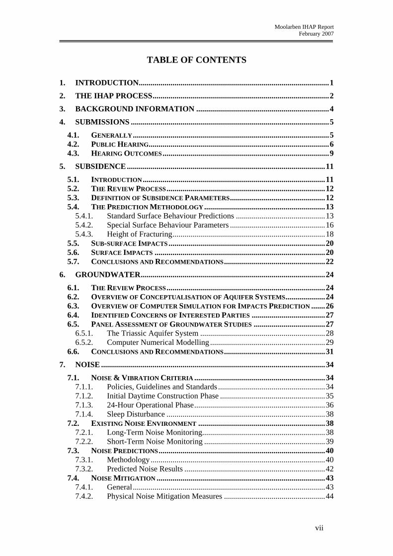
Table 6.1: Comparison of surface subsidence predictions for the Drip and the Corner
Gorge.
SEPL PSM MSEC
Peak Closure (mm) < 1 to 2 - 86
Peak Upsidence (mm)
< 1 to 2 - 106
Peak Horizontal Displacement (mm)
47 (95% Confidence) 57 (99% Confidence)
130 (50% Confidence) (1:1000 chance of being 300 to 400)
-
Against this background, the IHAP is supportive of the revised mine layout contained in the PPR, which now proposes a 500m wide barrier between longwall panels and the Drip and a 450m wide barrier to the Corner Gorge. These distances satisfy the angle of draw criteria (50°) discussed by Dr Pells and result in valley closure and upsidence predictions by MSEC13 of less than 10mm and 30mm, respectively. Given the current state of the subsidence engineering knowledge base and the significance of the Drip and the Goulburn River Gorge, the IHAP consider that a 450 - 500m barrier is currently a more effective mitigation measure than relying solely on monitoring, and is possibly over-conservative. It is important to note that the IHAP do not consider that this barrier width should become a minimum standard in all other mining circumstances.
13 Supplementary Notes on Predictions of Subsidence, Valley Upsidence and Closure and Impacts of Subsidence, Upsidence and Closure on the Goulburn River and Cliff Lines. Mine Subsidence Engineering Consultants. Appendix A9 of Preferred Project Report
17

Moolarben IHAP Report February 2007
5.4.3. Height of Fracturing
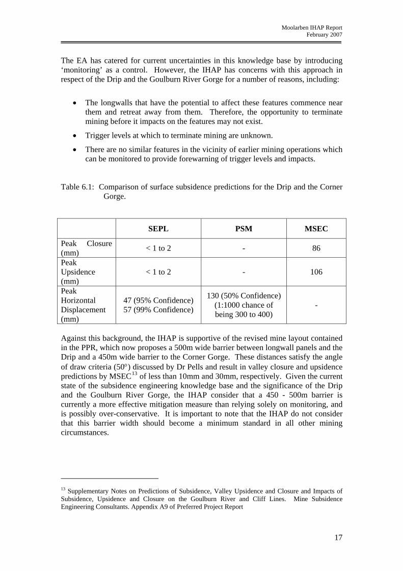
The height of fracturing above caved mine workings and the effect of this fracturing on strata permeability have been topics of concern to mining and geotechnical engineers for over a century as they have serious safety and economic implications for underground mines and can have serious economic and social consequences for groundwater and surface water resources. A number of factors impact on the issue, including the geological nature of the superincumbent strata, the permeability of this strata, the presence of aquicludes (impermeable strata), the depth of mining and the dimensions of mine excavations. Although a range of design procedures and guidelines have been developed around the world, there is considerable variability between them. The Subsidence Impact Assessment14 for the MCP EA utilised an empirical sub-surface fracturing model developed by SEPL and presented in ACARP (2003)15. This model defines a height of continuous fracturing and a height of discontinuous fracturing. It defines continuous fracturing as fracturing above a longwall panel that would provide a direct flow-path or hydraulic connection to the workings. Discontinuous fracturing is referred to as the additional extent above a longwall panel to which there could be a general increase in horizontal and vertical permeability but does not provide a direct flow path or connection to the workings. In the EA, the height of continuous fracturing is predicted to range from 82 to 97m. The IHAP process resulted in the fracture height prediction model being revised by SEPL, producing a new prediction for the maximum height of fracturing of 122m16. It has also been clarified in documentation relating to the revised model that it is possible that fractures within the discontinuous zone are hydraulically connected to the mine workings17. The revised model is apparently based on the same database as the original model. It comprises 6 points determined from a physical laboratory model in the UK and 8 points apparently determined on the basis of fluid loss when drilling boreholes in NSW and Queensland, Figure 5.2. Of these eight points, 3 are shown to be ‘truncated by massive conglomerate or sandstone units”. The IHAP has concerns regarding this model and the predictions arising from it, including:
• Physical laboratory models are noted for errors associated with scale and loading effects arising from the nature of the rock simulation material they are constructed out of (plaster, sand, sawdust, paper, cardboard etc) and the mechanical manner in which they are loaded. They have fallen into disuse for these reasons, the last in the Australian coal industry being dismantled a decade ago.
14 Appendix 8 of EA 15 Review of Industry Subsidence Data in Relation to the Impact of Significant Variations in Overburden Lithology and Initial Assessment of sub-surface Fracturing on Groundwater. Project No. C10023. Strata Engineering Report No. 00-181-ACR/1. September 2003. 16 Point 9 of responses to Prof Galvin, SEPL Report No. 04-001-WHT/3, Addendum A, Compendium of Responses. 17 Appendix A8, SEPL Report No. 04-001-WHT/3, Addendum F, Compendium of Responses.
18
Moolarben IHAP Report February 2007
• No information has been provided as to how well the strata that the UK physical model attempted to simulate correspond with the strata that overlie the proposed Moolarben longwall panels.
• There is an extensive range of fracture heights over a relatively small range in mining height for the Australian data points.
• Only three data points apparently relate to massive sandstone circumstances like those that SEPL associate with the MCP.
• Drilling fluid loss is not necessarily a reliable measure of fracturing and change in permeability.
• The revised model is premised on a number of untested, albeit reasonable, assumptions.
• The fracture heights predicted with the revised model are still less than those predicted by a number of other fracture models that have found successful application in the field and by some numerical models which also find successful application in the field. (Of course, these successful models might still be over-predicting the height of fracturing.)
Figure 5.2: Base data used in SEPL fracture height model.
The predicted fracture heights may well prove to be correct. However, the IHAP is of the opinion that the prediction model is not sufficiently robust for the IHAP to be confident in the outcomes at this point in time. The IHAP notes that SEPL have made various references to the model being preliminary, that the problem is of a complex
19

Moolarben IHAP Report February 2007
nature and that it is usually recommended to undertake a sub-surface monitoring program in non-sensitive areas to validate predictions.
5.5. SUB-SURFACE IMPACTS
The base of the Triassic strata typically lies 90 to 100m above the proposed MCP longwall panels. Although the original prediction was that the height of the continuous fracture zone would exceed 90m at some point over all longwall panels, and typically range from 93 to 97m, SEPL nevertheless concluded in the EA18 that ‘it is considered unlikely at this stage that a reduction in extraction or modification to the mine plans will be required, based on the available data. However, this may change once the impact of mining is better understood.’ The revised model predicts that the base of the continuous fracture zone ranges from 72 to 122m above the longwall panels.19 This would obviously result in fracturing impacting upon the Triassic aquifer system above some sections of the underground workings. Depending on the hydraulic connectivity of fractures in the discontinuous zone to the mine workings, these impacts may be greater. The Subsidence Response that comprises Appendix A8 of the PPR does not address the impact of the revised fracture height predictions. However, MCMPL noted in their closing presentation to the IHAP hearing that it was prepared to reduce mining height from 4.2m down to 3m in order to restrict the height of fracturing to below that of the Triassic strata. The Compendium of Responses also notes that mitigation strategies for longwall mining are generally limited to reducing the extraction height and decreasing the panel width20. SEPL has advised the IHAP that it will be possible to measure actual heights of fracturing for the preferred project layout in non-sensitive southern areas of Underground 4 area without impacting on the Goulburn River Gorge or deep alluvium near the end of longwall panel 121. The IHAP consider these measurements, in association with monitoring of impacts on groundwater pressure and flow, to be essential. This need is reinforced by the inconclusive nature of some preliminary groundwater pressure monitoring data made available to the IHAP by UCML since the conclusion of the public hearings.
5.6. SURFACE IMPACTS
Based on the site inspection and the hearing, the IHAP is of the opinion that surface features and infrastructure that potentially could be impacted upon by subsidence have been adequately identified for the purpose of the EA. To date, restricted access has limited the assessment of some areas in the vicinity of Dronvisa Quarry. This and other aspects related to the management of interactions with the quarry process should be able to be addressed adequately in the SMP process. 18 Section 12.3.2. Appendix 8. MCP EA. 19 SEPL Report No. 04-001-WHT/3, Addendum A, point 9, Compendium of Responses. 20 SEPL Report No. 04-001-WHT/3, Addendum F, page A25, Compendium of Responses. 21 SEPL Report No. 04-001-WHT/3, Addendum E, Compendium of Responses.
20

Moolarben IHAP Report February 2007
The IHAP considers that the revised mine plan presented in the PPR incorporates important mitigation measures that significantly reduce the level of risk of subsidence related damage to the following features:
• The Drip
• The Corner Gorge
• The bed of the Goulburn River
• Cliff Line 3 (CL3)
• The 6 Aboriginal archaeological sites that were identified during the IHAP process as being of high scientific significance22, namely:
i. 264 – a collection of 78 grinding grooves
ii. 280 – a rock shelter containing grinding grooves, occupation material and hand stencil rock art
iii. 282, 286 and 287 – a rock shelter containing occupational material only
iv. 283 –– a rock shelter containing occupational material and painted rock art.
The Drip, the Corner Gorge and the Goulburn River now fall well outside the zone of recorded subsidence damage from longwall mining23. Damage to CL3 should be substantially mitigated, but not necessarily eliminated, by the revised mine design. The mine design is now amenable to refinement in this regard when a SMP is prepared at some future date. As a consequence of providing an increased level of protection to CL3, the risk of damage to two archaeological sites (256 and 261) has increased24. However, these sites are both regarded as having low scientific significance. The revised mine design has reduced the likelihood of damage to the grinding groove site (264) from ‘moderate to high’ to ‘low’. The IHAP is of the opinion that this site must not be damaged and, therefore, further refinements to the plan may be necessary when preparing a SMP. The revised mine plan is amenable to such refinements. The level of risk of damage to site 280 has been reduced from ‘high’ to ‘moderate’. The mitigation and management measures recommended in the EA for this site will still need to undertaken. The risk of damage to the remaining archaeological sites of significance is now rated as ‘low’ and the mine plan is amenable to refinement during the SMP process to further mitigate these impacts if necessary. Although significant modifications have been made to the mine plan, it is still important that monitoring is undertaken of all of the above features to confirm the conservativeness of the revised design for MCP site specific conditions. The IHAP concurs with the assessments of the remaining features identified in the EA and the 22 Reference, for example, presentation No. 32, Appendix I. 23 This excludes impacts on the groundwater system. 24 Appendix A8, Preferred Project Report
21

Moolarben IHAP Report February 2007
PPR and is generally satisfied that impacts can be adequately managed through the SMP process. It is noted for the record that towards the end of the IHAP process, the panel received an enquiry regarding seismic impacts due to underground mining. This matter was not referred to MCMPL for comment. Suffice to state that the IHAP considers that it is unlikely to be of concern given the shallow depth of mining and the limited extent of underground mine workings in the Ulan area.
5.7. CONCLUSIONS AND RECOMMENDATIONS
Sub-surface Impacts of Subsidence 1. The IHAP is not sufficiently confident of the accuracy of the model for
predicting the height of continuous fracturing above the proposed longwall panels, and the extent to which discontinuous fracturing can also impact on groundwater aquifers within the Triassic sandstones and inflow to the mine workings.
2. Proposals to undertake monitoring of subsidence impacts on the Triassic strata early into the project in less sensitive locations, and to reduce mining height to 3m if necessary, are considered reasonable management responses.
3. The impact of subsidence on fracturing of ground water systems is a vexing issue under most circumstances and is only likely to be resolved on this occasion by the outcomes of studies currently in progress at Ulan Colliery, adjacent to the MCP, and/or monitoring over longwall panels in the MCP subject area.
Surface Impacts of Subsidence
1. The empirical methodology for predicting the standard components of surface subsidence associated with the MCP would benefit from further development and calibration to the local conditions associated with the MCP.
2. The initial longwall panels in the MCP provide the opportunity to validate the prediction methodology and to calibrate it to MCP site specific conditions without unduly jeopardising the integrity of significant surface features.
3. In the meantime, the current surface subsidence predictions for the MCP are likely to be conservative.
4. The revised mine plan is an appropriate response to managing the risk of subsidence damage to surface features and structures of significance in the vicinity of the proposed underground workings of the MCP.
5. Nevertheless, ongoing monitoring is still required to confirm site specific subsidence behaviour and to refine the mine plan as necessary when Subsidence Management Plans are prepared in the future.
22

Moolarben IHAP Report February 2007
Recommended Conditions of Approval The IHAP recommends that if the project is approved, the Conditions of Approval should make provision for:
1. Monitoring of the height of fracturing above the goaf of longwall panels 1 to 4 (panels being located in positions that approximate those shown in the PPR) and the impact of this fracturing on groundwater pressure head and flow.
2. The preparation of a report at least 6 weeks before the completion of each longwall panel, up to the completion of longwall panel 4, detailing the findings of the fracturing and groundwater monitoring.
3. The submission of each fracturing and groundwater monitoring report to an independent subsidence reviewer and an independent groundwater reviewer appointed by the approving authority.
4. The preparation of a report to the approving authority by each of the two independent reviewers prior to the completion of each longwall panel, up to the completion of longwall panel 4.
5. The proponent and the approving authority formally reviewing and responding to the fracturing and groundwater monitoring outcomes before the completion of the next longwall panel in the series.
6. Monitoring of the development of surface subsidence above longwall panels 1 to 4 (located in positions that approximate those shown in the PPR), including the measurement of all near and far-field components of subsidence.
7. Monitoring of the impact of surface subsidence on surface features.
8. Monitoring of the effectiveness of subsidence mitigation measures proposed in the PPR.
9. The preparation of a report within 4 weeks of the completion of each longwall panel, up to the completion of longwall panel 4, detailing the cumulative findings of the surface subsidence monitoring, including impacts on surface features.
10. The submission of each surface subsidence monitoring report to an independent subsidence reviewer appointed by the approving authority.
11. The preparation of a report to the approving authority by the independent subsidence reviewer within 8 weeks of the completion of each longwall panel, up to the completion of longwall panel 4.
12. A formal review of all fracturing, groundwater and surface subsidence monitoring outcomes prior to the completion of longwall panel 4, with outcomes being used to decide approval conditions for longwall panel 7 and thereafter (recognising that longwall panel development typically needs to be maintained 2 to 3 panels ahead of the longwall panel extraction).
23

Moolarben IHAP Report February 2007
6. GROUNDWATER
Assessment of mining related impacts on regional groundwater aquifer systems normally follows a pathway that involves conceptualisation of groundwater (and surface water) processes, simulation of these processes using computer based mathematical modelling to an appropriate level of representation, imposition of proposed changes to the processes, and assessment of the resulting impacts. Like subsidence, the process is iterative in so far as unacceptable impacts may require a change to the mine plan. However, unlike subsidence, groundwater impacts can extend for many kilometres beyond a mine footprint, into areas that are poorly characterised by measurement. Accordingly, it is often necessary to invoke judgements relating to groundwater occurrence based on proficiency and experience.
6.1. THE REVIEW PROCESS
The review process in relation to groundwater has focused on:
• conceptualisation of the aquifer systems;
• computer simulation of those aquifer systems;
• concerns raised by interested parties;
• an assessment of the groundwater studies. A number of aspects of this process required interactions with MCMPL, its consultants and stakeholders, supported by a site inspection. The principal groundwater consultant for the proponent is P. Dundon and Associates Pty Ltd (PDA), with additional specialist input for groundwater numerical modelling provided by Aquaterra Pty Ltd. Appendix IV summarises the key activities in the groundwater review process.
6.2. OVERVIEW OF CONCEPTUALISATION OF AQUIFER SYSTEMS
Conceptualisation requires an understanding of rock strata and hydraulic properties, rainfall recharge, groundwater flow systems, surface and groundwater interactions, and numerous other factors. The level of detail applied to measurement of an aquifer system should be commensurate with the identified sensitivities of a region since groundwater systems, once impacted, can take a very long period of time to equilibrate or recover. Indeed, due to changed rock hydraulic properties as a result of mining, many systems may never fully recover. It is important, therefore, to ensure that sufficient field measurements and analyses are undertaken to confidently characterise aquifer systems. Hydrogeological investigations undertaken by MCMPL for the proposed Stage 1 of the MCP have comprised consolidation of available historical data, generated largely by UCML. More recent data relating to the Wilpinjong Coal Project has also been assimilated. Supporting field studies have included the installation of a network of
24

Moolarben IHAP Report February 2007
piezometers by MCMPL that have been used to test and monitor groundwater contained in the rock strata. Testing of these piezometers has provided estimates of the water transmission capacities of strata, while regular monitoring has facilitated an assessment of groundwater pressure distributions and movements in groundwater levels over time. Water samples have also been obtained and analysed in order to hydrochemically characterise the aquifer systems. Studies presented in the EA have identified regional rock strata that comprise Triassic and more recent sedimentary rocks overlying older Permian coal measures that contain the target Ulan coal seam. These strata, in turn, overly much older granites that subcrop in the south of the project area. The Goulburn River-Moolarben Creek is the central major drainage flowing northward and close to the proposed Moolarben open cut and underground operations. The river and its tributaries have eroded and shaped the rock strata to a relatively subdued landscape in Permian areas, and a more dramatic landscape in some Triassic areas, especially in the areas identified as the Drip and the Goulburn River Gorge. Unconsolidated alluvial materials have been deposited within and along these drainages. The rock strata contain groundwater that has been recharged by rainfall infiltration over geologic time. Surface drainages that dissect these strata act as hydraulic sinks, attracting groundwater seepage from the rock strata (as base flow at lower elevation) and conveying available flow to the north-east, beyond the area of interest. At a local scale the alluvial deposits along these drainages act as an active groundwater store by continually exchanging groundwater with surface flow. As a result of these processes and prior to any mining activity in the region, the regional groundwater table and subsurface pressure distributions probably reflected topography in a subdued way, with higher groundwater levels observed in elevated areas and lower groundwater levels observed along drainages. Variability in strata transmission properties may have moderated this distribution. Groundwater is exploited via boreholes that have been identified throughout the region. Additionally, there are numerous springs and seeps issuing groundwater from the relatively shallow strata generally identified with the regolith or weathered rock zone. A number of these springs feed local dams and have continued to flow throughout the current drought period. The most widely recognised spring is the Drip, situated on the Goulburn River immediately north of the proposed Moolarben Underground 4 area. This feature contains significant plant life reliant upon groundwater resources and is regarded as a high value groundwater dependent ecosystem. Historical mining of the Ulan Seam at UCML has resulted in regional scale groundwater depressurisation within the coal seam, which has been observed at installed piezometers. This ‘in seam’ depressurisation has induced groundwater flows from overlying strata which have in turn, been variably depressurised. Proposed mining operations at the MCP are expected to induce similar impacts upon the groundwater systems to those observed at UCML.
25

Moolarben IHAP Report February 2007
6.3. OVERVIEW OF COMPUTER SIMULATION FOR IMPACTS PREDICTION
The application of computer based numerical models to problem solving in groundwater engineering provides a powerful tool for the rationalization of spatially and temporally varying field conditions. The modelling process utilizes a system of mathematical equations for water flow through porous media, subject to prescribed boundary conditions. The process requires conceptualisation of aquifer systems in respect of geometry, hydraulic properties and applied stresses including rainfall, bore and well pumpage, river/creek leakage and mine induced seepage. Since the numerical model is central to the determination of groundwater related impacts arising from the MCP, it is important to ensure that the selected model code is appropriate, the model is designed and developed to minimise numerical errors and distortions, and that the supporting data and simulations properly reflect field conditions. PDA has undertaken computer modelling of the aquifer systems and simulated the impacts of proposed mining in a cumulative manner by including historical mining at Ulan Coal and scheduled mining at Wilpinjong. A calibrated model has been developed and presented in the EA. The model, known as MC1.3, adopts the Modflow code and represents the Triassic strata, the Permian coal measures, the southern granites and the alluvium strata in a simplified way. The Modflow code has a number of well known limitations that can affect the accuracy of simulating underground and open cut mining operations. These limitations largely relate to the simulation of steep hydraulic gradients that typically evolve adjacent to and above mine workings, and to the simulation of multiple horizons where zero pore pressures (dewatered conditions) prevail, especially in respect of the subsided fractured zone above mine workings. Another significant limitation is an inability to reflect changed aquifer properties associated with a subsided fracture zone in an efficient way. Model MC1.3 has been used as a basis for development of a revised model (MC1.4) presented in the PPR, which employs an alternate code known as Modflow-Surfact. This is a more robust code that mitigates some of the limitations already noted. Model MC1.4 was prepared to address prior concerns raised by the panel during the IHAP process. Mining operations have been simulated by the model by draining groundwater held within the Ulan coal seam. This has induced flows towards the drainage points and generated strata depressurisation within the model. The drainage locations have been assigned to represent both open cut and underground operations. A large number of dewatering boreholes are proposed for water supply to the coal preparation plant and these have also been included in the model along the eastern side of the proposed underground operations. Reported results of modelling indicate limited depressurisation of the coal seam in the areas of Open Cut pits 2 and 3 due to limited submergence below the water table. More substantial depressurisation of the coal seam is predicted in the northern part of Open Cut 1 and the Underground 4 area due to increasing submergence of the coal
26

Moolarben IHAP Report February 2007
seam in a northward direction. Relatively minor depressurisation is predicted within the overlying Permian and Triassic strata in these areas. Approximately 32 gigalitres of groundwater is predicted to be pumped from the underground operations and associated dewatering borefield during the mine life. Impacts arising from formation depressurisation are reported by PDA to be mixed. Existing bores and springs within five kilometres of mining operations that derive water from the Permian strata, may be impacted for the duration of mining and until such time as water levels subsequently recover. Bores and springs deriving water from shallower strata are not expected to be impacted since it is believed that the two systems are disconnected hydraulically. Leakage losses from the Goulburn River induced by mining are predicted to be about 0.5 megalitres per day. Mine water seepage rates, dewatering bore yields and potential water supply from UCML operations or Wilpinjong Mine, are reported to be sufficient to meet mining demands.
6.4. IDENTIFIED CONCERNS OF INTERESTED PARTIES
After consideration of submissions made to it, the IHAP believes the groundwater related issues of greatest concern include:
• loss of water supply in springs and bores located throughout the region;
• leakage and flow losses from the Goulburn River and tributary systems, resulting from sustained depressurisation of underlying strata;
• depressurisation/dewatering of the Triassic aquifer systems that host the Drip and other groundwater dependent ecosystems;
• surpluses or deficits in the management of water supply to the proposed operations, resulting in a need to discharge water or source additional water from neighbouring mines or from groundwater resources;
• leachate generation from waste rock and tailings.
6.5. PANEL ASSESSMENT OF GROUNDWATER STUDIES
The IHAP acknowledges that a significant effort has been directed towards the evaluation of groundwater impacts relating to the proposed Moorlarben mine plan. The IHAP also recognises the need for such effort in view of the likely scale of groundwater impacts and the difficulty in arresting unforseen impacts within short timeframes. As a result of the IHAP process and various interactions with the proponent, the panel consider that some concerns may be reasonably addressed by the amelioration measures proposed by MCMPL. Other concerns are substantial and remain insufficiently addressed. In respect of Open Cut areas 2 and 3 and the southern and central part of Open Cut 1 area, proposed operations are generally near to the prevailing water table. The target Ulan Seam is only partially saturated in these areas, hence groundwater related impacts from mining are expected to be limited to partial water table loss. Due to the
27

Moolarben IHAP Report February 2007
often complicated nature of groundwater flow systems, some bores, springs and seeps in proximity to the proposed mine pits may dry up while others may be altogether unaffected. Those situated within a few kilometres of the pit crests are considered to be most at risk. It is important, therefore, that accurate baseline data is available for future impact assessment purposes. This data should include routine measurement of bore water levels and yields, and spring and seep flows. An expanded network of observation piezometers needs to be established by MCMPL around the proposed open cut operations prior to commencement of mining. MCMPL has committed to compensate or replace waters for affected landholders. The IHAP considers that leakage induced subterranean losses from Moolarben Creek and the Goulburn River arising from open pit operations are unlikely to be significant. However, the IHAP notes that loss of surface runoff to these drainages will occur during the period of mining and beyond, until such time as rehabilitation of spoil piles restores the runoff. Whilst the impact of this loss on the major drainage systems is poorly quantified in the EA, it is considered to be temporary, provided that the constructed drainage systems on the final landforms are appropriately designed and do not facilitate leakage into underlying spoils.
Geochemical characterisation in respect of ionic species of leachate likely to be generated through re-saturation of waste rock overburden has not yet been conducted. This leachate may accumulate in the open cut pit shells in the long term as a result of the recovery of groundwater levels or rainfall infiltration through spoils. The IHAP considers that leachate characterisation needs to be addressed before commencement of mining in order to understand the potential long term impacts of void re-saturation. In respect of the Underground 4 area, the IHAP continues to have concerns regarding the predicted impacts of mining. These concerns are largely driven by:
• a limited knowledge of the important Triassic aquifer system;
• a lack of confidence in the input data to computer numerical models used to predict impacts;
• a lack of confidence in the numerical models themselves.
6.5.1. The Triassic Aquifer System
The Triassic system covers a large part of the proposed mining operations and surrounding areas. It is an important stratigraphic unit that governs recharge and piezometric surfaces throughout the region. It is especially important in so far as it hosts the Drip and significant reaches of the Goulburn River. Depressurisation of the system has the potential to impact upon these features. The IHAP considered early into the panel process that studies reported in the EA inadequately addressed hydraulic parameterisation of this system, while piezometric mapping was sparse. These inadequacies were noted by the DNR and by Dr. Pells, who provided a submission to the IHAP on behalf of Ms J. Imrie. Subsequently, the proponent installed three piezometers and conducted hydraulic testing at these locations. Additional piezometric data and explanations not previously reported in the EA were then provided to assist the IHAP.
28

Moolarben IHAP Report February 2007
In view of the sensitivity of the Triassic aquifer system, the IHAP sought certain piezometric information from UCML and provided this to MCMPL25. Such information included observed depressurisation of strata at two piezometer sites and indicated a potential for mining induced groundwater depressurisation within the Triassic system. The proponent examined this additional information and has responded to the contrary26, attributing the observed depressurisation to natural recharge and flow processes within the Triassic system. The IHAP has considered the proponent’s responses and believes that there is a potential for depressurisation of groundwater systems within the Triassic aquifers greater than that currently predicted by numerical modelling.
6.5.2. Computer Numerical Modelling
The IHAP has reviewed groundwater modelling reported in the EA and in the PPR in some detail and notes, inter alia, the following.
Model hydraulic properties: The calibrated model (MC1.3) presented in the EA exhibits a number of domains for hydraulic conductivity (permeability), distributed within five model layers. With the exception of layer one, the remaining layers have a distinct north-south linear boundary which defines domains to the east and west that have differing hydraulic conductivities by up to an order of magnitude. A similar east-west boundary prevails roughly along an identified paleochannel and Wilpinjong Creek. These differing conductivities appear in large part, to be an artefact of the model calibration process and are likely to influence the evolution of regional depressurisation of strata.
The IHAP expressed concerns that there appeared to be no underlying geological-hydrogeological controls for these domains. PDA modified these distributions in subsequent modelling reported in the PPR.
Subsidence failure regime: Underground mining simulations represented in the EA predominantly support a scenario where only the coal seam has been extracted in longwall panel areas without inclusion of a subsidence failure regime. This regime is predicted to occur above extracted panels (reference Section 6.4.3) and normally exhibits reasonably high groundwater transmission capacity through the presence of fractured rocks. It is generally acknowledged to be relatively free draining over the zone of connected vertical cracking. Exclusion of this zone in reported model simulations, including the calibrated model MC1.3, is considered by the IHAP to be unrepresentative of mining conditions.
Only one simulation included a failure regime that extended 50m above the coal seam (fracture height is predicted to be 82 to 97m in the EA and revised to 72 to 122m during the hearings). This model simulation also changed groundwater storage
25 Letter prepared by Strata Control Technologies, addressed to Xstrata Coal 04/12/06 – IHAP request for piezometric results from DDH242 and R855 at Ulan 26 Letter prepared by Peter Dundon & Associates addressed to Mr. Mackie 13/12/06
29
Moolarben IHAP Report February 2007
properties within the strata and adopted a less than free draining condition incorporated within a parameter known as the drain conductance.
The IHAP considers the adopted height of the failure regime, the changed storage properties and the use of a very low drain conductance to be poorly representative of underground mining conditions.
Revised modelling: A revised groundwater model addressing concerns raised by the IHAP has been reported in the PPR27. This model (MC1.4) adopts a computer code more amenable to mining conditions. It has an improved capability for simulating steep hydraulic gradients and evolution of depressurisation in strata below the water table. The amended model includes a revised mine plan for the Underground 4 area.
In view of the concerns raised by the IHAP in relation to prior modelling, a more detailed examination of the preferred model has been conducted. Such examination has identified ongoing concerns that include restrictive representation of the underground failure regimes at both UCML and MCMPL, leading to unrealistically low depressurisation of strata and associated under-estimation of seepage rates to mining operations. Figures 6.1 and 6.2 illustrate this. Figure 6.128 provides a model simulation of the groundwater head distribution or piezometric surface, within the Ulan seam (model layer 4) at the completion of proposed mining at MCMPL in 2021. Clearly there is a distinct piezometric low regime (shaded yellow) prevailing over both UCML and MCMPL extracted panels and surrounding areas. In contrast, Figure 6.2 provides groundwater heads within the overlying Permian strata at a datum horizon just 25m above the coal seam (model node horizon). These heads exhibit little evidence of seam depressurisation. The IHAP has difficulty in accepting this lack of pressure loss as a realistic prediction of the impacts of longwall mining.
Model extents also appear to be insufficient to accommodate regional depressurisations arising from simulated mining, in a natural way. This is suggested by the geometry of the piezometric contours exhibited in Figure 6.1 in the north-western part of the model (shaded yellow). Here the distinct north-south trend of the contours suggests that pressure losses may be influenced and enhanced substantially by the northern and western boundaries of the model. The IHAP has difficulty in reconciling the impacts of mining with the impacts of boundary proximity.
27 in PDA Report No. 05-0158-R03B as Attachment B 28 taken from PDA Report No. 05-0158-R03C Attachment B Figures 4.10 and 4.9,
30

Moolarben IHAP Report February 2007
6.6. CONCLUSIONS AND RECOMMENDATIONS
Assessment of groundwater related impacts arising from surface and underground mining requires a comprehensive understanding of the geologic and hydraulic properties of strata, groundwater and surface water flow processes and interactions, mining induced changes to strata, and importantly, proficiency in translating these processes into a representative groundwater model. The geologic properties of the rock strata (stratigraphy, lithology) appear to be reasonably known or predicted for the purpose of groundwater assessments. Hydraulic properties appear to be reasonably measured in respect of horizontal hydraulic conductivities for certain strata. However, the vertical hydraulic conductivities are poorly known, having been derived largely on the basis of a ‘calibrated’ groundwater model for which the calibration remains questionable. Storage properties of all strata are similarly poorly known. Measurements of hydraulic properties of the important Triassic aquifers in sensitive areas, remain sparse. The IHAP believes that most of these issues could be addressed through conventional inspection and testing of rock core obtained from exploratory drilling. The IHAP also considers that:
• The groundwater flow processes and surface water interactions are reasonably understood or reasonably inferred in a regional context. However, impact assessment would benefit from localised and more focused analysis of both the regolith and its role in supporting shallow groundwater sources, and Permian-Triassic strata hydraulic connectivity to the major drainages.
• Mining induced changes to strata associated with the subsidence fracture zone are poorly characterised in terms of hydraulic properties, both in the EA and the PPR. It is widely acknowledged that this zone can be free draining to heights largely governed by connectivity of vertical cracking (estimated to be 122m by SEPL). Since this zone provides a conduit for horizontal drainage from shallow strata, the IHAP considers it important to adopt a precautionary approach by including the maximum predicted height of cracking and generally free draining conditions in any analysis of impacts.
• The numerical models presented in the EA contain a number of deficiencies that have the potential to inaccurately represent underground mining operations, mine water seepage rates and strata depressurisations arising there from. Revised modelling undertaken in the PPR is considered to have similar deficiencies which could be addressed by ensuring the model domain and discretisation is sufficient to predict impacts without distortion, and the model hydraulic properties and imposed boundary conditions are either supported by field measurement or are inferred in a manner that promotes confidence in the model outcomes.
In view of the numerous issues identified above, the IHAP is unable to comprehend with sufficient certainty, the magnitude and extent of impacts likely to prevail upon aquifer systems as a consequence of proposed longwall mining operations at MCMPL. Consequently, the IHAP has serious reservations concerning the
31

Moolarben IHAP Report February 2007
development of an underground mine until such time as impacts are predicted with increased certainty and are found to be acceptable. In respect of open cut mining, the IHAP considers that the impacts on aquifers systems are likely to be limited in magnitude and extent. Such impacts are most likely to be associated with loss of yield in bores, springs and seeps located within a few kilometres of the open cut operations. MCMPL has stated a commitment to replace affected water supplies or to compensate affected landholders. Consequently, the IHAP sees no major impediment to open cut mining providing that the following are addressed within conditions of approval:
• sufficient water supply is available to meet mining demand in the absence of contributions from underground mining operations;
• long term spoils leachate quality is determined to have no adverse impact on existing or future groundwater systems;
• the existing piezometric monitoring regime is enhanced to provide a network of additional multi level piezometers around each open cut operation. This network should provide advance warning of impacts and facilitate the determination of action trigger levels in respect of adverse impacts;
• the placement, design, and schedule of monitoring at all piezometers should have the concurrence of DNR;
• routine monitoring of identified boreholes, springs and seeps (including dam fed seeps) is maintained;
• routine monitoring of the identified groundwater dependent ecosystems is undertaken; and
• a groundwater impact response plan is formalised that provides for:
o investigation of any exceedances of action trigger levels by an independent and suitably qualified person;
o measures to mitigate, prevent or offset any mining induced leakage from Moolarben Creek, Wilpinjong Creek or the Goulburn River, or the associated alluvial aquifers;
o procedures for compensating landholders affected by loss of groundwater.
32

Moolarben IHAP Report February 2007
Figure 6.1: Piezometric surface for model MC1.4 layer 4 - Ulan seam at 2021 (after
Aquaterra Figure 4.10 in PPR). Yellow shading shows approximate area of depressurisation within the coal seam induced by panel extractions.
Figure 6.2: Piezometric surface for model MC1.4 layer 3 – coal measures
overlying Ulan seam at 2021 (after Aquaterra Figure 4.9 in PPR). The piezometric surface is generated for a horizon located approximately 25m above the seam. Expected depressurisation around extracted panels is not evident.
33

Moolarben IHAP Report February 2007
7. NOISE
The IHAP process for the MCP has focused on assessing:
1. The reasonableness of the noise and vibration assessment methodology.
2. The adequacy of the noise monitoring and noise modelling.
3. The order of accuracy of the predictions.
4. The impact of these predictions on noise-sensitive receivers.
5. The measures proposed by the proponent for mitigating and managing these impacts.
In-depth analysis and discussions with MCMPL, its consultants and some affected stakeholders, supported by a site inspection, were undertaken as part of this assessment. The acoustic consultant for the proponent is Spectrum Acoustics Pty Ltd (SAPL). The IHAP has reviewed the EA, however this report focuses on the review of the noise and vibration assessment work presented in the Preferred Project Noise and Vibration Impact Assessment Report, herein referred to as the PPR. Appendix V summarises the key activities in the noise and vibration review process.
7.1. NOISE & VIBRATION CRITERIA
7.1.1. Policies, Guidelines and Standards
The noise and vibration impact assessment presented in the PPR was conducted using the following policies, guidelines and standards:
• NSW ‘Industrial Noise Policy’, 2000 (INP)
• NSW ‘Environmental Criteria for Road Traffic Noise’, 1999 (ECRTN)
• DEC’s Sleep Disturbance Criteria
• EPA ‘Environmental Noise Control Manual’ (ENCM)
• DEC ‘Assessing Vibration: A Technical Guideline’, 2006
• ANZECC ‘Technical Basis for Guidelines to Minimise Annoyance due to Blasting Overpressure and Ground Vibration’, 1990
The INP sets two separate noise criteria to meet environmental noise objectives, one to account for intrusive noise, the other to protect the amenity of existing land users. The more stringent of the two is used when setting Project Specific Noise Levels (PSNLs), or target noise levels, for a particular project. PSNLs set the benchmark against which noise impacts and the need for mitigation are assessed. However, setting PSNLs is not just a matter of comparing the magnitude of the amenity criteria to the intrusive criteria, and selecting the smallest value to be the PSNL. This is
34
Moolarben IHAP Report February 2007
because different time periods apply (intrusive criteria are over 15 mins while amenity criteria are over the entire day, evening or night periods, being 11 hours, 4 hours and 9 hours, respectively), which means that the assessment for each criterion is different. For example, where the same number applies to the amenity and intrusive criteria, the intrusive criteria would typically be more stringent because it is determined over a much shorter period. However, where the amenity criteria are lower than the intrusive criteria, the proponent must demonstrate that both criteria will be satisfied. The IHAP raised concerns over this matter during the hearings and the IHAP are now satisfied that this has been adequately addressed in the PPR. Background noise levels need to be determined before intrusive noise from a project can be assessed, and are generally achieved through long term noise monitoring in the project area prior to development. Long term monitoring is used to determine the Rating Background Level (RBL), which is the level used for assessment purposes being a single value for day, evening and night periods29, indicative for the entire year. Sometimes the results of long term unattended background noise monitoring can lead to an RBL, for the evening or night period being determined higher than the RBL for the daytime period. These situations can often arise due to increased noise from, for example, temperature inversion conditions during winter and insects etc during the summer, and has been noted in the EA to occur at Locations N6 (R13 Renshaw) and at N4 (R25 Tuck-Lee). According to DEC’s “Application Notes – NSW Industrial Noise Policy” (2006), in determining PSNLs from the RBLs, it is generally expected that greater control of noise be taken during the more sensitive evening and night-time periods than the less sensitive daytime period. Therefore, in determining PSNLs for a particular development, it is generally recommended that the intrusive noise level for evening be set at no greater than the intrusive noise level for daytime. Similarly, the intrusive noise level for night-time should be no greater than the intrusive noise level for day or evening. The IHAP raised concerns on this matter during the hearings, and the PPR has accordingly set day, evening and night criteria in the correct manner.
7.1.2. Initial Daytime Construction Phase
The PPR recommends that daytime noise criteria up to 5dB(A) above the PSNLs be approved for the initial 6 months of the project whilst a bund is to be constructed around Pit 1. This implies that after completion of the bund, the criteria at the affected locations in the vicinity of Pit 1 would revert back to the daytime PSNLs for the remainder of the 12 month period of daytime activities (i.e. a further 6 months after completion of the bund) when surface infrastructure will be completed. Although not stated in the PPR, it appears that the PPR’s recommendation to relax the PSNLs for the first 6 months of the project is practically equivalent to applying construction noise criteria. As has been the case for many mine approvals in the Hunter, both the DEC and DoP do not normally accept construction noise criteria for
29 Day, evening and night periods are defined in the INP as: 0700-1800h, 1800-2200h, and 2200-0700h
Monday to Saturday; and 0800-1800h, 1800-2200h, and 2200-0800h Sundays and Public Holidays.
35

Moolarben IHAP Report February 2007
mining proposals. This is because the noise of activities associated with construction is very similar to the noise associated with mining activities in an open-cut pit. The PPR states that the “proposed construction noise criteria and PSNLs are summarised in Table 11”. These do not consistently show a difference of 5dB(A) between the proposed noise criteria for ‘0-6 mths’ and those for ‘6-12 mths’. The IHAP has also noted inconsistencies between the PSNLs listed in Tables 9 and 11 of the PPR, the latter being repeated in the ‘Executive Summary’ of the PPR. Notwithstanding the above, the IHAP holds the view that if the less stringent criteria are applied only to the construction of the bund, which is to be built for the purpose of reducing noise, and this work is restricted to daytime hours, then a less stringent criteria is reasonable. It is recommended that such construction work be restricted to the normal construction hours as specified in the EPA’s ‘Environmental Noise Control Manual’, of 7am to 6pm from Monday to Friday and 8am to 1pm on Saturdays, with no works on Sundays or Public Holidays. Also, the noise criteria should be applied to the most affected point within a residential property boundary, or where this is greater than 30m from the dwelling, then at the most affected point 30m from the dwelling.
7.1.3. 24-Hour Operational Phase
Chapter 5.1 of the PPR presents a discussion which argues that receivers in the Ulan Village experience ambient and background noise which is controlled by UCML operations, and the ambient and background noise levels vary according to the activities of the UCML and meteorological conditions. Chapter 5.1 reports existing noise levels in the Ulan Village as:
• ambient LAeq noise levels: 43 - 48dB(A)
• background LA90 noise levels: 41 - 45dB(A). In establishing the above existing noise levels, Chapter 5.1 refers to Chapter 3.3 of the PPR, claiming that where a range of noise levels has been measured the lower value in the range has been used. However, Chapter 3.3 of the PPR presents a summary table of UCML noise levels measured in Ulan Village, with and without trucks, crushers etc operating and these indicate noise levels with the following ranges:
• ambient LAeq noise levels: 40 - 42dB(A) without trucks/crushers
46 – 50dB(A) with trucks/crushers
• background LA90 noise levels: 38 - 42dB(A) without trucks/crushers
44 – 48dB(A) with trucks/crushers. Therefore, the table in Chapter 3.3 shows that noise levels have been measured by the proponent to be lower in some cases than those used in Chapter 5.1 to set PSNLs for Ulan Village receivers. Consequently, the IHAP considers this has affected the MCP noise criteria in Table 12 of the PPR so that they are higher than what they should be.
36

Moolarben IHAP Report February 2007
In its submission to the IHAP, the DEC considered the ambient and background noise level data made available to it by the proponent, and formed the opinion that representative existing noise levels in the Ulan Village at night are as follows:
• ambient LAeq noise levels: 42dB(A)
• background LA90 noise levels: 40 - 42dB(A). Given that the ‘amenity’ criteria are significantly lower than the ‘intrusiveness’ criteria in the case of receivers at Ulan Village, the IHAP has identified that there is a gross difference between the night PSNLs in the PPR and those that could be set if the measured lower ambient and background noise levels were used, as referred to above. This is an important and critical issue as there is a significant discrepancy between the proponent’s proposed night-time LAeq(period) noise criteria of 33-38dB(A) and DEC’s proposed 30dB(A) in their IHAP submission. Importantly, as raised by the IHAP during the hearings, there is now agreement between DEC and the proponent in the PPR, that the MCP’s noise criteria for Ulan Village should not depend on UCML’s future noise levels, as the UCML’s future noise levels are unknown and outside the control of the MCP. Furthermore, as stated in UCML’s submission to the hearing, it will be difficult to reduce noise substantially from such a large operation with numerous noise sources. Therefore, the IHAP concurs with the PPR, that it is unlikely that existing noise levels will reduce substantially at the Ulan Village in the near future. Chapter 3.3 of the PPR presents an argument that considers the effect of meteorology on UCML noise levels at the Ulan Village, based on short-term noise measurements conducted in the Village. Although the IHAP concurs that existing noise levels in the Village are dependent on UCML’s operations and meteorology, it does not agree that existing ambient noise monitored over a longer period, say 1-2 weeks, would necessarily be affected by extreme Leq results. This is because ambient Leq noise levels used in setting amenity criteria are based on the logarithmic-average of all the Leq noise levels measured in each period (15 hours for day, 4 hours for evening and 9 hours for night) over the entire monitoring duration. Therefore, the IHAP considers long-term noise monitoring as more reliable when setting noise criteria than short-term noise measurements. With reference to Table 12 in Chapter 5.1 of the PPR, the IHAP does not consider it practical that at each receiver location be set different noise criteria for different meteorological conditions. It is recommended that a single upper limit be set for each assessment period. By placing more emphasis on long-term noise monitoring results than on short-term results, and applying the INP, the IHAP suggests that the DEC and the DoP give consideration to setting the following upper night-time limits at any residential property in the Ulan Village under any meteorological conditions:
• Intrusive noise criteria: LAeq, 15min = LA90 40 + 5 = 45dB(A) • Amenity noise criteria: LAeq, 9hour = LAeq 45 – 10 = 35dB(A)
37

Moolarben IHAP Report February 2007
These noise limits are not dissimilar to those set for other coal mines in the Hunter region. Notwithstanding the above, the IHAP recommends that the immediate goal is for the MCP not to raise existing ambient noise levels, which are currently excessive, and that all reasonable and feasible noise control and management measures be implemented by all mining operations in the vicinity of Ulan Village to reduce ambient noise levels to the INP’s acceptable amenity noise levels.
7.1.4. Sleep Disturbance
The sleep disturbance criteria used in the PPR were determined using the Lmax noise metric. The limits are set by adding 15dB(A) to the night-time background (LA90), or RBL, at each assessment location. This equates to an Lmax sleep disturbance criterion of 45dB(A) for many receivers, with some receivers having criteria reaching 55dB(A). The IHAP concurs with this approach.
7.2. EXISTING NOISE ENVIRONMENT
7.2.1. Long-Term Noise Monitoring
Long-term (unattended) noise monitoring was conducted at six representative residential receiver locations surrounding the project site during July 2005. Existing LAeq and LA90 (RBL) levels are summarised in Table 5.1 below. Table 5.1: Measured Ambient and Background Noise Levels
LAeq, period LA90, periodLocation Day Evening Night Day Evening Night
N1 R36 Rayner 43 37 42 30* 30* 30* N2 R106 Reid 47 40 37 30* 30* 30* N3 R170 Roberts 49 45 39 34 33 32 N4 R25 Tuck-Lee 55 44 44 33 36 34 N5 R157 Powers 55 53 51 42 41 40 N6 R13 Renshaw 49 48 46 30* 31 30* Note: * LA90 levels may have been below 30dB(A), however were set at 30dB(A) as per DEC’s INP Upon reviewing the long-term noise monitoring results presented in Appendix B of the PPR, it is evident that there are times when LA90 background noise levels fall below 30dB(A) at all but two of the six monitoring locations, these being locations N3 and N5. It appears to the IHAP that during quiet periods at night at Locations N3 and N4, the noise monitor may have recorded noise levels lower than 30dB(A) had it been capable of so doing. Should this be the case, the night LA90 background noise levels presented for Locations N3 and N4 in Table 5.1 above would need to be changed from 32dB(A) and 34dB(A) respectively, to 30dB(A) for both locations.
38

Moolarben IHAP Report February 2007
The implications of this are that the project’s ‘intrusive’ noise criteria at night for these two locations would need to be set at lower levels than what has been presented in Table 7 of the PPR – from 38dB(A) down to 35dB(A) at both locations – which subsequently sets the PSNLs to 35dB(A) for both R170 and R25. Similarly, all surrounding receiver locations which have had their PSNLs based on those set at these two locations, would also need to be adjusted, causing the predicted impacts of the MCP to increase by 3dB(A) at these receivers. Furthermore, noise monitoring appears to be undertaken over a period of only some 2 days at Location N2. This does not meet the DEC requirement of at least 1 week (7 days) of noise monitoring requirement. According to the proponent, this was due to instrumentation failure in the field. Notwithstanding this, it is clear that the background levels were well below 30dB(A). Given that the INP accepts adoption of a minimum background noise level of 30dB(A) in quiet rural environments where there are no industrial noise sources, then the MCP noise criterion in the vicinity of Location N3 is appropriately set at 35 dB(A),Leq(15 min) day, evening and night.
7.2.2. Short-Term Noise Monitoring
Additional noise monitoring was also conducted using short-term measurement techniques in November 2005 and August 2006 at Location N3 (R157 Powers) within the Ulan Village and at R49 (Olive Lea), south of Ulan Village. Following concerns raised by the IHAP during the hearings, a further set of short-term noise measurements were made in November 2006 at Location N3 (R157 Powers), R151 (Catholic Church), R160A (Ulan School), R172 (Kimber) and at R153 (Newton). The PPR concludes that Ulan Village currently experiences noise levels, predominantly controlled by UCML operations, of:
• LAeq 40-50dB(A)
• LA90 38-48dB(A) The PPR reports that variations to measured noise levels are attributed to changes in the operations of UCML and meteorological conditions, which the IHAP considers to be a reasonable explanation. Although the IHAP concurs that existing noise levels in the Village are dependent on UCML’s operations and meteorology, it does not agree that noise levels measured over short-term periods are entirely representative of the ambient noise levels that would be monitored over a longer period of say 1-2 weeks. This is because existing ambient Leq noise levels used in setting amenity criteria are based on the logarithmic-average of all the Leq noise levels measured in each period (15 hours for day, 4 hours for evening and 9 hours for night) over the entire monitoring duration. This takes into account a range of different operations of UCML under a range of different meteorological conditions. Therefore, although the IHAP finds short-term noise measurements to be useful, it does not consider them as reliable as long-term noise monitoring when setting noise criteria. The IHAP recommends that long-term noise monitoring be undertaken as part of the post-approval noise management plan for the Ulan Village.
39

Moolarben IHAP Report February 2007
7.3. NOISE PREDICTIONS
7.3.1. Methodology
After determining the PSNLs, the INP requires the prediction of noise levels from industrial noise sources, leading to the determination of noise impact. This process involves:
1. Identifying all possible noise sources, sites and receiver parameters so that noise levels can be adequately predicted.
2. Predicting noise levels from the subject noise source at receiver locations, taking into account all important parameters identified (e.g. source noise levels and locations, operating times, receiver locations, meteorological conditions, site features, topography etc).
3. Comparing the predicted noise levels with the PSNLs to determine the noise impacts.
According to the INP, the following important parameters for predicting noise need to be determined and clearly identified for noise impacts to be predicted adequately:
• all noise sources related to the proposed development, including vehicles that operate on site;
• noise source levels, site location and effective height of the noise source. References should be provided for all source noise levels used in the assessment (for example, direct measurement, previous EIS, manufacturer’s specifications);
• all stages of project development;
• all nearby receivers potentially affected by the development;
• weather conditions applicable to the site;
• noise criteria apply under existing weather conditions;
• site features (including natural and constructed, development and surrounding land uses) that affect noise propagation; and
• operating times of the development.
The PPR lists the various operational noise sources, their respective sound power levels and the heights of noise sources. These have been modelled to assess their impacts on neighbouring sensitive receivers. Although more detailed descriptions of the noise sources and the activities they represent could be provided in some cases (for example, the sound power levels of loading empty coal wagons, locomotives idling on site, and conveyors), overall the PPR adequately addresses this point. The proponent used a computer noise model, ENM, incorporating identifiable noise sources and surrounding terrain characteristics, to calculate the expected contribution to noise levels at the closest potentially affected noise sensitive areas to the proposed mine for each stage of the mine development. Noise models were generated for each of the following operational scenarios, under a range of atmospheric conditions:
40

Moolarben IHAP Report February 2007
• Year 0: Commencement of construction of mine Commencement of mine operation; Pit 1 with 15m high environmental bund around the western edge of Pit 1 and a 3.5m high acoustic barrier along the western side of the ROM coal hopper
• Year 1:
Continuation of mine operation; Pit 1 as above except mining advanced further into Pit 1 and further overburden emplacement occurring
• Year 2:
Commencement of mining at northern end of Pit 2 after completion of Pit 1.
• Year 6a:
Continuation of mine operation at Pit 2, except 15m high bund is completed.
• Year 6b:
Commencement of mining at the northern end of Pit 3 with Pit 2 nearing completion at its southern end. Coal haulage is behind the continuous acoustic bunds formed during operations in Pits 1 and 2.
• Year 7/8:
Continuation of mining at the southern end of Pit 3. • Year 9/10: According to the proponent, noise sources in the noise model were based on typical equipment, usage, locations and application of noise attenuation measures for each of the modeled scenarios described above. These are described in the PPR and noise source placements are shown in Appendix A, Figures 5 to 8 of the PPR. The atmospheric conditions used in the noise assessments are mild temperature inversions, gentle winds and relative humidity. Meteorological data from the weather monitoring stations near the Rayner residence (N1) and in Ulan village (N5) were used for the noise impact assessment. According to the proponent, at both locations, the temperature inversion / lapse data monitored showed D Class (neutral) conditions dominate, followed by E Class (mild inversions) then F Class (moderate inversions). No G Class (strong inversion) conditions were recorded in the data sets. The following data are the most significant with respect to noise propagation and so these were the meteorological conditions modeled:
• Typical calm conditions of no wind, 20oC, 70% RH and -1oC/100m vertical temperature gradient to represent daytime noise levels under calm conditions.
• Moderate temperature inversions likely to occur at night, 5oC, 70% RH and inversion strength +30C/100m (as per procedures in the INP, Appendix C). Meteorological data from the weather station in Ulan village suggest that winds are predominantly from the NE under F and G Pasquill-Gifford stability conditions (indicative of potential inversions). A 2m/s drainage wind from the NE was therefore modelled with the temperature inversion for the Pit 1 assessment. At the Rayner weather station, winds coinciding with temperature inversions are predominantly from the SE, so this drainage wind was modeled with the inversion for assessment of Pits 2 and 3.
41

Moolarben IHAP Report February 2007
• Gentle winds are predominantly ESE and SW. A wind speed of 3m/s (at 10m above ground level) from each of these directions was modelled to determine the noise impact under each of these ‘prevailing’ wind conditions, with 20oC and 70% RH.
The IHAP considers these meteorological conditions to be reasonable for the purpose of noise modeling.
7.3.2. Predicted Noise Results
The PPR presents predicted noise levels at key noise sensitive assessment locations in tabulated and noise contour map form, for worst-case operational scenarios according to the proponent. The PPR identifies receivers that are expected to experience MCP noise levels that exceed the PSNLs and groups these receivers in three noise exceedance categories:
• 0-2dB(A): minor exceedances
• 2-5dB(A): marginal exceedances
• >5dB(A): significant exceedances The DEC and DoP would generally consider the above noise exceedance categories to trigger the implementation of appropriate noise management and/or mitigation strategies. That is, ‘minor’ and ‘marginal’ exceedances would generally trigger implementation of an appropriate noise management action, while ‘significant’ noise exceedances would trigger property acquisition. ‘Modifying Factor Corrections’ are corrections that are applied to modelled or measured noise levels to account for any additional annoyance caused by the character of the subject noise. Figure 4 of the PPR references and reproduces the INP’s ‘Modifying Factor Corrections’, yet there is no clear discussion in the PPR on whether or not these corrections have been applied in the assessment. Furthermore, it appears that the PPR does not include a firm commitment that 'modifying factor corrections' shall apply to operational noise measurements undertaken as part of the Noise Management Plan. These concerns were raised by the IHAP during the IHAP process. The IHAP is of the view that, apart from additional annoyance caused by reversing-alarms/beepers on mobile plant if clearly audible over the background noise, ‘modifying factor corrections’ would not be necessary for the prediction of noise levels and impacts. However, the IHAP recommends that ‘modifying factor corrections’ be included in post-approval management plans and operational noise monitoring. Operational Noise (Initial Daytime Operations)
Table 9 of the PPR presents predicted noise levels from the initial period of daytime activities, prior to the commencement of 24 hour activities. Table 10 of the PPR lists all the properties predicted to exceed the construction noise criteria as reported in Table 9, however it omits R173 (Richter “Willow Park”), which is predicted to exceed the noise criteria by 4dB(A).
42

Moolarben IHAP Report February 2007
Operational Noise (24-Hour Operations)
During the hearings, the following additional locations were raised by the IHAP as requiring noise measurement, noise modelling and noise impact assessment:
• R48 (O’Sullivan)
• R172 (Kimber)
• R15 (Green)
• R160A (Ulan School)
• R168 (Ulan Anglican Church)
• R151 (Ulan Catholic Church) The IHAP considers that the PPR has adequately undertaken this additional work to the above locations. Sleep Disturbance
Peak noise level events, such as reversing beepers, noise from heavy items being dropped or other high noise level events, have the potential to cause sleep disturbance. The potential for high noise level events at night and effects on sleep should be addressed in noise assessments for both the construction and operational phases of a development. Chapter 5.4.3 of the PPR provides an assessment of likely sleep disturbance resulting from the operation of Pit 1 of the MCP. Chapter 5.5.1 of the PPR provides a similar assessment for the operation of Pit 2. The PPR, however, does not include a detailed sleep disturbance assessment of Pit 3 operations, which the IHAP raised as a concern during the hearings. The IHAP recommends that this be addressed in post-approval management plans. The Lmax results tabulated for assessing sleep disturbance show compliance is achieved with DEC’s sleep arousal criteria except at four locations. These locations result from the operation of Pit 2 and are R5 (Swords), R13 (Renshaw), R20 (Williamson) and R6 (Thompson).
7.4. NOISE MITIGATION
7.4.1. General
The PPR does not adopt at-source noise mitigation. Instead, the PPR proposes the use of noise mitigation measures between the source and the receiver path, such as the use of noise bunds and barriers. The IHAP accepts that bunding and barriers are an effective way of reducing noise to neighbours; however, under adverse weather conditions the effectiveness of bunds and barriers is significantly hindered. Given that the MCP is a new mine, the IHAP recommends that the opportunity of procuring ‘quiet’ plant should not be missed. Where ‘quiet’ plant is unavailable then the retrofitting of ‘noise-control’ kits onto standard plant should be explored in more detail than what has been presented in the EA and the PPR. Many mines are actively
43

Moolarben IHAP Report February 2007
investigating ways to mitigate noise at the source and some have implemented such measures. To address residual noise impacts, the PPR proposes property acquisition and negotiated agreement with property owners where noise exceedances are ‘significant’. It proposes the implementation of noise management measures where noise exceedances are less than ‘significant’.
7.4.2. Physical Noise Mitigation Measures
The PPR proposes the following physical noise mitigation measures:
• 15m high environmental bund around the western edge of Pit 1;
• 3.5m high acoustic barrier along the western side of the ROM hopper;
• 10m high acoustic bund constructed along the western edge of Pit 2;
• 7m high acoustic bund constructed along the western side of the coal haulage route between Pit 2 and Pit 3; and
• Property acquisition triggered where ‘significant’ noise exceedances [>5dB(A)] are found. Based on the predicted noise levels tabulated for each scenario in the PPR, the IHAP has identified that noise levels at the following properties are likely to exceed the PSNLs set in the PPR by more than 5dB(A) for at least one of the modelled scenarios and/or are predicted to exceed blasting limits:
(As at 9th February 2007) - R5 Swords privately owned
privately owned - R6 Thompson privately owned - R12 M&J Transport owned by MCMPL - R13 Renshaw privately owned - R20 Williamson privately owned - R24 Hoare privately owned - R25 Tuck-Lee privately owned - R29A Mayberry privately owned - R29B Mayberry privately owned - R36 Rayner privately owned - R41C Libertis owned by UCML - R46A Flannery Centre privately owned - R148 Loughrey owned by UCML (to be confirmed) - R150 Meredith privately owned - R153 Newton privately owned - R154 Cashel privately owned - R155 Tortely privately owned - R156 Knox owned by MCMPL - R157 Power privately owned - R158 Carlisle owned by MCMPL - R159 Power privately owned - R160B Minister of Education privately owned - R161 Palmer privately owned - R165 Andrew owned by MCMPL - R167 Boyd
44

Moolarben IHAP Report February 2007
7.4.3. Noise Management Measures
The PPR proposes the following noise management measures:
• Restrict earthmoving mobile plant and truck movements at night to below maximum elevation of overburden and emplacement areas as defined in the noise modelling conducted for the EA and PPR.
• Preparation of post-approval noise monitoring / management plans; and
• Properties with noise exceedances less than ‘significant’ [i.e. less than 5dB(A)], should fall under the proponent’s post-approval noise monitoring/management plans. These properties are:
- R22 Aiton
Robinson - R26 Cox ‘Moolarben’ - R30 Szymkarczuk - R37 Olive Lea - R49 Primo Park - R169 Richter - R173
It is noted that if the PSNLs have to be re-set at lower levels, these levels will be exceeded at a number of additional properties. To mitigate night-time noise impacts at Ulan Village, it was suggested during the hearings that the MCP could operate daytime and evenings over an initial period and delay commencing a 24 hour operation until mining activities have progress to a sufficient depth and a sufficient distance from Ulan Village. To demonstrate the feasibility of such a measure, the DEC noted in additional information provided to the IHAP, that the Bowens Road North Open Cut (BRNOC) coal mine and the Stratford Coal Mine (SCM) deliver coal to a single washery, and although the washery operates 24 hours per day, mining and delivery of coal to the washery is conducted during daytime only at BRNOC, and during daytime and evening only at SCM. That is, neither of these operations undertake mining during the night-time period. The IHAP considers this approach to be reasonable given that precedence has been set by other mines. The feasibility of this suggestion ought to be further investigated by the proponent in-light of the benefits this method can provide.
7.5. CUMULATIVE NOISE LEVELS
It is often considered necessary to assess cumulative impacts for regions where similar types of development tend to emerge and operate, such as in known mining regions. In mining regions, it is recommended that the total noise from all mines and their associated activities (eg site noise, traffic on roads, rail activities etc) affecting noise receivers be assessed in terms of their cumulative impacts, rather than their individual noise contribution to the area. This is so assurance can be provided that the total amenity objectives of an area are not compromised and an equitable share of the remaining available allocation of noise for the new MCP is achieved.
45

Moolarben IHAP Report February 2007
There are existing issues with noise from the UCML operations affecting the Ulan Village. The operational noise assessment outlined in the PPR provides some consideration of implications of total noise from both the existing neighbouring UCML and the proposed MCP operating concurrently. The outcome is that the addition of noise from the MCP will increase noise levels in the Ulan Village. The IHAP believes, therefore, that the immediate goal is for the MCP not to raise existing ambient noise levels. It would be helpful if all mine operators in the vicinity of Ulan Village worked together to reduce ambient noise levels to the INP’s acceptable amenity noise levels. Chapter 5.7 of the PPR also addresses cumulative noise impacts from the proposed MCP with the existing Wilpinjong mine east of the MCP. Worst case noise levels east of MCP would occur under inversions and winds generally from the west. Conversely, worst case noise levels from Wilpinjong at these receivers would occur under winds from the east when noise from MCP is negligible. When added together, the results presented in Table 24 of the PPR suggest that there is no appreciable cumulative noise impact. The IHAP is satisfied with the approach taken in the PPR on this matter.
7.6. BLASTING
No blasting criteria exceedances (ground vibration or airblast overpressure) have been predicted in Ulan village. Excessive vibration levels from blasting have been predicted in the PPR at some receivers close to proposed Pits 2 and 3. Negotiated agreements will need to be reached between these receivers and MCMPL. Blasting will occur within 700m of the Moolarben Dam wall. Predicted ground vibration levels at the dam wall from MCP blasting activities in Pit 1 are reported to pose no structural damage risk to the dam. Two rock shelter sites (referred to in the archaeological report as S1MC55 and S1MC56) in the escarpment near Pit 2 are predicted to receive vibration levels from blasting in Pit 2 which are well below the vibration limit cited in the Wilpinjong EIS. The IHAP is satisfied that the blasting noise and vibration assessment presented in the PPR is reasonable for the purpose of an impact assessment; however it is recommended that post-approval management plans incorporate the following:
• some site-specific testing prior to the commencement of blasting works; • in addition to an assessment of impacts to all occupants of buildings, an
assessment be undertaken of all significant non-residential structures (e.g. non-occupied buildings; road, rail and power structures; rock shelters etc) for the purpose of preventing structural damage;
• all buildings inside the acceptable blast over-pressure and vibration contour (as determined from pre-blast operation site tests), be inspected prior to the commencement of any blasts and again after blasting, and any mining related damage rectified at the expense of MCP; and
46

Moolarben IHAP Report February 2007
• blasting be suitably staged to minimize impacts.
7.7. TRAIN NOISE & VIBRATION (OFF-SITE)
7.7.1. Train Noise
The PPR reports that train noise on the Gulgong – Sandy Hollow Rail Line is the responsibility of the Australian Rail Track Corporation (ARTC), with noise goals and Pollution Reduction Program guidelines contained in ARTC’s Environmental Pollution License (EPL 3124). The PPR makes reference to and relies on the train noise assessment undertaken for Wilpinjong Mine EIS. Apparently, some of the proposed MCP trains were included in the cumulative train noise impact assessment for Wilpinjong Mine. Specifically, the assessment included two 650m trains per day for Ulan Phase 2 Underground (now part of the MCP lease area), as part of the currently approved train traffic on the Gulgong – Sandy Hollow Rail Line. According to the PPR, the calculated cumulative daytime train noise levels east of the site would increase by 1dB(A) from those presented in the Wilpinjong EIS (which included existing trains from Ulan Coal Mine) as a result of introducing additional trains from MCP. No measurable increase in LAeq levels was calculated for additional night-time train movements. Notwithstanding the above, the set-back distance for achieving the ARTC noise goals is reported to be 70m (as established in the Wilpinjong EIS) and is governed by predicted night time LAeq levels. According to the PPR, the set-back distance based on a noise objective of 85dB(A), LAmax in the ARTC EPL, is 30m. Since this is an LAmax
set-back, it is not influenced by the number of train passbys. The PPR identified 22 residences as falling within the set-back distance of 70m of the rail line between the site and Muswellbrook. Most of these residences are in the town of Denman, with the remaining residences being in rural areas. A further 175 residences are within the set-back distance of 70m west and south of the MCP. These residences are mostly in Mudgee, Kandos, Portland, Wallerawang and Rylstone. Sixteen (16) residences were identified as being within 30m of the rail line between the MCP and Lithgow. These mainly comprise older residences in Mudgee, Kandos, Portland, Wallerawang and Rylstone. Two rural residences were identified as being within the 30m set-back distance in other directions. It is noted that the number of residences identified in the PPR as falling within the prescribed set-back distances does not take account of any specific topographic features, cuttings and any other noise attenuating / enhancing elements at each residence. The IHAP considers the approach in the MCP EA as reasonable.
47
Moolarben IHAP Report February 2007
7.7.2. Train Vibration
The PPR sets vibration criteria using the DEC’s “Assessing Vibration: A Technical Guideline”, 2006. The PPR then refers to a single study conducted by another acoustic consultant in 1997 at Jerrys Plains Rail Spur, and concludes from the findings of that study that exceedances of the rail vibration criteria are not expected to occur at any receiver. Given that the railway line to be used by the MCP exists and that it currently carries many coal trains daily from neighbouring coal mines, the IHAP recommends that measurements should be carried out at representative receiver locations and at different distances from the rail line to confirm compliance with the set vibration criteria. Alternatively, many more studies of vibration levels from passing laden and unladen coal trains should be referenced before drawing a conclusion of outright compliance. The IHAP recommends that, as a minimum, these issues be addressed in the post-approval management plans.
7.8. ROAD TRAFFIC NOISE (OFF-SITE)
According to the traffic study conducted for the project, all mine workers would live in Mudgee (75%) and Gulgong (25%). The increased light vehicle movements through Ulan village around shift changes are considered to represent the greatest potential for traffic impacts. Additional delivery vehicles on Ulan Road will not significantly increase the current road traffic volume and any increase in noise levels will be negligible, according to the PPR. The PPR includes a worst-case assumption that the entire day shift workers would arrive between 6:30am and 7am and the night shift workers would leave between 7am and 7:30am. On the basis that the entire estimated maximum of 48 employee vehicles during the shift-change would travel on local roads, the traffic noise level at the worst-affected residential façades would be below the night-time traffic noise criterion of 55dB(A), LAeq(1 hr), as set in the NSW ‘Environmental Noise Criteria for Road Traffic Noise’ (ECRTN), for such road categories. The base or target noise criteria set out in the ECRTN apply to total traffic noise levels, and not only to traffic noise contributions from a particular development. The EA adequately addressed road traffic noise impacts from passenger vehicles during the shift-change, however it did not account for total road traffic noise on the surrounding road network, which is unrelated to the MCP. That is, where noise levels from traffic unrelated to the MCP are found to already exceed the ECRTN base criteria, then the increase to existing traffic noise should be considered to ensure that such an increase is insignificant.
The traffic noise modelling undertaken in the EA and the PPR uses algorithms and a method dated back to 1974, which is not endorsed by the DEC. It was suggested by the IHAP that traffic noise calculations be re-done using one of the methods set out in Appendix C5 in the ECRTN, and that these should be validated against actual noise
48

Moolarben IHAP Report February 2007
measurements conducted on the subject roads. The proponent elected to present in the PPR a second method for calculating traffic noise levels, using actual noise measurements of vehicle pass-bys conducted in close proximity to the proposed MCP. This method shows traffic noise levels could be approximately 1dB(A) higher than the original approach, therefore the IHAP’s concerns are adequately addressed in the PPR.
7.9. CONCLUSIONS AND RECOMMENDATIONS
In conclusion, the IHAP is satisfied with the PPR in respect of noise, except in respect of the following matters:
1. A prevailing gross difference between the night PSNLs in the PPR and those that could be set if the measured lower ambient and background noise levels were used for Ulan Village. This is an important and critical issue as there is a significant discrepancy between the proponent’s proposed night-time LAeq(period) noise criteria of 33-38dB(A) and DEC’s proposed 30dB(A) in its submission to the IHAP.
The IHAP suggests that the DEC and the DoP give consideration to setting the following upper night-time limits at any residential property in the Ulan Village under any meteorological conditions:
Intrusive noise criteria: LAeq, 15min = LA90 40 + 5 = 45dB(A) Amenity noise criteria: LAeq, 9hour = LAeq 45 – 10 = 35dB(A)
2. Cumulative noise impacts at Ulan Village. Given that there are existing issues
with noise from the UCML operations affecting the Ulan Village, the IHAP recommends that the immediate goal is for the MCP not to raise existing ambient noise levels, which are currently excessive. The IHAP recommends that all reasonable and feasible noise control and management measures be implemented by all mining operations in the vicinity of Ulan Village, to reduce ambient noise levels to the INP’s acceptable amenity noise levels. The IHAP encourages all mine operations in the area to work together in this regard.
3. The accuracy of long-term noise monitoring results presented in the PPR for some locations. The IHAP considers it likely that the true background noise levels in two of the monitored areas could be lower than measured. Therefore, the project’s ‘intrusive’ noise criteria at night may need to be set lower at some locations. The IHAP recommends that additional long-term noise monitoring should be a requirement of any post-approval noise management plan.
4. Modifying factor corrections. It is not clear in the PPR whether or not ’modifying factor corrections’ have been applied in the assessment. Furthermore, it appears that the PPR does not include a firm commitment that 'modifying factor corrections' shall apply to operational noise measurements undertaken as part of the noise management plans. The IHAP is of the view that, apart from additional annoyance caused by reversing-alarms/beepers on mobile plant (if clearly audible over the background noise), ‘modifying factor corrections’ would not be necessary for the prediction of noise levels and impacts. However, the IHAP recommends that ‘modifying factor corrections’ be included in any post-approval management plans and operational noise monitoring.
49

Moolarben IHAP Report February 2007
5. Sleep disturbance due to Pit 3. The PPR provides an assessment of likely sleep disturbance resulting from the operation of Pit 1 and Pit 2 of the MCP. The PPR however, does not include a detailed sleep disturbance assessment of Pit 3 operations, which the IHAP raised as a concern during the hearings. The IHAP recommends that this be addressed in any post-approval management plans.
6. The PPR does not adopt at-source noise mitigation. Instead, the PPR proposes the use of noise mitigation measures between the source and the receiver path, such as the use of noise bunds and barriers. The IHAP accepts that bunding and barriers are an effective way of reducing noise to neighbours; however under adverse weather conditions the effectiveness of bunds and barriers is significantly hindered. Given that the MCP is a new mine, the IHAP recommends that the opportunity of procuring ‘quiet’ plant should not be missed. Where ‘quiet’ plant is unavailable then retrofitting ‘noise-control’ kits onto standard plant should be explored in more detail than what has been presented in the EA and the PPR. Many mines are actively investigating ways to mitigate noise at the source and some have implemented such measures.
7. Operating hours during early life of Pit 1. To mitigate night-time noise impacts at Ulan Village due to the MCP, it was suggested during the hearings that the MCP could operate daytime and evenings over an initial period before moving to 24 hour operation once mining activities progress to a sufficient depth and a sufficient distance from Ulan Village. The DEC demonstrated the feasibility of such a measure by referring to two different coal mines where mining did not occur during night-time periods. The IHAP considers this approach to be reasonable given that precedence has been set by other mines. The feasibility of this suggestion ought to be further investigated by the proponent in-light of the benefits this method can provide.
8. Noise criteria. The IHAP questions the appropriateness of using a noise criteria that is 5dB(A) less stringent for the construction of the noise bund for Pit 1 than for the mining of Pit 1. It is also unclear from the PPR as to whether the proponent is planning to revert back to the daytime PSNLs in Year 1 for the remainder of daytime activities after the construction of the noise bund for Pit 1. This practice would not normally be accepted by the Department of Environment and Conservation (DEC) and the Department of Planning (DoP) for mining projects, with precedence set on other mine approvals in the Hunter region. The matter is deferred to these agencies.
Notwithstanding the above, the IHAP holds the view that if this work is restricted to daytime hours, less stringent criteria may be applied to the construction of the noise bund (but not other structures). It is recommended that such work be restricted to the normal construction hours as specified in the EPA’s ‘Environmental Noise Control Manual’, of 7am to 6pm from Monday to Friday and 8am to 1pm on Saturdays, with no works on Sundays or Public Holidays. The noise criteria should be applied at the most affected point within a residential property boundary or, where this is greater than 30m from the dwelling, at the most affected point 30m from the dwelling.
9. Noise and vibration due to blasting. It is recommended that the blasting noise and
vibration post-approval management plans incorporate the following:
50

Moolarben IHAP Report February 2007
• some site-specific testing prior to the commencement of blasting works; • in addition to an assessment of impacts to all occupants of buildings, an
assessment be undertaken of all significant non-residential structures (e.g. non-occupied buildings; road, rail and power structures; rock shelters etc) for the purpose of preventing structural damage;
• all buildings inside the acceptable blast over-pressure and vibration contour (as determined from pre-blast operation site tests), be inspected prior to the commencement of any blasts and again after blasting, and any mining related damage rectified at the expense of MCMPL; and
• blasting be suitably staged to minimize impacts.
10. Rail noise and vibration. The PPR refers to a single study conducted by another acoustic consultant in 1997, and concludes from this that exceedances of the rail vibration criteria are not expected to occur at any receiver from this project. The IHAP recommends that measurements can readily be carried out at representative receiver locations and at different distances from the rail line to confirm compliance with the set vibration criteria. Alternatively, many more studies of vibration levels from passing laden and unladen coal trains should be referenced before drawing a conclusion of outright compliance for this project. The IHAP recommends that, as a minimum, these issues be addressed in any post-approval management plans.
Given the predicted significant noise/vibration exceedances at many properties (>25 properties), even after all the proposed noise mitigation measures are implemented, the IHAP is of the opinion that the proponent has not exhausted all reasonable and feasible measures to reduce noise impacts associated with the MCP and has not in many cases adopted ‘best practice’ to control or mitigate noise impacts. The IHAP recommends that justification of finally selected noise mitigation measures be provided within any post-approval management plans. Recommended Conditions of Consent The IHAP recommends that if the project is approved, the Conditions of Consent should make provision that:
• The MCP operates within all of the licensed noise and vibration emission limits identified for each noise-sensitive receiver location.
• The licensed noise emission limits apply under meteorological conditions of:
o Calm-isothermal conditions;
o Wind speeds up to 3m/s at 10 metres above ground; or
o Temperature inversion conditions of up to 3°C/100m and wind speeds up to 2m/s at 10 metres above ground.
• Properties exposed to ‘significant’ exceedances over the licensed noise and vibration emission limits, be approached for acquisition by the proponent.
51

Moolarben IHAP Report February 2007
• Where the owners of properties significantly impacted by MCP noise do not wish to have their properties acquired by the Company, then consideration should be given to providing these properties with acoustic treatment (eg local noise bunds/fences, improved glazing, mechanical ventilation or airconditioning, building insulation etc) and a combination of negotiated agreements.
• Noise from the MCP is to be monitored at the most affected point within the boundary or at the most affected point within 30m of the dwelling (rural situations) where the dwelling is more than 30m from the boundary to determine compliance with the LAeq PSNL noise limits.
• Noise from the MCP is to be measured at 1m from the most affected façade of the dwelling to determine compliance with the LAl(lminute) sleep disturbance noise limits.
• Where it can be demonstrated that direct measurement of noise from the premises is impractical, the DEC give consideration to accepting alternative means of determining compliance in accordance with Chapter 11 of the NSW Industrial Noise Policy.
• The modification factors presented in Section 4 of the NSW Industrial Noise Policy shall also be applied to the measured noise levels where applicable.
• All mobile plant be fitted with smart-reversing alarms that automatically adjust their emission levels based on surrounding background noise and/or use suitable broad band sound.
• Rail noise associated with train haulage of coal shall be limited to a maximum noise level of 65dB(A) LAeq15hr (day), 60dB(A) LAeq9hr (night), 60dB(A) LAeq24hr, and 85dBA LAmax 24hr for all rail movements on the line, measured at one metre from the most-affected receiver facade.
• Road traffic noise associated with the MCP meet the noise guidelines set out in the NSW ‘Environmental Noise Criteria for Road Traffic Noise’ (ECRTN).
• Blasting limits for residential properties include requirements that:
- Blast monitoring should be measured at any point within the grounds of noise and vibration sensitive locations and within 30m of any residence or other noise sensitive location such as a school or church.
- Ground vibration peak particle velocity from the blasting operations at the premises not exceed 5mm/s for more than five per cent of the total number of blasts over a period of 12 months.
- Ground vibration peak particle velocity from the blasting operations at the premises not exceed 10mm/sec at any time.
- The overpressure level from blasting operations on the premises not exceed 115dB(Lin Peak) for more than five per cent of the total number of blasts over a period of 12 months.
- The overpressure level from blasting operations on the premises not exceed 120dB(Lin Peak) at any time.
- Blasting operations at the premises only take place between 9:00am-5:00pm Monday to Friday. (Where compelling safety reasons exist, the
52

Moolarben IHAP Report February 2007
Authority may permit a blast to occur outside the abovementioned hours. Prior written (or facsimile) notification of any such blast must be made to the Authority).
- Blasting is limited to "X" blast(s) each week or at such other times as may be approved by the DEC.
• Management Plans are prepared to satisfy the Policy requirements of the DEC, such as the Industrial Noise Policy (INP), and the document 'Technical Basis for Guidelines to Minimise Annoyance due to Blasting Overpressure and Ground Vibration' released by the Australian and New Zealand Environment Council as adopted blasting policy by the DEC.
a) Construction Noise Management Plan
Prior to the commencement of construction related activity the proponent shall develop, and shall subsequently implement, a comprehensive and detailed Construction Noise Management Plan (CNMP) to the approval of the DEC and DoP. The CNMP shall include, but not necessarily be limited to:
- approved hours for construction; - predicted construction noise levels; - mitigation measures and commitment to use best practice engineering
noise controls; - monitoring methods and program; - details of monitoring locations, duration and extent of monitoring, - community consultation / notification; - complaints handling monitoring/system; - site contact person to follow up complaints; - contingency measures where noise complaints are received; and - provisions for future negotiations with the owners of affected properties.
b) Operational Noise Management Plan
Prior to the commencement of mining operations the proponent shall develop, and shall subsequently implement, a comprehensive and detailed Operational Noise Management Plan (ONMP) to the approval of the DEC and DoP. The ONMP shall include, but not necessarily be limited to:
- licence limits for noise; - mitigation measures and commitment to use best practice engineering
noise controls; - monitoring methods and program; - details of monitoring locations, duration and extent of monitoring, - procedures where non-compliances are detected; - community consultation / notification; - complaints handling monitoring/system; - site contact person to follow up complaints; and - contingency measures where noise complaints are received.
53

Moolarben IHAP Report February 2007
c) Blast Management Plan
Prior to the commencement of blasting operations, the proponent shall develop, and shall subsequently implement, a comprehensive and detailed Blast Management Plan (BMP) to the approval of the DEC and DoP. The BMP shall include, but not necessarily be limited to:
- compliance standards; - mitigation measures and commitment to use best practice controls; - remedial action; - pre-blasting site test program and assessment; - blast monitoring methods and program; - details of monitoring locations, duration and extent of monitoring; and - notification procedures for neighbours prior to detonation of each blast.
d) Rail Noise & Vibration Management Plan
The proponent shall prepare and implement a comprehensive and detailed Rail Noise & Vibration Management Plan (RNVMP) to the approval of the DEC and DoP. The RNVMP shall include, but not necessarily be limited to: - compliance standards; - mitigation measures such as contractual conditions that will require the rail
service provider to use best practice locomotives and best practice rolling stock;
- monitoring methods and program; - details of monitoring locations, duration and extent of monitoring; - procedures where non-compliances are detected; - community consultation / notification; - complaints handling monitoring/system; - site contact person to follow up complaints; and - contingency measures where noise complaints are received.
e) Road Traffic Management Plan
The proponent shall prepare and implement a comprehensive and detailed Road Traffic Noise Management Plan (RTNMP) to the approval of the DEC and DoP. The RTNMP shall include, but not necessarily be limited to: - compliance standards; - mitigation measures such as contracts with service providers including
conditions such as having to abide by the mine operator's reasonable instructions for the purposes of minimising noise impact, heavy vehicle deliveries to be during the daytime where possible, and arranging shift times to maximise the potential to spread light vehicle movements and avoid peaks;
- details of monitoring locations, duration and extent of monitoring;
54

Moolarben IHAP Report February 2007
- procedures where non-compliances are detected; - community consultation / notification; - complaints handling monitoring/system; - site contact person to follow up complaints; and - contingency measures where noise complaints are received.
55

Moolarben IHAP Report February 2007
8. OVERALL CONCLUSIONS
The IHAP is of the opinion that:
1. Noise impacts should be able to be effectively mitigated and managed through appropriate conditions of approval, supported by ongoing monitoring and remediation measures.
2. Sub-surface fracturing impacts need to be confirmed by monitoring of ground behaviour and groundwater response over the first 4 longwall panels. If mining is found to impact upon the Triassic aquifer system, the mine layout may need to be modified.
3. Impacts on surface features are likely to be adequately mitigated and managed by the current mine plan and refinements to this plan during subsequent Subsidence Management Plan processes, supported by conditions of approval. Nevertheless, monitoring is required to confirm that this is the case and to validate and enhance the subsidence prediction process.
4. Groundwater related impacts cannot be comprehended with sufficient certainty at this point in time. Additional and alternative numerical modelling may be required.
Emeritus Professor JM Galvin
Chair
Independent Hearing and Assessment Panel
Moolarben Coal Project
22nd February 2007
56

Moolarben IHAP Report February 2007
APPENDIX I - SUMMARY OF ORAL SUBMISSIONS
57

Moolarben IHAP Report February 2007
I.1 SPECIAL INTEREST GROUPS
1. Central West Environment Council Inc This Council describes itself as an umbrella organization of groups of individuals working to protect the environment of Central West NSW. A presentation was made by Ms Bev Smiles, the Secretary of this organisation. Ms Smiles raised 21 objections in her written submission to the IHAP. Her oral presentation, supported by a supplementary written submission, concentrated on:
1. The capacity for government officers based in Bathurst to adequately monitor, regulate and respond to complaints and impacts associated with the operation of the new mine.
2. The special conditions in the Moolarben Exploration Licence relating to the licence holder seeking development consent by the end of year 3 to construct an Ultra Clean Coal (UCC) demonstration plant and to the licence holder continuing to review options for other potential on site coal utilisation, including a power station. Ms Smiles considered that “these conditions pre-empt the planning process and indicate the lack of transparency in NSW Government management of the coal and energy industries”.
3. Increased contribution to greenhouse gas emissions if the MCP goes ahead.
4. Cumulative impacts, particularly in respect of noise and dust.
The Council recommend rejection of the MCP. 2. Mudgee District Environment Group Inc This group has been active in the local area since 1989. It made a written submission that noted 18 specific concerns in relation to the MCP. Ms Jocelyn Hulme, Honorary Secretary, made an oral presentation on behalf of this organisation, supported by a supplementary written submission. Her presentation was focussed strongly on the cumulative effects of mining and canvassed:
1. A call for a regional independent cumulative impact study of the Upper Goulburn River catchment which includes an evaluation of the existing impacts from the Ulan coal mine operation, verification of the predictions made in the Wilpinjong coal mine proposal and a regional monitoring program for noise, dust, traffic and train movements.
2. Existing concerns regarding the impact that Ulan Coal Mines Limited (UCML) is having on groundwater and apparent ongoing problems in water management at Ulan coal mine.
3. A lack of baseline data on which to base predictions of the impacts of the MCP.
4. The accuracy of modelling and predictions in the EA.
58

Moolarben IHAP Report February 2007
5. A lack of confidence in the community of the NSW Government’s commitment and ability to adequately control the environmental and social impacts from coal mining in the Upper Goulburn River catchment.
The Mudgee District Environment Group called on the IHAP to recommend a Mid Western Strategic Assessment of the coal mining industry with the same terms of reference as the Upper Hunter Strategic Assessment. 3. Ulan Public School/P&C Ms Tanya Kimber (President of the P&C), Ms Annette Riley (School Principal), Ms Heather Glover (Secretary of the P&C) and Ms Sharon Mara spoke to this submission and supported it with a supplementary written submission. The school has 31 enrolments, of whom 2 walk to school, 21 travel by bus and 8 by car. The school is of weatherboard construction, is over 100 years old and utilises tank water. A number of school activities are held outdoors. Major areas of concern relate to noise, dust, traffic and the sustainability of enrolments. Noise is a concern in regards to the construction of the bund to ameliorate noise from Open Cut 1 and the residual noise levels. Dust is a concern in respect of asthma and tank water. There are a number of concerns with traffic and safety relating to the school bus. School bus stops are unmarked and there are no roadside bays for school buses to pull into. Some shift change times at existing mining operations already clash with school bus times. The submission requested:
1. a range of building upgrades take place to mitigate the impacts of the MCP;
2. real time noise, dust and vibration monitors be located within school boundaries and that school staff have access to monitoring records;
3. mine authorities schedule shift time changes to fall outside school bus times;
4. in the event that the situation at Ulan School became untenable, MCMPL should bear the cost of relocating the school;
5. ongoing consultation with mine officials. This presentation generated a considerable degree of discussion between the presenters, the IHAP members and the representatives of MCP. A number of aspects were substantiated by later presenters and some have already been addressed by MCMPL in the PPR. 4. Moolarben Consultative Committee Ms Julia Imrie and Mr Malcolm Cox presented on behalf of the Moolarben Consultative Committee. Ms Imrie expressed concerns relating to:
• a lack of confidence in the EA, particularly in regard to failing to address cumulative impacts;
• ecosystems not being returned to their pre-mining condition;
• the omission of some residences, domestic water sources and nature reserves in the EA;
• noise;
59

Moolarben IHAP Report February 2007
• increase in road and rail traffic, compounded by the recently approved Wilpinjong Project;
• the MCP increasing production from 5 to 25 million tonnes per annum as additional stages are approved in time to come;
• the lack of clear guidelines for purchasing the properties of affected persons. Mr Cox addressed social and economic impacts including:
• families moving from the area;
• land values dropping;
• benefits not being returned to the local community;
• impacts of removing a local hill in order to provide source material for the bund for Open Cut 1.
I.2 INDIVIDUAL SUBMISSIONS
5. Ms Jocelyn Hulme
Ms Hulme’s original written submission and her supplementary written submission canvassed groundwater, greenhouse gas production, subsidence, the social impact of noise, dust and rail transport, aboriginal cultural heritage, impacts on the Drip and the Goulburn River Sandstone Gorge, loss of biodiversity of fauna and flora and National Trust listing. Her presentation to the IHAP was focussed on the impacts on fauna and flora, with a strong emphasis on the impacts of land clearing on habitats and ecologically endangered species. Ms Hulme recommended that the MCP be rejected to ensure protection of the woodland flora and fauna, for the conservation of pure water supplies, for the preservation of the Drip, to cut down greenhouse gases and to preserve the quality of life of the people living in its environs. 6. Ms Tanya Kimber Ms Kimber drew the IHAP’s attention to the fact that her family residence was not listed in the EA and expressed concern that this is indicative of the (lack of) accuracy of the EA. Her presentation addressed dust, noise and road traffic impacts, with a particular emphasis on the cumulative effects of noise. Ms Kimber stated that noise exposure from Ulan Coal Mine was already excessive and that UCML had recently installed a noise monitor on her property. Discussion followed between Ms Kimber, Mr Karantonis (Panel Member) and Mr Kitto (DoP) regarding noise impacts and management.
60

Moolarben IHAP Report February 2007
7. Mr Scott McGregor Mr McGregor operates a tourist centre that provides accommodation in decommissioned rail carriages located atop of a ridge some five to seven kilometres away from the proposed mining operations. He is concerned that the proposed site of the facilities depot for the MCP will be in line of sight of his centre. Mr McGregor reported that he had not received any complaints from guests about existing noise levels. He expressed concern about loss of night sky due to mine lighting (which could affect night time star gazing activities at his tourist centre) and about damage to tourist sites such as the Drip. MCMPL responded by stating that consideration will be given to relocating the facilities depot. 8. Ms Gabrielle McGuire Ms McGuire was concerned that shift changeover times already clash with school bus times and could be aggravated if the MCP was approved. She noted that there are no bays for school buses to pull into when boarding and disembarking children and that mining personnel are not complying with the 40 kph speed limit when passing a stationary school bus. Ms McGuire expressed support for mines to operate in the area but advocated a need for improved consultation between mining companies and local communities and a greater return of mining royalties and profits to local community. 9. Ms Diane O’Mara Ms O’Mara’s presentation canvassed a wide range of issues, supported by a supplementary written submission. These issues included the economic impacts of the MCP, downstream water impacts, the Stern Review and greenhouse gas impacts, lack of long term vision and a lack of confidence in mining companies honouring their commitments to employ stated numbers of regional workforce. Her first written submission also advocated that a one kilometre barrier be left between the Goulburn River and mine workings. 10. Mr and Mrs O’Sullivan The O’Sullivan property is immediately south-east of Open Cut 3 and just off the maps presented in the EA for MCP. It has not been assessed for mining impacts. The property has been in the O’Sullivan family since 1962 and Mr and Mrs O’Sullivan have raised three children on it. The property has a permanent groundwater supply and has never had to be de-stocked in times of drought. The O’Sullivans believe that as a result of mining induced dust, noise, blasting and traffic impacts, they will lose their view, peace, tranquillity, wildlife and property value. They presented a list of questions in writing which they requested MCMPL to answer. MCMPL agreed to respond to these questions and to have their noise consultant undertake further
61

Moolarben IHAP Report February 2007
investigations at their property30. Mr and Mrs O’Sullivan expressed a desire to ‘seek an agreeable outcome’, which might include purchase of their property. 11. Ms Bev Smiles Ms Smiles’ third presentation to the hearing was made in a personnel capacity. Her property lies closer to the Wilpinjong Mine and she is a member of the Community Consultative Committee for that mine and for Ulan Coal Mine. Her primary concerns in her oral submission related to cumulative effects of mining, mining companies not honouring commitments given at the time of approval, groundwater impacts and the impacts of future stages of development of the MCP. Her written submission contained 10 objections relating to cumulative impacts on water (surface and groundwater), noise, dust, fauna and flora, the Goulburn National Park, diesel consumption, traffic, and the amenity of Ulan village, to subsidence impacts, aboriginal cultural heritage and the ultra clean coal plant and coal fired power station. 12. Mrs and Mr Imrie (Julia and Col) Mr and Mrs Imrie engaged the services of Dr Phillip Pells, a well respected geotechnical engineer, to provide a review of groundwater and subsidence impacts. Dr Pells prepared a report that was included with Mr and Mrs Imrie’s written submission and he also presented to the IHAP. The Imries own 2000 acres immediately downstream of the Drip and the Goulburn River Corner Gorge. They operate an eco-tourism business established over a period of 30 years and rely on bore water for their holiday cottages and property. They have serious concerns regarding mining impacts on access and services to their property, groundwater, the Drip, the Goulburn River Corner Gorge, archaeological and heritage sites and local amenities. Their concerns regarding groundwater encompass their bore, the Drip and flow in the Goulburn River. Time and financial constraints limited the extent of studies undertaken by Dr Pells and he has had to rely on data and results presented in the EA (in particular, Appendices 4 – Groundwater and 8 – Subsidence) and supported by limited investigations that he has undertaken. In relation to groundwater, Dr Pells was of the opinion that:
1. There were errors in some of the data and results presented in the EA.
2. Not enough data had been collected of the properties of the Triassic aquifers and general hydrogeological regime. Dr Pells stated that a key hydrological Unit in computing the possible impact of the proposed mining in the Triassic sedimentary rocks, represented predominantly by the Narrabeen Group…yet despite this importance there are no measurements of water levels or piezometer pressures anywhere in the Unit, no pump tests and no permeability measures…Notwithstanding the fact that there are no reported measurements of the hydrogeological characteristics of the Triassic rocks, a single set permeability values is adopted for the hydrological computer analysis wherein
30 Documentation received by the IHAP Chair on 20/12/06 indicates that Mr and Mrs O’Sullivan were visited by a representative of MCMPL on 10/12/06 and written responses to their questions were prepared on 18/12/06.
62

Moolarben IHAP Report February 2007
the consultants claim to have discriminated a 100 times difference between the horizontal and vertical permeabilities….It is considered that the (permeability) values are probably uncertain by ten times in the horizontal direction and by 100 times in the vertical direction. This led Dr Pells to suggest that:
3. Parametric analysis should have been undertaken of the variables affecting groundwater flow.
4. The use of the MODFLOW model for predicting groundwater impacts was inappropriate.
5. Permian groundwater is feeding creek flows in the area and once draw down occurs, this will affect creek flows.
6. The groundwater study for the EA did not adequately reflect what drives the behaviour of the Drip.
In relation to surface subsidence impacts, Dr Pells expressed the opinions that:
1. The research report data on which some of the subsidence predictions have been based has been found subsequently to contain significant survey errors (which have since been corrected).
2. There is a significant probability (estimated > 1:50) that subsidence predictions for the Drip and the Goulburn River Corner Gorge will be exceeded.
3. There is a probability of between 1:100 and 1:500 that movements at the the Drip and the Goulburn River Corner Gorge could be >100mm. Given the fragile nature of some of the overhanging cliff lines, these movements could generate rockfalls.
4. A small change in the estimated angle of draw could have a significant effect on the stability of surface features.
5. The classification system applied to assessing cliff falls essentially encompasses the value system of the consultants that developed the system and not society as a whole.
Further to Dr Pells’ opinions, Mr and Mrs Imrie submitted that:
• There is no data to support the claim in the EA that . “the Triassic aquifer system is ‘believed to be hydraulically separated from the Permian aquifer”. If this ‘belief’ is incorrect, it has implications for the accuracy of the surface water study completed for the EA.
• The spring and bore water census contained in the EA is incomplete.
• There are inaccuracies in regard to the extent that past mining activities have disturbed the flow path of the Goulburn River.
• The probability or risk that mine subsidence will destabilise river cliffs is unacceptable.
63

Moolarben IHAP Report February 2007
• Any instability from mining threatens safe public access to the Drip Gorge area and cultural sites along adjacent escarpments. Over one month this spring, 355 school children visited the Drip with the Red Hill Environmental Education Centre. MCP EA report has not addressed these public safety and future access issues.
• …the Archaeological report treats the aboriginal connection with the area as a museum not contemporary
• …longwall mining should not be permitted within a 1km buffer zone from the Goulburn River…
• The Fauna and Flora report has inadequately assessed impacts.
• The EA does not address impacts on their family ecotourism business and does not identify all infrastructure associated with this business.
• The MCP EA relies (too) heavily on post approval monitoring and Management Plans to resolve outstanding concerns and unacceptable risks to the public.
• The Moolarben Coal Mine should not be approved. 13. Ms Lesley Hails Ms Hail’s written submission addressed water impacts (including impacts on the Drip and ecosystems), stability of cliffs, caves and rock shelters and loss of cultural heritage. Her oral submission expanded on these and included reference to coal trains, dust and noise. The accompanying supplementary written submission was particularly concerned with impacts on the groundwater system. Ms Hails recommended that a more comprehensive water study was required and that no mining should take place within one (1) kilometre of the Drip. 14. Ms Susan Symons Ms Symons stated that her residence is located within a few hundred metres from Open Cut 1. She is a school bus driver. Her experience is that the impacts of traffic arising from the Wilpinjong Project are far greater than stated in the EA for this project31. She expressed concerns about driving the school bus related to narrow roads, lack of passing lanes and wide and long loads travelling to and from mine sites. She was also concerned that her residence is so close to Open Cut 1 that she will have to vacate it. 15. Mr Grayson Tuck-Lee Mr Tuck-Lee went to school in Ulan and is also a school bus driver. He has been doing this task for 12 years. He expressed concerns regarding the dangers presented to the school bus, and said that he had written to both UCML and Wilpinjong Coal Mines and to government in an effort to have his concerns addressed but had not
31 The IHAP was advised by officers of the Department of Planning that this is a temporary situation associated with the construction of a new access to the Wilpinjong Mine.
64

Moolarben IHAP Report February 2007
achieved any success. He was also of the opinion that the mines provide little benefit to small communities like Ulan. 16. Mr Malcolm Cox Mr Cox has lived on a property that is close to the proposed Open Cut 3 since 1975 and planned to pass it down to his sons. The residence on his father’s property, which adjoins his, is not shown in the correct position in the EA. Some boreholes and wells are also not recorded in the EA. Mr Cox’s concerns related to noise associated with road haulage and traffic to and from the Open Cut mines, to water loss, to animal ingress (kangaroos, wild dogs etc) from the National Park after the mined land is handed over to the National Parks Board, and to devaluation of his property. Mr Cox is sceptical about the noise modelling done at this property. Representatives from MCMPL stated that the entire haul road would be bunded to mitigate noise, except where it crosses Moolarben Creek. 17. Mr Clifford Wall Mr Wall lives on 25 acres on the western side of Open Pit 2 and has experience in truck driving in the area. He expressed concerns relating to loss of groundwater, to traffic noise, congestion and road safety following the opening of Wilpinjong Mine and to devaluation of his property. He was also concerned that his property had not been identified in the EA as ‘an impacted’ property. 18. Mr and Mrs Sword Malcolm and Helen Sword raised 6 children on their property, which is located in the Moolarben Valley and encompasses part of Open Cut 2. Their residence has been recorded in the EA but not the nearby residence of their son. They run cattle and are totally dependent on groundwater. Mr and Mrs Sword sought a guarantee that they would not lose their water. They were also concerned about noise and property devaluation and were of the opinion that in order to control pests such as kangaroos and wild dogs, mined land should be returned to agriculture rather than being incorporated into the National Park. They have been in communication with MCMPL but no negotiations have been entered into. Their supplementary written submission lamented a lack of benefits and returns to local community from coal mining operations in the area. 19. Mr John Szymkarczuk Mr Szymkarczuk grazes 250 cattle on his property. The back block looks onto Open Cuts 2 and 3. He is particularly concerned about the impacts of noise, dust, water loss, lighting and blasting, especially in regards to his cattle. He stated that since the opening of Wilpinjong Mine, traffic noise had become unbearable along Ulan Road. 20. Ms Phyllis Setchell Ms Setchell canvassed an extensive range of issues in her presentation and supplementary report. These included dust, air and water pollutants, noise, road
65

Moolarben IHAP Report February 2007
safety, sleep deprivation and loss of lifestyle and family stability. Ms Setchell is particularly concerned about noise impacts on Ulan School, the preservation of the Drip, loss of ground water and loss of cultural and natural environment. She sought more active consultation with community. This included the aboriginal community, in particular, aboriginal women. Ms Setchell noted that in the past the Goulburn River was a shared corridor between three aboriginal tribes. Local people of aboriginal descent are not from this area and are not familiar with it. Ms Setchell also noted that 355 children from Gulgong had visited the Drip to study geology, geography and aboriginal studies. She requested that mining approach no closer than one (1) kilometre to the Drip if the proposal goes ahead. 21. Mr Robert Carroll Mr Carroll lives beside the Sandy Hollow railway line, between Ulan Mine and Wilpinjong Mine. He stated that he is already affected by noise from these two operations and that if the MCP goes ahead, he will be affected by additional noise. 22. Mr Lance Batey Mr Batey lives some 3.5 km from Wilpinjong Mine and expressed concern about cumulative effects of dust, ground water and noise and the social impacts of mining in the area. He told the IHAP that he is already affected by dust and noise from the Wilpinjong Mine. Mr Batey is particularly concerned about airborne particulate matter smaller than one micron in size and comprising toxic or carcinogenic chemicals. 23. Ms Linda Adams Ms Adams lives in Gulgong. She spoke in general terms about hydrogeological systems and hydrological systems. She is of the opinion that the science on which the MCP is based is now outdated and incorrect, especially in the light of climate change. 24. Ms Robyn Williams Ms Williams expressed concerns about aboriginal land title ownership32 and the impact on aboriginal culture of mining between Lithgow and Ulan. 25. Mr Geoff Pettett Mr Pettett prepared an extensive written submission and a supplementary submission that canvassed numerous issues. The submission was modelled on a similar submission he made to the Anvil Hill Panel and of which the IHAP Chair was familiar. Mr Pettett kindly complied with a request by the IHAP Chair to confine his presentation to issues specific to the MCP and, in particular, to the IHAP’s terms of reference. He noted the significance of the Drip and made a number of suggestions regarding noise attenuation, mine operating procedures and standards, and mine closure plans. 32 The current Moolarben Coal Project does not impact on native title.
66

Moolarben IHAP Report February 2007
26. Ulan Coal Mines Limited (UCML) This organisation was represented by Mr David Ryan and Mr Phil English, with input from two consultants, Mr John Wassermann (noise) and Mr Paul Tammetta (geotechnical). Issues were raised relating to noise, blasting, groundwater and subsidence. Mr Wassermann discussed the noise limits imposed on UCML and the Noise Reduction Plan recently submitted to the DoP as a condition of approval. This provided the basis for him to conclude that the permissible night time noise level set in the MCP EA is incorrect and, hence, so are the criteria derived from that assumption. Mr Wassermann expressed the opinions that:
• The correct value for Leq night should be 32dB(A) and not 38db(A) as in the EA.
• There was insufficient information in the EA to enable a proper assessment of the effects of blasting on infrastructure belonging to UCML. Potential impacts on the Moolarben Dam, airstrip, communications tower and water treatment plants belonging to UCML were of particular concern.
• Further consideration needed to be given to the potential for blasting to interrupt operations at Ulan Coal Mine.
Considerable discussion regarding existing noise approval limits and conditions for the village of Ulan took place between Mr Karantonis (IHAP), and representatives from UCML, MCMPL and the DoP at the conclusion of the UCML presentation. The matter was not resolved on the day. Mr Tammatta spoke to and expanded on a number of concerns raised in the written submission by UCML regarding the manner in which groundwater had been assessed in the EA. These included:
• the groundwater assessment in the EA is extremely localised and fails to address potential regional groundwater impacts;
• the accuracy of background information; • the modelling process; • omissions and unsupported conclusions; • cumulative impact of water drawdown on water sources currently used by
UCML; and • water discharge and salinity levels.
67

Moolarben IHAP Report February 2007
This prompted a range of questions from Mr Mackie and Prof Galvin, particularly in regards to the height of fracturing above longwall panels and the potential for mining to affect permeability and the Triassic aquifer system. Commercial-in-confidence considerations limited the amount of information that Mr Tammetta could provide the IHAP. Suffice to state that there are ongoing studies at Ulan Coal Mine into these matters33. Mr English expressed concerns that infrastructure owned by UCML could be impacted upon by far-field subsidence effects. He also noted that the potential impacts of subsidence on Ulan House, a historical farm house, had not been assessed in the EA. 27. Ms Aleshia Okenfeld Ms Okenfield had not been allocated a hearing before the IHAP, apparently because her written submission went astray. Ms Okenfeld is of Aboriginal descent and made a request during the hearings to talk to the IHAP in private regarding the impacts of mining in the region, including the proposed MCP, on Aboriginal culture, particularly in respect of Aboriginal women and “women’s business”. She identified the Drip, the axe grinding site and artefact sites as areas of significance to Aboriginal people. Ms Okenfeld considers that those interviewed in regards to Aboriginal culture and heritage in the area do not represent the whole local Aboriginal community. She posed the question “Where are the cultural offsets offered by the proponent to the Aboriginal community”? Her presentation, supported by a written submission, gave the IHAP a better appreciation of a range of relevant aspects of the culture of Aboriginal people and their spiritual connections with the landscape.
I.3 AGENCIES
28. Mid-Western Regional Council This agency was represented by Ms Catherine Van Laeren and Mr James Loneragan. Ms Van Laeren is Group Manager, Planning and Development. She expressed a number of concerns on behalf of council, particularly in respect of the potential impacts of mining on the Drip and geographical features of the area, water management, noise at Ulan School and road transport. The Council’s written submission addressed in more detail concerns regarding the accuracy of subsidence predictions, impacts on natural and cultural features (including the Drip), water management, noise and coal transport. 33 On 23/11/06, MCMPL wrote to UCML seeking further information on a range of matters relating to subsidence and groundwater. The IHAP members are not aware of the outcomes of this request. On the 28/11/06, Panel member, Mr Col Mackie, sought on behalf of himself and the IHAP Chair, further information from UCML relating to groundwater piezometer studies in progress at Ulan Coal Mine and views on the potential height of any fracture regime above the goaf. The IHAP members were provided with a brief report on these matters prepared by SCT Operations Pty Ltd and dated 4/12/06. A copy of this report was made available to MCMPL and their groundwater consultants and they responded with comments to the IHAP members.
68

Moolarben IHAP Report February 2007
Mr Loneragan is Chairman, Planning and Development, for the Council. He expressed concerns at the independence of the process in terms of how it appears, and not necessarily as it actually is. These concerns related primarily to the proponent sitting to one side of the top table during the hearings. Mr Loneragan considered that some presenters could be intimidated by this. His point was well made and noted for the benefit of future hearings. Mr Loneragan made a request for the Council and the local community to have the opportunity to see the report of the IHAP prior to it being submitted to the DoP. Mr Mike Young from the DoP explained that under the Act the IHAP is not the decision making authority and is required to report directly to the Director-General, whereupon the IHAP report would be made publicly available and copies sent to each person and organisation that has appeared at the hearing. Mr Loneragan also expressed concerns regarding the accuracy of the groundwater and subsidence studies undertaken for the EA and considered that mining within 500m of the Goulburn River Gorge was too close.34 He made a call for MCMPL to be responsive to those persons impacted upon by the MCP. Mr Loneragan was of the view that the local community would not receive adequate benefits from the project if it went ahead. 29. Department of Environment and Conservation (DEC) The DEC submission was presented by Mr Richard Whyte, Regional Manager for the Bathurst area, and Mr Larry Clarke, Manager of the Noise Assessment Unit. The Department’s written submission was quite comprehensive and canvassed a wide range of issues. It stated that the DEC is of the opinion that the most significant environmental issues are:
• the impact of noise on nearby sensitive receptors;
• the level of dust emissions, particularly PM10, on nearby sensitive receptors;
• the net loss of 65 ha of an Endangered Ecological Community; and,
• the impact on Aboriginal heritage. The written submission concluded that “….it (the DEC) is able to support the (MCMPL) proposal subject to the Department of Planning seeking the amendments to the draft Statement of Commitments, identified in Attachment 1.” Subsequently, the DEC submitted a supplementary written dated 6/11/06. It provided for the benefit of the IHAP notes regarding its advice to the DoP on groundwater, subsidence and noise. The presentation to the Panel addressed:
• the role of the DEC in the approval process, including the issuing of relevant licences and approval conditions;
34 At that time, mining was actually planned to take place within 180m of this gorge.
69

Moolarben IHAP Report February 2007
• concerns regarding the determination of noise profiles and the potential for up to an additional 15 residences to be affected by noise;
• setting the night-time noise criteria at 30dB(A), as compared to 38dB(A) contained in the EA for the MCP.
The presentation elicited discussion between Mr Karantonis, the DEC and MCMPL on noise related matters, with the DEC taking some questions on notice from Prof Galvin and Mr Karantonis35. 30. Department of Natural Resources (DNR) The DNR submission was presented by Mr Fergus Hancock. The Department’s written submission was quite comprehensive and canvassed a wide range of issues. It concluded that “significant uncertainties remain in terms of groundwater impact predictions occurring as a result of mining”. The submission contained and expanded on the following comments on the EA for the IHAP to consider:
1. The assessment of impacts to, and protection of, high quality connected groundwater systems and groundwater-dependent ecosystems requires further explanation. The EA assessment …fails to adequately consider the linkages between shallow groundwater systems, such as jointed Triassic sandstone aquifer and colluvial/alluvial fill aquifers, and the deeper Permian aquifer to be mined through for the open cut pits and the No. 4 underground workings.
2. The EA presentation of the proposed water management system requires further explanation…..DNR has doubts on the ability of the local groundwater environment to supply this demand without unacceptable impacts on the local water source.
3. The EA assessment of impacts on surface water must be further explained…..As acknowledged in the EA document, potential impacts on watercourses may occur as a result of groundwater depressurisation or subsidence-induced fracturing. The applicant must demonstrate that these impacts can be prevented or minimised.
4. The EA provides conflicting details on proposed stream location
5. The draft EA does not address salinity budget or groundwater impacts.
6. The EA assessment only partially addresses impacts on other water users.
7. The Statement of Commitments to the project must include management of riparian buffer areas, and groundwater dependent ecosystems.
Mr Hancock’s presentation was supported by a supplementary written submission and expanded on these issues. It considered the following issues:
• proximity of mining operations to Moolarben Creek and the Goulburn River and groundwater impact predictions;
• production borefield;
35 The DEC has subsequently supplied the IHAP members with responses to these questions.
70

Moolarben IHAP Report February 2007
• post-mining groundwater-dependent ecosystems;
• management of groundwater-dependent ecosystems;
• monitoring and verification procedure;
• response mechanisms, including potential mine plan variation. Mr Hancock explained to the IHAP how the MCP was subject to licences issued by DNR in respect of water. Points of note included:
• it is unacceptable to crack the Goulburn River;
• the DNR requests that modelling of the Drip area be validated;
• it is preferable to assess the impacts of the MCP borefield separate to other impacts;
• the need for an integrated assessment of the cumulative impacts on water of the Ulan, Wilpinjong and Moorlarben coal mining operations.
The DNR assessment concluded that the acceptability of the proposal is dependent on verification of a number of assessment and predictions made in the EA. 31. Department of Primary Industries (DPI) The DPI submission was presented by Ms Ellise Newberry and Messrs Mike Young, William Hughes and Ray Ramage. The Department’s earlier written submission included advice that:
• The Department of Primary Industries (DPI) supports the proposed mine development as an appropriate use of the State’s coal resources.
• The Proponent will require a mining lease…mining lease conditions will require the proponent to submit to the DPI Minerals Resources Division (MR) a Mining Operations Plan (MOP) and an Annual Environmental Management Report (AEMR).
• The EA is considered to be generally adequate in its description of the proposal, the affected environment, its analysis of interactions with the environment and proposed management measures.
• A subsidence management plan (SMP) for the Underground No. 4 .would need to be submitted as part of the Mining Operations Plan. The identified potential major subsidence issues that warrant attention and adequate assessment at the current planning stages are…
o Aquifers. There is a risk of cracking the Triassic aquifers due to the proposed underground mining, which could potentially cause drawdown of these aquifers. Any effects of such potential drawdown on the aquifers in the neighbouring Goulburn River National Park should also be assessed.
71

Moolarben IHAP Report February 2007
o Archaeological Sites. There are numerous archaeological sites and associated rock formation which may potentially be impacted, including cracking and localised Rockfalls due to the proposed mining…
Attention should be paid to potential subsidence impacts on tributaries of the Goulburn River, with and without alluvial deposits, where they would be directly undermined, particularly where depth of cover is relatively low.
It is assessed that other surface features identified in the EA that may be impacted by the proposed mining can be dealt with during the SMP approval process. For example, it is considered feasible to develop processes to manage any potential subsidence impacts on the Goulburn River and the Drip.
The oral presentation of the DPI focussed on the underground mine. The DPI considers that procedures are in place to manage the open cut operations. It was stressed that the project approval process and the SMP process needed to be integrated seamlessly. The EA and approval process should give consideration to:
• the broad mine design;
• the subsidence footprint;
• management plans. The SMP process was intended to have an intimate focus on detailed mine layout. The DPI reiterated concerns in its written submission in respect of:
• cracking of Triassic aquifers;
• damage to archaeological sites. The Department stressed the need to have the broad mine design correct as part of the approval process as serious problems are associated with trying to change mine layouts at the SMP approval stage. It was willing to make subsidence expertise within the Department available to assist the IHAP. 32. Moolarben Coal Mines Pty Limited (MCMPL) The presentation by MCMPL was led by Mr Ian Callow, Project Manager for the MCP. Mr Callow stressed that MCMPL was making every effort to consider the concerns of community and agencies. To this effect, it had already decided to modify the plan of the underground mine and its Statement of Commitments. MCMPL was prepared to:
• shorten longwall panels 13 and 14 in order to increase the buffer zone between mine workings, the Drip and the Goulburn River Corner Gorge;
72

Moolarben IHAP Report February 2007
• reduce the mining height from 4.2m down to 3m in a move designed to prevent fracturing of the Triassic aquifer;
• ameliorate noise and dust impacts at Ulan public school, contributing if necessary to the relocation of the school;
• be approached by landholders to purchase their properties if they are impacted upon by more than 5dB(A) above specified noise limits;
• replace water lost by the farming community where the loss could be directly attributable to the operations of the MCP;
• work with other local mining operations in plan sharing to protect the environment.
Mr Carlow reiterated the financial commitments already made to the Mid-Western Regional Council before handing over to Mr Wells, whose company facilitated the preparation of the EA. Mr Wells noted that MCMPL was seeking approval of its environmental protection measures from the IHAP and that it has strived from day one to accommodate the needs and concerns of the local community. MCMPL had heard the concerns raised during the public hearings and would respond to them. He thanked the community for their tolerance with the project team assessing their properties and for their general hospitality. These two presentations were followed by presentations from four of the consultants who had assisted MCMPL in preparing the EA. The first was by Mr Giles Hamm, an expert in Aboriginal archaeology. Mr Hamm’s presentation was valuable in clarifying the significance of the various Aboriginal sites falling within the MCP subject area. He noted that:
• Three Aboriginal community organisations were involved in his field study.
• A total of 44 Aboriginal sites were identified within the Underground 4 area.
• These comprised 15 rock shelter sites, 1 grinding groove site, 20 isolated finds and 8 stone artefact scatter sites.
• In addition, the Drip, the Goulburn River and Bora Creek, whilst not located over proposed underground workings, were assessed to have cultural landscape values.
• Of the 44 Aboriginal sites, a total of 6 were assessed as being of high scientific significance based on their content, location, condition and rarity. There were:
o 264 – a collection of 78 grinding grooves.
o 280 – a rock shelter containing grinding grooves, occupation material and hand stencil rock art.
o 282 – a rock shelter containing occupational material only.
o 283 –– a rock shelter containing occupational material and painted rock art.
o 286 – a rock shelter containing occupational material only.
o 287 – a rock shelter containing occupational material only.
73

Moolarben IHAP Report February 2007
• Of the remaining 38 sites, 4 are assessed to be of medium scientific significance whilst the remaining 34 are assessed to be of low scientific significance.
• 16 of the 44 sites will be impacted by mine subsidence. Two of these are of high scientific significance, being 264 and 280. One site is assessed to be of medium scientific significance, namely 287.
• Site 264 (grinding grooves) should be protected and preserved by modifying the mine layout.
• Sites 280 and 287 should be intensively recorded and a full recovery made of any cultural materials using archaeological methods.
Mr Neil Pennington then made a presentation on noise aspects of the MCP. Mr Pennington had already accepted to undertake additional studies requested by Mr Karantonis (Panel member) and the only outstanding matter for discussion at the time was the noise limits that apply to Ulan village. Mr Peter Dundon gave a presentation on groundwater. Discussion took place between Mr Mackie (Panel member) and Mr Dundon regarding the selection and calibration of the groundwater model used in the EA and the reliability of the outcomes. A presentation on subsidence was made by Mr Steve Ditton. This already factored in some changes to the mine plan from that shown in the EA. It also incorporated a revision to the predicted height of fracturing premised on a revised model developed in recent days. Prof Galvin (Panel member) raised a number of questions relating to the height of fracturing and noted that he needed time to review the new fracture model.
74

Moolarben IHAP Report February 2007
APPENDIX II – KEY STEPS IN IHAP SUBSIDENCE
ASSESSMENT PROCESS
75

Moolarben IHAP Report February 2007
Table II.1: Key steps in the IHAP subsidence assessment process for the MCP.
Date Activity Reference
21/7/06
Prof Galvin provided comments to DoP on Draft EA in respect of significant issues or major technical flaws in the methodology and/or outcomes of the subsidence impact assessment for the MCP.
Report Reviewed: SEPL Report No: 04-001-WHT/1
May, 2006
15/10/06 Prof Galvin sought clarification from MCMPL on a range of matters regarding the subsidence prediction methodology and predictions for MCP.
Addendum A of SEPL Report No: 04-001-WHT/3
contained in Compendium of
Responses
18/10/06
Meeting between Prof Galvin, MCPL and SEPL representatives to discuss issues raised in correspondence of 15/10/06. Prof Galvin provided with some preliminary written responses.
3/11/06 Prof Galvin requested further information from MCMPL.
Addendum A of SEPL Report No: 04-001-WHT/3
contained in Compendium of
Responses
4/11/06 Prof Galvin provided with finalised written responses to his queries of 15/10/06.
Addendum A of Sparke Helmore
File No: MCM896/6
(First edition)
6/11/06 Site inspection of areas and features potentially by subsidence.
7/11/06 –
9/11/06
IHAP hearings – a range of subsidence related issues explored.
7/11/06 Prof Galvin provided with finalised written responses to his queries of 15/10/06 and 3/11/06
Addendum A of SEPL Report No: 04-001-WHT/3
contained in Compendium of
Responses
8/11/06
IHAP presented with a report prepared by MSEC entitled. Notes on Valley Upsidence and Closure, Cliff Line Impacts and Subsidence Predictions Due to the Proposed Mining of Longwalls 1 to 14 at Moolarben Coal Project. Mine Subsidence Engineering Consultants. MSEC280 Rev C. November 2006. 50 pages.
Report No. MSEC280 Rev C
(Not included in
MCP documentation)
76

Moolarben IHAP Report February 2007
9/11/06 MCMPL presented to the IHAP a revised mine layout intended to address a range of subsidence concerns identified during the review process.
14/11/06 Prof Galvin sought further clarification arising from the IHAP hearing.
Addendum E of SEPL Report No: 04-001-WHT/3
contained in Compendium of
Responses
8/12/06
Preferred Project Report produced. This contained an additional report prepared by MSEC relating to impacts of subsidence on cliffs, the Goulburn River and the Drip. It also included further refinements to the mine layout.
Report No. MSEC287 Rev C
Appendix A9
Preferred Project
Report
22/12/06 Response received to queries of 14/11/06.
Addendum E of SEPL Report No: 04-001-WHT/3
contained in Compendium of
Responses
77

Moolarben IHAP Report February 2007
APPENDIX III - SUMMARY OF SUBSIDENCE PARAMETERS
78

Moolarben IHAP Report February 2007
III.1 DEFINING SUBSIDENCE PARAMETERS
In a longwall panel, the immediate roof collapses, or caves, very soon after the coal has been extracted. The caved material (known as ‘goaf’) bulks and this results in the falling material chocking itself off some distance up into the roof. The overlying strata fractures and subsides onto the caved material, causing it to compact and to allow more subsidence to occur. If the width, W, of a longwall panel is sufficiently narrow compared to the depth, H, of the IHAP (that is, the W/H ratio is low), a point may be reached where strata higher up in the roof bends and subsides without undergoing extensive fracturing. The permeability of strata in the caved and fractured zones is enhanced significantly and these zones can act as a conduit for water inflow into the mine. The height of caving, the height of fracturing and the amount of surface subsidence resulting from compaction of the goaf increase with increase in mining height, h. Surface subsidence above a longwall panel (with a few special exceptions not applicable to the MCP) takes on a saucer shaped profile. Technically, the vertical component of this movement is referred to as ‘vertical displacement’; however, it is also often loosely referred to as ‘surface subsidence’. The surface curves outwards (convex curvature) towards the edges of the subsidence profile and inwards (concave curvature) toward the centre of the profile. The surface is stretched in the convex curvature zone and therefore subjected to tension, or tensile strain. It is compressed in the concave curvature zone, and so subjected to compressive strain. In both instances, strain is expressed in terms of millimetres change in length per metre distance, that is, as mm/m. The point where curvature changes from convex to concave is referred to as the ‘point of inflexion’. When two adjacent points on the surface undergo different amounts of vertical displacement, the slope of the surface between the two points changes. This causes a corresponding change in the tilt of any feature or structure on this surface; that is change in slope is equal to change in tilt. Changes in slope and tilt are also expressed in terms of millimetres of change per metre distance, that is, mm/m. Maximum tilt occurs at the point of inflexion. Vertical displacement of the surface extends beyond the footprint of the longwall panels. This displacement tapers off very slowly and it can be very difficult to accurately determine where it ceases. Hence, it is common practice to define a vertical displacement of 20mm as marking the limit of the subsidence trough. This level of vertical displacement of a similar order to that associated with natural seasonal changes in ground movement and results in negligible impacts to surface features. The angle, measured from the vertical, is that subtended between the edge of the mine workings and the 20mm vertical displacement limit is known as the ‘angle of draw’. In recent years it has been identified that in some Australian coalfields, mining under or in the vicinity of valleys can result in closure of the valleys and uplift, or upsidence, of the valley floor. These affects appear to be associated with redistribution and relief of high horizontal stresses that are naturally present in the rock mass. It has also been identified that in these circumstances, en-mass
79

Moolarben IHAP Report February 2007
movements of the surface can occur for considerable distances (>1 km in some instances) outside the angle of draw. These movements are referred to as ‘far-field’ movements. Valley closure can have implications for the stability of the valley walls and the structural and functional integrity of features that span the valley (bridges, power lines, dam walls, pipe lines etc). Limited and minor implications appear to be associated with far-field movements as they result in negligible differential movements between points. Upsidence appears to be associated naturally with valley floors in areas subjected to moderate to high horizontal stress. As the valley floors deepen, more horizontal stress is deflected from the valley sides into the floor, causing the valley floors to buckle. This can create partings beneath watercourses and result in sub-surface flow. The process is self perpetuating, with buckling of the valley floor resulting in a further increase in the horizontal stresses driving the process. Mine subsidence can increase the rate and extent of the upsidence process. This can result in a reduction in surface flows and, in marginal situations, may result in all surface water flow reverting to sub-surface flow above the area impacted upon by mining.
III.2 COMPUTING SURFACE SUBSIDENCE PARAMETERS
Theoretically, tilt is a measure of the rate of change of vertical displacement. Hence, tilt can be calculated mathematically by differentiating the vertical displacement profile curve. Similarly, theoretically, curvature is the rate of change of tilt and so it can also be calculated mathematically by differentiating the tilt curve. Hence, tilt is the first differential of vertical displacement and curvature is the second differential. Whilst strain is mechanistically related to curvature, it cannot be calculated using a pure mathematics approach. Therefore, a number of empirical approaches have been developed. The approach adopted by SEPL is to multiply curvature by a correlation factor of 10 to produce strain predictions. The value of this correlation factor used by other consultants in other NSW coalfields ranges from 10 to 15. The application of mathematical methods as described results in so-called uniformly distributed predictions of strain and tilt. That is, strains and tilts are predicted to develop over each meter distance in strict accordance with the number of millimeters (mm) change predicted over that meter. In reality, this is not the case. At low levels of displacement, changes might well be uniformly distributed in the rock mass. However, as displacement levels increase and the rock mass begins to develop fractures, further displacements tend to concentrate at the site of these fractures. Hence, a predicted uniform displacement of, say, 2mm/m, might report in the field as concentrated displacements comprising 20mm wide cracks spaced every 10m. The location, spacing and magnitude of such cracks are very sensitive to the local geology and geography. Suffice to state that:
• It is unlikely that strains and tilts will be uniformly distributed other than at low values of displacement and/or in soil and alluvium type materials.
80

Moolarben IHAP Report February 2007
• The prediction of tilt and strain distributions in the field is a challenge irrespective of which subsidence prediction methodology is utilized.
81

Moolarben IHAP Report February 2007
APPENDIX IV – KEY STEPS IN IHAP GROUNDWATER
ASSESSMENT PROCESS
82

Moolarben IHAP Report February 2007
Table IV.1: Key steps in the IHAP groundwater assessment process for the MCP.
Date Activity Reference
25/7/06
Mr Mackie provided comments to DoP on Draft EA in respect of significant issues or major technical flaws in the methodology and/or outcomes of the groundwater assessment for the MCP.
Report Reviewed: PDA Report No:
05-0158-R01D(Rev1)
220606 May, 2006
9/10/06 MCMPL project briefing to IHAP
Addendum to Appendix F of
PDA Report No. 05-0158-R01J
6/11/06 Mr Mackie received outstanding documentation (Review of groundwater modelling) for EA and data previously requested.
6/11/06 Site inspection of areas and features potentially affected by subsidence.
7/11/06 –
9/11/06
IHAP hearings – a range of groundwater related issues explored.
15/11/06 Mr. Mackie provides a list of concerns to MCMPL in relation to groundwater assessments.
27/11/06 MCMPL addressed a number of concerns raised by Mr. Mackie in relation to groundwater assessments.
28/11/06 Mr. Mackie provided a list of continuing concerns to MCMPL in relation to groundwater assessments.
6/12/06 Mr Mackie forwarded specific information in respect of Triassic aquifers to MCMPL (supplied by UCML following IHAP request)
8/12/06
Preferred Project Report produced. This contained additional data in respect of the Triassic aquifers and additional groundwater modelling (model MC1.4).
PDA Report No. 05-0158-R04B Appendix A10
Preferred Project
Report 22/12/06 Reviewed model MC1.4 with assistance of PDA
83

Moolarben IHAP Report February 2007
APPENDIX V – KEY STEPS IN IHAP NOISE & BLASTING
ASSESSMENT PROCESS
84
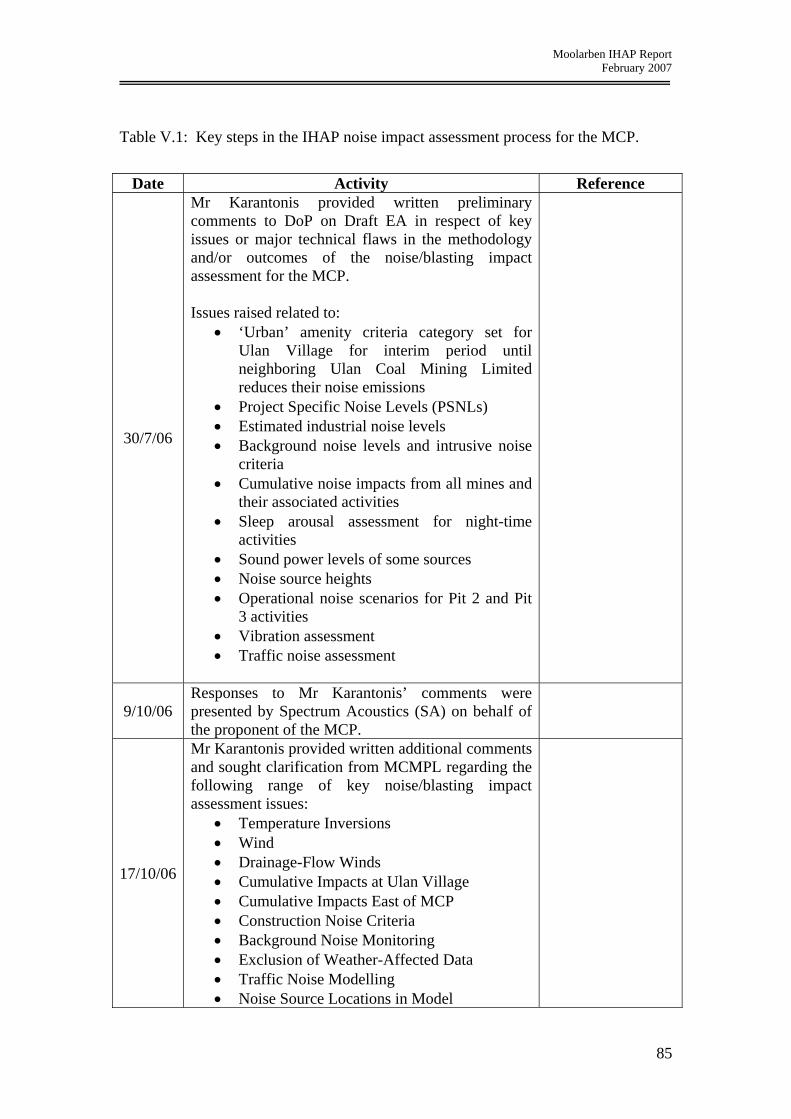
Moolarben IHAP Report February 2007
Table V.1: Key steps in the IHAP noise impact assessment process for the MCP.
Date Activity Reference
30/7/06
Mr Karantonis provided written preliminary comments to DoP on Draft EA in respect of key issues or major technical flaws in the methodology and/or outcomes of the noise/blasting impact assessment for the MCP. Issues raised related to:
• ‘Urban’ amenity criteria category set for Ulan Village for interim period until neighboring Ulan Coal Mining Limited reduces their noise emissions
• Project Specific Noise Levels (PSNLs) • Estimated industrial noise levels • Background noise levels and intrusive noise
criteria • Cumulative noise impacts from all mines and
their associated activities • Sleep arousal assessment for night-time
activities • Sound power levels of some sources • Noise source heights • Operational noise scenarios for Pit 2 and Pit
3 activities • Vibration assessment • Traffic noise assessment
9/10/06 Responses to Mr Karantonis’ comments were presented by Spectrum Acoustics (SA) on behalf of the proponent of the MCP.
17/10/06
Mr Karantonis provided written additional comments and sought clarification from MCMPL regarding the following range of key noise/blasting impact assessment issues:
• Temperature Inversions • Wind • Drainage-Flow Winds • Cumulative Impacts at Ulan Village • Cumulative Impacts East of MCP • Construction Noise Criteria • Background Noise Monitoring • Exclusion of Weather-Affected Data • Traffic Noise Modelling • Noise Source Locations in Model
85

Moolarben IHAP Report February 2007
Date Activity Reference • Underground Mining • Equipment Fleet • Modifying Factor Corrections • Project Specific Noise Levels (Noise
Criteria) • Errors when Comparing Noise Monitoring
Results in Different Locations
26/10/06 Mr Karantonis was provided, by SA, written responses to the additional comments submitted by Mr Karantonis on 17/10/06.
3/11/06 Mr Karantonis raised a number of further questions and sought clarification on the responses provided by SA.
6/11/06 Mr Karantonis was provided, by SA, with a second set of responses to his queries.
6/11/06
Mr Karantonis conducted a night-time site inspection of Ulan Village and some areas affected by existing noise and potentially by additional noise from the MCP.
7/11/06 –
9/11/06
IHAP hearings – a range of noise and blasting related issues were discussed and investigated.
8/11/06 IHAP was presented a letter prepared by SA addressing noise criteria issues raised by DEC in their submission.
15/11/06 Mr Karantonis prepared written comments identifying residual noise and blasting issues from the IHAP hearing.
8/12/06
Preferred Project Report produced. This contained an additional report prepared by SA relating to impacts of noise and blasting. It also included additional noise monitoring and modelling results, and further refinements to the proposed noise control and management measures.
Preferred Project Report - Appendix A11 - Noise and
Blasting Response Doc No: 04098-
1629
Compendium of Responses –
Response No. 4 - Doc No: 04098-
1629
18/12/06 Response received to residual issues raised by
Mr Karantonis on 15/11/06.
86