report of the fourth havana urban design charrette - … · report of the fourth havana urban...
TRANSCRIPT

Report of theFourth Havana Urban Design Charrette
Conducted22nd to the 27th of March, 2010
Cuban and Norwegian Chapters:CEU: Council for European UrbanismINTBAU: International Network for Traditional Building and Urbanism


Report of the Fourth Havana Urban Design Charrette22nd to the 27th of March, 2010
Charrette Organizers: CEU: Council for European Urbanism INTBAU: International Network for Traditional Building and UrbanismCharrette Partner: The Academy of Urbanism (UK and Ireland)
Julio César Pérez HernándezAudun EnghJohn Pilling (Report Editor)Jana Milosovicova
Report Date: March 20, 2011
Table of ContentsSummary 1Introduction 2Study Areas 4Process 8Content of Briefings 10Recommendations 18Conclusions 36Social Events 37Notes 39
Photo by Jeffrey Heller

Charrette Participants
Peter BairdGiséle BoneNigel Bowen-MorrisMichael CovarrubasAliexis de la CruzTiziana DestinoSilvina DonnalaCarolyn DwyerAudun EnghJoel EstevezSergio Ferro CisnerosYanie Garcia PoloHéctor Gómez AdánAlix Gonzales AstencioPetra HavelskaJeffrey HellerEthan LacyNaomi LaneEsteban Martinez HernándezJana MilosovicovaOriam Morales AvilésCarmen Perez de los RiosJulio César Pérez HernándezJohn PillingMarien RiosGina Rey RodriquesMonica SantosMónica Soffi DiazJuan Carlos ToledoStepehn Waite
Tour ParticipantsSteve MouzonElisabeth Steira
Special Thanks
Mr. Jan Tore Holvik, Ambassador and Lisa Reeve Stearns, Norwegian EmbassyChargé D’Affairs Caitlin Jones and Stephen BradshawEnglish Embassy Jenny White, Secretary of Science and Culture from The British Council, Marco Giomini, Cultural Advisor of the Italian Embassy Office of the Historian of Old Havana Union of Artists and Writers in CubaUnion of Engineers and Architects of Construction in CubaThe Faculty of Architecture, CUJAEProfessor Mario CoyulaProfessor Orestes del CastilloProfessor José Enruique FornesProfessor Angela Rojas
Report of the Fourth Havana Urban Design CharretteCharrette Organizers: CEU: Council for European Urbanism INTBAU: International Network for Traditional Building and UrbanismCharrette Partner: The Academy of Urbanism (UK and Ireland)
Report Date: March 20, 2011

The Cuban and Scandinavian chapters of INTBAU and CEU, in partnership with the Academy of Urbanism (UK), conducted the fourth International Havana Urban Design Charrette from the 22nd to the 27th of March, 2010. This charrette focused on the area of East Havana lying between the Morro Castle and the fishing village of Cojimar about six kilometers to the east. All four charettes have built on the principles and proposals of “The Masterplan for XXI Century Havana” authored by Cuban Architect Julio César Pérez Henandez and his team of Cuban architects. The charrette process consisted of on-site studies, including interviews with residents of Ciudad Camilo Cienfuegos; briefings by Cuban and International experts; design studies; and four sets of design recommendations. A transit workshop at the beginning of the charrette concluded with a proposal for a light rail line extending around Havana Harbour and crossing under the Harbour entrance between Habana del Este and La Habana Vieja. The transit proposal was used in the recomendations for each study area.
Alturas de Casa Blanca is proposed as a set of low density residential neighborhoods with an arrangement of blocks and buildings which maintain a relationship with the surrounding points of interest - landmarks such as El Morro and La Cabaña, the national meterological station, and the officer’s housing district. Recomendations for Ciudad Camilo Cienfuegos called for- Creating a ‘monumental interchange’
gateway;- Breaking up the superblock with a
logical layout grid;- A general development parameter
of four storeys for new buildings with potential for five storeys on corner plots or where buildings terminate;
- A tranquil and natural environment (Green Network)
- A new seafront generator; and A great/living community.
The Habanamar proposal envisioned Cojímar, Habanamar, and Ciudad Camilo Cienfuegos being linked by a major boulevard which parallels the Via Monumental. The grid of blocks in Habanamar will align with the axis of the spine boulevard. The proposal calls for a 20 meter green buffer zone along the coastline and a marketplace and plaza between the Estadio Panamericano and the spine boulevard.
Cojímar was a beach destination in recent history before the Cojímar river became polluted. Proposed remediation and sanitation improvements would result in a cleaner river and harbour for Cojímar so it can build on its existing importance as a leisure destination and fishing village heritage assocated with Ernest Hemingway. The historic center should be restored using recognized preservation guidelines. UK urban designer Peter Baird describes the results of the 2010 Havana Urban Design Charrette: “For the continued development of the Havana XXI Century masterplan, the charette provides a regular injection of new perspectives and new opinions on the future of the city, which can be challenged and discussed further once the charette is over. As Julio Cesar says, it is a work of love, but one that will hopefully one day have a positive bearing on the future of an already complex and beautiful city.”1
PROPOSAL
Proposal for Ciudad Camilo Cienfuegos
Summary

2010 Havana Urban Design Charrette
2 - Cuban and Norwegian Chapters: C.E.U • INTBAU
The 2010 International Havana Urban Design Charrette was the fourth, annual event devoted to proposals for the regeneration and development of Havana Harbour, its waterfront, and surrounding communities. The charrette attracted more than 35 professionals and students interested in the future of Havana’s urban design. These experts; from Argentina, Canada, Cuba, Germany, Greece, Italy, Norway, Slovakia, Spain, the United Kingdom, and the United States; built on the work from the 2007, 2008 and 2009 charrettes. The results of work from previous years are proposals for the regeneration and development of Havana Harbour, its waterfront in Old Havana, and the marine communities of Atares, Regla, and Casablanca. Cuban Architect Julio César Pérez Hernández and Norwegian legal advisor Audun Engh came up with the idea of the Charrettes while attending several European urban design conferences together in 2005 and 2006. Originally, the events were sponsored by the Cuban and Norwegian Chapters of the Council for European Urbanism (CEU). As the process has evolved, the Cuban and Scandinavian Chapters of the International Network for Traditional Building and Urbanism (INTBAU) co-sponsored the work, and the Academy of Urbanism became a partner. Peter Baird, one of the members of the 2010 team summarized the reasons for his participation in this event and a previous one. “Some cities in the world, through the combination of culture climate, art and architecture, evoke strong feelings of passion in all who visit. One such city is Havana, Cuba - “Key to the New World and Rampart of the West Indies”. The opportunity, therefore, to immerse yourself in such a great city through an urban design charette is an exciting prospect and a challenge I undertook twice as part of the Masterplan for XXI Century Havana charette.” All four charettes have built on the principles and proposals of The Masterplan for XXI Century Havana” authored by Cuban Architect Julio César Pérez Henandez with the help of his team of Cuban architects.
The principles of the Masterplan are summarized in “A Vision for the XXI Century” portion of the document. “The Plan is based upon some key concepts, listed here below and further developed in detail:1. Waterfront Revitalization - A
waterfront defines a city2. Reinforcement of the Polycentric
Structure. We assess the importance of centers for urban life
3. New Public Transport System. People need to rely on a public transportation system, rather than cars.
4. Infrastructure Upgrading. Infrastructure needs to be upgraded according to modern technology
5. New Urban Image. The city needs a new image that speaks for its regeneration and vitality
6. Increase of Public Space. Life is vibrant on streets, squares, and parks and allows for human exchange
7. Mixed Use. New neighborhoods share different uses as the model provided by the traditional city.
8. Social and Cultural integration. People should be able to freely work, relax, enjoy, and interact.
9. Revitalization of the ‘Calzadas’ and thoroughfares. Commercial axes attract people.
10. Increase of green areas. It is an environmental must.”
Introduction
The masterplan, according to architect Perez Hernandez “proposes a respectful attitude to new interventions in historical contexts, and values the creation of places where human beings can live, work and enjoy: a contemporary city that respects and values tradition, order and urbanity, and honors the culture of cities.” 2 The focus of the 2007, 2008, and 2009 Charettes was Havana Harbour and the communities comprising its waterfront. The 2010 Charrette changed the study area to the portion of East Havana lying between the Morro Castle and the fishing village of Cojimar about six kilometers to the east of the Morro Castle.
2010 Charrete Subject: East Havana Architect Perez Hernandez explains the reason for expanding the areas of urban design studies beyond Havana Harbour to East Havana. “The East Havana Waterfront Sector is one of the most relevant in the Waterfront Redevelopment Concept of the Master Plan for 21st Century Havana. Its proximity to the harbor and vacant land makes it very appealing for potential future development. Since its very foundation Havana’s expansion was restricted to the East, so it sprawled westwards along four centuries, and even further based on the car along the XX Century. Once the distances became unfeasible, the territory beyond Old Havana to the East was very much appreciated for new development, although it could not be developed until
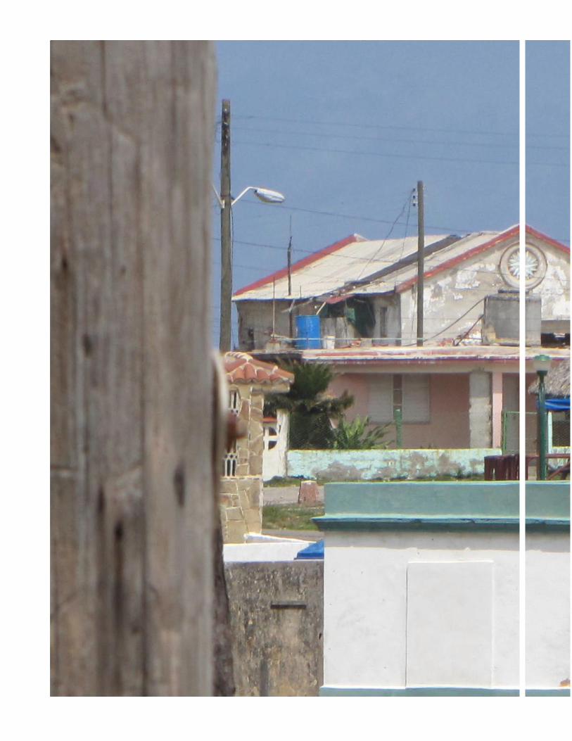
Photo by Audun Engh

March 20, 2011 - 3
1958 after the Tunnel of Havana, executed by the French Societé de Grands Travaux de Marseille, was finished. The tunnel and a new highway - Vía Monumental - contributed to increase the value of the land, and soon several urban projects were done for the now available area, including Sert’s new Presidential Palace across the bay and one by Italian architect from Milan, Franco Albini. The US firm Skidmore, Owen and Merril were also involved in the projects that were thought to create a paradise for casinos and hotels at the time when Las Vegas didn’t even exist. After the 1959 Revolution, Albini’s project turned into a new and smaller social housing complex, East Havana Neighborhood Unit Camilo Cienfuegos district according to the then current urban trends, finished in 1963. Although a high architectural quality was achieved, it lacked connectivity with the rest of the areas like Cojímar, a small fishermen’s town where writer Ernest Hemingway used to have his boat. In the 1970s a
massive precast construction project flooded Alamar, another district after the Cojímar River, and in 1991 a new urban development was added with the construction of several sports facilities and the Villa Panamericana for the celebration of the Pan American Sport Games, the former being examples of bad architecture, and the latter a failed attempt to recreate the traditional city with a central street and blocks filled in with kitsch post-modern style buildings. Via Monumental physically links East Havana with the north part of Casablanca and provides access to the historical Colonial fortresses that were also included in the 1982 UNESCO World Heritage declaration of Old Havana, and with the towns of Guanabacoa and Regla, while extending beyond to reach East Havana Beaches like Santa María del Mar, Boca Ciega, Guanabo and Jibacoa.
For the Master Plan purpose - and also for the charrette’s- the sector is defined by the presence of the Morro Castle fortress and the town of Cojímar. The character of this sector is quite different from the harbor in terms of urban landscape, environmental conditions, urban and architectural typologies, heritage presence, urban design and architecture. The challenges are many and huge, but the most important one will be the integration of this territory as proposed in the Master Plan following its guidelines and design codes - urban, landscape and architectural - so that the whole waterfront is developed according to both its vocation and its potential to give Havana a new facade related to the sea, that orients new urban development to the sea and creates an urban realm according and a sustainable environment. The challenge will consist in the integration of this area to the rest of Havana in both physical and cultural terms, so that it gives continuity to the tradition of excellence of Havana’s urbanism and architecture.” 3
High density
Medium density
Low density
Key
TrainMetro
Stations
Existing centers
New centers
The Master Plan for Havana: Sustainable Urbanism
----
MAIN CONCEPTS and STRATEGIES• Waterfront Revitalization.• Polycentric Structure• New Public Transport System• Infrastructure Upgrading• New Urban Image• Increase of Public Space• Mixed Use/Infill development• Social & Cultural integration• Revitalization of “ ��������”• Increase of Green Space

2010 Havana Urban Design Charrette
4 - Cuban and Norwegian Chapters: C.E.U • INTBAU
Study Areas
Alturas de Casablanca Casablanca, the maritime and military village across entrance channel to Havana Harbour from La Habana Vieja has been studied in each of the four urban design charrettes. The study area for the 2010 charrette is called by the report editor ‘Alturas de Casablanca.’ It consists of the open land at the ridge extending from El Morro de La Habana at the west to the Naval Hospital on the east. Its northern limit is the Via Monumental. Casablanca’s existing urban development is its southern limit.

March 20, 2011 - 5
Unidad No. 1, Habana del Este (Ciudad Camilo Cienfuegos)
In the introduction to an essay entitled “Mirar a los 60. Antología cultural de una década” Eduardo Luis Rodriguez says “All triumphant revolutions have an ‘heroic’ period. In that [period] the new government needs to demonstrate its superiority over the preceding one, and make it in forms of grandeloquent and epic gestures, accompanied by an optimism many times made outside the scale of the realities of the country and of an inexperience that is tried to be replaced with the vehemence of the expositions.” Ciudad Camilo Cienfuegos is the result of the plans of this heroic period. With the direction of Pastorita Núñez and under the auspices of the National Institute of Savings and Housing, a team of designers including architects Mario González, Hugo Dacosta, Mercedes Álvarez, Reynaldo Estévez, Ana Vega and engineer Lenin Castro designed and oversaw construction of housing for 8,000 people from 1959 to 1961. As stated in “Two Faces of the Antillean Metropolis,” “Unit 1’s residential component reflects the leading design principles of the United State and Europe regarding site planning that departed from the existing city grid.”

2010 Havana Urban Design Charrette
6 - Cuban and Norwegian Chapters: C.E.U • INTBAU
Habanamar
Habanamar, as it is described in the Masterplan for XXI Century Havana, is the area of open land bounded by Habitación Camilio Cienfuegos the Villa Panamericana, the seacoast, and the Via Monumental. The major feature of this area is the Estadio Panamericano and its related facilities.
Photo by Carmen Perez de los Rios

March 20, 2011 - 7
Cojimar
Cuban architects Alix Gonzalez Astencia and Alexis De La Cruz Alvarez were members of a team who prepared a study and presentation entitled “Cojimar … pueblo del mar.” This description of the study area is drawn from the work of that team as well as an article by Jes´s Risquet Bueno entitled ‘El Sitio Urbano de Cojímar athttp://www.trabajadores.cu/secciones/cuba/cuba_por_dentro/el-sitio-urbano-de-cojimar/ The word ‘Cojímar’ means ‘entrance of water in a fertile land’ in the Arauco language. Its urban form and setting is tied to the fisherman’s way of life. It has a poplulation of about 20,400. The town consists of an historic district, the waterfront, some surrounding urbanization, and the Villa Panamericana. Cojímar’s beginnings are as part of the extension of the defences of La Habana. El Torreón de Cojímar remains today as part of these miliatry works recognized by UNESCO as a world heritage site. Cojímar is also well known as both the port of call of the Pilar, Ernest Hemingway’s sport fisherman, and the inspiration for his novel, ‘The Old Man and the Sea.’ A plaza with a pavilion and bust of Hemingway is close by the remains of the dock at which he moored his yacht. Las Terrazas restaurant, where Heminway dined, remains an important tourist destination. The current condition of Cojímar’s buidlings and infrastructure is described by authorities as normal to bad. The distance between the transit stops on the Via Monumental and the historic center leaves its poplulation isolated from many of Havana’s employment opportunities. Cojímar has a history of being a leisure destination as well as a fishing village. That history may represent opportunities for the community in the future.
Photo by Jeffrey Heller

2010 Havana Urban Design Charrette
8 - Cuban and Norwegian Chapters: C.E.U • INTBAU
Process On Monday, March 22, 2010, International members of charrette gathered in La Habana Vieja at Hostal Conde de Villanueva for a design orientation that included a visit to the Maqueta to La Habana Vieja and a talk by Cuban archtiect Orestes del Castillo as well as a morning tour of Habana del Este lead by Cuban architect Julio César Pérez Hernández. After the visit to the Maquetta, the group traveled by van through the tunel under the Harbor to visit the Cristo De La Habana above Casablanca. From the Cristo the group went past the Naval Hospital into Ciudad Camilo Cienfuegos (1959-1961) and the Playa del Chivo. The continued down the Via Monumental to stop at the Estadio Panamericano (1991) and then go on the Villa Panamercana (1991). From there they went to the historic center of Cojimar. After lunch at the La Terazza de Cojímar, the restaurant at which Hemingway dined often. After lunch, the internation group returned to the Hostal Conde de Villanueva for background briefings and organizing into teams with their Cuban colleagues. The entire group decided on four study areas, amd the Cuban and International participants chose their place of interest. The breakdown of study areas and participants were as follows:
Ciudad Camilo CienfuegosPeter BairdJoel EstevezCarolyn Dwyer Petra Havelska Yanei García PoloJuan Carlos Toledo
HabanamarOriam Morales AvilésTiziana Destino Silvina Donnola Ethan LacyNaomi LaneMonica Santos
Alturas de CasablancaGisèle BoneNigel Bowen-MorrisEsteban Martínez HernándezCarmen Pérez de los Ríos Marien Rios
CojímarAlexis de la CruzHéctor Gómez AdánAlix Gonzales AstencioMónica Soffi DíazStephen Waite
Audun Engh, Julio César Pérez Hernández, John Pilling, and Jana Milovokova acted as coordinators for the teams. Jeffrey Heller and Michael Covarrubias acted as guest critics

March 20, 2011 - 9
On Tuesday, March 23, 2010, U.S. architect Jeffrey Heller conducted a transit alignment workshop with all of the teams. The agreed alignment resulting from that workshop was used in the investigations of each study area. Following the workshop, each of the teams met and began their preliminary investigations. The work continued for all of Wednesday, March 24, 2010 as well. On Thursday, March 25, 2010, each of the teams presented their preliminary presentations to Jeffrey Heller and Michael Covarrubias. The teams incorporated Messrs Heller and Covarurubias’s remarks into their final investigations, which continued for the rest of Thursday and the entire day of Friday, March 26, 2010. On Saturday, March 27, 2010, each of the teams made their final presentation to Cuban and International guests.

2010 Havana Urban Design Charrette
10 - Cuban and Norwegian Chapters: C.E.U • INTBAU
Julio César Pérez Hernández - A Masterplan for the Future of Havana Julio César Pérez Hernández’s presentation of excepts from the Masterplan document recounted the history of urban design and development of Havana. Many of the topics of his remarks are included in the introduction to this report.
John H. Pilling AIA - Recap of the Havana Urban Design Charrettes The material presented by John Pilling may be found in the reports from each of the charrettes at their websites:
http://johnpilling.net/Havana_Harbour_Charrettehttp://johnpilling.net/2008_havana_harbour_charrettehttp://johnpilling.net/2009-havana-harbour-charrette
Content of Briefings
Alexey Martin - “A Brief Outline of Urban Planning Principles in Cuba.”4 Historical antecedents to present day Havana date back to prehistory and history in the West, East, and the Americas. In Mesopotamia, the cradle of western civilization, the cities of Ur and Uruk are examples of regulated urban form. The Code of Hamurabi, 1750 BCE, inlcudes the first written ordinance on urban building and form. The city of Solon, 594 BCE, established limits of private property. The Ordinances of Hippodamo are significant, because they proposed the concept of the grid. Rhodes and Alexandria follow Hippodamo. In 450 BCE, Rome’s law of 12 tables addressed urban issues, and both Julius Caesar and Caesar Agustus enacted laws regulating building. In India the Manas-Ara Treatise, which established 8 models for urban structure for creating cities, transforming topography into defensive systems, as well as building palaces and temples dates back to the 19th and 20 centuries BCE. In China, Kao Kung Chi’s pholosphical principles, based on Confucius, guided agrarian and urban territories which are based on precise quadrilateras known as ‘mow,’ taking as a point of reference public land. Imperial China also records the first enforcement of the building regulations it established. In Precolumbian America we find many cities of great sophistication. On the Yucatan, Tulum and Chichen Itza, 433 and 453 BCE respectively. Teotihuacan, dating from the sixth century BCE, in the Basin of Mexico presents the definitive urban structure, with all buildings perpendicular and parrallel to each other and the principal avenue of the metropolis. Tenochitlan, the city of the Aztecs had a ceremonial center and distinct ‘calpuli’ or neighborhoods. We cannot know the exact structure of Inca Cuzco, because it was destroyed by the Spaniards, but Machu Pichu, discovered in 1911, was not molested. From the sixth to fifteenth centuries urban laws were presented in the creation of feudal castles and cities. The Stautory Law authorized greater powers to the cities. Cities grew up on and took form from their Roman predecessors with their central plaza with the Church as well as subsidiary one. Numerous cities were founded in the twelfth and thirteen centuries, such as Leon and Najera.
Havana for all: an aspiration for the civic
Illustration from the presentation
Title slide from the presentation

March 20, 2011 - 11
The Renaissance brought the concept of the ‘Ideal City” inspired by Roman grids. This concept of the Ideal City found itself explored in the development of Colonial Hispanoamerica. The “Leyes de Indias” originated in 1523, revised in 1573, and edited again in 1647 established the requirements for hundreds of cities in colonial Latin Amierica. These ordinances contain details on minimum requirements for creating a city, required grids and plazas, and the alignment and sections of streets. Santo Domingo, for example, was created based on the geometric concepts in 1496. Of similar importance were the Municipal Ordinances of each of the colonial cities. These ordinances complimented the basic law. The ordinances went into more details about administration, sanitation, and urban order. One of the first was dictated by Cortes in 1527. The Municipal Ordinances of Alonzo de Caceres were presented to the mayor of Havana on the 15th of January 1574. These were the first created in Cuba for Cuba. They are considered a true technical monument of the epoch, being one of the most complete for any settlement in the Americas. Afterward there were successive regulations such as those from 1855 and 1859. Special attention is paid to the Ordinances of 1861, which constituted Havana as an urban district within the country. From its administration came the creation of El Vedado, the most complete and beautiful urban district in Cuba. The Republican period created the roots of good technical implmentation of already agreed ideas. in 1925 the Law of Public Works codified the thoughts of the Plan for improving, Embellishing, and Expanding the City of Havana. Subsequent laws in 1930 built on the 1925 work, but little was done during the economic crisis of the 1930’s. In 1940 Article 215 created the Municipal Commission of Urbanization and Article 230 created the Metropolitan District of Havana. These two ordiances retained their implact until 1976 and the promolgation of the Law of the Political - Administrative Division. Without a doubt the decade of the 50s was a time of high-rise and disorganized urban development resulting from several pieces of legislation, notably legislation about renting urban villas and the Law of Horizontal Property. After 1959 the most signifcant actions were: - The Laws of Blighted Solares and of Urban Reform; - The 1960 Physical Plan; - The 1977 law of National Monuments and Places; - The 1978 Decreee Regulating Physical Planning; - The General Law of Dwellings of 1984; - The Civil Code of 1987 that regulated the forms of property,
the rights of lands, and the relations of neighbors; and - The General Law of Dwelling of 1988. In acutality, right now, our country now has great variety of laws with many contradicitons. As a result, there are many aspects of urban development that are not addressed in our urban ordinances. It’s for that reason that we need to revise our laws to resolve the contradictions and to normalize our urban development in a more coherent way that is more in keeping with the needs of our times.
JCN Forestier’s 1929 Plan for Havana
Park of Fraternity and Capitol gardens Paseo del Prado, 1929
The Pilot Plan for Havana, 1958. Town Planning Associates
The Revolution
Plan Director 1964
Plan Director 1971
Plan Director,1990
Tourism & hotels
New campuses
Prefab housing
Illustrations this page from ‘A Masterplan for the Future of Havana

2010 Havana Urban Design Charrette
12 - Cuban and Norwegian Chapters: C.E.U • INTBAU
Jeffrey Heller FAIA - Emeryville Marketplace and Guanzho, China 5
The Emeryville Marketplace is a LEED Platinum Certified Master Plan. According to LEED’s sponsor, the U.S. Green Building Council, “LEED is a third-party certification program and the nationally accepted benchmark [in the United States] for the design, construction and operation of high-performance green buildings. LEED gives building owners and operators the tools they need to have an immediate and measurable impact on their buildings’ performance. LEED promotes a whole-building approach to sustainability by recognizing performance in five key areas of human and environmental health: sustainable site development, water savings, energy efficiency, materials selection and indoor environmental quality.” Emeryville Marketplace is a 15 acre site in Emeryville, California, a city in the Bay Area located between Oakland and Berkely TMG partners, a full-service real estate development company in San Francisco was appointed by the City of Emeryville as project manager for the Emeryville Marketplace project. TMB retained Heller Manus to develop a master plan for a site in the City of Emeryville in the Bay Area. The Emeryville Marketplace is about ten minutes from downtown San Francisco by way of BART or the Bay Bridge. The Sacramento San Francisco highway and a major rail line bisect the area. The region’s Amtrak terminal, the 10th busiest station in the United States, lies at the center of the site. The project area is a “brownfield” site, that is, a contaminated site capped in accordance with environmental regulations. It was built out originally in the 1980’s as an auto-dominated superblock, whose suburban patterns and site conditions inhibit additional development. The existing conditions, including existing buildings offering free surface parking provide no incentive to abandon cars. Most users drive to the site even with AMTRAK and a free BART shuttle. The resulting heavy traffic adds to freeway and surface congestion.
Emeryville Marketplace Redevelopment
4 years collaboration creates a sustainable LEED Platinum community:
• People-friendly, transit-oriented neighborhood
• Affordable homes
• Shops and services
• Open space, walkways & gathering places
Heller Manus proposed a masterplan that replaces cars with places for people, transforming the superblock into a neighborhood. From the beginning the plan promoted sustainability and LEED certification. The plan calls for a transit oriented, high density, mixed used neighborhood. It proposes a transportation management plan that slowly rebalances car and transit incentives. The number of parking spaces are reduced, switched from free to paid, and moved into structures. Discounts are offered for using transit. The USGBC’s LEED certification program has a checklist for Neighborhood Development. The Emeryville project rated highly with this program. The masterplan proposal, a dense, mixed-use development with walkable streets and affordable housing complements the base qualities of the site area itself. Besides physical planning, the plan calls for sustainable operations such as car sharing, bike use, composting, recycling, on-site fuel generation, and low-water landscaping. The Emeryville Marketplace is one of 205 LEED Neighborhood Development projects registered in 39 states and the District of Columbia.Heller Manus created the master plan with the consultation of Simon & Associates, Inc., Green Building Consultants.
Dense Infill Urban Design (21 points)
• Pedestrian places dominate land at ground
• Buildings replace surface parking
• Density sufficient to support transit and services
Illustrations from the presentation

March 20, 2011 - 13
Heller Manus developed a Master Plan for the City of Guangzhou, China’s third lagest city. The plan for accessible, livable, and sustainable urban planning and urban design is based on four principles: - Reconnect to Nature; - People over Cars; - Heat Island with Trees and Landscape;
and - Sustainabiltiy via Transit - Energy
- Water.
The plan is divided into a North and South Axis, using the river and the TV tower as the dividing point. The North Axis begins with the Yanling Park, proposed as a natural reserve system. The plan proposes a footbridge over a major transit spine to link the park with the city. Along side that spine is the existing plaza and boulevard in front of the train station. The plan proposes a sizeable green roof and set of pedestrian bridges to mitigate current heat island effects and unfriendly pedestrian environment. The pedestrian and green orientation continues through the existing sports center. Since the streets are really car oriented, the plan calls for separating pedestrians at the main plaza, putting bus and rapid transit directly under the street to act as a convenient magnet. The Liu Yun neighborhood is a unique existing environment with a distinctive flavor. The plan proposes revitalizing it to become a pedestrian connector from the Plaza and the river. The South axis, across the river, begins with the TV tower and ajacent area of tourism. It’s a very large district, being more than more than 14 Km long and 22 square km in area, comparable to lower Manhattan or Central DC. It’s surrounded by the branches of the Pearl River. Overall, the plan calls for a dense urban development surrounding the ecological park, which creates a visual connection through the new city. It proposes 6 transit lines and 10 stations that would be within five minutes’ walking distance to 72% of the land area. Also, existing villages that have become urban centers, were done in a very free-wheeling way. The results are ‘crazy.’ and they need to be changed. The plan calls for a policy to demolish buildings and districts to allow for better quality residential environments.
Illustrations from the presentation

2010 Havana Urban Design Charrette
14 - Cuban and Norwegian Chapters: C.E.U • INTBAU
Petra Havelska - “In between” Havana 6
Examples of the kinds of spaces in Havana that have potential to be transformed through projects that take ownership of ‘in between’ urban spaces include the courtyard of the power station worker’s housing, plazas in Casablanca, and derelict harborfront structures. An example of a space that has already been transformed is the Callejon de Hamel. Another is the Malecon, which transforms itself by its cycle of use from day to night and week to month. The 2009 Havana Urban Design Charrette studied the railroad viaduct along the harborfront of Ensenada Atares. Ms Havelska proposed its transformation into a public space as part of the work of her charrette team. A concrete example of this kind of proposal is ‘auditorium S2, in Zilnia Slovakia, by Marek Adamov. The building is made of surplus materials, primarily beer crates and staw bales with scrap wood flooring. It occupies a space under a highway flyover, and it continues to be used as a performance space. The Jugaad Pavilion in India, by Sanijeev Shankar is made from surplus vegetable oil tins that have been washed and then tied together with rope to form a canopy providing day time shade and a lighted outdoor space at night. The Southwark Lido, in London, by Exyzt & Solidspace transformed a brownfield lot alongside a railroad viaduct into a positive open space for a tight urban area. It has a children’s play space with wading pool, small shelters for squatters, and a decked meeting area. The Nomadic Museum in New York City, by Shigeru Ban transformed a derelict pier into a major exhibition space by using cargo containers, sonotubes, canvas and pipe framing. In another proposal for interventions Ms. Havelska as part of FoRM associates with Igor Marko proposed applying ideas currently explored in the High Line in Manhattan to an iron bridge in Bratislava. Illustrations from the presentation

March 20, 2011 - 15
Steve Mouzon AIA • CNU • LEED - The Original Green 7
Ten top problems today for the built environment:
1. The absence of plain spoken sustainability. 2. The dangers of ‘wishes.’ Carbon targets are only wishes
- for someone else. We need to make our own targets. 3. The dilemma of global warming. The environment has
become a political issue now. We need total partipation. 4. The fate of ‘Ought-to.’ Do you mainly do what your ought
to do, or what you want to do. ‘Sustainability’ is framed as ought to. Better to go with want to do.
5. Growth. There are different kinds of growth, physical and metaphysical (spiritual). Cities need to grow ‘better,’ as opposed to just ‘more.’
6. Consumption. Many describe our culture as ‘consumer.’ The end result of consumption is no resources and a lot of garbage. We need a conservative economy instead of a consuming one.
7. The achilles heel of architecture. Starchitecture leads to more and more strange buildings. We need to design more ‘lovably.’ 8. The fuzzy carbon focus. Our urban infrastructure makes LEED Platinum just crazy. We can’t just focus on the carbon footprint of individual builidngs.
9. The supply side focus. Driving keeps on growing, to a difficult end.
10. The 2.6 billion people problem. The current impact by the US poplulation could multiply times nine in the future.
So what do we do? We can think about the six realms of green; the transect. The concept of the transect is from 100 years ago. It classifies the human environment into different landscapes: natural, rural, suburban, general urban, urban centers, urban cores, and special districts. Each of these environments needs to be sustainable. The wisdom of sustainability needs to be shared with everyone. It should be done with public education. Nature invents beauty, and architecture can capture it. Embed the wisdom of sustainabitliy into architectural beauty and involve everone to make the results happen. What is ‘Original Green?’ Workman, tool, and product are the means of sustainability. The tool is the living tradition. The product, the artifacts, are that which is built. First we must build sustainable places. Then we can build sustainable buildings. Sustainable places are nourishable, accessible, serviceable, and securabe. Sustainable buildings are lovable, durable, flexible, and frugal. Much more information about Original Green can be found at http://www.originalgreen.org
T2
T3
T4
T5
T6
D R A W I N G B Y L E O N K R I E R
Illustrations from the presentation

2010 Havana Urban Design Charrette
16 - Cuban and Norwegian Chapters: C.E.U • INTBAU
Yunior Carmona Pino - Landscape Project for Mounumental Motorway 8
The Via Monumental (Monumental motorway) is Havana‘s eastern land access. National and local authorities asked the Grupo para el Desarrollo Integral de la Capital (GDIC), to collaborate with University of Havana Faculty of Geography and the CUJAE Faculty of Architecture to make recommendations for improving its functional and visual qualities. The study area extends from the mouth of the tunnel up to the intersection with Via Blanca highway, covering a total lenth of 6,7 km.. The motorway has two roadways 11,10 m. wide, with a 7,00 m. central divider, rigid pavement and concrete edges both sides. Cross-section has three lanes 3,70 m each one. At present there are problems concerning - Pedestrian movement; - Roadside structures used for light meals and other public
services; and - Unitended plant material overwhelming original landscape
design, for the road, its frontage, and important nodes.Study Goals - To increase functional, environmental and visual qualities; - To identify and analyse present problems; - To set up general and specific landscape and urban design
guidelines; - To work out short and long term landscape, urban design and
roadside structure design projects. These goals are set with the undertanding that landscape projects for contemporary urban and sub-urban motorways must, in the first place, fulfill driver’s safety, a good integration between the road and its environment, and passengers’ visual pleasure.Past History Studies for crossing the bay entrance channel to get access to the land and beaches east of Havana started at the beginning of the XXth century. There was a bridge proposal dating from 1910, but nothing was done because of financial and technical problems. In 1949 the subject was again considered resulting in the construction of a tunnel under the bay entrance channel. Work was assigned to French enterprise Societé des Grands Travaux de Marseille; the tunnel was opened in march 1958; official opening took place on may 31est 1958. The Monumental motorway was conceived as part of a peripherical ring around the city, so to obtain a fast connection with towns and villages in the eastern side such as as Cojímar and Guanabacoa. The intersection with Via Blanca highway, 6,7 km southeast, made possible a quick and direct access toward eastern beaches. This speculative program was fully integrated with the Master Plan for Havana’s growth worked out by José Luis Sert, Wiener and Schultz (1958). With the tunnel and highway, new territories towards east were opened to speculative market. These proposals underwent a radical change in January 1959, with the change in government resulting from the Triumph of the Revolution.Monumental Motorway Development After 1959
The speculative market projects were replaced with new types of dwelling complex in the empty lands of La Habana del Este. The cornerstone for them was dedicated by Fidel Castro on the early days of March 1959. This complex (now called Ciudad Camilo Cienfuegos) and others that followed were finished by the middle of the 60’s. Thirty years later, the Pan-American Games were held in Havana were held in 1991. For the occasion, a large sport complex was built near to Ciudad Camilo Cienfuegos on both sides of the Monumental motorway. The associated Pan-American Village (sportsmen housing) became a westward extension of Cojimar. The Pan-American Village was built according to traditional urban patterns. , A city park has been developed around the sport complex, the so called Pan-American Park. Properly speaking, the park exists, but really few people visit it. This way, by leaps and bounds, eastern territories alongside Monumental motorway, had been lengthy occupied. Detailed Analysis and Proposals

March 20, 2011 - 17
Main Problems Along the Length of the Motorway 1. Vehicular circulation: Mostly ok.. 2. Pedestrian movements: Mostly Not OK, there are no
sidewalks. 3. Public transportation: The bus stops are poorly located and
infrequent. 4. Street furniture: Mostly ok. 5. Green areas. Coccoloba uvifera (tree), and Nerium oleander (shrub) have
been planted on central divider. The Southern strip next to military installation is partially masked with C. uvifera groves. Northern strip is against seaside panorama; there are scattered C. uvifera groves and other trees and shrubs that hide the seascape.
6. Other problems. Devices on southern strip have structural problems and poor
landscape solutions. Also graphic design lacks could be improved.
Specific Analysis and Proposal - Camilo Cienfuegos City / Naval Hospital AxisGeneral: This is one of most problematic nodes; pedestrian movement in all directions, roadside food kiosks, vehicular movements, public transportation and bus stopping places. 1. Vehicular circulation There are auxiliary streets coming in and out on the hospital
side of the motorway, but none on the Camilo Cienfuegos side. The auxiliary streets are mostly used for public transportation. Vehicular movements are very strong and continuous.
2. Pedestrian circulation This is major problem, especially crossing point over
Monumental motorway. The pedestrian bridge is too high (5,00 m). As a result people jump over protection fence, accidents are frequent.
3. Transportation. The bus stops are poorly located. Other: - minimal or non-existent local bus transportation - Bus stops for service heading to Havana are directly on the
motorway 4. Street Furniture. - Most food kiosks aren’t well designed and lack sanitary
facilities. - The median fence is in bad repair. - Waste baskets and similar devices are not enough nor
properly located. - No Public lighting on the northern side of the motorway. 5. Green areas - The environment is generally perceived as highly
degraded. - Lawns are highly damaged, because of intense pedestrian
movements in all directions, soils become eroded and compacted.
- Tree density is also very high, both sides, particularly northern side; there are security and social problems.
Proposed Guidelines for Landscape and Urban Design
Landscape goals: - Raise and strengthen transportation safety. - Mitigate and temper environmental impact, looking for best fit
between road and landscape. - Provide motorist and passengers a pleasant visual recreation
while traveling. Landscape Guidelines: Screen undesirable sights, complete masking of outdoor enclosure, reorganize groves, improve graphic design and supporting structures, improve planting solution on central divider, apply appropriate pruning wherever needed. Node 2: Urban design project. - Build an underground pedestrian broad passage, with appropriate environmental and climatic conditions, in order to solve definitively all problems concerning pedestrian circulation. -- Provide a new direct way out between the northern strip and the motorwayto improve vehicular circulation and bus stops. ConclusionsHabana del Este is of great importance for urban, recreational, landscape and touristic development of the city and the whole region. The opportunity presented by it cannot be neglected nor lost.
Tiziana Destino - Morphology and Typology
Tiziana Destino presented examples of using graphic recording, analysis, and tabulation of urban forms and architecture in plan, section, and elevation as a means for proposing urban design guidelines. The range of analysis goes from the urban in the landscape to the individual building.
Jana Milosvicova - Trams Havana
Jana Milosvicova described the positive impact of trams on urbanism by showing examples of how Tram service has encouraged density & vice versa. She included historic photographs of the demolition of Havana’s street railways in the 1950’s, and she concluded her presentation with an illustration of the charrette’s recommendations for new light rail service in Habana del Este and around Havana Harbour.

2010 Havana Urban Design Charrette
18 - Cuban and Norwegian Chapters: C.E.U • INTBAU
Recommendations
Alturas de Casa Blanca
After doing alternate design studies and conferring with the charrette coordinators, the team concluded that this set of neighborhoods needs to be low densitiy residential. The arrangement of blocks and buildings needs to maintain a relationship with the surrounding points of interest - landmarks such as El Morro and La Cabaña, the national meterological station, and the officer’s housing district.
The urban design sould create a polycentric “city within the city” that has vistas to the sea create panoramic vistas to the sea, the forts, and Havana itself. take care of the vistas and panoramas. It’s fine scale should be driven by the needs of the pedestrian. These activity centers will be spaced for a convenience of five minute’s walk
In general terms, connect Casablance to Centro Habana and La Habana Vieja with improved public transportation. Make La Playa del Chivo and the coastline a natural reserve for pedestrians. Create convenient crossing points along the Via Monumental to give residents of Casablanca convenient access to the reserve.
March 20, 2011 - 19
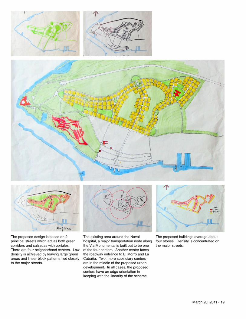
The proposed design is based on 2 principal streets which act as both green corridors and calzadas with portales. There are four neighborhood centers. Low density is achieved by leaving large green areas and linear block patterns tied closely to the major streets.
The existing area around the Naval hospital, a major transportation node along the Via Monumental is built out to be one of the four centers. Another center faces the roadway entrance to El Morro and La Cabaña. Two, more subsidiary centers are in the middle of the proposed urban development. In all cases, the proposed centers have an edge orientation in keeping with the linearity of the scheme.
The proposed buildings average about four stories. Density is concentrated on the major streets.

2010 Havana Urban Design Charrette
20 - Cuban and Norwegian Chapters: C.E.U • INTBAU
Ciudad Camilo Cienfuegos
“The majority of the buildings were built in the early 1960s to design ideals established by Team Ten and CIAM. Clear principles of landscape and open space were used in combination with provision for future personal motor vehicle use. The development comprises a mixture of block types and sizes ranging from four storeys to 11 storeys, incomprehensibly arranged and orientated, amongst amorphous parking courtyards and areas of open space. A commercial centre is provided, and several communal shelters on the streets for informal gathering. The area is identified as currently having a natural character to it, but the lack of relationship of the built form to the open space and lack of acknowledgement of pedestrian desire lines substantially limits the quality and value of this space.
British Urban Designer Peter Baird describes the conclusions of his team in these excerpts from his paper “Participating in the Key to the New World’s Future,” 9
His text is accompanied by illustrations assembled by the team and edited by Slovakian Architect Petra Havelska for the team’s final presentation to the Charrette
PROBLEMS TRANSPORTATION PROBLEMS TRANSPORTATION ACCESSIBILITY
PROBLEMS TRANSPORTATION ACCESSIBILITY SCALE OF INFRASTRUCTURE
PROBLEMS TRANSPORTATION ACCESSIBILITY SCALE OF INFRASTRUCTURE
HAVANA URBAN DESIGN CHARRETTE 2010_Camilo CienfuegosTEAM: Caroline, Peter, Juan Carlos, Petra, Yanei, Joel
PROBLEMS TRANSPORTATION ACCESSIBILITY SCALE OF INFRASTRUCTURE LANDSCAPING
PROBLEMS TRANSPORTATION ACCESSIBILITY SCALE OF INFRASTRUCTURE LANDSCAPING DESIRE LINES
Through site visits, use of maps, and interviews with local residents we identified the following issues:
1 Accessibility issues between the estate, central Havana and local facilities
2 Scale of infrastructure / road beyond what is required
3 Poor quality landscaping4 Paths and routes do not follow desire
lines5 Poor quality public realm6 Poor supply and range of facilities

March 20, 2011 - 21
PROBLEMS TRANSPORTATION ACCESSIBILITY SCALE OF INFRASTRUCTURE LANDSCAPING DESIRE LINES PUBLIC REALM
PROBLEMS TRANSPORTATION ACCESSIBILITY SCALE OF INFRASTRUCTURE LANDSCAPING DESIRE LINES PUBLIC REALM FACILITIES
PROBLEMS TRANSPORTATION ACCESSIBILITY SCALE OF INFRASTRUCTURE LANDSCAPING DESIRE LINES PUBLIC REALM FACILITIES
The positive aspects of the area we identified were:
1 The seaside location2 The cooling ocean breeze3 The natural surroundings of the
neighbourhood4 Strong sense of community felt by
residents5 The tranquil atmosphere, separate
from central Havana6 The availability of local gardening
plots to grow food for residents
BENEFITS SEASIDE LOCATION AND VIEWS BENEFITS SEASIDE LOCATION AND VIEWS CLIMATE / OCEAN BREEZE
BENEFITS SEASIDE LOCATION AND VIEWS CLIMATE / OCEAN BREEZE NATURAL HABITAT
BENEFITS SEASIDE LOCATION AND VIEWS CLIMATE / OCEAN BREEZE
STRONG NEIGHBOURHOOD NATURAL HABITAT
BENEFITS SEASIDE LOCATION AND VIEWS CLIMATE / OCEAN BREEZE
STRONG NEIGHBOURHOOD TRANQUILITY
NATURAL HABITAT
BENEFITS SEASIDE LOCATION AND VIEWS CLIMATE / OCEAN BREEZE
STRONG NEIGHBOURHOOD TRANQUILITY LOCAL GARDENING PLOTS
NATURAL HABITAT

2010 Havana Urban Design Charrette
22 - Cuban and Norwegian Chapters: C.E.U • INTBAU
ROBERTO, 45, driver
MANUEL, 44, waiter
My apartmentis the best!
I have to commute towork every day
IVAN, 32, builder There is no musicvenue in our area
Hi Iʼm IVANʼs mum, I used to live in the U.S.
Our hospital is oneof the best in Havana
Maria Eugenia, 48, shop assistant
TRES AMIGOS, livce in this block
We like the sea breeze and tranquility here CARLOS, 28, vet
Iʼm always outside and I know all my neighbors
EDILIA, 49, on disability benefits
There is no bakeryin Centro Commercial YOSEF, 32, translator of Persian
There is no swimming pool in our area
ONELIO, 56, sailor Our housesare well maintained
and big enough
KIDS FROM LOCAL SCHOOL
Illustrations from the presentation

March 20, 2011 - 23
Design Solutions to Achieve Principles Creating a ‘monumental interchange’ gateway - To enable the creation of an active centre and gateway in this location we proposed sinking the Via Monumental for a short stretch. This would allow the reprioritising of vehicle and pedestrian movement, slowing traffic which is on the same level as pedestrians whilst allowing for relocated bus stops in a new public plaza at ground level. This space would provide the opportunity for new buildings to capitalize on the activity generated by the node and transport interchange function. These new buildings would be designed to be capable of accommodating a range of uses with particular focus on encouraging retail, food and drinks and other commercial activities at ground floor level, replacing the informal vendors who have already identified this location as profitable. The design and orientation of these buildings would also need to create enclosure to the public space and across the local road bridge as seen in examples such as Edinburgh’s North Bridge, creating a crossing which seamlessly links the hospital, north Casablanca and Camilo Cienfuegos without change in level and with continuous street and public space treatment. A logical layout grid - In order to establish logical blocks with a clear front public aspect and private rear new blocks, new roads and clear pedestrian routes linking these blocks, were proposed within existing building arrangement. These new blocks need to be arranged to create appropriate street widths in a clear hierarchy, using 32m front to front as a maximum width for main boulevards, 28m for single boulevards, 22m for standard streets. Smaller pedestrian routes and mews type routes would be in a range between 16m and 20m.
GATEWAY
SPORT CENTRE / STADIUMNEW NEIGHBOURHOOD
CASABLANCAVIA MONUMENTAL
NEW MARINA WITH BREAKWATERSEAFRONT
GATEWAY GRID
Existing figure GroundNorth (seaside) faces down in all diagrams.
Illustrations from the presentation

2010 Havana Urban Design Charrette
24 - Cuban and Norwegian Chapters: C.E.U • INTBAU
Where wider streets potentially result in an excess of solar gain on the southern facing facades of the block, a single or double avenue of street trees is proposed. Details design including balcony rooms and louvers could also be introduced to these buildings at the detailed design stage. In the area of extension to the existing estate blocks are arranged at 45 degrees to north in order to minimize negative effects of passive solar gain and maximize breezes from the sea to cool the air and the estate. A general development parameter of four storeys would apply to all new buildings with potential for five storeys on corner plots or where buildings terminate vistas to assist with legibility. Mews streets would be fronted in most cases by the two storey buildings. Increasing consistency of building height will reduce the potential for significant downdrafts currently experienced around the taller 11 storey buildings on the site. However, using a presumption of four storeys will also retain views from these 11 storey buildings to the sea which is valued by the residents. Buildings in corner locations should be designed to accommodate flexible uses on the ground floor and as natural meeting points within the development. Buildings fronting the mews style streets are intended to be flexible to accommodate workshops and small-scale light industrial activities and garages to the rear. This meets a direct need for covered places to park cars to protect them from the wind and salty air whilst also reducing their impact on the street scene.
GATEWAY GRID GREEN NETWORK
A tranquil and natural environment (Green Network) - In order to create a tranquil residential environment similar to popular neighbourhoods (such as El Vedado) block sizes for the extension to the estate have been chosen which are between 60 and 90m square. This ensures there is space within the blocks for open green space, and that buildings can be set back from the road to allow for variety and increase the prominence of trees and greenery in front gardens which aids natural cooling. This block size also allows for the centre of the block to be used either for further mews units above parking/workshops or for the areas to be turned over to community gardens for growing local vegetable supplies. We indicatively demonstrated a number of these solutions however they should be considered at the detailed design stage when the intended mix and demographic of residents is clearer. These internal green spaces are linked to the street and to each other to allow the movement of wildlife as part of a green network. Each block had three designated breaks in the building line, which allow access to the rear of the block in such a way which may restrict human access if necessary but that allows for movement by animals and birds.
Illustration from the presentation

March 20, 2011 - 25
New seafront generator - New buildings face the Malecon with lightweight pavilion buildings possible along the seafront as small scale retain opportunities. These are intended to be largely open at ground floor level to allow continuous views through to the sea. From an economic perspective, as properties looking out to sea are likely to generate the highest land values, the street arrangement has been designed to open up the width of streets as they approach the coast to maximize the number of properties which have direct views of the sea. This was considered important as a solution which maximised the value of the location while also allowing buildings to be kept at four storeys in height so as to not obscure views from existing higher rise buildings with in the estate. A great/living community - The proposals allow for the introduction at detailed design stage of small places and parks within the masterplan framework, for small community nodes and community facilities matched with local school provision. These spaces are intended to be locally discovered and claimed by the local residents, they should therefore allow for a certain amount of adaptation which lets them evolve over time as the character and identity of the rejuvenated Camilo Cienfuegos estate establishes.”
GATEWAY GRID GREEN NETWORK GENERATING ACTIVITY BY THE SEASIDE
GATEWAY GRID GREEN NETWORK GENERATING ACTIVITY BY THE SEASIDE GREAT LIVING
Illustrations from the presentation

2010 Havana Urban Design Charrette
26 - Cuban and Norwegian Chapters: C.E.U • INTBAU
Habanamar The Habanamar study area is the largest one of the charrette. Habanamar has the potential for a considerable amount of urban development.
In keeping with the advice of guest critic and transportation expert, Jeffrey Heller, the team proposed that Cojímar, Habanamar, and Ciudad Camilo Cienfuegos should be linked by a major boulevard which parallels the Via Monumental. Building on existing street patterns of Ciudad Camilo Cienfuegos and the Villa Panamericana, the boulevard will begin at the Naval Hospital and continue on the Cojímar waterfront.

March 20, 2011 - 27
The team explored different ideas about whether the boulevard would be an axis for both cars and light rail, or whether the two modes of transportation would be separated. The grid of blocks in Habanamar will align with the axis of the spine boulevard, resulting in a more free form pattern than that of Cojímar and the Villa Panamericana.
The proposal inlcudes the creation of a 20 meter green buffer zone along the coastline with water-oriented plazas and piers extending out from the shoreline at intervals. The team also suggested a passenger ferry linking La Habana Vieja with Cojímar with intermediate stops at the piers.

2010 Havana Urban Design Charrette
28 - Cuban and Norwegian Chapters: C.E.U • INTBAU
The waterfront plazas become anchors for green avenues, similar to Presidente and Paseo in El Vedado, which cross the spine boulevard and extend up the slope to the frontage on the Via Monumental.

March 20, 2011 - 29
The plan also calls for creating a major marketplace and large plaza between the Estadio Panamericano and the spine boulevard. Both the marketplace and plaza would extend for two entire blocks of the district, thereby becoming Habanamar’s major center. As part of that center, the team proposed to make the Estadio Panmericano and its other facilities a better community resource.
2010 Havana Urban Design Charrette
30 - Cuban and Norwegian Chapters: C.E.U • INTBAU
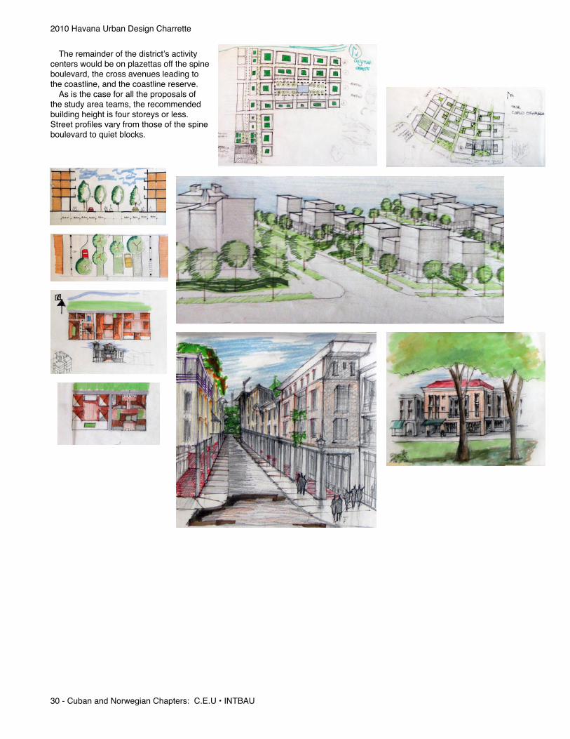
The remainder of the district’s activity centers would be on plazettas off the spine boulevard, the cross avenues leading to the coastline, and the coastline reserve. As is the case for all the proposals of the study area teams, the recommended building height is four storeys or less. Street profiles vary from those of the spine boulevard to quiet blocks.

March 20, 2011 - 31
Cojimar Cuban members of the Cojímar team recall its recent history before the Cojimar river became badly polluted by development upstream. Tthe town was a beach destination. Since this pollution is relativley recent history, they suggest that the beach and general environmentment of Cojímar could be restored more easily than other bodies of water such as Havana Harbour.
They proposed multiple means of water treatment - from technolgically complex facilities to street designs incorporating bioswales.
Photos from design presentation: “Cojímar … pueblo de mar”authors:D.I. Elena Garcia RoyoD. I. Dailyn CruzA.P. Teresa Sánches BravoA.P. Javier Martinez HerreraArq. Javier Martinez HerreraArq. Alix Gonzalez Astenciao.Arq. Alexis de la Cruz AlvarezAreq. Ernesto J. Llanes Segui

2010 Havana Urban Design Charrette
32 - Cuban and Norwegian Chapters: C.E.U • INTBAU
With a cleaner river and harbour, Cojímar can build on its existing importance as a leisure destination and heritage as a fishing village that was Hemingway’s home port in Cuba. Future transit will be a boon to Cojímar, with the potential for light rail connections by way of both a Via Blanca and Via Monumental alighment. All the communities of La Habana del Este can be linked by a bus loop which intersects with the light rail. Leisure travel can be accomplished with a passenger ferry linking the Malecón of La Habana Vieja with the dock in Cojímar.
The town’s topography provides views across the city down to the sea. This same topography promotes natural drainage and cooling. The team proposed dewveloping the natural amphitheater between the town and the Via Monumental as a park space and entertainment center.

March 20, 2011 - 33
The block pattern of Cojíamr is already established and recorded. It is just a matter of refininng the categories and uses of streets. The street classification will be guided by reinforcing two centers of activity - the historic center and the Villa Panamericana and creating two new, neighborhood centers in the southeast and northwests quadrants.

2010 Havana Urban Design Charrette
34 - Cuban and Norwegian Chapters: C.E.U • INTBAU
It’s important to maintain the historic center as an historic center - restore the existing context instead of changing it. Vistors come from all over the world to walk the streets that the famous author and his fishermen friends walked. It is possible to turn the principal street linking the historic center to the Via Monumental into a shopping street.
Cojímar’s oceanfront malecon is not historically significant. It provides the same opportunity for a leisure time space as has been proposed for Habanamar’s plazas.

March 20, 2011 - 35
The team also explored the opporunity for a major, figural building at the center of Cojîmar’s four, proposed neighborhoods that acts as a magnet of activity for all of Habana del Este.

2010 Havana Urban Design Charrette
36 - Cuban and Norwegian Chapters: C.E.U • INTBAU
Conclusions
Peter Baird’s paper fairly describes the results of the 2010 Havana Urban Design Charrette: “The charette process is an invigorating experience. For an overseas participant it offers the opportunity to adapt and apply knowledge in a creative highly enthusiastic environment. It is a perfect place to make new friends and to learn new ideas and ways of working. For the continued development of the Havana XXI Century, masterplan the charette provides a regular injection of new perspectives and new opinions on the future of the city, which can be challenged and discussed further once the charette is over. As Julio Cesar says, it is a work of love, but one that will hopefully one day have a positive bearing on the future of an already complex and beautiful city.” 10
Photo by Audun Engh
Photo by Audun Engh

March 20, 2011 - 37
Social Events
Opening Reception The charrette organizers under the direction of Norweigan legal advisor, Audun Engh, welcomed the Cuban and International members of the 2010 Charrette on Sunday night, March 21 in the patio of the Hostal Conde de Villanueva. The reception was an opportunity for the organizers to recognize old friends and welcome new participants.
Norwegian Ambassador On the evening of March 25, 2010 Norwegian Ambassador Jan Torre Hovik and his wife hosted a dinner reception with live music at their residence in Siboney. The Havana Urban Design Charrette organizers are very greatful to the Ambassador and the Country of Norway for their continued support of the goals and work surrounding the Masterplan for XXI Century Havana.
Photo by Audun Engh
Photo Courtesy of Audun Engh
Photo by Audun Engh


Notes1: Page 1: “Participating in the Key to the New World’s Future: International Urban Design Charette Master Plan for XXI Century
Havana (2010),” Peter Baird (July 2010)2: Page 52 “A Master Plan for III Century Havana” © Julio César
Pérez Hernández (May 2008)3: Julio César Pérez Hernández unpublished position paper (2010)4: Transcribed by editor during Sr. Martin’s briefing5: Text edited from content of Jeffrey Heller’s briefing6: Transcribed by editor during Ms. Havelska’s briefing7: Transcribed by editor during Mr. Mouzon’s briefing8: Edited from text of Yunior Carmona Pino’s briefing9: Page 2-5: “Participating in the Key to the New World’s Future:
International Urban Design Charette Master Plan for XXI Century Havana (2010), ”Peter Baird (July 2010)”
10: Page 5: “Participating in the Key to the New World’s Future: International Urban Design Charette Master Plan for XXI Century Havana (2010), ”Peter Baird (July
2010)”Other photos and text by report editor