rehabilitation of the jetty system at the mouth of the
TRANSCRIPT
Revised Final Environmental Assessment
Columbia River at the Mouth, Oregon and Washington
Rehabilitation of the Jetty System at the Mouth of the Columbia River
U.S. Army Corps of Engineers Jetty System at the Mouth of the Columbia River (MCR)
June 2012
Rehabilitation of the MCR Jetty System Revised Final Environmental Assessment
Revised EA, June 2012 i
Table of Contents 1. INTRODUCTION ...................................................................................................................... 1
1.1. Project Authority ................................................................................................................. 2 1.2. Background .......................................................................................................................... 3 1.3. Purpose and Need for Action ............................................................................................... 7
1.3.1. Purpose................................................................................................................. 7 1.3.2. Need ..................................................................................................................... 7
1.4. Project Area Description ...................................................................................................... 7 2. AFFECTED ENVIRONMENT .................................................................................................. 8
2.1. Physical Characteristics ....................................................................................................... 8 2.1.1. Waves, Currents, and Morphology ...................................................................... 9 2.1.2. Foundation Conditions ....................................................................................... 11 2.1.3. Landforms .......................................................................................................... 11 2.1.4. Sediment, Water Quality, and Spill History at the MCR ................................... 33
2.2. Fish and Wildlife ............................................................................................................... 35 2.2.1. ESA-listed Species under NMFS Jurisdiction ................................................... 36 2.2.2. ESA-listed Species under USFWS Jurisdiction ................................................. 44
2.3. Cultural and Historic Resources ........................................................................................ 46 2.4. Socio-economic Resources ................................................................................................ 47
2.4.1. Communities near the MCR .............................................................................. 47 2.4.2. Commercial Navigation ..................................................................................... 50
3. NO-ACTION ALTERNATIVE AND MODELING BASE CONDITION FOR THE MCR JETTIES ............................................................................................................................................ 52
3.1. North Jetty No Action and Base Condition ....................................................................... 55 3.2. South Jetty No Action and Base Condition ....................................................................... 56
3.2.1. Concrete Monolith ............................................................................................. 58 3.2.2. South Jetty Existing Spur Groins ....................................................................... 59
3.3. Jetty A No Action and Base Condition .............................................................................. 60 4. ALTERNATIVES AND DESIGN OPTIONS ......................................................................... 61
4.1. General Alternatives Analysis Categories and Features .................................................... 61 4.1.1. Common Engineering Features Considered as Part of Rehabilitation
Alternatives 62 4.1.2. Evaluation of Engineering Features ................................................................... 63
4.2. Range of Options and Alternatives Considered ................................................................. 66 4.2.1. No Action Alternative ........................................................................................ 67 4.2.2. Base Condition Alternative for Modeling .......................................................... 69 4.2.3. Options Addressing Erosional Areas ................................................................. 71 4.2.4. Scheduled Repair without Engineering Features ............................................... 73 4.2.5. Scheduled Repair with Engineering Features .................................................... 73 4.2.6. Immediate Rehabilitation using Minimum Cross Section ................................. 73 4.2.7. Immediate Rehabilitation using Small Cross Section ........................................ 73 4.2.8. Immediate Rehabilitation using Moderate Cross Section .................................. 74 4.2.9. Immediate Rehabilitation using Large Cross Section ........................................ 74 4.2.10. Immediate Rehabilitation using Composite Cross Section ................................ 74 4.2.11. Scheduled Rehabilitation using Minimum or Composite Cross Section ........... 75
4.3. Comparison of Design Options and Alternatives .............................................................. 79 4.3.1. North Jetty Alternatives ..................................................................................... 80 4.3.2. South Jetty Alternatives ..................................................................................... 81

Rehabilitation of the MCR Jetty System Revised Final Environmental Assessment
Revised EA, June 2012 ii
4.3.3. Jetty A Alternatives ........................................................................................... 82 5. PREFERRED ALTERNATIVE ............................................................................................... 85
5.1. Overview ............................................................................................................................ 85 5.2. Actions for the North Jetty................................................................................................. 88
5.2.1. North Jetty Trunk and Root ............................................................................... 88 5.2.2. North Jetty Spur Groins (No Longer Proposed) ................................................ 91 5.2.3. North Jetty Head Capping (Now Reduced to Stabilization Measure) ............... 96 5.2.4. North Jetty Lagoon Fill and Culvert Replacement ............................................ 98
5.3. Actions for the South Jetty................................................................................................. 99 5.3.1. South Jetty Trunk and Root (Preferred Alternative is Now Base Condition) .... 99 5.3.2. South Jetty Spur Groins (No Longer Proposed) .............................................. 102 5.3.3. South Jetty Head Capping (Reduced to a Stabilization Measure) ................... 109 5.3.4. South Jetty Root Erosion and Dune Augmentation ......................................... 110
5.4. Actions for Jetty A ........................................................................................................... 112 5.4.1. Jetty A Trunk and Root .................................................................................... 112 5.4.2. Jetty A Spur Groins (No Longer Proposed) ..................................................... 114 5.4.3. Jetty A Head Capping (Reduced To Stabilization Measures) .......................... 117
5.5. Construction Measures and Implementation Activities ................................................... 118 5.5.1. Construction Measures and Timing ................................................................. 118 5.5.2. Construction Sequence and General Schedule................................................. 122 5.5.3. Rock Sources and Transportation .................................................................... 123 5.5.4. Barge Offloading Facilities .............................................................................. 128 5.5.5. Dredging for Barge Offloading Facilities ........................................................ 136 5.5.6. Dredged Material Disposal Sites ..................................................................... 137 5.5.7. Pile Installation and Removal .......................................................................... 137 5.5.8. Rock Placement ............................................................................................... 138 5.5.9. Construction Staging, Storage, and Rock Stock Piles ..................................... 140 5.5.10. Temporary Erosion Controls............................................................................ 141 5.5.11. Emergency Response ....................................................................................... 142 5.5.12. Hazardous Materials ........................................................................................ 142 5.5.13. Spill Containment and Control ........................................................................ 142 5.5.14. Water Quality Monitoring................................................................................ 143
5.6. Wetland and Waters Fill and Associated Mitigation ....................................................... 143 5.6.1. Wetland Fill and Wetland Mitigation .............................................................. 145 5.6.2. Fill in Waters Other Than Wetlands and Mitigation ........................................ 154 5.6.3. General Wetland Mitigation Design and Monitoring ...................................... 159
5.7. Uplands Disturbance and Re-stabilization ....................................................................... 160 6. ENVIRONMENTAL CONSEQUENCES ............................................................................. 161
6.1. Rock Transport ................................................................................................................ 161 6.2. Construction Staging, Storage, and Rock Stock Piles ..................................................... 162 6.3. Rock Placement ............................................................................................................... 163
6.3.1. North Jetty........................................................................................................ 163 6.3.2. South Jetty........................................................................................................ 163 6.3.3. Jetty A .............................................................................................................. 163
6.4. Dredging .......................................................................................................................... 164 6.5. Disposal ........................................................................................................................... 164 6.6. Barge Offloading Facilities .............................................................................................. 165 6.7. Pile Installation and Removal .......................................................................................... 165 6.8. Wetland, Waters, Lagoon Fill and Culvert Replacement ................................................ 166 6.9. South Jetty Root Erosion and Dune Augmentation ......................................................... 167

Rehabilitation of the MCR Jetty System Revised Final Environmental Assessment
Revised EA, June 2012 iii
6.10. Water Quality ................................................................................................................... 168 6.11. Hydraulic and Hydrologic Processes ............................................................................... 169
6.11.1. Water Circulation and Velocity ....................................................................... 170 6.11.2. Salinity ............................................................................................................. 179 6.11.3. Plume Dynamics .............................................................................................. 184 6.11.4. Bed Morphology .............................................................................................. 184
6.12. Wetland and Waters Mitigation ....................................................................................... 188 6.13. Effects on Fish and Wildlife ............................................................................................ 189
6.13.1. Anadromous and Resident Fish Species .......................................................... 189 6.13.2. Macrophytes and Invertebrates ........................................................................ 195 6.13.3. Dungeness Crab ............................................................................................... 195 6.13.4. Marine Mammals and Sea Turtles ................................................................... 195 6.13.5. Terrestrial Wildlife, Plants, and Seabirds ........................................................ 196
6.14. Cultural and Historic Resources ...................................................................................... 198 6.15. Socio-economic Resources .............................................................................................. 199 6.16. Cumulative Effects .......................................................................................................... 200
7. COORDINATION.................................................................................................................. 205 8. COMPLIANCE WITH LAWS AND REGULATIONS ........................................................ 213
8.1. Clean Air Act ................................................................................................................... 213 8.2. Marine Protection, Research, and Sanctuaries Act .......................................................... 213 8.3. Clean Water Act .............................................................................................................. 214 8.4. Coastal Zone Management Act ........................................................................................ 214 8.5. Endangered Species Act .................................................................................................. 214 8.6. Fish and Wildlife Coordination Act ................................................................................. 215 8.7. Magnuson-Stevens Fishery Conservation and Management Act .................................... 215 8.8. Marine Mammal Protection Act ...................................................................................... 215 8.9. Migratory Bird Treaty Act and Migratory Bird Conservation Act .................................. 216 8.10. National Historic Preservation Act .................................................................................. 216 8.11. Native American Graves Protection and Repatriation Act .............................................. 216 8.12. Environmental Justice ...................................................................................................... 217 8.13. Executive Order 11988, Floodplain Management ........................................................... 217 8.14. Executive Order 11990, Protection of Wetlands ............................................................. 217 8.15. Prime and Unique Farmlands .......................................................................................... 217 8.16. Comprehensive Environmental Response, Compensation, and Liability Act and Resource
Conservation and Recovery Act ............................................................................................. 218 9. REFERENCES ....................................................................................................................... 219 LIST OF TABLES Table 1. Construction And Repair History Of The MCR Jetties ........................................................ 5 Table 2. 2007 Wetland Scores, North Jetty ...................................................................................... 12 Table 3. 2011 Wetland Classifications, North Jetty ......................................................................... 15 Table 4. 2011 Wetland Rating Scores, North Jetty ........................................................................... 16 Table 5. 2011 Wetland Classifications, Jetty A ................................................................................ 17 Table 6. 2011 Wetland Rating Scores, Jetty A ................................................................................. 17 Table 7. 2011 Wetland Classifications, South Jetty and Mitigation Area ........................................ 23 Table 8. 2011 Wetland Functions and Values, South Jetty Depressional – Sheet A ........................ 24 Table 9. 2011 Wetland Functions and Values, South Jetty Depressional – Sheet B ........................ 25 Table 10. 2011 Wetland Functions and Values, South Jetty Estuarine – Sheet A ............................ 26 Table 11. 2011 Wetland Functions and Values, South Jetty Estuarine – Sheet B ............................ 27 Table 12. 2011 Wetland Functions and Values, Mitigation Area Depressional – Sheet A .............. 29
Rehabilitation of the MCR Jetty System Revised Final Environmental Assessment
Revised EA, June 2012 iv
Table 13. 2011 Wetland Functions and Values, Mitigation Area Depressional – Sheet B .............. 30 Table 14. 2011 Wetland Functions and Values, Mitigation Area Estuarine – Sheet A .................... 31 Table 15. 2011 Wetland Functions and Values, Mitigation Area Estuarine – Sheet B .................... 32 Table 16. Threatened and Endangered Species under NMFS Jurisdiction ....................................... 37 Table 17. Threatened and Endangered Species under USFWS Jurisdiction .................................... 44 Table 18. Additional Structures at the MCR South Jetty.................................................................. 59 Table 19. North Jetty Spur Groin Features (No Longer Proposed) .................................................. 91 Table 20. North Jetty Head Cap Features (No Longer Proposed; Stabilization Feature Proposed at a
Smaller Volume) ........................................................................................................................ 96 Table 21. North Jetty Lagoon and Wetland Fill Features ................................................................. 98 Table 22. South Jetty Spur Groin Features (No Longer Proposed) ................................................ 103 Table 23. South Jetty Head Capping Features (No Longer Proposed) ........................................... 109 Table 24. Jetty A Spur Groin Feature (No Longer Proposed) ........................................................ 114 Table 25. Jetty A Head Cap Feature (No Longer Proposed) .......................................................... 117 Table 26. Quarry Information ......................................................................................................... 126 Table 27. Rock Volume and Area of Barge Offloading Facilities and Causeways ........................ 136 Table 28. Estimated Dredging Volumes for Barge Offloading Facilities....................................... 136 Table 29. Acreages Needed for Construction Staging, Storage, and Rock Stock Piles .................. 140 Table 30. Estimated Acreages for 404 Wetland and Waters Mitigation ........................................ 144 Table 31. Summary of Estimated Acreages for 404 Wetland and Waters Mitigation .................... 156 Table 32. Possible Mitigation Features for Impacts to 404 Waters of the US – Final to be
Determined ............................................................................................................................... 157 LIST OF FIGURES Figure 1. Project Area Showing the MCR Jetties and Underwater Sand Shoals ................................ 3 Figure 2. 2011 Wetland Delineations at the North Jetty ................................................................... 14 Figure 3. 2011 Wetland Delineations at the Jetty A ......................................................................... 18 Figure 4. Clatsop Spit Vegetative Communities............................................................................... 20 Figure 5. 2011 Wetland Delineations, Clatsop Spit West, South Jetty ............................................. 21 Figure 6. 2011 Wetland Delineations, Clatsop Spit West, South Jetty ............................................. 22 Figure 7. 2011 Wetland Delineations, Clatsop Spit West, South Jetty ............................................. 28 Figure 8. Sediment Trend Analysis in the MCR Area ...................................................................... 33 Figure 9. Shipwrecks at the MCR ..................................................................................................... 47 Figure 10. Jetty System at the MCR ................................................................................................. 52 Figure 11. Clatsop Spit and South Jetty Root Erosion...................................................................... 58 Figure 12. Existing Spur Groins at the MCR South Jetty ................................................................. 59 Figure 13. Typical Spur Cross Section - Change with Depth ........................................................... 64 Figure 14. 3-D Examples of Rehabilitation and Template Options at All Jetties ............................. 76 Figure 15. North Jetty Cross Section for Existing Condition and Scheduled Repair Template ....... 89 Figure 16. Proposed Action for the North Jetty (Without Spur Groins or Head-Capping) .............. 90 Figure 17. North Jetty Spur Groin NJ1C (No Longer Proposed) ..................................................... 92 Figure 18. North Jetty Spur Groin NJ2C (No Longer Proposed) ..................................................... 93 Figure 19. North Jetty Spur Groin NJ3O (No Longer Proposed) ..................................................... 94 Figure 20. North Jetty Spur Groin NJ4C (No Longer Proposed) ..................................................... 95 Figure 21. North Jetty Head Cap (No Longer Proposed; Replaced by Smaller Stabilization Feature)
................................................................................................................................................... 97 Figure 22. South Jetty Cross Section for Existing Condition (and Scheduled Repair, Which is No
Longer Proposed) ....................................................................................................................... 99 Figure 23. Proposed Action for the South Jetty Without Spur Groins or Head Cap and With Interim
Repair Maintenance Strategy ................................................................................................... 101
Rehabilitation of the MCR Jetty System Revised Final Environmental Assessment
Revised EA, June 2012 v
Figure 24. South Jetty Spur Groin SJ1O (No Longer Proposed) .................................................... 104 Figure 25. South Jetty Spur Groin SJ2C (No Longer Proposed) .................................................... 105 Figure 26. South Jetty Spur Groin SJ3C (No Longer Proposed) .................................................... 106 Figure 27. South Jetty Spur Groin SJ4C (No Longer Proposed) .................................................... 107 Figure 28. South Jetty Spur Groin SJ5O (No Longer Proposed) .................................................... 108 Figure 29. South Jetty Head Cap (No Longer Proposed) ............................................................... 110 Figure 30. South Jetty Root Shoreline Area ................................................................................... 111 Figure 31. Jetty A Cross Section for Proposed Action (No Longer Proposed. Cross- section Will
Be Similar to that of North Jetty) ............................................................................................. 112 Figure 32. Proposed Action for Jetty A (No Longer Proposed. Scheduled Repair Will Be Similar to
that of North Jetty) ................................................................................................................... 113 Figure 33. Jetty A Spur Groin JA1C (No Longer Proposed) .......................................................... 115 Figure 34. Jetty A Spur Groin JA2O (No Longer Proposed) ......................................................... 116 Figure 35. Jetty A Head Cap (No Longer Proposed; Replaced With Reduced Stabilization Measure)
................................................................................................................................................. 118 Figure 36. Updated Construction Schedule .................................................................................... 121 Figure 37. Potential Quarry Locations (red dots) for Repairs to MCR Jetties ................................ 125 Figure 38. North Jetty Offloading, Staging, Storage and Causeway Facilities .............................. 129 Figure 39. South Jetty Offloading, Staging, Storage and Causeway Facilities .............................. 130 Figure 40. Jetty A Offloading, Staging, Storage and Causeway Facilities ..................................... 132 Figure 41. Cross Section of Stone Access Ramp at Barge Offloading Facilities at East End of
Clatsop Spit near Parking Area D and Photos of Typical Barge Offloading Facilities ........... 133 Figure 42. Illustration of a Jack-up Barge ...................................................................................... 139 Figure 43. Illustration of Avoidance, Minimization, and Wetland and Waters Impacts at North Jetty
................................................................................................................................................. 147 Figure 44. Illustration of Avoidance, Minimization, and Wetland and Waters Impacts at Jetty A 149 Figure 45. Illustration of Avoidance, Minimization, and Wetland Impacts at South Jetty ............. 151 Figure 46. Illustration of Wetland Mitigation Area Near the South Jetty....................................... 154 Figure 47. Residual Velocity Bed Layer for August/September Period ......................................... 171 Figure 48. Residual Velocity Surface Layer for August/September Period ................................... 172 Figure 49. Residual Velocity near North Jetty and Jetty A for August/September Period ............. 173 Figure 50. Residual Velocity near South Jetty for August/September Period ................................ 174 Figure 51. Residual Velocity Bed Layer for October/November Period ........................................ 176 Figure 52. Residual Velocity near North Jetty and Jetty A for October/November Period ............ 177 Figure 53. Residual Velocity near South Jetty for October/November Period ............................... 178 Figure 54. Mean Salinity for Bed Layer for August/September Period ......................................... 180 Figure 55. Mean Salinity for Surface Layer for August/September Period .................................... 181 Figure 56. Mean Salinity for Surface Layer for October/November Period .................................. 182 Figure 57. Mean Salinity for Surface Layer for October/November Time Window ...................... 183 Figure 58. Bathymetry at the MCR ................................................................................................ 185 Figure 59. Difference in Bed Level (meters) for August/September Time Window...................... 186 Figure 60. Difference in Bed Level (meters) for October/November Time Window .................... 187
Rehabilitation of the MCR Jetty System Environmental Assessment
Revised EA, June 2012 vi
ABBREVIATIONS AND ACRONYMS AMT Adaptive Management Team BA Biological Assessment BMP best management practices cfs cubic feet per second Corps U.S. Army Corps of Engineers CRE Columbia River estuary cy cubic yard(s) DDT dichloro-diphenyl-trichloroethane DPS Distinct Population Segment DMEF Dredged Material Evaluation Framework EIS Environmental Impact Statement ESA Endangered Species Act EA Environmental Assessment EFH Essential Fish Habitat ERDC Engineer Research and Development Center ESU Evolutionarily Significant Unit(s) FONSI Finding of No Significant Impact FR Federal Register ft foot or feet HCP Habitat Conservation Plan IHA incidental harassment authorization MCR Mouth of the Columbia River mcy million cubic yard(s) MHHW mean higher high water MLLW mean lower low water MTL mean tidal low NEPA National Environmental Policy Act NAVD North American Vertical Datum NMFS National Marine Fisheries Service ODEQ Oregon Department of Environmental Quality OPRD Oregon Parks and Recreation Department PAH polynuclear aromatic hydrocarbon(s) PCB polychlorinated biphenyl(s) PNNL Pacific Northwest National Laboratory ppt parts per thousand PSMFC Pacific States Marine Fisheries Commission RM river mile SEF Sediment Evaluation Framework SWS Shallow Water (ocean disposal) Site TMDL total maximum daily loads USEPA U.S. Environmental Protection Agency USFWS U.S. Fish and Wildlife Service USGS U.S. Geological Survey WDOE Washington Department of Ecology
Environmental Assessment of the Rehabilitation of the MCR Jetty System
Revised EA, June 2012 1
1. INTRODUCTION This Revised Final Environmental Assessment (EA) evaluates the environmental effects for major rehabilitation and repairs of the North and South Jetties and Jetty A, which are part of the U.S. Army Corps of Engineers’ (Corps) mouth of the Columbia River (MCR) navigation project (see cover photo and Figure 1). The EA provides a comprehensive analysis for all actions proposed at the MCR, including actions for the South Jetty dune augmentation, actions at the North Jetty described in the North Jetty Major Maintenance Report (MMR), May 2011, and actions described in the Major Rehabilitation Report (MCR Jetty System Major Rehabilitation Evaluation Report, June 2012). This document describes and evaluates all of these actions, and their associated cumulative effects are detailed here. In June 2006, the Corps issued a draft EA (Draft Environmental Assessment, Columbia River at the Mouth, Oregon and Washington, Rehabilitation of the Jetty System at the Mouth of the Columbia River, June 2006) for public review and comment. This 2006 draft EA identified a proposed action for major rehabilitation and repairs including rebuilding the jetty lengths, adding spur groins, and capping the head at each of the jetties. In January 2010, the Corps issued a revised draft EA (Revised Draft Environmental Assessment Columbia River at the Mouth, Oregon and Washington Rehabilitation of the Jetty System at the Mouth of the Columbia River, January 2010) for public review and comment, which superseded the 2006 draft EA. The proposed action included a smaller-scaled project without the rebuilt lengths and included head-capping, spur groins, and repair and rehabilitation actions at the jetties. The 2010 revised draft EA also included the following actions: South Jetty foredune augmentation at the jetty root near the neck of Clatsop Spit; fill of the lagoon at the North Jetty; and critical repairs to Stations 86-99 of the North Jetty. After public review of the 2010 draft EA, the Corps modified the proposed action for the North Jetty, South Jetty, and Jetty A. The modification also included avoidance of fill in Trestle Bay. These combined modifications avoided and minimized some of the formerly identified environmental impacts by reducing the final structure and construction footprints necessary to achieve a resilient jetty system at the MCR. The 2010 draft EA was finalized in May 2011, Final Environmental Assessment Columbia River at the Mouth, Oregon and Washington Rehabilitation of the Jetty System at the Mouth of the Columbia River and Finding of No Significant Impact, May 31, 2011 (2011 final EA). In addition to avoiding fill in Trestle Bay, the proposed action in the 2011 final EA included: spur groin and head-capping features at all jetties; scheduled repairs as the South Jetty; North Jetty lagoon fill; dune augmentation at Clatsop spit; immediate rehabilitation at Jetty A; and a proposed schedule of activities in a 20-year period. The Corps signed a FONSI in 2011 for a subset of the proposed action described in the 2011 final EA, which included the following: critical repairs at the North Jetty (stations 86-99), North Jetty lagoon fill; and the dune augmentation at Clatsop spit. This 2012 revised final EA updates the 2011 final EA. It makes the clarification that the No Action Alternative is not the same as the Base Condition, since the Base Condition in the 2011 final EA included some action (these were the selected course of action in the 2011 FONSI). The revised final EA also clarifies modifications to the Base Condition assumptions per suggestions from an Independent, External Peer Review (IEPR) team. The cumulative effects evaluation has been updated in this revised final EA to incorporate the Corps’ proposal to designate nearshore dredge disposal sites at the MCR (see the April 24, 2012 Public Notice for: Nearshore Disposal Locations at the Mouth of Columbia River Federal Navigation Project Pacific County, Washington Clatsop County, Oregon).
Environmental Assessment of the Rehabilitation of the MCR Jetty System
Revised EA, June 2012 2
Currently the Corps has identified a preferred alternative addressing the rubble-mound structures at the MCR over the next 8 years. Because these structures are built on sand, are subject to extreme physical environmental conditions, and have been established for over 125 years, they would require work and repair beyond the 8-year period. Throughout and at the end of 8-years, via inspections and monitoring the Corps would need to examine any needed future maintenance, rehabilitation or reconstruction. The duration and preferred alternative for all of these actions remain within the scope of effects previously evaluated in the 2011 Biological Opinion and Concurrence Letter, (May 18, 2011, Endangered Species Act Biological Opinion and Conference Report and Magnuson-Stevens Fishery Conservation and Management Act Essential Fish Habitat Consultation for the Major Rehabilitation of the Jetty System at the Mouth of the Columbia River – NMFS No 2010/06104, and; 2/23/2011, Major Rehabilitation of the Jetty System at the Mouth of the Columbia River Navigation Channel, Clatsop County, Oregon and Pacific County, WA USFWS # 13420-2011-I-0082).
1.1. Projec t Authority
The features of the MCR navigation project were authorized by the River and Harbor Acts of 1884, 1905, and 1954. The navigation project consists of a 0.5-mile wide navigation channel extending for about 6 miles through a jettied entrance between the Columbia River and the Pacific Ocean. The MCR is the ocean gateway for maritime navigation to and from the Columbia-Snake River navigation system. Approximately $20 billion of commerce passes through the MCR jetty system annually. The ocean entrance at the MCR is characterized by large waves and strong currents and is considered one of the world’s most dangerous coastal inlets. For the authorization for the actual construction of the MCR jetties, the present navigation channel and configuration of the inlet at the mouth of the Columbia River are the result of continuous improvement and maintenance efforts undertaken by the Corps Portland District since 1885. Congress has authorized the improvement of the MCR for navigation through the past legislation:
• Senate Executive Document 13, 47th Congress, 2nd Session (5 July 1884) authorized the Corps to construct the South Jetty (first 4.5 miles) for the purpose of attaining a 30-foot channel across the bar at the MCR.
• House Document 94, 56th Congress, 1st Session (3 March 1905) authorized the Corps to extend the South Jetty (to 6.62 miles) and construct a North Jetty (2.35 miles long) for the purpose of attaining a 40-foot channel (0.5 mile wide) across the bar at the MCR.
• House Document 249, 83rd Congress, 2nd Session (3 September 1954) authorized a bar channel of 48 feet in depth and a spur jetty ("B") on the north shore of the inlet. Funds for Jetty "B" construction were not appropriated.
• Public Law 98-63 (30 July 1983) authorized the deepening of the northern most 2,000 feet of the MCR channel to a depth of 55 feet below mean lower low water (MLLW).
The MCR federal navigation project was originally authorized (in 1884) before formulation of local sponsor cost sharing agreements; therefore, all navigation maintenance and improvements costs at MCR are borne by the Federal Government. The authority for maintenance of the MCR jetties comes from its original authority for construction of the project and then with Corps’ policies for the operations, maintenance, and management of a Corps’ project (Chapter 11 of EP 1165-2-1). For navigation, completed projects like the MCR have established
Environmental Assessment of the Rehabilitation of the MCR Jetty System
Revised EA, June 2012 3
that operations and maintenance (O&M) is solely a federal responsibility to be accomplished at federal cost. When maintaining a Corps’ project, there is regular O&M, major maintenance, and major rehabilitation. Major rehabilitation consists of either one or both of two mutually exclusive categories, reliability or efficiency improvements.
• Reliability. Rehabilitation of a major project feature that consists of structural work on a Corps operated and maintained facility to improve reliability of an existing structure, the result of which would be a deferral of capital expenditures to replace the structure. Rehabilitation would be considered as an alternative when it can measurably extend the physical life of the feature (such as a jetty) and can be economically justified by a benefit/cost relationship. Each year the budget Engineering Circular (EC) delineates the dollar limits and construction seasons (usually two construction seasons).
• Efficiency Improvements. This category would enhance operational efficiency of major project components. Operational efficiency would increase outputs beyond the original project design. This category is typically used to evaluate hydropower production.
Thus, the authority for maintenance of the MCR jetties comes from the authorization documents for the project and/or the authority to operate and maintain the structures.
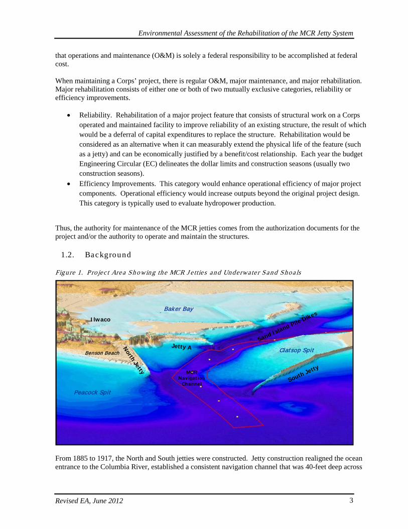
1.2. Background
Figure 1. P ro jec t Area Sh owing the MCR J e tties and Underwater Sand Shoa ls
From 1885 to 1917, the North and South jetties were constructed. Jetty construction realigned the ocean entrance to the Columbia River, established a consistent navigation channel that was 40-feet deep across
South Jetty
North Jetty
Peacock Spit
Clatsop Spit
Ilwaco
Baker Bay
Benson Beach
MCR Navigation
Channel
Jetty ASand Island Pile Dikes
South Jetty
North Jetty
Peacock Spit
Clatsop Spit
Ilwaco
Baker Bay
Benson Beach
MCR Navigation
Channel
Jetty ASand Island Pile Dikes
Environmental Assessment of the Rehabilitation of the MCR Jetty System
Revised EA, June 2012 4
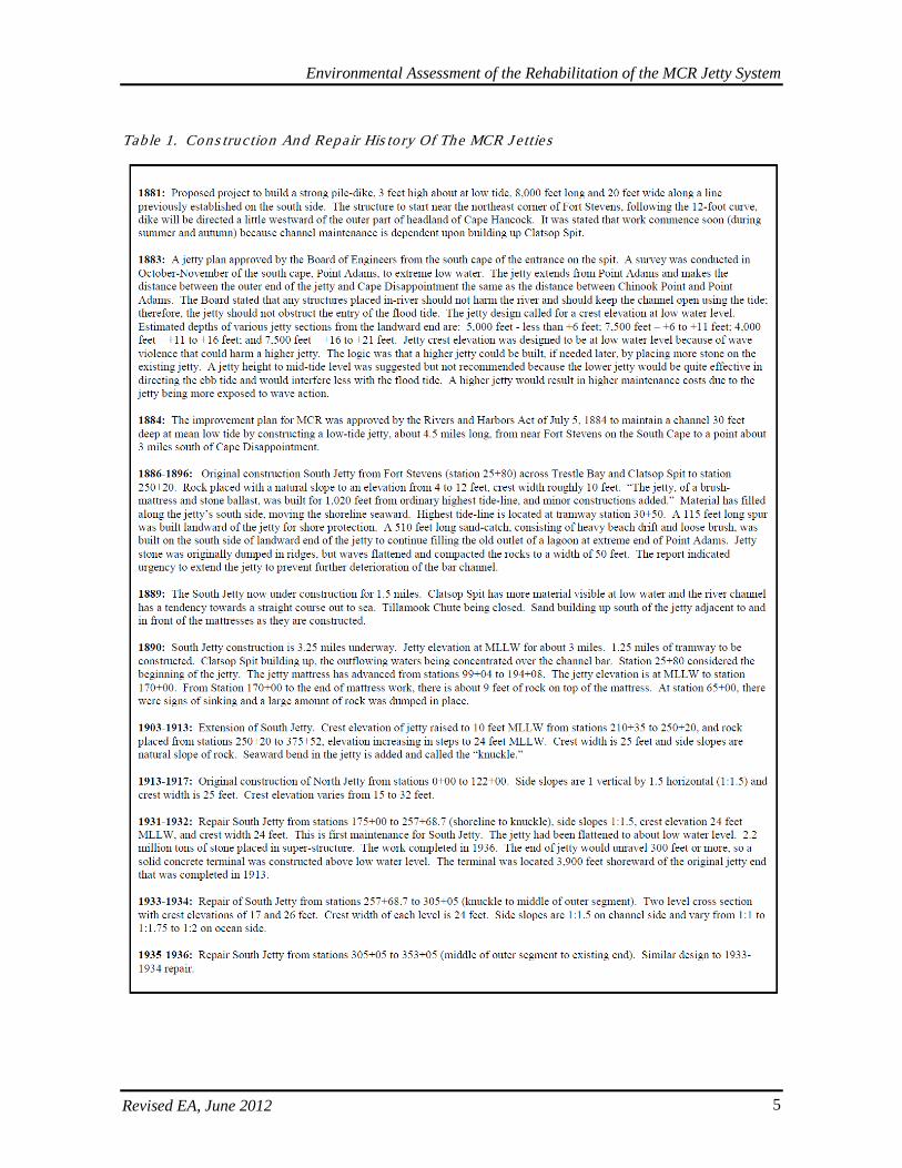
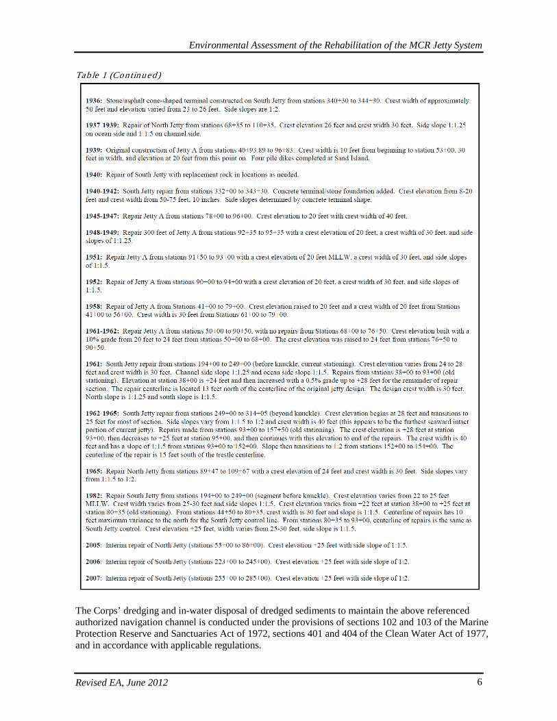
the bar, and dramatically improved navigation through the MCR. Improvements made from 1930 to 1942 (including adding Jetty A and the Sand Island pile dikes) produced the present entrance configuration. The MCR jetties are unique structures that help ocean-going vessels move between the Columbia River and Pacific Ocean. Simply put, a jetty is a rock finger that stretches out into the ocean from the shoreline, essentially extending the mouth of the river well into the sea. Where a river empties into the ocean, currents slow and sand bars develop, which cause a dangerous situation for ships trying to navigate through an ever-changing channel. Jetties create more defined and concentrated flows at the mouth of the river to help scour out the shallow sand deposits and maintain a stable channel location and depth. The forces of nature have taken their toll on the structural integrity of the MCR jetties, and the Corps is working at restoring them to acceptable levels of reliability. Repairs were made in 1965 for the North Jetty, in 1962 for Jetty A, and in 1982 for the South Jetty. Additional repairs to address immediate needs were completed at the North Jetty in 2005 and at the South Jetty in 2007. Further details on repair history are described below. From 1885 to 1939, three rubble-mound jetties with a total length of 9.7 miles were constructed at the MCR on massive tidal shoals. The jetties were constructed to accelerate the flow of the river, which helps maintain the depth and orientation of the navigation channel, and to provide protection for ships of all sizes (both commercial and recreational) entering and leaving the Columbia River. The intention was to secure a consistent navigation channel through the coastal inlet, though morphology of the inlet currently remains in a dynamic, high-energy state. Under such conditions, the jetties have experienced considerable deterioration since construction, mainly due to extreme wave attack and foundation instability associated with erosion of the tidal shoals on which the jetties were built. The initial 4.5-mile section of the South Jetty was completed in 1895-1896. The Rivers and Harbor Act of 3 March 1905 authorized the extension of the South Jetty to 6.6 miles, with the 2.4-mile extension completed in 1913. Historical records show that six spur groins were constructed along the channel side of the South Jetty. Four of the groins were subsequently buried by accreted shoreline or sand shoal. Nine repairs to the South Jetty have been completed with the latest one in 2007. To date, jetty rock placement at the South Jetty totals approximately 8.8 million tons. In spite of these repairs and structural features, over 6,100 feet (1.1 miles) of loss has occurred at the South Jetty. The North Jetty was completed in 1917. Three repairs to the North Jetty have been made with the last one completed in 2005. To date, jetty rock placement totals approximately 3.4 million tons. Since initial construction, about 2100 feet (0.4 mile) of the North Jetty has eroded. Jetty A was constructed in 1939 to 1.1 miles in length in connection with rehabilitation of the North Jetty for the purpose of channel stabilization. Its purpose was to assist in controlling the location and direction of the ebb tidal flow through the navigation entrance. Improvements made from 1930 to 1942 (including addition of Jetty A and Sand Island pile dikes) produced the present entrance configuration. The construction and repair history of the MCR jetties is summarized in Table 1.
Environmental Assessment of the Rehabilitation of the MCR Jetty System
Revised EA, June 2012 5
Tab le 1. Cons truc tion An d Repair His to ry Of The MCR J e ttie s
Environmental Assessment of the Rehabilitation of the MCR Jetty System
Revised EA, June 2012 6
Tab le 1 (Continued)
The Corps’ dredging and in-water disposal of dredged sediments to maintain the above referenced authorized navigation channel is conducted under the provisions of sections 102 and 103 of the Marine Protection Reserve and Sanctuaries Act of 1972, sections 401 and 404 of the Clean Water Act of 1977, and in accordance with applicable regulations.
Environmental Assessment of the Rehabilitation of the MCR Jetty System
Revised EA, June 2012 7
1.3. Purpos e and Need for Ac tion
1.3.1. Purpos e
The purpose of the proposed action is to perform modifications and repairs to the North and South jetties and Jetty A at the MCR that would strengthen the jetty structures, extend their functional life, and maintain deep-draft navigation.
1.3.2. Need
Structural degradation of the +100-year old MCR jetty system has accelerated in recent years because of increased storm activity and loss of sand shoal material upon which the jetties are constructed. In addition, beaches on the ocean sides of the North and South jetties, which formed as a result of jetty construction, have been receding gradually over the years, exposing previously protected sections of the jetties at the beach line to storm waves. Taking no action to protect and to extend the functional life of the jetties will result in further deterioration of the jetties and the sand shoals upon which they rest, increasing the likelihood of a jetty breach. Recent jetty repairs have addressed immediate critical needs. Additional modifications and repairs to the jetties are necessary to address important near- and long-term needs to keep the jetties functioning at an acceptable reliability and to reduce the potential for emergency repairs, emergency dredging, and impacts to navigation.
1.4. Projec t Area Des crip tion
The North Jetty and Jetty A are located in Pacific County, Washington, near Ilwaco and Long Beach on the Long Beach Peninsula (see cover photo). The North Jetty is located within Cape Disappointment State Park (formerly Fort Canby), and Jetty A is located near the Coast Guard station. The 2.3-mile long North Jetty was completed in 1917. Three repairs to the North Jetty have been made with the last one completed in 2005. To date, jetty rock placement totals approximately 3.4 million tons. Since initial construction, about 0.4 miles of the North Jetty head has eroded and is no longer functional. Jetty A, positioned on the south side of the North Jetty, was constructed in 1939 to a length of 1.1 miles and is located upstream of the North Jetty. Jetty A was constructed to direct river and tidal currents away from the North Jetty foundation. The South Jetty is located in Clatsop County, Oregon near Warrenton/Hammond and Astoria (see cover photo). The South Jetty is located in Fort Clatsop State Park. The South Jetty is about 6.6 miles long. The initial 4.5-mile section of the South Jetty was completed in 1896, with a 2.4-mile extension completed in 1914. Currently, approximately 3 miles of jetty extends seaward of the shoreline. To stabilize the jetty foundation, six groins perpendicular to the South Jetty were constructed with lengths from about 100 to 1,000 feet (see Section 3.2.2). Over 6,100 feet of loss has occurred at the South Jetty. Nine repairs to the South Jetty have been completed with the latest one in 2007. To date, jetty rock placement at the South Jetty totals approximately 8.8 million tons.

Environmental Assessment of the Rehabilitation of the MCR Jetty System
Revised EA, June 2012 8
2. AFFECTED ENVIRONMENT
2.1. Phys ica l Charac teris tic s
The MCR is a high-energy environment. Horizontal circulation in the estuary is generally clockwise (when viewed from above), with incoming ocean waters moving upstream in the northern portion of the estuary and river waters moving downstream in the southern portion of the estuary. Vertical circulation is variable, reflecting the complex interaction of tides with river flows and bottom topography and roughness (Corps 1983). The Columbia River estuarine environment (based on salinity and tidal effects) extends from the mouth to river mile (RM) 38. The width of the river varies from 2 to 5 miles wide throughout the estuary and about 1 mile wide at RM 30. Tidal effect extends almost 150 miles upstream (Corps 1983), but the saltwater wedge is limited to about RM 20 (Corps 1999). The North and South Jetties and Jetty A were constructed at the MCR to help stabilize the channel, to reduce the need for dredging, and to provide protection for ships. The navigation channel is maintained at authorized depths of 48 to 55 feet below mean lower low water (MLLW)1
and is 0.5-mile wide from RM -3 to RM 3. River flows are controlled by upstream storage dams.
A dredged material disposal site called the North Jetty Site is entirely within inland waters. It is located about 400 feet south of the North Jetty, occupies an area of 1,000 feet by 5,000 feet, and has an average water depth of 35-55 feet. This site was evaluated and established by the Corps in 1999 under Section 404 of Clean Water Act to allow the placement of dredged material along the toe of the North Jetty to protect it from excessive waves and current scour. Use of the site is limited to disposal of MCR dredged material. From 1999-2008, about 4.4 million cubic yards (mcy) of dredged material was placed in the North Jetty site. An ocean disposal site called the Shallow Water Site (SWS) lies within 2 miles offshore from the MCR and was evaluated and designated in 2005 by the U.S. Environmental Protection Agency (USEPA) under Section 102 of the Marine Protection, Research and Sanctuaries Act. The SWS occupies a trapezoidal area of 3,100- to 5,600 feet in width by 11,500 feet in length and lies within a water depth of 45-75 feet. The SWS is used for disposal of material dredged from either the MCR or the lower Columbia River. The SWS is dispersive, which means that material placed there is transported away from the site by waves and currents. Active monitoring and evaluation determined that 80% to 95% of the dredged sand annually placed at the SWS moves northward onto Peacock Spit. From 1997-2008, approximately 29 mcy of dredged sand has been placed in the SWS. The SWS is of strategic importance to the region; its continual use has supplemented Peacock Spit with sand, sustained the littoral sediment budget north of the MCR, protected the North Jetty from scour and wave attack, and stabilized the MCR inlet. There is also an active deep water disposal site 7 miles off shoreline in Pacific Ocean (Deep Water Site), west of the Columbia River, as well as an active disposal site in the estuary at RM 7 called the Chinook Channel Area D, the latter of which receives materials from the Columbia and Lower Willamette reaches. These active disposal sites have undergone extensive evaluation and review regarding potential effects prior to their site designation. The Corps has recently proposed designating additional dredge material disposal sites near both the North and South Jetties. If designated, those sites may also be available. The
1 In this EA, depth is expressed as MLLW or as North American Vertical Datum (NAVD); the difference between MLLW and NAVD is about 0.3 feet.
Environmental Assessment of the Rehabilitation of the MCR Jetty System
Revised EA, June 2012 9
current proposed disposal actions for the MCR repairs and rehabilitation are congruent with these active projects and efforts. Dredged material from this proposal will likely be placed in the SWS or other preapproved locations. Disposal actions from this project will be similar to and in compliance with actions described in associated site designations and approvals. The Corps is not proposing any new disposal sites specific to this jetty repair/rehabilitation action and will most likely use the SWS site, which is a designated Ocean Dredged Material Disposal Site (ODMDS). The EPA designates and manages the disposal of ocean dredged material pursuant to section 102 of the Marine Protection, Research, and Sanctuaries Act (MPRSA). The designation process for both the SWS and Deep Water Sites was finalized in 2005 and can be found at 70 FR 10041. As part of the associated Site Management and Monitoring Plan (SMMP) to ensure adaptive management and protection from adverse mounding and environmental impacts, the Corps submits an Annual Use Plan to EPA requesting use of the sites for placing materials before the beginning of dredge season and disposal at the site. Approximately 19,575 acres of shallow-water habitat presently exist in the vicinity of the MCR project, some of which is intertidal sandflat and is periodically exposed. For the purposes of this analysis, shallow-water habitat was considered to include water 20-feet deep and shallower, whether or not it experienced periodic exposure at low tides. During the geospatial analysis, boundary conditions were set as closely as possible to match those which were used in the hydraulic and hydrologic analyses and modeling. This area roughly extends to RM 3, and 3 miles seaward. Generally, shallow-water habitat in the MCR is concentrated around the jetty structures and in adjacent coves and bays. The dominant substrate in vicinity of the jetties consists of relic rock and shifting sand, with little habitat heterogeneity due to the dynamic current, wind, and wave conditions.
2.1.1. Waves , Curren ts , and Morphology
The ocean entrance at the MCR is characterized by large waves and strong currents interacting with spatially variable bathymetry. The MCR entrance is considered one of the world’s most dangerous coastal inlets for navigation. Approximately 70% of all waves approaching the MCR are from the west-northwest (Moritz and Moritz 2004). During winter storms, the ocean offshore of the jettied river entrance is characterized by high swells approaching from the northwest to southwest combined with locally generated wind waves from the south to southwest. From October to April, average offshore wave height and period is 9 feet and 12 seconds, respectively. From May to September, average offshore wave height and period is 5 feet and 9 seconds, respectively, and waves approach mostly from the west-northwest. Occasional summer storms produce waves approaching from the south-southwest with wave heights of 6.5 to 13 feet and wave periods of 7 to 12 seconds. The tides are mixed semi-diurnal with a diurnal range of 7.5 feet. The instantaneous flow rate of estuarine water through the MCR inlet during ebb tide can reach 1.8 million cubic feet per second (cfs). Tidally dominated currents at the MCR can exceed 8.2 feet per second. A large, clockwise-rotating eddy current has been observed to form between the North Jetty, the navigation channel, and Jetty A during ebb tide. A less pronounced counter-clockwise eddy forms in response to flood tide. The North Jetty eddy has varying strength and direction (based on location and timing of tide) ranging from 0.3 to 3.3 feet per second. As waves propagate shoreward toward the MCR, the waves are modified by the asymmetry (irregularity) of the MCR’s underwater morphology (form). The asymmetric configuration of the MCR and its morphology is characterized by the sizeable offshore extent of Peacock Spit on the north side of the North Jetty, southwesterly alignment of the North/South jetties and channel, and the absence of a large shoal on the south side of the MCR. Nearshore currents and tidal currents are also modified by the jetties and the MCR’s morphology. These modified currents interact with the shoaling waves, river currents, and
Environmental Assessment of the Rehabilitation of the MCR Jetty System
Revised EA, June 2012 10
seasonal hydrograph to produce a complex and agitated wave environment at the MCR. The asymmetry of the MCR causes incoming waves to be focused onto areas which would not otherwise be exposed to direct wave action. An example of this wave-focusing effect is the area along the south side of the North Jetty. Initially, it would appear that this area is most susceptible to wave action approaching the MCR from the southwest. However, this is not the case; the opposite is what occurs. The area located between the North Jetty, the navigation channel, and Jetty A is affected by wave action during conditions when the offshore wave direction is from the west-northwest, because of the refractive nature of Peacock Spit. Waves passing over Peacock Spit (approaching from the northwest) are focused to enter the MCR along the south side of the North Jetty. Conversely, large waves approaching the MCR from the southwest are refracted/diffracted (changed in direction) around the South Jetty and over Clatsop Spit, protecting the south side of the North Jetty from large, southerly waves. The stability of the MCR channel is related to the jetties and the morphology of Peacock and Clatsop spits (Moritz et al., 2003). Through phased jetty construction from 1885 to 1939 and the associated response of MCR morphology, the project features at the MCR and the resultant morphology are now dependent on one another both in terms of structural integrity and project feature functional performance. If the jetties change over time (further recession of jetty head or breach within jetty trunk), the inlet’s morphology will respond accordingly. For example, if the head of the North Jetty recedes landward by 100 feet, the morphology adjacent to the North Jetty will adjust accordingly, with much of the mobilized sediment entering the MCR navigation channel. The offshore extent of the North Jetty acts to retain Peacock Spit and to prevent its southward re-entry into the MCR inlet. The North Jetty acts to constrain current flow through the entrance to maintain a stable inlet. Jetty A helps to reduce severe ebb tide circulation affecting the North Jetty, thereby protecting the North Jetty. Jetty A also protects Sand Island and Ilwaco channel from severe flood tide currents and storm wave action entering the inlet from the ocean. By effectively constraining currents within the inlet, Jetty A also reduces the likelihood of Clatsop Spit migrating northward into the inlet. The offshore extent of the South Jetty protects the MCR inlet from severe wave action and constrains destabilizing currents. The present condition of the South Jetty also acts to stabilize Clatsop Spit and shore land south of the jetty. In summary, the function of the MCR jetties is related to the offshore distance to which the jetties extend. Potential long-term impacts of climate change were considered in the analysis of the MCR Jetties. Climate change impacts on coastal projects can potentially involve two separate factors, increased sea level and changes in the wave climate. Analysis of monthly mean sea level data from 1925 to 2006 at the National Weather Service’s Astoria gauge has shown that the mean sea level trend is -0.31 millimeters/year, which is equivalent to a change of -0.05 feet in 50 years. The trend is negative because of the opposing effect of rebound of the landmass in the area. Overall, water levels along the Oregon Coast are primarily a function of astronomical tide influences with a representative tidal range of approximately 7 feet. Other factors that can influence water levels are atmospheric pressure, El Nino/La Nina cycles, wind set-up, and wave set-up. Those values can combine with a high tide level to approximate an extreme high water level (during storm wave action) of approximately 15.8 feet MLLW. The extreme low water level (during storm wave action) was estimated to be 1.3 feet MLLW. Overall, since the projected historical trend of sea level at the project site is estimated to be -0.05 feet in 50 years, sea level rise is not projected to be a dominant climate change factors at the project site. Another concern regarding climate change is wave height trends. Waves that affect each jetty are a function of deepwater waves and water depths at each jetty. Shallower water depths may limit wave heights along a given section of a jetty. The potential for future changes in wave climate along each jetty
Environmental Assessment of the Rehabilitation of the MCR Jetty System
Revised EA, June 2012 11
was addressed by estimating two factors: 1) increases in present offshore storm wave height, and 2) reduction in the MCR inlet morphology. The latter could increase depth-limited wave height. Analysis of deep water wave data near the project site may indicate increasing trends in height of storm-related waves and frequency of storms. Due to the relatively short data record (1984 to 2009), it is not known whether this trend accurately represents a one-way increase, or is simply a subset of a larger, wider-ranging database of wave heights. The comprehensive analysis of historical storm events is expected to adequately capture the present deep water contribution of potential wave height variation for this project site. The above approach forms the basis for estimating the potential changes in wave climate that could affect the MCR jetty system.
2.1.2. Founda tion Conditions
The MCR jetties were constructed on underwater sand shoals. These shoals are considered to be crucial project elements. These shoals and adjacent morphology are receding. As the morphology near the MCR jetties experiences measurable recession (erosion), the jetties will be undermined by waves and currents.
2.1.3. Landforms
Near the Oregon shore of the estuary, Clatsop Spit is a coastal plain. On the Washington shore, Cape Disappointment is a narrow, rocky headland. Extensive accretion of land has occurred north of the North Jetty since its construction. This accreted land, however, is now in the process of recession as is evident by erosion at Benson Beach. The Corps is in the process of evaluating possible use of Columbia River sand to place back into the littoral drift north of the North Jetty, and some sand has been placed at Benson Beach. Behind the headland is beach dune and swale. Wetlands occur on accreted land north of the North Jetty and on Clatsop Spit, and depressional wetlands also occur at Jetty A. On the Oregon shore, Fort Clatsop State Park is also mostly on accreted land formed with construction of the South Jetty, and depressional wetlands occur throughout this area as well. Wetlands near North Jetty. Scouring has taken place on the north side of the North Jetty resulting in formation of wetlands and a backwater lagoon within the approximately 16-acre wedge of land between North Jetty and the North Jetty Access Road. Lagoons are typically characterized by shallow water and intermittent ocean connectivity and are often oriented parallel to the shoreline. Because of their interface location between land and sea, their exposure to rapidly changing physical and chemical influences, their short and varied water residence time, and their wind and weather dependent vertical and horizontal stratification, these lagoon features can be very dynamic and productive based on these natural constraints (Troussellier 2007). However, a recently repaired sand berm now currently separates the western entrance of the North Jetty lagoon from tidal flows along the south end of Benson Beach, and there is very little aquatic vegetation within or around the channel. The North Jetty lagoon is often inundated both by tidal waters that come through the jetty and by freshwater from wetlands that have formed in accreted lands north of the North Jetty Access Road and which drain through a culvert into the lagoon and its few adjacent wetlands. The lagoon and wetland areas on the south side of the North Jetty Access Road were originally delineated in this wedge of land and equaled approximately 6.5 acres total of both wetlands (1.78) and waters of the United States (4.71). Updated and expanded delineations indicate that scour has increased the size of the lagoon, while storms have covered some of the previously identified wetlands at the western end of the lagoon. Currently, south of the North Jetty Access Road there are a total of 8.86 acres of both wetlands (0.84) and waters of the U.S. (8.02).
2007 Delineations: Wetlands south of the North Jetty Access Road were originally delineated by Tetra Tech (2007a, b) in accordance with the Corps’ Wetlands Delineation Manual (Corps 1987). The following three distinct wetlands were identified in the earlier delineation.
Environmental Assessment of the Rehabilitation of the MCR Jetty System
Revised EA, June 2012 12
Wetland 1 (0.61 acre). These disjunct wetlands were classified as estuarine emergent, persistently regularly flooded. These patches of wetlands fringe the scoured-out tidal channel and were characterized by bighead sedge, American dune grass, Baltic rush, and tufted hairgrass. These fringe wetlands were ephemeral in nature and could be affected by moving sand. This was evident during a field visit in fall of 2007 when sand from a storm during the previous winter washed sand eastward covering nearly all of a patch of wetlands that occurred near Benson Beach. Wetland 2 (0.97 acre). These wetlands were classified as palustrine emergent, persistently seasonally flooded and as palustrine scrub-shrub broad-leaved deciduous seasonally flooded. They occurred adjacent to the beach access road in drainage ditches. Three plant communities characterized this wetland: Baltic rush-velvet grass emergent, slough sedge emergent, and willow shrub. Wetland 3 (0.20 acre). This wetland was classified as palustrine scrub-shrub, broad-leaved deciduous, seasonally flooded. This bowl-shaped wetland occurred toward the west end of the area projected for filling and is characterized by a thick understory of slough sedge and an over-story mainly of alder. Pacific crabapple and Sitka spruce were also present. Other Waters of the U.S. The surrounding lagoon resembled a scoured-out tidal channel and was a non-vegetated (and non-wetland) area of bare sand comprising approximately 4.71 acres.
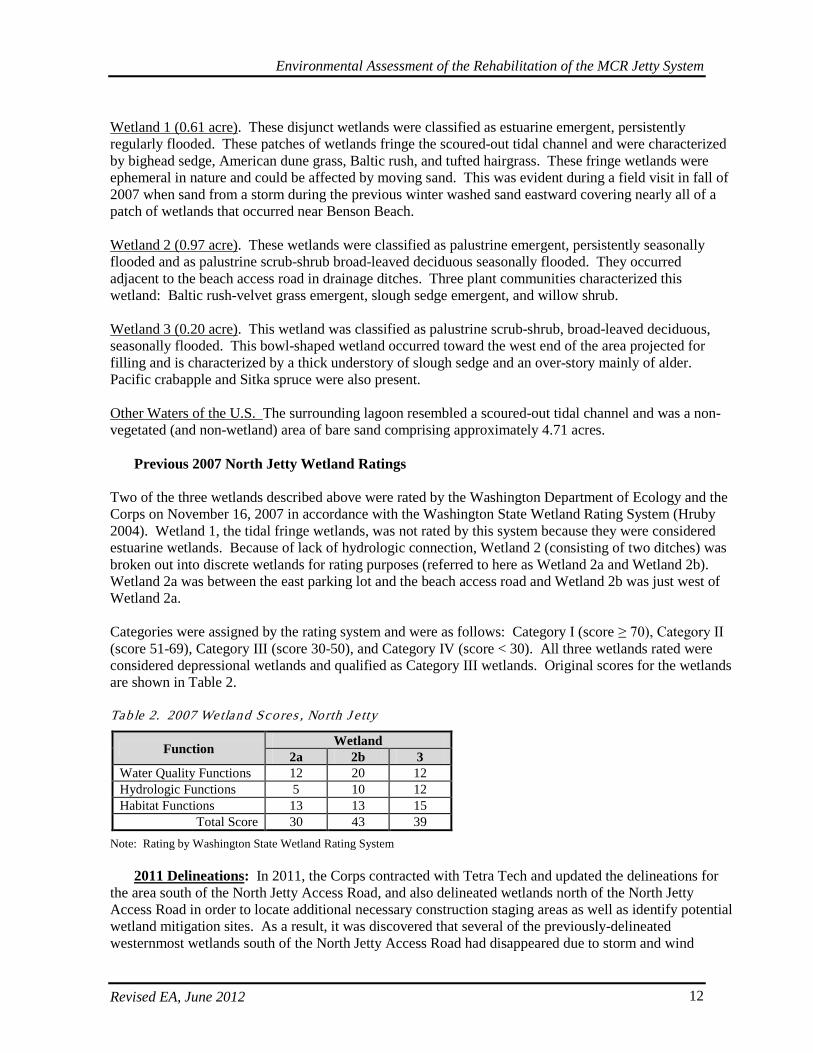
Previous 2007 North Jetty Wetland Ratings Two of the three wetlands described above were rated by the Washington Department of Ecology and the Corps on November 16, 2007 in accordance with the Washington State Wetland Rating System (Hruby 2004). Wetland 1, the tidal fringe wetlands, was not rated by this system because they were considered estuarine wetlands. Because of lack of hydrologic connection, Wetland 2 (consisting of two ditches) was broken out into discrete wetlands for rating purposes (referred to here as Wetland 2a and Wetland 2b). Wetland 2a was between the east parking lot and the beach access road and Wetland 2b was just west of Wetland 2a. Categories were assigned by the rating system and were as follows: Category I (score ≥ 70), Category II (score 51-69), Category III (score 30-50), and Category IV (score < 30). All three wetlands rated were considered depressional wetlands and qualified as Category III wetlands. Original scores for the wetlands are shown in Table 2. Tab le 2. 2007 Wetland Scores , North J e tty
Function Wetland 2a 2b 3
Water Quality Functions 12 20 12 Hydrologic Functions 5 10 12 Habitat Functions 13 13 15
Total Score 30 43 39 Note: Rating by Washington State Wetland Rating System
2011 Delineations: In 2011, the Corps contracted with Tetra Tech and updated the delineations for the area south of the North Jetty Access Road, and also delineated wetlands north of the North Jetty Access Road in order to locate additional necessary construction staging areas as well as identify potential wetland mitigation sites. As a result, it was discovered that several of the previously-delineated westernmost wetlands south of the North Jetty Access Road had disappeared due to storm and wind
Environmental Assessment of the Rehabilitation of the MCR Jetty System
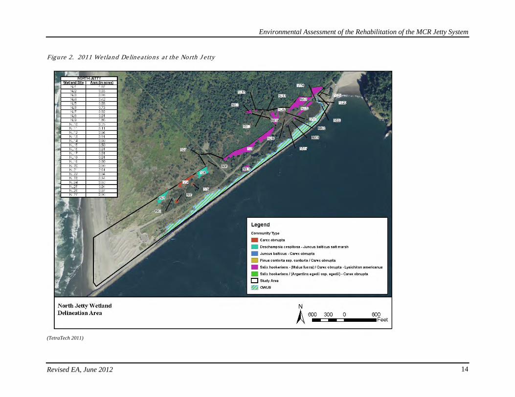
Revised EA, June 2012 13
activity, and the remaining wetlands were somewhat smaller for the same reasons. In contrast, the lagoon area increased due to scour action at the interior jetty root. The following figure indicates the wetlands or wetland mosaics that were identified both north and south of the North Jetty Access Road.
Environmental Assessment of the Rehabilitation of the MCR Jetty System
Revised EA, June 2012 14
Figure 2. 2011 Wetland Delinea tions a t the North J e tty
(TetraTech 2011)
Environmental Assessment of the Rehabilitation of the MCR Jetty System
Revised EA, June 2012 15
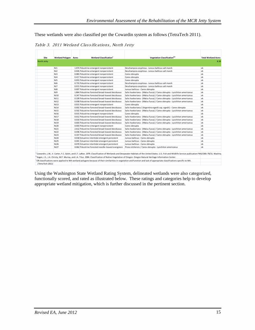
These wetlands were also classified per the Cowardin system as follows (TetraTech 2011). Tab le 3. 2011 Wetland Clas s ifica tions , No rth J e tty
Using the Washington State Wetland Rating System, delineated wetlands were also categorized, functionally scored, and rated as illustrated below. These ratings and categories help to develop appropriate wetland mitigation, which is further discussed in the pertinent section.
Site Wetland Polygon Acres Wetland Classificationa Vegetation Classificationb/c Total Wetland Acres
North Jetty 8.38
NJ1 1.074 Palustrine emergent nonpersistent Deschampsia cespitosa - Juncus balticus salt marsh okNJ2 0.026 Palustrine emergent nonpersistent Deschampsia cespitosa - Juncus balticus salt marsh okNJ3 0.083 Palustrine emergent nonpersistent Carex obnupta okNJ4 0.417 Palustrine emergent nonpersistent Carex obnupta okNJ5 0.033 Palustrine emergent nonpersistent Carex obnupta okNJ6 0.733 Palustrine emergent nonpersistent Deschampsia cespitosa - Juncus balticus salt marsh okNJ7 0.015 Palustrine emergent nonpersistent Deschampsia cespitosa - Juncus balticus salt marsh okNJ8 0.007 Palustrine emergent nonpersistent Juncus balticus - Carex obnupta okNJ9 1.864 Palustrine forested broad-leaved deciduous Salix hookeriana - (Malus fusca) / Carex obnupta - Lysichiton americanus okNJ10 0.247 Palustrine forested broad-leaved deciduous Salix hookeriana - (Malus fusca) / Carex obnupta - Lysichiton americanus okNJ11 0.109 Palustrine forested broad-leaved deciduous Salix hookeriana - (Malus fusca) / Carex obnupta - Lysichiton americanus okNJ12 0.038 Palustrine forested broad-leaved deciduous Salix hookeriana - (Malus fusca) / Carex obnupta - Lysichiton americanus okNJ13 0.015 Palustrine emergent nonpersistent Carex obnupta okNJ14 0.002 Palustrine forested broad-leaved deciduous Salix hookeriana / (Argentina egedii ssp. egedii) - Carex obnupta okNJ15 0.502 Palustrine forested broad-leaved deciduous Salix hookeriana - (Malus fusca) / Carex obnupta - Lysichiton americanus okNJ16 0.015 Palustrine emergent nonpersistent Carex obnupta okNJ17 0.012 Palustrine forested broad-leaved deciduous Salix hookeriana - (Malus fusca) / Carex obnupta - Lysichiton americanus okNJ18 0.010 Palustrine forested broad-leaved deciduous Salix hookeriana - (Malus fusca) / Carex obnupta - Lysichiton americanus okNJ19 0.003 Palustrine forested broad-leaved deciduous Salix hookeriana - (Malus fusca) / Carex obnupta - Lysichiton americanus okNJ20 0.003 Palustrine emergent nonpersistent Carex obnupta okNJ21 2.612 Palustrine forested broad-leaved deciduous Salix hookeriana - (Malus fusca) / Carex obnupta - Lysichiton americanus okNJ22 0.036 Palustrine forested broad-leaved deciduous Salix hookeriana - (Malus fusca) / Carex obnupta - Lysichiton americanus okNJ23 0.337 Palustrine forested broad-leaved deciduous Salix hookeriana - (Malus fusca) / Carex obnupta - Lysichiton americanus okNJ24 0.018 Estuarine intertidal emergent persistent Juncus balticus - Carex obnupta okNJ25 0.041 Estuarine intertidal emergent persistent Juncus balticus - Carex obnupta okNJ26 0.070 Estuarine intertidal emergent persistent Juncus balticus - Carex obnupta okNJ27 0.062 Palustrine forested needle-leaved evergreen Picea sitchensis / Carex obnupta - Lysichiton americanus ok
a Cowardin, L.M., V. Carter, F.C. Golet, and E.T. LaRoe. 1979. Classification of Wetlands and Deepwater Habitats of the United States. U.S. Fish and Wildlife Service publication FWS/OBS-79/31. Washing b Kagan, J.S., J.A. Christy, M.P. Murray, and J.A. Titus. 2004. Classification of Native Vegetation of Oregon. Oregon Natural Heritage Information Center. c OR classifications were applied to WA wetland polygons because of their similarities in vegetation and function and lack of appropriate classifications specific to WA.
(TetraTech 2011)
Environmental Assessment of the Rehabilitation of the MCR Jetty System
Revised EA, June 2012 16
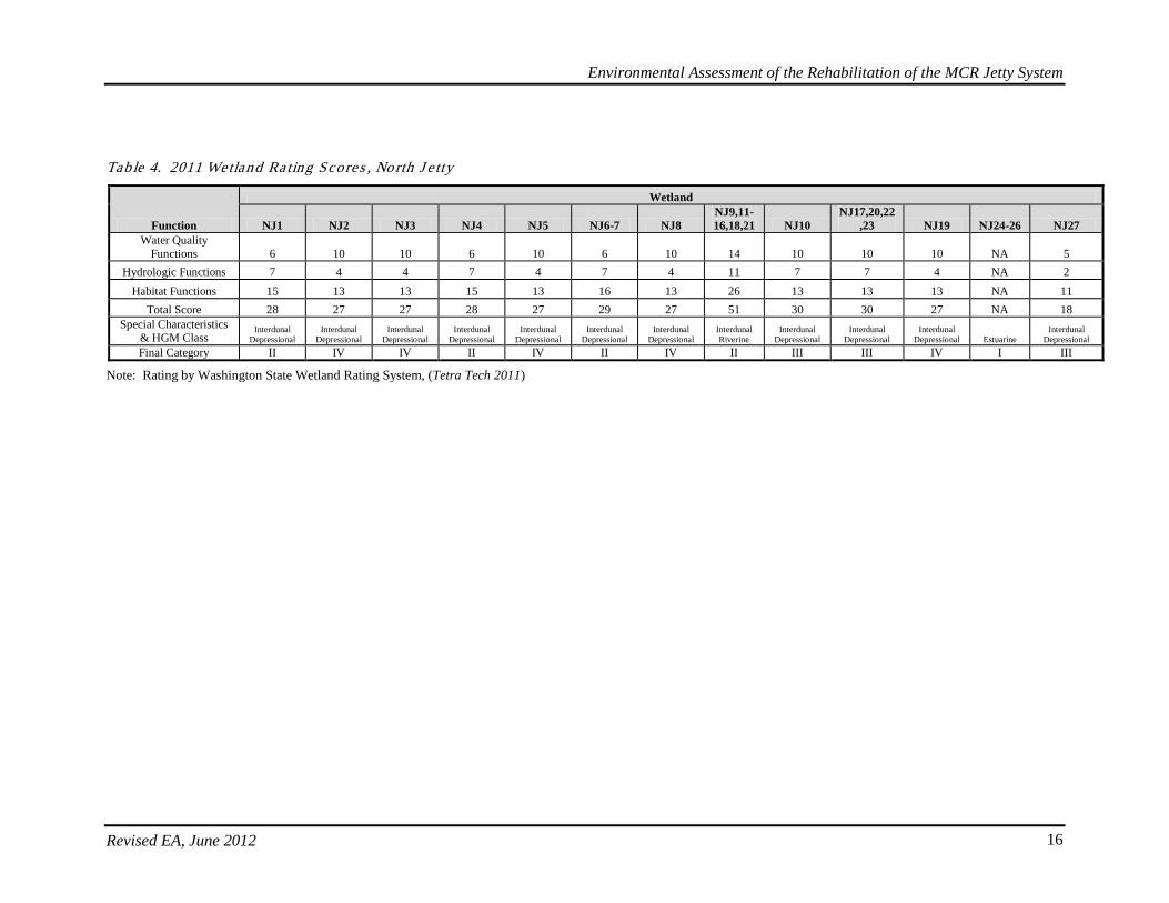
Tab le 4. 2011 Wetland Ra ting Scores , No rth J e tty
Function
Wetland
NJ1 NJ2 NJ3 NJ4 NJ5 NJ6-7 NJ8 NJ9,11-16,18,21 NJ10
NJ17,20,22,23 NJ19 NJ24-26 NJ27
Water Quality Functions 6 10 10 6 10 6 10 14 10 10 10 NA 5
Hydrologic Functions 7 4 4 7 4 7 4 11 7 7 4 NA 2 Habitat Functions 15 13 13 15 13 16 13 26 13 13 13 NA 11
Total Score 28 27 27 28 27 29 27 51 30 30 27 NA 18 Special Characteristics
& HGM Class Interdunal
Depressional Interdunal
Depressional Interdunal
Depressional Interdunal
Depressional Interdunal
Depressional Interdunal
Depressional Interdunal
Depressional Interdunal Riverine
Interdunal Depressional
Interdunal Depressional
Interdunal Depressional Estuarine
Interdunal Depressional
Final Category II IV IV II IV II IV II III III IV I III
Note: Rating by Washington State Wetland Rating System, (Tetra Tech 2011)
Environmental Assessment of the Rehabilitation of the MCR Jetty System
Revised EA, June 2012 17
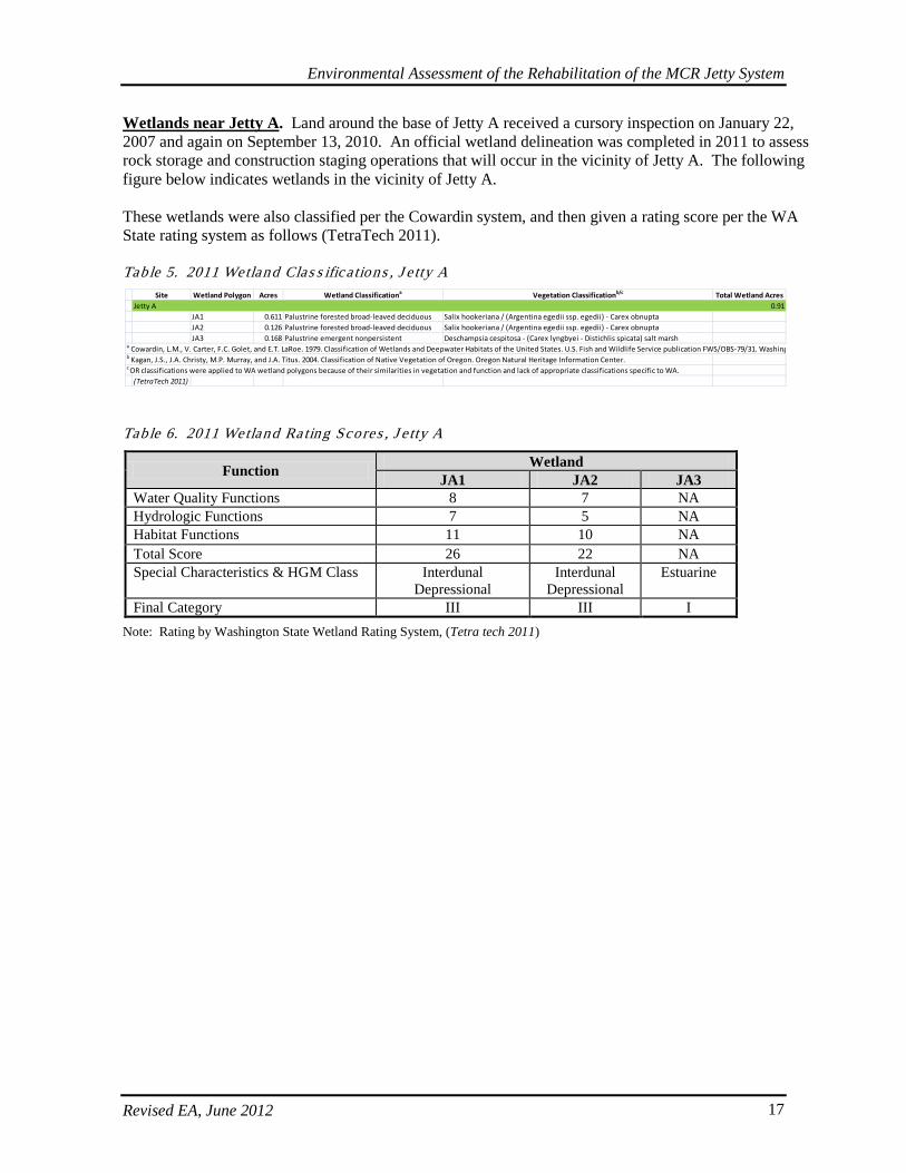
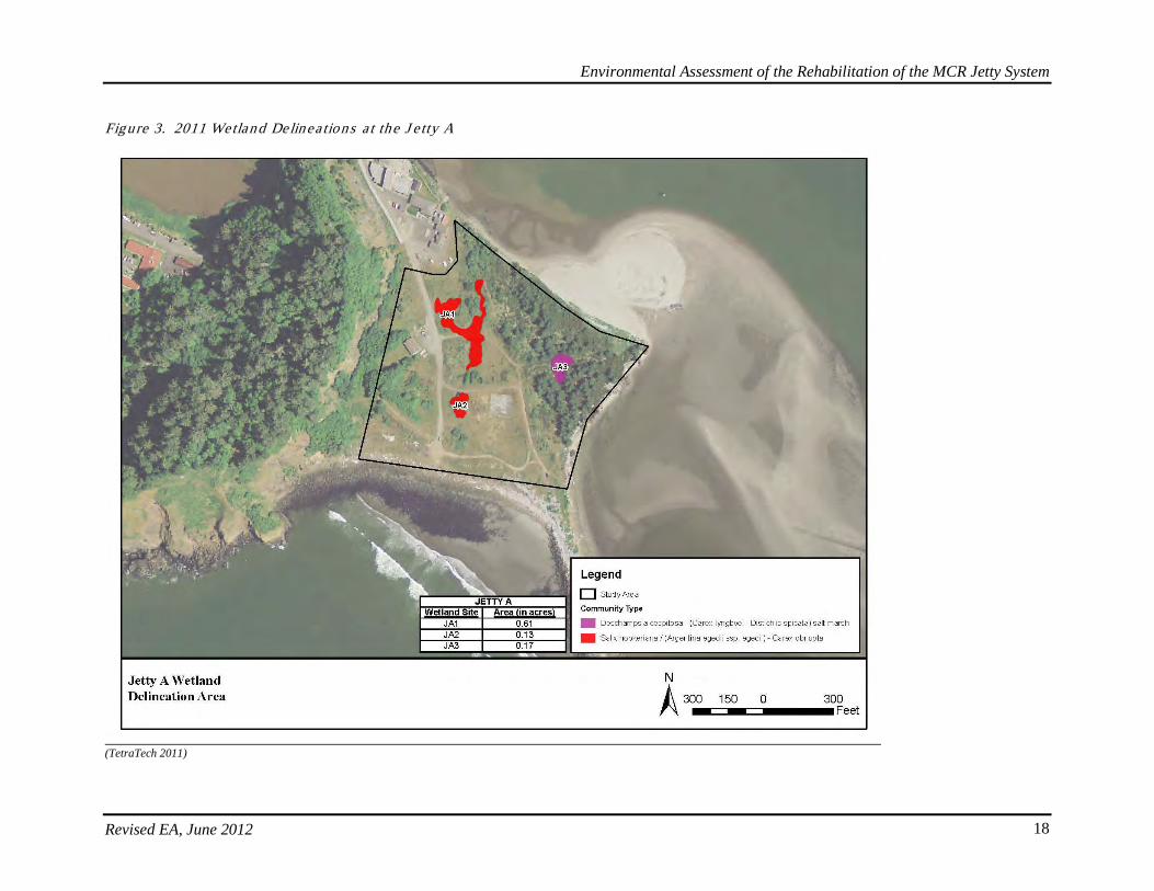
Wetlands near Jetty A. Land around the base of Jetty A received a cursory inspection on January 22, 2007 and again on September 13, 2010. An official wetland delineation was completed in 2011 to assess rock storage and construction staging operations that will occur in the vicinity of Jetty A. The following figure below indicates wetlands in the vicinity of Jetty A. These wetlands were also classified per the Cowardin system, and then given a rating score per the WA State rating system as follows (TetraTech 2011). Tab le 5. 2011 Wetland Clas s ifica tions , J e tty A
Tab le 6. 2011 Wetland Ra ting Scores , J e tty A
Function Wetland JA1 JA2 JA3
Water Quality Functions 8 7 NA Hydrologic Functions 7 5 NA Habitat Functions 11 10 NA Total Score 26 22 NA Special Characteristics & HGM Class Interdunal
Depressional Interdunal
Depressional Estuarine
Final Category III III I Note: Rating by Washington State Wetland Rating System, (Tetra tech 2011)
Site Wetland Polygon Acres Wetland Classificationa Vegetation Classificationb/c Total Wetland AcresJetty A 0.91
JA1 0.611 Palustrine forested broad-leaved deciduous Salix hookeriana / (Argentina egedii ssp. egedii) - Carex obnuptaJA2 0.126 Palustrine forested broad-leaved deciduous Salix hookeriana / (Argentina egedii ssp. egedii) - Carex obnuptaJA3 0.168 Palustrine emergent nonpersistent Deschampsia cespitosa - (Carex lyngbyei - Distichlis spicata) salt marsh
a Cowardin, L.M., V. Carter, F.C. Golet, and E.T. LaRoe. 1979. Classification of Wetlands and Deepwater Habitats of the United States. U.S. Fish and Wildlife Service publication FWS/OBS-79/31. Washing b Kagan, J.S., J.A. Christy, M.P. Murray, and J.A. Titus. 2004. Classification of Native Vegetation of Oregon. Oregon Natural Heritage Information Center. c OR classifications were applied to WA wetland polygons because of their similarities in vegetation and function and lack of appropriate classifications specific to WA.
(TetraTech 2011)
Environmental Assessment of the Rehabilitation of the MCR Jetty System
Revised EA, June 2012 18
Figure 3. 2011 Wetland Delinea tions a t the J e tty A
(TetraTech 2011)
Environmental Assessment of the Rehabilitation of the MCR Jetty System
Revised EA, June 2012 19
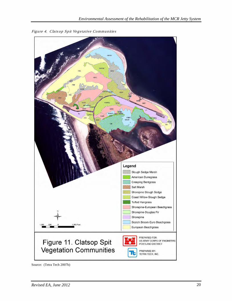
Wetlands near South Jetty (on Clatsop Spit). An investigation into vegetation communities on Clatsop Spit was conducted in spring of 2007 (Tetra Tech 2007b). See the first figure below. Though not official delineations, these habitat surveys suggested that of the 600-acres of Clatsop Spit investigated, 193-acres were likely wetlands (Tetra Tech 2007b). The topography of the area is complex with dunes and intertidal swales forming a mosaic of various vegetation communities including shorepine-slough sedge, slough sedge marsh, American dune grass, creeping bent grass, salt marsh, coast willow-slough sedge, tufted hair grass, shorepine-European beach grass, shorepine-Douglas fir, shorepine, Scotch broom-European beach grass, and European beach grass (Figure 2). At least three of these communities (shorepine-slough sedge, shorepine-Douglas fir, and coast willow-slough sedge) have been ranked globally and by the State for their rarity and vulnerability to extinction and should be protected from impacts (Tetra Tech 2007b). It is anticipated that the proposed action will avoid most impacts to wetlands and waters of the United States in this area to the maximum degree feasible. The vegetation surveys allowed initial identification of possible locations for construction storage, staging, and stockpiling areas. In order to further avoid and minimize impacts, wetland delineations were also completed by Tetra Tech at the South Jetty in 2011 in the vicinity of the areas under consideration for construction staging and stockpiling as well as mitigation. The following series of figures after the Vegetative Communities figure indicate areas in which wetlands were identified. The Cowardin classifications and vegetative communities for each class are also described in the tables below. Wetlands at the South Jetty and South Jetty mitigation area were also scored based on their functional conditions and values, though differently than the process used in Washington. The method used to evaluate wetlands at the Clatsop Spit was Oregon Rapid Wetlands Assessment Protocol (ORWAP) 2.0.2, which was developed in partnership by the OR Department of State Lands (DSL), the US EPA, and the Portland District Regulatory Branch (ORWAP 2010). Functional output scores are based on the following parameters: Water Storage; Sediment Retention; Phosphorus Retention; Nitrate Removal; Thermoregulation; Carbon Sequestration; Organic Matter Export; Aquatic Invertebrate Habitat; Anadromous Fish Habitat; Non-anadromous Fish Habitat; Amphibian and Reptile Habitat; Waterbird Feeding Habitat; Waterbird Nesting Habitat; Songbird, Raptor, and Mammal Habitat; Pollinator Habitat; and Native Plant Diversity. Grouped Service Functions include: Hydrologic; Water Quality Support; Fish Support; Aquatic Support; Terrestrial Support; and Carbon Sequestration. Value scores include the same categories, with the following exceptions: Carbon Sequestration and Organic Matter Export are not included; and in the Grouped Service Values, Carbon Sequestration is replaced by Public Use and Recognition, and Provisioning. Functions are considered the physical, chemical, and biological processes that characterize the wetland ecosystem; while values reflect the importance or worth of wetland functions to societal needs (ORWAP 2010). According to ORWAP guidance, scores that rank above the median threshold relative to 221 state-scored wetlands can be considered “relatively high” for that output, and conversely, “relatively low” if the opposite is true (ORWAP 2010).
Environmental Assessment of the Rehabilitation of the MCR Jetty System
Revised EA, June 2012 20
Figure 4. Cla ts op Sp it Vegeta tive Communities
Source: (Tetra Tech 2007b)
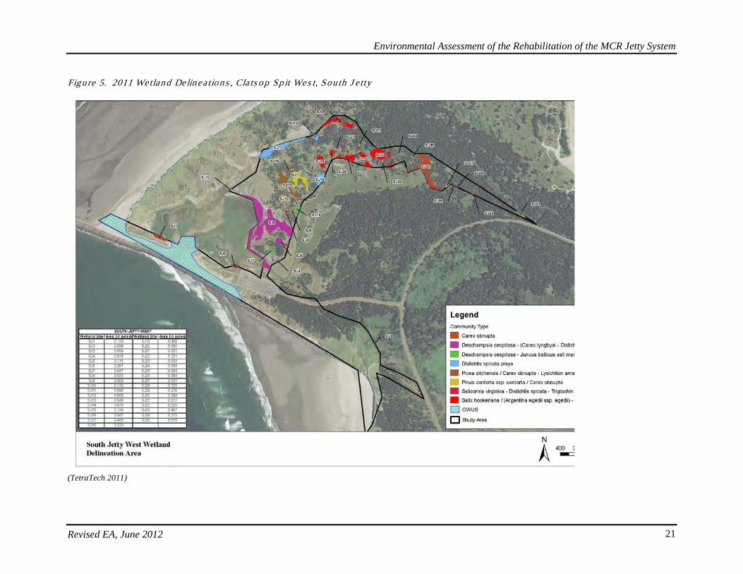
Environmental Assessment of the Rehabilitation of the MCR Jetty System
Revised EA, June 2012 21
Figure 5. 2011 Wetland Delinea tions , Cla ts op Sp it Wes t, Sou th J e tty
(TetraTech 2011)
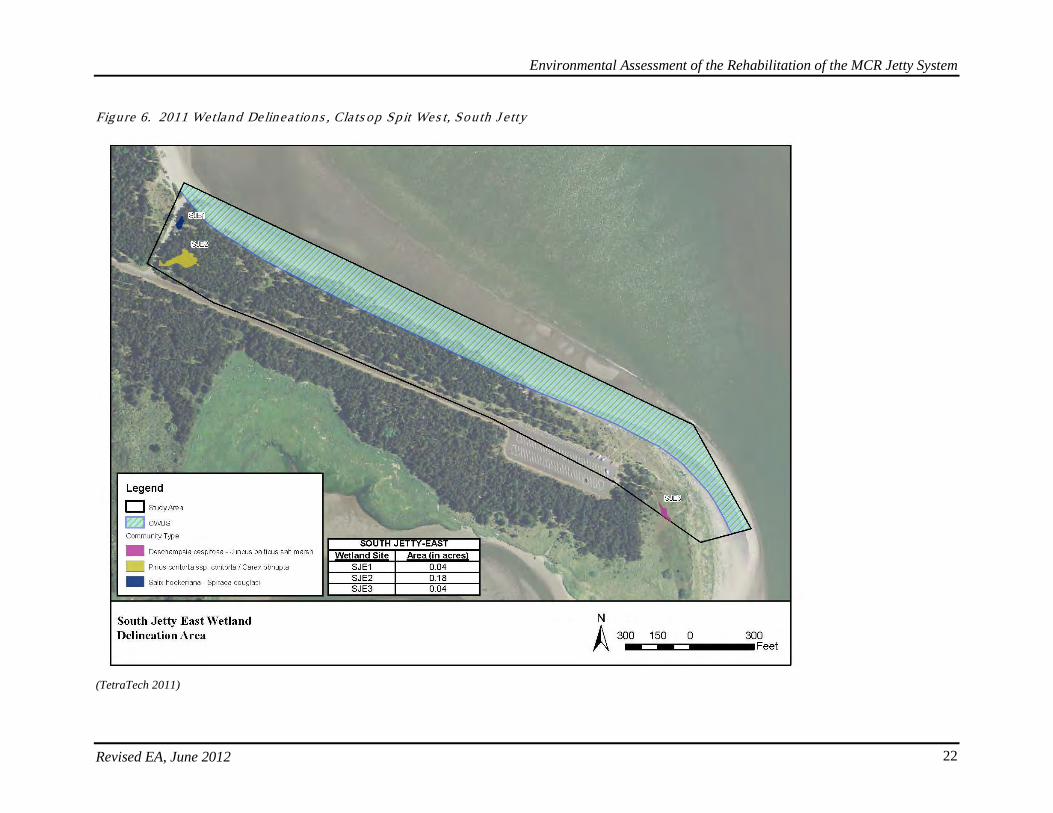
Environmental Assessment of the Rehabilitation of the MCR Jetty System
Revised EA, June 2012 22
Figure 6. 2011 Wetland Delinea tions , Cla ts op Sp it Wes t, Sou th J e tty
(TetraTech 2011)
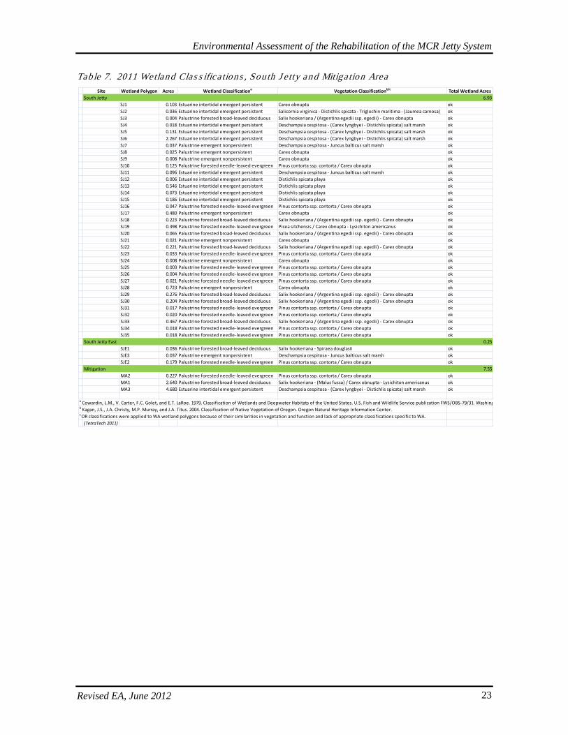
Environmental Assessment of the Rehabilitation of the MCR Jetty System
Revised EA, June 2012 23
Table 7. 2011 Wetland Clas s ifica tions , Sou th J e tty and Mitiga tion Area
Site Wetland Polygon Acres Wetland Classificationa Vegetation Classificationb/c Total Wetland AcresSouth Jetty 6.93
SJ1 0.103 Estuarine intertidal emergent persistent Carex obnupta okSJ2 0.036 Estuarine intertidal emergent persistent Salicornia virginica - Distichlis spicata - Triglochin maritima - (Jaumea carnosa) okSJ3 0.004 Palustrine forested broad-leaved deciduous Salix hookeriana / (Argentina egedii ssp. egedii) - Carex obnupta okSJ4 0.018 Estuarine intertidal emergent persistent Deschampsia cespitosa - (Carex lyngbyei - Distichlis spicata) salt marsh okSJ5 0.131 Estuarine intertidal emergent persistent Deschampsia cespitosa - (Carex lyngbyei - Distichlis spicata) salt marsh okSJ6 2.267 Estuarine intertidal emergent persistent Deschampsia cespitosa - (Carex lyngbyei - Distichlis spicata) salt marsh okSJ7 0.037 Palustrine emergent nonpersistent Deschampsia cespitosa - Juncus balticus salt marsh okSJ8 0.025 Palustrine emergent nonpersistent Carex obnupta okSJ9 0.008 Palustrine emergent nonpersistent Carex obnupta okSJ10 0.125 Palustrine forested needle-leaved evergreen Pinus contorta ssp. contorta / Carex obnupta okSJ11 0.096 Estuarine intertidal emergent persistent Deschampsia cespitosa - Juncus balticus salt marsh okSJ12 0.006 Estuarine intertidal emergent persistent Distichlis spicata playa okSJ13 0.546 Estuarine intertidal emergent persistent Distichlis spicata playa ok SJ14 0.073 Estuarine intertidal emergent persistent Distichlis spicata playa okSJ15 0.186 Estuarine intertidal emergent persistent Distichlis spicata playa okSJ16 0.047 Palustrine forested needle-leaved evergreen Pinus contorta ssp. contorta / Carex obnupta okSJ17 0.480 Palustrine emergent nonpersistent Carex obnupta okSJ18 0.223 Palustrine forested broad-leaved deciduous Salix hookeriana / (Argentina egedii ssp. egedii) - Carex obnupta okSJ19 0.398 Palustrine forested needle-leaved evergreen Picea sitchensis / Carex obnupta - Lysichiton americanus okSJ20 0.065 Palustrine forested broad-leaved deciduous Salix hookeriana / (Argentina egedii ssp. egedii) - Carex obnupta okSJ21 0.021 Palustrine emergent nonpersistent Carex obnupta okSJ22 0.221 Palustrine forested broad-leaved deciduous Salix hookeriana / (Argentina egedii ssp. egedii) - Carex obnupta okSJ23 0.033 Palustrine forested needle-leaved evergreen Pinus contorta ssp. contorta / Carex obnupta okSJ24 0.008 Palustrine emergent nonpersistent Carex obnupta okSJ25 0.003 Palustrine forested needle-leaved evergreen Pinus contorta ssp. contorta / Carex obnupta okSJ26 0.004 Palustrine forested needle-leaved evergreen Pinus contorta ssp. contorta / Carex obnupta okSJ27 0.021 Palustrine forested needle-leaved evergreen Pinus contorta ssp. contorta / Carex obnupta okSJ28 0.723 Palustrine emergent nonpersistent Carex obnupta okSJ29 0.276 Palustrine forested broad-leaved deciduous Salix hookeriana / (Argentina egedii ssp. egedii) - Carex obnupta okSJ30 0.204 Palustrine forested broad-leaved deciduous Salix hookeriana / (Argentina egedii ssp. egedii) - Carex obnupta okSJ31 0.017 Palustrine forested needle-leaved evergreen Pinus contorta ssp. contorta / Carex obnupta okSJ32 0.020 Palustrine forested needle-leaved evergreen Pinus contorta ssp. contorta / Carex obnupta okSJ33 0.467 Palustrine forested broad-leaved deciduous Salix hookeriana / (Argentina egedii ssp. egedii) - Carex obnupta okSJ34 0.018 Palustrine forested needle-leaved evergreen Pinus contorta ssp. contorta / Carex obnupta okSJ35 0.018 Palustrine forested needle-leaved evergreen Pinus contorta ssp. contorta / Carex obnupta ok
South Jetty East 0.25SJE1 0.036 Palustrine forested broad-leaved deciduous Salix hookeriana - Spiraea douglasii okSJE3 0.037 Palustrine emergent nonpersistent Deschampsia cespitosa - Juncus balticus salt marsh okSJE2 0.179 Palustrine forested needle-leaved evergreen Pinus contorta ssp. contorta / Carex obnupta ok
Mitigation 7.55MA2 0.227 Palustrine forested needle-leaved evergreen Pinus contorta ssp. contorta / Carex obnupta okMA1 2.640 Palustrine forested broad-leaved deciduous Salix hookeriana - (Malus fusca) / Carex obnupta - Lysichiton americanus okMA3 4.680 Estuarine intertidal emergent persistent Deschampsia cespitosa - (Carex lyngbyei - Distichlis spicata) salt marsh ok
a Cowardin, L.M., V. Carter, F.C. Golet, and E.T. LaRoe. 1979. Classification of Wetlands and Deepwater Habitats of the United States. U.S. Fish and Wildlife Service publication FWS/OBS-79/31. Washing b Kagan, J.S., J.A. Christy, M.P. Murray, and J.A. Titus. 2004. Classification of Native Vegetation of Oregon. Oregon Natural Heritage Information Center. c OR classifications were applied to WA wetland polygons because of their similarities in vegetation and function and lack of appropriate classifications specific to WA.
(TetraTech 2011)
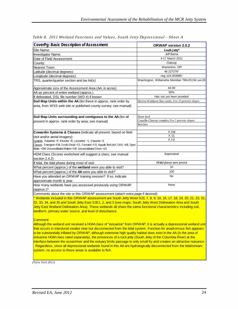
Environmental Assessment of the Rehabilitation of the MCR Jetty System
Revised EA, June 2012 24
Tab le 8. 2011 Wetland Fu nctions and Values , Sou th J e tty Dep res s iona l – Sh ee t A
(Tetra Tech 2011)
CoverPg: Basic Description of Assessment ORWAP version 2.0.2Site Name: South Jetty*Investigator Name: Jeff BarnaDate of Field Assessment: 4-17 March 2011County: ClatsopNearest Town: Warrenton, ORLatitude (decimal degrees): 46.227276°Longitude (decimal degrees): neg 124.003985°TRS, quarter/quarter section and tax lot(s) Washington, Willamette Meridian T9N,R11W,sec26
Approximate size of the Assessment Area (AA, in acres) 44.00AA as percent of entire wetland (approx.) 50%If delineated, DSL file number (WD #) if known Has not yet been provided
Heceta-Waldport fine sands, 0 to 15 percent slopes
Dune landCoquille-Clatsop complex, 0 to 1 percent slopesBeaches
P, EMP, SSP, FO
HGM Class (Scores worksheet will suggest a class; see manual section 2.4.2)
Depressional
If tidal, the tidal phase during most of visit: All tidal phases were presentWhat percent (approx.) of the wetland were you able to visit? 10
What percent (approx.) of the AA were you able to visit? 100
Have you attended an ORWAP training session? If so, indicate approximate month & year.
No
How many wetlands have you assessed previously using ORWAP (approx.)?
None
Soil Map Units within the AA (list these in approx. rank order by area, from WSS web site or published county survey; see manual)
Soil Map Units surrounding and contiguous to the AA (list all present in approx. rank order by area; see manual)
Cowardin Systems & Classes (indicate all present, based on field visit and/or aerial imagery): Systems: Palustrine =P, Riverine =R, Lacustrine =L, Estuarine =EClasses: Emergent =EM, Scrub-Shrub =SS, Forested =FO, Aquatic Bed (incl. SAV) =AB, Open Water =OW, Unconsolidated Bottom =UB, Unconsolidated Shore =US
Comments about the site or this ORWAP assessment (attach extra page if desired):* Wetlands included in this ORWAP assessment are South Jetty West SJ3, 7, 8, 9, 10, 16, 17, 18, 19, 20, 21, 23, 31, 32, 33, 34, and 35 and South Jetty East SJE1, 2, and 3 (see maps; South Jetty West Delineation Area and South Jetty East Wetland Delineation Area). These wetlands all share the same functional characteristics including soil, landform, primary water source, and level of disturbance.
Comment: Although the wetland unit received a HGM class of "estuarine" from ORWAP, it is actually a depressional wetland unit that occurs in interdunal swales near but disconnected from the tidal system. Function for anadromous fish appears to be substantially inflated by ORWAP; although extensive high quality habitat does exist in the AA (in the area of estuarine HGM class rated separately), the presences of a rock jetty (South Jetty of the Columbia River) at the interface between the ocean/river and the estuary limits passage to only small fry and creates an attractive nuisance . Regardless, since all depressional wetlands found in this AA are hydrologically disconnected from the tidal/stream system, no access to these areas is available to fish.
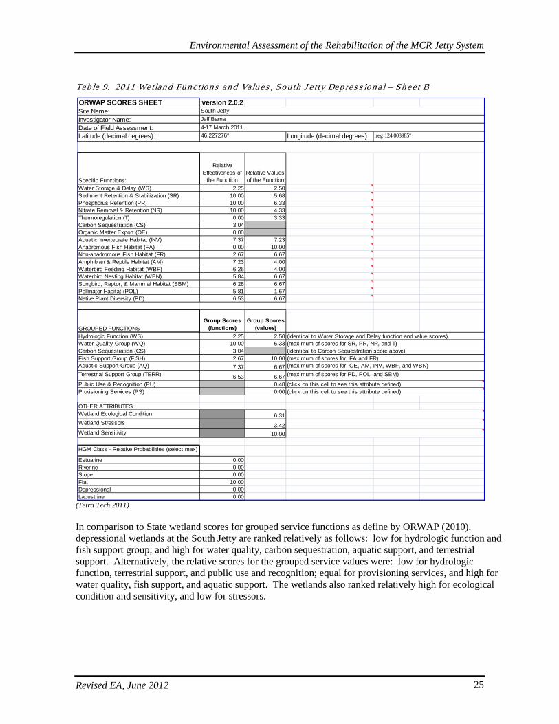
Environmental Assessment of the Rehabilitation of the MCR Jetty System
Revised EA, June 2012 25
Tab le 9. 2011 Wetland Fu nctions and Values , Sou th J e tty Dep res s iona l – Sh ee t B
(Tetra Tech 2011) In comparison to State wetland scores for grouped service functions as define by ORWAP (2010), depressional wetlands at the South Jetty are ranked relatively as follows: low for hydrologic function and fish support group; and high for water quality, carbon sequestration, aquatic support, and terrestrial support. Alternatively, the relative scores for the grouped service values were: low for hydrologic function, terrestrial support, and public use and recognition; equal for provisioning services, and high for water quality, fish support, and aquatic support. The wetlands also ranked relatively high for ecological condition and sensitivity, and low for stressors.
ORWAP SCORES SHEET version 2.0.2Site Name:Investigator Name:Date of Field Assessment:Latitude (decimal degrees): Longitude (decimal degrees):
Specific Functions:
Relative Effectiveness of
the FunctionRelative Values of the Function
Water Storage & Delay (WS) 2.25 2.50Sediment Retention & Stabilization (SR) 10.00 5.68Phosphorus Retention (PR) 10.00 6.33Nitrate Removal & Retention (NR) 10.00 4.33Thermoregulation (T) 0.00 3.33Carbon Sequestration (CS) 3.04Organic Matter Export (OE) 0.00Aquatic Invertebrate Habitat (INV) 7.37 7.23Anadromous Fish Habitat (FA) 0.00 10.00Non-anadromous Fish Habitat (FR) 2.67 6.67Amphibian & Reptile Habitat (AM) 7.23 4.00Waterbird Feeding Habitat (WBF) 6.26 4.00Waterbird Nesting Habitat (WBN) 5.84 6.67Songbird, Raptor, & Mammal Habitat (SBM) 6.28 6.67Pollinator Habitat (POL) 5.81 1.67Native Plant Diversity (PD) 6.53 6.67
GROUPED FUNCTIONSGroup Scores
(functions)Group Scores
(values)Hydrologic Function (WS) 2.25 2.50Water Quality Group (WQ) 10.00 6.33Carbon Sequestration (CS) 3.04Fish Support Group (FISH) 2.67 10.00Aquatic Support Group (AQ) 7.37 6.67Terrestrial Support Group (TERR) 6.53 6.67Public Use & Recognition (PU) 0.48Provisioning Services (PS) 0.00
OTHER ATTRIBUTESWetland Ecological Condition 6.31Wetland Stressors 3.42Wetland Sensitivity 10.00
HGM Class - Relative Probabilities (select max)
Estuarine 0.00Riverine 0.00Slope 0.00Flat 10.00Depressional 0.00Lacustrine 0.00
(identical to Water Storage and Delay function and value scores)(maximum of scores for SR, PR, NR, and T)
(maximum of scores for OE, AM, INV, WBF, and WBN)(maximum of scores for FA and FR)
(click on this cell to see this attribute defined)(click on this cell to see this attribute defined)
(maximum of scores for PD, POL, and SBM)
(identical to Carbon Sequestration score above)
South JettyJeff Barna4-17 March 201146.227276° neg 124.003985°
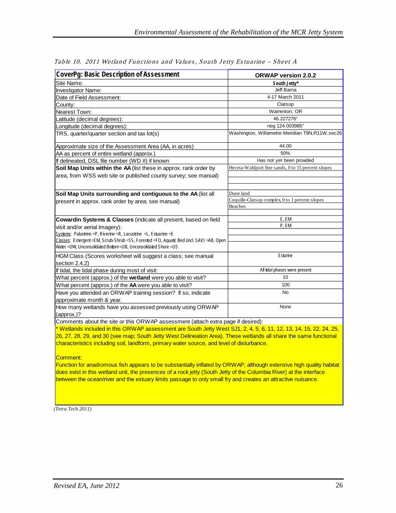
Environmental Assessment of the Rehabilitation of the MCR Jetty System
Revised EA, June 2012 26
Tab le 10. 2011 Wetland Functions and Values , Sou th J e tty Es tua rine – Shee t A
(Tetra Tech 2011)
CoverPg: Basic Description of Assessment ORWAP version 2.0.2Site Name: South Jetty*Investigator Name: Jeff BarnaDate of Field Assessment: 4-17 March 2011County: ClatsopNearest Town: Warrenton, ORLatitude (decimal degrees): 46.227276°Longitude (decimal degrees): neg 124.003985°TRS, quarter/quarter section and tax lot(s) Washington, Willamette Meridian T9N,R11W,sec26
Approximate size of the Assessment Area (AA, in acres) 44.00AA as percent of entire wetland (approx.) 50%If delineated, DSL file number (WD #) if known Has not yet been provided
Heceta-Waldport fine sands, 0 to 15 percent slopes
Dune landCoquille-Clatsop complex, 0 to 1 percent slopesBeaches
E, EMP, EM
HGM Class (Scores worksheet will suggest a class; see manual section 2.4.2)
Esturine
If tidal, the tidal phase during most of visit: All tidal phases were presentWhat percent (approx.) of the wetland were you able to visit? 10
What percent (approx.) of the AA were you able to visit? 100
Have you attended an ORWAP training session? If so, indicate approximate month & year.
No
How many wetlands have you assessed previously using ORWAP (approx.)?
None
Soil Map Units within the AA (list these in approx. rank order by area, from WSS web site or published county survey; see manual)
Soil Map Units surrounding and contiguous to the AA (list all present in approx. rank order by area; see manual)
Cowardin Systems & Classes (indicate all present, based on field visit and/or aerial imagery): Systems: Palustrine =P, Riverine =R, Lacustrine =L, Estuarine =EClasses: Emergent =EM, Scrub-Shrub =SS, Forested =FO, Aquatic Bed (incl. SAV) =AB, Open Water =OW, Unconsolidated Bottom =UB, Unconsolidated Shore =US
Comments about the site or this ORWAP assessment (attach extra page if desired):* Wetlands included in this ORWAP assessment are South Jetty West SJ1, 2, 4, 5, 6, 11, 12, 13, 14, 15, 22, 24, 25, 26, 27, 28, 29, and 30 (see map; South Jetty West Delineation Area). These wetlands all share the same functional characteristics including soil, landform, primary water source, and level of disturbance.
Comment: Function for anadromous fish appears to be substantially inflated by ORWAP; although extensive high quality habitat does exist in this wetland unit, the presences of a rock jetty (South Jetty of the Columbia River) at the interface between the ocean/river and the estuary limits passage to only small fry and creates an attractive nuisance.
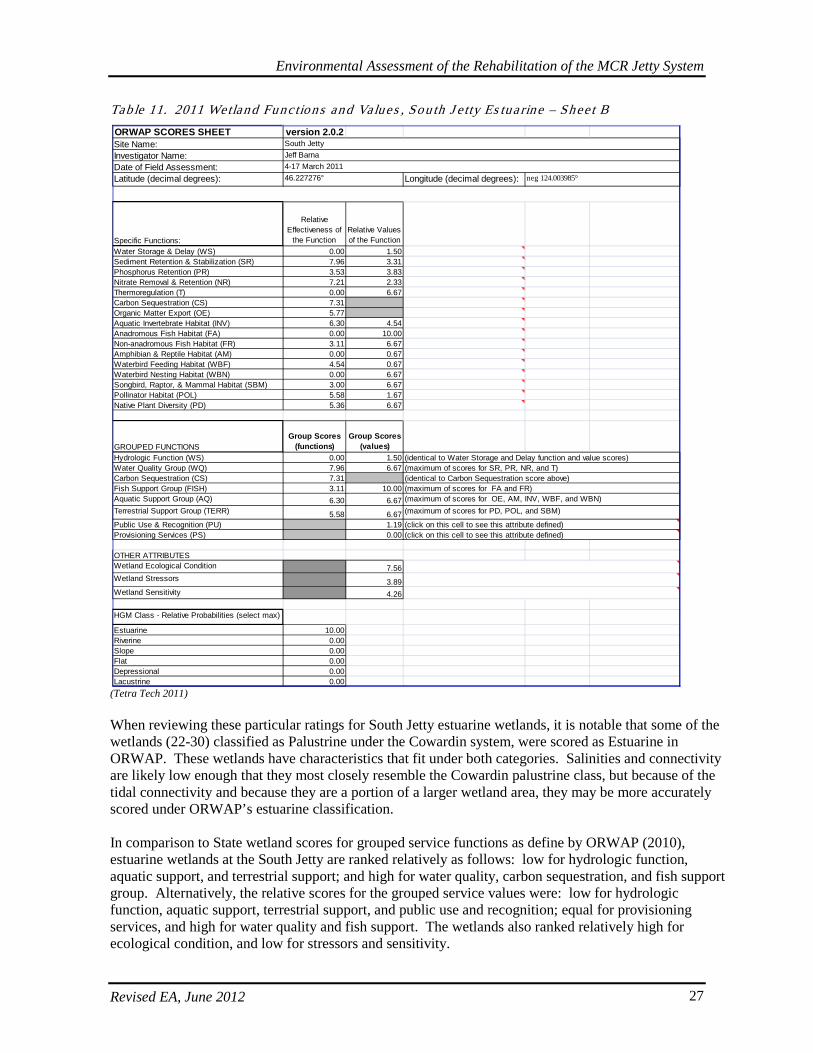
Environmental Assessment of the Rehabilitation of the MCR Jetty System
Revised EA, June 2012 27
Table 11. 2011 Wetland Functions and Values , Sou th J e tty Es tua rine – Shee t B
(Tetra Tech 2011) When reviewing these particular ratings for South Jetty estuarine wetlands, it is notable that some of the wetlands (22-30) classified as Palustrine under the Cowardin system, were scored as Estuarine in ORWAP. These wetlands have characteristics that fit under both categories. Salinities and connectivity are likely low enough that they most closely resemble the Cowardin palustrine class, but because of the tidal connectivity and because they are a portion of a larger wetland area, they may be more accurately scored under ORWAP’s estuarine classification. In comparison to State wetland scores for grouped service functions as define by ORWAP (2010), estuarine wetlands at the South Jetty are ranked relatively as follows: low for hydrologic function, aquatic support, and terrestrial support; and high for water quality, carbon sequestration, and fish support group. Alternatively, the relative scores for the grouped service values were: low for hydrologic function, aquatic support, terrestrial support, and public use and recognition; equal for provisioning services, and high for water quality and fish support. The wetlands also ranked relatively high for ecological condition, and low for stressors and sensitivity.
ORWAP SCORES SHEET version 2.0.2Site Name:Investigator Name:Date of Field Assessment:Latitude (decimal degrees): Longitude (decimal degrees):
Specific Functions:
Relative Effectiveness of
the FunctionRelative Values of the Function
Water Storage & Delay (WS) 0.00 1.50Sediment Retention & Stabilization (SR) 7.96 3.31Phosphorus Retention (PR) 3.53 3.83Nitrate Removal & Retention (NR) 7.21 2.33Thermoregulation (T) 0.00 6.67Carbon Sequestration (CS) 7.31Organic Matter Export (OE) 5.77Aquatic Invertebrate Habitat (INV) 6.30 4.54Anadromous Fish Habitat (FA) 0.00 10.00Non-anadromous Fish Habitat (FR) 3.11 6.67Amphibian & Reptile Habitat (AM) 0.00 0.67Waterbird Feeding Habitat (WBF) 4.54 0.67Waterbird Nesting Habitat (WBN) 0.00 6.67Songbird, Raptor, & Mammal Habitat (SBM) 3.00 6.67Pollinator Habitat (POL) 5.58 1.67Native Plant Diversity (PD) 5.36 6.67
GROUPED FUNCTIONSGroup Scores
(functions)Group Scores
(values)Hydrologic Function (WS) 0.00 1.50Water Quality Group (WQ) 7.96 6.67Carbon Sequestration (CS) 7.31Fish Support Group (FISH) 3.11 10.00Aquatic Support Group (AQ) 6.30 6.67Terrestrial Support Group (TERR) 5.58 6.67Public Use & Recognition (PU) 1.19Provisioning Services (PS) 0.00
OTHER ATTRIBUTESWetland Ecological Condition 7.56Wetland Stressors 3.89Wetland Sensitivity 4.26
HGM Class - Relative Probabilities (select max)
Estuarine 10.00Riverine 0.00Slope 0.00Flat 0.00Depressional 0.00Lacustrine 0.00
(identical to Carbon Sequestration score above)
South JettyJeff Barna4-17 March 201146.227276° neg 124.003985°
(identical to Water Storage and Delay function and value scores)(maximum of scores for SR, PR, NR, and T)
(maximum of scores for OE, AM, INV, WBF, and WBN)(maximum of scores for FA and FR)
(click on this cell to see this attribute defined)(click on this cell to see this attribute defined)
(maximum of scores for PD, POL, and SBM)
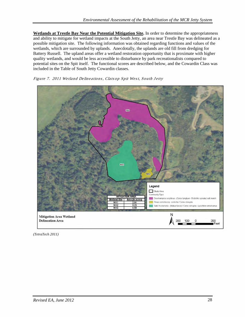
Environmental Assessment of the Rehabilitation of the MCR Jetty System
Revised EA, June 2012 28
Wetlands at Trestle Bay Near the Potential Mitigation Site. In order to determine the appropriateness and ability to mitigate for wetland impacts at the South Jetty, an area near Trestle Bay was delineated as a possible mitigation site. The following information was obtained regarding functions and values of the wetlands, which are surrounded by uplands. Anecdotally, the uplands are old fill from dredging for Battery Russell. The upland areas offer a wetland restoration opportunity that is proximate with higher quality wetlands, and would be less accessible to disturbance by park recreationalists compared to potential sites on the Spit itself. The functional scores are described below, and the Cowardin Class was included in the Table of South Jetty Cowardin classes. Figure 7. 2011 Wetland Delinea tions , Cla ts op Sp it Wes t, Sou th J e tty
(TetraTech 2011)
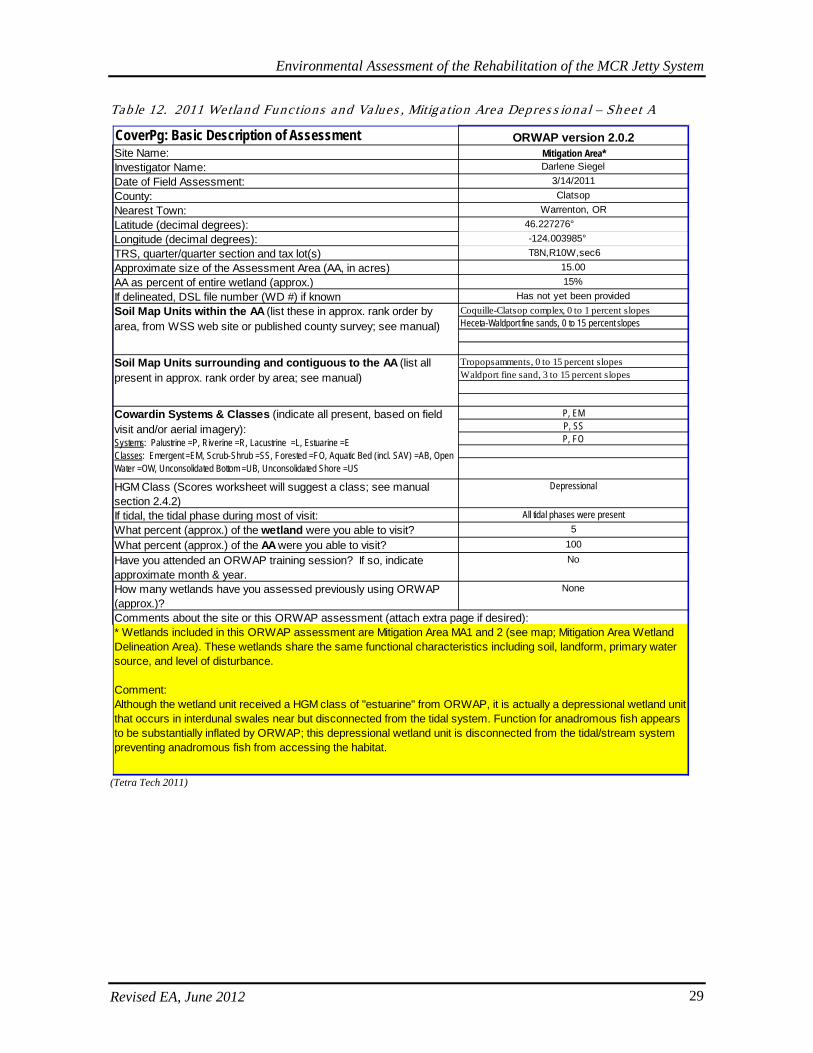
Environmental Assessment of the Rehabilitation of the MCR Jetty System
Revised EA, June 2012 29
Table 12. 2011 Wetland Functions and Values , Mitiga tion Area Depres s iona l – Sh ee t A
(Tetra Tech 2011)
CoverPg: Basic Description of Assessment ORWAP version 2.0.2Site Name: Mitigation Area*Investigator Name: Darlene SiegelDate of Field Assessment: 3/14/2011County: ClatsopNearest Town: Warrenton, ORLatitude (decimal degrees): 46.227276° Longitude (decimal degrees): -124.003985° TRS, quarter/quarter section and tax lot(s) T8N,R10W,sec6 Approximate size of the Assessment Area (AA, in acres) 15.00AA as percent of entire wetland (approx.) 15%If delineated, DSL file number (WD #) if known Has not yet been provided
Coquille-Clatsop complex, 0 to 1 percent slopesHeceta-Waldport fine sands, 0 to 15 percent slopes
Tropopsamments, 0 to 15 percent slopesWaldport fine sand, 3 to 15 percent slopes
P, EMP, SSP, FO
HGM Class (Scores worksheet will suggest a class; see manual section 2.4.2)
Depressional
If tidal, the tidal phase during most of visit: All tidal phases were presentWhat percent (approx.) of the wetland were you able to visit? 5
What percent (approx.) of the AA were you able to visit? 100
Have you attended an ORWAP training session? If so, indicate approximate month & year.
No
How many wetlands have you assessed previously using ORWAP (approx.)?
None
Soil Map Units within the AA (list these in approx. rank order by area, from WSS web site or published county survey; see manual)
Soil Map Units surrounding and contiguous to the AA (list all present in approx. rank order by area; see manual)
Cowardin Systems & Classes (indicate all present, based on field visit and/or aerial imagery): Systems: Palustrine =P, Riverine =R, Lacustrine =L, Estuarine =EClasses: Emergent =EM, Scrub-Shrub =SS, Forested =FO, Aquatic Bed (incl. SAV) =AB, Open Water =OW, Unconsolidated Bottom =UB, Unconsolidated Shore =US
Comments about the site or this ORWAP assessment (attach extra page if desired):* Wetlands included in this ORWAP assessment are Mitigation Area MA1 and 2 (see map; Mitigation Area Wetland Delineation Area). These wetlands share the same functional characteristics including soil, landform, primary water source, and level of disturbance.
Comment: Although the wetland unit received a HGM class of "estuarine" from ORWAP, it is actually a depressional wetland unit that occurs in interdunal swales near but disconnected from the tidal system. Function for anadromous fish appears to be substantially inflated by ORWAP; this depressional wetland unit is disconnected from the tidal/stream system preventing anadromous fish from accessing the habitat.
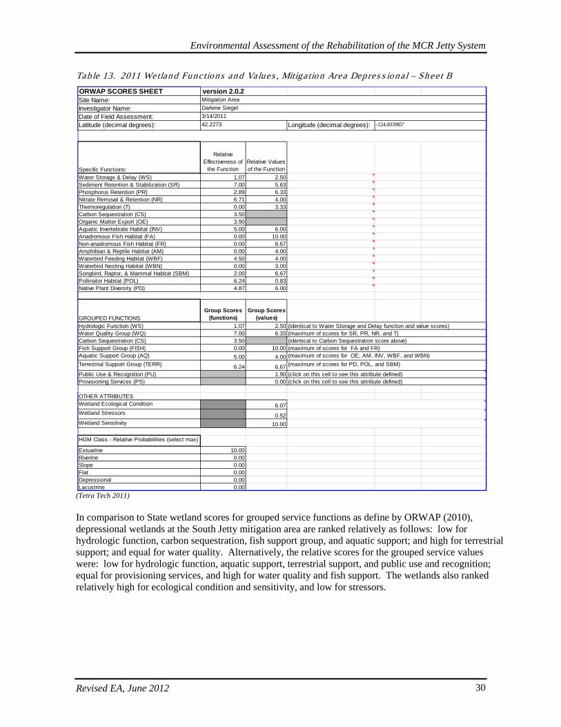
Environmental Assessment of the Rehabilitation of the MCR Jetty System
Revised EA, June 2012 30
Table 13. 2011 Wetland Functions and Values , Mitiga tion Area Depres s iona l – Sh ee t B
(Tetra Tech 2011) In comparison to State wetland scores for grouped service functions as define by ORWAP (2010), depressional wetlands at the South Jetty mitigation area are ranked relatively as follows: low for hydrologic function, carbon sequestration, fish support group, and aquatic support; and high for terrestrial support; and equal for water quality. Alternatively, the relative scores for the grouped service values were: low for hydrologic function, aquatic support, terrestrial support, and public use and recognition; equal for provisioning services, and high for water quality and fish support. The wetlands also ranked relatively high for ecological condition and sensitivity, and low for stressors.
ORWAP SCORES SHEET version 2.0.2Site Name:Investigator Name:Date of Field Assessment:Latitude (decimal degrees): Longitude (decimal degrees):
Specific Functions:
Relative Effectiveness of
the FunctionRelative Values of the Function
Water Storage & Delay (WS) 1.07 2.50Sediment Retention & Stabilization (SR) 7.00 5.63Phosphorus Retention (PR) 2.89 6.33Nitrate Removal & Retention (NR) 6.71 4.00Thermoregulation (T) 0.00 3.33Carbon Sequestration (CS) 3.50Organic Matter Export (OE) 3.90Aquatic Invertebrate Habitat (INV) 5.00 6.00Anadromous Fish Habitat (FA) 0.00 10.00Non-anadromous Fish Habitat (FR) 0.00 6.67Amphibian & Reptile Habitat (AM) 0.00 4.00Waterbird Feeding Habitat (WBF) 4.50 4.00Waterbird Nesting Habitat (WBN) 0.00 3.00Songbird, Raptor, & Mammal Habitat (SBM) 2.00 6.67Pollinator Habitat (POL) 6.24 0.83Native Plant Diversity (PD) 4.87 6.00
GROUPED FUNCTIONSGroup Scores
(functions)Group Scores
(values)Hydrologic Function (WS) 1.07 2.50Water Quality Group (WQ) 7.00 6.33Carbon Sequestration (CS) 3.50Fish Support Group (FISH) 0.00 10.00Aquatic Support Group (AQ) 5.00 4.00Terrestrial Support Group (TERR) 6.24 6.67Public Use & Recognition (PU) 1.90Provisioning Services (PS) 0.00
OTHER ATTRIBUTESWetland Ecological Condition 6.07Wetland Stressors 0.52Wetland Sensitivity 10.00
HGM Class - Relative Probabilities (select max)
Estuarine 10.00Riverine 0.00Slope 0.00Flat 0.00Depressional 0.00Lacustrine 0.00
(identical to Water Storage and Delay function and value scores)(maximum of scores for SR, PR, NR, and T)
(maximum of scores for OE, AM, INV, WBF, and WBN)(maximum of scores for FA and FR)
(click on this cell to see this attribute defined)(click on this cell to see this attribute defined)
(maximum of scores for PD, POL, and SBM)
(identical to Carbon Sequestration score above)
Mitigation AreaDarlene Siegel3/14/201142.2273 -124.003985°
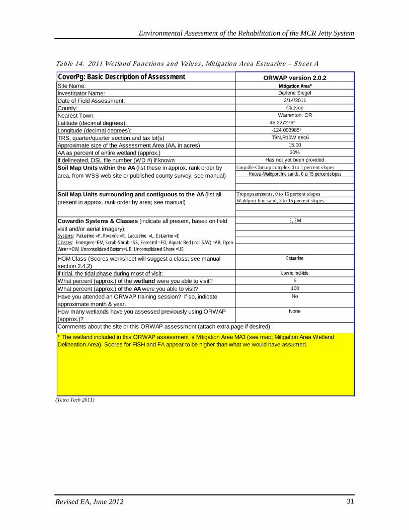
Environmental Assessment of the Rehabilitation of the MCR Jetty System
Revised EA, June 2012 31
Tab le 14. 2011 Wetland Functions and Values , Mitiga tion Area Es tuarine – Shee t A
(Tetra Tech 2011)
CoverPg: Basic Description of Assessment ORWAP version 2.0.2Site Name: Mitigation Area*Investigator Name: Darlene SiegelDate of Field Assessment: 3/14/2011County: ClatsopNearest Town: Warrenton, ORLatitude (decimal degrees): 46.227276° Longitude (decimal degrees): -124.003985° TRS, quarter/quarter section and tax lot(s) T8N,R10W,sec6 Approximate size of the Assessment Area (AA, in acres) 15.00AA as percent of entire wetland (approx.) 30%If delineated, DSL file number (WD #) if known Has not yet been provided
Coquille-Clatsop complex, 0 to 1 percent slopesHeceta-Waldport fine sands, 0 to 15 percent slopes
Tropopsamments, 0 to 15 percent slopesWaldport fine sand, 3 to 15 percent slopes
E, EM
HGM Class (Scores worksheet will suggest a class; see manual section 2.4.2)
Estuarine
If tidal, the tidal phase during most of visit: Low to mid-tideWhat percent (approx.) of the wetland were you able to visit? 5
What percent (approx.) of the AA were you able to visit? 100
Have you attended an ORWAP training session? If so, indicate approximate month & year.
No
How many wetlands have you assessed previously using ORWAP (approx.)?
None
Soil Map Units within the AA (list these in approx. rank order by area, from WSS web site or published county survey; see manual)
Soil Map Units surrounding and contiguous to the AA (list all present in approx. rank order by area; see manual)
Cowardin Systems & Classes (indicate all present, based on field visit and/or aerial imagery): Systems: Palustrine =P, Riverine =R, Lacustrine =L, Estuarine =EClasses: Emergent =EM, Scrub-Shrub =SS, Forested =FO, Aquatic Bed (incl. SAV) =AB, Open Water =OW, Unconsolidated Bottom =UB, Unconsolidated Shore =US
Comments about the site or this ORWAP assessment (attach extra page if desired):
* The wetland included in this ORWAP assessment is Mitigation Area MA3 (see map; Mitigation Area Wetland Delineation Area). Scores for FISH and FA appear to be higher than what we would have assumed.

Environmental Assessment of the Rehabilitation of the MCR Jetty System
Revised EA, June 2012 32
Table 15. 2011 Wetland Functions and Values , Mitiga tion Area Es tuarine – Shee t B
(Tetra Tech 2011) In comparison to State wetland scores for grouped service functions as define by ORWAP (2010), estuarine wetlands at the South Jetty mitigation area are ranked relatively as follows: low for hydrologic function and water quality; and high for carbon sequestration, fish support group, aquatic support, and terrestrial support. Alternatively, the relative scores for the grouped service values were: low for hydrologic function, aquatic support, terrestrial support, and public use and recognition; equal for provisioning services, and high for water quality and fish support. The wetlands also ranked relatively high for ecological condition and stressors, and low for sensitivity.
ORWAP SCORES SHEET version 2.0.2Site Name:Investigator Name:Date of Field Assessment:Latitude (decimal degrees): Longitude (decimal degrees):
Specific Functions:
Relative Effectiveness of
the FunctionRelative Values of the Function
Water Storage & Delay (WS) 0.00 2.50Sediment Retention & Stabilization (SR) 6.71 5.92Phosphorus Retention (PR) 2.97 6.33Nitrate Removal & Retention (NR) 6.03 4.33Thermoregulation (T) 0.00 6.67Carbon Sequestration (CS) 7.31Organic Matter Export (OE) 7.65Aquatic Invertebrate Habitat (INV) 5.50 7.00Anadromous Fish Habitat (FA) 5.36 10.00Non-anadromous Fish Habitat (FR) 4.21 6.67Amphibian & Reptile Habitat (AM) 0.00 4.00Waterbird Feeding Habitat (WBF) 5.29 4.00Waterbird Nesting Habitat (WBN) 0.00 3.00Songbird, Raptor, & Mammal Habitat (SBM) 7.00 6.67Pollinator Habitat (POL) 6.33 0.83Native Plant Diversity (PD) 6.69 6.00
GROUPED FUNCTIONSGroup Scores
(functions)Group Scores
(values)Hydrologic Function (WS) 0.00 2.50Water Quality Group (WQ) 6.71 6.67Carbon Sequestration (CS) 7.31Fish Support Group (FISH) 5.36 10.00Aquatic Support Group (AQ) 7.65 4.00Terrestrial Support Group (TERR) 7.00 6.67Public Use & Recognition (PU) 1.90Provisioning Services (PS) 0.00
OTHER ATTRIBUTESWetland Ecological Condition 7.74Wetland Stressors 5.68Wetland Sensitivity 3.53
HGM Class - Relative Probabilities (select max)
Estuarine 10.00Riverine 0.00Slope 0.00Flat 0.00Depressional 0.00Lacustrine 0.00
(identical to Carbon Sequestration score above)
Mitigation AreaDarlene Siegel3/14/201146.2273 -124.003985°
(identical to Water Storage and Delay function and value scores)(maximum of scores for SR, PR, NR, and T)
(maximum of scores for OE, AM, INV, WBF, and WBN)(maximum of scores for FA and FR)
(click on this cell to see this attribute defined)(click on this cell to see this attribute defined)
(maximum of scores for PD, POL, and SBM)
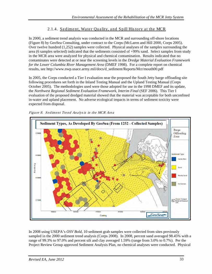
Environmental Assessment of the Rehabilitation of the MCR Jetty System
Revised EA, June 2012 33
2.1.4. Sediment, Wate r Quality, and Spill His tory a t the MCR
In 2000, a sediment trend analysis was conducted in the MCR and surrounding off-shore locations (Figure 8) by GeoSea Consulting, under contract to the Corps (McLaren and Hill 2000, Corps 2005). Over twelve hundred (1,252) samples were collected. Physical analyses of the samples surrounding the area (6 samples selected) indicated that the sediments consisted of +99% sand. Select samples from study in the MCR area were analyzed for physical and chemical contamination. Results indicated that no contaminates were detected at or near the screening levels in the Dredge Material Evaluation Framework for the Lower Columbia River Management Area (DMEF 1998). For a complete report on chemical results, see http://www.nwp.usace.army.mil/docs/d_sediment/Reports/Mcr/mouth00.pdf In 2005, the Corps conducted a Tier I evaluation near the proposed the South Jetty barge offloading site following procedures set forth in the Inland Testing Manual and the Upland Testing Manual (Corps October 2005). The methodologies used were those adopted for use in the 1998 DMEF and its update, the Northwest Regional Sediment Evaluation Framework, Interim Final (SEF 2006). This Tier I evaluation of the proposed dredged material showed that the material was acceptable for both unconfined in-water and upland placement. No adverse ecological impacts in terms of sediment toxicity were expected from disposal. Figure 8. Sed iment Trend An alys is in the MCR Area
In 2008 using USEPA’s OSV Bold, 10 sediment grab samples were collected from sites previously sampled in the 2000 sediment trend analysis (Corps 2008). In 2008, percent sand averaged 98.45% with a range of 99.3% to 97.0% and percent silt and clay averaged 1.59% (range from 3.0% to 0.7%). Per the Project Review Group approved Sediment Analysis Plan, no chemical analyses were conducted. Physical
Environmental Assessment of the Rehabilitation of the MCR Jetty System
Revised EA, June 2012 34
results for the 2000 and 2008 sampling events were compared. The mean percent sand for all samples in September 2000 was 98.11% and for June 2008 was 98.45%. In both data sets, sediments towards the outer portion of the mouth are finer than sediments towards the center of the mouth. Oregon and Washington have classified the lower Columbia River as water quality-limited and placed it on the Clean Water Act Section 303(d) list for the following parameters: RM 0 to 35.2 for temperature and polychlorinated biphenyls (PCBs); RM 35.2 to 98 for arsenic, dichlorodiphenyl trichloroethane (DDT), PCBs, and temperature; and RM 98 to 142 for temperature, arsenic, DDT, PCBs, and polynuclear aromatic hydrocarbons (PAHs). In Washington, the river also is on the Section 303(d) list for dichloro-diphenyl-dichloroethane, Alpha BHC (a pesticide), mercury, dissolved gas, dieldrin, chlordane, aldrin, dichloro-diphenyl-dichloroethylene, fecal coliforms, and sediment bioassay. In addition, the entire river is subject to an USEPA total maximum daily load for dioxin. According to the Lower Columbia River Geographic Response Plan (GRP) (WADOE 2003), routes for major shipping traffic keep super tankers 50-60 Nautical Miles (NM) offshore, minimizing potential coastal effects from a catastrophic spill. Up until 2003, the GRP also quantified the volume of potential spilled material as follows. Refined product in barges and small tankers transported closer to the shoreline and up the Columbia River averaging 160 tank barge movements as well as 50-60 bunkering operations by barge to a variety of vessels per month. The majority of these bunker barges had a capacity of 15,000 barrels. Annually, self propelled tankers made approximately 100 port calls to the Portland area. The majority of the tank vessels were approximately 39,000 deadweight tonnage, having had capacity of approximately 275,000 barrels, although the largest had a capacity of 400,000 barrels. Supertankers in ballast also transited the river enroute to the Portland Ship yard for routine inspections and maintenance. Approximately 2,000 general cargo, bulk, and container vessels entered the river annually, carrying bunker fuels of approximately 15,000 barrels capacity (WADOE 2003). According to information in the Oregon Department of Environmental Quality’s spill tracking database, between 1998 and March 2011, 63 spills were reported in Clatsop County in the vicinity of the Columbia River from Astoria downriver (DEQ 2011). Of these 63 spills, 43 were less than 50 gallons and were mostly the result of equipment malfunctions and minor spills and vessel leakage. Five spills were between 50 and 100 gal; 6 between 100 and 200 gallons; 2 between 200 and 800 gallons; then up to 6 at 1000 gallons; and one over 10,000 gallons (DEQ 2011). The incidents with the highest level of spill discharge generally involved storm sewage overflows or sewage release, followed by the sinking, grounding, or capsizing of fishing vessels, then land to surface water releases from other facility malfunctions (DEQ 2011). Washington Department of Ecology’s Environmental Reports Tracking System (ERTS) shows about 145 incidences between January 2000 and December 2010, with the majority of the sources indicated from various size vessels (WADOE 2011). Of these, most were petroleum products in the following quantities: 63 incidences were under 5 gallons; 11 were between 6-30 gallons; 9 were between 50-100 gallons; 3 were 101-300 gallons; and the largest quantified was 1 at 1500 gallons; 57 incidences did not have any associated quantities (WADOE 2011). The GRP also further describes several of the most prominent spills on the Columbia prior to 2003, including: the1984 T/V Mobiloil spill of 200,000 gallons; the 1991 discharge of 11,000 gallons of Intermediate Fuel Oil (IFO) 380 from the M/V Tai Chung at the Columbia Aluminum Facility; two similar bunkering mishaps within six months of each other at Longview Anchorage; the 1993 M/V Central spill of approximately 3,000 gallons of IFO 180; and the 1994 M/V An Ping 6 spill of a similar amount of product at the same location as M/V Central (WADOE 2003). It is notable that none of the identified spills occurred in the vicinity of the MCR, but rather further inland and upriver.
Environmental Assessment of the Rehabilitation of the MCR Jetty System
Revised EA, June 2012 35
With specific regards to Corps activities, from the time span between September 2006 and August 2010, dredging operations had 21 reportable spills ranging from 0.5 gallons to 25 gallons (Corps 2011). Of these spills, 12 occurred in the vicinity of Astoria or downriver towards the mouth (Corps 2011).
2.2. Fis h and Wild life
A variety of anadromous and resident fish species occur within the Columbia River offshore area, including several listed under the Endangered Species Act (ESA). Both the North and South Jetties are located in high-energy areas subject to strong tidal and river currents and wave action. These high-energy conditions contribute to continual movement of sediments with both deposition and erosion occurring. The continual disturbance limits biological productivity and use by fish and other marine organisms along the vicinity of the jetty structures themselves. The occurrence of adult anadromous salmonids in the offshore area is correlated primarily with their period of upstream migration. Juvenile salmonids are present following their migration out of the Columbia River estuary primarily in the spring and fall. The southern distinct population segment (DPS) of green sturgeon also occurs in the estuary, which is included as part of its designated critical habitat. Its specific distribution and habitat use in the Columbia River estuary is not well known, but is being studied by the U.S. Geological Survey (USGS) under contract with the Corps. However, green sturgeon would be expected to occur in the more tranquil estuary proper to a greater extent than in the vicinity of the jetties. Anadromous Pacific lamprey (Lampetra tridentate) may be present in the vicinity of the MCR as they return to freshwater during spawning migration from July to October. Lampreys typically spend about 4 to 6 years rearing in freshwater, returning to the ocean during spring high flows where they would also occur in the vicinity of the jetties. During their 2 to 3 years in the ocean, lampreys act as scavengers, parasites, or predators on larger prey such as salmon and marine mammals (PSMFC 2009). The Southern DPS of eulachon (or smelt) have also been recently listed as Threatened under the ESA, though critical habitat has yet to be designated. Eulachon are anadromous and spend 3-5 year is saltwater before returning to freshwater in late winter to spawn in the early spring. Resident fish species occur throughout the year with many using the estuary as a rearing and nursery area. Resident fish species that may be present in the jetty areas include various groundfish species, such as California skate (Raja inornata), soupfin shark (Galeorhinus galeus), spiny dogfish (Squalus acanthias), lingcod (Ophiodon elongates), Pacific cod (Gadus macrocephalus), butter sole (Isopsetta isolepis), English sole (Parophyrs vetulus), Pacific sanddab (Citharichthys sordidus), rex sole (Glyptocephalus zachirus), rock sole (Lepidopsetta bilineata), sand sole (Psettichthys melanostictus), starry flounder (Platichthys stellatus), black rockfish (Sebastes melanops), brown rockfish (Sebastes auriculatus), and copper rockfish (Sebastes caurinus). Some species use the MCR as a migratory corridor when traveling to rearing areas in bays and intertidal areas where there are larger concentrations of food organisms (e.g., Corophium salmonis). Other groundfish species, principally rockfish, may use the jetties as habitat. Almost all of the Columbia River offshore area experiences some type of commercial fishing activity. The major fisheries are for bottom fish, salmon, Dungeness crab (Cancer magister), and other shellfish species. Crab fishing occurs from December to September with the majority of the catch occurring early in the season. Most crab fishing occurs north of the Columbia River mouth at water depths ranging from 25-250 feet. Dungeness crab population numbers are subject to large cyclic fluctuations in abundance. Catch records for the fishery are generally believed to represent actual population fluctuations. Modeling studies by Higgins and others (1997) have shown that small scale environmental changes, such as delay in the onshore currents in the spring by a short period of time, can dramatically impact survival of young-of-the-year crab but have no effect on adults and older juveniles inshore. Bottom fishing by trawl for
Environmental Assessment of the Rehabilitation of the MCR Jetty System
Revised EA, June 2012 36
flatfish, rockfish, and shrimp occurs year-round over the entire offshore area, primarily at depths offshore from the jetties. Commercial and recreational salmon fishing occurs over much of the offshore area. The areas around Clatsop Spit south of the Jetty are known to have razor clam beds, and clamming occurs regularly in the vicinity of MCR. Marine mammals known to occur in the offshore area include gray whales, orcas, dolphins, porpoises, sea lions, and harbor seals. Most cetacean species observed by Green and others (1991) occurred in Pacific slope or offshore waters (600 to 6,000 feet in depth). Harbor porpoises (Phocoena phocoena) and gray whales (Eschrichtius robustus) were prevalent in shelf waters less than 600 feet in depth. Pinniped species that may occur in the vicinity of the jetties include Pacific harbor seals (Phoca vitulina richardsi), California sea lions (Zalophus californianus), and Steller (northern) sea lions (Eumetopias jubatus). Pelagic birds are numerous off the Columbia River including gulls, auklets, common murres, fulmars, phalaropes, and kittiwakes. Briggs and others (1992) found that seabird populations were most densely concentrated over the continental shelf (< 600 feet in depth). Brown pelicans (Pelecanus occidentalis) typically occur from late spring to mid-fall along the Oregon and Washington coasts. Three species of cormorants occur and forage in nearshore Pacific Ocean waters, the estuary, or upriver. Three species of terns occur in the Columbia River or over nearshore waters. Caspian terns (Hydroprogne caspia) are present from April to September and have established large colonies on islands in the estuary. Shorebirds found on beaches include sanderlings and various species of sandpipers, dunlins, and plovers. Four bald eagle (Haliaeetus leucocephalus) territories, two at Cape Disappointment, Washington (Cape Disappointment and Fort Canby pairs) and two on Clatsop Spit, Oregon (Fort Stevens and Tansy Point/Clear Lake pairs), occur in the general vicinity of the proposed project (Isaacs and Anthony 2005). Bald eagles have multiple (alternate) nest sites; the nearest nest location for the Fort Canby pair is approximately 1.6 miles northeast of Benson Beach. The nearest nest location for the Cape Disappointment pair is about 2.2 miles northeast of Benson Beach. The Fort Stevens and Tansy Point/Clear Lake pairs are more than 3 miles from the South Jetty. The territories on Cape Disappointment lie adjacent to Baker Bay, a shallow subtidal and intertidal bay adjacent to Ilwaco and Chinook, Washington. Baker Bay probably represents the focal area for foraging by these pairs as waterfowl and fisheries resources are plentiful in the bay. Bald eagles have been observed foraging along the shoreline from Ilwaco to the Fort Canby boat launch, on or adjacent to West Sand Island, and from pilings scattered throughout the western portion of Baker Bay. Foraging activities along the North Jetty and Benson Beach may occur infrequently. Bald eagles from territories on Clatsop Spit appear to forage in Trestle Bay. Other probable foraging locations include the various lakes scattered throughout Clatsop Spit and the shorelines and intertidal mudflats of the Columbia River estuary.
2.2.1. ESA-lis ted Spec ies under NMFS J uris d ic tion
Federally listed threatened and endangered species under the jurisdiction of the National Marine Fisheries Service (NMFS) that may occur in the MCR project area include 13 salmonid stocks and other fish and marine wildlife species (Table 16). A Biological Assessment (BA) was prepared and provided to the NMFS to evaluate the effects of the proposed project on the anadromous salmonids, marine mammal, and marine turtle species. Critical habitat and essential fish habitat (EFH) were also addressed in the BA. The EFH species present in the vicinity of the project area include five coastal pelagic fish species, numerous Pacific Coast groundfish species, and coho and Chinook salmon.
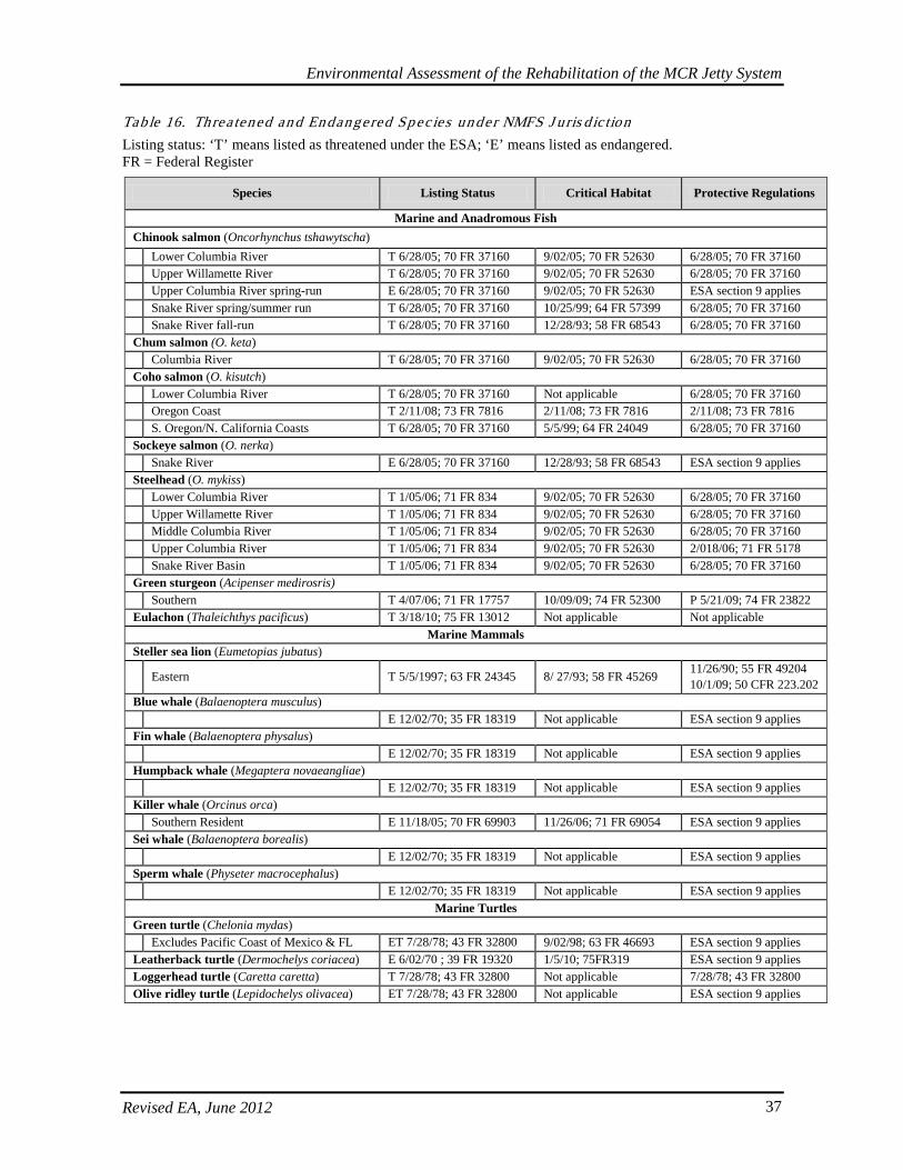
Environmental Assessment of the Rehabilitation of the MCR Jetty System
Revised EA, June 2012 37
Table 16. Threa tened an d Endangered Sp ec ies un der NMFS J uris d ic tion Listing status: ‘T’ means listed as threatened under the ESA; ‘E’ means listed as endangered. FR = Federal Register
Species Listing Status Critical Habitat Protective Regulations
Marine and Anadromous Fish Chinook salmon (Oncorhynchus tshawytscha) Lower Columbia River T 6/28/05; 70 FR 37160 9/02/05; 70 FR 52630 6/28/05; 70 FR 37160 Upper Willamette River T 6/28/05; 70 FR 37160 9/02/05; 70 FR 52630 6/28/05; 70 FR 37160 Upper Columbia River spring-run E 6/28/05; 70 FR 37160 9/02/05; 70 FR 52630 ESA section 9 applies Snake River spring/summer run T 6/28/05; 70 FR 37160 10/25/99; 64 FR 57399 6/28/05; 70 FR 37160 Snake River fall-run T 6/28/05; 70 FR 37160 12/28/93; 58 FR 68543 6/28/05; 70 FR 37160 Chum salmon (O. keta) Columbia River T 6/28/05; 70 FR 37160 9/02/05; 70 FR 52630 6/28/05; 70 FR 37160 Coho salmon (O. kisutch) Lower Columbia River T 6/28/05; 70 FR 37160 Not applicable 6/28/05; 70 FR 37160 Oregon Coast T 2/11/08; 73 FR 7816 2/11/08; 73 FR 7816 2/11/08; 73 FR 7816 S. Oregon/N. California Coasts T 6/28/05; 70 FR 37160 5/5/99; 64 FR 24049 6/28/05; 70 FR 37160 Sockeye salmon (O. nerka) Snake River E 6/28/05; 70 FR 37160 12/28/93; 58 FR 68543 ESA section 9 applies Steelhead (O. mykiss) Lower Columbia River T 1/05/06; 71 FR 834 9/02/05; 70 FR 52630 6/28/05; 70 FR 37160 Upper Willamette River T 1/05/06; 71 FR 834 9/02/05; 70 FR 52630 6/28/05; 70 FR 37160 Middle Columbia River T 1/05/06; 71 FR 834 9/02/05; 70 FR 52630 6/28/05; 70 FR 37160 Upper Columbia River T 1/05/06; 71 FR 834 9/02/05; 70 FR 52630 2/018/06; 71 FR 5178 Snake River Basin T 1/05/06; 71 FR 834 9/02/05; 70 FR 52630 6/28/05; 70 FR 37160 Green sturgeon (Acipenser medirosris) Southern T 4/07/06; 71 FR 17757 10/09/09; 74 FR 52300 P 5/21/09; 74 FR 23822 Eulachon (Thaleichthys pacificus) T 3/18/10; 75 FR 13012 Not applicable Not applicable
Marine Mammals Steller sea lion (Eumetopias jubatus) Eastern T 5/5/1997; 63 FR 24345 8/ 27/93; 58 FR 45269 11/26/90; 55 FR 49204
10/1/09; 50 CFR 223.202 Blue whale (Balaenoptera musculus) E 12/02/70; 35 FR 18319 Not applicable ESA section 9 applies Fin whale (Balaenoptera physalus) E 12/02/70; 35 FR 18319 Not applicable ESA section 9 applies Humpback whale (Megaptera novaeangliae) E 12/02/70; 35 FR 18319 Not applicable ESA section 9 applies Killer whale (Orcinus orca) Southern Resident E 11/18/05; 70 FR 69903 11/26/06; 71 FR 69054 ESA section 9 applies Sei whale (Balaenoptera borealis) E 12/02/70; 35 FR 18319 Not applicable ESA section 9 applies Sperm whale (Physeter macrocephalus) E 12/02/70; 35 FR 18319 Not applicable ESA section 9 applies
Marine Turtles Green turtle (Chelonia mydas) Excludes Pacific Coast of Mexico & FL ET 7/28/78; 43 FR 32800 9/02/98; 63 FR 46693 ESA section 9 applies Leatherback turtle (Dermochelys coriacea) E 6/02/70 ; 39 FR 19320 1/5/10; 75FR319 ESA section 9 applies Loggerhead turtle (Caretta caretta) T 7/28/78; 43 FR 32800 Not applicable 7/28/78; 43 FR 32800 Olive ridley turtle (Lepidochelys olivacea) ET 7/28/78; 43 FR 32800 Not applicable ESA section 9 applies
Environmental Assessment of the Rehabilitation of the MCR Jetty System
Revised EA, June 2012 38
On March 18, 2011, The Corps received a Biological Opinion from NMFS indicating that the Corps’ proposed actions were not likely to adversely affect any of the listed species, with the exception of eulachon, humpback whales, and Stellar sea lions (2010/06104). For these species, NMFS determined that Corps actions were not likely to jeopardize the existence of the species. NMFS also concluded that the Corps’ actions were not likely to adversely affect any of the current or proposed critical habitats. Anadromous Salmonids In 2005, critical habitat was designated for all Columbia River steelhead and Columbia River salmon Evolutionarily Significant Units (ESU), with the exception of lower Columbia River coho salmon ESU. General run-specific life history descriptions for the various salmonid ESUs shown in Table 1 are provided below. Snake River Spring and Summer Run Chinook Salmon. Fish from this ESU occur in the mainstem Snake River and sub-basins including the Tucannon, Grande Ronde, Imnaha, and Salmon Rivers. Adults migrate in late winter to spring and spawn from late August to November. Spawning occurs in tributaries to the Snake River. Juveniles remain in freshwater from 1-3 years and out-migrate from early spring to summer. Snake River Fall Run Chinook Salmon. Fish from this ESU occur in the mainstem Snake River and sub basins including the Tucannon, Grande Ronde, Imnaha, and Salmon Rivers. Adults migrate from mid-August to October and spawn from late August to November. Spawning occurs in the Snake River and lower reaches of tributaries to the Snake River. Juveniles rear in freshwater from 1-3 years and out-migrate from early spring to summer. Lower Columbia River Chinook Salmon. Fish from this ESU occur from the MCR upstream to Little White Salmon River, Washington and Hood River, Oregon and including the Willamette River upstream to Willamette Falls. Adults migrate in mid-August through October (fall run) and late winter to spring (spring run). Spawning occurs from late August to November. Spawning occurs in the mainstem Columbia River to upper reaches of tributaries. Juveniles out-migrate from early spring to fall. Upper Columbia River Spring Run Chinook Salmon. Fish from this ESU occur in Columbia River tributaries upstream of the Rock Island Dam and downstream of Chief Joseph Dam in Washington, excluding the Okanogan River. Adults migrate from late winter to spring and spawn from late August to November. Spawning occurs in the mainstem Columbia River to upper reaches of tributaries. Juveniles out-migrate from early spring to summer. Upper Willamette River Chinook Salmon. Fish from this ESU migrate upstream from late winter to spring and spawn from late August to November. Juveniles migrate from early spring to summer, some rearing in the Columbia River estuary and some in freshwater. Lower Columbia River Coho Salmon. It is believed that the majority of fish from this ESU return to the lower Columbia River to spawn between early December and March. Spawning occurs in tributaries to the Columbia River. Young hatch in spring, rear in freshwater for one year, and out-migrate to the ocean the following spring. Most juveniles out-migrate from April to August, with a peak in May. Coho salmon occur in the Columbia River estuary as smolts and limited estuarine rearing occurs (more extensive estuarine rearing occurs in Puget Sound). Oregon Coast Coho Salmon. Fish from this ESU are found in Oregon coastal streams south of the Columbia River and North of Cape Blanco. They generally migrate up spawning streams from August
Environmental Assessment of the Rehabilitation of the MCR Jetty System
Revised EA, June 2012 39
through November, and spawning takes place from late September through January in shallow tributaries with gravel bottoms. Fry emerge from the redd in May or June and remain in fresh water from one to four winters before going to sea. Coho salmon smolts tend to stay close to shore at first, feeding on plankton. As they grow larger, they move farther out into the ocean and switch to a diet of small fish. Coho salmon can stay at sea for two to three years. Southern Oregon/N. California Coasts Coho Salmon. The SONCC coho ESU includes all naturally spawned populations of coho salmon in coastal streams between Cape Blanco, Oregon, and Punta Gorda, California. Spawning runs occur throughout the year, varying in time by species and location. Depending on temperatures, eggs incubate for several weeks to months before hatching. Then juveniles may spend from a few hours to several years in freshwater before migrating to the ocean. En route to the ocean the juveniles may spend from a few days to several weeks in the estuary. Juveniles and sub-adults typically spend from 1 to 5 years foraging in the ocean before returning to freshwater to spawn. Columbia River Chum Salmon. Fish from this ESU are distributed from Bonneville Dam to the MCR. Adults migrate from early October through November and spawning occurs in November and December. Spawning habitat includes lower portions of rivers just above tidewater and in the side channel near Hamilton Island below Bonneville Dam. Juveniles enter estuaries from March to mid-May and most chum salmon leave Oregon estuaries by mid-May. Most juveniles spend little time in freshwater and rear extensively in estuaries. Snake River Sockeye Salmon. Fish from this ESU occur in the Salmon River, a tributary to the Snake River. This population migrates in spring and summer and spawning occurs in February and March. Spawning occurs in inlets or outlets of lakes or in river systems. Juveniles rear in freshwater and out-migrate in spring and early summer, out-migrating primarily between April and early June. They spend little time in estuaries as smolts and are guided to ocean waters by salinity gradients. Snake River Basin Steelhead. Fish from this ESU occur in all accessible tributaries of the Snake River. Upstream migration occurs in spring and summer and spawning occurs in February and March. Spawning habitat includes upper reaches of tributaries. Juveniles spend from 1-7 years (average 2 years) in freshwater and out-migrate during spring and early summer. Middle Columbia River Steelhead. Fish from this ESU are distributed from Wind River, Washington and Hood River, Oregon upstream to the Yakima River, Washington. These fish migrate in winter and summer and spawning occurs in February and March. Spawning habitat includes upper reaches of tributaries. Juveniles spend from 1 to 7 years (average 2 years) in freshwater and out-migrate during spring and early summer. Upper Willamette River Steelhead. Fish from this ESU are a late-migrating winter group, rearing 2 years in freshwater and 2 years in the Pacific Ocean before returning to spawn. The run timing appears to be an adaptation to ascending Willamette Falls at Oregon City. Lower Columbia River Steelhead. Fish from this ESU are distributed from Wind River, Washington and Hood River, Oregon downstream to the MCR. These fish migrate in winter and spring/summer and spawning occurs in February and March. Spawning habitat includes upper reaches of tributaries. Juveniles spend from 1-7 years (average 2 years) in freshwater and out-migrate during spring and early summer. Upper Columbia River Steelhead. Fish from this ESU are distributed from the Yakima River upstream to the Canadian border. These fish migrate in spring and summer and spawning occurs in February and
Environmental Assessment of the Rehabilitation of the MCR Jetty System
Revised EA, June 2012 40
March. Spawning habitat includes upper reaches of tributaries. Juveniles spend from 1-7 years (average 2 years) in freshwater and out-migrate during spring and early summer. Salmon Ecology in the MCR Area. Adult ESA-listed anadromous salmonids use the MCR area as a migration corridor to spawning areas throughout much of the Columbia River Basin. They are actively migrating and are not expected to use the area for resting or feeding, although they would spend time in the MCR to physiologically acclimate to freshwater. Chum, coho and Chinook salmon and steelhead populations spawn in tributaries to the Columbia River, and chum and Chinook salmon spawn in the mainstem Columbia River in appropriately sized gravels. No spawning would occur in the vicinity of the MCR for these species because of the lack of tributaries and appropriate spawning substrate. Juvenile ESA-listed anadromous salmonids occur in the MCR area during their out-migration to the ocean. Juveniles that have already become smolts are present in the lower river for a short time period. Juveniles that have not become smolts, such as Chinook salmon sub yearlings, spend extended periods of time rearing in the lower river. They normally remain in the lower river or estuary until summer or fall, or even to the following spring when they smoltify and then migrate to the ocean. Rearing occurs primarily in shallow backwater areas. The majority of juvenile salmonids out-migrate in late spring and early summer, although fall Chinook salmon typically have a more extended outmigration period than other Columbia Basin salmonids and commonly out-migrate in late summer as well. A recent study on acoustically tagged sub-yearling and yearling Chinook salmon and steelhead was conducted in the vicinity of the North and South jetties (PNNL 2005). Detection nodes were placed across the channel at RM 5.6 (primary node) and at RM 1.8 (secondary node). The secondary node did not extend all the way to the south side of the channel, however. As a result, fish could pass close to the South Jetty without being detected. A third set of detection nodes were placed near the North Jetty disposal area. Chinook salmon, both sub-yearling and yearling, were run-of-the-river fish tagged and released at the Bonneville Second Powerhouse juvenile bypass facility. Steelhead were Snake River-origin hatchery fish that were collected from fish transport barges between John Day and Bonneville dams and released mainly at Skamania Landing downstream of Bonneville Dam (some were transported and released at the Astoria-Megler Bridge). Sub-yearling Chinook salmon were shown to move back and forth past the nodes, remaining longer in the vicinity of the nodes than yearling Chinook salmon and steelhead. They also tended to use nearshore areas (closer to the North Jetty) more than yearling Chinook salmon and steelhead. Yearling Chinook salmon and steelhead were concentrated more in deeper waters near the navigation channel. Of the salmonid species, sub-yearling Chinook salmon stay in the estuary for the longest period of time and use the greatest variety of estuarine habitats (Bottom et al., 2001), mainly slower, shallower, backwater areas. Healey (1982) proposed that Chinook salmon is the most estuarine dependent of salmonid species. These slow water areas are not typically available in close proximity to the jetties, but even in this high energy environment, sub-yearling Chinook still show a tendency to linger and to use nearshore areas. According to PNNL studies, sub-yearling Chinook residence times within the detection areas were up to five times longer than yearling Chinook salmon and steelhead, averaging up to 14.8 hours and usually passing on two to three ebb tides instead of one for yearlings. Also, they took longer to reach the MCR from Bonneville Dam (average 4.8 days) than yearling Chinook salmon and steelhead. Juvenile salmon movement toward the ocean is facilitated by ebb tides when current movement in the channel is generally in an east to west direction (PNNL 2005). Salmon Ecology in the Columbia River Plume. The Columbia River plume is the zone of freshwater/saltwater interface where the freshwater exiting the Columbia River meets and rises above the denser saltwater of the Pacific Ocean, just seaward of the MCR. This multi-layered mixing zone plays an

Environmental Assessment of the Rehabilitation of the MCR Jetty System
Revised EA, June 2012 41
important role as habitat for juvenile salmonids. The first few weeks of their ocean life, some of which is spent in the plume, are critical for recruitment success of salmonids (Pearcy 1992). The Columbia River plume provides a high turbidity refuge from predation, provides fronts and eddies where prey become concentrated, and provides a stable habitat for northern anchovy spawning (Richardson 1981, Bakun 1996). A strong, quickly moving plume also helps juvenile salmonids move rapidly offshore. Studies in the Columbia River plume show that juvenile salmonids typically use upper waters, above about 39 feet (Emmett et al., 2004). Many Columbia River Basin salmonids enter the ocean when river flow is high and frontal formation is intensified, during spring and early summer. De Robertis and others (2005) found that juvenile salmonids tended to be abundant in the frontal and plume regions compared to the more marine shelf waters, but this pattern differed among species and was not consistent across two study years. Juvenile chum and yearling coho salmon were more abundant in the front than adjacent plume or ocean, while juvenile steelhead were more abundant in the front and plume than adjacent ocean. No statistically significant differences were observed in Chinook habitat use during 2001. In 2002, both yearling coho and Chinook were more abundant in the plume than adjacent front and ocean, whereas juvenile steelhead was more abundant in the front than adjacent plume and ocean. Small numbers of chum captured in 2002 precluded statistical analysis. There was no statistically significant difference in the fraction of marked (hatchery) fish among ocean, front, and plume habitats (appears to indicate that hatchery fish did not use habitats differently than wild fish). This study did not support the hypothesis that juvenile salmonids congregate to feed at the plume fronts. De Robertis and others (2005) postulated that the short persistence time of these ephemeral fronts may prevent juveniles from exploiting this food-rich zone. They caution that given that the plume is the first area salmon encounter during ocean entry, changes in plume structure may markedly influence the distribution and survival of salmon. Green Sturgeon. Green sturgeon is a widely distributed, marine-oriented sturgeon found in nearshore waters from Baja California to Canada (NMFS 2007). They are anadromous, spawning in the Sacramento, Klamath and Rogue rivers in the spring (NMFS 2007). Spawning occurs in deep pools or holes in large, turbulent river mainstreams. Two DPSs have been defined, a northern DPS with spawning populations in the Klamath and Rogue rivers and a southern DPS that spawns in the Sacramento River (NMFS 2007). The southern DPS was listed as threatened in 2006. The northern DPS remains a species of concern. Critical habitat for southern DPS green sturgeon was designated in 2009 and includes all tidally-influenced areas of the Columbia River to approximately RM 46 and up to MHHW and includes adjacent coastal marine areas [74 Federal Register (FR) 52300]. Green sturgeons congregate in coastal waters and estuaries, including non-natal estuaries, where they are vulnerable to capture in salmon gillnet and white sturgeon sport fisheries. Green sturgeon are known to enter Washington estuaries during summer when water temperatures are more than 2°C warmer than adjacent coastal waters (Moser and Lindley 2007). Sturgeon migrations are thought to be related to feeding and spawning (Bemis and Kynard 1997). They suggested that green sturgeon move into estuaries of non-natal rivers to feed. However, the empty gut contents of green sturgeon captured in the Columbia River gillnet fishery suggests that these green sturgeon were not actively foraging in the estuary [T. Rien, ODFW, pers. comm. in Moser and Lindley (2007)]. That they are caught on baited hooks incidentally during the sport season for white sturgeon suggests they are feeding in the estuaries. Moser and Lindley (2007) used acoustic telemetry to document the timing of green sturgeon use of Washington estuaries. Sturgeon they captured were tagged, and released in both Willapa Bay and Columbia River estuaries. They deployed an array of four fixed-site acoustic receivers in Willapa Bay to detect the estuarine entry and exit of these and any of over 100 additional green sturgeon tagged in other systems during 2003 and 2004. Green sturgeon occurred in Willapa Bay in summer when estuarine water
Environmental Assessment of the Rehabilitation of the MCR Jetty System
Revised EA, June 2012 42
temperatures exceeded coastal water temperatures by at least 2°C. They exhibited rapid and extensive intra- and inter-estuary movements and green sturgeon from all known spawning populations were detected in Willapa Bay. Moser and Lindley (2007) hypothesized that green sturgeon optimize their growth potential in summer by foraging in the relatively warm, saline waters of Willapa Bay. Information from fisheries-dependent sampling suggests that green sturgeon only occupy large estuaries during the summer and early fall in the northwestern United States. Commercial catches of green sturgeon peak in October in the Columbia River estuary, and records from other estuarine fisheries (Willapa Bay and Grays Harbor, Washington) support the idea that sturgeon are only present in these estuaries from June until October [O. Langness, WDFW, pers. comm. in Moser and Lindley (2007)]. Green sturgeon enter the Columbia River at the end of spring with their numbers increasing through June (B. James, WDFW, pers. comm. 2007 with W. Briner, Portland District). The greatest numbers are caught in the estuary in July through September. The majority of green sturgeon were caught in the lower reaches of the Columbia River based upon harvest information from 1981-2004 (B. James, WDFW, e-mail comm. 2007 with W. Briner, Portland District). There are no known spawning populations in the Columbia River and its tributaries. Pacific Eulachon. The NMFS listed the southern DPS of Pacific eulachon (smelt) as threatened in March 2010. This DPS consists of populations spawning in rivers south of the Nass River in British Columbia, Canada, to and including the Mad River in California. The Columbia River and its tributaries support the largest known eulachon run. The major and most consistent spawning runs return to the mainstem Columbia River (from just upstream of the estuary at RM 25 to immediately downstream of Bonneville Dam) and in the Cowlitz River. Eulachon typically spend 3-5 years in saltwater before returning to freshwater to spawn from late winter through early summer. Spawning occurs in January, February, and March in the Columbia River. Spawning occurs at temperatures from about 39° to 50°F (4° to 10°C) in the Columbia River and tributaries over sand, coarse gravel, or detrital substrates. Shortly after hatching, the larvae are carried downstream and dispersed by estuarine and ocean currents. After leaving estuarine rearing areas, juvenile eulachon move from shallow nearshore areas to deeper areas over the continental shelf. Larvae and young juveniles become widely distributed in coastal waters and are found mostly at depths up to about 49 feet. Steller Sea Lion. Steller sea lions breed along the West Coast from California’s Channel Islands to the Kurile Islands and the Okhotsk Sea in the western North Pacific Ocean. They are year-long residents along the Oregon Coast. A major haul-out area for Steller sea lions occurs at the head of South Jetty, where the monthly averages between 1995 and 2004 ranged from about 168 to 1106 animals at the South Jetty. Steller sea lions are most abundant in the vicinity during the winter months and tend to disperse elsewhere to rookeries during breeding season between May and July (Corps 2007). Marine Whales. The whale species listed in Table 1 are all federally endangered and occur as migrants off the Oregon Coast in waters typically much farther from shore than the nearshore MCR area. Blue whales occur off the coast in May and June, as well as in August through October. Blue whales typically occur offshore as individuals or in small groups and winter well south of Oregon. Fin whales also winter far south of Oregon and range off the coast during summer. Sei whales winter south of Oregon and probably occur in southward migration off the Oregon Coast in late summer and early fall. Sperm whales occur as migrants and some may summer off the coast; they forage in waters much deeper than those in the nearshore area. Humpback whales primarily occur off the Oregon Coast from April to October with peak numbers from June through August. Humpback whales are particularly concentrated in Oregon along the southern edge of Heceta Bank and are found primarily on the continental shelf and slope. North Pacific right whales may occur off the coast during winter and summer in cool waters north of 50 degrees north latitude.
Environmental Assessment of the Rehabilitation of the MCR Jetty System
Revised EA, June 2012 43
According to the NMFS (2008), the southern resident killer whale population consists of three pods, designated J, K, and L pods, that reside from late spring to fall in the inland waterways of Washington State and British Columbia. During winter, pods have moved into Pacific coastal waters and are known to travel as far south as central California. Winter and early spring movements and distribution are largely unknown for the population. Recent sightings of members of K and L pods in Oregon (L pod at Depoe Bay in April 1999 and Yaquina Bay in March 2000, unidentified Southern Residents at Depoe Bay in April 2000, and members of K and L pods off of the Columbia River) and in California (17 members of L pod and four members of K pod at Monterey Bay in 2000; L pod members at Monterey Bay in March 2003; L pod members near the Farallon Islands in February 2005 and again off Pt. Reyes in January 2006) have considerably extended the southern limit of their known range (NMFS 2008). Sightings of southern resident killer whales off the coast of Washington, Oregon, and California indicate that they are utilizing resources in the California Current ecosystem in contrast to other North Pacific resident pods that exclusively use resources in the Alaskan Gyre system (NMFS 2008). Marine Turtles. The loggerhead sea turtle, green sea turtle, leatherback sea turtle, and olive Ridley sea turtle are all federally listed species and have been recorded from strandings along the Oregon and Washington coasts. The occurrence of sea turtles off the Oregon Coast is associated with the appearance of albacore. Albacore occurrence is strongly associated with the warm waters of the Japanese current. Because these warm waters generally occur 30 to 60+ miles offshore from the Oregon Coast, these sea turtle species do not typically occur in the nearshore MCR area. In October, 2007, NMFS received a petition from the Center for Biological Diversity, Oceana, and Turtle Island Restoration Network (Petitioners) to revise the leatherback sea turtle critical habitat designation. Current critical habitat consists of terrestrial shoreline approximately in and around Sandy Point Beach, St. Croix, and the U.S. Virgin Islands (see 50 CFR 17.95). In December 2007, NMFS initiated a Notice of Petition finding that there was sufficient merit to initiate further review and requested public information and comment (72 FR 73745). Subsequently, on January 5, 2010, NMFS officials proposed a revised critical habitat designation for the leatherback sea turtle by designating additional locations to include the nearshore area from Cape Flattery, Washington, to Umpqua River (Winchester Bay), Oregon and offshore to the 2,000 meter isobath (75 FR 319). Leatherbacks forage primarily on cnidarians (jellyfish and siphonophores) and to a lesser extent on tunicates (pyrosomas and salps) (NMFS and USFWS 1998). The nutrient-rich waters of the Columbia River plume tend to aggregate and retain jellyfish in the northern California Current (Shenker 1984). There is some evidence that Leatherbacks feed farther offshore in association with the Columbia River plume and off of Washington in general than they do along the central California coast (PFMC 2006) where they feed in the vicinity of Monterey Bay (NMFS November 2006). Leatherbacks are most frequently sighted in ocean waters off Oregon and Washington from late spring to early fall (Bowlby 1994). From the limited amount of research on jellyfish and leatherbacks in Pacific Northwestern nearshore waters, it appears that there is overlap in time of occurrence of jellyfish and leatherbacks. Knowledge about leatherback abundance in the Columbia River plume, as well as foraging activity, is sparse. Most species of marine turtles are expected to occur further offshore and would not regularly be in the vicinity of the MCR or a majority of the proposed actions. There may be some occurrence of marine turtles along the potential barge routes, which may overlap with designated critical habitat. Leatherbacks are not known to enter the Columbia River, though they are known to feed offshore and nearer shore on jellyfish.
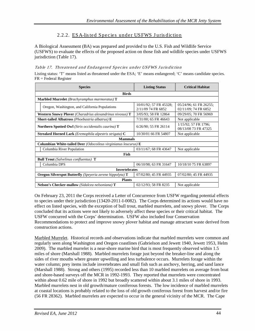
Environmental Assessment of the Rehabilitation of the MCR Jetty System
Revised EA, June 2012 44
2.2.2. ESA-lis ted Spec ies under USFWS J uris d ic tion
A Biological Assessment (BA) was prepared and provided to the U.S. Fish and Wildlife Service (USFWS) to evaluate the effects of the proposed action on those fish and wildlife species under USFWS jurisdiction (Table 17). Tab le 17. Threa tened an d Endangered Sp ec ies un der USFWS J u ris d ic tion Listing status: ‘T’ means listed as threatened under the ESA; ‘E’ means endangered; ‘C’ means candidate species. FR = Federal Register
Species Listing Status Critical Habitat
Birds Marbled Murrelet (Brachyramphus marmoratus) T Oregon, Washington, and California Populations 10/01/92; 57 FR 45328;
2/11/09 74 FR 6852 05/24/96; 61 FR 26255; 02/11/09; 74 FR 6852
Western Snowy Plover (Charadrius alexandrinus nivosus) T 3/05/93; 58 FR 12864 09/29/05; 70 FR 56969 Short-tailed Albatross (Phoebastria albatrus) E 7/31/00; 65 FR 46643 Not applicable
Northern Spotted Owl (Strix occidentalis caurina) T 6/26/90; 55 FR 26114 1/15/92; 57 FR 1796; 08/13/08 73 FR 47325
Streaked Horned Lark (Eremophila alpestris strigata) C 10/30/01 66 FR 54807 Not applicable Mammals
Columbian White-tailed Deer (Odocoileus virginianus leucurus) E Columbia River Population 03/11/67; 68 FR 43647 Not applicable
Fish Bull Trout (Salvelinus confluentus) T Columbia DPS 06/10/98; 63 FR 31647 10/18/10 75 FR 63897
Invertebrates Oregon Silverspot Butterfly (Speyeria zerene hippolyta) T 07/02/80; 45 FR 44935 07/02/80; 45 FR 44935
Plants Nelson’s Checker-mallow (Sidalcea nelsoniana) T 02/12/93; 58 FR 8235 Not applicable
On February 23, 2011 the Corps received a Letter of Concurrence from USFW regarding potential effects to species under their jurisdiction (13420-2011-I-0082). The Corps determined its actions would have no effect on listed species, with the exception of bull trout, marbled murrelets, and snowy plover. The Corps concluded that its actions were not likely to adversely affect these species or their critical habitat. The USFW concurred with the Corps’ determination. USFW also included four Conservation Recommendations to protect and improve snowy plover habitat and manage attractant waste derived from construction actions. Marbled Murrelet. Historical records and observations indicate that marbled murrelets were common and regularly seen along Washington and Oregon coastlines (Gabrielson and Jewett 1940, Jewett 1953, Helm 2009). The marbled murrelet is a near-shore marine bird that is most frequently observed within 1.5 miles of shore (Marshall 1988). Marbled murrelets forage just beyond the breaker-line and along the sides of river mouths where greater upwelling and less turbulence occurs. Murrelets forage within the water column; prey items include invertebrates and small fish such as anchovy, herring, and sand lance (Marshall 1988). Strong and others (1995) recorded less than 10 marbled murrelets on average from boat and shore-based surveys off the MCR in 1992-1993. They reported that murrelets were concentrated within about 0.62 mile of shore in 1992 but broadly scattered within about 3.1 miles of shore in 1993. Marbled murrelets nest in old growth/mature coniferous forests. The low incidence of marbled murrelets at coastal locations is probably related to the loss of old growth coniferous forest from harvest and/or fire (56 FR 28362). Marbled murrelets are expected to occur in the general vicinity of the MCR. The Cape
Environmental Assessment of the Rehabilitation of the MCR Jetty System
Revised EA, June 2012 45
Disappointment area is located about 1.6 miles northeast of the North Jetty at Benson Beach and contains suitable habitat for marbled murrelet nesting. While nesting has not been documented in this area, birds have been noted in flight during the nesting season. Western Snowy Plover. Although western snowy plovers historically occurred in the vicinity of Clatsop Spit, no breeding or wintering plovers have been reported from these beaches in recent years (USFWS 2001). In 2012, two snowy plover were sited during surveys at Clatsop Spit, but no nests were observed (Blackstone, 2012). A small population of western snowy plovers occurs on beaches at Leadbetter Point, Washington, which is more than 20 miles north of the project vicinity. The closest Oregon nesting location is far south of the project vicinity at Bayocean Spit in Tillamook County. Though snowy plovers are not currently nesting at the South Jetty, the Oregon Parks and Recreation Department (OPRD) identified the northern-most tip of Clatsop Spit in their 2010 Habitat Conservation Plan (HCP) for western snowy plovers (OPRD 2010). This area is part of Fort Stevens State Park and will be managed for species recovery as OPRD develops its site management plan. In 2011, the Corps entered into a Memorandum of Agreement with federal and state partners including USFWS and Oregon Parks and Recreation Department (OPRD) regarding cooperation in implementing the snowy plover Habitat Conservation Plan (HCP) for the Clatsop Spit. Short-tailed Albatross. There have been three confirmed sightings of short-tailed albatross off the Oregon Coast. The closest sighting to the project was 20 miles southwest of the MCR (Marshall et al., 2003). Northern Spotted Owl. Northern spotted owls are nocturnal predators that generally prey primarily on small forest mammals and nest from February to June, with parental care of the juveniles lasting into September (USFWS 2010a). Spotted owls live in forests characterized by dense canopy closure of mature and old-growth trees, abundant logs, standing snags, and live trees with broken tops; they prefer older forest stands with variety multi-layered canopies of several tree species of varying size and age, both standing and fallen dead trees, and open space among the lower branches to allow flight under the canopy (USFWS 2010a). Benson Beach and Clatsop Spit have large areas of land that have accreted since the construction of the MCR jetty system and are not old enough to have evolved these forest characteristics. These habitat conditions do not exist in the immediate vicinity where the majority of the construction activities will occur. Benson Beach and Clatsop Spit are not designated as critical habitat. Streaked Horned Lark. According to the USFWS (2010b), the streaked horned lark once occurred from British Columbia, Canada, south to northern California and was a common summer resident in larger and smaller valleys on the west side of the Cascade Mountain range, wintering in eastern Washington, Oregon, and Northern California. Streaked horned larks have also been reported on islands in the lower Columbia River. The species is associated with bare ground or sparsely vegetated habitats and are known to nest in grass seed fields, pastures, fallow fields, and wetland mudflats, and can also be found in and along gravel roads and adjacent ditches. Nesting begins in late March and continues into June and consists of a shallow depression built in the open or near a grass clump and lined with fine dead grasses. The streaked horned lark feeds on the ground, and eats mainly weed seeds and insects. Columbian White-tailed Deer. Columbian white-tailed deer occur on the Oregon and Washington mainland and instream islands primarily from Skamokawa, Washington upstream to Port Westward. Their closest location to the MCR jetties project vicinity is 34 miles upstream at the Julia Butler Hansen National Wildlife Refuge near Cathlamet, WA. Bull Trout. Bull trout are endemic to western North America and were more widely distributed historically. The Columbia River may have provided important historical rearing and overwintering habitat for bull trout (Buchanan et al., 1997). Currently, the occurrence of bull trout in the Columbia
Environmental Assessment of the Rehabilitation of the MCR Jetty System
Revised EA, June 2012 46
River downstream of Bonneville Dam appears to be incidental, and their occurrence upstream of Bonneville Dam appears to be limited. However, there are resident populations in rivers and creeks both in and east of the Cascades. Historic records have documented bull trout passing the fish ladder at Bonneville Dam in 1941, 1947, 1982, 1986, and 1994, as well as in the lower Columbia River near Jones Beach. High quality bull trout habitat is characterized by cold water temperatures; abundant cover in the form of large wood, undercut banks, boulders, etc; clean substrate for spawning; interstitial spaces large enough to conceal juvenile bull trout; and stable channels (USFWS 2000). The Columbia River downstream of Bonneville Dam does not typically achieve water temperatures suitable for bull trout. Oregon Silverspot Butterfly. This butterfly occupies coastal headlands or Coast Range peaks that provide specific habitat features, primarily because of the presence of its host plant, the early blue violet (Viola adunca). The closest populations of this butterfly to the project area occur at Camp Riles in Clatsop County, Oregon to the south and at Long Beach, Washington to the north. Suitable viola habitat was not observed during the plant community surveys on Clatsop Spit, and the only community where it could occur is in the tufted hairgrass community (Tetra Tech 2007b). Nelson’s Checker-mallow. This perennial herb has tall, lavender to deep pink flowers. Flowering occurs as early as mid-May and extends into September although Coast Range populations generally flower later and produce seed earlier (USFWS 2010c). Nelson’s checker-mallow most frequently occurs in Oregon ash swales and meadows with wet depressions, or along streams, and species also grow in wetlands within remnant prairie grasslands or along roadsides at stream crossings where non-native plants, such as reed canary grass, blackberry, and Queen Anne’s lace, are also present (USFWS 2010c). Nelson’s checker-mallow primarily occurs in open areas with little or no shade and will not tolerate encroachment of woody species (USFWS 2010c). Critical habitat has not been designated.
2.3. Cultura l and His toric Res ources
There are no recorded historic properties within the immediate jetty areas. The pilings that remain from the South Jetty trestle structure are historic. The jetties themselves are over 50 years old and may be eligible for listing under National Register criteria (a): “associated with events that have made a significant contribution to the broad patterns of our history.” The MCR and nearshore areas to the north and south are littered with shipwrecks (Figure 9). Well over 200 major shipwrecks have occurred near the mouth – known for a century as “The Graveyard of the Pacific” (Astoria and Warrenton Area Chamber of Commerce, http://www.oldoregon.com/about/entry/about-the-astoria-warrenton-area/). The Columbia River bar is one of the most difficult crossings of any river in the world. These shipwrecks date to the early 1800s, although there is circumstantial evidence of shipwrecks before that. Spanish ships may have wrecked in the early 1700s, probably driven ashore in storms.
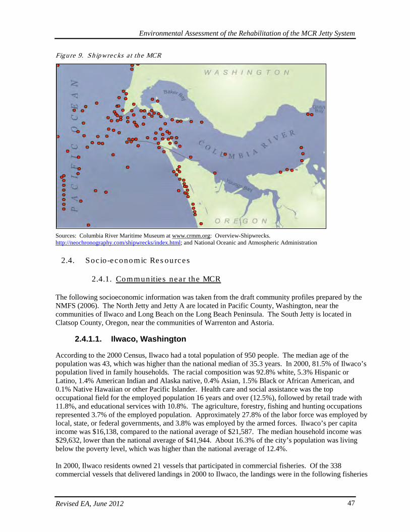
Environmental Assessment of the Rehabilitation of the MCR Jetty System
Revised EA, June 2012 47
Figure 9. Sh ipwrecks a t the MCR
Sources: Columbia River Maritime Museum at www.crmm.org: Overview-Shipwrecks. http://neochronography.com/shipwrecks/index.html; and National Oceanic and Atmospheric Administration
2.4. Soc io-economic Res ources
2.4.1. Communitie s near the MCR
The following socioeconomic information was taken from the draft community profiles prepared by the NMFS (2006). The North Jetty and Jetty A are located in Pacific County, Washington, near the communities of Ilwaco and Long Beach on the Long Beach Peninsula. The South Jetty is located in Clatsop County, Oregon, near the communities of Warrenton and Astoria.
2.4.1.1. Ilwaco, Washington
According to the 2000 Census, Ilwaco had a total population of 950 people. The median age of the population was 43, which was higher than the national median of 35.3 years. In 2000, 81.5% of Ilwaco’s population lived in family households. The racial composition was 92.8% white, 5.3% Hispanic or Latino, 1.4% American Indian and Alaska native, 0.4% Asian, 1.5% Black or African American, and 0.1% Native Hawaiian or other Pacific Islander. Health care and social assistance was the top occupational field for the employed population 16 years and over (12.5%), followed by retail trade with 11.8%, and educational services with 10.8%. The agriculture, forestry, fishing and hunting occupations represented 3.7% of the employed population. Approximately 27.8% of the labor force was employed by local, state, or federal governments, and 3.8% was employed by the armed forces. Ilwaco’s per capita income was $16,138, compared to the national average of $21,587. The median household income was $29,632, lower than the national average of $41,944. About 16.3% of the city’s population was living below the poverty level, which was higher than the national average of 12.4%. In 2000, Ilwaco residents owned 21 vessels that participated in commercial fisheries. Of the 338 commercial vessels that delivered landings in 2000 to Ilwaco, the landings were in the following fisheries
Environmental Assessment of the Rehabilitation of the MCR Jetty System
Revised EA, June 2012 48
(data shown represents landings in metric tons/value of said landings/number of vessels landing; NA = not available): coastal pelagic fish (NA/NA/2), crab (861.9 t/$3,864,427/104), groundfish (2350.7 t/$634,261/35), highly migratory fish species (1907.1 t/$3,595,659/119), salmon (187.4 t/$468,717/98), shrimp (NA/NA/2), and other species (47.5 t/$183,071/81). In 2000, approximately 14 charter-fishing operators serviced sport anglers and tourists. In 2003, there were 1,580 sport fishing license transactions valuing $24,978. In Catch Area 1 (Ilwaco-Ocean) and Area 1A (Ilwaco-Buoy 10), the 2000 sport salmon catch was 27,889 and 16,335 respectively. This data includes (1/1A): (1,630/2,972) Chinook and (26,259/13,363) coho, based on creel survey estimates. In 2000, there were about 16,243/42,061 (1/1A) marine angler trips in the sport salmon fishery for a total of 58,304 across both Ilwaco areas. A total of 106 steelhead were caught by anglers in Area 1, Columbia River to Leadbetter Point. The coastal bottom fish catch for Area 1, Ilwaco/Ilwaco Jetty, was 8,388/631, respectively, and the Pacific halibut catch for Areas 1-2 (Ilwaco-Westport-Ocean Shores) was 2,341 fish. Cape Disappointment State Park (formerly Fort Canby State Park) is situated just outside of Ilwaco. This 1,882-acre, year-round park is a popular recreation area has several miles of ocean beaches that offer water-sport activities such as surfing, kayaking, and kite boarding, as well as beach activities such as clam digging, hiking, and running. The park has a campground, a boat launch, two lighthouses (Cape Disappointment and North Head), and hiking trails.
2.4.1.2. Long Beach, Washington
According to the 2000 Census, Long Beach had a total population of 1,283 people. The median age was 47.4, which was higher than the national median of 35.3 years. In 2000, 66.6% of Long Beach’s population lived in family households. The racial composition was 89.9% white, 4.8% Hispanic or Latino, 1.1% American Indian and Alaska native, 1.4% Asian, and 0.1% Black or African American. Accommodations and food services were the top occupational field, employing 21.1% of the employed population 16 years and older. This was followed by health care and social assistance with 20.3% and retail trade with 9.5%. The agriculture, forestry, fishing and hunting occupations represented 4.8% of the employed population. Approximately 17.7% of the labor force was employed by either local, state, or federal governments and 1.1% was employed by the armed forces. Long Beach’s per capita income was $21,266, compared to the national average of $21,587. The median household income was $23,611, lower than the national average of $41,944. About 18.7% of the population was living below the poverty level, which was higher than the national average of 12.4%. In 2000, no commercial vessels delivered landings to Long Beach. Residents owned 21 vessels that participated in West Coast fisheries. Recorded data shows the number of vessels that participated in each fishery by state (WA/OR/CA; NA = not available) was: coastal pelagic (0/1/0), crab (9/4/0), groundfish (1/0/NA), highly migratory species (NA/0/NA), salmon (4/7/1), shellfish (NA/0/NA), shrimp (NA/3/0), and other species (6/0/0). In 2003, there were 5,044 sport fishing license transactions in Long Beach valued at $70,171. In 2000, one salmon charter fishing operator serviced sport anglers and tourists.
2.4.1.3. Warrenton, Oregon
According to the 2000 Census, the population of Warrenton was 4,096. The median age of the population was 36.6 years, slightly above the national average of 35.3. A total of 82.4% of the population lived in family households in 2000. The racial composition was 92.5% white, 3% Hispanic or Latino, 1.8% Asian, and 1.3% American Indian/Alaska Native. In 2000, the main occupational fields were education, health, and social services (19.3%) and retail (18.6%). The agriculture, forestry, fishing and hunting occupations represented 3.4% of the employed population, and 14.2% of the labor force was employed by local, state, or federal governments. Warrenton’s per capita income was $16,874, compared to the national average of $21,587. The median household income was $33,472, which was lower than the
Environmental Assessment of the Rehabilitation of the MCR Jetty System
Revised EA, June 2012 49
national average of $41,944. About 14.2% of the population was living below the poverty level, which was higher than the national average of 12.4%. In 2000, Warrenton residents owned 52 vessels that participated in commercial fisheries. A total of 334 commercial vessels delivered landings to the Astoria-Warrenton port complex in 2000. These fishery landings included (data shown represents landings in metric tons/value of said landings/number of vessels landing): coastal pelagic fish (5907 t/$794,612/29), crab (1399 t/$6,530,137/92), groundfish (45,284 t/$12,980,569/151), highly migratory fish species (1682 t/$3,273,354/112), other fish species (178 t/$633,751/84), salmon (52 t/$138,537/82), and shrimp (3947 t/$3,816,430/48). In 2000, there were at least four seafood processors operating in Warrenton with about 168 employees. Approximately 39,523,763 pounds of fish were processed at a value of $22,361,265. In 2000, the top three processed products in the community, in terms of pounds landed and revenue earned, were Dungeness crab, flounder, and shrimp. In 2003, at least two outfitter guide businesses and two licensed charter vessel businesses were based in Warrenton. For the Astoria-Warrenton port complex, in 2000 the recreational salmonid catch in the Ocean Boat Fishery was 766 Chinook and 13,712 coho salmon. The recreational non-salmonid catch totaled 1,533 fish, the majority being black rockfish (Sebastes melanops). Fort Stevens State Park is situated just outside of Warrenton. This 3,700-acre, year-round park is a very popular recreation area and offers camping, freshwater lake swimming, 9 miles of bicycle trails, 6 miles of hiking trails, wildlife viewing, an historic shipwreck, and an historic military area. Several miles of ocean beaches offer water-sport activities such as surfing, kayaking, windsurfing, and kite boarding, as well as beach activities such as clam digging, kite flying, hiking, Frisbee, running, and dog exercise.
2.4.1.4. Astoria, Oregon
According to the 2000 Census, the population of Astoria was 9,813. The median age of the population was 38.3 years, slightly higher than the national average of 35.3. The racial composition was 91.1% white, 6% Hispanic or Latino, 2% Asian, 1.2% American Indian/Alaska Native, and 0.5% Black or African American. While the fishing industry has long formed the economic foundation of Astoria, the largest employers in 2003 were the U.S. Coast Guard, the Astoria School District, the Columbia Memorial Hospital, Clatsop County, and the Clatsop Community College. Other main industries in Astoria in 2000 were education, health and social services, retail trade, recreation, and accommodation and food services. According the 2000 Census 17.1% of the surveyed population worked for the local, state, or federal government and 2.5% were in the armed forces. Astoria’s per capita income was $18,759, compared to the national average of $21,587. The median household income was $33,011, which was lower than the national average of $41,944. About 15.9% of the population was living below the poverty level, which was higher than the national average of 12.4%. In 2000, Astoria residents owned 184 vessels that participated in commercial fisheries. For information about commercial fishery landings in Astoria, see Section 2.4.3. There were at least four seafood processors operating in Astoria in 2000. About 154 employees were employed by these processors and about 10,119,325 pounds of fish were processed at an estimated value of $16,870,071. The top three processed products, in terms of pounds and revenue earned, were flounders, Dungeness crab, and shrimp. Astoria had at least six outfitter guide businesses in 2003, and six licensed charter vessel businesses were located in the community. For the Astoria-Warrenton port group, in 2000 the recreational salmonid catch in the Ocean Boat Fishery was 766 Chinook and 13,712 coho salmon. The recreational non-salmonid catch was 1533 fish, consisting primarily of black rockfish.
Environmental Assessment of the Rehabilitation of the MCR Jetty System
Revised EA, June 2012 50
2.4.2. Commerc ia l Naviga tion
The MCR is the gateway to the Columbia-Snake River system, accommodating commercial traffic with an approximate annual value of $20 billion dollars a year. The Columbia/Snake River navigation system from the Pacific Ocean to Lewiston, Idaho is a vital transportation link for the states of Oregon, Washington, Idaho, and Montana, as well as for the Nation as a whole. The Columbia/Snake navigation system flows through Idaho and Washington and forms the southern border of Washington and the northern border of Oregon, serving multiple ports along the way. The Corps maintains the navigation channels and operates navigation locks at eight federal hydropower projects on the Columbia/Snake River system. The navigation channels and locks provide access to markets for producers throughout the United States, and are part of a just-in-time delivery system for this major international trade gateway. The elements of the Columbia/Snake navigation system include the deep-draft navigation channel, the inland navigation channel, and the jetties, anchorages, turning basins, and upriver locks necessary to accommodate increasingly larger ships and growing inland barge movements. The inland navigation channel runs about 365 miles upstream from Portland/Vancouver to Lewiston, Idaho. The Waterborne Trade Atlas indicates that about 10 million tons of cargo is barged annually, with an estimated value of $1.5 to $2 billion. The deep-draft navigation channel runs 110 miles downstream of Portland/Vancouver to the MCR. The Waterborne Trade Atlas indicates that the deep-draft channel carries about 40 million tons of cargo annually, with an estimated value of $20 billion. Also, about 40,000 local jobs are dependent on this trade.

Environmental Assessment of the Rehabilitation of the MCR Jetty System
Revised EA, June 2012 51
(this page intentionally left blank)
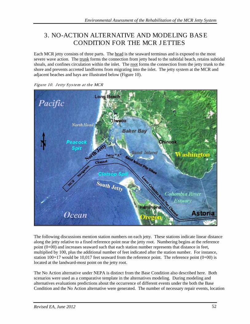
Environmental Assessment of the Rehabilitation of the MCR Jetty System
Revised EA, June 2012 52
3. NO-ACTION ALTERNATIVE AND MODELING BASE CONDITION FOR THE MCR J ETTIES
Each MCR jetty consists of three parts. The head is the seaward terminus and is exposed to the most severe wave action. The trunk forms the connection from jetty head to the subtidal beach, retains subtidal shoals, and confines circulation within the inlet. The root forms the connection from the jetty trunk to the shore and prevents accreted landforms from migrating into the inlet. The jetty system at the MCR and adjacent beaches and bays are illustrated below (Figure 10). Figure 10. J e tty Sys tem a t the MCR
The following discussions mention station numbers on each jetty. These stations indicate linear distance along the jetty relative to a fixed reference point near the jetty root. Numbering begins at the reference point (0+00) and increases seaward such that each station number represents that distance in feet, multiplied by 100, plus the additional number of feet indicated after the station number. For instance, station 100+17 would be 10,017 feet seaward from the reference point. The reference point (0+00) is located at the landward-most point on the jetty root. The No Action alternative under NEPA is distinct from the Base Condition also described here. Both scenarios were used as a comparative template in the alternatives modeling. During modeling and alternatives evaluations predictions about the occurrence of different events under the both the Base Condition and the No Action alternative were generated. The number of necessary repair events, location
Environmental Assessment of the Rehabilitation of the MCR Jetty System
Revised EA, June 2012 53
of repairs, possible breaches, dredging needs (dredging and breach events were only considered under fix-as-fails alternatives), etc. were predicted both for the No Action alternative and the Base Condition, as well as for the additional alternatives that were identified for further evaluation and comparison. Further discussion of modeling used to generate and evaluate these predictions is discussed in Section 4.1.2 Evaluation of Engineering Features, and Section 4.2 Range of Alternatives Considered. Notably, this revised final EA reflects updates to circumstances assumed under the Base Condition used for modeling predictions to help identify the Preferred Alternative. This is the result of input from an Independent External Peer Review (IEPR) process, refinement in model assumptions, and modification of the assumed regular jetty maintenance and monitoring strategy implemented in the future. The No Action Alternative remains essentially the same, except that South Jetty foredune augmentation has been evaluated here as an alternative rather than assumed as a previously completed action (as it is under the Base Condition). No Action: For the No Action Alternative, no planned large-scale action (such as head-capping or spur groin construction) would be taken to slow down the large, physical processes (larger waves, increased storm activity, and others) that are negatively impacting the structural stability the MCR jetty system. Those larger physical processes include landward recession of the jetty head, shrinking of the ebb tidal shoal, foundation erosion, and adjacent shoreline erosion. The lengths of each jetty would continue to recede landward with the expected response of the surrounding morphology including continued shrinking of adjacent underwater shoals and the overall shrinking of the ebb tidal shoal. Much of the material eroded from the inlets’ shrinking shoals would be transported into the MCR inlet, thereby adding to requirements for regular maintenance dredging. The underwater sand shoals upon which the jetties are built would continue to erode, leaving deeper water depths along the jetties. The deeper water (over the eroded shoals) would allow larger waves to attack the jetties resulting in greater jetty deterioration and greater foundation erosion. Wave and current action within the MCR inlet would increase. However, on a smaller scale more immediate actions may be taken to address specific jetty sections and localized processes via an intermittent or fix-as-fails repair strategy. The No Action alternative could be somewhat characterized as a fix-as-fails approach. In this scenario, South Jetty maintenance is deferred for a given segment until the upper cross-sectional area falls below about 30% of its standard template profile. At the North Jetty and Jetty A, the repair strategy is triggered at a lower threshold when at a given segment the upper cross-sectional area falls below about 40% of its standard template profile. Because of the greater potential navigational impacts from a failure at the North Jetty and the length and exposure of making repairs difficult at the South Jetty, this results in relatively more frequent repair actions under the repair strategy for the North Jetty compared to fix-as-fails at the South Jetty. Depending on the condition and rate of damage to the jetty cross-section for either repair strategy, maintenance actions may be conducted as a normally planned operation, in an expedited fashion, or on an emergency basis. A fix-as-fails approach involving minimal, site-specific emergency repairs is how the jetties have been maintained historically. This approach represents the No-Action alternative. Base Condition (for Corps Planning and Modeling Purposes): Interim repairs have a different repair threshold trigger than fix-as-fails such that action is taken when less of the prism is gone (~30-40%- remaining for interim) relative to fix-as-fail (under fix-as-fails, ~30% remaining on the South Jetty standard template profile, ~30-40% remaining of the standard template profile for North Jetty and Jetty A). Because of the greater potential navigational impacts from a failure at the North Jetty and because of the length and exposure of making repairs difficult at the South Jetty,
Environmental Assessment of the Rehabilitation of the MCR Jetty System
Revised EA, June 2012 54
this results in relatively more frequent repair actions under the interim repair strategy for the North Jetty compared to at the South Jetty. Interim repairs are a more proactive approach. For the purposes of modeling, interim repair strategies were part of the suite of alternatives evaluated for the jetties under the Base Condition alternative. The Base Condition is a Corps-specific plan/scenario against which all other alternative plans are measured in the Corps’ planning process. When predicting a Base Condition, the most reasonable operations and maintenance (O&M) strategy must be forecasted and used to compare against various project alternatives. The following considerations were determined to develop the Base Condition: operating trends, current and projected reliability of all critical components, and planned maintenance on the project. Unlike the No-Action alternative, Base Condition additional repair actions and activities must be considered and may be implemented to keep the jetties functional, and as such may extend beyond those localized, minimal actions undertaken as reactive, fix-as-fails maintenance. Consequently, while the MCR Base Condition allows the jetty heads to recede, interim repairs on the jetty trunk are implemented to prevent costly emergency repairs. Base Condition maintenance is beyond that which might be exercised under No Action per NEPA. The Base Condition requires the Corps to take all measures short of major repairs and rehabilitation to keep the jetty system functional. A rubble-mound structure can incur a certain level of damage before the whole cross section fails resulting in a functional impact; however, a complete breach through the above water portion of the structure can result in rapid deterioration. Due to the level of construction and the high mobilization costs, the Base Condition does not include any jetty head re-construction. Only the trunk and the root of the jetty are maintained via interim repairs, and the jetty is allowed to recede landward. Maintenance of trunk and root of the jetty is minimized by deferring repair activities into the future for as long as possible. Jetty repairs are initiated only when an unacceptable failure of the upper portion of the jetty cross section seems to be progressing. The Base Condition is identified as an interim repair approach because the upper portion of the cross section is allowed to be damaged to approximately 40% remaining prior to repair actions being taken. In this way, the jetty is maintained close to the margin of functional loss. Depending on the percentage of lost cross section and rate of damage which results from the deferred action, maintenance actions may need to be conducted as a normally planned operation or on an expedited basis. In all cases, the repair occurs before the complete failure of the upper part of the cross section. The interim repair approach carries an elevated risk for incurring added costs through expediting repairs (to prevent functional loss of a jetty). Consequently, there is an elevated likelihood that jetty repairs may be more expensive (cost/ton of repair stone placed) when they do occur. It is also noteworthy that for modeling purposes only augmentation of the foredune at the South Jetty is considered part of the base-condition, but it is NOT part of the No Action alternative. Similarly, limited repair actions (stations 86-99) and lagoon fill at the North Jetty are also included as part of the base condition for modeling, but are NOT part of No-Action. This is due to the fact that North Jetty repairs, North Jetty lagoon fill, and augmentation of the South Jetty foredune would all be implemented as maintenance actions regardless of whether or not the additional major rehabilitation and repairs are completed in order to avoid a breach. They have been identified as priority actions that are required as a basis for all subsequent actions. Therefore, limited North Jetty repairs, lagoon fill, and foredune augmentation at the South Jetty are assumed components when the base conditions are discussed. These actions will likely be a separately funded maintenance projects and were further described and evaluated for their effects in the 2011 EA and FONSI. They have yet to be implemented and are closely associated with the other components of the proposed action. They would occur early in relationship to the overall rehabilitation and repair schedule.
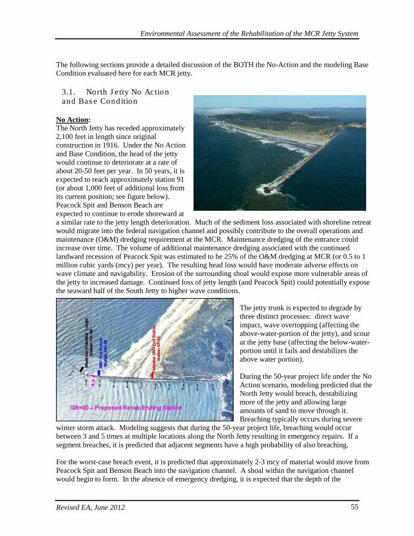
Environmental Assessment of the Rehabilitation of the MCR Jetty System
Revised EA, June 2012 55
The following sections provide a detailed discussion of the BOTH the No-Action and the modeling Base Condition evaluated here for each MCR jetty.
3.1. North J e tty No Action and Bas e Condition
No Action: The North Jetty has receded approximately 2,100 feet in length since original construction in 1916. Under the No Action and Base Condition, the head of the jetty would continue to deteriorate at a rate of about 20-50 feet per year. In 50 years, it is expected to reach approximately station 91 (or about 1,000 feet of additional loss from its current position; see figure below). Peacock Spit and Benson Beach are expected to continue to erode shoreward at a similar rate to the jetty length deterioration. Much of the sediment loss associated with shoreline retreat would migrate into the federal navigation channel and possibly contribute to the overall operations and maintenance (O&M) dredging requirement at the MCR. Maintenance dredging of the entrance could increase over time. The volume of additional maintenance dredging associated with the continued landward recession of Peacock Spit was estimated to be 25% of the O&M dredging at MCR (or 0.5 to 1 million cubic yards (mcy) per year). The resulting head loss would have moderate adverse effects on wave climate and navigability. Erosion of the surrounding shoal would expose more vulnerable areas of the jetty to increased damage. Continued loss of jetty length (and Peacock Spit) could potentially expose the seaward half of the South Jetty to higher wave conditions.
The jetty trunk is expected to degrade by three distinct processes: direct wave impact, wave overtopping (affecting the above-water-portion of the jetty), and scour at the jetty base (affecting the below-water-portion until it fails and destabilizes the above water portion). During the 50-year project life under the No Action scenario, modeling predicted that the North Jetty would breach, destabilizing more of the jetty and allowing large amounts of sand to move through it. Breaching typically occurs during severe
winter storm attack. Modeling suggests that during the 50-year project life, breaching would occur between 3 and 5 times at multiple locations along the North Jetty resulting in emergency repairs. If a segment breaches, it is predicted that adjacent segments have a high probability of also breaching. For the worst-case breach event, it is predicted that approximately 2-3 mcy of material would move from Peacock Spit and Benson Beach into the navigation channel. A shoal within the navigation channel would begin to form. In the absence of emergency dredging, it is expected that the depth of the
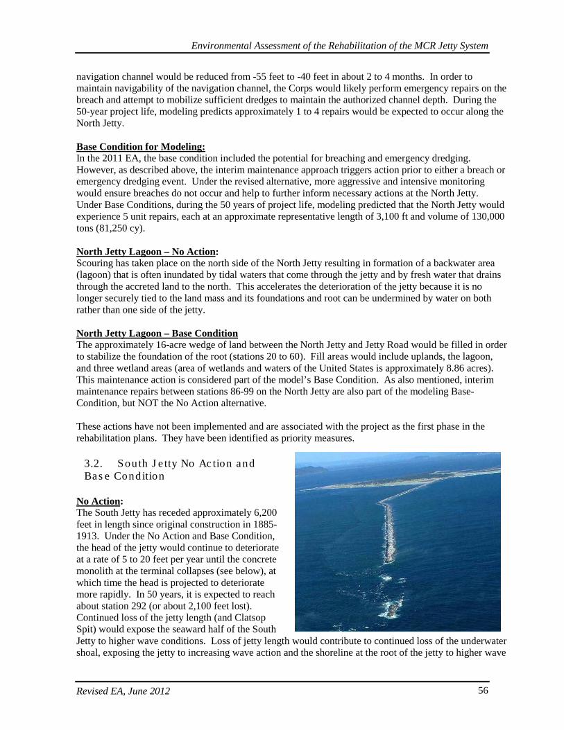
Environmental Assessment of the Rehabilitation of the MCR Jetty System
Revised EA, June 2012 56
navigation channel would be reduced from -55 feet to -40 feet in about 2 to 4 months. In order to maintain navigability of the navigation channel, the Corps would likely perform emergency repairs on the breach and attempt to mobilize sufficient dredges to maintain the authorized channel depth. During the 50-year project life, modeling predicts approximately 1 to 4 repairs would be expected to occur along the North Jetty. Base Condition for Modeling: In the 2011 EA, the base condition included the potential for breaching and emergency dredging. However, as described above, the interim maintenance approach triggers action prior to either a breach or emergency dredging event. Under the revised alternative, more aggressive and intensive monitoring would ensure breaches do not occur and help to further inform necessary actions at the North Jetty. Under Base Conditions, during the 50 years of project life, modeling predicted that the North Jetty would experience 5 unit repairs, each at an approximate representative length of 3,100 ft and volume of 130,000 tons (81,250 cy). North Jetty Lagoon – No Action: Scouring has taken place on the north side of the North Jetty resulting in formation of a backwater area (lagoon) that is often inundated by tidal waters that come through the jetty and by fresh water that drains through the accreted land to the north. This accelerates the deterioration of the jetty because it is no longer securely tied to the land mass and its foundations and root can be undermined by water on both rather than one side of the jetty. North Jetty Lagoon – Base Condition The approximately 16-acre wedge of land between the North Jetty and Jetty Road would be filled in order to stabilize the foundation of the root (stations 20 to 60). Fill areas would include uplands, the lagoon, and three wetland areas (area of wetlands and waters of the United States is approximately 8.86 acres). This maintenance action is considered part of the model’s Base Condition. As also mentioned, interim maintenance repairs between stations 86-99 on the North Jetty are also part of the modeling Base-Condition, but NOT the No Action alternative. These actions have not been implemented and are associated with the project as the first phase in the rehabilitation plans. They have been identified as priority measures.
3.2. South J e tty No Ac tion and Bas e Condition
No Action: The South Jetty has receded approximately 6,200 feet in length since original construction in 1885-1913. Under the No Action and Base Condition, the head of the jetty would continue to deteriorate at a rate of 5 to 20 feet per year until the concrete monolith at the terminal collapses (see below), at which time the head is projected to deteriorate more rapidly. In 50 years, it is expected to reach about station 292 (or about 2,100 feet lost). Continued loss of the jetty length (and Clatsop Spit) would expose the seaward half of the South Jetty to higher wave conditions. Loss of jetty length would contribute to continued loss of the underwater shoal, exposing the jetty to increasing wave action and the shoreline at the root of the jetty to higher wave
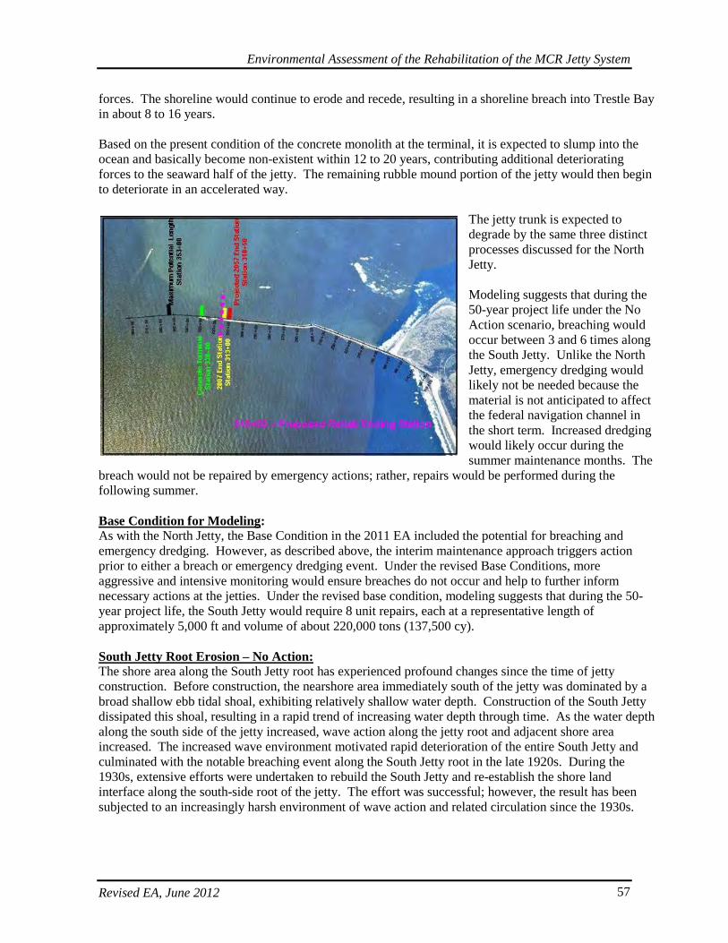
Environmental Assessment of the Rehabilitation of the MCR Jetty System
Revised EA, June 2012 57
forces. The shoreline would continue to erode and recede, resulting in a shoreline breach into Trestle Bay in about 8 to 16 years. Based on the present condition of the concrete monolith at the terminal, it is expected to slump into the ocean and basically become non-existent within 12 to 20 years, contributing additional deteriorating forces to the seaward half of the jetty. The remaining rubble mound portion of the jetty would then begin to deteriorate in an accelerated way.
The jetty trunk is expected to degrade by the same three distinct processes discussed for the North Jetty. Modeling suggests that during the 50-year project life under the No Action scenario, breaching would occur between 3 and 6 times along the South Jetty. Unlike the North Jetty, emergency dredging would likely not be needed because the material is not anticipated to affect the federal navigation channel in the short term. Increased dredging would likely occur during the summer maintenance months. The
breach would not be repaired by emergency actions; rather, repairs would be performed during the following summer. Base Condition for Modeling: As with the North Jetty, the Base Condition in the 2011 EA included the potential for breaching and emergency dredging. However, as described above, the interim maintenance approach triggers action prior to either a breach or emergency dredging event. Under the revised Base Conditions, more aggressive and intensive monitoring would ensure breaches do not occur and help to further inform necessary actions at the jetties. Under the revised base condition, modeling suggests that during the 50-year project life, the South Jetty would require 8 unit repairs, each at a representative length of approximately 5,000 ft and volume of about 220,000 tons (137,500 cy). South Jetty Root Erosion – No Action: The shore area along the South Jetty root has experienced profound changes since the time of jetty construction. Before construction, the nearshore area immediately south of the jetty was dominated by a broad shallow ebb tidal shoal, exhibiting relatively shallow water depth. Construction of the South Jetty dissipated this shoal, resulting in a rapid trend of increasing water depth through time. As the water depth along the south side of the jetty increased, wave action along the jetty root and adjacent shore area increased. The increased wave environment motivated rapid deterioration of the entire South Jetty and culminated with the notable breaching event along the South Jetty root in the late 1920s. During the 1930s, extensive efforts were undertaken to rebuild the South Jetty and re-establish the shore land interface along the south-side root of the jetty. The effort was successful; however, the result has been subjected to an increasingly harsh environment of wave action and related circulation since the 1930s.
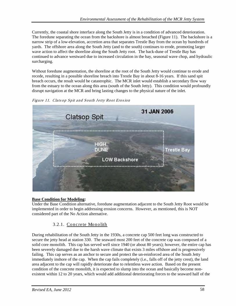
Environmental Assessment of the Rehabilitation of the MCR Jetty System
Revised EA, June 2012 58
Currently, the coastal shore interface along the South Jetty is in a condition of advanced deterioration. The foredune separating the ocean from the backshore is almost breached (Figure 11). The backshore is a narrow strip of a low-elevation, accretion area that separates Trestle Bay from the ocean by hundreds of yards. The offshore area along the South Jetty (and to the south) continues to erode, promoting larger wave action to affect the shoreline along the South Jetty root. The back-dune of Trestle Bay has continued to advance westward due to increased circulation in the bay, seasonal wave chop, and hydraulic surcharging. Without foredune augmentation, the shoreline at the root of the South Jetty would continue to erode and recede, resulting in a possible shoreline breach into Trestle Bay in about 8-16 years. If this sand spit breach occurs, the result would be catastrophic. The MCR inlet would establish a secondary flow way from the estuary to the ocean along this area (south of the South Jetty). This condition would profoundly disrupt navigation at the MCR and bring lasting changes to the physical nature of the inlet. Figure 11. Cla ts op Sp it and South J e tty Root Eros ion
Base Condition for Modeling: Under the Base Condition alternative, foredune augmentation adjacent to the South Jetty Root would be implemented in order to begin addressing erosion concerns. However, as mentioned, this is NOT considered part of the No Action alternative.
3.2.1. Concre te Monolith
During rehabilitation of the South Jetty in the 1930s, a concrete cap 500 feet long was constructed to secure the jetty head at station 330. The seaward most 200 feet of the concrete cap was composed of a solid core monolith. This cap has served well since 1940 (or about 80 years); however, the entire cap has been severely damaged due to the harsh wave climate that exists 3 miles offshore and is progressively failing. This cap serves as an anchor to secure and protect the un-reinforced area of the South Jetty immediately inshore of the cap. When the cap fails completely (i.e., falls off of the jetty crest), the land area adjacent to the cap will rapidly deteriorate due to relentless wave action. Based on the present condition of the concrete monolith, it is expected to slump into the ocean and basically become non-existent within 12 to 20 years, which would add additional deteriorating forces to the seaward half of the
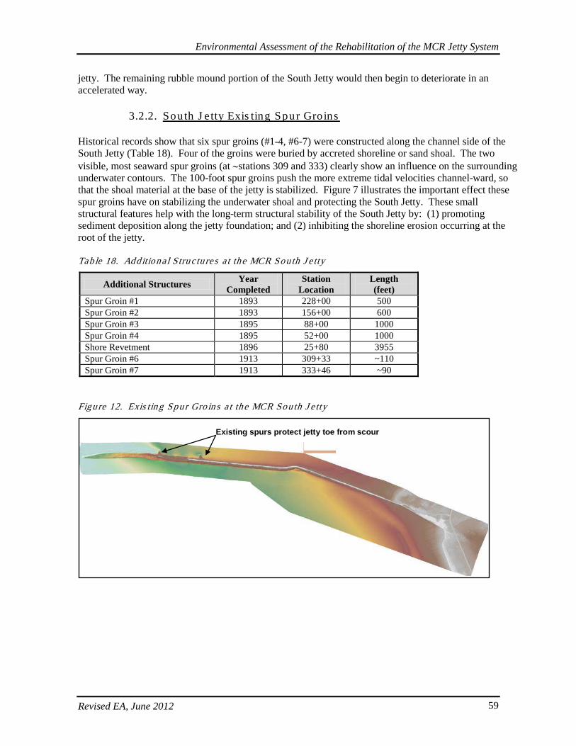
Environmental Assessment of the Rehabilitation of the MCR Jetty System
Revised EA, June 2012 59
jetty. The remaining rubble mound portion of the South Jetty would then begin to deteriorate in an accelerated way.
3.2.2. South J e tty Exis ting Spur Groins
Historical records show that six spur groins (#1-4, #6-7) were constructed along the channel side of the South Jetty (Table 18). Four of the groins were buried by accreted shoreline or sand shoal. The two visible, most seaward spur groins (at ∼stations 309 and 333) clearly show an influence on the surrounding underwater contours. The 100-foot spur groins push the more extreme tidal velocities channel-ward, so that the shoal material at the base of the jetty is stabilized. Figure 7 illustrates the important effect these spur groins have on stabilizing the underwater shoal and protecting the South Jetty. These small structural features help with the long-term structural stability of the South Jetty by: (1) promoting sediment deposition along the jetty foundation; and (2) inhibiting the shoreline erosion occurring at the root of the jetty. Tab le 18. Additiona l S tru c tures a t the MCR South J e tty
Additional Structures Year Completed
Station Location
Length (feet)
Spur Groin #1 1893 228+00 500 Spur Groin #2 1893 156+00 600 Spur Groin #3 1895 88+00 1000 Spur Groin #4 1895 52+00 1000 Shore Revetment 1896 25+80 3955 Spur Groin #6 1913 309+33 ~110 Spur Groin #7 1913 333+46 ~90
Figure 12. Exis ting Spur Gro ins a t the MCR South J e tty
Existing spurs protect jetty toe from scour
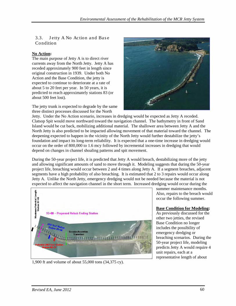
Environmental Assessment of the Rehabilitation of the MCR Jetty System
Revised EA, June 2012 60
3.3. J e tty A No Action and Bas e Condition
No Action: The main purpose of Jetty A is to direct river currents away from the North Jetty. Jetty A has receded approximately 900 feet in length since original construction in 1939. Under both No Action and the Base Condition, the jetty is expected to continue to deteriorate at a rate of about 5 to 20 feet per year. In 50 years, it is predicted to reach approximately stations 83 (or about 500 feet lost). The jetty trunk is expected to degrade by the same three distinct processes discussed for the North Jetty. Under the No Action scenario, increases in dredging would be expected as Jetty A receded. Clatsop Spit would move northward toward the navigation channel. The bathymetry in front of Sand Island would be cut back, mobilizing additional material. The shallower area between Jetty A and the North Jetty is also predicted to be impacted allowing movement of that material toward the channel. The deepening expected to happen in the vicinity of the North Jetty would further destabilize the jetty’s foundation and impact its long-term reliability. It is expected that a one-time increase in dredging would occur on the order of 800,000 to 1.6 mcy followed by incremental increases in dredging that would depend on changes in channel shoaling patterns and spit movement. During the 50-year project life, it is predicted that Jetty A would breach, destabilizing more of the jetty and allowing significant amounts of sand to move through it. Modeling suggests that during the 50-year project life, breaching would occur between 2 and 4 times along Jetty A. If a segment breaches, adjacent segments have a high probability of also breaching. It is estimated that 2 to 3 repairs would occur along Jetty A. Unlike the North Jetty, emergency dredging would not be needed because the material is not expected to affect the navigation channel in the short term. Increased dredging would occur during the
summer maintenance months. Also, repairs to the breach would occur the following summer. Base Condition for Modeling: As previously discussed for the other two jetties, the revised Base Condition no longer includes the possibility of emergency dredging or breaching scenarios. During the 50-year project life, modeling predicts Jetty A would require 4 unit repairs, each at a representative length of about
1,900 ft and volume of about 55,000 tons (34,375 cy).
Environmental Assessment of the Rehabilitation of the MCR Jetty System
Revised EA, June 2012 61
4. ALTERNATIVES AND DESIGN OPTIONS
4.1. Genera l Alte rna tives Ana lys is Ca tegories and Fea tures
Neither the alternatives in this EA nor the previously Preferred Alternatives for the MCR jetties discussed in the 2006 and 2010 draft EAs or May 2011 EA include rebuilding the three jetties to their originally authorized lengths, nor to the lengths proposed in the first Draft EA released in 2006. Evaluations of the alternatives now consider the ends of the jetties at their current locations or receding, which is short of both the originally authorized and the 2006 recommended lengths. In addition, this EA updates the alternative plans considered and includes a revised Preferred Alternative at the North Jetty, South Jetty, and Jetty A. The current changes to the Preferred Alternative for the North Jetty, South Jetty, and Jetty A would further avoid and minimize some of the previously identified environmental impacts by reducing the final structure and construction footprints necessary to achieve a resilient jetty system at the MCR. The major changes from the 2011 EA are the additional alternatives considered and the assumptions in the Base Condition such that the jetties are managed and maintained in order to not allow them to breach. The model takes a simplified approach to managing the risk of degradation trigger points and assessing life-cycle costs of different cross-sections and timing of actions. All alternatives are compared to the No Action alternative and also to this revised Base Condition. Alternatives and design options were evaluated by comparing reliability of the system, average annual costs, potential environmental effects, and anticipated repair frequencies for each alternative. Repair and rehabilitation options comprise the general categories of alternatives considered and evaluated for the MCR jetty system, as described below. Repair Alternatives. The programmed scheduled repair strategy monitors each 100-ft jetty segment for its current cross section and degradation rates. When a threshold occurs (usually about four-years before failure), this triggers a repair action. Generally, they are triggered when the upper profile of the cross-sectional area falls below 30-50% of its standard template profile (or, 50-70% of the previously existing prism is gone). Repair alternatives usually involve adding limited amounts of stone to trunk and root features in order to restore the affected cross-section back to a standard repair template. Under repair options, stone placement generally is limited to above-water sections and remains within the existing jetty and relic stone structures. Repair alternatives also considered differing degrees of repair varying by volume, frequency, and size of the restored prism. Repair alternatives are also varied in their implementation strategy, which could occur on the basis of a scheduled, predetermined time and place, or on an interim repair basis (as the base condition) for which a stochastic model predicted jetty repair scenarios. For the North and South Jetties and Jetty A, the repair alternative included repair combined with and without engineering features (head capping, spur groins, etc.). Scheduled repairs occur even sooner than interim repairs, as they are initiated when even less of the jetty prism has been degraded. Interim repairs (Base Condition) allow a greater level of degradation to occur prior to triggering action relative to levels acceptable under the scheduled repair scenario. However, this interim repair strategy also entails more aggressive and intensive monitoring such that interim repairs avoid both breaching and resulting dredging scenarios. Both are more proactive than fix-as-fails under the No Action alternative. Rehabilitation Alternatives. Rehabilitation alternatives generally incorporate engineering components which may extend beyond the current footprint of jetty and relic stone structures and could entail both above and below-water fill. Certain engineering features were evaluated and incorporated as common components present in many of the rehabilitation alternatives considered. Engineering features included
Environmental Assessment of the Rehabilitation of the MCR Jetty System
Revised EA, June 2012 62
capping jetty heads, constructing additional spur groins, and filling the North Jetty lagoon area. However, fill at the North Jetty lagoon, certain North Jetty repairs from stations 86-99, and augmentation of the South Jetty foredune are engineering features but are also considered separate maintenance actions that are implemented under the Base Condition; they are NOT part of the No Action alternative. Rehabilitation strategies were evaluated as both immediate and scheduled. Immediate rehabilitation begins at one end of the jetty and continues in succession along adjacent section of the jetties without prioritizing a reach based on its condition. Scheduled rehabilitation constructs at specific locations along the jetty at specific time periods in order to prioritize areas where conditions warrant sooner attention.
4.1.1. Common Engineering Fea tures Cons ide red as Part o f Rehabilita tion Alte rna tives
4.1.1.1. Spur Groins
Historically, spur groins were constructed along the trunk of the jetties and were a design component considered in the current alternatives analyses related to this rehabilitation. A spur groin is a relatively short structure (in comparison to jetty length) usually extending perpendicular from the main axis of a jetty. Spur groins are constructed: (1) on the ocean or beach side of a jetty to deflect the longshore (rip) current and related littoral sediment away from the jetty and prevent littoral sediment from entering the navigation channel; and (2) on the channel side of a jetty to divert the tidal or river current away from the channel side toe of the jetty. Spur groins also act to reduce the scour affecting the foundation while increasing the current in the navigation channel, thus reducing the deposition in the channel. In areas where foundation scour threatens the overall stability of the MCR jetties, spur groins constructed perpendicular to the structure facilitate stabilization by the accumulation of sediment along the jetty’s foundation.
4.1.1.2. Jetty Length and Head
All three MCR jetties have receded measurably from their original authorized length, and without the proposed action this is expected to continue. As described previously, all three jetties have essentially lost their functional heads, resulting in further unraveling and deterioration of their remaining trunk and root structures. Due to the interaction of wave patterns and currents with the jetties configuration, shorter jetty lengths can increase underwater shoal erosion and influence shoreline position adjacent to the jetties. Jetty head design is much larger (wider prism, with larger-sized armor stone) than a typical jetty trunk section due to its increased exposure to wave attack and its critical protective function for the rest of the structure. It was important to determine how much to rebuild the original jetty structures and where the newly located (shortened, compared to the authorized length) jetty lengths should be stabilized. Parameters evaluated in addressing jetty lengths included possible impacts on tidal velocities and salinity, protection of the navigation entrance from waves, impacts on adjacent shorelines and ebb tidal shoal erosion, and impacts on dredged material disposal activities. The location of the relic stone base left from past construction efforts also played a role in determining the head stabilization location. Head capping is one method of head stabilization that was evaluated in more detail as described further below. However, there are various methods and degrees of head and length stabilization which could include capping or some other form of armoring.
4.1.1.3. Cross-section Design
The cross-section design for the MCR jetties was guided by the following considerations: • The repair template must be cost effective in terms of construction materials.
Environmental Assessment of the Rehabilitation of the MCR Jetty System
Revised EA, June 2012 63
• The repair template must be easily constructed. • The minimum modification to the jetty footprint is most desirable in order to limit potential impacts
to the surrounding environment. • The jetty repair should be structurally consistent with the current jetty configuration and future repair
scenarios. • Each action taken should be directed toward improving the long-term reliability of the jetty system
and its function to protect the navigation channel. Because of the variability in wave climates between the jetties, the jetties’ individual reach sections, and their individual repair histories, the cross-section design options vary for the jetties. Jetty cross-section options examined crest elevation, crest width, and side-slope adjustments. For jetty reaches where foundation stability was a concern, special designs were developed for the toe berm area of the cross section for the long-term stabilization of the upper portion of the section. Above and below water adjustments also were made to address both the variability in design climate and the accuracy and expected method of construction. Two-dimensional physical modeling was used to assess and fine-tune the cross-section designs for each jetty. There are four general categories of cross-section descriptions: Minimum. This cross section generally fits within the existing footprint of the current jetty structure or relic stone and involves rock placement above the water. Small. This cross section generally fits mostly within the existing footprint of the current jetty structure or relic stone, but may extend slightly beyond it. It generally involves rock placement above the water. Moderate. This cross section fits somewhat within the existing footprint of the current jetty structure or relic stone, but may extend beyond it. It generally involves rock placement both above and below the water. Much of the cross section is encased in armor stone, and below-water instabilities are addressed. Large. This cross section generally extends beyond the existing footprint of the current jetty structure or relic stone. It involves rock placement both above and below the water. Much of the cross section is encased in two layers of armor stone, and below-water instabilities are addressed. Slopes are generally flatter and include a larger toe structure. Composite. When referring to a composite cross-section, this could entail any combination of the above cross-section types tailored to address structure concerns along specific jetty reach sections.
4.1.2. Evalua tion of Engineering Fea tures
4.1.2.1. Spur Groin Location and Number (ERDC Model)
The Corps’ Engineering Research and Development Center (ERDC) in Vicksburg, Mississippi analyzed the hydrodynamics and circulation patterns in the MCR entrance, as well as the potential impacts and effectiveness of placing spur groins on the jetties. This analysis was conducted with the coastal modeling system and other models to select the type, depth, and length of spur groins necessary to protect the each jetty from the processes causing increased scour (e.g., rip currents, eddies). Though spur groins were evaluated based on the following assumptions detailed below, further subsequent modeling by the Portland District Corp no longer justifies the need for spur groins at any of the jetties. It is currently assumed that a stable jetty system can be maintained without spur groins. Real-time monitoring will be conducted yearly to confirm assumptions that the jetties remain stable without these features and that there is no risk of breaching. Therefore, these features are no longer being carried
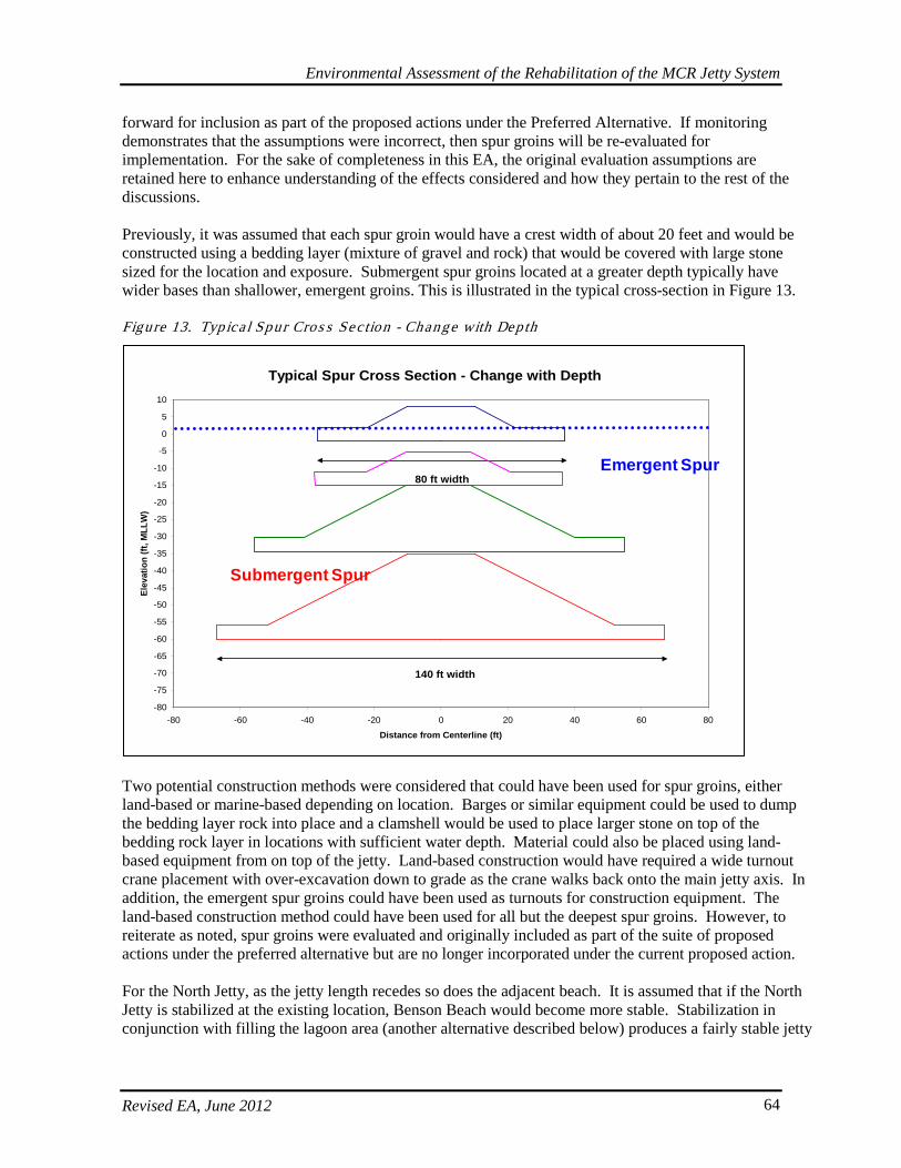
Environmental Assessment of the Rehabilitation of the MCR Jetty System
Revised EA, June 2012 64
forward for inclusion as part of the proposed actions under the Preferred Alternative. If monitoring demonstrates that the assumptions were incorrect, then spur groins will be re-evaluated for implementation. For the sake of completeness in this EA, the original evaluation assumptions are retained here to enhance understanding of the effects considered and how they pertain to the rest of the discussions. Previously, it was assumed that each spur groin would have a crest width of about 20 feet and would be constructed using a bedding layer (mixture of gravel and rock) that would be covered with large stone sized for the location and exposure. Submergent spur groins located at a greater depth typically have wider bases than shallower, emergent groins. This is illustrated in the typical cross-section in Figure 13. Figure 13. Typica l Spur Cros s Sec tion - Change with Depth
Two potential construction methods were considered that could have been used for spur groins, either land-based or marine-based depending on location. Barges or similar equipment could be used to dump the bedding layer rock into place and a clamshell would be used to place larger stone on top of the bedding rock layer in locations with sufficient water depth. Material could also be placed using land-based equipment from on top of the jetty. Land-based construction would have required a wide turnout crane placement with over-excavation down to grade as the crane walks back onto the main jetty axis. In addition, the emergent spur groins could have been used as turnouts for construction equipment. The land-based construction method could have been used for all but the deepest spur groins. However, to reiterate as noted, spur groins were evaluated and originally included as part of the suite of proposed actions under the preferred alternative but are no longer incorporated under the current proposed action. For the North Jetty, as the jetty length recedes so does the adjacent beach. It is assumed that if the North Jetty is stabilized at the existing location, Benson Beach would become more stable. Stabilization in conjunction with filling the lagoon area (another alternative described below) produces a fairly stable jetty
Typical Spur Cross Section - Change with Depth
-80
-75
-70
-65
-60
-55
-50
-45
-40
-35
-30
-25
-20
-15
-10
-5
0
5
10
-80 -60 -40 -20 0 20 40 60 80
Distance from Centerline (ft)
Elev
atio
n (ft
, MLL
W)
80 ft width
140 ft width
Emergent Spur
Submergent Spur
Environmental Assessment of the Rehabilitation of the MCR Jetty System
Revised EA, June 2012 65
tied to a landmass. It is anticipated that spur groins would not be required in the near-term. Monitoring would be conducted to validate these assumptions.
4.1.2.2. Jetty Length (USGS Model)
The U.S. Geological Society (USGS) assisted the Corps with evaluating potential improvements and impacts of rebuilding the lengths of the MCR jetties. The USGS efforts focused on using the Delft-3D model to identify potential changes in circulation, salinity and sediment transport that could result from the offshore re-build of the three jetties. Increased jetty lengths were investigated to determine if they could provide a more sustainable jetty system over the long term. An initial assessment of options for jetty rebuild limited the considerations to partial jetty rebuild rather than considering rebuild to fully authorized lengths. The South Jetty length rebuild was investigated out to station 353 or 4,000 feet seaward of its current location; the North Jetty out to station 115 or 1,500 feet seaward; and Jetty A out to station 97 or 900 feet seaward. The model results for the jetty length rebuilds showed only small changes on the overall patterns of salinity flow, waves, and sediment transport at the MCR inlet. However, due to the severe ocean conditions at the MCR, tremendous costs would be required to rebuild the jetties and to re-establish a resilient jetty head section at the originally authorized lengths or to those proposed in the earlier 2006 EA. It was recommended that all three jetty lengths remain the same as the current jetty head locations. However, a project plan that does not stabilize the jetty heads would likely have a negative impact on both Clatsop and Peacock Spits, as well as the shoreline areas adjacent to both the North and South jetties. Stabilizing the jetty heads at the proposed current locations would reduce the migration of littoral sediment from Peacock Spit into the navigation channel. This current proposal is anticipated to provide an adequate level of protection for the jetty system and adjacent landforms and habitats, while rebuilding to the authorized or previously proposed lengths would add considerable cost increases without an anticipated equivalent or sufficient corresponding benefit in additional protection or reliability. Part of the exponential increase in cost for achieving the authorized lengths is derived from the volume of rock placement needed for structure fill at current depths characteristic of the locations where the heads were originally authorized.
4.1.2.3. Cross-section Design (Physical Model)
The ERDC was contracted to conduct a two-dimensional physical model of the jetty cross-section design. The range of structural repair types addressed in the model included crest elevation and crest widths variations, side-slope variations, underwater berms, armor stone, and concrete armor unit options. The purpose for the two-dimensional physical model was three-fold:
1. Assist in defining damage initiation and progression relationships (damage function) for existing condition and proposed alternatives to feed into a reliability analysis of the three structures.
2. Conduct qualitative screening of a wide range of alternatives that will bracket potential structural and material-type options that could be applied on the three structures.
3. Assist in cross-section optimization and material-type design for the alternatives to be assessed. Both the North and South jetties were tested under low and high water conditions. Incident wave heights up to 35 feet were applied to the jetty cross sections. Armor units tested included quarry stone and dolos concrete armor units. An additional concrete armor unit was tested called a c-roc. The c-roc armor unit more closely resembles a large rock with interlocking members. Due to its rock-like configuration, it is expected to be less fragile than concrete armor units which have thinner flange-like elements. Existing condition and potential design alternative cross sections were modeled. The physical model testing of the jetty cross section resulted in a range of graduated design options that achieve varying levels of structure reliability that were carried forward into the life-cycle analysis model of the jetty system.
Environmental Assessment of the Rehabilitation of the MCR Jetty System
Revised EA, June 2012 66
Physical modeling results showed that the primary failure modes for the North and South jetties were high water level wave attack and overtopping. The jetties can be reliably designed using attainable rock (quarry stone). The seaward head of jetty may require advanced design. Dolos concrete armor units did not hold up well in the tests. Very flat slopes would be needed to make this armor unit viable. C-roc appeared to hold up well during preliminary testing (concerns regarding c-roc include reliability of one-layer system, not field-tested, elaborate construction control requirements, and uncertainty about interlocking with relic base). The results were used to determine cross-section design options for the jetties that achieve varying levels of structure reliability.
4.2. Range of Options and Alte rna tives Cons ide red
The options under consideration for the MCR jetties ranged from the reactive fix-as-fails interim repairs of the No Action alternative, to the more aggressive interim repairs under the Base Condition, to increasingly higher levels of repair or rehabilitation action to prevent cumulative jetty damage and impacts to project function. Not all of the options addressed the full range of structure and project degradation and each had varying levels of risk, as well as need for repair and emergency action readiness associated with it. The options considered for the jetties included No Action, Base Condition, scheduled repair, immediate rehabilitation, and scheduled rehabilitation as shown below. To reiterate, South Jetty dune augmentation, North Jetty interim repairs from Stations 86-99, and North Jetty Lagoon fill (Stations 20-60) were considered part of the model’s base condition, but were not part of the No Action alternative. They are considered as priority maintenance actions.
No Action Alternative • Fix-as-fails; Allows jetty to recede (North Jetty, Jetty A and South Jetty). Emergency or
expedited repairs to occur as needed.
Base Condition • Interim Repair; Allow jetty to recede (North Jetty, Jetty A and South Jetty) • Interim Repairs; Hold jetty at current location (North Jetty, Jetty A and South Jetty) • South Jetty foredune augmentation • North Jetty critical repairs (STA 86-99) • North Jetty lagoon fill (STA 20-60)
Scheduled Repair Alternative • Scheduled Repair without engineering features (North and South Jetties, Jetty A) • Scheduled Repair with engineering features (North and South jetties) • Scheduled Repair both holding the jetty end station and allowing it to recede (North Jetty,
Jetty A and South Jetty)
Immediate Rehabilitation Alternative • Using minimum cross section (North and South jetties) • Using small cross section (South Jetty and Jetty A) • Using moderate cross section (North and South jetties) • Using large cross section (North and South jetties) • Using composite cross section (North and South jetties)
Environmental Assessment of the Rehabilitation of the MCR Jetty System
Revised EA, June 2012 67
• Both holding the jetty end station and allowing it to recede (North Jetty, South Jetty, and Jetty A)
Scheduled Rehabilitation Alternative • Using minimum cross section (North and South jetties) • Using small cross section (Jetty A) • Using composite cross section (North and South jetties)
The scheduled repair alternatives evaluated use a minimum cross-section repair template that addresses only above-water jetty structural degradation processes. The full rehabilitation alternatives evaluated may include all engineering features for structure stability or variations of components. The intent of full rehabilitation of the MCR jetties is three-fold: (1) to improve the stability of the foundation (toe) of each jetty affected by scour; (2) to improve the side-slope stability (above and below water) of each jetty; and (3) to improve the stability of each jetty to withstand wave impact. Two different methods were used to apply the full rehabilitation alternatives, immediate rehabilitation and scheduled rehabilitation. Under immediate rehabilitation, actions would begin at a given year and continue annually until the entire jetty is completed. Under a scheduled approach, the timing of the rehabilitation would be staged by applying the rehabilitation only to a portion of the jetty when it was needed. The sheer size of the MCR jetties along with the limited construction window available at the project requires that any rehabilitation effort would result in scheduling the construction over a number of years. Construction at the North and South jetties is projected to take from 5 to 20 years, depending on the alternative. Rehabilitation efforts were also distinguished by their cross-section design. In the following discussions, it is notable that the small cross section is not mentioned as alternatives considered for the North Jetty. Because of the contemporary depths of the channel side toe of this structure, the amount and placement of stone necessary to attain a stable slope and base would automatically exceed descriptive thresholds of the small cross-section category at the North Jetty. The characteristics of the list of alternatives considered for the MCR jetties are discussed in the following subsections.
4.2.1. No Action Alte rna tive
The No Action Alternative is described in Section 3. For this analysis, the No Action alternative (fix-as-fails or interim repairs approach) jetty repairs are deferred for as long as reasonably possible. The interim and fix-as-fails repair maintenance strategies carry higher risk for implementing expedited or emergency actions in response to an imminent or actual breach action. However, the Corps may take additional measures beyond those described in the No Action Alternative depending on future conditions, monitoring results, and funding. This alternative was included in the analysis as part of the NEPA process requirements. The No Action alternative has the lowest functional reliability. The following recap characterizes the No Action alternative at each of the jetties. North Jetty. Modeling suggests that in 50 years, the North Jetty could breach between three and six times at multiple locations, destabilizing more of the jetty and allowing sand to move through the jetty. The jetty head would continue to recede back at a rate of 20-50 feet per year. Modeling suggests that for a worst-case breach event, about 2-3 mcy of sand could move from Peacock Spit and the Benson Beach area into the federal navigation channel. In the absence of emergency
Environmental Assessment of the Rehabilitation of the MCR Jetty System
Revised EA, June 2012 68
dredging, it is expected that the federal channel could fill with up to 15 feet of sand in about 2-4 months. In order to maintain navigability of the federal channel, emergency repairs would be needed on the breach and dredges mobilized to maintain the authorized channel depth. To perform emergency repairs to a breached area, a contractor would truck in readily available stone from existing quarries to the jetty needing repair, build a haul road on top of the jetty, and place jetty stone into the breached area with an excavator or similar equipment to stop sand from migrating into the navigation channel. These actions may not be as feasible during inclement weather common in the winter months. In order to maintain navigability of the federal channel, emergency repairs would be performed on the breach and/or emergency dredging of the channel would occur. A breach would likely happen during winter (October-March) in response to a storm wave event (wave action at the MCR during winter can be intense). If a jetty breaches, adjacent segments would have a high probability of also breaching. However, due to the inclement weather and dangerous conditions at MCR, emergency repairs and dredging may not be immediately feasible during the winter months. Emergency dredging and repairs are more likely for breaches at the North Jetty, as hydraulic conditions at Jetty A and the South Jetty are less likely to cause rapid channel encroachment and immediate navigation interference. Post jetty breach responses at the South Jetty or Jetty A would occur the following summer (within 7 months of a breach). In this case, the breach response would be expedited in nature. The Columbia River Bar can only be maintained with the use of a hopper dredge. These types of dredges have two drag arms that extend to the river bottom and hydraulically remove material. The material is temporarily stored within the ship in a hopper, and then transported to a disposal location. Once at the proper location, doors on the bottom of the ship open or the hull of the ship opens and the material falls from the hopper through the water column to the disposal site. To perform emergency dredging, one or two dredges would be mobilized. Production rates for the dredges would be approximately 20% to 30% of normal due to weather conditions and storm events. The dredges would rely on weather windows and favorable sea conditions to remove as much of the shoal as possible with a goal of maintaining navigation. Due to the physical limitation of the dredges, it is unlikely they could achieve the -55 feet of depth of the outbound lane with swells of larger than 10 feet. This course of action would present high risks to the dredges and their crew. Given the winter wave conditions, it is highly likely that damage would occur to the drag arm of the dredge while working. Environmental concerns regarding loss of hydraulic fluid or oil spills may result if the dredges are damaged. Dredged material would be disposed of at an approved in-water disposal site. Because it is predicted that up to 3 mcy of material would enter the navigation channel (for a worst case north jetty breach scenario), the dredges are not expected to be able to remove all of the material from the channel; therefore, the following dredging year could require up to three dredges to work the entrance to remove twice the amount of material than in a normal maintenance year. During the last 23 years, there were about 7 years when the wave climate would have been too severe to do emergency dredging. Under those circumstances, there would be more risk of not being able to do emergency dredging with the potential impacts to navigation. Because there were no capping or stabilization measures to protect the head, jetty recession was predicted to continue throughout the life of the project, ultimately reaching Benson Beach. Furthermore, multiple breaches were anticipated throughout the length of the jetty, and one to four major repairs were expected to occur along the jetty within the 50-year life span. These were not qualities that would ensure the purposes of maintaining a functional MCR jetty system or deep-draft navigation.

Environmental Assessment of the Rehabilitation of the MCR Jetty System
Revised EA, June 2012 69
South Jetty. Modeling suggests that during the 50-year project life, the South Jetty could breach between 3 and 6 times at multiple locations, destabilizing more of the jetty and allowing sand to move through the jetty. The jetty head would continue to recede back at a rate of 5 to 20 feet per year. Unlike the North Jetty, emergency dredging may not be needed because in the short term, since the sand is not anticipated to affect the federal navigation channel. Dredging could occur during maintenance during the following summer. Because there were no capping or stabilization measures to protect the head, jetty recession was predicted to continue throughout the life of the project, ultimately reaching about station 295. Furthermore, multiple breaches were anticipated throughout the inner 2/3 of the length of the jetty, and three to six major repairs were expected to occur along the jetty within the 50-year life span. These were not qualities that would ensure the purposes of maintaining a functional MCR jetty system or deep-draft navigation. Jetty A. During the 50-year project life, modeling predicts Jetty A could breach between two and five times, destabilizing more of the jetty and allowing sand to move through the jetty. The jetty head would continue to recede back at a rate of 5-20 feet per year. Like the South Jetty, emergency dredging may not be needed because in the short term, since the sand is not anticipated to affect the federal navigation channel. Dredging would occur during maintenance during the following summer. Because there were no capping or stabilization measures to protect the head, jetty recession was predicted to continue throughout the life of the project, ultimately losing around 500 feet of jetty length from present position. Furthermore, numerous breaches were anticipated throughout the length of the jetty, and two or three major repairs were expected to occur along the jetty within the 50-year life span. These were not qualities that would ensure the purposes of maintaining a functional MCR jetty system or deep-draft navigation. Given the relatively larger anticipated number of repairs and probable increase in maintenance dredging needs, the No Action alternative for the North Jetty, South Jetty, and Jetty A likely would lead to higher frequencies of human disturbance to the natural environment via repairs and dredging in the MCR due to the vicinity of these man-made features to both fish and wildlife and their habitats. The actual footprint of the No Action Alternatives is smaller compared to the other alternatives and there would be fewer storage and staging needs. However, with the No-Action Alternative there could be jetty recession which at the North Jetty would result in additional loss of beach front and intertidal sand habitat as a result of littoral drift into the navigation channel, and this alternative is at greater risk for this process than the other alternatives. The morphology at the MCR would also be at a higher risk of accelerated alteration as wave, current, and erosional forces would continue to influence the potential migration of the channel mouth. For these reasons, the No Action alternatives at the North and South Jetties and Jetty A could have some of the greatest impacts to the human environment.
4.2.2. Bas e Condition Alte rna tive for Mode ling
North Jetty. During the 50 years of project life, modeling predicted that the North Jetty would experience 5 unit repairs, each at an approximate representative length of 3,100 ft and volume of 130,000 tons (81,250 cy). As mentioned, South Jetty foredune augmentation, interim maintenance repairs between stations 86-99 on the North Jetty and lagoon fill (Stations 20 to 60) are also part of the Base-Condition alternative.
Environmental Assessment of the Rehabilitation of the MCR Jetty System
Revised EA, June 2012 70
This alternative was included as a result of the IEPR comments in order to meet Corps planning requirements. However, the Base Condition alternative is not considered as the preferred alternative for the North Jetty because it had low functional reliability. Interim repairs without measures to protect or stabilize the head allowed jetty recession that was predicted to continue throughout the life of the project, ultimately reaching Benson Beach. These were not qualities that would ensure the purposes of maintaining a functional MCR jetty system to support deep-draft navigation. South Jetty. Modeling suggests that during the 50-year project life, the South Jetty would require 8 unit repairs, each at a representative length of approximately 5,000 ft and volume of about 220,000 tons (137,500 cy). The jetty head would continue to recede back at a rate of 5 to 20 feet per year. Unlike the North Jetty, emergency dredging may not be needed because in the short term, the sand is not anticipated to affect the federal navigation channel. Dredging could occur during maintenance during the following summer. The Preferred Alternative for the South Jetty is the Base Condition — continuing the interim repairs, allowing head recession, and including foredune augmentation near the jetty root. However, when conditions are appropriate (i.e., repairs of the South Jetty allow for a haul road to be established to the end of the jetty), head stabilization would be re-evaluated — using parameters such as least cost, environmental acceptability and engineering feasibility — during the development of the detailed design report (DDR). Because the concrete monolith at the head is predicted to last for another 12-20 years, it is expected that the optimal head location would be determined before the monolith is lost and accelerated recession occurs. Additionally, South Jetty foredune stabilization provides lower risk of breaching through Trestle Bay, and there is less risk to the navigation channel in the event of a breach along the South Jetty trunk relative to the North Jetty. An interim repair approach allows the upper portion of the cross section to be damaged until approximately 40 percent remaining prior to repair actions being taken. However, a rubble-mound structure can incur a certain level of damage before the whole cross section fails resulting in a functional impact. In this way, the jetty is maintained close to the margin of functional loss without breaching. For the South Jetty, the Base Condition is the least-cost alternative and is expected to provide adequate function to meet the project’s purpose and need. Base condition with the foredune stabilization at the jetty root is the least-cost plan for the South Jetty and is expected to meet the purposes of providing a resilient and functional jetty system in support of deep draft navigation. Jetty A. During the 50-year project life, modeling predicts Jetty A would require 4 unit repairs, each at a representative length of about 1,900 ft and volume of about 55,000 tons (34,375 cy). The jetty would continue to recede back at a rate of 5-20 feet per year. Like the South Jetty, emergency dredging may not be needed because in the short term, since the sand is not anticipated to affect the federal navigation channel. Dredging would occur during maintenance during the following summer. This alternative was included as a result of the IEPR comments in order to meet Corps planning requirements. However, Base Condition alternative is not considered as the preferred alternative for Jetty A because it had low functional reliability. Because there were no stabilization measures to protect the head, jetty recession was predicted to continue throughout the life of the project, ultimately losing around 500 feet of jetty length from present position. These were not qualities that would ensure the purposes of maintaining a functional MCR jetty system to support deep-draft navigation.
Environmental Assessment of the Rehabilitation of the MCR Jetty System
Revised EA, June 2012 71
4.2.3. Options Addres s ing Eros iona l Areas
4.2.3.1. North Jetty Lagoon Fill
Scouring has taken place on the north side of the North Jetty resulting in formation of a backwater area (lagoon) that is often inundated by tidal waters that come through the jetty and by fresh water that drains through the accreted land to the north. The approximately 16-acre wedge of land between the North Jetty and Jetty Road would be filled in order to stabilize the foundation of the root. Fill areas would include uplands, the lagoon, and three wetland areas (area of CWA 404 wetlands and waters of the United States is approximately 8.86 acres). This fill alternative was considered in combination with other repair and rehabilitation alternatives. Ultimately, it was considered part of the Preferred Alternative and is described in more detail below.
4.2.3.2. South Jetty Root Erosion
As described under No Action for the South Jetty, the offshore area along the South Jetty (and to the south) continues to erode, promoting larger wave action to affect the shoreline along the South Jetty root. The back dune of Trestle Bay has continued to advance westward due to increased circulation in the bay, seasonal wave chop, and hydraulic surcharging. To address this, two options for South Jetty foredune augmentation were evaluated based on potential variation of the implementation strategy to stabilize the foredune within the erosion embayment adjacent to the South Jetty. To adequately protect the foredune during storm conditions, the template for both options requires that the top of fill (crest) extend vertically to 25 feet North American Vertical Datum (NAVD) and have an alongshore application length of approximately 1,100 feet extending southward from the South Jetty root. The constructed template crest would be approximately 10 to 15 feet above the current beach grade and have a 1 vertical to 10 horizontal slope aspect from crest to existing grade. Sand Berm Foredune Augmentation Augmenting the South Jetty foredune using a sand fill template was one option considered but ultimately not recommended as the Preferred Alternative. It would have required placement of approximately 225,000 cy of sand. Maximum crest width of the sand fill template was estimated to extend 400 feet seaward from the seaward base of the present foredune. Construction of the sand berm augmentation would have required 4-8 weeks. The gradation of the sand fill material would have varied from fine sand to coarse sand depending upon the source of the material. Two options were also considered for placing the sand fill material. Sand procured from upland sources would be placed using haul trucks and dozers; in this case, the sand is more likely to be medium to course sand. Upland source sand would have been transported on surface roads and through Fort Stevens State Park to a beach access point at the project site. The sand fill material was also considered for procurement from the MCR or lower Columbia River navigation channel during maintenance dredging. The dredged material (clean sand of variable gradation) would have been pumped ashore to the jetty root using a “pump-ashore” method. A hopper dredge possibly located in the interior area of Clatsop Spit near Trestle Bay (RM 6) would likely have pumped-off sand from the dredge located near the proposed jetty stone marine delivery area, across the neck of Clatsop Spit, to the augmentation area. Depending on bathymetry and final staging location, additional dredging would likely have been required to position the hopper dredge. Ultimately, relative to use of upland sources, this sand pump-ashore method was likely to cause a greater range of geographic and aquatic resources disturbance via additional dredging in shallow-water habitat for the dredge vessel, and in-water and overland placement of the pipeline dredge through sensitive wetlands and wildlife viewing areas.
Environmental Assessment of the Rehabilitation of the MCR Jetty System
Revised EA, June 2012 72
Cobble Berm Foredune Augmentation The other stabilization option that was evaluated and ultimately included as the Preferred Alternative involves using a cobble rather than sand substrate. Augmenting the South Jetty foredune using a cobble fill template would require placement of approximately 60,000 cy of cobble material. Maximum crest width of the cobble fill template is estimated to extend 70 feet seaward from the seaward base of the present foredune. Construction of the cobble berm augmentation would require 2 to 6 weeks. Cobble fill material would be procured from upland sources and placed using haul trucks and dozers. The cobble material would be transported on surface roads and through Fort Stevens State Park to a beach access point at the project site. Advantages of the cobble berm are that it would require less material than a sand berm, exhibit more resiliency (to wave action), and have a smaller construction footprint. One disadvantage is that the unit cost for cobble material may be higher than that for sand. Over time, the slope of the cobble berm would be flattened to perhaps 1 vertical to 20 horizontal. The areal configuration of the cobble berm should minimize alongshore displacement. Although offshore transport of the cobble material is expected to be much less than for sand, over a period of time the cobble berm would lose material. The cobble berm would emulate the foreshore conditions similar to those at Seaside, Oregon, 18 miles south of the South Jetty. If repairs to the South Jetty are not completed, the cobble berm may require maintenance every 4-10 years (assume 40% replacement volume). Due to the costs and potential environmental impacts from dredging and sand placement entailed in the implementation of the sand foredune alternative, the cobble option is included as the Preferred Alternative. The cobble alternative is also expected to demonstrate superior engineering performance regarding stabilization and resilience compared to the sand augmentation option, and for these reasons is also favored. Impacts from these activities would be above MHHW outside 404 water of the US and are anticipated to be insubstantial. As a result shoreline area would be preserved. This option uses small cobble to fortify the toe of the western, South Jetty foredune to resist wave-induced erosion/recession. A layer of sand may be placed over this berm or natural accretion may facilitate sand recruitment in the area. Further design details are discussed under the South Jetty Proposed Action. This alternative was considered in combination with other repair and rehabilitation alternatives. Ultimately, it was considered part of the Preferred Alternative and is described in more detail below. Cobble Augmentation in Trestle Bay This option is no longer being proposed under this action. Cobble or sand augmentation to the Trestle Bay side of Clatsop Spit was an additional alternative considered in the design to stabilize the Spit area. Shoreline of approximately 1,800-ft along-shore (centered on relic South Jetty) and 900-ft cross-shore from (mean tidal low) MTL to +4 MHHW (mean higher high water) of the Trestle Bay was evaluated for stabilization actions. Enhanced vegetation was considered for addition to the intertidal area from MTL to MHHW. Extratidal stabilization from MHHW to +4 MHHW via placement of approximately 50,000 cy of coarser material was also evaluated. It is notable that neither cobble nor sand augmentation to the east side of Clatsop Spit in Trestle Bay is proposed as part of the Preferred Alternative. Consideration would also be given to development of appropriate revegetation plans which incorporate native dune grasses to supplement foredune stabilization in the augmentation area. This bioengineering component could help restore habitat and take advantage of natural plant rooting functions that provide greater protection from erosive forces.
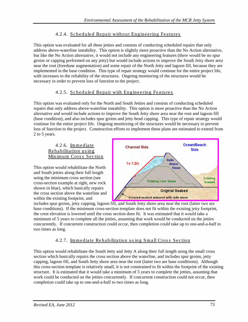
Environmental Assessment of the Rehabilitation of the MCR Jetty System
Revised EA, June 2012 73
4.2.4. Scheduled Repa ir without Engineering Features
This option was evaluated for all three jetties and consists of conducting scheduled repairs that only address above-waterline instability. This option is slightly more proactive than the No Action alternative, but like the No Action alternative, it would not include any engineering features (there would be no spur groins or capping performed on any jetty) but would include actions to improve the South Jetty shore area near the root (foredune augmentation) and some repair of the North Jetty and lagoon fill, because they are implemented in the base condition. This type of repair strategy would continue for the entire project life, with increases to the reliability of the structures. Ongoing monitoring of the structures would be necessary in order to prevent loss of function to the project.
4.2.5. Scheduled Repa ir with Engineering Fea tures
This option was evaluated only for the North and South Jetties and consists of conducting scheduled repairs that only address above-waterline instability. This option is more proactive than the No Action alternative and would include actions to improve the South Jetty shore area near the root and lagoon fill (base condition), and also includes spur groins and jetty head capping. This type of repair strategy would continue for the entire project life. Ongoing monitoring of the structures would be necessary to prevent loss of function to the project. Construction efforts to implement these plans are estimated to extend from 2 to 5 years.
4.2.6. Immedia te Rehabilita tion us ing Minimum Cros s Sec tion
This option would rehabilitate the North and South jetties along their full length using the minimum cross section (see cross-section example at right, new rock shown in blue), which basically repairs the cross section above the waterline and within the existing footprint, and includes spur groins, jetty capping, lagoon fill, and South Jetty shore area near the root (latter two are base conditions). If the minimum cross-section template does not fit within the existing jetty footprint, the crest elevation is lowered until the cross section does fit. It was estimated that it would take a minimum of 5 years to complete all the jetties, assuming that work would be conducted on the jetties concurrently. If concurrent construction could occur, then completion could take up to one-and-a-half to two times as long.
4.2.7. Immedia te Rehabilita tion us ing Small Cros s Sec tion
This option would rehabilitate the South Jetty and Jetty A along their full length using the small cross section which basically repairs the cross section above the waterline, and includes spur groins, jetty capping, lagoon fill, and South Jetty shore area near the root (latter two are base conditions). Although this cross-section template is relatively small, it is not constrained to fit within the footprint of the existing structure. It is estimated that it would take a minimum of 5 years to complete the jetties, assuming that work could be conducted on the jetties concurrently. If concurrent construction could not occur, then completion could take up to one-and-a-half to two times as long.
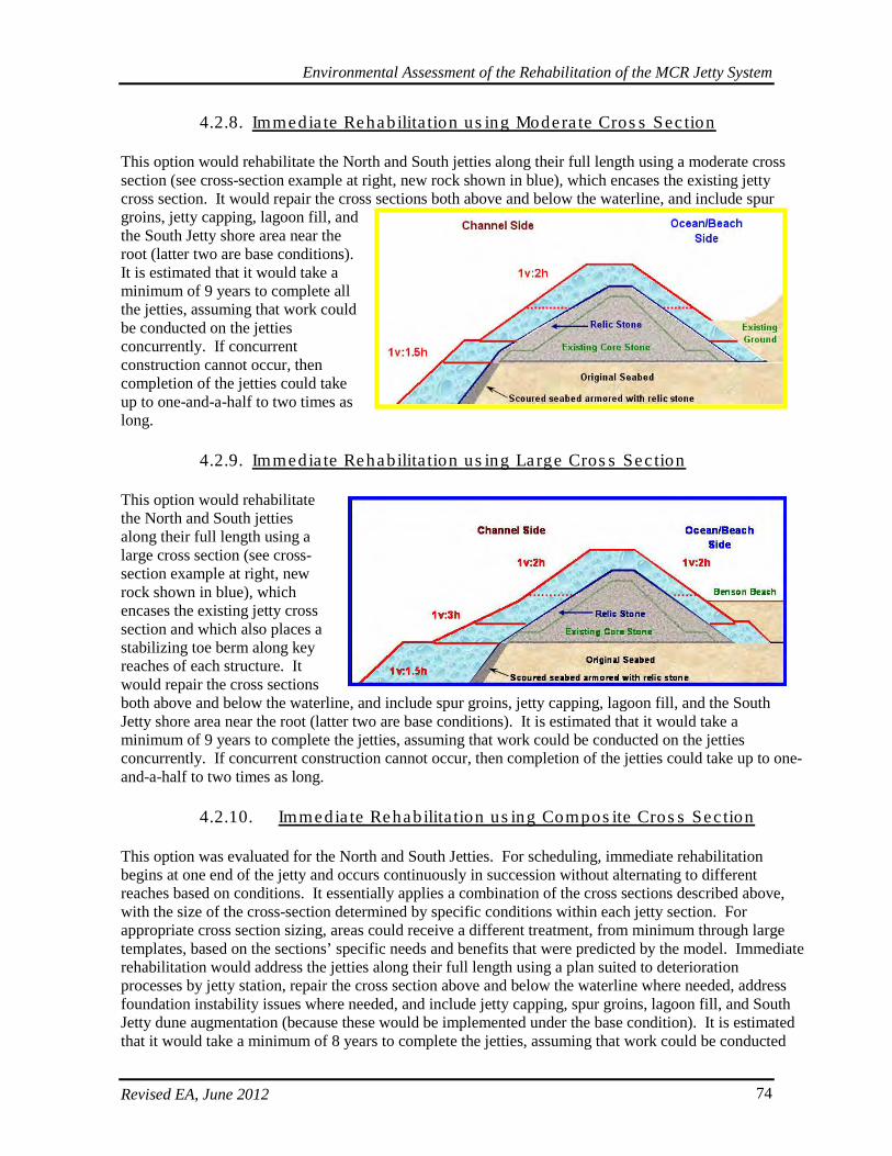
Environmental Assessment of the Rehabilitation of the MCR Jetty System
Revised EA, June 2012 74
4.2.8. Immedia te Rehabilita tion us ing Modera te Cros s Sec tion
This option would rehabilitate the North and South jetties along their full length using a moderate cross section (see cross-section example at right, new rock shown in blue), which encases the existing jetty cross section. It would repair the cross sections both above and below the waterline, and include spur groins, jetty capping, lagoon fill, and the South Jetty shore area near the root (latter two are base conditions). It is estimated that it would take a minimum of 9 years to complete all the jetties, assuming that work could be conducted on the jetties concurrently. If concurrent construction cannot occur, then completion of the jetties could take up to one-and-a-half to two times as long.
4.2.9. Immedia te Rehabilita tion us ing Large Cros s Sec tion
This option would rehabilitate the North and South jetties along their full length using a large cross section (see cross-section example at right, new rock shown in blue), which encases the existing jetty cross section and which also places a stabilizing toe berm along key reaches of each structure. It would repair the cross sections both above and below the waterline, and include spur groins, jetty capping, lagoon fill, and the South Jetty shore area near the root (latter two are base conditions). It is estimated that it would take a minimum of 9 years to complete the jetties, assuming that work could be conducted on the jetties concurrently. If concurrent construction cannot occur, then completion of the jetties could take up to one-and-a-half to two times as long.
4.2.10. Immedia te Rehabilita tion us ing Compos ite Cros s Sec tion
This option was evaluated for the North and South Jetties. For scheduling, immediate rehabilitation begins at one end of the jetty and occurs continuously in succession without alternating to different reaches based on conditions. It essentially applies a combination of the cross sections described above, with the size of the cross-section determined by specific conditions within each jetty section. For appropriate cross section sizing, areas could receive a different treatment, from minimum through large templates, based on the sections’ specific needs and benefits that were predicted by the model. Immediate rehabilitation would address the jetties along their full length using a plan suited to deterioration processes by jetty station, repair the cross section above and below the waterline where needed, address foundation instability issues where needed, and include jetty capping, spur groins, lagoon fill, and South Jetty dune augmentation (because these would be implemented under the base condition). It is estimated that it would take a minimum of 8 years to complete the jetties, assuming that work could be conducted
Environmental Assessment of the Rehabilitation of the MCR Jetty System
Revised EA, June 2012 75
on the jetties concurrently. If concurrent construction does not occur, then completion of the jetties could take up to one-and-a-half to two times as long. Five separate immediate composite plans were evaluated for the South Jetty and one immediate composite plan for the North Jetty.
4.2.11. Scheduled Rehabilita tion us ing Minimum or Compos ite Cros s Sec tion
Scheduled rehabilitation options were evaluated for the North and South Jetties. Due to the sheer size of the MCR jetties and the limited construction window, any rehabilitation work on the MCR structures will need to occur over a number of years. Scheduled rehabilitation takes the scheduling a step further to implement the rehabilitation of specific reaches of each jetty at designated times to address the most vulnerable reaches first; includes adding spur groins on the jetties to promote structure stability, capping the head of both the North and South jetties to stop deterioration, lagoon fill at the North Jetty to stop erosion at the jetty root, and South jetty foredune augmentation near the root (again, already part of the base condition). Rehabilitation is not conducted until conditions indicate that there is a need for rehabilitation of specific portions of the jetty. The reliability and the cost of the scheduled alternatives were evaluated for the minimum and composite templates. Conducting the rehabilitation when needed instead of continuously, as in the immediate rehabilitation alternative increases the length of time construction occurs to 15 years but construction actually occurs only 11 years out of that total. This is expected because construction is not expected to occur on all jetties at the same time. The following figures further illustrate the described design options that were evaluated during this review. Though 3-dimensional examples are not available for all of the alternatives or selected plans, the concepts are well displayed and remain applicable for describing scheduled repair templates. The minimum template with a smaller version of head stabilization relative to capping will most closely resemble the proposed scheduled repair actions.
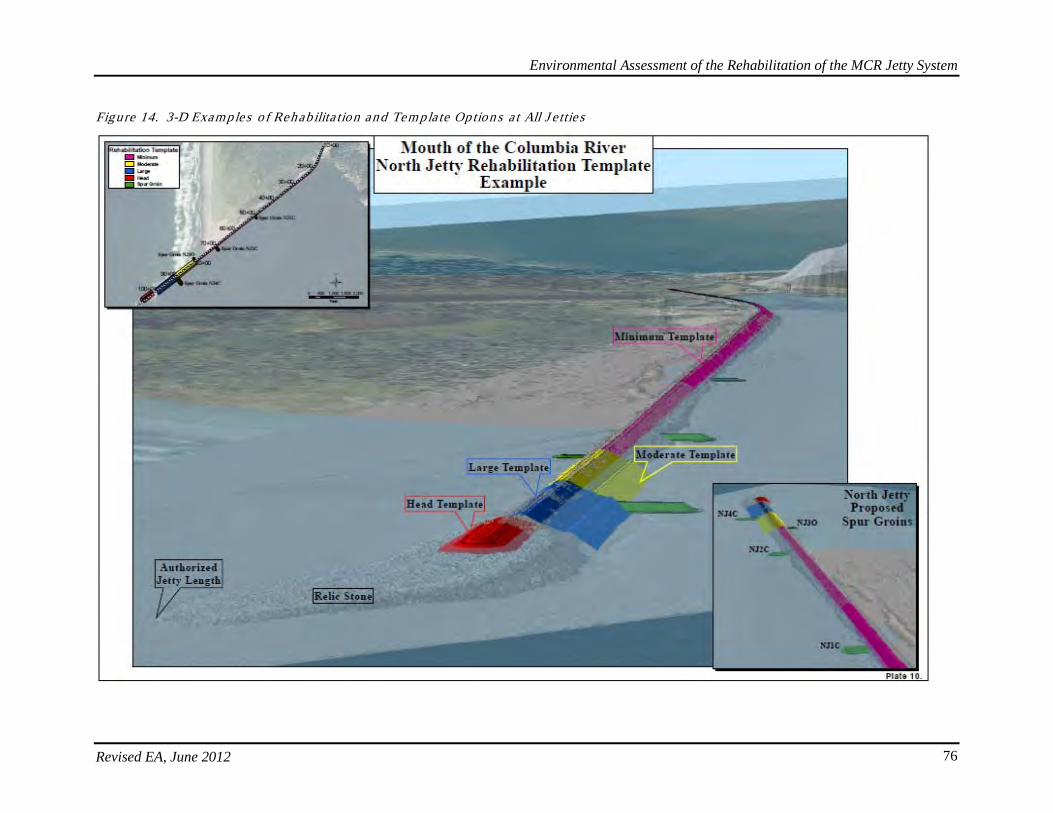
Environmental Assessment of the Rehabilitation of the MCR Jetty System
Revised EA, June 2012 76
Figure 14. 3-D Examples o f Rehab ilita tion and Tem pla te Option s a t All J e ttie s
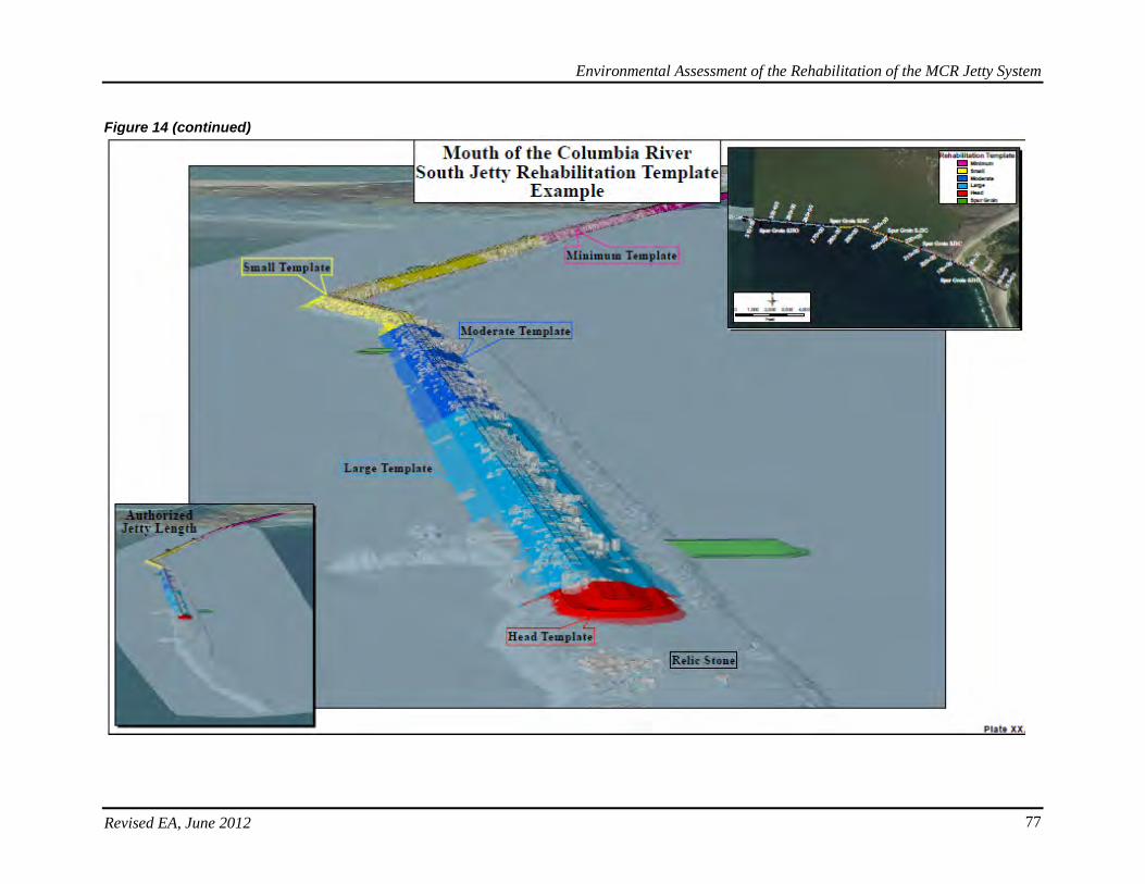
Environmental Assessment of the Rehabilitation of the MCR Jetty System
Revised EA, June 2012 77
Figure 14 (continued)
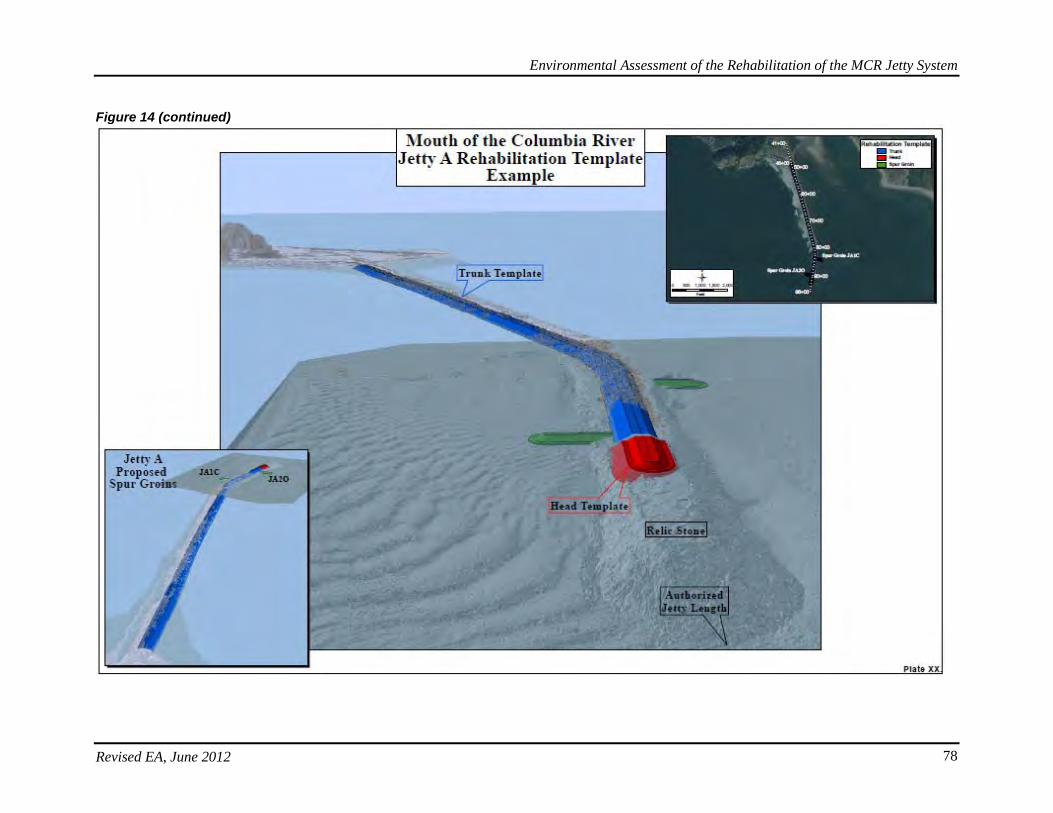
Environmental Assessment of the Rehabilitation of the MCR Jetty System
Revised EA, June 2012 78
Figure 14 (continued)
Environmental Assessment of the Rehabilitation of the MCR Jetty System
Revised EA, June 2012 79
4.3. Comparis on of Des ign Options and Alte rna tives
An analysis and optimization of the design options was performed using a stochastic (probability), risk-based life-cycle model developed for the MCR jetties. Each jetty was analyzed separately. The model application was initiated by simulating the structures’ previous life cycle history and producing a calibrated model of structure performance. This calibrated model was used to project the existing condition into the future. Future life-cycle simulations were performed for the range of repair and rehabilitation alternatives described in Section 4.2. The model used a series of storms and waves that attacked the jetties. Damage to the jetties was calculated when certain trigger points were reached. The model would then simulate repair of the appropriate portion of the jetty according to the particular alternative approach (interim base condition, scheduled, or immediate repair or rehabilitation cross-sections) and then continue assessing the structure and actions over a 50-year timeframe. The model was used to produce life-cycle costs for damages to the structure, repair volumes required, and changes in annual dredging volumes. Then, costs were further developed. A common set of life-cycle metrics was used to assess the performance for each jetty within a historical and future context. Metrics used to assess historical performance included jetty repair aspects (timing, frequency, location), life-cycle repair cost, jetty geometry configuration (crest profile, cross-section, jetty head location), and jetty reliability. The metrics used to assess future jetty performance and compare the alternatives included:
1. Average annual cost (AAC), including: a. Initial construction cost. b. Repair costs and their timing after rehabilitation. c. Reliability or the probability of a project feature to perform satisfactorily.
2. Constructability and access costs
Design options were evaluated using three categories predicted to have some degree of environmental impact. These categories included: (1) frequency of required repair and construction activities; (2) potential morphological changes at the inlet from continued jetty recession; and (3) shallow-water habitat loss due to placement of engineering features, specifically offloading facilities and lagoon fill. Category one was evaluated based on minimizing repeated impact to the same area after the area had re-established. Category two evaluated the changes to the jetty foundation, the inlet, and the adjacent beaches as a result of continued recession of jetty length. The current assumptions favored rigidity as a surrogate for resilience, and assumed fewer new environmental impacts by maintaining current habitat locations. Category three reflected the loss of shallow-water habitat by the engineered structures and fill. These categories were rated high, medium, and low depending on the loss of habitat or frequency of repair or change in morphology of the inlet. Maximum effects were assumed to occur with the largest jetty cross section, maximum change in morphology from the largest reduction in jetty length and the highest amount of repairs. Other construction and staging elements also were evaluated to determine the best way to avoid and minimize environmental impacts. Additional common project elements across design options included location of stockpile storage, selection of staging areas, location of barge offloading sites, and construction access. The options for each jetty are discussed and compared in the following sections.
Environmental Assessment of the Rehabilitation of the MCR Jetty System
Revised EA, June 2012 80
4.3.1. North J e tty Alte rna tives
For the North Jetty the following design options in addition to No Action were evaluated:
• Base Condition: Interim repairs with and without head stabilization. • Scheduled Repair: Six scheduled repair plans were evaluated for the North Jetty: scheduled
repair without engineering features and scheduled repair with engineering features (head capping, spur groins); both holding the jetty end station and allowing it to recede.
• Immediate Rehabilitation (Rehab): Eight immediate rehabilitation plans were evaluated for the North to determine which plan to select for further consideration. Various cross-sections were analyzed; both holding the jetty end station and allowing it to recede.
• Scheduled Rehab: Fourteen scheduled rehabilitation plans considered for the North Jetty. Various cross-sections were analyzed; both holding the jetty end station and allowing it to recede.
For this evaluation, the comparison of alternatives was simplified. All actions were initiated when a common physical trigger occurred (a percent degradation of the original jetty cross-section prism). Triggers were similar in nature and consequences but different strategies and timing were applied to reduce the rate of degradation. This changed the length of time between actions. Different maintenance and rehabilitation options have different triggers for enacting repairs, and different durations of time for which the repairs last before additional action would be necessary. For the North Jetty, the immediate and scheduled rehabilitation options with moderate and large cross sections were screened out due to their high average annual costs. Originally, model results and a comparison of the economic and performance parameters for the best performing North Jetty alternatives were used to determine the selected plan. When ranked by functional reliability, the composite scheduled rehabilitation options ranks the highest, followed closely by scheduled repair with engineering features. When ranked by costs of repair after rehabilitation, the immediate and scheduled rehabilitation options have the lowest costs because they address jetty damage processes at the beginning of the life cycle and provide more resilient jetty maintenance plans. The scheduled rehabilitation options with composite cross section addresses existing and ongoing damage and provides less likelihood of breaching than the smaller cross-section options (scheduled repair and base condition). However, comparing the immediate and scheduled rehabilitation options to scheduled repair with engineering features shows that the scheduled repair options provides high functional reliability at the lowest average annual cost and highest benefit-to-cost ratio. The scheduled repair options had less risk of potential for breech events over the base condition and increased functional reliability of the project. The scheduled repair options would stabilize the jetty head to prevent further head recession and potential impacts to the inlet, adjacent shorelines and shoals, and navigation channel. In addition, while construction of spurs provides more resilience to the jetty foundation along its length and helps control erosion of the supporting underwater shoal, they were not recommended at this point. However, a more intensive and aggressive jetty monitoring and inspection schedule would be implemented to address and avoid any potential breach or emergency dredging scenarios. Additional actions would be taken and the addition of spur groins re-considered if current assumptions prove incorrect and the jetty foundation reaches an unacceptable level of deterioration. For these reasons, it was determined that scheduled repair holding the head stable but without additional engineered features would be described as the Preferred Alternative at the North Jetty. Therefore, the Preferred Alternative includes Scheduled Repair and holding the end station at or around its current location, which is the least cost plan for the North Jetty.
Environmental Assessment of the Rehabilitation of the MCR Jetty System
Revised EA, June 2012 81
4.3.2. South J e tty Alte rna tives
For the South Jetty the following options in addition to No Action alternative were evaluated:
• Base Condition: Interim repairs with and without head stabilization. • Scheduled Repair: Six scheduled repair plans were evaluated for the South Jetty: scheduled
repair without engineering features and scheduled repair with engineering features (head capping, spur groins); both holding the jetty end station and allowing it to recede.
• Immediate Rehab: Eighteen immediate rehabilitation plans were evaluated for the South Jetty to determine which plan to select for further consideration. Various cross-sections were analyzed; both holding the jetty end station and allowing it to recede.
• Scheduled Rehab: Four scheduled rehabilitation plans considered for the South Jetty. Various cross-sections were analyzed; both holding the jetty end station and allowing it to recede.
For the South Jetty, the immediate and scheduled rehabilitation options with moderate, large, and composite cross sections were screened out due to their high average annual costs. Model results and a comparison of the economic and performance parameters for the best performing South Jetty alternatives were used to determine the preferred plan. One feature common to several of the option brought forward for the South Jetty is inclusion of engineering features – jetty head capping and spur groins. While previous analysis showed that these engineering features were necessary for the long-term stability of the MCR jetty system, the jetty roots, and the navigation function, they were not recommended at this point. However, a more intensive and aggressive jetty monitoring and inspection schedule would be implemented to address and avoid any potential breach or emergency dredging scenarios. Additional actions would be taken and the implementation of spur groins re-considered if current assumptions prove incorrect and the jetty foundation reaches an unacceptable level of deterioration. If the South Jetty head recedes further, it is likely to impact Clatsop Spit and the adjacent shorelines. Continued head recession could negatively affect the wave climate and navigability of the inlet and could expose other elements of the jetty system to higher wave conditions. However, South Jetty foredune stabilization provides lower risk of breaching through Trestle Bay, and there is less risk to the navigation channel in the event of a breach along the South Jetty trunk relative to the North Jetty. It is anticipated that the jetty head would be allowed to recede during the next 8 years of construction, but in the future may be rebuilt to or at its current location. Monitoring and ongoing assessment during Detailed Design Review (DDR) would help assess the optimal jetty length. Continued monitoring would further refine and determine the optimal timing and location of the stabilization features. Comparing immediate and scheduled rehabilitation to scheduled repair with engineering features shows that scheduled repair provides higher functional reliability at a demonstrably lower average annual cost. Scheduled repair almost cuts in half the potential for breech events over the base condition and increases functional reliability of the project. Scheduled repair would stabilize the jetty head to prevent further head recession and potential impacts to the inlet and adjacent shorelines and shoals. In addition, while the construction of spurs would provide more resilience to the jetty foundation along its length and help control the erosion of the supporting underwater shoal, they were not recommended at this point. However, a more intensive and aggressive jetty monitoring and inspection schedule would be implemented to address and avoid any potential breach or emergency dredging scenarios. Additional actions would be taken and the addition of spur groins re-considered if current assumptions prove incorrect and the jetty foundation reaches an unacceptable level of deterioration. In comparing South Jetty alternatives, key criteria were the considerable cost to repair the structure and the relatively low threat to navigation immediately after a failure. For these reasons, it was determined that the Base
Environmental Assessment of the Rehabilitation of the MCR Jetty System
Revised EA, June 2012 82
Condition (interim repairs) alternative without engineering features would be the best alternative for the South Jetty. An interim repair approach allows the upper portion of the cross section to be damaged until approximately 40 percent remaining prior to repair actions being taken. However, a rubble-mound structure can incur a certain level of damage before the whole cross section fails resulting in a functional impact. In this way, the jetty is maintained close to the margin of functional loss without breaching. For the South Jetty, the Base Condition is the least-cost option and is expected to provide adequate function to meet the project’s purpose and need. Base condition with the foredune stabilization at the jetty root is the least-cost plan for the South Jetty and is expected to meet the purposes of providing a resilient and functional jetty system in support of deep draft navigation. This is described as part of the Preferred Alternative for the South Jetty, which is the Base Condition at this location where the jetty head would eventually be stabilized after some degree of recession. This will be accompanied by a more intensive and aggressive jetty monitoring and inspection schedule to address and avoid any potential breach or emergency dredging scenario.
4.3.3. J e tty A Alte rna tives
For Jetty A the following options were evaluated in addition to No Action:
• Base Condition: Interim repairs with and without head stabilization. • Scheduled Repair: Two scheduled repair plans were developed and evaluated for Jetty A:
scheduled repair allowing head recession and scheduled repair holding the end station. • Immediate Rehab: Four immediate rehabilitation plans were developed and evaluated for Jetty
A: immediate rehabilitation with two types of small templates; allowing head recession and holding the jetty end state.
Model results and a comparison of the economic and performance parameters were also used for analyses of the Jetty A options. The immediate rehabilitation option with small cross section offers greater reliability at a lower average annual cost (and higher benefit-to-cost ratio) than scheduled repair without engineering features, and would require a continuous and aggressive maintenance strategy to prevent negative impacts to navigation. Though previous analyses recommended immediate rehabilitation, subsequent modeling demonstrated that a resilient jetty system could be achieved at a lower cost. This was demonstrated by a more simplified modeling approach to manage risk associated with degradation so that repair needs were addressed by implementing them sooner or by implementing them with a larger cross section. The Scheduled Repair, holding the end current station, is part of the Preferred Alternative at Jetty A and is the least cost plan for Jetty A. As with the other two jetties, this would be accompanied by a more intensive and aggressive jetty monitoring and inspection schedule to address and avoid any potential breach or emergency dredging scenario. In summary, the proposed action (Preferred Alternative) for the MCR jetty system consists of the following features:
Environmental Assessment of the Rehabilitation of the MCR Jetty System
Revised EA, June 2012 83
• North Jetty – scheduled repair with head stabilization (to a lesser extent relative to previously proposed capping), along with Base Condition interim maintenance repairs to stations 86-99 and lagoon fill to stop erosion of the jetty root.
• South Jetty – Base Condition without current head stabilization and including foredune augmentation near the jetty root.
• Jetty A – scheduled repair and head stabilization at a reduced scale relative to capping. Section 5 of this EA provides a detailed description of the Preferred Alternative for the MCR jetty system.
Environmental Assessment of the Rehabilitation of the MCR Jetty System
Revised EA, June 2012 84
(this page intentionally left blank)
Environmental Assessment of the Rehabilitation of the MCR Jetty System
Revised EA, June 2012 85
5. PREFERRED ALTERNATIVE
5.1. Overview
The Preferred Alternative (Proposed Action) is generally composed of four categories applicable to each jetty: (1) engineered designs elements and features of the physical structures; (2) construction measures and implementation activities; (3) proposed Clean Water Act (CWA) 404 mitigation actions for impacts to wetlands and waters of the US, and (4) proposed establishment of and coordination with an Adaptive Management Team (AMT) composed of representatives from the Corps and appropriate federal and state agencies. After additional feedback and comments from an Independent External Peer Review (IEPR) process, the current Preferred Alternative includes actions at each jetty, which have been modified from what was described in the previous draft EAs. The Preferred Alternative represents a further reduction in project footprint and schedule while continuing to meet the purpose of maintaining a resilient jetty system and functional navigation channel. The duration of the construction schedule is about 8 years with a 50-year operational lifetime for the MCR jetty system. Therefore, an inherent level of uncertainty exists regarding dynamic environmental conditions and actual conditions of and at each of the jetties. For this reason, in all cases where areas, weights, and volumes (tons, acres, cubic yards, etc.) or other metrics are indicated, these are best professional estimates and may vary by greater or lesser amounts within a 20% range when final designs are completed. These amounts represent Corps’ best professional judgment of what the range of variability could entail as the design is further developed and as on-the-ground conditions evolve over the construction and maintenance schedule. This variability may also apply to the construction schedule as funding streams may not be available at the forecasted times, or additional new information may shift the repair priorities to alternate sections on the jetties. The Corps maintains an active jetty monitoring and surveying program that would further inform the timing and design of the proposed action in order to facilitate efficient completion of the project and whenever possible to avoid emergency repair scenarios. This program would also pursue an even more aggressive level of monitoring, inspection frequency, and reviews in order to ensure detailed evaluation helps maintain a resilient jetty system and responds with appropriate actions. This suite of actions represents the proposed repair and rehabilitation strategy based on the most current information available based on present jetty conditions. Jetty conditions and deterioration may change over time or perform in ways not anticipated in modeling. In this case, additional repair actions or features may be required in the future. Details regarding the Preferred Alternative are described below. In practice the following would be done to assess actual locations for repair: a biennial monitoring program where photogrammetric surveys of each of jetties would be executed to track cross-sectional degradation and head recession; annual visual inspections; and reporting by the Coast Guard and commercial ship traffic. Consequently, actual jetty repairs may not follow the exact locations identified by the predictive planning model used to develop the seven-year construction sequence on all three jetties. Furthermore, while earlier modeling indicated the need for spur groins as part of the jetty stabilization measures, refinements and revised forecasts do not currently demonstrate a need for these structures. As noted previously, spur groins were evaluated for their effects in earlier versions of EAs and are maintained in this draft EA as reference material. However, they are no longer included in the suite of proposed actions under the Preferred Alternative.

Environmental Assessment of the Rehabilitation of the MCR Jetty System
Revised EA, June 2012 86
The same is true for head-capping. While head stabilization remains included in the suite of proposed actions, it is at a level reduced from that which was proposed under the head-capping measures. The stabilization measure would be a reduced version of the earlier versions of head-capping and would occupy a smaller footprint relative to that previous evaluated in earlier EA versions. However, the information from the earlier analysis is retained here for informational purposes. In both cases monitoring would determine if the assumptions and predictions are valid, and appropriate corrective measures would be pursued and spurs and head stabilization would be re-evaluated. (1.) Design elements and structural features specific to each jetty include the following:
• North Jetty – Scheduled repairs addressing the existing loss of cross section and head stabilization to minimize future cross section instability are proposed. The cross-section repairs are primarily above MLLW, with a majority of stone placement not likely to extend beyond -5 feet below MLLW. To address the structural instability the jetty head (western-most section) would be stabilized with armoring of large stone, but to a lesser extent than capping that was previously proposed. The head stabilization measure at approximately station 101 would be placed on relic and jetty stone that is above MLLW. The shore-side measures that have been identified are culvert replacement and lagoon fill (STA 20-60). These actions are designed to stop the current ongoing erosion of the jetty root and are considered part of the base condition, along with interim repairs between stations 86-99.
• South Jetty – Maintenance of the Base Condition, interim repair strategy that defers head
stabilization is proposed. The head may recede somewhat, but the optimal terminal location remains to be determined. The cross-section repairs are primarily above MLLW, with a majority of stone placement not likely to extend beyond -5 feet below MLLW. Augmentation of the dune at the western shoreline extending south from the jetty root has been included in the base condition, but is describe in detail under the selected plan. This action is intended to prevent the degradation of the jetty root and prevent the potential breaching of the foredune.
• Jetty A – Scheduled repairs addressing the existing loss of cross section and head stabilization to
minimize future cross section instability are proposed. The cross-section repairs are primarily above MLLW, with a majority of stone placement not likely to extend beyond -5 feet below MLLW. The jetty head (southern most section) would be stabilized at approximately station 87 with large armoring stone placed on relic and jetty stone that is above MLLW.
(2.) Construction measures and implementation activities for all three jetties include the following:
• Storage and staging areas for rock stockpiles and all associated construction and placement activities such as: roadways, parking areas, turn-outs, haul roads, weigh stations, yard area for sorting and staging actions, etc.
• Stone delivery from identified quarries either by barge or by truck. Possible transit routes have been identified. This also includes the construction and use of permanent barge offloading facilities and causeways with installation and removal of associated piles and dolphins.
• Stone placement either from land or water, which includes the construction, repair, and maintenance of a haul road on the jetty itself, crane set-up pads, and turnouts on jetty road. Placement by water could occur via the use of a jack-up barge on South Jetty, but will not occur by other means or on North Jetty to avoid impacts to crab and juvenile salmon migration.
• Regular dredging and disposal of infill at offloading facilities with frequency dependent on a combination of the evolving conditions at the site and expected construction scheduling and delivery. Disposal will occur at existing designated and approved in-water sites.
Environmental Assessment of the Rehabilitation of the MCR Jetty System
Revised EA, June 2012 87
(3.) In addition, the Corps has identified specific and potential mitigation for impacts to CWA 404 wetlands and waters of the US. Wetland mitigation opportunities have been identified adjacent to the impacted wetlands at the North Jetty. Wetland mitigation for Jetty A would also be implemented at the North Jetty because space is unavailable at Jetty A. Mitigation for wetland impacts at the South Jetty would occur within the State Park but southwest of the impact area in a location south of Trestle Bay. The mitigation for the impacted wetlands would be creation of wetlands of similar type and function. Specific mitigation for impacts to waters other than wetlands has not been determined, but a suite of potential projects and examples has been identified. Depending on further development of both the project and potential mitigation alternatives and commensurate with final impacts, a specific mitigation project or combination of projects would be selected and constructed concurrently. Mitigation would provide environmental benefits to offset impacts as portions of the proposed action are completed over time. This EA has identified and quantified the maximum amount of impacts and mitigation likely under the Preferred Alternative, and further details and selection of specific appropriate mitigation actions for waters other than wetlands would be refined as the project moves forward. Depending on the method of project implementation, commensurate mitigation could also be reduced if impacts are avoided. Generally, possible mitigation measures could include but are not limited to an individual project or a combination of projects and actions such as the following list.
• Excavation and creation of tidal channel and wetlands to restore and improve hydrologic functions including water quality, flood storage, and salmonid refugia.
• Culvert and tide gate replacements or retrofits to restore or improve fish passage and access to important spawning, rearing, and resting habitat.
• Beneficial uses of dredged material from MCR hopper dredge to replenish littoral cells. • Invasive species removal and control and revegetation of native plants to restore ecological and
food web functions that benefit fisheries. Mitigation meets compliance obligations under the Clean Water Act and would be commensurate with impacts from construction activities. It also complements Corps obligations to protect and restore critical habitat for ESA listed species. More specifics regarding mitigation are described in that section. (4.) Due to the dynamic conditions at MCR and the long duration of the MCR Jetty Rehabilitation schedule, the Corps proposes formation of a modified interagency Adaptive Management Team (AMT). The Corps suggests annual meetings and more as needed to discuss relevant design and construction challenges and modifications, technical data, new species listings or critical habitat designations, evolving environmental conditions, and adaptive management practices as needed. The primary purpose of the proposed AMT and its implementation is to ensure construction, operation, and maintenance actions have no greater impacts than those described in the Biological Assessments and this Environmental Assessment, and that Corps obligations and terms and conditions are being met. This will also allow confirmation that any necessary construction or design refinements remain within the range and scope of effects described during Consultations and that compliance obligations are being met and efforts are being made to adjust mitigation once final impacts are fully understood. These adjustments could result in a reduction in mitigation based on actual impacts occurring. This forum would provide an opportunity for periodic evaluation as to whether or not the proposed actions, ESA listings, or environmental conditions result in any re-initiation triggers. It would also facilitate continued coordination and updating and allow the Corps to inform agency partners when unforeseen changes arise. Results regarding marine mammal and fish monitoring, mitigation monitoring, as well as water quality monitoring would be made available to the AMT in order to fulfill reporting requirements and to address any unexpected field observations. Results of jetty monitoring surveys would also inform the AMT of the repair schedule and design
Environmental Assessment of the Rehabilitation of the MCR Jetty System
Revised EA, June 2012 88
refinements that may become necessary as the system evolves over time. This venue would provide transparency and allow opportunities for additional agency input. Final selection and design of the mitigation proposal would be determined by the Corps and would be vetted through this forum to facilitate obtaining final environmental clearance documents for this component of the MCR proposed action. Potential principal partners include federal (National Marine Fisheries Service, U.S. Fish and Wildlife Service) and State (Washington and Oregon) resource management agencies.
5.2. Actions for the North J e tty
The proposed action for the North Jetty is Scheduled Repair (including base condition interim repairs between stations 86 and 99), head stabilization, culvert replacement, and lagoon fill to stop erosion of the jetty root (base condition) (Figures 15 and 16). The jetty head and foundation at the most exposed portion of jetty will be stabilized.
5.2.1. North J e tty Trunk and Root
The cross-section design from stations 20+00 to 99+00 would have a crest width of approximately 30 feet and would lie essentially within the existing jetty footprint based on the configuration of the original cross section, previous repair cross sections, and redistribution of jetty rock by wave action. About 221,000 tons (~138,125 cy) of new rock will be placed on relic armor stone, with the majority of stone placement above MLLW. About three repair events were predicted over the next 50 years. Each repair action is expected to cover a length range of up to 1,500 feet and include stone volumes and rework in the range of 53,000 to 103,000 tons (~33,125-64,375 cy) per season. At the time of repair, it is expected that 50% to 70% of the standard jetty template cross-section has been displaced. Therefore, each repair event would increase the degraded cross-section from 30% to 50% back to 100% of the desired standard cross-section template. This means the overall added rock would essentially triple what exists immediately prior to the time of repair. This could be described as a ~300% increase in rock relative to the existing jetty rock volume. However, this would not increase the jetty prism or footprint beyond the scope and size of the historic structure, and does not include any modification that changes the character, scope, or size of the original structure design. The following estimates were made previously but remain somewhat within the range of percents placed in each zone and are somewhat representative of the Preferred Alternative. With placement divided into elevation zones per representative repair event, about 21,550 cy of rock would have been placed above MHHW. This represented 58% of the overall stone placement on these portions of the jetty and 376% change from the existing jetty prism. This meant that currently only a small portion of the original profile remained in this zone and over three times as much stone would be placed compared to what presently remained. As described, above, this same concept applied to characterizations about the rest of the zones. About 9,230 cy of rock would have been placed between MHHW and MLLW. This represented 25% of the overall stone placement on these jetty portions and a 192% change from the existing jetty prism. About 6,675 cy of rock would have been placed below MLLW. This represented 18% of the overall stone placement on these jetty portions and a 150% change from the existing jetty prism. The footprint of the trunk and root will remain on relic stone and within its current dimensions.
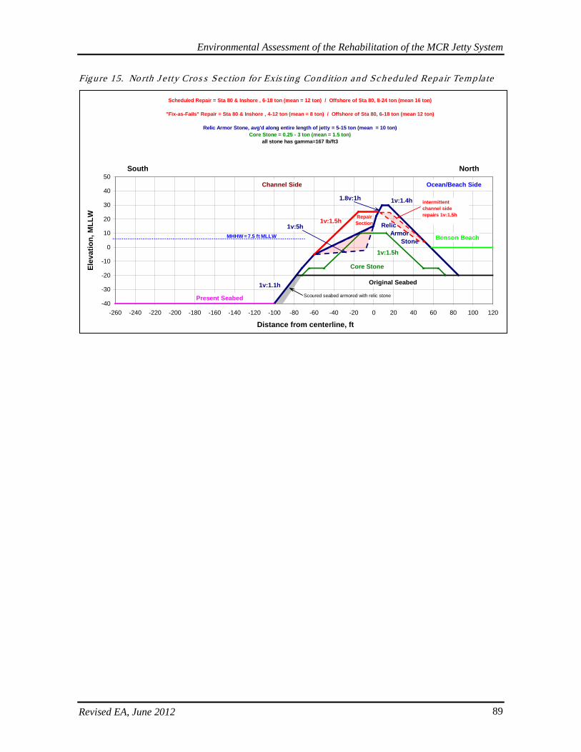
Environmental Assessment of the Rehabilitation of the MCR Jetty System
Revised EA, June 2012 89
Figure 15. No rth J e tty Cros s Sec tion fo r Exis ting Condition and Sch eduled Repair Templa te
-40
-30
-20
-10
0
10
20
30
40
50
-260 -240 -220 -200 -180 -160 -140 -120 -100 -80 -60 -40 -20 0 20 40 60 80 100 120
Distance from centerline, ft
Elev
atio
n, M
LLW
Ocean/Beach SideChannel Side
Core Stone
Present Seabed
Relic Armor Stone
RepairSection
Benson Beach
Original Seabed
1v:1.5h
1v:1.1h
1v:1.4h
1v:5h
1.8v:1h
1v:1.5h
South North
Scoured seabed armored with relic stone
intermittent channel side repairs 1v:1.5h
Scheduled Repair = Sta 80 & Inshore , 6-18 ton (mean = 12 ton) / Offshore of Sta 80, 8-24 ton (mean 16 ton)
"Fix-as-Fails" Repair = Sta 80 & Inshore , 4-12 ton (mean = 8 ton) / Offshore of Sta 80, 6-18 ton (mean 12 ton)
Relic Armor Stone, avg'd along entire length of jetty = 5-15 ton (mean = 10 ton)Core Stone = 0.25 - 3 ton (mean = 1.5 ton)
all stone has gamma=167 lb/ft3
MHHW = 7.5 ft MLLW
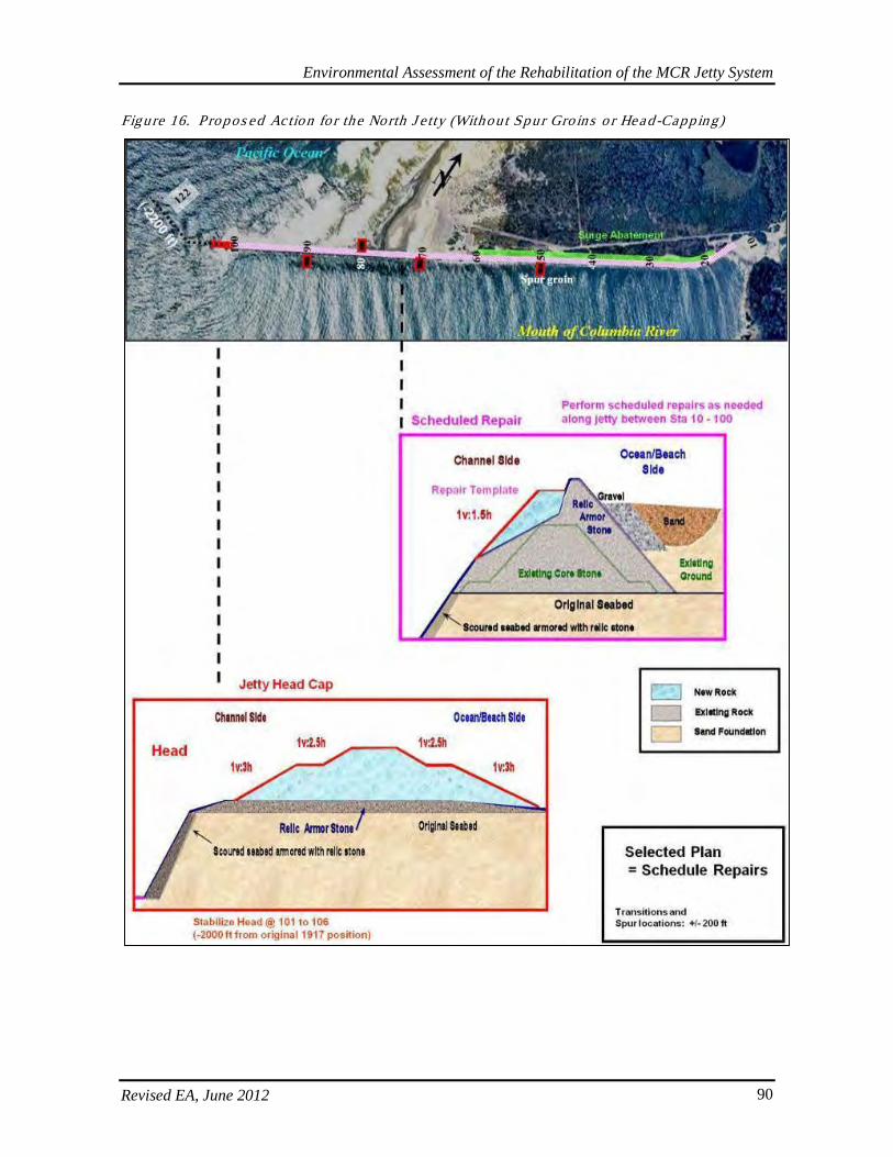
Environmental Assessment of the Rehabilitation of the MCR Jetty System
Revised EA, June 2012 90
Figure 16. Propos ed Action fo r the North J e tty (Without Spur Gro ins o r Head-Capping)

Environmental Assessment of the Rehabilitation of the MCR Jetty System
Revised EA, June 2012 91
5.2.2. North J e tty Spur Groins (No Longer Propos ed)
Originally, modeling indicated spur groins were necessary to ensure jetty foundation stabilization. Subsequent model refinements have indicated spur groins are not required for maintenance of a resilient jetty system within the Corps standards and operations and maintenance forecasts. More aggressive monitoring and inspection would confirm these assumptions. If unacceptable degradation is observed, then actions that could include spur groins may be implemented in the future and would be re-evaluated accordingly. The following discussion is retained here in order to provide information and disclosure of the previous context in which these structures were evaluated for their effects. Three submergent spur groins were planned for the channel side (NJ1C, NJ2C, and NJ4C) and one emergent spur groin on the ocean side (NJ3O) of the North Jetty to stabilize the foundation (Figures 17 to 20). The approximate dimensions and other features of the spur groins are shown in Table 19. Tab le 19. No rth J e tty Spur Gro in Fea tures (No Longer P ropos ed)
Spur Groin Features North Jetty Number of spurs on channel side 3 Number of spurs on ocean side 1
Approximate total rock volume per spur (± 20%)
NJ1C: 3,350 tons (~2,094 cy) NJ2C: 11,090 tons (~6,931 cy) NJ3O: 2,010 tons (~1,256 cy) NJ4C: 29,250 tons (~18,281 cy)
Approximate total rock volume (all spurs) (± 20%) 53,000 tons (~33,125 cy)
Approximate area affected by each spur
NJ1C: 0.18 acres NJ2C: 0.45 acres NJ3O: 0.11 acres NJ4C: 0.80 acres
Approximate total area affected (all spurs) 1.55 acres
Approximate area of spurs above MLLW
NJ1C: 0% NJ2C: 0% NJ3O: 24% NJ4C: 0%
Approximate area of spurs below -20 MLLW
NJ1C: 0% NJ2C: 88% NJ3O: 0% NJ4C: 100%
Approximate dimension of spurs: length x width x height (feet)
NJ1C: 100 x 80 x 10 NJ2C: 170 x 115 x 19 NJ3O: 60 x 80 x 10 NJ4C: 170 x 115 x 19
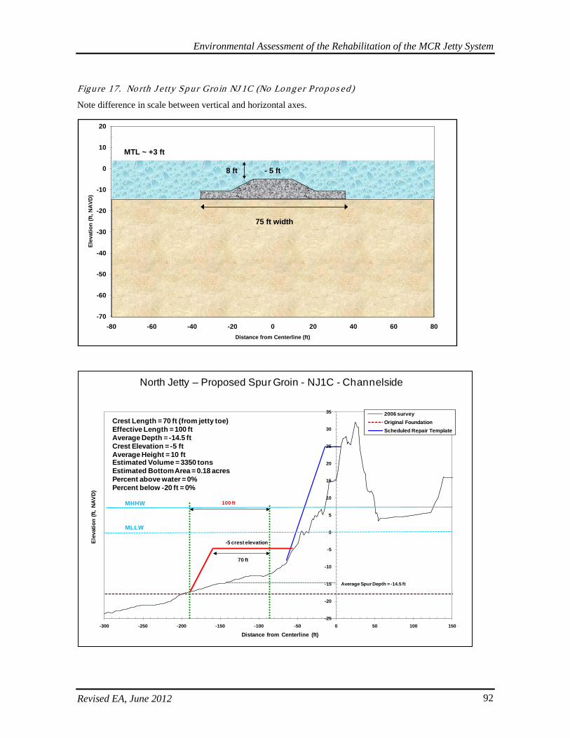
Environmental Assessment of the Rehabilitation of the MCR Jetty System
Revised EA, June 2012 92
Figure 17. No rth J e tty Sp ur Gro in NJ 1C (No Longe r P ropos ed)
Note difference in scale between vertical and horizontal axes.
-70
-60
-50
-40
-30
-20
-10
0
10
20
-80 -60 -40 -20 0 20 40 60 80Distance from Centerline (ft)
Elev
atio
n (ft
, NA
VD)
75 ft width
- 5 ft
MTL ~ +3 ft
8 ft
-25
-20
-15
-10
-5
0
5
10
15
20
25
30
35
-300 -250 -200 -150 -100 -50 0 50 100 150
Elev
atio
n (ft
, NAV
D)
Distance from Centerline (ft)
2006 surveyOriginal FoundationScheduled Repair Template
-5 crest elevation
100 ft
70 ft
Average Spur Depth = -14.5 ft
Crest Length = 70 ft (from jetty toe)Effective Length = 100 ftAverage Depth = -14.5 ftCrest Elevation = -5 ftAverage Height = 10 ftEstimated Volume = 3350 tonsEstimated Bottom Area = 0.18 acresPercent above water = 0%Percent below -20 ft = 0%
North Jetty – Proposed Spur Groin - NJ1C - Channelside
MHHW
MLLW
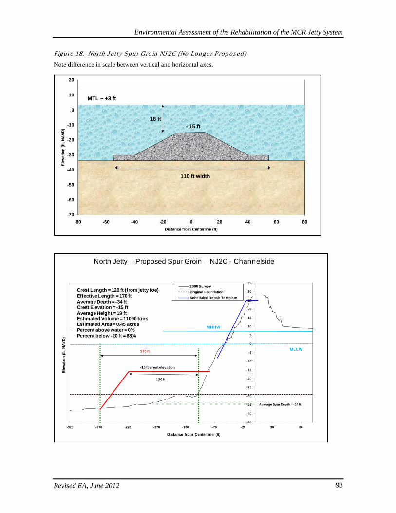
Environmental Assessment of the Rehabilitation of the MCR Jetty System
Revised EA, June 2012 93
Figure 18. No rth J e tty Sp ur Gro in NJ 2C (No Longe r P ropos ed)
Note difference in scale between vertical and horizontal axes.
-70
-60
-50
-40
-30
-20
-10
0
10
20
-80 -60 -40 -20 0 20 40 60 80Distance from Centerline (ft)
Elev
atio
n (ft
, NA
VD)
110 ft width
- 15 ft
MTL ~ +3 ft
18 ft
-45
-40
-35
-30
-25
-20
-15
-10
-5
0
5
10
15
20
25
30
35
-320 -270 -220 -170 -120 -70 -20 30 80
Elev
atio
n (ft
, NAV
D)
Distance from Centerline (ft)
2006 SurveyOriginal FoundationScheduled Repair Template
120 ft
-15 ft crest elevation
170 ft
Average Spur Depth = -34 ft
North Jetty – Proposed Spur Groin – NJ2C - Channelside
MLLW
MHHW
Crest Length = 120 ft (from jetty toe)Effective Length = 170 ftAverage Depth = -34 ftCrest Elevation = -15 ftAverage Height = 19 ftEstimated Volume = 11090 tonsEstimated Area = 0.45 acresPercent above water = 0%Percent below -20 ft = 88%
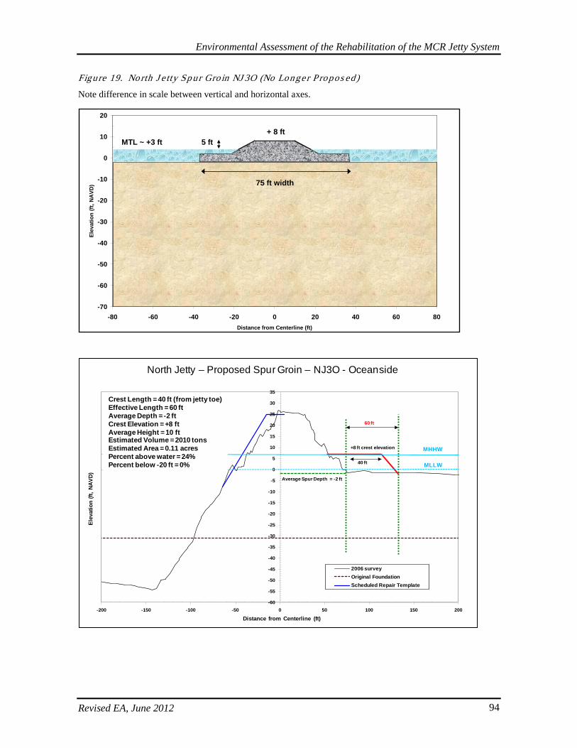
Environmental Assessment of the Rehabilitation of the MCR Jetty System
Revised EA, June 2012 94
Figure 19. No rth J e tty Sp ur Gro in NJ 3O (No Longe r P ropos ed)
Note difference in scale between vertical and horizontal axes.
-70
-60
-50
-40
-30
-20
-10
0
10
20
-80 -60 -40 -20 0 20 40 60 80Distance from Centerline (ft)
Elev
atio
n (ft
, NA
VD) 75 ft width
+ 8 ftMTL ~ +3 ft 5 ft
-60
-55
-50
-45
-40
-35
-30
-25
-20
-15
-10
-5
0
5
10
15
20
25
30
35
-200 -150 -100 -50 0 50 100 150 200
Elev
atio
n (ft
, NAV
D)
Distance from Centerline (ft)
2006 surveyOriginal FoundationScheduled Repair Template
60 ft
+8 ft crest elevation
40 ft
Average Spur Depth = -2 ft
North Jetty – Proposed Spur Groin – NJ3O - Oceanside
MLLW
MHHW
Crest Length = 40 ft (from jetty toe)Effective Length = 60 ftAverage Depth = -2 ftCrest Elevation = +8 ftAverage Height = 10 ftEstimated Volume = 2010 tonsEstimated Area = 0.11 acresPercent above water = 24%Percent below -20 ft = 0%
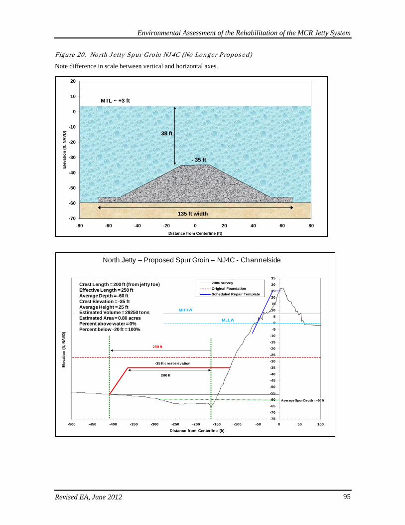
Environmental Assessment of the Rehabilitation of the MCR Jetty System
Revised EA, June 2012 95
Figure 20. No rth J e tty Sp ur Gro in NJ 4C (No Longe r P ropos ed)
Note difference in scale between vertical and horizontal axes.
-70
-60
-50
-40
-30
-20
-10
0
10
20
-80 -60 -40 -20 0 20 40 60 80Distance from Centerline (ft)
Elev
atio
n (ft
, NA
VD)
135 ft width
- 35 ft
MTL ~ +3 ft
38 ft
-75
-70
-65
-60
-55
-50
-45
-40
-35
-30
-25
-20
-15
-10
-5
0
5
10
15
20
25
30
35
-500 -450 -400 -350 -300 -250 -200 -150 -100 -50 0 50 100
Elev
atio
n (ft
, NAV
D)
Distance from Centerline (ft)
2006 surveyOriginal FoundationScheduled Repair Template
200 ft
250 ft
-35 ft crest elevation
Average Spur Depth = -60 ft
North Jetty – Proposed Spur Groin – NJ4C - Channelside
MLLW
MHHW
Crest Length = 200 ft (from jetty toe)Effective Length = 250 ftAverage Depth = -60 ftCrest Elevation = -35 ftAverage Height = 25 ftEstimated Volume = 29250 tonsEstimated Area = 0.80 acresPercent above water = 0%Percent below -20 ft = 100%
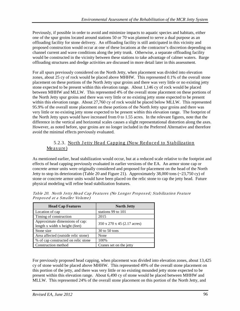
Environmental Assessment of the Rehabilitation of the MCR Jetty System
Revised EA, June 2012 96
Previously, if possible in order to avoid and minimize impacts to aquatic species and habitats, either one of the spur groins located around stations 50 or 70 was planned to serve a dual purpose as an offloading facility for stone delivery. An offloading facility is still anticipated in this vicinity and proposed construction would occur at one of these locations at the contractor’s discretion depending on channel current and wave conditions along the jetty trunk. Otherwise, a separate offloading facility would be constructed in the vicinity between these stations to take advantage of calmer waters. Barge offloading structures and dredge activities are discussed in more detail later in this assessment. For all spurs previously considered on the North Jetty, when placement was divided into elevation zones, about 25 cy of rock would be placed above MHHW. This represented 0.1% of the overall stone placement on these portions of the North Jetty spur groins and there was very little or no existing jetty stone expected to be present within this elevation range. About 1,146 cy of rock would be placed between MHHW and MLLW. This represented 4% of the overall stone placement on these portions of the North Jetty spur groins and there was very little or no existing jetty stone expected to be present within this elevation range. About 27,760 cy of rock would be placed below MLLW. This represented 95.9% of the overall stone placement on these portions of the North Jetty spur groins and there was very little or no existing jetty stone expected to be present within this elevation range. The footprint of the North Jetty spurs would have increased from 0 to 1.55 acres. In the relevant figures, note that the difference in the vertical and horizontal scales causes a slight representational distortion along the axes. However, as noted before, spur groins are no longer included in the Preferred Alternative and therefore avoid the minimal effects previously evaluated.
5.2.3. North J e tty Head Capping (Now Reduced to S tab iliza tion Meas ure )
As mentioned earlier, head stabilization would occur, but at a reduced scale relative to the footprint and effects of head capping previously evaluated in earlier versions of the EA. An armor stone cap or concrete armor units were originally considered and proposed for placement on the head of the North Jetty to stop its deterioration (Table 20 and Figure 21). Approximately 38,000 tons (~23,750 cy) of stone or concrete armor units would have been placed on the relic stone to cap the jetty head. Future physical modeling will refine head stabilization features. Tab le 20. No rth J e tty Head Cap Fea tures (No Long er Propos ed ; S tab iliza tio n Fea ture Propos ed a t a Smalle r Vo lume)
Head Cap Features North Jetty Location of cap stations 99 to 101 Timing of construction 2015 Approximate dimensions of cap: length x width x height (feet) 350 x 270 x 45 (2.17 acres)
Stone size 30 to 50 tons Area affected (outside relic stone) None % of cap constructed on relic stone 100% Construction method Cranes set on the jetty
For previously proposed head capping, when placement was divided into elevation zones, about 13,425 cy of stone would be placed above MHHW. This represented 49% of the overall stone placement on this portion of the jetty, and there was very little or no existing mounded jetty stone expected to be present within this elevation range. About 6,490 cy of stone would be placed between MHHW and MLLW. This represented 24% of the overall stone placement on this portion of the North Jetty, and
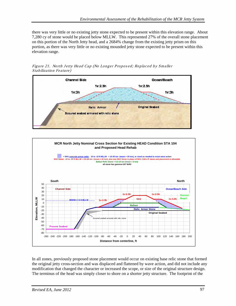
Environmental Assessment of the Rehabilitation of the MCR Jetty System
Revised EA, June 2012 97
there was very little or no existing jetty stone expected to be present within this elevation range. About 7,280 cy of stone would be placed below MLLW. This represented 27% of the overall stone placement on this portion of the North Jetty head, and a 2684% change from the existing jetty prism on this portion, as there was very little or no existing mounded jetty stone expected to be present within this elevation range. Figure 21. No rth J e tty Head Cap (No Longer P ropos ed ; Replaced b y Sm alle r S tab iliza tion Fea ture )
In all zones, previously proposed stone placement would occur on existing base relic stone that formed the original jetty cross-section and was displaced and flattened by wave action, and did not include any modification that changed the character or increased the scope, or size of the original structure design. The terminus of the head was simply closer to shore on a shorter jetty structure. The footprint of the
MCR North Jetty Nominal Cross Section for Existing HEAD Condition STA 104 and Proposed Head Rehab
-80-70-60-50-40-30-20-10
01020304050
-260 -240 -220 -200 -180 -160 -140 -120 -100 -80 -60 -40 -20 0 20 40 60 80 100 120 140 160 180 200
Distance from centerline, ft
Elev
atio
n, M
LLW
Ocean/Beach SideChannel Side
Present Seabed
Relic Armor Stone
Benson Beach
Original Seabed
1v:3.0h
1v:2.5h
South North
Scoured seabed armored with relic stone
1v:2.5h
1v:3.0h
= NH1 concrete armor units: 10 to -10 ft MLLW = 10-30 ton (mean = 20 ton), or sized as needed to resist wave actionNH2 Stone: -10 to -20 ft MLLW = 24-48 ton (mean = 32 ton), also use NH2 Stone in place of NH1 CAUs IF stone and placement is allowable
Ballast Relic Stone = 0.5-10 ton (mean = 5 ton)all stone has gamma=167 lb/ft3
NH2
Ballast
MHHW = 7.5 ft MLLW
Environmental Assessment of the Rehabilitation of the MCR Jetty System
Revised EA, June 2012 98
existing jetty mound on the flattened relic stone is approximately 1.37 acres, and the additional capping on the relic stone would have increased the width of the prism approximately 0.80 acres, for a total footprint of 2.17 acres, all of which would remain on the existing relic stone.
5.2.4. North J e tty Lagoon Fill and Culvert Replacement
Approximately 109,000 tons (~68,125 cy) of gravel and sand would be added to the jetty’s beach side as lagoon fill to eliminate the tidal flow through the jetty that is destabilizing the foundation. A recent berm repair action now precludes lagoon inundation by tidal nearshore waters. Scouring has taken place on the north side of the North Jetty resulting in formation of a backwater area (lagoon) that was previously inundated both by tidal waters that come through the jetty and by freshwater that drains from the O’Neil Lake-McKenzie Head lagoon and wetland complex area through the accreted land to the north of the jetty and North Jetty Road. This area drains through a culvert under the road and provides some of the freshwater flow to the lagoon. The surrounding lagoon resembles a scoured-out tidal channel and is a non-vegetated (and non-wetland) area of bare sand comprising approximately 8.02 acres. These wetlands and waters would be filled to protect and stabilize the foundation of the North Jetty and to serve as a location for rock stockpiles and construction staging activities. The features of this work are shown in Table 21. Tab le 21. No rth J e tty Lag oon and Wetland Fill Fea tures
Features North Jetty Timing of construction 2014 Material used for fill Sand, gravel, quarry stone Short-term and long-term use
Stockpile area, long-term stabilization of root
De-watering Culvert feeding into area will be replaced Impact on wetlands 1.14 acres Impact on Section 404 waters
8.02 acres
The aging culvert draining south from the wetland complex north of the roadway would be replaced, as it provides required drainage under the roadway. The design of the inlet, elevation, and culvert size would be determined so that hydrologic function in the adjacent wetland system is not negatively impacted. The outlet channel downstream of the culvert would not be filled. This area may provide an opportunity for minor stream and bank enhancement which will be evaluated when the culvert design is finalized, but this is uncertain until possible benefits can be further assessed. Under the proposed action, the existing channel would outlet to an engineered sump area comprised of newly placed lagoon fill material. In addition to infiltration through the jetty structure, this small portion of the creek currently connects the wetland to the lagoon and likely also receives some backwater flow from jetty infiltration. The current culvert is perched and the regularly disconnected nature of the lagoon system does not appear to support anadromous fish use. Fish surveys were not completed for the stream inlet leading into this wetland complex and creek. An initial sampling survey would be conducted during peak juvenile salmon outmigration to determine whether or not fish salvage and fish exclusion efforts for ESA-listed species is warranted. The Corps would coordinate with NMFS if listed species are identified. Redesign of this system may provide an opportunity to accommodate improved hydrology to newly created wetlands excavated adjacent to the existing wetland complex, and would be further investigated during the hydraulic/hydrologic design analysis.
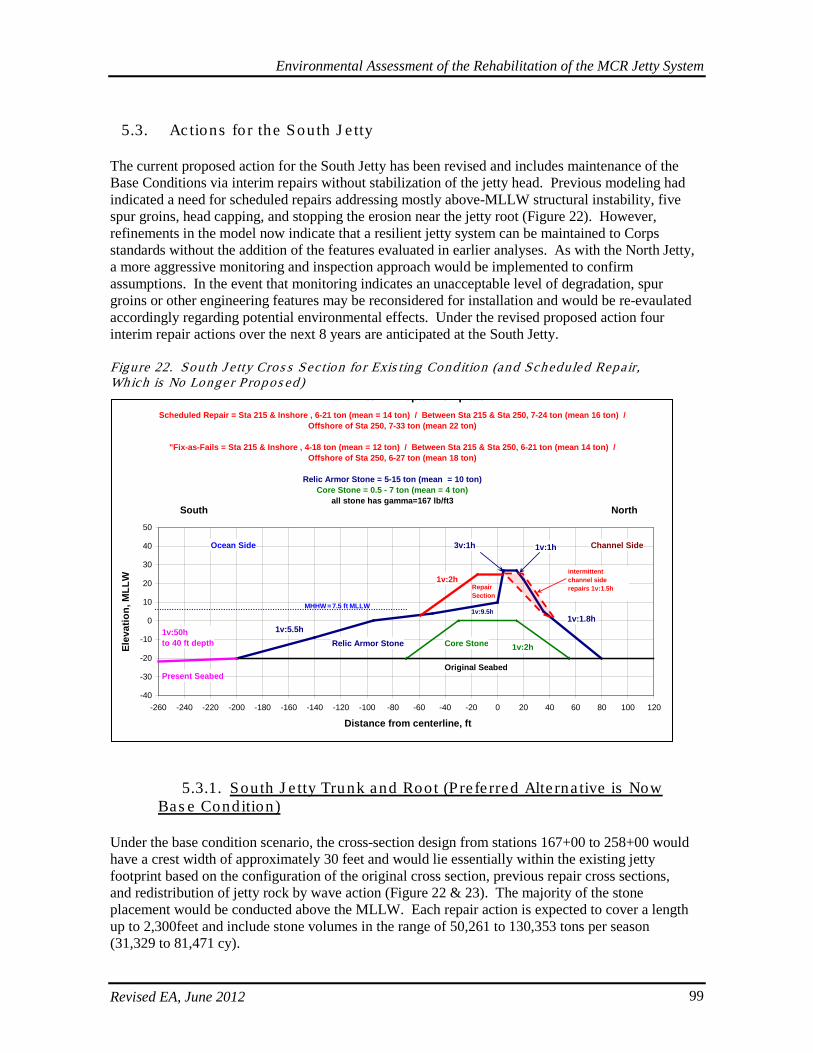
Environmental Assessment of the Rehabilitation of the MCR Jetty System
Revised EA, June 2012 99
5.3. Actions for the South J e tty
The current proposed action for the South Jetty has been revised and includes maintenance of the Base Conditions via interim repairs without stabilization of the jetty head. Previous modeling had indicated a need for scheduled repairs addressing mostly above-MLLW structural instability, five spur groins, head capping, and stopping the erosion near the jetty root (Figure 22). However, refinements in the model now indicate that a resilient jetty system can be maintained to Corps standards without the addition of the features evaluated in earlier analyses. As with the North Jetty, a more aggressive monitoring and inspection approach would be implemented to confirm assumptions. In the event that monitoring indicates an unacceptable level of degradation, spur groins or other engineering features may be reconsidered for installation and would be re-evaulated accordingly regarding potential environmental effects. Under the revised proposed action four interim repair actions over the next 8 years are anticipated at the South Jetty. Figure 22. Sou th J e tty Cros s Sec tion fo r Exis ting Condition (and Scheduled Repair, Which is No Longe r P rop os ed)
5.3.1. South J e tty Trunk and Root (Pre fe rred Alte rna tive is Now Bas e Condition)
Under the base condition scenario, the cross-section design from stations 167+00 to 258+00 would have a crest width of approximately 30 feet and would lie essentially within the existing jetty footprint based on the configuration of the original cross section, previous repair cross sections, and redistribution of jetty rock by wave action (Figure 22 & 23). The majority of the stone placement would be conducted above the MLLW. Each repair action is expected to cover a length up to 2,300feet and include stone volumes in the range of 50,261 to 130,353 tons per season (31,329 to 81,471 cy).
and Interim Repair Template
-40
-30
-20
-10
0
10
20
30
40
50
-260 -240 -220 -200 -180 -160 -140 -120 -100 -80 -60 -40 -20 0 20 40 60 80 100 120
Distance from centerline, ft
Elev
atio
n, M
LLW
Ocean Side Channel Side
Core Stone
Present Seabed
Relic Armor Stone
RepairSection
Original Seabed
Scheduled Repair = Sta 215 & Inshore , 6-21 ton (mean = 14 ton) / Between Sta 215 & Sta 250, 7-24 ton (mean 16 ton) / Offshore of Sta 250, 7-33 ton (mean 22 ton)
"Fix-as-Fails = Sta 215 & Inshore , 4-18 ton (mean = 12 ton) / Between Sta 215 & Sta 250, 6-21 ton (mean 14 ton) / Offshore of Sta 250, 6-27 ton (mean 18 ton)
Relic Armor Stone = 5-15 ton (mean = 10 ton)Core Stone = 0.5 - 7 ton (mean = 4 ton)
all stone has gamma=167 lb/ft3
1v:50h to 40 ft depth
1v:5.5h
1v:2h
1v:9.5h
1v:1h
1v:1.8h
1v:2h
South North
3v:1h
intermittent channel side repairs 1v:1.5h
MHHW = 7.5 ft MLLW
Environmental Assessment of the Rehabilitation of the MCR Jetty System
Revised EA, June 2012 100
Similar to the North Jetty repair action, it was expected that 60% to 70% of the South Jetty’s overall standard jetty template cross section had been displaced. Therefore, each repair event would increase the existing degraded cross section from 30% to 40% and back to 100% of the desired standard cross-section template. Overall, this meant that the added rock would essentially triple what existed immediately prior to the time of repair. This could be described as a ~300% increase in rock relative to the existing jetty rock volume. However, this would not result in an increase the jetty prism or footprint beyond the scope and size of the historic structure, and did not include any modification that changes the character, scope, or size of the original structure design.
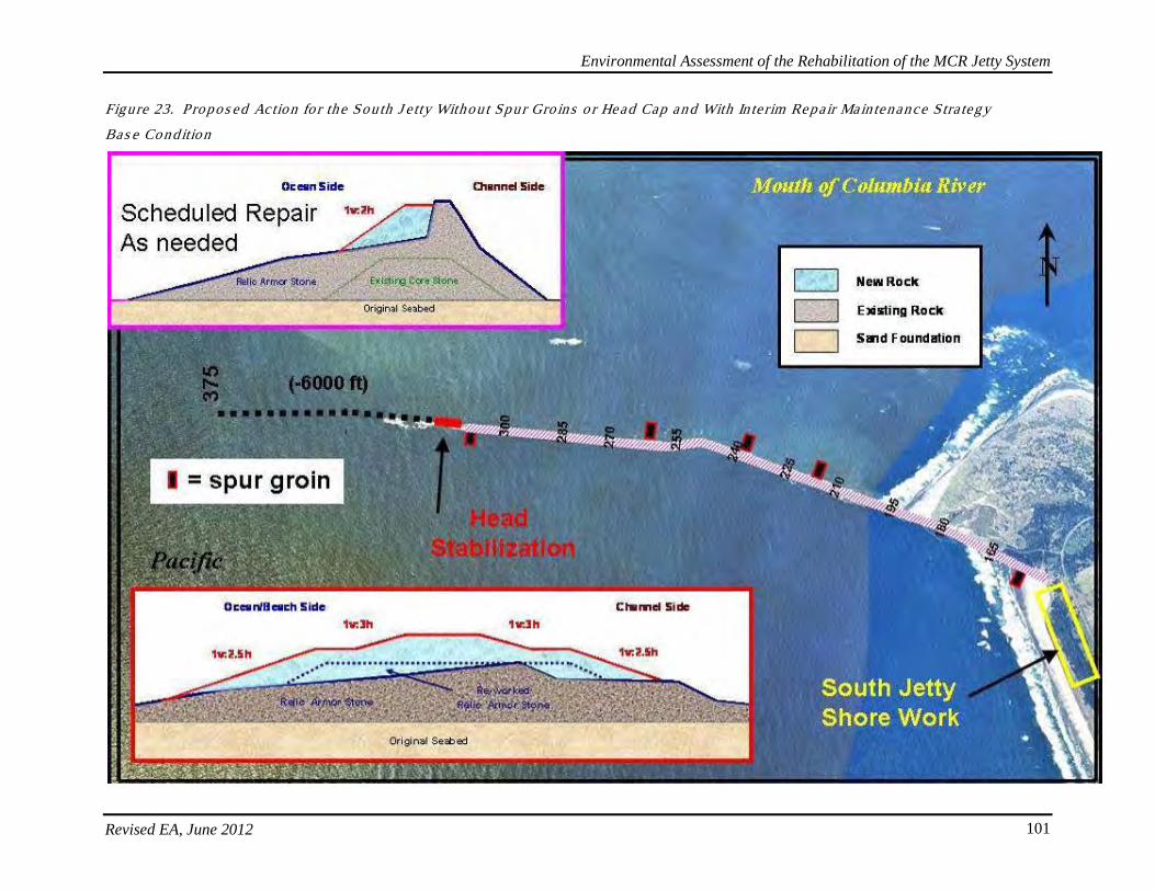
Environmental Assessment of the Rehabilitation of the MCR Jetty System
Revised EA, June 2012 101
Figure 23. Propos ed Action fo r the South J e tty Without Spur Gro ins o r Head Cap and With In te rim Repair Main tenance Stra teg y
Bas e Condition
Environmental Assessment of the Rehabilitation of the MCR Jetty System
Revised EA, June 2012 102
Previously proposed scheduled repairs would have proceeded as described. However, repairs now would occur on an interim basis as described in the Base Condition. Prior, per scheduled repair event, when divided into elevation zones, about 37,640 cy of rock would be placed above MHHW. This represented 68% of the overall stone placement on these portions of the South Jetty and a 1023% change from the existing jetty prism, as very little stone currently remains in the zone and a larger amount of stone must be placed compared to what presently remains. As described above, this same concept applied characterizations about the rest of the zones. About 10,420 cy of rock would be placed between MHHW and MLLW. This represented 19% of the overall stone placement on these portions of the South Jetty and a 225% change from the existing jetty prism. About 6,940 cy of rock would be placed below MLLW. This represented 13% of the overall stone placement on these portions of the South Jetty and a 150% change from the existing jetty cross section. However, in all zones, all proposed stone placement would occur on existing base relic stone that formed the original jetty cross section. The footprint of the trunk and root of the South Jetty would remain within its current jetty dimensions and on relic stone.
5.3.2. South J e tty Spur Gro ins (No Longer Propos ed)
Originally, modeling indicated spur groins were necessary to ensure jetty base stabilization. Subsequent model refinements have indicated spur groins are not required for maintenance of a resilient jetty system within the Corps standards and operations and maintenance forecasts. The following discussion is retained in order to provide information and disclosure of the previous context in which these structures were evaluated for their effects. Monitoring efforts will be implemented to confirm this assumption. Three emergent and two submergent spur groins were proposed to stabilize the jetty’s foundation (Figures 24 to 28). The dimensions and other features of the spur groins are shown in Table 22.
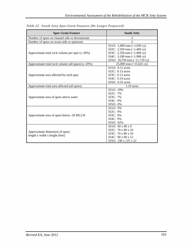
Environmental Assessment of the Rehabilitation of the MCR Jetty System
Revised EA, June 2012 103
Table 22. Sou th J e tty Spur Gro in Fea tures (No Lo nger P ropos ed)
Spur Groin Feature South Jetty Number of spurs on channel side or downstream 3 Number of spurs on ocean side or upstream 2
Approximate total rock volume per spur (± 20%)
SJ1O: 1,680 tons (~1,050 cy) SJ2C: 2,350 tons (~1,469 cy) SJ3C: 2,350 tons (~1,469 cy) SJ4C: 3,180 tons (~1,988 cy) SJ5O: 18,750 tons (~11,719 cy)
Approximate total rock volume (all spurs) (± 20%) 25,000 tons (~15,625 cy)
Approximate area affected by each spur
SJ1O: 0.11 acres SJ2C: 0.13 acres SJ3C: 0.13 acres SJ4C: 0.19 acres SJ5O: 0.55 acres
Approximate total area affected (all spurs) 1.10 acres
Approximate area of spurs above water
SJ1O: 29% SJ2C: 7% SJ3C: 7% SJ4C: 0% SJ5O: 0%
Approximate area of spurs below -20 MLLW
SJ1O: 0% SJ2C: 0% SJ3C: 0% SJ4C: 0% SJ5O: 92%
Approximate dimension of spurs: length x width x height (feet)
SJ1O: 60 x 80 x 9 SJ2C: 70 x 80 x 10 SJ3C: 70 x 80 x 10 SJ4C: 90 x 90 x 12 SJ5O: 190 x 125 x 22
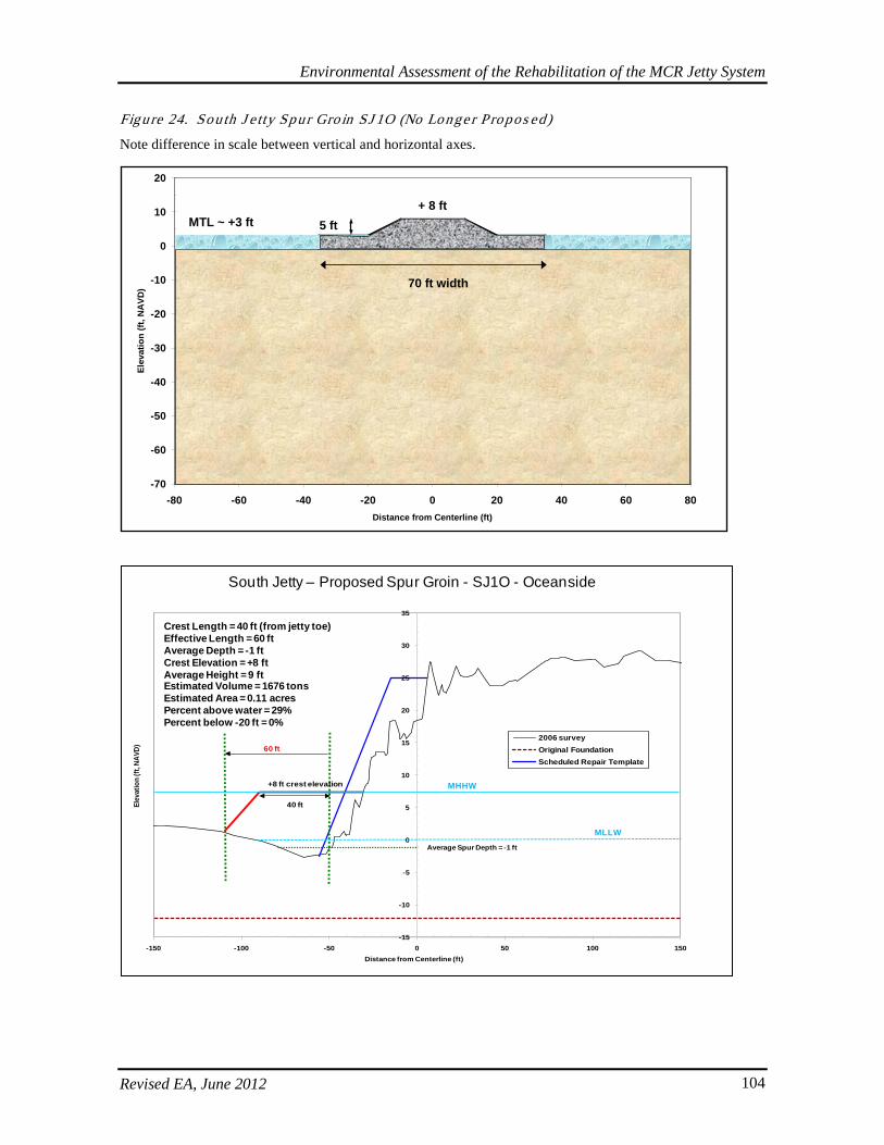
Environmental Assessment of the Rehabilitation of the MCR Jetty System
Revised EA, June 2012 104
Figure 24. Sou th J e tty Spur Gro in SJ 1O (No Longe r P ropos ed)
Note difference in scale between vertical and horizontal axes.
-70
-60
-50
-40
-30
-20
-10
0
10
20
-80 -60 -40 -20 0 20 40 60 80Distance from Centerline (ft)
Elev
atio
n (ft
, NA
VD) 70 ft width
+ 8 ftMTL ~ +3 ft 5 ft
-15
-10
-5
0
5
10
15
20
25
30
35
-150 -100 -50 0 50 100 150
Elev
atio
n (ft
, NAV
D)
Distance from Centerline (ft)
2006 surveyOriginal FoundationScheduled Repair Template
40 ft
+8 ft crest elevation
60 ft
Average Spur Depth = -1 ft
South Jetty – Proposed Spur Groin - SJ1O - Oceanside
MLLW
MHHW
Crest Length = 40 ft (from jetty toe)Effective Length = 60 ftAverage Depth = -1 ftCrest Elevation = +8 ftAverage Height = 9 ftEstimated Volume = 1676 tonsEstimated Area = 0.11 acresPercent above water = 29%Percent below -20 ft = 0%
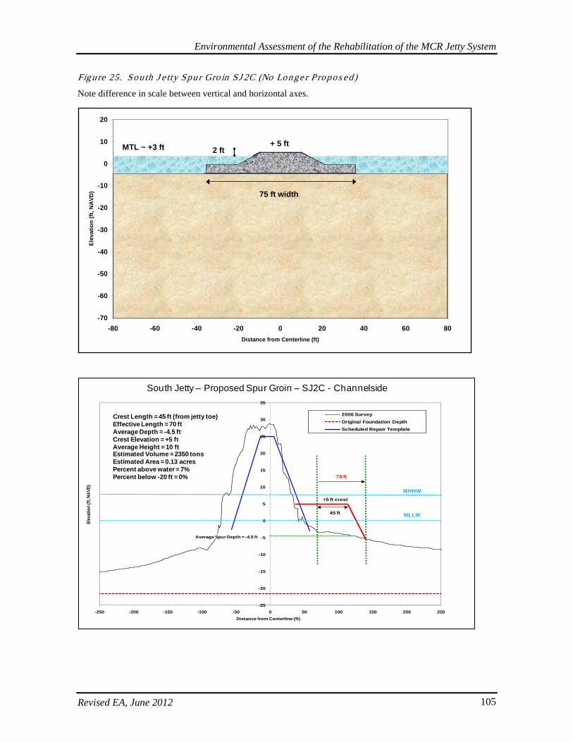
Environmental Assessment of the Rehabilitation of the MCR Jetty System
Revised EA, June 2012 105
Figure 25. Sou th J e tty Spur Gro in SJ 2C (No Longe r P ropos ed)
Note difference in scale between vertical and horizontal axes.
-70
-60
-50
-40
-30
-20
-10
0
10
20
-80 -60 -40 -20 0 20 40 60 80Distance from Centerline (ft)
Elev
atio
n (ft
, NA
VD) 75 ft width
+ 5 ftMTL ~ +3 ft 2 ft
-25
-20
-15
-10
-5
0
5
10
15
20
25
30
35
-250 -200 -150 -100 -50 0 50 100 150 200 250
Elev
atio
n (ft
, NAV
D)
Distance from Centerline (ft)
2006 SurveyOriginal Foundation DepthScheduled Repair Template
45 ft
+5 ft crest
70 ft
Average Spur Depth = -4.5 ft
Crest Length = 45 ft (from jetty toe)Effective Length = 70 ftAverage Depth = -4.5 ftCrest Elevation = +5 ftAverage Height = 10 ftEstimated Volume = 2350 tonsEstimated Area = 0.13 acresPercent above water = 7%Percent below -20 ft = 0%
South Jetty – Proposed Spur Groin – SJ2C - Channelside
MLLW
MHHW
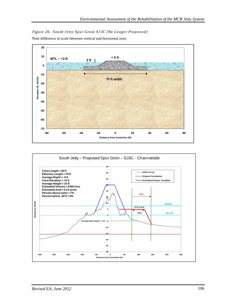
Environmental Assessment of the Rehabilitation of the MCR Jetty System
Revised EA, June 2012 106
Figure 26. Sou th J e tty Spur Gro in SJ 3C (No Longe r P ropos ed)
Note difference in scale between vertical and horizontal axes.
-70
-60
-50
-40
-30
-20
-10
0
10
20
-80 -60 -40 -20 0 20 40 60 80Distance from Centerline (ft)
Elev
atio
n (ft
, NA
VD)
75 ft width
+ 5 ftMTL ~ +3 ft 2 ft
-30
-25
-20
-15
-10
-5
0
5
10
15
20
25
30
35
40
-250 -200 -150 -100 -50 0 50 100 150 200 250
Elev
atio
n (ft
, NAV
D)
Distance from Centerline (ft)
2006 survey
Original Foundation
Scheduled Repair Template
45 ft
+5 ft crest
70 ft
Average Spur Depth = -5 ft
Crest Length = 45 ftEffective Length = 70 ftAverage Depth = -5 ftCrest Elevation = +5 ftAverage Height = 10 ftEstimated Volume = 2350 tonsEstimated Area = 0.13 acresPercent above water = 7%Percent below -20 ft = 0%
South Jetty – Proposed Spur Groin – SJ3C - Channelside
MLLW
MHHW
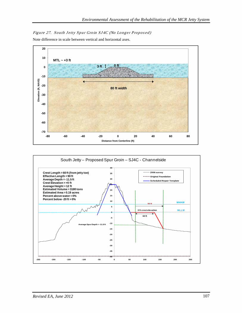
Environmental Assessment of the Rehabilitation of the MCR Jetty System
Revised EA, June 2012 107
Figure 27. Sou th J e tty Spur Gro in SJ 4C (No Longe r P ropos ed)
Note difference in scale between vertical and horizontal axes.
-70
-60
-50
-40
-30
-20
-10
0
10
20
-80 -60 -40 -20 0 20 40 60 80Distance from Centerline (ft)
Elev
atio
n (ft
, NA
VD)
80 ft width
0 ftMTL ~ +3 ft
3 ft
-40
-35
-30
-25
-20
-15
-10
-5
0
5
10
15
20
25
30
35
40
-250 -200 -150 -100 -50 0 50 100 150 200 250
2006 survey
Original Foundation
Scheduled Repair Template
60 ft
90 ft
0 ft crest elevation
Average Spur Depth = -11.5 ft
Crest Length = 60 ft (from jetty toe)Effective Length = 90 ftAverage Depth = -11.5 ftCrest Elevation = +0 ftAverage Height = 12 ftEstimated Volume = 3180 tonsEstimated Area = 0.19 acresPercent above water = 0%Percent below -20 ft = 0%
South Jetty – Proposed Spur Groin – SJ4C - Channelside
MLLW
MHHW
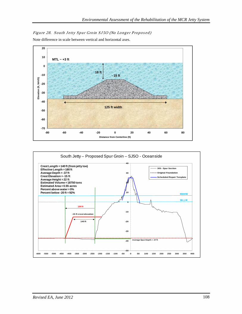
Environmental Assessment of the Rehabilitation of the MCR Jetty System
Revised EA, June 2012 108
Figure 28. Sou th J e tty Spur Gro in SJ 5O (No Longe r P ropos ed)
Note difference in scale between vertical and horizontal axes.
-70
-60
-50
-40
-30
-20
-10
0
10
20
-80 -60 -40 -20 0 20 40 60 80Distance from Centerline (ft)
Elev
atio
n (ft
, NA
VD)
125 ft width
- 15 ft
MTL ~ +3 ft
18 ft
-50
-40
-30
-20
-10
0
10
20
30
40
-600 -550 -500 -450 -400 -350 -300 -250 -200 -150 -100 -50 0 50 100 150 200 250 300 350 400
305 - Spur Section
Original Foundation
Scheduled Repair Template
-15 ft crest elevation
190 ft
140 ft
Average Spur Depth = -37 ft
South Jetty – Proposed Spur Groin – SJ5O - Oceanside
MLLW
MHHW
Crest Length = 140 ft (from jetty toe)Effective Length = 180 ftAverage Depth = -37 ftCrest Elevation = -15 ftAverage Height = 22 ftEstimated Volume = 18750 tonsEstimated Area = 0.55 acresPercent above water = 0%Percent below -20 ft = 92%
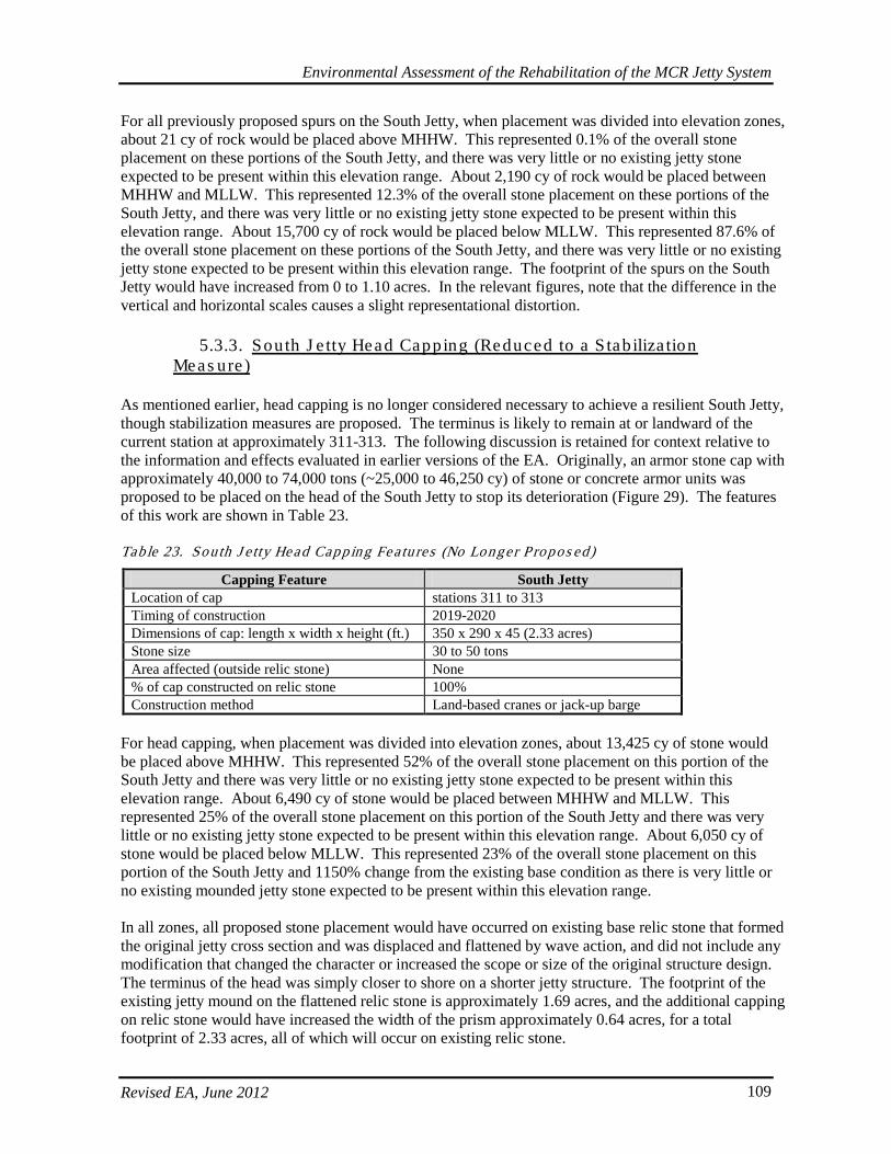
Environmental Assessment of the Rehabilitation of the MCR Jetty System
Revised EA, June 2012 109
For all previously proposed spurs on the South Jetty, when placement was divided into elevation zones, about 21 cy of rock would be placed above MHHW. This represented 0.1% of the overall stone placement on these portions of the South Jetty, and there was very little or no existing jetty stone expected to be present within this elevation range. About 2,190 cy of rock would be placed between MHHW and MLLW. This represented 12.3% of the overall stone placement on these portions of the South Jetty, and there was very little or no existing jetty stone expected to be present within this elevation range. About 15,700 cy of rock would be placed below MLLW. This represented 87.6% of the overall stone placement on these portions of the South Jetty, and there was very little or no existing jetty stone expected to be present within this elevation range. The footprint of the spurs on the South Jetty would have increased from 0 to 1.10 acres. In the relevant figures, note that the difference in the vertical and horizontal scales causes a slight representational distortion.
5.3.3. South J e tty Head Capping (Reduced to a S tab iliza tion Meas ure )
As mentioned earlier, head capping is no longer considered necessary to achieve a resilient South Jetty, though stabilization measures are proposed. The terminus is likely to remain at or landward of the current station at approximately 311-313. The following discussion is retained for context relative to the information and effects evaluated in earlier versions of the EA. Originally, an armor stone cap with approximately 40,000 to 74,000 tons (~25,000 to 46,250 cy) of stone or concrete armor units was proposed to be placed on the head of the South Jetty to stop its deterioration (Figure 29). The features of this work are shown in Table 23. Tab le 23. Sou th J e tty Head Capping Fea tures (No Longer P ropos ed)
Capping Feature South Jetty Location of cap stations 311 to 313 Timing of construction 2019-2020 Dimensions of cap: length x width x height (ft.) 350 x 290 x 45 (2.33 acres) Stone size 30 to 50 tons Area affected (outside relic stone) None % of cap constructed on relic stone 100% Construction method Land-based cranes or jack-up barge
For head capping, when placement was divided into elevation zones, about 13,425 cy of stone would be placed above MHHW. This represented 52% of the overall stone placement on this portion of the South Jetty and there was very little or no existing jetty stone expected to be present within this elevation range. About 6,490 cy of stone would be placed between MHHW and MLLW. This represented 25% of the overall stone placement on this portion of the South Jetty and there was very little or no existing jetty stone expected to be present within this elevation range. About 6,050 cy of stone would be placed below MLLW. This represented 23% of the overall stone placement on this portion of the South Jetty and 1150% change from the existing base condition as there is very little or no existing mounded jetty stone expected to be present within this elevation range. In all zones, all proposed stone placement would have occurred on existing base relic stone that formed the original jetty cross section and was displaced and flattened by wave action, and did not include any modification that changed the character or increased the scope or size of the original structure design. The terminus of the head was simply closer to shore on a shorter jetty structure. The footprint of the existing jetty mound on the flattened relic stone is approximately 1.69 acres, and the additional capping on relic stone would have increased the width of the prism approximately 0.64 acres, for a total footprint of 2.33 acres, all of which will occur on existing relic stone.
Environmental Assessment of the Rehabilitation of the MCR Jetty System
Revised EA, June 2012 110
Figure 29. Sou th J e tty Head Cap (No Longer P ropos ed)
5.3.4. South J e tty Root Eros ion and Dune Augmenta tion
As previously described, the coastal shore interface along the South Jetty is in a condition of advanced deterioration (see Figure 11). About 40,000 to 70,000 cy of cobble in the shape of angular or rounded graded stone is proposed at the South Jetty root in order to fortify the toe of the foredune and to improve the foreshore fronting to resist wave-induced erosion/recession (Figure 30). Maximum crest width of the template is estimated to extend 70 feet seaward from the seaward base of the present foredune. Construction of the berm augmentation would require 2 to 6 weeks. To adequately protect the foredune during storm conditions, this requires that the top of the stone berm (crest) extend vertically to approximately 25 feet NAVD and have an alongshore application length of approximately 1,100 feet, extending southward from the South Jetty root. This is equivalent to about 3 acres. The constructed template crest would be 10 to 15 feet above the current beach grade and have a 1 vertical to 10 horizontal slope aspects from crest to existing grade. Cobble is not expected to extend
-80-70-60-50-40-30-20-10
01020304050
-260 -240 -220 -200 -180 -160 -140 -120 -100 -80 -60 -40 -20 0 20 40 60 80 100 120 140 160 180 200
Distance from centerline, ft
Elev
atio
n, M
LLW
Ocean/Beach Side Channel Side
Present Seabed
Relic Armor Stone
Original Seabed
1v:2.5h
1v:3h
South North
1v:3h
1v:2.5h
= SH1 concrete armor units: 10 to -10 ft MLLW = 20-30 ton (mean = 25 ton), or sized as needed to resist wave actionSH2 Stone: -10 to -20 ft MLLW = 25-48 ton (mean = 32 ton), also use SH2 Stone in place of SH1 CAUs IF stone & placement is possible
all stone has gamma=167 lb/ft3
SH2
Present Seabed
Re-worked relic armor stone
MHHW = 7.5 ft MLLW
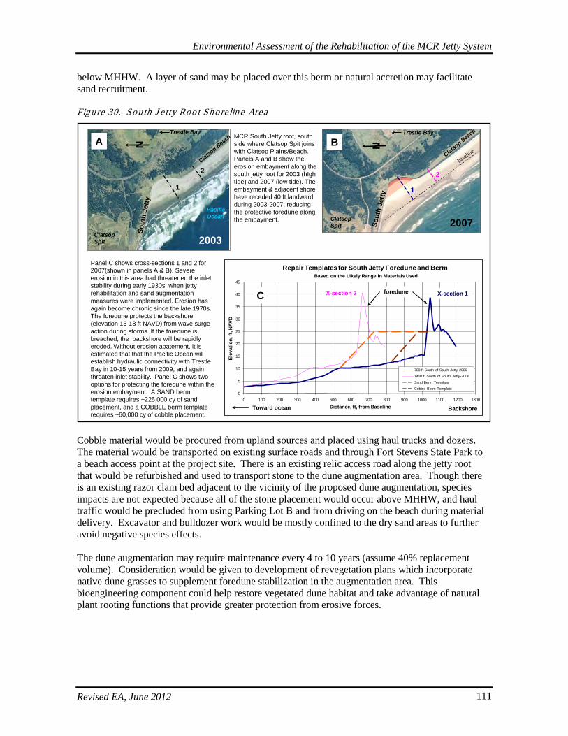
Environmental Assessment of the Rehabilitation of the MCR Jetty System
Revised EA, June 2012 111
below MHHW. A layer of sand may be placed over this berm or natural accretion may facilitate sand recruitment. Figure 30. Sou th J e tty Root Shore lin e Area
Cobble material would be procured from upland sources and placed using haul trucks and dozers. The material would be transported on existing surface roads and through Fort Stevens State Park to a beach access point at the project site. There is an existing relic access road along the jetty root that would be refurbished and used to transport stone to the dune augmentation area. Though there is an existing razor clam bed adjacent to the vicinity of the proposed dune augmentation, species impacts are not expected because all of the stone placement would occur above MHHW, and haul traffic would be precluded from using Parking Lot B and from driving on the beach during material delivery. Excavator and bulldozer work would be mostly confined to the dry sand areas to further avoid negative species effects. The dune augmentation may require maintenance every 4 to 10 years (assume 40% replacement volume). Consideration would be given to development of revegetation plans which incorporate native dune grasses to supplement foredune stabilization in the augmentation area. This bioengineering component could help restore vegetated dune habitat and take advantage of natural plant rooting functions that provide greater protection from erosive forces.
0
5
10
15
20
25
30
35
40
45
0 100 200 300 400 500 600 700 800 900 1000 1100 1200 1300
Elev
atio
n, ft
, NAV
D
Distance, ft, from Baseline
Repair Templates for South Jetty Foredune and BermBased on the Likely Range in Materials Used
700 ft South of South Jetty-2006
1400 ft South of South Jetty-2006
Sand Berm Template
Cobble Berm Template
Panel C shows cross-sections 1 and 2 for 2007(shown in panels A & B). Severe erosion in this area had threatened the inlet stability during early 1930s, when jetty rehabilitation and sand augmentation measures were implemented. Erosion has again become chronic since the late 1970s. The foredune protects the backshore (elevation 15-18 ft NAVD) from wave surge action during storms. If the foredune is breached, the backshore will be rapidly eroded. Without erosion abatement, it is estimated that that the Pacific Ocean will establish hydraulic connectivity with Trestle Bay in 10-15 years from 2009, and again threaten inlet stability. Panel C shows two options for protecting the foredune within the erosion embayment: A SAND berm template requires ~225,000 cy of sand placement, and a COBBLE berm template requires ~60,000 cy of cobble placement.
C
2003
2
1
Sout
h Je
ttyNA
Trestle Bay
Clatsop Spit
Clatsop Beach
Pacific Ocean
X-section 2 X-section 1foredune
Toward ocean Backshore
MCR South Jetty root, south side where Clatsop Spit joins with Clatsop Plains/Beach. Panels A and B show the erosion embayment along the south jetty root for 2003 (hIghtide) and 2007 (low tide). The embayment & adjacent shore have receded 40 ft landward during 2003-2007, reducing the protective foredune along the embayment. 2007
2
1
Sout
h Je
ttyNB
Trestle Bay
Clatsop Spit
Clatsop Beach
baseline
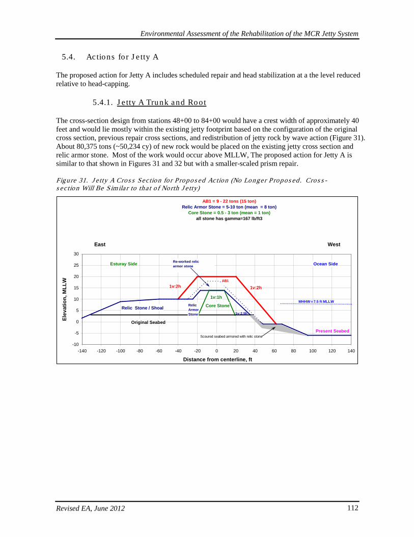
Environmental Assessment of the Rehabilitation of the MCR Jetty System
Revised EA, June 2012 112
5.4. Actions for J e tty A
The proposed action for Jetty A includes scheduled repair and head stabilization at a the level reduced relative to head-capping.
5.4.1. J e tty A Trunk and Root
The cross-section design from stations 48+00 to 84+00 would have a crest width of approximately 40 feet and would lie mostly within the existing jetty footprint based on the configuration of the original cross section, previous repair cross sections, and redistribution of jetty rock by wave action (Figure 31). About 80,375 tons (~50,234 cy) of new rock would be placed on the existing jetty cross section and relic armor stone. Most of the work would occur above MLLW, The proposed action for Jetty A is similar to that shown in Figures 31 and 32 but with a smaller-scaled prism repair. Figure 31. J e tty A Cros s Sec tion fo r Propo s ed Action (No Longer P ropos ed . Cros s - s ec tion Will Be Simila r to tha t o f North J e tty)
-10
-5
0
5
10
15
20
25
30
-140 -120 -100 -80 -60 -40 -20 0 20 40 60 80 100 120 140
Distance from centerline, ft
Elev
atio
n, M
LLW
Esturay Side Ocean Side
Core Stone
Present Seabed
Relic Stone / Shoal
AB1
Original Seabed
AB1 = 9 - 22 tons (15 ton) Relic Armor Stone = 5-10 ton (mean = 8 ton)
Core Stone = 0.5 - 3 ton (mean = 1 ton)all stone has gamma=167 lb/ft3
1v:2h
1v:2.5h
1v:1h
East West
1v:2h
Relic ArmorStone
Scoured seabed armored with relic stone
Re-worked relic armor stone
MHHW = 7.5 ft MLLW
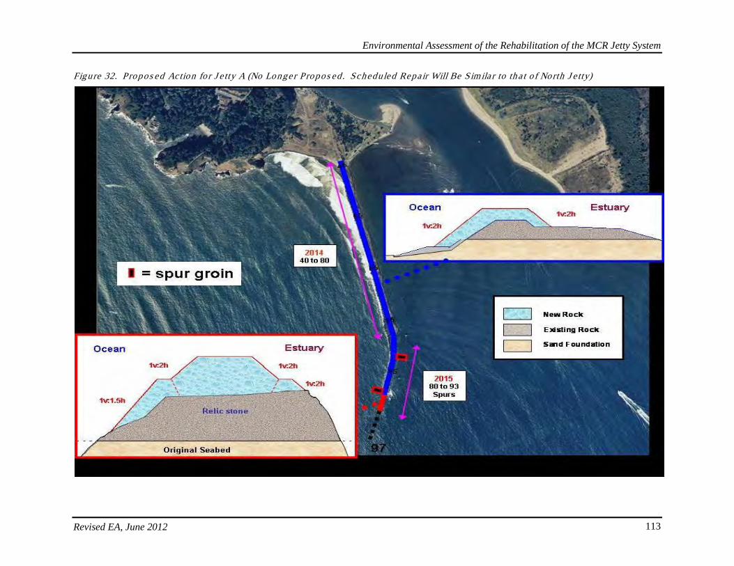
Environmental Assessment of the Rehabilitation of the MCR Jetty System
Revised EA, June 2012 113
Figure 32. Propos ed Action fo r J e tty A (No Longe r Propos ed . Scheduled Repair Will Be Simila r to th a t o f North J e tty)
Environmental Assessment of Rehabilitation of the MCR Jetty System
Revised EA, June 2012 114
The following amounts apply to the previously proposed design option. The new action, which is part of the Preferred Alternative, would have a smaller prism and footprint. Previously, about 63,700 cy of rock would have been placed above MHHW, which represented 63% of the overall stone placement on Jetty A and a 2020% change from the existing jetty prism, as very little stone remains in the zone and a larger amount of stone must be placed. As described for North and South jetties, this same concept applied to characterizations about the rest of the zones. About 28,940 cy of rock would have been placed between MHHW and MLLW, which represented 29% of the overall stone placement on these portions of Jetty A and a 280% change from the jetty prism. About 8,030 cy of rock would have been placed below MLLW. This represented 8% of the overall rock on these portions of Jetty A and a 233% change from the existing jetty prism. In all zones, most of the stone placement would have occurred on existing base relic stone that formed the original jetty cross-section. However, the footprint of the previously proposed prism could have increase in width as compared to the existing prism by up to 10 feet along the length of the jetty (though it would still be on relic stone). This equaled about 1.2 acres but it was not expected to result in additional habitat conversion because it would have been in a bottom location already comprised of jetty stone, and did not include any modification that changes the character, scope, or size of the original structure design.
5.4.2. J e tty A Spur Groins (No Longer Propos ed)
As with previous jetties, spur groins are no longer proposed in the current actions, but the discussions are retained here to provide context regarding what was previously evaluated. Originally, one submergent spur groin would have been placed on the downstream (JA1C) side and one submergent spur would have been placed on upstream (JA2O) side to stabilize the jetty’s foundation (Table 24 and Figures 33-34). Tab le 24. J e tty A Spur Gro in Fea ture (No Longe r P ropos ed)
Spur Groin Feature Jetty A Number of spurs on channel side or downstream for Jetty A 1 Number of spurs on ocean side or upstream for Jetty A 1
Approximate total rock volume per spur (+/- 20%) JA1C: 9,650 tons (~ 6,031 cy) JA2O: 7,330 tons (~ 4,581 cy)
Approximate total rock volume (all spurs) (+/- 20%) 25,000 tons (~ 15,625 cy) Approximate area affected by each spur JA1C: 0.33 acres; JA2O: 0.29 acres Approximate total area affected (all spurs) 0.61 acres Approximate area of spurs above water JA1C: 0%; JA2O: 0% Approximate area of spurs below -20 MLLW JA1C: 1%; JA2O: 0%
Approximate dimension of spurs: length x width x height (ft) JA1C: 135 x 105 x 18 JA2O: 125 x 100 x 15
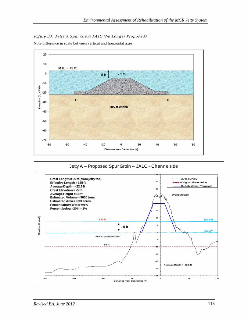
Environmental Assessment of Rehabilitation of the MCR Jetty System
Revised EA, June 2012 115
Figure 33. J e tty A Spur Gro in J A1C (No Longer Pro pos ed)
Note difference in scale between vertical and horizontal axes.
-70
-60
-50
-40
-30
-20
-10
0
10
20
-80 -60 -40 -20 0 20 40 60 80Distance from Centerline (ft)
Elev
atio
n (ft
, NA
VD)
105 ft width
- 5 ft
MTL ~ +3 ft
8 ft
-30
-25
-20
-15
-10
-5
0
5
10
15
20
25
30
35
40
-400 -300 -200 -100 0 100 200
Elev
atio
n (ft,
NAV
D)
Distance from Centerline (ft)
2006 surveyOriginal FoundationRehabilitation Template
East West/Ocean
95 ft
-5 ft crest elevation
135 ft
Average Depth = -22.5 ft
Jetty A – Proposed Spur Groin – JA1C - Channelside
- 8 ftMLLW
MHHW
Crest Length = 95 ft (from jetty toe)Effective Length = 135 ftAverage Depth = -22.5 ftCrest Elevation = -5 ftAverage Height = 18 ftEstimated Volume = 9650 tonsEstimated Area = 0.33 acresPercent above water = 0%Percent below -20 ft = 1%
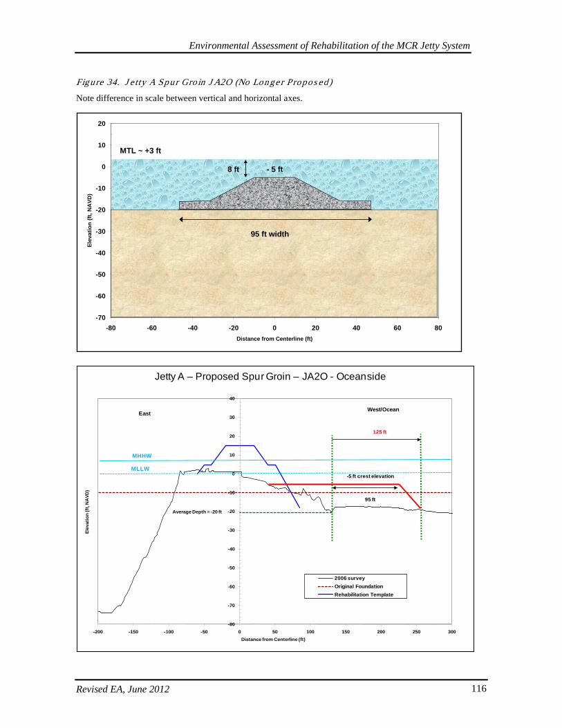
Environmental Assessment of Rehabilitation of the MCR Jetty System
Revised EA, June 2012 116
Figure 34. J e tty A Spur Gro in J A2O (No Longe r Propos ed)
Note difference in scale between vertical and horizontal axes.
-70
-60
-50
-40
-30
-20
-10
0
10
20
-80 -60 -40 -20 0 20 40 60 80Distance from Centerline (ft)
Elev
atio
n (ft
, NA
VD)
95 ft width
- 5 ft
MTL ~ +3 ft
8 ft
Jetty A – Proposed Spur Groin – JA2O - Oceanside
-80
-70
-60
-50
-40
-30
-20
-10
0
10
20
30
40
-200 -150 -100 -50 0 50 100 150 200 250 300
Elev
atio
n (f
t, N
AVD
)
Distance from Centerline (ft)
2006 surveyOriginal FoundationRehabilitation Template
EastWest/Ocean
95 ft
-5 ft crest elevation
125 ft
Average Depth = -20 ft
MLLW
MHHW
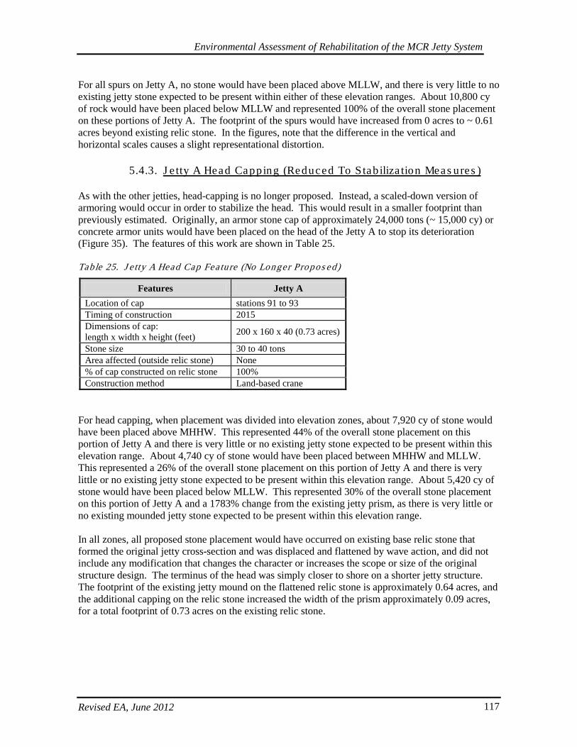
Environmental Assessment of Rehabilitation of the MCR Jetty System
Revised EA, June 2012 117
For all spurs on Jetty A, no stone would have been placed above MLLW, and there is very little to no existing jetty stone expected to be present within either of these elevation ranges. About 10,800 cy of rock would have been placed below MLLW and represented 100% of the overall stone placement on these portions of Jetty A. The footprint of the spurs would have increased from 0 acres to ~ 0.61 acres beyond existing relic stone. In the figures, note that the difference in the vertical and horizontal scales causes a slight representational distortion.
5.4.3. J e tty A Head Capping (Reduced To S tab iliza tion Meas ures )
As with the other jetties, head-capping is no longer proposed. Instead, a scaled-down version of armoring would occur in order to stabilize the head. This would result in a smaller footprint than previously estimated. Originally, an armor stone cap of approximately 24,000 tons (~ 15,000 cy) or concrete armor units would have been placed on the head of the Jetty A to stop its deterioration (Figure 35). The features of this work are shown in Table 25. Tab le 25. J e tty A Head Cap Fea ture (No Longer Propos ed)
Features Jetty A Location of cap stations 91 to 93 Timing of construction 2015 Dimensions of cap: length x width x height (feet) 200 x 160 x 40 (0.73 acres)
Stone size 30 to 40 tons Area affected (outside relic stone) None % of cap constructed on relic stone 100% Construction method Land-based crane
For head capping, when placement was divided into elevation zones, about 7,920 cy of stone would have been placed above MHHW. This represented 44% of the overall stone placement on this portion of Jetty A and there is very little or no existing jetty stone expected to be present within this elevation range. About 4,740 cy of stone would have been placed between MHHW and MLLW. This represented a 26% of the overall stone placement on this portion of Jetty A and there is very little or no existing jetty stone expected to be present within this elevation range. About 5,420 cy of stone would have been placed below MLLW. This represented 30% of the overall stone placement on this portion of Jetty A and a 1783% change from the existing jetty prism, as there is very little or no existing mounded jetty stone expected to be present within this elevation range. In all zones, all proposed stone placement would have occurred on existing base relic stone that formed the original jetty cross-section and was displaced and flattened by wave action, and did not include any modification that changes the character or increases the scope or size of the original structure design. The terminus of the head was simply closer to shore on a shorter jetty structure. The footprint of the existing jetty mound on the flattened relic stone is approximately 0.64 acres, and the additional capping on the relic stone increased the width of the prism approximately 0.09 acres, for a total footprint of 0.73 acres on the existing relic stone.
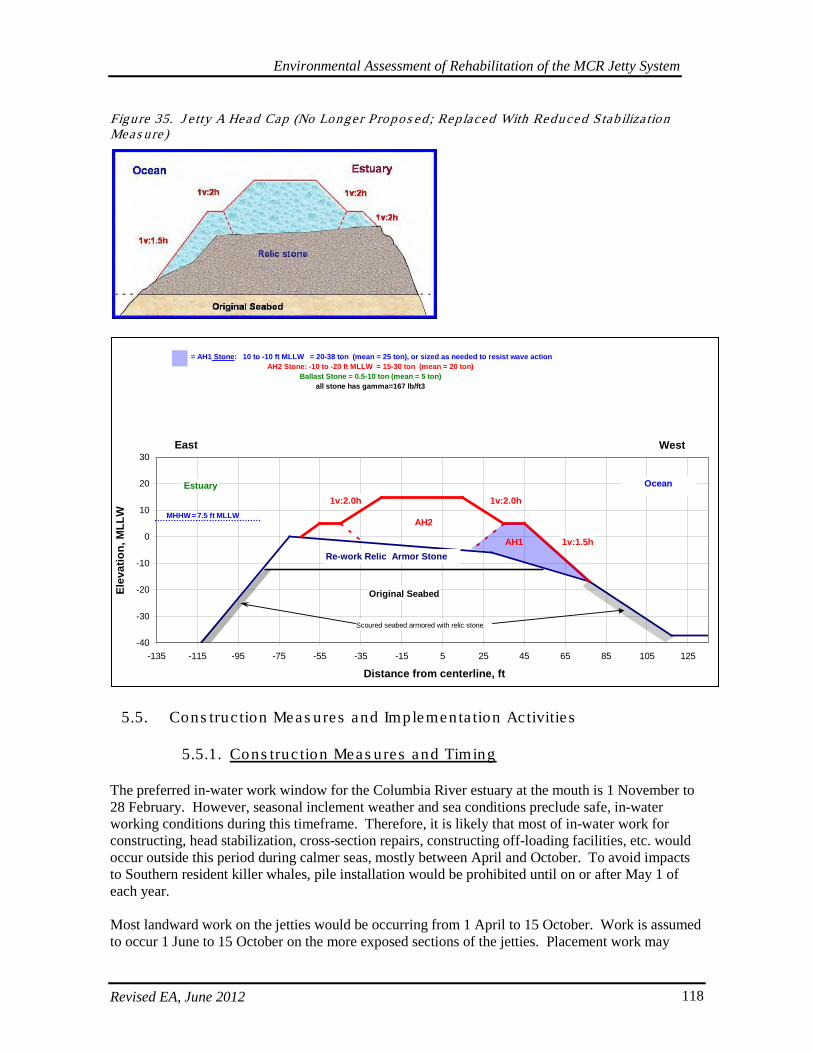
Environmental Assessment of Rehabilitation of the MCR Jetty System
Revised EA, June 2012 118
Figure 35. J e tty A Head Cap (No Longer Propos ed ; Replaced With Reduced Stab iliza tion Meas ure)
5.5. Cons truc tion Meas ures and Implementa tion Ac tivitie s
5.5.1. Cons truc tion Meas ures and Timing
The preferred in-water work window for the Columbia River estuary at the mouth is 1 November to 28 February. However, seasonal inclement weather and sea conditions preclude safe, in-water working conditions during this timeframe. Therefore, it is likely that most of in-water work for constructing, head stabilization, cross-section repairs, constructing off-loading facilities, etc. would occur outside this period during calmer seas, mostly between April and October. To avoid impacts to Southern resident killer whales, pile installation would be prohibited until on or after May 1 of each year. Most landward work on the jetties would be occurring from 1 April to 15 October. Work is assumed to occur 1 June to 15 October on the more exposed sections of the jetties. Placement work may
-40
-30
-20
-10
0
10
20
30
-135 -115 -95 -75 -55 -35 -15 5 25 45 65 85 105 125
Distance from centerline, ft
Elev
atio
n, M
LLW
OceanEstuary
Re-work Relic Armor Stone
Original Seabed
1v:2.0h
1v:1.5h
East West
Scoured seabed armored with relic stone
1v:2.0h
= AH1 Stone: 10 to -10 ft MLLW = 20-38 ton (mean = 25 ton), or sized as needed to resist wave actionAH2 Stone: -10 to -20 ft MLLW = 15-30 ton (mean = 20 ton)
Ballast Stone = 0.5-10 ton (mean = 5 ton)all stone has gamma=167 lb/ft3
AH2
AH1
MHHW = 7.5 ft MLLW
Environmental Assessment of Rehabilitation of the MCR Jetty System
Revised EA, June 2012 119
extend beyond these windows if weather and wave conditions are conducive to safe construction and delivery. Stone delivery by land or water could occur year-round, depending on delivery location, method, and weather breaks. Barge delivery would most likely occur during the months of April through October or at other times of the year depending on breaks in the weather and which jetty is being used. Quarrying of the rock may be limited depending on the regulations pertinent to each quarry. Work elements fall into four general categories for scheduling: (1) rock procurement, quarrying, and delivery transport, (2) construction site preparation, (3) lagoon fill and dune augmentations, and (4) jetty repair and rehabilitation work with construction of the design features including head stabilization. Site preparation would consist of the preparation of the rock stockpile storage and staging areas, as well as the construction of any barge-offloading facilities that may be required. Approximate transport quantities by method are 30 tons per truck and 6,500 tons per barge. The majority of the jetty rehabilitation work is expected to be conducted from the top of the jetty downward using an excavator or a crane. Areas which may require marine plant work include construction at the South Jetty head. For design and cost-benefit estimates, the project was modeled and designed for a 50-year operational lifespan. The schedule shown in Figure 36 illustrates construction actions related to building engineered features anticipated to occur at any one or some combination of all three of the jetties for the duration of 8 years. It also includes a predicted schedule of repair actions that the Corps’ model estimates will be necessary within that same time period. Additional repairs have also been predicted to occur after the initial 8-year construction schedule and within the 50-year lifespan of the project. Additional repairs beyond the 8-year schedule will be similar in scale and nature to those described above in the standard repair template. Repair actions are generally triggered when a cross-section of the jetty falls below about 30% to 50% of the standard repair template profile. The schedule described further in the narrative is a combined reflection of constructing specific engineered features and forecasting needed repairs. Real-time implementation of repair actions will likely vary based on evolving conditions at the jetties and could be shifted within and beyond this 8-year construction schedule. In the construction schedule, foredune augmentation begins in 2013 subject to funding. The rock production and stockpiling material for the first jetty installation is scheduled for late spring 2014. Base condition – lagoon fill and North Jetty repairs and the rest of construction continues through 2020. The estimate assumes the work would be accomplished with multi-year contracts. Prior to construction activities, an incidental harassment authorization (IHA) for marine mammals at the South Jetty will be obtained from the NMFS. The Corps anticipates that the new IHA permit would entail requirements similar to those in the previous permit for repair of the South Jetty. These previous requirements included monitoring and reporting the number of sea lions and seals (by species if possible) present on the South Jetty for 1 week before (re)starting work on this jetty. During construction, the Corps provided weekly reports to the NMFS that included a summary of the previous week’s numbers of sea lions and seals that may have been disturbed as a result of the jetty repair construction activities. These reports included dates, time, tidal height, maximum number of sea lions and seals on the jetty and any observed disturbances. A description of construction activities at the time of observation was also included. Post-construction monitoring occurred with one count every 4 weeks for 8 weeks to determine recolonization of the South Jetty. The Corps anticipates future monitoring and reporting requirements will be similar and will designate a biologically trained on-site marine mammal observer(s) to carry out this monitoring and reporting. The required reports will be submitted to the NMFS and the AMT. The ODFW, who monitors sea
Environmental Assessment of Rehabilitation of the MCR Jetty System
Revised EA, June 2012 120
lion use of the South Jetty, will also be apprised of the Corps work and results of the monitoring efforts. Conservation measures that will be implemented to minimize disturbance to Steller sea lions includes the following: during land-based rock placement, the contractor vehicles and personnel will avoid as much as possible direct approach towards pinnipeds that are hauled out. If it is absolutely necessary for the contractor to make movements towards pinnipeds, the contractor shall approach in a slow and steady manner to reduce the behavioral harassment to the animals as much as possible. Monitoring and reporting will occur as required. Also, measures 1, 2, and 3 discussed below will be employed during the marbled murrelet nesting season (April 1 to September 15) to reduce impacts from noise to nesting marbled murrelets on the Washington side, and measure 4 will be considered to create western snowy plover nesting habitat:
1. Trucks will only be allowed to use roads through Cape Disappointment State Park during daylight hours.
2. Trucks will not unnecessarily stop along the roads through Cape Disappointment State Park. 3. Trucks will be prohibited from using compression brakes (Jake-brakes) on the roads through
Cape Disappointment State Park. 4. The Corps is currently investigating opportunities to create western snowy plover nesting
habitat on Clatsop Spit within Fort Stevens State Park. As staging areas could be attractive to plovers, the Corps would consider creation of 10 -20 acres of habitat during or after use of the Spit for rock storage is completed. This habitat would be created with the intent to avoid potential limitations to rock storage and transport on the Spit if plovers begin to nest in construction areas. The options to create plover habitat concurrently with rock storage is preferable if plover use of the created habitats and beaches would not interfere with the Corps’ ability to use Clatsop Spit throughout the life of the project. This scenario would instead provide preferable alternative habitat away from the potential attractive nuisance of open sands that the construction disturbance would create. In other words, the Corps would be creating bare sand habitat that would attract birds away from construction site impacts. Habitat maintenance each year after creation would be required to provide functional habitat. The Corps would maintain these sites during construction, but after project completion maintenance would not be the responsibility of the Corps. The Corps has had initial discussions with OPRD regarding plover habitat creation and has signed a Memorandum of Agreement with the OPRD, USFWS, and other agencies regarding management of snowy plovers at Clatsop Spit and on other Corps lands. The Corps would be implementing best management practices (BMPs) that are in alignment with its efforts under the HCP.
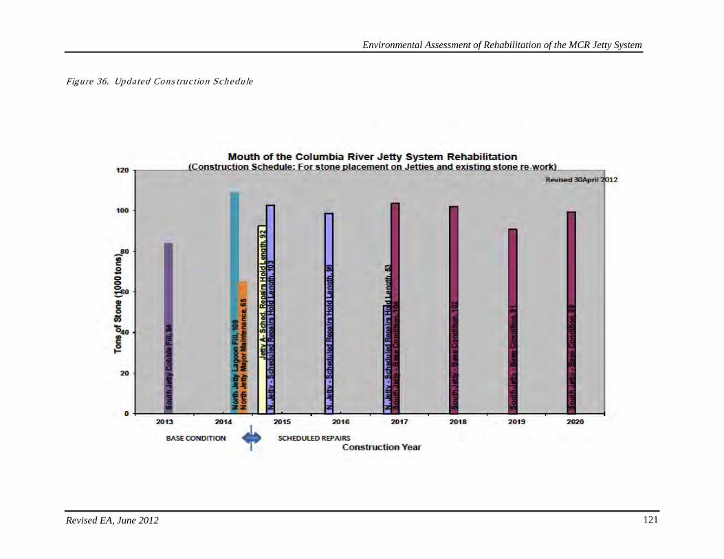
Environmental Assessment of Rehabilitation of the MCR Jetty System
Revised EA, June 2012 121
Figure 36. Updated Cons truc tion Sch edule
Environmental Assessment of Rehabilitation of the MCR Jetty System
Revised EA, June 2012 122
5.5.2. Cons truc tion Sequence and Genera l Schedule
The construction schedule for the MCR jetty system assumes the work would be accomplished with multi-year contracts. In 2013 South Jetty foredune augmentation would be implemented. This is the earliest possible time this could occur subject to availability of funding. In 2014, rock procurement activities and critical repairs would be initiated for the North Jetty interim repairs (Stations 86-99). In addition, rock procurement activities for the scheduled repairs would be initiated for the North Jetty in 2014 concurrent with plans and specification development. Quarries utilized are expected to be located in Oregon or Washington, although some rock may be obtained from Canadian quarries. In 2014, the on-site work would begin with filling the lagoon area behind the North Jetty root (stations 20 to 60) and installing a culvert to divert overland flow to another area that would not impact the North Jetty root stability. The lagoon area would be filled with rock, gravel, and sand. Once the lagoon is filled, it would serve as a staging and stockpile area for the rock delivered to the North Jetty site. The North Jetty repair work would begin in 2015 repairing cross section damage between stations 20+00 and 45+00. The North Jetty would require installing a barge offloading facility on the channel side of the jetty at approximately station 45 in order to facilitate efficient rock delivery to the site. Dredging of 30,000 cy is anticipated to provide the minimum 25 feet of working clearance. Repair of Jetty A would occur concurrently with the first year of repair for North Jetty. Jetty A work would begin with constructing the off loading facility which requires approximately 60,000 cy of dredging to accommodate the rock delivery by barge, and constructing the jetty crest haul road from stations 40 to 80. Total new stone in 2015 would consist of approximately 170,000 tons of imported rock, equivalent to 5700 trucks or 26 barges. In 2016, construction would continue on the North Jetty head from stations 45+00 to 76+00. The haul road would need to be constructed with approximately 26,000 tons of rock fill material. Total new stone for 2016 would consist of approximately 86,000 tons of imported rock, equivalent to 2900 trucks or 13 barges. Site preparation work and stockpiling stone at the South Jetty would occur to prepare the staging and stockpile areas for 2017 construction. In 2017, work continues on the North Jetty with placement of 29,000 tons of small and large armor near between stations 77+00 to 85+00. This ending stations corresponds with the beginning of the repair identified in as a portion of the base condition for this rehabilitation report. Work at these seaward stations requires refurbishing the haul road and building vehicle turnouts. At the North Jetty the 29,000 tons of imported small and large armor stone is equivalent to 970 trucks or 5 barges. In 2017, construction on the South Jetty is projected to begin, starting with repairing damaged cross-sections between stations 167+00 and 195+00. South Jetty construction would require either a haul road be constructed on top of the jetty or constructed from a marine plant. Total work effort on the South Jetty in 2017 is projected to consist of approximately 90,000 tons of small and medium armor stone; equivalent to 3000 trucks or 14 barges.

Environmental Assessment of Rehabilitation of the MCR Jetty System
Revised EA, June 2012 123
In 2018, construction on the South Jetty continues by extending the repairs from station 197+00 to station 222+00. It is anticipated that the haul road would have to be repaired and extended to accommodate the placement of the small, medium and large armor stone. Total work effort in 2018 is projected to consist of approximately 89,000 tons of small and medium armor stone; equivalent to 2970 trucks or 14 barges. In 2019, construction on the South Jetty continues by extending the repairs from station 223+00 to station 246+00. The haul road would again have to be repaired and extended to accommodate the placement of the armor stone which is evenly divided between medium and large armor stone for these stations. Total work effort in 2019 is projected to consist of approximately 79,000 tons of small and medium armor stone; equivalent to 2640 trucks or 12 barges. In 2020, the initial repairs for the three jetties are completed with the conclusion of South Jetty repairs on stations 258+00 to 290+00. The haul road would again have to be repaired and extended to accommodate the placement of the stone, which is very large armor stone. The transportation and placement of the stone may be accomplished by marine plant and land based crane depending upon the capabilities of the selected contractor. Total work effort in 2020 is projected to consist of approximately 87,000 tons of imported large and very large armor stone; equivalent to 2980 trucks or 13 barges. The size of the very large armor stone, (16-33 tons) may dictate how they are transported and would require additional time and effort for placement.
5.5.3. Rock Sources and Trans porta tion
Currently, it is not exactly known where jetty rock would come from and how it would be transported to the jetty sites. However, one or more of the options discussed below would be employed (Figure 37 and Table 26). Rock sources located within 150 miles of a jetty would likely be transported by truck directly to the jetty. Stone sources located at further distances, especially if they are located near waterways, are likely to be transported by truck to a barge onloading facility, then transported by tug and barge to either a Government provided or commercial barge offloading site located nearby. Railway may also be an option for transporting stone, provided that an onloading site is convenient to the quarry. Most railroads follow main highway arterials, such as Interstate 5. The closest railroad terminal to the South Jetty is at Tongue Point, east of Astoria, OR, which is about 15 miles from the jetty. The nearest railroad terminal to the MCR on the north side of the Columbia River is at Longview, WA. The Corps intends to use operating quarries rather than opening any new quarries. The Contractor and quarry owner/operator would be responsible for ensuring that quarries selected for use are appropriately permitted and in environmental compliance with all state and federal laws. Canadian Quarries. Quarries in British Columbia are typically located adjacent to waterways and rock produced from these quarries will likely have a limited truck haul. Due to the long distance to the MCR, plus the immediate availability to deep water, rock would likely be loaded onto barges and shipped down the Washington Coast to barge offloading sites. Washington Quarries. Quarries located in northern Washington are typically not on the water, but are generally located within 50 miles of a potential barge on-loading site. As a result, rock would need to be hauled, at least initially, by truck. Rock would be transported by trucks most likely to a barge on-loading facility or possibly all the way to the staging site at the jetty. In the event of a combination of trucking and barging, trucks would be loaded at the quarry, and then traverse public
Environmental Assessment of Rehabilitation of the MCR Jetty System
Revised EA, June 2012 124
roads to existing facilities. Once the rock is loaded on barges, it would be transported down the coast to barge offloading sites. It also is possible that railway systems may be used to transport rock much of the way to the jetties. Burlington Northern Railroad operates a rail system that parallels Interstate 5 throughout Washington which would be the most likely route rock would be transported. Rock from the quarry would be taken by truck to a nearby railway station where they would be loaded onto railway cars and transported to an intermediate staging area. Trucks would then again take the rock the remainder of the way to the jetty staging areas. Truck hauling of rock from northern Washington sources to the North Jetty or Jetty A most likely would be transported by public road to Interstate 5 or any of the main roads over to Highway 101. Trucks using Interstate 5 would either turn at Longview on Highway 4 to Highway 101, or cross over the Longview Bridge to Highway 30 near Rainier, Oregon. From this point they would proceed west to Astoria to Highway 101, crossing the Astoria-Megler Bridge through Ilwaco to the jetty staging areas. Delivery to the South Jetty most likely would use main roads to Interstate 5 or any of the main roads over to Highway 101.
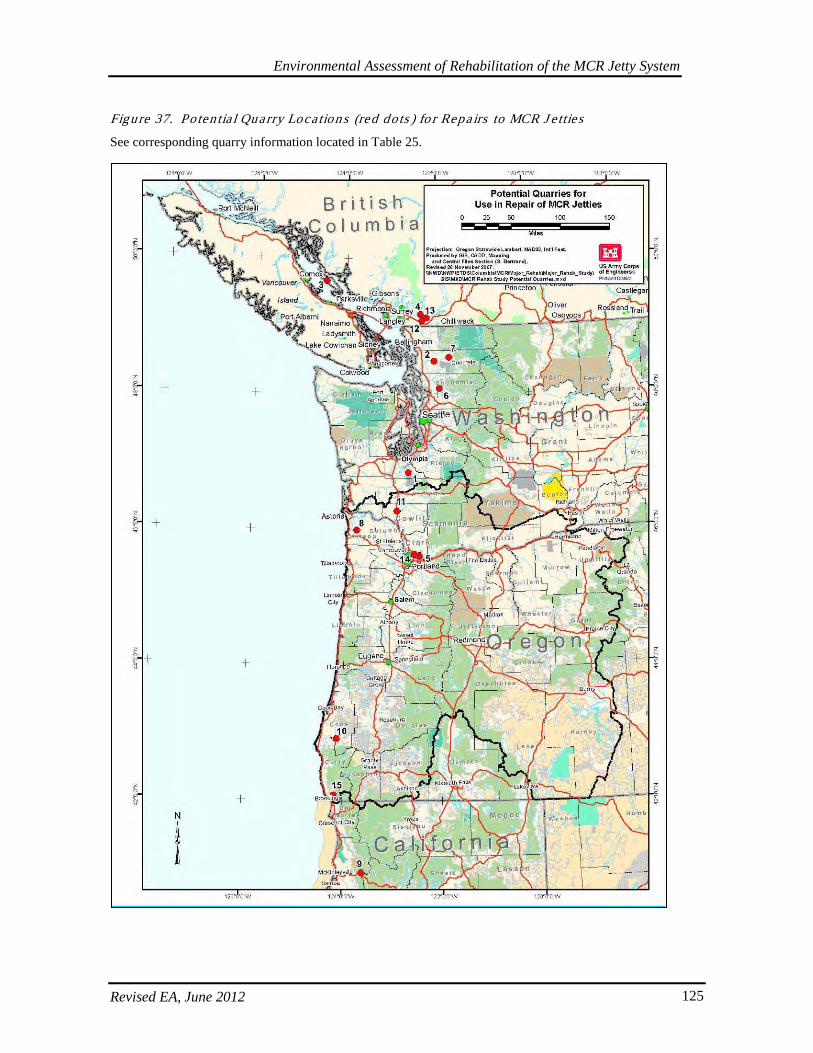
Environmental Assessment of Rehabilitation of the MCR Jetty System
Revised EA, June 2012 125
Figure 37. Po ten tia l Qua rry Loca tion s (red do ts ) fo r Repa irs to MCR J e tties
See corresponding quarry information located in Table 25.
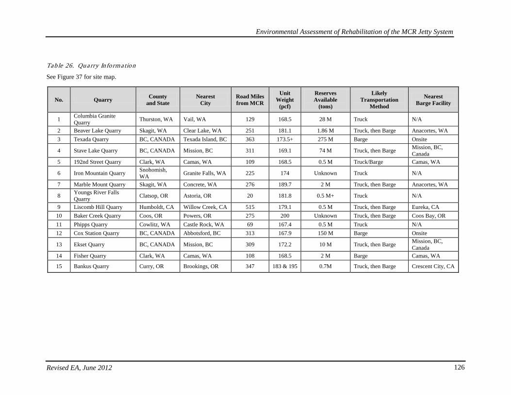
Environmental Assessment of Rehabilitation of the MCR Jetty System
Revised EA, June 2012 126
Tab le 26. Qua rry In forma tion
See Figure 37 for site map.
No. Quarry County and State
Nearest City
Road Miles from MCR
Unit Weight
(pcf)
Reserves Available
(tons)
Likely Transportation
Method
Nearest Barge Facility
1 Columbia Granite Quarry Thurston, WA Vail, WA 129 168.5 28 M Truck N/A
2 Beaver Lake Quarry Skagit, WA Clear Lake, WA 251 181.1 1.86 M Truck, then Barge Anacortes, WA 3 Texada Quarry BC, CANADA Texada Island, BC 363 173.5+ 275 M Barge Onsite
4 Stave Lake Quarry BC, CANADA Mission, BC 311 169.1 74 M Truck, then Barge Mission, BC, Canada
5 192nd Street Quarry Clark, WA Camas, WA 109 168.5 0.5 M Truck/Barge Camas, WA
6 Iron Mountain Quarry Snohomish, WA Granite Falls, WA 225 174 Unknown Truck N/A
7 Marble Mount Quarry Skagit, WA Concrete, WA 276 189.7 2 M Truck, then Barge Anacortes, WA
8 Youngs River Falls Quarry Clatsop, OR Astoria, OR 20 181.8 0.5 M+ Truck N/A
9 Liscomb Hill Quarry Humboldt, CA Willow Creek, CA 515 179.1 0.5 M Truck, then Barge Eureka, CA 10 Baker Creek Quarry Coos, OR Powers, OR 275 200 Unknown Truck, then Barge Coos Bay, OR 11 Phipps Quarry Cowlitz, WA Castle Rock, WA 69 167.4 0.5 M Truck N/A 12 Cox Station Quarry BC, CANADA Abbotsford, BC 313 167.9 150 M Barge Onsite
13 Ekset Quarry BC, CANADA Mission, BC 309 172.2 10 M Truck, then Barge Mission, BC, Canada
14 Fisher Quarry Clark, WA Camas, WA 108 168.5 2 M Barge Camas, WA
15 Bankus Quarry Curry, OR Brookings, OR 347 183 & 195 0.7M Truck, then Barge Crescent City, CA
Environmental Assessment of Rehabilitation of the MCR Jetty System
Revised EA, June 2012 127
Trucks using Highway 101 south through Washington would likely cross the Astoria-Megler Bridge, go through Warrenton using local roads into Fort Stevens State Park and the staging area. Trucks utilizing Interstate 5 would either turn at Longview on Highway 4 to Highway 101, or on Highway 30 near Rainier, proceeding through Astoria to Highway 101, going through Warrenton through local roads into Fort Stevens State Park and the jetty staging area. Rock located within southern Washington would likely be trucked to the jetty staging areas. An exception to this would be a quarry that occurs within just a few miles of a port on the Washington Coast or a quarry that is near the Columbia River. In either of these two barge possibilities, rock would be delivered by truck to a barge on-loading facility, loaded on oceangoing or riverine barges, and delivered to one of the barge offloading facilities (see section on barge offloading facilities below). Truck hauling of rock from this area to the jetties would be as described above. Oregon Quarries. Rock located in northern Oregon within 50 miles of the North Jetty and Jetty A would likely utilize any of the main roads over to Highway 101 or Highway 30. From this point they would cross the Astoria-Megler Bridge and proceed west through Ilwaco to the jetty staging areas. Quarries exceeding 50 miles from the jetties would likely utilize main roads at a farther distance from the jetty sites. This would involve longer haul distances on Highways 101, 30, 26, and others before crossing the Astoria-Megler Bridge and proceeding to the staging areas. Truck hauling of rock from quarries within 50 miles of the South Jetty will most likely utilize any of the main roads over to Highway 101 or Highway 30. From this point they would proceed through Astoria and Warrenton, or Seaside and Gearhart to local roads leading to Fort Stevens State Park and the jetty staging areas. Quarries exceeding 50 miles from the jetty would likely utilize main roads at a farther distance from the jetty site. This would involve longer haul distances on Highways 101, 30, 26, and others before going through Astoria and Warrenton, or Seaside and Gearhart to local roads leading into Fort Stevens State Park and the staging areas. The likely mode of transportation from southern Oregon quarries is trucking, or a combination of trucking and barging. Many of the quarries may be near the Oregon Coast; however, they may not be near a port facility that has barge on-loading capability. Providing that barge facilities are available, rock located south of Waldport would be loaded at the quarry onto trucks and traverse main public roads to the barge on-loading site, loaded on ocean-going barges, and shipped up the Oregon Coast to one of the barge offloading facilities (see section on barge offloading facilities below). Quarries north of Waldport would most likely be hauled by truck the entire distance. Southern Oregon rock sources requiring trucking would be loaded onto lowboy trucks one to three at a time and would traverse main roads to more main arterials such as Highway 101 or, to a lesser degree, Interstate 5. An effort would be made to use the least distance possible to transport the rock without sacrificing transport time. California Quarries. For northern California quarries, there would be a very long haul distance required to get rock to the jetty repair areas. Barging of rock would be the only economically feasible option. Rock would be transferred by truck from the quarries along main roads leading to Highway 101 to a barge offloading facility. For water-based delivery of rock, a tow boat and barge would deliver the rock to the channel side of the jetties where water depth, waves, and current conditions permit. During rock offloading, the barge may be secured to approximately 4 to 8 temporary dolphins/H-piles to be constructed within 200 feet of the jetty. Rock would be off-loaded from the barge by a land- or water-based crane and
Environmental Assessment of Rehabilitation of the MCR Jetty System
Revised EA, June 2012 128
either placed directly within the jetty work area or stock piled on the jetty crest for subsequent placement at a later time. For land-based delivery of rock, jetty access for rock hauling trucks would be via an existing paved road to the Benson Beach parking lot at Cape Disappointment State Park (North Jetty) and via an existing paved road to the Parking Lots C and D at the South Jetty. An existing overland route between Jetty A and North Jetty may also be used for land-based hauling. Work areas for delivery of rock, maneuvering of equipment, and stockpiling of rock near the jetties have been identified and are discussed in the next section.
5.5.4. Barge Offloading Facilitie s
Stone delivery by water could require up to four barge offloading facilities that allow ships to unload cargo onto the jetty so that it can then be placed or stockpiled for later sorting and placement. The range of locations for these facilities is shown in Figures 38-40. Depending on site-specific circumstances, offloading facilities may be partially removed and rebuilt, may be permanently removed, or may remain as permanent facilities upon project completion. Facility removal will depend on access needs and evolving hydraulic, wave, and jetty cross-section conditions at each offloading locations. Additionally, in the draft EA released in January 2010, a third offloading facility was under consideration for the South Jetty in the bay adjacent to the area known as Social Security Beach. Due to the size of the footprint and the possible effects to shallow-water habitat in the vicinity, this option has been withdrawn from further consideration in order to avoid and minimize environmental impacts. The site near Parking Area D at the South Jetty was deemed to have a smaller footprint, was likely to require less dredging, and had fewer impacts to shallow-water habitat. Facilities will range from approximately 200- to 500-feet long and 20- to 50-feet wide, which ranges from about 0.48 to 2.41 acres in total area. Examples are shown in Figure 41. For initial construction of all four facilities combined, approximately up to 96 Z- or H-piles that are 12-16-inches in diameter could be installed as dolphins, and up to 373 sections of Z- or H-piles installed to retain rock fill. Figure 41 shows a cross-section diagram for stone access ramp at potential barge offloading facilities and photos illustrating typical barge offloading facilities. Facilities will have a 15-foot NGVD crest elevation and will be installed at channel depths between -20 and -30 feet NGVD. A vibratory hammer will be used for pile installation and only untreated wood will be used, where applicable. Removal and replacement of the facilities could occur within the duration of the construction schedule. Volume and acreage of fill for these facilities are shown in Table 27.
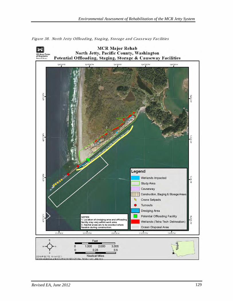
Environmental Assessment of Rehabilitation of the MCR Jetty System
Revised EA, June 2012 129
Figure 38. No rth J e tty Offload ing , S tag ing , S torage and Caus eway Fac ilities
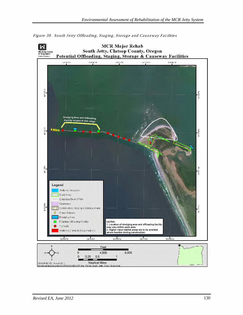
Environmental Assessment of Rehabilitation of the MCR Jetty System
Revised EA, June 2012 130
Figure 39. Sou th J e tty Offload ing , S tag ing , S torag e and Cau s eway Fac ilitie s
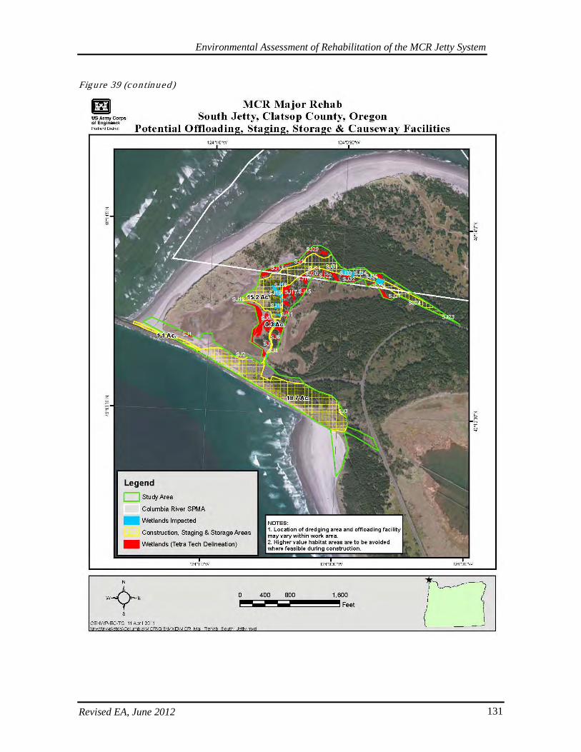
Environmental Assessment of Rehabilitation of the MCR Jetty System
Revised EA, June 2012 131
Figure 39 (con tinued)
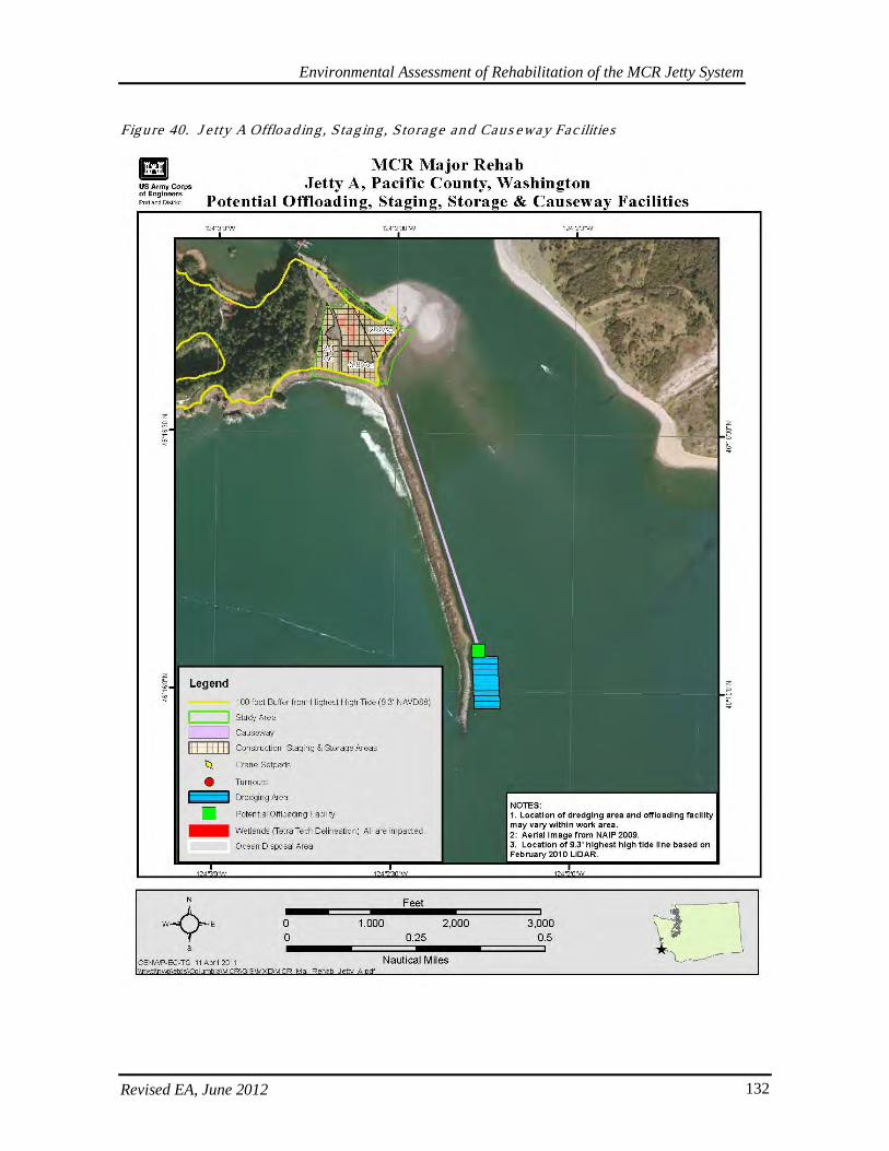
Environmental Assessment of Rehabilitation of the MCR Jetty System
Revised EA, June 2012 132
Figure 40. J e tty A Offload ing , S tag ing , S torage an d Caus eway Fac ilitie s
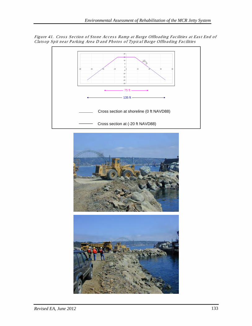
Environmental Assessment of Rehabilitation of the MCR Jetty System
Revised EA, June 2012 133
Figure 41. Cros s Sec tion o f Stone Acces s Ramp a t Barge Offload ing Fac ilities a t Eas t En d of Cla ts op Sp it n ear Pa rking Area D and Photos o f Typica l Barge Offload ing Fac ilities
-25
-20
-15
-10
-5
0
5
10
15
20
-80 -60 -40 -20 0 20 40 60 80
Cross section at shoreline (0 ft NAVD88)
Cross section at (-20 ft NAVD88)
75 ft
135 ft
1.51
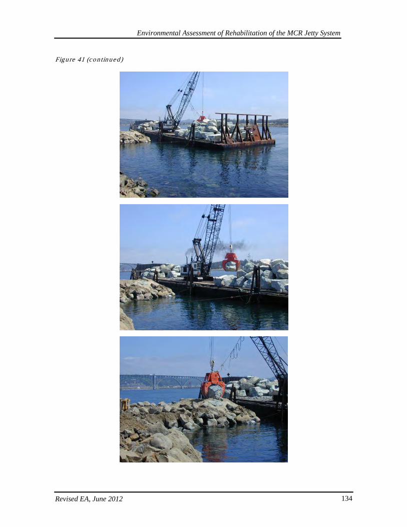
Environmental Assessment of Rehabilitation of the MCR Jetty System
Revised EA, June 2012 134
Figure 41 (con tinued)
Environmental Assessment of Rehabilitation of the MCR Jetty System
Revised EA, June 2012 135
The following existing private facilities may serve as potential offloading sites depending on availability for Corps’ use:
• Commercial Site in Ilwaco. For the North Jetty, barges would pull up to a dock at Ilwaco where rock would be transferred by crane onto trucks that would proceed by public road to Cape Disappointment State Park. Trucks would then pass through the park grounds to the staging area adjacent to the jetty. For Jetty A, trucks would proceed through the Coast Guard facility to the staging area near the root of the jetty.
• Commercial Site in Warrenton. Nygaard Logging has a deep-water offloading site that
could be used to offload rock. For the North Jetty/Jetty A, rock would be transferred to trucks that would likely use Highway 101 into Astoria, cross the Astoria-Megler Bridge, and head west through Ilwaco to Cape Disappointment State Park. Trucks would then pass through the park grounds to the staging area adjacent to the jetty. For the South Jetty, rock would be transferred to trucks which would then proceed west through Hammond to Fort Stevens State Park and use the existing park road to staging area adjacent to the jetty. This site needs no improvement to accommodate deep-draft vessels.
If existing facilities are not available or do not have adequate capacity to provide access, barge offloading facilities could be constructed at each jetty.
• North Jetty: Between Stations 50 and 70, a barge offloading facility will be constructed in the reach such that wave conditions allow safe offloading. This offloading facility will require 4-8 dolphins of 3 piles each for vessel tie-up, and sheet-pile installation will be required to shore-up and retain rock at the offloading point.
• Jetty A: An offloading facility will be sited around station 81, at the upstream portion of the jetty near the head. A 15-foot causeway will also be constructed along the entire length of the jetty on existing relic stone that runs adjacent to and abutting the upstream eastern portion of the jetty. This facility will likely remain a permanent facility, but may deteriorate due to wave and tidal action. This offloading facility will require 4-8 dolphins of 3 piles each for vessel tie-up, and sheet-pile installation will be required to shore-up and retain rock at offloading point.
• South Jetty: The South Jetty could have up to two associated offloading sites. One will be located at Parking Area D near the northeastern-most corner of the spit. The second facility will be located along the jetty and will resemble an extra-large turn-out facility. It is likely to be located somewhere on the northern, channel-side of the jetty and west of Station 270 in order to take advantage of deeper bathymetry and subsequently less need for dredging. The facility at Parking Area D may be removed after 5 or more years depending on hydraulic impacts of the structure and spit. The facility along the jetty will likely be partially removed and rebuilt after each repair to avoid the potential for wave-focusing on the jetty. Otherwise, it will remain in place until about 2033. Each offloading facility will require 4-8 dolphins of 3 piles each for vessel tie-up, and sheet-pile installation will be required to shore-up and retain rock at offloading point.

Environmental Assessment of Rehabilitation of the MCR Jetty System
Revised EA, June 2012 136
Table 27. Rock Volume and Area o f Barge Offload ing Fac ilitie s and Caus eways
Location Approximate Length (ft)
Approximate Rock
Volume (cy) Below 0 MLLW
Total Approximate
Rock Volume (cy)
Approximate Square Feet Acres
North Jetty 200 7,778 29,640 cy 21,000 0.48 Jetty A near head 200 7,778 29,640 cy 21,000 0.48 Jetty A mid-section causeway 5000 38,888 38,888 105,000 2.41
South Jetty Parking Area D 450 17,417 33,688 cy 47,250 1.08
South Jetty along jetty turn-out 200 18,640 cy 21,000 0.48
5.5.5. Dredging for Barge Offloading Fac ilitie s
Transport of rock would most likely be done by ocean-going barges that require deeper draft (20-22 feet) and bottom clearance when fully loaded than river-going barges. Therefore, dredging will be required to develop each of the barge offloading facilities. Under-keel clearance should be no less than 2 feet. The elevation at barge offloading sites should have access to navigable waters and a dredge prism with a finish depth no higher than -25 feet MLLW, with advance maintenance and disturbance zone depths not to extend below -32 feet MLLW. These facilities should also provide for a maneuvering footprint of approximately 400 feet x 400 feet. The depth along the unloading sites would be maintained during the active period for which the rock barges will be unloaded. A clamshell dredge would likely be used for all dredging, although there is a small chance that a pipeline dredge could be used. The material to be dredged is medium to fine-grained sand, typical of MCR marine sands. Disposal of material would occur in-water at an existing, previously-evaluated and designated or other approved disposal site. The volume of material to be dredged is shown in Table 28; these estimates are based on current bed morphology and may change. Also, maintenance dredging to a finish depth of -25 feet MLLW will be needed before offloading during each year of construction. Dredging is likely to occur on a nearly annual basis for the duration of the project construction period, but this will be intermittent per jetty, depending on which one is scheduled for construction in a particular year. Tab le 28. Es timated Dred ging Volumes fo r Ba rge Offload ing Fac ilitie s
Location* Estimated Dredging Volume (cy) Approximate Acres Initial Est. Maintenance**
North Jetty 30,000 30,000 3.73 Jetty A 60,000 None (1 year only) 3.73 South Jetty – Along Jetty 20,000 20,000 4.19 South Jetty – Parking Area D 20,000 20,000 4.19
* Some of the locations will not be used on an annual basis; it depends on the construction schedule for each jetty. **All dredging will be based on surveys that indicate depths shallower than -25 feet MLLW.
Environmental Assessment of Rehabilitation of the MCR Jetty System
Revised EA, June 2012 137
Clamshell dredging is done using a bucket operated from a crane or derrick that is mounted on a barge or operated from shore. Sediment removed from the bucket is generally placed on a barge before disposal. This type of dredge is typically used in shallow-water areas. The following overall impact minimization practices and best management practices (BMPs) will be used for all maintenance dredging for offloading facilities.
1. To reduce the potential for entrainment of juvenile salmon or green sturgeon, the cutter-heads on pipeline dredges will remain on the bottom to the greatest extent possible and only be raised 3 feet off the bottom when necessary for dredge operations.
2. To reduce turbidity, if a clamshell bucket is used, all digging passes shall be completed
without any material, once in the bucket, being returned to the wetted area. No dumping of partial or half-full buckets of material back into the project area will be allowed. No dredging of holes or sumps below minimum depth and subsequent redistribution of sediment by dredging dragging or other means will be allowed. All turbidity monitoring will comply with State 401 Water Quality Certification Conditions.
3. If the Captain or crew operating the dredges observes any kind of sheen or other indication
of contaminants, he/she will immediately stop dredging and notify the Corps’ environmental staff to determine appropriate action.
4. If routine or other sediment sampling determines that dredged material is not acceptable for
unconfined, in-water placement, then a suitable alternative disposal plan will be developed in cooperation with the NMFS, EPA, Oregon Department of Environmental Quality (ODEQ), Washington Department of Ecology (WDOE), and other appropriate agencies.
5.5.6. Dredged Mate ria l Dis pos a l S ite s
Two dredged material disposal sites, the Shallow Water Site (SWS) and the North Jetty site, are located near the North Jetty. The SWS is the most likely sites to be used for disposal of dredged material. Modeling has showed that the potential changes to the two disposal sites from the proposed action would not inhibit their use as disposal sites. As previously mentioned, these disposal sites have been previously vetted through the appropriate regulatory agencies, were evaluated for their effects, and were subsequently designated or approved after such review. There is also a Deep Water Site (DWS) further offshore, west of the North Jetty. It is less likely that this site would be used, though it is also an approved disposal site. The current proposed action and use of the SWS or other designated disposal site will maintain compliance with approved use. This will likely be covered in the Annual Use Plan which includes a request for use and is approved by the EPA. This involves a request for concurrence that the Corps’ proposed Annual Use Plan is in compliance with the Site Monitoring and Management Plan.
5.5.7. Pile Ins ta lla tion and Remova l
As mentioned earlier, inclement weather and sea conditions during the preferred in-water work window preclude safe working conditions during this time period. Therefore, installation of piles is most likely to occur outside of the in-water work window. For initial construction of all four facilities combined, approximately up to 96 Z- or H-piles could be installed as dolphins, and up to
Environmental Assessment of Rehabilitation of the MCR Jetty System
Revised EA, June 2012 138
373 sections of sheet pile to retain rock fill. They will be located within 200-ft of the jetty structure. Because the sediments in the region are soft (sand), use of a vibratory driver to install piles is feasible and will be used when necessary. The presence of relic stone may require locating the piling further from the jetty so that use of this method is not precluded by the existing stone. The dolphins/Z- and H-piles would be composed of either untreated timber or steel piles installed to a depth of approximately 15 to 25 feet below grade in order to withstand the needs of off-loading barges and heavy construction equipment. Because vibratory hammers will be implemented in areas with velocities greater than 1.6 feet per second, the need for hydroacoustic attenuation is not an anticipated issue. Piling will be fitted with pointed caps to prevent perching by piscivorous birds to minimize opportunities for avian predation on listed species. Some of the pilings and offloading facilities will be removed at the end of the construction period.
5.5.8. Rock P lacement
Placement of armor stone and jetty rock on the MCR jetties would be accomplished by land or limited water-based equipment. Only clean stone will be used for rock placement, where appropriate and feasible. Where appropriate, there may also be some re-working and reuse of the existing relic and jetty prism stone. Fill for the jetty haul roads will not be cleaned prior to installation. Dropping armor stone from a height greater than 2 feet will be prohibited. During placement there is a very small chance of stone slippage down the slope of the jetty. However, this is unlikely to occur due to the size and cost of materials and placement. Another approach to water-based rock placement would be via a jack-up barge. This would only be applicable at the South Jetty. For armor stone and rock placement at the head, a jack-up barge with crane could be used to serve as a stable work platform (Figure 42). Once into place, the jack-up barge would be jacked up on six legs so that the deck is at the same elevation as the jetty. The legs are designed to use high-pressure water spray from the end of the legs to agitate the sand and sink the legs under their own weight. The jacking process does not use any lubricants that contain oils, grease, and/or other hydrocarbons. The stone and rock will be barged to the jack-up barge and offloaded onto the jetty head. The jack-up barge will keep moving around the head of the jetty to complete the work. A jack-up barge would not be used on the North Jetty or Jetty A to avoid interference with navigation of fishing boats and crab and fish migrations.
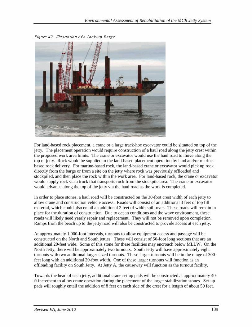
Environmental Assessment of Rehabilitation of the MCR Jetty System
Revised EA, June 2012 139
Figure 42. Illus tra tion o f a J ack-up Ba rge
For land-based rock placement, a crane or a large track-hoe excavator could be situated on top of the jetty. The placement operation would require construction of a haul road along the jetty crest within the proposed work area limits. The crane or excavator would use the haul road to move along the top of jetty. Rock would be supplied to the land-based placement operation by land and/or marine-based rock delivery. For marine-based rock, the land-based crane or excavator would pick up rock directly from the barge or from a site on the jetty where rock was previously offloaded and stockpiled, and then place the rock within the work area. For land-based rock, the crane or excavator would supply rock via a truck that transports rock from the stockpile area. The crane or excavator would advance along the top of the jetty via the haul road as the work is completed. In order to place stones, a haul road will be constructed on the 30-foot crest width of each jetty to allow crane and construction vehicle access. Roads will consist of an additional 3 feet of top fill material, which could also entail an additional 2 feet of width spill-over. These roads will remain in place for the duration of construction. Due to ocean conditions and the wave environment, these roads will likely need yearly repair and replacement. They will not be removed upon completion. Ramps from the beach up to the jetty road will also be constructed to provide access at each jetty. At approximately 1,000-foot intervals, turnouts to allow equipment access and passage will be constructed on the North and South jetties. These will consist of 50-foot long sections that are an additional 20-feet wide. Some of this stone for these facilities may encroach below MLLW. On the North Jetty, there will be approximately two turnouts. South Jetty will have approximately eight turnouts with two additional larger-sized turnouts. These larger turnouts will be in the range of 300-feet long with an additional 20-foot width. One of these larger turnouts will function as an offloading facility on South Jetty. At Jetty A, the causeway will function as the turnout facility. Towards the head of each jetty, additional crane set up pads will be constructed at approximately 40-ft increment to allow crane operation during the placement of the larger stabilization stones. Set-up pads will roughly entail the addition of 8 feet on each side of the crest for a length of about 50 feet.
Environmental Assessment of Rehabilitation of the MCR Jetty System
Revised EA, June 2012 140
Some of this stone for these facilities may encroach below MLLW. Approximately five set-up pads will be required to construct each jetty head.
5.5.9. Cons truc tion S tag ing , S torage , and Rock S tock P ile s
Jetty repairs and associated construction elements entail additional footprints for activities involving equipment and supply staging and storage, parking areas, access roads, scales, general yard requirements, and rock stock pile areas. It was determined that for most efficient work flow and placement, a 2-year rock supply would be maintained on site and would be continuously replenished as placement occurred on each jetty. In order to estimate the area needed, a surrogate area was determined for a reference volume of 8,000 cy, which was then used to extrapolate the area needed at each jetty. These results are shown in Table 15. Tab le 29. Ac reages Need ed fo r Cons truc tion Stag ing , S torage , and Ro ck Stock P iles
Location Approximate Acres
North Jetty 31 Jetty A 23 South Jetty 44
Several actions will be taken to avoid and minimize environmental impacts from these activities. Staging and stockpiles will remain above MHHW and where feasible, have been sited to avoid impacts to wetlands and habitats identified as having higher ecological value. In order to maintain erosive resilience along the shoreline, a vegetative buffer would be preserved. When available and possible, partial use will be made of existing parking lots. Additional measures specific to each jetty have also been considered. Besides access roads in the areas identified in Figures 38-40, no additional roadways or major roadway improvements are anticipated. Some roadway repair and maintenance will likely be required on existing roads experiencing heavy use by the Corps. For the North Jetty, the lagoon fill necessary for root stabilization will also serve a dual purpose for the bulk of staging and storage activities at this structure. At the South Jetty, a small spur road will be required to connect the existing road with the proposed staging area and is indicated in Figures 38-40. The existing road along the neck of the South Jetty to be used for dune augmentation work may require minor repair/improvements for equipment access. Construction access to the area receiving dune augmentation will be limited to the existing access road along the relic jetty structures at the neck of the spit. Equipment will be precluded from using the access point from Parking Lot B for delivery in order to avoid impacts to water quality and razor clam beds in the vicinity of the proposed dune fill area. Grading equipment may have to access the area by driving along the shore, but this route will be used as a last resort and equipment will be limited to dry sand where feasible. Additionally, the proposed actions will avoid the more sensitive habitat areas south of Parking Lot D. If possible, the project will avoid and minimize impacts to the adjacent marshland by allowing crossing between the construction area and the South Jetty via a Bailey bridge, which may require small removable abutments on either end of the marsh crossing. Otherwise a series of culverts and associated fill will be installed, or equipment will be required to enter and exit from the same access road on the northeast end of the main staging area indicated in Figures 38-40.
Environmental Assessment of Rehabilitation of the MCR Jetty System
Revised EA, June 2012 141
At the outlet of the marsh complex, a culvert will be installed under the construction access road, which will allow continuous hydrologic connectivity between affected portions of the marsh and ocean exchange through the South Jetty. This will also avoid equipment passage through marsh waters. To connect the staging area to the jetty haul road, a temporary gravel access road would be constructed from the staging area nearest the jetty to the jetty crest. The access road would measure approximately 400 feet in length by 25 feet in width, would be above MHHW, would require approximately 4,000 cy of sand, gravel and rip rap, and would require the installation and removal of a temporary culvert near station 178+00 to maintain tidal exchange into and out of the intertidal wetland and through the jetty. The staging areas and haul roads, except for the jetty haul road, would be removed and restored to pre-construction conditions once repairs to the jetty are completed. Prior to in-water work for installing the construction access road and culverts across the southern portion of the marsh wetland outlet at the South Jetty, the Corps will conduct fish salvage and implement fish exclusion to and from the wetland complex upstream of the proposed culvert. Also, post-installation of the culvert, the Corps will develop and implement fish monitoring as necessary to ensure that no listed fish species are stranded. If listed fish species are found, NMFS will be contacted immediately to determine the appropriate course of action. At Jetty A, adequate area may not be available for the estimated storage and staging needs. Therefore, construction sequencing will accommodate the supply that can be fit into the acreage available. Land-based delivery options may be precluded due to road access constraints, though some existing access may prove available and feasible depending on load and truck sizes. The following measures will also be required at each location to further avoid and minimize impacts to species. Before alteration of the project area, the project boundaries will be flagged. Sensitive resource areas, including areas below ordinary high water, wetlands and trees to be protected will be flagged. Chain link fencing or something functionally equivalent will likely encircle much of the construction, stockpile, and staging areas.
5.5.10. Tempora ry Eros ion Contro ls
Temporary erosion controls will be in place before any alteration of the site. If necessary, all disturbed areas will be seeded and/or covered with coir fabric at completion of ground disturbance to provide immediate erosion control. Erosion control materials (and spill response kits) will remain on-site at all times during active construction and disturbance activities (e.g., silt fence, straw bales). If needed these measures will be maintained on the site until permanent ground cover or site landscaping is established and reasonable likelihood of erosion has passed. When permanent ground cover and landscaping is established, temporary erosion prevention and sediment control measures, pollution control measures and turbidity monitoring will be removed from the site, unless otherwise directed. An Erosion Sediment and Pollution Control Plan or Stormwater Pollution Prevention Plan, as applicable to each state, will outline facilities and Best Management Practices (BMPs) that will be implemented and installed prior to any ground disturbing activities on the project site, including mobilization. These erosion controls will prevent pollution caused by surveying or construction operations and ensure sediment-laden water or hazardous or toxic materials do not leave the project site, enter the Columbia River, or impact aquatic and terrestrial wildlife. The Corps retains a general 1200-CA permit from Oregon Department of Environmental Quality (DEQ), and will also work with
Environmental Assessment of Rehabilitation of the MCR Jetty System
Revised EA, June 2012 142
EPA to obtain use of the NPDES General Permit for Stormwater Discharge from Construction Activities. At a minimum, these plans will include the following elements and considerations:
• Construction discharge water generated on-site (debris, nutrients, sediment and other pollutants) will be treated using the best available technology.
• Water quality treatments will be designed, installed, and maintained in accordance with manufacturer’s recommendation and localized conditions.
• Straw wattles, sediment fences, graveled access points, and concrete washouts may be used to control sedimentation and construction discharge water.
• Construction waste material used or stored on site will be confined, removed, and disposed of properly.
• No green concrete, cement grout silt, or sandblasting abrasive will be generated at the site.
5.5.11. Emergency Res pons e
To avoid the need for emergency response a Corps’ Government Quality Assurance Representative will be on-site or available by phone at all times throughout construction. Emergency erosion/pollution control equipment and best management practices will be on site at all times; Corps’ staff will conduct inspections and ensure that a supply of sediment control materials (e.g., silt fence, straw bales), hazardous material containment booms and spill containment booms are available and accessible to facilitate the cleanup of hazardous material spills, if necessary. In the event of spill or leak, appropriate response and reporting requirements will be implemented per State and Federal requirements.
5.5.12. Hazardous Mate ria ls
A description of any regulated or hazardous products or materials to be used for the project, including procedures for inventory, storage, handling and monitoring, will be kept on-site. Regulated or hazardous products will be appropriately stored according to manufactures suggestions and regulatory requirements. Fuels or toxic materials associated with equipment will not be stored or transferred near the water, except in a confined barge. Equipment will be fueled and lubricated only in designated refueling areas at least 150 feet away from the MHHW, except in a confined barge or when in-place via the Wiggins system, or an equivalent as described below.
5.5.13. Spill Conta inment and Contro l
A description of spill containment and control procedures will be on-site, including: notification to proper authorities, specific cleanup and disposal instructions for different products, quick response containment and cleanup measures that will be available on the site including a supply of sediment control materials, proposed methods for disposal of spilled materials, and employee training for spill containment. Generators, cranes, and any other stationary power equipment operated within 150-feet MHHW will be maintained as necessary to prevent leaks and spills from entering the water. Vehicles / equipment will be inspected daily for fluid leaks and cleaned as needed before leaving staging and storage area for operation within 150 feet of MHHW. Any leaks discovered will be repaired before the vehicle / equipment resumes service. Equipment used below MHHW will be cleaned before leaving the staging area, as often as necessary to remain grease-free. Additionally, the Corps proposes to use a Wiggins fast fuel system or equivalent (uses a sealed vehicle tank with
Environmental Assessment of Rehabilitation of the MCR Jetty System
Revised EA, June 2012 143
automatic shut-off fuel nozzle) to reduce leaks during fueling of cranes and other equipment in-place on the jetties. Also, spill pans will be mounted under the crane and monitored daily for leaks.
5.5.14. Water Qua lity Monito ring
In-water work will require turbidity monitoring that will be conducted in accordance with conditions in the Oregon and Washington 401 Water Quality Certifications to ensure the project maintains compliance with state water quality standards. Turbidity exceedences are expected to be minimal due to the large size of stone being placed. Dynamic conditions at the jetties in the immediate action area preclude the effective use of floating turbidity curtains (or approved equal). Sedimentation and migration of turbid water into the Columbia is not expected to reach harmful levels. Best management practices will be used to minimize turbidity during in-water work. Turbidity monitoring will be conducted and recorded each day during daylight hours when in-water work is conducted. Representative background samples will be taken according to the schedule set by the resource agencies at an undisturbed area up-current from in-water work. Compliance samples will be taken on the same schedule, coincident with timing of background sampling, down-current from in-water work. Compliance sample will be compared to background levels during each monitoring interval. Additional 401 water quality certification conditions and protocols may be required.
5.6. Wetland and Wate rs Fill and As s oc ia ted Mitiga tion
The Preferred Alternative for repair and rehabilitation of the MCR jetties has been developed and refined to take advantage of opportunities to avoid and minimize, to the maximum extent practicable, the proposed project’s ecological impacts to wetland, aquatic habitats, and species per requirements under the Clean Water Act and Executive Order (EO) No. 11990. Efforts were made to reduce the project footprint and to locate staging areas away from wetland and waters areas. However, there would be unavoidable effects to wetlands and waters as aquatic habitat would be filled and converted as a result of the project. The process used to determine mitigation was to first maximize avoidance of the impacts. However, some impacts to wetlands and waters remained unavoidable. Mitigation for unavoidable impacts was then based on the extent and quality of the habitat affected. As mentioned initially, the actions evaluated in this EA include South Jetty dune augmentation, actions at the North Jetty described in the North Jetty Major Maintenance Report (MMR), May 2011, and actions described in the Major Rehabilitation Report (MRR) (MCR Jetty System Major Rehabilitation Evaluation Report, June 2012). Though these actions will be funded as separate projects, they were analyzed together. The following mitigation is required as a result of their associated cumulative effects. The breakdown of effects from fill are indicated in the Table 30 below and then described in further detail.
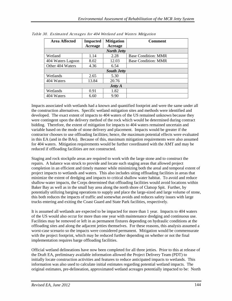
Environmental Assessment of Rehabilitation of the MCR Jetty System
Revised EA, June 2012 144
Table 30. Es timated Acreages fo r 404 Wetland and Waters Mitiga tion
Area Affected Impacted Acreage
Mitigation Acreage
Comment
North Jetty Wetland 1.14 2.28 Base Condition: MMR 404 Waters Lagoon 8.02 12.03 Base Condition: MMR Other 404 Waters 4.36 6.54
South Jetty Wetlands 2.65 5.30 404 Waters 13.84 20.76
Jetty A Wetlands 0.91 1.82 404 Waters 6.60 9.90
Impacts associated with wetlands had a known and quantified footprint and were the same under all the construction alternatives. Specific wetland mitigation sites and methods were identified and developed. The exact extent of impacts to 404 waters of the US remained unknown because they were contingent upon the delivery method of the rock which would be determined during contract bidding. Therefore, the extent of mitigation for impacts to 404 waters remained uncertain and variable based on the mode of stone delivery and placement. Impacts would be greater if the contractor chooses to use offloading facilities; hence, the maximum potential effects were evaluated in this EA (and in the BAs). Because of this, maximum mitigation requirements were also assumed for 404 waters. Mitigation requirements would be further coordinated with the AMT and may be reduced if offloading facilities are not constructed. Staging and rock stockpile areas are required to work with the large stone and to construct the repairs. A balance was struck to provide and locate such staging areas that allowed project completion in an efficient and timely manner while minimizing both the areal and temporal extent of project impacts to wetlands and waters. This also includes siting offloading facilities in areas that minimize the extent of dredging and impacts to critical shallow water habitat. To avoid and reduce shallow-water impacts, the Corps determined that offloading facilities would avoid locations within Baker Bay as well as in the small bay area along the north shore of Clatsop Spit. Further, by potentially utilizing barging operations to supply and place the large-sized and large volume of stone, this both reduces the impacts of traffic and somewhat avoids and reduces safety issues with large trucks entering and exiting the Coast Guard and State Park facilities, respectively. It is assumed all wetlands are expected to be impacted for more than 1 year. Impacts to 404 waters of the US would also occur for more than one year with maintenance dredging and continuous use. Facilities may be removed or left in as permanent fixtures depending on hydraulic conditions at the offloading sites and along the adjacent jetties themselves. For these reasons, this analysis assumed a worst-case scenario so the impacts were considered permanent. Mitigation would be commensurate with the project footprint, which may be reduced further depending on whether or not the final implementation requires barge offloading facilities. Official wetland delineations have now been completed for all three jetties. Prior to this at release of the Draft EA, preliminary available information allowed the Project Delivery Team (PDT) to initially locate construction activities and features to reduce anticipated impacts to wetlands. This information was also used to calculate initial estimates regarding potential wetland impacts. The original estimates, pre-delineation, approximated wetland acreages potentially impacted to be: North

Environmental Assessment of Rehabilitation of the MCR Jetty System
Revised EA, June 2012 145
Jetty ~4.78 acres, South Jetty up to ~22 acres, and Jetty A up to ~11 acres, for an estimated total of ~38.28 acres of potential wetlands impacts. Post wetland delineations and after further minor refinement of locations for staging areas since the release of the draft EA, these impact numbers have been revised and dramatically reduced. Ultimately, the project seeks to achieve no net loss in wetland habitat, to protect, improve and restore overall ecosystem functions, and to provide mitigation actions that are anticipated to restore affected benefits to aquatic species in the vicinity of the project. Towards that end, specific project footprints and activities described above have been identified, categorized, and quantified with conservative estimates where appropriate. Per initial consultation with resource agencies and as a result of the wetland types, functional values and aquatic habitat proposed to be impacted, a preliminary ratio of 2:1 was suggested for wetland mitigation, and a ratio of 1.5:1 for waters other than wetlands to offset impacts that would occur to aquatic resources. As required, the Corps would mitigate for impacts which could not be otherwise avoided or minimized. Mitigation plans currently address three general categories: actions that create wetlands, offsetting actions for 404 impacts in-water, and actions that re-stabilize and replant construction-disturbed upland habitats. Onsite or adjacent mitigation to address impacts is preferred. The Corps coordinated with the States, USFWS, and NMFS to determine appropriate mitigation ratios based on wetland types, functional values and typical compliance requirements. Proposed wetland mitigation is at a 2:1 ratio and mitigation for waters other than wetlands is at a 1.5:1 ratio. Though WQCs have not yet been obtained, the Corps has been working closely with the Certifying agencies to ensure it is meeting its legal responsibilities. The Consultations evaluated effects from a larger project footprint than the current preferred alternative. The current proposed action has further minimized impacts subsequent to the Consultations with the Services, and the following quantities represent the worst-case scenario from effects of barge offloading facilities after minimization measures have been implemented to the maximum extent practicable. It is anticipated that through meetings and discussions with the AMT, the total for proposed mitigation would reflect the reduced project footprint if barge offloading sites are not constructed. All agencies will be kept abreast of project construction and development to ensure mitigation commitments are appropriate and realized.
5.6.1. Wetland Fill and Wetland Mitiga tion
Impact to wetland types and other waters of the U.S. now include the following amounts at each jetty: North Jetty: Wetland fill at the North Jetty would occur as a result of critical repairs at the root and lagoon fill and are further detailed in this EA as well as the North Jetty Major Maintenance Report. Rock storage and staging activities require a minimum of 31 acres to meet the project need for implementation. All wetlands south of the North Jetty Access Road would be impacted and filled in order to reduce processes eroding and undermining the jetty root, to which the lagoon also contributes. Additionally, a few small wetlands north of the roadway would be impacted in order to provide the necessary space for adequate rock storage (enough for 2 years-worth of rock placement) and efficient construction, staging, and access areas. There would also be some wetland impacts during replacement of the damaged culvert crossing under the North Jetty Access Road. The lagoon fill would then be used as a staging area in order to avoid additional impacts elsewhere. After avoidance and minimization measures, including implementation of an 80-ft buffer around conserved wetlands north of the roadway and a 200-ft shoreline buffer beyond the Highest High Tide, unavoidable total wetland impacts come to about 1.14 acres out of the 31 acres of staging area
Environmental Assessment of Rehabilitation of the MCR Jetty System
Revised EA, June 2012 146
identified for construction actions, and impacts to other waters of the U.S. via the lagoon fill equals about 8.02 acres. Of the wetlands impacted, 0.11 acre is part of a wetland mosaic complex which rated as Category IV Interdunal, Depressional wetlands. About 0.65 acres are part of a wetland mosaic complex which rated as Category III Interdunal, Depressional wetlands. About 0.25 acre is rated as Category II Interdunal Riverine wetlands; and 0.13 acres rated as Category 1 Estuarine, Freshwater Tidal Fringe. All these wetlands all would be mitigated onsite adjacent to the project area, in an area north of the North Jetty Access Road adjacent to the conserved wetland fringe that extends further north. At a 2:1 mitigation ratio, this equals about 2.28 acres of wetland mitigation, plus the required buffer. This amount of upland area is available, and wetland creation via excavation to appropriate depths, appropriate native plantings, invasive species removal, and buffer requirements would offset impacts to wetland within the same vicinity in which they are proposed. This 2:1 ratio also aligns with mitigation requirements in WA that were developed in partnership with WA Department of Ecology (DOE) (a 401 Certifying Agency), EPA, and the Corps (WADOE 2006). According to this guidance, estuarine ratios are developed on a case-by-case basis (WADOE 2006). The Corps has worked closely with WA DOE to determine the appropriate mitigation ratio of 2:1. Given the ample rainfall and close proximity to higher functioning wetlands, the likelihood of successful wetland establishment further supports the proposed amount of wetland mitigation. Though these buffers, ratios, and acreages are likely close to the final amounts, they may change following further coordination with WA Department of Ecology and receipt of conditions in the WA State Clean Water Act 401 Water Quality Certification and the determination of Coastal Zone Management Act Consistency.

Environmental Assessment of Rehabilitation of the MCR Jetty System
Revised EA, June 2012 147
Figure 43. Illus tra tion o f Avo idance , Min imiza tion , and Wetland and Waters Impacts a t No rth J e tty
Environmental Assessment of Rehabilitation of the MCR Jetty System
Revised EA, June 2012 148
Jetty A: Wetland fill at Jetty A occurs as a result of work during the Major Rehabilitation actions described in this EA and in the MRR. Rock storage and staging activities require a minimum of about 23 acres to meet the project need for implementation at Jetty A. This encompasses most of the area adjacent to the jetty root at the Coast Guard Station. A total of about 0.91 acre of wetland at Jetty A would also be filled due to rock storage and construction staging activities. Unfortunately, these wetlands cannot be avoided, but impacts to adjacent water of the U.S. would be minimized by implementing a 100-ft buffer beyond the Highest High Tide elevation, which is consistent with the setbacks required for lands designated as “Conservancy” by Pacific County. Of the wetlands impacted, 0.74 acre is rated as a Category III Interdunal, Depressional wetlands with scores under 26. About 0.17 acre is rated as Category 1 Estuarine, Freshwater Tidal Fringe wetlands. Because of onsite space constraints and site conditions, these wetlands at Jetty A would be mitigated in the same vicinity as the mitigation area identified at the North Jetty, north of the North Jetty Access Road. At a 2:1 mitigation ratio, this equals about 1.82 acres of wetland mitigation, plus the required buffer. As with the North Jetty these requirements were determined as described for the North Jetty and align with joint COE and WADOE guidance (2006). Wetland creation would occur in conjunction with and in addition to the area and process described for mitigation at the North Jetty. Reduced disturbance coupled with improved potential hydrology and adjacent functioning wetlands at North Jetty compared to at Jetty A make the success of wetland creations more likely at the location at the North Jetty compared to any creation at Jetty A. Therefore with Jetty A mitigation included, the total mitigation acreage at the North Jetty is 4.1 acres, and this area is available as described. As with the North Jetty, though these mitigation ratios and acreages are likely close to the final amounts, they may change following further coordination with WA Department of Ecology and receipt of conditions in the WA State Clean Water Act 401 Water Quality Certification and the determination of Coastal Zone Management Act Consistency.
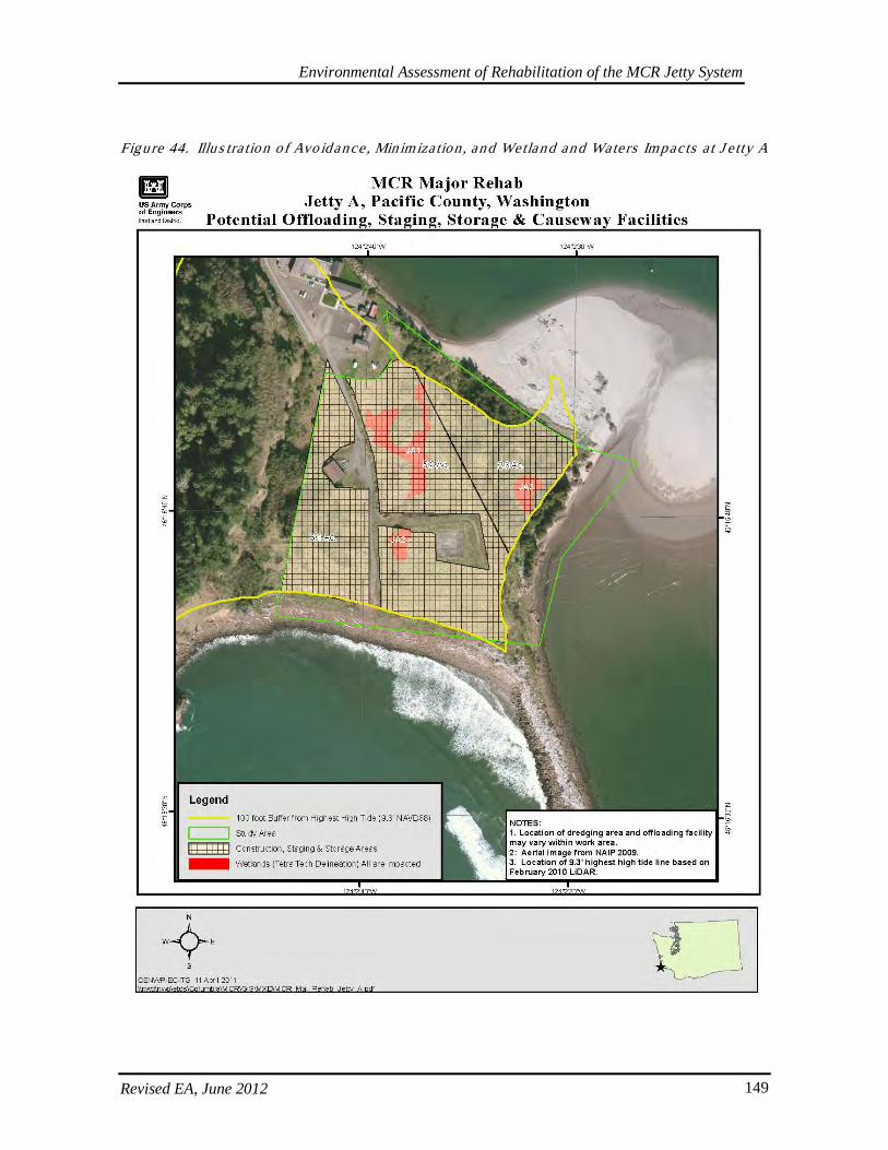
Environmental Assessment of Rehabilitation of the MCR Jetty System
Revised EA, June 2012 149
Figure 44. Illus tra tion o f Avo idance , Min imiza tion , and Wetland and Waters Impacts a t J e tty A

Environmental Assessment of Rehabilitation of the MCR Jetty System
Revised EA, June 2012 150
South Jetty: Wetland fill at South Jetty occurs as a result of work during the Major Rehabilitation actions described in this EA and in the MRR. In order to acquire the 44 acres needed for staging and rock stockpiles, 2.65 acres of unavoidable wetland impacts would occur at the South Jetty. However, by slightly revising locations, maintaining hydrologic connections at wetland and lagoon crossings, and by maintaining a 50-ft wetland, shoreline, and riparian buffer for preserved areas whenever possible, these impacts have been greatly reduced and minimized relative to initial conservative impact estimates. This includes limiting the roads required to cross wetlands to a 20-ft width and requiring culverts to maintain hydrologic connectivity at crossings. In addition to wetlands, about 3.5 of the existing 5.2 acres of other waters of the US would be impacted in the form of fill in a lagoon area adjacent to and along the jetty. There would be a road and crossing over these waters, which would be crossed with culverts in order to maintain flows into and out of the marsh wetland complex; and the 40-ft wide causeway/jetty access roadway would be constructed immediately adjacent to the jetty in order to minimize interference with and impacts to the inlet of the marsh complex. According to the Cowardin Classification system (1979), of the wetlands impacted, approximately: 0.77 acres are classified as Estuarine-Intertidal-Emergent-Persistent; 0.66 acres are classified as Palustrine-Forested-Needled-leaved-Evergreen; 0.75 are classified as Palustrine-Emergent-Non-persistent; and, 0.47 acres are classified as Palustrine-Forested-Broad-leaved-Deciduous. As described in the South Jetty section under Landforms 2.1.3., wetlands were scored for grouped service functions as define by ORWAP (2010), and the categories depressional and estuarine were identified. It is notable that Cowardin and Hydrogeomorphic (HGM) classifications are not necessarily the same thing. For ORWAP scoring purposes, the HGM class for Estuarine appears broader than the Cowardin class. Because a portion of the wetlands preserved and impacted may be small, fringe parts of a larger wetland complex or feature (with possibly a tenuous connection to those other wetlands); therefore the dominant hydrological influence of the greater wetland area was considered. In some cases though the wetland was classified under Cowardin as Palustrine (considering landscape position and degree of connectivity of the delineated area to the greater wetland area), the greater dominating hydrologic regime was tidal (therefore the Estuarine classification in ORWAP). Following this method in determining the types of wetland impacts, this brings the totals under the ORWAP categories to 1.15 acres of impacts to depressional wetlands at the South Jetty, which were ranked relatively as follows: low for hydrologic function and fish support group; and high for water quality, carbon sequestration, aquatic support, and terrestrial support. Alternatively, the relative scores for the grouped service values were: low for hydrologic function, terrestrial support, and public use and recognition; equal for provisioning services, and high for water quality, fish support, and aquatic support. The wetlands also ranked relatively high for ecological condition and sensitivity, and low for stressors. In comparison to State wetland scores for grouped service functions as define by ORWAP (2010), 1.49 acres of impacts would affect estuarine wetlands at the South Jetty which are ranked relatively as follows: low for hydrologic function, aquatic support, and terrestrial support; and high for water quality, carbon sequestration, and fish support group. Alternatively, the relative scores for the grouped service values were: low for hydrologic function, aquatic support, terrestrial support, and public use and recognition; equal for provisioning services, and high for water quality and fish support. The wetlands also ranked relatively high for ecological condition, and low for stressors and sensitivity.
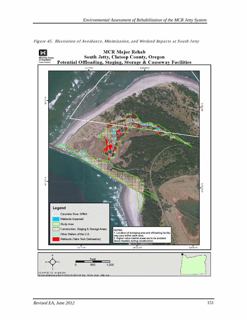
Environmental Assessment of Rehabilitation of the MCR Jetty System
Revised EA, June 2012 151
Figure 45. Illus tra tion o f Avo idance , Min imiza tion , and Wetland Impacts a t Sou th J e tty
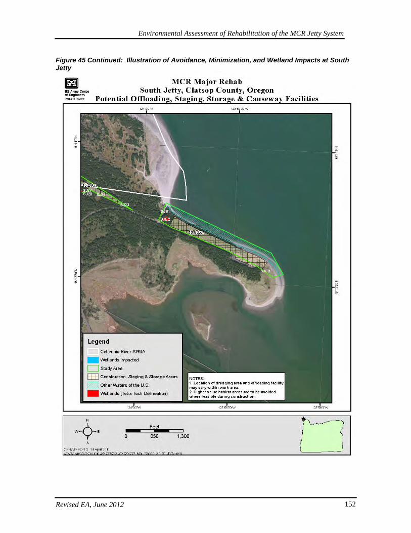
Environmental Assessment of Rehabilitation of the MCR Jetty System
Revised EA, June 2012 152
Figure 45 Continued: Illustration of Avoidance, Minimization, and Wetland Impacts at South Jetty
Environmental Assessment of Rehabilitation of the MCR Jetty System
Revised EA, June 2012 153
These wetlands would be mitigated near the impact site in an area identified in Trestle Bay near the channel entrance to Swash Lake. At a 2:1 mitigation ratio, this equals about 5.3 acres of wetland mitigation. Anecdotally, it is thought that the uplands in this area are the result of previous historic fill from the dredging the adjacent channel, so that excavation of uplands would result in restoration of wetland that are likely to be intertidal. There is also a former Oregon Department of Transportation (ODOT) mitigation site that the Corps would likely abut. This is an appropriate mitigation site because it is within the same sub-watershed (HUC 7), and per the ORWAP scoring and Cowardin classification, the adjacent areas have wetland types similar to those being impacted. The likelihood of successful wetland plant establishment is also higher because of proximity to already functioning native wetland communities and existing hydrology. In comparison to State wetland scores for grouped service functions as define by ORWAP (2010), depressional wetlands at the South Jetty mitigation area are ranked relatively as follows: low for hydrologic function, carbon sequestration, fish support group, and aquatic support; and high for terrestrial support; and equal for water quality. Alternatively, the relative scores for the grouped service values were: low for hydrologic function, aquatic support, terrestrial support, and public use and recognition; equal for provisioning services, and high for water quality and fish support. The wetlands also ranked relatively high for ecological condition and sensitivity, and low for stressors. In comparison to State wetland scores for grouped service functions as define by ORWAP (2010), estuarine wetlands at the South Jetty mitigation area are ranked relatively as follows: low for hydrologic function and water quality; and high for carbon sequestration, fish support group, aquatic support, and terrestrial support. Alternatively, the relative scores for the grouped service values were: low for hydrologic function, aquatic support, terrestrial support, and public use and recognition; equal for provisioning services, and high for water quality and fish support. The wetlands also ranked relatively high for ecological condition and stressors, and low for sensitivity. Proximity of the uplands proposed for wetland conversion to the existing wetlands from both classes that had similar ORWAP scores at the mitigation site, in addition to tidal and precipitation hydrology should serve as reasonable indicators for potential success of the mitigation site. For all proposed mitigation, detailed designs, plans, and specifications will be further determined in the next stages of project development and will be constructed concurrent with wetland impacts. Actions adjacent to or onsite of the North and South Jetties that were identified to mitigate wetland impacts include excavation of low and high saltwater marsh wetlands and new interdunal wetlands adjacent to existing wetlands; establishment of native wetland plant communities and removal of invasive species around a buffer zone for wetlands; restoration or provision of hydrology to newly excavated wetlands via appropriate elevation design; and/or restoration of wetland connectivity between existing fragmented wetlands. Offsite opportunities for wetland mitigation in the estuary that warranted further investigation were associated with: levee breaches, inlet improvements, or tide gate retrofits, as appropriate. However, these are not the preferred mitigation as part of the Preferred Alternative as they were further away from the impacted areas and were not of similar wetland or habitat type impacted. Purchasing mitigation bank credits was considered as a possibility, though this is currently constrained by limitations of service area and availability of appropriate wetland types. Hydrology and vegetative communities are heavily influenced by elevation; therefore, providing improved hydrology combined with strategic excavation and appropriate plantings should result in a simple and self-sustaining design and outcome.
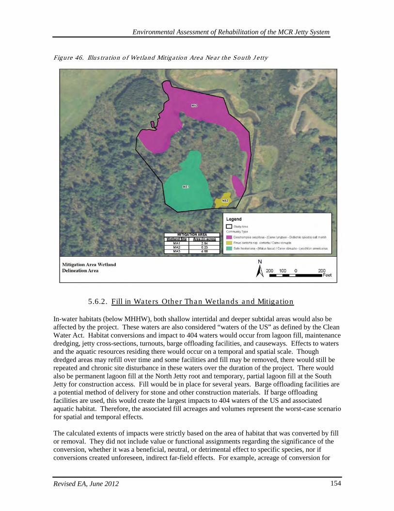
Environmental Assessment of Rehabilitation of the MCR Jetty System
Revised EA, June 2012 154
Figure 46. Illus tra tion o f Wetland Mitiga tion Area Near the South J e tty
5.6.2. Fill in Wate rs Other Than Wetlands and Mitiga tion
In-water habitats (below MHHW), both shallow intertidal and deeper subtidal areas would also be affected by the project. These waters are also considered “waters of the US” as defined by the Clean Water Act. Habitat conversions and impact to 404 waters would occur from lagoon fill, maintenance dredging, jetty cross-sections, turnouts, barge offloading facilities, and causeways. Effects to waters and the aquatic resources residing there would occur on a temporal and spatial scale. Though dredged areas may refill over time and some facilities and fill may be removed, there would still be repeated and chronic site disturbance in these waters over the duration of the project. There would also be permanent lagoon fill at the North Jetty root and temporary, partial lagoon fill at the South Jetty for construction access. Fill would be in place for several years. Barge offloading facilities are a potential method of delivery for stone and other construction materials. If barge offloading facilities are used, this would create the largest impacts to 404 waters of the US and associated aquatic habitat. Therefore, the associated fill acreages and volumes represent the worst-case scenario for spatial and temporal effects. The calculated extents of impacts were strictly based on the area of habitat that was converted by fill or removal. They did not include value or functional assignments regarding the significance of the conversion, whether it was a beneficial, neutral, or detrimental effect to specific species, nor if conversions created unforeseen, indirect far-field effects. For example, acreage of conversion for
Environmental Assessment of Rehabilitation of the MCR Jetty System
Revised EA, June 2012 155
shallow sandy sub-tidal habitat to rocky sub-tidal habitat was calculated in the same manner as conversion from shallow intertidal habitat to shallow sub-tidal habitat. Multiple aquatic species utilize these waters, including macro-invertebrates like crabs, benthic organisms, marine mammals, and various other fish and wildlife species. It is also notable that impacts to 404 waters of the US would occur in an area that is listed as Essential Fish Habitat (EFH) for various species as well as in Critical Habitat for several listed ESA species. This impact was described in the 404 (b) (1) analysis. In WA at MCR, the CWA beneficial use designations for fresh waters by Water Resource Inventory Area (WRIA) include the following general and specific uses: Aquatic Life Uses - Spawning/Rearing; Recreation Uses; Water Supply Uses; Misc. Uses - Wildlife Habitat, Harvesting, Commerce/Navigation, Boating, and Aesthetics. In OR, the following list of beneficial uses were identified: Anadromous Fish Passage; Drinking Water; Resident Fish and Aquatic Life; Estuarine Water; Shellfish Growing; Human Health; and Water Contact Recreation. These designated beneficial uses also include specific water quality criteria to protect the most sensitive uses, which includes use by salmonids for rearing and migration. For this reason, mitigation under the CWA also complements protections and conservation measures under the ESA for salmon and steelhead. Without drawing a distinction between depths or tidal elevations, initial acreage estimates for all in-water impacts and habitat conversions in 404 waters of the US include:
• North Jetty ~12.38 acres (8.02 lagoon fill – this would occur during Major Maintenance; 0.63. barge offloading facilities, crane set-up pads, and turnouts; 3.73 dredging at offloading facility – the latter actions would occur during the Major Rehabilitation scenario.)
• South Jetty ~13.84 acres (3.5 lagoon fill; 0.4 crane set-up pads, and turnouts; 1.56 barge offloading facilities; 8.38 dredging at offloading facilities – all actions would occur during the Major Rehabilitation scenario.)
• Jetty A ~ 6.62 acres (2.89 barge offloading facility and causeway; 3.73 dredging at offloading facility– all actions would occur during the Major Rehabilitation scenario.)
This results in an estimated total of ~ 32.84 acres of potential in-water conversions and effects to 404 waters of the US other than wetlands. Shallow-water habitat is especially important to several species in the estuary; thus, specific initial estimates were calculated regarding shallow-water habitat (shallow here defined as -20-feet or -23-feet below MLLW). About 21 acres at these depths would be affected by maintenance dredging and construction of the causeways and barge offloading facilities. About 12 acres would be affected by lagoon fill. However, this estimate does NOT include any expansion of the jetty’s existing footprint or overwater structures from barge offloading facilities. For this analysis, there was no distinction drawn between periodically exposed intertidal habitat and shallow-water sandflat habitat. These approximations would be updated as project designs are refined and as additional surveys are completed to quantify changes in jetty and dune cross sections. However, these shallow-water footprints are very small as a relative percentage of the ~19,575 acres of shallow-water habitat available within a 3-mile proximity to the MCR. Because of these impacts, the Corps has proposed mitigation actions at a ratio of 1.5:1 to offset temporal and spatial impacts to 404 waters and associated aquatic resources. This ratio was determined with input from the resource agencies considering several factors including: beneficial use listings that involve species with EFH and critical habitat designations in the impacted areas, the
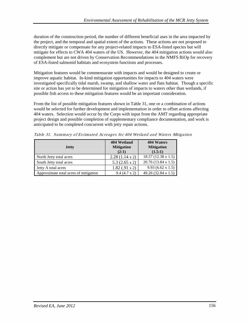
Environmental Assessment of Rehabilitation of the MCR Jetty System
Revised EA, June 2012 156
duration of the construction period, the number of different beneficial uses in the area impacted by the project, and the temporal and spatial extent of the actions. These actions are not proposed to directly mitigate or compensate for any project-related impacts to ESA-listed species but will mitigate for effects to CWA 404 waters of the US. However, the 404 mitigation actions would also complement but are not driven by Conservation Recommendations in the NMFS BiOp for recovery of ESA-listed salmonid habitats and ecosystem functions and processes. Mitigation features would be commensurate with impacts and would be designed to create or improve aquatic habitat. In-kind mitigation opportunities for impacts to 404 waters were investigated specifically tidal marsh, swamp, and shallow water and flats habitat. Though a specific site or action has yet to be determined for mitigation of impacts to waters other than wetlands, if possible fish access to these mitigation features would be an important consideration. From the list of possible mitigation features shown in Table 31, one or a combination of actions would be selected for further development and implementation in order to offset actions affecting 404 waters. Selection would occur by the Corps with input from the AMT regarding appropriate project design and possible completion of supplementary compliance documentation, and work is anticipated to be completed concurrent with jetty repair actions. Tab le 31. Summary of Es timated Acreages fo r 404 Wetland and Waters Mitiga tion
Jetty 404 Wetland Mitigation
(2:1)
404 Waters Mitigation
(1.5:1) North Jetty total acres 2.28 (1.14 x 2) 18.57 (12.38 x 1.5) South Jetty total acres 5.3 (2.65 x 2) 20.76 (13.84 x 1.5) Jetty A total acres 1.82 (.91 x 2) 9.93 (6.62 x 1.5) Approximate total acres of mitigation 9.4 (4.7 x 2) 49.26 (32.84 x 1.5)
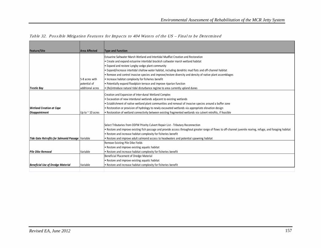
Environmental Assessment of Rehabilitation of the MCR Jetty System
Revised EA, June 2012 157
Table 32. Pos s ib le Mitiga tion Fea tures fo r Impacts to 404 Wate rs o f the US – Fina l to be Determined
Feature/Site Area Affected Type and Function
Trestle Bay
5-8 acres with potential of additional acres
Estuarine Saltwater Marsh Wetland and Intertidal Mudflat Creation and Restoration• Create and expand estuarine intertidal brackish saltwater marsh wetland habitat• Expand and restore Lyngby sedge plant community• Expand/increase intertidal shallow water habitat, including dendritic mud flats and off-channel habitat• Remove and control invasive species and improve/restore diversity and density of native plant assemblages• Increase habitat complexity for fisheries benefit• Potentially expand floodplain terrace and improve riparian function• (Re)introduce natural tidal disturbance regime to area currently upland dunes
Wetland Creation at Cape Disappointment Up to ~ 10 acres
Creation and Expansion of Inter-dunal Wetland Complex• Excavation of new interdunal wetlands adjacent to existing wetlands • Establishment of native wetland plant communities and removal of invasive species around a buffer zone • Restoration or provision of hydrology to newly excavated wetlands via appropriate elevation design• Restoration of wetland connectivity between existing fragmented wetlands via culvert retrofits, if feasible
Tide Gate Retrofits for Salmonid Passage Variable
Select Tributaries from ODFW Priority Culvert Repair List - Tributary Reconnection• Restore and improve existing fish passage and provide access throughout greater range of flows to off-channel juvenile rearing, refuge, and foraging habitat• Restore and increase habitat complexity for fisheries benefit• Restore and improve adult salmonid access to headwaters and potential spawning habitat
Pile Dike Removal Variable
Remove Existing Pile Dike Fields• Restore and improve existing aquatic habitat• Restore and increase habitat complexity for fisheries benefit
Beneficial Use of Dredge Material Variable
Beneficial Placement of Dredge Material • Restore and improve existing aquatic habitat• Restore and increase habitat complexity for fisheries benefit
Environmental Assessment of Rehabilitation of the MCR Jetty System
Revised EA, June 2012 158
Specific opportunities were investigated in the Columbia River estuary and Youngs Bay (see Table 30) and several are under consideration to mitigate for impacted aquatic functions in 404 waters of the US. Depending on further development and determination of appropriate mitigation siting for final impacts to 404 waters, a specific project or combination of projects would be designed and constructed concurrently as the proposed repair and rehabilitation options are completed over time. Proposed projects are subject to further analysis, and unforeseen circumstances may preclude further development of any specific project. In all cases, final selection, design, and completion of specific mitigation features is contingent on evolving factors and further analyses including: potential reduction in estimated impact acreage due to alterations in project implementation, hydraulic and hydrologic conditions, cultural resource issues, etc. For this reason a suite of potential proposals has been identified and subsequent selection of one or some combination of these or other projects and designs would occur during continued discussion with resource agencies participating on the AMT. The Corps would make a decision regarding the specific mitigation proposal for waters other than wetlands and then would vet the final designs through the AMT in order to obtain necessary clearances. Actions considered and investigated to provide mitigation for in-water habitat impacts include levee breaches, inlet improvements, or tide gate retrofits. However, mitigation efforts must consider in-kind mitigation and are constrained by the project’s O&M authority, which precludes acquisition of private property and does not authorize breaches of federal levees. Additional associated actions that were investigated and may be implemented with the wetland mitigation include: excavation in sand dunes and uplands to specified design elevations in order to create additional intertidal shallow-water habitat with dendritic channels and mud flats, and excavation for potential expansion of the floodplain terraces. Though conceptually considered, other specific opportunities for mitigation projects such as the following were not identified but warrant further investigation if none of the projects in the list is determined to be feasible: removal of overwater structures and fill in the estuary; removal of relic pile-dike fields; removal of fill from Trestle Bay or elsewhere; removal of shoreline erosion control structures and replacement with bioengineering features; beneficial use of dredge material to create shallow water habitat features; and restoration of eelgrass beds. Certain pile fields and engineering features may be providing current habitat benefits that could be lost with removal, and such actions would require appropriate hydraulic analysis coordination with engineers and resource agencies. For potential mitigation projects located in Trestle Bay, there is additional monitoring and assessment opportunity. A separate hydraulic/engineering study under a different project authority could investigate whether or not an expansion of low-energy, intertidal habitat near Swash Lake could effectively provide additional storage capacity and affect circulation in the bay such that erosive pressure at neck of Clatsop Spit could be reduced. This would not be covered under the existing project authority. A previous Section 1135 action that breached a section of the relic jetty structure is speculated to have been the cause of increased circulation and erosion. It would be worth evaluating whether or not projects that expand floodplain and intertidal areas in Trestle Bay provide demonstrable energy dissipation and additional low-energy storage capacity to offset or redirect erosive pressures. Alternatively, if other mitigation concepts are pursued that include removal of additional piles or creation of additional inlets, it would be worth investigating whether these actions could have indirect positive impacts that further reduce concern with erosion at the neck. Evaluating actions in this light would provide valuable information and insight regarding possible solutions and concerns for erosion and breaching at the neck area of Clatsop Spit on Trestle Bay.
Environmental Assessment of Rehabilitation of the MCR Jetty System
Revised EA, June 2012 159
5.6.3. Genera l Wetland Mitiga tion Des ign and Monitoring
As mentioned, wetlands at Jetty A and North Jetty would be mitigated immediately north of the North Jetty Road adjacent to the project site. This is an appropriate location for the North Jetty impacts because mitigation remains as near the impact area as possible and compensates for mostly the same wetland types, of which the majority are interdunal depressional. For Jetty A, space is unavailable near the jetty, and the likelihood of successful creation is higher in the North Jetty location due to the land use requirements and disturbance from Coast Guard activities at Jetty A. Based on adjacent reference wetlands at the North Jetty of the same type, appropriate elevations would be determined, and existing uplands would be cleared of invasive species and excavated and graded to the appropriate depths and contours. Materials removed from impacted wetlands would be reused in the created wetlands as appropriate to take advantage of the existing wetland seed bank and hydrologic soils constituents. Plantings, revegetation, and invasive species removal would also be implemented, including the required buffer around the new wetland area. It is anticipated that upland material removed during wetland creation would be placed as part of the lagoon fill. With ample precipitation, functioning adjacent reference sites, and appropriate plantings, the likelihood of successful wetland establishment is reasonably high. At the South Jetty, wetland mitigation would take place adjacent to an existing mitigation site further southwest of the impact area at the bottom of Trestle Bay such that there are reference elevations and hydrophytic species to facilitate design planning and vegetation establishment, respectively. The mitigation location near Swash Lake is not as close to the area of impacts as the site at the North Jetty, but the proposed location is further away from areas experiencing heavy recreation and all-terrain vehicle (ATV) use such as is occurring in the existing wetlands on Clatsop Spit. Therefore, the likelihood of successful wetland establishment is greater in the proposed location. The process for creating the wetlands at the South Jetty site would be similar to that at the North Jetty, but an additional dendritic channel may also be included as appropriate such that newly created wetlands experience an estuarine connection like those that are being impacted by the project. This would also involve excavation to create hydrologic conditions based on tidal and reference site elevations Monitoring of all mitigation sites is expected to occur prior to, during, and for three years after mitigation implementation. For wetlands, sample reference plots would be established along with a photo point, and success criteria would be based on achievement similar or better functions and values scores relative to those indicated by the delineations for those impacted by the project. Monitoring components would likely include the following elements, which may be modified as further mitigation development details are available: percent survival; percent cover; percent of native vs. non-native species; and achievement of appropriate hydrology. Hydrologic indicators would include establishment of topography and contouring/geomorphology that is similar to adjacent representative sites, and in the case of South Jetty, achievement of regular tidal inundation. Appropriate monitoring criteria would also be developed for the mitigation to waters other than wetlands. Refinement and implementation of this overall mitigation plan would help protect species and habitats while restoring wetland, inwater, and upland functions affected by the proposed action. Monitoring and maintenance of mitigation will be required to ensure successful establishment of

Environmental Assessment of Rehabilitation of the MCR Jetty System
Revised EA, June 2012 160
mitigation goals and satisfactory return on investment. These mitigation actions and monitoring results would also be recorded on the Corps mitigation website at: https://sam-db01mob.sam.ds.usace.army.mil:4443/pls/apex/f?p=107:1:1390572094248259. Regular coordination with the AMT would further facilitate implementation of appropriate mitigation for impacts to wetlands and waters that appropriately offset affected habitat and are complementary to the framework for successful protection and preservation of aquatic resources, ESA listed species, and high-value habitat.
5.7. Uplands Dis turbance and Re-s tab iliza tion
As described in the Construction Implementation section, rock storage and staging areas would impact both wetlands as well as uplands. Best Management Practices (BMP) to reduce the environmental footprint and to avoid, and minimize impacts have been incorporated and would be implemented, including appropriately locating staging sites, implementing stormwater management plans, and stabilizing the site during and after construction. Post-construction upland re-stabilization to meet CWA National Pollution Discharge Elimination System (NPDES) requirements would include re-establishing native grasses, shrubs, and trees where appropriate; controlling and removing invasive species like scotch broom and European beach grass in the project vicinity; and re-grading/tilling the area to restore pre-project natural contours. The Oregon Parks and Recreation Department (OPRD) has requested that the Corps utilize the State Forester as one resource for determining optimal revegetation plans. Upland Replanting - (1:1) NPDES site stabilization
• North Jetty total acres: 28.7 • South Jetty total acres: 18.7-28.7 (Depending on snowy plover habitat creation) • Jetty A total acres: 12 • Approximate total acres of stabilization: 69.4
As mentioned, on Clatsop Spit, there is a unique opportunity to partner with USFWS and OPRD regarding creation and management of snowy plover habitat. The OPRD (2010) developed a HCP to manage snowy plover habitat. There may be locations in the vicinity and away from projected construction and staging areas to convert upland habitat to snowy plover habitat via invasive species removal, tilling, and application of shell hash. Operation and maintenance during the project via regular tilling and shell hash distribution could possibly be coordinated between the agencies through a Memorandum of Agreement (MOA) or similar avenue. This scenario would also provide preferable alternative habitat away from the potential attractive nuisance of open sands that the construction disturbance would create. The Corps currently has a signed MOA indicating it will cooperate with OPRD in the implementation of the snowy plover management plan under development. Habitat creation would also be consistent with the intent of the HCP and the Conservation Measures recommended by USFWS.
Environmental Assessment of Rehabilitation of the MCR Jetty System
Revised EA, June 2012 161
6. ENVIRONMENTAL CONSEQUENCES The Corps has determined that elements of the proposed action could have effects discussed in the following section. However, through this EA and associated Biological Assessments and completed Consultations with resource agencies, the Corps has come to a determination that the proposed actions under the selected plan will not result in long-term or large-scale adverse impacts to the human environment.
• Rock Transport • Construction Access, Staging, Storage, And Rock Stockpiling • Rock Placement • Dredging • Disposal • Barge Offloading Facilities • Pile Installation and Removal • Lagoon And Wetland Fill And Culvert Replacement • Dune Augmentation • Water Quality
o Suspended sediment Dredging Disposal Pile Installation and Removal
o Spills Leaks o Contamination
• Hydraulic and Hydrological Processes o Water Velocity o Salinity and Plume Dynamics o Bed Morphology
• Wetland and Waters Mitigation
6.1. Rock Trans port
Barge transport of stone from quarry sites is likely and would occur mostly during daylight hours along major navigation routes in existing harbors and navigation channels. The number of additional barge trips per year attributable to the proposed action is expected to be somewhere between 8 and 22 ships. This is small annual percentage increase relative to the current number of other commercial and recreational vessels already using any of these potential routes. The MCR is the gateway to the Columbia-Snake River system, accommodating commercial traffic with an approximate annual value of $20 billion dollars a year. Loaded water-borne container traffic identified as foreign in- and outbound to/from Portland that would likely have crossed the MCR in 2008 totaled approximately 195,489 ships (Corps 2010). Traffic from the proposed action will also be limited mostly to summer months when fair weather allows safe passage. Though transport will occur on an annual basis, stone may or may not be delivered to one or more jetties seasonally. Due to the infrequency of these vessel trips, their geographic limitation to existing navigation channels, and their minimal duration in any particular area, the disturbance effects are expected to be
Environmental Assessment of Rehabilitation of the MCR Jetty System
Revised EA, June 2012 162
discountable. The proposed action will not cause any meaningful increase (less than 1%) in annual vessel traffic along the routes or around the MCR jetty system. Any increase in acoustic levels from barge traffic during delivery will be transient. Sound levels are expected to return to background near the source, and are not expected reach harmful levels. Therefore, these effects are negligible and discountable.
6.2. Cons truc tion S tag ing , S torage , and Rock S tock P ile s
Construction activities will occur on an annual basis, could happen throughout the year, and may occur at one or more jetties simultaneously. Upland effects could include repetitive disturbance; de-vegetation; residual rock side-cast; and soil compaction. Changes in soil structure and composition could also result in localized habitat conversion of the vegetative and biological communities. Invasive species are located in the vicinity of all three jetties, and chronic disturbance can increase the spread and establishment of such species. Changes in the plant communities can also cause trophic effects on the faunal communities that rely on these ecosystems for forage and habitat. However, The Corps is not aware of any listed plant or invertebrate species present in the proposed action area. The Corps expects effects to aquatic listed species from associated construction activities for staging, roadways, and stockpiles to be localized at all jetties, as the majority of these construction features are located in upland areas above mean high tide elevation. Thus, species exposure is highly unlikely. Avoidance and minimization measures have also reduced and contained the construction footprint where possible, and higher value habits like marsh wetlands and slough sedge communities have been preserved such that activities are limited to areas where previous disturbance and development have already occurred. Wetland fill effects from these activities are discussed in the wetland fill section. Whenever feasible, stabilizing dune vegetation is being preserved and little if any riparian or vegetative cover will be removed or disturbed. Furthermore, protective fencing, set-backs, and an Erosion and Sediment Control Plan or Stormwater Protection Plan will be implemented so that BMPs avoid stormwater erosion and run-off from disturbed areas. The topography in this area is flat, and proposed impact minimization measures for construction will reduce the likelihood for sediment to enter the Columbia River. When construction activities are suspended for the season, appropriate demobilization and site stabilization plans will limit the distribution and duration of any effects. No pollutants are expected to enter waterways. There may be some disturbance from equipment sounds and human presence, but these will be indirect and of low intensity, mostly during daylight hours and summer months. Therefore, disturbance effects from these activities are expected to be minimal. Any increase in acoustic levels from truck traffic during delivery will be transient and intermittent. Conservation measures limit the hours for stone delivery as well as the use of compression brakes, which will reduce species exposure to acoustic effects. Trucks will only be allowed to use the roads through Cape Disappointment State Park during daylight hours. Sound levels are expected to return to background near the source, and are not expected reach harmful levels. Therefore, these effects are negligible and discountable. There may be some disturbance from equipment sounds and human presence, but these will be indirect and of low intensity, mostly during daylight hours and summer months. The geographic area will be limited, and species will be able to avoid work areas. Therefore, disturbance effects from these activities are expected to be minimal and discountable.
Environmental Assessment of Rehabilitation of the MCR Jetty System
Revised EA, June 2012 163
6.3. Rock P lacement
Rock placement will occur on an annual basis starting in the late spring through the late to early fall seasons. Placement may occur at more than one jetty per season and will occur regularly throughout the duration of the construction schedule. Some permanent habitat conversion and modification will occur as a result of stone placement for repair and rehabilitation of jetty features. Along specific portions of North and South jetties and along the entire length of Jetty A, substrate will be converted to rocky sub and intertidal habitat, and associated benthic communities will be covered. In addition, crane set-up pads and turnouts will require placement of rock that could extend slightly off the current centerline of the jetty trunk. However, this total area is a relatively small percentage of the existing jetty structures. Generally, effects to in-water habitat could include the following: sub-tidal and intertidal habitat conversion from sandy to rocky substrate and potential unforeseen indirect far-field effects from hydraulic influence (slight, localized changes to accretion, currents, velocities, etc). However, relatively little habitat conversion and footprint expansion will occur because a majority of the stone placement for construction of the jetty head, trunk, and root features will occur on existing relic jetty stone and within the existing structural prism. Moreover, aquatic species would experience limited exposure since stone placement for cross-section repair and rehabilitation actions occurs mostly above the MHHW elevation. This is summarized below for each jetty.
6.3.1. North J e tty
• About 58% of overall stone placement on the jetty will be placed above MHHW, about 25% of the volume between MHHW and MLLW, and about 18% of the volume below MLLW. Thus, about 83% of the volume placed for trunk and root cross-section repairs is above MLLW. There is no expected expansion of the footprint beyond relic jetty stone/structure.
• Stone placement for offloading facilities, turn-outs, and set-up pad facilities will cover and convert about 0.63 acres and will be confined within the same location as the stone placed for repairs. This is a small percentage relative to the existing acreage of jetty structure and available adjacent remaining shallow-water sand habitat in the vicinity.
6.3.2. South J e tty
• Stone placement for offloading facilities, causeways, turn-out, and set-up pad facilities will cover and convert about 1.96 acres. This is a small percentage relative to the existing acreage of jetty structure and available adjacent remaining shallow-water sand habitat in the vicinity.
6.3.3. J e tty A
• Stone placement for barge offloading facilities, causeways, turn-out, and set-up pad facilities will cover and convert about 2.89 acres. This is a small percentage relative to the existing acreage of jetty structure and available adjacent remaining shallow-water sand habitat in the vicinity.
Indirect disturbance effects due to placement activities will be localized and occur mostly during daylight hours in the summer months. Disturbance effects are expected to be of limited duration and minimal, since a majority of the placement is above MHHW and on existing relic stone. Acoustic effects of construction on the jetties similar to those mentioned in the Construction and Staging

Environmental Assessment of Rehabilitation of the MCR Jetty System
Revised EA, June 2012 164
section are less likely to reach the land at levels much above background. There may be temporary disturbance to species using the jetty structure in the vicinity of placement activities. However, the Corps does not expect long-term negative effects from these actions.
6.4. Dredging
Dredging will be needed for construction and maintenance of barge offloading facilities and is likely during early summer prior to rock delivery; it may not occur at all facilities annually. If all facilities were dredged, this would total about 16 acres near the jetties. However, it is likely only one or two facilities would be used seasonally for short durations and would be dredged on a periodic basis as needed. The effects of dredging on physical habitat features include modification of bottom topography, which in the vicinity of the jetties is extremely dynamic. Dredging may convert intertidal habitats to subtidal, or shallow subtidal habitats to deeper subtidal. Such conversions may affect plant and animal assemblages uniquely adapted to the particular site conditions these habitats offer. However, the dredge prisms would be very small as a relative percentage of the ~19,575 acres of shallow-water habitat available within a 3-mile proximity to the MCR. The proposed dredging of offloading facilities would affect bottom topography, but is unlikely to cause large-scale or long-term effects to habitat features. Dredging activities will also have some contribution to increased acoustic disturbance that could occur for a limited duration while dredging is underway. These effects are expected to attenuate rapidly such that they return to background levels within a short distance from the source. Dredging effects on water quality and suspended sediment are discussed below in the Water Quality section.
6.5. Dis pos a l
Disposal is likely to occur on an annual basis originating from one or more of the offloading facilities. The duration of disposal will be limited to daylight hours for a few days out of the year and will likely occur earlier in the construction season in the spring or summer when ocean and wave conditions permit safe operations and prior to use of offloading facilities. All disposal of dredged material will be placed in previously evaluated and USEPA-approved ODMDS or other approved disposal sites. No new or different impacts to species or habitats than those previously evaluated by USEPA or other resource agencies for disposal approval are expected from these actions. Per USEPA guidelines, the ODMDS have a Site Management and Monitoring Plan that is aimed at assuring that disposal activities will not unreasonably degrade or endanger the marine environment. This involves regulating the time, quantity, and physical/chemical characteristics of dredged material that is placed in the site; establishing disposal controls; and monitoring the site environs to verify that unanticipated or deleterious adverse effects are not occurring from past or continued use of the site and that permit terms are met. The relative quantities, characteristics, and effects of the proposed action would not be expected to have different or measurable negative impacts to these sites. The effects of disposal on physical habitat features include modification of bottom topography. In some cases, disposal may result in the mounding of sediments on the bed of the disposal site. Such conversions may affect plant and animal assemblages uniquely adapted to the particular site conditions these habitats offer. However, the area impacted by disposal would be relatively small compared to the thousands of acres of shallow and deeper water habitats at and beyond the MCR and would occur in deeper habitat offshore or in the littoral cell. The proposed disposal is unlikely to cause large-scale or long-term effects to habitat features. Disposal effects on suspended sediment are discussed below in the Water Quality section.
Environmental Assessment of Rehabilitation of the MCR Jetty System
Revised EA, June 2012 165
6.6. Barge Offloading Facilitie s
Barge offloading facilities are a potential method of delivery for stone and other construction materials. If barge offloading facilities are used, this would create the largest impacts to 404 waters of the US and associated aquatic habitat. Therefore, the associated fill acreages and volumes represent the worst-case scenario for spatial and temporal effects. Installation of offloading facilities is likely to occur once in the late spring or early summer prior to or during the first season of construction on the associated jetty. Subsequently, periodic maintenance may be required as facilities weather wave and current conditions. Effects associated with dredging are discussed in that section. Facilities may also occasionally be partially removed and reconstructed, which could slightly increase the frequency of disturbance. Depending on the specific facility and contemporary conditions at the time, removal would then occur at the end of the scheduled construction duration. Temporally, this limits the repetition of disturbance activities associated with the construction of these facilities. Use of the facilities may be annual with periodic breaks in between, depending on the construction schedule and conditions at the jetties. Annual use is likely at least one of the facilities and will be seasonally concentrated in the spring, summer, and fall. Although unlikely, occasional breaks in weather could allow offloading at other times of the year. Stone placement for barge offloading facilities could have the same minimal effects described previously under rock placement, with the exception of the facility at Parking Lot D on the Clatsop Spit. Construction and maintenance of the facility and associated and piles would be equivalent to actions already occurring from jetty repair and stone placement, and would not cause a separate or cumulative increase in disturbance. Also as mentioned previously, chemically treated wood would not be used for decking material, as treated decking could leach toxic substances into the water. Therefore, water quality is not expected to be negatively impacted by these facilities. Possible effects of the action to water quality are discussed below in the Water Quality section. Offloading facilities will be areas of slightly increased activity and vessel traffic, but the intensity of use is expected to be low and seasonal in nature. Additional noise from vessel activities may increase disturbance, but acoustic effects are not expected to reach harmful levels and will be geographically and temporally limited. A return to background noise levels is likely near the source. The anticipated effects from pile installation/removal for these facilities are discussed in the next section.
6.7. Pile Ins ta lla tion and Remova l
Pile installation and subsequent removal is likely to occur once in the late spring or early summer prior to or during the first season of construction on the associated jetty. Subsequently, periodic maintenance may be required as piles weather barge use and wave/current conditions. Occasionally, piles may be partially removed and reinstalled, which could slightly increase the frequency of disturbance. Depending on the associated offloading facility and contemporary conditions at the time, removal would occur at the end of the scheduled construction duration. Temporally, this limits the repetition of disturbance associated with the installation and removal of these structures. For initial construction of all four facilities combined, up to approximately 96 Z- or H-piles could be installed as dolphins, and up to approximately 373 sections of Z or H piles installed to retain rock fill. However, it is unlikely that all facilities would be installed at the same time. Installation is
Environmental Assessment of Rehabilitation of the MCR Jetty System
Revised EA, June 2012 166
likely to happen early in the construction season sometime between April and June, and is weather dependent. Piles will be located within 200-feet of the jetty and offloading structures. Vibratory drivers will be used and will dampen any acoustic effects to fish and other species. Because of the soft substrates in the lower Columbia River, vibratory drivers can be used effectively to install and remove piles. Sound wave form and intensity is not expected to reach harmful levels and are expected to return to background levels within a short distance from the source. Any acoustic impacts would be short duration and intermittent in frequency. Therefore, this action would not be expected to have any considerable direct effects. The presence of piles at offloading facilities could increase perching opportunities for piscivorous birds, especially cormorants and brown pelicans. However, the use of piling caps will avoid any measurable increase in new perch sites so that effects would be minimized. Furthermore, because perching opportunities for these birds are abundant in the lower Columbia River, piles associated with the proposed action would not be expected to increase cormorant and pelican use in the area.
6.8. Wetland , Wate rs , Lagoon Fill and Culvert Replacement
Wetlands near North Jetty. Wetlands within, fringing, and adjacent to the lagoon will be filled in areas and quantities described previously. Fill of wetlands will be permanent. As described, mitigation commensurate with impacts to these wetlands will be developed and implemented concurrent with actions and in coordination with the appropriate resource agencies. The area selected for mitigation is north of the North Jetty Access Road in existing uplands adjacent to a wetland mosaic complex. Wetlands near South Jetty (on Clatsop Spit). Efforts have been made to locate rock stockpiles and offloading facilities such that they will avoid and minimize impacts to wetlands and waters, and protections and BMPs will be implemented for the identified rare and ranked vegetative communities within this area. Strategic use of uplands for rock storage has been done to the most practicable extent in order to avoid and minimize these impacts. Wetland fill will be permanent and in the areas and quantities described previously. As with wetlands near the North Jetty, wetland mitigation will be further developed and implemented commensurate and concurrent with impacts, and the Corps will coordinate closely with the appropriate resource agency during planning and design of the mitigation proposals. The selected mitigation area is in uplands adjacent to existing wetlands near the entrance to Swash Lake in Trestle Bay. Wetlands near Jetty A. Permanent wetland fill will occur at Jetty A in the areas and quantities previously described. Commensurate with impacts, mitigation will be implemented at the North Jetty adjacent to the North Jetty mitigation area and existing wetland complex. Wetland fills and culvert installations at all jetties would occur once and could happen during anytime in the construction season depending on weather. Sequentially, these actions would be required prior to several of the other features of the proposed action. They would be considered permanent in nature for the purposes of mitigation because they would be in place for up to four years and will have temporal impacts even if they are eventually removed. Subsequent removal of construction-related culverts would be likely to occur once and could also happen during anytime in the construction season depending on weather and construction needs. Periodic culvert maintenance may be required during construction. Temporally, this limits the repetition of disturbance activities to single event and season on separate jetties.

Environmental Assessment of Rehabilitation of the MCR Jetty System
Revised EA, June 2012 167
Where possible, the construction, access, and staging areas at all jetties have been planned so that the footprint would minimize impacts to wetlands and higher value habitat features. Protections and BMPs would be implemented for the identified rare and ranked vegetative communities within the area. Strategic use of uplands and lower quality wetlands for rock storage would be undertaken to the most practicable extent in order to avoid and minimize these impacts. However, permanent and temporary wetland fill would occur as a result of construction staging, storage, and rock stockpiles at all three jetties. Fill used to protect the North Jetty root would also affect wetlands. Long-term direct and indirect impacts to wetlands could include permanent wetland fill, potential fragmentation of and between existing wetlands, soil compaction, loss of vegetation, altered hydrology, conversion to upland, and loss of ecosystem functions (water quality, flood storage, nitrogen cycling, habitat, etc.). However, it is expected that effects from wetland impacts and lagoon fill would be immeasurable regarding effects on river functions, as the wetlands are not within the channel prism of the Columbia River. Although these wetlands are connected hydrologically to the Columbia River, wetland fill impacts would not be likely to negatively alter groundwater-stream exchange or hyporheic flow because the wetlands are on accreted land that has formed on stabilized sand shoals behind the jetties. Wetland hydrology is mostly elevation and rainfall dependent, and fill impacts would be relatively inconsequential to the Columbia channel. Culverts would be installed to maintain wetland hydrology and connectivity with permanent replacement at the North Jetty and when temporary construction roadways cross wetlands. In addition, the overall effects of the wetland and waters mitigation proposed by the Corps are discussed in Section 5.6. Fill in 404 waters other than wetlands would occur in the form of lagoon fill, offloading facilities, dredging, and stone placement. Off-loading facilities also have temporal as well as spatial impacts and may or may not be removed post-construction; therefore they have been considered as permanent impacts with proposed associated mitigation even if they are removed and eventually infill natural sand recruitment. Effects of these fill actions are more specifically described in the associated subsections in chapter 6. This includes potentially chronic low levels of associated turbidity from barge operations and dredging, impacts to benthic organisms, and conversion of habitat types. Lagoon fill is also permanent, especially at the North Jetty. Though culverts and drainage will be provided to minimize impacts to associated wetlands, macro-invertebrates and benthic organisms utilizing the lagoon will be buried when fill is placed. An initial sampling survey would be conducted in the lagoons during peak juvenile salmon outmigration to determine whether or not fish salvage and fish exclusion efforts for ESA-listed species is warranted. The Corps would coordinate with NMFS if listed species are identified. Redesign of this system at the North Jetty may provide an opportunity to accommodate improved hydrology to newly created wetlands excavated adjacent to the existing wetland complex, and would be further investigated during the hydraulic/hydrologic design analysis. This action may also result in temporary turbidity as materials settle in the fill area and migrate through the jetty trunk.
6.9. South J e tty Root Eros ion and Dune Augmenta tion
This action is proposed only at the South Jetty. This action would occur once during a single season and could likely happen in the late spring or early summer depending on weather. Temporally and geographically, this limits the repetition of disturbance activities to single event and season on a single jetty. Sequentially, this action would be required prior to several of the other features of the proposed action. Periodic maintenance may be required, likely on a decadal scale.
Environmental Assessment of Rehabilitation of the MCR Jetty System
Revised EA, June 2012 168
This action at the South Jetty would occur above mean high tide; thus, this action would cause limited exposure to aquatic species. Although substrate modification would occur along the shoreline, it is not expected that any measurable changes from in-water habitat conversion below MHHW would occur. Clean cobble material would be placed from an existing roadway and delivery via beach access will be prohibited. Some equipment will be required to move materials around on the dry sand. There is little likelihood of having any direct or indirect negative impacts to water quality or intertidal species, and the amount of dry sand conversion is relatively small as compared to the amount of similar adjacent habitat. Cobble replenishment would likely occur on a decadal scale. Thus, the effects of this action would likely be minimal and species exposure unlikely.
6.10. Water Qua lity
Effects of the proposed action to water quality could occur by increasing suspended sediments, increasing the potential occurrence of spills and leaks, and increasing the potential for contamination. However, the Corps expects these effects to be negligible. Placement of rock by heavy equipment, jetty access road construction, dredging, disposal, and pile installation and removal could all cause temporary and local increases in suspended sediment. This is expected to have minimal and limited effects on the environment. Previous tests have confirmed that material to be dredged will be primarily sand with little or no fines, which does not stay suspended in the water column for an extended length of time. During infrequent and limited duration dredging and disposal which could occur for a few days annually or less often, depending on use of the facilities, suspended sediments may increase locally for a short time. These increases will dissipate quickly due to the sandy nature of the sediment, and inwater activities will be further constrained to conditions in the State 401 Water Quality Certification that limit the duration of such exceedences. Light attenuation and water quality effects from increased suspended sediments are expected to be minimal and fleeting. Pile driving is also expected to occur in sand and therefore have similar transient and minimal effects to water quality. Jetty roads could also contribute suspended sediments that would create turbidity during stormy seasons or overtopping events, but since they are above MHHW this will likely be an infrequent occurrence. When erosion of roads does occur, the background turbidity and wave climate is likely to also be in a state of increased turbulence and turbidity such that any additional roadway runoff will be a minimal contribution to the dynamic ocean and channel-forming processes churning the waters during overtopping events. Small increases in turbidity from construction activities on the jetties will likely occur on a nearly daily basis but will be of limited extent and duration, as rock placement will involve clean fill of large, individual boulders with a majority of the placement actions occurring above MLLW. Turbidity monitoring and compliance with expected likely conditions of the 401 State Water Quality Certification would also ensure protection of aquatic life and other beneficial uses in the vicinity of the inwater work. Wave and current conditions in the action area naturally contribute to higher background turbidity levels; and such conditions also preclude the effective use of isolating measures to minimize turbidity. However, other BMPs described for the proposed action would further reduce effects of turbidity from the proposed action. Effects from potential stormwater runoff were addressed in the Construction Staging and Stockpile section. Therefore, impact from suspended sediments should be inconsequential. The Corps will require the contractor to provide a spill prevention and management plan that will include measures to avoid and minimize the potential for spills and leaks and to respond quickly to minimize damages should spills occur. Good construction practices, proper equipment maintenance, appropriate staging set-backs, and use of a fast fueling system would further reduce the likelihood of leak and spill potential and exposure extent and its associated effects.
Environmental Assessment of Rehabilitation of the MCR Jetty System
Revised EA, June 2012 169
Test results on dredge material described earlier further indicated that materials in the area are approved for unconfined in-water disposal and do not contain contaminants in concentrations harmful to organisms occupying the action area. The prohibition of treated wood will also avoid contamination from the migration of creosote and its components (e.g., copper and PAHs) from treated wood in the lotic environments. Temporally, effects to water quality from suspended sediment and turbidity could occur on a daily basis, but are not expected to be continuous throughout the day. Clean, large boulders are not expected to create much discharge, and the substrate on which they are being placed also includes large, weathered boulders. Any other inwater work such as construction or dredging of offloading facilities will involve sandy materials that settle out very quickly. Turbidity levels and durations will be limited to conditions required in the State Water Quality Certifications which will likely include exceedence windows that are protective of beneficial uses such as salmonids and other aquatic life. Spills or leaks are expected to be infrequent and unlikely. Although the repetition of disturbance may be greater, it is still expected to remain within safe ranges that would not have long-term or deleterious effects. Furthermore, effects are expected to be geographically limited, short term, and minor.
6.11. Hydraulic and Hydrologic Proces s es
The USGS and ERDC conducted numerical modeling to evaluate changes in circulation and velocity, salinity, and sediment transport at the MCR for various rehabilitation design scenarios for the MCR jetty system. A 2007 USGS model evaluation assessed the functional performance for rebuilding the jetty lengths in order to aid in the assessment of potential impacts to fish from the rebuilt lengths. Ultimately, even in the larger rebuild scenario only negligible and inconsequential changes were predicted to the overall hydraulic and hydrological process at the MCR. For the proposed action addressed in this EA, rebuilding of the jetty lengths is not included. However, model results under the larger jetty length rebuild scenario are still relevant for comparing and evaluating potential changes to the MCR system as a whole. This earlier modeling work also remains valid because the current proposed action in this EA caps the jetties at their present lengths, which is essentially the same length as the “base condition” used in the models. Modeling by the USGS was performed for two time periods, August-September and October-November. Existing conditions were established using actual data collected in August-September 2005. The October-November model period was established for engineering purposes as this time period represents extreme conditions at the MCR. Plots were produced to show existing and post-rehabilitation conditions for the following parameters: residual (average for all tides) velocity and current direction for bed and near surface, residual bed load transport, residual total load transport (bed load + suspended load), and mean salinity for bed and near surface. The ERDC analyzed the impacts of the presence of spur groins at the MCR in 2007. This analysis was done independently of the USGS modeling and was conducted with the coastal modeling system (CMS) and other models that operate within the surface water modeling system (SMS). A regional circulation model (ADCIRC) provided the tidal and wind forcing for the boundaries of project-and local-scale wave, current, sediment transport, and morphology change calculated by the CMS. The half-plane version of the wave transformation model, STWAVE, was coupled with two-dimensional and three-dimensional versions of the CMS, which calculates current, sediment transport, and
Environmental Assessment of Rehabilitation of the MCR Jetty System
Revised EA, June 2012 170
morphology change. These models were coupled to provide wave forcing and update calculated bathymetry used in both models at regular intervals (Connell and Rosati 2007). The results of these modeling efforts are discussed in the following sections. In summary, the 2007 modeling work remains valid because the current proposed action caps the jetties at their present lengths, which is essentially the same length as the “base condition” used in the 2007 modeling. Modeling results showed that the changes to velocities, currents, salinity, plume dynamics, and bed morphology would be small to negligible under the larger jetty length rebuild scenario with spur groins. Any small changes to the system would be even less unlikely under the current proposed action because it does not involve rebuilding the length of the jetties or adding the spur groins. Therefore, no fundamental overall changes to the current hydraulics or hydrology of the MCR system are anticipated under the current proposed action.
6.11.1. Water Circu la tion and Ve loc ity
For the August-September period, the USGS model predicted an increase to residual bed layer velocity on the west side of the south portion of Jetty A to currents oriented in a south-southeast direction (Figure 47) but mean differences (existing to predicted) were less than 0.1 meter/second in this area. Smaller changes in residual velocities were predicted for near surface waters in the vicinity of Jetty A (Figure 48; USGS 2007, Moritz 2010). These changes are small (10% or less) relative to the natural variation in the MCR’s high-energy environment. In the velocity figures, length of arrows indicates magnitude of velocity, red arrows indicate existing conditions, and black arrows indicate predicted conditions resulting from rebuilding the jetty lengths. Under the length rebuild scenario, surface current direction for the August-September period was predicted to change slightly toward the north as water flowed around Jetty A forming a more pronounced clockwise eddying effect west of Jetty A and tending to force water more directly toward the North Jetty. However, residual velocities toward the North Jetty were predicted to decrease and this effect would have protected the North Jetty. Predicted changes to current direction in the bed layer are less pronounced than in the surface layer (Figure 49). Changes to current direction and velocities are negligible in the vicinity of the South Jetty (Figure 50; USGS 2007, Moritz 2010).
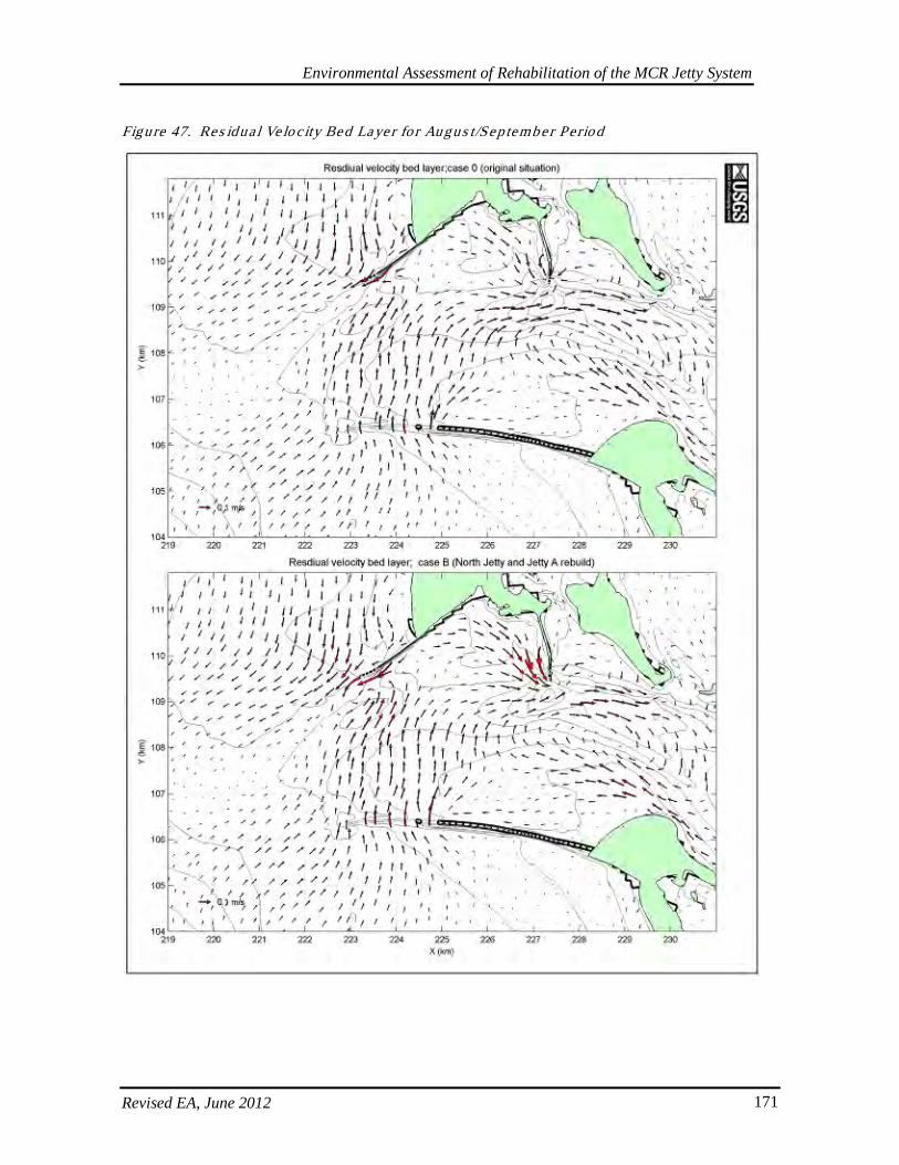
Environmental Assessment of Rehabilitation of the MCR Jetty System
Revised EA, June 2012 171
Figure 47. Res idua l Ve lo c ity Bed Laye r fo r Augus t/Sep tember Period
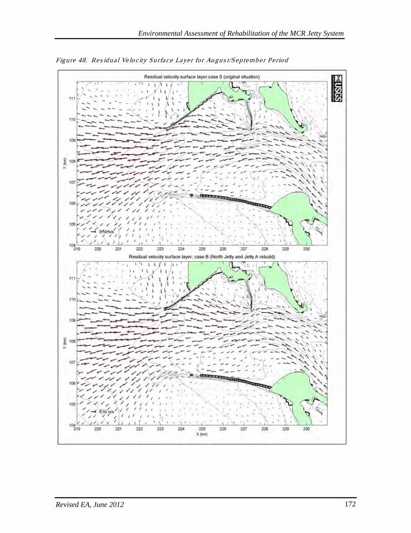
Environmental Assessment of Rehabilitation of the MCR Jetty System
Revised EA, June 2012 172
Figure 48. Res idua l Ve lo c ity Su rface Layer fo r Au gus t/Sep tember Period
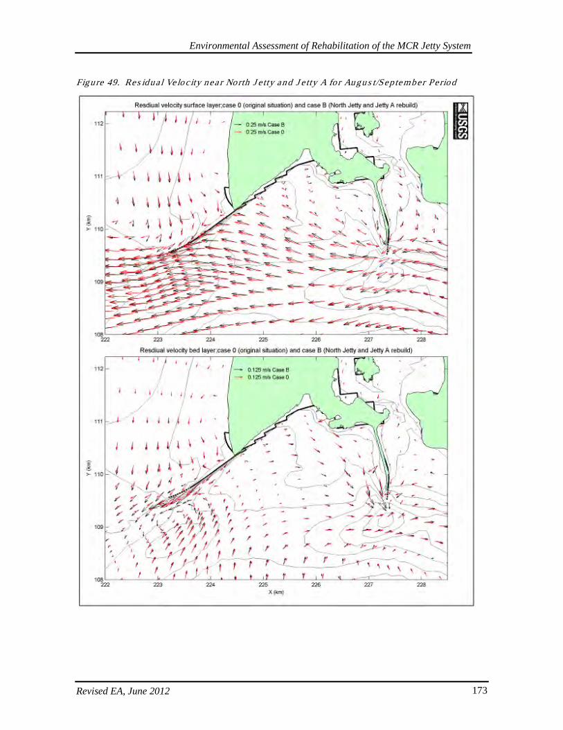
Environmental Assessment of Rehabilitation of the MCR Jetty System
Revised EA, June 2012 173
Figure 49. Res idua l Ve lo c ity nea r North J e tty and J e tty A for Augu s t/Sep tember Period

Environmental Assessment of Rehabilitation of the MCR Jetty System
Revised EA, June 2012 174
Figure 50. Res idua l Ve lo c ity nea r South J e tty fo r Au gus t/Sep tember Period

Environmental Assessment of Rehabilitation of the MCR Jetty System
Revised EA, June 2012 175
For the October-November period, the situation was similar to the August-September period in that a relatively large increase to residual bed layer velocity, as compared to other areas in the MCR, was predicted on the west side of the south portion of Jetty A to currents oriented in a south-southeast direction (Figure 51; USGS 2007, Moritz 2010). However, as with the August-September period, these changes were small as compared to natural variability. For the October-November period, current direction was predicted to change slightly toward the north as water flows around Jetty A forming a more pronounced clockwise eddying effect west of Jetty A and tending to force water more directly toward the North Jetty (Figure 52). However, residual velocities toward the North Jetty are predicted to decrease and this effect would act to protect the North Jetty, as is the case with the August-September period (Moritz 2010, and USGS 2007). Such small changes to velocities and currents would be less likely since the current proposed action does not involve rebuilding the length of the jetties nor the spur groins. For the October-November period, there also were predicted increases in bed layer velocity near the terminus of the North Jetty (Figure 53). Only small changes in residual velocities were predicted for near surface waters near the North Jetty terminus. Changes in surface current direction are similar to those described above for the August-September period. Changes to velocities and current directions were predicted to be minimal for areas near the South Jetty (see Figure 53), because these parameters at the South Jetty are essentially unaffected by alterations on the north side of the river (USGS 2007, Moritz 2010). Again, such small changes to residual velocities would be less unlikely since the current proposed action does not involve rebuilding the length of the jetties nor the spur groins.
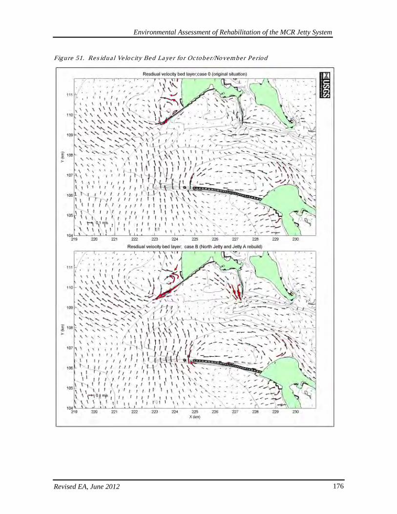
Environmental Assessment of Rehabilitation of the MCR Jetty System
Revised EA, June 2012 176
Figure 51. Res idua l Ve lo c ity Bed Laye r fo r Octobe r/November Pe riod
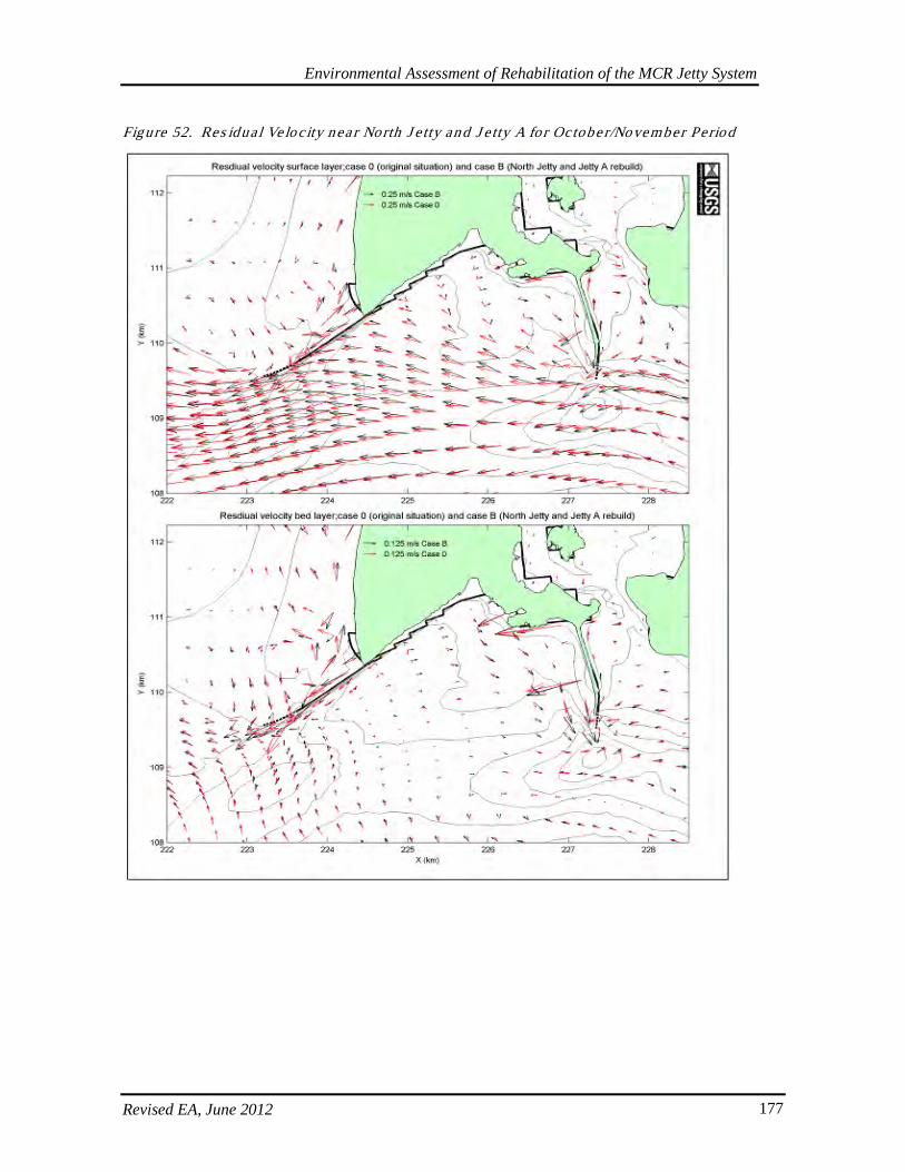
Environmental Assessment of Rehabilitation of the MCR Jetty System
Revised EA, June 2012 177
Figure 52. Res idua l Ve lo c ity nea r North J e tty and J e tty A for Octobe r/November Period
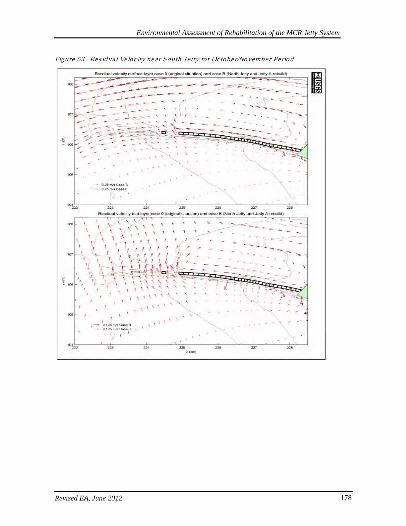
Environmental Assessment of Rehabilitation of the MCR Jetty System
Revised EA, June 2012 178
Figure 53. Res idua l Ve lo c ity nea r South J e tty fo r October/November Pe rio d
Environmental Assessment of Rehabilitation of the MCR Jetty System
Revised EA, June 2012 179
6.11.2. Salin ity
Salinity distribution in the Columbia River estuary is determined by the circulation patterns and the mixing process driven by tidal currents. The 2007 USGS modeling results showed that in near-surface waters near the landward portions of the North Jetty, salinity naturally varies with tides to 20 parts per thousand (ppt) during October-November (USGS 2007, Moritz 2010). The USGS model predicted minor, local changes to mean salinity as a result of jetty length rebuilds. For the August-September period, changes to bed layer salinity were predicted in waters between Jetty A and the North Jetty (Figure 54). An increase in mean salinity of 0-4 ppt (from 26-28 ppt to 28-30 ppt) was predicted to occur over some of this area (USGS 2007, Moritz 2010. This could be calculated as up to ~15% change, but was still well under the 20 ppt change in range of natural variability. A similar but less extensive salinity pattern was predicted for the near surface layer in waters between Jetty A and the North Jetty, where mean salinity was also predicted to increase 0-4 ppt (from 18-20 ppt to 20-22 ppt; Figure 55). For the near surface layer, note that this increase in mean salinity included the area in close proximity to much of the landward portion of the North Jetty. For the near surface layer, a decrease in mean salinity of 0-4 ppt (from 12-14 ppt to 14-16 ppt) was predicted to occur over a relatively small area south of West Sand Island, which is located just east of Jetty A (USGS 2007, Moritz 2010). For the October-November period, small patterns of salinity change were also predicted. For the bed layer, a small-scale extrusion of higher salinity water was predicted for the main channel and along the South Jetty as a result of jetty length rebuilds (Figure 56). For example, for the existing condition, salinity in the range of 28-30 ppt occurs just upstream of Jetty A, whereas after the jetty length rebuilds, this zone of salinity ended directly south of Jetty A. Only small changes in salinity were predicted in the bed layer near the North Jetty. For the surface layer, extrusion of higher salinity water in the main channel was not predicted, but higher salinity was predicted for waters near the South Jetty (Figure 57). For the existing condition, salinity in the range of 24-26 ppt was predicted along the seaward 1/3 of the South Jetty, whereas after the jetty length rebuilds this area was predicted to support salinity in the range of 22-24 ppt. A minor reduction of lower salinity waters, in the range of 18-20 ppt, was predicted along the landward half of the North Jetty (USGS 2007, Moritz 2010). In summary, minor local changes to mean salinity were predicted to occur as a result of jetty length rebuilds. However, these minor changes were within range of natural variability. Such small changes to mean salinity would be even less likely since the current proposed action does not involve rebuilding the length of the jetties nor the spur groins.
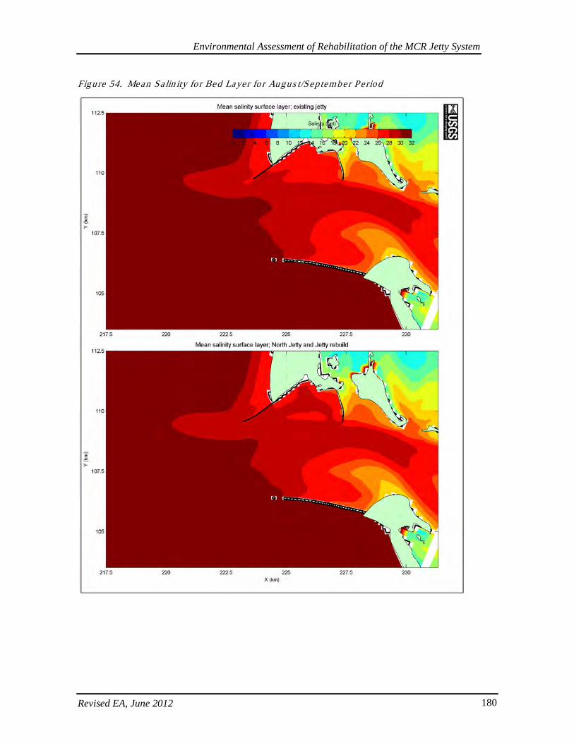
Environmental Assessment of Rehabilitation of the MCR Jetty System
Revised EA, June 2012 180
Figure 54. Mean Sa lin ity fo r Bed Layer fo r Augus t/Sep tember Period
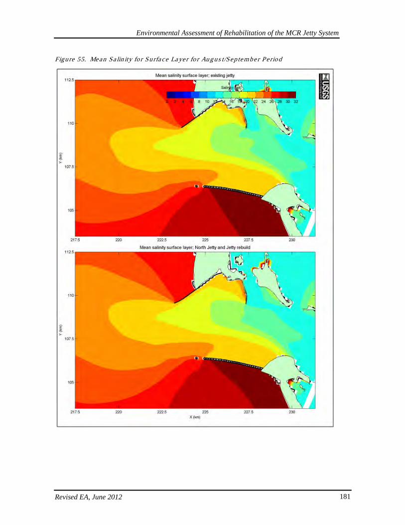
Environmental Assessment of Rehabilitation of the MCR Jetty System
Revised EA, June 2012 181
Figure 55. Mean Sa lin ity fo r Surface Layer fo r Aug us t/Sep tember Period
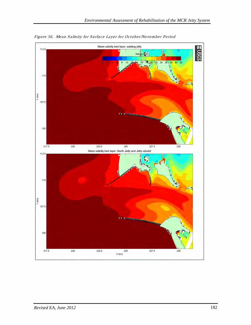
Environmental Assessment of Rehabilitation of the MCR Jetty System
Revised EA, June 2012 182
Figure 56. Mean Sa lin ity fo r Surface Layer fo r October/November Pe riod
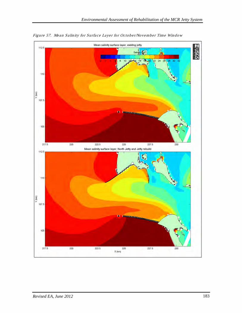
Environmental Assessment of Rehabilitation of the MCR Jetty System
Revised EA, June 2012 183
Figure 57. Mean Sa lin ity fo r Surface Layer fo r October/November Time Win dow
Environmental Assessment of Rehabilitation of the MCR Jetty System
Revised EA, June 2012 184
6.11.3. Plume Dynamics
For the larger jetty length rebuilds, the parameters in the 2007 USGS modeling were predicted to be less affected in the plume than in the entrance itself. As shown in the above figures, there would be only small predicted changes to residual velocity and current directions for both bed layer and near surface layer for the August-September and October-November periods in the plume. A decrease in bed layer salinity of 0-4 ppt (from 28-30 ppt to 26-28 ppt) was predicted in the plume over an oval area west of the terminus of the North Jetty. Only small changes were predicted to residual bed load transport and residual total load transport within the plume for the August-September and October-November periods (USGS 2007, Moritz 2010). Under the current proposed action in this EA, no jetty length rebuilds are included. Because of the smaller scale of the current proposed action, the small changes previously predicted by the model would be minimal to nonexistent.
6.11.4. Bed Morphology
The bathymetry at the MCR is shown in Figure 58. The 2007 USGS model predicted some bed level changes along the seaward channel-side of the North Jetty due to the jetty length rebuild and spur groins. With longer jetty lengths, changes were predicted for both modeled periods, but were more pronounced in winter (October-November period) with about an 8.3% difference in bed elevation of about 4 to 5 feet. This change is relatively small, however, considering that water here is 39 to 79 feet deep and the dynamic environment at the MCR (Connell and Rosati 2007, Moritz 2010). Bed morphology changes were predicted to occur in similar areas during the August-September and October-November periods but more scouring and deposition was predicted to occur during the latter. In addition to the result described above for the channel side of the seaward portion of the North Jetty, decreases to bed level with implementation of the proposed action were predicted for a broad area in deep waters of the navigation channel off of Jetty A and deep waters around the seaward portion of Jetty A and for locations north of the North Jetty, which includes shallow nearshore waters. Areas predicted to have an increase in bed level occurred upstream and downstream of Jetty A, downstream of the above-mentioned broad area in the navigation channel, on the ocean side of the North Jetty, and downstream of Clatsop Spit (Connell and Rosati 2007, Moritz 2010). As mentioned before, the scale of the current proposed action is much smaller and precludes a length rebuild. Therefore, any changes previously predicted would be even smaller or unlikely. From ERDC model results for spur groins, it was predicted that a temporary increase in bed level due to sedimentation would occur upstream of the spurs, but that a temporary decrease in bed level due to erosion would occur immediately downstream of the spurs. This is no longer anticipated since spur groins are no longer proposed for this action.
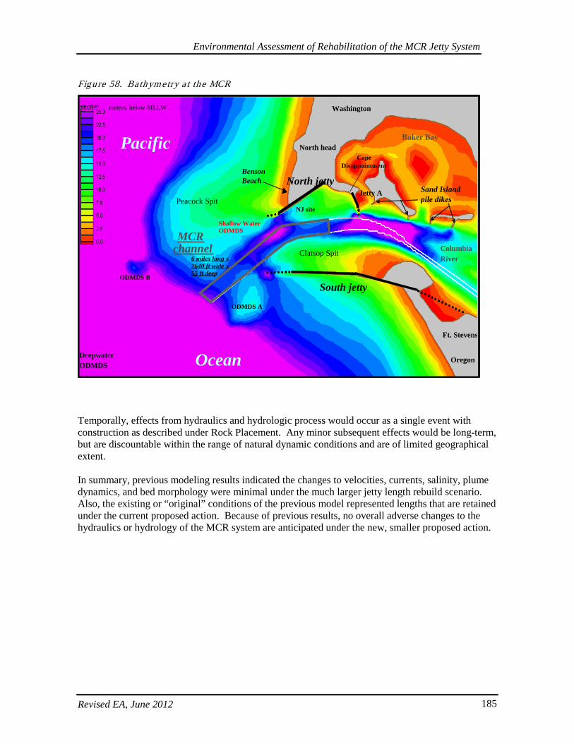
Environmental Assessment of Rehabilitation of the MCR Jetty System
Revised EA, June 2012 185
Figure 58. Bath ymetry a t the MCR
Temporally, effects from hydraulics and hydrologic process would occur as a single event with construction as described under Rock Placement. Any minor subsequent effects would be long-term, but are discountable within the range of natural dynamic conditions and are of limited geographical extent. In summary, previous modeling results indicated the changes to velocities, currents, salinity, plume dynamics, and bed morphology were minimal under the much larger jetty length rebuild scenario. Also, the existing or “original” conditions of the previous model represented lengths that are retained under the current proposed action. Because of previous results, no overall adverse changes to the hydraulics or hydrology of the MCR system are anticipated under the new, smaller proposed action.
Pt. Adams
Pacific
Ocean
Peacock Spit
Baker Bay
meters
MCR channel
South jetty
North jetty
Washington
Oregon
Columbia River
Benson Beach
Deepwater ODMDS
Shallow Water ODMDS
NJ site
Clatsop Spit
ODMDS B
ODMDS A
, below MLLW
Sand Island pile dikes
6 miles long x 2640 ft wide x 55 ft deep
North head Cape
Disappointment
Ft. Stevens
Jetty A
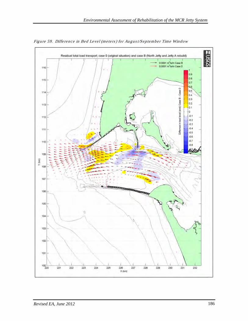
Environmental Assessment of Rehabilitation of the MCR Jetty System
Revised EA, June 2012 186
Figure 59. Diffe rence in Bed Level (mete rs ) fo r Au gus t/Sep tember Time Window
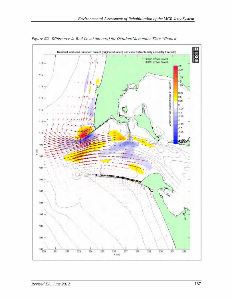
Environmental Assessment of Rehabilitation of the MCR Jetty System
Revised EA, June 2012 187
Figure 60. Diffe rence in Bed Level (mete rs ) fo r Oc tober/November Time Window
Environmental Assessment of Rehabilitation of the MCR Jetty System
Revised EA, June 2012 188
6.12. Wetland and Wate rs Mitiga tion
The Corps has proposed mitigation for impacts to 404 waters of the US under the Clean Water Act. These actions would complement Conservation Measures recommended by NMFS for the benefit of listed and candidate salmonid species as well as other native and listed species found in the lower Columbia River ecosystem. The Corps is also required to provide mitigation for wetland impacts. The Corps has identified specific wetland mitigation opportunities and would develop detailed plans and specifications for these areas, as well as proposals for mitigation to 404 waters. These mitigation requirements would be determined by the Corps and coordinated with the Services and State resource agencies in order to obtain legally required compliance documents using the AMT. As described in the proposed action, the Corps has developed a mitigation plan to offset impacts to wetland and waters with a suite of potential actions and to offset impacts to shallow-water habitats. In the long term, implementation of mitigation along with upland revegetation would increase the overall square footage of wetlands and improve uplands, potentially also improving wetland-stream hydrologic functions in the Columbia River estuary. Mitigation for impacts to low saltwater marsh habitat would improve resting and rearing habitat access for juvenile fish, as well as improved and increased instream and riparian and estuarine functions; for example, creation of intertidal and mudflat habitat, restoration of hydrologic regimes, and improvement of riparian and canopy cover. These actions would mitigate for impacted habitats and functions, which are being affected in the immediate vicinity of the jetties. Actions could also improve estuarine productivity lower in the Columbia River system for a wide range of species in the mitigation areas. Re-establishment of native plant communities and improvement of estuarine functions would improve water quality function, habitat complexity, and trophic inputs. Reintroduction of a greater range of flows and more natural tidal regimes to current uplands would also improve the likelihood of re-establishing native intertidal species. Re-establishing hydrologic and tidal regimes increases the opportunity to develop edge networks, dendritic channels, and mud flat habitats for use by listed species. Increased benthic habitat could also improve food web productivity. This mitigation also complements the recovery plan in the estuary module (NMFS 2007c), as actions being proposed by the Corps address threats identified in the recovery plan, and specifically relate to Columbia River Estuary (CRE) management actions. Depending on final plan selection, mitigation may specifically address the following CRE actions: 1 (riparian protection and restoration); 4 (restoring flow regimes via improved/restored tributary hydrologic connectivity); 5 (replenishment of littoral cell via beneficial use of dredged materials); or; 9 (protection of remaining high-quality off-channel habitat from degradation). Several of these CREs were also in the higher rankings for benefits with implementation, and higher percentages for Survival Improvement Targets (NMFS 2007c). Therefore, the Corps expects mitigation actions to have either direct or indirect long-term beneficial rather than adverse effects to most aquatic species, including listed species and their designated critical habitat in the action area. In the short-term, temporary disturbance and increased suspended sediment may result in higher turbidity during in-water construction at restoration sites. This is not likely to occur during upland planting. However, these actions would be limited in duration and intensity, as BMPs to reduce and avoid pollutant runoff described in the proposed action would also be applicable to actions at the mitigation sites. Suspended sediments from in-water work would be monitored per State Water Quality Certification conditions, and appropriate BMPs to minimize
Environmental Assessment of Rehabilitation of the MCR Jetty System
Revised EA, June 2012 189
turbidity will also be implemented to ensure levels do not reach a duration or intensity that would harm species. For invasive species removal, the Corps proposes to use no herbicides within 100 feet of the Columbia River or associated water bodies, and therefore, does not expect increased pollutant loads or effects on instream or riparian function. Short-term noise disturbances are likely to attenuate near the source and project locations are likely to be much further away from habitat used by marine mammals. These acoustic effects will likely be minimal and discountable. Temporally, implementation of different components of mitigation projects could occur throughout the year. It would likely be possible to complete associated in-water work during the appropriate in-water work windows that protect listed species at the mitigation sites. Concurrent with initial impacts to wetlands, construction would likely occur in one or two seasons with subsequent monitoring. Temporally, this limits the repetition of disturbance activities associated with the construction of these projects. Short-term effects to water quality may occur on a daily basis, but would be limited and similar to those describe in the Water Quality effects discussion.
6.13. Effec ts on Fis h and Wild life
6.13.1. Anadromous and Res ident Fis h Spec ies
On March 18, 2011, The Corps received a Biological Opinion from NMFS indicating that the Corps’ proposed actions were not likely to adversely affect any listed species, with the exception of eulachon, humpback whales, and Stellar sea lions (2010/06104). For these species, NMFS determined that Corps’ actions were not likely to jeopardize the existence of the species. NMFS also concluded that Corps actions were not likely to adversely modify any of the current or proposed critical habitats. There was a Conservation Recommendation to carry out actions to reverse threats to species survival identified in the Columbia River Estuary ESA Recovery Plan Module for Salmon and Steelhead. The Corps also provided a conference report for critical habitat that NMFS proposed for leatherback turtles, eulachon, and Lower Columbia River coho salmon. The Corps will request NMFS adopts its conference report when this habitat becomes designated. The Corps will also request an Incidental Harassment Authorization of Stellar sea lions, humpback whales, California sea lions, and harbor seals prior to the start of construction. On February 23, 2011 the Corps received a Letter of Concurrence from USFW regarding potential effects to species under their jurisdiction (13420-2011-I-0082). The Corps determined its actions would have no effect on listed species, with the exception of bull trout, marbled murrelets, and snowy plover. The Corps concluded that its actions were not likely to adversely affect these species or their critical habitat. The USFW concurred with the Corps’ determination. USFW also included four Conservation Recommendations to protect and improve snowy plover habitat and manage attractant waste derived from construction actions. In the Corps Biological Assessment, the following possible effects of the proposed action on anadromous and resident fish species and their critical habitat were evaluated to determine their significance. These included:
• Temporary and permanent interruption/alteration of adult and juvenile migration pathways. • Temporary and/or permanent loss of shallow-water habitat.

Environmental Assessment of Rehabilitation of the MCR Jetty System
Revised EA, June 2012 190
• Juvenile predator attraction to the jetty substrate and habitat type. • Temporary disruption and displacement from piling installation and barge offloading traffic. • Temporary loss of benthic organisms. • Temporary displacement from dredging and rock placement activities. • Temporary water quality impacts from construction activities, dredging, rock placement, and
potential spills. • Temporary and permanent negligible changes to salinity, velocity, and bed morphology.
Adult salmonids that could be in the vicinity of the proposed action are highly mobile and in the process of upstream migration. Adults are not expected to spend extended amounts of time in the vicinity of the jetties and are able to avoid areas of disturbance. No adverse permanent disturbances to habitat that adult salmonids use in the MCR area are expected to result from the proposed action. The potential impacts discussed below primarily pertain to juvenile salmonids in the vicinity of the MCR jetties during their out-migration from the estuary to the ocean primarily in spring and fall. To avoid and minimize impacts to listed salmonids, the States established an in-water work window to prevent disruption of spawning activities and ensure project actions occur when fish are least likely to be present. The MCR in-water work window is from November 1 to February 28. However, adverse wave and inclement winter weather conditions at the MCR often preclude safe working conditions during the in-water work window; thus, it is unlikely that barge offload structures and other project elements could be built during this time. Crew safety and construction feasibility may require project actions to occur during fair weather months outside of the in-water work window. Rock Placement. Rock placement is not expected to cause mortality to adult or juvenile anadromous and resident fish. Fish could be displaced during rock placement by disturbance from rocks entering the water. Some benthic habitat will be permanently lost due to rock placement. Adjacent benthic areas will suffer relatively minor and temporary effects due to settling of suspended sediments. Because much of the rock will be placed above MLLW on existing relic rock, most benthic habitat should not be adversely affected. Because the jetties are in a high energy environment and existing habitat near the structures is relatively unproductive, this habitat loss is considered negligible. Jetties and Causeways. Juvenile salmonids, especially sub-yearling Chinook salmon, out-migrate in close proximity to the North Jetty, and may out-migrate in close proximity to the South Jetty as well. The length of the North Jetty forces fish that are bound for waters near the surf zone along Benson Beach farther offshore. They swim a farther distance and are potentially exposed to increased risks from predation before reaching preferred shallow-water nearshore habitat. However, the PNNL (2005) acoustic tagging studies have indicated that the areas immediately adjacent to the jetties are not shown to demonstrate the highest peaks for juvenile migration, which tend to occur closer to the navigation channels in the vicinity of the jetties. Further, the duration of exposure to these structures is relatively limited, as juveniles spend only a short residence time in the MCR vicinity, ranging from hours to days during the. With rehabilitation of the North Jetty, it is expected that Benson Beach will halt its recession and resume accretion, which over time will lessen the distance that sub-yearling juvenile Chinook salmon must swim to reach preferred nearshore waters. Deposition of sand upstream of existing spurs has been shown on the channel side of the South Jetty. It is expected that juvenile salmonids would utilize rebuilt portions of the jetties. It is possible that juvenile salmonid outmigration occurs in close proximity to the South Jetty as it does at the North Jetty. Only off-loading facilities on the channel side with elevations at or above MLLW are expected to be capable of altering outmigration routes by forcing juvenile salmonids away from the shallower
Environmental Assessment of Rehabilitation of the MCR Jetty System
Revised EA, June 2012 191
waters along the jetty proper and into deeper waters as they swim around offloading facilities, particularly the one near Parking Area D on the Clatsop Spit. Effects to juvenile salmonids could result from predator attraction to the rock structure and disruption to migration pathways as a result of the presence of off-loading facilities. Piscivorous fish capable of preying on juvenile salmonids could recruit to rebuilt portions of the jetties, piles for barge offloading facilities, and temporary causeways. It is when juvenile salmonids are near these locations that they would be susceptible to predation from piscivorous fish. The addition of rock to the jetties and the presence of piles and causeways may increase perching opportunities for piscivorous birds, especially cormorants and brown pelicans. However, pile caps will reduce this likelihood, and perching opportunities for cormorant and pelican use are not expected to increase in a measurable manner. Also because rocks are already abundant at the MCR, no increases in pinnipeds, capable of preying on adult salmonids, would occur because of the presence of additional rock. Barge Offloading Facilities and Dredging. Barge offloading facilities are a potential method of delivery for stone and other construction materials. If barge offloading facilities are used, this would create the largest impacts to 404 waters of the US and associated aquatic habitat. Therefore, the associated fill acreages and volumes represent the worst-case scenario for spatial and temporal effects. Pilings will be constructed out of untreated wood or steel. The presence of the barge facilities would not likely cause disturbance to salmonids in the vicinity, except for the coming and going of barges that could induce movement in fish. The construction and eventual removal of these facilities, including dredging and pile driving, would temporarily disturb fish. Because of the soft substrates, it is expected that vibratory drivers can be used effectively to install piles. The impacts from pile driving would be intermittent and would not be expected to adversely affect fish. Material to be dredged for barge offloading facilities is primarily sand with little or no fines. Disposal of dredged material is expected to occur primarily at previously approved or designated in-water disposal sites. A clamshell dredge will be used for most dredging. Fish would likely be forced into moving to other nearby suitable habitat during dredging. There also would be a loss of benthic invertebrates in areas dredged, but only negligible losses to food resources for juvenile salmonids and aquatic species would be expected to result. If all four offloading facilities were utilized simultaneously, this would result in a dredged area of approximately 16 acres. Within an estimated 3-mile proximately of the MCR jetties, about 19, 575 acres of shallow water habitat (anything -20 ft or shallower) exists. Therefore, as with stone placement, this results in a habitat conversion of less than one percent. Furthermore, it is more likely that only one or two facilities would be needed per year, which makes the relative percent of habitat conversion even smaller. Though there will be loss of benthic invertebrates in areas dredged, only negligible losses to food resources of juvenile salmonids or sturgeon are expected to result. Because eulachon feed on plankton, their foraging habitat will not be affected. Some sandy, shallow-water inter-tidal habitat will be converted to deeper inter- and sub-tidal habitat. Consequently, these conversions and disturbances could result in a possible conversion of biological communities with changes in depth and light penetration. The extent is expected to be minimal and recolonization is expected to be rapid. These effects are unlikely to measurably impact food resources or foraging behavior of juveniles or adults. Potential Spills. Operation of heavy equipment requires use of fuel and lubricants that would kill or injure aquatic organisms if spilled into the water. The contractor will provide a spill prevention plan to include measures to minimize the potential for spills and to respond quickly should spills occur.
Environmental Assessment of Rehabilitation of the MCR Jetty System
Revised EA, June 2012 192
Due to preventative and response measures required, it is unlikely that spills would adversely affect aquatic resources because of their low chance of occurrence. Turbidity. Placement of rock and dredging/pile driving for barge offloading facilities will be conducted and are not likely to require measures to minimize turbidity. Placement of clean fill and pile installation in sandy substrate is not anticipated to create deleterious turbidity plumes. Increased turbidity from construction activities will be intermittent over the projected 8-year construction timeframe, but individual, localized increases should be of limited extent and duration. These turbidity increases would likely not result in a reduction in feeding rates and growth, physiological stress, and increased mortality of juvenile and adult salmonids and other fish because of rapid dissipation of turbidity in the high-energy MCR environment and the mobility of fish. Movement from turbid areas and behavioral avoidance of turbid areas by fish would likely result. Sediment suspension is not thought to be an issue with respect to aquatic resource impacts because the sediments that would be suspended are mostly clean sand, which settles quickly. In-water work also requires turbidity monitoring be conducted in accordance with conditions in the Oregon and Washington Section 401 Water Quality Certifications to ensure the proposed action maintains compliance with water quality standards that are protective of fish and other aquatic resources (see Section 5.5.14). System Effects - Permanent Changes to Velocity, Salinity, Bed Morphology. Modeling results show that no appreciable permanent changes to velocity, salinity, and bed morphology at the MCR would be expected from implementation of the proposed action. Any negligible changes to water velocities resulting from the proposed action would not likely adversely alter aquatic habitat or affect the organisms that use the MCR area. Salmonid Critical Habitat. Increases in suspended sediment and resultant turbidity from driving piles and/or placement of jetty stones may impact aquatic habitat. The increases in suspended sediment and turbidity will generally be limited to the construction areas along the jetty bases and will be intermittent over the projected 8-year construction timeframe. No contaminated material would be suspended because sediment is nearly pure sand. The course-grained characteristic of the sand will cause it to settle relatively quickly. Rock placement will occur for jetty repair and stabilization and for construction of barge offloading facilities. Alteration of bottom habitat would occur from dredging, which will create temporary disturbance and greater depths that could affect the composition of benthic communities. These effects are inconsequential, as the character of the area is naturally dynamic and prone to extreme energy conditions, and benthic organisms are adapted for such conditions and usually rapidly recolonize. Alteration of bottom habitat by pile driving, placing additional rock to expand the base of the jetties should not adversely affect aquatic habitat. The MCR is an active migration corridor and it is unlikely that salmon are feeding to any extent in the area. Measurable effects on salmon feeding habitats are not expected. The permanent removal or conversion of some shallow water, nearshore sandy habitat likely used by juvenile salmonids for migrating, foraging, or rearing habitat would result from previously described rock placement for turnouts, set-up pads, causeways and stone docks for offloading facilities. In addition, some shallow water, nearshore sandy habitat likely used as migrating, foraging, or rearing habitat by juvenile salmonids would be unavailable for the projected 8-year construction timeframe Some causeway structures would be removed upon project completion and others will remain.

Environmental Assessment of Rehabilitation of the MCR Jetty System
Revised EA, June 2012 193
In-water habitats, both shallow intertidal and deeper subtidal areas would also be affected by the project. Habitat conversions and temporal disturbance would occur from maintenance dredging and placement of jetty cross-sections, turnouts, crane set-up pads, barge offloading facilities, and causeways. There would also be permanent lagoon fill at the North Jetty root and temporary lagoon fill lasting more than a year at the South Jetty. Without drawing a distinction between depths, original initial acreage estimates of maximum potential footprint for all in-water impacts included: North Jetty ~11.75, South Jetty ~21.2, and Jetty A ~7.23. This came to an approximated total of ~40.18 acres of potential in-water conversions. These estimates were included in the Biological Assessments that are under Consultation because they are considered the worst case scenario for analysis of potential impacts. However, now under the current revisions of the proposed action, these estimates would likely be closer to approximately 32.82 total acres of in-water footprint, with estimates being closer to 12.38, 13.84, and 6.62 acres of impact possible at each jetty respectively. The larger estimates included a reflection of estimates for previously evaluated alternatives, including the proposed Trestle Bay fill and the expanded prism of the North Jetty, which are no longer part of the selected plan. Shallow-water habitat is especially important to several species in the estuary; therefore, specific initial estimates were also calculated regarding shallow-water habitat (shallow here defined as -20-ft or -23-ft below MLLW). About 21 acres (out of the ~33 mentioned above) of area at these depths will be affected by, maintenance dredging, and construction of the causeways and barge offloading facilities, and about 12 acres will be impacted by lagoon fill. However, this shallow-water footprint estimate does NOT including any expansion of the jetty’s existing footprint. For this analysis, there was no distinction drawn between periodically exposed intertidal habitat and shallow-water sandflat habitat. As with wetland estimates, these approximations would be updated and may be reduced as project designs are refined and as additional analyses and surveys are completed to quantify changes in jetty and dune cross sections. Consequently, these conversions and disturbances could result in disturbance of benthic invertebrates and a possible conversion of biological communities. Within an estimated 3-mile proximity of the MCR jetties, about 19, 575 acres of shallow water habitat (anything -20 ft or shallower) exists, of which 33 acres represents a difference of much less than 1 %. Therefore, these effects of habitat conversion are expected to be minimal, and unlikely to appreciably impact food resources or foraging behavior of juvenile or adult salmonids. Spawning does not occur in the areas of habitat conversion, so effects from the proposed action would not impact spawning substrate or behavior. Green Sturgeon. The federally listed green sturgeon (southern DPS) occurs in the Columbia River estuary. Its distribution and habitat use in the estuary is not well known, though the area was recently listed as critical habitat (74 FR 52300). Green sturgeon would be expected to occur in the more tranquil estuary proper to a greater extent than in the vicinity of the MCR jetties. Though sandlance provide one food source for the green sturgeon, the proposed project is not expected to have any considerable impact on this supply. Given the existing relic rock substrate resulting from the current jetty structures, it is unlikely that the area in the vicinity of the jetty repairs provides much suitable habitat for sandlance. Therefore placements of the jetty stone on top of or near the existing footprint will not likely result in any measurable impact to the green sturgeon’s food availability. There is a slightly higher likelihood of affecting sandlance habitat in the vicinity of the proposed barge off-loading sites, but these impacts are also anticipated to be negligible relative to the habitat available, and new ephemeral shallow-water habitat will likely be created as sand is accreted behind the repaired jetty structures. During construction, rock placement and dredging (turbidity) could disturb green sturgeon in the area. Some sand habitat in close proximity to the jetties that

Environmental Assessment of Rehabilitation of the MCR Jetty System
Revised EA, June 2012 194
green sturgeon could potentially use would be permanently removed by placement of rock for off-loading facilities, jetty and stabilization stone. The Corps and USGS have recently been working on a green sturgeon study in the Coos and Columbia River estuaries. Though results are preliminary and sample sizes are relatively small, acoustic receivers detected green sturgeon presence several times off the tip of Jetty A, near the North Jetty, and in the area of Social Security beach off the Clatsop Spit (USGS Preliminary 2009-2010 data). Information about specific use in the action area is still under development, but activities at Jetty A and North Jetty could cause some avoidance behavior by green sturgeon present during construction. Eulachon. Impacts to federally listed eulachon are anticipated to be temporary and minimal. Eulachon occur in nearshore ocean waters and to 1,000 feet in depth, except for the brief spawning runs into their natal (birth) streams. After leaving estuarine rearing areas, juvenile eulachon move from shallow nearshore areas to deeper areas over the continental shelf. Larvae and young juveniles become widely distributed in coastal waters and are found mostly at depths up to about 49 feet. Though substrate likely to be impacted by dredge and fill activities may be similar to eulachon spawning habitat, the likely timing for work in late summer/early fall are outside of the typical eulachon spawning season. Further, eulachon are planktonic feeders, so minimal losses of benthic invertebrates would not affect their foraging behaviors. Finally, the Biological Review Team further identified dredging activities as low to moderate threats for eulachon (NOAA 2009). Bull Trout. Federally listed bull trout are known to have occurred in the Columbia River historically but now appear to occur only incidentally in the lower river. Water temperature and lack of spawning substrate likely limits their use at the MCR to migratory passage. Only sporadic records of bull trout in the Columbia River downstream of Bonneville Dam or passing through the dam have been documented dating to 1941. The proposed action will occur in the area designated as bull trout critical habitat, mostly serving as a migratory corridor. For these reasons, the proposed action is not likely to adversely affect bull trout. Pacific Lamprey. Pacific lampreys are likely present in the vicinity of the MCR as juveniles out-migrate from February to June, adults return to freshwater from July to October. Depending on the available construction window, either end of the age distribution may be present during project activities. However, the project is not anticipated to impact their food sources or habitat, as the jetty system is not expected to discernibly alter the current distribution of predator or prey species, and the rocky substrate may provide some resting habitat on which lampreys could attach. Resident Fish Species. The proposed action will directly affect species such as English sole, sand sole and starry flounder from the permanent loss of sandy bottom habitat preferred by these species from jetty construction. Impacts to groundfish habitat are likely to be minimal because the jetties do not provide highly productive rocky habitat due to low benthic productivity, unstable bottoms, and high current/wave action in the jetty areas. There may be a long term, intermittent impact from disturbance to some groundfish species that use the jetty habitat over the projected 8-year construction timeframe. Effects on groundfish migratory habitat are likely to be negligible since disturbed areas will be small relative to the amount of available migratory habitat at the MCR. It is unlikely that disturbing this small amount of migratory habitat would impact the population levels of groundfish. Groundfish species should quickly recolonize the jetty areas once construction for a particular jetty is completed.

Environmental Assessment of Rehabilitation of the MCR Jetty System
Revised EA, June 2012 195
Essential Fish Habitat (EFH). The Columbia River estuary and the Pacific Ocean are designated as EFH for various groundfish and coastal pelagic and salmon species. The proposed action will directly affect EFH for Chinook salmon, coho salmon, English sole, sand sole and starry flounder from the spatially limited, small amount of permanent loss of sandy bottom habitat due to jetty construction. Short-term disturbances to EFH would result for lingcod, English sole, sand sole, starry flounder, black rockfish, brown rockfish, China rockfish, copper rockfish, and quillback rockfish. However, the addition of rock would increase EFH for lingcod, black rockfish, brown rockfish, China rockfish, copper rockfish, and quillback rockfish. These effects are not expected to be detectable at a species or population scale. An EFH assessment under the Magnuson-Stevens Act was provided as part of the Biological Assessment submitted to the NMFS for the proposed action. In the subsequent Biological Opinion, no additional Conservation Measures were proposed.
6.13.2. Macrophytes and Invertebra tes
The mobile sand community at the MCR provides habitat for invertebrate species such as polychaetes, clams, amphipods, and crabs. This is a high-energy zone and generally less productive than other areas of the estuary. The jetties provide rocky intertidal and subtidal habitat. Dominant macrophytes include brown and green seaweeds and sea lettuce that are attached to the jetty rocks. Invertebrate species include sponges, hydroids, sea anemones, crabs, tubeworms, limpets, and mussels that live on the rocks or in crevices. There would be some loss of invertebrates with construction; however, those species occupying rocky habitats would colonize newly placed rock. No permanent, adverse effects to macrophyte and invertebrate populations are expected.
6.13.3. Dungenes s Crab
Crabbing occurs in the river between the jetties. Extensive use by crabs occurs on sandy bottom areas on the south side of the North Jetty and to a lesser extent on the north side of the South Jetty. Crabs move out of the estuary in large numbers (as 1+ aged crabs) along the northern part of the channel (south side of the North Jetty) in the fall and move into the estuary as megalops in the spring. Megalops enter the estuary passively by current mainly along the north side of the entrance (on the south side of the North Jetty) where current is strongest and salinity highest. No adverse impacts to adult and juvenile Dungeness crabs would be expected from the proposed action because modeling shows no appreciable permanent changes to velocity, salinity, and bed morphology at the MCR. Disposal actions could smother crabs and other benthic invertebrates at the disposal site. However, this is not expected to discernibly affect the population or species. Further evaluation of disposal effects on crabs was conducted when the disposal sites were designated.
6.13.4. Marine Mammals and Sea Turtle s
Whales. Federally listed whales that could occur in the vicinity of the vicinity of the MCR project include blue, fin, sei, sperm, humpback, and southern resident killer whales. These species are migratory in the vicinity of the MCR, generally are not found close to shore, and are highly mobile. Moreover, MCR is likely not the preferred habitat for these species, they are unlikely to feed in the vicinity of the jetties, and jetty rehabilitation work would have inconsequential impacts on their prey base. The proposed action is not expected to adversely affect these whale species. Turtles. Federally listed marine turtles that could occur in the vicinity of the MCR project include leatherback, loggerhead, green, and olive Ridley sea turtles. These turtle species are migratory in the vicinity of the MCR, are generally are not found close to shore, and are highly mobile. In 2010 the
Environmental Assessment of Rehabilitation of the MCR Jetty System
Revised EA, June 2012 196
NMFS proposed a revised critical habitat designation for leatherback turtles that includes the vicinity of the MCR project (75 FR 319). The MCR is likely not the preferred habitat for any of these marine turtle species because the area is not located within a migration corridor, they are unlikely to feed in the vicinity of the MCR jetties, and jetty repair/rehabilitation work will likely have inconsequential impacts on their prey base. Consequently, the proposed action is not expected to adversely affect any federally listed turtle species. Sea Lions. The South Jetty is an important year-round, non-breeding haulout site for federally listed Steller sea lions. Based on data recorded by ODFW between 1995 and 2004, monthly averages number of Steller sea lions at the South Jetty ranged from 168 to 1106 animals (Corps 2007). They primarily use the concrete block structure that has become an island with the erosion of the rubble mound structure landward. This concrete block structure is the farthest ocean-ward, above-water portion of the South Jetty. Steller sea lions are not known to use the North Jetty or Jetty A. Their use of the South Jetty is concentrated more in the winter months and is least during the May-July breeding season when adults disperse to rookeries. Stabilization of the jetty head and placing jetty rock near the head will disturb Steller sea lions by forcing them to move off haul out areas; however, they will be able to haul out elsewhere in the vicinity. Prey resources for sea lions are not expected to be affected. The proposed action is not likely to adversely affect Steller sea lions.
6.13.5. Terres tria l Wild life , P lan ts , and Seabirds
The proposed action is not expected to measurably affect terrestrial wildlife and seabird species. These species could readily avoid the construction areas, any impacts to shallow intertidal habitat would be small relative to the availability of adjacent foraging habitat, and the short temporal loss may be replaced with some accreted habitat that is formed behind the repaired jetty structures. This habitat will likely be ephemeral and will not provide a long-lasting benefit. At the jetty structures, wave and current action likely limits seabird and shorebird use of these areas. Common loon, Clark’s grebe, western grebe, horned grebe, red-necked grebe, Brandt’s cormorant, bufflehead, rhinoceros auklet, Cassin’s auklet, tufted puffin, black oystercatcher, harlequin duck, fork-tailed storm petrel, and peregrine falcon are species of concern in the states of Oregon and/or Washington (Oregon Natural Heritage Program 2004; WDFW 2005) and could occur in the vicinity of the MCR. The proposed action is not expected to markedly affect these species because they could readily avoid the construction areas. Pelagic and Brandt’s cormorants nest on the cliffs of Cape Disappointment (Corps 1999). Three species of terns occur in the Columbia River or over nearshore waters. Caspian terns are present from April to September and have established a large colony on East Sand Island within the estuary. Common and arctic terns occur off the Oregon and Washington coasts from April to September (Corps 1999) principally during migration. Shorebirds found on coastal beaches at the MCR and estuarine flats include sanderlings and various species of sandpipers, dunlins, and plovers. Various species of gulls are common in the vicinity of the MCR. Shearwaters, auklets, murres, fulmars, phalaropes, and kittiwakes are occasionally noted in the vicinity of the MCR but more commonly offshore. Again, the proposed action is not expected to measurably affect these species because they could readily avoid the construction areas, and impacts to shallow intertidal habitat is minimal relative to the availability of adjacent foraging habitat, and the short temporal loss is likely to be replaced with accreted habitat that is captured and formed behind the new and repaired structures. Furthermore, wave and current action at the jetty features likely limits shorebird use of these areas.
Environmental Assessment of Rehabilitation of the MCR Jetty System
Revised EA, June 2012 197
It is unlikely that bald eagles would be impacted by the proposed action because they can readily avoid the construction areas while foraging. The Cape Disappointment bald eagle pair nests in close proximity to roads through the park, but use of haul roads is less of a concern for nesting bald eagles because they appear to be acclimated to traffic and noise. ESA-listed species the short-tailed albatross and Columbian white-tailed deer are not expected in the vicinity of the MCR; therefore the proposed action would have no effect on these species. Also, no Oregon silverspot butterfly populations are known to occur in the project area, and the project is not anticipated to have any effect on their preferred habitat types. Brown pelicans are likely to be in the vicinity during construction, though they were delisted in 2009. Though there is a possibility of minimal disturbance, considering their acclimation to human activity at the MCR and the availability of nearby suitable habitat, the proposed actions could temporarily affect brown pelicans, but likely not to a level that causes harm. Due to the minimal likelihood that species would be present, that they would encounter any elements of the proposed action, or that actions would occur in or measurably affect any portion of their critical habitat, the Corps determined that the proposed action would have no effect on the following federally listed species: short-tailed albatross, northern spotted owl, Columbian white-tailed deer, Oregon silverspot butterfly, Nelson’s Checker-mallow, and streaked horned lark (see Section 2.2.2). Marbled murrelets are expected to occur in the general vicinity of the MCR, specifically on the Columbia River bar and nearshore waters (see Section 2.2.2). Their numbers are anticipated to be low throughout the general project area. Cape Disappointment State Park is located about 1.6 miles northeast of the North Jetty at Benson Beach and contains suitable habitat for marbled murrelet nesting. While nesting has not been documented in this area, birds have been noted in flight during the nesting season. Periodic minor disturbance may occur to marbled murrelets due to noise generated from trucks on haul roads through Washington State Parks property adjacent to possible nesting habitat, although all truck traffic would occur only during daylight hours. The following measures would be employed during the marbled murrelet nesting season (April 1 to September 15) to reduce impacts from noise to nesting murrelets: 1. Trucks will only be allowed to use roads through Cape Disappointment during daylight hours. 2. Trucks will not unnecessarily stop along the roads through Cape Disappointment. 3. Trucks will be prohibited from using compression brakes (jake brakes) on roads through Cape
Disappointment. No adverse impacts on feeding by marbled murrelets would be expected from implementation of the proposed action because modeling shows no appreciable permanent changes to velocity, salinity, and bed morphology at the MCR. Because the proposed action is located approximately 1.6 miles from potential nesting areas, periodic disturbance may occur to marbled murrelets in project vicinity because of noise generated from construction and from trucks on the haul roads through Washington State Parks property. Conservation measures will further avoid and minimize disturbance to marbled murrelets. Western snowy plovers historically occurred in the vicinity of Clatsop Spit although no breeding or wintering plovers have been reported from these beaches in recent years (see Section 2.2.2). This evidence was supported by a survey completed by the USFWS and Corps representatives in May 2010 when no plovers were observed. However, two birds were sighted in recent surveys (Blackstone 2012). Benson Beach and Clatsop Spit are not designated as critical habitat, although a
Environmental Assessment of Rehabilitation of the MCR Jetty System
Revised EA, June 2012 198
Habitat Conservation Plan (HCP) has been developed for Clatsop Spit by OPRD. Most of the land-based construction activities would occur above the MHHW levels in the near and immediate vicinity of the jetties. Thus, this limits the geographical extent of the disturbance effects from construction clearing, and reduces the likelihood that actions would occur in foraging areas preferred by snowy plover. According to USFWS, European beachgrass reduces the amount of open, sandy habitat, contributes to steepened beaches, and increases habitat for predators. These conditions are problematic at the Spit, and may actually be improved by the proposed foredune augmentation, clearing for stockpiling and construction staging, and eventual replanting of native dune plants. A draft Habitat Conservation Plan (HCP) for western snowy plovers was prepared (Jones and Stokes 2007 and 2009) and included restoration activities at various locations along the Oregon Coast including Clatsop Spit. The Snowy Plover Management Area identified on Clatsop Spit included 0.62 mile of beach along the Columbia River within the park and is located north of the South Jetty. This area is owned by the Corps and leased by the OPRD. The OPRD manages the natural resources, facilities, and visitors within the leased area. Activities that OPRD are interested in include predator management, symbolic fencing, public outreach and education, habitat restoration and maintenance (which could include grading of vegetated areas), and monitoring. On December 17, 2010, the Corps joined the USFWS, other federal agencies, and the State of Oregon in signing a statewide HCP for snowy plovers. The area proposed for construction, storage, and staging is mostly outside of the area on Clatsop Spit identified in the HCP. Thus, the proposed action is not likely to adversely affect snowy plovers. The Corps would be implementing best management practices (BMPs) that are in alignment with its efforts under the HCP. As discussed in Section 5, the Corps is investigating opportunities to create western snowy plover nesting habitat on Clatsop Spit within Fort Stevens State Park. As staging areas could be attractive to plovers, the Corps would consider creation of habitat after use of the Spit for rock storage is completed to avoid potential limitations to rock storage and transport on the Spit if plovers begin to nest in staging areas. The Corps would also consider options to create plover habitat concurrently with rock storage if it is certain that plover use of the created habitats and beaches would not interfere with the Corps’ ability to use Clatsop Spit throughout the life of the project. This habitat area would be implemented with the intention to create more preferable nesting habitat such that plover are lured away from the potential attractive nuisance of the cleared staging areas. In other words, the Corps would be creating bare sand habitat that would attract birds away from construction site impacts. Habitat maintenance each year after creation would be required to preserve functional habitat. The Corps would maintain these sites during construction, but after project completion maintenance would not be the responsibility of the Corps. The Corps has had initial discussions with the USFWS and OPRD regarding snowy plover habitat creation.
6.14. Cultura l and His toric Res ources
Section 106 of the National Historic Preservation Act (NHPA) requires that federally assisted or federally permitted projects account for the potential effects on sites, districts, buildings, structures, or objects that are included in or eligible for inclusion in the National Register of Historic Places (Register). The preferred alternative is being conducted in an area that is highly erosive and has previously been disturbed by jetty construction. Jetty site evaluations concluded that shipwrecks or remnants of shipwrecks do not occur at the jetty locations. Although the MCR jetties are currently not listed on the National Register of Historic Places, nomination of the structures is planned. Documentation of the structures will be coordinated with the State Historic Preservation Offices. The North and South Jetties are eligible for listing on the Register because they are associated with important historical events and thus meet Criterion A under the National Register criteria. Section
Environmental Assessment of Rehabilitation of the MCR Jetty System
Revised EA, June 2012 199
106 documentation of the current condition of the jetty trestle remnants was conducted in 2006 for the repair work. Both the North and South jetties are eligible for the National Register of Historic Places because they are important historically. However, they do not retain original materials of workmanship as they have been repaired many times, but they do retain their original alignments. Much of the area around each jetty is composed of accreted material from littoral drift with little or no potential for historic properties. Previous cultural resources surveys provide coverage over portions of the project footprints and adjacent areas, though much of this selected action will be conducted in an area that is highly erosive and has previously been disturbed by jetty construction and prior dredging. The rehabilitation and repair work; the staging/work, and mitigation areas are on landforms created in historic times from accretion or dredged material disposal after the jetties were constructed. Work in these areas has little chance of impacting historic resources, though there is the possibility of encountering shipwreck remains. There are no known historic properties recorded within the immediate project footprint other than the jetties and associated trestle remains. The South Jetty and trestle remains are not contributing elements to Fort Stevens (OR-CLT-1), which was officially listed on the Register in 1971, and the North Jetty and trestle remains are not contributory to the Cape Disappointment (formerly Fort Canby State Park) Historic District. Interim repair work done in 2005 and 2006 on the Washington side was coordinated with the State Historic Preservation Office; a no adverse effect determination was supported for this interim repair after remnants of the original trestle were documented by a historic architecture study in an area adjacent to the jetty rock structure in a planned staging area where trestle remnants would be impacted. Much of the area around each jetty is composed of accreted material from littoral drift with little or no potential for historic properties. The Corps determined that the undertaking would have no effect on historic properties since the action would not affect the criteria that make the jetties eligible for the National Register of Historic Places and the Washington and Oregon State Historic Preservation Offices (SHPO) have concurred.
6.15. Soc io-economic Res ources
Construction vehicles hauling jetty rock would have an intermittent affect on local traffic patterns in the Long Beach/Ilwaco area (North Jetty/Jetty A) and in Warrenton/Hammond area (South Jetty), depending on whether barge or truck transport is used for jetty rock. The approximate number of trucks or barges to be used for rock transport is shown below. This revised schedule is much reduced relative to the earlier prediction of a schedule extending out to year 2033. • Construction Year 2013 (South Jetty Dune Augmentation): 2000 trucks (not likely to come in
by barge) • Construction Year 2014 (North Jetty Lagoon Fill and Critical Maintenance): 2500 trucks for
lagoon fill; 1500 trucks 8 barges for North Jetty stone. • Construction Year 2016 (North Jetty): 2900 trucks or 13 barges. • Construction Year 2017 (North Jetty): 970 trucks or 5 barges. • Construction Year 2017 (South Jetty): 3000 trucks or 14 barges. • Construction Year 2018 (South Jetty): 2970 trucks or 14 barges. • Construction Year 2019 (South Jetty): 2640 trucks or 12 barges. • Construction Year 2020 (South Jetty): 2980 trucks or 13 barges.
Environmental Assessment of Rehabilitation of the MCR Jetty System
Revised EA, June 2012 200
Construction of the proposed action would have minor adverse impacts to recreationists at Cape Disappointment State Park and Fort Stevens State Park, both those participating in water-sports and beach activities near the jetties, and those using the jetty structures for fishing and crabbing. Heavy equipment using park roads and parking lots will delay or inconvenience park visitors and water sport and beach recreationists. Park visitors and recreationists are likely to be disturbed by construction noise. A number of restrictions would be in place near the construction zones at each jetty to protect park visitors, water sport and beach recreationists, and the public. For public safety reasons, the Corps discourages use of the jetty structures themselves, and this policy would remain in force throughout the construction period. Along the South Jetty where surfing occurs, there may be some exclusion areas near the jetty structure and during dune augmentation and portions of jetty repair. However, the bulk of vessel traffic will occur on the channel side of the jetty and repairs will be in the immediate vicinity of the structure, so the minimal and short-term effects on surfing are likely to be negligible. Some park roads and parking lots would likely be closed at times during construction. Razor clam beds in the vicinity of the jetties may be temporarily closed during construction activities, but are not expected to be negatively impacted. Access to the jetties and nearby beaches would also be closed periodically at different times during construction of the individual jetties, which would also impact water sport and beach recreationists and anglers using the immediate vicinity. However, large portions of the parks and beaches will remain open and accessible to the public, and the bulk of the construction activities are likely to be seasonally concentrated. The long-term reduction in the levels of recreational activity could also affect the local economy of the Long Beach peninsula and the Warrenton/Hammond area, which are highly dependent on tourism. However, navigation traffic transiting the MCR, including recreational vessels and cruise ships that dock at Astoria, Oregon, would not be affected during construction. Overall, the recreation and local economy impacts during construction of the proposed action are expected to be minor. Therefore, the Corps is not proposing mitigation for recreational impacts, nor is the Corps proposing to construct additional beach access points. The potential environmental impacts of creating additional beach access points outweigh the inconvenience and reduced access caused by seasonal construction activities. After construction, rehabilitation of the MCR jetty system would have a long-term, positive effect on navigation and vessel safety, including recreation vessels and cruise ships. Maintenance of the shoreline at Clatsop Spit and Benson Beach is expected, which preserves these areas for recreational opportunities mentioned above. The proposed action would have no effect on utilities and public services in the area. The MCR is the gateway to the Columbia-Snake River system, accommodating commercial navigation traffic with an approximate annual value of $20 billion dollars a year. The proposed action would have a long-term, positive effect on maintaining this vital transportation link and associated economy for the states of Oregon, Washington, Idaho and Montana, as well as for the Nation as a whole.
6.16. Cumula tive Effec ts
Cumulative effects are defined as, “The impact on the environment which results from the incremental impact of an action when added to other past, present, and reasonably foreseeable future actions regardless of what agency (federal or non-federal) or person undertakes such other actions” (Code of Federal Regulations Title 40, Section 1508.7). Cumulative impacts can result from individually minor, but collectively significant actions taking place over a period of time. The past actions that have occurred in and near the MCR jetties are identified below. Together, these actions have resulted in the existing conditions in the vicinity of the MCR jetties (see Section 2).
Environmental Assessment of Rehabilitation of the MCR Jetty System
Revised EA, June 2012 201
• European settlement and associated modifications in the vicinity of the MCR. • Residential, commercial, and industrial development that occurred in upland areas. • Original construction of the MCR jetty system and subsequent rehabilitation and repairs. • Development and recreational use of Fort Stevens and Cape Disappointment State Parks. • Operation and maintenance of the Columbia River federal navigation channel including
navigational structures, periodic dredging and disposal, surveying, etc. • Designation and use of dredge material disposal sites. Several active and historic disposal sites
occur in the vicinity of the MCR. A North Jetty site was established in 1999 to allow placement of dredged material along the jetty toe to protect it from excessive waves and current scour. Its use is limited to disposal of MCR dredged material. From 1999-2008, about 4.4 mcy of dredged material was placed in this site. The shallow water ocean disposal site (SWS) was designated in 2005 by USEPA and lies about 2 miles offshore from the MCR. The SWS is used for disposal of material dredged from the MCR and is of strategic importance to the region; its continual use has supplemented Peacock Spit with sand, sustained the littoral sediment budget north of the MCR, protected the North Jetty from scour and wave attack, and stabilized the MCR inlet. There is a deep water ocean disposal site further offshore from the MCR and a proposed dredge material disposal site near the South Jetty.
• Disposal of dredged material (marine sand) at Benson Beach. • Deepening of the Columbia River federal navigation channel. The reasonably foreseeable future actions under consideration in this analysis are identified below. The listing includes relevant foreseeable actions in and near the MCR including those by the Corps, other federal agencies, state and local agencies, and private/commercial entities. • Mitigation associated with the proposed action. • Operation and maintenance of the federal navigation channel for authorized project purposes. • Protection and restoration of existing natural areas and potential acquisition, restoration and
protection of natural areas in the vicinity of the MCR by federal, state, and local agencies. • Operation and maintenance of existing recreational facilities in Fort Stevens and Cape
Disappointment State Parks. • Continued use and development in upland areas for residential, commercial and industrial use in
proportion to future increases in population throughout the area. • Water quality improvements with implementation of more stringent non-point source pollution
standards, such as total maximum daily loads (TMDLs). • The Corps has recently proposed designation of three dredge disposal areas that would provide
potential benefit in restoring a sediment budget to the littoral cells in the vicinity of MCR. These sites include: South Jetty Nearshore site (subtidal), Benson Beach Intertidal site, and the North Head Nearshore site (subtidal). As with the existing North Jetty 404 Site, these additional sites could also help to alleviate some to the scour occurring at the jetty structures. The proposed sites are somewhat removed from the immediate geographic vicinity of the jetty Major Rehabilitation proposed actions. These beneficial use sites could also help rebuild the sand shoals at the North and South Jetty foundations. However, it is uncertain in what priority, frequency, and timeframe these new disposal sites would be implemented. Currently, the South Jetty Nearshore site is top priority, followed by Benson Beach, and then the North Head site. The specifics for these sites have been described and evaluated in the Corps’ April 2012 Draft EA for Proposed Nearshore Disposal Locations at the Mouth of the Columbia River Federal Navigation Project, Oregon and Washington.
Environmental Assessment of Rehabilitation of the MCR Jetty System
Revised EA, June 2012 202
The potential cumulative effects associated with the proposed Major Rehabilitation actions were evaluated with respect to each of the resource evaluation categories in this Environmental Assessment. For the proposed action, water quality impacts (suspended sediment and turbidity increases) are expected to be temporary and localized, and BMPs would further reduce effects. Water quality impacts from the proposed action are not expected to be cumulatively significant. Stricter controls placed on foreseeable future projects would reduce short-term, adverse impacts and are anticipated to provide a long-term, cumulative benefit to the water quality in the vicinity of the MCR. Future development, construction activities, and other foreseeable future projects, in combination with population growth, would produce changes in the amount of impervious surfaces and associated runoff in the vicinity of the MCR. However, all projects are required to adhere to local, state, and federal stormwater control regulations and best management practices that are designed to limit surface water inputs. Biological resources include fish and wildlife, vegetation, wetlands, federal threatened and endangered species, other protected species, and natural resources management. While historic development in the vicinity of the MCR has caused losses of aquatic and riparian habitats, especially in the lower Columbia River and estuary with resulting adverse impacts to fish and wildlife resources, these actions occurred in a regulatory landscape that is very different from that which exists today. While future development will likely have localized impacts on these resources, under the current regulatory regime these resources are unlikely to suffer significant losses. Moreover, initiatives by federal, state, and local agencies and groups would operate to mitigate the unavoidable environmental impacts of any future development. In addition, there are a number of actions that are ongoing or planned that would provide a cumulative, long-term improvement to aquatic resources and habitat, especially for ESA-listed salmonid species, including the implementation of the Conservation Recommendations and Reasonable and Prudent Alternatives specified in the 2008 NMFS Federal Columbia River Power System Biological Opinion and more stringent non-point source pollution standards. Any future federal actions would require additional evaluation under the National Environmental Policy Act at the time of their development. In the long term, mitigation associated with the proposed action would provide the benefits previously described, including an increase in the overall square footage of wetlands and improve uplands, potentially also improving wetland-stream hydrologic functions in the Columbia River estuary. A long-term reduction in the levels of recreational activities near the MCR jetties would occur during the proposed action and future activities. This reduction in recreation activity could also affect the local economy of the Long Beach peninsula and the Warrenton/Hammond area, which are highly dependent on tourism. These recreation and local economy impacts are not expected to be significant. The proposed action and future activities are not expected to cause a cumulative, adverse change to population or other indicators of social well being, and should not result in a disproportionately high or adverse effect on minority populations or low-income populations. No cultural and historic resources are expected to be impacted by the proposed action. Reasonably foreseeable future actions will be subject to review and approval by State Historic Preservation Officer. The proposed action would facilitate effective maintenance of the Columbia River navigation channel, as it would improve and restore the function of the MCR jetty system. The jetty system helps reduce shoaling in the main channel and directs and concentrates currents in order to preserve
Environmental Assessment of Rehabilitation of the MCR Jetty System
Revised EA, June 2012 203
sufficient depths in the main channel. While operations and maintenance dredging would continue at the MCR, the proposed action is intended to reduce the migration of littoral drift into the channel; upon completion, this may reduce the volumes and frequency of future operation and maintenance dredging at the MCR. Another benefit of reducing littoral drift into the MCR is the preservation of Benson Beach and Clatsop Spit. The dredge disposal at Benson Beach and the other existing SWS, North Jetty 404 site, and proposed North Head beneficial use sites may complement the proposed infill actions that are intended to protect the North Jetty root. Similarly, this may also be the case if new disposal sites are implemented at both the South Jetty Nearshore and Intertidal sites near the South Jetty trunk, root, and dune augmentation areas. Shoreline preservation could be complemented by the infill activities, dredge disposal, and further stabilization and augmentation efforts at the spit. In conclusion, this cumulative effects analysis considered the effects of implementing the proposed action in association with past, present, and reasonably foreseeable future Corps’ and other parties’ actions in and near the MCR. The potential cumulative effects associated with the proposed action were evaluated with respect to each resource evaluation category and no cumulatively significant, adverse effects were identified. In addition, there are a number of actions that are ongoing or planned that would provide a cumulative, long-term improvement to aquatic and wildlife resources and habitat.

Environmental Assessment of Rehabilitation of the MCR Jetty System
Revised EA, June 2012 204
(this page intentionall left blank)
Environmental Assessment of Rehabilitation of the MCR Jetty System
Revised EA, June 2012 205
7. COORDINATION An agency coordination meeting was held on May 25, 2006 for the purpose of introducing the project to several agencies that will be involved with review of environmental documents. Staff from the USACE Portland District presented the current state of environmental review and engineering modeling to the NMFS, USFWS, WDOE, ODEQ, and Oregon Department of Land Conservation and Development. On April 13, 2007 the USACE met with the U.S. Geological Survey (USGS) and Portland State University regarding numerical modeling in support of the MCR rehabilitation project. Also in 2007, four resource agency meetings and presentations were held regarding the MCR project on April 27, May 30, July 11, and September 5. A public information meeting was held in Astoria, Oregon on July 31, 2006. After a presentation about the MCR jetty rehabilitation project, the public was invited to ask questions and talk to USACE staff about the project. In addition, the USACE Portland District established a web site to keep the public informed about the repair/rehabilitation of the MCR jetties located at https://www.nwp.usace.army.mil/issues/jetty/home.asp. An initial draft EA was distributed for a 30-day public review in June 2006. Six comment letters were received based on the June 2006 EA. Since the current range of alternatives and project description changed, comments received on the June 2006 EA may no longer be relevant to the current proposed alternatives. A summary of these comments is provided below.
• Interested in how rehabilitation would impact siltation in side channels and in Baker Bay and effects to coastal erosion.
• Need to analyze/mitigate losses to crab nursery habitat. • Loss of sand from coastlines (primarily Benson Beach) needs to be analyzed/mitigated.
Interested in sand placement on Benson Beach. • Focus on Environmental Impact Statement (EIS) and evaluate all projects in the MCR
vicinity cumulatively in a comprehensive context (dredging, dam regulation, disposal, etc). • Purpose should be to get goods to market not rehabilitate the jetties. Alternative should
consider other options besides shipping. • Jetty A’s purpose should be discussed; noted that channel has moved north. • Evaluate how existing spur groins have performed. • Affected environment should extend to Grays Harbor. • Role of near-jetty disposal should be evaluated in greater detail. • The degree to which waves have changed should be evaluated with respect to jetty design. • Discuss project impacts to Clatsop Spit and Peacock Spit and sediment budget to littoral cell. • Sand placement alternatives should be considered to address jetty foundation shoal erosion. • The draft EA (2006) was put out for public review too early and has deprived the public its
opportunity to comment. • Should report current rates of erosion at Peacock Spit. • Supports rehabilitation of the MCR jetties citing navigation safety and economic benefits. • Interested in how rehabilitation of Jetty A would affect base of North Jetty and channel
entrance to Port of Ilwaco with respect to sand accumulation. • Supports studying/planning and rehabilitating the MCR jetties citing the
international/economic importance of shipping. • Recommend that rehabilitation be accomplished from land-based work sites to minimize
amount of dredging.
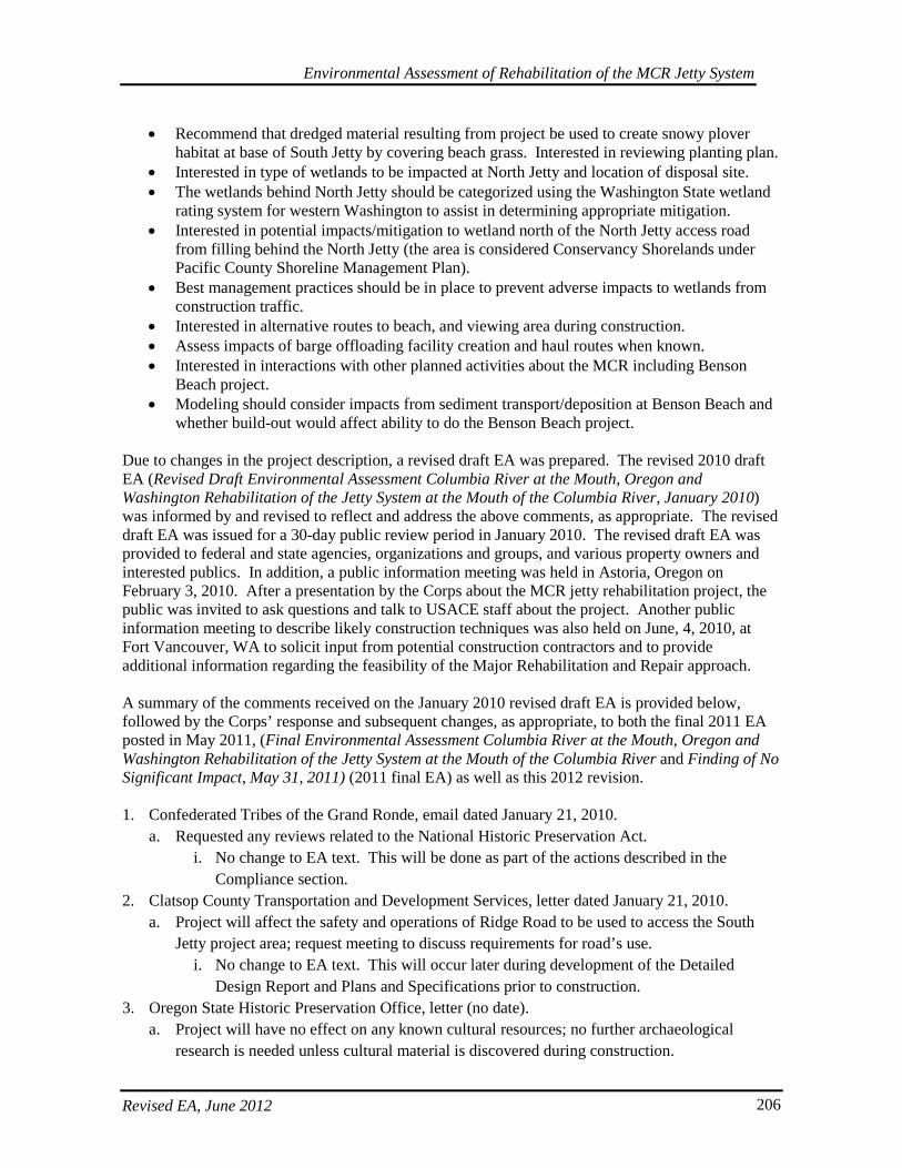
Environmental Assessment of Rehabilitation of the MCR Jetty System
Revised EA, June 2012 206
• Recommend that dredged material resulting from project be used to create snowy plover habitat at base of South Jetty by covering beach grass. Interested in reviewing planting plan.
• Interested in type of wetlands to be impacted at North Jetty and location of disposal site. • The wetlands behind North Jetty should be categorized using the Washington State wetland
rating system for western Washington to assist in determining appropriate mitigation. • Interested in potential impacts/mitigation to wetland north of the North Jetty access road
from filling behind the North Jetty (the area is considered Conservancy Shorelands under Pacific County Shoreline Management Plan).
• Best management practices should be in place to prevent adverse impacts to wetlands from construction traffic.
• Interested in alternative routes to beach, and viewing area during construction. • Assess impacts of barge offloading facility creation and haul routes when known. • Interested in interactions with other planned activities about the MCR including Benson
Beach project. • Modeling should consider impacts from sediment transport/deposition at Benson Beach and
whether build-out would affect ability to do the Benson Beach project. Due to changes in the project description, a revised draft EA was prepared. The revised 2010 draft EA (Revised Draft Environmental Assessment Columbia River at the Mouth, Oregon and Washington Rehabilitation of the Jetty System at the Mouth of the Columbia River, January 2010) was informed by and revised to reflect and address the above comments, as appropriate. The revised draft EA was issued for a 30-day public review period in January 2010. The revised draft EA was provided to federal and state agencies, organizations and groups, and various property owners and interested publics. In addition, a public information meeting was held in Astoria, Oregon on February 3, 2010. After a presentation by the Corps about the MCR jetty rehabilitation project, the public was invited to ask questions and talk to USACE staff about the project. Another public information meeting to describe likely construction techniques was also held on June, 4, 2010, at Fort Vancouver, WA to solicit input from potential construction contractors and to provide additional information regarding the feasibility of the Major Rehabilitation and Repair approach. A summary of the comments received on the January 2010 revised draft EA is provided below, followed by the Corps’ response and subsequent changes, as appropriate, to both the final 2011 EA posted in May 2011, (Final Environmental Assessment Columbia River at the Mouth, Oregon and Washington Rehabilitation of the Jetty System at the Mouth of the Columbia River and Finding of No Significant Impact, May 31, 2011) (2011 final EA) as well as this 2012 revision. 1. Confederated Tribes of the Grand Ronde, email dated January 21, 2010.
a. Requested any reviews related to the National Historic Preservation Act. i. No change to EA text. This will be done as part of the actions described in the
Compliance section. 2. Clatsop County Transportation and Development Services, letter dated January 21, 2010.
a. Project will affect the safety and operations of Ridge Road to be used to access the South Jetty project area; request meeting to discuss requirements for road’s use.
i. No change to EA text. This will occur later during development of the Detailed Design Report and Plans and Specifications prior to construction.
3. Oregon State Historic Preservation Office, letter (no date). a. Project will have no effect on any known cultural resources; no further archaeological
research is needed unless cultural material is discovered during construction.
Environmental Assessment of Rehabilitation of the MCR Jetty System
Revised EA, June 2012 207
i. No change to EA text. This will help inform part of the National Historic Preservation Act actions described in the Compliance section.
4. Columbia River Crab Fisherman’s Association, letter dated February 1, 2010. a. Agree with findings of report/no action is unacceptable; EA and Finding of No Significant
Impact (FONSI) are appropriate. i. No change to EA text.
b. Just adding stone to jetties will not solve entire foundation problem, direct sand supplementation of the sand foundation is needed to stabilize jetties over coming decades.
i. No change to EA text. Engineering staff has evaluated and designed the project as described in the EA to address the perceived problems and causes, including consideration of spur groins to accrete sand and protect the jetties’ foundations.
c. Lengthen Jetty A to full length will help stabilize natural northern migration of shipping channel and help somewhat with increasing erosion on Sand Island.
i. No change to EA text. Engineering staff has evaluated and designed the project to address the perceived problems and causes as described in the EA, including capping or stabilization of the head of Jetty A at its current length to avoid further head loss.
d. Routine direct placement of sand near root of jetties and north along Benson Beach will be required and must be part of the long-range stabilization plan. Consider a permanent pipe with frequent outlets for length of jetties to distribute sediment on both sides of jetties to supplement sand foundation. Consider permanent pipeline to supplement Benson Beach.
i. No change to EA text. Engineering staff has evaluated and designed the project to address the perceived problems and causes as described in the EA, including lagoon fill and consideration of spur groins to address protection of the jetty foundation. Benson Beach littoral drift replenishment is being conducted under a separate project.
e. In general, the Columbia River Crab Fisherman’s Association supports the project. i. No change to EA text.
5. Public Commenter, email dated February 12, 2010. a. Previous jetties repairs have required a great deal of truck traffic in SW Washington;
transport rock this time via barge. State is in a budget crisis cannot afford to repair roads; barges are more energy efficient and would keep roads from being compromised.
i. As described in Section 5.5.3, the feasibility of several transportation options have been considered, and a combination of approaches may be implemented.
6. Public Commenter, letter dated January 15, 2010. a. During design, consider how construction will affect the surf break.
i. No change to EA text. Wave climate and currents were modeled and considered for their impacts to the function and integrity of the jetty structures for maintaining navigation. Understanding wave formation for recreational uses was not one of the project purposes evaluated.
b. Locations of spur groins not clearly shown in the EA. i. Locations of spurs were clearly shown on the proposed action figure for each jetty.
They are no longer proposed in this 2012 preferred alternative. c. The EA does not adequately address impact to socio-economics of Warrenton; revise text
(Sections 2.4.3 and 6.8) to acknowledge other activities like water sports (surfing, kayaking,
Environmental Assessment of Rehabilitation of the MCR Jetty System
Revised EA, June 2012 208
kite boarding), clam digging, and beach activities such as walking, running, dog exercise, etc.
i. Text of EA was revised as suggested. d. There needs to be public access to beach immediately south of South Jetty; prohibiting
access by not allowing climbing over jetty rocks is not a solution. Public beach access should be maintained during construction. Letter provides two ways to address this: (1) contractor can retain some parking at Lot C and provide safe pedestrian access through construction zone; or (2) contractor can build new or temporary parking lot/path to the beach south of jetty.
i. As described in the Socio-economic sections of the EA, for safety reasons, the Corps prohibits climbing on jetty rocks, and to maintain safety will also have certain portions of the park closed where there is construction, equipment, or staging activities. Though there may be intermittent closures in certain areas, there are likely to be portions of the beach that remain open and unaffected. The Corps will be coordinating with the Park and construction staff to maintain the safety of park visitors.
e. Post-construction establish a permanent, safe public access from the parking area to the beach.
i. No change to EA text. The purpose of this project is to maintain the jetties and does not include construction of additional beach access points.
f. The EA should address construction safety for surfers and other water sport enthusiasts; contractor to delineate safety zones when working in or around the water using buoys or other types of notification; provide signs or displays warning surfers when in-water work is underway.
i. No change to the EA text. This is mentioned in Section 6.15 7. Chadbourne + Doss Architects, email dated February 4, 2010.
a. Spends time at South Jetty and sees opportunity for interpretive center or thoughtful installation to help communicate purpose of the jetty and efforts of Corps.
i. No change in the EA text. This does not fit with the purpose and need of the project. 8. Public Commenter, letter dated January 17, 2010.
a. Provides information and photos of Japanese approach to sea walls and breaker barriers. i. No change in the EA text. Concrete armor units similar to those shared by the
commenter are already under consideration for use at the jetty heads. 9. JP&M Mining, email dated January 20, 2010.
a. Attending meeting in Astoria on February 3, wants any existing surveys on North and South jetties and information on previous quarries used.
i. Request was forwarded to the geotechnical engineer, and a quarry list has been provided in the EA.
b. Putting together a business plan that may include revamping a coastal port. i. No change in the EA text.
c. Jetty rehab excellent way to use local workers and improve infrastructure in coastal communities.
i. No change in the EA text. 10. Public Commenter, letter dated February 2, 2010.
Environmental Assessment of Rehabilitation of the MCR Jetty System
Revised EA, June 2012 209
a. Provided two historical references to be added to history of MCR jetties section. i. These were added to reference section.
b. Draft EA overemphasizes use of quarried armor stones; other approaches like reinforced concrete armor units and structural solutions using reinforced concrete elements should also be given emphasis in decision-making process.
11. More information was added to EA about physical model (Section 4.1.2.3). Concrete armor units are under consideration for use at the jetty heads. PND Engineers, letter dated February 12, 2010. a. Provided information on OPEN CELL jetty structures.
i. No change in the EA text. Information was forwarded to the coastal engineers. 12. Northwest Environmental Advocates, letter dated February 12, 2010.
a. USACE must prepare an EIS that complies with the purpose of NEPA. i. No change to the EA text. With the release of the Draft EA for solicitation of public
comments, through its evaluation of impacts and alternative, and through meeting its other compliance obligations, the Corps has also been complying with its NEPA obligations. At the conclusion of the Final EA, the Corps will make its determination as to whether or not an EIS or a FONSI will be completed.
b. Information required for public disclosure has been omitted from draft EA (disposal of dredged materials, costs and benefit-to-cost ratio for the project, meaningful discussion of impacts, etc).
i. EA text has been revised for dredged material disposal, alternative selection, and impact discussions.
c. Draft EA segregates connected actions; the jetties, maintenance of the MCR and Columbia River navigation channel, and dredged material disposal sites are connected actions.
i. No change to text in the EA. The purpose and need described in the proposed action is limited to repair and rehabilitation of the existing jetty system.
d. Biological Assessments for the Services not completed prior to public review of draft EA. i. The EA text has been edited to reflect updated evaluations and information, including
in the ESA Compliance section. Biological Assessments have been completed, and a Biological Opinion and Letter of Concurrence have been obtained from the Services prior to completion of the final EA.
e. Inadequate information on future conditions that will degrade the jetties, e.g., wave height changes, climate change.
i. Text was added to the EA in section 6.11 describing hydrologic and hydraulic processes and modeling that was conducted during evaluation and design of the jetty alternatives.
f. Draft EA does not address the impacts of filling the Trestle Bay area with cobble. i. As described in the alternatives discussion for the South Jetty, this alternative
component has been removed as part of the selected or preferred plan. Text was added to Section 6 to discuss impacts from fill at the foredune augmentation.
g. Draft EA does not adequately analyze alternatives. i. Changes to the text were made for describing the selection of alternatives.
h. Draft EA does not contain a detailed mitigation plan.

Environmental Assessment of Rehabilitation of the MCR Jetty System
Revised EA, June 2012 210
i. The wetland impacts and mitigation sections have been revised to reflect mitigation plans.
i. Draft EA fails to identify/analyze cumulative impacts of past, current and future actions; as with previous EIS or EAs for MCR and Channel Deepening projects, including deepwater site, there is no evaluation of baseline conditions and cumulative changes to issues such as salinity, ocean plume, risk of oil spills, changes in shipping, habitat loss, impacts on salmonids, and sedimentation processes.
i. The Cumulative Effects section has been revised. The No Action and Baseline conditions, impacts, and hydrology and hydraulics have also been described.
j. Draft EA does not discuss how littoral cell and other Corps actions, such as hydrosystem operation and dredging and disposal of dredged materials, have affected sedimentation in the littoral cell and how continued maintenance of existing jetty length will continue to affect sedimentation processes.
i. Text was added to the EA in section 6.11 describing hydrologic and hydraulic processes and modeling that was conducted during evaluation and design of the jetty alternatives.
k. Draft EA does not address possible effects of filling the dunes at South Jetty root/Trestle Bay.
i. As described in the alternatives discussion for the South Jetty, the Trestle Bay fill alternative component has been removed as part of the selected or preferred plan. Text was added to Section 6 to discuss impacts from fill at the foredune augmentation.
l. Action area should encompass the entirety of the littoral cell. i. The affected environment and possible environmental consequences were both
described, as were effects to hydraulics and hydrology in the project vicinity. m. Project timing and schedule not clear – draft EA does not state how long repairs should last;
timing of project is described as lasting 50 years but project actions take place in 2045 and 2069.
i. More information has been added to EA under Construction Scheduling, and also in the description of alternatives and proposed actions. The construction schedule has also been revised in this EA and the previous draft and final EAs. Even with repairs and rehabilitation earlier in the project life, the model predicts that future repairs could be required given storm and wave climate at the jetties. This has been described in the No Action section.
n. A supplemental EIS for the MCR is required to address impacts of jetty rehabilitation project.
i. No changes were made to the EA text. The Corps disagrees and has determined a separate EA for jetty repairs and rehabilitation is an appropriate path for complying with NEPA requirements.
o. Independent peer review is required by the Water Resources Development Act of 2007. i. No change to EA text. The 90% Major Rehabilitation Report, of which the draft EA
was a part, has completed independent external peer review (IEPR). 13. United States Fish and Wildlife Service, letter received February 23, 2010.
a. Requests disposal of dredged material be used to cover European beach grass.
Environmental Assessment of Rehabilitation of the MCR Jetty System
Revised EA, June 2012 211
i. These actions would be evaluated during construction implementation and would also be vetted through the AMT.
b. Requests heavy equipment to remove European beach grass and to restore and enhance snowy plover nesting habitat in concert with the draft Habitat Conservation Plan and Oregon Parks and Recreation Department (OPRD).
i. Habitat preferred by snowy plover will be created adjacent to the staging areas in order to reduce the potentially attractive nuisance created by the cleared staging area.
c. Requests habitat improvements in coordination with OPRD for rock storage via creation of habitat areas for snowy plover that do not interfere with use of the Spit.
i. Habitat preferred by snowy plover will be created adjacent to the staging areas in order to reduce the potentially attractive nuisance created by the cleared staging area.
This 2012 revised final EA updates and corrects the 2011 final EA by updating the alternative plans considered and the Preferred Alternative actions proposed for the North Jetty, South Jetty and Jetty A. This has resulted in smaller project and environmental footprints than proposed in the 2006 draft EA, the 2010 draft EA and the 2011 EA. It also updates the Cumulative Effects section with the addition of the Corps’ proposed designation of additional nearshore disposal sites. The 2011 and 2012 EAs were also informed by and revised to reflect and address the above public notice comments, as appropriate. After the previous 30-day public review period and receipt of comments from federal and state agencies, organizations and groups, and various property owners and interested publics, public concerns identified in comments were addressed. A determination would be made as to whether or not an Environmental Impact Statement (EIS) is necessary. The determination would be made in a Record of Decision or Finding of No Significant Impact (FONSI). Besides these official public information meetings and distribution of the EA, the Corps has also had multiple meetings with various regulatory agencies to ensure regular coordination throughout project development. As mentioned in the overview of the Preferred Alternative, the Corps has also proposed formation of a modified interagency Adaptive Management Team to keep resource agency partners apprised of any potential project changes or challenges during implementation.

Environmental Assessment of Rehabilitation of the MCR Jetty System
Revised EA, June 2012 212
(this page intentionally left blank)
Environmental Assessment of Rehabilitation of the MCR Jetty System
Revised EA, June 2012 213
8. COMPLIANCE WITH LAWS AND REGULATIONS
8.1. Clean Air Ac t
This Act established a comprehensive program for improving and maintaining air quality throughout the United States. Its goals are achieved through permitting of stationary sources, restricting the emission of toxic substances from stationary and mobile sources, and establishing National Ambient Air Quality Standards. Title IV of the Act includes provisions for complying with noise pollution standards. Section 118 (42 U.S.C. 7418) of the Clean Air Act specifies that each department, agency, and instrumentality of the executive, legislative, and judicial branches of the Federal Government (1) having jurisdiction over any property or facility or (2) engaged in any activity resulting, or which may result, in the discharge of air pollutants, shall be subject to, and comply with, all Federal, State, interstate, and local requirements respecting the control and abatement of air pollution in the same manner, and to the same extent as any non-governmental entity. Corps activities resulting in the discharge of air pollutants must conform to National Ambient Air Quality Standards (NAAQS) and State Implementation Plans (SIP), unless the activity is explicitly exempted by EPA regulations10. Repair and rehabilitation of the MCR jetty system is anticipated to remain in compliance with the Clean Air Act and the State Implementation Plan. This is not a transportation project, it will not qualify as a major stationary source of emissions of criteria pollutants, and the project does not appear to be located in a non-attainment area for limited air quality. There would be an intermittent but long-term reduction in air quality during construction of the proposed action due to emissions from construction equipment. Any emissions that do occur during and after construction from motor vehicles or facility functions are expected to be de minimus and will be from activities of a similar scope and operation to those of the original facility. There also would be an intermittent but long-term increase in noise levels from construction equipment. Efforts to avoid and minimize these effects have been considered when comparing and evaluating construction methods. Use of vibratory hammers will minimize some of the noise impacts during piling placement. It is also possible barging rocks verses overland trucking would result in reduced truck traffic and lower project emissions. These effects will be evaluated while taking into consideration other environmental factors during final selection of construction methods.
8.2. Marine Pro tec tion , Res ea rch , and Sanc tua ries Ac t
Prior to dredging and disposal activities, the Corps will request authorization to use one of the designated Section 102 sites for disposal of dredged materials. This will include a request for concurrence that the Corps’ proposed Annual Use Plan is in compliance with the Site Monitoring and Management Plan. The proposed transportation of dredged material for placement or disposal in ocean waters will be further evaluated to determine that the proposed disposal will not unreasonably degrade or endanger human health, welfare, or amenities or the marine environment, ecological systems, or economic potentialities. In making this determination, the criteria established by the Administrator, EPA pursuant to section 102(a) of the Ocean Disposal Act will be applied. In addition, based upon an evaluation of the potential effect which the failure to utilize this ocean disposal site will have on navigation, economic and industrial development, and foreign and domestic commerce of the United States, an independent determination will be made regarding the need to dispose of the dredged material in ocean waters, other possible methods of disposal, and other appropriate locations.
Environmental Assessment of Rehabilitation of the MCR Jetty System
Revised EA, June 2012 214
8.3. Clean Wate r Ac t
Effects to water quality and effects from discharges and disposal into navigable waters, including 404 wetlands and waters including mitigation have been described in the pertinent sections of this EA. This Act also requires 401 Water Quality Certification from state or interstate water control agencies which certify that a proposed water resources project is in compliance with established federal and state effluent limitations and water quality standards. The proposed action is expected to be in compliance with the Act. A Section 404(b) (1) Evaluation has been prepared for the proposed action. The Section 404(b) (1) Evaluation and any additional necessary information will be submitted to the ODEQ and the WDOE. These agencies will be responsible for project review and issuance of the 401 Water Quality Certificates which will likely include terms and conditions to ameliorate impacts from the proposed action, including BMPs and turbidity monitoring requirements. The Corp will obtain these State 401 Water Quality Certifications prior to any inwater work or wetland fill. In addition, a National Pollutant Discharge Elimination System permit will be required from the USEPA and obtained prior to disturbance and work performed on federal lands in Washington, and the Corps intends to use the construction general permit after development of an appropriate Stormwater Pollution Prevention Plan. The Corps has a general 1200-CA permit (#14926) through the ODEQ that, though expired, has been administratively extended indefinitely by ODEQ and remains in effect. The Corps intends to maintain compliance with its terms and conditions, including development of an Erosion and Sediment Control Plan prior to disturbance and work performed on federal, state, and local lands in the Oregon State.
8.4. Coas ta l Zone Management Ac t
This Act requires federal agencies to comply with the federal consistency requirement of the Coastal Zone Management Act. This activity will be coordinated with the Oregon Department of Land Conservation and Development and the WDOE. A consistency determination will be prepared and concurrence received from both States prior to construction.
8.5. Endangered Spec ies Ac t
In accordance with Section 7(a) (2) of this Act, federally funded, constructed, permitted, or licensed projects must take into consideration impacts to federally listed or proposed threatened or endangered species. Information on federally listed species and designated critical habitat is presented in this EA. Biological Assessments (BAs) were prepared for the proposed action to address federally listed species under the jurisdiction of the NMFS and USFWS. The BAs were provided to the respective agencies for review and consultation. On March 18, 2011, The Corps received a Biological Opinion from NMFS indicating that the Corps’ proposed actions were not likely to adversely affect any listed species, with the exception of eulachon, humpback whales, and Stellar sea lions (2010/06104). For these species, NMFS determined that Corps’ actions were not likely to jeopardize the existence of the species. NMFS also concluded that Corps actions were not likely to adversely modify any of the current or proposed critical habitats. There was a Conservation Recommendation to carry out actions to reverse threats to species survival identified in the Columbia River Estuary ESA Recovery Plan Module for Salmon and Steelhead. The Corps also provided a conference report for critical habitat that NMFS proposed for leatherback turtles, eulachon, and Lower Columbia River coho salmon. The Corps will request NMFS adopts its conference report when this habitat becomes designated. Prior to construction, the
Environmental Assessment of Rehabilitation of the MCR Jetty System
Revised EA, June 2012 215
Corps will also request an Incidental Harassment Authorization of Stellar sea lions, humpback whales, California sea lions, and harbor seals. On February 23, 2011 the Corps received a Letter of Concurrence from USFW regarding potential effects to species under their jurisdiction (13420-2011-I-0082). The Corps’ determined its actions would have no effect on listed species, with the exception of bull trout, marbled murrelets, and snowy plover. The Corps concluded that its actions were not likely to adversely affect these species or their critical habitat. The USFW concurred with the Corps’ determination. USFW also included four Conservation Recommendations to protect and improve snowy plover habitat and manage attractant waste derived from construction actions. Mitigation components have been included in the proposed action by the Corps. These actions complement the Corps’ affirmative commitment to fulfill responsibility to assist with conservation and recovery of ESA-listed salmonids.
8.6. Fis h and Wild life Coordina tion Ac t
This Act states that federal agencies involved in water resource development are to consult with the USFWS concerning proposed actions or plans. The proposed action has been coordinated with the USFWS in accordance with the Act. The Corps has also been in regular coordination with ODFW and WDFW regarding plan selection and development of wetland and waters mitigation projects.
8.7. Magnus on-Ste vens Fis hery Cons erva tion and Management Ac t
The Sustainable Fisheries Act of 1996 amended the Magnuson-Stevens Act establishing requirements for essential fish habitat (EFH) for commercially important fish. Pursuant to the Magnuson-Stevens Act, an EFH consultation is necessary for the proposed action at the MCR jetties. Essential fish habitat is defined by the Act as “those waters and substrate necessary to fish for spawning, breeding, feeding, or growth to maturity.” The estuary and the Pacific Ocean off the MCR are designated as EFH for various groundfish and coastal pelagic and salmon species. The proposed action will directly affect EFH for Chinook salmon, coho salmon, English sole, sand sole, and starry flounder from the permanent loss of sandy bottom habitat from jetty construction. Short-term disturbances to EFH would result for lingcod, English sole, sand sole, starry flounder, black rockfish, brown rockfish, China rockfish, copper rockfish, and quillback rockfish. However, the addition of rock would increase EFH for lingcod, black rockfish, brown rockfish, China rockfish, copper rockfish, and quillback rockfish. An EFH assessment under the Magnuson-Stevens Act was provided as part of the Biological Assessment submitted to the NMFS for the proposed action. In the subsequent Biological Opinion, no additional Conservation Measures were proposed.
8.8. Marine Mammal Pro tec tion Ac t
This Act prohibits the take or harassment of marine mammals. It is possible that the proposed action could result in harassment of the federally listed Steller sea lion with construction at the existing above-water portion of the head of the South Jetty. They can be present at any time of the year. Impacts to this species were evaluated and are described in this EA. Impacts were further evaluated as part of the Biological Assessment submitted to the NMFS for the proposed action. The Biological Opinion from NMFS indicated Corps actions would NOT jeopardize the survival of the species.
Environmental Assessment of Rehabilitation of the MCR Jetty System
Revised EA, June 2012 216
Prior to construction activities, an incidental harassment authorization (IHA) for marine mammals at the South Jetty will be obtained from the NMFS. The Corps anticipates that the new IHA permit will entail requirements similar to those in the previous permit for repair of the South Jetty. The Corps also proposed Conservation Measures as previously described.
8.9. Migra tory Bird Trea ty Ac t and Migra tory Bird Cons erva tion Ac t
These acts require that migratory birds not be harmed or harassed. Under the Migratory Bird Treaty Act, “migratory birds” essentially include all birds native to the U.S. and the Act pertains to any time of the year, not just during migration. The Migratory Bird Conservation Act aims to protect game birds. Impacts of construction at the jetties and the hauling of rock to the jetties could displace birds by causing flushing, altering flight patterns, or causing other behavioral changes, but it is not expected that effects would rise to the level of harm or harassment.
8.10. Nationa l His toric Pres e rva tion Ac t
Section 106 of this Act requires that federally assisted or federally permitted projects account for the potential effects on sites, districts, buildings, structures, or objects that are included in or eligible for inclusion in the National Register of Historic Places. This project is being conducted in an area that is highly erosive and has previously been disturbed by jetty construction and prior dredging. There are no known historic properties recorded within the immediate project footprint other than the jetties and associated trestle remains. The proposed action has been coordinated with the Washington and Oregon State Historic Preservation Offices (SHPO) in order to obtain their comments on this Section 106 action in accordance with the Act. Letters were sent to WA Department of Antiquities and Historic Preservation on April 16, 2012, and to Oregon State Historic Preservation Office on April 16, 2012. The Corps anticipated concurrence from the respective State Historic Preservation Officers of Washington and Oregon if monitoring is conducted during excavations and the usual inadvertent discovery protocols followed. The Oregon and Washington SHPOs have concurred that the undertaking would have no effect on historic properties as the action would not affect the criteria that make the structures eligible, essentially, importance in historic events and alignment. Original workmanship and materials have all changed over a century of repairs and the alignment and configuration remain essentially the same. The Corps also coordinated with the Grande Ronde Tribe in accordance with Section 106 of the NHPA, and the Grande Ronde Tribe indicated they have no concerns in regards to this project’s effects to properties on or eligible to the Register.
8.11. Native American Graves Pro tec tion and Repa tria tion Ac t
This Act provides for the protection of Native American (and Native Hawaiian) cultural items, established ownership and control of Native American cultural items, human remains, and associated funerary objects to Native Americans. It also establishes requirements for the treatment of Native American human remains and sacred or cultural objects found on federal land. This Act also provides for the protection, inventory, and repatriation of Native American cultural items, human remains, and associated funerary objects. There are no recorded historic properties within the immediate project area and the probability of locating human remains in this area is low. However, if human remains are discovered during construction, the Corps and/or the Contractor will be responsible for following all requirements of the Act.
Environmental Assessment of Rehabilitation of the MCR Jetty System
Revised EA, June 2012 217
8.12. Environmenta l J us tice
Executive Order 12898 requires federal agencies to consider and minimize potential impacts on subsistence, low-income, or minority communities. The goal is to ensure that no person or group of people should shoulder a disproportionate share of the negative environmental impacts resulting from the execution of domestic and foreign policy programs. The proposed action is not expected to disproportionately affect low income and/or minority populations and is in compliance with Executive Order 12898.
8.13. Executive Order 11988, Floodpla in Management
The proposed action would not further encourage development in, or negatively alter any floodplain areas. Executive Order 11988 regarding Floodplain Management was signed May, 24, 1977. The order requires that Federal agencies recognize the value of floodplains and consider the public benefits from their restoration and preservation. The objective is to avoid long and short-term adverse impacts to the base floodplain (100-year flood interval), and to avoid direct and indirect support of development in the base floodplain when there is a practicable alternative. Though the jetties are located in the floodplain on accreted land at the Clatsop Spit and Benson Beach, the floodplain in which they are located is relatively recently created and is at the mouth of the Columbia River. Therefore, these areas do not provide much floodplain storage or peak attenuation capacity. Furthermore, there are no other practicable alternative locations to conduct repairs or their associated construction activities, as the jetties are in a fixed location which is water and location dependent to maintain navigation. Additionally, the construction activities and fill will not be affecting floodplain areas that that have any private property, and there are few structures within the vicinity of the State Park lands and action area. The location of the State Park also precludes additional development in the vicinity of the jetties. Finally, the Corps does not expect any loss of beneficial values in the floodplain, and will be conducting some mitigation and restoration actions that will improve wetland function and dune stabilization. In order to inform the public of the proposed action, a draft EA was widely distributed and public comments were solicited. None of the commentators remarked on concerns for floodplain issues.
8.14. Executive Order 11990, Pro tec tion of Wetlands
Wetlands near the North and South Jetties and Jetty A will be filled for the proposed action. Plans for filling wetlands and the associated subsequent mitigation has been documented here and has been documented through the Section 404 (b) (1) evaluation that has also been prepared for the proposed action.
8.15. Prime and Unique Farmlands
No prime or unique farmlands will be affected by the proposed actions.
Environmental Assessment of Rehabilitation of the MCR Jetty System
Revised EA, June 2012 218
8.16. Comprehens ive Environmenta l Res pons e , Compens a tion , and Liability Ac t and Res ource Cons erva tion and Recovery Ac t
There is no indication that any hazardous, toxic, and radioactive wastes are in the vicinity of the MCR jetties. Any presence of these types of wastes would be responded to within the requirements of the law and Corps’ regulations and guidelines.

Environmental Assessment of Rehabilitation of the MCR Jetty System
Revised EA, June 2012 219
9. REFERENCES Bakun, A. 1996. Patterns in the Ocean: Ocean Processes and Marine Population Dynamics.
California Sea Grant College System. Beamis, W.E. and B. Kynard 1997. Sturgeon rivers: An introduction to acipensiform biogeography
and life history. Environ Biol Fishes 48:167-1 83. Blackstone, Vanessa. 2012. Oregon Parks and Recreation Department. Personal communication via
email to Greg Smith, US Army Corps of Engineers. Sent: Monday, June 04, 2012. Bottom, D.L., C.A. Simenstad, A.M. Baptista, D.A. Jay, J. Burke, K.K. Jones, E. Casillas, and M.H.
Schiewe. 2001. Salmon at River’s End: The Role of the Estuary in the Decline and Recovery of Columbia Salmon. National Marine Fisheries Service, Seattle WA.
Bowlby, C.E. 1994. Observations of leatherback turtles offshore of Washington and Oregon.
Northwest Naturalist 75:33-35. Briggs, K.T., D.H. Varoujean, W.W. Williams, R.G. Ford, M.L. Bonnell, and J.L. Casey. 1992.
Seabirds of the Oregon and Washington OCS, 1989-1990. Final Report for Pacific OCA Region, Minerals Management Service, USDI, Los Angeles CA.
Buchanan, D., M.L. Hanson, and R.M. Hooton. 1997. Status of Oregon’s bull trout, distribution, life
history, limiting factors, management considerations, and status. Technical report to Bonneville Power Administration (BPA Report DOE/BP-34342-5).
Connell, K.J. and J.D. Rosati. June 2007. Analysis of jetty rehabilitation at the Mouth of the
Columbia River, Washington/Oregon, USA, Part 2: Regional Circulation, sediment transport, and morphology change. Corps of Engineers, Engineer Research, and Development Center.
Corps. See U.S. Army Corps of Engineers. Cowardin, L.M., V. Carter, F.C. Golet, and E.T. LaRoe. 1979. Classification of Wetlands and
Deepwater Habitats of the United States. U.S. Fish and Wildlife Service publication FWS/OBS-79/31. Washington, DC.103 pp.
De Robertis, A., C.A. Morgan, R.A. Schabetsberger, R.W. Zabel, R.D. Brodeur, R.L. Emmett, C.M.
Knight, G.K. Krutzikowsky, E. Casillas. 2005. Columbia River plume fronts. II. Distribution, abundance, and feeding ecology of juvenile salmon. Marine Ecology Progress Series 299:33-44.
DMEF (Dredged Material Evaluation Framework). 1998. Dredged Material Evaluation Framework
for the Lower Columbia River Management Area. Prepared by the U.S. Army Corps of Engineers (Portland and Seattle Districts); U.S. Environmental Protection Agency, Region 10; Oregon Department of Environmental Quality; and Washington State Department of Natural Resources and Department of Ecology.
Emmett, R.L., R.D. Brodeur, and P.M. Orton. 2004. The vertical distribution of juvenile salmon
(Oncorhynchus spp.) and associated fishes in the Columbia River plume. Fisheries Oceanography 13:5, 392-402.
Environmental Assessment of Rehabilitation of the MCR Jetty System
Revised EA, June 2012 220
Gabrielson, I.N., and S.G. Jewett. 1940. Birds of Oregon. Oregon State College, Corvallis, Oregon. Gelfenbaum, G., Sherwood, C.R., Peterson, C.D., Kaminsky, G.M., Buijsman, M., Twichell, D.C.,
Ruggiero, P., Gibbs, A.E., Reed, C. 1999. The Columbia River littoral cell: a sediment budget overview, Proceedings of Coastal Sediments ‘99, 1660–1675.
Green, M.L., J.J. Brueggeman, R.A. Groetfendt, C.E. Bowlby, M.L. Bonnel, and K.C. Balcomb III.
1991. Cetacean Distribution and Abundance off Oregon and Washington, 1989-1990. Final Report for Pacific OCS Region, Minerals Management Service, USDI, Los Angeles CA.
Healey, M.C. 1982. Juvenile Pacific salmon in estuaries: The life support system, pp. 315-341 In
Estuarine Comparisons. V.S. Kennedy (ed.). Academic Press, New York. Helm, Steven. 2009. Personal Communication. U.S. Army Corps of Engineers. CENWP-PM-E,
Portland OR. 2009 Hickson, R.E. and F.W. Rodolf. 1950. History of Columbia River Jetties. Pages 285-298 In
Proceedings 1st Conference on Coastal Engineering. Council on Wave Research, The Engineering Foundation, Long Beach, CA.
Higgins, K., A. Hastings, J.N. Sarvela and L.W. Botsford. 1997. Stochastic Dynamics and
Deterministic Skeletons: Population Behavior of Dungeness Crab. Science 276:1431-1435. Hruby, T. August 2004. Washington State Wetland Rating System for Western Washington.
Washington State Department of Ecology Publication # 04-06-025. Olympia WA. ICF Jones & Stokes. 2009. Habitat Conservation Plan for the Western Snowy Plover. August. (J&S
06537.06.) Portland, OR. Prepared for Fish and Wildlife Service and Oregon Parks and Recreation Department.
Isaacs, F.B. and R.G. Anthony. 2005. Bald eagle nest locations and history of use in Oregon and the
Washington portion of the Columbia River Recovery Zone, 1972-2005. Oregon Cooperative Fish and Wildlife Research Unit, Oregon State University, Corvallis.
Jewett, S. G., W. P. Taylor, W. T. Shaw, and J .W. Aldrich. 1953. Birds of Washington State.
University of Washington Press, Seattle, Washington, USA. Lockett, J.B. 1962. Phenomena Affecting Improvement of the Lower Columbia Estuary and
Entrance. Pages 695-755 In Proceedings 8th Conference on Coastal Engineering. Council on Wave Research, The Engineering Foundation, Mexico City, Mexico.
Lower Columbia Solutions Group. 2011. Mouth of the Columbia River Regional Sediment
Management Plan. August 2011. Marshall, D.B. 1988. Status of the Marbled Murrelet in North America with Special Emphasis on
Populations in Washington, Oregon and California. Audubon Society of Portland, Portland OR. Marshall, D.B., M.G. Hunter, A. Contreras (eds). 2003. Birds of Oregon: A General Reference.
Oregon State University Press, Corvallis.
Environmental Assessment of Rehabilitation of the MCR Jetty System
Revised EA, June 2012 221
McLaren, P. and S. Hill. April 2000. A Sediment Trend Analysis (STA®). GeoSea Consulting.
Brentwood Bay, BC, Canada. Moritz, H. 2001. Observing Large Waves Using Bottom-Mounted Pressure and Current Meters.
Fourth International Symposium Waves 2001, San Francisco, CA. Moritz, H.R., H.P. Moritz, J.R. Hays, and H.P. Sumerell. 2003. 100-Years of Shoal Evolution at the
Mouth of the Columbia River: Impacts on Channel, Structures, and Shorelines. Proceedings International Conference on Coastal Sediments 1999, St Petersburg, FL.
Moritz, H.P. and H.R. Moritz. 2004. Regional Analysis of Extremal Wave Height Variability,
Oregon Coast, USA, In Proceedings of the 8th International Workshop in Wave Hindcasting and Forecasting, Oahu HI.
Moritz, H.P. and H.R. Moritz. 2006. Evaluating Extreme Storm Power and Potential Implications to
Coastal Infrastructure Damage, Oregon Coast, USA. In 9th International Workshop on Wave Hindcasting and Forecasting, September 24-29, 2006, Victoria, B.C.
Moritz, H.P. and H.R. Moritz. 2007. Assessing Extreme Storm Intensity by Combining Storm Power
with Surge, Oregon, USA. In Proceedings 10th International Workshop on Wave Hindcasting and Forecasting, Oahu, HI.
Moritz, H.R., G. Gelfenbaum, G. Lesser, and D. Michalsen. Undated. Morphological implications of
oceanographic measurements acquired along a mega-transect at the mouth of the Columbia River (MCR), USA. Poster. U.S. Army Corps of Engineers, U.S. Geological Survey, and Delft Hydraulics.
Moritz, H.R. and H.P. Moritz. 2010. Personal Communication. U.S. Army Corps of Engineers,
Portland District. Moser, M. and S. Lindley. 2007. Use of Washington estuaries by subadult and adult green sturgeon.
Environmental Biology of Fishes 79:243-253. Moyle, P.B. 2002. Inland fish of California. 2nd ed. University of California Press, Berkeley. NMFS (National Marine Fisheries Service). 1998. Position document for use of treated wood in
areas in Oregon occupied by Endangered Species Act proposed/listed anadromous fish species. NMFS. 2004. Endangered Species Act Section 7 Formal Consultation and Magnuson-Stevens
Fishery and Conservation Management Act Essential Fish Habitat Consultation for the Columbia River North and South Jetties Rehabilitation, Columbia River Basin, Clatsop County, Oregon.
NMFS. 2006. Community Profiles for West Coast and North Pacific Fisheries: Washington, Oregon,
California, and other U.S. States (draft). Northwest and Alaska Fisheries Science Centers. NMFS. November 2006. Leatherback Turtles in the Pacific III: The Variable Ecosystem. Video. NMFS. 2007. Species of Concern Fact Sheet - Green Sturgeon (Acipenser medirostris) Northern
DPS. Office of Protected Resources website http://www.nmfs.noaa.gov/pr/species/concern/.
Environmental Assessment of Rehabilitation of the MCR Jetty System
Revised EA, June 2012 222
NMFS. 2007a. Columbia River Estuary ESA Recovery Plan Module for Salmon and Steelhead.
Prepared for NOAA Fisheries by the Lower Columbia River Estuary Partnership. Northwest Region. November 5, 2007.
NMFS. 2008. Recovery Plan for Southern Resident Killer Whales (Orcinus orca). Northwest
Region, Seattle WA. NMFS. 2008. Remand of 2004 Biological Opinion on the Federal Columbia River Power System
(FCRPS) including 19 Bureau of Reclamation Projects in the Columbia Basin (Revised pursuant to court order, NWF v. NMFS, Civ. No. CV 01-640-RE (D. Oregon)
NMFS. 2011. Columbia River Estuary ESA Recovery Plan Module for Salmon and Steelhead.
NMFS Northwest Region. Portland, OR. January. Prepared for NMFS by the Lower Columbia River Estuary Partnership (contractor) and PC Trask & Associates, Inc., subcontractor.
NMFS and USFWS (U.S. Fish and Wildlife Service). 1998. Recovery Plan for U.S. Pacific
Populations of the Leatherback Turtle (Dermochelys coriacea). Silver Springs, MD. NOAA (National Oceanic and Atmospheric Administration). March 13, 2009. Endangered and
Threatened Wildlife and Plants: Proposed Threatened Status for Southern Distinct Population Segment of Eulachon. 50 CFR Part 223, [Docket No. 080229343–81352–02] RIN 0648–XF87, Federal Register Vol. 74, No. 48, Proposed Rules 10857-10876. http://www.nmfs.noaa.gov/pr/pdfs/fr/fr74-10857.pdf.
Oregon Department of Environmental Quality (DEQ). 2011. Raw excel data from spill tracker
database provided in an email by Kimberly Van Patton and Ray Hoy. DEQ Headquarters. Portland, Oregon. March 28, 2011.
Oregon Department of State Lands (DSL), the U.S. Environmental Protection Agency (EPA), and
the Corps. 2010. Guidance for Using the Oregon Rapid Wetland Assessment Protocol (ORWAP) in the State and Federal Permit Programs. USACE, Portland District, and USEPA Region 10.
Oregon Natural Heritage Program. 2004. Rare, Threatened and Endangered Species of Oregon.
Oregon State University, Corvallis. OPRD (Oregon Parks and Recreation Department). August 2010. Habitat Conservation Plan for the
Western Snowy Plover. Salem. PNNL (Pacific Northwest National Laboratory). 2005. Draft report: Use of acoustic telemetry to
assess habitat use of juvenile Chinook salmon and steelhead at the mouth of the Columbia River. PFMC (Pacific Fisheries Management Council). 1998. Essential Fish Habitat: Coastal pelagic
species [modified from Coastal Pelagic Species Fishery Management Plan (Amendment 8 to the Northern Anchovy Fishery Management Plan)].
PFMC. 1999. Amendment 14 to the Pacific Coast Salmon Plan. Appendix A: Description and
identification of essential fish habitat, adverse impacts and recommended conservation measures
Environmental Assessment of Rehabilitation of the MCR Jetty System
Revised EA, June 2012 223
for salmon. Pacific Fishery Management Council, Portland, OR. Located at http://www.pcouncil.org/salmon/salfmp/a14.html.
PFMC. 2005. Amendment 19 to the Pacific Coast Groundfish Fishery Management Plan. Pacific
Fishery Management Council, Portland, OR. PFMC. 2006. Final Environmental Impact Statement (FEIS) for the Proposed ABC/OY
Specifications and Management Measures for the 2007-2008 Pacific Coast Groundfish Fishery/Amendment 16-4 to the Groundfish Fishery Management Plan. Pacific Fishery Management Council, Portland, OR.
PFMC. 2006 (August 8-9). Highly Migratory Species Management Team (meeting minutes). Lajolla,
CA. PSMFC (Pacific States Marine Fisheries Commission). 2009. Lamprey Fact Sheet.
Fhttp://www.psmfc.org/habitat/edu_lamprey_fact.html (accessed 125/15/2009). Pearcy, W.G. 1992. Ocean Ecology of North Pacific Salmon. Washington Sea Grant Program,
University of Washington Press, Seattle WA. Richardson, S.L. 1981. Spawning biomass and early life of northern anchovy, Engraulis mordax, in
the northern subpopulation off Oregon and Washington. Fisheries Bulletin, U.S. 78(4):855-876. Sediment Evaluation Framework. September 2006. Northwest Regional Sediment Evaluation
Framework, Interim Final. Prepared by U.S. Army Corps of Engineers Seattle, Portland, and Walla Walla Districts and Northwestern Division; U.S. Environmental Protection Agency Region 10; Washington Departments of Ecology and Natural Resources; Oregon Department of Environmental Quality; Idaho Department of Environmental Quality; National Marine Fisheries Service; and U.S. Fish and Wildlife Service.
Shenker, J.M. 1984. Scyphomedusae in surface waters near the Oregon coast, May-August 1981.
Estuarine, Coastal and Shelf Science 19:619-632. Simenstad, C.A. and E.O. Salo. 1982. Foraging success as a determinant of estuarine and nearshore
carrying capacity of juvenile chum salmon (Oncorhynchus keta) in Hood Canal, Washington, pp. 21-37 In Proceedings of the North Pacific Aquaculture Symposium. B.R. Melteff and R.A. Neve (eds). Alaska Sea Grant Program, University of Alaska, Fairbanks.
Strong, C.S., B.S. Keitt, W.R. McIver, C.J. Palmer, and I. Gaffney. 1995. Distribution and
population estimates of marbled murrelets at sea in Oregon during summer of 1992 and 1993, pp. 339-353 In Ecology and Conservation of the Marbled Murrelet. C.J. Ralph, G.L. Hunt, M.G. Raphael and J.F. Piatt (eds). Gen Tech Rpt PSW-GTR-152. U.S. Forest Service, Albany CA.
Tetra Tech, Inc. April 2007a. Wetland and Waters of the U.S. Delineation Revised Final Report:
North Jetty, Mouth of the Columbia River, Pacific County, Washington. Prepared for U.S. Army Corps of Engineers, Portland OR.
Tetra Tech, Inc. April 2007b. Clatsop Spit Plant Communities Investigation and Mapping, Final
Report: South Jetty, Mouth of the Columbia River, Clatsop County, Oregon. Prepared for U.S. Army Corps of Engineers, Portland OR.
Environmental Assessment of Rehabilitation of the MCR Jetty System
Revised EA, June 2012 224
Thorpe, J.E. 1994. Salmonid fishes and the estuarine environment. Estuaries 17:76-93. Troussellier, Marc (Lead Author); Jean-Pierre Gattuso (topic editor). 2007. Coastal lagoon. In
Encyclopedia of Earth. Eds. Cutler J. Cleveland (Washington, D.C.: Environmental Information Coalition, National Council for Science and the Environment). [First published in the Encyclopedia of Earth November 21, 2006; Last revised August 13, 2007; Retrieved November 23, 2009]. http://www.eoearth.org/article/Coastal_lagoon.
U.S. Army Corps of Engineers. 1983. Columbia River at the Mouth Navigation Channel
Improvement, Final Environmental Impact Statement, Oregon-Washington. Portland OR. U.S. Army Corps of Engineers. 1987. Corps of Engineers Wetlands Delineation Manual,
Washington, D.C. Waterways Experiment Station, Vicksburg MS. U.S. Army Corps of Engineers. 1999. Integrated Feasibility Report for Channel Improvements and
Environmental Impact Statement, Columbia and Lower Willamette River Federal Navigation Channel. Portland OR.
U.S. Army Corps of Engineers. 2005. Columbia River Channel Improvement Project monitoring
data (unpublished). Portland OR. U.S. Army Corps of Engineers. October 2005. Mouth of the Columbia River South Jetty Barge
Offloading Zone Tier I Sediment Evaluation. Portland OR. U.S. Army Corps of Engineers. 2007. Request (to NMFS) for Incidental Harassment Authorization
under the Marine Mammal Protection Act (unpublished). Portland OR. U.S. Army Corps of Engineers. 2008. Columbia River at the Mouth Annual Summary Report.
(http://www.nwp.usace.army.mil/docs/d_sediment/Summary_Reports/FY08_MCR_Sed.pdf). U.S. Army Corps of Engineers. 2010. Navigation Data Center. U.S. Waterborne Container Traffic by
Port/Waterway in 2008. Located at http://www.ndc.iwr.usace.army.mil//wcsc/by_portname08.htm. Accessed 12/7/2010.
U.S. Army Corps of Engineers. 2011. Reportable spill tracking provided by Ken Duncan at
CENWP-OD-SR. Portland, OR. Email received March 29, 2011. USFWS (U.S. Fish and Wildlife Service). October 23, 2000. Bull Trout Occurrence and Habitat
Selection: A White Paper Addressing Bull Trout Distribution and Habitat Requirements as Related to Potentially Occupied Habitats. Western Washington Office.
USFWS. 2001. Western Snowy Plover (Charadrius alexandrinus nivosus) Pacific Coast Population
Draft Recovery Plan. USFWS. 2010a. Oregon Fish & Wildlife Office Species Fact Sheet: Northern Spotted Owl (located
at http://www.fws.gov/oregonfwo/Species/Data/NorthernSpottedOwl). USFWS. 2010b. Oregon Fish & Wildlife Office Species Fact Sheet: Streaked Horned Lark (located
at http://www.fws.gov/oregonfwo/Species/Data/StreakedHornedLark).
Environmental Assessment of Rehabilitation of the MCR Jetty System
Revised EA, June 2012 225
USFWS. 2010c. Oregon Fish & Wildlife Office Species Fact Sheet: Nelson’s Checker Mallow
(located at http://www.fws.gov/oregonfwo/Species/Data/NelsonsCheckerMallow). USGS (U.S. Geological Survey). 2007. Jetty Rehabilitation Mouth of the Columbia River. Draft
V02. Elias, E. and G. Gelfenbaum. Washington Department of Ecology, U.S. Army Corps of Engineers Seattle District, and U.S.
Environmental Protection Agency Region 10. March 2006. Wetland Mitigation in Washington State-Part 2: Developing Mitigation Plans (Version 1). Washington Department of Ecology Publication #06-06-011b, Olympia.
Washington State Department of Ecology. 2003. Northwest Area Committee – Lower Columbia
River Geographic Response Plan (GRP) - ii. Publication No. 95-258 (Revised 11-03). Washington State Department of Ecology. 2006. Wetland Mitigation in Washington State, Part 1:
Agency Policy and Guidelines v.1. Developed in Partnership with the Seattle District Corps of Engineers and the US EPA Region 10. Publication No. 06-06-011a March 2006.
Washington State Department of Ecology. 2011. Query from Environmental Reports Tracking
System (ERTS) via email and excel spreadsheet from Jim Sachet. March 30, 2011. Washington Department of Fish and Wildlife. 2005. Species of Concern in Washington State
(located at http://wdfw.wa.gov/wlm/diversity/soc/soc.htm).