rehabilitation, decommissioning and closure report
TRANSCRIPT

Appendix W
W
volume four
Arafura Resouces Ltd
Rehabilitation, Decommissioning and ClosureReport
Nolans Environmental Impact Statement

Arafura Resources
Nolans Project Appendix W: Mine Closure Plan
May 2016


GHD | Report for Arafura Resources - Nolans Project, 43/22301 | i
Executive summary
Arafura Resources Limited (the Proponent) plans to develop a wholly owned Nolans Rare Earths (RE) Project (the Nolans Project) at a site ten kilometres west of the all-weather Stuart Highway, 65 km from the Darwin-Adelaide railway, and 135 km by road from Alice Springs.
As part of the Northern Territory and Commonwealth approval processes an Environmental Impact Statement (EIS), Mine Management Plan and accompanying documents are required, of which a Mine Closure Plan (MCP) is a requirement (this document).
This MCP has been developed in accordance with Section 5.12 of the EIS Terms of Reference (NTEPA, 2015) and also draws on guidelines widely used by industry, in particular those issued by the Western Australia Department of Mining and Petroleum.
A risk assessment was undertaken to identify the key environmental risks associated with mine closure, these include management of potentially contaminated sites, surface and groundwater quality and long term final landform stability for which mitigation strategies have been proposed.
The MCP is a live document that will evolve as new information is gathered and additional studies are undertaken to address any information shortfalls identified. Actions to be completed during the pre and post closure stages of the operation have been identified and form the basis for mine closure from an environmental perspective. A rehabilitation strategy has been proposed for all key areas and conceptual final landforms have been proposed for the key domains. When final life of mine information is available, these concepts should be revisited and detailed designs prepared.

ii | GHD | Report for Arafura Resources - Nolans Project, 43/22301
Table of contents
Executive summary ................................................................................................................................... i
1. Scope and purpose ........................................................................................................................ 4
1.1 Background .......................................................................................................................... 4
1.2 Purpose of this report........................................................................................................... 4
1.3 Scope ................................................................................................................................... 4
1.4 Limitations ............................................................................................................................ 4
2. Closure concept ............................................................................................................................. 6
2.1 Project Domains ................................................................................................................... 6
2.2 Closure Concept by Domain ................................................................................................ 6
3. Closure context ............................................................................................................................ 17
3.1 Land Use and Tenure ........................................................................................................ 17
3.2 Physical Environment ........................................................................................................ 18
3.3 Biological Environment ...................................................................................................... 24
3.4 Socio-economic and Cultural Environment ....................................................................... 27
4. Closure obligations and commitments ......................................................................................... 29
4.1 Legislation and Guidance .................................................................................................. 29
4.2 Obligations and Commitments ........................................................................................... 31
5. Stakeholder consultation .............................................................................................................. 32
5.1 Stakeholder Engagement Strategy .................................................................................... 32
5.2 Stakeholder Consultation and Engagement Register ........................................................ 32
6. Post-closure land uses, objectives and criteria ............................................................................ 33
6.1 Closure and Rehabilitation Objectives ............................................................................... 33
6.2 Post Closure Land Uses .................................................................................................... 33
6.3 Completion Criteria ............................................................................................................ 35
6.4 Performance Indicators ...................................................................................................... 35
7. Closure impacts and risks ............................................................................................................ 43
7.1 Introduction ........................................................................................................................ 43
7.2 Decommissioning and Closure .......................................................................................... 47
7.3 Landscape and ecological rehabilitation ............................................................................ 50
7.4 Post Closure Releases and Emissions .............................................................................. 53
7.5 Long term sustainability ..................................................................................................... 55
7.6 Stakeholder and Social Impacts ........................................................................................ 57
8. Closure implementation ............................................................................................................... 59
8.1 Operational Management .................................................................................................. 59
8.2 Planning ............................................................................................................................. 59
8.3 Closure ............................................................................................................................... 63
8.4 Rehabilitation ..................................................................................................................... 67
8.5 Post Closure Phase ........................................................................................................... 70

GHD | Report for Arafura Resources - Nolans Project, 43/22301 | iii
8.6 Execution of Closure .......................................................................................................... 71
9. Monitoring and maintenance ........................................................................................................ 72
9.1 Operational Monitoring....................................................................................................... 72
9.2 Post-operational Monitoring and Maintenance .................................................................. 72
10. References ................................................................................................................................... 75
Table index
Table 2-1 Closure Design by Domain .................................................................................................. 7
Table 2-2 Summary of waste types stored on site ............................................................................. 15
Table 3-1 Nolans Site Land Tenure ................................................................................................... 17
Table 3-2 Land Systems .................................................................................................................... 22
Table 3-3 Groundwater quality data ................................................................................................... 24
Table 3-4 Exotic species recorded within the Study area .................................................................. 26
Table 4-1 Relevant Legislation and guidance .................................................................................... 29
Table 6-1 Preliminary Post-Rehabilitation Land Uses and Target Ecosystems ................................ 33
Table 6-2 MCP Completion Objectives and Criteria .......................................................................... 36
Table 7-1 Summary of Closure Risks ................................................................................................ 44
Table 7-2 Potential Environmental Causes of Post-Closure Rehabilitation Failure ........................... 51
Table 8-1 Closure Implementation Timetable .................................................................................... 60
Table 8-2 Pre-Closure Trials and Investigations ................................................................................ 62
Table 8-3 Closure Waste Streams ..................................................................................................... 66
Table 8-4 The domains to which progressive rehabilitation applies. ................................................. 67
Table 9-1 Post-Decommissioning Monitoring Programme ................................................................ 73
Appendices
Appendix A Nolans Project Care and Maintenance Plan Document Framework
Appendix B Climate Data
Appendix C Risk Assessment
Appendix D Obligations and Commitments Register Template

4 | GHD | Report for Arafura Resources - Nolans Project, 43/22301
1. Scope and purpose
1.1 Background
Arafura Resources Limited (the Proponent) plans to develop a wholly owned Nolans Rare Earths (RE) Project (the Nolans Project) at a site ten kilometres west of the all-weather Stuart Highway, 65 km from the Darwin-Adelaide railway, and 135 km by road from Alice Springs.
As part of the Northern Territory and Commonwealth approval processes an Environmental Impact Statement (EIS), Mine Management Plan and accompanying documents are required.
1.2 Purpose of this report
At the conclusion of its operating life, the Project will be required to meet various obligations in relation to closure and rehabilitation.
The purpose of the mine closure plan (MCP) is to create a framework for closure and rehabilitation for all Project components at the Nolans site, as understood at the feasibility stage. This will be refined and have more detail added as the Project develops.
The MCP intends to provide the Project’s EIS with an outline of the measures to be employed to successfully close and rehabilitate the Nolans site and to minimise long term environmental impacts.
1.3 Scope
The scope of this MCP is based on Section 5.12 of the EIS Terms of Reference (NT EPA, 2015) which are appended to the EIS document. The MCP also draws on guidelines widely used by industry (Section 4.1), in particular those issued by the Western Australia Department of Mining and Petroleum.
This MCP covers the activities associated with planned closure at the end of the currently proposed 43-year mine life. Activities required prior to and during an unanticipated period of Care and Maintenance are the subject of the Care and Maintenance Plan (Appendix A).
This MCP does not cover activities associated with the transport and processing of RE oxide beyond the Nolans site. A quarry for extraction of carbonates for use in the refining process is also outside the scope of this MCP.
1.4 Limitations
This report: has been prepared by GHD for Arafura Resources and may only be used and relied on by Arafura Resources for the purpose agreed between GHD and the Arafura Resources as set out in section 1.3 of this report.
GHD otherwise disclaims responsibility to any person other than Arafura Resources arising in connection with this report. GHD also excludes implied warranties and conditions, to the extent legally permissible.
The services undertaken by GHD in connection with preparing this report were limited to those specifically detailed in the report and are subject to the scope limitations set out in the report.
The opinions, conclusions and any recommendations in this report are based on conditions encountered and information reviewed at the date of preparation of the report. GHD has no responsibility or obligation to update this report to account for events or changes occurring subsequent to the date that the report was prepared.

GHD | Report for Arafura Resources - Nolans Project, 43/22301 | 5
GHD has prepared this report on the basis of information provided by Arafura Resources and others who provided information to GHD (including Government authorities), which GHD has not independently verified or checked beyond the agreed scope of work. GHD does not accept liability in connection with such unverified information, including errors and omissions in the report which were caused by errors or omissions in that information.

6 | GHD | Report for Arafura Resources - Nolans Project, 43/22301
2. Closure concept
2.1 Project Domains
For the purpose of the MCP, the Project is divided into domains reflecting basic components of the Project as follows:
At the mine site
– Pit and haul roads
– Waste rock dumps (WRDs)
– Run of Mine (ROM) pad, concentrator plant and slurry pipeline
– Flotation tailings storage facility (FTSF).
At the processing site
– Rare earths (RE) intermediate plant, power and H2SO4 Plant
– Residue storage facilities (RSFs) and evaporation pond (EP)
– Administration offices and maintenance
– Infrastructure and roads facilities.
Accommodation village
Former exploration sites.
A full description of the operational aspects of the project can be found in the EIS Project Description.
2.2 Closure Concept by Domain
Table 2-1 summarises the MCP domains into which the Nolans site is divided and the closure concept for each.
A number of the key closure landforms (WRDs, FTSF and RSF) are designed for the long term storage of mining and processing waste. Central to the closure concept for each of these is the type of material each will store and specifications for containment. A brief summary of these materials is provided in Table 2-2.

GHD | Report for Arafura Resources - Nolans Project, 43/22301 | 7
Table 2-1 Closure Design by Domain
Domain Operational Components Closure Design Concept Likely Closure Activities
Pit and haul
road
Area: approx. 135 ha
Open cut pit void (to 225 m depth) and ramps
Haul road On site ‘turkey’s nest’ dewatering
storage ponds Mine water (dust suppression)
storage ponds Stormwater collector and diversion
drains Stormwater sediment basins / event
ponds for pumped pit dewatering.
Pit walls will be retained at the final batter angles, provided these are geo-technically stable
Installation of pit abandonment bunds in accordance with WA Department of Industry and Resources Guidelines “Safety Bund Walls around Abandoned Open Pit Mines”
Groundwater inflow from the pit walls will be allowed to collect and evaporate
Cut-off drains and associated water storage ponds will be removed. Surface water runoff will be re-established into natural drainage
Haul roads will be re-profiled and revegetated or left in place if leaseholder requires.
Remove and decontaminate any plant and equipment from pit
Dismantle pit dewatering system Cease pumping from the pit allowing
formation of pit lake Rip haul road and remove any
contaminated material Cover surroundings of pit, including
bunds and haul road with top soil. Install Cellular Confinement System (CCS) if required
Revegetate using local seed species Revegetate appropriate to target
ecosystem / land use Remove residue from stormwater
sediment basins / event ponds to pit if required
Remove stormwater sediment basins / event pond embankments.

8 | GHD | Report for Arafura Resources - Nolans Project, 43/22301
Domain Operational Components Closure Design Concept Likely Closure Activities
WRDs
Area: 586 ha (WRDs)
95 ha (Topsoil storage)
Capacity: 158 M loose cubic metres (lcm)
6 WRDs each approximately 50 m high with 10 m lifts
Encapsulation of a small proportion (c.<0.05 % of PAF waste rock) in low permeability soil
Store / release (evapotranspiration) and reduce risk of runoff and erosion
Topsoil Storage Diversion drainage Stormwater sediment basins / event
ponds on diversion drains Kerosene Camp Creek Diversion.
Profile top of WRDs into cells to encourage storage and infiltration to minimise runoff. Topsoil will be applied and surfaces revegetated appropriate to stabilisation requirements, target ecosystem and land use. CSS installed where required.
Outer profile of WRD will be shaped to be consistent with natural topographic features in the area. Testing will be done to determine erosion characteristics of the waste rock. Once known, WRD batter profiles will be determined and used as part of the final rehabilitation strategy. Flow diversion bunds will be installed if required.
Diversion drains around WRDs will be retained. On completion of rehabilitation stormwater sediment basins will be removed and drainage directed towards natural water drainage lines.
Slopes will be re-contoured to reduce erosion potential and integrated into the surrounding landscape.
Reshape top surface to closure profile where required
Where required, re-profile batters to reflect natural local topography and final landform design
Construct 1 m bund at WRD crest and grade top surface to 1.5° (2.5 %) back-sloped from crest edge
Install flow diversion bunds cover, rock lined chute and energy dissipater as required.
ROM Pad,
concentrator
ROM Pad Crushing plant Ore stockpiles; Grinding, magnetic separation and
floatation plant within concentrator Tailings transfer and water return
lines to FTSF Diversion drains
All plant, equipment, structures, hardstand and concrete footings, buildings, water storages will be removed and decontaminated.
Any contaminated soil material will be removed.
Disturbed ground surfaces will be stabilised, re-contoured, topsoiled and revegetated to an appropriate target ecosystem / land use.
Transport all unused reagents off-site Disconnect all gas, electrical power,
water supply and sewerage services Drain down and flush all pipelines,
tanks and thickeners to FTSF Remove any hazardous materials for
disposal

GHD | Report for Arafura Resources - Nolans Project, 43/22301 | 9
Domain Operational Components Closure Design Concept Likely Closure Activities
Stormwater sediment basins / event ponds on diversion drains.
Diversion drains, stormwater sediment basins and event ponds will be removed.
Remove all plant, equipment, structures, hardstand and concrete footings, buildings, water storages
Remove any contaminated soil material
Backfill structural voids and excavations including areas where contaminated soil has been removed
Re-contour to existing landscape Rip surface and cover with topsoil Revegetate appropriate to target
ecosystem / land use Remove culverts and drain crossings Revegetate using local seed species.
TSFs
Area: 245 ha
Capacity: storage of (c. 9 Mt) of concentrator plant tailings for a 43-year mine life.
5 FTSF cells with 25.1 m high embankment
Low permeability (10-8 m/s) soil liner Supernatant recovery Diversion drains Stormwater sediment basins / event
ponds for discharge overflows and diversion drains.
Tailings facilities will be rehabilitated similar to WRDs as the waste has been shown to exhibit similar geochemical characteristics as waste rock.
Profile top of TSF into cells to encourage storage and infiltration to minimise runoff. Topsoil will be applied and surfaces revegetated appropriate to stabilisation requirements, target ecosystem and land use. CSS installed where required.
Outer profile of TSF will be shaped to be consistent with natural topographic features in the area. Testing will be done to determine erosion characteristics on cover materials forming the outer batter of the TSF. Once known, TSF batter profiles will be determined and used
Construct roads on top of TSF on contour to provide access for haulage of cover materials.
Construct 1 m bund at TSF crest and grade top surface to 1.5° (2.5 %) back-sloped from crest edge. If spillways are required, slope gently from the embankments towards the final spillway location and the spillway invert adjusted to drain the beach as far as practical.
Excavate spillway and line using waste rock for erosion control if spillways are required.
Grade event pond embankments, remove accumulated sediment and dispose into FTSF.
Cover capping with growth medium. Revegetate appropriate to target
ecosystem / land use.

10 | GHD | Report for Arafura Resources - Nolans Project, 43/22301
Domain Operational Components Closure Design Concept Likely Closure Activities
as part of the final rehabilitation strategy. Flow diversion bunds will be installed if required.
Tailings surface and downstream slope of embankment will be revegetated with shallow rooted species to an appropriate target ecosystem / land use.
On completion of rehabilitation stormwater sediment basins will be removed and drainage directed towards natural water drainage lines.
Any accumulated sediment in the event ponds will be removed and disposed of in TSF if required. Embankments will be removed and the batters revegetated appropriate to target ecosystem / land use.
Processing
Plant
Rare Earths recovery plant including water leaching, precipitation and hydroxide conversion of REs
Desalination Plant and Storage Pond Power Plant H2SO4 Plant and associated stores Hard stand storage areas Stormwater sediment basins / event
ponds on diversion drains Administration, amenities, laboratory
maintenance and warehouse.
All plant, equipment, structures, hardstand and concrete footings, buildings, water storages will be removed; and decontaminated.
Any contaminated soil material will be removed.
Disturbed ground surfaces will be stabilised, re-contoured, topsoiled and revegetated to an appropriate target ecosystem / land use.
Diversion drains, stormwater sediment basins and event ponds will be removed.
Transport all unused reagents off-site Disconnect all gas, electrical power,
water supply and sewerage services Drain down and flush all pipelines,
tanks and thickeners to RSF Remove any hazardous materials for
disposal Remove and decontaminate all plant,
equipment, structures, hardstand and concrete footings, buildings, water storages
Remove any contaminated soil material
Re-contour to existing landscape

GHD | Report for Arafura Resources - Nolans Project, 43/22301 | 11
Domain Operational Components Closure Design Concept Likely Closure Activities
Backfill structural voids and excavations including areas where contaminated soil has been removed
Rip surface, contour, and cover with topsoil
Revegetate appropriate to target ecosystem / land use
Remove culverts and drain crossings Revegetate using local seed species
and any available vegetation detritus.
Residual
storage
facilities (RSFs)
and evaporation
ponds
Area: 220 ha
Capacity: 22 MT tailings from RE Intermediates Plant (total)
2 Water Leach Residue (WLR) cells 2 Impurity Removal Residue (IRR)
cells 2 Phosphate Removal Residue
(PRR) cells 6 Evaporation concentrator cells with
HDPE Liner Low permeability (5.8 x 10⁻⁸ m/s) soil
and HDPE liner system Stormwater sediment basins / event
ponds on diversion drains.
Sub-aerial tailings deposition during operation will ensure stable beaches.
Residual tailings facilities will be rehabilitated similar to WRDs once the waste has been shown to exhibit similar geochemical characteristics as waste rock; If the residues exhibit different characteristics then an appropriate cover strategy will be developed.
Profile top of RSF into cells to encourage storage and infiltration to minimise runoff. Topsoil will be applied and surfaces revegetated appropriate to stabilisation requirements, target ecosystem and land use. CSS installed where required.
Outer profile of RSF will be shaped to be consistent with natural topographic features in the area. Testing will be done to determine erosion characteristics on cover materials forming the outer batter of the RSF. Once known, TSF batter profiles will be determined and used as part of the final rehabilitation
Disconnect electrical power supply Remove and decontaminate any
equipment Remove and if necessary clean any
infrastructure to be transported off site for reuse/sale
Grout decant pipelines under embankment and remove all residue tailings and return water piping
Construct roads on top of RSF on contour to provide access for haulage of cover materials
Construct 1 m bund at TSF crest and grade top surface to 1.5° (2.5 %) back-sloped from crest edge. If spillways are required, slope gently from the embankments towards the final spillway location and the spillway invert adjusted to drain the beach area as far as practical
Excavate spillway and line using waste rock for erosion control if spillways are required
Cap tailings with capillary break and low permeability cover material.

12 | GHD | Report for Arafura Resources - Nolans Project, 43/22301
Domain Operational Components Closure Design Concept Likely Closure Activities
strategy. Flow diversion bunds will be installed if required.
Tailings surface and downstream slope of embankment will be covered with topsoil and revegetated with shallow rooted species to an appropriate target ecosystem / land use.
Diversion drains will be retained. On completion of rehabilitation stormwater sediment basins will be removed.
Any residual material in the evaporation pond will be removed and disposed of in RSF, embankments and liners removed, footprint regraded and the sites covered in topsoil and revegetated appropriate to target ecosystem / land use if required.
Evaporation ponds: o Pump any remaining liquids and
precipitate from Evaporation Pond to RSF, remove and dispose of evaporation pond HDPE liner as required
o Remove any contaminated material; and Rip and cover surface with topsoil
Revegetate appropriate to target ecosystem / land use
Install flow diversion bund, rock lined chute and energy dissipater if required.
Administration
offices and
maintenance
Administration and Security offices Laboratory Concentrator controls, workshop and
storage Explosive magazine Dangerous goods storage Process Plant controls, workshop
and storage Medical centre Heavy and light vehicle workshop Vehicle wash station and
weighbridge Mobile Equipment Workshop Fuel storage.
All plant, equipment, structures, hardstand and concrete footings, buildings, water storages will be removed and decontaminated.
Any contaminated soil material will be removed.
Disturbed ground surfaces will be stabilised, re-contoured, covered with topsoil and revegetated to an appropriate target ecosystem / land use.
Diversion drains, stormwater sediment basins and retention ponds will be removed.
Remove and decontaminate all plant, equipment, structures, hardstand and concrete footings, buildings, water storages
Demolish all infrastructure and services
Remove any contaminated soil material; Re-contour to existing landscape
Backfill structural voids and excavations including areas where contaminated soil has been removed
Rip and cover surface with topsoil Revegetate appropriate to target
ecosystem / land use.

GHD | Report for Arafura Resources - Nolans Project, 43/22301 | 13
Domain Operational Components Closure Design Concept Likely Closure Activities
Accommodation
village
Area: 15.5 ha
Accommodation for 400 people Mess facilities Administration offices Recreational facilities RO plant for potable water Roads and car parks Closed water treatment ponds and
village landfill Diversion drains Stormwater sediment basins / event
ponds on diversion drains.
All plant, equipment, structures, hardstand and concrete footings, buildings, water storages will be removed.
Any contaminated soil material will be removed.
Disturbed ground surfaces will be stabilised, re-contoured, covered with topsoil and revegetated to an appropriate target ecosystem / land use.
Diversion drains, stormwater sediment basins and retention ponds will be removed.
Disconnect all gas, electrical power, water supply and sewerage services
Remove all plant, equipment, structures, hardstand and concrete footings, buildings, water storages
Demolish all infrastructure and services
Remove any contaminated soil material
Backfill structural voids and excavations including areas where contaminated soil has been removed
Re-contour to existing landscape Rip and cover surface with topsoil Revegetate appropriate to target
ecosystem / land use.
Infrastructure, pipelines and roads Area
Borefield and raw water supply pipeline
Potable water supply and sewerage treatment
Offtake gas pipeline; Power distribution from generators Access roads:
o from Stuart Highway; o between Processing and Mine
Sites; o to accommodation village; and o to borefield.
Bunded slurry pipe to RE Intermediate plant
Stormwater sediment basin / event ponds covering slurry pipelines and haul road.
Remove and decontaminate any plant and equipment pipes and cables.
The borefield wells will be closed and decommissioned if not required by other stakeholders.
On agreement with stakeholders, any roads / bores required on-site post-closure will be retained and handed over. Where appropriate, access roads will be compacted to provide permanent firebreaks. Any other roads will be removed.
Disturbed ground surfaces will be stabilised, re-contoured covered with topsoil and revegetated to an appropriate target ecosystem / land use.
Remove and decontaminate any plant and equipment pipes and cables
Decommission borefield and close wells
Bitumen roads will be ripped and covered with topsoil. Bitumen removed will be placed in the FTSF or WRDs
Rip and cover surface with topsoil Revegetate appropriate to target
ecosystem / land use.

14 | GHD | Report for Arafura Resources - Nolans Project, 43/22301
Domain Operational Components Closure Design Concept Likely Closure Activities
Road drains, stormwater sediment basins and retention ponds will be removed following rehabilitation.
Exploration
tracks and drill
holes
Drill Pads Mineral exploration tracks.
Disturbed ground surfaces will be progressively stabilised including surface roughening / contour ripping and revegetated to an appropriate target ecosystem / land use.
Rip roads and drill pads. Remove remaining drilling muds from pits and backfill. Permanently plug drill holes
Revegetate appropriate to target ecosystem / land use.

GHD | Report for Arafura Resources - Nolans Project, 43/22301 | 15
Table 2-2 Summary of waste types stored on site
Type Waste source Proposed disposal facility
Approx. LOM volume MT
Characteristics
Waste Rock Pit Waste Rock Dumps
370 Mixed waste rock material of varying sizes and is broadly classified into four waste rock types: mineralised, pegmatite, schist and gneiss
May present as fissile, blocky, oxidised or fresh Geochemical testing indicates that most (~99%) of the material is non-reactive
and non-acid-forming (NAF) WRD leachates are unlikely to have elevated levels of most contaminants but
may contain metals such as zinc that form soluble compounds when their sulphide forms are oxidised and neutralised
Based on the overall geochemistry of the waste rock and ore, the risk of acid, metalliferous or saline drainage is very low and the material can generally be managed as NAF waste, although the management plan should have a contingency for management of, nominally, ~0.05 % of material being PAF
Waste rock containing >1 Bq/gram is classified as radioactive and waste rock with <1 Bq/gram is classified as inert.
Flotation tailingsb Concentrator Flotation Tailings Storage
Facility
18.5 Silty sand with clay tailings slow settling but achieving reasonable densities Tailings are slightly alkaline, therefore acid consuming Solids have elevated U, Th, P, Pb and F.
Phosphate Removal Residueb
Processing Plant
Residue Storage Facility
5.8 Fine, slow-settling low-density tailings Low acid generation due to high CO3 levels Solids have elevated P, Ca, CO3, Si, Al, Fe, U, Th and F Liquor contains elevated Na, PO4, SO4 and S.
Impurity Removal Residueb
24.3
Fine, slow-settling tailings with low to moderate density A neutralised impurity removal waste slurry with significant gypsum component Solids are elevated with S (as SO4), Ca, Th U, Th, Si, P, Al and F.
Water Leach Residueb
14.6 Sandy silt with clay tailings, slow settling low to moderate density Potentially acidic due to the addition of acid during the leach, although the
process will include neutralisation of this residue Solids are elevated with Si, S (as SO4), Ca, Al, U, P and Fe.

16 | GHD | Report for Arafura Resources - Nolans Project, 43/22301
Type Waste source Proposed disposal facility
Approx. LOM volume MT
Characteristics
Other process or maintenance wastes and residues?
Plant, maintenance, laboratory etc.
On-site landfills and offsite to
licensed facility
Minor Miscellaneous hazardous and non-hazardous waste.
Litter / domestic refuse
Accommodation and
Administration
On-site landfills Minor Miscellaneous non-hazardous waste.

GHD | Report for Arafura Resources - Nolans Project, 43/22301 | 17
3. Closure context
This section summarises the site conditions prior to the construction of the Project. The aim of this chapter is to provide context to the rehabilitation objectives and the risks and impacts associated with the closure phase. Further detail on site baseline conditions can be found in the Project Environmental Impact Statement.
Monitoring during operations (Section 9.1) will record changes to the environmental baseline throughout the operating life of the mine.
3.1 Land Use and Tenure
3.1.1 Title and Ownership Details
Arafura Resource Ltd holds secure title over the deposit under EL 28473 and is making additional ML applications on EL 28473, EL 28498 and EL 29509.
The pastoral leaseholders or other occupiers for the Nolans site are provided in Table 3-1.
Table 3-1 Nolans Site Land Tenure
Project Component Parcel Name Parcel No Owner
Mining, processing, infrastructure,
administration and accommodation
Aileron NT POR 703 Aileron Pastoral Holdings Pty Ltd
Borefield
Aileron NT POR 703 Aileron Pastoral Holdings Pty Ltd
Napperby Station
NT POR 747 Napperby Proprietors - Roy and
Janet Chisholm.
3.1.1 Traditional Owners
The subject area is located within the traditional country of the Anmatyerr people. The Nolans site lies within the general area referred to by the Anmatyerr as Apmere Alkelirrlpe; although the name applies specifically to two hills immediately west of the proposed mine site (refer Appendix U and Chapter 16 for detailed information relating cultural heritage values).
Further information on traditional land uses will be sought as part of consultation (Section 5).
3.1.2 Land Use
The predominant land use is rangeland cattle grazing using extracted groundwater from local bores on the pastoral tenure of the Aileron, Napperby and Pine Hill stations, with stocking rates varying according to rainfall patterns. Mineral exploration (including that associated with the Nolans Project) has also taken place.
3.1.3 Settlements
Alice Springs is 135 kilometres south east. There are two settlements within 20 km of the Nolans site, Aileron Roadhouse and Alyuen Outstation, both of which are near the Stuart Highway.

18 | GHD | Report for Arafura Resources - Nolans Project, 43/22301
3.1.4 Infrastructure
Third party infrastructure in the vicinity of the Nolans project site includes:
Amadeus Basin to Darwin gas pipeline which runs south west to north east near the south eastern boundary of the processing plant mining lease. It is buried to a depth of about 1 m below surface
Stuart Highway which runs north – south about 12 km to the east
Napperby Station access track runs east – west about 12 km to the south of the processing plant.
3.2 Physical Environment
3.2.1 Topography
The mine site sits in the Kerosene Camp Creek valley on the north facing slopes Reynolds Range. The topography of the Nolans site comprises wide shallow valleys with gentle downstream gradients, typically at elevations of 650 to 700 m ASL. These are bordered by low hills with maximum elevation of 1006 m ASL at Mt Freeling to the west of the Nolans site.
3.2.2 Drainage
Key drainage features in the Nolans site are as follows:
Kerosene Camp Creek - an ephemeral creek flowing through the centre of the pit area before joining the Woodforde River 12.5 km to the north of Nolan bore. Catchment area upstream of the pit area is ~18 km2.
Nolans Creek- a tributary of Kerosene Camp Creek with a catchment of 26 km2 upstream of the pit area.
A tributary which joins Kerosene Camp Creek about 5 km downstream of the mining area into which Kerosene Camp Creek will be diverted upstream of the mining area.
Stream Geomorphology
Local creek beds tend to be mobile with deep sand deposition and banks that show signs of active erosion. In cross-section, the channel is symmetrical and relatively simplistic in form with limited evidence of features such as pools, bars or benches. Banks are composed of alluvial deposited sand and silt and are vegetated with low grasses and scattered shrubs and trees.
Intense, short duration rainfall events can be expected to occur over the Nolans site and the relatively shallow depth of creek channels could lead to out-of-bank flow and possibly temporary and short-term flooding of adjacent areas.
The creeks are characterised by low sinuosity channels (i.e. generally straight with gentle bends) with a grade of approximately 1 in 400 (0.25%). The existing channel of Kerosene Creek has bankfull widths in the order of 10 to 15 metres and depths in the range of 1 to 2 metres. The tributary has a wider channel, typically between 25 and 35 metres, reflecting the larger catchment area of the tributary upstream of the diversion (refer to Appendix I for further information relating to surface water resources).
Environmental Water Use
Environmental water use is constrained by the sporadic nature of rainfall and surface runoff. Vegetation and fauna are either capable of surviving in between rainfall events or are able to access shallow groundwater. Depth to groundwater is generally greater than the reach of root systems, except along watercourses where the channel alluvium provides access to shallow

GHD | Report for Arafura Resources - Nolans Project, 43/22301 | 19
groundwater particularly along the Woodforde River downstream of the proposed mine site. Riparian vegetation is dominated by red gum (Eucalyptus camaldulensis) with localised occurrences of bean tree (Erythrina vespertilio) and ghost gum (Corymbia aparrerinja) along Kerosene Camp Creek and Nolans Creek, with mulga (Acacia aneura) woodland in flood out areas in the lower reaches of catchments, particularly the Southern Basins (refer to Appendix M for additional information relating to flora and vegetation).
Ephemeral rock pools occur along drainage lines or in depressions in outcropping rock across the study area and surrounding hills. These features are filled by rainfall and or surface runoff and provide a source of water for environmental use until depleted by evaporation.
Lake Lewis (a salt lake) and its surrounds is a site of conservation significance with a rating of National Significance. The processing site is located in the headwaters of the Southern Basins, which drain towards Lake Lewis, approximately 30 km to the north east of the lake.
Flows
Surface runoff and flows within local creeks are infrequent and only occur during exceptional rainfall events.
The closest relevant flow gauge is at Arden Soak Bore on the Woodforde River, approximately 26 km downstream of the proposed mine and is indicative of the pattern of flow in catchments at the Nolans site.
Flow events are infrequent with only 25 percent of days during the 41-year record having a total daily flow greater than 3 ML (average discharge 0.03 m3/s). At least one flow event can be expected most years, most likely from December to March and generally intense and short lived. The maximum recorded flow at Arden Soak Bore on Woodforde River is 206 m3/s and occurred in January 2010.
Despite data indicating no baseflow, anecdotal evidence suggests that shallow groundwater and a ‘soak’ upstream of the pit area led to watercourses being wet most of the wet years of 2010 and 2011.
The volume of surface runoff relative to locally recorded rainfall for the January 2010 event at Arden Soak Bore is estimated to be nine percent and indicates relatively high rainfall losses of over 90 percent. What proportion of this ‘loss’ infiltrates to a shallow aquifer and what proportion is lost to the atmosphere through evapotranspiration is uncertain but serves to confirm the typically low rate of surface runoff in the area.
Flood peak flow estimates for the site have been generated using a rainfall-runoff model (XP-RAFTS):
Kerosene Camp Creek downstream mine lease boundary has a derived 1:100 year ARI of 111 m3/s
Nolans Creek downstream mine lease boundary has a derived 1:100 year ARI of 122 m3/s
Kerosene Camp Creek Tributary Existing Case (Downstream of Proposed Diversion) has a derived 1:100 year ARI of 184 m3/s.
Prediction of flooding around the Nolans site using a TUFLOW 2-D model indicates inundation of areas along the Kerosene Camp and Nolans Creeks within the Project area in a 1:100 year ARI event.
Further detail on flows can be found in the EIS technical report on Surface water resources (Appendix I).

20 | GHD | Report for Arafura Resources - Nolans Project, 43/22301
Surface Water Quality
The character of surface water quality is influenced by land use and the mineral composition of soils and near-surface geology. The absence of a sustained baseflow contribution to watercourses is likely to limit the influence of deeper bedrock geology on surface water quality.
Relevant ambient surface water quality is limited to two samples monitored at Arden Soak Bore in 2011.
The water sampled in Woodforde River was fresh but very turbid, neutral in pH and with sufficient dissolved oxygen to support aquatic life.
Conditions at the Nolans site may exhibit higher salinity and turbidity due to the lower volume of flow and thus a smaller dilution capacity.
Salinity, pH and temperature are naturally variable both seasonally and spatially among and within ecosystem types causing natural biological communities to adapt to site-specific conditions.
Further detail on flows can be found in the EIS technical report on Surface water (Appendix I).
3.2.3 Climate
The following section summarises local climatic conditions. Further details on climatic conditions can be found within the MCP Appendix B and in within the EIS technical report Surface water (Appendix I).
Rainfall
Mean annual rainfall recorded at Napperby rain gauge is 310 mm. A rainfall gauge installed at the Nolans site in 2008 recorded annual rainfall ranging between 173 mm to 1634 mm (average 629 mm). These were skewed by some exceptionally high monthly rainfall totals in 2009.
Annual rainfall is erratic from year to year and almost 50 percent of annual total rainfall can occur within a single month.
Maximum rainfall tends to occur in summer months although historical maximum daily totals of 94 mm and 142 mm were recorded at Napperby and Pine Hill, respectively, in May 1968.
Evaporation
The nearest evaporation pan gauge with a long-term record is located at Alice Springs Airport. The 75-year record exhibits a mean annual potential evaporation of 2196 mm.
Mean annual potential evaporation measures by evaporation pan on-site since 2006 is 2396 mm.
Winds
Prevailing winds are from the south-east quadrant.
Temperature
Mean monthly minimum and maximum temperatures range between 4.9 oC in July and 37.6 oC in January.
Projected Climate Change
Climate projections (changes in monthly temperatures and rainfall) have been developed by CSIRO for 2029 and 2070 for key Australian mineral provinces, including the WA Goldfields (Loechel et al. 2010). The future climate scenarios generally point towards a hotter, drier climate for the WA Goldfields.

GHD | Report for Arafura Resources - Nolans Project, 43/22301 | 21
By 2029, future climate conditions are predicted to be between 0.6 to 1 ºC warmer and 5 to 7% drier. The number of days above 35 ºC is expected to increase from its present mean of 38 ºC to between 43 ºC to 53 ºC days (Loechel et al. 2010). Evaporation is likely to increase and water availability is likely to decrease. In addition, greater incidence and severity of extreme weather events, including high winds and intense rainfall are predicted (Loechel et al. 2010). Therefore, closure designs need to consider performance and sustainability criteria under the increased environmental stress associated with:
More frequent and more severe drought periods
Higher average annual and maximum temperatures
Lower annual average rainfall
Higher intensity and more severe storm events.
3.2.4 Geology
The geology of the Nolans site comprises greenschist to granulite facies metamorphic rocks with granitic intrusions overlain by alluvial sediments in the west and central parts and sheetflow fan sediments in the east. The ore body is known, from exploration drilling, to be bounded in all directions by the Proterozoic Arunta Region gneissic granite host rock.
3.2.5 Soils
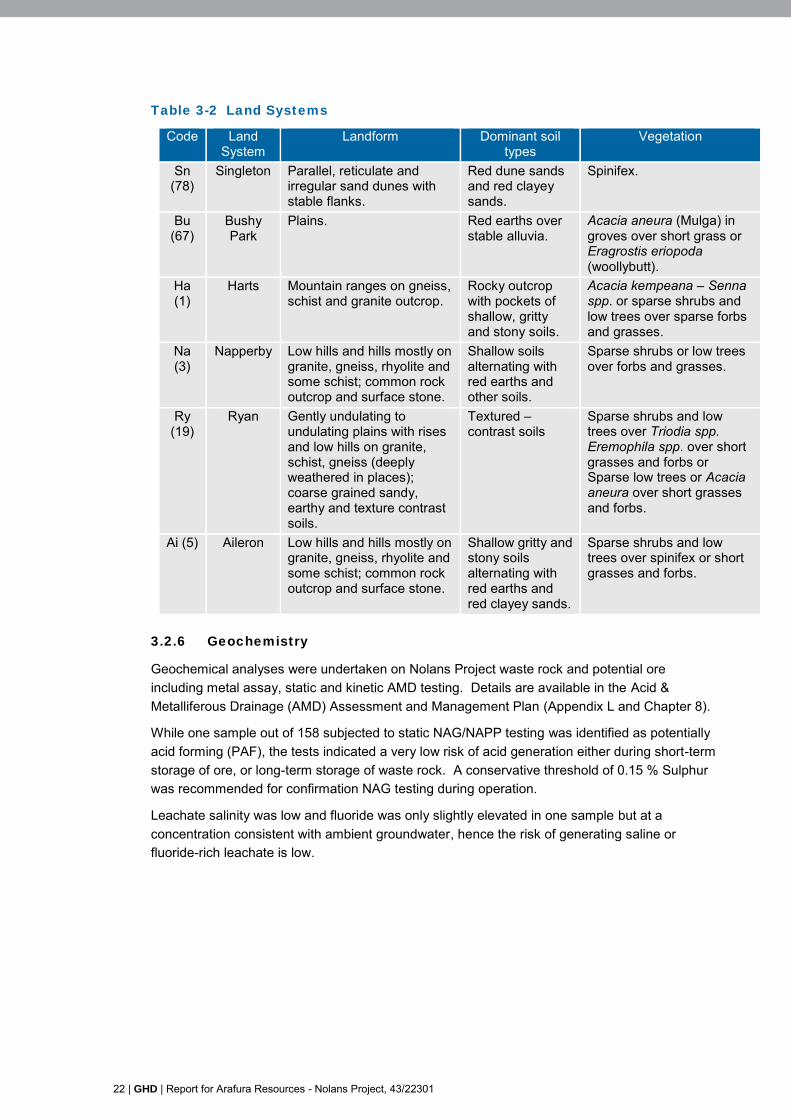
The Study area is covered by land system mapping of the Alice Springs area which has been completed at a scale of 1:1,000,000 as part of surveys carried out by the Division of Land Research and Regional Survey between 1956 and 1957 (Perry et al 1962).
A total of six land systems have been mapped across the Study area. The majority of the area is covered by two land systems, the Napperby system which is characterised by sparse shrubs or low trees over forbs and grasses and the Bushy Park system which primarily consist of mulga plains on red earths.
Table 3-2 provides a summary of the land systems that have been mapped within the Study area along with their typical landform, soil descriptions and general vegetation (Perry et al 1962).
22 | GHD | Report for Arafura Resources - Nolans Project, 43/22301
Table 3-2 Land Systems
Code Land System
Landform Dominant soil types
Vegetation
Sn (78)
Singleton Parallel, reticulate and irregular sand dunes with stable flanks.
Red dune sands and red clayey sands.
Spinifex.
Bu (67)
Bushy Park
Plains. Red earths over stable alluvia.
Acacia aneura (Mulga) in groves over short grass or Eragrostis eriopoda (woollybutt).
Ha (1)
Harts Mountain ranges on gneiss, schist and granite outcrop.
Rocky outcrop with pockets of shallow, gritty and stony soils.
Acacia kempeana – Senna spp. or sparse shrubs and low trees over sparse forbs and grasses.
Na (3)
Napperby Low hills and hills mostly on granite, gneiss, rhyolite and some schist; common rock outcrop and surface stone.
Shallow soils alternating with red earths and other soils.
Sparse shrubs or low trees over forbs and grasses.
Ry (19)
Ryan Gently undulating to undulating plains with rises and low hills on granite, schist, gneiss (deeply weathered in places); coarse grained sandy, earthy and texture contrast soils.
Textured –contrast soils
Sparse shrubs and low trees over Triodia spp. Eremophila spp. over short grasses and forbs or Sparse low trees or Acacia aneura over short grasses and forbs.
Ai (5) Aileron Low hills and hills mostly on granite, gneiss, rhyolite and some schist; common rock outcrop and surface stone.
Shallow gritty and stony soils alternating with red earths and red clayey sands.
Sparse shrubs and low trees over spinifex or short grasses and forbs.
3.2.6 Geochemistry
Geochemical analyses were undertaken on Nolans Project waste rock and potential ore including metal assay, static and kinetic AMD testing. Details are available in the Acid & Metalliferous Drainage (AMD) Assessment and Management Plan (Appendix L and Chapter 8).
While one sample out of 158 subjected to static NAG/NAPP testing was identified as potentially acid forming (PAF), the tests indicated a very low risk of acid generation either during short-term storage of ore, or long-term storage of waste rock. A conservative threshold of 0.15 % Sulphur was recommended for confirmation NAG testing during operation.
Leachate salinity was low and fluoride was only slightly elevated in one sample but at a concentration consistent with ambient groundwater, hence the risk of generating saline or fluoride-rich leachate is low.

GHD | Report for Arafura Resources - Nolans Project, 43/22301 | 23
Based on the geochemical characterisation completed on the ore and waste rock, seepage could contain elevated concentrations of some metals. Some samples consistently exceeded ANZECC & ARMCANZ (2000) Freshwater Aquatic Ecosystems 95% threshold and ambient groundwater concentrations, however all leachate samples were within ranges acceptable for stock watering, where guidelines are given in ANZECC & ARMCANZ (2000), including those for uranium and gross alpha and beta radiation, based on the total thorium and uranium content.
3.2.7 Groundwater
Groundwater bodies
Regionally, the Nolans mine site is located within the basement rocks on the southern margin of the Ti-Tree Basin and the northern margin of the Whitcherry Basin (part of the ‘Southern Basins’). Whilst the two basins are considered to be connected through the Margins Area to the southeast, the basement rocks result in a major groundwater divide with groundwater flowing north of the divide to the Ti-Tree Basin and south of the divide to the Southern Basins.
At the pit location a localised aquifer associated with the orebody and mineralisation extent is surrounded by much lower permeability rocks. The localised aquifer will be dewatered and the pit is predicted to behave as a long term permanent groundwater sink. This sink is modelled to influence basement rocks adjacent to the pit with minor drawdowns extending into the nearby basins in the very long term (during the 1000 year modelled closure period).
The processing site is on the north-eastern margin of the Southern Basins. The borefield is located in the Southern Basins and will result in drawdowns that are not anticipated to rebound in the short term but rebound due to natural recharge over a period of hundreds of years.
Water Resources
The Nolans mine site lies within the south-western fringe of the Ti-Tree Water Control District. The Woodforde River passes through the western margins of the Ti-Tree Basin which is about 20 km down gradient of the Nolans site.
Groundwater is abstracted for stockwater from the Southern Basins, the Ti-Tree Basin and from the basement rocks. Drinking water is supplied from groundwater to a number of communities in the wider region including Ti-Tree (54 km to north of the Nolan bore), Pmara Jutunta (46 km northeast of Nolan bore), Laramba (50 km to the west of the Nolan bore) and Alyuen (3 km to the south of the Aileron roadhouse). About 40 km to the northeast, groundwater is abstracted from Ti-Tree Basin aquifer for irrigation (for horticulture and viticulture).
Additional information relating to groundwater is contained in Appendix K.
Groundwater Quality
Baseline groundwater quality data has been obtained from the results of tests carried out during previous installation of stock water supply bores in the immediate vicinity of the Project. As shown in Table 3-3 the quality of groundwater at the Nolans site is very poor due to mineralisation.

24 | GHD | Report for Arafura Resources - Nolans Project, 43/22301
Table 3-3 Groundwater quality data
Analyte RN 016815
RN 013647
RN 011769
RN 010759
RN 012624
units
Location On southern boundary of mine
site
On southern boundary of mine
site
Within mine site
8 km to north of Nolans
site
8 km to north of Nolans
site
-
Bore depth 42 36 51 50 30.5 mBGL pH 8.2 7.4 8.1 8.9 8.5 -
Total Dissolved Solids
2570 2510 1960 2290 2510 mg/L
Conductivity 4300 4110 3100 3590 4850 μS/cm Sodium Chloride 1390 1231 783 976 1121 mg/L
Sodium 765 662 515 765 805 mg/L Chloride 842 747 475 592 680 mg/L Sulphate 360 264 295 310 345 mg/L Nitrate 8 13 70 57 81 mg/L
Bicarbonate 989 1056 811 696 897 mg/L Fluoride 3.4 3.6 4.8 4.4 3.7 mg/L
Carbonate - - - 96 17 mg/L Total Alkalinity (as
Ca CO3) 811 866 665 731 764 mg/L
Total Hardness (as Ca CO3)
522 612 523 205 311 mg/L
Potassium 30 49 33 46 51 mg/L Calcium 20 76 42 13 26 mg/L
Iron (total) 0.1 0.1 1.9 1.5 5.4 mg/L Silica 67 82 71 48 <1 mg/L
Magnesium 115 103 102 42 60 mg/L
3.2.8 Seismicity
A preliminary seismic hazard assessment has been carried out for the Nolans Project using existing data, from Geoscience Australia. Seismic ground motion parameters have also been determined for the Nolans site.
The data indicate that 11 earthquakes occurred within 200 km of the site with earthquake magnitude in the range of M (magnitude) 3.0 to 4.8 between June 1968 and November 2013.
The M4.8 event occurred within 38.0 km of the Nolans site on 3 August 1968. A M6.7 earthquake occurred 315.6 km north in January 1988.
Based on a probabilistic seismic hazard model for the Nolans site using the EZ-FRISK (Risk Engineering, Inc., 2011), a Maximum Credible Earthquake of M6.65 occurring within 136 km, at a depth of 15 km and causing peak ground acceleration (PGA) of 0.053 g could occur.
3.3 Biological Environment
3.3.1 Flora and Vegetation Communities
Vegetation is predominantly mulga and other acacia woodlands with short grasses and forbs, and spinifex grasslands.
GHD | Report for Arafura Resources - Nolans Project, 43/22301 | 25
A total of 14 vegetation communities were identified within the study area (Appendix M and Chapter 9). These vegetation communities each display a degree of variation which is to be expected given the influence of differing geology, soils, hydrology, fire regimes and grazing pressures. Despite these variations these communities have been defined based on similarities in landscape position, floristics, vegetation structure and patterns.
The dominant vegetation types within the study area are mulga shrublands, which occur on alluvial fans and plains containing clayey red earths, and triodia hummock grasslands which grow on sandy plains. Riparian areas are dominated by red gum (Eucalyptus camaldulensis) woodland and localised occurrences of bean tree (Erythrina vespertilio) and ghost gum (Corymbia aparrerinja) along Kerosene Camp Creek. Vegetation across the study area is generally in good condition with little anthropologic disturbance and high species richness.
A map of the Nolans site vegetation communities is presented in the EIS flora and fauna technical reports (Appendix M and Appendix N).
3.3.2 Fauna
The native vegetation across the Nolans site can be broadly grouped into six fauna habitat types:
Mulga woodland
Spinifex-dominated grassland on sandplain
Rocky rises
Acacia and mallee shrubland/woodland
Riparian woodland
Non-spinifex grassland (occasionally with sparse open woodland).
Three of these habitats mulga woodland, spinifex grassland sandplain and rocky habitats dominate. Overall, mulga woodland was the most species rich of the fauna habitats. This species richness was influenced by a high diversity of mammals and birds.
Mammals
Studies undertaken for the EIS (Appendix N and Chapter 9) identified 25 native and five non-native mammal species within the Nolans site. Four of these are listed as threatened species and two, Black-footed Rock-wallaby (Petrogale lateralis) and Brush-tailed Mulgara (Dasycercus blythi), are listed as Vulnerable under the EPBC Act. These and two further species, Spectacled Hare-wallaby, (Lagorchestes conspicillatus) and Northern Nailtail Wallaby (Onychogalea unguifera), are also listed as Near Threatened or Vulnerable under the Northern Territory’s Territory Parks and Wildlife Conservation (TPWC) Act.
Birds
Across both surveys, 103 native bird species were identified within the Nolans site. Four are currently listed as Near Threatened under the TPWC Act. These are two large ground birds (Australian Bustard, Ardeotis australis, and Emu, Dromaius novaehollandiae), one small ground bird (Bush Stone-curlew, Burhinus grallarius), and one pigeon (Flock Bronzewing, Phaps histrionica).
Of the 121 bird species recorded historically in the area (1,416 records in total), 44 of them (36.4%) have been recorded ten times or more. This suggests a relatively low level of bird survey effort (or recorded effort) across the region, but it also reflects the sparse and nomadic nature of many bird species across arid habitats, particularly as seasonal conditions change habitats.

26 | GHD | Report for Arafura Resources - Nolans Project, 43/22301
Reptiles
Across both surveys, 41 native reptile species were identified within the Nolans site. One reptile, the Great Desert Skink (Liopholis kintorei), was recorded in 2015 and is currently listed as Vulnerable EPBC Act and Vulnerable TPWC Act.
Of the 44 reptiles recorded historically in the area (146 records in total), 29 of them (65.9%) have been recorded twice or less, and 22 (50%) have been recorded only once. Only nine reptile species (20.5%) have been recorded five times or more. This indicates that many of the reptile observations are likely to have been from targeted reptile surveys. However, the most-common-reptile list includes none of the larger, more obvious or more iconic species (e.g. Bearded Dragon, Black-headed Python, Thorny Devil), which suggests that many observations of more common fauna have not been included in the records.
Frogs
Three native frog species were identified within the Nolans site. No frog species that are known to occur in the vicinity of the Nolans site are currently listed as threatened species.
Invertebrates
Invertebrates are poorly known fauna. No invertebrate species are included in the DLRM list for the Nolans site. However, one species of snail listed as threatened under the TPWC has the potential to occur. Of the 17 mammals recorded historically in the area (90 records in total), three of them have been recorded only once, and a further four have been recorded only twice. Only eight mammal species have been recorded five times or more. This indicates a relative lack of survey for mammals across the area.
3.3.3 Introduced plants
A total 14 introduced plant species were recorded during the field survey (Table 3-4). With the exception of Buffel Grass (Cenchrus ciliaris), these species occurred in low abundance across the Study area.
One of these species Caltrop (Tribulus terrestris) is listed as a Class B (spread must be controlled) and Class C (not to be introduced to the NT) noxious weeds under the WM Act. Caltrop is a spreading annual or bi-annual herb. It is likely that this species is spread by cattle and vehicle movement.
Buffel Grass was recorded predominantly within floodplain and riparian vegetation types and in areas that have been disturbed by cattle and/or by mining exploration. A significant environmental weed due to its ability to alter the species composition and structure of plant communities by outcompeting native taxa, it can also lead to increased fire severity by rapidly accumulating combustible biomass and rapidly re-sprout after fire and to burn again. Alluvial plains, calcareous landforms and riparian vegetation zone communities are also particularly susceptible to invasion.
Within the Study area, Buffel Grass was mostly restricted to preferred habitat within alluvial plains and riparian drainage lines. It was also abundant in disturbed areas within other vegetation communities, adjacent tracks, cattle yards, the Northern Territory Gas Pipeline, mineral exploration areas and creek banks.
Table 3-4 Exotic species recorded within the Study area
Common Name Scientific Name Legislative status (WM Act)
Caltrop Tribulus terrestris s.lat. Listed as a Class B and Class
C Noxious Weed Cobblers Pegs Bidens bipinnata Not listed

GHD | Report for Arafura Resources - Nolans Project, 43/22301 | 27
Buffel Grass Cenchrus ciliaris Not listed Purple-top Chloris Chloris barbata Not listed
Rhodes Grass Chloris virgata Not listed Paddy Melon Citrullus lanatus Not listed Couch Grass Cynodon dactylon var. dactylon Not listed
Summer Grass Digitaria ciliaris Not listed Pitted Lovegrass Eragrostis barrelieri Not listed
Eragrostis trichophora Not listed Lovegrass Eragrostis minor Not listed
Malvastrum Malvastrum americanum Not listed Mimosa Bush Vachellia farnesiana var. farnesiana Not listed Milk Thistle Sonchus oleraceus Not listed
3.4 Socio-economic and Cultural Environment
3.4.1 Socio-Economic conditions
Traditional owners of the land on which the project will operate are Anmatjere people, with senior traditional owners living in the Alyuen, Ti Tree, Pmara Jutunta (Six Mile) and Laramba communities and further afield in places such as Alice Springs.
Some existing communities are stable, functional communities with a better employment history and relatively little conflict. Elsewhere there may be tensions between local groups of people, particularly in communities with mixed populations, and tensions over how to resolve social and health issues.
Remote Territory communities continue to reflect poorly against the key global determinants of physical and social health, and these impact on school attendance and employment, within these communities. The poor health status of Aboriginal Territorians has the potential impact on people’s ability to work and the potential to improve health outcomes through an improved standard of living and workplace programs.
Despite this, Anmatjere people still have strong ties to their land, water and culture and speak their traditional languages at home and traditional owners retain strong cultural authority. Knowledge of special sites on the country around Aileron and knowledge about plants, animals and hunting sites in the area has been retained in spite of the many disruptions to traditional Aboriginal culture and way of life due to early pastoral settlement.
Services and community infrastructure is provided primarily by the Northern Territory Government and Central Desert Regional Council, including policing, health and education, municipal services to communities in the local area around the Project as well as major infrastructure such as utilities, roads and telecommunications (Appendix S).
Ti Tree includes the local office and workshops of Central Desert Regional Council, school, health centre, police station, women’s shelter, a park, oval, and air strip. Other services include outback stores, roadhouse and caravan park and Desert Farm run by a Church group. Ti Tree is largely surrounded by an Aboriginal Land Trust land.
Pmara Jutunta (Six Mile) is connected to Ti Tree’s power and water supplies. Some houses were upgraded as part of the Strategic Indigenous Housing and Infrastructure Program but the level of overcrowding constrains any population increase. The community accesses jobs and community services in Ti Tree, including policing and education. Children commute from Pmara Jutunta to school in Ti Tree by bus and some residents drive to work in Ti Tree.
Nturiya (Ti Tree Station) has few services apart from reticulated water and electricity, a road to Ti Tree and school bus services.

28 | GHD | Report for Arafura Resources - Nolans Project, 43/22301
Laramba include a school, health clinic, stores at Laramba and Napperby Station, a Church, women’s centre, laundry, childcare centre, recreational facilities, and Community Development Program facility run by Central Desert Regional Council. There is an air strip half way between Laramba and Napperby Station.
Alyuen community has suffered from water stress which has reportedly led to families moving to Pmara Jutunta (Six Mile) or camps around Ti Tree. The community was recently connected to a better water supply by Central Desert Regional Council following the discovery of the groundwater resources within the Southern basin by Arafura Resources. Infrastructure improvements currently being considered include a community garden, permanent health facilities for visiting nurses from Ti Tree and a central laundry and ablutions block. Because Alyuen is an outstation, services are provided by Central Desert Regional Council and Department of Community Services.
3.4.2 Heritage
Archaeological assessment (Appendix U) identified a number of historic and cultural heritage items. None of the historic sites will be impacted by the Project, however some the cultural sites will be affected and disturbed. Aboriginal site features include artefact quarries, scarred trees, grinding surfaces, reduction areas, and a rockshelter, potential habitation structure, and an engraving.

GHD | Report for Arafura Resources - Nolans Project, 43/22301 | 29
4. Closure obligations and commitments
4.1 Legislation and Guidance
Table 4-1 summarises the requirements of the key legislation and guidance relevant to the MCP.
Table 4-1 Relevant Legislation and guidance
Reference Relevance to this Pan
Legislation
Environmental Assessment Act 1992
The Nolans Project requires an assessment at the level of Environment Impact Statement.
EIS Terms of Reference (ToR) were issued by NT EPA in May 2015. In summary, these require:
A risk based assessment of potential post closure impacts Draft MCP A Care and Maintenance Plan for unexpected temporary
closure.
Section 5.12 of the ToR sets out specific requirements for the MCP.
Mining Management Act 2012
This Act regulates mining operation in the Territory. As a new mining project, Nolans Project is subject to the MMA. The Act requires an appropriate level of environmental management during closure.
This MCP is part the Mine Management Plan and is the first iteration of the plan for closure as required under the Act, although the plan will be reviewed and updated throughout the life of the mine.
A Rehabilitation Security Bond will be required for the Nolans Project. Closure criteria have been developed as part of this MCP and are set out in Section 6.3.
A Certificate of closure will be required based on achievement of closure criteria.
Rehabilitation and Closure Requirements for the Extractive Industry (NT DME 2015)
An advisory note outlining the minimum rehabilitation and closure requirements for the extractive industry.
Environment Protection and Biodiversity Conservation Act 1999 (Commonwealth)
A referral was made to the Commonwealth Government in February 2015. In March 2015 the Commonwealth Minister for Environment responded to the referral, determining that the Nolans Project was a Controlled Action under the EPBC Act and that it will be assessed under a bilateral Agreement with the Northern Territory Government. Therefore, the Environmental Assessment Act 1992 Terms of Reference discussed above cover the specific EPBC requirements.
Australian Radiation Protection and Nuclear Safety Act 1998
National Standard for Limiting Occupational Exposure to Ionizing Radiation (ARPANSA, 2002)

30 | GHD | Report for Arafura Resources - Nolans Project, 43/22301
Reference Relevance to this Pan
Guide to Radiation Protection and Radioactive Waste Management in Mining and Mineral Processing (the code) (ARPANSA)
Recommendations for Limiting Exposure to Ionizing Radiation.
Guidance
Guidelines for Preparing Mine Closure Plans (Western Australia Department of Mines and Petroleum 2015)
The Northern Territory Department of Mines and Energy published guidelines on ‘Mine Closure and Completion’ and ‘Mine rehabilitation’ in November 2006. We understand that these documents have been withdrawn and are being updated.
In the absence of NT guidelines, the Western Australia ‘Guidelines for Preparing Mine Closure Plans, May 2015’ are used for this MCP.
The content and scope of this MCP follows the requirements of the WA guidelines. The structure prescribed in the WA guidelines has been used to guide the structure of this document.
Code of Practice and Safety Guide -Radiation Protection and Radioactive Waste Management in Mining And Mineral Processing (ARPANSA 2005)
Provides guidance on the safe management of radioactive materials during the operation and closure of mining and mineral processing activities.
The International Atomic Energy Agency (IAEA) has also published guidelines on sustainable development principles (IAEA 2009) and best practice principles (IAEA 2010) specific to uranium mining, based on global experience.
Designing and planning for closure through an integrated and iterative process is a key to sustainable development (IAEA 2009, section 2).
Strategic Framework for Mine Closure (ANZMEC 2000)
Presents a high level framework for the development of Mine Closure Planning. This MCP falls within this framework.
Leading Practice Sustainable Development Program for the Mining Industry – Mine Closure and Completion (DRET, 2006)
Guidance and Case Studies on sustainable approaches to Mine Closure across Australia.
Environmental Notes on Mining, (Western Australia Department of Mines and Petroleum updated September 2009)
The Care and Maintenance Plan is required as part of this MCP (Appendix A) for which a framework has been provided. The Care and Maintenance Plan will be provided once the project has received approval and prior to mining commencing. The plan will be informed by the requirements and advice within this guidance note ‘Guidance and requirement for Care and Maintenance Plans’.
TEAM NT: Technologies for the Environmental Advancement of Mining in the Northern Territory
Guidance and discussion of challenges specific to mining and mine closure in the Northern Territory.

GHD | Report for Arafura Resources - Nolans Project, 43/22301 | 31
Reference Relevance to this Pan
Toolkit (NTMC and DMPM, 2004)
Mine Close-out Objectives, Life of Mine Planning Objectives. NT DME 2006
Sets out general requirements for setting Closure objectives for mines in Northern Territory.
4.2 Obligations and Commitments
To date no commitments have been made by Arafura to third parties in relation to the closure of the Nolans Project.
Activities during Closure will be subject to specific commitments made during the approvals process, and obligations and conditions resulting from the approval process and any subsequent regulatory requirements.
As the Nolans Project proceeds through the approval process and into construction and operation, a Commitments and Obligations Register will be prepared and maintained which will record progress towards their fulfilment.
32 | GHD | Report for Arafura Resources - Nolans Project, 43/22301
5. Stakeholder consultation
Stakeholder consultation is described in detail in Appendix H and Chapter 6 of the EIS. Consultation activities have been undertaken between 2007 and 2015, by and on behalf of Arafura.
5.1 Stakeholder Engagement Strategy
A consultation and communication strategy was prepared to guide the environmental impact assessment process and provide a means for stakeholder feedback to be addressed in the EIS.
The information and feedback collated during the consultation process has fed into the social impact assessment (described in Appendix S) and the social impact management sub plan (SIMP) in Appendix X.
The SIMP outlines strategies for ongoing community engagement and communication to maintain relationships and keep the community informed, particularly once the company makes a decision to proceed with the project.
Consultation activities were conducted with the following key groups:
Government departments, agencies and regulators
Central Desert Regional Council
Central Land Council (CLC)
Aboriginal communities and traditional owners
Alice Springs Town Council
Arid Lands Environment Centre
Non-Government organisations such as NT Shelter, Waltja Tjutangku Palyapayi and the Multicultural Community Services of Central Australia
Aileron Roadhouse
Pastoralists
Various business entities including Chamber of Commerce, local businesses, other mining companies, employment and training services providers
Environmental groups in Darwin and Alice Springs.
5.2 Stakeholder Consultation and Engagement Register
The Mine Closure Plan will include a register of stakeholders consulted and engaged as part of the development and execution of closure and rehabilitation activities. This register will be a subset of the Nolans Project Stakeholder Register.

GHD | Report for Arafura Resources - Nolans Project, 43/22301 | 33
6. Post-closure land uses, objectives and
criteria
6.1 Closure and Rehabilitation Objectives
The objectives of mine closure and rehabilitation are:
To establish a safe and stable post-mining land surface which supports vegetation growth over the long-term
To return the land, as close is reasonably practical, to its pre-disturbance land use
To make the site suitable for future leaseholders likely uses for the site.
6.2 Post Closure Land Uses
6.2.1 Approach
The Northern Territory Department of Mines and Energy (DME) requires that a post mining land use is ‘discussed with all stakeholders and agreed to by the Department’, and that ‘this should be recorded in the earliest planning documentation for the site’.
The final, post-closure land use will be developed and refined through the operating life of the mine. Various factors will influence its development:
Consultation with stakeholders as discussed in Section 5
A Post-Closure Land-use Alternatives Assessment undertaken in parallel with consultation
Emerging knowledge of the nature of the deposits, and the composition and quantity of waste products
Any future changes to mine design.
6.2.2 Preliminary Post-Closure Land Uses and Target Ecosystems
An initial step to developing preliminary post-closure land uses for each of the domains are proposed in Table 6-1.
Post closure land use must be balanced with the target ecosystems and pre-mining landuse identified in the EIS flora and fauna technical reports (Appendix M and appendix N).
Targets for ecological rehabilitation will be native flora species with a preference for local providence flora species.
The target ecosystems will evolve with the post-closure rehabilitation planning and the results of re-vegetation trials.
Table 6-1 Preliminary Post-Rehabilitation Land Uses and Target Ecosystems
Domain Current Land Use
Proposed Closure Land Use Target Ecosystem
Pit and haul
Road
Cattle grazing Open pit and pit lake.
No viable use. Pit access to remain restricted.
N/A

34 | GHD | Report for Arafura Resources - Nolans Project, 43/22301
Domain Current Land Use
Proposed Closure Land Use Target Ecosystem
Run of Mine
(ROM)
concentrator
plant
Cattle grazing Livestock grazing. Vegetation communities as mapped in EIS flora and fauna technical reports (Appendix M and appendix N) as far as practicable.
WRDs Cattle grazing Livestock grazing. Optimum native vegetation community to secure slope stability and prevent erosion.
TSF Cattle grazing Native grassland habitat.
Optimum native vegetation community to secure slope stability, prevent erosion and preserve integrity of cover system.
Processing
Plant, power
and H2SO4
plant
Cattle grazing Livestock grazing. Vegetation communities as mapped in EIS flora and fauna technical reports (Appendix M and appendix N) as far as practicable.
Residual
storage
facilities
(RSFs) and
evaporation
pond
Cattle grazing Native grassland habitat.
To minimise erosion of the cover systems livestock will be prevented from grazing on the RSF.
Optimum native vegetation community to secure slope stability, prevent erosion and preserve integrity of cover system.
Administration
offices and
maintenance
Cattle grazing Cattle grazing. Vegetation communities as mapped in EIS flora and fauna technical reports (Appendix M and appendix N) as far as practicable.
Infrastructure Cattle grazing
Cattle grazing.
Roads and fences retained if agreed through stakeholder consultation.
Vegetation communities as mapped in EIS flora and fauna technical reports (Appendix M and appendix N) as far as practicable.
Accommodati
on village
Cattle grazing Cattle grazing.
Vegetation communities as mapped in EIS flora and fauna technical reports (Appendix M and appendix N) as far as practicable.
Exploration
tracks and
holes
Cattle grazing Cattle grazing. Vegetation communities as mapped in EIS flora and fauna technical reports (Appendix M and appendix N) as far as practicable.
GHD | Report for Arafura Resources - Nolans Project, 43/22301 | 35
6.3 Completion Criteria
The completion criteria provide a means of evaluating the successful achievement of the closure objectives (described in Section 6.1).
Ideally these should be SMART (specific, measurable, attainable, relevant and timely) and, once agreed, set the conditions on which the relinquishment of the Nolans site can take place.
The level of detail of completion criteria should be appropriate to the stage of development. This conceptual closure plan is submitted pre-approval and further detail and definition will be added to the criteria during Project design, construction and during operations.
In agreement with the regulators, the criteria may be reviewed and amended in response to operational and post-closure management and monitoring programmes.
The preliminary Completion Criteria are listed in Table 6-2.
6.4 Performance Indicators
In the first post commencement version of the MCP, specific performance indicators will be determined to demonstrate that rehabilitation trends are following the predicted performance, particularly where mathematical modelling is utilised to predict any long term environmental impact.

36 | GHD | Report for Arafura Resources - Nolans Project, 43/22301
Table 6-2 MCP Completion Objectives and Criteria
Objective Criteria Measurement Compliance
Nolans Project meets all binding conditions and commitments relevant to rehabilitation and closure.
Register of compliance with legal requirements is prepared and updated annually and records no non-compliances.
Audit of compliance with legal requirements.
Stakeholder and Social issues
Post-mining land use is agreed with stakeholders.
Closure design employs agreed landforms, land- uses and closure performance criteria.
Stakeholder engagement records.
Post-mining land use corresponds to that agreed with stakeholders.
Final rehabilitated land use conforms to that agreed with stakeholders.
As built plans; and Stakeholder engagement records.
Condition of heritage and archaeological sites meets the requirements of relevant authorities.
Heritage or archaeological features are not removed as part of construction or operation and remain undisturbed.
Cultural Heritage survey on closure.
Decommissioning and Closure
A safe workplace is provided for all personnel engaged in decommissioning, closure and rehabilitation activities.
A safety management system covers all activities associated with decommissioning, closure and rehabilitation and records no non-conformances.
Safety Management System Audit.
Areas disturbed during mineral exploration are rehabilitated.
Rehabilitation of all exploration sites with all holes capped, drill pads rehabilitated, cuttings removed or buried and tracks revegetated.
Rehabilitation monitoring

GHD | Report for Arafura Resources - Nolans Project, 43/22301 | 37
Objective Criteria Measurement
Risk of impacts to human health, livestock and ecosystems on the site from closure activities are reduced to an acceptable level.
All waste materials (including litter) are either disposed off-site at a licenced facility or securely managed on-site according to the Waste Management Plan.
Waste tracking documentation for regulated wastes removed from site
Audit of on-site waste management.
All drill holes, shafts, open pits and other openings are securely capped, filled or otherwise made safe.
Final inspection by regulator.
Hazardous sites (e.g. the pit, TSF and RSF) are fenced, clearly signposted and bunded where appropriate.
As built fencing plans.
All slopes and rock faces are stable. Geotechnical stability assessment.
All contamination is identified and contained or remediated as agreed with the authorities.
Post remediation soil survey Final inspection by regulator.
Radiation levels are such that they are consistent with pre-operational levels.
All sources of radioactivity are decontaminated, removed or encapsulated such that levels of radioactivity on-site are consistent with pre-mining levels.
Post remediation radiation survey; and Final inspection by regulator.
All facilities and equipment are safely decommissioned, demolished and removed unless they are to remain for an agreed future use.
Final site inspection by regulator.
Waste disposed on-site is securely contained to prevent impacts on human health and ecology.
Waste rock, tailings and residues, and any other waste storage facilities (e.g. solid waste landfills) with potential for environmental impact have been managed appropriately.
Inspection and audit of environmental performance throughout operation.
Design and performance of systems to prevent air and water ingress/egress and to contain hazardous materials are approved by regulators.
Written approval of waste storage designs from regulator
Audit of approved designs and specifications.

38 | GHD | Report for Arafura Resources - Nolans Project, 43/22301
Objective Criteria Measurement
As built containment systems conform to approved designs. Inspection and audit of rehabilitation works during and after construction
As built drawings. Landscape and ecological rehabilitation
All final landforms are safe and stable.
Landform designs to provide long-term geotechnical stability and safety and are approved by regulators.
Written approval of landform designs from regulator Audit of approved designs and specifications.
As built landforms conform to approved designs. Inspection and audit of rehabilitation works during and after construction
As built drawings.
Rehabilitated landforms minimise visual impact.
Landforms are visually compatible with surrounding natural landforms, in terms of form, gradient, soil and vegetation cover.
Visually consistent with surrounding topography.
WRDs have a maximum height of 50 m. Inspection and audit of rehabilitation works during and after construction
As built drawings.
Landform surfaces are stable. Landform height, gradient and slope length are designed to minimise potential for erosion and final surface materials and treatments match the characteristics of the slope.
Erosion modelling Drainage design Audit of approved designs and specifications for final
surface profiles and surface treatments.
Post closure wind and water erosion rates are at least comparable with background levels of the area.
Regular monitoring of: o Topsoil depth o Vegetation cover, Drainage performance and
Water erosion (rill and gully assessment) o Visual assessment of sediment and dust
deposition.

GHD | Report for Arafura Resources - Nolans Project, 43/22301 | 39
Objective Criteria Measurement
Surface material properties will not inhibit the development of the target ecosystem.
Landform designs include a suitable growth medium or surface cover.
Audit of approved designs and specifications.
Chemical properties of soil do not limit revegetation. Rehabilitation vegetation monitoring and assessment Chemical soil testing.
Rehabilitated ecosystem is able retain water and nutrient resources.
Rehabilitation monitoring and assessment.
Rehabilitated ecosystem has equivalent values, functions and resilience as the target ecosystem.
Nolans site recolonised by previously existing fauna communities.
Camera surveys of fauna populations.
Revegetation uses locally sourced seeds at the optimum mix for successful establishment and representativeness of target ecosystem.
Records of planting trials Audit seed list.
Self-sustaining vegetation cover is successfully re-established on disturbed areas.
Rehabilitation vegetation monitoring and assessment.
Rehabilitated vegetation community species composition and diversity, density and structure are representative of the target ecosystem.
Rehabilitation vegetation monitoring and assessment.
Weed populations do not restrict establishment of target ecosystem.
Weed surveys.
The rehabilitated landscape is compatible with the agreed final post-closure use.
As far as possible, post-closure watercourses have geomorphology and riparian communities consistent with those on site prior to development.
Post-closure drainage does not lead to flooding of pit or erosion of waste landforms during storm events.
Drainage can accommodate a 1 in 1000-year ARI wet year rainfall.
Flood modelling Flow monitoring Audit of approved designs and specifications for
drainage pathways and outflows including design flows.

40 | GHD | Report for Arafura Resources - Nolans Project, 43/22301
Objective Criteria Measurement
Landforms, including surface covers, designed with drainage pathways and outflows that manage surface drainage, including extreme rainfall events, erosion and sedimentation have been agreed with relevant stakeholders.
Record of consultation with stakeholders representing future land users.
Permanently unusable land is limited to the WRDs, TSF, RSF and mine pit footprints.
As built fencing plans.
Post Closure Emissions
Water quality leaving the site is generally consistent with pre-mining quality causing limited impact to the downstream beneficial use(s).
Sediment deposition downstream of the site consistent with baseline conditions.
Groundwater down gradient of the sites consistent with baseline conditions and groundwater site specific trigger values.
Annual sediment sampling Water erosion (rill and gully assessment) Groundwater sampling.
Levels of dissolved contaminants in runoff from Nolans site consistent with local background levels.
Surface water quality monitoring Flood modelling Flow monitoring.
Water levels in the pit always remain below surrounding groundwater levels, such that groundwater entering the pit only exits the pit lake through evaporation.
Groundwater monitoring including bore and pit level monitoring
Groundwater model validations Visual observations.
Disturbed areas will be progressively rehabilitated during operation.
Operational areas on site will be progressively. Mining programme Rehabilitation reports.
The pit lake does not present a hazard to human or ecological health.
Wildlife and livestock are prevented / deterred from using the pit lake as a water source.
Pit abandonment bund Visual wildlife monitoring.

GHD | Report for Arafura Resources - Nolans Project, 43/22301 | 41
Objective Criteria Measurement
Containment of waste materials left on-site prevents release of contaminants such that there is no deleterious effect on local land uses.
Dust composition downwind of Nolans site reflects background levels of radionuclides and other contaminants.
Dust quality and composition monitoring.
Long term sustainability
The landscape and integrity of waste storage landforms is retained through extreme future events such as flooding, bushfires and drought.
Research trials demonstrate the potential of the rehabilitation to regenerate following fire.
Success of post-fire regeneration.
Monitoring has confirmed the rehabilitation can survive one or more seasons of drought.
Qualitative assessment of vegetation health.
Radioactive and chemically hazardous material pose no long term threat to human or ecological health.
Containment of all waste stored on-site has long term resilience to erosion.
Regular monitoring: o Performance of capping materials and depth of
topsoil cover (i.e. evidence of topsoil erosion and loss)
o Vegetation cover species o Resilience integrity of constructed drainage o Erosion and silt accumulation in constructed
drainages o Net sediment loss rates tonnes/ha/year o Sediment quality o Runoff quality.
Design life of containment for radioactive contaminants is appropriate to decay of the material.
Radioactive Waste Management Plan (RWMP) will be prepared prior to mining which will cover decommissioning
Modelling of the cover systems and waste contaminant levels.
The location and details of any buried hazards remain clearly defined and marked in the long term.
Clear marking signage and record keeping lodged with authorities.

42 | GHD | Report for Arafura Resources - Nolans Project, 43/22301
Objective Criteria Measurement
There is no long term reduction in the availability of water to meet local environmental values or human uses, other than immediately adjacent to the pit.
Quality and availability of water at adjacent boreholes not reduced in long term.
Groundwater monitoring.
The site does not require continuing active management
No additional site surface water management required. Monitoring of water course condition Erosion rates Sediment quality.
Groundwater movements and dewatering will not impact on the potential post-mining land use and will pose no risk to livestock, irrigation or ecology following rehabilitation. Post mining groundwater quality is to be consistent with baseline conditions.
Groundwater monitoring Fauna monitoring at pit lake.
No additional land management is required to that of surrounding land uses.
Site inspection and audit of monitoring and management records to determine land management requirements.

GHD | Report for Arafura Resources - Nolans Project, 43/22301 | 43
7. Closure impacts and risks
7.1 Introduction
7.1.1 Risk Assessment Methodology
The risks associated with closure, rehabilitation and post mining land use were examined as part of a high level risk assessment undertaken for the Nolans Project (described in more detail in Chapter 5).
The risk assessment considered each domain individually with the inherent risks and hazards arising from the event identified by an assembled group of technical and mining specialists. This was later reviewed and edited by key technical specialists before issue and approval by Arafura Resources.
This process was completed in accordance with the requirements outlined in Australian Standard AS/NZS ISO 31000:2009 Risk Management and HB 436:2004 Risk Management Guidelines. Following the identification of measures to eliminate or mitigate the risks, the assessment was repeated for each risk to determine the ‘residual’ or ‘mitigated’ risk. Likelihood and consequence are determined and compared using a risk matrix to determine risk scores.
The descriptions of the likelihood and consequence categories used in the assessment can be found within Appendix C.
7.1.2 Key Closure Risks and Issues
Sections 7.1.2 and 7.2 are based on the Nolans Project risk assessment, with a detailed focus on closure and rehabilitation.
A summary of the closure related risks identified by the assessment and the domains to which each applies is presented in Table 7-1. This also describes the relationship of each to the Project Risk Assessment contained in the EIS document (Appendix F).
The section identifies the management measures to remove or reduce the risk but does not include monitoring, which is described in Section 9.

44 | GHD | Report for Arafura Resources - Nolans Project, 43/22301
Table 7-1 Summary of Closure Risks
Risk Section Relevant Risk in Project Risk
Register
Domain
Pit
an
d H
au
l R
oad
WR
D
Co
ncen
trato
r
TS
F
RE
In
term
ed
iate
s
Pla
nt
RS
F
Ad
min
an
d
Main
ten
an
ce
A
cco
mm
od
ati
on
Villa
ge
B
orr
ow
Pit
s
Infr
astr
uctu
re
Exp
lora
tio
n
Decommissioning and Closure
Unexpected early closure 7.2.1 77 x x x x x x x x x x x
Insufficient funds / bonds for closure activities 7.2.2 78 x x x x x x x x x x x
Operational practices make it difficult to manage waste facilities during closure
7.2.3 76 x x x x x
Insufficient cover material available on closure 7.2.4 76 x x
Ineffective closure designs and execution 7.2.5 78,79 x x x x x x x x x x x
Incomplete removal of infrastructure 7.2.6 80 x x x x x x x
Incomplete remediation of contaminated sites. 7.2.7 80 x x x x x x x x x x
Health and safety risks to personnel during closure 7.2.8 36,37 43-67 x x x x x x x x x x x
Environmental impacts from closure activities 7.2.9 7-11,14, 37 x x x x x x x x x x x

GHD | Report for Arafura Resources - Nolans Project, 43/22301 | 45
Risk Section Relevant Risk in Project Risk
Register
Domain
Pit
an
d H
au
l R
oad
WR
D
Co
ncen
trato
r
TS
F
RE
In
term
ed
iate
s
Pla
nt
RS
F
Ad
min
an
d
Main
ten
an
ce
A
cco
mm
od
ati
on
Villa
ge
B
orr
ow
Pit
s
Infr
astr
uctu
re
Exp
lora
tio
n
Landscape and Ecological Rehabilitation
Rehabilitation failure due to rehabilitation design / execution
7.3.1 78,79 x x x x x x x x x x x
Rehabilitation failure due to post-closure conditions 7.3.2 79,81 x x x x x x x x x x x
Weed infestations prevent achieving ecosystem targets for rehabilitation
7.3.3 7,36 x x x x x x x x x x x
Post-Closure Emissions
Seepage 7.4.1 20-22 x x x x
Contaminated runoff 7.4.2 1,6,34, 40 x x x x x x x x x x x
Dust 7.4.2 10, 70 x x x x
Radiation from post closure sources 7.4.4 71, 34 x x x x
Long-term Sustainability
Long term landscape instability 7.5.1 79,81 x x x

46 | GHD | Report for Arafura Resources - Nolans Project, 43/22301
Risk Section Relevant Risk in Project Risk
Register
Domain
Pit
an
d H
au
l R
oad
WR
D
Co
ncen
trato
r
TS
F
RE
In
term
ed
iate
s
Pla
nt
RS
F
Ad
min
an
d
Main
ten
an
ce
A
cco
mm
od
ati
on
Villa
ge
B
orr
ow
Pit
s
Infr
astr
uctu
re
Exp
lora
tio
n
Groundwater recharge rate is slower than expected 7.5.2 18,19 x x
Long term risks from hypersaline pit lake 7.5.3 28,32 x
Long term failure of containment of harmful substances / radionuclides
7.5.3 20-26 x x x
Stakeholder and Social Impacts
Public access to harmful areas of Nolans site during and post-closure
7.6.1 60 x x x x x x x
Failure to agree post closure land use 7.6.2 74,75 x x x x x x x x x x x
Failure to achieve approved post closure land use 7.6.3 79 x x x x x x x x x x x

GHD | Report for Arafura Resources - Nolans Project, 43/22301 | 47
7.2 Decommissioning and Closure
7.2.1 Unexpected early closure
Risk
Unanticipated events including falling commodity prices could result in unplanned closure before adequate closure and rehabilitation planning and design can take place. This may result in ineffective or incomplete rehabilitation, including:
Contaminated seepage
Loss of containment of hazardous materials
Failure to achieve proposed closure land uses and target ecosystems.
Control Measures
The following controls for unanticipated closures are proposed:
Plan and design for closure iteratively through operational life of mine (Section 8.2.1)
Prepare inventory and stockpiles of closure materials (topsoils, capping, clean waste rock) at start-up of operations and update regularly (Section 8.3.1)
Operate waste facilities to allow rapid closure (Section 8.3.6)
Design closure of waste storage conservatively so that closure concepts do not significantly change in the case of early closure (Section 8.3.6)
Prepare a Care and Maintenance Plan to cover temporary closures (Appendix A)
Undertake progressive rehabilitation (Section 8.4.1).
7.2.2 Insufficient funds / bonds for closure activities
Risk
Inadequate closure designs, poor assumptions or failure to recognise impact of changes to operations on MCP results in insufficient bonds or funds on closure causing delays to effective rehabilitation and potential ongoing environmental hazards.
Control Measures
The following controls are proposed:
Prepare closure costs based on conservative assumptions before operations commence
Develop closure costs iteratively through design and operational life of mine as discussed (Section 8.2.1) including issue of a first detailed closure cost estimate in the first year of operation
Agreed bond with NT Government and review annually.

48 | GHD | Report for Arafura Resources - Nolans Project, 43/22301
7.2.3 Poor operational practice makes it difficult to manage waste
facilities during closure
Risk
Failure of operational process (e.g. neutralisation prior to RSF disposal, maintenance of containment facilities, partitioning of radionuclides) leaves a legacy of difficult to manage waste facilities during closure resulting in:
Impacts associated with rehabilitation failure or post-closure emissions as discussed in Sections 7.3 and 7.4
Costly and complex remediation
Delays to effective rehabilitation
Cost overruns.
Control Measures
Achieving good quality waste management will depend on competent operational management personnel and management systems and the full implementation of the Mine Management Plan (Appendix X) in the operation of waste processes and facilities.
7.2.4 Insufficient cover material available on closure
Risk
The lack of availability of suitable low permeability material on site, or prohibitive cost of importing large volumes from elsewhere, prohibits the creation of proposed capping for TSF and RSF preventing long term stabilisation and containment of waste.
Initial geotechnical survey data (Lycopodium, 2010) indicates that sufficient material to create low permeability soil liners are not likely to be found on site given the sandy soil.
Control Measures
The following controls to deliver sufficient closure material are proposed:
Prior to the issue of the MCP, a survey of the mine site will be completed to prepare detailed inventory of closure material resources
Investigate technical measures such as scarification and re-compaction (Lycopodium, 2010) to create suitable materials on site
Explore nearby sources to identify quantities of suitable material
Incorporate material imports, including synthetic materials if required, into closure costs if necessary.
7.2.5 Ineffective closure design and execution
Risk
Closure not implemented satisfactorily due to:
Closure designs not being developed to sufficient detail or based on incorrect assumptions
Poorly managed execution of closure works.
This may result in the failure of post-closure landforms and waste containment, extensive cost overruns, delays to relinquishment, return of bond and damage to reputation.

GHD | Report for Arafura Resources - Nolans Project, 43/22301 | 49
Control Measures
The following controls to deliver effective closure design are proposed:
Use conservative assumptions and costing for concept closure designs as outlined in Section 2.2
Prepare detailed closure designs as part of iterative closure design development programme as discussed in 8.2.1
Ensure design of structures adhere to legal and good practice requirements (e.g. ANCOLD for TSF embankments).
The following controls to deliver effective closure execution are proposed:
Implement this plan as a framework for managing closure and rehabilitation phases
Prepare a closure materials balance based on the mine plan and closure design (Section 8.3.3)
Progressively rehabilitate landforms during operations, monitor performance and incorporate any feedback into later closure designs through field performance (Section 8.4.1).
7.2.6 Incomplete removal of infrastructure
Risk
Incomplete removal of equipment, structures, hardstand and concrete footings, buildings, water storages created health and safety hazards for future land users.
This may result in non-acceptance of closure and consequent cost overruns, delays to relinquishment, return of bond, and damage to reputation.
Control Measures
The following controls are proposed:
Pre demolition surveys of plant and infrastructure to be removed (Section 8.2.2)
Pre demolition contaminated land survey(Section 8.2.2)
Appointment of suitable demolition contractor
Investigate reuse, recycling and waste disposal for used plant (Section 8.3.8)
Audit of completion (Section 8.2.1).
7.2.7 Incomplete remediation of contaminated sites
Risk
Contamination resulting from operations is not remediated to an agreed level, resulting in:
Harm to the health of flora and fauna
Harm to public health including that of future land users
Failure of effective rehabilitation (Section 7.3.1).
This may result in extensive cost overrun, delays to relinquishment, return of bond and damage to reputation.

50 | GHD | Report for Arafura Resources - Nolans Project, 43/22301
Control Measures
To ensure suitable remediation of any ground contaminated by mining operations, a process of assessment, remediation planning and design will be implemented prior to closure. These are described in Section 8.3.2.
7.2.8 Health and safety risks to personnel during closure
Risk
Risk of impacts to health and safety of personnel while carrying out closure activities. The project risk assessment identifies potential operational hazards that may result in ill health, injury or death. Some of these will be applicable during the execution of closure and rehabilitation.
Control Measures
Prior to closure the updated safety management system will be reviewed and updated to include potential hazards and risks associated with closure activities. The approach to Health, Safety and Environmental Management during closure and rehabilitation are discussed in Section 8.3.7.
7.2.9 Environmental impacts from closure activities
Risk
Closure activities are poorly managed leading to impacts on local communities, flora, fauna, water resources, such as:
Noise and Vibration
Light
Dust
Unnecessary damage to vegetation
Spreading of weeds
Contamination of surface water or groundwater.
Control Measures
The Mine Management Plan is reviewed and updated annually to include potential impacts from closure activities. The approach to Health, Safety and Environmental Management during closure and rehabilitation are discussed in Section 8.3.7.
7.3 Landscape and ecological rehabilitation
7.3.1 Rehabilitation failure due to rehabilitation design / execution
Risk
Landscape and ecological rehabilitation fails to achieve sufficient vegetation to stabilise ground, allow proposed land uses or achieve target ecosystems, due to inappropriate design or execution of rehabilitation, including:
Inappropriate planting strategies, seed mix, cultivation methods, etc.
Inappropriate distribution of growth medium
Inappropriate landform design

GHD | Report for Arafura Resources - Nolans Project, 43/22301 | 51
Inappropriate construction of post-closure drainage (Section 7.3.4).
Control Measures
The following controls are proposed:
Prepare detailed rehabilitation designs as part of iterative closure design development programme as discussed in Section 8.2.1:
– Select plants and seed mix that are endemic to the area will ensure rapid colonisation and ensure species are suitable to present and future fire, drought and land use conditions
– Use sufficient growth medium or surface cover with suitable nutrients and organic content and with appropriate physical properties.
Develop programme of vegetation trials and create detailed a plan for revegetation prior to closure (Section 8.2.2)
Rehabilitate progressively through operational life, feeding back lessons learned into later rehabilitation activities (Section 8.4.1)
Design and implement stable post-closure drainage system to minimise erosion (Section 7.3.4).
7.3.2 Rehabilitation failure due to post-closure conditions
Risk
Landscape and ecological rehabilitation fails to achieve sufficient vegetation to stabilise ground, allow proposed land uses or achieve target ecosystems, due to extreme events or unsuitable post closure conditions, summarised in Table 7-2. Failure of rehabilitation could result in delays to relinquishment of Nolans site and associated cost overruns.
Table 7-2 Potential Environmental Causes of Post-Closure Rehabilitation
Failure
Potential Cause Description
Weed infestation Impacts of weed infestation on rehabilitation are discussed in Section 7.3.3.
Contaminated soil Contamination in soil resulting from incomplete remediation (Section 7.2.7) may prevent revegetation and reduce quality of runoff.
Water erosion Water erosion of soil / cover leads to failure of revegetation, elevated sediment loads in watercourses and potential dispersal of harmful materials.
Wind erosion Wind erosion of soil / cover leads to failure of revegetation, elevated dust emissions and potential dispersal of harmful materials.
Contaminated groundwater Contaminated groundwater results in vegetation impacts.
Groundwater loss Lowered water table results in decline in availability of water to ecosystems.
Bush fires and drought conditions
Loss of vegetation cover from bushfires or drought conditions could render post closure landforms more vulnerable to erosion.
Uncontrolled grazing by wildlife, pests or livestock
Unmanaged grazing by cattle or presence of feral animals such as rabbits or donkeys prevents successful establishment of vegetation.

52 | GHD | Report for Arafura Resources - Nolans Project, 43/22301
Post closure failure of waste storage facilities
Containment of tailings and waste residues stored on-site fails and releases contaminants that impact vegetation cover on rehabilitated sites.
Trees colonise on storage facilities (specifically RSF) breaching capping with root systems.
Control Measures
Measures to prevent post closure failure of waste storage are described in Section 7.2.3.
Measures to control weed infestations are discussed in Section 7.3.3.
Measures to protect groundwater resources are discussed in Section 7.5.2.
An Erosion and Sediment Control Plan (ESCP) will be developed for the closure and rehabilitation phase (Section 8.4.7).
Concept level closure and rehabilitation proposals that will include appropriate drainage and erosion control (Section 2.2) will employ conservative design and costing assumptions and develop iteratively as part of the closure design development programme discussed in 8.2.1.
Design and implement stable post-closure drainage system to minimise erosion (Section 7.3.4).
Post closure fire management is discussed in Section 8.4.8.
7.3.3 Weed infestations prevent achievement of ecosystem targets for
rehabilitation
Risk
Weed infestations created or exacerbated by operation or closure activities lead to failure in achieving ecosystem targets for rehabilitation.
Control Measures
The following controls are proposed:
Prior to closure, review and update the Weed Management Plan to incorporate specific control measures for managing weeds during closure and rehabilitation (Section 8.4.5)
Consult with future site owners / users (e.g. Aileron / Napperby Station leaseholders) in developing post-closure weed management regime.
7.3.4 Failure to achieve fauna habitat
Risk
Failure of fauna populations, including those of threatened species, to recover to pre-project levels following completion of closure due to:
Weed infestation (Section 7.3.3)
Increase in pest animal species (dingoes, cats, rabbits, foxes, rats, mice).
Control Measures
Measures to achieve ecosystem targets, limit harm to riparian environments, weed infestations, maintain surface water quality and prevent wind-borne dispersion of contaminants are discussed in their relevant sections.

GHD | Report for Arafura Resources - Nolans Project, 43/22301 | 53
The following controls for pest species are proposed:
Regularly review and update the Biodiversity Management Plan contained within the EIS (Appendix X). These updates are intended to incorporate specific control measures for closure and rehabilitation
Post closure monitoring of feral fauna species numbers around the Nolans site.
The following controls to prevent harm to fauna from the hypersaline pit lake are proposed:
Regularly monitor wildlife visitation to pit lake and apply suitable management response
Model and monitor long term behaviour of pit lake chemistry (Section 7.5.3).
7.4 Post Closure Releases and Emissions
7.4.1 Seepage
Risk
Following closure, contaminants from seepage result in site contamination, TSF, WRD and RSF causing deterioration in surface and groundwater quality.
As discussed in Section 3.2.6 and 3.2.7 monitoring indicates that ambient groundwater quality is low. There is no permanent surface water drainage on site.
Geochemical analysis described in the AMD report (Section 3.2.6) indicates that the ore body and surrounding rocks are largely Non Acid Forming with low sulphur content and significant neutralising capacity. Leachate metal and salinity content is slightly elevated but within levels acceptable for stock watering. Waste characterisation study results shows AMD seepage from the WRD is unlikely.
Risk of post closure impacts on groundwater quality from WRD seepage is low. TSF tailings and RSF residue seepage composition are expected to mirror that of the WRD and are also not expected to result in adverse groundwater impacts, particularly given the liner systems proposed (below).
The characterisation studies and radiological impact assessment of seepage has shown potential for radioactive materials in seepage from WRDs and TSF to be negligible due to very low mobility. Risk of post closure exposure to radioactive materials is discussed in Section 7.4.4.
Leaching from land contaminated during operation and from an on-site landfill could result in minor localised release of harmful material if not correctly rehabilitated (Section 7.2.7).
Control Measures
The following controls for seepage of harmful contaminants are proposed:
Further sampling and testing through the AMD Management Plan during pre-production and operation (Section 8.1)
If necessary prior to closure, review and update the AMD Management Plan to incorporate specific control measures for closure and rehabilitation
Isolation of any separable PAF waste rock in clay lined cells
Lining and capping of TSF and RSF if required (Section 2)
Implement groundwater monitoring program through closure phase (Section 9.2)
Prepare detailed closure designs as part of iterative closure design development programme (Section 8.2.1).

54 | GHD | Report for Arafura Resources - Nolans Project, 43/22301
7.4.2 Contaminated runoff
Risk
The closed site becomes an ongoing source of surface water pollution during the post closure phase, as a result of:
Erosion and sedimentation resulting from run-off from unstable soils and landforms or failure to contain tailings and residue materials (Section 7.3.1 and 7.3.2)
Seepage from waste facilities and concentration by evaporation at surface (Section 7.4.1).
As discussed in Section 3.2.2 the low rainfall and very high evaporation rates mean that site drainage is ephemeral and impacts on surface water quality would only occur during flood events when sediment levels would be naturally elevated and dilution of contaminants naturally occurs.
Risk of post closure exposure to radioactive materials is discussed in Section 7.4.4.
Control Measures
The controls to manage surface water pollution are listed in the relevant sections as described above.
7.4.3 Dust
Risk
Post-closure wind erosion and transport of material from the Nolans site leads to dust deposition potentially resulting in:
Exposure of wildlife, livestock and humans to radiation doses from radionuclides contained within dust including indirectly via consumption of livestock meat or local bush foods (plant or animal). Risk of post closure exposure to radioactive materials is discussed in Section 7.4.4
Exposure of wildlife, livestock and humans to toxic metal compounds
Exposure of future users of the site and local communities to fine particulate dust (TSP and PM10) with impacts to human health
Vegetation dieback from dust deposition
Degradation of surface water quality
Nuisance dust for surrounding communities.
Control Measures
The following controls for post-closure wind borne dust are proposed:
Stabilising the landform surfaces by re-vegetation as described in Sections 2.2, 7.3.1 and 7.3.2
Design WRD, TSF and RSF with appropriate containment (cover / capping and liners) as described in Section 2.2
Prior to closure, review and update the Dust Management Plan with specific control measures for closure and rehabilitation and implement post closure.

GHD | Report for Arafura Resources - Nolans Project, 43/22301 | 55
7.4.4 Radiation from post closure sources
Risk
Exposure to radiation from post-closure sources may occur through the following routes:
Direct gamma ‘shine’ or direct irradiation from large masses of low specific activity material or smaller masses of high specific activity material (specifically the post closure open pit)
Inhalation of long-lived alpha-emitting radionuclides (especially those of U, Th, Ra, Po[isotopes]) in airborne ore dust, process dust, product dust, or tailings dust
Via inhalation of short-lived radon decay products (radon and thoron daughters)
Via ingestion of radionuclides in foods gathered, caught or farmed locally.
The credible consequence to human health and safety of public located nearby, is the potential for measurable increase to radiation exposure, up to 1 m/Sv per year.
Control Measures
The following controls are proposed:
Manage dust during operations and into closure to minimise impacts
Ensure suitable containment of waste (Section 7.4)
Predictive studies indicate that the risk of impacts form these exposures is very unlikely.
Compliance with relevant legislative requirements including the Code of Practice on Radiation Protection and Radioactive Waste Management in Mining and Mineral Processing, 2005 (RPS #9) and Code of Practice for Safe Transport of Radioactive Materials 2008 (RPS #2)
Prior to closure, review and update Radiation Management Plan (RMP) and Radioactive Waste Management Plan (RWMP) to incorporate specific control measures for closure and rehabilitation.
7.5 Long term sustainability
7.5.1 Long term landscape stability
Risk
Risk that the over the long term the rehabilitated landscape experiences higher erosion rates, reduced vegetation cover and slope instability reducing the life of waste cover systems allowing exposure and mobilisation of waste materials.
This may be exacerbated long term due to climate change resulting in more frequent and extreme storm events, droughts and/or bushfires (Section 7.3.2).
Control Measures
Analyse past climatic data and likely future climate scenarios to identify likely drought conditions to be faced by the rehabilitated site and ensure rehabilitation systems can cope with a full range of likely conditions.

56 | GHD | Report for Arafura Resources - Nolans Project, 43/22301
7.5.2 Groundwater recharge rate is slower than expected
Risk
Overuse of groundwater during operations, changes to the groundwater regime caused by drawdown from evaporation of the pit lake, and / or changes to recharge rates due to climate change result in slower than predicted aquifer recovery. This could result in:
Decline in availability of water to ecosystems, including riparian vegetation associated with Day Creek with downstream impacts to Lake Lewis
Loss of future availability of water resource from the Southern basins borefield
Impact on water dependant cultural heritage sites.
Control Measures
The following controls are proposed:
Undertake hydrogeological investigations and predictive groundwater flow modelling
Monitor groundwater bores during operations to collect performance data
Recalibrate groundwater model during operational life and in advance of closure with operational data
Monitor groundwater bores during post closure monitoring phase
Development and implementation of groundwater and surface water management strategies
Identify current and potential future users
Install groundwater monitoring bores and provide substitute water source from elsewhere for existing stock bores if required
Decommission all project bores at closure.
7.5.3 Long term management of pit lake
Risk
Contaminants in groundwater are concentrated by evaporation from the pit lake post closure which can result in elevated analytes that then become mobile through:
Animal ingestion (Section 7.3.4)
An extreme event resulting in a flood release
An unexpected increase in hydraulic conductivity (e.g. preferential pathways or large fractures not identified during initial assessment)
A density-driven flow where sinks leak into surrounding aquifers and offer a potential pathway.
Control Measures
Post closure landforms and drainage will be designed where practicable to direct runoff and seepage to the pit. The key to managing the pit post closure is to develop an improved understanding of the long term behaviour of groundwater during the operational life of the Project, by undertaking successive iterations of modelling following collection of operating data.
Model scenarios should be run for an appropriate time period, commensurate with the risk of the pit lake.

GHD | Report for Arafura Resources - Nolans Project, 43/22301 | 57
7.6 Stakeholder and Social Impacts
7.6.1 Public exposure during closure and post-closure
Risk
Unauthorised site access / security breach during closure, leading to exposure of the public to hazards and risking ill health, injury or death.
Plant and/or equipment contaminated with ore or process materials leaving the site while still contaminated with radioactive or other hazardous material resulting in off-site radioactive or chemical contamination resulting in harm to the public.
Control Measures
The following controls are proposed:
Stakeholder and community engagement program during closure
Site security and access restrictions including signage and fencing
Security management plan
Additional access restrictions to high risk areas
Procedure for escorting visitors
Contactor management system
Media communication protocols / plan
Community engagement program
Operator observations and reporting
Emergency response procedures, team and equipment
Develop hazardous material disposal protocol
Implemented Radiation Management Plan, including requirements for wheel wash, physical inspections and procedures to ensure that nothing leaves site without thorough cleaning and a radiation scan.
The approach to Health, Safety and Environmental Management during closure and rehabilitation are discussed in Section 8.3.7.
7.6.2 Failure to agree post closure land use
Risk
The future uses proposed by the MCP are not accepted by Dept. of Mines and Energy (DME) or stakeholders resulting in delays to approvals.
Control Measures
The following controls are proposed:
Consult stakeholders with preliminary closure land uses
Maintain stakeholder engagement throughout life of mine and future iterations of the MCP during operations.

58 | GHD | Report for Arafura Resources - Nolans Project, 43/22301
7.6.3 Failure to achieve agreed post closure land use
Risk
Post-closure site does not conform to regulator and stakeholder expectations for land-use, leading to Dept. of Mines and Energy (DME) not accepting relinquishment, associated rehabilitation costs and ongoing liability.
Control Measures
The following controls are proposed:
Consult stakeholders with preliminary closure land uses
Incorporate Stakeholder feedback into Post-Closure Land-use Alternatives Assessment (Section 6.2.1)
Develop and implement a regular stakeholder engagement and communications plan for informing local and regional communities and other stakeholders of closure planning processes including agreeing on post-mining land uses, closure objectives, completion criteria and implementation strategies, and include in the MCP
Maintain stakeholder engagement throughout life of mine and future iterations of the MCP during operations.

GHD | Report for Arafura Resources - Nolans Project, 43/22301 | 59
8. Closure implementation
8.1 Operational Management
The success of closure and rehabilitation is strongly dependent on achieving good practice during the operational phase of mining.
The Mine Management Plan (MMP) will establish a system by which environmental impacts are managed during operation, including maintaining the site so it can be closed and rehabilitated practicably and without creating additional environmental impacts.
Key elements of operational management that will contribute to closure are:
Acid Metalliferous Drainage Plan.
– Confirmatory AMD testing as more sample data becomes available during the pre-production phase
– Sampling and NAPP/NAG testing of ore and waste rock
– Separate storage of all separable PAF material
– Blending of any minor PAF with NAF and ACM.
Process Plant Process Controls, especially multi-stage neutralisation process (pH control)
A Tailings Management Plan for tailings and residue deposition to support closure will include:
– Sub-aerial deposition of tailings will ensure stable beaches
– Where practicable, processing will be terminated at the end of the dry season to minimise surplus water treatment
– Temporary closure of TSF and RSF is described in the Care and Maintenance Plan.
Site management plans including the ESCP, Weed Management Plan and vegetation management plan.
8.2 Planning
8.2.1 Closure and Rehabilitation Implementation Timetable
Table 8-1 provides an indicative timeline of the phases of closure and rehabilitation planning, implementation and monitoring.
Importantly, the programme is provisional and may be subject to change resulting from a wide range of potential factors. The programme will be reviewed and updated regularly during the life of the Project.

60 | GHD | Report for Arafura Resources - Nolans Project, 43/22301
Table 8-1 Closure Implementation Timetable
Phase Timetable Summary of activities Closure Plan Closure and Rehab Designs Closure Costs
Approvals Pre-operation Initial Closure Planning and Design.
Preliminary MCP (this plan)
Initial stakeholder engagement and Post-Closure Land-use Alternatives Assessment.
Closure Concept (Section 2).
Conservative preliminary closure costs prepared before operation.
Operation 1st year of operation
Detailed Closure Planning and Design.
First Draft detailed MCP
First Draft detailed Care and Maintenance Plan
Stakeholder agreed post closure land uses.
Outline closure design Conservative waste
storage to cope with early closure.
Prepare robust closure costs estimate in the first year of operation.
43 years based on current LOM
Progressive rehab of TSF, RSF, WRD
Vegetation and cover trials.
Annual review of MCP Trials, investigations
and monitoring Regular review of risk
assessment and MCP.
Annual review of closure and rehab designs
Progressive rehabilitation
Iterations to designs with new innovations in closure design emerging data and amendments to mining plans and activities.
Annual review of costs in response to updated designs and MCP.
Pre-Closure 5 years pre- closure
Seeding of closure vegetation
Develop tender documents and procure contractors for closure activities
Pre closure surveys
Final detailed closure plan;
Pre-closure surveys; and
Closure Waste Management Plan.
Finalised closure design.
Finalised costs.
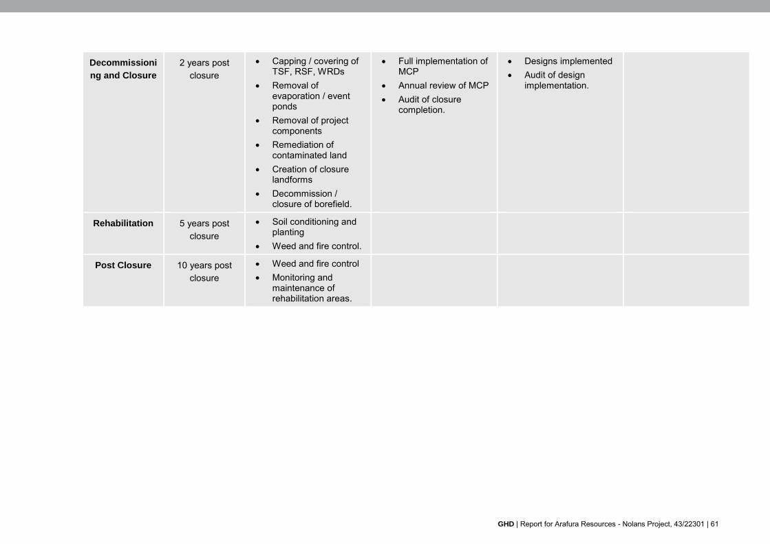
GHD | Report for Arafura Resources - Nolans Project, 43/22301 | 61
Decommissioni
ng and Closure
2 years post closure
Capping / covering of TSF, RSF, WRDs
Removal of evaporation / event ponds
Removal of project components
Remediation of contaminated land
Creation of closure landforms
Decommission / closure of borefield.
Full implementation of MCP
Annual review of MCP Audit of closure
completion.
Designs implemented Audit of design
implementation.
Rehabilitation 5 years post closure
Soil conditioning and planting
Weed and fire control.
Post Closure 10 years post closure
Weed and fire control Monitoring and
maintenance of rehabilitation areas.

62 | GHD | Report for Arafura Resources - Nolans Project, 43/22301
8.2.2 Pre-Closure Trials and Investigations
A number of trials and investigations will be carried out during the operational life of the mine. The results of these trials will be used to inform final landform design and rehabilitation proposals. Table 8-2 summarises the currently envisaged programme. This will be reviewed and updated during the operational phase.
Table 8-2 Pre-Closure Trials and Investigations
Topic Information Gap /
Uncertainty
Description
Vegetation trials Optimum seed planting mixes for rapid establishment under local climatic and soil conditions and on post closure landforms.
Undertake trials of soil covers and vegetation recruitment on WRDs and other disturbed surfaces.
Progressive Rehabilitation trials
Optimum WRD cover design for maximum stability and vegetation establishment success.
Small scale trials of soil profile, erosion and vegetation recruitment.
Rehabilitation and closure materials
Availability of suitable cover material for closure.
Cover materials resource assessment: Undertake further detailed geotechnical and geochemical studies to locate and characterise sufficient quantities of rehabilitation cover materials (clay, waste rock and topsoil).
This will include timing of material availability in relation to progressive rehabilitation.
Tailings Storage Facility Covers and
Rehabilitation
Stable covering for TSF and RSF appropriate to determine appropriate capping design.
Trials of rehabilitation vegetation and soil types on capped and covered tailings surfaces.
Waste Opportunities for material and equipment re-use.
Investigate the potential for sale and/or transfer of plant and equipment.
Geochemical studies Ongoing sampling and NAPP/NAG testing of ore and waste rock.
Ongoing kinetic leach tests of waste products in WRD, TSF and RSF.
Ongoing NAF/PAF and compositional analyses.
Radiological testing Suitability of encapsulation design of radioactive materials in the long term.
Operational phase monitoring associated with radiation, which can be applied to closure designs. Monitoring will include gamma shine and inhalation as per type and frequency listed in the Radiation Management Plan (RMP).
Groundwater Resources
Impact on groundwater levels and chemistry.
Ongoing monitoring of groundwater levels and chemistry and reviewing of model predictions over time.

GHD | Report for Arafura Resources - Nolans Project, 43/22301 | 63
Long Term Pit Lake Behaviour
Overall water balance. Ongoing review of predicted pit lake levels to address any modification of rehabilitation options.
Ecology and Weeds Assess quality of remaining vegetation communities and fauna habitat in and around site to target ecological rehabilitation.
Conduct pre-closure ecology condition survey.
Assess Analog sites for post closure Rehabilitation monitoring and assessment.
Conduct detailed assessment of weeds in all domains.
Soil Contamination The extent of soil contamination and remediation will only be apparent close to closure.
Conduct contaminated soil investigation of all domains where potentially contaminative activities have taken place.
8.3 Closure
8.3.1 Security and Access
Security arrangements during closure will comprise:
Security, fencing, signage will be maintained as during operation
Measures (e.g. safety berms) incorporated into closure designs will be constructed
Public access will be restricted as it was during operation
Post closure access arrangements will be discussed with stakeholders.
8.3.2 Contaminated Land Remediation
The following measures will be employed to limit residual contamination following closure:
Operational environmental management will aim to limit the creation of contaminated land. Nonetheless, some areas (e.g. the ROM pad) will handle potentially hazardous materials and may at closure exhibit levels of contaminants in excess of baseline
Contaminated land will be identified during the pre-closure phase (Section 8.2.2)
Appropriate pre-closure contaminated land sampling/monitoring will accurately define level and extent of any ground contamination and improve volumetric estimates
All contaminated soils will be excavated down to extent of contaminated soil horizon. Materials will be disposed of within the TSF or RSF
Prepare a pre-remediation contaminated sites register and use it to audit completed remediation works
Incorporate contaminated sites remediation programme into MCP prior to closure
Commission an independent audit of the remediated site to demonstrate completion.

64 | GHD | Report for Arafura Resources - Nolans Project, 43/22301
8.3.3 Closure Materials
Mass Balance
To provide confidence that sufficient materials will be available to implement the closure designs. The main categories of closure material anticipated are as follows:
Topsoil is required as a growing medium on post-closure landforms. This will be sourced mainly from onsite topsoil storages close to the mining area, FTSF, RSF and other Project infrastructure areas.
Clean waste rock is required for a variety of uses including cover system capillary break/capping, erosion protection, final land-form profiling. This will be sourced from a designated area of the WRDs where rock meeting geochemical and geotechnical specifications will be stored; and
Low Permeability Soil / Clay (permeability <10-8 m/s) will be required for lining capping of TSF and RSFs, and, if necessary, PAF cells in WRDs.
Clean inert waste rock will be available in significant volumes for closure works, however the topsoil and low permeability clay for lining and cover systems will be less abundant. Therefore, during the first year of mining, conceptual closure designs will be developed to determine material volume requirements for closure. The required closure materials will be reconciled with the site available materials within actual and planned stockpiles in a mass balance. These closure volumes and mass balance will be refined throughout the mine life based on:
Cover material investigations
The evolution of the MCP and closure designs
Ongoing monitoring of the properties of waste materials generated during the mine life.
Detailed specifications for closure materials will be developed in the Detailed MCP during the first year of operation. The QA/QC process during closure (Section 8.6) will need to ensure materials meet specifications.
8.3.4 Managing Radioactivity
Based on characterisation and predictive studies it is anticipated that only wastes contained within the RSF will contain higher levels of radioactivity (Appendix P and Chapter 12).
A Radiation Management Plan (RMP) and a Radioactive Waste Management Plan (RWMP) will be implemented for all radioactive material.
Waste management activities will comply with relevant legislative requirements including the Code of Practice on Radiation Protection and Radioactive Waste Management in Mining and Mineral Processing, 2005 (RPS #9).
At closure this should ensure that any radioactive material will be contained with the RSF and ready for appropriate capping/closure as described in Section 2.2.
8.3.5 Managing Dust
During closure and rehabilitation dust will managed through the Dust Management Plan which will be reviewed and updated prior to closure. This will include as a minimum, application of industry dust control measures including:
Use of water sprays on haul roads, unsealed surfaces, covering of exposed loads where practicable and maintaining moisture levels in bulk loose construction materials

GHD | Report for Arafura Resources - Nolans Project, 43/22301 | 65
Minimising hauling and vehicle travel in conditions when wind strength results in spatially extensive and heavy dust deposition in surrounding habitats
Reduced vehicle speeds for high-use areas/roads
Minimise open areas exposed to wind erosion
Major earthworks to be restricted during unsuitable wind directions and speeds
Progressive rehabilitation (Section 8.4.1).
8.3.6 Unexpected Closure or Hiatus
The following measures will be in place to prepare for an unexpected closure before completing the anticipated Life of Mine:
Through the Mining Management Plans (MMP), reports will be submitted annually summarising disturbed areas and progressive rehabilitation status and planned disturbance and rehabilitation for the next year
Closure costs will be calculated annually providing a detailed allocation of the decommissioning and rehabilitation costs, including a contingency. Any adjustment to the security bond will be made based on the updated costs
A Conceptual Care and Maintenance Plan (Appendix A) is in place and will be refined in parallel with the MCP. This will provide for making the Nolans site secure and safe and implementing an accelerated closure process based on the plans within the MCP based on returning it to the proposed post-closure land use and target ecosystem as defined in Section 6.1
Progressive rehabilitation of WRDs and other post-closure landforms will reduce the requirement for closure and rehabilitation activities in the event of a sudden closure
All water storages and tailings will be designed to an appropriate ANCOLD risk category and adherence to relevant design standards for the provision of adequate storage capacity
Sufficient freeboard allowance will be maintained to prevent overflow from TSF or RSF during predictable high rainfall conditions.
8.3.7 Health Safety and Environmental Management During Closure
The Health, Safety and Environmental management systems employed during operation will be reviewed and updated prior to closure and rehabilitation and will remain in force while activities continue at the site.
8.3.8 Waste Management
A specific Closure Waste Management Plan will be prepared prior to closure for waste generated during the closure phase.
Closure waste management will abide by the following principles:
Implementation of the Waste Management Hierarchy (reduce > reuse > recycling> disposal)
Material segregation (waste materials will be segregated to facilitate reuse and recycling)
Ecological sustainability (avoiding environmental harm).
The waste stream, proposed treatment and disposal destination are summarised in Table 8-3.

66 | GHD | Report for Arafura Resources - Nolans Project, 43/22301
Table 8-3 Closure Waste Streams
Waste stream Disposal destination Pre-Treatment
Processing plant, equipment, pipes
etc.
All plant and equipment removal for off-site recycling or disposal.
Opportunities for resale and reuse will be investigated.
Decontaminated in a designated decontamination area on hard standing with isolated drainage leaning.
Cut and/or break up demolition debris, piping and liner to suitable size for safe transport.
Unused hazardous
materials (process ingredients, explosives)
Return re-useable material to suppliers.
Remove off-site for safe disposal at licensed facility.
Securely contained for transport off site.
Oil and oily wastes off-site
(from maintenance
facilities).
Remove off-site for safe disposal at licensed facility.
Securely contained for transport off site.
Inert soil and rock material
All inert material will be used in landscaping.
Material characterisation, QA and QC.
Contaminated soil, fines removed
from stormwater sediment event
ponds, etc. removed during
remediation.
Disposal on-site in a designated disposal area.
Onsite bioremediation of degradable contaminants such as hydrocarbons.
Evaporation Pond Liners
Where practicable remove off-site for safe disposal at licensed facility or dispose onsite if approved.
Decontaminated in a designated decontamination area on hard standing with isolated drainage.
Cut to suitable size for safe transport.
Buildings and structures
Transportable buildings and equipment will be sold.
Any remaining structures will be dismantled and buried or removed from the site.
On-site landfilling for inert structures.
Litter On-site landfill. Compaction.

GHD | Report for Arafura Resources - Nolans Project, 43/22301 | 67
8.4 Rehabilitation
8.4.1 Progressive Rehabilitation
WRDs will remain on the surface rather than be backfilled into the pit and thereby sterilising the resource. Thus, progressive rehabilitation is a key component of the rehabilitation strategy for the Project and will be integrated into the mine plan. As much of the Project site as possible will be rehabilitated progressively during operation.
Table 8-4 The domains to which progressive rehabilitation applies.
Domain Measure
Waste Rock Dumps Location and staging of WRD to facilitate progressive rehabilitation
Cover and revegetation of slopes (particularly any visible outer faces) and tops of landforms.
TSFs and RSFs Cover and revegetation once embankment slopes reach final batters
Cover and vegetation of TSF / RSF cells as they are filled.
Exploration Early rehabilitation of exploration sites for non-mineralised areas.
Progressive rehabilitation will take place in combination with the trials discussed in Section 8.2.2 which will allow the refinement of the rehabilitation techniques and specifications as the Project progresses.
8.4.2 Landform development
Prior to covering and revegetation, most domains will to some degree require excavation and / or earthworks to create post closure landforms. Certain domains (in particular the WRD, TSF and RSF) will require specific works to ensure long term stability and containment of waste materials.
The general approach to re-forming disturbed areas will be as follows:
Reduce gradient on slopes where necessary for stability
Round edges of waste landforms to blend into natural features
Rip disturbed areas (not containing capped waste material) to roughen surface
Removal of flow diversion banks and drains
Growth medium and revegetate (below).
8.4.3 Soils
The arid conditions of the Project site mean that topsoil is typically thin, lacking nutrients.
Topsoil will be cleared pre-construction, which will be staged progressively as infrastructure is required to limit storage duration and moved to a designated topsoil stores where it will be stored in 3 m windrows and seeded. Condition of stored topsoil will be carefully monitored and managed during the life of the Project.
This will minimise the need for importing or creating new growing medium for rehabilitation as well as revegetation from the seed bank in the soil, minimising the need for direct revegetation.

68 | GHD | Report for Arafura Resources - Nolans Project, 43/22301
Success of reinstating stored topsoil will be measured as part of cover trials along with any additives required to provide the appropriate level of organics, and physical properties porosity water retention, establishment time.
8.4.4 Revegetation
Replanting of disturbed areas will comprise a mix of species aimed at rapid colonisation and establishment of the vegetation communities associated with landform stability, the future land use and the target ecosystem (Section 6.1).
All revegetated areas will be protected with stock proof fencing until trees mature and are safe from damage.
However, progressive rehabilitation, cover and vegetation trials will allow the iterative development of the optimum revegetation strategy. These will examine:
Planting location
Slope angle
Vegetation community types
Appropriate species / seed mixes
Local availability of seeds for rehabilitation.
Rehabilitated areas will be monitored to ensure the success of the rehabilitation programme and impacts from mining activities.
Monitoring of rehabilitated sites will be undertaken annually until completion criteria have been met. The monitoring will assess the species diversity, plant density and community structure against agreed completion criteria.
Given the arid climatic conditions rehabilitation may take longer to establish successful and sustainable vegetation than in areas of higher rainfall.
8.4.5 Weed Management
Weeds will be monitored and controlled through the Mine Management Plan during the operational phase. (Section 8.1).
A full weed survey of the site will be undertaken pre-closure (8.2.2). The operational Weed Management Plan will be reviewed and updated before closure. This will comprise:
Ongoing weed surveys and weed spraying programs (with non-soil-residual herbicides) as required
Testing and quarantine of closure and rehabilitation materials imported to or moved from weed infested areas of the site
Wash down of vehicles entering the site
Managing off-road vehicle use.
8.4.6 Drainage Rehabilitation
Rehabilitating operational site drainage to a stable and natural condition with low erosion rates requires careful consideration and is an essential part of the mine closure and rehabilitation designs.

GHD | Report for Arafura Resources - Nolans Project, 43/22301 | 69
Closure drainage designs will be developed along with the mine closure designs according to the programme set out in Section 8.2.1. The designs will be underpinned by the following principles:
Diversions:
– The Kerosene Camp Creek diversion will be left in place. Modelling (EIS Surface water report (Appendix I) indicates the possibility of sediment accumulation over time due to the low gradients in the diversion potentially lessening the flood immunity capture of Kerosene Camp Creek into the pit. An upstream section of the diversion will be steepened and flood protection bunds added to mitigate this. Future modelling will be undertaken to optimise diversion design, and this will include modelling of stream behaviour over a longer term to determine stability during closure.
– Landform diversion drains for the WRD, TSF and RSF will be left in place, with erosion control and flow reduction structures incorporated as necessary.
– Flow diversion banks around the pit will become the ultimate pit abandonment bunds for the Project in accordance with the Western Australian Department of Industry and Resources, Safety Bund Walls Around Abandoned Open Pit Mines. The diversion banks will continue to operate as an impermeable core to the abandonment bund, however the following modifications will be made:
Expanded to minimum dimension of 2 m height and 5 m wide base; and
Developed with unweathered (geochemically stable) freely draining end dumped rockfill.
WRDs:
– Rehabilitated WRDs will not be capped with impermeable layer, encouraging infiltration and reducing stormwater runoff.
– Outer profile of WRD will be shaped to be consistent with natural topographic features in the area. Testing will be done to determine erosion characteristics of the waste rock. Once known, WRD batter profiles will be determined and used as part of the final rehabilitation strategy and will be progressively rehabilitated during operations. Flow diversion bunds will be installed if required.
TSF and RSF
– Tailings facilities will be rehabilitated similar to WRDs as the waste has been shown to exhibit similar geochemical characteristics as waste rock.
– Profile top of TSF into cells to encourage storage and infiltration to minimise runoff. Topsoil will be applied and surfaces revegetated appropriate to stabilisation requirements, target ecosystem and land use. CSS installed where required.
– Outer profile of TSF will be shaped to be consistent with natural topographic features in the area. Testing will be done to determine erosion characteristics on TSF materials forming the outer batter of the TSF. Once known, TSF batter profiles will be determined and used as part of the final rehabilitation strategy. Flow diversion bunds will be installed if required.
Disturbed or diverted channels will be revegetated with riparian and riverine species. These will be direct seeded.

70 | GHD | Report for Arafura Resources - Nolans Project, 43/22301
8.4.7 Erosion Control
Controlling erosion is fundamental to the establishment of a stable post-closure landscape and central to the drainage and landform designs of the closure concept described in Section 2.2.
In addition to closure and rehabilitation design measures, the following ESC measures will be implemented to slow down the rates of erosion to the capacity at which the receiving environment to can absorb and assimilate it without adverse impacts.
Restrict livestock grazing and conduct population control for herbivorous pest species (e.g. rabbits) during rehabilitation phase
Adopt post closure drainage design based on the principles set out in Section 8.4.6
Development of detailed post-closure drainage design in advance of closure
The ESCP maintained during operation, will be reviewed and updated in the run-up to closure to set out the detailed arrangements for managing, maintaining and monitoring the site to prevent erosion
A long term landscape evolution model will be prepared and updated as the mine develops. This will assist with implementing detailed drainage and erosion protection measures in closure and rehabilitation designs.
8.4.8 Fire Management
Prevention of fires caused by project activities will be addressed in the Fire Management Plan (FMP) which will be reviewed and updated prior to closure.
Long term resilience to drought and naturally occurring vegetation fires is an important factor in ensuring successful rehabilitation and, in particular, ensuring the long term containment of waste materials stored on site.
The fire management strategy during closure and rehabilitation will comprise the following:
Establishment and maintenance of preventative fire breaks protecting vegetation cover during rehabilitation
In the aftermath of a fire review erosion control in waterways, if fire should occur and results in loss of vegetation that otherwise stabilises soil/sediments
Active fire management and vegetation reduction program during rehabilitation.
The site will require ongoing fire management post-relinquishment and some aspects of the fire management strategy may be different from surrounding lands due the site’s mining history. Fire management requirements will be discussed with the land lease holders and post mining land users as part of stakeholder consultation prior to closure.
8.5 Post Closure Phase
8.5.1 Security and Access
Security arrangements after closure will comprise:
Stakeholders will be consulted as to whether they wish any existing fencing to be retained. Any fences not required after closure will be removed
Grazing access to areas undergoing rehabilitation or retained for nature conservation may be restricted post closure.

GHD | Report for Arafura Resources - Nolans Project, 43/22301 | 71
8.5.2 Pit Lake Management
As discussed in Section 2.2 it is proposed to leave the pit as a sink for groundwater seepage and minimal surface water runoff from disturbed areas.
The average annual evaporation from the pit surface significantly exceeds the average runoff from the pit and surrounding catchment that is intended to drain towards the pit. Modelling of post closure conditions indicate that pit lake levels remain sufficiently below the surrounding groundwater level to retain inward flow of groundwater. If significant changes are made to the surface water catchment or WRD capping materials, then the water balance and resulting groundwater levels will be remodelled to confirm inward flow is maintained.
Although leachate from the waste rock, RSF and TSF is likely to have water quality equivalent to or slightly better than existing groundwater, water quality in the open pit, including naturally occurring dissolved metals, radionuclides and salinity, will continuously decline as a result of concentration by evaporation.
8.6 Execution of Closure
8.6.1 Roles, Responsibilities and Authorities
During operation the HSEC Manager will have responsibility for the development of the MCP, designs and costs as well as ongoing closure related activities such trials, monitoring, progressive rehabilitation.
Prior to closure a Closure Project Manager will be appointed whose role will be to establish a robust management process for the closure and rehabilitation phases, including:
QA/QC procedures
Record Keeping
Document Storage and Control
Review and Audit.
8.6.2 Procurement
It is anticipated that specialised contractors will be used for decommissioning where required. In the final year of mining, tender documents will be prepared and procurement will be programmed for completion before the closure date, so that decommissioning commences as soon as possible after the end of production.
8.6.3 Closure and Rehabilitation Resources
Arafura Resources are responsible for ensuring that there are adequate resources available for rehabilitation, particularly for the premature closure of the mine.
Detailed estimates will be prepared during later stages of the development of the MCP, designs and costs during operation.

72 | GHD | Report for Arafura Resources - Nolans Project, 43/22301
9. Monitoring and maintenance
9.1 Operational Monitoring
Monitoring undertaken during operations will provide data to help refine the MCP. Data gathered during the implementation of the Mine Management Plan and its sub-plans will be retained in a manner that allows easy access for monitoring purposes.
Various trials and investigations undertaken to inform closure planning (Section 8.2.2) will also be monitored and results used to refine closure design and planning.
9.2 Post-operational Monitoring and Maintenance
The post-closure phase will include a programme to monitor the effectiveness of rehabilitation and closure and the achievement of closure criteria (Section 6.3).
Post-closure monitoring will include assessments of public safety, geotechnical stability, physical stability, chemical stability and revegetation success.
A preliminary monitoring programme is outlined in Table 9-1. Further details of the monitoring location, frequency and parameters will be provided in later detailed revisions of the MCP which will be confirmed with Northern Territory Government prior to closure.
For consistency and continuity many of the monitoring parameters and locations will be the same as during operation.
Following the end of operations, an agreed monitoring program will be implemented, that will span the closure and rehabilitation phases. The programme will record progress on meeting completion criteria.
The need for any ongoing monitoring will be reassessed annually.
9.2.1 Post-Closure Maintenance
Where monitoring identifies failure to meet completion criteria or predictive trends, the causes will be investigated and if possible, alternate remediation determined and implemented.
9.2.2 Post-Closure Reporting
Reports detailing the monitoring results will be issued annually to DME. The reports and monitoring are to be undertaken by suitably qualified individuals and provided to the relevant governing authorities.
The completion criteria and monitoring programme may change as research and development findings and monitoring trends emerge.
9.2.3 Rehabilitation Audit
Prior to relinquishment, a Rehabilitation Audit will be undertaken to assess the achievement of the completion criteria. The results will be issued to DME for them to consider whether the site can be relinquished.

GHD | Report for Arafura Resources - Nolans Project, 43/22301 | 73
Table 9-1 Post-Decommissioning Monitoring Programme
Discipline Parameter Sampling/Monitoring Approach Sampling/ Monitoring Frequency
Meteorological data
Rainfall, evaporation, wind and temperature. Maintain weather station post closure. Continuous
Surface Water Surface water runoff flows. Use already installed rising stage samplers and gauging stations in creeks in and around Project to monitor surface flows.
During periods of flow
Surface water quality in watercourses.
Physical, chemical and biological characteristics assessed against baseline and site specific trigger values where sufficient data is available.
Use already installed rising stage samplers and gauging stations in creeks in and around Project to monitor surface flows.
During periods of flow
Pit lake water quality. In situ testing and laboratory analysed samples. Six monthly
Groundwater Groundwater Quality.
Physical and chemical parameters.
Groundwater site specific trigger values established for the process site and mine site for assessment purposes.
Sampling from groundwater monitoring boreholes.
The sample locations are to focus on areas likely to be impacted by mining operations.
Piezometer monitoring with TSF/RSF/WRD.
Visual inspections for seepage.
Six Monthly/continuous
Groundwater levels. Boreholes Six Monthly
Stability Phreatic levels within and physical condition of embankments.
Embankment piezometers and survey pins, regular dam inspections.
Quarterly
Erosion.
Length, depth and attributes of the erosion post closure landforms and watercourses including presence of gullies, rills and excess sedimentation in local watercourses.
Erosion monitoring at permanent transects across post closure landforms across the Project site, especially steeper slopes and the TSF, RSF and WRDs which are then used to calculate percentage erosion over time.
Annual

74 | GHD | Report for Arafura Resources - Nolans Project, 43/22301
Pit wall stability. Geotechnical Assessment.
Visual inspection and photographic record.
Annual
Ecological and landscape
rehabilitation
Revegetation.
Plant establishment, survival/success rate, growth, diversity, cover and weeds.
Quadrat and transect surveys of planted areas. Annual
Overall ecosystem function.
This comprises surface soil condition assessment, vegetation establishment, erosion and habitat development.
Rehabilitation monitoring and assessment
(developed by the Commonwealth Scientific and Industrial Research Organisation (CSIRO)).
Regularly scheduled monitoring of transects on both rehabilitated landforms and analogue sites (i.e. undisturbed sites similar to the target ecosystems of the rehabilitation areas) to determine trends of ecosystem development, functional role of vegetation structure and habitat quality for fauna.
Typically these sites are established in advance of mine closure to allow for baseline information to be collected.
Annual
Fauna Species specific fauna surveys including camera surveys for populations of key threatened fauna, indicator species and pests.
Annual
Riparian condition.
Riparian and riverine revegetation and geomorphology of diverted or rehabilitated channels as well as the extent of natural regeneration and the characteristics of the evolving ecosystem.
Visual surveys. Annual
Dust A quantitative dust monitoring program. Dust deposition gauges. Quarterly

GHD | Report for Arafura Resources - Nolans Project, 43/22301 | 75
10. References
EIS Terms of Reference (NTEPA, 2015)
Knight Piesold (2014) Nolans Project Infrastructure Engineering Cost Study, (Lycopodium. February 2014)
Knight Piesold (2014) Tailings Storage Facility, Engineering Cost Study
Guidelines for Preparing Mine Closure Plans, Government of Western Australia Department of Mines and Energy / Environmental Protection Agency, May 2015.
Code Of Practice And Safety Guide -Radiation Protection And Radioactive Waste Management In Mining And Mineral Processing. Radiation Protection Series Publication No. 9. Commonwealth, August 2005

Appendices
GHD | Report for Arafura Resources - Nolans Project, 43/22301
Appendix A Nolans Project Care and Maintenance Plan Document Framework

GHD | Report for Arafura Resources - Nolans Project, 43/22301
Care and Maintenance Plan - Document Framework
Executive summary ................................................................................................................................... i
1. Scope and purpose ........................................................................................................................ 4
1.1 Background .......................................................................................................................... 4
1.2 Purpose of this report........................................................................................................... 4
1.3 Scope ................................................................................................................................... 4
1.4 Limitations ............................................................................................................................ 4
2. Closure concept ............................................................................................................................. 6
2.1 Project Domains ................................................................................................................... 6
2.2 Closure Concept by Domain ................................................................................................ 6
3. Closure context ............................................................................................................................ 17
3.1 Land Use and Tenure ........................................................................................................ 17
3.2 Physical Environment ........................................................................................................ 18
3.3 Biological Environment ...................................................................................................... 24
3.4 Socio-economic and Cultural Environment ....................................................................... 27
4. Closure obligations and commitments ......................................................................................... 29
4.1 Legislation and Guidance .................................................................................................. 29
4.2 Obligations and Commitments ........................................................................................... 31
5. Stakeholder consultation .............................................................................................................. 32
5.1 Stakeholder Engagement Strategy .................................................................................... 32
5.2 Stakeholder Consultation and Engagement Register ........................................................ 32
6. Post-closure land uses, objectives and criteria ............................................................................ 33
6.1 Closure and Rehabilitation Objectives ............................................................................... 33
6.2 Post Closure Land Uses .................................................................................................... 33
6.3 Completion Criteria ............................................................................................................ 35
6.4 Performance Indicators ...................................................................................................... 35
7. Closure impacts and risks ............................................................................................................ 43
7.1 Introduction ........................................................................................................................ 43
7.2 Decommissioning and Closure .......................................................................................... 47
7.3 Landscape and ecological rehabilitation ............................................................................ 50
7.4 Post Closure Releases and Emissions .............................................................................. 53
7.5 Long term sustainability ..................................................................................................... 55
7.6 Stakeholder and Social Impacts ........................................................................................ 57
8. Closure implementation ............................................................................................................... 59
8.1 Operational Management .................................................................................................. 59
8.2 Planning ............................................................................................................................. 59
8.3 Closure ............................................................................................................................... 63
8.4 Rehabilitation ..................................................................................................................... 67
8.5 Post Closure Phase ........................................................................................................... 70

GHD | Report for Arafura Resources - Nolans Project, 43/22301
8.6 Execution of Closure .......................................................................................................... 71
9. Monitoring and maintenance ........................................................................................................ 72
9.1 Operational Monitoring....................................................................................................... 72
9.2 Post-operational Monitoring and Maintenance .................................................................. 72
10. References ................................................................................................................................... 75

GHD | Report for Arafura Resources - Nolans Project, 43/22301
Appendix B Climate Data

GHD | Report for Arafura Resources - Nolans Project, 43/22301
Rainfall and Evaporation
Major sources of rainfall in the region are due to the occasional southward extension of the monsoon trough and incursion of north-west cloud bands. In summer, the position of the monsoon trough can deviate far southwards allowing moisture laden north-westerly flow to penetrate the semi-arid interior. Similarly, bands of moisture at high altitude originating from the Indian Ocean can move south-east across the interior resulting in late autumn and early winter rainfall. Thunderstorms do occur but are often ‘dry’ storms with most or all rain evaporating before reaching the ground 1.
Bureau of Meteorology rainfall gauges in the area are listed in Table B1 nearest rainfall gauge is located at Aileron approximately 15 km to the east of the site. Unfortunately, the record at Aileron contains a significant proportion of gaps (20 percent).
Data from Bureau of Meteorology stations within 50 km of the mine site Aileron, Pine Hill, Napperby, and Territory Grape Farm (Table B1), indicates that long term mean annual rainfall at the proposed mine site is likely to be about 310 mm.
Previous studies have relied on the rainfall record at Alice Springs Airport. Whilst the record has few if any data gaps, it is situated 146 km to the south of the mine site and may not be representative of climatic conditions at the mine site. Comparison of the long-term average rainfall at Alice Springs Airport with gauges at Aileron, Pine Hill and Napperby suggests its recorded rainfall is 8% lower than that of the gauges further north and closer to the proposed mine site. This difference is most likely due to the influence of nearby hills on increased rainfall patterns relative to the nearby plains.
Annual rainfall is erratic from year to year and almost 50 percent of annual total rainfall can occur within a single month. Maximum rainfall tends to occur in summer months although historical maximum daily totals of 94 mm and 142 mm were recorded at Napperby and Pine Hill, respectively, in May 1968.
The seasonal distribution of rainfall from the Napperby rainfall gauge and potential evaporation based on data from Alice Springs Airport is shown in Figure B1. This shows that on average monthly rainfall is about one fifth monthly potential evaporation but monthly rainfall can exceed potential evaporation in very wet months.
Rainfall Intensity
Table B2 shows predicted rainfall intensities for a range of storm durations and average recurrence intervals as determined by the Bureau of Meteorology. For example, a 1 in 100-year 24-hour rainfall intensity (9.53 mm/hr) is almost twice the 1 in 10-year 24-hour rainfall intensity (5.03 mm/hr) and one eighth the 1 in 100-year 1-hour rainfall intensity. In general, higher rainfall intensity occurs over short durations, also higher rainfall intensity events are a less frequent occurrence than lower intensity rainfall events.
Evaporation
Evaporation gauges in the area are listed in Table B3 and their location relative to the proposed mine site is shown in Figure B1. The nearest evaporation gauge is located at Territory Grape Farm 50 km to the north east but the record is of limited length (7 years).
An evaporation pan has been recording potential evaporation at the proposed mine site since September 2008. During this period annual potential evaporation rates ranged between 2111 mm to 3162 mm (average 2396 mm). It is unclear if the reported data represents evaporation
1 Australian Bureau of Statistics. http://www.abs.gov.au/ausstats/[email protected]/Previousproducts/1301.0Feature%20Article22006?open

GHD | Report for Arafura Resources - Nolans Project, 43/22301
as measured by the pan or whether it has been adjusted by pan factors to account for the scale effects of the instrument.
The nearest evaporation pan gauge with a long-term record is located at Alice Springs Airport. The 75-year record exhibits a mean annual potential evaporation of 2196 mm (assuming monthly pan factors ranging between 0.67 to 0.78). Evaporation is less spatially variable than rainfall and despite the distance from the mine site recorded evaporation at Alice Springs can be expected to be similar to conditions at the site.
Actual evaporation is constrained by available water and rates are much lower than potential rates. Therefore, actual evaporation will closely match rainfall throughout the year and virtually all the rain that does fall will evaporate.

GHD | Report for Arafura Resources - Nolans Project, 43/22301
Table B1 Rainfall Gauges
Gauge Number Name Lat Long Record Start Record End Record Length (years)
Distance from Mine Site
Mean Annual Rainfall (mm)
b - Nolans Mine 22.56 133.24 Sep 2008 open 8 0 314 a
015543 Aileron 22.646 133.346 1949 2009 60 15 km 301 015507 Pine Hill 22.380 133.050 1967 open 48 32 km 348 015518 Napperby 22.509 132.752 1955 2014 59 48 km 309 015643 Territory Grape
Farm 22.452 133.638 1987 Open 28 49 km 319
015658 Tilmouth Well 22.81 132.60 1991 Open 24 64 km - 015515 Amburla 23.34 133.17 1968 Open 47 78 km - 015501 Yambah 23.13 133.84 1968 Open 47 84 km - 015650 Narwietooma 23.23 132.63 1989 Open 26 88 km - 015542 Anningie 21.848 133.123 1941 Open 74 88 km - 015596 Bushy Park 22.90 134.05 1954 Open 61 91 km - 015553 Hamilton
Downs 22.90 134.05 1958 Open 57 96 km -
015535 Coniston 22.050 132.495 1948 Open 77 97 km - 015631 Bond Springs
Homestead 23.54 133.92 1901 Open 114 124 km -
015525 Barrow Creek 21.532 133.890 1874 2014 140 142 km - 015590 Alice Springs
Airport 23.800 133.890 1940 Open 75 146 km -
Table B2 Rainfall Intensity – Duration – Frequency Data
Units mm/hr Frequency as an Average Recurrence Interval Duration 1 year 2 year 5 year 10 year 20 year 50 year 100 year 5 mins 56.0 74.3 104 123 147 180 205 6 mins 52.2 69.4 97.5 115 138 168 192
10 mins 43.5 58.0 81.9 97.0 116 142 163 20 mins 33.5 44.7 63.4 75.4 90.5 111 128 30 mins 27.9 37.2 53.0 63.2 76.0 93.5 107
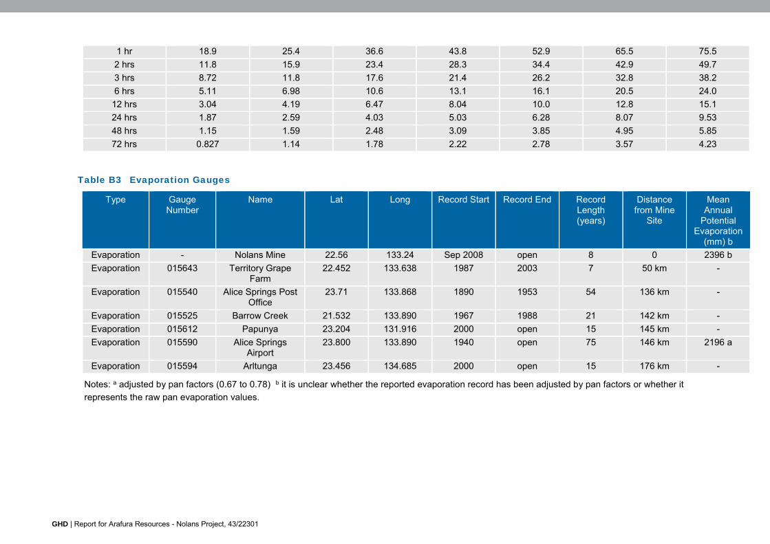
GHD | Report for Arafura Resources - Nolans Project, 43/22301
1 hr 18.9 25.4 36.6 43.8 52.9 65.5 75.5 2 hrs 11.8 15.9 23.4 28.3 34.4 42.9 49.7 3 hrs 8.72 11.8 17.6 21.4 26.2 32.8 38.2 6 hrs 5.11 6.98 10.6 13.1 16.1 20.5 24.0
12 hrs 3.04 4.19 6.47 8.04 10.0 12.8 15.1 24 hrs 1.87 2.59 4.03 5.03 6.28 8.07 9.53 48 hrs 1.15 1.59 2.48 3.09 3.85 4.95 5.85 72 hrs 0.827 1.14 1.78 2.22 2.78 3.57 4.23
Table B3 Evaporation Gauges
Type Gauge Number
Name Lat Long Record Start Record End Record Length (years)
Distance from Mine
Site
Mean Annual
Potential Evaporation
(mm) b Evaporation - Nolans Mine 22.56 133.24 Sep 2008 open 8 0 2396 b Evaporation 015643 Territory Grape
Farm 22.452 133.638 1987 2003 7 50 km -
Evaporation 015540 Alice Springs Post Office
23.71 133.868 1890 1953 54 136 km -
Evaporation 015525 Barrow Creek 21.532 133.890 1967 1988 21 142 km - Evaporation 015612 Papunya 23.204 131.916 2000 open 15 145 km - Evaporation 015590 Alice Springs
Airport 23.800 133.890 1940 open 75 146 km 2196 a
Evaporation 015594 Arltunga 23.456 134.685 2000 open 15 176 km -
Notes: a adjusted by pan factors (0.67 to 0.78) b it is unclear whether the reported evaporation record has been adjusted by pan factors or whether it represents the raw pan evaporation values.

GHD | Report for Arafura Resources - Nolans Project, 43/22301
Figure B1 Seasonal Distribution of Rainfall and Evaporation
t

GHD | Report for Arafura Resources - Nolans Project, 43/22301
Air
As Nolans mine is located 135 km north of Alice Springs it may be considered the same climate classification as desert (semi-arid; hot persistently dry) or the Grassland (hot persistently dry) to the north and north-west of Alice Springs. On site observations from Nolans mine site from July 2011 to June 2015 were validated against the closest Bureau of Meteorology (BoM) automatic weather station (AWS), NT Grape Farm (site 015643). Nolans mine site and BoM data were generally in agreement.
Temperature
Temperatures follow the expected seasonal pattern of cycling between warmer temperatures in the summer (peaking in December-January) and cooler temperatures (lowest in July) in the winter. Figure B2 indicates the annual cycle and compares the site monthly averages to the longer term BoM site. The maximum average hourly temperature was 42.6° C at 4 pm on January 11 2011 while the minimum was -1.16° C at 5 am on 8 July 2014. Note that while temperatures often overnight in winter get as low as freezing point, there are few if any frosts as the desert dew point is lower and a dew does not form (to then be frozen into a frost).
The air temperatures are very similar with the on-site maximum matching closely with the BoM data and the on-site minimum being slightly higher in general.
Figure B2 – Air temperatures
Relative humidity
Figure B3 shows that relative humidity was higher in summer (likely due to greater rainfall and associated higher dew points at times) and in winter (likely due to the air temperature being lower as cooler air is not able to hold as much water). Spring had the lowest humidity. The maximum hourly average was 95.94% at 9 am on 10 April 2014 while the minimum was 4.04% at 5 pm on 27 October 2013.
This is consistent with the BoM data although the on-site humidity is generally lower than the BoM data, especially in the spring months.
0
5
10
15
20
25
30
35
40
Jan Feb Mar Apr May Jun Jul Aug Sep Oct Nov Dec
Tem
per
atu
re (
°C)
Air temperature (monthly averages from 2011-2015)
Max Min Average BoM max BOM Min

GHD | Report for Arafura Resources - Nolans Project, 43/22301
Figure B3 – Relative humidity
Wind
Figure B4 indicates that the vast majority of winds come from the south-east quadrant with an average wind speed of 2.77 m/s. There are also a small proportion of winds from north of east (compared to south of east) and very few winds coming from a westerly component. In terms of poor dust conditions, the incidence of light winds are important for poor dispersion while the strongest winds create the most wind erosion. As seen in the wind rose, most of the light winds (0.1 – 2.1 m/s) originate from the south-east. The strongest winds have the vast majority with an easterly component. This suggests sensitive receptors west and north-west of the site will be most vulnerable.
The wind distribution remains fairly constant throughout the year, Figure B5 shows seasonal variation, although there is a greater incidence of winds from north of east during spring and summer. The warmer months of the year see the sub-tropical ridge across Australia migrate well to the south and causing some disturbance to the prevailing south-east trade winds near the Tropic of Capricorn.
0
10
20
30
40
50
60
Jan Feb Mar Apr May Jun Jul Aug Sep Oct Nov Dec
Rel
ativ
e h
um
idit
y (%
)
Relative humidity (monthly averages from 2011-2015)
On-site BoM
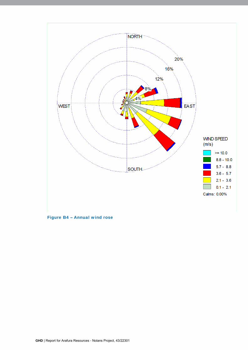
GHD | Report for Arafura Resources - Nolans Project, 43/22301
Figure B4 – Annual wind rose

GHD | Report for Arafura Resources - Nolans Project, 43/22301
Summer
Autumn
Winter Spring
Figure B5 – Seasonal wind roses

GHD | Report for Arafura Resources - Nolans Project, 43/22301
Appendix C Risk Assessment

GHD | Report for Arafura Resources - Nolans Project, 43/22301
Risk is expressed and assessed in terms of a combination of the consequence of an event and the associated likelihood of occurrence.
A “real chance or probability” of a significant impact from a particular source is defined as there being an extreme or high risk of a population (or the fauna community) experiencing a significant consequence as defined in the guidelines e.g. reduce the diversity or modify the composition of plant and animal species in a National Heritage place.
The initial levels of risk and determination of residual risk (after avoidance, mitigation and management actions have been applied) have been undertaken using standard qualitative risk assessment procedures consistent with AS/NZS ISO 31000:2009 ‘Risk Management – Principles and guidelines’, with the exception of economic risk which is not addressed in the guidelines.
Assessment of risk has been conducted through consideration of the circumstances around risks, identifying necessary controls to address potential impacts and assuming effective implementation of planned and committed mitigation of potential impacts. Avoidance, mitigation and management actions are proposed in an attempt to reduce residual risk (risk after actions) where possible to below “Extreme” or “High” risk outcomes to the extent reasonably practicable as part of reducing the overall project risk profile.
The depth of focus on risk controls is linked to the level of risk and opportunity for reduction to meet organisational commitments and goals linked to an environmentally and socially responsible operation, and those requirements are part of the regulatory obligations and impact assessment guidelines.
Table C1 provides a summary of the qualitative risk matrix adopted and the levels of risk for the various consequence and likelihood combinations and a brief description of each risk classification and the likely responses for the threatened species assessed is provided in Table C2 and Table C3. The project risk assessment completed for flora and vegetation is included as EIS technical Risk Register (Appendix F).
Table C1 Qualitative Risk Analysis Matrix
Likelihood Consequence Level Insignificant Minor Moderate Major Catastrophic
Almost Certain Medium High High Extreme Extreme Likely Medium Medium High High Extreme Possible Low Medium Medium High High Unlikely Low Low Medium Medium High Rare Low Low Low Medium Medium

GHD | Report for Arafura Resources - Nolans Project, 43/22301
Table C2 Definition of level of likelihood
Level of Likelihood
Definitions
Almost
certain
The event is expected to occur in most circumstances.
This event could occur at least once during a project of this nature.
91-100% chance of occurring during the project.
Likely The event will probably occur in most circumstances.
This event could occur up to once during a project of this nature.
51-90% chance of occurring during the project.
Possible The event could occur but not expected.
This event could occur up to once every 10 projects of this nature.
11-50% chance of occurring during the project.
Unlikely The event could occur but is improbable.
This event could occur up to once every 10-100 projects of this nature.
1-10% chance of occurring during the project.
Rare The event may occur only in exceptional circumstances.
This event is not expected to occur except under exceptional circumstances (up to once every 100 projects of this nature).
Less than 1% chance of occurring during the project.
Table C3 Definitions of levels of consequence
Levels of Consequence
Definitions
Critical Extensive long term environmental harm and/or harm that is extremely widespread. Impacts unlikely to be reversible within 10 years.
Major Major or widespread, unplanned environmental impact on or off the site. Significant resources required to respond and rehabilitate.
Significant Significant, unplanned environmental impact contained within the site or minor impact that is off the site.
Moderate Moderate, unplanned localised environmental impact contained on-site or with negligible off-site impact.
Minor Minor environmental impact. Any impacts are contained on-site and short term in nature.

GHD | Report for Arafura Resources - Nolans Project, 43/22301
Appendix D Obligations and Commitments Register Template

GHD | Report for Arafura Resources - Nolans Project, 43/22301
Commitments Register
Tenement No. Commitment / Obligation No.
Description Date of Commitment/ Obligation
Close-out date
Conditions of close-out
GHD | Report for Arafura Resources - Nolans Project, 43/22301
GHD
2 Salamanca Square Hobart 7000 GPO Box 667 Hobart 7001 T: 03 6210 0600 F: 03 6210 0601 E: [email protected]
© GHD 2016
This document is and shall remain the property of GHD. The document may only be used for the purpose for which it was commissioned and in accordance with the Terms of Engagement for the commission. Unauthorised use of this document in any form whatsoever is prohibited. \\ghdnet\ghd\AU\hobart\Projects\43\2230102\WP\63984.docx
Document Status
Rev No.
Author Reviewer Approved for Issue Name Signature Name Signature Date
0 Hugh Kerr Rob Longey
Nicole Conroy 25/03/2016


www.ghd.com