regulatory program - united states army
TRANSCRIPT
Page 1 of 8 Version: October 1, 2015
Regulatory ProgramINTERIM APPROVED JURISDICTIONAL DETERMINATION FORM
U.S. Army Corps of Engineers This form should be completed by following the instructions provided
in the Interim Approved Jurisdictional Determination Form User Manual.
SECTION I: BACKGROUND INFORMATION A. COMPLETION DATE FOR APPROVED JURISDICTIONAL DETERMINATION (AJD): November 20, 2019
B. ORM NUMBER IN APPROPRIATE FORMAT (e.g., HQ-2015-00001-SMJ): LRC-2011-655
C. PROJECT LOCATION AND BACKGROUND INFORMATION:State:Illinois County/parish/borough: Cook City: Harvey Center coordinates of site (lat/long in degree decimal format): Lat. 41.58394, Long. -87.65175. Map(s)/diagram(s) of review area (including map identifying single point of entry (SPOE) watershed and/or potential jurisdictional areas where applicable) is/are: attached in report/map titled Illinois Central Railroad - Markham Yard, Wetland Delineation & Stream Assessment Report, Cook County, Illinois; dated June 2019, prepared by AECOM.
Other sites (e.g., offsite mitigation sites, disposal sites, etc.) are associated with this action and are recorded on a different jurisdictional determination (JD) form. List JD form ID numbers (e.g., HQ-2015-00001-SMJ-1): .
D. REVIEW PERFORMED FOR SITE EVALUATION:Office (Desk) Determination Only. Date: .Office (Desk) and Field Determination. Office/Desk Dates: October 2, 2019 Field Date(s): August 20, 2019.
SECTION II: DATA SOURCES Check all that were used to aid in the determination and attach data/maps to this AJD form and/or references/citations in the administrative record, as appropriate.
Maps, plans, plots or plat submitted by or on behalf of the applicant/consultant. Title/Date: Illinois Central Railroad - Markham Yard, Wetland Delineation & Stream Assessment Report, Cook County, Illinois; dated June 2019,prepared by AECOM.
Data sheets prepared/submitted by or on behalf of the applicant/consultant. Data sheets/delineation report are sufficient for purposes of AJD form. Title/Date: Illinois Central Railroad -
Markham Yard, Wetland Delineation & Stream Assessment Report, Cook County, Illinois; dated June 2019, prepared by AECOM.
Data sheets/delineation report are not sufficient for purposes of AJD form. Summarize rationale and include information on revised data sheets/delineation report that this AJD form has relied upon: . Revised Title/Date: . Data sheets prepared by the Corps. Title/Date: . Corps navigable waters study. Title/Date: . CorpsMap ORM map layers. Title/Date: . USGS Hydrologic Atlas. Title/Date: Harvey.
USGS, NHD, or WBD data/maps. Title/Date: . USGS 8, 10 and/or 12 digit HUC maps. HUC number: Harvey. USGS maps. Scale & quad name and date: Harvey. USDA NRCS Soil Survey. Citation: . USFWS National Wetlands Inventory maps. Citation: . State/Local wetland inventory maps. Citation: . FEMA/FIRM maps. Citation: . Photographs: Aerial. Citation: . or Other. Citation: .
® ®
Page 2 of 8 Version: October 1, 2015
LiDAR data/maps. Citation: . Previous JDs. File no. and date of JD letter: . Applicable/supporting case law: . Applicable/supporting scientific literature: . Other information (please specify): .
SECTION III: SUMMARY OF FINDINGS
Complete ORM “Aquatic Resource Upload Sheet” or Export and Print the Aquatic Resource Water Droplet Screen from ORM for All Waters and Features, Regardless of Jurisdictional Status – Required
A. RIVERS AND HARBORS ACT (RHA) SECTION 10 DETERMINATION OF JURISDICTION: “navigable waters of the U.S.” within RHA jurisdiction (as defined by 33 CFR part 329) in the review area.
• Complete Table 1 - RequiredNOTE: If the navigable water is not subject to the ebb and flow of the tide or included on the District’s list of Section 10 navigable waters list, DO NOT USE THIS FORM TO MAKE THE DETERMINATION. The District must continue to follow the procedure outlined in 33 CFR part 329.14 to make a Section 10 RHA navigability determination.
B. CLEAN WATER ACT (CWA) SECTION 404 DETERMINATION OF JURISDICTION: “waters of the U.S.” withinCWA jurisdiction (as defined by 33 CFR part 328.3) in the review area. Check all that apply.
(a)(1): All waters which are currently used, were used in the past, or may be susceptible to use in interstate or foreign commerce, including all waters which are subject to the ebb and flow of the tide. (Traditional Navigable Waters (TNWs))
• Complete Table 1 - Required This AJD includes a case-specific (a)(1) TNW (Section 404 navigable-in-fact) determination on a water that
has not previously been designated as such. Documentation required for this case-specific (a)(1) TNW determination is attached.
(a)(2): All interstate waters, including interstate wetlands. • Complete Table 2 - Required
(a)(3): The territorial seas. • Complete Table 3 - Required
(a)(4): All impoundments of waters otherwise identified as waters of the U.S. under 33 CFR part 328.3. • Complete Table 4 - Required
(a)(5): All tributaries, as defined in 33 CFR part 328.3, of waters identified in paragraphs (a)(1)-(a)(3) of 33 CFR part 328.3.
• Complete Table 5 - Required (a)(6): All waters adjacent to a water identified in paragraphs (a)(1)-(a)(5) of 33 CFR part 328.3, including
wetlands, ponds, lakes, oxbows, impoundments, and similar waters. • Complete Table 6 - Required
Bordering/Contiguous. Neighboring:
(c)(2)(i): All waters located within 100 feet of the ordinary high water mark (OHWM) of a water identified in paragraphs (a)(1)-(a)(5) of 33 CFR part 328.3.
(c)(2)(ii): All waters located within the 100-year floodplain of a water identified in paragraphs (a)(1)-(a)(5) of 33 CFR part 328.3 and not more than 1,500 feet of the OHWM of such water.
(c)(2)(iii): All waters located within 1,500 feet of the high tide line of a water identified in paragraphs (a)(1) or (a)(3) of 33 CFR part 328.3, and all waters within 1,500 feet of the OHWM of the Great Lakes.
(a)(7): All waters identified in 33 CFR 328.3(a)(7)(i)-(v) where they are determined, on a case-specific basis, to have a significant nexus to a water identified in paragraphs (a)(1)-(a)(3) of 33 CFR part 328.3.
• Complete Table 7 for the significant nexus determination. Attach a map delineating the SPOEwatershed boundary with (a)(7) waters identified in the similarly situated analysis. - Required
Includes water(s) that are geographically and physically adjacent per (a)(6), but are being used for established, normal farming, silviculture, and ranching activities (33 USC Section 1344(f)(1)) and therefore are not adjacent and require a case-specific significant nexus determination.
(a)(8): All waters located within the 100-year floodplain of a water identified in paragraphs (a)(1)-(a)(3) of 33 CFR part 328.3 not covered by (c)(2)(ii) above and all waters located within 4,000 feet of the high tide line or OHWM of a water identified in paragraphs (a)(1)-(a)(5) of 33 CFR part 328.3 where they are determined on a case-specific basis to have a significant nexus to a water identified in paragraphs (a)(1)-(a)(3) of 33 CFR part 328.3.
Page 3 of 8 Version: October 1, 2015
• Complete Table 8 for the significant nexus determination. Attach a map delineating the SPOEwatershed boundary with (a)(8) waters identified in the similarly situated analysis. - Required
Includes water(s) that are geographically and physically adjacent per (a)(6), but are being used for established, normal farming, silviculture, and ranching activities (33 USC Section 1344(f)(1)) and therefore are not adjacent and require a case-specific significant nexus determination.
C. NON-WATERS OF THE U.S. FINDINGS:Check all that apply.
The review area is comprised entirely of dry land. Potential-(a)(7) Waters: Waters that DO NOT have a significant nexus to a water identified in paragraphs (a)(1)-
(a)(3) of 33 CFR part 328.3. • Complete Table 9 and attach a map delineating the SPOE watershed boundary with potential
(a)(7) waters identified in the similarly situated analysis. - Required Includes water(s) that are geographically and physically adjacent per (a)(6), but are being used for established,
normal farming, silviculture, and ranching activities (33 USC Section 1344(f)(1)) and therefore are not adjacent and require a case-specific significant nexus determination.
Potential-(a)(8) Waters: Waters that DO NOT have a significant nexus to a water identified in paragraphs (a)(1)-(a)(3) of 33 CFR part 328.3.
• Complete Table 9 and attach a map delineating the SPOE watershed boundary with potential(a)(8) waters identified in the similarly situated analysis. - Required
Includes water(s) that are geographically and physically adjacent per (a)(6), but are being used for established, normal farming, silviculture, and ranching activities (33 USC Section 1344(f)(1)) and therefore are not adjacent and require a case-specific significant nexus determination.
Excluded Waters (Non-Waters of U.S.), even where they otherwise meet the terms of paragraphs (a)(4)-(a)(8): • Complete Table 10 - Required
(b)(1): Waste treatment systems, including treatment ponds or lagoons designed to meet the requirements of the CWA.
(b)(2): Prior converted cropland. (b)(3)(i): Ditches with ephemeral flow that are not a relocated tributary or excavated in a tributary. (b)(3)(ii): Ditches with intermittent flow that are not a relocated tributary, excavated in a tributary, or drain
wetlands. (b)(3)(iii): Ditches that do not flow, either directly or through another water, into a water identified in
paragraphs (a)(1)-(a)(3). (b)(4)(i): Artificially irrigated areas that would revert to dry land should application of water to that area cease. (b)(4)(ii): Artificial, constructed lakes and ponds created in dry land such as farm and stock watering ponds,
irrigation ponds, settling basins, fields flooded for rice growing, log cleaning ponds, or cooling ponds. (b)(4)(iii): Artificial reflecting pools or swimming pools created in dry land.1 (b)(4)(iv): Small ornamental waters created in dry land.1 (b)(4)(v): Water-filled depressions created in dry land incidental to mining or construction activity, including
pits excavated for obtaining fill, sand, or gravel that fill with water. (b)(4)(vi): Erosional features, including gullies, rills, and other ephemeral features that do not meet the
definition of tributary, non-wetland swales, and lawfully constructed grassed waterways.1 (b)(4)(vii): Puddles.1 (b)(5): Groundwater, including groundwater drained through subsurface drainage systems.1 (b)(6): Stormwater control features constructed to convey, treat, or store stormwater that are created in dry
land.1 (b)(7): Wastewater recycling structures created in dry land; detention and retention basins built for wastewater
recycling; groundwater recharge basins; percolation ponds built for wastewater recycling; and water distributary structures built for wastewater recycling.
Other non-jurisdictional waters/features within review area that do not meet the definitions in 33 CFR 328.3 of (a)(1)-(a)(8) waters and are not excluded waters identified in (b)(1)-(b)(7).
• Complete Table 11 - Required.
D. ADDITIONAL COMMENTS TO SUPPORT AJD: .
1 In many cases these excluded features will not be specifically identified on the AJD form, unless specifically requested. Corps Districts may, in case-by-case instances, choose to identify some or all of these features within the review area.

Page 4 of 8 Version: October 1, 2015
Jurisdictional Waters of the U.S.
Table 1. (a)(1) Traditional Navigable Waters
(a)(1) Waters Name (a)(1) Criteria Rationale to Support (a)(1) Designation Include High Tide Line or Ordinary High Water Mark indicators, when applicable.
N/A Choose an item. N/A
Table 2. (a)(2) Interstate Waters
(a)(2) Waters Name Rationale to Support (a)(2) Designation N/A N/A
Table 3. (a)(3) Territorial Seas
(a)(3) Waters Name Rationale to Support (a)(3) Designation N/A N/A
Table 4. (a)(4) Impoundments
(a)(4) Waters Name Rationale to Support (a)(4) Designation N/A N/A N/A N/A

Page 5 of 8 Version: October 1, 2015
Table 5. (a)(5)Tributaries
(a)(5) Waters Name Flow Regime (a)(1)-(a)(3) Water Name to which this (a)(5) Tributary Flows
Tributary Breaks
Rationale for (a)(5) Designation and Additional Discussion. Identify flowpath to (a)(1)-(a)(3) water or attach map identifying the flowpath; explain any breaks or flow through excluded/non-jurisdictional features, etc.
Stream 3 Perennial Thorn Creek No The Calumet Union Drainage Canal flows directly into Thorn Creek
Stream 4 Intermittent Calumet Union Drainage Canal No Stream 4 flows directly into the Calumet Union Drainage
Canal, and drains a wetland.
Stream 7 Intermittent Calumet Union Drainage Canal No Stream 7 flows directly into the Calumet Union Drainage
Canal, and drains a wetland.
Stream 9 Perennial Thorn Creek No Stream 9 flows directly into the Calumet Union Drainage Canal.
Table 6. (a)(6) Adjacent Waters
(a)(6) Waters Name (a)(1)-(a)(5) Water Name to which this Water is Adjacent
Rationale for (a)(6) Designation and Additional Discussion. Identify the type of water and how the limits of jurisdiction were established (e.g., wetland, 87 Manual/Regional Supplement); explain how the 100-year floodplain and/or the distance threshold was determined; whether this water extends beyond a threshold; explain if the water is part of a mosaic, etc.
Wetland A Calumet Union Drainage Canal Wetland A was delineated utilizing the Midwest Supplement; and directly abuts the canal.
Wetland B Calumet Union Drainage Canal
Wetland B was separated from Wetland 5 by a road with a culvert pipe; and Wetland 5 drains via a flowing piped tributary directly into the Calumet Union Drainage Canal.
Wetland 4 Stream 4 Wetland 4 was delineated utilizing the Midwest Supplement, and is drained by Stream 4, which flows into the Calumet Union Drainage Canal.
Wetland 4A Stream 4 Wetland 4A is a subset of Wetland 4 due to different vegetative community, but part of the same complex; and is drained by Stream 4, which flows into the Calumet Union Drainage Canal.
Wetland 5 Calumet Union Drainage Canal.
Wetland 5 was delineated utilizing the Midwest Supplement; and drains north via a flowing piped tributary directly into the Calumet Union Drainage Canal.
Wetland 6 Stream 7 Wetland 6 was delineated utilizing the Midwest Supplement, and is drained by Stream 7, which flows into the Calumet Union Drainage Canal.

Page 6 of 8 Version: October 1, 2015
Table 7. (a)(7) Waters
SPOE Name (a)(7) Waters Name
(a)(1)-(a)(3) Water Name to which this Water has a Significant Nexus
Significant Nexus Determination Identify SPOE watershed; discuss whether any similarly situated waters were present and aggregated for SND; discuss data, provide analysis, and summarize how the waters have more than speculative or insubstantial effect on the physical, chemical, or biological integrity of the (a)(1)-(a)(3) water, etc.
N/A N/A N/A N/A N/A N/A N/A N/A
Table 8. (a)(8) Waters
SPOE Name (a)(8) Waters Name
(a)(1)-(a)(3) Water Name to which this Water has a Significant Nexus
Significant Nexus Determination Identify SPOE watershed; explain how 100-yr floodplain and/or the distance threshold was determined; discuss whether waters were determined to be similarly situated to subject water and aggregated for SND; discuss data, provide analysis, and then summarize how the waters have more than speculative or insubstantial effect the on the physical, chemical, or biological integrity of the (a)(1)-(a)(3) water, etc.
N/A N/A N/A N/A N/A N/A N/A N/A
Page 7 of 8 Version: October 1, 2015
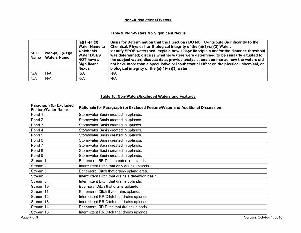
Non-Jurisdictional Waters
Table 9. Non-Waters/No Significant Nexus
SPOE Name
Non-(a)(7)/(a)(8) Waters Name
(a)(1)-(a)(3) Water Name to which this Water DOES NOT have a Significant Nexus
Basis for Determination that the Functions DO NOT Contribute Significantly to the Chemical, Physical, or Biological Integrity of the (a)(1)-(a)(3) Water. Identify SPOE watershed; explain how 100-yr floodplain and/or the distance threshold was determined; discuss whether waters were determined to be similarly situated to the subject water; discuss data, provide analysis, and summarize how the waters did not have more than a speculative or insubstantial effect on the physical, chemical, or biological integrity of the (a)(1)-(a)(3) water.
N/A N/A N/A N/A N/A N/A N/A N/A
Table 10. Non-Waters/Excluded Waters and Features
Paragraph (b) Excluded Feature/Water Name Rationale for Paragraph (b) Excluded Feature/Water and Additional Discussion.
Pond 1 Stormwater Basin created in uplands. Pond 2 Stormwater Basin created in uplands. Pond 3 Stormwater Basin created in uplands. Pond 4 Stormwater Basin created in uplands. Pond 5 Stormwater Basin created in uplands. Pond 6 Stormwater Basin created in uplands. Pond 7 Stormwater Basin created in uplands. Pond 8 Stormwater Basin created in uplands. Pond 9 Stormwater Basin created in uplands. Stream 1 Ephemeral RR Ditch created in uplands. Stream 2 Intermittent Ditch that only drains uplands. Stream 5 Ephemeral Ditch that drains upland area. Stream 6 Intermittent Ditch that drains a detention basin. Stream 8 Intermittent Ditch that drains uplands. Stream 10 Epemeral Ditch that drains uplands Stream 11 Ephemeral Ditch that drains uplands. Stream 12 Intermittent RR Ditch that drains uplands. Stream 13 Intermittent RR Ditch that drains uplands. Stream 14 Ephemeral RR Ditch that drains uplands. Stream 15 Intermittent RR Ditch that drains uplands.

Page 8 of 8 Version: October 1, 2015
Table 11. Non-Waters/Other
Other Non-Waters of U.S. Feature/Water Name Rationale for Non-Waters of U.S. Feature/Water and Additional Discussion.
N/A N/A
Page 1 of 7 Version: October 1, 2015
Regulatory ProgramINTERIM APPROVED JURISDICTIONAL DETERMINATION FORM
U.S. Army Corps of Engineers This form should be completed by following the instructions provided
in the Interim Approved Jurisdictional Determination Form User Manual.
SECTION I: BACKGROUND INFORMATION A. COMPLETION DATE FOR APPROVED JURISDICTIONAL DETERMINATION (AJD): October 28, 2019
B. ORM NUMBER IN APPROPRIATE FORMAT (e.g., HQ-2015-00001-SMJ): LRC-2017-176
C. PROJECT LOCATION AND BACKGROUND INFORMATION:State:Illinois County/parish/borough: Lake City: Mundelein Center coordinates of site (lat/long in degree decimal format): Lat. 42.283924, Long. -88.023441. Map(s)/diagram(s) of review area (including map identifying single point of entry (SPOE) watershed and/or potential jurisdictional areas where applicable) is/are: attached in report/map titled Wetland and Waterway Delineation Report dated September 4, 2019, prepared by TRC.Environmental Corporation.
Other sites (e.g., offsite mitigation sites, disposal sites, etc.) are associated with this action and are recorded on a different jurisdictional determination (JD) form. List JD form ID numbers (e.g., HQ-2015-00001-SMJ-1): .
D. REVIEW PERFORMED FOR SITE EVALUATION:Office (Desk) Determination Only. Date: .Office (Desk) and Field Determination. Office/Desk Dates: October 28, 2019 Field Date(s): October 18, 2019.
SECTION II: DATA SOURCES Check all that were used to aid in the determination and attach data/maps to this AJD form and/or references/citations in the administrative record, as appropriate.
Maps, plans, plots or plat submitted by or on behalf of the applicant/consultant. Title/Date: Wetland and Waterway Delineation Report dated September 4, 2019, prepared by TRC.Environmental Corporation.
Data sheets prepared/submitted by or on behalf of the applicant/consultant. Data sheets/delineation report are sufficient for purposes of AJD form. Title/Date: Wetland and Waterway
Delineation Report dated September 4, 2019, prepared by TRC.Environmental Corporation. Data sheets/delineation report are not sufficient for purposes of AJD form. Summarize rationale and include
information on revised data sheets/delineation report that this AJD form has relied upon: . Revised Title/Date: . Data sheets prepared by the Corps. Title/Date: . Corps navigable waters study. Title/Date: . CorpsMap ORM map layers. Title/Date: . USGS Hydrologic Atlas. Title/Date: Grayslake.
USGS, NHD, or WBD data/maps. Title/Date: . USGS 8, 10 and/or 12 digit HUC maps. HUC number: Grayslake. USGS maps. Scale & quad name and date: Grayslake. USDA NRCS Soil Survey. Citation: . USFWS National Wetlands Inventory maps. Citation: Grayslake. State/Local wetland inventory maps. Citation: . FEMA/FIRM maps. Citation: . Photographs: Aerial. Citation: . or Other. Citation: .
LiDAR data/maps. Citation: . Previous JDs. File no. and date of JD letter: . Applicable/supporting case law: .
® ®
Page 2 of 7 Version: October 1, 2015
Applicable/supporting scientific literature: . Other information (please specify): .
SECTION III: SUMMARY OF FINDINGS
Complete ORM “Aquatic Resource Upload Sheet” or Export and Print the Aquatic Resource Water Droplet Screen from ORM for All Waters and Features, Regardless of Jurisdictional Status – Required
A. RIVERS AND HARBORS ACT (RHA) SECTION 10 DETERMINATION OF JURISDICTION: “navigable waters of the U.S.” within RHA jurisdiction (as defined by 33 CFR part 329) in the review area.
• Complete Table 1 - RequiredNOTE: If the navigable water is not subject to the ebb and flow of the tide or included on the District’s list of Section 10 navigable waters list, DO NOT USE THIS FORM TO MAKE THE DETERMINATION. The District must continue to follow the procedure outlined in 33 CFR part 329.14 to make a Section 10 RHA navigability determination.
B. CLEAN WATER ACT (CWA) SECTION 404 DETERMINATION OF JURISDICTION: “waters of the U.S.” withinCWA jurisdiction (as defined by 33 CFR part 328.3) in the review area. Check all that apply.
(a)(1): All waters which are currently used, were used in the past, or may be susceptible to use in interstate or foreign commerce, including all waters which are subject to the ebb and flow of the tide. (Traditional Navigable Waters (TNWs))
• Complete Table 1 - Required This AJD includes a case-specific (a)(1) TNW (Section 404 navigable-in-fact) determination on a water that
has not previously been designated as such. Documentation required for this case-specific (a)(1) TNW determination is attached.
(a)(2): All interstate waters, including interstate wetlands. • Complete Table 2 - Required
(a)(3): The territorial seas. • Complete Table 3 - Required
(a)(4): All impoundments of waters otherwise identified as waters of the U.S. under 33 CFR part 328.3. • Complete Table 4 - Required
(a)(5): All tributaries, as defined in 33 CFR part 328.3, of waters identified in paragraphs (a)(1)-(a)(3) of 33 CFR part 328.3.
• Complete Table 5 - Required (a)(6): All waters adjacent to a water identified in paragraphs (a)(1)-(a)(5) of 33 CFR part 328.3, including wetlands, ponds, lakes, oxbows, impoundments, and similar waters.
• Complete Table 6 - Required Bordering/Contiguous. Neighboring:
(c)(2)(i): All waters located within 100 feet of the ordinary high water mark (OHWM) of a water identified in paragraphs (a)(1)-(a)(5) of 33 CFR part 328.3.
(c)(2)(ii): All waters located within the 100-year floodplain of a water identified in paragraphs (a)(1)-(a)(5) of 33 CFR part 328.3 and not more than 1,500 feet of the OHWM of such water.
(c)(2)(iii): All waters located within 1,500 feet of the high tide line of a water identified in paragraphs (a)(1) or (a)(3) of 33 CFR part 328.3, and all waters within 1,500 feet of the OHWM of the Great Lakes.
(a)(7): All waters identified in 33 CFR 328.3(a)(7)(i)-(v) where they are determined, on a case-specific basis, to have a significant nexus to a water identified in paragraphs (a)(1)-(a)(3) of 33 CFR part 328.3.
• Complete Table 7 for the significant nexus determination. Attach a map delineating the SPOEwatershed boundary with (a)(7) waters identified in the similarly situated analysis. - Required
Includes water(s) that are geographically and physically adjacent per (a)(6), but are being used for established, normal farming, silviculture, and ranching activities (33 USC Section 1344(f)(1)) and therefore are not adjacent and require a case-specific significant nexus determination.
(a)(8): All waters located within the 100-year floodplain of a water identified in paragraphs (a)(1)-(a)(3) of 33 CFR part 328.3 not covered by (c)(2)(ii) above and all waters located within 4,000 feet of the high tide line or OHWM of a water identified in paragraphs (a)(1)-(a)(5) of 33 CFR part 328.3 where they are determined on a case-specific basis to have a significant nexus to a water identified in paragraphs (a)(1)-(a)(3) of 33 CFR part 328.3.
• Complete Table 8 for the significant nexus determination. Attach a map delineating the SPOEwatershed boundary with (a)(8) waters identified in the similarly situated analysis. - Required
Page 3 of 7 Version: October 1, 2015
Includes water(s) that are geographically and physically adjacent per (a)(6), but are being used for established, normal farming, silviculture, and ranching activities (33 USC Section 1344(f)(1)) and therefore are not adjacent and require a case-specific significant nexus determination.
C. NON-WATERS OF THE U.S. FINDINGS:Check all that apply.
The review area is comprised entirely of dry land. Potential-(a)(7) Waters: Waters that DO NOT have a significant nexus to a water identified in paragraphs (a)(1)-
(a)(3) of 33 CFR part 328.3. • Complete Table 9 and attach a map delineating the SPOE watershed boundary with potential
(a)(7) waters identified in the similarly situated analysis. - Required Includes water(s) that are geographically and physically adjacent per (a)(6), but are being used for established,
normal farming, silviculture, and ranching activities (33 USC Section 1344(f)(1)) and therefore are not adjacent and require a case-specific significant nexus determination.
Potential-(a)(8) Waters: Waters that DO NOT have a significant nexus to a water identified in paragraphs (a)(1)-(a)(3) of 33 CFR part 328.3.
• Complete Table 9 and attach a map delineating the SPOE watershed boundary with potential(a)(8) waters identified in the similarly situated analysis. - Required
Includes water(s) that are geographically and physically adjacent per (a)(6), but are being used for established, normal farming, silviculture, and ranching activities (33 USC Section 1344(f)(1)) and therefore are not adjacent and require a case-specific significant nexus determination.
Excluded Waters (Non-Waters of U.S.), even where they otherwise meet the terms of paragraphs (a)(4)-(a)(8): • Complete Table 10 - Required
(b)(1): Waste treatment systems, including treatment ponds or lagoons designed to meet the requirements of the CWA. (b)(2): Prior converted cropland. (b)(3)(i): Ditches with ephemeral flow that are not a relocated tributary or excavated in a tributary. (b)(3)(ii): Ditches with intermittent flow that are not a relocated tributary, excavated in a tributary, or drain wetlands. (b)(3)(iii): Ditches that do not flow, either directly or through another water, into a water identified in paragraphs (a)(1)-(a)(3). (b)(4)(i): Artificially irrigated areas that would revert to dry land should application of water to that area cease. (b)(4)(ii): Artificial, constructed lakes and ponds created in dry land such as farm and stock watering ponds, irrigation ponds, settling basins, fields flooded for rice growing, log cleaning ponds, or cooling ponds. (b)(4)(iii): Artificial reflecting pools or swimming pools created in dry land.1 (b)(4)(iv): Small ornamental waters created in dry land.1 (b)(4)(v): Water-filled depressions created in dry land incidental to mining or construction activity, including pits excavated for obtaining fill, sand, or gravel that fill with water. (b)(4)(vi): Erosional features, including gullies, rills, and other ephemeral features that do not meet the definition of tributary, non-wetland swales, and lawfully constructed grassed waterways.1 (b)(4)(vii): Puddles.1 (b)(5): Groundwater, including groundwater drained through subsurface drainage systems.1 (b)(6): Stormwater control features constructed to convey, treat, or store stormwater that are created in dry land.1 (b)(7): Wastewater recycling structures created in dry land; detention and retention basins built for wastewater recycling; groundwater recharge basins; percolation ponds built for wastewater recycling; and water
distributary structures built for wastewater recycling. Other non-jurisdictional waters/features within review area that do not meet the definitions in 33 CFR 328.3 of
(a)(1)-(a)(8) waters and are not excluded waters identified in (b)(1)-(b)(7). • Complete Table 11 - Required.
D. ADDITIONAL COMMENTS TO SUPPORT AJD: .
1 In many cases these excluded features will not be specifically identified on the AJD form, unless specifically requested. Corps Districts may, in case-by-case instances, choose to identify some or all of these features within the review area.

Page 4 of 7 Version: October 1, 2015
Jurisdictional Waters of the U.S.
Table 1. (a)(1) Traditional Navigable Waters
(a)(1) Waters Name (a)(1) Criteria Rationale to Support (a)(1) Designation Include High Tide Line or Ordinary High Water Mark indicators, when applicable.
N/A Choose an item. N/A
Table 2. (a)(2) Interstate Waters
(a)(2) Waters Name Rationale to Support (a)(2) Designation N/A N/A
Table 3. (a)(3) Territorial Seas
(a)(3) Waters Name Rationale to Support (a)(3) Designation N/A N/A
Table 4. (a)(4) Impoundments
(a)(4) Waters Name Rationale to Support (a)(4) Designation N/A N/A N/A N/A
Page 5 of 7 Version: October 1, 2015
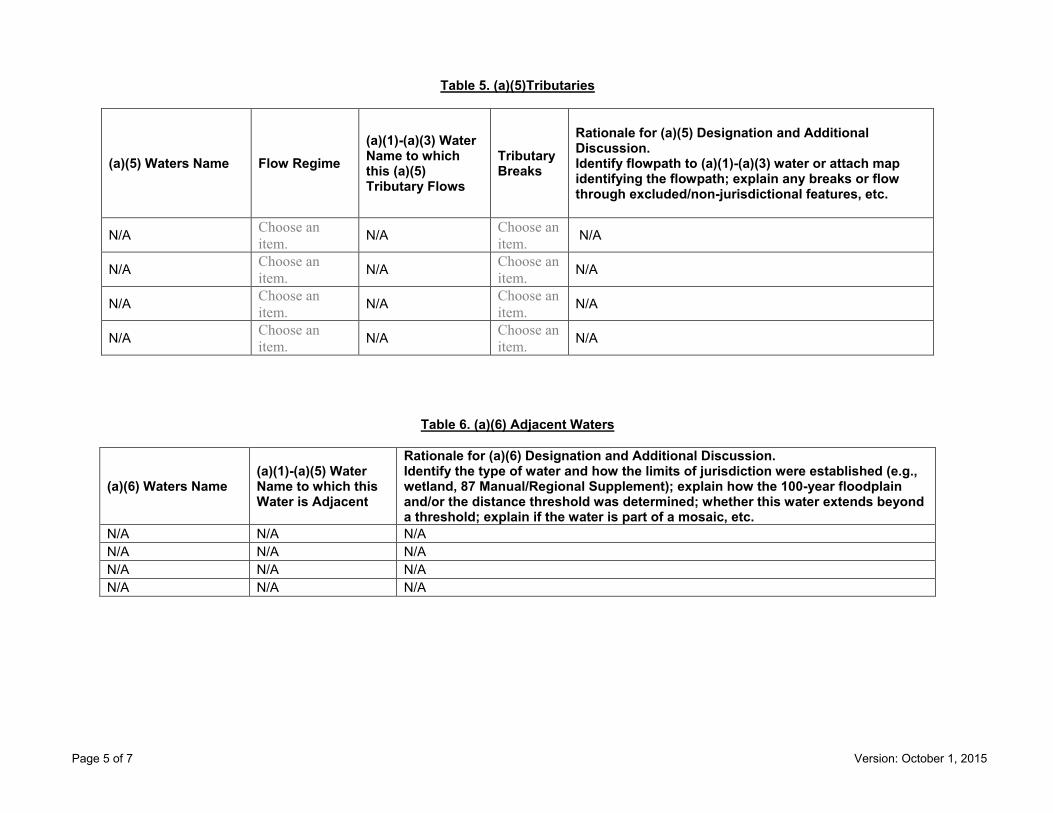
Table 5. (a)(5)Tributaries
(a)(5) Waters Name Flow Regime (a)(1)-(a)(3) Water Name to which this (a)(5) Tributary Flows
Tributary Breaks
Rationale for (a)(5) Designation and Additional Discussion. Identify flowpath to (a)(1)-(a)(3) water or attach map identifying the flowpath; explain any breaks or flow through excluded/non-jurisdictional features, etc.
N/A Choose an item. N/A Choose an
item. N/A
N/A Choose an item. N/A Choose an
item. N/A
N/A Choose an item. N/A Choose an
item. N/A
N/A Choose an item. N/A Choose an
item. N/A
Table 6. (a)(6) Adjacent Waters
(a)(6) Waters Name (a)(1)-(a)(5) Water Name to which this Water is Adjacent
Rationale for (a)(6) Designation and Additional Discussion. Identify the type of water and how the limits of jurisdiction were established (e.g., wetland, 87 Manual/Regional Supplement); explain how the 100-year floodplain and/or the distance threshold was determined; whether this water extends beyond a threshold; explain if the water is part of a mosaic, etc.
N/A N/A N/A N/A N/A N/A N/A N/A N/A N/A N/A N/A

Page 6 of 7 Version: October 1, 2015
Table 7. (a)(7) Waters
SPOE Name (a)(7) Waters Name
(a)(1)-(a)(3) Water Name to which this Water has a Significant Nexus
Significant Nexus Determination Identify SPOE watershed; discuss whether any similarly situated waters were present and aggregated for SND; discuss data, provide analysis, and summarize how the waters have more than speculative or insubstantial effect on the physical, chemical, or biological integrity of the (a)(1)-(a)(3) water, etc.
N/A N/A N/A N/A N/A N/A N/A N/A
Table 8. (a)(8) Waters
SPOE Name (a)(8) Waters Name
(a)(1)-(a)(3) Water Name to which this Water has a Significant Nexus
Significant Nexus Determination Identify SPOE watershed; explain how 100-yr floodplain and/or the distance threshold was determined; discuss whether waters were determined to be similarly situated to subject water and aggregated for SND; discuss data, provide analysis, and then summarize how the waters have more than speculative or insubstantial effect the on the physical, chemical, or biological integrity of the (a)(1)-(a)(3) water, etc.
N/A N/A N/A N/A N/A N/A N/A N/A
Page 7 of 7 Version: October 1, 2015
Non-Jurisdictional Waters
Table 9. Non-Waters/No Significant Nexus
SPOE Name
Non-(a)(7)/(a)(8) Waters Name
(a)(1)-(a)(3) Water Name to which this Water DOES NOT have a Significant Nexus
Basis for Determination that the Functions DO NOT Contribute Significantly to the Chemical, Physical, or Biological Integrity of the (a)(1)-(a)(3) Water. Identify SPOE watershed; explain how 100-yr floodplain and/or the distance threshold was determined; discuss whether waters were determined to be similarly situated to the subject water; discuss data, provide analysis, and summarize how the waters did not have more than a speculative or insubstantial effect on the physical, chemical, or biological integrity of the (a)(1)-(a)(3) water.
N/A N/A N/A N/A N/A N/A N/A N/A
Table 10. Non-Waters/Excluded Waters and Features
Paragraph (b) Excluded Feature/Water Name Rationale for Paragraph (b) Excluded Feature/Water and Additional Discussion.
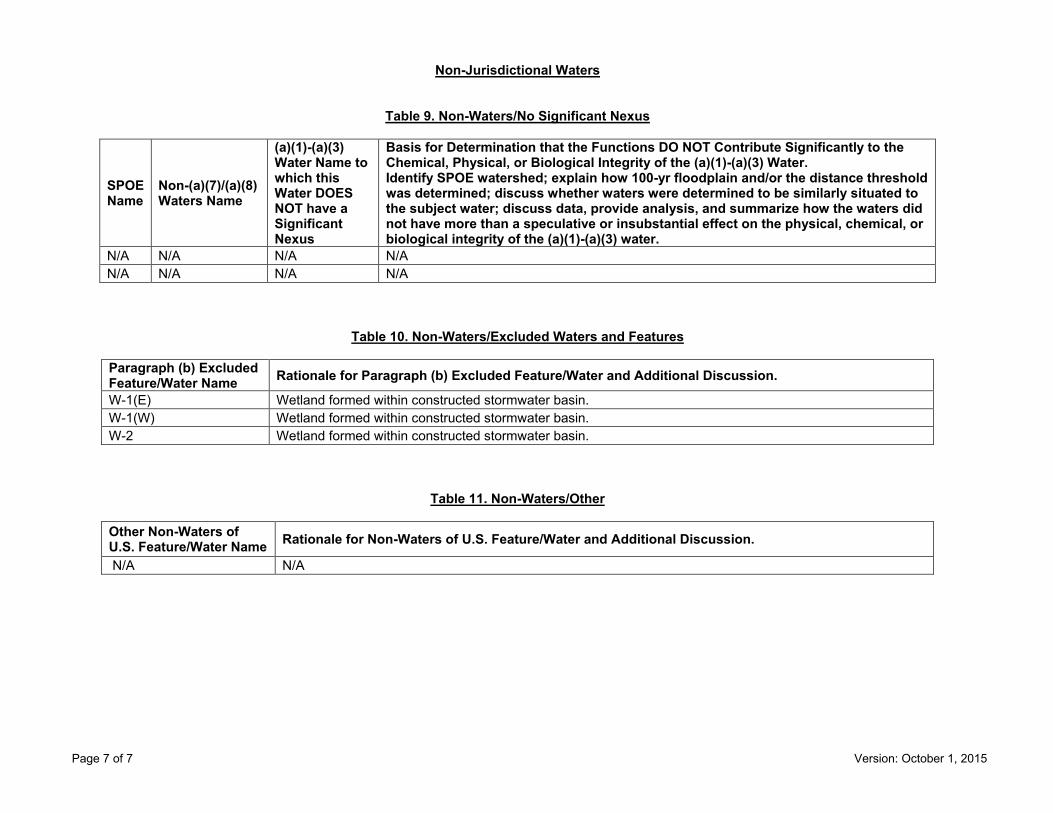
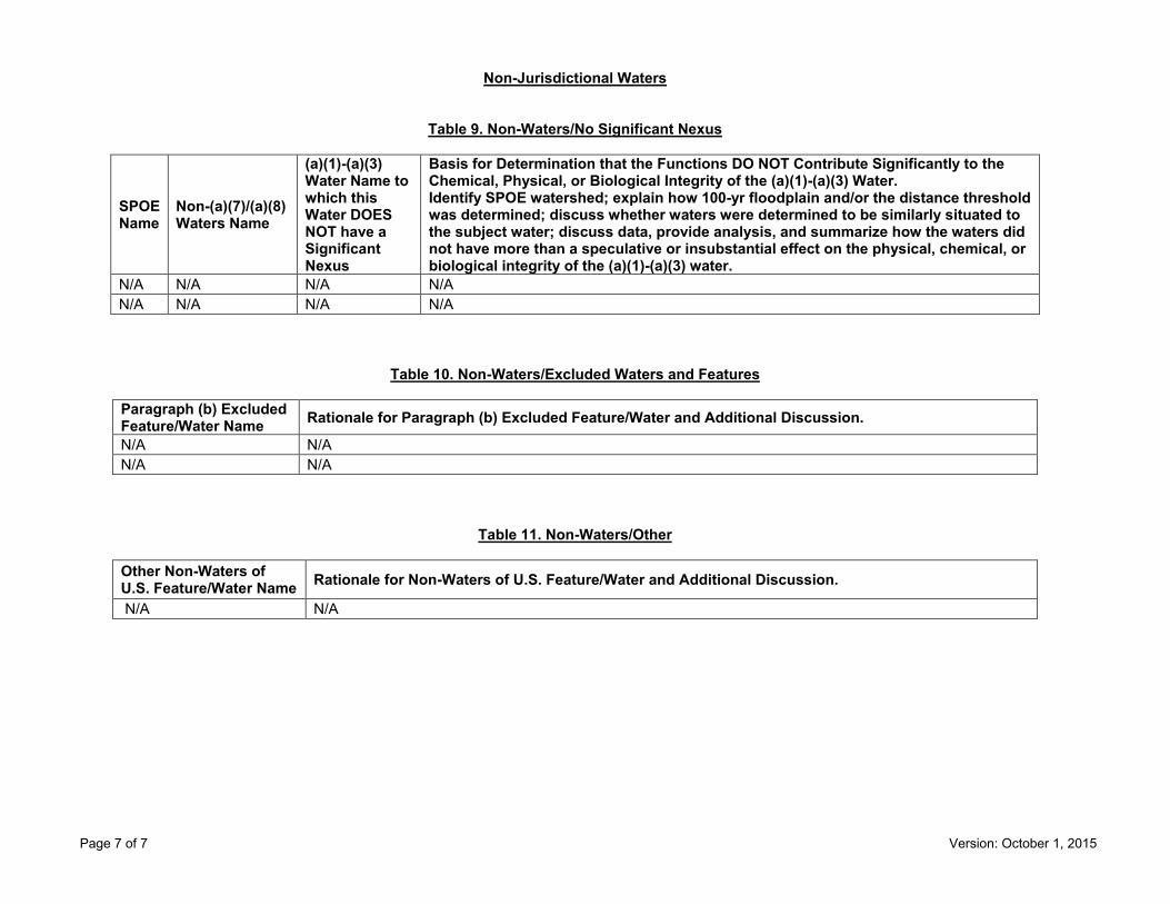
W-1(E) Wetland formed within constructed stormwater basin. W-1(W) Wetland formed within constructed stormwater basin. W-2 Wetland formed within constructed stormwater basin.
Table 11. Non-Waters/Other
Other Non-Waters of U.S. Feature/Water Name Rationale for Non-Waters of U.S. Feature/Water and Additional Discussion.
N/A N/A
Page 1 of 7 Version: October 1, 2015
Regulatory ProgramINTERIM APPROVED JURISDICTIONAL DETERMINATION FORM
U.S. Army Corps of Engineers This form should be completed by following the instructions provided
in the Interim Approved Jurisdictional Determination Form User Manual.
SECTION I: BACKGROUND INFORMATION A. COMPLETION DATE FOR APPROVED JURISDICTIONAL DETERMINATION (AJD): November 13, 2019
B. ORM NUMBER IN APPROPRIATE FORMAT (e.g., HQ-2015-00001-SMJ): LRC-2018-405
C. PROJECT LOCATION AND BACKGROUND INFORMATION:State:Illinois County/parish/borough: McHenry City: McHenry Center coordinates of site (lat/long in degree decimal format): Lat. 42.404522, Long. -88.213078. Map(s)/diagram(s) of review area (including map identifying single point of entry (SPOE) watershed and/or potential jurisdictional areas where applicable) is/are: attached in report/map titled Wetland Delineation Report dated May 17, 2019, prepared by McConnell Environmental.
Other sites (e.g., offsite mitigation sites, disposal sites, etc.) are associated with this action and are recorded on a different jurisdictional determination (JD) form. List JD form ID numbers (e.g., HQ-2015-00001-SMJ-1): .
D. REVIEW PERFORMED FOR SITE EVALUATION:Office (Desk) Determination Only. Date: .Office (Desk) and Field Determination. Office/Desk Dates: November 13, 2019 Field Date(s): August 18, 2019.
SECTION II: DATA SOURCES Check all that were used to aid in the determination and attach data/maps to this AJD form and/or references/citations in the administrative record, as appropriate.
Maps, plans, plots or plat submitted by or on behalf of the applicant/consultant. Title/Date: Site Plan and Topographic Survey for Proposed Pole Barn dated 08-30-2019, prepared by Luco Surveying.
Data sheets prepared/submitted by or on behalf of the applicant/consultant. Data sheets/delineation report are sufficient for purposes of AJD form. Title/Date: Wetland Delineation Report
dated May 17, 2019, prepared by McConnell Environmental. Data sheets/delineation report are not sufficient for purposes of AJD form. Summarize rationale and include
information on revised data sheets/delineation report that this AJD form has relied upon: . Revised Title/Date: . Data sheets prepared by the Corps. Title/Date: . Corps navigable waters study. Title/Date: . CorpsMap ORM map layers. Title/Date: . USGS Hydrologic Atlas. Title/Date: Fox Lake.
USGS, NHD, or WBD data/maps. Title/Date: . USGS 8, 10 and/or 12 digit HUC maps. HUC number: . USGS maps. Scale & quad name and date: Fox Lake. USDA NRCS Soil Survey. Citation: . USFWS National Wetlands Inventory maps. Citation: . State/Local wetland inventory maps. Citation: . FEMA/FIRM maps. Citation: . Photographs: Aerial. Citation: . or Other. Citation: .
LiDAR data/maps. Citation: . Previous JDs. File no. and date of JD letter: . Applicable/supporting case law: .
® ®

Page 2 of 7 Version: October 1, 2015
Applicable/supporting scientific literature: . Other information (please specify): .
SECTION III: SUMMARY OF FINDINGS
Complete ORM “Aquatic Resource Upload Sheet” or Export and Print the Aquatic Resource Water Droplet Screen from ORM for All Waters and Features, Regardless of Jurisdictional Status – Required
A. RIVERS AND HARBORS ACT (RHA) SECTION 10 DETERMINATION OF JURISDICTION:
“navigable waters of the U.S.” within RHA jurisdiction (as defined by 33 CFR part 329) in the review area. • Complete Table 1 - Required
NOTE: If the navigable water is not subject to the ebb and flow of the tide or included on the District’s list of Section 10 navigable waters list, DO NOT USE THIS FORM TO MAKE THE DETERMINATION. The District must continue to follow the procedure outlined in 33 CFR part 329.14 to make a Section 10 RHA navigability determination. B. CLEAN WATER ACT (CWA) SECTION 404 DETERMINATION OF JURISDICTION: “waters of the U.S.” within CWA jurisdiction (as defined by 33 CFR part 328.3) in the review area. Check all that apply.
(a)(1): All waters which are currently used, were used in the past, or may be susceptible to use in interstate or foreign commerce, including all waters which are subject to the ebb and flow of the tide. (Traditional Navigable Waters (TNWs))
• Complete Table 1 - Required This AJD includes a case-specific (a)(1) TNW (Section 404 navigable-in-fact) determination on a water that
has not previously been designated as such. Documentation required for this case-specific (a)(1) TNW determination is attached.
(a)(2): All interstate waters, including interstate wetlands. • Complete Table 2 - Required
(a)(3): The territorial seas. • Complete Table 3 - Required
(a)(4): All impoundments of waters otherwise identified as waters of the U.S. under 33 CFR part 328.3. • Complete Table 4 - Required
(a)(5): All tributaries, as defined in 33 CFR part 328.3, of waters identified in paragraphs (a)(1)-(a)(3) of 33 CFR part 328.3.
• Complete Table 5 - Required (a)(6): All waters adjacent to a water identified in paragraphs (a)(1)-(a)(5) of 33 CFR part 328.3, including
wetlands, ponds, lakes, oxbows, impoundments, and similar waters. • Complete Table 6 - Required
Bordering/Contiguous. Neighboring: (c)(2)(i): All waters located within 100 feet of the ordinary high water mark (OHWM) of a water identified in
paragraphs (a)(1)-(a)(5) of 33 CFR part 328.3. (c)(2)(ii): All waters located within the 100-year floodplain of a water identified in paragraphs (a)(1)-(a)(5) of
33 CFR part 328.3 and not more than 1,500 feet of the OHWM of such water. (c)(2)(iii): All waters located within 1,500 feet of the high tide line of a water identified in paragraphs (a)(1) or
(a)(3) of 33 CFR part 328.3, and all waters within 1,500 feet of the OHWM of the Great Lakes. (a)(7): All waters identified in 33 CFR 328.3(a)(7)(i)-(v) where they are determined, on a case-specific basis, to
have a significant nexus to a water identified in paragraphs (a)(1)-(a)(3) of 33 CFR part 328.3. • Complete Table 7 for the significant nexus determination. Attach a map delineating the SPOE
watershed boundary with (a)(7) waters identified in the similarly situated analysis. - Required Includes water(s) that are geographically and physically adjacent per (a)(6), but are being used for established,
normal farming, silviculture, and ranching activities (33 USC Section 1344(f)(1)) and therefore are not adjacent and require a case-specific significant nexus determination.
(a)(8): All waters located within the 100-year floodplain of a water identified in paragraphs (a)(1)-(a)(3) of 33 CFR part 328.3 not covered by (c)(2)(ii) above and all waters located within 4,000 feet of the high tide line or OHWM of a water identified in paragraphs (a)(1)-(a)(5) of 33 CFR part 328.3 where they are determined on a case-specific basis to have a significant nexus to a water identified in paragraphs (a)(1)-(a)(3) of 33 CFR part 328.3.
• Complete Table 8 for the significant nexus determination. Attach a map delineating the SPOE watershed boundary with (a)(8) waters identified in the similarly situated analysis. - Required

Page 3 of 7 Version: October 1, 2015
Includes water(s) that are geographically and physically adjacent per (a)(6), but are being used for established, normal farming, silviculture, and ranching activities (33 USC Section 1344(f)(1)) and therefore are not adjacent and require a case-specific significant nexus determination.
C. NON-WATERS OF THE U.S. FINDINGS:Check all that apply.
The review area is comprised entirely of dry land. Potential-(a)(7) Waters: Waters that DO NOT have a significant nexus to a water identified in paragraphs (a)(1)-
(a)(3) of 33 CFR part 328.3. • Complete Table 9 and attach a map delineating the SPOE watershed boundary with potential
(a)(7) waters identified in the similarly situated analysis. - Required Includes water(s) that are geographically and physically adjacent per (a)(6), but are being used for established,
normal farming, silviculture, and ranching activities (33 USC Section 1344(f)(1)) and therefore are not adjacent and require a case-specific significant nexus determination.
Potential-(a)(8) Waters: Waters that DO NOT have a significant nexus to a water identified in paragraphs (a)(1)-(a)(3) of 33 CFR part 328.3.
• Complete Table 9 and attach a map delineating the SPOE watershed boundary with potential(a)(8) waters identified in the similarly situated analysis. - Required
Includes water(s) that are geographically and physically adjacent per (a)(6), but are being used for established, normal farming, silviculture, and ranching activities (33 USC Section 1344(f)(1)) and therefore are not adjacent and require a case-specific significant nexus determination.
Excluded Waters (Non-Waters of U.S.), even where they otherwise meet the terms of paragraphs (a)(4)-(a)(8): • Complete Table 10 - Required
(b)(1): Waste treatment systems, including treatment ponds or lagoons designed to meet the requirements of the CWA. (b)(2): Prior converted cropland. (b)(3)(i): Ditches with ephemeral flow that are not a relocated tributary or excavated in a tributary. (b)(3)(ii): Ditches with intermittent flow that are not a relocated tributary, excavated in a tributary, or drain wetlands. (b)(3)(iii): Ditches that do not flow, either directly or through another water, into a water identified in paragraphs (a)(1)-(a)(3). (b)(4)(i): Artificially irrigated areas that would revert to dry land should application of water to that area cease. (b)(4)(ii): Artificial, constructed lakes and ponds created in dry land such as farm and stock watering ponds, irrigation ponds, settling basins, fields flooded for rice growing, log cleaning ponds, or cooling ponds. (b)(4)(iii): Artificial reflecting pools or swimming pools created in dry land.1 (b)(4)(iv): Small ornamental waters created in dry land.1 (b)(4)(v): Water-filled depressions created in dry land incidental to mining or construction activity, including pits excavated for obtaining fill, sand, or gravel that fill with water. (b)(4)(vi): Erosional features, including gullies, rills, and other ephemeral features that do not meet the definition of tributary, non-wetland swales, and lawfully constructed grassed waterways.1 (b)(4)(vii): Puddles.1 (b)(5): Groundwater, including groundwater drained through subsurface drainage systems.1 (b)(6): Stormwater control features constructed to convey, treat, or store stormwater that are created in dry land.1 (b)(7): Wastewater recycling structures created in dry land; detention and retention basins built for wastewater recycling; groundwater recharge basins; percolation ponds built for wastewater recycling; and water
distributary structures built for wastewater recycling. Other non-jurisdictional waters/features within review area that do not meet the definitions in 33 CFR 328.3 of
(a)(1)-(a)(8) waters and are not excluded waters identified in (b)(1)-(b)(7). • Complete Table 11 - Required.
D. ADDITIONAL COMMENTS TO SUPPORT AJD: .
1 In many cases these excluded features will not be specifically identified on the AJD form, unless specifically requested. Corps Districts may, in case-by-case instances, choose to identify some or all of these features within the review area.

Page 4 of 7 Version: October 1, 2015
Jurisdictional Waters of the U.S.
Table 1. (a)(1) Traditional Navigable Waters
(a)(1) Waters Name (a)(1) Criteria Rationale to Support (a)(1) Designation Include High Tide Line or Ordinary High Water Mark indicators, when applicable.
N/A Choose an item. N/A
Table 2. (a)(2) Interstate Waters
(a)(2) Waters Name Rationale to Support (a)(2) Designation N/A N/A
Table 3. (a)(3) Territorial Seas
(a)(3) Waters Name Rationale to Support (a)(3) Designation N/A N/A
Table 4. (a)(4) Impoundments
(a)(4) Waters Name Rationale to Support (a)(4) Designation N/A N/A N/A N/A

Page 5 of 7 Version: October 1, 2015
Table 5. (a)(5)Tributaries
(a)(5) Waters Name Flow Regime (a)(1)-(a)(3) Water Name to which this (a)(5) Tributary Flows
Tributary Breaks
Rationale for (a)(5) Designation and Additional Discussion. Identify flowpath to (a)(1)-(a)(3) water or attach map identifying the flowpath; explain any breaks or flow through excluded/non-jurisdictional features, etc.
N/A Choose an item. N/A Choose an
item. N/A
N/A Choose an item. N/A Choose an
item. N/A
N/A Choose an item. N/A Choose an
item. N/A
N/A Choose an item. N/A Choose an
item. N/A
Table 6. (a)(6) Adjacent Waters
(a)(6) Waters Name (a)(1)-(a)(5) Water Name to which this Water is Adjacent
Rationale for (a)(6) Designation and Additional Discussion. Identify the type of water and how the limits of jurisdiction were established (e.g., wetland, 87 Manual/Regional Supplement); explain how the 100-year floodplain and/or the distance threshold was determined; whether this water extends beyond a threshold; explain if the water is part of a mosaic, etc.
Wetland Pistakee Lake Wetland delineated using Midwest Supplement; and wetland is along channel of Pistakee Lake, which is part of the Fox River Chain O’Lakes system.
N/A N/A N/A N/A N/A N/A N/A N/A N/A

Page 6 of 7 Version: October 1, 2015
Table 7. (a)(7) Waters
SPOE Name (a)(7) Waters Name
(a)(1)-(a)(3) Water Name to which this Water has a Significant Nexus
Significant Nexus Determination Identify SPOE watershed; discuss whether any similarly situated waters were present and aggregated for SND; discuss data, provide analysis, and summarize how the waters have more than speculative or insubstantial effect on the physical, chemical, or biological integrity of the (a)(1)-(a)(3) water, etc.
N/A N/A N/A N/A N/A N/A N/A N/A
Table 8. (a)(8) Waters
SPOE Name (a)(8) Waters Name
(a)(1)-(a)(3) Water Name to which this Water has a Significant Nexus
Significant Nexus Determination Identify SPOE watershed; explain how 100-yr floodplain and/or the distance threshold was determined; discuss whether waters were determined to be similarly situated to subject water and aggregated for SND; discuss data, provide analysis, and then summarize how the waters have more than speculative or insubstantial effect the on the physical, chemical, or biological integrity of the (a)(1)-(a)(3) water, etc.
N/A N/A N/A N/A N/A N/A N/A N/A
Page 7 of 7 Version: October 1, 2015
Non-Jurisdictional Waters
Table 9. Non-Waters/No Significant Nexus
SPOE Name
Non-(a)(7)/(a)(8) Waters Name
(a)(1)-(a)(3) Water Name to which this Water DOES NOT have a Significant Nexus
Basis for Determination that the Functions DO NOT Contribute Significantly to the Chemical, Physical, or Biological Integrity of the (a)(1)-(a)(3) Water. Identify SPOE watershed; explain how 100-yr floodplain and/or the distance threshold was determined; discuss whether waters were determined to be similarly situated to the subject water; discuss data, provide analysis, and summarize how the waters did not have more than a speculative or insubstantial effect on the physical, chemical, or biological integrity of the (a)(1)-(a)(3) water.
N/A N/A N/A N/A N/A N/A N/A N/A
Table 10. Non-Waters/Excluded Waters and Features
Paragraph (b) Excluded Feature/Water Name Rationale for Paragraph (b) Excluded Feature/Water and Additional Discussion.
N/A N/A N/A N/A
Table 11. Non-Waters/Other
Other Non-Waters of U.S. Feature/Water Name Rationale for Non-Waters of U.S. Feature/Water and Additional Discussion.
N/A N/A
Page 1 of 7 Version: October 1, 2015
Regulatory Program
INTERIM APPROVED JURISDICTIONAL DETERMINATION FORM U.S. Army Corps of Engineers
This form should be completed by following the instructions provided in the Interim Approved Jurisdictional Determination Form User Manual.
SECTION I: BACKGROUND INFORMATION A. COMPLETION DATE FOR APPROVED JURISDICTIONAL DETERMINATION (AJD): November 8, 2019 B. ORM NUMBER IN APPROPRIATE FORMAT (e.g., HQ-2015-00001-SMJ): LRC-2019-367 C. PROJECT LOCATION AND BACKGROUND INFORMATION: State:Illinois County/parish/borough: Lake City: Barrington Center coordinates of site (lat/long in degree decimal format): Lat. 42.157727, Long. -88.139828. Map(s)/diagram(s) of review area (including map identifying single point of entry (SPOE) watershed and/or potential jurisdictional areas where applicable) is/are: attached in report/map titled Wetland Delineation Report for Flint Creek Dreamway Restoration Project dated April 22, 2019, prepared by Applied Ecological Services, Inc.
Other sites (e.g., offsite mitigation sites, disposal sites, etc.) are associated with this action and are recorded on a different jurisdictional determination (JD) form. List JD form ID numbers (e.g., HQ-2015-00001-SMJ-1): . D. REVIEW PERFORMED FOR SITE EVALUATION:
Office (Desk) Determination Only. Date: . Office (Desk) and Field Determination. Office/Desk Dates: October 30, 2019 Field Date(s): October 24, 2019.
SECTION II: DATA SOURCES Check all that were used to aid in the determination and attach data/maps to this AJD form and/or references/citations in the administrative record, as appropriate.
Maps, plans, plots or plat submitted by or on behalf of the applicant/consultant. Title/Date: Wetland Delineation Report for Flint Creek Dreamway Restoration Project dated April 22, 2019, prepared by Applied Ecological Services, Inc.
Data sheets prepared/submitted by or on behalf of the applicant/consultant. Data sheets/delineation report are sufficient for purposes of AJD form. Title/Date: Wetland Delineation Report for Flint Creek Dreamway Restoration Project dated April 22, 2019, prepared by Applied Ecological Services, Inc.
Data sheets/delineation report are not sufficient for purposes of AJD form. Summarize rationale and include information on revised data sheets/delineation report that this AJD form has relied upon: . Revised Title/Date: .
Data sheets prepared by the Corps. Title/Date: . Corps navigable waters study. Title/Date: . CorpsMap ORM map layers. Title/Date: . USGS Hydrologic Atlas. Title/Date: Barrington. USGS, NHD, or WBD data/maps. Title/Date: . USGS 8, 10 and/or 12 digit HUC maps. HUC number: Barrington. USGS maps. Scale & quad name and date: Barrington. USDA NRCS Soil Survey. Citation: . USFWS National Wetlands Inventory maps. Citation: . State/Local wetland inventory maps. Citation: . FEMA/FIRM maps. Citation: . Photographs: Aerial. Citation: . or Other. Citation: . LiDAR data/maps. Citation: . Previous JDs. File no. and date of JD letter: .
® ®

Page 2 of 7 Version: October 1, 2015
Applicable/supporting case law: . Applicable/supporting scientific literature: . Other information (please specify): .
SECTION III: SUMMARY OF FINDINGS
Complete ORM “Aquatic Resource Upload Sheet” or Export and Print the Aquatic Resource Water Droplet Screen from ORM for All Waters and Features, Regardless of Jurisdictional Status – Required
A. RIVERS AND HARBORS ACT (RHA) SECTION 10 DETERMINATION OF JURISDICTION:
“navigable waters of the U.S.” within RHA jurisdiction (as defined by 33 CFR part 329) in the review area. • Complete Table 1 - Required
NOTE: If the navigable water is not subject to the ebb and flow of the tide or included on the District’s list of Section 10 navigable waters list, DO NOT USE THIS FORM TO MAKE THE DETERMINATION. The District must continue to follow the procedure outlined in 33 CFR part 329.14 to make a Section 10 RHA navigability determination. B. CLEAN WATER ACT (CWA) SECTION 404 DETERMINATION OF JURISDICTION: “waters of the U.S.” within CWA jurisdiction (as defined by 33 CFR part 328.3) in the review area. Check all that apply.
(a)(1): All waters which are currently used, were used in the past, or may be susceptible to use in interstate or foreign commerce, including all waters which are subject to the ebb and flow of the tide. (Traditional Navigable Waters (TNWs))
• Complete Table 1 - Required This AJD includes a case-specific (a)(1) TNW (Section 404 navigable-in-fact) determination on a water that
has not previously been designated as such. Documentation required for this case-specific (a)(1) TNW determination is attached.
(a)(2): All interstate waters, including interstate wetlands. • Complete Table 2 - Required
(a)(3): The territorial seas. • Complete Table 3 - Required
(a)(4): All impoundments of waters otherwise identified as waters of the U.S. under 33 CFR part 328.3. • Complete Table 4 - Required
(a)(5): All tributaries, as defined in 33 CFR part 328.3, of waters identified in paragraphs (a)(1)-(a)(3) of 33 CFR part 328.3.
• Complete Table 5 - Required (a)(6): All waters adjacent to a water identified in paragraphs (a)(1)-(a)(5) of 33 CFR part 328.3, including
wetlands, ponds, lakes, oxbows, impoundments, and similar waters. • Complete Table 6 - Required
Bordering/Contiguous. Neighboring: (c)(2)(i): All waters located within 100 feet of the ordinary high water mark (OHWM) of a water identified in
paragraphs (a)(1)-(a)(5) of 33 CFR part 328.3. (c)(2)(ii): All waters located within the 100-year floodplain of a water identified in paragraphs (a)(1)-(a)(5) of
33 CFR part 328.3 and not more than 1,500 feet of the OHWM of such water. (c)(2)(iii): All waters located within 1,500 feet of the high tide line of a water identified in paragraphs (a)(1) or
(a)(3) of 33 CFR part 328.3, and all waters within 1,500 feet of the OHWM of the Great Lakes. (a)(7): All waters identified in 33 CFR 328.3(a)(7)(i)-(v) where they are determined, on a case-specific basis, to
have a significant nexus to a water identified in paragraphs (a)(1)-(a)(3) of 33 CFR part 328.3. • Complete Table 7 for the significant nexus determination. Attach a map delineating the SPOE
watershed boundary with (a)(7) waters identified in the similarly situated analysis. - Required Includes water(s) that are geographically and physically adjacent per (a)(6), but are being used for established,
normal farming, silviculture, and ranching activities (33 USC Section 1344(f)(1)) and therefore are not adjacent and require a case-specific significant nexus determination.
(a)(8): All waters located within the 100-year floodplain of a water identified in paragraphs (a)(1)-(a)(3) of 33 CFR part 328.3 not covered by (c)(2)(ii) above and all waters located within 4,000 feet of the high tide line or OHWM of a water identified in paragraphs (a)(1)-(a)(5) of 33 CFR part 328.3 where they are determined on a case-specific basis to have a significant nexus to a water identified in paragraphs (a)(1)-(a)(3) of 33 CFR part 328.3.
• Complete Table 8 for the significant nexus determination. Attach a map delineating the SPOE watershed boundary with (a)(8) waters identified in the similarly situated analysis. - Required

Page 3 of 7 Version: October 1, 2015
Includes water(s) that are geographically and physically adjacent per (a)(6), but are being used for established, normal farming, silviculture, and ranching activities (33 USC Section 1344(f)(1)) and therefore are not adjacent and require a case-specific significant nexus determination.
C. NON-WATERS OF THE U.S. FINDINGS:Check all that apply.
The review area is comprised entirely of dry land. Potential-(a)(7) Waters: Waters that DO NOT have a significant nexus to a water identified in paragraphs (a)(1)-
(a)(3) of 33 CFR part 328.3. • Complete Table 9 and attach a map delineating the SPOE watershed boundary with potential
(a)(7) waters identified in the similarly situated analysis. - Required Includes water(s) that are geographically and physically adjacent per (a)(6), but are being used for established,
normal farming, silviculture, and ranching activities (33 USC Section 1344(f)(1)) and therefore are not adjacent and require a case-specific significant nexus determination.
Potential-(a)(8) Waters: Waters that DO NOT have a significant nexus to a water identified in paragraphs (a)(1)-(a)(3) of 33 CFR part 328.3.
• Complete Table 9 and attach a map delineating the SPOE watershed boundary with potential(a)(8) waters identified in the similarly situated analysis. - Required
Includes water(s) that are geographically and physically adjacent per (a)(6), but are being used for established, normal farming, silviculture, and ranching activities (33 USC Section 1344(f)(1)) and therefore are not adjacent and require a case-specific significant nexus determination.
Excluded Waters (Non-Waters of U.S.), even where they otherwise meet the terms of paragraphs (a)(4)-(a)(8): • Complete Table 10 - Required
(b)(1): Waste treatment systems, including treatment ponds or lagoons designed to meet the requirements of the CWA. (b)(2): Prior converted cropland. (b)(3)(i): Ditches with ephemeral flow that are not a relocated tributary or excavated in a tributary. (b)(3)(ii): Ditches with intermittent flow that are not a relocated tributary, excavated in a tributary, or drain wetlands. (b)(3)(iii): Ditches that do not flow, either directly or through another water, into a water identified in paragraphs (a)(1)-(a)(3). (b)(4)(i): Artificially irrigated areas that would revert to dry land should application of water to that area cease. (b)(4)(ii): Artificial, constructed lakes and ponds created in dry land such as farm and stock watering ponds, irrigation ponds, settling basins, fields flooded for rice growing, log cleaning ponds, or cooling ponds. (b)(4)(iii): Artificial reflecting pools or swimming pools created in dry land.1 (b)(4)(iv): Small ornamental waters created in dry land.1 (b)(4)(v): Water-filled depressions created in dry land incidental to mining or construction activity, including pits excavated for obtaining fill, sand, or gravel that fill with water. (b)(4)(vi): Erosional features, including gullies, rills, and other ephemeral features that do not meet the definition of tributary, non-wetland swales, and lawfully constructed grassed waterways.1 (b)(4)(vii): Puddles.1 (b)(5): Groundwater, including groundwater drained through subsurface drainage systems.1 (b)(6): Stormwater control features constructed to convey, treat, or store stormwater that are created in dry land.1 (b)(7): Wastewater recycling structures created in dry land; detention and retention basins built for wastewater recycling; groundwater recharge basins; percolation ponds built for wastewater recycling; and water
distributary structures built for wastewater recycling. Other non-jurisdictional waters/features within review area that do not meet the definitions in 33 CFR 328.3 of
(a)(1)-(a)(8) waters and are not excluded waters identified in (b)(1)-(b)(7). • Complete Table 11 - Required.
D. ADDITIONAL COMMENTS TO SUPPORT AJD: .
1 In many cases these excluded features will not be specifically identified on the AJD form, unless specifically requested. Corps Districts may, in case-by-case instances, choose to identify some or all of these features within the review area.

Page 4 of 7 Version: October 1, 2015
Jurisdictional Waters of the U.S.
Table 1. (a)(1) Traditional Navigable Waters
(a)(1) Waters Name (a)(1) Criteria Rationale to Support (a)(1) Designation Include High Tide Line or Ordinary High Water Mark indicators, when applicable.
N/A Choose an item. N/A
Table 2. (a)(2) Interstate Waters
(a)(2) Waters Name Rationale to Support (a)(2) Designation N/A N/A
Table 3. (a)(3) Territorial Seas
(a)(3) Waters Name Rationale to Support (a)(3) Designation N/A N/A
Table 4. (a)(4) Impoundments
(a)(4) Waters Name Rationale to Support (a)(4) Designation N/A N/A N/A N/A

Page 5 of 7 Version: October 1, 2015
Table 5. (a)(5)Tributaries
(a)(5) Waters Name Flow Regime (a)(1)-(a)(3) Water Name to which this (a)(5) Tributary Flows
Tributary Breaks
Rationale for (a)(5) Designation and Additional Discussion. Identify flowpath to (a)(1)-(a)(3) water or attach map identifying the flowpath; explain any breaks or flow through excluded/non-jurisdictional features, etc.
Flint Creek Perennial Fox River No Flint Creek flows into the Fox River (TNW).
N/A Choose an item. N/A Choose an
item. N/A
N/A Choose an item. N/A Choose an
item. N/A
N/A Choose an item. N/A Choose an
item. N/A
Table 6. (a)(6) Adjacent Waters
(a)(6) Waters Name (a)(1)-(a)(5) Water Name to which this Water is Adjacent
Rationale for (a)(6) Designation and Additional Discussion. Identify the type of water and how the limits of jurisdiction were established (e.g., wetland, 87 Manual/Regional Supplement); explain how the 100-year floodplain and/or the distance threshold was determined; whether this water extends beyond a threshold; explain if the water is part of a mosaic, etc.
Wetland 1 Flint Creek Wetland delineated using the Midwest Supplement; directly abuts Flint Creek. Wetland 2 Flint Creek Wetland delineated using the Midwest Supplement; directly abuts Flint Creek. Wetland 3 Flint Creek Wetland delineated using the Midwest Supplement; directly abuts Flint Creek. N/A N/A N/A

Page 6 of 7 Version: October 1, 2015
Table 7. (a)(7) Waters
SPOE Name (a)(7) Waters Name
(a)(1)-(a)(3) Water Name to which this Water has a Significant Nexus
Significant Nexus Determination Identify SPOE watershed; discuss whether any similarly situated waters were present and aggregated for SND; discuss data, provide analysis, and summarize how the waters have more than speculative or insubstantial effect on the physical, chemical, or biological integrity of the (a)(1)-(a)(3) water, etc.
N/A N/A N/A N/A N/A N/A N/A N/A
Table 8. (a)(8) Waters
SPOE Name (a)(8) Waters Name
(a)(1)-(a)(3) Water Name to which this Water has a Significant Nexus
Significant Nexus Determination Identify SPOE watershed; explain how 100-yr floodplain and/or the distance threshold was determined; discuss whether waters were determined to be similarly situated to subject water and aggregated for SND; discuss data, provide analysis, and then summarize how the waters have more than speculative or insubstantial effect the on the physical, chemical, or biological integrity of the (a)(1)-(a)(3) water, etc.
N/A N/A N/A N/A N/A N/A N/A N/A

Page 7 of 7 Version: October 1, 2015
Non-Jurisdictional Waters
Table 9. Non-Waters/No Significant Nexus
SPOE Name
Non-(a)(7)/(a)(8) Waters Name
(a)(1)-(a)(3) Water Name to which this Water DOES NOT have a Significant Nexus
Basis for Determination that the Functions DO NOT Contribute Significantly to the Chemical, Physical, or Biological Integrity of the (a)(1)-(a)(3) Water. Identify SPOE watershed; explain how 100-yr floodplain and/or the distance threshold was determined; discuss whether waters were determined to be similarly situated to the subject water; discuss data, provide analysis, and summarize how the waters did not have more than a speculative or insubstantial effect on the physical, chemical, or biological integrity of the (a)(1)-(a)(3) water.
N/A N/A N/A N/A N/A N/A N/A N/A
Table 10. Non-Waters/Excluded Waters and Features
Paragraph (b) Excluded Feature/Water Name Rationale for Paragraph (b) Excluded Feature/Water and Additional Discussion.
N/A N/A N/A N/A
Table 11. Non-Waters/Other
Other Non-Waters of U.S. Feature/Water Name Rationale for Non-Waters of U.S. Feature/Water and Additional Discussion.
N/A N/A

Page 1 of 7 Version: October 1, 2015
Regulatory Program
INTERIM APPROVED JURISDICTIONAL DETERMINATION FORM U.S. Army Corps of Engineers
This form should be completed by following the instructions provided in the Interim Approved Jurisdictional Determination Form User Manual.
SECTION I: BACKGROUND INFORMATION A. COMPLETION DATE FOR APPROVED JURISDICTIONAL DETERMINATION (AJD): November 20, 2019 B. ORM NUMBER IN APPROPRIATE FORMAT (e.g., HQ-2015-00001-SMJ): LRC-2019-775 C. PROJECT LOCATION AND BACKGROUND INFORMATION: State:Illinois County/parish/borough: Cook City: Chicago Heights Center coordinates of site (lat/long in degree decimal format): Lat. 41.5066, Long. -87.5994. Map(s)/diagram(s) of review area (including map identifying single point of entry (SPOE) watershed and/or potential jurisdictional areas where applicable) is/are: attached in report/map titled Regulated Waters Delineation Report dated May 23, 2019, prepared by Cardno.
Other sites (e.g., offsite mitigation sites, disposal sites, etc.) are associated with this action and are recorded on a different jurisdictional determination (JD) form. List JD form ID numbers (e.g., HQ-2015-00001-SMJ-1): . D. REVIEW PERFORMED FOR SITE EVALUATION:
Office (Desk) Determination Only. Date: . Office (Desk) and Field Determination. Office/Desk Dates: November 14, 2019 Field Date(s): November 7, 2019.
SECTION II: DATA SOURCES Check all that were used to aid in the determination and attach data/maps to this AJD form and/or references/citations in the administrative record, as appropriate.
Maps, plans, plots or plat submitted by or on behalf of the applicant/consultant. Title/Date: Site and Utility Plan, Chicago Heights, dated 09/10/2019, prepared by Cardno.
Data sheets prepared/submitted by or on behalf of the applicant/consultant. Data sheets/delineation report are sufficient for purposes of AJD form. Title/Date: Regulated Waters Delineation Report dated May 23, 2019, prepared by Cardno.
Data sheets/delineation report are not sufficient for purposes of AJD form. Summarize rationale and include information on revised data sheets/delineation report that this AJD form has relied upon: . Revised Title/Date: .
Data sheets prepared by the Corps. Title/Date: . Corps navigable waters study. Title/Date: . CorpsMap ORM map layers. Title/Date: . USGS Hydrologic Atlas. Title/Date: Calumet City. USGS, NHD, or WBD data/maps. Title/Date: . USGS 8, 10 and/or 12 digit HUC maps. HUC number: . USGS maps. Scale & quad name and date: Calumet City. USDA NRCS Soil Survey. Citation: . USFWS National Wetlands Inventory maps. Citation: . State/Local wetland inventory maps. Citation: . FEMA/FIRM maps. Citation: . Photographs: Aerial. Citation: . or Other. Citation: . LiDAR data/maps. Citation: . Previous JDs. File no. and date of JD letter: . Applicable/supporting case law: .
® ®

Page 2 of 7 Version: October 1, 2015
Applicable/supporting scientific literature: . Other information (please specify): .
SECTION III: SUMMARY OF FINDINGS
Complete ORM “Aquatic Resource Upload Sheet” or Export and Print the Aquatic Resource Water Droplet Screen from ORM for All Waters and Features, Regardless of Jurisdictional Status – Required
A. RIVERS AND HARBORS ACT (RHA) SECTION 10 DETERMINATION OF JURISDICTION:
“navigable waters of the U.S.” within RHA jurisdiction (as defined by 33 CFR part 329) in the review area. • Complete Table 1 - Required
NOTE: If the navigable water is not subject to the ebb and flow of the tide or included on the District’s list of Section 10 navigable waters list, DO NOT USE THIS FORM TO MAKE THE DETERMINATION. The District must continue to follow the procedure outlined in 33 CFR part 329.14 to make a Section 10 RHA navigability determination. B. CLEAN WATER ACT (CWA) SECTION 404 DETERMINATION OF JURISDICTION: “waters of the U.S.” within CWA jurisdiction (as defined by 33 CFR part 328.3) in the review area. Check all that apply.
(a)(1): All waters which are currently used, were used in the past, or may be susceptible to use in interstate or foreign commerce, including all waters which are subject to the ebb and flow of the tide. (Traditional Navigable Waters (TNWs))
• Complete Table 1 - Required This AJD includes a case-specific (a)(1) TNW (Section 404 navigable-in-fact) determination on a water that
has not previously been designated as such. Documentation required for this case-specific (a)(1) TNW determination is attached.
(a)(2): All interstate waters, including interstate wetlands. • Complete Table 2 - Required
(a)(3): The territorial seas. • Complete Table 3 - Required
(a)(4): All impoundments of waters otherwise identified as waters of the U.S. under 33 CFR part 328.3. • Complete Table 4 - Required
(a)(5): All tributaries, as defined in 33 CFR part 328.3, of waters identified in paragraphs (a)(1)-(a)(3) of 33 CFR part 328.3.
• Complete Table 5 - Required (a)(6): All waters adjacent to a water identified in paragraphs (a)(1)-(a)(5) of 33 CFR part 328.3, including
wetlands, ponds, lakes, oxbows, impoundments, and similar waters. • Complete Table 6 - Required
Bordering/Contiguous. Neighboring: (c)(2)(i): All waters located within 100 feet of the ordinary high water mark (OHWM) of a water identified in
paragraphs (a)(1)-(a)(5) of 33 CFR part 328.3. (c)(2)(ii): All waters located within the 100-year floodplain of a water identified in paragraphs (a)(1)-(a)(5) of
33 CFR part 328.3 and not more than 1,500 feet of the OHWM of such water. (c)(2)(iii): All waters located within 1,500 feet of the high tide line of a water identified in paragraphs (a)(1) or
(a)(3) of 33 CFR part 328.3, and all waters within 1,500 feet of the OHWM of the Great Lakes. (a)(7): All waters identified in 33 CFR 328.3(a)(7)(i)-(v) where they are determined, on a case-specific basis, to
have a significant nexus to a water identified in paragraphs (a)(1)-(a)(3) of 33 CFR part 328.3. • Complete Table 7 for the significant nexus determination. Attach a map delineating the SPOE
watershed boundary with (a)(7) waters identified in the similarly situated analysis. - Required Includes water(s) that are geographically and physically adjacent per (a)(6), but are being used for established,
normal farming, silviculture, and ranching activities (33 USC Section 1344(f)(1)) and therefore are not adjacent and require a case-specific significant nexus determination.
(a)(8): All waters located within the 100-year floodplain of a water identified in paragraphs (a)(1)-(a)(3) of 33 CFR part 328.3 not covered by (c)(2)(ii) above and all waters located within 4,000 feet of the high tide line or OHWM of a water identified in paragraphs (a)(1)-(a)(5) of 33 CFR part 328.3 where they are determined on a case-specific basis to have a significant nexus to a water identified in paragraphs (a)(1)-(a)(3) of 33 CFR part 328.3.
• Complete Table 8 for the significant nexus determination. Attach a map delineating the SPOE watershed boundary with (a)(8) waters identified in the similarly situated analysis. - Required
Page 3 of 7 Version: October 1, 2015
Includes water(s) that are geographically and physically adjacent per (a)(6), but are being used for established, normal farming, silviculture, and ranching activities (33 USC Section 1344(f)(1)) and therefore are not adjacent and require a case-specific significant nexus determination.
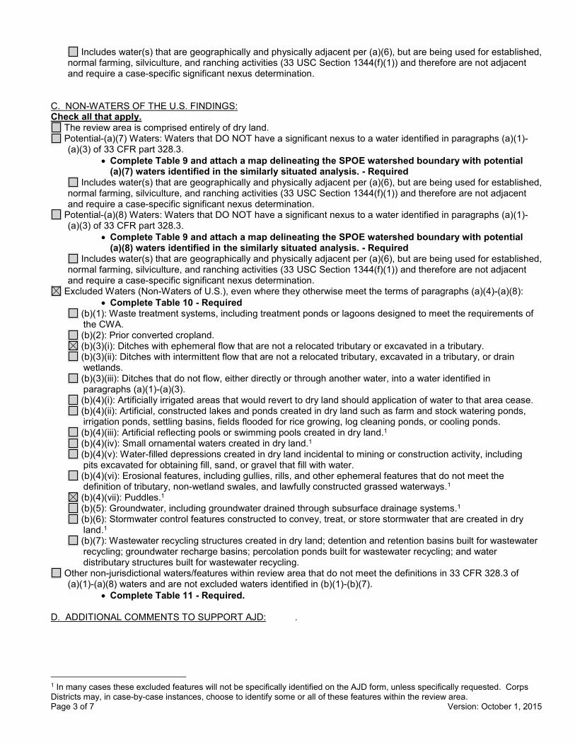
C. NON-WATERS OF THE U.S. FINDINGS: Check all that apply.
The review area is comprised entirely of dry land. Potential-(a)(7) Waters: Waters that DO NOT have a significant nexus to a water identified in paragraphs (a)(1)-
(a)(3) of 33 CFR part 328.3. • Complete Table 9 and attach a map delineating the SPOE watershed boundary with potential
(a)(7) waters identified in the similarly situated analysis. - Required Includes water(s) that are geographically and physically adjacent per (a)(6), but are being used for established,
normal farming, silviculture, and ranching activities (33 USC Section 1344(f)(1)) and therefore are not adjacent and require a case-specific significant nexus determination.
Potential-(a)(8) Waters: Waters that DO NOT have a significant nexus to a water identified in paragraphs (a)(1)-(a)(3) of 33 CFR part 328.3.
• Complete Table 9 and attach a map delineating the SPOE watershed boundary with potential (a)(8) waters identified in the similarly situated analysis. - Required
Includes water(s) that are geographically and physically adjacent per (a)(6), but are being used for established, normal farming, silviculture, and ranching activities (33 USC Section 1344(f)(1)) and therefore are not adjacent and require a case-specific significant nexus determination.
Excluded Waters (Non-Waters of U.S.), even where they otherwise meet the terms of paragraphs (a)(4)-(a)(8): • Complete Table 10 - Required
(b)(1): Waste treatment systems, including treatment ponds or lagoons designed to meet the requirements of the CWA. (b)(2): Prior converted cropland. (b)(3)(i): Ditches with ephemeral flow that are not a relocated tributary or excavated in a tributary. (b)(3)(ii): Ditches with intermittent flow that are not a relocated tributary, excavated in a tributary, or drain wetlands. (b)(3)(iii): Ditches that do not flow, either directly or through another water, into a water identified in paragraphs (a)(1)-(a)(3). (b)(4)(i): Artificially irrigated areas that would revert to dry land should application of water to that area cease. (b)(4)(ii): Artificial, constructed lakes and ponds created in dry land such as farm and stock watering ponds, irrigation ponds, settling basins, fields flooded for rice growing, log cleaning ponds, or cooling ponds. (b)(4)(iii): Artificial reflecting pools or swimming pools created in dry land.1 (b)(4)(iv): Small ornamental waters created in dry land.1 (b)(4)(v): Water-filled depressions created in dry land incidental to mining or construction activity, including pits excavated for obtaining fill, sand, or gravel that fill with water. (b)(4)(vi): Erosional features, including gullies, rills, and other ephemeral features that do not meet the definition of tributary, non-wetland swales, and lawfully constructed grassed waterways.1 (b)(4)(vii): Puddles.1 (b)(5): Groundwater, including groundwater drained through subsurface drainage systems.1 (b)(6): Stormwater control features constructed to convey, treat, or store stormwater that are created in dry land.1 (b)(7): Wastewater recycling structures created in dry land; detention and retention basins built for wastewater recycling; groundwater recharge basins; percolation ponds built for wastewater recycling; and water distributary structures built for wastewater recycling.
Other non-jurisdictional waters/features within review area that do not meet the definitions in 33 CFR 328.3 of (a)(1)-(a)(8) waters and are not excluded waters identified in (b)(1)-(b)(7).
• Complete Table 11 - Required.
D. ADDITIONAL COMMENTS TO SUPPORT AJD: .
1 In many cases these excluded features will not be specifically identified on the AJD form, unless specifically requested. Corps Districts may, in case-by-case instances, choose to identify some or all of these features within the review area.

Page 4 of 7 Version: October 1, 2015
Jurisdictional Waters of the U.S.
Table 1. (a)(1) Traditional Navigable Waters
(a)(1) Waters Name (a)(1) Criteria Rationale to Support (a)(1) Designation Include High Tide Line or Ordinary High Water Mark indicators, when applicable.
N/A Choose an item. N/A
Table 2. (a)(2) Interstate Waters
(a)(2) Waters Name Rationale to Support (a)(2) Designation N/A N/A
Table 3. (a)(3) Territorial Seas
(a)(3) Waters Name Rationale to Support (a)(3) Designation N/A N/A
Table 4. (a)(4) Impoundments
(a)(4) Waters Name Rationale to Support (a)(4) Designation N/A N/A N/A N/A
Page 5 of 7 Version: October 1, 2015
Table 5. (a)(5)Tributaries
(a)(5) Waters Name Flow Regime (a)(1)-(a)(3) Water Name to which this (a)(5) Tributary Flows
Tributary Breaks
Rationale for (a)(5) Designation and Additional Discussion. Identify flowpath to (a)(1)-(a)(3) water or attach map identifying the flowpath; explain any breaks or flow through excluded/non-jurisdictional features, etc.
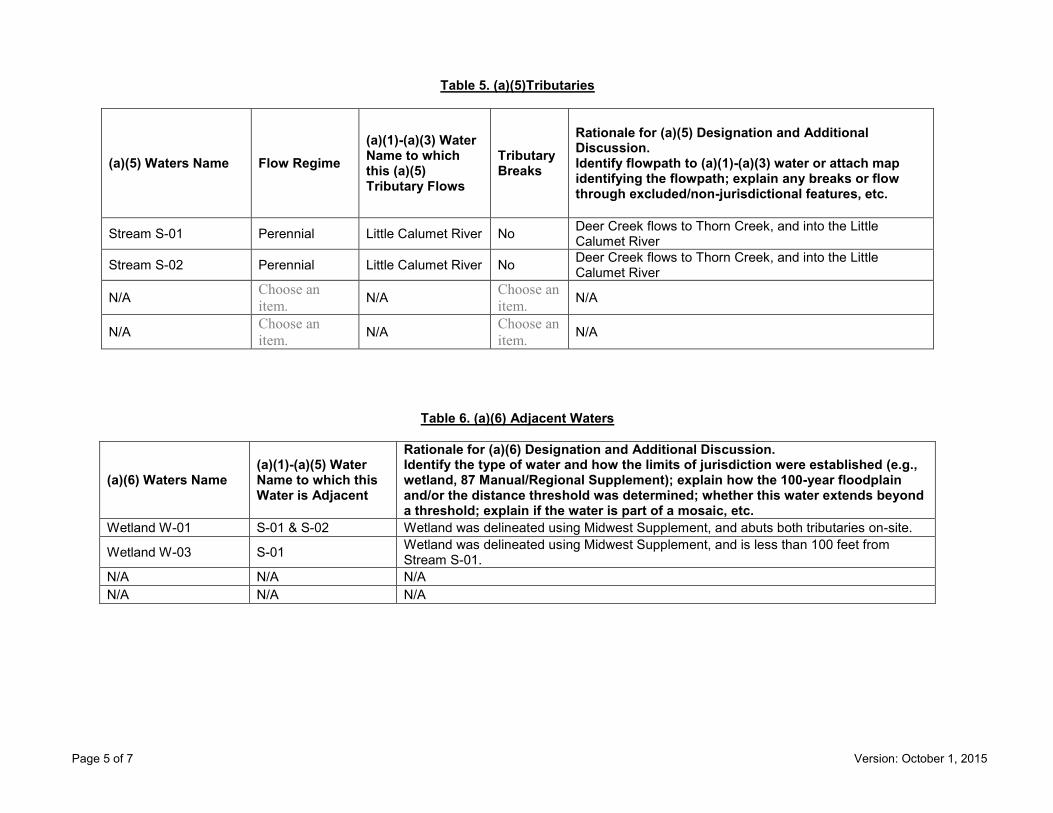
Stream S-01 Perennial Little Calumet River No Deer Creek flows to Thorn Creek, and into the Little Calumet River
Stream S-02 Perennial Little Calumet River No Deer Creek flows to Thorn Creek, and into the Little Calumet River
N/A Choose an item. N/A Choose an
item. N/A
N/A Choose an item. N/A Choose an
item. N/A
Table 6. (a)(6) Adjacent Waters
(a)(6) Waters Name (a)(1)-(a)(5) Water Name to which this Water is Adjacent
Rationale for (a)(6) Designation and Additional Discussion. Identify the type of water and how the limits of jurisdiction were established (e.g., wetland, 87 Manual/Regional Supplement); explain how the 100-year floodplain and/or the distance threshold was determined; whether this water extends beyond a threshold; explain if the water is part of a mosaic, etc.
Wetland W-01 S-01 & S-02 Wetland was delineated using Midwest Supplement, and abuts both tributaries on-site.
Wetland W-03 S-01 Wetland was delineated using Midwest Supplement, and is less than 100 feet from Stream S-01.
N/A N/A N/A N/A N/A N/A

Page 6 of 7 Version: October 1, 2015
Table 7. (a)(7) Waters
SPOE Name (a)(7) Waters Name
(a)(1)-(a)(3) Water Name to which this Water has a Significant Nexus
Significant Nexus Determination Identify SPOE watershed; discuss whether any similarly situated waters were present and aggregated for SND; discuss data, provide analysis, and summarize how the waters have more than speculative or insubstantial effect on the physical, chemical, or biological integrity of the (a)(1)-(a)(3) water, etc.
N/A N/A N/A N/A N/A N/A N/A N/A
Table 8. (a)(8) Waters
SPOE Name (a)(8) Waters Name
(a)(1)-(a)(3) Water Name to which this Water has a Significant Nexus
Significant Nexus Determination Identify SPOE watershed; explain how 100-yr floodplain and/or the distance threshold was determined; discuss whether waters were determined to be similarly situated to subject water and aggregated for SND; discuss data, provide analysis, and then summarize how the waters have more than speculative or insubstantial effect the on the physical, chemical, or biological integrity of the (a)(1)-(a)(3) water, etc.
N/A N/A N/A N/A N/A N/A N/A N/A

Page 7 of 7 Version: October 1, 2015
Non-Jurisdictional Waters
Table 9. Non-Waters/No Significant Nexus
SPOE Name
Non-(a)(7)/(a)(8) Waters Name
(a)(1)-(a)(3) Water Name to which this Water DOES NOT have a Significant Nexus
Basis for Determination that the Functions DO NOT Contribute Significantly to the Chemical, Physical, or Biological Integrity of the (a)(1)-(a)(3) Water. Identify SPOE watershed; explain how 100-yr floodplain and/or the distance threshold was determined; discuss whether waters were determined to be similarly situated to the subject water; discuss data, provide analysis, and summarize how the waters did not have more than a speculative or insubstantial effect on the physical, chemical, or biological integrity of the (a)(1)-(a)(3) water.
N/A N/A N/A N/A N/A N/A N/A N/A
Table 10. Non-Waters/Excluded Waters and Features
Paragraph (b) Excluded Feature/Water Name Rationale for Paragraph (b) Excluded Feature/Water and Additional Discussion.
Wetland W-03 Upland ponded area between old fill piles. Drainage Ditch Upland roadside drainage ditch that starts near south end of property, and is pitched to the north.
Table 11. Non-Waters/Other
Other Non-Waters of U.S. Feature/Water Name Rationale for Non-Waters of U.S. Feature/Water and Additional Discussion.
N/A N/A

Page 1 of 7 Version: October 1, 2015
Regulatory ProgramINTERIM APPROVED JURISDICTIONAL DETERMINATION FORM
U.S. Army Corps of Engineers This form should be completed by following the instructions provided
in the Interim Approved Jurisdictional Determination Form User Manual.
SECTION I: BACKGROUND INFORMATION A. COMPLETION DATE FOR APPROVED JURISDICTIONAL DETERMINATION (AJD): October 28, 2019
B. ORM NUMBER IN APPROPRIATE FORMAT (e.g., HQ-2015-00001-SMJ): LRC-2019-817
C. PROJECT LOCATION AND BACKGROUND INFORMATION:State:Illinois County/parish/borough: Cook City: Palatine Center coordinates of site (lat/long in degree decimal format): Lat. 42.11042, Long. -88.06303. Map(s)/diagram(s) of review area (including map identifying single point of entry (SPOE) watershed and/or potential jurisdictional areas where applicable) is/are: attached in report/map titled Wetland Delineation and Assessment Report dated June 24, 2019, prepared by BLA, Inc.
Other sites (e.g., offsite mitigation sites, disposal sites, etc.) are associated with this action and are recorded on a different jurisdictional determination (JD) form. List JD form ID numbers (e.g., HQ-2015-00001-SMJ-1): .
D. REVIEW PERFORMED FOR SITE EVALUATION:Office (Desk) Determination Only. Date: .Office (Desk) and Field Determination. Office/Desk Dates: October 28, 2019 Field Date(s): October 24, 2019.
SECTION II: DATA SOURCES Check all that were used to aid in the determination and attach data/maps to this AJD form and/or references/citations in the administrative record, as appropriate.
Maps, plans, plots or plat submitted by or on behalf of the applicant/consultant. Title/Date: Wetland Delineation and Assessment Report dated June 24, 2019, prepared by BLA, Inc.
Data sheets prepared/submitted by or on behalf of the applicant/consultant. Data sheets/delineation report are sufficient for purposes of AJD form. Title/Date: Wetland Delineation and
Assessment Report dated June 24, 2019, prepared by BLA, Inc. Data sheets/delineation report are not sufficient for purposes of AJD form. Summarize rationale and include
information on revised data sheets/delineation report that this AJD form has relied upon: . Revised Title/Date: . Data sheets prepared by the Corps. Title/Date: . Corps navigable waters study. Title/Date: . CorpsMap ORM map layers. Title/Date: . USGS Hydrologic Atlas. Title/Date: Palatine.
USGS, NHD, or WBD data/maps. Title/Date: . USGS 8, 10 and/or 12 digit HUC maps. HUC number: Palatine. USGS maps. Scale & quad name and date: Palatine. USDA NRCS Soil Survey. Citation: . USFWS National Wetlands Inventory maps. Citation: Palatine. State/Local wetland inventory maps. Citation: . FEMA/FIRM maps. Citation: . Photographs: Aerial. Citation: . or Other. Citation: .
LiDAR data/maps. Citation: . Previous JDs. File no. and date of JD letter: . Applicable/supporting case law: .
® ®
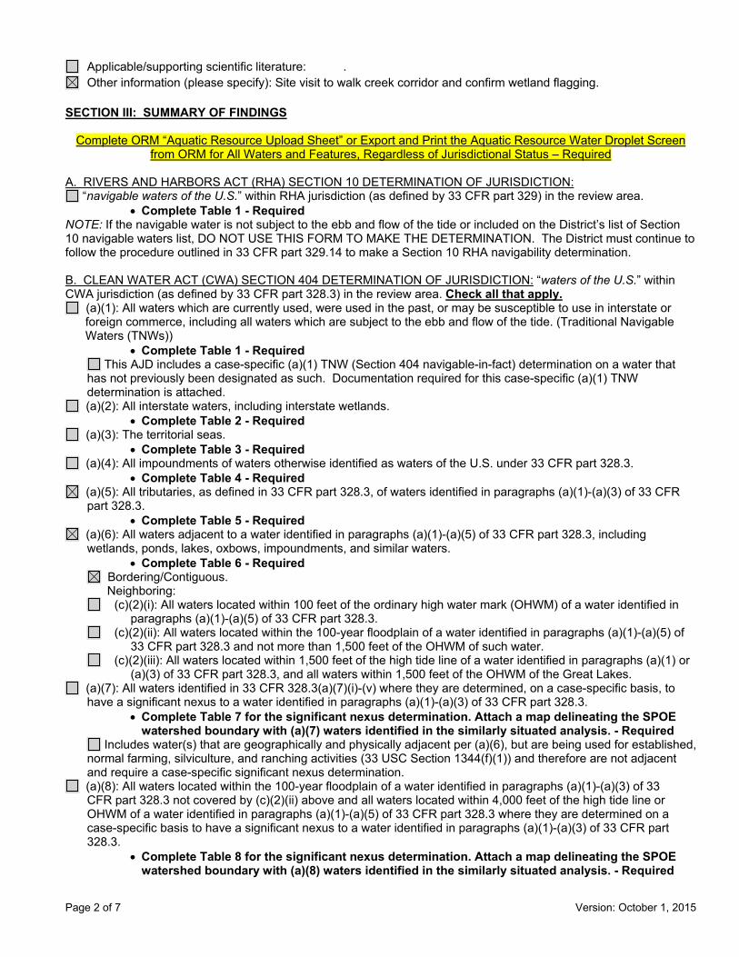
Page 2 of 7 Version: October 1, 2015
Applicable/supporting scientific literature: . Other information (please specify): Site visit to walk creek corridor and confirm wetland flagging.
SECTION III: SUMMARY OF FINDINGS
Complete ORM “Aquatic Resource Upload Sheet” or Export and Print the Aquatic Resource Water Droplet Screen from ORM for All Waters and Features, Regardless of Jurisdictional Status – Required
A. RIVERS AND HARBORS ACT (RHA) SECTION 10 DETERMINATION OF JURISDICTION:
“navigable waters of the U.S.” within RHA jurisdiction (as defined by 33 CFR part 329) in the review area. • Complete Table 1 - Required
NOTE: If the navigable water is not subject to the ebb and flow of the tide or included on the District’s list of Section 10 navigable waters list, DO NOT USE THIS FORM TO MAKE THE DETERMINATION. The District must continue to follow the procedure outlined in 33 CFR part 329.14 to make a Section 10 RHA navigability determination. B. CLEAN WATER ACT (CWA) SECTION 404 DETERMINATION OF JURISDICTION: “waters of the U.S.” within CWA jurisdiction (as defined by 33 CFR part 328.3) in the review area. Check all that apply.
(a)(1): All waters which are currently used, were used in the past, or may be susceptible to use in interstate or foreign commerce, including all waters which are subject to the ebb and flow of the tide. (Traditional Navigable Waters (TNWs))
• Complete Table 1 - Required This AJD includes a case-specific (a)(1) TNW (Section 404 navigable-in-fact) determination on a water that
has not previously been designated as such. Documentation required for this case-specific (a)(1) TNW determination is attached.
(a)(2): All interstate waters, including interstate wetlands. • Complete Table 2 - Required
(a)(3): The territorial seas. • Complete Table 3 - Required
(a)(4): All impoundments of waters otherwise identified as waters of the U.S. under 33 CFR part 328.3. • Complete Table 4 - Required
(a)(5): All tributaries, as defined in 33 CFR part 328.3, of waters identified in paragraphs (a)(1)-(a)(3) of 33 CFR part 328.3.
• Complete Table 5 - Required (a)(6): All waters adjacent to a water identified in paragraphs (a)(1)-(a)(5) of 33 CFR part 328.3, including
wetlands, ponds, lakes, oxbows, impoundments, and similar waters. • Complete Table 6 - Required
Bordering/Contiguous. Neighboring: (c)(2)(i): All waters located within 100 feet of the ordinary high water mark (OHWM) of a water identified in
paragraphs (a)(1)-(a)(5) of 33 CFR part 328.3. (c)(2)(ii): All waters located within the 100-year floodplain of a water identified in paragraphs (a)(1)-(a)(5) of
33 CFR part 328.3 and not more than 1,500 feet of the OHWM of such water. (c)(2)(iii): All waters located within 1,500 feet of the high tide line of a water identified in paragraphs (a)(1) or
(a)(3) of 33 CFR part 328.3, and all waters within 1,500 feet of the OHWM of the Great Lakes. (a)(7): All waters identified in 33 CFR 328.3(a)(7)(i)-(v) where they are determined, on a case-specific basis, to
have a significant nexus to a water identified in paragraphs (a)(1)-(a)(3) of 33 CFR part 328.3. • Complete Table 7 for the significant nexus determination. Attach a map delineating the SPOE
watershed boundary with (a)(7) waters identified in the similarly situated analysis. - Required Includes water(s) that are geographically and physically adjacent per (a)(6), but are being used for established,
normal farming, silviculture, and ranching activities (33 USC Section 1344(f)(1)) and therefore are not adjacent and require a case-specific significant nexus determination.
(a)(8): All waters located within the 100-year floodplain of a water identified in paragraphs (a)(1)-(a)(3) of 33 CFR part 328.3 not covered by (c)(2)(ii) above and all waters located within 4,000 feet of the high tide line or OHWM of a water identified in paragraphs (a)(1)-(a)(5) of 33 CFR part 328.3 where they are determined on a case-specific basis to have a significant nexus to a water identified in paragraphs (a)(1)-(a)(3) of 33 CFR part 328.3.
• Complete Table 8 for the significant nexus determination. Attach a map delineating the SPOE watershed boundary with (a)(8) waters identified in the similarly situated analysis. - Required

Page 3 of 7 Version: October 1, 2015
Includes water(s) that are geographically and physically adjacent per (a)(6), but are being used for established, normal farming, silviculture, and ranching activities (33 USC Section 1344(f)(1)) and therefore are not adjacent and require a case-specific significant nexus determination.
C. NON-WATERS OF THE U.S. FINDINGS:Check all that apply.
The review area is comprised entirely of dry land. Potential-(a)(7) Waters: Waters that DO NOT have a significant nexus to a water identified in paragraphs (a)(1)-
(a)(3) of 33 CFR part 328.3. • Complete Table 9 and attach a map delineating the SPOE watershed boundary with potential
(a)(7) waters identified in the similarly situated analysis. - Required Includes water(s) that are geographically and physically adjacent per (a)(6), but are being used for established,
normal farming, silviculture, and ranching activities (33 USC Section 1344(f)(1)) and therefore are not adjacent and require a case-specific significant nexus determination.
Potential-(a)(8) Waters: Waters that DO NOT have a significant nexus to a water identified in paragraphs (a)(1)-(a)(3) of 33 CFR part 328.3.
• Complete Table 9 and attach a map delineating the SPOE watershed boundary with potential(a)(8) waters identified in the similarly situated analysis. - Required
Includes water(s) that are geographically and physically adjacent per (a)(6), but are being used for established, normal farming, silviculture, and ranching activities (33 USC Section 1344(f)(1)) and therefore are not adjacent and require a case-specific significant nexus determination.
Excluded Waters (Non-Waters of U.S.), even where they otherwise meet the terms of paragraphs (a)(4)-(a)(8): • Complete Table 10 - Required
(b)(1): Waste treatment systems, including treatment ponds or lagoons designed to meet the requirements of the CWA. (b)(2): Prior converted cropland. (b)(3)(i): Ditches with ephemeral flow that are not a relocated tributary or excavated in a tributary. (b)(3)(ii): Ditches with intermittent flow that are not a relocated tributary, excavated in a tributary, or drain wetlands. (b)(3)(iii): Ditches that do not flow, either directly or through another water, into a water identified in paragraphs (a)(1)-(a)(3). (b)(4)(i): Artificially irrigated areas that would revert to dry land should application of water to that area cease. (b)(4)(ii): Artificial, constructed lakes and ponds created in dry land such as farm and stock watering ponds, irrigation ponds, settling basins, fields flooded for rice growing, log cleaning ponds, or cooling ponds. (b)(4)(iii): Artificial reflecting pools or swimming pools created in dry land.1 (b)(4)(iv): Small ornamental waters created in dry land.1 (b)(4)(v): Water-filled depressions created in dry land incidental to mining or construction activity, including pits excavated for obtaining fill, sand, or gravel that fill with water. (b)(4)(vi): Erosional features, including gullies, rills, and other ephemeral features that do not meet the definition of tributary, non-wetland swales, and lawfully constructed grassed waterways.1 (b)(4)(vii): Puddles.1 (b)(5): Groundwater, including groundwater drained through subsurface drainage systems.1 (b)(6): Stormwater control features constructed to convey, treat, or store stormwater that are created in dry land.1 (b)(7): Wastewater recycling structures created in dry land; detention and retention basins built for wastewater recycling; groundwater recharge basins; percolation ponds built for wastewater recycling; and water
distributary structures built for wastewater recycling. Other non-jurisdictional waters/features within review area that do not meet the definitions in 33 CFR 328.3 of
(a)(1)-(a)(8) waters and are not excluded waters identified in (b)(1)-(b)(7). • Complete Table 11 - Required.
D. ADDITIONAL COMMENTS TO SUPPORT AJD: .
1 In many cases these excluded features will not be specifically identified on the AJD form, unless specifically requested. Corps Districts may, in case-by-case instances, choose to identify some or all of these features within the review area.
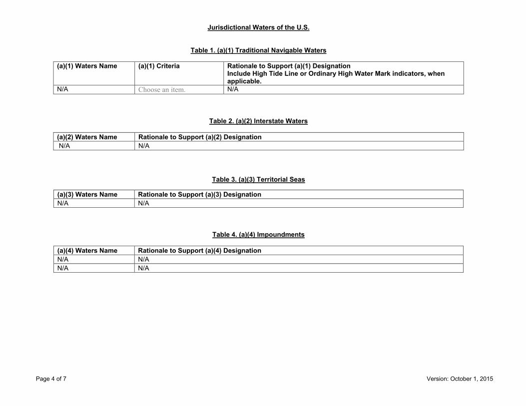
Page 4 of 7 Version: October 1, 2015
Jurisdictional Waters of the U.S.
Table 1. (a)(1) Traditional Navigable Waters
(a)(1) Waters Name (a)(1) Criteria Rationale to Support (a)(1) Designation Include High Tide Line or Ordinary High Water Mark indicators, when applicable.
N/A Choose an item. N/A
Table 2. (a)(2) Interstate Waters
(a)(2) Waters Name Rationale to Support (a)(2) Designation N/A N/A
Table 3. (a)(3) Territorial Seas
(a)(3) Waters Name Rationale to Support (a)(3) Designation N/A N/A
Table 4. (a)(4) Impoundments
(a)(4) Waters Name Rationale to Support (a)(4) Designation N/A N/A N/A N/A

Page 5 of 7 Version: October 1, 2015
Table 5. (a)(5)Tributaries
(a)(5) Waters Name Flow Regime (a)(1)-(a)(3) Water Name to which this (a)(5) Tributary Flows
Tributary Breaks
Rationale for (a)(5) Designation and Additional Discussion. Identify flowpath to (a)(1)-(a)(3) water or attach map identifying the flowpath; explain any breaks or flow through excluded/non-jurisdictional features, etc.
WOUS Perennial Des Plaines River No Salt Creek is 10-15 feet wide, and 2-4 feet deep with year round flow.
N/A Choose an item. N/A Choose an
item. N/A
N/A Choose an item. N/A Choose an
item. N/A
N/A Choose an item. N/A Choose an
item. N/A
Table 6. (a)(6) Adjacent Waters
(a)(6) Waters Name (a)(1)-(a)(5) Water Name to which this Water is Adjacent
Rationale for (a)(6) Designation and Additional Discussion. Identify the type of water and how the limits of jurisdiction were established (e.g., wetland, 87 Manual/Regional Supplement); explain how the 100-year floodplain and/or the distance threshold was determined; whether this water extends beyond a threshold; explain if the water is part of a mosaic, etc.
Wetland W-1 Salt Creek Wetland delineated using the Midwest Supplement, and directly abuts the creek on both banks.
N/A N/A N/A N/A N/A N/A N/A N/A N/A

Page 6 of 7 Version: October 1, 2015
Table 7. (a)(7) Waters
SPOE Name (a)(7) Waters Name
(a)(1)-(a)(3) Water Name to which this Water has a Significant Nexus
Significant Nexus Determination Identify SPOE watershed; discuss whether any similarly situated waters were present and aggregated for SND; discuss data, provide analysis, and summarize how the waters have more than speculative or insubstantial effect on the physical, chemical, or biological integrity of the (a)(1)-(a)(3) water, etc.
N/A N/A N/A N/A N/A N/A N/A N/A
Table 8. (a)(8) Waters
SPOE Name (a)(8) Waters Name
(a)(1)-(a)(3) Water Name to which this Water has a Significant Nexus
Significant Nexus Determination Identify SPOE watershed; explain how 100-yr floodplain and/or the distance threshold was determined; discuss whether waters were determined to be similarly situated to subject water and aggregated for SND; discuss data, provide analysis, and then summarize how the waters have more than speculative or insubstantial effect the on the physical, chemical, or biological integrity of the (a)(1)-(a)(3) water, etc.
N/A N/A N/A N/A N/A N/A N/A N/A

Page 7 of 7 Version: October 1, 2015
Non-Jurisdictional Waters
Table 9. Non-Waters/No Significant Nexus
SPOE Name
Non-(a)(7)/(a)(8) Waters Name
(a)(1)-(a)(3) Water Name to which this Water DOES NOT have a Significant Nexus
Basis for Determination that the Functions DO NOT Contribute Significantly to the Chemical, Physical, or Biological Integrity of the (a)(1)-(a)(3) Water. Identify SPOE watershed; explain how 100-yr floodplain and/or the distance threshold was determined; discuss whether waters were determined to be similarly situated to the subject water; discuss data, provide analysis, and summarize how the waters did not have more than a speculative or insubstantial effect on the physical, chemical, or biological integrity of the (a)(1)-(a)(3) water.
N/A N/A N/A N/A N/A N/A N/A N/A
Table 10. Non-Waters/Excluded Waters and Features
Paragraph (b) Excluded Feature/Water Name Rationale for Paragraph (b) Excluded Feature/Water and Additional Discussion.
N/A N/A N/A N/A
Table 11. Non-Waters/Other
Other Non-Waters of U.S. Feature/Water Name Rationale for Non-Waters of U.S. Feature/Water and Additional Discussion.
N/A N/A
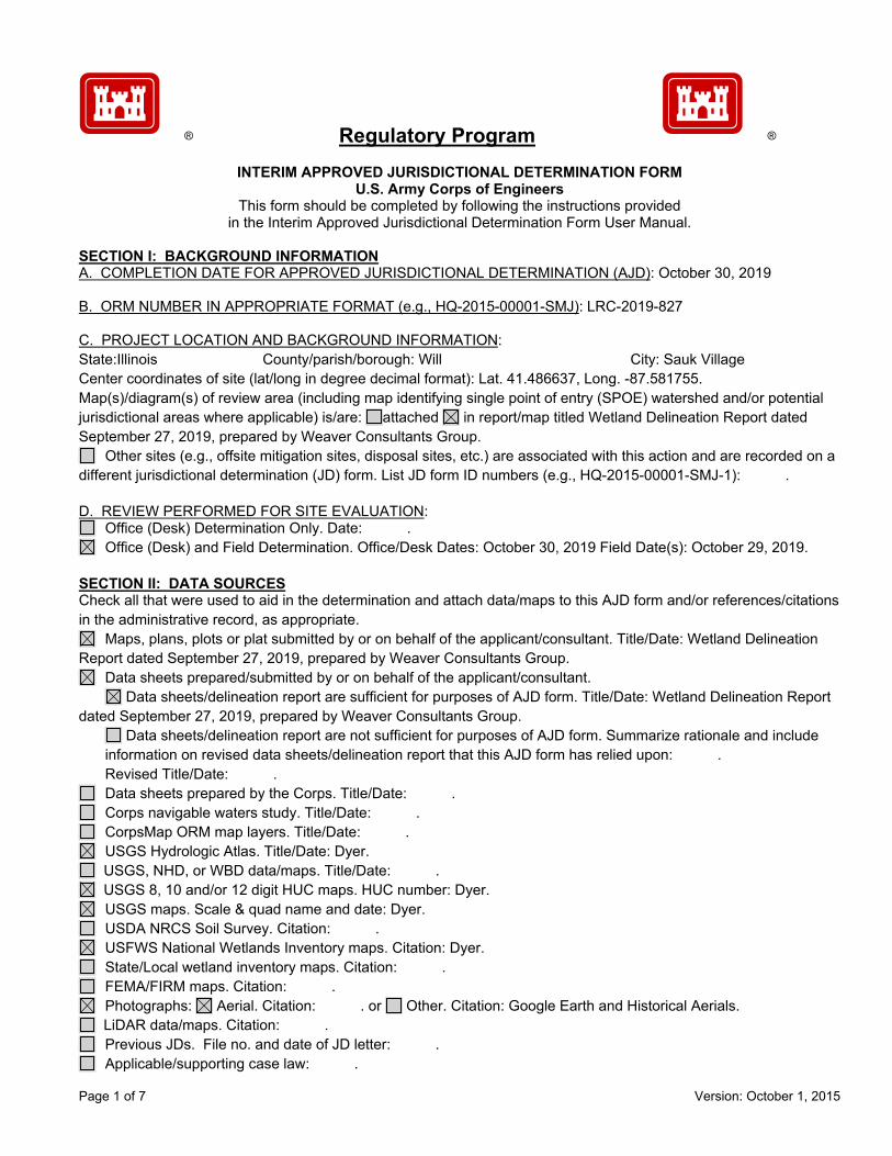
Page 1 of 7 Version: October 1, 2015
Regulatory Program
INTERIM APPROVED JURISDICTIONAL DETERMINATION FORM U.S. Army Corps of Engineers
This form should be completed by following the instructions provided in the Interim Approved Jurisdictional Determination Form User Manual.
SECTION I: BACKGROUND INFORMATION A. COMPLETION DATE FOR APPROVED JURISDICTIONAL DETERMINATION (AJD): October 30, 2019 B. ORM NUMBER IN APPROPRIATE FORMAT (e.g., HQ-2015-00001-SMJ): LRC-2019-827 C. PROJECT LOCATION AND BACKGROUND INFORMATION: State:Illinois County/parish/borough: Will City: Sauk Village Center coordinates of site (lat/long in degree decimal format): Lat. 41.486637, Long. -87.581755. Map(s)/diagram(s) of review area (including map identifying single point of entry (SPOE) watershed and/or potential jurisdictional areas where applicable) is/are: attached in report/map titled Wetland Delineation Report dated September 27, 2019, prepared by Weaver Consultants Group.
Other sites (e.g., offsite mitigation sites, disposal sites, etc.) are associated with this action and are recorded on a different jurisdictional determination (JD) form. List JD form ID numbers (e.g., HQ-2015-00001-SMJ-1): . D. REVIEW PERFORMED FOR SITE EVALUATION:
Office (Desk) Determination Only. Date: . Office (Desk) and Field Determination. Office/Desk Dates: October 30, 2019 Field Date(s): October 29, 2019.
SECTION II: DATA SOURCES Check all that were used to aid in the determination and attach data/maps to this AJD form and/or references/citations in the administrative record, as appropriate.
Maps, plans, plots or plat submitted by or on behalf of the applicant/consultant. Title/Date: Wetland Delineation Report dated September 27, 2019, prepared by Weaver Consultants Group.
Data sheets prepared/submitted by or on behalf of the applicant/consultant. Data sheets/delineation report are sufficient for purposes of AJD form. Title/Date: Wetland Delineation Report dated September 27, 2019, prepared by Weaver Consultants Group.
Data sheets/delineation report are not sufficient for purposes of AJD form. Summarize rationale and include information on revised data sheets/delineation report that this AJD form has relied upon: . Revised Title/Date: .
Data sheets prepared by the Corps. Title/Date: . Corps navigable waters study. Title/Date: . CorpsMap ORM map layers. Title/Date: . USGS Hydrologic Atlas. Title/Date: Dyer. USGS, NHD, or WBD data/maps. Title/Date: . USGS 8, 10 and/or 12 digit HUC maps. HUC number: Dyer. USGS maps. Scale & quad name and date: Dyer. USDA NRCS Soil Survey. Citation: . USFWS National Wetlands Inventory maps. Citation: Dyer. State/Local wetland inventory maps. Citation: . FEMA/FIRM maps. Citation: . Photographs: Aerial. Citation: . or Other. Citation: Google Earth and Historical Aerials. LiDAR data/maps. Citation: . Previous JDs. File no. and date of JD letter: . Applicable/supporting case law: .
® ®

Page 2 of 7 Version: October 1, 2015
Applicable/supporting scientific literature: . Other information (please specify): .
SECTION III: SUMMARY OF FINDINGS
Complete ORM “Aquatic Resource Upload Sheet” or Export and Print the Aquatic Resource Water Droplet Screen from ORM for All Waters and Features, Regardless of Jurisdictional Status – Required
A. RIVERS AND HARBORS ACT (RHA) SECTION 10 DETERMINATION OF JURISDICTION:
“navigable waters of the U.S.” within RHA jurisdiction (as defined by 33 CFR part 329) in the review area. • Complete Table 1 - Required
NOTE: If the navigable water is not subject to the ebb and flow of the tide or included on the District’s list of Section 10 navigable waters list, DO NOT USE THIS FORM TO MAKE THE DETERMINATION. The District must continue to follow the procedure outlined in 33 CFR part 329.14 to make a Section 10 RHA navigability determination. B. CLEAN WATER ACT (CWA) SECTION 404 DETERMINATION OF JURISDICTION: “waters of the U.S.” within CWA jurisdiction (as defined by 33 CFR part 328.3) in the review area. Check all that apply.
(a)(1): All waters which are currently used, were used in the past, or may be susceptible to use in interstate or foreign commerce, including all waters which are subject to the ebb and flow of the tide. (Traditional Navigable Waters (TNWs))
• Complete Table 1 - Required This AJD includes a case-specific (a)(1) TNW (Section 404 navigable-in-fact) determination on a water that
has not previously been designated as such. Documentation required for this case-specific (a)(1) TNW determination is attached.
(a)(2): All interstate waters, including interstate wetlands. • Complete Table 2 - Required
(a)(3): The territorial seas. • Complete Table 3 - Required
(a)(4): All impoundments of waters otherwise identified as waters of the U.S. under 33 CFR part 328.3. • Complete Table 4 - Required
(a)(5): All tributaries, as defined in 33 CFR part 328.3, of waters identified in paragraphs (a)(1)-(a)(3) of 33 CFR part 328.3.
• Complete Table 5 - Required (a)(6): All waters adjacent to a water identified in paragraphs (a)(1)-(a)(5) of 33 CFR part 328.3, including
wetlands, ponds, lakes, oxbows, impoundments, and similar waters. • Complete Table 6 - Required
Bordering/Contiguous. Neighboring: (c)(2)(i): All waters located within 100 feet of the ordinary high water mark (OHWM) of a water identified in
paragraphs (a)(1)-(a)(5) of 33 CFR part 328.3. (c)(2)(ii): All waters located within the 100-year floodplain of a water identified in paragraphs (a)(1)-(a)(5) of
33 CFR part 328.3 and not more than 1,500 feet of the OHWM of such water. (c)(2)(iii): All waters located within 1,500 feet of the high tide line of a water identified in paragraphs (a)(1) or
(a)(3) of 33 CFR part 328.3, and all waters within 1,500 feet of the OHWM of the Great Lakes. (a)(7): All waters identified in 33 CFR 328.3(a)(7)(i)-(v) where they are determined, on a case-specific basis, to
have a significant nexus to a water identified in paragraphs (a)(1)-(a)(3) of 33 CFR part 328.3. • Complete Table 7 for the significant nexus determination. Attach a map delineating the SPOE
watershed boundary with (a)(7) waters identified in the similarly situated analysis. - Required Includes water(s) that are geographically and physically adjacent per (a)(6), but are being used for established,
normal farming, silviculture, and ranching activities (33 USC Section 1344(f)(1)) and therefore are not adjacent and require a case-specific significant nexus determination.
(a)(8): All waters located within the 100-year floodplain of a water identified in paragraphs (a)(1)-(a)(3) of 33 CFR part 328.3 not covered by (c)(2)(ii) above and all waters located within 4,000 feet of the high tide line or OHWM of a water identified in paragraphs (a)(1)-(a)(5) of 33 CFR part 328.3 where they are determined on a case-specific basis to have a significant nexus to a water identified in paragraphs (a)(1)-(a)(3) of 33 CFR part 328.3.
• Complete Table 8 for the significant nexus determination. Attach a map delineating the SPOE watershed boundary with (a)(8) waters identified in the similarly situated analysis. - Required

Page 3 of 7 Version: October 1, 2015
Includes water(s) that are geographically and physically adjacent per (a)(6), but are being used for established, normal farming, silviculture, and ranching activities (33 USC Section 1344(f)(1)) and therefore are not adjacent and require a case-specific significant nexus determination.
C. NON-WATERS OF THE U.S. FINDINGS: Check all that apply.
The review area is comprised entirely of dry land. Potential-(a)(7) Waters: Waters that DO NOT have a significant nexus to a water identified in paragraphs (a)(1)-
(a)(3) of 33 CFR part 328.3. • Complete Table 9 and attach a map delineating the SPOE watershed boundary with potential
(a)(7) waters identified in the similarly situated analysis. - Required Includes water(s) that are geographically and physically adjacent per (a)(6), but are being used for established,
normal farming, silviculture, and ranching activities (33 USC Section 1344(f)(1)) and therefore are not adjacent and require a case-specific significant nexus determination.
Potential-(a)(8) Waters: Waters that DO NOT have a significant nexus to a water identified in paragraphs (a)(1)-(a)(3) of 33 CFR part 328.3.
• Complete Table 9 and attach a map delineating the SPOE watershed boundary with potential (a)(8) waters identified in the similarly situated analysis. - Required
Includes water(s) that are geographically and physically adjacent per (a)(6), but are being used for established, normal farming, silviculture, and ranching activities (33 USC Section 1344(f)(1)) and therefore are not adjacent and require a case-specific significant nexus determination.
Excluded Waters (Non-Waters of U.S.), even where they otherwise meet the terms of paragraphs (a)(4)-(a)(8): • Complete Table 10 - Required
(b)(1): Waste treatment systems, including treatment ponds or lagoons designed to meet the requirements of the CWA. (b)(2): Prior converted cropland. (b)(3)(i): Ditches with ephemeral flow that are not a relocated tributary or excavated in a tributary. (b)(3)(ii): Ditches with intermittent flow that are not a relocated tributary, excavated in a tributary, or drain wetlands. (b)(3)(iii): Ditches that do not flow, either directly or through another water, into a water identified in paragraphs (a)(1)-(a)(3). (b)(4)(i): Artificially irrigated areas that would revert to dry land should application of water to that area cease. (b)(4)(ii): Artificial, constructed lakes and ponds created in dry land such as farm and stock watering ponds, irrigation ponds, settling basins, fields flooded for rice growing, log cleaning ponds, or cooling ponds. (b)(4)(iii): Artificial reflecting pools or swimming pools created in dry land.1 (b)(4)(iv): Small ornamental waters created in dry land.1 (b)(4)(v): Water-filled depressions created in dry land incidental to mining or construction activity, including pits excavated for obtaining fill, sand, or gravel that fill with water. (b)(4)(vi): Erosional features, including gullies, rills, and other ephemeral features that do not meet the definition of tributary, non-wetland swales, and lawfully constructed grassed waterways.1 (b)(4)(vii): Puddles.1 (b)(5): Groundwater, including groundwater drained through subsurface drainage systems.1 (b)(6): Stormwater control features constructed to convey, treat, or store stormwater that are created in dry land.1 (b)(7): Wastewater recycling structures created in dry land; detention and retention basins built for wastewater recycling; groundwater recharge basins; percolation ponds built for wastewater recycling; and water distributary structures built for wastewater recycling.
Other non-jurisdictional waters/features within review area that do not meet the definitions in 33 CFR 328.3 of (a)(1)-(a)(8) waters and are not excluded waters identified in (b)(1)-(b)(7).
• Complete Table 11 - Required.
D. ADDITIONAL COMMENTS TO SUPPORT AJD: .
1 In many cases these excluded features will not be specifically identified on the AJD form, unless specifically requested. Corps Districts may, in case-by-case instances, choose to identify some or all of these features within the review area.

Page 4 of 7 Version: October 1, 2015
Jurisdictional Waters of the U.S.
Table 1. (a)(1) Traditional Navigable Waters
(a)(1) Waters Name (a)(1) Criteria Rationale to Support (a)(1) Designation Include High Tide Line or Ordinary High Water Mark indicators, when applicable.
N/A Choose an item. N/A
Table 2. (a)(2) Interstate Waters
(a)(2) Waters Name Rationale to Support (a)(2) Designation N/A N/A
Table 3. (a)(3) Territorial Seas
(a)(3) Waters Name Rationale to Support (a)(3) Designation N/A N/A
Table 4. (a)(4) Impoundments
(a)(4) Waters Name Rationale to Support (a)(4) Designation N/A N/A N/A N/A
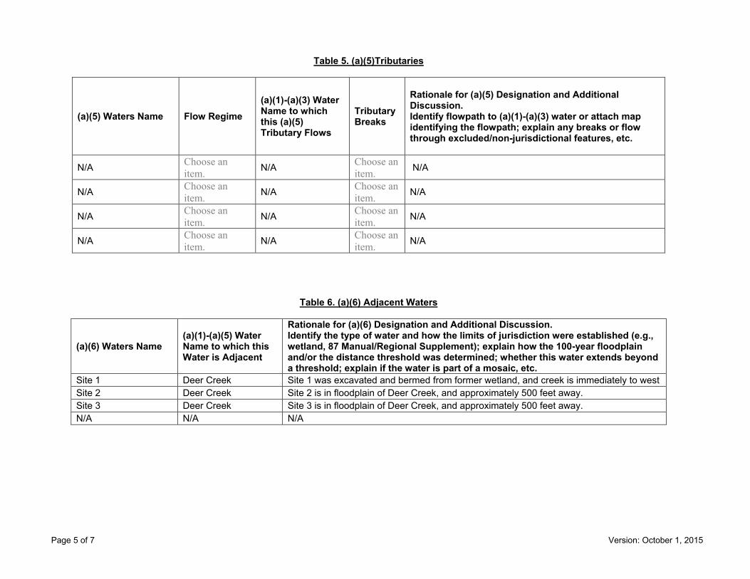
Page 5 of 7 Version: October 1, 2015
Table 5. (a)(5)Tributaries
(a)(5) Waters Name Flow Regime (a)(1)-(a)(3) Water Name to which this (a)(5) Tributary Flows
Tributary Breaks
Rationale for (a)(5) Designation and Additional Discussion. Identify flowpath to (a)(1)-(a)(3) water or attach map identifying the flowpath; explain any breaks or flow through excluded/non-jurisdictional features, etc.
N/A Choose an item. N/A Choose an
item. N/A
N/A Choose an item. N/A Choose an
item. N/A
N/A Choose an item. N/A Choose an
item. N/A
N/A Choose an item. N/A Choose an
item. N/A
Table 6. (a)(6) Adjacent Waters
(a)(6) Waters Name (a)(1)-(a)(5) Water Name to which this Water is Adjacent
Rationale for (a)(6) Designation and Additional Discussion. Identify the type of water and how the limits of jurisdiction were established (e.g., wetland, 87 Manual/Regional Supplement); explain how the 100-year floodplain and/or the distance threshold was determined; whether this water extends beyond a threshold; explain if the water is part of a mosaic, etc.
Site 1 Deer Creek Site 1 was excavated and bermed from former wetland, and creek is immediately to west Site 2 Deer Creek Site 2 is in floodplain of Deer Creek, and approximately 500 feet away. Site 3 Deer Creek Site 3 is in floodplain of Deer Creek, and approximately 500 feet away. N/A N/A N/A
Page 6 of 7 Version: October 1, 2015
Table 7. (a)(7) Waters
SPOE Name (a)(7) Waters Name
(a)(1)-(a)(3) Water Name to which this Water has a Significant Nexus
Significant Nexus Determination Identify SPOE watershed; discuss whether any similarly situated waters were present and aggregated for SND; discuss data, provide analysis, and summarize how the waters have more than speculative or insubstantial effect on the physical, chemical, or biological integrity of the (a)(1)-(a)(3) water, etc.
N/A N/A N/A N/A N/A N/A N/A N/A
Table 8. (a)(8) Waters
SPOE Name (a)(8) Waters Name
(a)(1)-(a)(3) Water Name to which this Water has a Significant Nexus
Significant Nexus Determination Identify SPOE watershed; explain how 100-yr floodplain and/or the distance threshold was determined; discuss whether waters were determined to be similarly situated to subject water and aggregated for SND; discuss data, provide analysis, and then summarize how the waters have more than speculative or insubstantial effect the on the physical, chemical, or biological integrity of the (a)(1)-(a)(3) water, etc.
N/A N/A N/A N/A N/A N/A N/A N/A
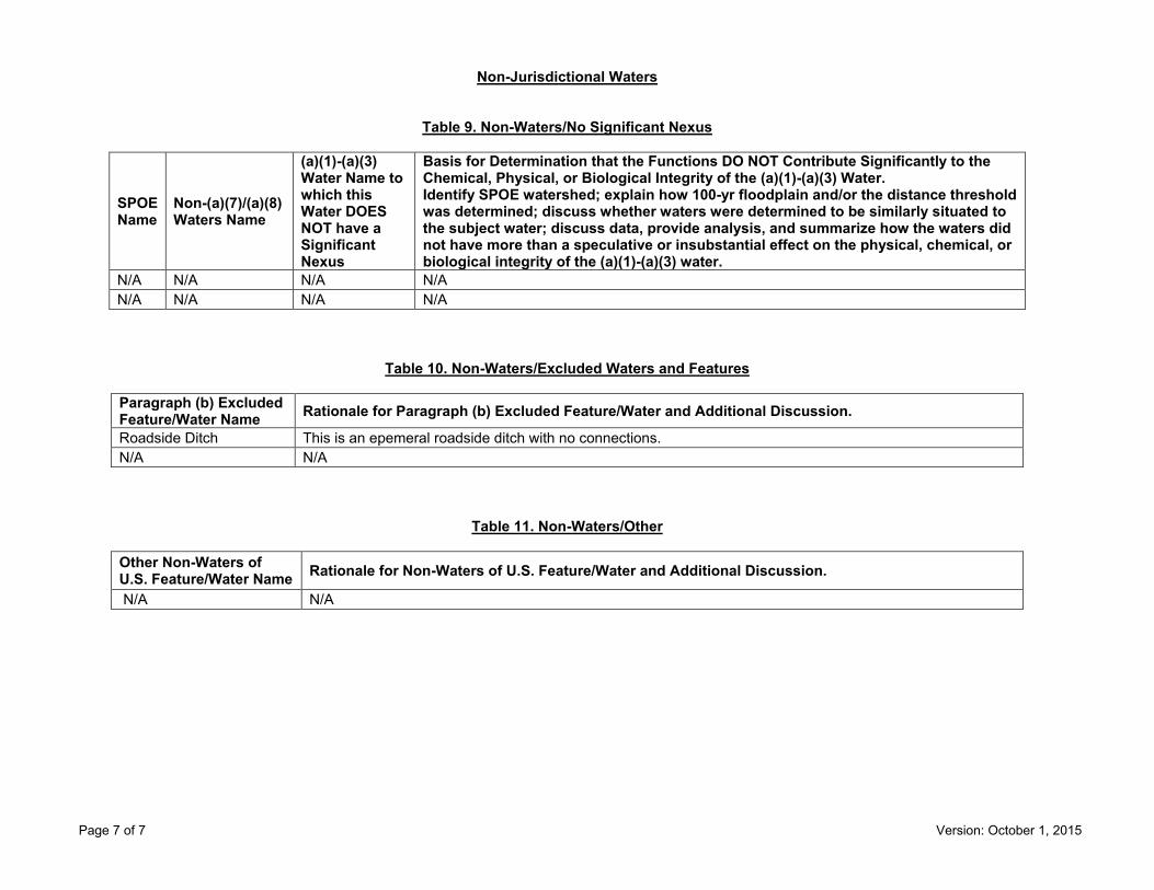
Page 7 of 7 Version: October 1, 2015
Non-Jurisdictional Waters
Table 9. Non-Waters/No Significant Nexus
SPOE Name
Non-(a)(7)/(a)(8) Waters Name
(a)(1)-(a)(3) Water Name to which this Water DOES NOT have a Significant Nexus
Basis for Determination that the Functions DO NOT Contribute Significantly to the Chemical, Physical, or Biological Integrity of the (a)(1)-(a)(3) Water. Identify SPOE watershed; explain how 100-yr floodplain and/or the distance threshold was determined; discuss whether waters were determined to be similarly situated to the subject water; discuss data, provide analysis, and summarize how the waters did not have more than a speculative or insubstantial effect on the physical, chemical, or biological integrity of the (a)(1)-(a)(3) water.
N/A N/A N/A N/A N/A N/A N/A N/A
Table 10. Non-Waters/Excluded Waters and Features
Paragraph (b) Excluded Feature/Water Name Rationale for Paragraph (b) Excluded Feature/Water and Additional Discussion.
Roadside Ditch This is an epemeral roadside ditch with no connections. N/A N/A
Table 11. Non-Waters/Other
Other Non-Waters of U.S. Feature/Water Name Rationale for Non-Waters of U.S. Feature/Water and Additional Discussion.
N/A N/A

Page 1 of 7 Version: October 1, 2015
Regulatory Program
INTERIM APPROVED JURISDICTIONAL DETERMINATION FORM U.S. Army Corps of Engineers
This form should be completed by following the instructions provided in the Interim Approved Jurisdictional Determination Form User Manual.
SECTION I: BACKGROUND INFORMATION A. COMPLETION DATE FOR APPROVED JURISDICTIONAL DETERMINATION (AJD): November 13, 2019 B. ORM NUMBER IN APPROPRIATE FORMAT (e.g., HQ-2015-00001-SMJ): LRC-2019-830 C. PROJECT LOCATION AND BACKGROUND INFORMATION: State:Illinois County/parish/borough: Will City: Mokena Center coordinates of site (lat/long in degree decimal format): Lat. 41.549731, Long. -87.93978. Map(s)/diagram(s) of review area (including map identifying single point of entry (SPOE) watershed and/or potential jurisdictional areas where applicable) is/are: attached in report/map titled Wetland Summary Exhibit 6; Approximate Acreages.
Other sites (e.g., offsite mitigation sites, disposal sites, etc.) are associated with this action and are recorded on a different jurisdictional determination (JD) form. List JD form ID numbers (e.g., HQ-2015-00001-SMJ-1): . D. REVIEW PERFORMED FOR SITE EVALUATION:
Office (Desk) Determination Only. Date: . Office (Desk) and Field Determination. Office/Desk Dates: November 13, 2019 Field Date(s): November 7, 2019.
SECTION II: DATA SOURCES Check all that were used to aid in the determination and attach data/maps to this AJD form and/or references/citations in the administrative record, as appropriate.
Maps, plans, plots or plat submitted by or on behalf of the applicant/consultant. Title/Date: Wetland Summary Exhibit 6; Approximate Acreages.
Data sheets prepared/submitted by or on behalf of the applicant/consultant. Data sheets/delineation report are sufficient for purposes of AJD form. Title/Date: .
Data sheets/delineation report are not sufficient for purposes of AJD form. Summarize rationale and include information on revised data sheets/delineation report that this AJD form has relied upon: . Revised Title/Date: .
Data sheets prepared by the Corps. Title/Date: . Corps navigable waters study. Title/Date: . CorpsMap ORM map layers. Title/Date: . USGS Hydrologic Atlas. Title/Date: Mokena. USGS, NHD, or WBD data/maps. Title/Date: . USGS 8, 10 and/or 12 digit HUC maps. HUC number: Mokena. USGS maps. Scale & quad name and date: Mokena. USDA NRCS Soil Survey. Citation: . USFWS National Wetlands Inventory maps. Citation: Mokena. State/Local wetland inventory maps. Citation: . FEMA/FIRM maps. Citation: . Photographs: Aerial. Citation: . or Other. Citation: . LiDAR data/maps. Citation: . Previous JDs. File no. and date of JD letter: . Applicable/supporting case law: . Applicable/supporting scientific literature: .
® ®

Page 2 of 7 Version: October 1, 2015
Other information (please specify): GIS Review. SECTION III: SUMMARY OF FINDINGS
Complete ORM “Aquatic Resource Upload Sheet” or Export and Print the Aquatic Resource Water Droplet Screen from ORM for All Waters and Features, Regardless of Jurisdictional Status – Required
A. RIVERS AND HARBORS ACT (RHA) SECTION 10 DETERMINATION OF JURISDICTION:
“navigable waters of the U.S.” within RHA jurisdiction (as defined by 33 CFR part 329) in the review area. • Complete Table 1 - Required
NOTE: If the navigable water is not subject to the ebb and flow of the tide or included on the District’s list of Section 10 navigable waters list, DO NOT USE THIS FORM TO MAKE THE DETERMINATION. The District must continue to follow the procedure outlined in 33 CFR part 329.14 to make a Section 10 RHA navigability determination. B. CLEAN WATER ACT (CWA) SECTION 404 DETERMINATION OF JURISDICTION: “waters of the U.S.” within CWA jurisdiction (as defined by 33 CFR part 328.3) in the review area. Check all that apply.
(a)(1): All waters which are currently used, were used in the past, or may be susceptible to use in interstate or foreign commerce, including all waters which are subject to the ebb and flow of the tide. (Traditional Navigable Waters (TNWs))
• Complete Table 1 - Required This AJD includes a case-specific (a)(1) TNW (Section 404 navigable-in-fact) determination on a water that
has not previously been designated as such. Documentation required for this case-specific (a)(1) TNW determination is attached.
(a)(2): All interstate waters, including interstate wetlands. • Complete Table 2 - Required
(a)(3): The territorial seas. • Complete Table 3 - Required
(a)(4): All impoundments of waters otherwise identified as waters of the U.S. under 33 CFR part 328.3. • Complete Table 4 - Required
(a)(5): All tributaries, as defined in 33 CFR part 328.3, of waters identified in paragraphs (a)(1)-(a)(3) of 33 CFR part 328.3.
• Complete Table 5 - Required (a)(6): All waters adjacent to a water identified in paragraphs (a)(1)-(a)(5) of 33 CFR part 328.3, including
wetlands, ponds, lakes, oxbows, impoundments, and similar waters. • Complete Table 6 - Required
Bordering/Contiguous. Neighboring: (c)(2)(i): All waters located within 100 feet of the ordinary high water mark (OHWM) of a water identified in
paragraphs (a)(1)-(a)(5) of 33 CFR part 328.3. (c)(2)(ii): All waters located within the 100-year floodplain of a water identified in paragraphs (a)(1)-(a)(5) of
33 CFR part 328.3 and not more than 1,500 feet of the OHWM of such water. (c)(2)(iii): All waters located within 1,500 feet of the high tide line of a water identified in paragraphs (a)(1) or
(a)(3) of 33 CFR part 328.3, and all waters within 1,500 feet of the OHWM of the Great Lakes. (a)(7): All waters identified in 33 CFR 328.3(a)(7)(i)-(v) where they are determined, on a case-specific basis, to
have a significant nexus to a water identified in paragraphs (a)(1)-(a)(3) of 33 CFR part 328.3. • Complete Table 7 for the significant nexus determination. Attach a map delineating the SPOE
watershed boundary with (a)(7) waters identified in the similarly situated analysis. - Required Includes water(s) that are geographically and physically adjacent per (a)(6), but are being used for established,
normal farming, silviculture, and ranching activities (33 USC Section 1344(f)(1)) and therefore are not adjacent and require a case-specific significant nexus determination.
(a)(8): All waters located within the 100-year floodplain of a water identified in paragraphs (a)(1)-(a)(3) of 33 CFR part 328.3 not covered by (c)(2)(ii) above and all waters located within 4,000 feet of the high tide line or OHWM of a water identified in paragraphs (a)(1)-(a)(5) of 33 CFR part 328.3 where they are determined on a case-specific basis to have a significant nexus to a water identified in paragraphs (a)(1)-(a)(3) of 33 CFR part 328.3.
• Complete Table 8 for the significant nexus determination. Attach a map delineating the SPOE watershed boundary with (a)(8) waters identified in the similarly situated analysis. - Required

Page 3 of 7 Version: October 1, 2015
Includes water(s) that are geographically and physically adjacent per (a)(6), but are being used for established, normal farming, silviculture, and ranching activities (33 USC Section 1344(f)(1)) and therefore are not adjacent and require a case-specific significant nexus determination.
C. NON-WATERS OF THE U.S. FINDINGS: Check all that apply.
The review area is comprised entirely of dry land. Potential-(a)(7) Waters: Waters that DO NOT have a significant nexus to a water identified in paragraphs (a)(1)-
(a)(3) of 33 CFR part 328.3. • Complete Table 9 and attach a map delineating the SPOE watershed boundary with potential
(a)(7) waters identified in the similarly situated analysis. - Required Includes water(s) that are geographically and physically adjacent per (a)(6), but are being used for established,
normal farming, silviculture, and ranching activities (33 USC Section 1344(f)(1)) and therefore are not adjacent and require a case-specific significant nexus determination.
Potential-(a)(8) Waters: Waters that DO NOT have a significant nexus to a water identified in paragraphs (a)(1)-(a)(3) of 33 CFR part 328.3.
• Complete Table 9 and attach a map delineating the SPOE watershed boundary with potential (a)(8) waters identified in the similarly situated analysis. - Required
Includes water(s) that are geographically and physically adjacent per (a)(6), but are being used for established, normal farming, silviculture, and ranching activities (33 USC Section 1344(f)(1)) and therefore are not adjacent and require a case-specific significant nexus determination.
Excluded Waters (Non-Waters of U.S.), even where they otherwise meet the terms of paragraphs (a)(4)-(a)(8): • Complete Table 10 - Required
(b)(1): Waste treatment systems, including treatment ponds or lagoons designed to meet the requirements of the CWA. (b)(2): Prior converted cropland. (b)(3)(i): Ditches with ephemeral flow that are not a relocated tributary or excavated in a tributary. (b)(3)(ii): Ditches with intermittent flow that are not a relocated tributary, excavated in a tributary, or drain wetlands. (b)(3)(iii): Ditches that do not flow, either directly or through another water, into a water identified in paragraphs (a)(1)-(a)(3). (b)(4)(i): Artificially irrigated areas that would revert to dry land should application of water to that area cease. (b)(4)(ii): Artificial, constructed lakes and ponds created in dry land such as farm and stock watering ponds, irrigation ponds, settling basins, fields flooded for rice growing, log cleaning ponds, or cooling ponds. (b)(4)(iii): Artificial reflecting pools or swimming pools created in dry land.1 (b)(4)(iv): Small ornamental waters created in dry land.1 (b)(4)(v): Water-filled depressions created in dry land incidental to mining or construction activity, including pits excavated for obtaining fill, sand, or gravel that fill with water. (b)(4)(vi): Erosional features, including gullies, rills, and other ephemeral features that do not meet the definition of tributary, non-wetland swales, and lawfully constructed grassed waterways.1 (b)(4)(vii): Puddles.1 (b)(5): Groundwater, including groundwater drained through subsurface drainage systems.1 (b)(6): Stormwater control features constructed to convey, treat, or store stormwater that are created in dry land.1 (b)(7): Wastewater recycling structures created in dry land; detention and retention basins built for wastewater recycling; groundwater recharge basins; percolation ponds built for wastewater recycling; and water distributary structures built for wastewater recycling.
Other non-jurisdictional waters/features within review area that do not meet the definitions in 33 CFR 328.3 of (a)(1)-(a)(8) waters and are not excluded waters identified in (b)(1)-(b)(7).
• Complete Table 11 - Required.
D. ADDITIONAL COMMENTS TO SUPPORT AJD: .
1 In many cases these excluded features will not be specifically identified on the AJD form, unless specifically requested. Corps Districts may, in case-by-case instances, choose to identify some or all of these features within the review area.

Page 4 of 7 Version: October 1, 2015
Jurisdictional Waters of the U.S.
Table 1. (a)(1) Traditional Navigable Waters
(a)(1) Waters Name (a)(1) Criteria Rationale to Support (a)(1) Designation Include High Tide Line or Ordinary High Water Mark indicators, when applicable.
N/A Choose an item. N/A
Table 2. (a)(2) Interstate Waters
(a)(2) Waters Name Rationale to Support (a)(2) Designation N/A N/A
Table 3. (a)(3) Territorial Seas
(a)(3) Waters Name Rationale to Support (a)(3) Designation N/A N/A
Table 4. (a)(4) Impoundments
(a)(4) Waters Name Rationale to Support (a)(4) Designation N/A N/A N/A N/A

Page 5 of 7 Version: October 1, 2015
Table 5. (a)(5)Tributaries
(a)(5) Waters Name Flow Regime (a)(1)-(a)(3) Water Name to which this (a)(5) Tributary Flows
Tributary Breaks
Rationale for (a)(5) Designation and Additional Discussion. Identify flowpath to (a)(1)-(a)(3) water or attach map identifying the flowpath; explain any breaks or flow through excluded/non-jurisdictional features, etc.
N/A Choose an item. N/A Choose an
item. N/A
N/A Choose an item. N/A Choose an
item. N/A
N/A Choose an item. N/A Choose an
item. N/A
N/A Choose an item. N/A Choose an
item. N/A
Table 6. (a)(6) Adjacent Waters
(a)(6) Waters Name (a)(1)-(a)(5) Water Name to which this Water is Adjacent
Rationale for (a)(6) Designation and Additional Discussion. Identify the type of water and how the limits of jurisdiction were established (e.g., wetland, 87 Manual/Regional Supplement); explain how the 100-year floodplain and/or the distance threshold was determined; whether this water extends beyond a threshold; explain if the water is part of a mosaic, etc.
Wetland Marley Creek Tributary
Wetland drains out via a small tributary that flows south under Maple Road, and into Marley Creek, which flows into Hickory Creek, and finally into the Des Plaines River.
N/A N/A N/A N/A N/A N/A N/A N/A N/A

Page 6 of 7 Version: October 1, 2015
Table 7. (a)(7) Waters
SPOE Name (a)(7) Waters Name
(a)(1)-(a)(3) Water Name to which this Water has a Significant Nexus
Significant Nexus Determination Identify SPOE watershed; discuss whether any similarly situated waters were present and aggregated for SND; discuss data, provide analysis, and summarize how the waters have more than speculative or insubstantial effect on the physical, chemical, or biological integrity of the (a)(1)-(a)(3) water, etc.
N/A N/A N/A N/A N/A N/A N/A N/A
Table 8. (a)(8) Waters
SPOE Name (a)(8) Waters Name
(a)(1)-(a)(3) Water Name to which this Water has a Significant Nexus
Significant Nexus Determination Identify SPOE watershed; explain how 100-yr floodplain and/or the distance threshold was determined; discuss whether waters were determined to be similarly situated to subject water and aggregated for SND; discuss data, provide analysis, and then summarize how the waters have more than speculative or insubstantial effect the on the physical, chemical, or biological integrity of the (a)(1)-(a)(3) water, etc.
N/A N/A N/A N/A N/A N/A N/A N/A

Page 7 of 7 Version: October 1, 2015
Non-Jurisdictional Waters
Table 9. Non-Waters/No Significant Nexus
SPOE Name
Non-(a)(7)/(a)(8) Waters Name
(a)(1)-(a)(3) Water Name to which this Water DOES NOT have a Significant Nexus
Basis for Determination that the Functions DO NOT Contribute Significantly to the Chemical, Physical, or Biological Integrity of the (a)(1)-(a)(3) Water. Identify SPOE watershed; explain how 100-yr floodplain and/or the distance threshold was determined; discuss whether waters were determined to be similarly situated to the subject water; discuss data, provide analysis, and summarize how the waters did not have more than a speculative or insubstantial effect on the physical, chemical, or biological integrity of the (a)(1)-(a)(3) water.
N/A N/A N/A N/A N/A N/A N/A N/A
Table 10. Non-Waters/Excluded Waters and Features
Paragraph (b) Excluded Feature/Water Name Rationale for Paragraph (b) Excluded Feature/Water and Additional Discussion.
N/A N/A N/A N/A
Table 11. Non-Waters/Other
Other Non-Waters of U.S. Feature/Water Name Rationale for Non-Waters of U.S. Feature/Water and Additional Discussion.
N/A N/A

Page 1 of 8 Version: October 1, 2015
Regulatory ProgramINTERIM APPROVED JURISDICTIONAL DETERMINATION FORM
U.S. Army Corps of Engineers This form should be completed by following the instructions provided
in the Interim Approved Jurisdictional Determination Form User Manual.
SECTION I: BACKGROUND INFORMATION A. COMPLETION DATE FOR APPROVED JURISDICTIONAL DETERMINATION (AJD): November 22, 2019
B. ORM NUMBER IN APPROPRIATE FORMAT (e.g., HQ-2015-00001-SMJ): LRC-2019-835
C. PROJECT LOCATION AND BACKGROUND INFORMATION:State:Illinois County/parish/borough: Kane City: Pingree Grove Center coordinates of site (lat/long in degree decimal format): Lat. 42.048853 , Long. -88.416855 . Map(s)/diagram(s) of review area (including map identifying single point of entry (SPOE) watershed and/or potential jurisdictional areas where applicable) is/are: attached in report/map titled Wetland Delineation Report; Jack Cook Park, dated September 25, 2019, prepared by Applied Ecological Services, Inc.
Other sites (e.g., offsite mitigation sites, disposal sites, etc.) are associated with this action and are recorded on a different jurisdictional determination (JD) form. List JD form ID numbers (e.g., HQ-2015-00001-SMJ-1): .
D. REVIEW PERFORMED FOR SITE EVALUATION:Office (Desk) Determination Only. Date: .Office (Desk) and Field Determination. Office/Desk Dates: November 22, 2019 Field Date(s): November 19, 2019.
SECTION II: DATA SOURCES Check all that were used to aid in the determination and attach data/maps to this AJD form and/or references/citations in the administrative record, as appropriate.
Maps, plans, plots or plat submitted by or on behalf of the applicant/consultant. Title/Date: Wetland Delineation Report; Jack Cook Park, dated September 25, 2019, prepared by Applied Ecological Services, Inc.
Data sheets prepared/submitted by or on behalf of the applicant/consultant. Data sheets/delineation report are sufficient for purposes of AJD form. Title/Date: . Data sheets/delineation report are not sufficient for purposes of AJD form. Summarize rationale and include
information on revised data sheets/delineation report that this AJD form has relied upon: . Revised Title/Date: . Data sheets prepared by the Corps. Title/Date: . Corps navigable waters study. Title/Date: Pingree Grove. CorpsMap ORM map layers. Title/Date: . USGS Hydrologic Atlas. Title/Date: Pingree Grove.
USGS, NHD, or WBD data/maps. Title/Date: . USGS 8, 10 and/or 12 digit HUC maps. HUC number: Pingree Grove. USGS maps. Scale & quad name and date: Pingree Grove. USDA NRCS Soil Survey. Citation: . USFWS National Wetlands Inventory maps. Citation: Pingree Grove. State/Local wetland inventory maps. Citation: . FEMA/FIRM maps. Citation: . Photographs: Aerial. Citation: . or Other. Citation: .
LiDAR data/maps. Citation: . Previous JDs. File no. and date of JD letter: . Applicable/supporting case law: . Applicable/supporting scientific literature: .
® ®
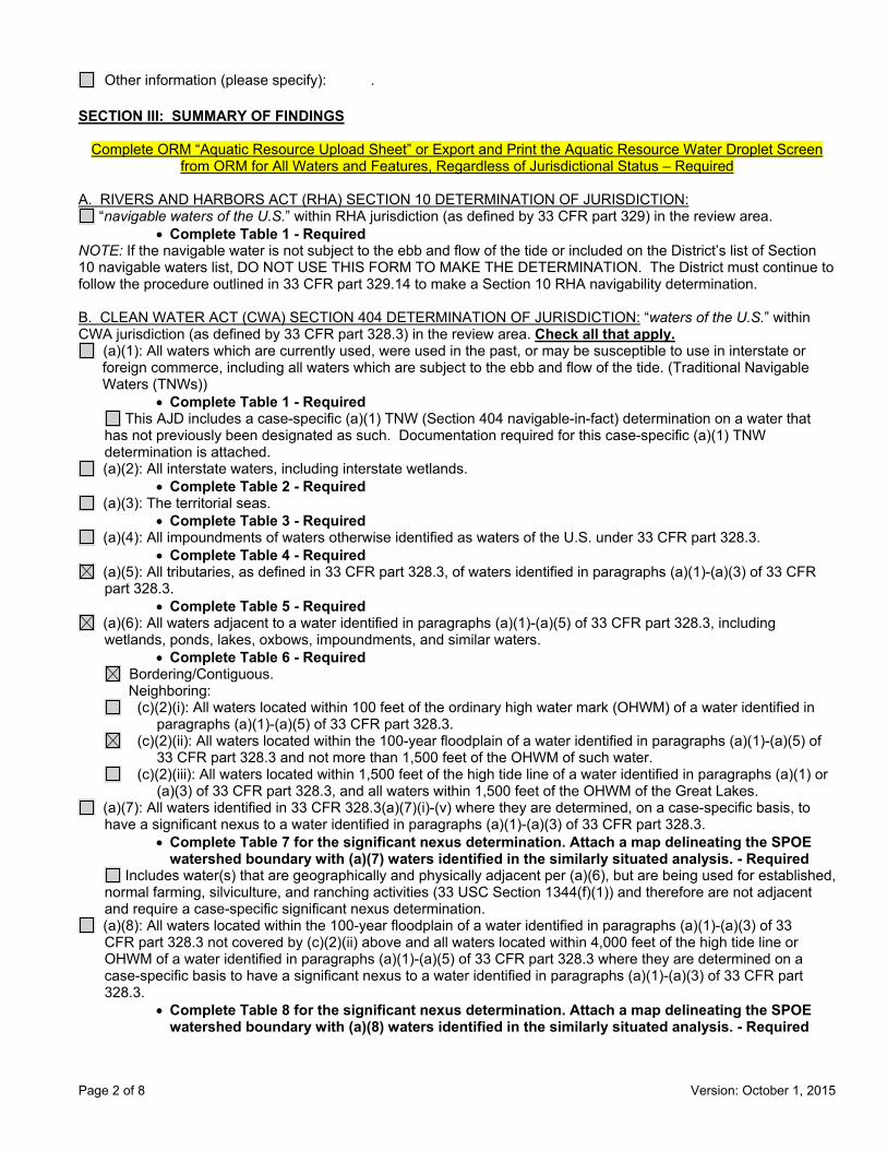
Page 2 of 8 Version: October 1, 2015
Other information (please specify): .
SECTION III: SUMMARY OF FINDINGS
Complete ORM “Aquatic Resource Upload Sheet” or Export and Print the Aquatic Resource Water Droplet Screen from ORM for All Waters and Features, Regardless of Jurisdictional Status – Required
A. RIVERS AND HARBORS ACT (RHA) SECTION 10 DETERMINATION OF JURISDICTION: “navigable waters of the U.S.” within RHA jurisdiction (as defined by 33 CFR part 329) in the review area.
• Complete Table 1 - RequiredNOTE: If the navigable water is not subject to the ebb and flow of the tide or included on the District’s list of Section 10 navigable waters list, DO NOT USE THIS FORM TO MAKE THE DETERMINATION. The District must continue to follow the procedure outlined in 33 CFR part 329.14 to make a Section 10 RHA navigability determination.
B. CLEAN WATER ACT (CWA) SECTION 404 DETERMINATION OF JURISDICTION: “waters of the U.S.” withinCWA jurisdiction (as defined by 33 CFR part 328.3) in the review area. Check all that apply.
(a)(1): All waters which are currently used, were used in the past, or may be susceptible to use in interstate or foreign commerce, including all waters which are subject to the ebb and flow of the tide. (Traditional Navigable Waters (TNWs))
• Complete Table 1 - Required This AJD includes a case-specific (a)(1) TNW (Section 404 navigable-in-fact) determination on a water that
has not previously been designated as such. Documentation required for this case-specific (a)(1) TNW determination is attached.
(a)(2): All interstate waters, including interstate wetlands. • Complete Table 2 - Required
(a)(3): The territorial seas. • Complete Table 3 - Required
(a)(4): All impoundments of waters otherwise identified as waters of the U.S. under 33 CFR part 328.3. • Complete Table 4 - Required
(a)(5): All tributaries, as defined in 33 CFR part 328.3, of waters identified in paragraphs (a)(1)-(a)(3) of 33 CFR part 328.3.
• Complete Table 5 - Required (a)(6): All waters adjacent to a water identified in paragraphs (a)(1)-(a)(5) of 33 CFR part 328.3, including wetlands, ponds, lakes, oxbows, impoundments, and similar waters.
• Complete Table 6 - Required Bordering/Contiguous. Neighboring:
(c)(2)(i): All waters located within 100 feet of the ordinary high water mark (OHWM) of a water identified in paragraphs (a)(1)-(a)(5) of 33 CFR part 328.3.
(c)(2)(ii): All waters located within the 100-year floodplain of a water identified in paragraphs (a)(1)-(a)(5) of 33 CFR part 328.3 and not more than 1,500 feet of the OHWM of such water.
(c)(2)(iii): All waters located within 1,500 feet of the high tide line of a water identified in paragraphs (a)(1) or (a)(3) of 33 CFR part 328.3, and all waters within 1,500 feet of the OHWM of the Great Lakes.
(a)(7): All waters identified in 33 CFR 328.3(a)(7)(i)-(v) where they are determined, on a case-specific basis, to have a significant nexus to a water identified in paragraphs (a)(1)-(a)(3) of 33 CFR part 328.3.
• Complete Table 7 for the significant nexus determination. Attach a map delineating the SPOEwatershed boundary with (a)(7) waters identified in the similarly situated analysis. - Required
Includes water(s) that are geographically and physically adjacent per (a)(6), but are being used for established, normal farming, silviculture, and ranching activities (33 USC Section 1344(f)(1)) and therefore are not adjacent and require a case-specific significant nexus determination.
(a)(8): All waters located within the 100-year floodplain of a water identified in paragraphs (a)(1)-(a)(3) of 33 CFR part 328.3 not covered by (c)(2)(ii) above and all waters located within 4,000 feet of the high tide line or OHWM of a water identified in paragraphs (a)(1)-(a)(5) of 33 CFR part 328.3 where they are determined on a case-specific basis to have a significant nexus to a water identified in paragraphs (a)(1)-(a)(3) of 33 CFR part 328.3.
• Complete Table 8 for the significant nexus determination. Attach a map delineating the SPOEwatershed boundary with (a)(8) waters identified in the similarly situated analysis. - Required

Page 3 of 8 Version: October 1, 2015
Includes water(s) that are geographically and physically adjacent per (a)(6), but are being used for established, normal farming, silviculture, and ranching activities (33 USC Section 1344(f)(1)) and therefore are not adjacent and require a case-specific significant nexus determination.
C. NON-WATERS OF THE U.S. FINDINGS:Check all that apply.
The review area is comprised entirely of dry land. Potential-(a)(7) Waters: Waters that DO NOT have a significant nexus to a water identified in paragraphs (a)(1)-
(a)(3) of 33 CFR part 328.3. • Complete Table 9 and attach a map delineating the SPOE watershed boundary with potential
(a)(7) waters identified in the similarly situated analysis. - Required Includes water(s) that are geographically and physically adjacent per (a)(6), but are being used for established,
normal farming, silviculture, and ranching activities (33 USC Section 1344(f)(1)) and therefore are not adjacent and require a case-specific significant nexus determination.
Potential-(a)(8) Waters: Waters that DO NOT have a significant nexus to a water identified in paragraphs (a)(1)-(a)(3) of 33 CFR part 328.3.
• Complete Table 9 and attach a map delineating the SPOE watershed boundary with potential(a)(8) waters identified in the similarly situated analysis. - Required
Includes water(s) that are geographically and physically adjacent per (a)(6), but are being used for established, normal farming, silviculture, and ranching activities (33 USC Section 1344(f)(1)) and therefore are not adjacent and require a case-specific significant nexus determination.
Excluded Waters (Non-Waters of U.S.), even where they otherwise meet the terms of paragraphs (a)(4)-(a)(8): • Complete Table 10 - Required
(b)(1): Waste treatment systems, including treatment ponds or lagoons designed to meet the requirements of the CWA. (b)(2): Prior converted cropland. (b)(3)(i): Ditches with ephemeral flow that are not a relocated tributary or excavated in a tributary. (b)(3)(ii): Ditches with intermittent flow that are not a relocated tributary, excavated in a tributary, or drain wetlands. (b)(3)(iii): Ditches that do not flow, either directly or through another water, into a water identified in paragraphs (a)(1)-(a)(3). (b)(4)(i): Artificially irrigated areas that would revert to dry land should application of water to that area cease. (b)(4)(ii): Artificial, constructed lakes and ponds created in dry land such as farm and stock watering ponds, irrigation ponds, settling basins, fields flooded for rice growing, log cleaning ponds, or cooling ponds. (b)(4)(iii): Artificial reflecting pools or swimming pools created in dry land.1 (b)(4)(iv): Small ornamental waters created in dry land.1 (b)(4)(v): Water-filled depressions created in dry land incidental to mining or construction activity, including pits excavated for obtaining fill, sand, or gravel that fill with water. (b)(4)(vi): Erosional features, including gullies, rills, and other ephemeral features that do not meet the definition of tributary, non-wetland swales, and lawfully constructed grassed waterways.1 (b)(4)(vii): Puddles.1 (b)(5): Groundwater, including groundwater drained through subsurface drainage systems.1 (b)(6): Stormwater control features constructed to convey, treat, or store stormwater that are created in dry land.1 (b)(7): Wastewater recycling structures created in dry land; detention and retention basins built for wastewater recycling; groundwater recharge basins; percolation ponds built for wastewater recycling; and water
distributary structures built for wastewater recycling. Other non-jurisdictional waters/features within review area that do not meet the definitions in 33 CFR 328.3 of
(a)(1)-(a)(8) waters and are not excluded waters identified in (b)(1)-(b)(7). • Complete Table 11 - Required.
D. ADDITIONAL COMMENTS TO SUPPORT AJD: .
1 In many cases these excluded features will not be specifically identified on the AJD form, unless specifically requested. Corps Districts may, in case-by-case instances, choose to identify some or all of these features within the review area.

Page 4 of 8 Version: October 1, 2015
Jurisdictional Waters of the U.S.
Table 1. (a)(1) Traditional Navigable Waters
(a)(1) Waters Name (a)(1) Criteria Rationale to Support (a)(1) Designation Include High Tide Line or Ordinary High Water Mark indicators, when applicable.
N/A Choose an item. N/A
Table 2. (a)(2) Interstate Waters
(a)(2) Waters Name Rationale to Support (a)(2) Designation N/A N/A
Table 3. (a)(3) Territorial Seas
(a)(3) Waters Name Rationale to Support (a)(3) Designation N/A N/A
Table 4. (a)(4) Impoundments
(a)(4) Waters Name Rationale to Support (a)(4) Designation N/A N/A N/A N/A

Page 5 of 8 Version: October 1, 2015
Table 5. (a)(5)Tributaries
(a)(5) Waters Name Flow Regime (a)(1)-(a)(3) Water Name to which this (a)(5) Tributary Flows
Tributary Breaks
Rationale for (a)(5) Designation and Additional Discussion. Identify flowpath to (a)(1)-(a)(3) water or attach map identifying the flowpath; explain any breaks or flow through excluded/non-jurisdictional features, etc.
Waters A Perennial Fox River No Creek flows to Tyler Creek, and into the Fox River
N/A Choose an item. N/A Choose an
item. N/A
N/A Choose an item. N/A Choose an
item. N/A
N/A Choose an item. N/A Choose an
item. N/A
Table 6. (a)(6) Adjacent Waters
(a)(6) Waters Name (a)(1)-(a)(5) Water Name to which this Water is Adjacent
Rationale for (a)(6) Designation and Additional Discussion. Identify the type of water and how the limits of jurisdiction were established (e.g., wetland, 87 Manual/Regional Supplement); explain how the 100-year floodplain and/or the distance threshold was determined; whether this water extends beyond a threshold; explain if the water is part of a mosaic, etc.
Wetland A Pingree Creek Wetland delineated using the Midwest Supplement; and is within the 100 year floodplain based on GIS mapping, and within 1500 feet of the (a)(5) waters on the site.
Wetland B Pingree Creek Wetland delineated using the Midwest Supplement; and is within the 100 year floodplain based on GIS mapping, and within 1500 feet of the (a)(5) waters on the site.
Wetland C Pingree Creek Wetland delineated using the Midwest Supplement; and is within the 100 year floodplain based on GIS mapping, and within 1500 feet of the (a)(5) waters on the site.
Wetland D Pingree Creek Wetland delineated using the Midwest Supplement; and is within the 100 year floodplain based on GIS mapping, and within 1500 feet of the (a)(5) waters on the site.
Wetland E Pingree Creek Wetland delineated using the Midwest Supplement; and is within the 100 year floodplain based on GIS mapping, and within 1500 feet of the (a)(5) waters on the site.
Wetland F Pingree Creek Wetland delineated using the Midwest Supplement; and is within the 100 year floodplain based on GIS mapping, and within 1500 feet of the (a)(5) waters on the site.
Wetland G Pingree Creek Wetland delineated using the Midwest Supplement; and is within the 100 year floodplain based on GIS mapping, and within 1500 feet of the (a)(5) waters on the site.

Page 6 of 8 Version: October 1, 2015
Wetland H Pingree Creek Wetland delineated using the Midwest Supplement; and is within the 100 year floodplain based on GIS mapping, and within 1500 feet of the (a)(5) waters on the site.
Wetland I Pingree Creek Wetland delineated using the Midwest Supplement; and is within the 100 year floodplain based on GIS mapping, and within 1500 feet of the (a)(5) waters on the site.

Page 7 of 8 Version: October 1, 2015
Table 7. (a)(7) Waters
SPOE Name (a)(7) Waters Name
(a)(1)-(a)(3) Water Name to which this Water has a Significant Nexus
Significant Nexus Determination Identify SPOE watershed; discuss whether any similarly situated waters were present and aggregated for SND; discuss data, provide analysis, and summarize how the waters have more than speculative or insubstantial effect on the physical, chemical, or biological integrity of the (a)(1)-(a)(3) water, etc.
N/A N/A N/A N/A N/A N/A N/A N/A
Table 8. (a)(8) Waters
SPOE Name (a)(8) Waters Name
(a)(1)-(a)(3) Water Name to which this Water has a Significant Nexus
Significant Nexus Determination Identify SPOE watershed; explain how 100-yr floodplain and/or the distance threshold was determined; discuss whether waters were determined to be similarly situated to subject water and aggregated for SND; discuss data, provide analysis, and then summarize how the waters have more than speculative or insubstantial effect the on the physical, chemical, or biological integrity of the (a)(1)-(a)(3) water, etc.
N/A N/A N/A N/A N/A N/A N/A N/A

Page 8 of 8 Version: October 1, 2015
Non-Jurisdictional Waters
Table 9. Non-Waters/No Significant Nexus
SPOE Name
Non-(a)(7)/(a)(8) Waters Name
(a)(1)-(a)(3) Water Name to which this Water DOES NOT have a Significant Nexus
Basis for Determination that the Functions DO NOT Contribute Significantly to the Chemical, Physical, or Biological Integrity of the (a)(1)-(a)(3) Water. Identify SPOE watershed; explain how 100-yr floodplain and/or the distance threshold was determined; discuss whether waters were determined to be similarly situated to the subject water; discuss data, provide analysis, and summarize how the waters did not have more than a speculative or insubstantial effect on the physical, chemical, or biological integrity of the (a)(1)-(a)(3) water.
N/A N/A N/A N/A N/A N/A N/A N/A
Table 10. Non-Waters/Excluded Waters and Features
Paragraph (b) Excluded Feature/Water Name Rationale for Paragraph (b) Excluded Feature/Water and Additional Discussion.
N/A N/A N/A N/A
Table 11. Non-Waters/Other
Other Non-Waters of U.S. Feature/Water Name Rationale for Non-Waters of U.S. Feature/Water and Additional Discussion.
N/A N/A

Page 1 of 7 Version: October 1, 2015
Regulatory ProgramINTERIM APPROVED JURISDICTIONAL DETERMINATION FORM
U.S. Army Corps of Engineers This form should be completed by following the instructions provided
in the Interim Approved Jurisdictional Determination Form User Manual.
SECTION I: BACKGROUND INFORMATION A. COMPLETION DATE FOR APPROVED JURISDICTIONAL DETERMINATION (AJD): November 1, 2019
B. ORM NUMBER IN APPROPRIATE FORMAT (e.g., HQ-2015-00001-SMJ): LRC-2018-505`
C. PROJECT LOCATION AND BACKGROUND INFORMATION:State:Illinois County/parish/borough: Cook City: Lemont Center coordinates of site (lat/long in degree decimal format): Lat. 41.68156, Long. -87.976907. Map(s)/diagram(s) of review area (including map identifying single point of entry (SPOE) watershed and/or potential jurisdictional areas where applicable) is/are: attached in report/map titled Memorandum on the Wetland Delineation Report for The Forge Adventure Park, dated May 13, 2019, prepared by Hey and Associates, Inc.
Other sites (e.g., offsite mitigation sites, disposal sites, etc.) are associated with this action and are recorded on a different jurisdictional determination (JD) form. List JD form ID numbers (e.g., HQ-2015-00001-SMJ-1): .
D. REVIEW PERFORMED FOR SITE EVALUATION:Office (Desk) Determination Only. Date: .Office (Desk) and Field Determination. Office/Desk Dates: November 1, 2019 Field Date(s): October 4, 2019.
SECTION II: DATA SOURCES Check all that were used to aid in the determination and attach data/maps to this AJD form and/or references/citations in the administrative record, as appropriate.
Maps, plans, plots or plat submitted by or on behalf of the applicant/consultant. Title/Date: The Forge Adventure Park Plans dated 08-21-2019, prepared by Engineering Resource Associates.
Data sheets prepared/submitted by or on behalf of the applicant/consultant. Data sheets/delineation report are sufficient for purposes of AJD form. Title/Date: Memorandum on the
Wetland Delineation Report for The Forge Adventure Park, dated May 13, 2019, prepared by Hey and Associates, Inc.
Data sheets/delineation report are not sufficient for purposes of AJD form. Summarize rationale and include information on revised data sheets/delineation report that this AJD form has relied upon: . Revised Title/Date: . Data sheets prepared by the Corps. Title/Date: . Corps navigable waters study. Title/Date: . CorpsMap ORM map layers. Title/Date: . USGS Hydrologic Atlas. Title/Date: Sag Bridge.
USGS, NHD, or WBD data/maps. Title/Date: . USGS 8, 10 and/or 12 digit HUC maps. HUC number: Sag Bridge. USGS maps. Scale & quad name and date: Sag Bridge. USDA NRCS Soil Survey. Citation: . USFWS National Wetlands Inventory maps. Citation: Sag Bridge. State/Local wetland inventory maps. Citation: . FEMA/FIRM maps. Citation: . Photographs: Aerial. Citation: . or Other. Citation: .
LiDAR data/maps. Citation: . Previous JDs. File no. and date of JD letter: .
® ®

Page 2 of 7 Version: October 1, 2015
Applicable/supporting case law: . Applicable/supporting scientific literature: . Other information (please specify): .
SECTION III: SUMMARY OF FINDINGS
Complete ORM “Aquatic Resource Upload Sheet” or Export and Print the Aquatic Resource Water Droplet Screen from ORM for All Waters and Features, Regardless of Jurisdictional Status – Required
A. RIVERS AND HARBORS ACT (RHA) SECTION 10 DETERMINATION OF JURISDICTION: “navigable waters of the U.S.” within RHA jurisdiction (as defined by 33 CFR part 329) in the review area.
• Complete Table 1 - RequiredNOTE: If the navigable water is not subject to the ebb and flow of the tide or included on the District’s list of Section 10 navigable waters list, DO NOT USE THIS FORM TO MAKE THE DETERMINATION. The District must continue to follow the procedure outlined in 33 CFR part 329.14 to make a Section 10 RHA navigability determination.
B. CLEAN WATER ACT (CWA) SECTION 404 DETERMINATION OF JURISDICTION: “waters of the U.S.” withinCWA jurisdiction (as defined by 33 CFR part 328.3) in the review area. Check all that apply.
(a)(1): All waters which are currently used, were used in the past, or may be susceptible to use in interstate or foreign commerce, including all waters which are subject to the ebb and flow of the tide. (Traditional Navigable Waters (TNWs))
• Complete Table 1 - Required This AJD includes a case-specific (a)(1) TNW (Section 404 navigable-in-fact) determination on a water that
has not previously been designated as such. Documentation required for this case-specific (a)(1) TNW determination is attached.
(a)(2): All interstate waters, including interstate wetlands. • Complete Table 2 - Required
(a)(3): The territorial seas. • Complete Table 3 - Required
(a)(4): All impoundments of waters otherwise identified as waters of the U.S. under 33 CFR part 328.3. • Complete Table 4 - Required
(a)(5): All tributaries, as defined in 33 CFR part 328.3, of waters identified in paragraphs (a)(1)-(a)(3) of 33 CFR part 328.3.
• Complete Table 5 - Required (a)(6): All waters adjacent to a water identified in paragraphs (a)(1)-(a)(5) of 33 CFR part 328.3, including wetlands, ponds, lakes, oxbows, impoundments, and similar waters.
• Complete Table 6 - Required Bordering/Contiguous. Neighboring:
(c)(2)(i): All waters located within 100 feet of the ordinary high water mark (OHWM) of a water identified in paragraphs (a)(1)-(a)(5) of 33 CFR part 328.3.
(c)(2)(ii): All waters located within the 100-year floodplain of a water identified in paragraphs (a)(1)-(a)(5) of 33 CFR part 328.3 and not more than 1,500 feet of the OHWM of such water.
(c)(2)(iii): All waters located within 1,500 feet of the high tide line of a water identified in paragraphs (a)(1) or (a)(3) of 33 CFR part 328.3, and all waters within 1,500 feet of the OHWM of the Great Lakes.
(a)(7): All waters identified in 33 CFR 328.3(a)(7)(i)-(v) where they are determined, on a case-specific basis, to have a significant nexus to a water identified in paragraphs (a)(1)-(a)(3) of 33 CFR part 328.3.
• Complete Table 7 for the significant nexus determination. Attach a map delineating the SPOEwatershed boundary with (a)(7) waters identified in the similarly situated analysis. - Required
Includes water(s) that are geographically and physically adjacent per (a)(6), but are being used for established, normal farming, silviculture, and ranching activities (33 USC Section 1344(f)(1)) and therefore are not adjacent and require a case-specific significant nexus determination.
(a)(8): All waters located within the 100-year floodplain of a water identified in paragraphs (a)(1)-(a)(3) of 33 CFR part 328.3 not covered by (c)(2)(ii) above and all waters located within 4,000 feet of the high tide line or OHWM of a water identified in paragraphs (a)(1)-(a)(5) of 33 CFR part 328.3 where they are determined on a case-specific basis to have a significant nexus to a water identified in paragraphs (a)(1)-(a)(3) of 33 CFR part 328.3.
• Complete Table 8 for the significant nexus determination. Attach a map delineating the SPOEwatershed boundary with (a)(8) waters identified in the similarly situated analysis. - Required

Page 3 of 7 Version: October 1, 2015
Includes water(s) that are geographically and physically adjacent per (a)(6), but are being used for established, normal farming, silviculture, and ranching activities (33 USC Section 1344(f)(1)) and therefore are not adjacent and require a case-specific significant nexus determination.
C. NON-WATERS OF THE U.S. FINDINGS:Check all that apply.
The review area is comprised entirely of dry land. Potential-(a)(7) Waters: Waters that DO NOT have a significant nexus to a water identified in paragraphs (a)(1)-
(a)(3) of 33 CFR part 328.3. • Complete Table 9 and attach a map delineating the SPOE watershed boundary with potential
(a)(7) waters identified in the similarly situated analysis. - Required Includes water(s) that are geographically and physically adjacent per (a)(6), but are being used for established,
normal farming, silviculture, and ranching activities (33 USC Section 1344(f)(1)) and therefore are not adjacent and require a case-specific significant nexus determination.
Potential-(a)(8) Waters: Waters that DO NOT have a significant nexus to a water identified in paragraphs (a)(1)-(a)(3) of 33 CFR part 328.3.
• Complete Table 9 and attach a map delineating the SPOE watershed boundary with potential(a)(8) waters identified in the similarly situated analysis. - Required
Includes water(s) that are geographically and physically adjacent per (a)(6), but are being used for established, normal farming, silviculture, and ranching activities (33 USC Section 1344(f)(1)) and therefore are not adjacent and require a case-specific significant nexus determination.
Excluded Waters (Non-Waters of U.S.), even where they otherwise meet the terms of paragraphs (a)(4)-(a)(8): • Complete Table 10 - Required
(b)(1): Waste treatment systems, including treatment ponds or lagoons designed to meet the requirements of the CWA. (b)(2): Prior converted cropland. (b)(3)(i): Ditches with ephemeral flow that are not a relocated tributary or excavated in a tributary. (b)(3)(ii): Ditches with intermittent flow that are not a relocated tributary, excavated in a tributary, or drain wetlands. (b)(3)(iii): Ditches that do not flow, either directly or through another water, into a water identified in paragraphs (a)(1)-(a)(3). (b)(4)(i): Artificially irrigated areas that would revert to dry land should application of water to that area cease. (b)(4)(ii): Artificial, constructed lakes and ponds created in dry land such as farm and stock watering ponds, irrigation ponds, settling basins, fields flooded for rice growing, log cleaning ponds, or cooling ponds. (b)(4)(iii): Artificial reflecting pools or swimming pools created in dry land.1 (b)(4)(iv): Small ornamental waters created in dry land.1 (b)(4)(v): Water-filled depressions created in dry land incidental to mining or construction activity, including pits excavated for obtaining fill, sand, or gravel that fill with water. (b)(4)(vi): Erosional features, including gullies, rills, and other ephemeral features that do not meet the definition of tributary, non-wetland swales, and lawfully constructed grassed waterways.1 (b)(4)(vii): Puddles.1 (b)(5): Groundwater, including groundwater drained through subsurface drainage systems.1 (b)(6): Stormwater control features constructed to convey, treat, or store stormwater that are created in dry land.1 (b)(7): Wastewater recycling structures created in dry land; detention and retention basins built for wastewater recycling; groundwater recharge basins; percolation ponds built for wastewater recycling; and water
distributary structures built for wastewater recycling. Other non-jurisdictional waters/features within review area that do not meet the definitions in 33 CFR 328.3 of
(a)(1)-(a)(8) waters and are not excluded waters identified in (b)(1)-(b)(7). • Complete Table 11 - Required.
D. ADDITIONAL COMMENTS TO SUPPORT AJD: .
1 In many cases these excluded features will not be specifically identified on the AJD form, unless specifically requested. Corps Districts may, in case-by-case instances, choose to identify some or all of these features within the review area.

Page 4 of 7 Version: October 1, 2015
Jurisdictional Waters of the U.S.
Table 1. (a)(1) Traditional Navigable Waters
(a)(1) Waters Name (a)(1) Criteria Rationale to Support (a)(1) Designation Include High Tide Line or Ordinary High Water Mark indicators, when applicable.
N/A Choose an item. N/A
Table 2. (a)(2) Interstate Waters
(a)(2) Waters Name Rationale to Support (a)(2) Designation N/A N/A
Table 3. (a)(3) Territorial Seas
(a)(3) Waters Name Rationale to Support (a)(3) Designation N/A N/A
Table 4. (a)(4) Impoundments
(a)(4) Waters Name Rationale to Support (a)(4) Designation N/A N/A N/A N/A

Page 5 of 7 Version: October 1, 2015
Table 5. (a)(5)Tributaries
(a)(5) Waters Name Flow Regime (a)(1)-(a)(3) Water Name to which this (a)(5) Tributary Flows
Tributary Breaks
Rationale for (a)(5) Designation and Additional Discussion. Identify flowpath to (a)(1)-(a)(3) water or attach map identifying the flowpath; explain any breaks or flow through excluded/non-jurisdictional features, etc.
N/A Choose an item. N/A Choose an
item. N/A
N/A Choose an item. N/A Choose an
item. N/A
N/A Choose an item. N/A Choose an
item. N/A
N/A Choose an item. N/A Choose an
item. N/A
Table 6. (a)(6) Adjacent Waters
(a)(6) Waters Name (a)(1)-(a)(5) Water Name to which this Water is Adjacent
Rationale for (a)(6) Designation and Additional Discussion. Identify the type of water and how the limits of jurisdiction were established (e.g., wetland, 87 Manual/Regional Supplement); explain how the 100-year floodplain and/or the distance threshold was determined; whether this water extends beyond a threshold; explain if the water is part of a mosaic, etc.
WOTUS-1 I&M Canal Open water lake within 100 feet of an (a)(3) water. WOTUS-2 I&M Canal Open water lake within 100 feet of an (a)(3) water. Wetland 7 I&M Canal Wetland delineated with the Midwest Supplement, and within 100 feet of an (a)(3) water. N/A N/A N/A

Page 6 of 7 Version: October 1, 2015
Table 7. (a)(7) Waters
SPOE Name (a)(7) Waters Name
(a)(1)-(a)(3) Water Name to which this Water has a Significant Nexus
Significant Nexus Determination Identify SPOE watershed; discuss whether any similarly situated waters were present and aggregated for SND; discuss data, provide analysis, and summarize how the waters have more than speculative or insubstantial effect on the physical, chemical, or biological integrity of the (a)(1)-(a)(3) water, etc.
N/A N/A N/A N/A N/A N/A N/A N/A
Table 8. (a)(8) Waters
SPOE Name (a)(8) Waters Name
(a)(1)-(a)(3) Water Name to which this Water has a Significant Nexus
Significant Nexus Determination Identify SPOE watershed; explain how 100-yr floodplain and/or the distance threshold was determined; discuss whether waters were determined to be similarly situated to subject water and aggregated for SND; discuss data, provide analysis, and then summarize how the waters have more than speculative or insubstantial effect the on the physical, chemical, or biological integrity of the (a)(1)-(a)(3) water, etc.
N/A N/A N/A N/A N/A N/A N/A N/A
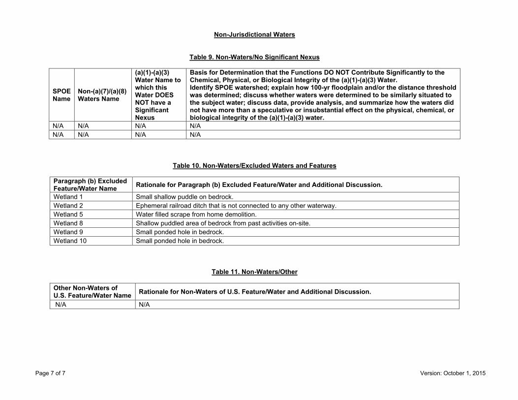
Page 7 of 7 Version: October 1, 2015
Non-Jurisdictional Waters
Table 9. Non-Waters/No Significant Nexus
SPOE Name
Non-(a)(7)/(a)(8) Waters Name
(a)(1)-(a)(3) Water Name to which this Water DOES NOT have a Significant Nexus
Basis for Determination that the Functions DO NOT Contribute Significantly to the Chemical, Physical, or Biological Integrity of the (a)(1)-(a)(3) Water. Identify SPOE watershed; explain how 100-yr floodplain and/or the distance threshold was determined; discuss whether waters were determined to be similarly situated to the subject water; discuss data, provide analysis, and summarize how the waters did not have more than a speculative or insubstantial effect on the physical, chemical, or biological integrity of the (a)(1)-(a)(3) water.
N/A N/A N/A N/A N/A N/A N/A N/A
Table 10. Non-Waters/Excluded Waters and Features
Paragraph (b) Excluded Feature/Water Name Rationale for Paragraph (b) Excluded Feature/Water and Additional Discussion.
Wetland 1 Small shallow puddle on bedrock. Wetland 2 Ephemeral railroad ditch that is not connected to any other waterway. Wetland 5 Water filled scrape from home demolition. Wetland 8 Shallow puddled area of bedrock from past activities on-site. Wetland 9 Small ponded hole in bedrock. Wetland 10 Small ponded hole in bedrock.
Table 11. Non-Waters/Other
Other Non-Waters of U.S. Feature/Water Name Rationale for Non-Waters of U.S. Feature/Water and Additional Discussion.
N/A N/A