regolith-landform mapping of the kalgoorlie-kanowna...
TRANSCRIPT
REGOLITH-LANDFORM MAPPING OF THE KALGOORLIE-KANOWNA AREA
Marian Skwarnecki
Geological Survey of Western Australia
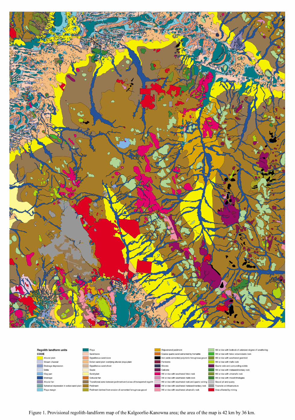
Regolith-landform mapping of the Kalgoorlie area commenced in 2001 as part of the Development Areas Resource Mapping (DARM) project. The object of the DARM programme is to undertake detailed regolith-landform mapping and resource delineation in regional areas of Western Australia that are likely to undergo significant development and where landuse planning would benefit from the availability of digital and hard copy geoscience datasets. Compilation and release of available digital datasets (including digital 1:25 000 digital orthophotography, Landsat TM images, magnetic (TMI) and Bouguer gravity images, and spatial data for regolith-landform features, abandoned mine sites, and mine and mineral deposits (MINEDEX)) was completed in 2004 (GSWA Record 2004/12). During the 2004 field season, regolith-landform mapping of the Kalgoorlie and Boulder sheets was reassessed and fieldwork was completed for the Kanowna and Golden Ridge 1:50 000 sheets. The release of the digital regolith-landform map, covering an area of 1512 km2 (42 km by 36 km), including the Kalgoorlie-Boulder townsite and the mining areas of Golden Mile-Mount Charlotte, Kanowna, Binduli, Panglo, Golden Ridge and Nimbus, together with any updates of Record 2004/12, is planned for June 2005. Methodology The regolith-landform polygons were drawn in ArcMap onto a rectified orthophotograph base with an overlay of height contours at 0.5 m intervals derived from the digital elevation model. The Geological Survey of Western Australia (GSWA) regolith classification system (Hocking et al., 2001), based on landform position and regolith composition, was used to code the polygons. Supporting digital datasets were used, including Landsat, HYMAP, and field observations from the corporate database (WAROX). The map was produced as a digital product nominally at 1:25 000 scale, with digitizing of individual polygons at 1:5 000 scale. Regolith-landform map units Two principal regolith-landform domains occur: (i) a dominant relict-colluvial domain characterized by low hills and rises (commonly with outcrops of weathered to almost fresh bedrock), skirted by a broad pediment and fringed by a transitional zone, exhibiting the underlying pediment structure but overlain by up to 25 m of transported material, and alluvial plains; and (ii) the playa-eolian domain overlying dominantly alluvial deposits. Regolith-landform units can be assigned to seven primary landform categories (Figure 1): residual or relict; exposed; colluvial (proximal slope); alluvial; lacustrine; eolian; sandplain. Three additional non-regolith categories (mining; gravel pit or quarry; infrastructure) have been used to classify other components of the map.
Colluvial-relict domainThe principal components are ranges of low hills and rises surrounded by a gently inclined to flat pediment (or peneplain), which have been incised by major northerly or northwesterly drainages and northeasterly to southwesterly tributaries, and by playas. Secondary (rejuvenated) pediments, typically fringed by linear breakaways, may be cut into the older pediment by this drainage system. The materials of the older pediment were derived from the weathering and erosion of the ranges and have blanketed pre-existing topographic relief. Thin (generally <2 m), more recent alluvial and/or eolian cover may form a veneer. Ferruginous materials are ferricretes (probably ferruginized saprolite) occurring on hill crests and rises, overlying saprolite, and cemented polymictic ferruginous gravels that occur either along former drainage lines or as scree deposits (valley-fill) along hill slopes. The latter occur at various levels in the landscape, from playa-eolian domains to the crests of the higher hills along the ranges (e.g., to the north of the Golden Ridge mine). In the latter instance, weathering of these gravels has given rise to local glacis pediments (i.e., pediments formed by secondary products derived from the gravels). Playa domain This domain corresponds to the Kunanalling, Black Flag, Hannan and Yindarlgooda arms of the Roe Palaeochannel (Kern, 1995, 1996), an arcuate northeasterly to easterly belt to the north and northwest of Kalgoorlie, and smaller sections further south. The main components are: playas and playa margins, playa plains (which appear to be zones where playa/alluvial processes are relatively active), dunes and eolian sandplain. Internal drainage is via linear depressions/swales. Hills (with outcrop) may occur at the western margins of some playas. Silcrete and ferruginous deposits (typically hematite-cemented coarse quartz sand) are restricted to this domain and fringe some of the playas. Significance of results Landform-based regolith-landform mapping, together with field observations, indicates that there is a close association between geology and landforms and this can be used to derive an interpretation of near-surface regolith (Figure 1). Pediment and hills outline areas of outcrop, colluvium and thin transported cover. The topographic contour patterns of the relict-colluvial domain disappear where cover is significantly thicker in the playa domain. From a mineral exploration perspective, such maps give a clearer indication of which sampling techniques can be applied. References Hocking, R.M., Langford, R.L., Thorne, A.M., Sanders, A.J., Morris, P.A., Strong, C.A. &
Gozzard, J.R. 2001 A classification system for regolith in Western Australia. Western Australian Geological Survey Record 2001/4, 21 pp.
Kern, A.M. 1995 Hydrogeology of the Kalgoorlie 1:250 000 sheet. Western Australian
Geological Survey, 1:250 000 Hydrogeological Series Explanatory Notes, 16 pp. Kern, A.M. 1996 Hydrogeology of the Kurnalpi 1:250 000 sheet. Western Australian
Geological Survey, 1:250 000 Hydrogeological Series Explanatory Notes, 16 pp.