regional sediment management (rsm) program northeast ...this technical report provides a description...
TRANSCRIPT

ERD
C/CH
L TR
-16-
3
Regional Sediment Management (RSM) Program
Northeast Florida Regional Sediment Management Implementation Strategies and Recommendations for Nassau County and Duval County, Florida
Coas
tal a
nd H
ydra
ulic
s La
bora
tory
Kevin C. Hodgens, Michael Neves, and Linda S. Lillycrop March 2016
Approved for public release; distribution is unlimited.

The U.S. Army Engineer Research and Development Center (ERDC) solves the nation’s toughest engineering and environmental challenges. ERDC develops innovative solutions in civil and military engineering, geospatial sciences, water resources, and environmental sciences for the Army, the Department of Defense, civilian agencies, and our nation’s public good. Find out more at www.erdc.usace.army.mil.
To search for other technical reports published by ERDC, visit the ERDC online library at http://acwc.sdp.sirsi.net/client/default.

Regional Sediment Management (RSM) Program
ERDC/CHL TR-16-3 March 2016
Northeast Florida Regional Sediment Management Implementation Strategies and Recommendations for Nassau County and Duval County, Florida
Kevin C. Hodgens and Michael P. Neves U.S. Army Engineer District, Jacksonville 701 San Marco Boulevard Jacksonville, FL 32207
Linda S. Lillycrop U.S. Army Engineer Research and Development Center Coastal and Hydraulics Laboratory 3909 Halls Ferry Road Vicksburg, MS 39180-6199
Final report Approved for public release; distribution is unlimited.
Prepared for U.S. Army Corps of Engineers Washington, DC 20314-1000

ERDC/CHL TR-16-3 ii
Abstract
This technical report provides a description of Regional Sediment Management (RSM) investigations performed by the U.S. Army Corps of Engineers, Jacksonville District, along Florida’s northeast coast in Nassau and Duval Counties. Provided first is an overview of the study area, including previous RSM activities, pertinent studies, and stakeholder discussions. Next is a discussion of the various Federal projects in the study area, including authorization, funding, and permitting. Finally, management alternative strategies are provided for each project, as well as recommendations for future actions to improve management of the sediments.
The most successful implementation of RSM principles in northeast Florida involves beneficial use of navigation maintenance sediment to serve as shore protection and mitigation for navigation projects’ disruption to the natural sediment transport patterns and morphology. The beneficial use of dredged sediment from the Mayport Navy project and the Jacksonville Harbor Federal Navigation project has been successful to date but could be expanded through the use of nearshore placement. Additional opportunities outlined in this report that would enhance the RSM program in northeast Florida are currently under investigation or need further investigation. A more robust data collection program is needed to develop a greater understanding of the physical processes that influence sediment transport in the vicinity of northeast Florida Federal projects. Geotechnical investigations are required to ensure sediment compatibility between areas of identified sources and areas of need, including delineation of borrow areas. The multitude of stakeholders that have an interest in the coastal system within the northeast Florida area requires that management strategies and alternatives are actively coordinated.
DISCLAIMER: The contents of this report are not to be used for advertising, publication, or promotional purposes. Citation of trade names does not constitute an official endorsement or approval of the use of such commercial products. All product names and trademarks cited are the property of their respective owners. The findings of this report are not to be construed as an official Department of the Army position unless so designated by other authorized documents. DESTROY THIS REPORT WHEN NO LONGER NEEDED. DO NOT RETURN IT TO THE ORIGINATOR.

ERDC/CHL TR-16-3 iii
Contents Abstract .......................................................................................................................................................... ii
Figures and Tables ........................................................................................................................................ vi
Preface ...........................................................................................................................................................vii
Unit Conversion Factors ........................................................................................................................... viii
Acronyms ....................................................................................................................................................... ix
Introduction ............................................................................................................................................ 1 Regional Sediment Management (RSM) Program ................................................................. 1 Purpose of the study ................................................................................................................ 1
Study area ............................................................................................................................................... 3 Northeast Florida RSM strategies and efforts ........................................................................ 4 Stakeholder discussions .......................................................................................................... 6 Previous studies ....................................................................................................................... 7
Fernandina Harbor ....................................................................................................................... 8 Nassau County shore protection project (SPP) .......................................................................... 8 Jacksonville Harbor ...................................................................................................................... 8 Duval County SPP ......................................................................................................................... 8
Additional studies ..................................................................................................................... 8 St. Marys River Entrance Sediment Management, 1997 .......................................................... 8 St. Johns River (SJR) and Ft. George River (FGR) Entrances Sediment Management, 2000 ..................................................................................................................... 8 Nassau and Duval Counties Dredging Alternatives, 2002 ........................................................ 9 St. Johns, Flagler, and Volusia Counties Sediment Budget, 2007 ............................................ 9 Nassau, Duval, St. Johns, Flagler, and Volusia Counties Beach Management, 2008 ............. 9 Jacksonville Harbor RSM Needs, 2011 .................................................................................... 10 Jacksonville Harbor Channel Dredging, 2012 .......................................................................... 10 Jacksonville Harbor O&M Dredging Needs Update, 2013 ....................................................... 10
Sediment ................................................................................................................................ 11 Compatibility ............................................................................................................................... 11 Needs and sources .................................................................................................................... 11 Sediment budget ........................................................................................................................ 12
Northeast Florida Federal Projects ................................................................................................. 15 Kings Bay navigation project ................................................................................................. 15
Authorization and funding ......................................................................................................... 16 Permitting ................................................................................................................................... 16 Dredged sediment management .............................................................................................. 17
Fernandina Harbor ................................................................................................................. 24 Authorization and funding ......................................................................................................... 24 Permitting ................................................................................................................................... 24

ERDC/CHL TR-16-3 iv
Nassau County Shore Protection Project (NCSPP) ............................................................... 25 Authorization and funding ......................................................................................................... 25 Permitting ................................................................................................................................... 27 Project history ............................................................................................................................. 27
Atlantic Intracoastal Waterway (AIWW) and Intracoastal Waterway (IWW) ......................... 28 Authorization and funding ......................................................................................................... 28 Permitting ................................................................................................................................... 30
Naval Station (NS) Mayport ................................................................................................... 31 Authorization and funding ......................................................................................................... 31 Permitting ................................................................................................................................... 31
Jacksonville Harbor ................................................................................................................ 32 Authorization and funding ......................................................................................................... 33 Permitting ................................................................................................................................... 33 Dredged material management ................................................................................................ 34 Current general reevaluation report (GRR) ............................................................................... 38
Duval County Shore Protection Project (DCSPP) .................................................................. 39 Authorization and funding ......................................................................................................... 39 Permitting ................................................................................................................................... 41 Project history ............................................................................................................................. 41
Management Alternative Strategies and Recommendations ................................................... 44 Kings Bay Entrance Channel (KBEC) and Kings Bay Interior Channel (KBIC) Navigation Projects ................................................................................................................ 44
Alternative strategies ................................................................................................................. 44 Recommendations ..................................................................................................................... 46
AIWW and IWW ....................................................................................................................... 46 Alternative strategies ................................................................................................................. 46 Recommendations ..................................................................................................................... 47
Ft. George River (FGR) Inlet ................................................................................................... 48 Alternative strategies ................................................................................................................. 48 Recommendations ..................................................................................................................... 51
Naval Station (NS) Mayport ................................................................................................... 52 Alternative strategies ................................................................................................................. 52 Recommendations ..................................................................................................................... 53
Jacksonville Harbor O&M beach and nearshore placement ............................................... 53 Alternative strategies ................................................................................................................. 53 Recommendations ..................................................................................................................... 56
Hanna Park and Duval County SPP ....................................................................................... 57 Alternative strategies ................................................................................................................. 57 Recommendations ..................................................................................................................... 58
St. Johns River (SJR) North Jetty shoal and ebb shoal ......................................................... 58 Alternative strategies ................................................................................................................. 58 Recommendations ..................................................................................................................... 60
Jacksonville Harbor DMMA offloading .................................................................................. 60 Alternative strategies ................................................................................................................. 60 Recommendations ..................................................................................................................... 61

ERDC/CHL TR-16-3 v
Jacksonville Harbor marsh improvements with dredged sediment .................................... 61 Alternative strategies ................................................................................................................. 61 Recommendations ..................................................................................................................... 62
Conclusions .......................................................................................................................................... 63
References ................................................................................................................................................... 66
Report Documentation Page
ERDC/CHL TR-16-3 vi
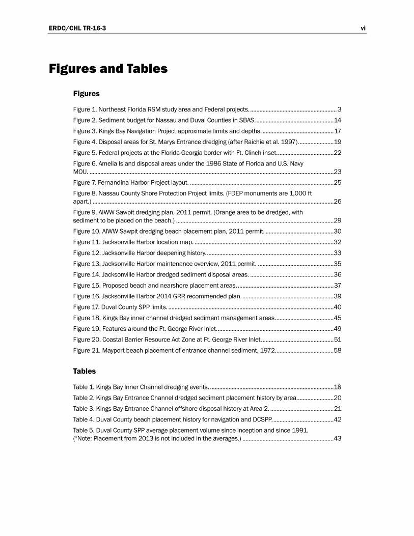
Figures and Tables
Figures
Figure 1. Northeast Florida RSM study area and Federal projects. ........................................................ 3 Figure 2. Sediment budget for Nassau and Duval Counties in SBAS. .................................................. 14 Figure 3. Kings Bay Navigation Project approximate limits and depths. .............................................. 17 Figure 4. Disposal areas for St. Marys Entrance dredging (after Raichie et al. 1997). ...................... 19 Figure 5. Federal projects at the Florida-Georgia border with Ft. Clinch inset. .................................... 22 Figure 6. Amelia Island disposal areas under the 1986 State of Florida and U.S. Navy MOU. .............................................................................................................................................................. 23 Figure 7. Fernandina Harbor Project layout. ............................................................................................. 25 Figure 8. Nassau County Shore Protection Project limits. (FDEP monuments are 1,000 ft apart.) ............................................................................................................................................................ 26 Figure 9. AIWW Sawpit dredging plan, 2011 permit. (Orange area to be dredged, with sediment to be placed on the beach.) ...................................................................................................... 29 Figure 10. AIWW Sawpit dredging beach placement plan, 2011 permit. ............................................ 30 Figure 11. Jacksonville Harbor location map. .......................................................................................... 32 Figure 12. Jacksonville Harbor deepening history. .................................................................................. 33 Figure 13. Jacksonville Harbor maintenance overview, 2011 permit. ................................................. 35 Figure 14. Jacksonville Harbor dredged sediment disposal areas. ...................................................... 36 Figure 15. Proposed beach and nearshore placement areas. .............................................................. 37 Figure 16. Jacksonville Harbor 2014 GRR recommended plan. ........................................................... 39 Figure 17. Duval County SPP limits. ........................................................................................................... 40 Figure 18. Kings Bay inner channel dredged sediment management areas. ..................................... 45 Figure 19. Features around the Ft. George River Inlet. ........................................................................... 49 Figure 20. Coastal Barrier Resource Act Zone at Ft. George River Inlet. .............................................. 51 Figure 21. Mayport beach placement of entrance channel sediment, 1972...................................... 58
Tables
Table 1. Kings Bay Inner Channel dredging events. ................................................................................ 18 Table 2. Kings Bay Entrance Channel dredged sediment placement history by area. ....................... 20 Table 3. Kings Bay Entrance Channel offshore disposal history at Area 2. ......................................... 21 Table 4. Duval County beach placement history for navigation and DCSPP. ....................................... 42 Table 5. Duval County SPP average placement volume since inception and since 1991. (*Note: Placement from 2013 is not included in the averages.) ........................................................... 43

ERDC/CHL TR-16-3 vii
Preface
The studies reported herein were conducted as part of the U.S. Army Corps of Engineers (USACE) Regional Sediment Management (RSM) Program, under the RSM initiative Northeast Florida Regional Sediment Manage-ment. The USACE RSM Program is administered at the U.S. Army Engineer Research and Development Center (ERDC), Coastal and Hydraulics Laboratory (CHL), under the Navigation Research, Development, and Technology (RD&T) Program. At the time this effort was conducted, Jeffrey A. McKee was the Headquarters, USACE (HQUSACE) Navigation Business Line Manager overseeing the RSM Program. W. Jeff Lillycrop, CHL, was the ERDC Technical Director for Civil Works and Navigation RD&T, and Linda S. Lillycrop, CHL, was the USACE RSM Program Manager. Kevin C. Hodgens and Michael Neves, U.S. Army Engineer District, Jacksonville (SAJ), were the SAJ RSM principal investigators for the USACE RSM Program during the conduct of this initiative and the preparation of this report. Hodgens and Neves substantially prepared this report with manuscript technical review and edification by Linda S. Lillycrop.
At the time of publication of this report, Tanya Beck was Chief, Coastal Engineering Branch; Dr. Jackie Pettway was Chief, Navigation Division; W. Jeff Lillycrop was Technical Director, Navigation RD&T; and José E. Sánchez was Director of CHL. COL Bryan S. Green was Commander of ERDC, and Dr. Jeffrey P. Holland was Director.

ERDC/CHL TR-16-3 viii
Unit Conversion Factors
Multiply By To Obtain
cubic yards 0.7645549 cubic meters
cubic yards per year 0.76455 cubic meters per year
feet 0.3048 meters
miles 1.60934 kilometers
million cubic yards 0.76455 million cubic meters

ERDC/CHL TR-16-3 ix
Acronyms
ADCP Acoustic Doppler Current Profiler
AIWW Atlantic Intracoastal Waterway
CAP Continuing Authorities Program
CBRA Coastal Barrier Resources Act
CDF Confined Disposal Facility
CG Construction General
CHL Coastal and Hydraulics Laboratory
CMS Coastal Modeling System
CNIC Commander, Navy Installation Command
DA Department of the Army
DCSPP Duval County Shore Protection Project
DDNREC Delaware Department of Natural Resources and Environmental Control
DMMA Dredge Material Management Area
DMMP Dredge Material Management Plan
ERDC Engineer Research and Development Center
FAC Florida Administrative Code
FDEP Florida Department of Environmental Protection
FGR Ft. George River
FIND Florida Inland Navigation District
FCCE Flood Control and Coastal Emergency
FDOT Florida Department of Transportation
FPS Florida Park Service
GDNR Georgia Department of Natural Resources
GRR General Reevaluation Report
IWW Intracoastal Waterway
JAXPORT Jacksonville Port Authority
KBEC Kings Bay Entrance Channel

ERDC/CHL TR-16-3 x
KBIC Kings Bay Inner Channel
LCS Lower Cumberland Sound
MPRSA Marine Protection, Research, and Sanctuaries Act
MLLW Mean Lower Low Water
MLW Mean Low Water
MOU Memorandum of Understanding
NBDS North Beach Disposal Site
NCSPP Nassau County Shore Protection Project
NDS Nearshore Disposal Site
NEPA National Environmental Policy Act
NGO Non-government Organizations
NPS National Park Service
NS Naval Station
NSB Naval Submarine Base
ODMDS Ocean Dredge Material Disposal Site
O&M Operation and Maintenance
R Florida Department of Environmental Protection Range Monument
RD&T Research, Development, and Technology
RM Florida River Mile from Atlantic Ocean
RSM Regional Sediment Management
SAJ South Atlantic District, Jacksonville
SBAS Sediment Budget Analysis System
SBDS South Beach Disposal Site
SJR St. Johns River
SPP Shore Protection Project
STWAVE STeady WAVE
UCS Upper Cumberland Sound
UNF University of North Florida
USACE U.S. Army Corps of Engineers
ERDC/CHL TR-16-3 xi
USEPA U.S. Environmental Protection Agency
USFWS U.S. Fish and Wildlife Service
WRDA Water Resources Development Act

ERDC/CHL TR-16-3 1
Introduction
Regional Sediment Management (RSM) Program
The objective of the U.S. Army Corps of Engineers (USACE) Regional Sediment Management (RSM) Program is to optimize the use of sediments and management of projects through a systems-based approach. RSM supports sustainable navigation and dredging, flood and storm damage reduction, and environmental restoration practices to increase overall benefits and reduce lifecycle costs. RSM strives to enhance the planning, construction, and operation and maintenance of projects where the exchange of sediments would occur naturally. RSM is also a means to involve stakeholders to leverage resources, share technology and data, identify needs and opportunities, and develop solutions to improve the utilization and management of sediments. The main focus is to better understand the regional sediment transport process through integration of regional data and application of tools that improve knowledge of the regional processes, understand and share demands for sediment, and identify and implement adaptive management strategies to optimize use of sediments and streamline projects. Benefits of this approach are improved partnerships with stakeholders, improved sediment utilization and project management on a regional scale, improved environmental stewardship, and reduced overall lifecycle costs.
Purpose of the study
This USACE Engineer Research and Development Center (ERDC), Coastal and Hydraulics Laboratory (CHL) technical report provides a description of the RSM investigations performed by the USACE Jacksonville District (SAJ) along Florida’s northeast coast in Nassau and Duval counties. Provided first is an overview of the study area including previous RSM activities, stakeholder discussions, pertinent studies, and backgrounds of Federal projects. Following the overview, management alternatives and strategies, and recommendations for future actions are provided.
RSM is a systems-based approach integrating the management of littoral, estuarine, and riverine sediments to achieve balanced and sustainable solutions to sediment-related needs. RSM objectives for the northeast Florida study area include beneficially using dredged sediments,

ERDC/CHL TR-16-3 2
coordinating dredging schedules for navigation and storm damage reduction projects, investigating alternatives to better stabilize beaches, and presenting improvements to the state’s inlet management plan. These objectives can be reached by coordinating available Federal authorities, permitting, and funding. Then, a collaboration with stakeholders on the social, cultural, and technical components can promote strategies to reach objectives and combine resources to meet common goals.
This document reviews northeast Florida RSM accomplishments and future opportunities, including the limitations and challenges that remain for accomplishing additional RSM goals. The most successful RSM objective regularly implemented in northeast Florida is beneficial use of sediments dredged from Federal civil works and military navigation channels for shore protection purposes. Beneficial use of navigation maintenance sediments for shore protection alleviates erosional pressure on vulnerable shorelines and protects upland assets. As a result, renourishment intervals for some shore protection projects can be increased, thus reducing overall project costs. Coordination with local stakeholders and environmental organiza-tions in northeast Florida has resulted in a partnering opportunity to restore the tidal efficiency of Ft. George River (FGR) Inlet, an unmaintained inlet, while providing sediments to a nearby shore protection project. As part of the effort, an RSM study is underway to optimize a dredging footprint that will reestablish inlet efficiency and reduce erosional pressure on the adjacent shoreline of Little Talbot Island State Park. A challenge that often arises when implementing new RSM strategies is the lack of necessary data, including geotechnical, survey, and hydrodynamic data, to describe the physical processes of coastal systems. These data are essential to predict outcomes of proposed activities and satisfy concerns of environmental agencies.

ERDC/CHL TR-16-3 3
Study area
Nassau and Duval counties are located on the northeast coast of Florida (Figure 1). Nassau County is bounded on the north by the Florida-Georgia state line (Camden County, GA), and on the south by Duval County. Duval County is, in turn, bounded on the south by St. Johns County. Nassau County has approximately 13 miles of Atlantic coastal shoreline while Duval County has approximately 15 miles.
Figure 1. Northeast Florida RSM study area and Federal projects.
The study area includes the entire ocean-facing coastlines of Nassau and Duval counties, and includes the following USACE projects:
• Two deep-draft Federal harbors (Fernandina and Jacksonville) • Two deep-draft Navy harbors (Kings Bay and Mayport) • The Atlantic Intracoastal Waterway (AIWW) and the Intracoastal
Waterway (IWW)

ERDC/CHL TR-16-3 4
• Two Federal shore protection projects (SPP) (Nassau and Duval Counties)
• One local, non-Federal shore stabilization project (South Amelia Island).
The area also includes two unmaintained inlets (Nassau Sound and the FGR) that influence sediment transport behavior. It is the proximity of these Federal navigation and SPP projects, and their needs for sediment removal or placement, that make this an ideal area for RSM implementation.
Northeast Florida RSM strategies and efforts
When the national USACE RSM Program was in its infancy, the USACE SAJ identified the northeast Florida region, encompassing the study area of this report and St. Johns County, as an ideal location to implement RSM due to the number of navigation and shore protection projects. There are also numerous aquatic preserves and parks in the region. Roughly defined, RSM beneficial use of dredged sediments in the study area dates back to at least the early 1960s. At that time, beach-compatible sediment dredged from the St. Johns River (SJR) entrance channel was placed on the beaches downdrift of the inlet rather than being disposed offshore or in upland dredged material management areas (DMMAs). Since the early 1990s, other navigation maintenance projects (e.g., AIWW Sawpit Creek segment and the St. Marys River Entrance Channel [Kings Bay entrance channel]) followed suit and placed sediments on nearby beaches.
In 2000, SAJ organized several workshops with the state of Florida and other stakeholders to identify potential RSM strategies that were later documented by Martin (2002). The primary recommendations of those workshops are listed below, along with subsequent actions implemented as a result of those recommendations:
1. Stabilize the south end of Amelia Island using sand from the AIWW.
o Beneficial use of beach quality sediment from the Operation and Maintenance (O&M) dredging of the AIWW at Sawpit Creek was implemented.
o A local (non-Federal) beach nourishment project was constructed on the south end of Amelia Island with an offshore sediment source.

ERDC/CHL TR-16-3 5
2. Bypass sand intercepted north of the jetty at Cumberland Island, around the St. Marys River entrance, for placement on the Nassau County Shore Protection Project (NCSPP).
o The authorization and initial construction of the NCSPP accomplished this recommendation. Removing sediment from the south end of Cumberland Island where it is accreting would require consent from the National Park Service (NPS) because the island is designated a National Seashore. However, bypassing is indirectly achieved by placing beach quality sediment from the O&M dredging of the entrance channel on the beaches south of the inlet.
3. Backpass sand from the FGR northward to Little Talbot Island and bypass sand at the SJR entrance from north of the jetty to the Duval County SPP (DCSPP).
o This technical report analyzes the feasibility of using sediment in the vicinity of the FGR Inlet as the sediment source for the DCSPP. Again, bypassing is already indirectly achieved by placing beach quality sediment from the O&M dredging of the entrance channel on the beaches south of the inlet.
o Fiscal Year 2014 efforts included coupled hydrodynamic and wave modeling of the FGR and the SJR to test alternative borrow area configurations at the FGR Inlet ebb shoal and determination of the sediment transport nodal point south of the SJR jetties to enhance placement design of dredged sediment.
4. Bypass sand at St. Augustine Inlet, linking navigation and shore protection efforts.
o The St. Johns County RSM efforts use the St. Johns SPP authority to dredge the St. Augustine Inlet ebb shoal and the Federally authorized navigation channel for sediment sources for the SPP.
5. Offload (remove) beach quality sediment onto shoreline areas.
o Offloading of beach-quality sand from DMMAs to beaches is under investigation as part of the ongoing Nassau/Duval RSM program.
ERDC/CHL TR-16-3 6
6. Demonstrate innovative technologies to maximize placement of beach quality sediment in the littoral zone.
o Sediment budgets, numerical models, and RSM concepts/strategies have been continually updated as new innovations improve ability to estimate sediment transport rates, understand regional dynamics, and predict potential littoral impacts of dredging and coastal structures. The Fiscal Year 2014 RSM Fate of Fines proposal involved sampling sediment sources and constructed beaches to generate a set of tools/guidelines that may be used to increase the volume of O&M dredged sand that can be placed in the nearshore and on beaches. The effort may also lead to expanded SPP borrow areas if the limit of in situ fines is raised.
The projects accomplished as a result of recommendations (1) and (2) listed above demonstrate successful RSM implementation. Stability of the southern end of Amelia Island and the local (non-Federal) SPP have been achieved by placing sediment removed from the Sawpit Cuts of the AIWW onto the southern beaches of the island. This work prolongs the lifecycle of the local SPP project and protects popular state park land from erosion related to the Nassau Sound tidal currents. Navigation maintenance sediment removed from the Kings Bay Entrance Channel is consistently placed along the limits of the NCSPP, resulting in an increased renourish-ment interval for the NCSPP. Actively bypassing Kings Bay entrance channel (KBEC) maintenance sediment offsets downdrift erosion problems caused by the navigation structures. Additional opportunities for successful RSM implementation within the study area are presented in this report.
Stakeholder discussions
A cornerstone of RSM implementation is collaboration with stakeholders. In the process of developing the Fiscal Year 2012 objectives, stakeholders such as the Florida Department of Environmental Protection (FDEP), Florida Park Service (FPS), and engineering firms representing local sponsors were contacted. FDEP discussions were constructive and conveyed how SAJ authorities, permits, and funding could be combined with stakeholder resources to carry out objectives that are mutually beneficial. SAJ informed FDEP of previous and ongoing SAJ projects that have addressed some of their beach management concerns outlined in the previous workshop, as well as future strategies for the study area. An additional benefit of coordination was that SAJ had the opportunity to
ERDC/CHL TR-16-3 7
provide contributions to the FDEP Strategic Beach Management Plan for the Northeast Atlantic Coast Region, a document that is currently being finalized. The relationships established as a result of RSM efforts provide benefits well beyond this study area as they will prove essential on other projects throughout the state that require coordination with these same agencies.
Building upon Fiscal Year 2012 efforts, discussions with stakeholders in Fiscal Year 2013 resulted in the current RSM strategy implemented in the FGR inlet vicinity. Documents requesting that USACE perform a study of the FGR inlet system have been received from the National Parks Conservation Association and the NPS. These are initial steps toward obtaining authorization and funding under the Section 1135 Continuing Authorities Program (CAP) of the Water Resources Development Act (WRDA) 2007. Under Section 1135 (Environmental Restoration), CAP projects provide a total project cost of $10 million, including study and project implementation, which is cost shared at 65% Federal and 35% non-Federal. At this time, a local sponsor commitment is required by letter to USACE. Since CAP authority has not been granted, current studies of the FGR inlet system are executed under RSM funding streams. Leveraging RSM funding to analyze the problem will allow greater flexibility during project implementation should initiation of a CAP study occur.
Establishing strong relationships and trust among all stakeholders is essential for RSM to be most effective. Previous coordination efforts to place Jacksonville Harbor navigation maintenance sediment on downdrift beaches within the DCSPP and City of Jacksonville Hanna Park served both navigation and SPP interests. However, after several instances of poor sediment placed on the beaches of Hanna Park and within the DCSPP, the local sponsor (City of Jacksonville) is averse to using maintenance sediments to nourish beaches and instead prefers paying the additional cost of using the offshore DCSPP borrow area. Given the concern the local sponsor has with navigation maintenance sediments, greater assurance that only quality sediment will be used for shore protection activities needs to be provided and proven.
Previous studies
Federal civil works projects within the study area are listed below, along with the latest planning-decision, authorization-change documents for those projects.

ERDC/CHL TR-16-3 8
Fernandina Harbor
“Section 107, Detailed Project Report and Environmental Assessment, Fernandina Harbor, Nassau County, Florida” (USACE 1991).
Nassau County shore protection project (SPP)
“Nassau County, Florida, Shore Protection Project, General Reevaluation Report with Final Environmental Assessment” (USACE 1999).
Jacksonville Harbor
“Final Integrated General Reevaluation Report II, and Final Supplemental Environmental Impact Statement, Jacksonville Harbor, Duval County, Florida” (USACE 2014).
Duval County SPP
“Duval County, Florida, from St. Johns River to the Duval – St. Johns County Line, Shore Protection Project, Section 934 Study, Reevaluation Report with Environmental Assessment” (USACE 1990).
Additional studies
St. Marys River Entrance Sediment Management, 1997
The inlet management plan technical report for the St. Marys River Entrance by Raichle et al. (1997) includes an extensive study of inlet history, physical processes, natural resources, and inlet management. The primary goals of the study were to determine the relationship between the inlet and the adjacent beaches and to recommend a plan to address the Amelia Island shoreline problems caused by the modified inlet.
St. Johns River (SJR) and Ft. George River (FGR) Entrances Sediment Management, 2000
The Northeast Florida Regional Sediment Management Review of Sediment Management at the St. Johns and Ft. George River Entrances by the Committee on Tidal Hydraulics, USACE, was completed in December 2000 (USACE 2000). This document reviewed several questions regarding management of the FGR inlet in response to problems identified by stakeholders including FDEP, Florida Department of Transportation (FDOT), FPS, and SAJ. Management strategies considered

ERDC/CHL TR-16-3 9
included structural, dredging, and backpassing/bypassing alternatives; inlet relocation; and a no-action alternative. It also was recommended that all agencies develop a common set of goals towards resolution of the inlet stability problem. With these goals in mind, alternatives would be analyzed further, benefit-to-cost ratios would be developed for each viable alternative, and ultimately, selection of the best alternative for a final recommendation would be made.
Nassau and Duval Counties Dredging Alternatives, 2002
Taylor Engineering, Inc. (Gosselin et al. 2002) studied dredging alternatives for the lower FGR as well as the shoal inside of the north jetty of the SJR Entrance. The study used the USACE ERDC hydrodynamic flow model M2D (Militello and Zundel 2003) and the wave model Steady Wave (STWAVE) (Smith 2001a, b) to evaluate dredging alternatives and resulting impacts to the system. (M2D subsequently evolved into CMS-Flow [Sanchez et al. 2011].) STWAVE was also used to identify the nodal point south of the SJR south jetty where sediment transport direction reverses to the north from the predominant southerly direction in the area. The Gosselin et al. (2002) study identified the nodal point to vary between 1,500 feet (ft) to 3,000 ft south of the SJR south jetty.
St. Johns, Flagler, and Volusia Counties Sediment Budget, 2007
The USACE (2007) document titled Northeast Florida Atlantic Coast Regional Sediment Budget, Nassau through Volusia Counties expanded on a sediment budget developed by Taylor Engineering, Inc. in 2002. The 2002 analysis by Taylor Engineering, Inc. started at the St. Mary’s River at the Florida-Georgia border (the northern extent of Nassau County) and extended southward to include the beaches of Amelia Island, Little Talbot Island, Ward’s Bank, and Duval County beaches to FDEP range monument R-53 (the Atlantic Beach/Neptune Beach city limits and midpoint of the DCSPP). USACE (2007) extended the analysis to include St. Johns County, Flagler County, and Volusia County to the south to coincide with the northeast Florida region as defined by FDEP.
Nassau, Duval, St. Johns, Flagler, and Volusia Counties Beach Management, 2008
In 2008, FDEP updated the Strategic Beach Management Plan for the Northeast Atlantic Coast Region which includes the counties of Nassau,
ERDC/CHL TR-16-3 10
Duval, St. Johns, Flagler, and Volusia counties (FDEP 2008). The document provides management strategies for the beaches and inlets in the region. The report recommends that SAJ (a) study and analyze sand transfer or bypassing activities and their effects on the stability of the FGR inlet and (b) incorporate O&M dredged sediment from the Jacksonville Harbor Federal navigation project into the renourishment of the DCSPP.
Jacksonville Harbor RSM Needs, 2011
The July 2011 RSM document titled Implementation of Regional Sediment Management through Dredged Material Management Planning (USACE 2011) outlined the need to incorporate RSM principles into dredged sediment management documents for Federal navigation projects such as Jacksonville Harbor. RSM principles have been successfully incorporated into the 2013 Jacksonville Harbor Dredged Material Management Plan (DMMP) as discussed later in this report.
Jacksonville Harbor Channel Dredging, 2012
In 2012, USACE published Quantifying the Potential Economic Benefits of Regional Sediment Management (RSM) (USACE 2012), which analyzed the cost and benefits of placing sediment dredged from the Jacksonville Harbor channel cuts along the SJR near the ocean in the nearshore zone rather than directly on the beach or offshore in the Ocean Dredged Material Disposal Site (ODMDS). The study showed that nearshore placement cost 29% less than beach placement and 8% less than placing sediment in the ODMDS. Also analyzed were the benefits of using sediments from the channel cuts based on extraction and placement costs for an equivalent volume of sediment taken from offshore borrow areas of the DCSPP. The present value savings afforded to the DCSPP for years 10, 20, 30, 40, and 50 equaled $19, $33, $43, $49, and $53 million, respectively.
Jacksonville Harbor O&M Dredging Needs Update, 2013
The 2013 Jacksonville Harbor DMMP provides an update to the O&M dredging needs for the future 20-year period (USACE 2013). In the DMMP, current O&M practices are examined and management plans based on future expectations of dredging requirements are reviewed. The future shoaling estimates provided in the DMMP are the basis for development of management plans for the various DMMAs available for disposing dredged sediment from Jacksonville Harbor.

ERDC/CHL TR-16-3 11
Sediment
Compatibility
Sediments shared between navigation dredging and shore protection projects must be similar in nature for the RSM concept to work on these types of projects. The sediment to be dredged from the source must have similar characteristics (grain size, silt content, color, etc.) to the sediment found historically on the beach if it is going to be used for beach nourishment. In the case of the DCSPP, issues related to the quality and compatibility of sediment resulted in objections to placement of O&M sediments on the beach, and therefore, loss of the sediment from the active system.
FDEP determines sediment compatibility in its permit process and places limits on the percent silt (fines passing the #230 U.S. Standard sieve) that can be placed in state waters and on shorelines. Sand with up to 5% fines can be placed for the purpose of beach nourishment (Florida Administrative Code (FAC) 62B-41.007). Up to 10% fines can be placed if the sand has been dredged for navigation purposes and is being beneficially used by placing it on a beach. Up to 20% fines can be placed in the nearshore.
Dredged sediment that does not meet FDEP standards for beach placement must be approved for upland storage or offshore disposal. Dredged sediment intended for ocean disposal is evaluated by USACE for compliance with physical, chemical, and toxicological parameters as set forth by Section 103 of the Marine Protection, Research, and Sanctuaries Act (MPRSA) of 1972. Concurrence by letter from the U.S. Environmental Protection Agency (USEPA) is required under the Section 103 Act.
Needs and sources
A Federal SPP is typically formulated using offshore borrow areas as sand sources to address the sediment needs of the project area. RSM efforts seek to supplement SPP needs with opportune sources such as navigation O&M sediment, especially when cost savings are afforded to both the navigation and shore protection business lines.
Sediment needs in the study area include the authorized Nassau County and Duval County SPPs, as well as a local beach nourishment project on south Amelia Island. The current sediment sources in the project area
ERDC/CHL TR-16-3 12
include locations within navigation projects (e.g., AIWW/Sawpit Creek and the navigation channels of Jacksonville Harbor, Mayport, Kings Bay, and Fernandina Harbor) and separate offshore borrow area sources for both the NCSPP and DCSPP (as identified in project formulation).
A potential source that this study explored is the sediment in the vicinity of the FGR Inlet. Local stakeholders have conveyed considerable interest in this alternative to restore the system and prevent future environmental degradation that could result from inlet closure (refer to the FGR Inlet management in Section 3 of this report). Additionally, efforts to offload and use beach quality sediment currently available in the Kings Bay DMMAs are under investigation and discussed later in this document.
Sediment budget
To coordinate any project, the sediment pathways, sources, and sinks within the beach and inlet system must be defined and the existing sediment budget continually updated. A sediment budget analysis in Fiscal Year 2012 resulted in the compilation of all available sediment studies, management plans, and reports in Nassau and Duval counties, as well as information (or lack thereof) north of the Kings Bay Entrance Channel. To avoid duplication of previous work, an inquiry was made into SAJ efforts in the early- to mid-2000s by previous SAJ RSM points of contact (Thomas D. Smith and Bradd R. Schwichtenberg). The influence of those previous studies on current and future RSM strategies are further described throughout this document.
Once all available information collected in Fiscal Year 2012 was reviewed, the transport rates, beach placements, and removal estimates deemed most accurate were input into the latest version of the Sediment Budget Analysis System (SBAS) (Dopsovic et al. 2002; Rosati and Kraus 2003) to create the current working sediment budget in the study area (Figure 2). This latest version, now integrated as an add-in for ArcGIS 10, provides a better platform to work with the sediment budget and other geospatially referenced data. Ultimately, all input values were sourced from the Northeast Florida Atlantic Coast Regional Sediment Budget–Nassau through Volusia Counties (USACE 2007). Note that these current estimates have some possibility for minor error, and they will be refined as more data is collected and studies in this area are continued. It is believed that any possible errors in the sediment budget are minimal and will not significantly affect the recommendations provided in this report.

ERDC/CHL TR-16-3 13
Information north of the Kings Bay Entrance Channel is particularly desirable as the net littoral drift along this region of the coastline is from north to south, and therefore would be where sediment enters the study area. The sediment budget will be used to help understand coastal processes in the study area.

ERDC/CHL TR-16-3 14
Figure 2. Sediment budget for Nassau and Duval Counties in SBAS.
ERDC/CHL TR-16-3 15
Northeast Florida Federal Projects
This section outlines the various Federal projects in the study area, including project authority and permitting. Figure 1 shows locations of the projects and features discussed in this section. The majority of projects require FDEP Joint Coastal Permits–Consolidated Joint Coastal Permits and Sovereign Submerged Lands Authorizations. Permits issued for several projects within the study area cover various dredging and placement sites in their vicinity. Permits that enable the placement of beach quality sediment back into the system represent an RSM-oriented permit. Note the value provided by having various placement opportunities under one permit to facilitate RSM activities.
For Navy projects such as Kings Bay and Mayport, additional Department of the Army (DA) permits are required. The USACE regulatory divisions do not permit USACE civil works projects, which is why Army permits are not required on other Federal projects described throughout this document. For military navigation O&M, USACE issues a Section 10 permit by authority of the Rivers and Harbors Act of 1899 (33 U.S.C. §403) to dredge sediment from navigation channels, a Section 404 permit by authority of the Clean Water Act (33 U.S.C. §1344) to discharge beach-quality dredged sediment on the beach or to discharge sediment in a nearshore placement area, and a Section 103 MPRSA of 1972 permit to transport the dredged sediment for the purpose of disposal in an approved ODMDS. As mentioned previously, concurrence is needed from the USEPA to dispose of the dredged sediment in ODMDS sites.
Kings Bay navigation project
Naval Submarine Base (NSB), Kings Bay, is located in Camden County, GA, adjacent to the town of St. Marys (Figure 1). The Kings Bay navigation channel begins 10.8 miles offshore of the St. Marys River entrance and extends through the Cumberland Sound to the NSB, a total length of 20.8 miles. The two jetties that stabilize the channel were constructed in the 1880s under Civil Works authority associated with the Fernandina Harbor Federal navigation project. Formerly held as Army property, NSB Kings Bay was transferred to the Navy in 1978 to support the Ohio-class Trident submarine. The channel was deepened, widened, and extended farther offshore to support the new mission. In 1986–1987, the channel was deepened, and additional project features were added including

ERDC/CHL TR-16-3 16
settling basins (channel wideners) north and south of the channel and a 1,200 ft wide turning basin inside the inlet throat to support home-porting Trident II missile submarines (Rosati et al. 2013).
Authorization and funding
Navy dredging is authorized under Section 201 of the 1974 River and Harbor Act. Funding is 100% Navy and is provided from the Commander, Navy Installations Command (CNIC) as 1-year money and expires each year. The St. Marys Entrance Channel cuts are also known as the KBEC, and the remaining cuts heading north and terminating at the naval base are known as the Kings Bay Inner Channel (KBIC). KBEC is dredged to 46 ft mean lower low water (MLLW) plus 3 ft additional for advanced maintenance depth over a channel width of 500 ft plus another 2 ft of allowable overdepth dredging for a total maximum depth of -51 ft MLLW (Figure 3). KBIC is dredged to 45 ft MLLW plus 2 ft of allowable overdepth for a total maximum depth of 47 ft MLLW in the Lower Cumberland Sound (LCS). The Kings Bay and Upper Cumberland Sound (KB and UCS) section of KBIC is dredged to 44 ft MLLW plus 2 ft of allowable overdepth for a total maximum depth of 46 ft MLLW.
Permitting
Since the project crosses Florida and Georgia as well as two different USACE districts, permits from regulatory agencies in both states as well as two USACE districts are required.
The inner channel requires a DA Permit from the Savannah District and a Georgia Department of Natural Resources (GDNR) permit, which is a letter of concurrence. The DA Permit No. 200501790 was issued on 22 September 2007 and on 31 January 2013 was requested to extend expiration to 31 August 2014.
The entrance channel requires a DA permit from the Jacksonville District as well as an MPRSA of 1972 Section 103 permit and an FDEP permit. The Department of the Army Permit No. 1992 01854, Section 10/404, was issued on 17 October 2005, and was extended on 12 June 2013, to expire on 30 April 2014. The MPRSA of 1972 Section 103 was issued on 1 November 2012, to expire on 23 August 2015. FDEP Permit No. 0196204-001-JC was issued on 22 September 2003 and has an expiration of 22 September 2015, per Permit Modification No. 01 96204-013-JN.

ERDC/CHL TR-16-3 17
Figure 3. Kings Bay Navigation Project approximate limits and depths.
As described in Permit Modification No. 0196204-012-JN, placement locations for the dredged sediment depend on its quality and the FDEP requirements. The exact placement locations (beach, nearshore, and/or offshore) are detailed in the permit. The request for permit renewal is underway and required before annual O&M activities begin.
Dredged sediment management
Both the KBEC and KBIC are typically dredged on an annual basis. Disposal of dredged sediments from KBIC has been limited to upland DMMA sites located adjacent to the wharf facilities; however, recent efforts have investigated beneficially using the beach/nearshore quality sediment to save upland storage capacity. A brief history of KBIC dredging is presented in Table 1. As seen in this table, the actual annual dredging requirement for KBIC equals 930,000 cubic yards/year (cy/yr). The 2013 KBIC contract specified dredging 1,415,000 cy of sediment plus an additional 150,000 cy if execution of all contract options occurs.

ERDC/CHL TR-16-3 18
Table 1. Kings Bay Inner Channel dredging events.
Fiscal Year (FY) Estimated (cy) Actual (cy)
2006 800,000 1,101,864
2007 760,000 548,094
2008 880,000 523,423
2009 1,100,000 836,768
2010 471,000 314,887
2011* 1,190,000 1,322,525
Total 5,201,000 4,647,561
Annual Volume (cy/yr) 1,040,200 929,512
*Note: 150,000 cy estimated in 2011 plans for concurrent U.S. Marine Corps facility dredging were removed from volumes reported.
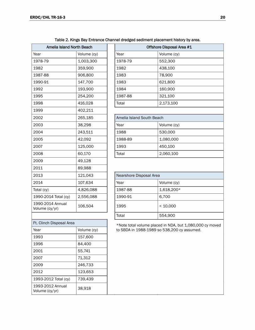
Maintenance dredging of KBEC has used several disposal areas dating back to 1978 (Figure 4). Prior to 1970, dredged sediment was sidecast to the southside of the channel. After 1970, dredged sediment was disposed offshore in Area #1 and continued until 1988 when Area #2 was designated by the USEPA (Figure 4, Table 2, and Table 3). Reuse of dredged sediment from KBEC for shore protection purposes dates back to at least 1978–1979 when the St. Marys entrance channel was deepened for naval interest, and 1,000,000 cy of sediment was placed within 2 miles south of the south jetty (Figure 4 and Table 2). The North Beach Disposal Site (NBDS) is still in use today and average annual placement since 1990 equals 107,000 cy/yr. The South Beach Disposal Site (SBDS) was used from 1988 to 1993, and the Nearshore Disposal Site (NDS) was used from 1987 to 1995. Since 1988, all sediment destined for offshore disposal is placed in Offshore Disposal Area #2. To date, 22,800,000 cy have been placed in Area #2 or an annual volume of 613,000 cy/yr since 1990.
In addition to using the aforementioned disposal areas, the KBEC project also places sediment along the shoreline fronting Ft. Clinch (inset of Figure 5). Ft. Clinch was built between 1847 and 1869 on the northern tip of Amelia Island, a location military troops have occupied since 1736. The Fort initially served Confederate blockade runners during the Civil War, but following its recapture by Union forces in 1862, it served as the base of Union operations for the area. The Fort became a state park in 1935, and the Fort Clinch State Park now includes the surrounding 1400+ acres. Strong tidal currents of the St. Marys River Inlet (KBEC) have necessitated construction of shore protection structures that have been rehabilitated to the present day configuration of six T-head groins and the remaining two

ERDC/CHL TR-16-3 19
relict groins, as seen in the Figure 5 inset. Between 1993 and 2012, 739,000 cy have been placed along the Ft. Clinch shoreline, or an average of 39,000 cy/yr (Table 2).
Figure 4. Disposal areas for St. Marys Entrance dredging (after Raichie et al. 1997).
ERDC/CHL TR-16-3 20
Table 2. Kings Bay Entrance Channel dredged sediment placement history by area.
Amelia Island North Beach Offshore Disposal Area #1
Year Volume (cy) Year Volume (cy)
1978-79 1,003,300 1978-79 552,300
1982 359,900 1982 438,100
1987-88 906,800 1983 78,900
1990-91 147,700 1983 621,800
1992 193,900 1984 160,900
1995 254,200 1987-88 321,100
1998 416,028 Total 2,173,100
1999 402,211
2002 265,185 Amelia Island South Beach
2003 38,298 Year Volume (cy)
2004 243,511 1988 530,000
2005 42,092 1988-89 1,080,000
2007 125,000 1993 450,100
2008 60,170 Total 2,060,100
2009 49,128
2011 89,988
2013 121,043 Nearshore Disposal Area
2014 107,634 Year Volume (cy)
Total (cy) 4,826,088 1987-88 1,618,200*
1990-2014 Total (cy) 2,556,088 1990-91 6,700
1990-2014 Annual Volume (cy/yr) 106,504 1995 < 10,000
Total 554,900
Ft. Clinch Disposal Area *Note total volume placed in NDA, but 1,080,000 cy moved to SBDA in 1988-1989 so 538,200 cy assumed. Year Volume (cy)
1993 157,600
1996 84,400
2001 55,741
2007 71,312
2009 246,733
2012 123,653
1993-2012 Total (cy) 739,439
1993-2012 Annual Volume (cy/yr) 38,918

ERDC/CHL TR-16-3 21
Table 3. Kings Bay Entrance Channel offshore disposal history at Area 2.
Year Volume (cy) Notes
1988 5,456,000
1988 267,500 Cumberland and St. Marys Entrance
1988 269,400 Cumberland and St. Marys Entrance
1988-91 2,132,100 Five events: 1988 (720,000 cy), 1989 (152,000, 330,000, and 424,100 cy), 1990-1991 (506,000 cy)
1990-91 17,400
1990-91 46,400
1992 929,800 Three events (640,200; 36,000; and 253,600 cy)
1994 769,700
1995 183,000
1996 1,109,000
1997 436,161
1998 805,376
1999 810,636
2001 853,600
2002 773,600
2003 769,190
2004 981,843
2005 548,039
2006 368,209
2007 578,311
2008 806,473
2009 1,316,863 Two events (256,477 cy; 1,052,386 cy)
2011 764,906
2012 537,987
2013 678,885
2014 625,000
Total 22,835,379
1990-2014 Total 14,710,379
1990-2014 Annual Volume (cy/yr) 612,932

ERDC/CHL TR-16-3 22
Figure 5. Federal projects at the Florida-Georgia border with Ft. Clinch inset.
In anticipation of KBEC project modifications starting in 1987, a 1986 Memorandum of Understanding (MOU) was negotiated between the State of Florida and the U.S. Navy that required the U.S. Navy to place all beach quality sediments within three designated Amelia Island sites. The sites included the NBDS, SBDS, and NDS (Figure 6). The MOU required that at 100% Navy expense, 1.4 million cubic yards (Mcy) of the estimated new work sediment would be placed at the NBDS, and the remaining 3.1 Mcy would be placed within the NDS. The state was required to meet an obligation of 50% of the additional cost to place the NDS sediments within the SBDS for the SBDS to be used. The MOU also provided that up to 100% of future U.S. Navy maintenance sediments would be placed along the NBDS, the NDS would only be used during emergency maintenance events, and the U.S. Navy would equally share additional costs required to place sediment in the SBDS versus the NBDS (Raichle et al. 1997).

ERDC/CHL TR-16-3 23
Figure 6. Amelia Island disposal areas under the 1986 State of Florida and U.S. Navy MOU.
Deepening of the KBEC occurred between 1987 and 1988, and placement of sediment included all three locations outlined in the 1986 MOU, as well as Offshore Disposal Area 2. The portion placed within the NBDS was fully funded by the U.S. Navy and equaled 907,000 cy of sediment. With 50% funding from the State of Florida, 530,000 cy were placed in the SBDS (Raichle et al. 1997).
During the deepening effort, 1,618,200 cy were also placed in the NDS in water depths of -20 ft to -35 ft MLW. A portion of the NDS sediment was later transferred to the SBDS shoreline (R-55 to R-60) using a cutterhead suction dredge, but the actual volume was disputed among USACE, the State of Florida, and local interests. The payment volume for the contractor was 1,083,000 cy, but the volume accounted for by survey equaled 750,000 cy. Olsen Associates, Inc. (2003) attributed the differences to winnowing losses (the loss of fine sediments, leaving coarse sediments behind) associated with the large volume of fine sediment that was observed in the fill sediment.
The current SAJ annual dredging estimate for KBEC over the 2007 to 2012 period equals 774,000 cy/yr (Bearce 2014). The annual estimate calculated from the disposal history presented in Table 2 and Table 3 is found by summing the annual placement amounts for the North Beach Disposal Area (107,000 cy/yr), the Ft. Clinch Disposal Area (39,000 cy/yr), and the Offshore Disposal Area #2 (613,000 cy/yr) to arrive at 759,000 cy/yr, very close to the current SAJ annual estimate. Rosati et al. (2013) calculated average annual shoaling rates for the entire KBEC to equal 929,000 cy/yr based on survey comparisons between 2006 and 2012.

ERDC/CHL TR-16-3 24
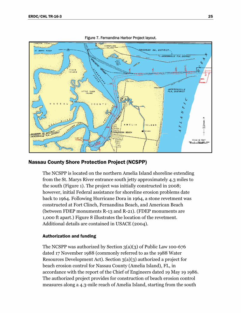
Fernandina Harbor
Fernandina Harbor is a relatively small port facility located in the northeast corner of Nassau County, FL, on the Amelia River approximately 23 miles north of the entrance to Jacksonville Harbor (Figure 1). Access to the Atlantic Ocean is through Cumberland Sound and the inlet between the north shoreline of Amelia Island, FL, and the south shoreline of Cumberland Island, GA (St. Marys/Kings Bay Entrance Channel).
Authorization and funding
Fernandina Harbor was initially authorized under the Rivers and Harbors Act of 1880 with several modifications occurring since the initial authorization. The last modification in 1991, pursuant to the continuing authority provided by Section 107 of the Rivers and Harbors Act of 1960, allocated funds to construct the sponsor-selected plan from the September 1991 Section 107 Detailed Project Report and Environmental Assessment for Fernandina Harbor. This plan provided for the construction of a 36 ft deep (referenced to mean low water [MLW]) and 400 ft wide inner channel extending west from the entrance channel south to mile 3 at the southern end of the proposed turning basin (Figure 7). The proposed turning basin configuration includes a bottom width of 1,000 ft with a stepped bottom depth of -36 ft MLW in the channel portion and -35 ft MLW in the remaining area west of the channel.
The authorized project is currently inactive. In the past there was cost sharing between the Navy and SAJ when dredging the entrance channel (now exclusively known as KBEC within SAJ) since the authorized project overlapped with Kings Bay. However, as the Navy’s channel needs are deeper than those of Fernandina Harbor, and since sediment never accretes above the authorized depth at Fernandina Harbor, funding for the KBEC is now 100% Navy and performed under Navy authorization with SAJ acting as their agent.
Permitting
Permit Number 0129228-001-JC was issued on 13 March 2000 with an expiration date of 13 March 2010, which was modified to extend to 13 March 2012. The permit allowed for beach or nearshore placement depending on the sediment quality.
ERDC/CHL TR-16-3 25
Figure 7. Fernandina Harbor Project layout.
Nassau County Shore Protection Project (NCSPP)
The NCSPP is located on the northern Amelia Island shoreline extending from the St. Marys River entrance south jetty approximately 4.3 miles to the south (Figure 1). The project was initially constructed in 2008; however, initial Federal assistance for shoreline erosion problems date back to 1964. Following Hurricane Dora in 1964, a stone revetment was constructed at Fort Clinch, Fernandina Beach, and American Beach (between FDEP monuments R-13 and R-21). (FDEP monuments are 1,000 ft apart.) Figure 8 illustrates the location of the revetment. Additional details are contained in USACE (2004).
Authorization and funding
The NCSPP was authorized by Section 3(a)(3) of Public Law 100-676 dated 17 November 1988 (commonly referred to as the 1988 Water Resources Development Act). Section 3(a)(3) authorized a project for beach erosion control for Nassau County (Amelia Island), FL, in accordance with the report of the Chief of Engineers dated 19 May 19 1986. The authorized project provides for construction of beach erosion control measures along a 4.3-mile reach of Amelia Island, starting from the south

ERDC/CHL TR-16-3 26
jetty of St. Marys Inlet going south to Sadler Road. The first 0.7 mile (Ft. Clinch State Park) is authorized for renourishment only. The remaining 3.6 miles of the study limits are authorized for a 20 ft berm at elevation 13.0 ft above MLW with a 1V:20H slope seaward of the berm out to MLW, and thence a 1V:50H slope to intersection with the existing bottom (USACE 2004).
Figure 8. Nassau County Shore Protection Project limits. (FDEP monuments are 1,000 ft apart.)

ERDC/CHL TR-16-3 27
During the review and approval process for the 2004 General Reevaluation Report (GRR), the 0.7-mile reach on the Atlantic Coast of Ft. Clinch State Park was removed from the recommended plan. This stretch, consisting of the northern-most reach of the project (between FDEP monuments R-10 and R-13), was entirely within a state park and consisted of periodic renourishment only (no design berm) to hold the existing shoreline in place to halt erosion. Since there were no storm damage reduction benefits for this reach, it could not be incrementally justified and was therefore removed from the recommended plan. However, this area is periodically nourished with sediment from the Kings Bay Entrance Channel, as discussed previously.
The recommended project area from the 2004 GRR is comprised of the 3.6 miles of Nassau County shoreline located between FDEP monuments R-13 and R-33, starting approximately 0.7 mile south of the south jetty for the St. Marys Entrance Channel and proceeding 3.6 miles to the south terminating near Sadler Road. The design template berm elevation is +13.0 ft MLW and provides for a preproject mean high water extension of 40 ft. The design slopes have changed to reflect the natural existing conditions of 1V:15H to MLW and thence 1V:25H to existing ground. The primary sediment source is located immediately south of the St. Marys Entrance Channel, approximately 2 miles from the center of the study area. The 2004 GRR increased the renourishment interval to every 5 years (from the previously authorized 2-year interval) over the 50-year life of the project. In the 2006 revision of the GRR, advanced nourishment is stated to be 297,000 cy/yr. Olsen Associates Inc. (2003) reports that, after accounting for all beach placement activities, the annual erosion rate between FDEP monuments R-10 and R-25 equals 163,000 cy/yr, far less than the advanced nourishment rate.
Permitting
Permit Number 0264288-001-JC was issued on 6 September 2007 and has an expiration date of 6 September 2012. It was subsequently extended to 6 September 2014 by Variance Number 0264288-002-EV.
Project history
Initial construction of the NCSPP occurred in 2008. The initial nourishment placed 1,932,000 cy of sediment along the 3.6-mile length of the project using sediment from the offshore borrow area located
ERDC/CHL TR-16-3 28
approximately 12,500 ft offshore within the ebb shoal of the St. Marys River Inlet. The length of time between initial project authorization (1988) and initial project construction in 2008 is due to the large amount of sediment that the project beaches receive from KBEC maintenance dredging as discussed previously (Table 2) and reformulation of the project features in the GRR of April 1999 (and 2004, 2006 revisions).
Atlantic Intracoastal Waterway (AIWW) and Intracoastal Waterway (IWW)
The AIWW extends from Norfolk, VA, to the SJR in Florida. At the SJR, the waterway continues to Miami under the official name of the IWW. The change in nomenclature is illustrated in Figure 1. The waterway provides shallow-draft navigation protected from ocean swells for the majority of the U.S. eastern seaboard.
Authorization and funding
The AIWW between Norfolk, VA, and the SJR, FL, was first authorized by the United States Congress on 4 March 1913. The original channel dimensions were 7 ft deep and 100 ft wide. Expansion of the channel to its current configuration of 12 ft deep and 90 ft to 150 ft wide was authorized by Congress on 20 June 1938.
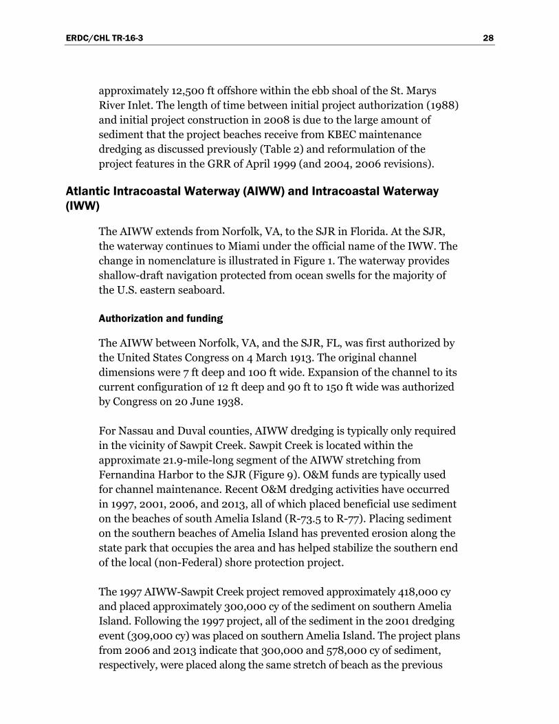
For Nassau and Duval counties, AIWW dredging is typically only required in the vicinity of Sawpit Creek. Sawpit Creek is located within the approximate 21.9-mile-long segment of the AIWW stretching from Fernandina Harbor to the SJR (Figure 9). O&M funds are typically used for channel maintenance. Recent O&M dredging activities have occurred in 1997, 2001, 2006, and 2013, all of which placed beneficial use sediment on the beaches of south Amelia Island (R-73.5 to R-77). Placing sediment on the southern beaches of Amelia Island has prevented erosion along the state park that occupies the area and has helped stabilize the southern end of the local (non-Federal) shore protection project.
The 1997 AIWW-Sawpit Creek project removed approximately 418,000 cy and placed approximately 300,000 cy of the sediment on southern Amelia Island. Following the 1997 project, all of the sediment in the 2001 dredging event (309,000 cy) was placed on southern Amelia Island. The project plans from 2006 and 2013 indicate that 300,000 and 578,000 cy of sediment, respectively, were placed along the same stretch of beach as the previous

ERDC/CHL TR-16-3 29
two events. The 2013 project cuts are presented in Figure 9 though other O&M events in the area, namely the 2006 project, included cuts as far south as the FGR. The permit plate depicting the beach placement area for 2013 is shown in Figure 10. Sediments not suitable for beach placement are placed in the upland DMMA, DU-2, as seen in Figure 9 between Cuts 5 and 6.
Figure 9. AIWW Sawpit dredging plan, 2011 permit. (Orange area to be dredged, with sediment to be placed on the beach.)
N
ERDC/CHL TR-16-3 30
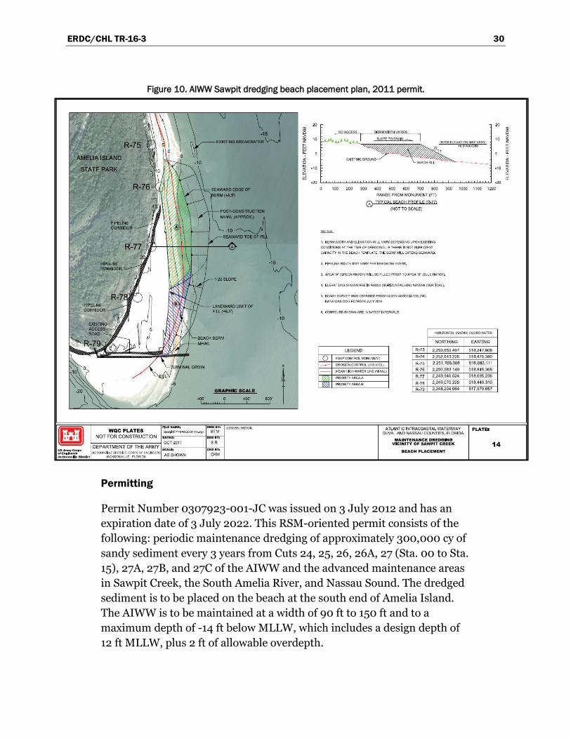
Figure 10. AIWW Sawpit dredging beach placement plan, 2011 permit.
Permitting
Permit Number 0307923-001-JC was issued on 3 July 2012 and has an expiration date of 3 July 2022. This RSM-oriented permit consists of the following: periodic maintenance dredging of approximately 300,000 cy of sandy sediment every 3 years from Cuts 24, 25, 26, 26A, 27 (Sta. 00 to Sta. 15), 27A, 27B, and 27C of the AIWW and the advanced maintenance areas in Sawpit Creek, the South Amelia River, and Nassau Sound. The dredged sediment is to be placed on the beach at the south end of Amelia Island. The AIWW is to be maintained at a width of 90 ft to 150 ft and to a maximum depth of -14 ft below MLLW, which includes a design depth of 12 ft MLLW, plus 2 ft of allowable overdepth.

ERDC/CHL TR-16-3 31
Naval Station (NS) Mayport
Naval Station (NS) Mayport is located immediately south of the SJR Inlet approximately 0.5 mile upstream from the jetty tips (Figure 1). In 1939, the United States selected the current site for a new naval base and originally dredged it to -29 ft relative to MLLW. The dredged sediments were used to create upland support facilities to accommodate naval interests. In 1942 the Naval Station was commissioned to provide maintenance and refueling services to submarines. This mission required deepening of the entrance channel to -42 ft MLLW. The present configuration of NS Mayport includes a turning basin, destroyer slip, and small-boat basin. In 2012 the basin was deepened to -50 ft MLLW to accommodate nuclear aircraft carriers; the entrance was deepened accordingly (Thomas and Dunkin 2012).
Authorization and funding
Navy dredging is authorized under Section 201 of the 1974 River and Harbor Act. Funding is 100% Navy and is provided by the Commander, Navy Installations Command (CNIC), as 1-year money, and expires each year. The SJR Entrance Channel (Bar Cut 3) and the Mayport Entrance Channel are dredged to -50 ft MLLW with 2 ft of allowable overdepth dredging for a total maximum depth of -52 ft MLLW. There are portions where an additional 2 ft of advance maintenance depth is also provided, bringing the total maximum depth to -54 ft MLLW in those areas. Similar to KBEC and Fernandina Harbor, the St. Johns Entrance Channel is shared between NS Mayport and Jacksonville Harbor. Since the Navy’s channel needs are deeper than those of Jacksonville Harbor, funding for maintenance is 100% Navy in locations where the projects overlap.
Permitting
In addition to an FDEP permit, Mayport requires a DA permit for dredging maintenance sediment, a DA permit for placement of dredged sediment, and an MPRSA of 1972 Section 103 permit to transport dredged sediment for the purpose of disposal in an ODMDS. Following geotechnical analysis and confirmation of beach quality sediment within Mayport entrance channel cuts, SAJ secured FDEP Permit #303186001, issued 23 May 2012, (and expiring 23 May 2022), for the U.S. Navy. This permit includes authority to place sediment on the beach and was used for the 2013 O&M placement event. The placement of sediment south of the jetty in the nearshore zone was previously evaluated for environmental impacts as

ERDC/CHL TR-16-3 32
required under the National Environmental Policy Act (NEPA), but the FDEP permit does not currently provide for a nearshore placement option.
Jacksonville Harbor
The Jacksonville Harbor Federal navigation project is located in Duval County, FL (Figure 11). The project includes initial construction and maintenance beginning at the mouth of the SJR, extending 27 river miles upriver. The harbor project provides deep-draft vessels access to terminal facilities located in the City of Jacksonville. The primary concentration of port facilities for Jacksonville Harbor is between River Mile 8 (RM8) and RM20 of the Federal navigation project. The current project depth is -42 ft MLLW (plus 2 ft of overdepth) from the ocean entrance to NS Mayport and -40 ft MLLW (plus 2 ft of overdepth) to RM20.
Figure 11. Jacksonville Harbor location map.
ERDC/CHL TR-16-3 33
Authorization and funding
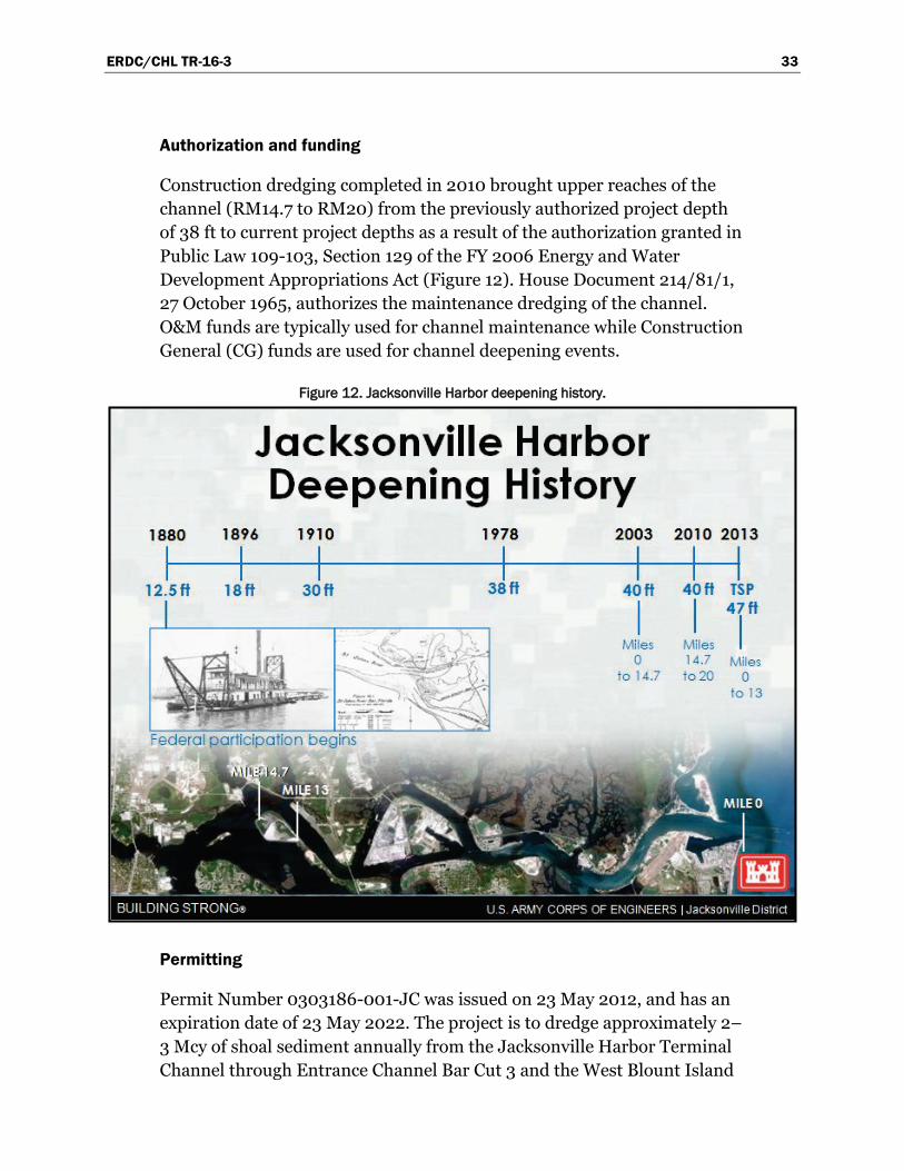
Construction dredging completed in 2010 brought upper reaches of the channel (RM14.7 to RM20) from the previously authorized project depth of 38 ft to current project depths as a result of the authorization granted in Public Law 109-103, Section 129 of the FY 2006 Energy and Water Development Appropriations Act (Figure 12). House Document 214/81/1, 27 October 1965, authorizes the maintenance dredging of the channel. O&M funds are typically used for channel maintenance while Construction General (CG) funds are used for channel deepening events.
Figure 12. Jacksonville Harbor deepening history.
Permitting
Permit Number 0303186-001-JC was issued on 23 May 2012, and has an expiration date of 23 May 2022. The project is to dredge approximately 2–3 Mcy of shoal sediment annually from the Jacksonville Harbor Terminal Channel through Entrance Channel Bar Cut 3 and the West Blount Island

ERDC/CHL TR-16-3 34
Channel. As seen in the permit plates submitted in 2011 (Figure 13), dredged sediment can be placed in upland disposal areas including Bartram Island, Buck Island, and/or another operational upland placement area; in an Ocean Dredged Material Disposal Site (ODMDS); in Huguenot Park; or on the beach south of the inlet.
Dredged material management
The latest Jacksonville Harbor DMMP (2013) provides estimates of dredging needs by river section and the plan for disposing the sediment. As outlined in the DMMP, disposal options for Jacksonville Harbor dredged sediments include current and proposed DMMAs, the ODMDS, the nearshore placement areas, and beach placement areas (Figure 14 and Figure 15). The DMMP classifies beach and nearshore sediment following the FDEP sand rule (FAC 62B-41.007(2)(j)), as discussed previously. Maintenance areas planned for offshore disposal have previously been approved by USACE Regulatory Divisions and USEPA. The sediment that is not suitable for beach, nearshore, or ODMDS placement and is not hazardous or toxic is considered confined disposal facility (CDF)-only quality. A CDF is an alternate name for a DMMA. Note that although this project currently has NEPA coverage to place sediment south of the inlet in a designated nearshore placement area and such activity is a stated management objective in the 2013 DMMP, current permit coverage does not provide for such placement activities.
Current annual dredging estimates for the cuts of the Federal navigation channel farthest upriver (including Cut 43 through the Terminal Channel) where sediments are predominantly fine grained and alluvial, are approximately 150,000 cy/yr. The DMMP shows that 6,600 cy/yr of sediment could be placed on the beach or nearshore, 100,050 cy/yr could be placed in the ODMDS, and the remaining volume (43,350 cy/yr) is limited to disposal in a CDF. Although some sediment can be placed on the beach, in the nearshore, or in the ODMDS, the least-cost disposal option for this section of river has historically been upland DMMAs. Dredging areas adjacent to the Federal channel that are maintained by the Jacksonville Port Authority (JAXPORT) are estimated to produce 416,000 cy/yr of sediment that is suitable for the ODMDS. Cuts F and G are restricted to CDF disposal, and Federal responsibility is estimated to equal 105,000 cy/yr; non-Federal responsibility equals 41,600 cy/yr.

ERDC/CHL TR-16-3 35
Figu
re 1
3. Ja
ckso
nvill
e Ha
rbor
mai
nten
ance
ove
rvie
w, 2
011
perm
it.

ERDC/CHL TR-16-3 36
Figu
re 1
4. Ja
ckso
nvill
e Ha
rbor
dre
dged
sed
imen
t dis
posa
l are
as.
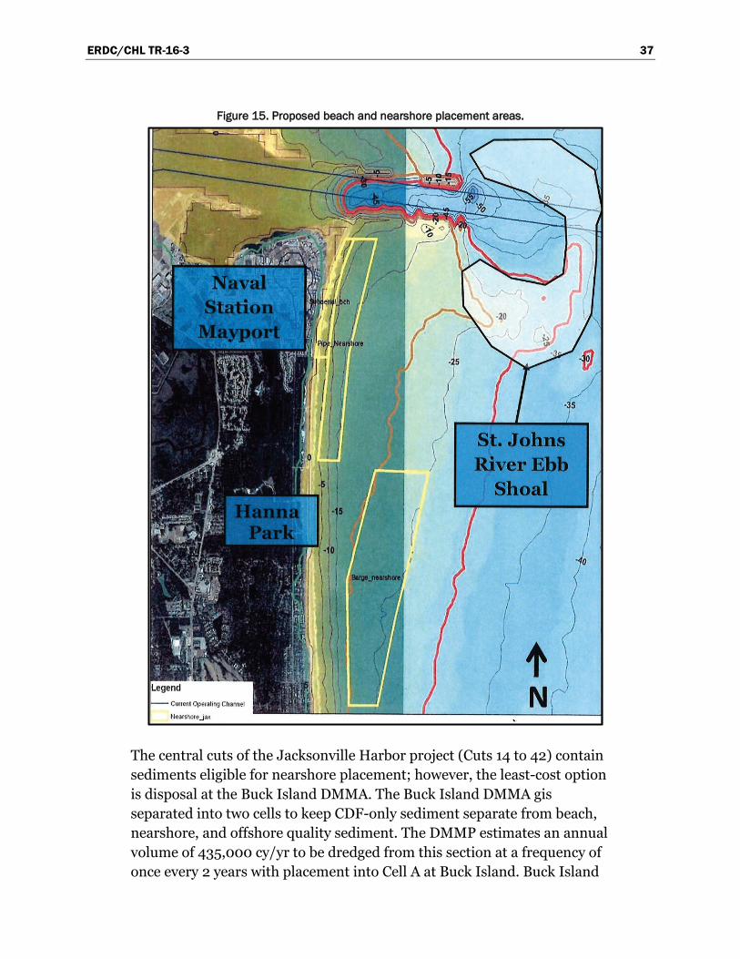
ERDC/CHL TR-16-3 37
Figure 15. Proposed beach and nearshore placement areas.
The central cuts of the Jacksonville Harbor project (Cuts 14 to 42) contain sediments eligible for nearshore placement; however, the least-cost option is disposal at the Buck Island DMMA. The Buck Island DMMA gis separated into two cells to keep CDF-only sediment separate from beach, nearshore, and offshore quality sediment. The DMMP estimates an annual volume of 435,000 cy/yr to be dredged from this section at a frequency of once every 2 years with placement into Cell A at Buck Island. Buck Island

ERDC/CHL TR-16-3 38
Cell B is planned for use by the local sponsor, JAXPORT, for CDF-only sediment. The DMMP estimates that 62,400 cy/yr will be removed every 2 years from non-Federal portions of the Jacksonville Harbor between Cuts 14 to 42 and placed into Cell B.
The cuts closest to the Atlantic Ocean (Bar Cut 3 through Cut 13) contain littoral sediment that could be suitable for direct placement on the beaches south of the inlet or within the nearshore zones (Figure 15). The proposed nearshore zones include an area for placement by pipe discharge as well as an area farther offshore to the south for placement by split-hull hopper dredges or barges. An estimated 185,000 cy/yr of sediment is the anticipated future dredging sediment from the cuts around the lower reaches of the SJR that could be placed back into the littoral system south of the SJR inlet. A history of placement of navigation maintenance sediment on the beaches south of the SJR is included in Table 4 of the following section regarding the Duval County Shore Protection Project.
Current general reevaluation report (GRR)
A GRR for Jacksonville Harbor was completed in 2014, analyzing channel deepening to make Jacksonville Harbor available to larger ships following the expansion of the Panama Canal, known as post-Panamax ships. The recommended plan includes deepening the Federal channel to -47 ft MLLW from the entrance channel to approximately RM13, widening two areas at the Training Wall Reach and St. Johns Bluff Reach, and constructing two turning basins at Blount Island and Brills Cut (Figure 16). A permit application to deepen the channel has not been submitted. However, SAJ has conducted preapplication coordination on the project mitigation plan with FDEP during the NEPA phase so that once an application is submitted, issues that would otherwise arise during the permitting process should be substantially reduced.
The deepening and widening proposed in the latest GRR of 2014 increases shoaling expectations but is not anticipated to impact the surrounding beaches. Shoaling increase estimates for the upper (Cut 43 to Terminal Channel), middle (Cut 14 to 42), and lower (Cuts 3 to 13) portions of the channel are 5,000 cy/yr, 120,000 cy/yr, and 12,000 cy/yr, respectively. The increase in shoaling was solely based on the increase in channel footprint given the same shoaling rate for a given channel cut. Modeling efforts are underway to refine the shoaling estimates. Note that areas of the channel currently determined to be suitable for beach or nearshore
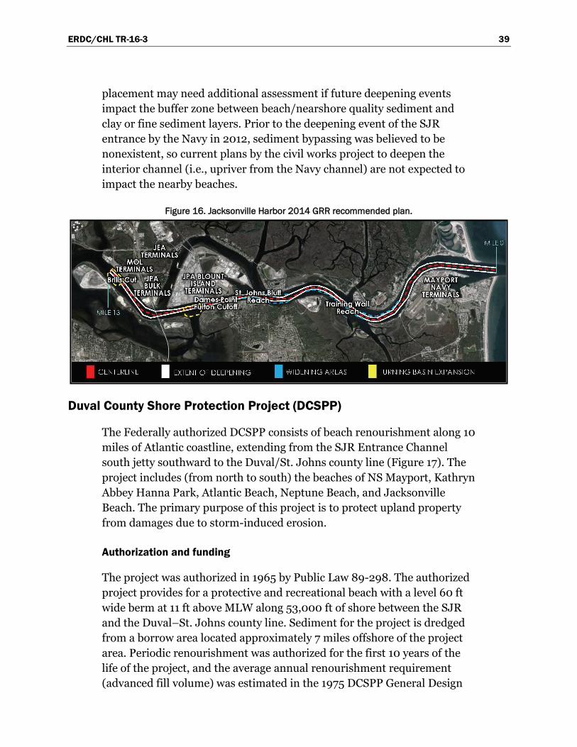
ERDC/CHL TR-16-3 39
placement may need additional assessment if future deepening events impact the buffer zone between beach/nearshore quality sediment and clay or fine sediment layers. Prior to the deepening event of the SJR entrance by the Navy in 2012, sediment bypassing was believed to be nonexistent, so current plans by the civil works project to deepen the interior channel (i.e., upriver from the Navy channel) are not expected to impact the nearby beaches.
Figure 16. Jacksonville Harbor 2014 GRR recommended plan.
Duval County Shore Protection Project (DCSPP)
The Federally authorized DCSPP consists of beach renourishment along 10 miles of Atlantic coastline, extending from the SJR Entrance Channel south jetty southward to the Duval/St. Johns county line (Figure 17). The project includes (from north to south) the beaches of NS Mayport, Kathryn Abbey Hanna Park, Atlantic Beach, Neptune Beach, and Jacksonville Beach. The primary purpose of this project is to protect upland property from damages due to storm-induced erosion.
Authorization and funding
The project was authorized in 1965 by Public Law 89-298. The authorized project provides for a protective and recreational beach with a level 60 ft wide berm at 11 ft above MLW along 53,000 ft of shore between the SJR and the Duval–St. Johns county line. Sediment for the project is dredged from a borrow area located approximately 7 miles offshore of the project area. Periodic renourishment was authorized for the first 10 years of the life of the project, and the average annual renourishment requirement (advanced fill volume) was estimated in the 1975 DCSPP General Design
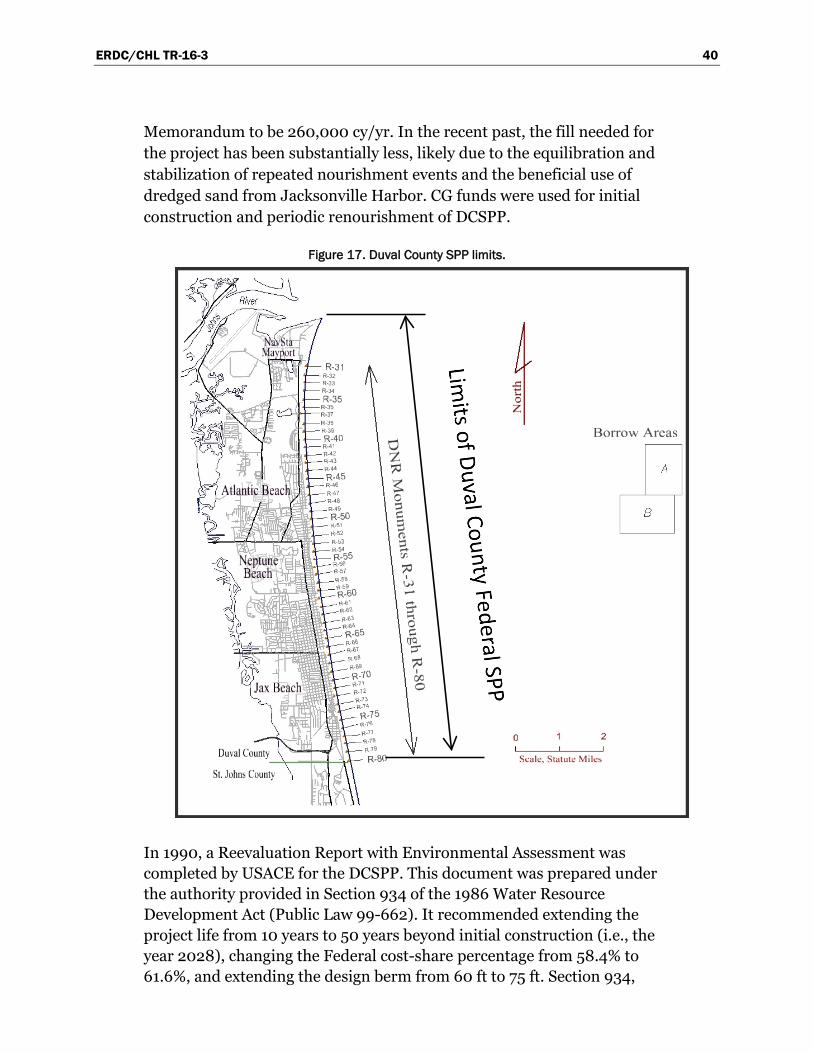
ERDC/CHL TR-16-3 40
Memorandum to be 260,000 cy/yr. In the recent past, the fill needed for the project has been substantially less, likely due to the equilibration and stabilization of repeated nourishment events and the beneficial use of dredged sand from Jacksonville Harbor. CG funds were used for initial construction and periodic renourishment of DCSPP.
Figure 17. Duval County SPP limits.
In 1990, a Reevaluation Report with Environmental Assessment was completed by USACE for the DCSPP. This document was prepared under the authority provided in Section 934 of the 1986 Water Resource Development Act (Public Law 99-662). It recommended extending the project life from 10 years to 50 years beyond initial construction (i.e., the year 2028), changing the Federal cost-share percentage from 58.4% to 61.6%, and extending the design berm from 60 ft to 75 ft. Section 934,
ERDC/CHL TR-16-3 41
however, only provides authority to extend periodic beach nourishment at authorized SPPs for a period of 50 years from project initiation and does not include provisions for project changes (such as increasing the design berm to 75 ft) as recommended by the Reevaluation Report. The recommended change to the Federal cost-share, however, is acknowledged in the 1992 Supplement to the Reevaluation Report. In the 2005 Cost Allocation Final Letter Report, the Federal cost-share was increased from 61.6% to 63.6% based on changes in access and ownership since the 1992 Supplement to the Reevaluation Report.
Permitting
Placement of sediment along the DCSPP is currently permited under FDEP permit number 0228528-001-JC. This is a 10-year permit issued on 18 April 2005 and expires 18 April 2015. The permit provides for direct beach placement of nourishment sediment from offshore borrow areas on the shoreline between FDEP monuments R-37 and R-80 or from the southern end of Hanna Park to the Duval/St. Johns county line (Figure 17). The FDEP permit was modified 10 January 2011 to extend the boundaries of Borrow Area A and increase available borrow area sand volumes from 508,000 cy to 2,330,000 cy. Further development of borrow areas offshore and south of the existing DCSPP borrow areas is underway. To place Jacksonville Harbor O&M sediment along the beaches of DCSPP, the permit associated with placement of navigation sediment needs a modification to expand the placement areas.
Project history
Initial construction of the DCSPP began in 1978 and was completed in 1980 (Table 4). Subsequent large-scale renourishments of the project under the authority of the DCSPP were performed in 1985–87, 1991, 1995, 2005, and 2011. Additionally, several smaller-scale beach fills were placed within the previously approved placement limits of the DCSPP during maintenance dredging of the adjacent Jacksonville Harbor Federal navigation project, some prior to initial DCSPP construction. These beach fill placements were funded and constructed under the authority of the Federal navigation project. Cost sharing between navigation and shore protection projects occurred in 1985 and 2003 when the DCSPP funded the additional costs to place sediment farther south than the least-cost disposal option at Mayport. Additionally, the 2005 renourishment event shared funding from the Flood Control and Coastal Emergency (FCCE) program and the DCSPP to restore the beach following the active
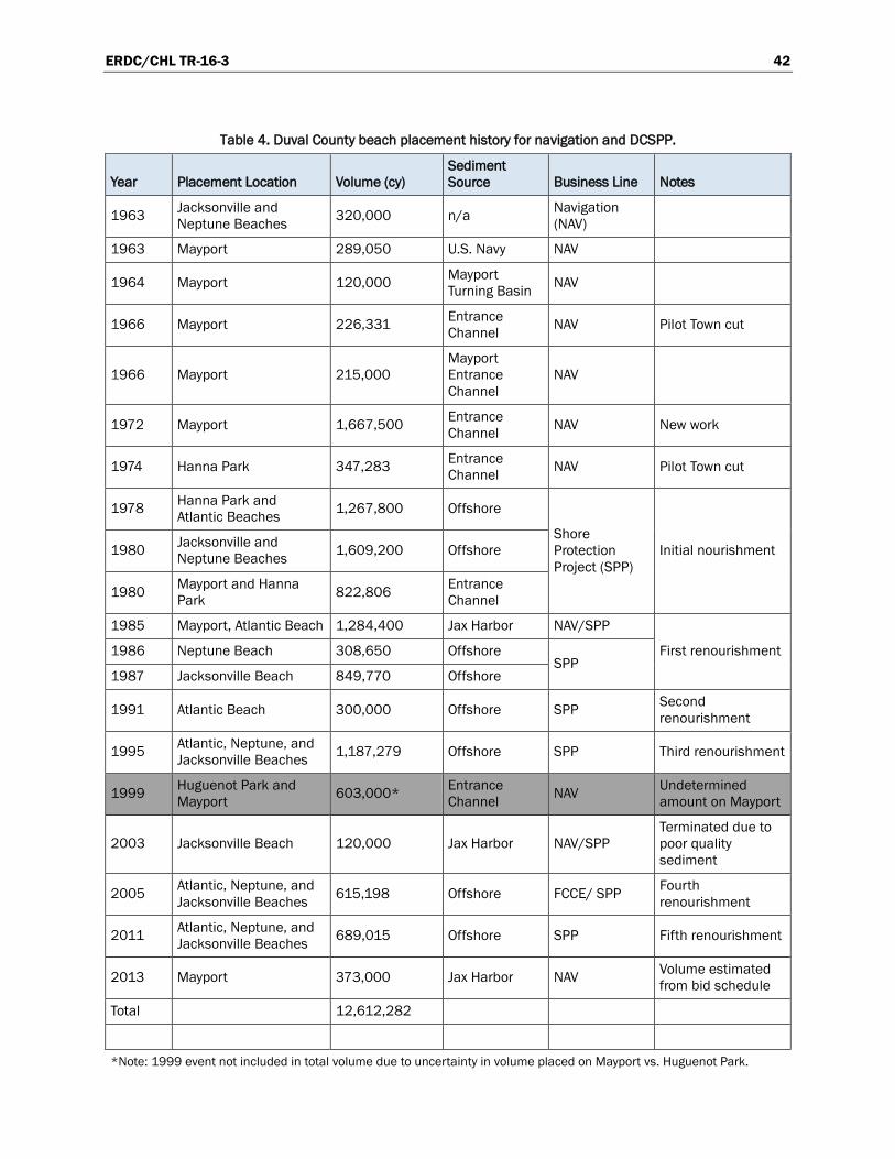
ERDC/CHL TR-16-3 42
Table 4. Duval County beach placement history for navigation and DCSPP.
Year Placement Location Volume (cy) Sediment Source Business Line Notes
1963 Jacksonville and Neptune Beaches 320,000 n/a Navigation
(NAV)
1963 Mayport 289,050 U.S. Navy NAV
1964 Mayport 120,000 Mayport Turning Basin NAV
1966 Mayport 226,331 Entrance Channel NAV Pilot Town cut
1966 Mayport 215,000 Mayport Entrance Channel
NAV
1972 Mayport 1,667,500 Entrance Channel NAV New work
1974 Hanna Park 347,283 Entrance Channel NAV Pilot Town cut
1978 Hanna Park and Atlantic Beaches 1,267,800 Offshore
Shore Protection Project (SPP)
Initial nourishment 1980 Jacksonville and Neptune Beaches 1,609,200 Offshore
1980 Mayport and Hanna Park 822,806 Entrance
Channel
1985 Mayport, Atlantic Beach 1,284,400 Jax Harbor NAV/SPP
First renourishment 1986 Neptune Beach 308,650 Offshore SPP
1987 Jacksonville Beach 849,770 Offshore
1991 Atlantic Beach 300,000 Offshore SPP Second renourishment
1995 Atlantic, Neptune, and Jacksonville Beaches 1,187,279 Offshore SPP Third renourishment
1999 Huguenot Park and Mayport 603,000* Entrance
Channel NAV Undetermined amount on Mayport
2003 Jacksonville Beach 120,000 Jax Harbor NAV/SPP Terminated due to poor quality sediment
2005 Atlantic, Neptune, and Jacksonville Beaches 615,198 Offshore FCCE/ SPP Fourth
renourishment
2011 Atlantic, Neptune, and Jacksonville Beaches 689,015 Offshore SPP Fifth renourishment
2013 Mayport 373,000 Jax Harbor NAV Volume estimated from bid schedule
Total 12,612,282
*Note: 1999 event not included in total volume due to uncertainty in volume placed on Mayport vs. Huguenot Park.
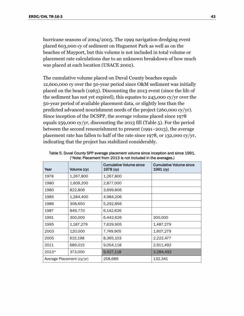
ERDC/CHL TR-16-3 43
hurricane seasons of 2004/2005. The 1999 navigation dredging event placed 603,000 cy of sediment on Huguenot Park as well as on the beaches of Mayport, but this volume is not included in total volume or placement rate calculations due to an unknown breakdown of how much was placed at each location (USACE 2002).
The cumulative volume placed on Duval County beaches equals 12,600,000 cy over the 50-year period since O&M sediment was initially placed on the beach (1963). Discounting the 2013 event (since the life of the sediment has not yet expired), this equates to 245,000 cy/yr over the 50-year period of available placement data, or slightly less than the predicted advanced nourishment needs of the project (260,000 cy/yr). Since inception of the DCSPP, the average volume placed since 1978 equals 259,000 cy/yr, discounting the 2013 fill (Table 5). For the period between the second renourishment to present (1991–2013), the average placement rate has fallen to half of the rate since 1978, or 132,000 cy/yr, indicating that the project has stabilized considerably.
Table 5. Duval County SPP average placement volume since inception and since 1991. (*Note: Placement from 2013 is not included in the averages.)
Year Volume (cy) Cumulative Volume since 1978 (cy)
Cumulative Volume since 1991 (cy)
1978 1,267,800 1,267,800
1980 1,609,200 2,877,000
1980 822,806 3,699,806
1985 1,284,400 4,984,206
1986 308,650 5,292,856
1987 849,770 6,142,626
1991 300,000 6,442,626 300,000
1995 1,187,279 7,629,905 1,487,279
2003 120,000 7,749,905 1,607,279
2005 615,198 8,365,103 2,222,477
2011 689,015 9,054,118 2,911,492
2013* 373,000 9,427,118 3,284,492
Average Placement (cy/yr) 258,689 132,341
ERDC/CHL TR-16-3 44
Management Alternative Strategies and Recommendations
RSM strategies result from combining authorities, funding, permits, and scheduled work, ideally resulting in economic savings while benefitting the region. Often, USACE operations staff achieves this on-the-fly through institutional knowledge. However, having strategies outlined in advance with key information regarding permits and authorities helps take advantage of all opportunities and increases overall efficiency while continuing to plan for additional benefit to the region. Additionally, gaps in Federal authority can be identified and targeted for assistance from local sponsors and state agencies. RSM strategies also facilitate permitting and various other stakeholder coordination activities when it can be demonstrated that impacts to the entire coastal system are being considered. This holistic approach results in the accomplishment of shared project goals on an expedited timeline. Strategies specific to the Nassau and Duval counties portion of the study area are presented below.
Kings Bay Entrance Channel (KBEC) and Kings Bay Interior Channel (KBIC) Navigation Projects
Alternative strategies
Maintenance dredging of the Kings Bay navigation channels (KBEC and KBIC) in support of the U.S. Navy submarine fleet is a national security priority and will likely continue in perpetuity. Current management strategies include upland disposal, beach placement, and offshore disposal in the ODMDS.
Investigations are underway to qualify dredged sediment within the KBIC for offshore or nearshore disposal, a measure that will save upland DMMA capacity. Additionally, coordination and investigative efforts are underway to increase the upland storage capacity for KBIC by offloading (removing) sediment from four DMMAs which are under Navy control including Crab Island, Main Disposal Area, Disposal Area 1, and Disposal Area 2 (Figure 18). The locally funded Amelia Island Shore Stabilization Project would remove the sediment and use it to restore the shoreline within the project limits.
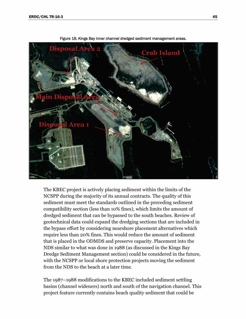
ERDC/CHL TR-16-3 45
Figure 18. Kings Bay inner channel dredged sediment management areas.
The KBEC project is actively placing sediment within the limits of the NCSPP during the majority of its annual contracts. The quality of this sediment must meet the standards outlined in the preceding sediment compatibility section (less than 10% fines), which limits the amount of dredged sediment that can be bypassed to the south beaches. Review of geotechnical data could expand the dredging sections that are included in the bypass effort by considering nearshore placement alternatives which require less than 20% fines. This would reduce the amount of sediment that is placed in the ODMDS and preserve capacity. Placement into the NDS similar to what was done in 1988 (as discussed in the Kings Bay Dredge Sediment Management section) could be considered in the future, with the NCSPP or local shore protection projects moving the sediment from the NDS to the beach at a later time.
The 1987–1988 modifications to the KBEC included sediment settling basins (channel wideners) north and south of the navigation channel. This project feature currently contains beach quality sediment that could be

ERDC/CHL TR-16-3 46
used for nourishing portions of the NCSPP. Rosati et al. (2013) determined that the north settling basin accumulates 47,000 cy/yr on average based on survey data analyzed between 2006 and 2012. The sandy sediment that accumulates in the settling basin is typically placed on the NCSPP or the beaches along Ft. Clinch; however, maintenance of the feature is not included in the 2014 KBEC contract. Future optimization studies of the KBEC project could include review of the settling basin feature including maintenance history, benefits, recharge rates, and geotechnical data. The settling basin could potentially be expanded and serve dual maintenance roles for navigation and shore protection projects.
Recommendations
• Continue efforts to determine the compatibility of the sediment located in the upland DMMAs used for KBIC dredging to supply sediment to the local Amelia Island SPP project, thus increasing future capacity for the U.S. Navy.
• Continue efforts to permit and place KBIC sediment in the nearshore or ODMDS to save DMMA capacity.
• Continue placement of maintenance sediment on SPP beaches and the Ft. Clinch shoreline.
• Investigate nearshore placement options to increase the amount of KBEC sediment that is bypassed to the beaches to the south and reduce pressure on the ODMDS.
• Include review of settling basins in future KBEC studies to determine if the settling basin can be expanded or better utilized.
• Pursue advanced maintenance of settling basins using SPP leveraged funds.
• Coordinate with local sponsor, FDEP, Georgia DNR, and other stakeholders to advance management strategies and promote new ideas.
AIWW and IWW
Alternative strategies
The proximity of the AIWW cuts near the southern end of Amelia Island, as well as the composition of sediments, have made beneficial use of AIWW dredged sediment a successful practice. The placement of this sediment on southern Amelia Island coupled with the terminal structure and offshore breakwater, both built in 2005 by local interests, have

ERDC/CHL TR-16-3 47
substantially stabilized the area compared to prior years. Beneficial use of the dredged sediment in the Sawpit Cuts reserves capacity of the upland storage facilities. Further study of these efforts may be warranted as the evolution of the sediment placed on southern Amelia Island is unknown and some sediment could migrate into Nassau Sound and deposit back into the AIWW channel.
Previous contracts for dredging the AIWW in the vicinity of Sawpit Creek have included cuts near the FGR. The FPS, NPS, City of Jacksonville, and nongovernmental organizations (NGO) have displayed interest in management efforts to ensure flow through the FGR is maintained and that inlet closure is prevented. The USACE efforts to remove sediment from the system (discussed in the following section) are currently focused on the ebb tidal shoal since it is the least-cost option for the DCSPP. Coordination with FGR stakeholders could provide a leveraging opportunity to dredge the FGR concurrently with future AIWW maintenance dredging contracts. To implement this idea, the stakeholders would need to secure disposal options, and the contracting mechanism for such a project would require analysis to determine if the work could be performed under an all-encompassing USACE contract or if separate contracts would be required. Sediment could be placed with AIWW sediment on south Amelia Island; however, long haul distances could be expensive and confirmation of compatibility would be required through geotechnical investigations. The beaches south of the SJR Inlet could also serve as a possible placement area.
Recommendations
• Continue to dredge AIWW sediment and maintain southern Amelia Island.
• Create a monitoring and/or data collection program with the intent of future hydrodynamic modeling of the projects to ensure that back-passed sediment is not redeposited in the AIWW navigation channel.
• Coordinate future dredging contracts with the environmental agencies and NGOs interested in restoring the efficiency of the FGR Inlet and determine if future contracts can be leveraged to support dredge work within the FGR funded by such organizations. If coordination is promising, provide assistance with geotechnical investigations and other potential permit requirements to accomplish the sediment removal.

ERDC/CHL TR-16-3 48
Ft. George River (FGR) Inlet
Alternative strategies
The impacts to the sediment transport regime caused by the SJR Inlet and the modifications of the inlet system in support of the Jacksonville Harbor Federal Navigation Project have resulted in documented northward migration of Wards Bank. The northward migration of Wards Bank (Figure 19) forces the FGR Inlet to move north, resulting in erosion to the southern end of Little Talbot Island (USACE 1997; Gosselin et al. 2002). The combined effects of cumulative erosional losses due to storms and the blocking of the predominant north-to-south sediment flow path in the area have also left the beaches south of the inlet starved for sand and have necessitated implementation of the Duval County SPP (USACE 1964). Management strategies to relocate a portion of captured sediments from within or north of the SJR inlet system to the beaches south of the inlet are discussed subsequently.
Management alternatives and strategies for the FGR Inlet complex were thoroughly reviewed by USACE (2000). The most realistic strategies include shoreline armoring, shoreline nourishment, dredging activities, or a combination thereof. Current planning for managing the FGR Inlet as stated by FDEP (2008) includes a detailed study and analysis of sand transfer or bypassing activities, including the resulting effects on inlet stability.
To determine the effectiveness of the dredging alternative strategies, SAJ has initiated a study effort as a part of the Northeast Florida RSM program by refocusing the CMS model that was developed in support of the Jacksonville Harbor GRR deepening study to the FGR inlet area. The model analyzed different dredging alternatives and the impacts of each alternative on the hydrodynamics of the river-inlet system. Additional management strategies outlined in USACE (2000) could be added to the modeling effort in the future if needed.
In support of the FGR Inlet modeling effort, the DCSPP sponsored a survey of the FGR ebb shoal, Wards Bank, and the SJR north jetty inner shoal in June 2013. These newer surveys do not cover the entire FGR region, and existing survey data sets from the early 2000s are becoming outdated for current use due to the dynamic nature of the area and growth of the flood shoals. The Wards Bay area has very limited survey coverage, which is insufficient to resolve the complex morphology of the bay.

ERDC/CHL TR-16-3 49
Figure 19. Features around the Ft. George River Inlet.
The goal of the CMS model of FGR inlet was to formulate a dredging plan that will provide a more efficient path for the FGR to exit into the ocean south of its present configuration to reduce erosional pressure on Little Talbot Island. As stated in USACE (2000), the efficiency of the inlet is reduced as it is displaced northward by the migrating Wards Bank. If the prevailing trend continues, the inlet will likely either close or create an alternate outlet that proves more hydraulically efficient that could occur in a location that would threaten public infrastructure within Huguenot Park or elsewhere. Therefore, stabilizing the inlet to alleviate environmental concern that the inlet may close, identifying a sediment source for the DCSPP, and reducing shoaling pressure on the Jacksonville Harbor Federal navigation project were desired outcomes of the FGR CMS model study.
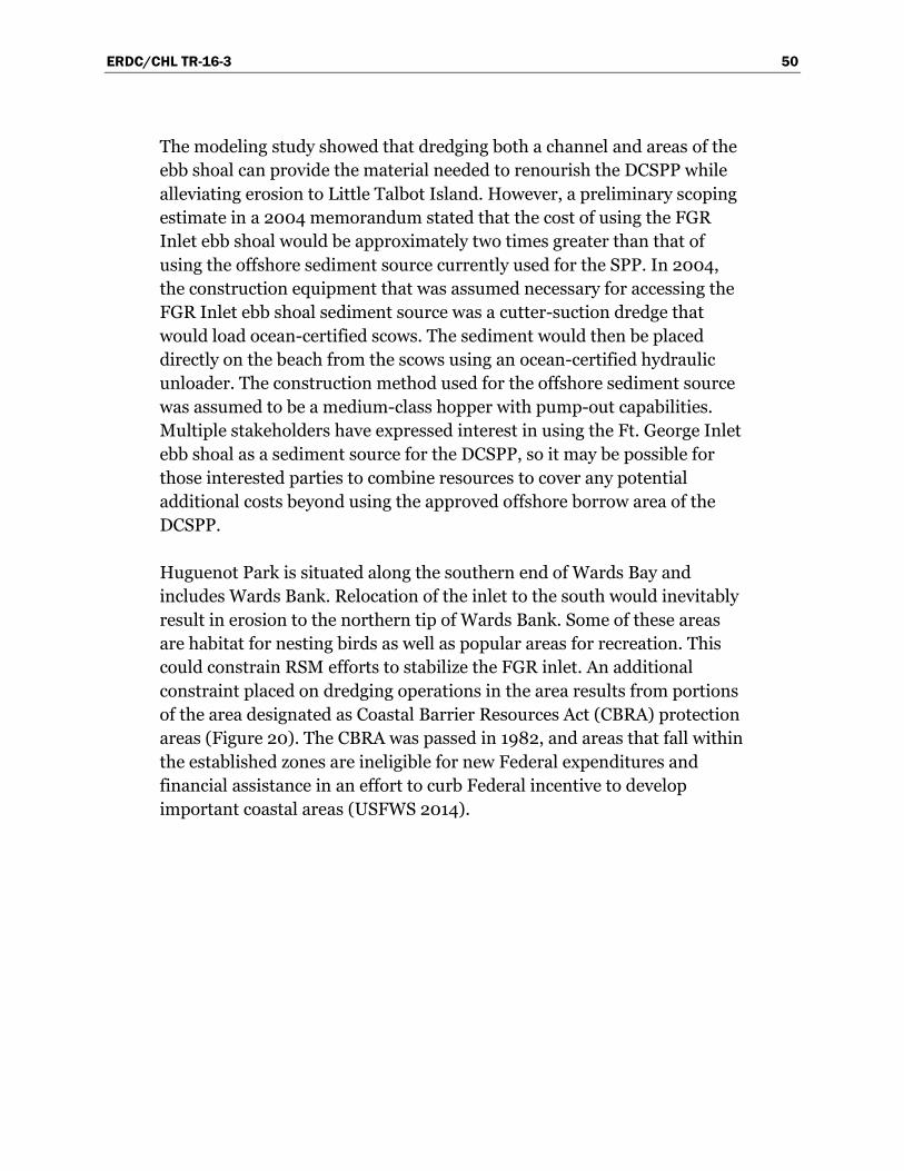
ERDC/CHL TR-16-3 50
The modeling study showed that dredging both a channel and areas of the ebb shoal can provide the material needed to renourish the DCSPP while alleviating erosion to Little Talbot Island. However, a preliminary scoping estimate in a 2004 memorandum stated that the cost of using the FGR Inlet ebb shoal would be approximately two times greater than that of using the offshore sediment source currently used for the SPP. In 2004, the construction equipment that was assumed necessary for accessing the FGR Inlet ebb shoal sediment source was a cutter-suction dredge that would load ocean-certified scows. The sediment would then be placed directly on the beach from the scows using an ocean-certified hydraulic unloader. The construction method used for the offshore sediment source was assumed to be a medium-class hopper with pump-out capabilities. Multiple stakeholders have expressed interest in using the Ft. George Inlet ebb shoal as a sediment source for the DCSPP, so it may be possible for those interested parties to combine resources to cover any potential additional costs beyond using the approved offshore borrow area of the DCSPP.
Huguenot Park is situated along the southern end of Wards Bay and includes Wards Bank. Relocation of the inlet to the south would inevitably result in erosion to the northern tip of Wards Bank. Some of these areas are habitat for nesting birds as well as popular areas for recreation. This could constrain RSM efforts to stabilize the FGR inlet. An additional constraint placed on dredging operations in the area results from portions of the area designated as Coastal Barrier Resources Act (CBRA) protection areas (Figure 20). The CBRA was passed in 1982, and areas that fall within the established zones are ineligible for new Federal expenditures and financial assistance in an effort to curb Federal incentive to develop important coastal areas (USFWS 2014).
ERDC/CHL TR-16-3 51
Figure 20. Coastal Barrier Resource Act Zone at Ft. George River Inlet.
Recommendations
• Present results of hydrodynamic modeling study of dredging alternatives to stakeholders. Upon favorable review of the modeling study, develop detailed cost estimates for the DCSPP to access the FGR Inlet ebb shoal as a borrow area. Perform geotechnical exploration and data collection to ensure compatibility between the DCSPP and the potential borrow area. Establish a survey data collection program for the area to refine the modeling efforts, as well as to set a baseline for

ERDC/CHL TR-16-3 52
monitoring sand mining activities and resulting effects on the river-inlet system.
• Resume coordination efforts with FDEP, the City of Jacksonville, FPS, NPS, and other stakeholders. Query interested parties for sponsorship of an environmental enhancement CAP study (as mentioned in the Stakeholder Discussions section) to reduce sedimentation in the river and restore flow efficiency. Leverage RSM study efforts to reduce CAP study costs and therefore preserve limited project construction funding. Solicit assistance from stakeholders, including universities, to sponsor additional data collection and studies.
Naval Station (NS) Mayport
Alternative strategies
Due to the overlap between the Mayport and Jacksonville Harbor maintenance efforts, management alternatives and strategies largely overlap as well. Refer to Jacksonville Harbor O&M Beach and Nearshore Placement (next subsection of this document) for discussion of management alternatives and strategies pertaining to channel maintenance.
During the 2013 beach placement of channel maintenance sediment, SAJ partnered with the University of North Florida (UNF) to monitor the evolution of the placement sediment. Using 2013 RSM funds, SAJ completed two topographic surveys of the placement that covered an area from behind the dune to the -30 ft MLW contour. UNF collected additional surveys to wading depths, as well as wave and current data using an Acoustic Doppler Current Profiler (ADCP) located in 30 ft water depths off the project area. The RSM SAJ/UNF data are being integrated into the ongoing Nassau/Duval RSM project.
Gosselin et al. (2002) determined that the sediment transport nodal point varies between 1,500 ft and 3,000 ft south of the south jetty. An original goal of the dredging alternative modeling study at FGR Inlet included verification of the nodal point location suggested by Gosselin et al. (2002); however, this effort was not concluded due to time restraints. Future placement of material south of the inlet should consider resuming the effort of determining the location of the nodal point and ensure that material is placed south of the nodal point to prevent northward migration of the sediment up to and through the porous south jetty. If beaches north

ERDC/CHL TR-16-3 53
of the nodal point reach an eroded state, nourishment efforts should focus on limited placement volumes or placement configurations that supply minimal input to the sediment transport regime (such as a dune feature or narrow, raised berm). The current areas covered under NEPA shown in Figure 15 may need modification depending on where the nodal point lies. Sand tightening of the south jetty could be pursued to reduce erosion of the beach north of the nodal point. The U.S. Navy may have a dual interest in the effort since it could reduce erosion to the beach at NS Mayport, as well as reduce sediment transported into the Mayport entrance channel.
Recommendations
• Continue monitoring (i.e., data collection) and analysis of the 2013 beach placement project and determine sediment transport pathways and response to environmental forcing to date. Re-engage UNF to assist with this effort.
• Resume modeling efforts to determine the sediment transport nodal point south of the SJR Inlet and modify beach nourishment placement locations accordingly.
• Expand Mayport maintenance dredging permit to include nearshore placement of sediment.
• Expand hydrographic survey data collection to extend beyond the extents of the channel to include areas adjacent to the jetties (particularly the south jetty as it relates to Mayport).
• Investigate benefits of sand-tightening the south jetty and if favorable, present concept to the Navy for funding assistance. Assist the Navy in securing excess granite stone as a result of the future Jacksonville Harbor Milepoint project.
Jacksonville Harbor O&M beach and nearshore placement
Alternative strategies
The clearest path to accomplish the FDEP and RSM goal of keeping sediments within the littoral zone involves beneficial use of O&M dredged sediments from the lower SJR cuts (Bar Cut 3 through Cut 13) (Figure 14). Federal authority already exists to remove sediments trapped by the Jacksonville Harbor navigation channel for placement south to restore down-drift beaches. As estimated by USACE (2012), nearshore placement of this sediment could cost 29% less than placing directly on the beach and 8% less than placing in the ODMDS. Nearshore placement could also

ERDC/CHL TR-16-3 54
significantly increase the volume of sand delivered to the downdrift littoral system due to less restrictive requirements for fines content.
The Navy and Civil Works Federal navigation projects located in the SJR generate a considerable volume of beach or nearshore quality sediment. The proposed deepening of the Jacksonville Harbor Navigation project will involve a significant volume of virgin cut sediment that is likely not beach compatible but mixed with beach-quality sands. Currently, there are no plans to recover any beach-quality sediment from the scheduled deepening project due to the inefficiency of available methods to separate beach/nearshore-quality sand from other nonbeach-quality sediments. However, maintenance of shoaling areas, turning basins, and other necessary activities associated with the harbor channel will continue if the deepening occurs, thus generating sediments that require disposal. The 2013 DMMP ensures enough upland storage capacity for 20 years; however, strategies to preserve capacity should be pursued and updated regularly. Once upland storage facilities reach capacity, sediment will have to be hauled to the ODMDS at higher cost unless either capital improvements are made to existing facilities or new facilities are developed.
Placing sediment in the nearshore or on the beach presents an effective way to preserve DMMA and ODMDS capacity. The annual O&M dredged volume estimate ranges from 185,000 cy/yr (USACE 2013) to 210,000 cy/yr (USACE 2007) between Cuts 3 and 13 alone. Current estimates for the increase in shoaling based on the increase in channel dimensions alone equal 12,000 cy/yr for Cuts 3 to 13, bringing the total potential beach quality estimate to 197,000 cy/yr. This volume satisfies the average renourishment rate of the DCSPP beaches since 1991 (132,000 cy/yr) as calculated in the project history section of this report. The 2013 DMMP also identifies that sediment from Cuts 14 to 42 could be placed in the nearshore zone.
Historically, O&M sediment was placed along the beaches just south of the inlet. With the exception of the 2013 placement event at Mayport, O&M sediment has not been accepted by the DCSPP local sponsor since 2003. If future O&M placement events ensure flexible placement locations so that the most depleted areas of the DCSPP are prioritized, then DCSPP renourishment intervals could potentially be increased. Coordinating this with the local sponsor will be necessary to gain sponsor support. The local

ERDC/CHL TR-16-3 55
sponsor of the DCSPP (the City of Jacksonville, owner and operator of Hanna Park) is no longer interested in supplementing offshore borrow area sediment with navigation maintenance sediment to restore the DCSPP beaches. This is due to the perception that the quality will be undesirable as experienced in the 2003 event that included oyster shells and clays in the sediment placed on the beach. Additional geotechnical data collection may be warranted to provide increased assurance to the local sponsor that the maintenance sediment is acceptable.
Beach quality sediment is found within the Jacksonville Harbor Federal navigation channel, and establishing a nearshore placement program for the Jacksonville Harbor maintenance sediment would provide additional opportunities to increase the amount of sediment available for placement along the DCSPP shoreline. Aesthetic concerns related to the quality of the sediment should be alleviated since the sediment that migrates from the nearshore to the beach will be naturally sorted and washed. If designed properly, nearshore placement of O&M sediment as a management measure will help maintain the DCSPP’s storm damage reduction benefits and reduce the need for offshore sand. Consideration of the depth of placement is of great importance during design and construction if the desired result is shoreward propagation of the sediment and attendant shore protection benefits.
To accomplish nearshore placement of maintenance sediment off DCSPP beaches, the current permit will need modification to allow placement within the nearshore zone. To best address the renourishment needs of the DCSPP using navigation O&M sediment, the permit should provide flexibility to place sediment in the nearshore (or directly on the beach) along the entire DCSPP so that depleted areas of the project can be prioritized for placement.
Typically, nearshore placement methods involve a split-hull barge or hopper dredge that empties into shallow water with the understanding that if placed in optimum water depths, the coarse desirable sediment will naturally migrate towards the shore while finer particles will be dispersed. Optimum nearshore placement water depths vary with ocean energy levels as well as sediment characteristics and typically present operational challenges due to proximity to the active surf zone.

ERDC/CHL TR-16-3 56
An additional method for placement in shallower water is discharge of dredged sediment as a water-sediment slurry by a pump mounted on the end of the barge or dredge, known as rainbow discharge. Due to elevated turbidity levels and the potential for negative environmental impacts, this method is only applicable in areas absent of benthic resources of concern (e.g., hardbottom or submerged aquatic vegetation). Rainbow discharge could provide more control in the three-dimensional shape of the placement which could offer recreation enhancements for surfing or swimming depending on design characteristics; however, there is added expense versus traditional bottom dumping of sediment due to reductions in productivity. As included in the 2013 DMMP, a nearshore area is also designated for placement by shore-based dredge pipe that extends into the surf zone (Figure 15).
Recommendations
• Coordinate maintenance sediment placement ideas with the local sponsor to gain support.
• Collect additional geotechnical data to provide additional assurances to the local sponsor that USACE can execute a beneficial use mission with high-quality sediment.
• Continue placing beach/nearshore quality sediment removed from the Jacksonville Harbor Federal navigation channel on the beaches south of the inlet or within the nearshore zone.
• Expand the current permit to provide for nearshore placement zones as outlined in environmental compliance (NEPA) documentation and in the 2013 DMMP. Consider expanding placement areas in the permit, as well as in NEPA documentation to allow for placement within areas of the DCSPP that are most eroded.
• Resume modeling efforts to determine the sediment transport nodal point south of the SJR Inlet and modify beach nourishment placement locations accordingly.
• Optimize nearshore placement depth versus equipment type, placement method, and productivity.
• Solicit consideration from FDEP on the inclusion of rainbow discharge as a placement method.
• Expand hydrographic survey data collection to extend beyond the extents of the channel to include areas adjacent to the jetties as well as the beaches north and south of the inlet.

ERDC/CHL TR-16-3 57
Hanna Park and Duval County SPP
Alternative strategies
The local sponsor of the DCSPP is averse to the idea of using Jacksonville Harbor O&M sediment for placement on DCSPP beaches due to concerns regarding sediment quality. One way this concern could be alleviated is through nearshore placement of O&M sediment as discussed in the previous section. Nearshore placement results in natural sorting of the dredged sediments, and only those sediment particles carried by natural transport processes would migrate onto the dry beach.
In addition to shore protection benefits, placement of navigation maintenance sediment could provide enhanced recreational benefits. If the placement area is designed to alter the wave environment with the goal of increasing its potential for optimal surfing, recreational benefits could be captured as well as any associated economic benefits. Consideration in design would require minimal interference with existing hydrodynamics similar to the design of submerged breakwaters that, if not placed properly, can reduce sediment transport in the lee of the structure; beaches down-drift then erode due to reduced sediment supply. If properly designed, however, interruptions to sediment transport are minimal, and given that the feature would consist of O&M sediment, its shape will quickly be altered due to wave and tidal action.
Goshow et al. (2001) investigated strategic maintenance sediment placement as well as a traditional surfing reef design for the nearshore waters off Hanna Park. Detailed wave modeling studies indicated that the surfability of the local wave field would be enhanced; however, the costs and environmental permitting were determined to be difficult obstacles. Defrayment of the costs by leveraging existing Jacksonville Harbor maintenance dredging work was mentioned in the Goshow et al. (2001) report but not considered in cost evaluations.
Placement of navigation maintenance sediment from the SJR entrance channel in 1972 (Figure 21) was not planned to provide recreational surfing enhancements, but anecdotal evidence suggests that it did (Kaufman 2014). The magnitude of the 1972 event is likely not to be repeated in the future, but the concept of beach placement extending offshore could be considered or a similar shape created as a submerged berm feature. Such a placement method is already included in environmental compliance (NEPA) documentation, but the FDEP permit would require modification to include the method.

ERDC/CHL TR-16-3 58
Figure 21. Mayport beach placement of entrance channel sediment, 1972.
Recommendations
• Solicit the local sponsor’s opinion on recreational enhancement design features related to navigation sediment placed in the nearshore.
• Refer to the previous section (Jacksonville Harbor O&M Beach and Nearshore Placement) for additional recommendations.
St. Johns River (SJR) North Jetty shoal and ebb shoal
Alternative strategies
Inside the north jetty of the SJR entrance channel, a large shoal extends from Wards Bank to the east and south toward the Federal navigation channel (Figure 19 and Figure 20). In Gosselin et al. (2002), this feature was studied as a possible source of sediment for bypassing to the beaches south of the inlet. The north jetty inner shoal feature is presumably a result of sediment that is transported through or over the jetty.
ERDC/CHL TR-16-3 59
The north jetty shoal may also be a result of decreased tidal flows due to the expansion in the channel area associated with the entrance to the NS Mayport ship basin, which is directly south of the shoal. The decreased flow allows sediments to settle out of the water column (Gosselin et al. 2002). The hydrodynamic model CMS-Flow was used in the Gosselin et al. (2002) study and showed that current velocities in and around the channel were lower for areas in the vicinity of the Mayport entrance and existing north jetty shoal. The modeling showed that the shoal was acting to deflect currents away from the leeward shoreline of the shoal during both the flood and ebb tidal cycles.
The sediments that comprise the north jetty shoal appear to have the qualities needed for direct beach placement if bypassing were initiated, but consideration needs to be given to the effects of mining the sediment. The roadway in Huguenot Park that provides access to the beach at Wards Bank is periodically damaged during storm events, and removal of the shoal may exacerbate the problem. Thus, armoring or other structural alternatives could be required to stabilize the roadway in Huguenot Park. Since this shoal area lies in a CBRA zone (Figure 20), using the area as a source of sediment for SPP efforts could prove difficult for using USACE funding.
The SJR ebb shoal outlined in Figure 15 could serve as a sediment source for the beaches south of the SJR inlet. Core borings from the SJR ebb shoal indicate that although the sediments are finer than what is typically used in the DCSPP, the sediment clearly meets the percent fines requirements for placement in the nearshore (i.e., less than 20%). Dredging the ebb shoal sediment could reduce the sediment load at the entrance of the Jacksonville Harbor Federal navigation project allowing for increased time between maintenance dredging cycles while also serving SPP needs. However, since offshore borrow areas contain compatible sediment for direct beach placement and shoaling rates associated with the ebb shoal feature are relatively low, local support for beneficial use of ebb shoal sediment is not likely to occur.
Adequate surveys are not available to estimate the growth rate of the entire ebb shoal, thus an expected recharge rate cannot be established at this time. Based on the latest sediment budget, 112,000 cy/yr is transported to the ebb shoal from the area north of the inlet and 57,000 cy/yr from the beaches to the south. Using the volume of sediment

ERDC/CHL TR-16-3 60
estimated to arrive at the SJR Inlet ebb shoal from north and south of the inlet, the ebb shoal could provide as much as 169,000 cy/yr of sediment for placement in the nearshore areas of the DCSPP. Although placing this volume of sediment in the nearshore would theoretically account for a majority of what is needed for the DCSPP efforts, the local sponsor would likely still prefer the coarser sediment obtained from the offshore borrow area for placement on the dry beach.
Even though beneficial use of the SJR ebb shoal is not likely, repeated surveys of the feature would provide information to update the sediment budget. The SJR ebb shoal has very limited survey coverage since the objective of most surveys is to identify shoals within the channel that create navigation hazards. Complete surveys of the ebb shoal would provide understanding of ebb shoal morphology and allow for updates to the sediment budget since the current budget was only able to assume an impoundment rate. Likewise, geotechnical investigations are limited to areas within and immediately adjacent to the navigation channel. Additional sediment characteristics data are needed to properly define the areas where sediment compatibility standards are met for nearshore placement.
Recommendations
• Following completion of the Fiscal Year 2014 RSM modeling effort, use model output to estimate channel infilling rates near the SJR inner shoal and ebb shoal. Reconfigure the model to include potential dredged cuts and analyze results for reduction in shoaling rates.
• Enhance the current survey data collection program to include regular periodic surveys of the north and south lobes of the SJR ebb shoal. Update the sediment budget for northeast Florida once sufficient data exist.
Jacksonville Harbor DMMA offloading
Alternative strategies
Using upland DMMA sand sources to maintain SPPs was one strategy identified by FDEP (2008). This strategy may prove difficult to implement for Jacksonville Harbor DMMAs due to the mixed quality of sediment in the DMMAs as well as the costs associated with mobilizing and placing the sediment.

ERDC/CHL TR-16-3 61
The 2013 update to the Jacksonville Harbor DMMP incorporates offloading Cell A of the Buck Island DMMA (Figure 14) for construction material. Although this management strategy does not keep sediments within the littoral system, the majority of sediments in this cell are not from the beach/nearshore zone. The current management strategy of offloading (emptying) Cell A for construction material represents a no-cost option for the Federal navigation project while expanding the capacity of the site, in keeping with beneficial use principles. Other Jacksonville Harbor DMMAs such as Bartram Island consist of sediment dredged from farther upriver and are typically classified as suitable for offshore disposal but in some cases are restricted to DMMA disposal. The least-cost option for disposal of upriver dredged sediments is placement in upland DMMAs. The Florida Inland Navigation District (FIND) DMMA (DU-6) at Mile Point contains 700,000 cy of capacity remaining for placement. Offloading the sediment in DU-6 for construction purposes or reintroducing the sediment into the littoral system may be considered if the DMMA capacity is not sufficient to address the disposal needs of the adjacent projects.
Recommendations
• Continue offloading Buck Island DMMA for construction material at no cost to the project.
• When capacity issues are presented for DMMA DU-6, initiate geotechnical investigations and project cost breakdowns for offloading into the nearshore fronting the DCSPP.
Jacksonville Harbor marsh improvements with dredged sediment
Alternative strategies
An application of beneficial use of dredged sediments is under investigation for application at Jacksonville Harbor and the surrounding marsh habitats. Current estimates of sea-level rise (including the potential for accelerated sea-level rise) present both a problem and opportunity for the environmental resources of the area. It is recognized that projected sea levels could substantially impact the marsh areas surrounding Jacksonville Harbor (Anderson et al. 2005), so initial coordination is underway for the consideration of using dredged sediment to raise the elevations of the marsh. The method of thin-layer placement of sediments has been used on Gulf of Mexico shorelines as well as in estuarine environments in the Chesapeake Bay and locations in Delaware and New Jersey to create

ERDC/CHL TR-16-3 62
marsh habitat (Welp 2014). The recent effort to restore marsh habitat on Pepper Creek in Dagsboro, DE, proved to be a great success for accomplishing project goals and was a great example of agency coordination by the Delaware Department of Natural Resources and Environmental Control (DDNREC 2014). ERDC is studying and applying this technology to increase implementation around the nation.
Recommendations
• Initiate further discussions with ERDC researchers and environmental agencies with the goal of instituting a thin-layer placement of dredged sediment test case in the vicinity of Jacksonville Harbor. Upon successful implementation, select locations where this technology can be implemented on a regular basis. Also, include the technology in the next Jacksonville Harbor DMMP, establish environmental compliance with NEPA, and obtain proper permitting so that future maintenance dredging events can include this disposal method.
ERDC/CHL TR-16-3 63
Conclusions
The most successful implementation of RSM principles in northeast Florida involves beneficial use of navigation maintenance sediment to serve as shore protection and to mitigate for navigation projects’ disruption to the natural sediment transport patterns and morphology. This practice involves the coordination of navigation and shore protection construction actions and the use of multiple authorities and permits for projects to accomplish the overall RSM objective of maintaining the maximum amount of littoral sediment in the coastal system. The NCSPP regularly benefits from beneficial use of navigation maintenance sediment that has extended the renourishment interval of the project. The successful coordination of the navigation project and shore protection project in Nassau County should serve as an example, providing motivation for other counties to increase beneficial use of dredged sediment.
The beneficial use of dredged sediment from the Mayport Navy project and the Jacksonville Harbor Federal Navigation project has been successful to date but could be expanded through the use of nearshore placement. This will require the coordination and permitting of a nearshore placement site south of the SJR entrance. This strategy has the potential to increase the amount of sediment bypassed to down-drift beaches due to less restrictive sediment requirements. Additionally, nearshore placement is 29% less expensive than traditional beach placement and 8% less expensive than disposal in the ODMDS as analyzed for the Jacksonville Harbor project (USACE 2012). Optimizing nearshore placement depth is an operational issue that warrants further study to balance effectiveness versus cost. Also, prioritizing placement areas along the shoreline of the shore protection project that are in greatest need of sediment could allow for extension of renourishment intervals, thus reducing lifetime project costs.
Additional opportunities outlined in this report that would enhance the RSM program in northeast Florida are currently under investigation or need further investigation. Potential beach-quality and cost-effective sediment sources identified for use in shore protection projects that would also benefit nearby navigation channels were considered for the KBEC (settling basin use and expansion), the FGR Inlet ebb shoal, the SJR inner shoal, and the SJR Inlet ebb shoal. The opportunities identified in this report each have challenges and limitations that must be overcome
ERDC/CHL TR-16-3 64
including stakeholder coordination, Federal authorization, and environmental concerns. Thus, efforts to better understand the physical processes and site conditions are needed to accept or reject opportunities as viable RSM options.
A more robust data collection program is needed to develop a greater understanding of the physical processes that influence sediment transport in the vicinity of northeast Florida Federal projects. Regular surveys of navigation channels and shore protection projects are performed; however, surveys are often project-specific and do not extend beyond what is necessary to monitor project performance. This practice introduces gaps in coverage that make complete understanding of the regional morphology change difficult. Data collection with improved spatial- and temporal-scale is the most important item needed to study and better understand the physical processes of the coastal system, and to better ensure RSM concepts and strategies outlined in this document are viable and carried forward into practice.
Geotechnical investigations are required to ensure sediment compatibility between areas of identified sources and areas of need, including delineation of borrow areas. Periodic hydrographic surveys that extend beyond the navigation channel and cover the ebb shoal lobes, the areas between the jetties, and the beaches north and south of inlets should be conducted on an annual basis or, at a minimum, between maintenance dredging events. These periodic surveys provide the information needed to update the sediment budget and enhance the understanding of the functioning coastal morphology. The two inlets in this region that are not maintained (Nassau Sound and FGR) should also be surveyed regularly to gain understanding of sediment transport processes so that adjacent projects are managed as effectively as possible. Collection of currents, water levels, and wave data are also important for input into hydrodynamic models to allow for simulation of any proposed changes to the system. As a relatively low-cost investment (compared to project costs), geotechnical data, survey data, and hydrodynamic data collection can provide great dividends over project lifecycles since additional efficiencies and enhanced management strategies will be realized.
The multitude of stakeholders that have an interest in the coastal system within the northeast Florida area requires that management strategies and alternatives are actively coordinated. Clear and frequent means of
ERDC/CHL TR-16-3 65
communication between Federal, state, city, academia, and NGOs will provide solutions tailored to address all parties’ concerns and enhance the management of the coastal resources in the region. Not only will project support be garnered and additional efficiencies achieved, but project implementation may also be realized where gaps in Federal authority preclude Federal action. Identifying the needs of all the stakeholders would also outline leveraging opportunities to help fund data collection, studies, and construction activities to accomplish shared goals. USACE can play a unique role to facilitate strategies that, for example, benefit U.S. Navy interests as well as non-Federal interests (by coordinating offloading sediments from DMMAs at Kings Bay to the local shore protection project on Amelia Island). Previous coordination meetings, including the 2013 meeting held regarding management alternatives for the FGR inlet system, have outlined paths forward and identified the roles that Federal, state, and local stakeholders can take to accomplish shared goals. USACE should continue to build collaborative relationships by setting up regular status meetings with interested parties.

ERDC/CHL TR-16-3 66
References Anderson, S. M., C. Katin, and W. R. Wise. 2005. Assessment of coastal water resources
and watershed conditions at Timucuan Ecological and Historic Preserve. Gainesville, FL: University of Florida, Department of Environmental Engineering Sciences.
Bearce, J. 2014. Personal communication. Jacksonville, FL: U.S. Army Engineer District, Jacksonville, Project Management Division.
Delaware Department of Natural Resources and Environmental Control (DDNREC). 2014. Pepper Creek, Dagsboro, Delaware. Dover, DE: Delaware Department of Natural Resources and Environmental Control. http://www.dnrec.delaware.gov/News/Pages/DNRECs-first-beneficial-reuse-marsh-restoration-project-succeeds-with-thin-layer-spray-application.aspx
Dopsovic, R., L. Hardegree, and J. Rosati. 2002 (rev. 2003). Sediment budget analysis system-A: SBAS-A forArcView© application. ERDC/CHL CHETN-XIV-7. Vicksburg, MS: U.S. Army Engineer Research and Development Center.
Florida Department of Environmental Protection (FDEP). 2008. Strategic beach management plan for the northeast Atlantic coast region. Tallahassee, FL: Florida Department of Environmental Protection, Bureau of Beaches and Coastal Systems.
Goshow, C. K., E. Albada, and M. S. Gosselin. 2001. Artificial surfing reef feasibility study, Jacksonville, Florida. Jacksonville, FL: Taylor Engineering, Inc. Prepared for U.S. Army Corps of Engineers, Jacksonville District, Jacksonville, FL, and Florida Department of Environmental Protection, Office of Beaches and Coastal Systems, Tallahassee, FL.
Gosselin, M. S., M. B. Kabiling, and E. A. Cranston. 2002. Bypass/backpass sand at Ft. George and St. Johns River entrances: Northeast Florida regional sediment management: Potential demonstration project; Diagnostic modeling system application. Jacksonville, FL: Tayloring Engineering, Inc. Prepared for U.S. Army Corps of Engineers, Jacksonville District, Jacksonville, FL, and Florida Department of Environmental Protection, Office of Beaches and Coastal Systems, Tallahassee, FL.
Kaufman, M. 2014. Personal communication. Jacksonville, FL: President, Wave Masters Society.
Martin, L. 2002. Regional sediment management: Background and overview of initial implementation. IWR Report 02-PS-2. Ft. Belvoir, VA: U.S. Army Corps of Engineers Institute of Water Resources Policy Studies Program.
Militello, A., and A. K. Zundel. 2003. SMS steering module for coupling waves and currents, 2: M2D and STWAVE. ERDC/CHL CHETN-IV-60. Vicksburg, MS: U.S. Army Engineer Research and Development Center.

ERDC/CHL TR-16-3 67
Olsen Associates, Inc. 2003. Amelia Island, Florida, island-wide beach monitoring 2000-2001 Nassau County, FL. Jacksonville, FL: Olsen Associates, Inc. Prepared for Nassau County Board of County Commissioners, Yulee, FL, and Fernandina Beach City Commission, Fernandina, FL.
Raichle, A. W., K. R. Bodge, and E. J. Olsen. 1997. St. Marys entrance inlet management plan. Technical Report Draft. Jacksonville, FL: Olsen Associates, Inc. Prepared for Nassau County Soil and Water Conservation District, Yulee, FL.
Rosati, J. D., and N. C. Kraus. 2003. Sediment budget analysis system (SBAS): Upgrade for regional applications. ERDC/CHL CHETN-XIV-3. Vicksburg, MS: U.S. Army Engineer Research and Development Center.
Rosati, J. D., T. Beck, R. Thomas, and L. Dunkin. 2013. U.S. Navy FCA shoaling study: NSB Kings Bay, FL. Unpublished technical report. http://navydredging.usace.army.milk/.
Sanchez, A., W. Wu, T. M. Beck, H. Li, J. D. Rosati, Z. Demirbilek, and M. Brown. 2011. Verification and validation of the Coastal Modeling System: Report 4, CMS-Flow; Sediment transport and morphology change. ERDC/CHL TR-11-10. Vicksburg, MS: U.S. Army Engineer Research and Development Center. http://acwc.sdp.sirsi.net/client/search/asset/1005707
Smith, J. M. 2001a. Modeling nearshore wave transformation with STWAVE. ERDC/CHL CHETN-1-64. Vicksburg, MS: U.S. Army Engineer Research and Development Center.
Smith, J. M. 2001b. STWAVE: Steady-state spectral wave model user’s manual for STWAVE, Version 3.0. ERDC/CHL SR-01-01. Vicksburg, MS: U.S. Army Engineer Research and Development Center.
Thomas, R. C., and L. M. Dunkin. 2012. U.S. Navy FCA shoaling study: Demonstration project, Mayport, FL. Unpublished technical report. http://navydredging.usace.army.mil/.
U.S. Army Corps of Engineers (USACE). 1964. Beach erosion control study, Duval County, Florida. Letter Report from U.S. Army Engineer District, Jacksonville, to Chief of Engineers, Department of the Army, Washington, DC.
_____. 1990. Duval County, Florida, from St. Johns River to the Duval – St. Johns County line: Shore protection project; Section 934 study, Reevaluation report with environmental assessment. Jacksonville, FL: U.S. Army Corps of Engineers, Jacksonville District.
_____. 1991. Section 107, Detailed project report and environmental assessment, Fernandina Harbor, Nassau County, Florida. Jacksonville, FL: U.S. Army Corps of Engineers, Jacksonville District.
_____. 1997. Duval County, Florida, Little Talbot Island state road-A1A/SR-105: Section 103, Shore protection feasibility study; Detailed project report with environmental assessment. Jacksonville, FL: U.S. Army Corps of Engineers, Jacksonville District.

ERDC/CHL TR-16-3 68
_____. 1999 (rev. 2004). Nassau County, Florida, shore protection project: General reevaluation report with final environmental assessment; April 1999, revised September 2004. Jacksonville, FL: U.S. Army Corps of Engineers, Jacksonville District.
_____. 2000. Northeast Florida regional sediment management: Review of sediment management at the St. Johns and Ft. George River entrances. Jacksonville, FL: Committee on Tidal Hydraulics. Jacksonville, FL: U.S. Army Corps of Engineers, Jacksonville District.
_____. 2002. Navigation study for Jacksonville Harbor: Final general reevaluation report and environmental assessment, Duval County, Florida. Jacksonville, FL: U.S. Army Corps of Engineers, Jacksonville District.
_____. 2007. Northeast Florida Atlantic coast regional sediment budget, Nassau through Volusia Counties. Jacksonville, FL: U.S. Army Corps of Engineers, Jacksonville District.
_____. 2011. Implementation of regional sediment management through dredged material management planning: Technical note on regional sediment management; Jacksonville Harbor O&M DMMP, Duval County, FL. Jacksonville, FL: U.S. Army Corps of Engineers, Jacksonville District.
_____. 2012. Quantifying the potential economic benefits of regional sediment management (RSM). Technical Note. Jacksonville, FL: U.S. Army Corps of Engineers, Jacksonville District.
_____. 2013. Operations and maintenance: Dredged material management plan; 2012–2031 update, Jacksonville Harbor, Duval County, Florida. Jacksonville, FL: U.S. Army Engineer District, Jacksonville.
_____. 2014. Final integrated general reevaluation report II, and final supplemental environmental impact statement; Jacksonville Harbor, Duval County, Florida. Jacksonville, FL: U.S. Army Corps of Engineers, Jacksonville District.
U.S. Fish and Wildlife Service (USFWS). 2014. Coastal Barrier Resources Act of 1982. Washington, DC. U.S. Fish and Wildlife Service. Webpage visited 1/30/2014. Webpage updated 1/10/2014. http://www.fws.gov/cbra/.
Welp, T. L. 2014. Personal communication. Vicksburg, MS: U.S. Army Engineer Research and Development Center, Coastal and Hydraulics Laboratory.

REPORT DOCUMENTATION PAGE
Form Approved
OMB No. 0704-0188
The public reporting burden for this collection of information is estimated to average 1 hour per response, including the time for reviewing instructions, searching existing data sources, gathering and maintaining the data needed, and completing and reviewing the collection of information. Send comments regarding this burden estimate or any other aspect of this collection of information, including suggestions for reducing the burden, to Department of Defense, Washington Headquarters Services, Directorate for Information Operations and Reports (0704-0188), 1215 Jefferson Davis Highway, Suite 1204, Arlington, VA 22202-4302. Respondents should be aware that notwithstanding any other provision of law, no person shall be subject to any penalty for failing to comply with a collection of information if it does not display a currently valid OMB control number. PLEASE DO NOT RETURN YOUR FORM TO THE ABOVE ADDRESS.
1. REPORT DATE March 2016
2. REPORT TYPE Technical Report
3. DATES COVERED (From - To)
4. TITLE AND SUBTITLE Northeast Florida Regional Sediment Management: Implementation Strategies and Recommendations for Nassau County and Duval County, Florida
5a. CONTRACT NUMBER
5b. GRANT NUMBER
5c. PROGRAM ELEMENT NUMBER
6. AUTHOR(S) Kevin C. Hodgens, Michael Neves, and Linda S. Lillycrop
5d. PROJECT NUMBER
5e. TASK NUMBER
5f. WORK UNIT NUMBER
7. PERFORMING ORGANIZATION NAME(S) AND ADDRESS(ES) U.S. Army Engineer District, Jacksonville 701 San Marco Blvd. Jacksonville, FL 32207 U.S. Army Engineer Research and Development Center, Coastal and Hydraulics Laboratory, 3909 Halls Ferry Road, Vicksburg, MS 39180-6199
8. PERFORMING ORGANIZATION REPORT NUMBER
ERDC/CHL TR-16-3
9. SPONSORING/MONITORING AGENCY NAME(S) AND ADDRESS(ES) Regional Sediment Management Program U.S. Army Corps of Engineers 441 G. Street, NW Washington, DC 20314-1000
10. SPONSOR/MONITOR'S ACRONYM(S)
11. SPONSOR/MONITOR'S REPORT NUMBER(S)
12. DISTRIBUTION/AVAILABILITY STATEMENT Approved for public release; distribution is unlimited. 13. SUPPLEMENTARY NOTES
14. ABSTRACT
This technical report provides a description of Regional Sediment Management (RSM) investigations performed by the U.S. Army Corps of Engineers, Jacksonville District, along Florida’s northeast coast in Nassau and Duval Counties. Provided first is an overview of the study area, including previous RSM activities, pertinent studies, and stakeholder discussions. Next is a discussion of the various Federal projects in the study area, including authorization, funding, and permitting. Finally, management alternative strategies are provided for each project, as well as recommendations for future actions to improve management of the sediments.
The most successful implementation of RSM principles in northeast Florida involves beneficial use of navigation maintenance sediment to serve as shore protection and mitigation for navigation projects’ disruption to the natural sediment transport patterns and morphology. The beneficial use of dredged sediment from the Mayport Navy project and the Jacksonville Harbor Federal Navigation project has been successful to date but could be expanded through the use of nearshore placement. Additional opportunities outlined in this report that would enhance the RSM program in northeast Florida are currently under investigation or need further investigation. A more robust data collection program is needed to develop a greater understanding of the physical processes that influence sediment transport in the vicinity of northeast Florida Federal projects. Geotechnical investigations are required to ensure sediment compatibility between areas of identified sources and areas of need, including delineation of borrow areas. The multitude of stakeholders that have an interest in the coastal system within the northeast Florida area requires that management strategies and alternatives are actively coordinated.
15. SUBJECT TERMS Beach nourishment Beneficial uses
Dredged material management Longshore currents Regional sediment management
Sand backpassing Sand bypassing Shore protection project Waves
16. SECURITY CLASSIFICATION OF: 17. LIMITATION OF ABSTRACT
SAR
18. NUMBER OF PAGES
80
19a. NAME OF RESPONSIBLE PERSON Linda S. Lillycrop a. REPORT
Unclassified
b. ABSTRACT Unclassified
c. THIS PAGE Unclassified
19b. TELEPHONE NUMBER (Include area code) 202-761-1837