regional municipality of peel · 2019. 1. 28. · region of peel project 14 -1375, engineering...
TRANSCRIPT

Project No. 14-1375
[ Month Year ]
REGIONAL MUNICIPALITY OF PEEL
PROJECT FILE REPORT
Engineering Services for Watermains Assignment A – McVean Drive
JANUARY 2019

January 22, 2019 Reference No. MI15-0439-001 Melvin Gonzalez, P.Eng. Region of Peel 10 Peel Centre Drive, Suite B, 4th Floor Brampton, ON L6T 4B9 Attention: Melvin Gonzalez Project Manager
Project 14-1375, Engineering Services for Watermains, Assignment A - McVean Drive Project File Report
Cole Engineering Group Ltd. (COLE) is pleased to submit our Project File Report for the McVean Drive Watermain Class Environmental Assessment (EA) Study. Completed as a Schedule “B” Class EA, this report documents Phases 1 and 2 of the Municipal Engineers Association’s (MEA) Municipal Class EA process, including a description of the problem/opportunity, identification of alternative solutions, inventory of the natural, socio‐economic and cultural environment, consultation with the public and stakeholders, and evaluation of alternative solutions resulting in a preferred solution with identified impacts and mitigation measures.
Best Regards, COLE ENGINEERING GROUP LTD. Fady Shweihat, P.Eng. Project Manager

Region of Peel Project 14-1375, Engineering Services for Watermains, Assignment A - McVean Drive – Project File Report
MI15-0439-001 January 2019 i
PREPARED BY:
COLE ENGINEERING GROUP LTD.
Patricia Becker, MES Environmental Specialist
CHECKED BY:
COLE ENGINEERING GROUP LTD.
Fady Shweihat, P.Eng. Project Manager
AUTHORIZED FOR ISSUE BY:
COLE ENGINEERING GROUP LTD.
Gord Gajich, P.Eng. Senior Director
Issues and Revisions Registry
Identification Date Description of issued and/or revision
Draft Report December 4, 2018 For internal review
Draft Report December 10, 2018 For client review
Final Report January 22, 2019 For Project File

Region of Peel Project 14-1375, Engineering Services for Watermains, Assignment A - McVean Drive – Project File Report
MI15-0439-001 January 2019 ii
Statement of Conditions
This Report / Study (the “Work”) has been prepared at the request of, and for the exclusive use of, the Owner / Client, Region of Peel and its affiliates (the “Intended User”). No one other than the Intended User has the right to use and rely on the Work without first obtaining the written authorization of Cole Engineering Group Ltd. and its Owner. Cole Engineering Group Ltd. expressly excludes liability to any party except the Intended User for any use of, and/or reliance upon, the work.
Neither possession of the Work, nor a copy of it, carries the right of publication. All copyright in the Work is reserved to Cole Engineering Group Ltd. The Work shall not be disclosed, produced or reproduced, quoted from, or referred to, in whole or in part, or published in any manner, without the express written consent of Cole Engineering Group Ltd., or the Owner.

Region of Peel Project 14-1375, Engineering Services for Watermains, Assignment A - McVean Drive – Project File Report
MI15-0439-001 January 2019 i
Table of Contents
Transmittal Letter Table of Contents
1 Introduction ............................................................................................................................. 1
1.1 Study Background .................................................................................................................... 1
1.2 Description of the Study Area .................................................................................................. 1
1.3 Planning and Policy Context ..................................................................................................... 2 1.3.1 Region of Peel Water and Wastewater Master Plan for the Lake Based Systems ................... 2 1.3.2 Provincial Plans (2017) ............................................................................................................. 2 1.3.3 Provincial Policy Statement (2014) ........................................................................................... 3
2 Needs Assessment and Justification .......................................................................................... 4
2.1 Problem/Opportunity Statement ............................................................................................ 4
3 Overview of the Municipal Class EA Planning Process ................................................................ 5
3.1 Municipal Class EA Schedules .................................................................................................. 6 3.1.1 Schedule B Classification .......................................................................................................... 7
3.2 Part II Order .............................................................................................................................. 7
4 Existing Conditions ................................................................................................................... 9
4.1 Natural Environment ................................................................................................................ 9 4.1.1 Aquatic Environment ................................................................................................................ 9 4.1.2 Terrestrial Environment ......................................................................................................... 10 4.1.3 Source Water Protection ........................................................................................................ 12
4.2 Geology and Hydrogeology .................................................................................................... 12 4.2.1 Regional Geology and Hydrogeology ..................................................................................... 12 4.2.2 Topography ............................................................................................................................ 13
4.3 Social-Cultural and Economic Environment ........................................................................... 13 4.3.1 Land Use ................................................................................................................................. 13 4.3.2 Built Heritage/Cultural Heritage Landscapes and Archaeological Assessment ...................... 13 4.3.3 Air Quality and Noise .............................................................................................................. 14
4.4 Technical Environment........................................................................................................... 14 4.4.1 Utilities ................................................................................................................................... 14
5 Identification of Alternative Solutions ..................................................................................... 15
5.1 Description of Alternative Solutions ...................................................................................... 15
6 Evaluation of Alternative Solutions ......................................................................................... 17
6.1 Evaluation Criteria .................................................................................................................. 17
6.2 Evaluation Methodology ........................................................................................................ 18
7 Preferred Alternative Solution ................................................................................................ 21
7.1 Watercourse Crossings........................................................................................................... 22
7.2 Construction Method ............................................................................................................. 22 7.2.1 Trenchless Technology ........................................................................................................... 22 7.2.2 Open Cut Excavation .............................................................................................................. 23
Region of Peel Project 14-1375, Engineering Services for Watermains, Assignment A - McVean Drive – Project File Report
MI15-0439-001 January 2019 ii
7.3 Permits and Approval Requirements ..................................................................................... 23
7.4 Climate Change (Mitigation and Adaptation) ........................................................................ 24 7.4.1 Project Impacts on Climate Change (Mitigation) ................................................................... 24 7.4.2 Impacts of Climate Change on the Project (Adaptation) ........................................................ 24
8 Identification of Impacts and Mitigation Measures .................................................................. 25
8.1 Property Requirements .......................................................................................................... 25
8.2 Utilities ................................................................................................................................... 25
8.3 Social-Cultural Environment Impacts ..................................................................................... 25 8.3.1 Traffic ...................................................................................................................................... 25 8.3.2 Public Notification .................................................................................................................. 26 8.3.3 Temporary Access to Private Property ................................................................................... 26 8.3.4 Generation of Excess Materials .............................................................................................. 26 8.3.5 Contaminated Soils ................................................................................................................. 26 8.3.6 Noise, Dust and Vibration Control .......................................................................................... 26 8.3.7 Encountering of Unknown Archaeology Remains .................................................................. 27
8.4 Natural Environment Impacts ................................................................................................ 27 8.4.1 Vegetation and Breeding Birds ............................................................................................... 27
9 Public and Agency Consultation .............................................................................................. 29
9.1 Notice of Study Consultation ................................................................................................. 29
9.2 Newsletter (October 2018) .................................................................................................... 29
9.3 Public and Agency Comments ................................................................................................ 29
9.4 Notice of Study Completion ................................................................................................... 31
9.5 Indigenous Communities Consultation .................................................................................. 31 9.5.1 Indigenous Communities Comments and Responses............................................................. 32
10 References ............................................................................................................................. 33
LIST OF TABLES
Table 4.1 Vegetation Communities .................................................................................................. 11 Table 6.1 Evaluation Criteria ............................................................................................................ 17 Table 6.2 Comparative Evaluation of Watermain Alternatives ........................................................ 20 Table 7.1 Connection Details ............................................................................................................ 21 Table 7.2 Permits and Approvals ...................................................................................................... 23
LIST OF FIGURES
Figure 1-1 Study Area ........................................................................................................................... 2 Figure 3-1 Municipal Class EA Planning and Design Process ............................................................... 6 Figure 5-1 Alternative Watermain Layout ......................................................................................... 16

Region of Peel Project 14-1375, Engineering Services for Watermains, Assignment A - McVean Drive – Project File Report
MI15-0439-001 January 2019 iii
APPENDICES
Appendix A Natural Environment Maps (from City of Brampton’s ESR) Appendix B Preferred Watermain Layout Appendix C Project Notifications and Contact List Appendix D Public and Agency Correspondence

Region of Peel Project 14-1375, Engineering Services for Watermains, Assignment A - McVean Drive – Project File Report
MI15-0439-001 January 2019 1
1 Introduction
The Region of Peel completed the 2013 Water and Wastewater Master Plan for the Lake Based Systems (Master Plan) which identifies the distribution watermain along McVean Drive (between Mayfield Road and Countryside Drive) as part of the preferred water servicing strategy to meet the servicing needs of existing and future development. As per the requirements outlined in the Master Plan for water supply and storage for the South Peel system through to the year 2031, the Region of Peel (the Region) will construct a 400 mm watermain for the northern portion of McVean Drive. To provide this service the Region intends to expand the existing 300 mm ductile iron watermain to 400 mm (from Countryside Drive to Castlemore Road) for system reliability and to service future development in the City of Brampton.
1.1 Study Background
The Region of Peel has initiated a Municipal Class Environmental Assessment (Class EA) study to evaluate alternatives to address the existing and future capacity constraints and security of supply of the watermain on McVean Drive from Castlemore Road to Countryside Drive in Brampton. The watermain would meet the preferred water servicing strategy identified in the 2013 Water and Wastewater Master Plan for the Lake Based Systems.
McVean Drive is a north-south minor arterial road with a two-lane rural cross section with both soft and paved shoulders. After the Region had completed their 2013 Master Plan, the City of Brampton initiated a Schedule C, Class EA for road improvements to McVean Drive. The preferred solution is the widening of McVean Drive to four travel lanes, including intersection improvements to support the additional capacity. The City of Brampton (the City) has now completed the McVean Drive Class EA road widening and improvements and is proceeding to detailed design and project construction. As it is opportune to implement the water system improvements proposed along McVean Drive ahead of the planned road improvements, the Region had recognized the social impacts and benefits of proceeding with a coordinated and combined construction program.
The Master Plan addresses long term infrastructure requirements to forecast the impacts on existing, planned and future projects, and to ensure water service continuation beyond 2031.
1.2 Description of the Study Area
For the purposes of studies and alignment of the watermain a study area was identified. The Study Area is located in the northeast area of the City of Brampton, immediately south of the Town of Caledon and west of the West Humber River. It consists of the McVean Drive corridor and adjacent properties from Countryside Drive (northwest end) to Castlemore Road (southeast end) as shown in Figure 1-1.
The watershed in which the study area resides is under the jurisdiction of the Toronto and Region Conservation Authority (TRCA) and includes several watercourse crossings, wetland locations, and areas with the presence of endangered species.

Region of Peel Project 14-1375, Engineering Services for Watermains, Assignment A - McVean Drive – Project File Report
MI15-0439-001 January 2019 2
Figure 1-1 Study Area
1.3 Planning and Policy Context
1.3.1 Region of Peel Water and Wastewater Master Plan for the Lake Based Systems
The Region of Peel completed the 2013 Water and Wastewater Master Plan for the Lake Based Systems (Master Plan) which identified a distribution watermain north of the current project along McVean Drive (between Mayfield Road and Countryside Drive). This northern section was part of the preferred water servicing strategy to meet the servicing needs of existing and future development. As per the requirements outlined in the Master Plan for water supply and storage for the South Peel system through to the year 2031, the Region of Peel (the Region) will construct a 400 mm watermain for the northern section of McVean Drive.
While the watermain project from Countryside Drive to Castlemore Road was not specifically in the Master Plan, the consideration of upsizing the existing watermain would address system reliability and ease of connections. The City of Brampton will be proceeding to construction of McVean Drive road improvements, specifically widening of the road from Mayfield Road to Castlemore Road. This provided an opportunity for the Region to consider upsizing and updating the existing watermain on McVean Drive (extending southerly from Countryside Drive to Castlemore Road) from 300 mm to a 400 mm.
1.3.2 Provincial Plans (2017)
Consideration was given as to whether parts of the study area were subject to the Oak Ridges Moraine Conservation Plan, Niagara Escarpment Plan, Greenbelt Plan and Growth Plan for the Greater Golden Horseshoe. If these plans are applicable to the study area then the relevant policies within these plans would need to be referenced. The 2017 provincial plans are now in effect and were reviewed.
The study area is within the settlement area outside of the Niagara Escarpment Plan, Greenbelt Plan, Greenbelt Plan for Greater Golden Horseshoe and Oak Ridges Moraine Conservation Plan. There are urban river valleys present.

Region of Peel Project 14-1375, Engineering Services for Watermains, Assignment A - McVean Drive – Project File Report
MI15-0439-001 January 2019 3
1.3.3 Provincial Policy Statement (2014)
Natural Heritage Policy 2.1 of the Provincial Policy Statement (PPS) (MMAH 2014) provides direction to regional and local municipalities regarding planning policies for the protection and management of natural heritage features and resources for applications pursuant to the Planning Act. The PPS 2014 defines eight natural heritage features and provides planning policies for each. The Natural Heritage Reference Manual (OMNR 2010) is a technical document used to help assess the natural heritage features listed below:
significant wetlands; significant coastal wetlands; significant habitat of endangered and threatened species; fish habitat; significant woodlands; significant valley lands; significant Areas of Natural and Scientific Interest (ANSIs); and, significant wildlife habitat.
Each of these features is afforded varying levels of protection subject to guidelines, and in some cases, regulations. Of these features, significant wetlands can be designated and/or identified either by the Ministry of Natural Resources and Forestry (MNRF) and/or the municipality. Habitat of threatened and endangered species is determined in accordance with provincial and federal requirements. Fish habitat is governed by Fisheries and Oceans Canada (DFO). The identification and regulation of the remaining features is the responsibility of the municipality or other planning authority.
PPS natural heritage features relevant to the subject property include fish habitat and significant habitat of an endangered species, Redside Dace.
The proposed McVean Drive road improvements were subject to study and assessment specific to the presence of Redside Dace. Conformity with the Endangered Species Act is required through application of Section 23.1 Ontario Regulation 293/11 for development that will encroach on the regulated habitat of this species, which is defined by a 30 m distance from the meander belt of the subject watercourse for recovery and occupied habitat.
The Provincial Policy Statement also provides direction to regional and local municipalities on infrastructure and public service facilities, specifically sewage, water and stormwater. Section 1.6.6.1 provides planning policies for water servicing that accommodates expected growth in a manner that promotes the optimization and efficient use of existing municipal water services and that integrates servicing and land use considerations at all stages of the planning process. The servicing policies have been met largely with the intent of the project to minimize impacts on resources by staying within the existing and future road ROW and coordinating the watermain construction with road improvements construction. In addition, future development, accommodated through the watermain for the north section of McVean Drive, upsizes the existing watermain and connections.

Region of Peel Project 14-1375, Engineering Services for Watermains, Assignment A - McVean Drive – Project File Report
MI15-0439-001 January 2019 4
2 Needs Assessment and Justification
The 2013 Water and Wastewater Master Plan for the Lake Based Systems identified the distribution watermain on McVean Drive from Countryside Drive to Castlemore Road as part of the preferred water servicing strategy. The Master Plan addressed longer range forecasting of infrastructure requirements, post-2031, to forecast impacts on existing, planned and future projects and to ensure continuation of water servicing visions beyond 2031.
2.1 Problem/Opportunity Statement
The problem or opportunity statement defines the starting point in the undertaking of the Class EA process and assists in defining the scope of the project.
The McVean Drive watermain was identified as a Schedule A+ project in the Master Plan. Since completion of the Master Plan, the City of Brampton completed a Schedule C, Class EA in May 2016 for road improvements to McVean Drive. The preferred alternative was to widen McVean Drive to a four (4) lane urban cross section road which includes proposed structures to span several of the watercourse crossings. The preferred design requires the alignment of the proposed watermain to be outside portions of the existing road right-of-way at the watercourse crossings requiring the need for property acquisition. This has resulted in the watermain being a Schedule B, Class EA project.
The problem statement for the watermain on McVean Drive is:
How to provide for a watermain on McVean Drive to meet the preferred water servicing strategy identified in the Water and Wastewater Master Plan for the Lake Based Systems.

Region of Peel Project 14-1375, Engineering Services for Watermains, Assignment A - McVean Drive – Project File Report
MI15-0439-001 January 2019 5
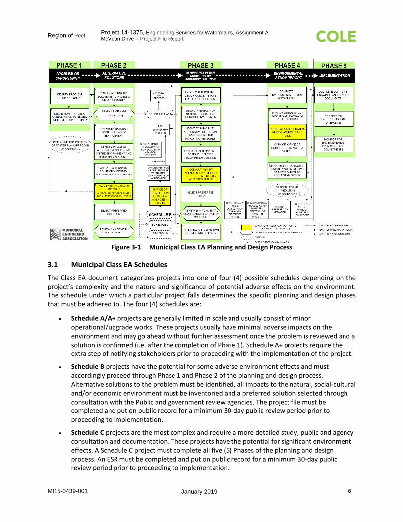
3 Overview of the Municipal Class EA Planning Process
This Class EA planning process, which follows the Municipal Engineers Association’s (MEA) Municipal Class Environmental Assessment document (2000, as amended 2007, 2011 and 2015), takes into consideration the protection of all aspects of the natural, social and economic environment as well as long-term planning for the mitigation of any adverse effects during both construction and commissioning. The Class EA process also includes consultation with the Public, Indigenous Communities, Government Agencies, local interest groups and review bodies to obtain input and feedback and to ultimately attain general acceptance for the preferred alternative.
There are five (5) phases depicted in the Municipal Class EA Planning and Design Process, which include:
Phase 1: Identify the problem(s) or opportunity: Identify the problem or opportunity that the Class EA is intended to address.
Phase 2: Identification of alternative solutions and selection of a preferred solution: This is based on a thorough evaluation of the options against a set of criteria. Phase 2 includes a detailed inventory of the natural, social and economic environment as well as the identification of any adverse impacts/effects and associated mitigating measures. Public consultation is held to review the problem/opportunity as well as all alternative solutions in an attempt to gain feedback leading to the selection of the preferred solution.
Phase 3: Identification and assessment of alternative design concepts for the preferred solution: The preferred solution selected in Phase 2 is expanded on in Phase 3 to include detailed design concepts. A second public consultation event is held to review the alternative design concepts in an attempt to gain further feedback leading to the selection of the preferred design.
Phase 4: Preparation of an Environmental Study Report (ESR): An ESR is developed documenting all phases and components of the Class EA process. The ESR is placed on public record and a notice of completion is filed.
Phase 5: Implementation: Implementation of the project works, including complete contract drawings and tender documents followed by construction and commissioning.
The complete Municipal Class EA Planning and Design Process is shown in Figure 3-1.
Region of Peel Project 14-1375, Engineering Services for Watermains, Assignment A - McVean Drive – Project File Report
MI15-0439-001 January 2019 6
Figure 3-1 Municipal Class EA Planning and Design Process
3.1 Municipal Class EA Schedules
The Class EA document categorizes projects into one of four (4) possible schedules depending on the project’s complexity and the nature and significance of potential adverse effects on the environment. The schedule under which a particular project falls determines the specific planning and design phases that must be adhered to. The four (4) schedules are:
Schedule A/A+ projects are generally limited in scale and usually consist of minor operational/upgrade works. These projects usually have minimal adverse impacts on the environment and may go ahead without further assessment once the problem is reviewed and a solution is confirmed (i.e. after the completion of Phase 1). Schedule A+ projects require the extra step of notifying stakeholders prior to proceeding with the implementation of the project.
Schedule B projects have the potential for some adverse environment effects and must accordingly proceed through Phase 1 and Phase 2 of the planning and design process. Alternative solutions to the problem must be identified, all impacts to the natural, social-cultural and/or economic environment must be inventoried and a preferred solution selected through consultation with the Public and government review agencies. The project file must be completed and put on public record for a minimum 30-day public review period prior to proceeding to implementation.
Schedule C projects are the most complex and require a more detailed study, public and agency consultation and documentation. These projects have the potential for significant environment effects. A Schedule C project must complete all five (5) Phases of the planning and design process. An ESR must be completed and put on public record for a minimum 30-day public review period prior to proceeding to implementation.

Region of Peel Project 14-1375, Engineering Services for Watermains, Assignment A - McVean Drive – Project File Report
MI15-0439-001 January 2019 7
3.1.1 Schedule B Classification
The scope of work for providing a watermain on McVean Drive to meet the preferred water servicing strategy identified in the Water and Wastewater Master Plan for the Lake Based Systems initially identified the watermain as a Schedule A+ project. Since completion of the Master Plan, the City of Brampton completed a Schedule C, Class EA in May 2016 for road improvements to McVean Drive. The preferred alternative was to widen McVean Drive to a four (4) lane urban cross section road which includes proposed structures to span several of the watercourse crossings. The preferred design requires the alignment of the proposed watermain to be outside portions of the existing and future road right-of-way at the watercourse crossings requiring the need for property acquisition. This has resulted in the construction of the watermain being a Schedule B, Class EA project as per the MEA’s Municipal Class Environmental Assessment document. Per Appendix 1 – Project Schedules of the document, this is characterized as:
Establish, extend or enlarge a water distribution system and all works necessary to connect the system to an existing system or water source, where such facilities are not in either an existing road allowance or an existing utility corridor.
As such, this study is being conducted in accordance with the approved requirements for a Schedule B Municipal Class EA, which requires the completion of Phase 1 and Phase 2 of the planning and design process.
Consultation between the proponent and affected or interested stakeholders early in and throughout the process is a key feature of EA planning, which provides opportunities for the exchange of information by which decision-making may be influenced. In addition, one of the primary goals in effectively consulting stakeholders is to resolve issues proactively to avoid controversy, which could ultimately lead to a Part II Order request (discussed below).
In a Schedule B Class EA there exists two mandatory points of contact with the public and review agencies. The first point of contact follows the proponent’s identification of the recommended alternative solution. It is at this point, through invitation for public comment and input that an opportunity for stakeholders to assist in the selection of a preferred solution exists. The second point of contact consists of the Notice of Completion of the planning process, which completes the screening requirements for Schedule B projects. Once completed, the final Project File Report will be available for the mandatory 30-day public review period by interested members of the public and agency groups.
3.2 Part II Order
In the event that an affected agency or other interested party has a concern that cannot be resolved through discussions upon completion of the Project File Report, individuals may request the Minister of the Environment, Conservation and Parks or delegate to issue a Part II Order under the Environmental Assessment Act. A Part II Order is a mechanism by which the Minister or delegate is requested to render a decision regarding the elevation of the EA (prior to proceeding with the proposed undertaking) to an individual EA. All Part II Order requesters must complete a Part II Order request form, issued by MECP, and it must be submitted to the Minister or delegate within the 30 calendar day review period and copied by the requester to the Director of Environmental Assessment and Permissions Branch and the proponent at the same time that they are submitted. Once a Part II Order is received, the proponent is advised of the receipt of the request by the Minister or Environmental Assessment and Permissions (EAP) Branch, whereby the proponent may make a submission to the EAP Branch addressing the issues

Region of Peel Project 14-1375, Engineering Services for Watermains, Assignment A - McVean Drive – Project File Report
MI15-0439-001 January 2019 8
raised in the request. Following the request, the EAP Branch must carry out a review, consider both sides of the argument, and make a recommendation to the Minister or delegate. The Minister reviews the request and study information and makes one of the following decisions:
Deny the request;
Refer the matter to mediation; or,
Grant the request and require the proponent to comply with Part II of the EA Act (complete an Individual EA)
Members of the public having concerns about the potential environmental effects of a project or the planning process being followed, have a responsibility to bring their concerns to the attention of the proponent early in the planning process, when the proponent has greater flexibility to accommodate changes in the project development and the process.

Region of Peel Project 14-1375, Engineering Services for Watermains, Assignment A - McVean Drive – Project File Report
MI15-0439-001 January 2019 9
4 Existing Conditions
The City of Brampton has now completed the McVean Drive Class EA road widening and improvements and is proceeding to detailed design and project construction. Given this Class EA, and the fact that the watermain on McVean Drive will be located largely in the road right-of-way, additional studies on the existing conditions, specifically the natural environment, were not undertaken by the Region. The existing conditions studies completed by the City and summarized below were used to understand potential impacts of the watermain project on the environment.
Portions of the subsections below include direct excerpts from the existing conditions of the City of Brampton McVean Drive Improvements Class Environmental Assessment Study, Environmental Study Report (May 2016 by Hatch).
The project area referenced in the existing conditions is a larger area than the study area. The study area is limited to where the watermain will be constructed within and the project area refers to the area where studies (e.g., natural heritage, archaeology, geotechnical) were undertaken to better understand the existing conditions present.
4.1 Natural Environment
There are two (2) watercourses (West Humber River and Salt Creek) with four (4) large crossings and two (2) small watercourses (ephemeral tributary of Salt Creek and permanent tributary of Salt Creek) running east‐west across McVean Drive within the Study Area and which are part of the West Humber River sub-watershed. Three of the large crossings are spanned by bridge structures, one large crossing spanned by a concrete steel pipe arch and the two small watercourses are conveyed by culvert across McVean Drive. Figures 2A and 2B (October 2014) completed by Beacon Environmental for the City of Brampton’s ESR have been included in Appendix A to show the existing conditions (specifically the natural heritage environment) present in the project area for the watermain project.
4.1.1 Aquatic Environment
The study area falls within the West Humber River Sub-watershed under the Toronto Region Conservation Authority’s (TRCA) jurisdiction. It has an area of 204 km2, with its headwaters in the South Slope, and the majority of the Sub-watershed situated within the Peel Plain. The soils are primarily comprised of clay with clay loam and loam, with high relative runoff and low infiltration. The baseflow in the West Humber tributaries tend to be low, with the larger tributaries often being dry in the summer months. The majority of the lower half of the Sub-watershed in Brampton has been or soon will be developed. (Humber River State of the Watershed Report – Surface Water Quantity, TRCA, 2008).
There are a total of six (6) watercourse crossings within the study area. Of the 6 watercourse crossings, three (3) crossings of Salt Creek, one (1) crossing of a Tributary of Salt Creek, one (1) crossing of a headwater drainage feature (ephemeral) that contributes flow to Salt Creek, and one (1) crossing of the West Humber River.
Tributary to Salt Creek
The southernmost watercourse within the Study Area, originates from the rear lot drainage of the estate residential subdivision northwest of the intersection of Castlemore and McVean Drive. The riparian vegetation found along the watercourse consists primarily of manicured lawns. The upstream watercourse meanders through the subdivision with a relatively linear swale conveyance and is directed

Region of Peel Project 14-1375, Engineering Services for Watermains, Assignment A - McVean Drive – Project File Report
MI15-0439-001 January 2019 10
through a roadside ditch to a cattail marsh just upstream of the CSP culvert beneath McVean Drive. The flow regime of this watercourse was identified as intermittent. Fish presence in the upstream reach is limited due to the presence of a perched culvert, although Creek Chub were identified.
A large scour pool has developed downstream of McVean Drive with a clay hardpan substrate. The watercourse continues as a long run until its convergence with Salt Creek. The flow regime was identified as permanent, due to the gradual grade/slope from its merge with Salt Creek. Warm and cool-water fish were identified in the scour pool.
Salt Creek
There are three (3) Salt Creek culvert watercourse crossings located at 540 m, 957 m, and 1093 m northwest of the intersection of McVean Drive and Castlemore Road. A series of riffle-run-pools with varying widths and depths at each crossing were noted. The riparian vegetation consists of varying areas of grasses and woody vegetation. An additional private crossing was identified between the second and third crossing with perched culverts creating a barrier to fish migration, and could potentially fail during a major storm event.
Tributary to Salt Creek (Da Vinci Ave/Ryckman Lane)
This headwater drainage feature is mainly conveyed through a vegetated swale along areas of roadside ditch and manicured lawns with two culvert crossings.
West Humber River
This watercourse crossing consists of a series of riffle-pool-runs, and a widening at McVean Drive. The substrate is made up of sand-gravel mix, with some cobble and occasional boulders. There is evidence of groundwater seepage along the footings of the crossing and a potential failure of the gabion baskets surrounding the crossing.
4.1.2 Terrestrial Environment
Four vegetation communities were identified on and adjacent to the Study Area. The designations for these communities are included in Table 4.1 below.

Region of Peel Project 14-1375, Engineering Services for Watermains, Assignment A - McVean Drive – Project File Report
MI15-0439-001 January 2019 11
Table 4.1 Vegetation Communities
Source: Table 4-2, Hatch Mott MacDonald, McVean Drive Improvements, ESR
Flora
Within the study area, a total of 107 plant species were identified, with 54 species (51%) being non-native to Ontario, reflecting the disturbed nature of most of the study area.

Region of Peel Project 14-1375, Engineering Services for Watermains, Assignment A - McVean Drive – Project File Report
MI15-0439-001 January 2019 12
No Endangered plant species, and no species globally or provincially rare as per the Natural Heritage Information Centre (NHIC) Database were identified within the study area. Three rare species (Red Pine, White Spruce, and Red Cedar) to Peel Region were found in the residential area planted as ornamentals, and two uncommon species (Common Primrose and Rough Bedstraw) to Peel Region were found in roadside ditches meaning that they can withstand a high level of disturbance.
4.1.3 Source Water Protection
The 2006 Clean Water Act (CWA) protects existing and future sources of municipal drinking water. As part of the CWA, vulnerable areas are delineated around surface water intakes and wellheads for every existing and planned municipal residential drinking water system that is located in a Source Protection Area. These vulnerable areas are known as a Wellhead Protection Areas (WHPAs) or surface water Intake Protection Zones (IPZs).
Projects may include activities that, if located in a vulnerable area, could be a threat to drinking water sources. However, as defined under the Clean Water Act, 2006 a “drinking water threat” means an activity or condition that adversely affects or has the potential to adversely affect the quality or quantity of any water that is or may be used as a source of drinking water, and includes an activity or condition that is prescribed by the regulations as a drinking water threat.
As per Regulation 287/07: General the construction of a watermain is not considered to be a drinking water threat.
The McVean Drive watermain is a project that involves watermain construction. Therefore, based on the CWA there are no project activities that would be classified as a prescribed activity.
The proponents also took into consideration whether the project was located within vulnerable areas since this could be incorporated into mitigation measures and/or construction methodologies.
The proposed McVean Drive watermain falls within the Toronto Source Protection Area. The MECP’s Source Water Protection Information Atlas was used to confirm that no WHPAs or IPZs are located within the study area. The Approved Source Protection Plan for CTC Source Protection Region, confirms that no WHPAs or IPZs are present in the study area.
The atlas and plan also confirm that the project is not located within other vulnerable areas (i.e., significant groundwater recharge areas or highly vulnerable aquifers).
Since the watermain construction is not a prescribed threat and there are no defined vulnerable areas present within the study area no further consideration (e.g., mitigation measures) was given to source water protection.
4.2 Geology and Hydrogeology
4.2.1 Regional Geology and Hydrogeology
The study area is situated within the Peel Plain physiographic region of Southern Ontario where a thin veneer of silt and clay lacustrine material up to 5m thick was deposited over the till. This physiographic region is a fairly level clay-till plain extending across the central portions of the Regional Municipalities of York, Peel and Halton. The surface of the plain is characterized by level to gently rolling topography, with a consistent, gradual slope toward Lake Ontario. The plain is made up of silt and clay, with some coarser materials. The topography of the site is sloping to the southeast within the tributaries streams

Region of Peel Project 14-1375, Engineering Services for Watermains, Assignment A - McVean Drive – Project File Report
MI15-0439-001 January 2019 13
of the West Humber River and the River itself. The ground surface elevations range from about 220m at the northwest of the study area to 191m above sea level (masl) at the southeast.
Bedrock in the study area along McVean Drive is of the Georgian Bay Formation, and consists of shale, limestone, dolostone or siltstone.
Field work was completed between February and March 2016, and the investigation identified fill material to depths ranging between 0.8m and 2.4m. The fill overlies a Glacial till layer found up to 11.5m below ground, with depth of the layer increasing towards the north of the Project area. Layers of silty sand to sandy silt were encountered in various boreholes at 0.8m to 3.8m below ground. This silty clay, silty sand and upper section of the bedrock, was interpreted as the water bearing zone by WSP. Bedrock of Georgian Bay Formation was encountered at depths ranging between 4.1m and 11.9m below existing ground level, with decreasing bedrock depth from north to south along the study area.
The geotechnical and hydrogeological investigation report prepared by WSP contains recommendations for the need of dewatering, trenchless methodologies, environmental concerns and restoration details based on the Peel Region design specifications. The information will be incorporated into the detailed design and used for permit and approval applications.
4.2.2 Topography
The general topography in the area slopes to the southeast, towards West Humber River and Lake Ontario. The study area generally slopes from the northwest to the southeast at an approximate grade of 0.7%. Interfacing with the boundaries of the project are residential and parkland area to the west, agricultural and residential to the east, residential to the north, and residential and commercial to the south.
Groundwater flow is expected to be in a southeasterly direction. The surficial geology maps show the surficial soils within the study area are composed of Paleozoic bedrock, fine texture glaciomarine deposits consisting of silt and clay, minor sand and gravel, fine-textured glaciolacustrine deposits consisting of interbedded and gritty, pebbly flow and clay to silt-textured till derived from fine-textured glaciolacustrine deposits.
4.3 Social-Cultural and Economic Environment
4.3.1 Land Use
Land use within and adjacent to the Study Area is that of upscale residential estates, open green space, woodlots, and agricultural fields. The Region of Peel Official Plan designates the Study Area as within the Regional Urban Boundary which identifies which lands will remain agricultural, rural, or accommodate the urban growth to the year 2031. The City of Brampton Official Plan places the Study Area within the Unique Communities with residential land use and open space system. The Plan identifies the majority of lands as residential, estate residential, and open space. Future land use will remain mostly unchanged south of Countryside Drive within the study area.
4.3.2 Built Heritage/Cultural Heritage Landscapes and Archaeological Assessment
A report “McVean Drive Improvements Class Environmental Assessment Study – Environmental Study Report” (ESR) was prepared by Hatch Mott McDonald on May 2016 for the City of Brampton as part of the Schedule C Municipal Class Environmental Assessment for a proposed widening of McVean Drive

Region of Peel Project 14-1375, Engineering Services for Watermains, Assignment A - McVean Drive – Project File Report
MI15-0439-001 January 2019 14
between Castlemore Road and Mayfield Road. The report provided background details, constraints and site limitations, and a conceptual 4‐lane design for McVean Drive including a storm sewer system with pipe size ranging from 375mm to 900mm diameter.
Two cultural heritage structures were identified within the Project area by the ESR. Both structures are away from the existing McVean Drive right‐of‐way and proposed watermain alignment, however a heritage impact assessment will be carried out and any required protective measures will be specified during detailed design and implemented during construction.
10450 McVean Drive (Harrison‐Hewgill Farmhouse) – approximately 31m from the edge of structure to centreline of McVean Drive.
10309 McVean Drive (Barn and house) – approximately 12m and 27m respectively from the edge of structures to centreline of McVean Drive.
A Stage 1 Archaeological Assessment report “Stage 1 Archaeological Assessment McVean Drive Improvements from Castlemore Road to Mayfield Road Multiple Lots and Concessions Geographic Townships of Toronto Gore and Albion Former Peel County, City of Brampton, Regional Municipality of Peel, Ontario” was prepared by Archaeological Research Associates Ltd. on October 2014 for Hatch Mott MacDonald, and included as part of the ESR completed by the City of Brampton. The report identified no areas of archaeological potential within the Project area as the watermain alignment is proposed within disturbed or under permanently wet areas.
4.3.3 Air Quality and Noise
An air quality assessment was not undertaken since the only impacts on air quality and an increase in noise levels would occur during watermain construction. Operation of the watermain would not have an impact on air quality or noise levels in the area. The City of Brampton’s road improvements, specifically widening, of McVean Drive would be the source of potential air quality impacts. Since that is a separate project conducted by the City and the watermain is a Region project, an air quality assessment was not undertaken.
There are some residential homes present along McVean Drive that are potential sensitive receptors. Therefore, mitigation measures to address potential dust and noise were considered and discussed in Section 8.3.6 for the preferred alternative.
4.4 Technical Environment
4.4.1 Utilities
A Quality Level D Subsurface Utility Engineering (SUE) review was conducted by Cole Engineering on August 2015 and 2016. Utility providers responded and provided record drawings and some guideline information. The utilities identified within the Project are as follows:
Hydro One Brampton: Overhead (aerial) hydro lines along and crossing between the east and west sides of McVean Drive. There are proposed aerial hydro lines along the west of McVean Drive to be constructed in conjunction to the McVean Drive widening;
City of Brampton: traffic light signals and signal network, and street light at the intersection of McVean Drive / Castlemore Road and McVean Drive / Countryside Drive;

Region of Peel Project 14-1375, Engineering Services for Watermains, Assignment A - McVean Drive – Project File Report
MI15-0439-001 January 2019 15
Trans‐Canada Pipeline: 36 inch diameter (900mm diameter) pipeline running east‐west within their utility corridor crossing McVean Drive approximately 200m north of Rae Avenue;
Enbridge: 24 inch diameter (600mm diameter) pipeline running east‐west within the Trans‐Canada pipeline corridor. There is a local NPS 4 PE IP pipeline which runs along the east side of McVean Drive and crosses intermittently to the west side at road intersections;
Rogers Communications: underground and overhead (aerial) coaxial, and aerial fiber within the Study Area;
Bell: located along the west side of McVean Drive; and,
Peel Region: Existing 750mm diameter sanitary sewer and sanitary lateral stubs. There is a future storm sewer system with pipe size ranging from 375mm to 900mm diameter along McVean Drive, with storm outfalls.
5 Identification of Alternative Solutions
5.1 Description of Alternative Solutions
In addition to addressing the problem statement, alternative solutions were identified based on technical feasibility and compliance with applicable regulations and land use policies of Peel Region, City of Brampton and TRCA. The City of Brampton has completed a Schedule C, Class EA for the widening of McVean Drive from Mayfield Road to Castlemore Road. The Region undertook a Water and Wastewater Master Plan for the Lake Based Systems which identified the need for a distribution watermain along McVean Drive as part of the preferred alternative. These two projects examined potential alternatives which resulted in limiting of the potential alternative solutions for this Class EA project. The two alternatives remaining are either Do Nothing (Alternative 1) or construct a watermain on McVean Drive (Alternative 2).
Alternative 1: Do Nothing, considers leaving the 300 mm diameter watermain and not constructing a new watermain that would be upsized to meet the water servicing strategy to 2031 and beyond. This alternative involves no watermain construction by Peel Region during the widening of McVean Drive by the City of Brampton.
Alternative 2: Construct Watermain on McVean Drive involves abandonment of the existing 300 mm diameter distribution watermain and construction of a new 400 mm distribution watermain on McVean Drive. This includes any necessary connections to existing distribution watermains that currently connect with the existing 300 mm watermain at Emanuele Place, Bowman Avenue, Ryckman Lane, DaVinci Avenue and Rae Avenue, in addition to the existing watermain near Countryside Drive on McVean Drive and the existing watermain at Castlemore Road on McVean Drive. The alternative watermain alignment is shown below in Figure 5-1.

Region of Peel Project 14-1375, Engineering Services for Watermains, Assignment A - McVean Drive – Project File Report
MI15-0439-001 January 2019 16
Figure 5-1 Alternative Watermain Layout

Region of Peel Project 14-1375, Engineering Services for Watermains, Assignment A - McVean Drive – Project File Report
MI15-0439-001 January 2019 17
6 Evaluation of Alternative Solutions
This section documents the decision-making process used to evaluate the two (2) watermain alternative solutions. The evaluation criteria and rationale for relative ranking are included.
Taking the existing environment into consideration, the alternative solutions (described in Section 5.0) were comparatively evaluated using a descriptive or qualitative assessment based on criteria developed within the following categories (representing the broad definition of the environment as described in the EA Act):
Natural Environment – having regard for protecting the natural and physical components of the environment (e.g. air, land, water and biota) including natural and/or ESAs.
Social-Cultural Environment – having regard for residents, neighbourhoods, businesses, community character, social cohesion, community features, historical/archaeological remains, and heritage features.
Technical Environment – having regard for the technical suitability/longevity and other engineering aspects associated with the alternative solutions.
Financial Environment – having regard for the cost implicating items associated with the alternative solutions.
6.1 Evaluation Criteria
Evaluation criteria were developed to assess the alternatives, to identify the potential environmental effects and distinguish the advantages and disadvantages between alternatives. The criteria reflect all components of the environment in the study area, the alternative solutions being considered, the problem/opportunity being addressed, and the Class EA requirements. The criteria include the social, cultural, and natural environments, planning policies and technical and cost considerations.
The criteria are described below in Table 6.1 for the watermain alternatives of Alternative 1: Do Nothing and Alternative 2: Watermain on McVean Drive. Once developed, the evaluation criteria were used to comparatively evaluate the alternative solutions and identify a recommended solution. The evaluation of each alternative solution is completed below to determine the recommended alternative solution.
Table 6.1 Evaluation Criteria
Natural Environmental Impacts
Vegetation and Woodland Impacts
Vegetation or Woodlands located adjacent to or directly intersected
Impacts to Surface Water Potential for impacts (e.g., erosion) during construction to surface water (e.g., ditches, watercourse, wetlands)
Watercourse Crossings The number and complexity of watercourses that are crossed
Socio-Cultural Environments
Traffic Disruption Potential for impacts to traffic as well as public and private properties (including businesses) during construction

Region of Peel Project 14-1375, Engineering Services for Watermains, Assignment A - McVean Drive – Project File Report
MI15-0439-001 January 2019 18
Table 6.1 Evaluation Criteria
Dust and Noise Issues Potential for dust and noise issues stemming from construction activities within close proximity to nearby communities
Archaeological and Cultural Heritage
Construction activities within undisturbed areas with proximity to known heritage or archaeological sites
Impacts to Adjacent Properties/Existing or Future Land Uses
Potential impacts to adjacent properties and the respective existing or future land uses
Technical Considerations
Ease of Construction Potential for encountering problems with construction of alternative (i.e. soil stability, ease of excavation)
Ability to Meet Water Servicing Strategy
Relocation or special construction techniques required as a result of existing buried utilities
Soil/Groundwater Conditions Impacts existing soils or ground water may have on design
Financial Considerations
Operation and Maintenance Efforts/ Costs
Total operation and maintenance efforts/costs
Capital Costs Total capital costs determined by assumed construction method
Land Acquisition/Easement Requirements
Potential for land acquisition or the need for easements for access if services cross private property.
6.2 Evaluation Methodology
In order to evaluate the proposed alternative solutions, each of the criteria presented in Table 6.1 were assessed as applicable in a descriptive manner rather than a quantitative manner. A numerical or weighted ranking system was not used, the evaluation concentrates instead on the strengths and weaknesses of each alternative to identify the best possible solution. Set weightings of criteria were not specifically assigned, however, all evaluation criteria are not necessarily created equal and professional judgement and knowledge of the area and issues will be used to understand preferences.
For each criterion and for each possible alternative, the potential effects on the environment (natural, social, etc.) were identified. The evaluation is based on the relative advantages and disadvantages of the potential environmental effects for each alternative taking into account the natural and social-cultural environments as well as technical and financial considerations.
Reasonable mitigation measures were then identified to avoid or minimize any potential negative effects. The selection of the preferred alternative is based on the relative advantages and disadvantages of the net environmental effects, including the results of applying mitigating measures.
The ranking of each alternative solution relative to the specific evaluation criteria was conducted using a colour coding system comprised of green, yellow and red, designed to be indicative of most (green) to least (red) preferred. The comparison of each criterion was made horizontally (within a category such as

Region of Peel Project 14-1375, Engineering Services for Watermains, Assignment A - McVean Drive – Project File Report
MI15-0439-001 January 2019 19
natural environment) between the alternatives and then vertically (between categories such as natural, technical environments) to derive the recommended solution. A summary row is provided where the alternatives are compared against each other within the four (4) categories of natural, social-cultural, technical and financial environments. The summary rows are then compared to determine the recommended alternative solution based on all aspects of the environment. The alternative solution which demonstrated the greatest number of “most” preferred boxes and/or the fewest “least” preferred boxes relative to their potential environmental effects would likely be the preferred alternative but this was dependent on the extent of potential effects and whether they could be mitigated. The comparative evaluations for each set of alternatives are provided in Table 6.2 below.

Region of Peel Project 14-1375, Engineering Services for Watermains, Assignment A - McVean Drive – Project File report
MI15-0439-001 January 2019 20
Table 6.2 Comparative Evaluation of Watermain Alternatives
Criteria Alternative 1:
Do Nothing Alternative 2:
Construct Watermain on McVean Drive
Nat
ura
l En
viro
nm
en
t
Vegetation and Woodland Impacts
No construction impacts Minimal construction related impacts with road widening occurring and watermain largely located within ROW
Some trees will be removed for watermain construction and these can be compensated for
Impacts to Surface Water No construction impacts Minimal impacts with watermain largely located within ROW and construction coordinated with road widening
Watercourse Crossings No construction impacts Watercourse crossings (Tributary to West Humber River and Salt Creek) required but mitigated with trenchless technology and coordination with road widening construction
Crossing of ephemeral tributary of Salt Creek will be done through open cut but crossing of tributaries of Salt Creek and West Humber River with no in-water works proposed
Summary No construction related impacts to natural environment
Impacts minimized by coordinating with road widening and staying within ROW except for 5 watercourse crossings (not required for ephemeral crossing)
Soci
al-C
ult
ura
l En
viro
nm
ent
Traffic Disruption No construction related traffic disruption Minimal traffic disruption by coordinating watermain construction with road widening
Dust and Noise Issues No dust or noise issues with no construction
Noise and dust issues can be minimized by coordinating watermain construction with road widening
Archaeological and Cultural Heritage
No impacts to archaeological or cultural heritage resources
No archaeological potential (watermain construction stays largely within disturbed ROW for widened road) and 2 cultural heritage resources present that are away from ROW but heritage impact assessment will be undertaken to ensure potential impacts are minimized
Impacts to Adjacent Properties/Existing or Future Land Uses
Impacts future land uses by not being able to address upsizing of water servicing requirement
Requires acquisition (permanent easements) of property for 5 watercourse crossings but minimizes impacts to existing or future land uses by providing water servicing
Summary No construction related impacts
Unable to meet water servicing needs of future land uses
Impacts minimized by coordinating watermain construction with road widening
Tech
nic
al E
nvi
ron
me
nt
Ease of Construction No construction Watermain construction can be coordinated with road widening minimizing construction related issues
Watermain can be connected to existing distribution watermains at Emanuele Place, Bowman Avenue, Ryckman Lane, DaVinci Avenue and Rae Avenue with minimal disruption
Trenchless watercourse crossings will require the construction of shafts to cross the underside of the watercourses
Ability to meet Water Servicing Strategy
Unable to meet water servicing strategy Meets water servicing strategy outlined in Master Plan beyond 2031 and provides upsizing of distribution watermain
Soil/Groundwater Conditions No construction impacts Watermain to be generally installed at nominal depth and minimal soil, groundwater complications are anticipated by coordinating with road widening construction
Shafts for trenchless construction will require groundwater dewatering during construction
Summary Not able to meet water servicing beyond 2031 as outlined in Master Plan
System will provide adequate upsizing of distribution watermain to meet servicing needs and is compatible with existing system to minimize disruptions
Fin
anci
al E
nvi
ron
me
nt
Operation and Maintenance Efforts/ Costs
Aging watermain infrastructure requires more maintenance efforts
New watermain would result in less maintenance costs
Capital Costs No capital costs Higher capital costs for watermain and construction (approx. $ 7.5 million) but can be coordinated with road widening construction
Land Acquisition/Easement Requirements
No land acquisition or easements required Permanent easements required for 2 watercourse crossings
Summary No new infrastructure capital costs but aging watermain infrastructure requires more maintenance efforts
Higher capital costs, lower maintenance costs with new watermain infrastructure and requires permanent easements
Overall Rating No construction of the watermain results in water servicing strategy outlined in Master Plan not being met and impacts servicing of existing and future land uses
No mitigation exists to provide servicing and alternative does not address problem statement
Most impacts result from road widening and those associated with watermain construction are minimized or mitigated by coordinating construction and staying within ROW of widened McVean Drive with the exception of 5 watercourse crossings where permanent easements are required
Provides upsizing of distribution watermain to meet servicing strategy up to and beyond 2031
Rating: Preferred Less Preferred Least Preferred

Region of Peel Project 14-1375, Engineering Services for Watermains, Assignment A - McVean Drive – Project File Report
MI15-0439-001 January 2019 21
7 Preferred Alternative Solution
Alternative 2: Construction of a watermain on McVean Drive is the preferred alternative solution as it meets the problem statement.
The Water and Wastewater Master Plan for the Lake Based Systems was undertaken by Peel Region in 2013. The Master Plan identified construction of a distribution watermain on McVean Drive (between Mayfield Road and Countryside Drive) to meet water servicing requirements beyond 2031. As well, the City of Brampton has completed the Schedule C, Class EA for the widening of McVean Drive between Mayfield Road and Castlemore Road and will be implementing this project. This provides an opportunity to upsize the existing distribution watermain (from 300 mm to 400 mm) on a portion of McVean Drive (from Countryside Drive to Castlemore Road) to meet the servicing needs up to and beyond 2031.
Permanent easements are potentially required at five of the watercourse crossings but the remainder of the potential impacts can be mitigated and/or minimized by coordinating the watermain construction with the City of Brampton’s project of widening McVean Drive and locating most of the watermain within the existing and future widened road right-of-way (ROW). Temporary easements are anticipated to be required for several of the watercourse crossings for construction related activities. The permanent and temporary easements are anticipated to be required from the City of Brampton, TRCA and private property owners. In addition, potential impacts to the natural environment can also be mitigated through the use of trenchless technology for most of the watercourse crossings.
The following Table 7.1 are connection details for the proposed 400 mm watermain that will replace the existing 300 mm (to be plugged and abandoned) located on McVean Drive.
Table 7.1 Connection Details
Location on McVean Drive Connection Details
North Limits (Countryside Drive)
Existing 300 mm watermain to be plugged and abandoned east of existing valve and proposed watermain to be connected to existing 400 mm watermain
Emanuele Place Existing 150 mm watermain to be plugged east of connection point and new connection to proposed watermain
Bowman Avenue Existing 150 mm watermain to be plugged west of connection point and new connection to proposed watermain
Ryckman Lane Existing 150 mm watermain to be plugged west of connection point and new connection to proposed watermain
Da Vinci Avenue Existing 150 mm watermain to be plugged east of connection point and new connection to proposed watermain
Rae Avenue Existing 150 mm watermain to be plugged east of connection point and new connection to proposed watermain
South Limits (Castlemore Road)
Existing 300 mm watermain to be plugged and abandoned west of connection point and proposed watermain to be connected to existing watermain
Prior to connections to any of the existing watermain being completed, the proposed watermain must be swabbed/cleaned, flushed and pressure tested as per all current Region of Peel documents and

Region of Peel Project 14-1375, Engineering Services for Watermains, Assignment A - McVean Drive – Project File Report
MI15-0439-001 January 2019 22
practices, Ministry of the Environment, Conservation and Parks (MECP) and American Water Works Association (AWWA) Regulations/Standards for Disinfection and Commissioning procedures. Once the proposed watermain has passed all required testing, then connections to the existing watermains would commence. All connections will be required to adhere to the requirements set out by MECP, OPS, AWWA and the Region of Peel, including conforming to pertinent Region of Peel standard drawings, including but not limited to standard drawings 1-7-2, 1-7-7 and 1-7-8.
Preferred Watermain Layout
Due to the size of the drawing, the preferred watermain layout is shown in Appendix B. The preferred watermain layout includes highlights of the watercourse crossings and the property requirements. During detailed design by the Region the watermain alignment may shift +/- 10 m from the alignment shown in the figure to accommodate the City’s road widening design.
7.1 Watercourse Crossings
The watercourses generally run east‐west within the Study Area. Three of the watercourse crossings are spanned by bridge structures and the watercourse crossing near Bowman Ave is contained through a Corrugated Steel Pipe (CSP) arch structure. The existing right‐of‐way is larger at the watercourse crossings to accommodate the easement of the existing 300 mm diameter watermain alignment, located adjacent to the structures along the east side of McVean Drive.
These watercourses are identified Redside Dace habitat by the Ministry of Natural Resources and Forestry (MNRF) and are subject to provisions under the provincial Endangered Species Act (ESA) and the federal Species at Risk Act (Environment Canada 2002). The watercourses are under the jurisdiction of the Toronto Regional Conservation Authority (TRCA). Coordination with TRCA and MNRF will continue during the Detailed Design Phase. Drawings will be submitted to TRCA and MNRF as part of the application for permits and approvals.
The City of Brampton is proposing to replace the existing structures with widened bridge structures under the City’s McVean Drive Widening project. The City has indicated the proposed watermain alignment should be located adjacent to the future bridge structures. The conceptual design in the McVean Drive Widening ESR however did not indicate the easement for the proposed watermain and associated property acquisition. No detailed design sections of bridge structures are available at present.
The updated proposed watermain alignment at each watercourse will be outside of the existing and future bridge structure, with the need to acquire property in addition to the needs of the future bridge structures. The proposed watermain alignment may have to be revised once additional design details of the bridge structures are available.
7.2 Construction Method
7.2.1 Trenchless Technology
Trenchless pipe installation is proposed for crossing beneath the watercourses (West Humber River and Salt Creek, excluding tributaries to Salt Creek). Trenchless pipe installation is suitable for deeper pipeline installations, crossing of environmentally sensitive areas and locations with significant utility congestion (e.g., Trans-Canada pipeline easement).

Region of Peel Project 14-1375, Engineering Services for Watermains, Assignment A - McVean Drive – Project File Report
MI15-0439-001 January 2019 23
Design of the trenchless pipe installation using the preferred trenchless method shall be completed in Detailed Design and after the completion of the geotechnical investigation.
7.2.2 Open Cut Excavation
The installation of new pipes by continuous trenching is frequently referred to as the open cut method. This method is well documented, and with adequate design and construction specifications. Open cut method is considered as a reliable method and is adopted in most situations. Open cut method will be used for two crossings of tributaries to Salt Creek (ephemeral and permanent).
All proposed watermain not laid by trenchless method will be laid by open trench method under this Project. Open trench was the preferred installation method as there is sufficient space for safe excavation and the proposed watermain will not be laid at a great depth at open trench sections. The open trench design will be reviewed after the completion of additional geotechnical investigation along the west side of McVean Drive.
7.3 Permits and Approval Requirements
The following Table 7.2 summarizes the identified agencies and permitting requirements associated with the construction of the watermain. Should additional permitting requirements be identified, they would be sought during the applicable project phase (e.g. detailed design).
Table 7.2 Permits and Approvals
Agency/Municipality Requirements
MECP If the total construction site dewatering is determined to exceed the MECP specified limit of 400,000 L/day, a Permit to Take Water will be needed for the project.
If the total construction site dewatering involves more than 50,000 L/day and less than 400,000 L/day, an Environmental Activity and Sector Registry, or EASR registration is required.
MNRF Due to Presence of Redside Dace, consultation with the Ministry of Natural Resources and Forestry will be required in determining permit requirements or notice of activity.
Region of Peel The drinking water system must be licensed under the municipal drinking water licensing program.
City of Brampton A Road Occupancy Permit is needed to do work or other activities on or beside McVean Drive as well as the shoulder.
TRCA The watermain crossing of the watercourses will need to meet the requirements of TRCA and permits will be obtained prior to construction (e.g., O. Regulation 166/06).
Trans-Canada Pipeline Required crossing agreement.
Enbridge Gas Required crossing agreement.

Region of Peel Project 14-1375, Engineering Services for Watermains, Assignment A - McVean Drive – Project File Report
MI15-0439-001 January 2019 24
7.4 Climate Change (Mitigation and Adaptation)
7.4.1 Project Impacts on Climate Change (Mitigation)
Climate change considerations were taken into account during the evaluation of alternatives. Potential impacts were considered of the project on climate change by examining direct greenhouse gas emissions of the alternatives and whether they would positively or negatively affect the storage of carbon or removal of carbon dioxide from the atmosphere. The watermain would have potential impacts on the climate change during the construction phase. Alternative 1 (Do Nothing) would have no potential impacts since there would be no construction related activities. Alternative 2 would have potential impacts but these would be limited to the construction phase. This is considered further in the preferred alternative and the mitigation measures through limiting idling during the operation of construction equipment.
Most of the construction will be undertaken in the road right-of-way which will be disturbed during the road widening to be undertaken by the City. There is minimal vegetation that will be impacted by construction of the watermain and thus there are limited alternative methods (e.g., construction scheduling) that could be considered. Coordinating the City’s road widening work and construction of the watermain can further reduce potential climate change impacts.
7.4.2 Impacts of Climate Change on the Project (Adaptation)
The watermain will be constructed to meet the Region’s design criteria which consider potential climate change issues for construction, operation and decommissioning. The construction will be scheduled to minimize the potential impacts of the environment (e.g., season, precipitation). The watermain will largely be located within the road right-of-way which minimizes the potential impacts from climate change with the City designing the road widening to address stormwater.
Future climate events may result in erosion from storm events affecting the watercourse. Adding casings on the watermain for watercourse crossings and nominal depth below invert of the creek will address the potential for erosion from increased flows in the watercourse due to storm events that may occur over time.

Region of Peel Project 14-1375, Engineering Services for Watermains, Assignment A - McVean Drive – Project File Report
MI15-0439-001 January 2019 25
8 Identification of Impacts and Mitigation Measures
Based on the results of the alternatives evaluations, the preferred watermain alignment may result in some negative impacts that are considered manageable with the appropriate mitigation techniques. The impacts and mitigation measures for each are discussed in the sections below. In most cases, impacts will be limited to the period of construction and during periodic future maintenance activities.
8.1 Property Requirements
Permanent easements will need to be acquired to accommodate the proposed watermain. The proposed property requirements (permanent easements) are shown in the preferred watermain layout provided in Appendix 2. During detailed design the Region will work with the property owners to obtain the necessary permanent easements.
8.2 Utilities
The existing utilities along McVean Drive include Rogers Communications, Trans‐Canada Pipeline, Enbridge Gas and Hydro One Brampton in addition to the existing 300 mm watermain, the 750mm sanitary sewer and the proposed storm sewer. Hydro and Rogers lines are located entirely overhead along McVean Drive. Enbridge, Trans‐Canada, watermain, sanitary sewer and the proposed storm sewer are located underground. Some cables of Rogers are identified underground at road intersections.
The updated alignment of the proposed 400 mm diameter watermain pipeline and appurtenances will require some hydro poles to be supported during construction. Some proposed storm sewer and catch basins may need to be re-located. The exact number and locations requiring utility support or re‐location will be determined during detailed design.
8.3 Social-Cultural Environment Impacts
8.3.1 Traffic
McVean Drive is frequently used and has high traffic volumes during peak periods. The Region and the City have indicated rolling closures within one lane is acceptable but McVean Drive cannot be fully closed at any point during construction. Every effort shall be made to ensure that access into adjacent properties along McVean Drive are not blocked. Portable Message Sign (PMS) boards will be implemented as a part of traffic management.
The conditions set out by the Region and the City were considered in preliminary design. A generalized Traffic Management Plan (TMP) will be submitted to the Region. It is noted that all roads are owned by the City of Brampton and all TMPs will require the City’s approval. All TMPs will be completed based on Ontario Traffic Manual Book 7. It is anticipated that construction of the watermain will be undertaken when the City widens McVean Drive which will minimize the overall potential traffic impacts.
Detours will take place on the following roads during construction:
McVean Drive Countryside Drive Emanuele Place Bowman Avenue Ryckman Lane

Region of Peel Project 14-1375, Engineering Services for Watermains, Assignment A - McVean Drive – Project File Report
MI15-0439-001 January 2019 26
Da Vinci Avenue Rae Avenue Castlemore Road
8.3.2 Public Notification
Public notification should occur in advance of construction to ensure that area residents are informed. Adjacent residents, and community services should be notified directly of impending works.
8.3.3 Temporary Access to Private Property
Impacts on adjacent private properties should be minimized to the extent possible by confining all construction activities to the working area, and the Contractor would not be allowed to enter or occupy any private property, unless prior written permission from the landowner has been obtained and provided to the Region. Should access to private property be granted, the property will be restored to its original condition or better following the completion of construction activities.
8.3.4 Generation of Excess Materials
The proposed works are likely to require excavation and filling. Various types of materials, including asphalt and soil may be generated during these project activities which will require appropriate management. All excess and unsuitable materials generated during construction should be managed appropriately.
Any contaminated wastes should be taken to an approved waste disposal site and transported by a licensed waste disposal carrier as per the operational constraint for the management of contaminated materials. The Contractor should be required to manage all waste materials generated by construction activities in accordance with all provincial and federal regulations and approval requirements.
8.3.5 Contaminated Soils
Based on the Baseline Environmental Site Investigation that was completed the importation of fill material of unknown quality is considered to be present in the study area which is an area of potential environmental concern. Another area of potential environmental concern exists due to de-icing activities along the roadways in the study area. Based on these activities the potential contaminants of concern include metals and inorganics, petroleum hydrocarbons, polycyclic aromatic hydrocarbons and volatile organic compounds. The results of the laboratory analyses indicated that all samples analyzed met the leachate quality criteria and are therefore classified as non-hazardous waste.
8.3.6 Noise, Dust and Vibration Control
There may be temporary impacts to nearby residential areas during the installation of the preferred alternatives. Noise disturbance will be limited by ensuring that construction takes place during normal working hours and complies with the local noise by-law.
Material handling, such as excavation, loading and hauling presents the most significant sources of dust during construction. Dust will be controlled through construction contract obligations.
To prevent air quality impacts associated with construction vehicle exhaust fumes, emission control devices on equipment should be functional and effective and new or well-maintained heavy equipment and machinery, preferably fitted with muffler/exhaust system baffles and engine covers, should be used.

Region of Peel Project 14-1375, Engineering Services for Watermains, Assignment A - McVean Drive – Project File Report
MI15-0439-001 January 2019 27
8.3.7 Encountering of Unknown Archaeology Remains
In the unlikely event that unknown archaeological remains are encountered during construction, the Ministry of Tourism, Culture and Sport (MTCS) and the Registrar or Deputy Registrar of the Cemeteries Regulation Unit of the Ministry of Consumer and Business Services shall be contacted immediately.
8.4 Natural Environment Impacts
8.4.1 Vegetation and Breeding Birds
Tree Removal and Disturbances to Terrestrial Features
In the event that the design will result in the loss of vegetation and tree removal, this loss should be quantified. A qualified arborist may identify that some of the trees to be removed should be mitigated through the implementation of a compensation plan. The compensation will provide a long‐term net benefit to the terrestrial resources with improved diversity of native species. Tree protection fencing should be installed as necessary and buffer setbacks established during consultation with a TRCA, Municipal Forestry staff or qualified biologist, as deemed necessary, prior to any tree removal or start‐up of construction.
Breeding Birds
Vegetation clearing should be completed within an allotted time period as to not interfere with breeding bird activity and shall adhere to the Migratory Birds Convention Act. Breeding generally occurs in southern Ontario between May 1st and July 31st, but may differ at the site level. Clearing outside of this timing window is acceptable. For vegetation clearing in small areas between May 1st and July 31st, a qualified ecologist should survey the area for breeding bird activity and advise whether vegetation clearing may proceed at that time.
Aquatic Habitats and Communities
Although no in-stream works are planned as part of the watermain installation works, all activities, including maintenance procedures, should be controlled to prevent the entry of petroleum products, debris, rubble, concrete or other deleterious substances into Salt Creek and the West Harbour Tributary. Vehicular refueling and maintenance will be conducted a minimum of 30m from the identified watercourse.
The preparation of a spill response plan for works near the watercourse will be required including the necessary actions and notification protocol of appropriate personnel in the event of a spill (MECP Spills Action).
Erosion and Sediment Control
Mitigation measures will be used for erosion and sediment control (ESC) to prohibit sediment from entering adjacent vegetation communities or watercourses on McVean Drive. To address these principles, the following mitigation measures are proposed:
According to Ontario Provincial Standard Specifications, silt fencing (OPSD 219.130) is required along all construction areas.

Region of Peel Project 14-1375, Engineering Services for Watermains, Assignment A - McVean Drive – Project File Report
MI15-0439-001 January 2019 28
All surfaces susceptible to erosion should be re-vegetated through the placement of native seeding, upon completion of construction activities in order to stabilize exposed or disturbed soils.
These measures should be incorporated into the initial detailed design drawings and contract specifications. An erosion and sedimentation control plan should be implemented to mitigate potential disturbances from construction activities. This plan should illustrate the location and details of all ESC measures proposed. A maintenance and inspection schedule should also be included in the ESC Plan.
Dewatering
Dewatering under the Project will be necessary due to the vicinity of the proposed watermain to watercourses along McVean Drive. Groundwater monitoring wells were installed as part of the geotechnical investigation between February and March 2016 by WSP. The Hydrogeological Impact Assessment Report concluded an accumulated dewatering flow estimate of 611,000 L/day if all open cut and trenchless construction occurred simultaneously. For this project the length of open cut watermain trench will be limited to 30 m.
Discharged water will require filtration through sediment filter bags prior to any discharge into the environment. Further coordination with the TRCA and the Region is necessary to determine if permitted to discharge into the existing drainage ditches or culverts. Protection of ditches and culverts will be required. An alternative discharge outlet to be considered is into the existing sanitary sewer.
Climate Change
With respect to Climate Change, this project has considered opportunities to mitigate its contributions to greenhouse gas emissions and adapt to potential climate change impacts.
Measures to mitigate greenhouse gas emissions include, where feasible, ensure construction equipment does not idle unnecessarily.

Region of Peel Project 14-1375, Engineering Services for Watermains, Assignment A - McVean Drive – Project File Report
MI15-0439-001 January 2019 29
9 Public and Agency Consultation
A key feature of the Class EA process is to ensure effective communication with the general public, agencies and other stakeholders throughout the project. To meet the Class EA consultation requirements for this Schedule B study, steps were taken to ensure effective communication throughout the project with the public, agencies and other stakeholders. The overall strategy has been to entertain any and all reasonable forms of communication received from the public, government agencies and other stakeholders and to review, consider, integrate (as appropriate), file, and respond in a reasonable timeframe. Copies of notifications and letters distributed, as well as the list of regulatory agencies and project stakeholders are provided in Appendix C. Correspondence between the project team and stakeholders concerning the project is provided in Appendix D.
9.1 Notice of Study Consultation
Initial communication with stakeholders and the public started with the Notice of Study Consultation, which was sent to all agencies and previously identified stakeholders on October 11, 2018. Notices and copy of the newsletter were emailed and/or mailed out to Agencies, Ministries, Indigenous Communities and other stakeholders. Those stakeholders with email addresses were emailed copies of the information. The remainder of the stakeholders had the information mailed out to them.
The Notice was advertised in the Brampton Guardian on October 11, 2018 and October 18, 2018 and posted on the Region’s website starting October 11, 2018.
The Notice provided information on the project and included a “How to Get Involved” section which provided a link to the newsletter that was available on the Region’s website.
9.2 Newsletter (October 2018)
The City of Brampton completed the Schedule C Class, EA for the road widening and improvements to McVean Drive from Castlemore Road to Countryside Drive in 2016. The widening of McVean Drive will have the potential for greater impacts to the natural, social, cultural and financial environments. Since the watermain was considered to be a minor component of the road widening a public information centre was not considered necessary to address the consultation requirements for the project. A newsletter was developed to address the consultation requirement for a Schedule B project. The newsletter provided study background, the EA process, alternatives, evaluation process and the recommended alternative.
The newsletter was mailed out to agencies, Indigenous Communities and other stakeholders along with the Notice of Study Consultation. The Notice of Study Consultation provided a link to the newsletter that was posted on the Region’s website starting on October 11, 2018. An opportunity for public and stakeholder input was provided with comments due by November 2, 2018.
9.3 Public and Agency Comments
No comments on the project or newsletter were received from the public, agencies or other stakeholders. The following ministries provided comments:
Ministry of Tourism, Culture and Sport Ministry of Natural Resources and Forestry Ministry of the Environment, Conservation and Parks

Region of Peel Project 14-1375, Engineering Services for Watermains, Assignment A - McVean Drive – Project File Report
MI15-0439-001 January 2019 30
Copies of the comments received to date and the Region’s responses are provided in Appendix D.
Ministry of Natural Resources and Forestry (MNRF)
Mark Heaton of MNRF provided comments through an email response on October 23, 2018 that MNRF has regular monthly meetings with Peel Region to discuss projects that may involve species at risk. McVean Drive involves work within regulated habitat for Redside Dace and the Region should use the monthly meetings to consult with MNRF regarding the Endangered Species Act (ESA) approvals. The Region provided a response to MNRF on January 10, 2019 to indicate that through ongoing meetings and communication the Region would work with the City of Brampton (for the road widening) and MNRF to provide notice of activity or obtain a permit, if required.
Ministry of Tourism, Culture and Sport (MTCS)
Dan Minkin of MTCS provided comments on November 2, 2018 that MTCS’ mandate relates to archaeological resources, built heritage resources and cultural heritage landscapes. MTCS noted that cultural heritage resources need to be identified. Archaeological resources were addressed through the Stage 1 completed by the City for the road widening. For built heritage and cultural heritage landscapes two cultural heritage structures were identified during the studies undertaken by the City.
The Region forwarded a response to MTCS on January 10, 2019 to inform them the Region will work with the City as a sub-utility with the watermain works added to the road widening activities and incorporated into the Stage 2 survey. The cultural heritage structures are located away from McVean Drive ROW and proposed watermain alignment however a heritage impact assessment will be carried out.
Ministry of the Environment, Conservation and Parks (MECP)
Trevor Bell of MECP provided comments on November 23, 2018 related to the Areas of Interest that provided guidance on the Ministry’s interest related to the Class EA process. Proponents are required to identify the applicable areas of interest and to provide a response as to how they have been addressed in the project file report. In addition, MECP requested information on how the duty to consult with Indigenous communities has been addressed. MECP noted that given the nature of the project and existing land uses in the area, MECP believes that “it is unlikely that this project would pose any new adverse impacts on treaty and/or Aboriginal rights”. This was based on the scope of the project remaining the same and the lack of impacts on the watercourses or natural areas.
The Region forwarded a response to the MECP on January 10, 2019 indicating that the scope of the project and the lack of impacts on the watercourses and natural areas remained the same and that the Indigenous Communities were consulted with during the Class EA process but no responses were received. In addition, the Region reviewed the Areas of Interest and noted how they were addressed in the Project File Report. In general these were addressed in the Project File Report as follows:
Source Water Protection – the study area is outside of the vulnerable areas and construction of a watermain is not a drinking water threat
Climate Change – provided discussion on both mitigation and adaptation measures Planning and Policy – study area is located in the settlement area outside of the Greenbelt, Oak
Ridges Moraine, Niagara Escarpment and Lake Simcoe protection Plan areas Air Quality, Dust and Noise – air quality was addressed by the City for the road widening and
mitigation measures were identified by the Region for dust and noise

Region of Peel Project 14-1375, Engineering Services for Watermains, Assignment A - McVean Drive – Project File Report
MI15-0439-001 January 2019 31
Ecosystem Protection and Restoration – natural heritage features were identified during the City’s Class EA for the road widening and the Region’s initial design works and potential impacts to features have been minimized through the use of trenchless technology for the watercourse crossings (West Humber River and Salt Creek)
Surface Water – discussion that no in-water works are proposed for the watercourse crossings except for the tributaries to Salt Creek (one is ephemeral and the other is small permanent watercourse)
Groundwater – discussion on the potential need for dewatering and for a Permit to Take Water and geotechnical studies that were done for the area
Contaminated Soils – discussion on addressing the potential for contaminated soils was included in mitigation measures
Excess Materials Management – discussion included in mitigation measures Servicing and Facilities – work on a distribution watermain in a municipal drinking water system
is captured under the municipal drinking water licensing program Mitigation and Monitoring – mitigation measures identified for the preferred alternative Consultation – summary of consultation activities to address Class EA requirements including
comments received and responses to MNRF, MTCS and MECP Class EA Process – description of permits and approvals required and consideration of
environmental effects of each alternative
9.4 Notice of Study Completion
The Notice of Study Completion will be sent out to stakeholders (include all agencies, ministries, Indigenous Communities and previously identified stakeholders) and the public. The Notice provides a minimum 30 day review period and outlines the Part II Order request process. The Notice will be placed in the Brampton Guardian on two dates and posted on the Region’s website.
9.5 Indigenous Communities Consultation
Indigenous Communities consultation is a mandatory part of the Municipal Class EA process. The following initiatives have been undertaken to notify Indigenous communities of the Class EA:
The consultation process consisted of ensuring that any potentially affected Indigenous Communities were first and foremost included on the stakeholder contact list (Appendix A). Indigenous Communities identified for the City of Brampton’s Class EA for the widening of McVean Drive were included in the current Project’s stakeholder list.
Each of the potentially affected Indigenous Communities included in the agency contact list, was sent all mail notices to ensure that they were kept apprised of the Project’s progress and methods for providing input.
The following Indigenous communities or associations were provided a copy of all project notices and the newsletter:
Chiefs of Ontario Office Association of Iroquois and Allied Indians Anishinabek Nation/Union of Ontario Indians Chippewas of Rama First Nation Mississaugas of the New Credit First Nation

Region of Peel Project 14-1375, Engineering Services for Watermains, Assignment A - McVean Drive – Project File Report
MI15-0439-001 January 2019 32
Six Nations Council Credit River Métis Council Curve Lake First Nation
The MECP indicated in their comments of November 23, 2018 that “given the nature of this project and the existing land uses in this area, MECP believes it is unlikely that this project would pose any new adverse impacts on treat and/or Aboriginal rights”. This was based on the scope of the project remaining the same and there are no construction impacts to a watercourse or natural area.
9.5.1 Indigenous Communities Comments and Responses
No comments or responses were received from the information provided to the Indigenous communities consulted with during the Class EA process.

Region of Peel Project 14-1375, Engineering Services for Watermains, Assignment A - McVean Drive – Project File Report
MI15-0439-001 January 2019 33
10 References
Archaeological Research Associates Ltd. October 2014. Stage 1 Archaeological Assessment McVean Drive Improvements from Castlemore Road to Mayfield Road Multiple Lots and Concessions Geographic Townships of Toronto Gore and Albion Former Peel County, City of Brampton, Regional Municipality of Peel, Ontario.
BluePlan Engineering Consultants Limited. March 2014. Region of Peel - 2013 Water and Wastewater Master Plan for the Lake-Based Systems (Volume III – Water Master Plan Final Report).
Cole Engineering Group Ltd. May 2016. Hydrogeological Data Report Watermain Replacement on McVean Drive, City of Brampton (prepared by WSP Canada Inc.).
Cole Engineering Group Ltd. May 2016. Draft Report on Geotechnical Investigation for Proposed 400mm Watermain Replacement along McVean Drive between Castlemore Road and Countryside Drive, City of Brampton, Ontario (prepared by WSP Canada Inc.).
Cole Engineering Group Ltd. June 2016. Baseline Environmental Site Investigation, McVean Drive, Countryside Drive to Castlemore Road, Brampton, ON (prepared by WSP Canada Inc.).
Beacon Environmental. October 2014, updated February 2016. Natural Heritage Evaluation McVean Drive Improvements for the City of Brampton.
Hatch Mott MacDonald. 2016. City of Brampton, McVean Drive Improvements, Class Environmental Assessment Study, Environmental Study Report.
Municipal Engineers Association. October 2000, as amended in 2007, 2011 & 2015. Municipal Class Environmental Assessment.
R.S.O. 1990a. Chapter C.27: Conservation Authorities Act.
R.S.O. 1990b. Chapter E.18 – Environmental Assessment Act.
R.S.O. 1990c. Chapter E.19 – Environmental Protection Act.
Toronto and Region Conservation Authority. 2008. Humber River State of the Watershed Report – Surface Water Quantity.
S.O. 2006. Chapter 22 – Clean Water Act and Ontario Regulation 287/07: General.

APPENDIX A
Natural Environment Maps (from City of Brampton’s ESR)

Castlem
ore Road
RaeAvenue
McVean Drive
Trib u tary S2
Tributary S3
Tribu
tary S4
Salt Creek
ANT
CUM1
AG
AG
ANT
MAS2
ANT
CUT1
ANT
CUM1
MAS2
ANT
CUM1 AG
CUM1
ANT
MAM2
MAM2
H
H
H
ANT
ANTMAM2
CUM1
MAM2
ANT
CUT1
MAS2
ANT
CUT1
CUW1
MAM2
MAS2
H
CUT1
CUM1
AG
CUT1
CUW1
HH
H
CUT1
CUM1
CUM1
CUM1
CUM1
CUT1
ANT
CUM1
CUM1
CUT1
CUM1
Pond
CUT1
Pond
ANT
H
CUT1
CUT1
ANT
CUM1
ANT
CUM1
ANT
MAM2
Project 212362October 2014
-1:5,0000 90 18045 Meters
UTM Zone 17 N, NAD 83
ExistingConditions
DRAFT
Figure 2a
McVean Drive Class EA, Brampton
First Base SolutionsWeb Mapping Service 2012
LegendStudy AreaELC CommunitiesSalt Creek (Permanent)Tributary S2 to S4 of Salt Creek (Intermittent)Watercourse LimitsMeander BeltVegetated Buffer
South
ELC Code ELC CommunityFOD5-4 Dry - Fresh Sugar Maple - Ironwood Deciduous ForestCUW1 Mineral Cultural WoodlandCUP3 Coniferous PlantationCUM1 Mineral Cultural MeadowCUT1 Mineral Cultural ThicketMAM2 Mineral Meadow MarshMAS2 Mineral Shallow MarshH HedgerowAG AgriculturalANT Anthropogenic

McVean Drive
Bowman Avenue
Rykman Lane
M ichelangelo Boulevard
ANT
ANT
ANT
ANT
ANT
ANT
AG
ANT
ANT
CUT1
ANT
ANT
ANT
H
CUM1
CUM1
AG
CUM1
H
H
CUW1
CUT1
H
CUM1
MAS2
ANT
H
MAS2
CUT1 AG
H
H
H
H
CUM1
CUP3
CUM1
H
FOD5-4
H
ANT
CUM1
H
CUM1
CUM1
H
H
H
MAM2
H
H
H
MAM2
MAM2Project 212362October 2014
-1:5,0000 90 18045 Metres
UTM Zone 17 N, NAD 83
ExistingConditions
DRAFT
Figure 2b
McVean Drive Class EA, Brampton
First Base SolutionsWeb Mapping Service 2012
LegendStudy AreaELC CommunitiesSalt Creek (Permanent)Tributary to West Humber River (Permanent)Tributary S1 to Salt Creek (Ephemeral)Watercourse LimitsMeander BeltVegetated Buffer
Central
Tributary to West Humber River
Tributary S1 to Salt C reek
Salt Creek
ELC Code ELC CommunityFOD5-4 Dry - Fresh Sugar Maple - Ironwood Deciduous ForestCUW1 Mineral Cultural WoodlandCUP3 Coniferous PlantationCUM1 Mineral Cultural MeadowCUT1 Mineral Cultural ThicketMAM2 Mineral Meadow MarshMAS2 Mineral Shallow MarshH HedgerowAG AgriculturalANT Anthropogenic

Country
side D
rive
Mayfield
Road
McVean Drive
Fenton Way
Tributary to West Hu mber River
CUM1
ANT
CUM1
CUM1
ANT
AG
ANT
ANTANT
ANT
AG
ANT
AG
H
H
MAS2
CUM1
H
ANT
CUM1
H
CUM1
CUP3H
HCUT1
CUT1
CUM1
MAS2MAS2
MAS2
MAS2
Project 212362October 2014
-1:5,0000 90 18045 Metres
UTM Zone 17 N, NAD 83
ExistingConditions
DRAFT
Figure 2c
McVean Drive Class EA, Brampton
First Base SolutionsWeb Mapping Service 2012
LegendStudy AreaELC CommunitiesTributary to West Humber River (Permanent)
North
ELC Code ELC CommunityFOD5-4 Dry - Fresh Sugar Maple - Ironwood Deciduous ForestCUW1 Mineral Cultural WoodlandCUP3 Coniferous PlantationCUM1 Mineral Cultural MeadowCUT1 Mineral Cultural ThicketMAM2 Mineral Meadow MarshMAS2 Mineral Shallow MarshH HedgerowAG AgriculturalANT Anthropogenic

APPENDIX B
Preferred Watermain Layout


APPENDIX C
Project Notifications and Contact List

NOTICEOFSTUDYCONSULTATIONWATERMAINONMCVEANDRIVE(CASTLEMOREROADTOCOUNTRYSIDEDRIVE)
StudyBackground
TheRegionofPeelhasinitiatedaMunicipalClassEnvironmentalAssessmentstudy(ClassEA)toexaminetheneedforawatermainonMcVeanDrivefromCastlemoreRoadtoCountrysideDriveinBramptontomeetthepreferredwaterservicingstrategyidentifiedintheWaterandWastewaterMasterPlanfortheLakeBasedSystems.Thefigureshowstheproposedwatermain(lightgreyshading)andtheexistingwatermain(dashedline).
The2013WaterandWastewaterMasterPlanfortheLakeBasedSystemsidentifiedthedistributionwatermainonMcVeanDrivefromCastlemoreRoadtoMayfieldRoadaspartofthepreferredwaterservicingalternative.TheMasterPlanaddressedlong-rangeinfrastructurerequirementstoforecastimpactsonexisting,plannedandfutureprojects,andtoensurewaterservicingcontinuationbeyond2031.TheCityofBramptoncompletedtheClassEAforMcVeanDriveroadwideningandimprovementsandisproceedingtodetaileddesignandconstructionoftheproject.
HowtoGetInvolvedStakeholderconsultation(whichincludespublicandagencies)isanimportantcomponentoftheClassEAprocess.TheRegionwantstoprovideanopportunityforinputontherecommendedwatermainalignment.WeareinterestedinhearinganycommentsorconcernsyoumayhavewithrespecttothisstudybyNovember2,2108.Informationaboutthisprojectisavailableasanewsletterthatsummarizesselectionoftherecommendedalignment.ThenewsletterisavailableontheRegionofPeel’swebsiteathttp://www.peelregion.ca/pw/water/environ-assess/water-req-castlemore-rd.htm
AnyinputreceivedonthealternativesolutionwillbeincorporatedintotheProjectFileReportforthestudy.ThenextstepintheClassEAprocesswillbetheProjectFileReportwhichwillbeadvertisedinanupcomingNoticeofCompletion. Forfurtherinformationandtoprovideyourcomments,pleasecontact:
MelvinGonzalez,ProjectManager,RegionofPeelWaterDivision,Transmission&Distribution-Capital905-791-7800,[email protected]
ThisnoticewasfirstissuedonOctober11,2018

1
NEWSLETTER(OCTOBER2018)WATERMAINONMCVEANDRIVE-CASTLEMOREROADTOCOUNTRYSIDEDRIVE
StudyBackground
TheRegionofPeelhasinitiatedaMunicipalClassEnvironmentalAssessmentstudy(ClassEA)toinvestigatetheneedforawatermainonMcVeanDrivefromCastlemoreRoadtoCountrysideDriveinBrampton.Thewatermainwouldmeetthepreferredwaterservicingstrategyidentifiedinthe2013WaterandWastewaterMasterPlanfortheLakeBasedSystems.Thefigureshowstheproposedwatermain(lightgreyshading)andexistingwatermain(dashedline).
TheMasterPlanaddresseslong-rangeinfrastructurerequirementstoforecasttheimpactsonexisting,plannedandfutureprojects,andtoensurewaterservicecontinuationbeyond2031.
ThisMcVeanDrivewatermainwasidentifiedasaScheduleA+projectintheMasterPlanandcouldproceedtodetaileddesignandconstruction.AftertheWaterandWastewaterMasterPlanwascompleted,theCityofBramptoninitiatedaScheduleC,ClassEAforroadimprovementstoMcVeanDrive.Theproposedroadalignmentforseveralofthewatermaincrossingsresultedinpropertyacquisitionandthewatermaintobebuiltoutsideportionsoftheexistingroadright-of-waywhichhasresultedinthewatermainEAbeingreclassifiedtoaScheduleBproject.
TheCityofBramptonhasnowcompletedtheMcVeanDriveClassEAroadwideningandimprovementsandisproceedingtodetaileddesignandprojectconstruction.GiventhisClassEA,andthefactthatthewatermainonMcVeanDrivewillbelocatedlargelyintheroadright-of-way,additionalstudiesontheexistingconditions,specificallythenaturalenvironment,werenotundertakenbytheRegion.TheexistingconditionsstudiescompletedbytheCitywereusedtounderstandpotentialimpactsofthewatermainprojectontheenvironment.
TheEAProcess
ThestudyisbeingcarriedoutinaccordancewiththeapprovedrequirementsforaScheduleBprojectasdescribedintheMunicipalEngineersAssociation’sMunicipalClassEnvironmentalAssessment(EA)document(October2000,asamendedin2007,2011&2015).ThisincludesthecompletionofPhase1(IdentificationoftheProblem)andPhase2(EvaluationandIdentificationofthePreferredAlternativeSolution)aswellaspublicandagencyconsultationandinputonthestudy.
CompletionoftheMasterPlanandtheMcVeanDriveroadimprovementsstudyresultedintwopotentialalternativesforthiswatermainstudy.
• Alternative1-DoNothing• Alternative2-ConstructaWatermainonMcVeanDrive

Thetwoalternativesolutionswereevaluatedbasedonthenatural,social-cultural,financialandtechnicalcomponentsoftheenvironment.Constructingawatermain(Alternative2)wastherecommendedalternativeastheproposedlargesizeofthedistributionwatermainwilladdresstheproblemstatementbymeetingthewaterservicingstrategyuptoandbeyond2031.ThewatermainconstructionwillbecoordinatedwiththeMcVeanDriveroadwideningtoreducetheconstructionrelatedimpacts.MostoftheimpactstotheenvironmentareduetotheroadwideningandimprovementsthatwillbeundertakenbytheCityofBrampton.Permanenteasementsarerequiredforpotentiallytwoofthewatermaincrossings,buttheremainderofthepotentialimpactscanbemitigatedand/orminimizedbycoordinatingtheconstructionwiththeCityofBrampton’sMcVeanDriveroadwideningprojectandlocatingmostofthewatermainwithinthewidenedroadright-of-way.
TheRecommendedAlternative
TherecommendedalternativesolutionistheconstructionofawatermainonMcVeanDrivewhichwillbeupsizedfrom300mmto400mmtobettermeettheservicingneeds.Theexistingwatermainwillabandonedaspartoftheconstructionworkforthenewwatermain.Thereareconnectionstoexistingdistributionwatermainsthatwillalsobecompletedaspartoftheproject.Allconnectionswillberequiredtomeetthestandardsanddesignsoftheapplicableregulatingbodies.Temporaryeasementsarealsoanticipatedtoberequiredforseveralofthewatermaincrossingsforconstructionrelatedactivities.
PublicInput
Stakeholderconsultation(whichincludesthepublicandagencies)isanimportantcomponentoftheClassEAprocess.TheRegionwantstoprovideanopportunityforinputontherecommendedalternativesolution.WeareinterestedinhearinganycommentsorconcernsyoumayhavewithrespecttothisstudybyNovember2,2018.
AnyinputreceivedonthealternativesolutionwillbeincorporatedintotheProjectFileReportforthestudy.ThenextstepintheClassEAprocesswillbecompletionofaProjectFileReportwhichwillbeadvertisedinanupcomingNoticeofCompletion.Forfurtherinformationandtoprovideyourcomments,pleasecontact:
MelvinGonzalez,ProjectManager,RegionofPeelWaterDivision,Transmission&Distribution-Capital905-791-7800,[email protected]

NOTICEOFSTUDYCOMPLETIONWATERMAINONMCVEANDRIVE(CASTLEMOREROADTOCOUNTRYSIDEDRIVE)
StudyBackgroundandPreferredSolution
TheRegionofPeelhascompletedaMunicipalClassEnvironmentalAssessment(ClassEA)studythataddressedtheexistingandfuturecapacityconstraintsandsecurityofsupplyofthewatermainonMcVeanDrivefromCastlemoreRoadtoCountrysideDriveinBrampton.Expandingtheexistingwatermainfrom300mmto400mmmeetsthepreferredwaterservicingstrategyidentifiedinthe2013WaterandWastewaterMasterPlanfortheLakeBasedSystems.Thefigureshowsthepreferredwatermainalignment(lightgreyshading)andtheexistingwatermain(dashedline).
Inaddition,theCityofBramptoncompletedtheClassEAforMcVeanDriveroadwideningandimprovementsandisproceedingtodetaileddesignandconstructionoftheproject.AsitisopportunetoimplementthewatersystemimprovementsproposedalongMcVeanDriveaheadoftheplannedroadimprovements,theRegionisproceedingwithacoordinatedandcombinedconstructionprogram.
PROJECTFILEREPORT
TheProjectFileReportisavailablefora30-dayreviewperiod(startingJanuary24,2019andendingFebruary25,2019)inaccordancewiththerequirementsoftheMunicipalEngineersAssociationClassEAprocess.
HardcopiesoftheProjectFileReportareavailableforpublicreviewatthefollowinglocationsonMondaytoFridayfrom8:30amto4:30pm:RegionofPeel CityofBramptonClerk’sOffices CityClerk’sOffice10PeelCentreDrive CityHall5thFloor–SuiteA 2WellingtonStreetWestBrampton,Ontario Brampton,OntarioElectroniccopiesoftheClassEAdocumentationarealsoavailableforpublicreviewathttp://www.peelregion.ca/pw/water/environ-assess/water-req-castlemore-rd.htm.
COMMENTS–THEREGIONWANTSTOHEARFROMYOU
InterestedpersonsmustprovidewrittencommentstotheProjectManagerlistedbelowontheproposalwithin30calendardaysfromthedateofthisNotice.
Ifconcernsariseregardingthisproject,whichcannotberesolvedindiscussionwiththeRegionofPeel,apersonorpartymayrequestthattheMinisteroftheEnvironment,ConservationandParks(MECP)

McVean Drive Watermain
Cole Engineering 01-21-2019 Agnency Contact List
Title First Name Last Name Position Agency 1 Agency 2 Address City Prov Postal Code EmailSir/Madam Chiefs of Ontario Office 111 Peter Street, Suite 804 Toronto ON M5V 2H1Mr. Allan Dokis Intergovernmental Affairs Director Anishinabek Nation/Union of Ontario Indians, Nipissing First Nation P.O. Box 711 North Bay ON P1B 8J8Ms. Chris Hoyos Policy Advisor Intergovernmental Affairs Association of Iroquois and Allied Indians 387 Princess Avenue London ON N6B 2A7 [email protected] Dan Shilling Chippewas of Rama First Nation 5884 Rama Road, Suite 200 Rama ON L3V 6H6 [email protected] Brian Laferme Mississaugas of the New Credit First Nation 2789 Mississauga Road, R.R. 6 Hagersville ON N0A 1M0Ms. Kate Cave Six Nations Council - Land and Resources 2498 Chiefswood Road, P.O. Box
5000Ohsweken ON N0A 1M0
Mr. Ryan McBride Credit River Metis Council 56 Baccarat Crescent Brampton ON L7A 1K8Sir/Madam Curve Lake First Nation ON [email protected]
Mr. Noah Gaetz Supervisor, Terrestrial Natural Heritage Toronto & Region Conservation Authority 101 Exchange Avenue Downsview ON M3N 1S4 [email protected]. Caroline Mugo Planner Toronto Region Conservation Authority 5 Shoreham Drive Downsview ON M3N 1S5 [email protected] H. M. Metcalf Peel Region Police Attention: Sergeant Dale Waller 7750 Hurontario Street Brampton ON L6Y 4M3Ms. Tina Dufresne District Manager Ministry of the Environment, Conservation and
ParksHlaton-Peel District Office 4145 North Service Road, Suite
300Burlington ON L7L 6A3
[email protected]. Brad Allan District Manager Ministry of Natural Resources and Forestry Aurora District 50 Bloomington Road West Aurora ON L4G 3G8 [email protected]. Mark Heaton Fish and Wildlife Biologist Ministry of Natural Resources and Forestry Aurora District 50 Bloomington Road West Aurora ON L4G 3G8 [email protected]. Laura Warner District Planner Ministry of Natural Resources and Forestry Aurora District 50 Bloomington Road West Aurora ON L4G 3G8 [email protected]. Rosi Zirger Heritage Planner Ministry of Tourism and Culture Culture Services Unit, Programs & Services
Branch401 Bay Street, Suite 1700 Toronto ON M7A 0A7
[email protected]. Sheryl Bennett Senior Officer Accommodation Services Section
Ontario Provincial Police777 Memorial Avenue, 1st Floor Orillia ON L3V 7V3
Mr. Bruce Singbush Ministry of Municipal Affairs and Housing Provincial Planning & Environmental Services Branch
777 Bay Street, 14 Floor Toronto ON M5G [email protected]
(email all notices) Ministry of the Environment, Conservation and Parks
5775 Yonge Street, 8th Floor North York ON M2M 4J1 [email protected]
(email all notices) Ministry of the Environment, Conservation and Parks
Mr. Paul Mountford Intermediate Planning Officer Peel District School Board H.J.A. Brown Education Centre 5650 Hurontario Street Mississauga ON L5R 1C6 Mr. Vince Nichilo Superintendent of Planning and Operations Dufferin-Peel Catholic District School Board 40 Matheson Boulevard West Mississauga ON L5R 1C5Mr. Camelo Tancioco Manager of Special Projects Enbridge Gas Distribution Inc. 500 Consumers Road, 4th Floor North York ON M2J 1P8Mr. Jamie Delaney Enbridge Gas Distribution Inc. 500 Consumers Road, 4th Floor North York ON M2J 1P8Ms. Diana Beaulne Enbridge Gas Distribution Inc. 500 Consumers Road, 4th Floor North York ON M2J 1P8Mr. Darrell Dimitroff Planning Team Manager Rogers Cable TV Limited 3573 Wolfedale Road Mississauga ON L5C 3T6Mr. Ryan Fiueiredo System Planner Rogers Cable TV Limited 3573 Wolfedale Road Mississauga ON L5C 3T6Ms. Marian Wright Rogers Cable TV Limited 3573 Wolfedale Road Mississauga ON L5C 3T6Ms. Elaine Oakley Bell Canada, Municipal Operations Centre c/o Plantec Consulting Engineers 200 Town Centre Blvd., Suite 300 Markham ON L3R 8G5Mr. Scott Moon Bell Canada 5115 Creekbank Road, Floor 3
West TowerMississauga ON
L4W 5R1Mr. Ernie Vicente Hydro One Brampton Inc. 175 Sandlewood Parkway West Brampton ON L7A 1E8 [email protected]. Robert Evangelista Engineering Supervisor - Development Hydro One Brampton Inc. 175 Sandlewood Parkway West Brampton ON L7A 1E8 [email protected]. Patricia Chrisjohn Chair Peel Aboriginal Network 5 Wellington Street East Brampton ON L6W 1Y1Mr. Jeffrey Lynch Senior Capital Acquisition Agent Region of Peel [email protected]. Sally Rook Manager, Transportation Program Planning Region of Peel [email protected]. Jayne Holmes Director Capital Works City of Brampton Brampton ON
[email protected]. Kristine Thususka Real Estate Coordinator City of Brampton Brampton ON [email protected]. Diarmuid K. Horgan Consulting Engineers & Planners CANDEVCON Limited ON

APPENDIX D
Public and Agency Correspondence

To:
Cc:
Pat Becker
[email protected]; Paquette, Samantha [[email protected]];Warner, Laura (MNRF) [[email protected]]; Allan, Brad (MNRF) [[email protected]];Maraj, Ashwantie (Kelly) [[email protected]]
You forwarded this message on 10/23/2018 11:12 PM.
Reply Reply All Forward
RE: Watermain on McVean Drive Class EA NoticesHeaton, Mark (MNRF) [[email protected]]
Monday, October 15, 2018 11:16 AM
HelloPat,MNRFhasregularmonthlymee6ngswithPeelRegiontodiscussprojectsthatmayinvolvespecies-at-risk.Thispar6cularprojectwillinvolveworkwithinregulatedhabitatforRedsideDace.Pleaseusethemonthlymee6ngtoconsultwithMNRFregardingESAapprovals.Kellycanbecontactedforschedulingmee6ngs.RegardsMarkHeatonOMNRFAuroraFrom:PatBecker[mailto:[email protected]]Sent:October15,201810:23AMTo:[email protected];[email protected];[email protected];[email protected];[email protected];Dufresne,Tina(MECP)<[email protected]>;Allan,Brad(MNRF)<[email protected]>;Heaton,Mark(MNRF)<[email protected]>;Warner,Laura(MNRF)<[email protected]>;Zirger,Rosi(MTCS)<[email protected]>;Singbush,Bruce(MOI)<[email protected]>;EANo6cestoCRegion(MECP)<[email protected]>;MEANo6cestoDirectorEAAB(MECP)<[email protected]>;[email protected];[email protected];[email protected];[email protected];[email protected];[email protected]:[email protected];FadyShweihat<[email protected]>Subject:WatermainonMcVeanDriveClassEANo6ces The Region of Peel is undertaking a Schedule B, MEA Class Environmental Assessment related to the need for a watermainon McVean Drive (from Castlemore Drive to Countryside Drive) in Brampton. We have complied the mailing list from otherstudies completed in the area, including the road widening Class EA completed for McVean Drive by the City of Brampton. The attached Notice of Study Consultation and Study Newsletter outline the opportunity to provide comments on theevaluation of alternatives and the recommended alternative. If you have any questions or comments please contact Melvin Gonzalez at the Region of Peel, as identified in the attachednotice and newsletter. Thanking you in advance for your participation in this process.

Public Works 10 Peel Centre Dr. Suite BBrampton, ON L6T 4B9 tel: 905-791-7800
peelregion.ca
January10,2019MarkHeatonManagementBiologistMinistryofNaturalResourcesandForestry-AuroraDistrictOfficeEmail:[email protected],2018commentingontheNoticeofStudyConsultationfortheWatermainonMcVeanDrive–CastlemoreRoadtoCountrysideDriveproject.TheRegionundertookthestudyandwillbeissuingtheProjectFileReporttocompletetheClassEAprocess.
Asyounoted,thewatermainprojectinvolvesworkwithinregulatedhabitatforRedsideDacewhichisaspecies-at-risk.TheRegionhasbeenworkingwithMNRFtodeterminewhethertheRegion’swatermainprojectwouldqualifyforanoticeofactivity.TheRegionwillcontinuetoworkwithMNRFandtheCityofBramptontoaddressanyESAapprovalrequirements.
AspartoftheClassEAprocess,theRegionwillforwardMNRFwithacopyoftheNoticeofCompletionforthewatermainproject.
Regards,
MelvinGonzalezProjectManagerWaterDivision,Transmission&Distribution–Capital

Ministry of Tourism, Culture and Sport
Heritage Planning Unit
Programs and Services Branch 401 Bay Street, Suite 1700 Toronto ON M7A 0A7 Tel: 416 314-7147
Ministère du Tourisme, de la Culture et du Sport
Unité des programmes patrimoine
Direction des programmes et des services 401, rue Bay, Bureau 1700 Toronto ON M7A 0A7 Tél: 416 314-7147
November 2, 2018 EMAIL ONLY Melvin Gonzales Project Manager Water Division, Transmission & Distribution – Capital Region of Peel [email protected]
MTCS File # : 0009818 Proponent : Peel Region Subject : Notice of Commencement Project : Watermain on McVean Drive – Castlemore Road to Countryside Drive Location : Brampton, Ontario
Dear Mr. Gonzalez:
Thank you for providing the Ministry of Tourism, Culture and Sport (MTCS) with the Notice of Commencement for the above-referenced project. MTCS’s interest in this Environmental Assessment (EA) project relates to its mandate of conserving Ontario’s cultural heritage, which includes:
Archaeological resources, including land and marine;
Built heritage resources, including bridges and monuments; and,
Cultural heritage landscapes. Under the EA process, the proponent is required to determine a project’s potential impact on cultural heritage resources. The recommendations below are for a Schedule B Municipal Class EA project, as described in the notice of study commencement. If any municipal bridges may be impacted by this project, we can provide additional screening documentation as formulated by the Municipal Engineers Association in consultation with MTCS. Identifying Cultural Heritage Resources While some cultural heritage resources may have already been formally identified, others may be identified through screening and evaluation. Indigenous communities may have knowledge that can contribute to the identification of cultural heritage resources, and we suggest that any engagement with Indigenous communities includes a discussion about known or potential cultural heritage resources that are of value to these communities. Municipal Heritage Committees, historical societies and other local heritage organizations may also have knowledge that contributes to the identification of cultural heritage resources. Archaeological Resources The notice indicates that this study will rely on technical studies that were prepared for the previous Class EA study for the McVean Drive road widening and improvements. At the time that Class EA study was completed, a Stage 1 Archaeological Assessment report had been prepared recommending Stage 2 archaeological work. It is unclear whether the Stage 2 survey has been completed. To the greatest extent possible, necessary archaeological fieldwork such as a Stage 2 survey should be completed during the EA process and incorporated into the evaluation of alternatives. Please ensure that this is done for the current study. Built Heritage and Cultural Heritage Landscapes The MTCS Criteria for Evaluating Potential for Built Heritage Resources and Cultural Heritage Landscapes is normally used to help determine whether this EA project may impact cultural heritage resources. The Clerk for the City of Brampton can provide information on property registered or designated under the

0009818 – Watermain on McVean Drive MTCS Letter/Comments 2
It is the sole responsibility of proponents to ensure that any information and documentation submitted as part of their EA report or file is accurate. MTCS makes no representation or warranty as to the completeness, accuracy or quality of the any checklists, reports or supporting documentation submitted as part of the EA process, and in no way shall MTCS be liable for any harm, damages, costs, expenses, losses, claims or actions that may result if any checklists, reports or supporting documents are discovered to be inaccurate, incomplete, misleading or fraudulent. Please notify MTCS if archaeological resources are impacted by EA project work. All activities impacting archaeological resources must cease immediately, and a licensed archaeologist is required to carry out an archaeological assessment in accordance with the Ontario Heritage Act and the Standards and Guidelines for Consultant Archaeologists. If human remains are encountered, all activities must cease immediately and the local police as well as the Registrar, Burials of the Ministry of Government and Consumer Services (416-326-8800) must be contacted. In situations where human remains are associated with archaeological resources, MTCS should also be notified to ensure that the site is not subject to unlicensed alterations which would be a contravention of the Ontario Heritage Act.
Ontario Heritage Act. Municipal Heritage Planners can also provide information that will assist in completing the checklist. In this case, we recognize that a Cultural Heritage Assessment Report (CHAR) was carried out in 2013. In our comment letter dated June 24, 2016, we recommended that heritage impact assessments be carried out early in the detailed design stage for 3864 Countryside Drive (Prendergast Farm), 10450 McVean Drive (Harrison-Hewgill Farmhouse), and if necessary 10309 McVean Drive, with the latter property also needing to be subjected to a full determination of cultural heritage value or interest. At this point we would recommend that these impact assessments and evaluation be incorporated into the current EA study. Environmental Assessment Reporting All technical cultural heritage studies and their recommendations are to be addressed and incorporated into EA projects. Please advise MTCS whether any further technical heritage studies will be completed for this EA project, and provide them to MTCS before issuing a Notice of Completion. If screening has identified no known or potential cultural heritage resources, or no impacts to these resources, please include the completed checklists and supporting documentation in the EA report or file. Thank you for consulting MTCS on this project and please continue to do so throughout the EA process. If you have any questions or require clarification, do not hesitate to contact me. Sincerely, Dan Minkin Heritage Planner [email protected]

orderachangeintheprojectstatusandrequireahigherlevelofassessmentunderanIndividualEnvironmentalAssessmentprocess(referredtoasaPartIIOrder).Reasonsmustbeprovidedfortherequest.RequestsmustbesubmittedusingaPartIIOrderRequestFormprovidedbyMECP(www.ontario.ca/page/class-environmental-assessments-part-ii-order).CopiesoftheRequestFormmustbesenttoeachofthefollowing:
MinisterMinistryoftheEnvironment,ConservationandParks77WellesleyStreetWest11thFloor,FergusonBlockToronto,[email protected]
DirectorEnvironmentalAssessmentandPermissionsBranchMinistryoftheEnvironment,ConservationandParks135St.ClairAvenueWest,1stFloorToronto,[email protected]
MelvinGonzalezProjectManager,RegionofPeelWaterDivision,Transmission&Distribution-Capital10PeelCentreDrive,SuiteB4thFloorBrampton,[email protected]
IfthereisnorequestreceivedbyFebruary25,2019,theproponentwillproceedtocarryoutdesignandconstructionofthewatermainasdescribedintheProjectFileReport.
ThisnoticewasfirstissuedonJanuary24,2019

Public Works 10 Peel Centre Dr. Suite BBrampton, ON L6T 4B9 tel: 905-791-7800
peelregion.ca
January10,2019DanMinkinHeritagePlannerMinistryofTourism,CultureandSportEmail:[email protected],2018ontheNoticeofStudyConsultationfortheWatermainonMcVeanDrive–CastlemoreRoadtoCountrysideDriveproject.TheRegionundertookthestudyandwillbeissuingtheProjectFileReporttocompletetheClassEAprocess.
AsyouareawaretheCityofBramptonhascompletedtheClassEAforroadimprovements,includingwideningtoafour-laneroad,forMcVeanDrive.SincetheroadwillbewidenedtheRegionistakingtheopportunitytoundertakereplacementoftheexistingwatermainbyupsizingfrom300mmtoa400mmwatermainonaportionofMcVeanDrive.TheRegionwilllargelybeconstructingthewatermainwithintheexistingandfutureroadrightofway(ROW)andwillutilizetrenchlesstechnologyforthewatercoursecrossings.Assuch,theRegionwillnotbeimpactinganymunicipalbridgestructures.
DuringtheClassEAprocessweforwardedprojectinformationtotheIndigenouscommunitiesthatwereconsultedbytheCityduringtheroadimprovementsClassEA.Nocommentshavebeenreceivedtodatetoindicatethatthereareanyculturalheritageresourcespresent.WearelargelywithinthedisturbedareaoftheROWforMcVeanDrive.
TheCitywillbeundertakingtheStage2archaeologicalassessmentandtheRegionwillworkwiththeCityasasub-utilitywiththewatermainworksaddedtotheroadwideningactivities.TheCityisawareoftheareaneededforthewatermainandwillensuretheStage2assessmentincludesanylandsneededforthewatermainthatareoutsideoftheROW.
AsyouindicatedtheCitycompletedaCulturalHeritageAssessmentReportin2013andtwoculturalheritageresourceswereidentifiedthatarelocatedawayfromtheMcVeanDriveROWandthewatermainalignment.TheportionsoflandneededforthewatermainalignmentthatarelocatedoutsideoftheROWdonotcontainanystructuresandthuswouldnotassistinevaluatingandselectingthepreferredalternativeforthisClassEAproject.Basedonthisaheritageimpactassessmentwillbecarriedoutduringdetaileddesignforthewatermain.
TheProjectFileReportcompletedforthewatermainhasnotedthattheCity’sroadimprovementsClassEAidentifiedtwoknownculturalheritageresourcesandthesewillbefurtherassessedduringdetaileddesignforthewatermain.AswelltheRegionwillworkwiththeCityasasub-utilityinrelationtotheStage2archaeologicalassessmentthatistobecompletedpriortoconstructionactivities.

Public Works 10 Peel Centre Dr. Suite BBrampton, ON L6T 4B9 tel: 905-791-7800
peelregion.ca
/2
AspartoftheClassEAprocesstheRegionwillforwardMTCSwithacopyoftheNoticeofCompletionforthewatermainproject.
Regards,
MelvinGonzalezProjectManagerWaterDivision,Transmission&Distribution–Capital

Ministry of the
Environment, Conservation
and Parks Central Region 5775 Yonge Street, 8th Floor North York ON M2M 4J1 Phone: 416.326.6700 Fax: 416.325.6345
Ministère de l'Environnement,
de la Protection de la nature et
des Parcs Région du Centre 8e étage, 5775, rue Yonge North York ON M2M 4J1 Tél : 416 326-6700 Téléc : 416 325-6345
November 23, 2018 File No.: EA 01-06-02 Melvin Gonzalez Project Manager Water Division, Transmission & Distribution - Capital Region of Peel [email protected] BY EMAIL ONLY
Re: Watermain on McVean Drive (Castlemore Road to Countryside Drive)
Region of Peel
Schedule B Municipal Class EA
Response to Notice of Commencement Dear Mr. Gonzalez, This letter is in response to the Notice of Commencement for the above noted project. The Ministry of the Environment, Conservation and Parks (MECP) acknowledges that the Region of Peel has indicated that this study is following the approved environmental planning process for a Schedule B project under the Municipal Engineers Association’s Municipal Class Environmental Assessment (Class EA). The attached “Areas of Interest” document provides guidance regarding the Ministry’s interests with respect to the Class EA process. Please identify the areas of interest which are applicable to the project and ensure they are addressed. Proponents who address all of the applicable areas of interest can minimize potential delays to the project schedule. The Crown has a legal duty to consult Aboriginal communities when it has knowledge, real or constructive, of the existence or potential existence of an Aboriginal or treaty right and contemplates conduct that may adversely impact that right. Before authorizing this project, the Crown must ensure that its duty to consult has been fulfilled, where such a duty is triggered. Although the duty to consult with Aboriginal peoples is a duty of the Crown, the Crown may delegate procedural aspects of this duty to project proponents while retaining oversight of the consultation process. Given the nature of this project and the existing land uses in this area, MECP believes it is unlikely that this project would pose any new adverse impacts on treaty and/or Aboriginal rights. However, if the scope of the project increases or there are construction impacts to a watercourse or natural area, MECP may reconsider potential Aboriginal community interests in the project. Please keep me updated in this respect as the study progresses.
A draft copy of the Project File Report (PFR) should be sent to this office prior to the filing of
the final report, allowing a minimum of 30 days for the ministry’s technical reviewers to
provide comments. Please also forward the Notice of Completion and final PFR to me when
completed.

2
Should you or any members of your project team have any questions regarding the material above, please contact me at [email protected] or 416-326-3577. Sincerely,
Trevor Bell, B.Sc., M.Env. Regional Environmental Assessment Coordinator Air, Pesticides and Environmental Planning cc: Paul Martin, Supervisor, Technical Support Section, MECP Tina Dufresne, Manager, Halton Peel District Office, MECP Central Region EA File
A & P File
Attach: Areas of Interest

3
AREAS OF INTEREST
It is suggested that you check off each applicable area after you have considered / addressed it.
� Source Water Protection (all projects) The Clean Water Act, 2006 (CWA) aims to protect existing and future sources of drinking water. To achieve this, several types of vulnerable areas have been delineated around surface water intakes and wellheads for every municipal residential drinking water system that is located in a source protection area. These vulnerable areas are known as a Wellhead Protection Areas (WHPAs) and surface water Intake Protection Zones (IPZs). Other vulnerable areas that have been delineated under the CWA include Highly Vulnerable Aquifers (HVAs), Significant Groundwater Recharge Areas (SGRAs), Event-based modelling areas (EBAs), and Issues Contributing Areas (ICAs). Source protection plans have been developed that include policies to address existing and future risks to sources of municipal drinking water within these vulnerable areas. Projects that are subject to the Environmental Assessment Act that fall under a Class EA, or one of the Regulations, have the potential to impact sources of drinking water if they occur in designated vulnerable areas or in the vicinity of other at-risk drinking water systems (i.e. systems that are not municipal residential systems). MEA Class EA projects may include activities that, if located in a vulnerable area, could be a threat to sources of drinking water (i.e. have the potential to adversely affect the quality or quantity of drinking water sources) and the activity could therefore be subject to policies in a source protection plan. Where an activity poses a risk to drinking water, policies in the local source protection plan may impact how or where that activity is undertaken. Policies may prohibit certain activities, or they may require risk management measures for these activities. Municipal Official Plans, planning decisions, Class EA projects (where the project includes an activity that is a threat to drinking water) and prescribed instruments must conform with policies that address significant risks to drinking water and must have regard for policies that address moderate or low risks.
• As you may be aware, in October 2015, the MEA Parent Class EA document was amended to include reference to the Clean Water Act (Section A.2.10.6) and indicates that proponents undertaking a Municipal Class EA project must identify early in their process whether a project is or could potentially
be occurring with a vulnerable area. Given this requirement, please include a section in the PFR
on source water protection.
o The proponent should identify the source protection area and should clearly document how the proximity of the project to sources of drinking water (municipal or other) and any delineated vulnerable areas was considered and assessed. Specifically the report should discuss whether or not the project is located in a vulnerable area and provide applicable details about the area. If located in a vulnerable area, proponents should document whether any project activities are prescribed drinking water threats and thus pose a risk to drinking water (this should be consulted on with the appropriate Source Protection Authority). Where an activity poses a risk to drinking water, the proponent must document and discuss in the PFR how the project adheres to or has regard to applicable policies in the local source protection plan. This section should then be used to inform and be reflected in other sections of the report, such as the identification of net positive/negative effects of alternatives, mitigation measures, evaluation of alternatives etc.
• While most source protection plans focused on including policies for significant drinking water threats in the WHPAs and IPZs it should be noted that even though source protection plan policies may not apply in HVAs, these are areas where aquifers are sensitive and at risk to impacts and within these areas, activities may impact the quality of sources of drinking water for systems other than municipal residential systems.
• In order to determine if this project is occurring within a vulnerable area, proponents can use this mapping tool: http://www.applications.ene.gov.on.ca/swp/en/index.php.The mapping tool will also provide a link to the appropriate source protection plan in order to identify what policies may be

4
applicable in the vulnerable area.
• For further information on the maps or source protection plan policies which may relate to their project,
proponents must contact the appropriate source protection authority. Please consult with the local
source protection authority to discuss potential impacts on drinking water. The contact for this
project is Jennifer Stephens at 416-661-6600 ext. 5568 or [email protected]. Please
document the results of that consultation within the Report and include all communication
documents/correspondence. More Information For more information on the Clean Water Act, source protection areas and plans, including specific information on the vulnerable areas and drinking water threats, please refer to Conservation Ontario’s website where you will also find links to the local source protection plan/assessment report. A list of the prescribed drinking water threats can be found in section 1.1 of Ontario Regulation 287/07 made under the Clean Water Act. In addition to prescribed drinking water threats, some source protection plans may include policies to address additional “local” threat activities, as approved by the MECP.
� Climate Change Ontario is leading the fight against climate change through the Climate Change Action Plan. Recently released, the plan lays out the specific actions Ontario will take in the next five years to meet its 2020 greenhouse gas reduction targets and establishes the framework necessary to meet its long-term targets.
As a commitment of the action plan, the province has now finalized a guide, "Considering Climate
Change in the Environmental Assessment Process" (Guide), which is found online at:
www.ontario.ca/page/considering-climate-change-environmental-assessment-process The Guide is now a part of the Environmental Assessment program's Guides and Codes of Practice. The Guide sets out the MECP's expectation for considering climate change in the preparation, execution and documentation of environmental assessment studies and processes. The guide provides examples, approaches, resources, and references to assist proponents with consideration of climate change in EA.
Proponents should review this Guide in detail.
• The MECP expects proponents to:
1. Take into account during the assessment of alternative solutions and alternative designs, the following:
a. the project's expected production of greenhouse gas emissions and impacts on carbon sinks (climate change mitigation); and
b. resilience or vulnerability of the undertaking to changing climatic conditions (climate change adaptation).
2. Include a discrete section in the PFR detailing how climate change was considered in the EA. How climate change is considered can be qualitative or quantitative in nature, and should be scaled to the project’s level of environmental effect. In all instances, both a project's impacts on climate change (mitigation) and impacts of climate change on a project (adaptation) should be considered. Please ensure climate change is considered in the report.
• The MECP has also prepared another guide to support provincial land use planning direction related to the completion of energy and emission plans. The "Community Emissions Reduction Planning: A Guide for Municipalities" document is designed to educate stakeholders on the municipal opportunities to reduce energy and greenhouse gas emissions, and to provide guidance on methods and techniques to incorporate consideration of energy and greenhouse gas emissions into municipal activities of all types. We encourage you to review the Guide for information.

5
� Planning and Policy
• Parts of the study area may be subject to the Oak Ridges Moraine Conservation Plan, Niagara Escarpment Plan, Greenbelt Plan, Lake Simcoe Protection Plan, or Growth Plan for the Greater Golden Horseshoe. Applicable policies should be referenced in the PFR, and the proponent should
describe how the proposed study adheres to the relevant policies in these plans. The new 2017
provincial plans are now in effect.
• The Provincial Policy Statement (2014) contains policies that protect Ontario’s natural heritage and water resources. Applicable policies should be referenced in the PFR, and the proponent should describe how this proposed project is consistent with these policies.
� Air Quality, Dust and Noise
• If there are sensitive receptors in the surrounding area of this project, an air quality/odour impact assessment will be useful to evaluate alternatives, determine impacts and identify appropriate mitigation measures. The scope of the assessment can be determined based on the potential effects of the proposed alternatives, and typically includes source and receptor characterization and a quantification of local air quality impacts on the sensitive receptors and the environment in the study area. The assessment will compare to all applicable standards or guidelines for all contaminants of
concern. Please contact this office for further consultation on the level of Air Quality Impact
Assessment required for this project if not already advised.
• If a full Air Quality Impact Assessment is not required for the project, the PFR should still
contain: o A discussion of local air quality including existing activities/sources that significantly impact local
air quality and how the project may impact existing conditions; o A discussion of the nearby sensitive receptors and the project’s potential air quality impacts on
present and future sensitive receptors; o A discussion of local air quality impacts that could arise from this project during both construction
and operation; and o A discussion of potential mitigation measures.
• As a common practice, “air quality” should be used an evaluation criterion for all road projects.
• Dust and noise control measures should be addressed and included in the construction plans to ensure that nearby residential and other sensitive land uses within the study area are not adversely affected during construction activities.
• The MECP recommends that non-chloride dust-suppressants be applied. For a comprehensive list of fugitive dust prevention and control measures that could be applied, refer to Cheminfo Services Inc. Best Practices for the Reduction of Air Emissions from Construction and Demolition Activities. Report prepared for Environment Canada. March 2005.http://www.bv.transports.gouv.qc.ca/mono/1173259.pdf
• The PFR should consider the potential impacts of increased noise levels during the operation of the completed project. The proponent should explore all potential measures to mitigate significant noise impacts during the assessment of alternatives.
� Ecosystem Protection and Restoration
• Any impacts to ecosystem form and function must be avoided where possible. The PFR should describe any proposed mitigation measures and how project planning will protect and enhance the local ecosystem.
• All natural heritage features should be identified and described in detail to assess potential impacts and

6
to develop appropriate mitigation measures. The following sensitive environmental features may be located within or adjacent to the study area:
• Areas of Natural and Scientific Interest (ANSIs)
• Rare Species of flora or fauna
• Watercourses
• Wetlands
• Woodlots
We recommend consulting with the Ministry of Natural Resources and Forestry (MNRF), Fisheries and Oceans Canada (DFO) and your local conservation authority to determine if special measures or additional studies will be necessary to preserve and protect these sensitive features. In addition, you may consider the provisions of the Rouge Park Management Plan if applicable.
� Surface Water
• The PFR must include a sufficient level of information to demonstrate that there will be no negative impacts on the natural features or ecological functions of any watercourses within the study area. Measures should be included in the planning and design process to ensure that any impacts to watercourses from construction or operational activities (e.g. spills, erosion, pollution) are mitigated as part of the proposed undertaking.
• Additional stormwater runoff from new pavement can impact receiving watercourses and flood conditions. Quality and quantity control measures to treat stormwater runoff should be considered for all new impervious areas and, where possible, existing surfaces. The ministry’s Stormwater Management Planning and Design Manual (2003) should be referenced in the PFR and utilized when
designing stormwater control methods. A Stormwater Management Plan should be prepared as
part of the Class EA process that includes:
• Strategies to address potential water quantity and erosion impacts related to stormwater draining into streams or other sensitive environmental features, and to ensure that adequate (enhanced) water quality is maintained
• Watershed information, drainage conditions, and other relevant background information
• Future drainage conditions, stormwater management options, information on erosion and sediment control during construction, and other details of the proposed works
• Information on maintenance and monitoring commitments.
• Ontario Regulation 60/08 under the Ontario Water Resources Act (OWRA) applies to the Lake Simcoe Basin, which encompasses Lake Simcoe and the lands from which surface water drains into Lake Simcoe. If the proposed sewage treatment plant is listed in Table 1 of the regulation, the PFR should describe how the proposed project and its mitigation measures are consistent with the requirements of this regulation and the OWRA.
• Any potential approval requirements for surface water taking or discharge should be identified in the PFR. In particular, a Permit to Take Water (PTTW) under the OWRA will be required for any water takings that exceed 50,000 L/day, with the exception of certain water taking activities that have been prescribed by the Water Taking EASR Regulation – O. Reg. 63/16. These prescribed water-taking activities require registration in the EASR instead of a PTTW. Please review the Water Taking User Guide for EASR for more information. Additionally, an Environmental Compliance Approval under the OWRA is required for municipal stormwater management works.
� Groundwater
• The status of, and potential impacts to any well water supplies should be addressed. If the project involves groundwater takings or changes to drainage patterns, the quantity and quality of groundwater may be affected due to drawdown effects or the redirection of existing contamination flows. In addition, project activities may infringe on existing wells such that they must be reconstructed or sealed and abandoned. Appropriate information to define existing groundwater conditions should be included in the

7
PFR.
• If the potential construction or decommissioning of water wells is identified as an issue, the PFR should refer to Ontario Regulation 903, Wells, under the OWRA.
• Potential impacts to groundwater-dependent natural features should be addressed. Any changes to groundwater flow or quality from groundwater taking may interfere with the ecological processes of streams, wetlands or other surficial features. In addition, discharging contaminated or high volumes of groundwater to these features may have direct impacts on their function. Any potential effects should be identified, and appropriate mitigation measures should be recommended. The level of detail required will be dependent on the significance of the potential impacts.
• Any potential approval requirements for groundwater taking or discharge should be identified in the PFR. In particular, a Permit to Take Water (PTTW) under the OWRA will be required for any water takings that exceed 50,000 L/day, with the exception of certain water taking activities that have been prescribed by the Water Taking EASR Regulation – O. Reg. 63/16. These prescribed water-taking activities require registration in the EASR instead of a PTTW. Please review the Water Taking User Guide for EASR for more information.
� Contaminated Soils
• Since the removal or movement of soils may be required, appropriate tests to determine contaminant levels from previous land uses or dumping should be undertaken. If the soils are contaminated, you must determine how and where they are to be disposed of, consistent with Part XV.1 of the Environmental Protection Act (EPA) and Ontario Regulation 153/04, Records of Site Condition, which details the new requirements related to site assessment and clean up. Please contact the ministry’s District Offices for further consultation if contaminated sites are present.
• Any current or historical waste disposal sites should be identified in the PFR. The status of these sites should be determined to confirm whether approval pursuant to Section 46 of the EPA may be required for land uses on former disposal sites.
• The location of any underground storage tanks should be investigated in the PFR. Measures should be identified to ensure the integrity of these tanks and to ensure an appropriate response in the event of a spill. The ministry’s Spills Action Centre must be contacted in such an event.
• The PFR should identify any underground transmission lines in the study area. The owners should be consulted to avoid impacts to this infrastructure, including potential spills.
� Excess Materials Management
• Activities involving the management of excess soil should be completed in accordance with the MECP’s current guidance document titled “Management of Excess Soil – A Guide for Best Management Practices” (2014) available online (http://www.ontario.ca/document/management-excess-soil-guide-best-management-practices).
• All waste generated during construction must be disposed of in accordance with ministry requirements.
� Servicing and Facilities
• Any facility that releases emissions to the atmosphere, discharges contaminants to ground or surface water, provides potable water supplies, or stores, transports or disposes of waste must have an Environmental Compliance Approval (ECA) before it can operate lawfully. Please consult with the Environmental Approvals Access and Service Integration Branch (EAASIB) to determine whether a new or amended ECA will be required for any proposed infrastructure.

8
• We recommend referring to the ministry’s “D-Series” guidelines – Land Use Compatibility to ensure that any potential land use conflicts are considered when planning for any infrastructure or facilities related to wastewater, pipelines, landfills or industrial uses.
� Mitigation and Monitoring
Contractors must be made aware of all environmental considerations so that all environmental standards and commitments for both construction and operation are met. Mitigation measures should be clearly referenced in the PFR and regularly monitored during the construction stage of the project. In addition, we encourage proponents to conduct post-construction monitoring to ensure all mitigation measures have been effective and are functioning properly.
• Design and construction reports and plans should be based on a best management approach that centres on the prevention of impacts, protection of the existing environment, and opportunities for rehabilitation and enhancement of any impacted areas.
• The proponent’s construction and post-construction monitoring plans must be documented in the PFR, as outlined in Section A.2.5 and A.4.1 of the MEA Class EA parent document.
� Consultation
• The PFR must demonstrate how the consultation provisions of the Class EA have been fulfilled, including documentation of all stakeholder consultation efforts undertaken during the planning process.
This includes a discussion in the PFR that identifies concerns that were raised and describes how
they have been addressed by the proponent throughout the planning process. The Class EA also directs proponents to include copies of comments submitted on the project by interested stakeholders, and the proponent’s responses to these comments.
� Class EA Process
• The PFR should provide clear and complete documentation of the planning process in order to allow for transparency in decision-making.
• If this project is a Master Plan: there are several different approaches that can be used to conduct a Master Plan, examples of which are outlined in Appendix 4 of the Class EA. The Master Plan should clearly indicate the selected approach for conducting the plan, in particular by identifying whether the levels of assessment, consultation and documentation are sufficient to fulfill the requirements for Schedule B or C projects. Please note that any Schedule B or C projects identified in the plan would be subject to Part II Order Requests under the Environmental Assessment Act (EAA), although the plan itself would not be.
• The Class EA requires the consideration of the effects of each alternative on all aspects of the environment. The PFR should include a level of detail (e.g. hydrogeological investigations, terrestrial and aquatic assessments) such that all potential impacts can be identified and appropriate mitigation measures can be developed. Any supporting studies conducted during the Class EA process should be referenced and included as part of the PFR.
• Please include in the PFR a list of all subsequent permits or approvals that may be required for the implementation of the preferred alternative, including but not limited to, MECP’s PTTW, EASR Registrations and ECAs, conservation authority permits, species at risk permits, and approvals under the Canadian Environmental Assessment Act (CEAA).
• Ministry guidelines and other information related to the issues above are available at http://www.ontario.ca/environment-and-energy/environment-and-energy. We encourage you to review all the available guides and to reference any relevant information in the PFR.

Public Works 10 Peel Centre Dr. Suite BBrampton, ON L6T 4B9 tel: 905-791-7800
peelregion.ca
January10,2019TrevorBellRegionalEACoordinatorAir,PesticidesandEnvironmentalPlanningMinistryoftheEnvironment,ConservationandParks,CentralRegionEmail:[email protected],2018ontheNoticeofStudyConsultationfortheWatermainonMcVeanDrive–CastlemoreRoadtoCountrysideDriveproject.TheRegionundertooktheScheduleBstudyandwillbeissuingtheProjectFileReporttocompletetheClassEAprocess.
AsyouareawaretheCityofBramptonhascompletedtheClassEAforroadimprovements,includingwideningtoafour-laneroad,forMcVeanDrive.SincetheroadwillbewidenedtheRegionistakingtheopportunitytoundertakereplacementoftheexistingwatermainbyupsizingfrom300mmtoa400mmwatermainonaportionofMcVeanDrive.
DuringtheClassEAprocessweforwardedprojectinformationtotheIndigenouscommunitiesthatwereconsultedbytheCityduringtheroadimprovementsClassEA.Nocommentshavebeenreceivedtodatefromthesecommunities.
Asyounotedinyourletter,giventhenatureoftheprojectandexistinglandusesinthearea,MECPbelievesthat“itisunlikelythatthisprojectwouldposeanynewadverseimpactsontreatyand/orAboriginalrights”.TheRegioncanconfirmthatthescopeoftheprojecthasremainsunchangedandwiththeproposeduseoftrenchlesstechnology,weanticipatenotominimalimpacttothewatercoursesornaturalareasintheprojectarea.
The Region reviewed the Areas of Interest you provided and noted how theywereaddressedintheProjectFileReport. Ingeneral,thesewereaddressedintheProjectFileReportasfollows:
• Source Water Protection – through review of the Source WaterProtection InformationAtlasand theCTCSourceProtectionPlan itwasdetermined the study area is outside of all vulnerable areas andconstructionofawatermainisnotadrinkingwaterthreat.
• ClimateChange–throughreviewoftheclimatechangeGuidesavailable,we provided a discussion on both mitigation (minimizing idling ofconstruction equipment) and adaptation (related to potential erosionissueswithnominaldepthofthewatermain,Regiondesignstandardsandtheuseofwatermaincasings)measures.
• PlanningandPolicy–reviewofthe2017ProvincialPlansidentifiesthestudyareaislocatedinthesettlementareaoutsideoftheGreenbelt,OakRidges Moraine, Niagara Escarpment and Lake Simcoe Protection Plan

Public Works 10 Peel Centre Dr. Suite BBrampton, ON L6T 4B9 tel: 905-791-7800
peelregion.ca
/2
areas. The Provincial Policy Statement was also reviewed and adiscussionwasprovided.
• AirQuality,DustandNoise–airqualitywasaddressedbytheCityfortheroadwideningandmitigationmeasureswereidentifiedbytheRegionfor dust and noise during watermain construction. There are no airquality,dustornoiseissuesassociatedwiththeoperationofawatermain.
• EcosystemProtectionandRestoration–naturalheritagefeatureswereidentified during the City’s Class EA for the road widening and theRegion’s initial design works. Potential impacts to features have beenminimizedthroughtheuseoftrenchlesstechnologyforthewatercoursecrossings(TributaryoftheWestHumberRiverandSaltCreek).
• SurfaceWater–discussionthatno in-waterworks(throughtheuseoftrenchlesstechnology)areproposedforthewatercoursecrossingsexceptforthetributariestoSaltCreek(oneisephemeralandtheotherissmallpermanent watercourse). A discussion on the potential need fordewateringandaPermittoTakeWaterwasprovided.
• Groundwater–discussiononthepotentialneedfordewateringandforaPermit to Take Water and summary of geotechnical studies that weredoneforthearea.
• Contaminated Soils – discussion on addressing the potential forcontaminatedsoilswasincludedinmitigationmeasuresforthepreferredalternativesolution.
• Excess Materials Management – discussion included in mitigationmeasuresforthepreferredalternativesolution.
• Servicing and Facilities – work on a distribution watermain in amunicipal drinking water system is captured under the municipaldrinkingwaterlicensingprogram.
• Mitigation and Monitoring – mitigation measures were identified forthepreferredalternativesolution.
• Consultation – summary of consultation activities to address Class EArequirements including comments received and responses to MNRF,MTCSandMECP.
• Class EA Process – provided a description of permits and approvalsrequired and summary of the consideration of environmental effects ofeachalternative.
AspartoftheClassEAprocesstheRegionwillforwardMECPwithacopyoftheNoticeofCompletionandtheProjectFileReportforthewatermainproject.

Public Works 10 Peel Centre Dr. Suite BBrampton, ON L6T 4B9 tel: 905-791-7800
peelregion.ca
/3
Regards,
MelvinGonzalezProjectManagerWaterDivision,Transmission&Distribution–Capital