region 1 - vancouver island o a his riv er o w dmir v y tr a hc on k k i r, lke gem ans d ig s cmx l...
TRANSCRIPT
X
OF
T A
EH
R
I
N
O
ROYAL
ALICE
CHANNEL
E
L
R
U
I
Bay PORT
McNEILL
a
L
S
GOLD
U
L
Tetachuck
Francois
CUMBERLAND
V
L
N
R
BUTE
O
Lake
Lake
NA
INL ET
O
VANDERHOOF
C
G
ER
Taseko
I
ALEXIS CREEK
V
L
I
V
R
PARK
RO
MACKENZIE
E
E
GEORGE
E
V
L
L
U
N
REVILLAGIGEDO
U
KUNGHIT I
NAT IONAL
C
NN
S
O
OBSERVATORY
S
D
PRINCESS
R
S
PORT
A
O
S
TN
D
Lake
C
Alert
Owikeno L
C
B
Eutsu k
White sail
Lake
PARK
INL ET
N
RI
I
I
ALBERNI
T
R
A
ER
UN
U
POW ELL
Lake
LCh ilko
FORT
AI
G
VANCOUVER
NEW WESTMINSTER
B
R
I
K
C
O
T
K
R
L
C
Pitt
GARIBALD I
L
Anderson
I V
IG
R
V E
S
R
I
PRINCE
V
S
RR
CHARLOTTE
MASSET
IE
WALES
LYELL I
KETCHICAN
Q
C
T
L
U
O
S
M D
PARK
I
D
ND
IV
E
Q
O
SOUND
SMITH
CANAL
SMITHERS
SE
O
K
ZEBALLOS
n
A
L
U
TOFINO
TAHSIS
RIVER
O
TW EEDSMUIR
V
Y
STR ATH CON A
KK
I
R
, Lake
Germansen Landing
SL
COMOX
L
Frase r
L
RE
NANAIMO
I
K
C
R T
N
R
L
Lakes
I
V
V
OI
IR
R
A
V
O
ROCK
BURNABY
CLOVERDALE
SQUAM ISH
E
E
QUESNEL
F
WL
NI
P
O
E
ISLAND
QUEEN
ISLAND
ISLAND
LOUISE I
N E
L
T
T
L
A U
N
QUATSINO SOUND
Allison Harbour
U
NAIYANSH
KU
Bella
L
A
N
A
N
l
d
Be
lla C
oo
la
B
D
Flores
E
Kelsey Bay
A
R
N
Ootsa
OM
PACIF IC
R
S
ND
NAT
NL
I
LAKE
Trembleur
Lake
CA
Cape Flattery
I
INL ET
K
Anahim Lake
K
J
D
F
Powell
CH
L
O
I
R T
E
JERVIS
I
E
I
SN
PARK
IO
D
IR
Q
KA
E
Ca pe Knox
DN
MORESBY
SOUTH
PARK
ISLAND
S
N
AO
Cape Scott
B
Butedale
R
PORT HARDY
Bella
n
I
FALLS
K
Tahtsa
Morice
O
V
H
Lake
I
C
D
HOUSTON
Babine
B
L
OU
Ce ntral L
L
E
H
MA
TH
O
W
T
C
Tchentlo
I
A
RIVER
TOBA
R
I
A
L
AO
T
VICTORIA
PEMBERTON
VE
S
E
A
G
R
A
RR
I
P
R
L
PORT CLEM ENTS
Cape St James
PARK
NAIKOON
PRINCE RUPERT
H
E
PO
DA
T
E
SO
ARISTAZABAL
STEWA
RT
CALVERT
ISLAND
GARDNER
TERRACE
U
ig
Namu
D
T
Kemano
Lake
HAZELTON
E
A
Nimpkish
BURKE
E
L
SAYW ARD
E
IR
GRANISLE
UCLUELET
V
Ch arlotte
PARK
PORT
I
R
NE
Tezzeron
VR
F
LADYSMITH
O
TEXADA
I
OD
ST
L
WILLISTON
S A
GIBSONS
O
HOWE
RA
E
R
R
M
MACKENZIE
L
ROOTKA
W
E
MORESBY
PRINCE
GRAHAM
OR
TE
DUNDAS
A
N
A
C
BANKS
ISLAND
PITT
ISLAND
A
O
T
ISLAND
R
Cape Cook
O
U
K
U
Kyuquot
Cape
Caution
s
OCEAN
R
KN
O
NOOTKA
N
E
NN
TELKWAR
L
E
O
V
A
PARK
E
A
K
COURTENAY
RIVER
I
E
BURNS
Takla
E
A
INL ET
Tatlayoko
ES
H
E
Port Re nfrew
D
DUNCAN
H
Na zko
C
Pinchi
R
I
SD
IR
L
T
O
E
RE
LAKE
WHITE
WHISTLER
Lilloo
L
O
R
O
D
IE
S
NC
E
A
ISLAND
R
A
R
AC
E
L
A
CHANNEL
DOUGL AS
INL ET
D
CAPE SCOTT
ISLAND
M
L
A
N
KITIMAT
YO
K
I
N
T
P
K
Y
R
E L L
O
A
L
Lake
E
Great
CAMPBELL
KNIGHT
A
R
Bamfie ld
ST
Stuart
Lake
RA
H
U
ST JAM ES
T N
LAKE
B
N
R
A
CAR P
P
L
R
R
R
IN
R
W
6-3
6-12
6-13
6-9
5-8
6-11
5-13
5-9
6-86-14
6-4
5-45-7
1-13
5-12
1-8
7-38
5-5
6-15
1-15
5-6
6-1
7-28
1-14
1-12
6-2
6-30
1-3
6-7
7-27
1-6
7-12
2-8
7-24
7-31
5-3
1-5
2-5
7-25
5-14
1-1
2-12
6-16
2-6
6-6
1-10
7-29
2-15
1-7
5-10
2-11
1-9
7-26
2-13
2-14
7-16
7-13
7-23
3-32
7-9
7-8
7-15
3-33
5-11
7-22
7-36
7-11
1-2
2-9
7-14
7-7
7-10
6-10
7-377-35
5-2
7-30
1-11
1-4
2-4
2-16
6-5
2-7
6-186-16
3-16
6-176-176-21
7-32
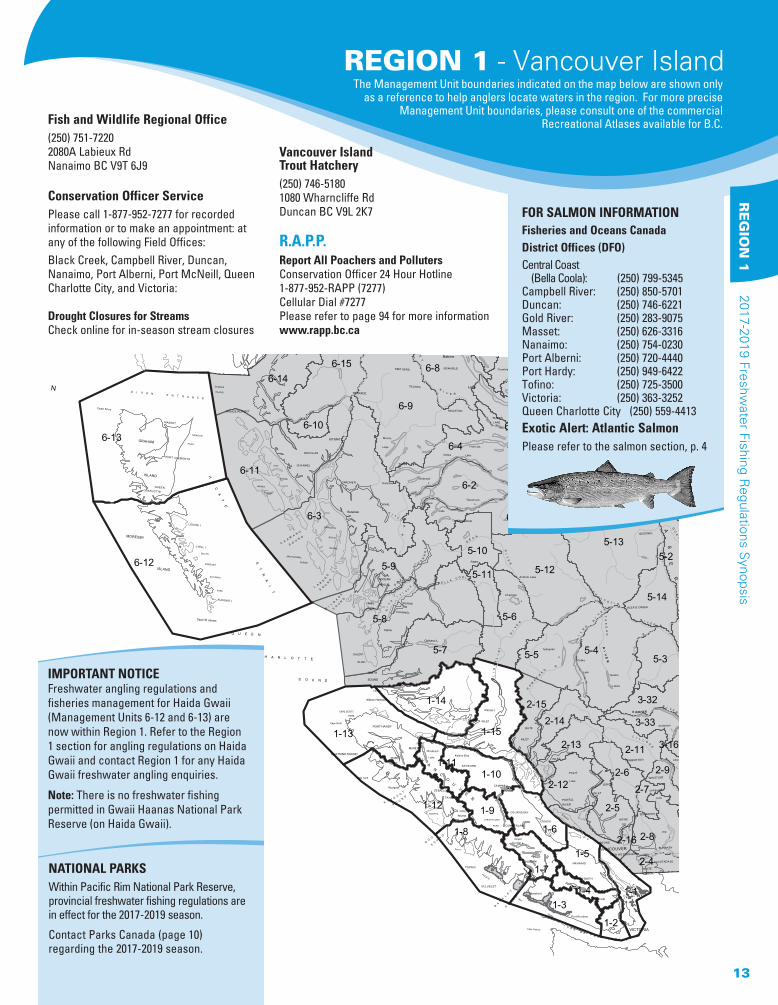
IMPORTANT NOTICEFreshwater angling regulations and fisheries management for Haida Gwaii (Management Units 6-12 and 6-13) are now within Region 1. Refer to the Region 1 section for angling regulations on Haida Gwaii and contact Region 1 for any Haida Gwaii freshwater angling enquiries.
Note: There is no freshwater fishing permitted in Gwaii Haanas National Park Reserve (on Haida Gwaii).
Fish and Wildlife Regional Office(250) 751-7220 2080A Labieux RdNanaimo BC V9T 6J9
Conservation Officer Service Please call 1-877-952-7277 for recorded information or to make an appointment: at any of the following Field Offices:Black Creek, Campbell River, Duncan, Nanaimo, Port Alberni, Port McNeill, Queen Charlotte City, and Victoria:
Drought Closures for StreamsCheck online for in-season stream closures
Vancouver Island Trout Hatchery(250) 746-51801080 Wharncliffe RdDuncan BC V9L 2K7
R.A.P.P. Report All Poachers and Polluters Conservation Officer 24 Hour Hotline 1-877-952-RAPP (7277)Cellular Dial #7277Please refer to page 94 for more informationwww.rapp.bc.ca
FOR SALMON INFORMATION
Fisheries and Oceans Canada District Offices (DFO)Central Coast (Bella Coola): (250) 799-5345Campbell River: (250) 850-5701Duncan: (250) 746-6221Gold River: (250) 283-9075Masset: (250) 626-3316Nanaimo: (250) 754-0230Port Alberni: (250) 720-4440Port Hardy: (250) 949-6422Tofino: (250) 725-3500Victoria: (250) 363-3252Queen Charlotte City (250) 559-4413Exotic Alert: Atlantic SalmonPlease refer to the salmon section, p. 4
NATIONAL PARKSWithin Pacific Rim National Park Reserve, provincial freshwater fishing regulations are in effect for the 2017-2019 season.
Contact Parks Canada (page 10) regarding the 2017-2019 season.
REGION 1 - Vancouver IslandThe Management Unit boundaries indicated on the map below are shown only
as a reference to help anglers locate waters in the region. For more precise Management Unit boundaries, please consult one of the commercial
Recreational Atlases available for B.C.
13
RE
GIO
N 1
2017-2019 Freshwater Fishing R
egulations Synopsis

Healed scar in place of adipose fin
Adipose presentwild origin trout
hatchery origin trout
REGION 1 DAILY QUOTAS (EXCLUDING HAIDA GWAII)(See tables for exceptions)Trout: 4, not more than
• 1 over 50 cm (2 hatchery steelhead over 50 cm allowed)
• 2 from streams (must be hatchery) And you must release:
• All wild trout and wild steelhead from streams
• All char (includes Dolly Varden) Note: There is no general minimum size limit for trout in lakes or hatchery origin trout in streams.Kokanee: 5 (none from streams)Bass: 4 (largemouth and smallmouth combined)White Sturgeon: CATCH AND RELEASE ONLYCrayfish: 25Yellow perch: 20
Haida Gwaii Daily Quotas (See tables for exceptions):Trout/char: 5, but not more than
• 1 over 50 cm • 3 Dolly Varden• 2 from streams
And you must release:• Trout/char under 30cm from streams• All wild steelhead
Kokanee: 10 (none from streams)
POSSESSION QUOTAS Possession quotas = 2 daily quotas
ANNUAL QUOTAS Annual catch quota for all B.C.: 10 steelhead per licence year (only hatchery steelhead may be retained in B.C.)
DAILY & ANNUAL QUOTAS FOR SALMON Please refer to the NOTICE on page 4 for Salmon Regulations.
GENERAL RESTRICTIONSSingle barbless hook: must be used in all streams of Region 1, all year.
Bait ban: excluding Haida Gwaii, applies to all streams of Region 1, all year, with some important exceptions. Check the tables.
Steelhead fishing: Your basic licence must be validated with a Steelhead Conservation Surcharge Stamp if you fish for steelhead anywhere in B.C. In addition, a Steelhead Stamp is mandatory when fishing most Classified Waters regardless of the species being angled for. Please see page 7 for details. When you have caught and retained your daily quota of hatchery steelhead from any water, you must stop fishing that water for the remainder of that day.
TABLE LEGENDSee the following tables for exceptions and additional regulations on specific waters.
π Stocked Lake or Stream (not all stocked lakes listed, see p. 87)∏ Classified Waters Licence required to fish Class I or Class II waters, see p. 8∑ Including tributaries∞ Wheelchair Accessible∂ Youth/Disabled Accompanied Water
WILD TROUT RELEASE ALL STREAMS REGULATION
Anglers note there is a region wide regulation (excluding Haida Gwaii) requiring the release of all wild origin trout in streams. This regulation allows only hatchery origin trout in streams to be harvested, except where prohibited by water specific regulation. In Region 1, stream hatchery origin trout can be dis-tinguished from wild origin trout by the presence of a healed scar in place of the adipose fin. Please note, this regulation does not apply to lakes. For more infor-mation please contact regional fisheries staff at (250) 751-7220.
STREAMS include rivers, creeks and sloughs.
Comox Lake: $100 reward tags are being used to assess the cutthroat trout fishery. Refer to page 86 for instructions on what to do if you catch a fish with a reward tag.
MERCURY ADVISORYMercury levels in larger Smallmouth Bass in lakes on Vancouver Island and the Gulf Islands may be above national guidelines. Mercury levels tend to increase with the size of the fish and larger Smallmouth Bass generally have higher levels of mercury. The general public, especially children and women of child bearing age, including pregnant and breastfeeding women, are recommended to limit their consumption of Smallmouth Bass. More information on mercury in fish and fish consumption can be found in the HealthLinkBC Food Safety: Mercury in Fish at https://www.healthlinkbc.ca/healthlinkbc-files/mercury-fish. It is advised to regularly check the online Freshwater Fishing Regulation Synopsis for more up to date information (http://www.env.gov.bc.ca/fw/fish/regulations/)
REGION 1- Vancouver IslandREGIONAL REGULATIONS
14
2017
-201
9 Fr
eshw
ater
Fis
hing
Reg
ulat
ions
Syn
opsi
s R
EG
ION
1

WATER BODY - MANAGEMENT UNIT ∑Includes Tributaries EXCEPTIONS TO THE REGIONAL REGULATIONS
ADAM RIVER (EXCEPT Eve River)∑ 1-10 Artificial fly only upstream of Eve River, to Highway 19 bridgeAHNUHATI RIVER∑ ∏ 1-15 Class II water Apr 1 - Oct 31; Steelhead Stamp mandatory Apr 1-June 30ALICE LAKE 1-13 No trout over 50 cm
Bait ban, single barbless hookAMOR LAKE 1-10 Trout daily quota = 2AMOR DE COSMOS CREEK 1-10 No Fishing from upper falls downstream 1 km to (Bear River) logging road bridge 3 km from tidewater
No Fishing from mouth to falls about 4 km upstream, Dec 1-May 31“ANDERSON” LAKE 1-3 Artificial fly only, bait ban, single barbless hook
Trout and kokanee release∑ Unnamed lake in the Walbran Creek Watershed approximately 7 km W/SW of Mt. WalbranANTLER LAKE π 1-9 No powered boatsARTLISH RIVER∑ 1-12 No Fishing upstream of the boundary signs at the bridge crossing approximately 10 km from the mouth, Nov 1-Apr 30 ASH RIVER 1-7 No Fishing from Elsie Lake to Dickson Lake
No Fishing from Dickson Lake to signs 200 m downstream of Lanternman Falls, Dec 1-Apr 30No Fishing from Dickson Falls downstream 30 m to signs
BAINBRIDGE LAKE 1-7 No angling from boats; ∂ Youth/Disabled Accompanied Water year round (see page 5 in the Provincial Regulations)BEAR LAKE 1-4 See Cowichan LakeBEAR RIVER 1-10 See Amor de Cosmos CreekBEAVER LAKE π 1-1 Engine power restriction - 7.5 kW (10 hp)BENSON RIVER∑ 1-13 Fly fishing only “BIG QUALICUM” RIVER 1-6 See Qualicum RiverBLACK CREEK∑ 1-6 No Fishing Dec 1-May 31BLACKBURN LAKE 1-1 No powered boatsBLACKWATER LAKE 1-10 Trout daily quota = 2BONANZA LAKE 1-11 No trout over 50 cm
Bait ban, single barbless hookBOOT LAKE π 1-10 Trout daily quota = 2
Bait ban, single barbless hookBRANNEN LAKE π 1-5 Speed restriction on parts (60 km/h)BROWNS RIVER 1-6 See Puntledge River∑BUTTLE LAKE’S TRIBUTARIES 1-9 Fly fishing only; Except Thelwood Creek is closed all year(Lower) CAMPBELL LAKE’S TRIBUTARIES
1-6 No Fishing Feb 1-July 15 including Campbell River between Strathcona Dam and (Lower) Campbell Lake
CAMPBELL RIVER 1-10 No Fishing between Elk Falls and John Hart Dam Power StationNo Fishing from Strathcona Dam downstream 100 m No Fishing from the boundary sign at the end of Maple Street downstream to the boundary sign at the cement block, Aug 1-Oct 31No Fishing in any tributaries (except Quinsam River), Dec 1-May 31From John Hart Dam Power Station to power line crossing approximately 200 m upstream of Quinsam River confluence: fly fishing only year-roundArtificial fly only downstream of power line crossing located approximately 200 m upstream of Quinsam River confluence: both Dec 1-May 31No boats between Elk Falls and John Hart Dam Power Station
CARNATION CREEK∑ 1-3 No FishingCATHERINE CREEK 1-10 No FishingCAYCUSE RIVER 1-3 Fly fishing only upstream of and including Hatton CreekCHEMAINUS RIVER 1-5 No Fishing from Copper Canyon Falls downstream 100 m to the fishing boundary signs
No Fishing upstream of Bannon Creek∑, Dec 1-June 30CHICADEE LAKE π 1-6 Electric motors onlyCLAUD ELLIOTT CREEK 1-10 No FishingCLAUD ELLIOTT LAKE 1-10 No trout over 50 cm; bait ban, single barbless hookCLEAR LAKE (Quadra Island) 1-15 Electric motors onlyCLUXEWE RIVER ∑ π 1-13 No Fishing upstream of the West Main logging road bridge (approximately 7.5 km upstream of the Highway 19 bridge), Dec 1-May 31COLQUITZ RIVER∑ 1-1 No FishingCOMOX LAKE 1-6 No cutthroat trout under 30 cm or over 50 cm
Bait ban, single barbless hookCONSORT CREEK∑ 1-10 No FishingCOPPER CREEK ∏ 6-12 No Fishing from Skidegate Lake to signs at second bridge 6km upstream of tidal boundary, Feb 1-Apr 30
Cutthroat trout releaseClass II water Sept 1-Apr 30*; Steelhead stamp mandatory Dec 1-Apr 30∑
COURTENAY RIVER 1-6 No Fishing Dec 1-Sept 30; Speed restriction on part (8 km/h)COUS CREEK 1-7 No Fishing Nov 1 - Apr 30COWICHAN LAKE (including Bear Lake)
1-4 Cutthroat trout daily quota = 2 (none over 50 cm)Bait ban and single barbless hook, Nov 15-Apr 15Speed restriction on parts (8 km/h), plus overall 10 km/h speed restriction within 60 m of shore
NOTE: If a lake or stream is NOT listed here, then only the Provincial Regulations (pages 9-11) and the Regional Regulations (page 14) apply. New restrictions are highlighted in blue. Check for any in-season changes at: www.env.gov.bc.ca/fw/fish/regulations/.
REGION 1 - Vancouver IslandWATER-SPECIFIC REGULATIONS
15
RE
GIO
N 1
2017-2019 Freshwater Fishing R
egulations Synopsis

WATER BODY - MANAGEMENT UNIT ∑Includes Tributaries EXCEPTIONS TO THE REGIONAL REGULATIONS
COWICHAN RIVER (see map below) 1-4 No Fishing from weir (dam) at Cowichan Lake’s outlet to Greendale trestle, Nov 15-Apr 15Tributaries upstream of and including Holt Creek No FishingFly fishing only upstream of CNR trestle (Mile 66) Aug 1-Nov 15No Fishing downstream of the CNR Mile 66 trestle between Aug 1-Nov 15Fly fishing only from signs at Greendale trestle to CNR bridge (mile 70.2)Speed restriction (8 km/h) and engine power restriction - 7.5 kW (10 hp) on parts
CRAIGFLOWER CREEK∑ 1-1 No FishingCRANE LAKE 1-10 Trout release; bait ban, single barbless hookCRESCENT LAKE 1-10 Trout release; bait ban, single barbless hookCRUICKSHANK RIVER∑ 1-6 No FishingCUSHEON LAKE π 1-1 Electric motors onlyDATLAMEN CREEK∑ ∏ 6-13 Class II water Sept 1-Apr 30; Steelhead Stamp mandatory Dec 1-Apr 30DAVIE RIVER∑ 1-11 No Fishing downstream of Schoen Lake, Dec 1-May 31DEENA CREEK ∏ 6-12 No Fishing upstream of fishing boundary signs posted at second bridge approximately 5 km upstream of the tidal boundary∑, Feb
1-May 31; Cutthroat trout releaseClass II water Sept 1-Apr 30; Steelhead Stamp mandatory Dec 1-Apr 30
DICKSON LAKE 1-7 No trout over 50 cm; bait ban, single barbless hook DIMPLE LAKE 1-3 Trout release; bait ban, single barbless hookDIVER LAKE π 1-5 Electric motors only; ∞ wheelchair accessible fishing platform located in Diver Lake ParkDONNER LAKE 1-9 No powered boatsDOUGAN LAKE π 1-4 Electric motors onlyDURRANCE LAKE π 1-1 Electric motors onlyECHO LAKE π 1-6 Electric motors onlyELK LAKE π 1-1 Engine power restriction on parts - 7.5 kW (10 hp); no vessels on parts, no powered boats on parts, no towing on parts
∞ A wheelchair accessible fishing pier is located on the lake’s NW shore via Brookleigh RoadELK RIVER (Also see Buttle Lake∑) 1-9 Fly fishing onlyENGLISHMAN RIVER 1-5 No Fishing from lower falls in Englishman River Park to signs approximately 100 m downstream
No Fishing downstream of the lower falls in Englishman River Falls Provincial Park to the Top Bridge crossing at the end of Allsbrook Road∑, Dec 1-May 31
ESARY LAKE 1-6 Trout release; bait ban, single barbless hookEVE RIVER∑ 1-10 No Fishing upstream of the fishing boundary signs (near the South Main bridge crossing) located approximately 5.4 km down-
stream of the Hwy 19 bridge, Dec 1-May 31FAIRY LAKE 1-3 Trout daily quota = 1 (none over 50 cm); bait ban, single barbless hook; Engine power restriction - 7.5 kW (10 hp)FAREWELL LAKE 1-10 Trout daily quota = 1 (none over 50 cm); artificial fly only, bait ban, single barbless hook FICKLE LAKE 1-10 No trout over 50 cm; bait ban, single barbless hookFLORA LAKE 1-4 Trout release; bait ban, single barbless hookFORBUSH LAKE 1-6 No trout over 50 cm; bait ban, single barbless hookFRENCH CREEK ∑ 1-5 No Fishing Dec 1 - May 31FULLER LAKE π 1-5 Electric motors only; ∞ wheelchair accessible fishing platform is located in Fuller Lake ParkGLEN LAKE π 1-2 Electric motors only; fishing platform is located in Glen Lake ParkGOLD LAKE 1-9 No trout over 50 cm; bait ban, single barbless hookGOLD RIVER 1-9 No Fishing upstream of, but not including, the Muchalat River∑
No Fishing from boundary signs approximately 300 m upstream of the Lions Campground upstream to the confluence with Muchalat River∑, Apr 1 - May 31No Fishing between the cascade falls (located approximately 6.5 km upstream of Muchalat Inlet, UTM 709137E, 5512420N) and fishing boundary signs approximately 80 m downstreamNo powered boats
GOLDSTREAM RIVER∑ 1-2 No FishingGORDON RIVER∑ 1-3 No Fishing upstream of Bugaboo Creek, Dec 1 - Apr 30; artifical fly only upstream of Bugaboo Creek when open
Old Lake Cowichan Road
Golding
Cr
Mayo L
SkutzFalls
Cowichan
Lake
Oliver Cr
Stan
ley
Cr
Josi
ah
Cr
Skutz Cr
Fairservice C
r
Joe
Gin
der Cr
Bear
Cr
Power
Stol
tz
Marie Canyon
Former CN Railway
Former EN Railway
Rd
Stoltz PoolCowichan RiverProvincial Park
IR 7SKUTZ
LAKECOWICHAN
WEIR
STANLEYCREEK
TRESTLE ATGREENDALE RD
GreendaleRd
18
1 2 3
Kilometres
4 50
CNR TRESTLEAT MILE 70.2
CNR TRESTLEAT MILE 66
CREEK DRAININGMAYO LAKE
SKUTZFALLS
Line
C o w i c h a n Cowichan River map is reprinted courtesy of the Haig-Brown Fly Fishing Association.
To purchase a larger map (1:40,000 scale) please contact: Haig-Brown Fly Fishing Association at www.haigbrown.ca)
REGION 1- Vancouver IslandWATER-SPECIFIC REGULATIONS
16
2017
-201
9 Fr
eshw
ater
Fis
hing
Reg
ulat
ions
Syn
opsi
s R
EG
ION
1
WATER BODY - MANAGEMENT UNIT ∑Includes Tributaries EXCEPTIONS TO THE REGIONAL REGULATIONS
GRACIE LAKE π 1-7 Electric motors only GRAHAM LAKE 1-6 Electric motors onlyGREAT CENTRAL LAKE 1-7 No Fishing Jan 1-Apr 30, from the dam to fishing boundary signs approximately 50m upstream (southwest) of the Ash Main bridge
No wild rainbow trout over 50 cmSingle barbless hook
GREEN LAKE π 1-5 Electric motors onlyGREENSTONE CREEK∑ 1-10 No Fishing GUNFLINT LAKE 1-15 Trout release; bait ban, single barbless hook; electric motors onlyHAGUE LAKE 1-15 Electric motors onlyHARRIS CREEK∑ 1-3 No Fishing upstream of and including Hemmingsen Creek∑HAREWOOD (Extension) LAKE 1-5 Trout daily quota = 2HASLAM CREEK 1-5 No FishingHAWARTH LAKE 1-19 No FishingHEALY (Panther) LAKE 1-5 Trout release; fly fishing only, bait ban, single barbless hookHEALY LAKE’S OUTLET STREAM 1-5 No FishingHEBER RIVER 1-9 No Fishing downstream of top of the lower canyon, located approximately 1.3 km upstream of the Gold River confluence
No Fishing upstream of top of the lower canyon, Dec 1 - Apr 30Fly fishing only downstream of Saunders Creek to the top of the lower canyon, May 1 - Nov 30
HEMMINGSEN CREEK∑ 1-3 No FishingHENRY LAKE 1-5 Trout release; artificial fly only, bait ban, single barbless hookHIGGENS LAKE 1-10 Trout release; bait ban, single barbless hookHOLLAND LAKE 1-5 No powered boatsHONNA RIVER∑ ∏ 6-13 Cutthroat trout release
Class II water Sept 1-Apr 30; Steelhead Stamp mandatory Dec 1-Apr 30IDA LAKE 1-11 No trout over 50 cm; bait ban, single barbless hookILLUSION LAKES 1-6 No powered boatsJASPER LAKE 1-10 Trout release; bait ban, single barbless hookJOHN HART LAKE’S TRIBUTARIES 1-10 No fishing Apr 15-July 15 (includes channel downstream of Ladore Dam)JUNE LAKE 1-7 Trout daily quota = 2KAKWEIKEN LAKE 1-15 Trout release; bait ban, single barbless hookKAKWEIKEN RIVER∑ ∏ 1-15 Class II water Apr 1 - Oct 31; Steelhead Stamp mandatory Apr 1-June 30KEMP LAKE π 1-2 No powered boatsKEOGH RIVER 1-13 No Fishing downstream of lower fish counting fence near tidewater
Release all steelheadNo Fishing in all parts∑, Dec 1-May 31
KINGCOME RIVER∑ ∏ 1-14 Class II water Apr 1 - Oct 31; Steelhead Stamp mandatory Apr 1-June 30KOKISH RIVER 1-11 No Fishing from boundary signs in Kokish canyon to Ida Lake, Nov 1-Apr 30;
No Fishing from the log boom located approxinately 100 m upstream of the IPP intake to signs at the tail of the canyon pool located approximately 250 m downstreamNo Fishing between signs at the IPP tail race confluence downstream approximately 500 m to signs
KOKSILAH RIVER∑ 1-4 No Fishing Dec 1-May 31LAKE WESTON (“Weston Lake”) 1-1 Trout daily quota = 1 (none over 50 cm); bait ban, single barbless hook; electric motors onlyLANGFORD LAKE π 1-2 Electric motors only; fishing platforms are available off Leigh Road and the Nixon Trail“LINK” RIVER 1-13 See Marble River
FISH OUT OF WATER! Taking a fish out of water can harm fish. If you plan on releasing the fish you catch make every effort to keep it in the water. McKenna Sport�shingMcKenna Sport�shingMcKenna Sport�shingMcKenna Sport�shingMcKenna Sport�shing
◆ Professional Salmon and Halibut guiding in beautiful Port Renfrew B.C. on the west coast of Vancouver Island◆ Coast guard approved and full insured◆ A member of the Port Renfrew chamber of commerce◆ Your guide Kevin McKenna will take you on and o� the water safely and o� the water safely
Book Now For Summer 2017
Email: kevin@mckennasport�shing.comWebsite: www.mckennasport�shing.com
Ph: 250-647-0123
Currie Cr
Hol
t Cr
Inwood Cr
WakeL
Cowichan Bay
Trunk Rd
Gibbins Rd
Indian Rd
Glenora Rd
Miller Rd
Allenby
Ko
ksila
h
River
Quamichan
Lake
Rd
Cambrai
Vim
y R
d
Vaux Rd
Riverbottom Road
Line
Pow
er
Rd
Robertson Rd
DUNCAN181
1
Somenos
Lake
TOWN OF DUNCANPUMPHOUSE
ALLENBY RD BRIDGE(THE WHITE BRIDGE)
Duncan Fish & Game Club River TrailHOLTCREEK
R i v e r
17
2017-2019 Freshwater Fishing R
egulations Synopsis
RE
GIO
N 1

WATER BODY - MANAGEMENT UNIT ∑Includes Tributaries EXCEPTIONS TO THE REGIONAL REGULATIONS
LITTLE MAIN LAKE (Quadra Island) 1-15 Bait ban and single barbless hook, Nov 1-Apr 30; electric motors onlyLITTLE QUALICUM RIVER 1-6 No Fishing from the falls in Little Qualicum Falls Provincial Park downstream to the hatchery fence, Dec 1-May 31
No Fishing - All tributariesThe standard 100 m closure around a fish rearing facility has been reduced to a no fishing area from the hatchery fence to signs approximately 35 m downstreamFly fishing only, Sept 1-Nov 30 (where open)
LIZARD LAKE π 1-3 Trout daily quota = 2; bait ban, single barbless hook; electric motors onlyLIZARD POND 1-7 Trout daily quota = 1; artificial fly only, bait ban, single barbless hookLOIS LAKE π 1-4 Trout daily quota = 1; release all brown trout; Artificial fly only, bait ban, single barbless hookLONG LAKE (Nanaimo) π 1-5 Speed restriction on parts (60 km/h); ∞ wheelchair accessible fishing platform is located in Loudon ParkLOON LAKE π 1-7 Electric motors onlyMACKTUSH CREEK 1-7 No FishingMAGGIE LAKE 1-8 No wild rainbow trout over 50 cm; bait ban, single barbless hookMAHATTA RIVER 1-13 No Fishing Nov 1-Apr 30MAIN LAKE (Quadra Island) 1-15 Bait ban and single barbless hook, Nov 1-Apr 30
Engine power restriction - 7.5 kW (10 hp)MAMIN RIVER∑ ∏ 6-13 Class II water Sept 1-Apr 30; Steelhead Stamp mandatory Dec 1-Apr 30
No Fishing upstream of fishing boundary signs posted on third bridge approximately 10 km upstream of the tidal boundary, Feb 1-Apr 30MAPLE LAKE π 1-6 Electric motors onlyMARBLE (“Link”) RIVER (only between Victoria and Alice lakes)
1-13 Fly fishing only∑
MARTHA LAKE π 1-10 Trout release; bait ban, single barbless hookMATHESON LAKE π 1-2 Electric motors only“MAXWELL LAKE” (Lake Maxwell) 1-1 Electric motors onlyMAYO LAKE π 1-4 ∂ Youth/Disabled Accompanied Water (see page 5 in the Provincial Regulations)MCKENZIE LAKE 1-2 No powered boatsMCNAIR LAKE 1-10 Trout release; bait ban, single barbless hookMEGIN LAKE 1-8 No trout over 50 cm; bait ban, single barbless hookMICHAEL LAKE 1-5 No powered boatsMILLER CREEK∑ 1-6 No FishingMINE LAKE 1-15 Engine power restriction - 7.5 kW (10 hp)MISTY LAKE 1-13 No Fishing (located in an Ecological Reserve)MOHUN CREEK∑ 1-10 No Fishing Dec 1-May 31
No Fishing from Menzies Bay logging mainline bridge crossing to Morton LakeMORTE LAKE 1-15 Electric motors onlyMUCHALAT RIVER∑ 1-12 No Fishing Dec 1 - May 15MYRA LAKE 1-10 No FishingNAHMINT LAKE 1-7 No trout over 50 cm; bait ban, single barbless hook; engine power restriction 7.5 kW (10 hp)NAHMINT RIVER 1-7 No Fishing Nahmint River (upstream and downstream of the lake), Dec 1-Apr 30; flyfishing only upstream of Nahmint Lake when open
DELUXE WALL TENTS *wall tents *aluminum frames*diesel heaters *wood stoves
*cots *tarps *bedrolls *used tents
(250) 704-2534Free Shipping In Canada
*with some restrictions*
REGION 1- Vancouver IslandWATER-SPECIFIC REGULATIONS
18
2017
-201
9 Fr
eshw
ater
Fis
hing
Reg
ulat
ions
Syn
opsi
s R
EG
ION
1
WATER BODY - MANAGEMENT UNIT ∑Includes Tributaries EXCEPTIONS TO THE REGIONAL REGULATIONS
NANAIMO RIVER 1-5 No Fishing from power line crossing at “Bore Hole” upstream to fishing boundary signs at the mouth of Boulder CreekNo Fishing from the Cedar Road bridge upstream approximately 400 m to the white square boundary signs near the Hwy 19 bridge, Sept 15-Oct 30No Fishing upstream of the Hwy 1 bridge∑, Dec 1-May 31Artificial fly only upstream of the westernmost of the two Nanaimo Lakes, known locally as “Second” Lake, including tributariesEngine power restriction on parts - 7.5 kW (10 hp)
NIMPKISH RIVER∑ 1-11 No Fishing upstream of Davie River, Dec 1-May 15NITINAT LAKE 1-3 Note: Nitinat Lake is tidal water; tidal regulations apply and a (federal) Tidal Waters Sport Fishing Licence is requiredNITINAT RIVER∑ 1-4 No Fishing upstream of Parker Creek
No Fishing between fishing boundary signs approximately 100 m upstream of and downstream of “Red Rock Pool,”approximately 2 km (by road) south of the Nitinat River bridge, Aug 25-Dec 31No Fishing between boundary signs approximately 50 m upstream of and downstream of the Nitinat River bridge, Aug 25-Oct 15
NOLA LAKE 1-9 No FishingO’CONNELL LAKE 1-13 No trout over 50 cm; bait ban, single barbless hookOYSTER RIVER π 1-6 No Fishing upstream of the confluence with Little Oyster River∑, Dec 1-June 30PALLANT CREEK∑ ∏ 6-12 Class II water Sept 1-Apr 30; Steelhead Stamp mandatory Dec 1-Apr 30PANTHER LAKE 1-5 See Healy LakePERRY LAKE 1-12 Trout daily quota = 1 (none over 50 cm); bait ban, single barbless hook“PETE’S POND” 1-3 Trout release; artificial fly only, bait ban, single barbless hook
Unnamed lake at the head of San Juan RiverPRIOR LAKE π 1-2 No powered boatsPROSPECT LAKE π 1-2 Speed restriction on parts (8 and 60 km/h)PROVOST DAM 1-5 No powered boatsPUNTLEDGE RIVER 1-6 No Fishing downstream of the BC Hydro diversion dam (approximately 3.5 km downstream of Comox Lake) to the base of Stoltan
Falls (approximately 450 m downstream of the Duncan Bay Mainline logging road bridge)No Fishing between fishing boundary signs approximately 100 m upstream and downstream of the confluence with Morrison CreekNo Fishing from fishing boundary signs located 50 m upstream of the BC Hydro generating station tailrace to signs located 75 m downstream of the Puntledge River hatchery fence (total distance approximately 500 m)No Fishing tributariesFly fishing only upstream of the BC Hydro diversion dam (approximately 3.5 km downstream of Comox Lake), including tributaries
QUALICUM RIVER 1-6 No Fishing downstream of boundary signs located approximately 100 m downstream of the hatchery counting fenceNo Fishing from E&N trestle to boundary signs located approximately 100 m downstream of the hatchery counting fence, Aug 10-Oct 15No Fishing tributariesArtificial fly only from the Horne Lake dam downstream to the E&N Railway Bridge, Oct 16-Aug 31Fly fishing only∑, Sept 1-Oct 15∞ wheelchair accessible fishing platform is located at the hatchery
QUATSE RIVER∑ π 1-13 No Fishing May 1-June 15Hatchery steelhead daily quota = 1No Fishing upstream of the Quatse River fishway (approximately 1.4 km upstream of Dick Booth Creek), Dec 1-June 15Bait ban, May 1-Nov 30
QUENNELL LAKE π 1-5 Speed restriction on parts (8 km/h)QUINSAM RIVER∑ 1-6 No Fishing from the fishing boundary signs at power line crossing (approximately 25 m upstream of Quinsam Hatchery weir) to
fishing boundary signs approximately 300 m downstream of weirNo Fishing from the falls situated downstream of Middle Quinsam Lake to the fishing boundary signs at power line crossing (ap-proximately 25 m upstream of the Quinsam hatchery weir) , Dec 1-June 30∞ wheelchair accessible fishing platform is located near the Hwy 28 bridge
REGAN LAKE 1-6 Trout release; bait ban, single barbless hookREGINALD LAKE π 1-6 Trout release; bait ban, single barbless hookROBERTS LAKE 1-10 No trout over 50 cm; bait ban, single barbless hookROONEY LAKE∑ 1-10 Brown trout daily quota = 1ROSELLE LAKE 1-11 Trout daily quota = 2ROSEN LAKE (Read Island) 1-15 No powered boatsROWBOTHAM LAKE 1-5 Trout release; artificial fly only, bait ban, single barbless hookST. MARY LAKE π 1-11 Electric motors onlySALMON RIVER∑ 1-10 No Fishing upstream of Kay Creek
No powered boats upstream of confluence with White River; speed restriction (10 km/h) from estuary to confluence with White RiverSAN JUAN RIVER∑ 1-3 No Fishing upstream of Fleet River
Toll Free 1.888.771.2111
Your Vancouver IslandReal Estate Connection
Campbell River • Comox Valley • Gold River • Tahsis and all points north
Each of� ce independently owned and operated.
View Area Listings www.NorthIslandRealEstate.ca
• Tahsis
Each of� ce independently owned and operated.
CAMPBELL RIVER
19
2017-2019 Freshwater Fishing R
egulations Synopsis
RE
GIO
N 1

WATER BODY - MANAGEMENT UNIT ∑Includes Tributaries EXCEPTIONS TO THE REGIONAL REGULATIONS
SEYMOUR RIVER ∏ 1-14 Class II water Aug 15-Oct 31∑; Steelhead Stamp not required unless fishing for steelheadSHAWNIGAN LAKE π 1-2 Speed restrictions on parts (8 and 65 km/h)SOMASS RIVER π 1-7 No Fishing between the tidal boundary at Papermill Dam to boundary signs approximately 1.0 km upstream (Falls Road Gravel Pit
and the southern most end of Collins Farm/Arrow Vale Campground on Hector Road), Aug 25-Nov 15Bait ban, June 1-Aug 24Engine power restriction 7.5 kW (10 hp)
SOOKE RIVER∑ 1-2 Fly fishing only downstream of Sooke River Falls, Sept 1-Nov 30No Fishing from the base of the lower “potholes” falls to signs approximately 100m downstream
SPIDER LAKE π 1-6 No powered boatsSPROAT LAKE 1-7 Cutthroat trout release, no wild rainbow trout over 50 cm; single barbless hookSPROAT RIVER 1-7 No Fishing from Sproat Lake to fishing boundary signs approximately 300 m downstream of Hwy #4, June 15-Nov 15
Bait ban, May 1-Oct 31STAMP RIVER π 1-7 No Fishing between fishing boundary signs 200m upstream of and 500m downstream of Stamp Falls, June 15-Nov15
No Fishing from the confluence with Ash River upstream to the Great Central Lake dam∑, Jan 1-Apr 30Bait ban all year upstream of signs at “Girl Guide Falls” (approximately 250 m upstream of the mouth of Beaver Creek)∑ Bait ban downstream of signs at “Girl Guide Falls” (approximately 250 m upstream of the mouth of Beaver Creek), June 1-Aug 24 Engine power restriction 7.5 kW (10 hp), on parts
STEWART LAKE 1-10 No trout over 50 cm; bait ban, single barbless hook; electric motors onlySTOCKING LAKE 1-5 No powered boats“STOWELL LAKE” (Lake Stowell) π 1-1 Electric motors onlySTRAMBERG LAKE 1-15 Trout release; bait ban, single barbless hook; electric motors onlySTRATHCONA PARK WATERS 1-9 No powered boats on any water within Strathcona Park except Gold, Upper Campbell and Buttle lakesTADJISS LAKE π 1-4 Trout daily quota = 1; release all brown trout; artificial fly only, bait ban, single barbless hookTAYLOR RIVER 1-7 Fly fishing onlyTHELWOOD CREEK 1-9 No FishingTHETIS LAKE π 1-1 Electric motors onlyTLELL RIVER* ∏ 6-13 Cutthroat trout rlease
Class II water Sept 1-Apr 30; Steelhead Stamp mandatory Dec 1-Apr 30Tidal waters regulations apply to waters downstream of tidal boundary sign located 1.5 km upstream of Hwy 16 bridge
TLOWILS LAKE 1-10 Electric motors onlyTLOOLS LAKE 1-9 No FishingTOQUART LAKE 1-8 No trout over 50 cm; bait ban, single barbless hookTOQUART RIVER∑ 1-8 Flyfishing only upstream of the Toquart mainline logging bridge when open; No Fishing upstream of the boundary sign located
near the falls approximately 800 m downstream of Toquart Lake (including the Upper Toquart River) between Nov 1-May 31. Note: this includes the river upstream of the lake
TOY LAKE 1-7 Trout daily quota = 2; bait ban, single barbless hookTRENT RIVER∑ 1-6 No Fishing Dec 1-May 31TSABLE RIVER∑ 1-6 No Fishing Dec 1-May 31TSABLE LAKE 1-6 Trout release; bait ban, single barbless hook
00.51 1 km
Scale
McNair L
Cedar L
Muskeg L
Mud L
Chain L
Blackwater L
Farewell L
Grace L
Roberts Lake
Am
or L
ake
Lake A
Lake B
19
MAP "A"
Roberts
AmorDe
Cosmos
Creek
Creek
Campbell River
Mary L
Crane L
Men
zies
Bay
Mai
nlin
e
Men
zies
Bay
Mai
nlin
e
Morton LMorton L
Mohun
Creek
Loveland Bay
Gosling L
Campbell Lake
JohnHart
Lake
Moh
un L
19
Lake C
Lake E
Lake G Lake H
Lake I
Lake D
Lake F
00.51 1 km
Scale
MAP "B"
Campbell River
FISH OUT OF WATER! Taking a fish out of water can harm fish. If you plan on releasing the fish you catch make every effort to keep it in the water.
REGION 1- Vancouver IslandWATER-SPECIFIC REGULATIONS
20
2017
-201
9 Fr
eshw
ater
Fis
hing
Reg
ulat
ions
Syn
opsi
s R
EG
ION
1
File: 015FFR_2.75x3.125-IO.indd Client: Island Outfitters Pub: BC Fishing Regs
design one Size: 2.75” x 3.125” Date: Jan 13, 2009
BLACK
freshwater bait & tackle
freshwater licenses fly fishing supplies
custom rod building & repairs
mail orders fishing charters & accommodations
Our store carries over 20,000 products from some of the finest fishing, outdoor, tackle and hunting manufacturers in the world, including:
3319 Douglas Street Victoria, BC V8Z 3L2 250-475-4969 1-866-915-4254
www.islandoutfitters.ca
WATER BODY - MANAGEMENT UNIT ∑Includes Tributaries EXCEPTIONS TO THE REGIONAL REGULATIONS
TSITIKA RIVER 1-10 No Fishing upstream of Catherine Creek, Nov 1-Apr 30Fly fishing only downstream of Catherine Creek
TSOLUM RIVER∑ 1-6 No FishingUNNAMED LAKE “A” - MAP A, on p.20 1-10 Trout release; bait ban, single barbless hookUNNAMED LAKE “B” - MAP A, on p.20 1-10 Trout release; bait ban, single barbless hookUNNAMED LAKE “C” - MAP B, on p.20 1-10 Trout daily quota = 2; bait ban, single barbless hookUNNAMED LAKE “D” - MAP B, on p.20 1-10 Trout daily quota = 2; bait ban, single barbless hookUNNAMED LAKE “E” - MAP B, on p.20 1-10 Trout release; bait ban, single barbless hookUNNAMED LAKE “F” - MAP B, on p.20 1-10 Trout daily quota = 2; bait ban, single barbless hookUNNAMED LAKE “G” - MAP B, on p.20 1-10 Trout daily quota = 2; bait ban, single barbless hookUNNAMED LAKE “H” - MAP B, on p.20 1-10 Trout release; bait ban, single barbless hookUNNAMED LAKE “I” - MAP B, on p.20 1-10 Trout daily quota = 2; bait ban, single barbless hookVILLAGE BAY LAKE 1-15 Bait ban and single barbless hook, Nov 1-Apr 30
Engine power restriction - 7.5 kW (10 hp)WAHPEETO CREEK 1-14 No Fishing within 100 m downstream of the falls situated approximately 4.5 km upstream of Wakeman RiverWAKEMAN RIVER∑ ∏ 1-14 Class II water Apr 1 - Oct 31; Steelhead Stamp mandatory Apr 1-June 30“WESTON LAKE” 1-1 See Lake WestonWEST WALBRAN RIVER∑ 1-3 Trout and kokanee releaseWESTWOOD LAKE π 1-5 ∞ wheelchair accessible fishing platform is located in Westwood Lake ParkWHITE RIVER∑ 1-10 No Fishing between fishing boundary signs at the salmon viewing poolWILLEMAR LAKE 1-6 No trout over 50 cm; bait ban, single barbless hookWOWO LAKE π 1-6 Trout daily quota = 2; artificial fly only, bait ban, single barbless hook
Electric motors onlyYAKOUN RIVER∑ ∏ 6-13 No Fishing from Yakoun Lake downstream approximately 13km to posted fishing boundary signs, Oct 1-Apr 30
Cutthroat trout releaseNo powered boatsClass II water Sept 1-Apr 30; Steelhead Stamp mandatory Dec 1-Apr 30
ZEBALLOS LAKE 1-12 No FishingZEBALLOS RIVER∑ 1-12 No Fishing Nov 1-Apr 30
NOTE: If a lake or stream is NOT listed here, then only the Provincial Regulations (pages 9-11) and the Regional Regulations (page 14) apply. New restrictions are highlighted in blue. Check for any in-season changes at: www.env.gov.bc.ca/fw/fish/regulations/.
21
2017-2019 Freshwater Fishing R
egulations Synopsis
RE
GIO
N 1
gonefi shinshop.com
Your One Stop Shop! t NANAIMO
600-2980 N.Island Hwy.250.758.7726
• FISHING • SHOOTING SPORTS• CLOTHING • WADING & MORE
3GREATLOCATIONS
COURTENAY#3-2720 Cliffe Ave.250.334.2007
PORT ALBERNI4985 Johnston Rd.250.723.1172
Live the Adventure
www.lodestaroutfi tters.com
We Rent: Wall Tents, Jet Boats, Optics, Fishing Gear & Fishing Boats
We Sell:Hunting, Fishing & Smoking Supplies
778.808.2862 LIKELY– likely-bc.caHome of the really big TroutGuided trips available
HORSEFLY– www.horsefly.bc.caLand of lakes, rivers and mountains
BIG LAKE – www.biglakeranchbc.com$1,000 Fishing Derby Prize—First weekend June
QUESNEL LAKE COUNTRY “Your Premier Wilderness
Destination”
Their future isin your hands
Help us conserve and protect B.C.’s
of present and future generations.
• Join• Donate• Volunteer
Their future isin your hands
Help us conserve and protect B.C.’s
of present and future generations.
• Join• Donate• Volunteer
The future is in your hands