refinement of spray drift estimates for non-target terrestrial plant
TRANSCRIPT

Refinement of Spray Drift Estimates for Non-Target Terrestrial Plant Risk
April 23, 2015
Dan Dyer - on Behalf of the CLA Spray Drift Issue Management Team

Tier-1 Ground Spray Model, AgDRIFT
• AgDRIFT produces unreasonably conservative
drift estimates
Especially conservative at far distance from edge of field
Low endpoints associated with endangered non-target
terrestrial plants often fall in this far-distance range
Leads to unreasonable, impractical buffer distance
• AgDRIFT is not representative of current spray
technology
Spray Drift Task Force (SDTF) dataset (1992 and 1993),
used old nozzle technology
No drift reducing nozzles (drift reducing technology)
No low drift air-induction/chamber nozzles
Page 2
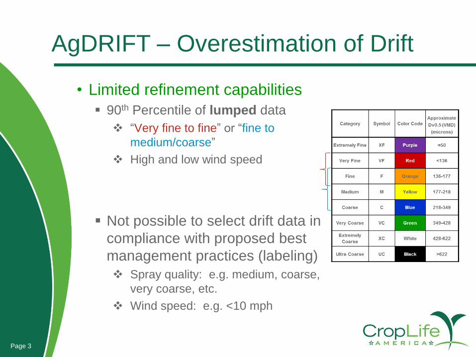
AgDRIFT – Overestimation of Drift
• Limited refinement capabilities
90th Percentile of lumped data
“Very fine to fine” or “fine to
medium/coarse”
High and low wind speed
Not possible to select drift data in
compliance with proposed best
management practices (labeling)
Spray quality: e.g. medium, coarse,
very coarse, etc.
Wind speed: e.g. <10 mph
Page 3

Endangered Species Drift Assessment for “Herbicide”
• Example of ongoing endangered non-target
terrestrial plant (NTTP) drift assessment
Endpoint: 0.05% of application rate (for most
sensitive species)
Label restrictions:
“coarse or coarser” spray quality
<10 mph wind speed
• AgDRIFT: 604-ft proximity distance
fine to medium/coarse nozzle
low boom height
• Impractical potential buffer distances
Page 4

Higher Tier Drift Refinement
• REGDISP -- model built on AGDISP (v. 8.26)
• US Forestry Service made code available to Industry
• uses current EPA accepted version of AGDISP
• desire to keep the mechanistic ground model
• No changes to existing AGDISP code existing
• Better interface for AGDISP calculators
• Enables parsing of data and addition of data
• Addresses issues with AgDRIFT
Page 5

Herbicide Higher Tier Drift Refinement
• Refinement based on Agriculture and Agri-Food
Canada (AAFC) dataset (2000, 2011)
Drift deposition curves selected based on spray quality
and wind speed
Drift reduction nozzles (e.g., air-induction), in addition to
standard flat fan
Spray boom height between 24” and 35” above ground
Wind speed from 5 to 19 mph
Regression equations taken from REGDISP
Page 6

• Methodology
Five coarse to extra-coarse nozzles in AAFC dataset
Multiple datasets per nozzle/wind speed
Proximity distances calculated from individual
deposition curves for different wind speeds and boom
heights based on the NTTP endpoint
Data grouped for each nozzle separately and according
to wind speeds (<10 mph or >10 mph)
Averages and total ranges of proximity distances
Page 7
Herbicide Higher Tier Drift Refinement

Page 8
30-113 ft (<10 mph) ; 80-176 ft (>10 mph)
6930
87113 103
133
80116
156176
0
50
100
150
200
250
AIXR110-025 DR110-05 AI110025 TT11005 AI11004
Pro
xim
ity
Dis
tan
ce (
ft)
Terrestrial Spray Drift Proximity Distance from Edge-of-Field(0.05% Deposition of Application Rate)
Wind speed <10 mph Wind speed >10 mph
Refinement based on AAFC dataset
AgDRIFT: 604 ft
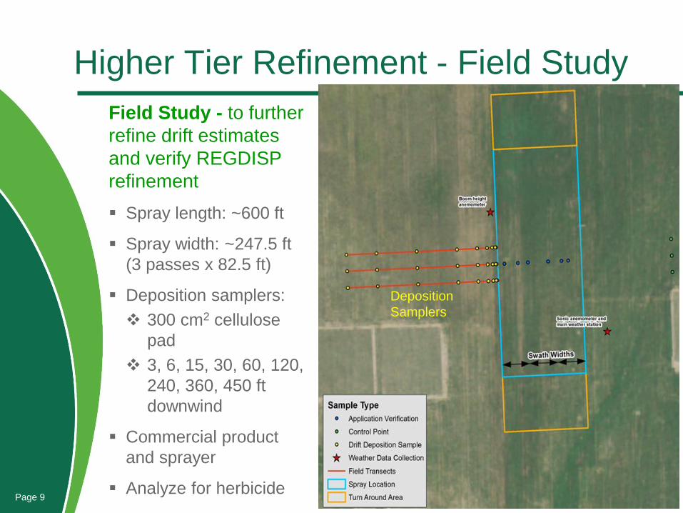
Higher Tier Refinement - Field Study
Field Study - to further
refine drift estimates
and verify REGDISP
refinement
Spray length: ~600 ft
Spray width: ~247.5 ft
(3 passes x 82.5 ft)
Deposition samplers:
300 cm2 cellulose
pad
3, 6, 15, 30, 60, 120,
240, 360, 450 ft
downwind
Commercial product
and sprayer
Analyze for herbicidePage 9
Deposition
Samplers

Drift Deposition – Field Study
• Field data and curve fit (example)
Page 10
0.000%
0.001%
0.010%
0.100%
1.000%
10.000%
100.000%
0 25 50 75 100 125 150 175 200 225 250 275 300 325 350 375 400 425 450
Per
cen
t o
f A
pp
licat
ion
Rat
e
Downwind Distance (ft)
TT11003 (37 psi)7.4 – 7.8 mph
Transect A
Transect B
Transect C
Curve Fit

0.0001%
0.0010%
0.0100%
0.1000%
1.0000%
10.0000%
100.0000%
0 15 30 45 60 75 90 105 120 135 150
Pe
rce
nt
of
Ap
pli
cati
on
Ra
te
Downwind Distance (ft)
Proximity Distance (based on Drift Trials)
AIXR11002 (10 mph)
TT11003 (<10 mph)
AIXR11002 (<10 mph)
Endpoint
Page 11
Drift Deposition – Field Study
AIXR11002 (10 mph): 68 ft
TT11003 (<10 mph): 64 ft
AIXR11002 (<10 mph): 45 ft
REGDISP: 30 - 113 ft

0.0001%
0.0010%
0.0100%
0.1000%
1.0000%
10.0000%
100.0000%
0 30 60 90 120 150 180 210 240 270 300 330 360 390 420 450 480 510 540 570 600
Per
cen
t o
f A
pp
licat
ion
Rat
e
Downwind Distance (ft)
Proximity Distance
AIXR11002 (10 mph)
TT11003 (<10 mph)
AIXR11002 (<10 mph)
AgDRIFT (6 swath; 270 ft)
AgDRIFT (20 swath)
Endpoint
Page 12
Field Drift vs REGDISP vs AgDRIFT
Field Study 45 - 68 ft
REGDISP 30 - 113 ft
AgDRIFT (6 swath) 322 ft
AgDRIFT (20 swath) 604 ft

Summary
• REGDISP allows for conservative, higher tier drift
modeling, necessary to refine unrealistic and impractical
drift estimates from AGDRIFT.
Conservative nature of REGDISP verified with results of field study
• REGDISP is especially critical/useful for NTTP
endangered species assessments, where endpoint may
be low.
Page 13
Summary
• REGDISP is valuable tool, and necessary step in a tiered
approach to drift refinement based on product best
management practices
Spray quality/nozzle type, wind speed, etc.
• Field drift studies should not be prerequisite for use of
REGDISP
field studies are appropriate higher tier refinement, when
necessary
Page 14

Thank you