reference gnss stations for warning on possibility of...
TRANSCRIPT

Earth Sciences 2020; 9(3): 100-107
http://www.sciencepublishinggroup.com/j/earth
doi: 10.11648/j.earth.20200903.12
ISSN: 2328-5974 (Print); ISSN: 2328-5982 (Online)
Reference GNSS Stations for Warning on Possibility of Upcoming Earthquake in Zagreb
Nikola Solaric1, *
, Miljenko Solaric1, Marijan Marjanovic
2, Zlatko Bogdanovski
3, Sasho Dimeski
4 1Institute for Geomatics, Faculty of Geodesy, University of Zagreb, Zagreb, Croatia 2The State Geodetic Survey, The State Geodetic Administration, Zagreb, Croatia 3Department of Geodesy and Mathematics/ Faculty of Civil Engineering, Ss. Cyril and Methodius University in Skopje, Skopje, North
Macedonia 4Agency for Real Estate, Skopje, North Macedonia
Email address:
*Corresponding author
To cite this article: Nikola Solaric, Miljenko Solaric, Marijan Marjanovic, Zlatko Bogdanovski, Sasho Dimeski. Reference GNSS Stations for Warning on
Possibility of Upcoming Earthquake in Zagreb. Earth Sciences. Vol. 9, No. 3, 2020, pp. 100-107. doi: 10.11648/j.earth.20200903.12
Received: March 9, 2020; Accepted: April 9, 2020; Published: May 18, 2020
Abstract: Distances between permanent GNSSS stations in positional systems are usually short between 30 km and 80 km.
So calculated distances between the GNSS stations from their position coordinates calculated by processing collected GNSS
data with Bernese software will be very well determined. The first time we determined that two days before earthquake in
Kraljevo 2010 were shortening of sides between the GNSS referent stations, that this was a compression of the Earth’s crust
two days before the earthquake. This effect was also confirmed on the Earthquakes Dreznica 2013, Skopje 2016 and Zagreb
2018 and that after compression two or several days after the earthquake occurs. However, they can also enable geophysicists
to determine warn of possible earthquakes. On the end it was suggested that in the Control Center of CROPOS is required to
establish a department for determination of compression in Earth crust based on GNSS measurement of the reference GNSS
stations. This compression is possible to determine by "The method of daily changing the distance between GNSS permanent
referent stations". After determination compression in Earth crust and using other geophysical methods will be probably
possible to warn to upcoming earthquakes.
Keywords: GNSS, AGROS, MAKPOS, CROPOS, Earthquake
1. Introduction
The permanent reference GNSS1 stations of positioning
systems are used by geodesists for precisely determination
the position of the points on Earth using the GNSS satellites.
However, they can also enable geophysicists to determine
displacements of the Earth's crust and warn of possible
earthquakes.
Distances between the reference GNSS stations are
generally between 30 and 80 km. At such relatively small
distances between the reference GNSS stations in
comparison with the distances of the GNSS satellites from
1 GNSS - abbreviation of Global Navigation Satellite Systems.
the Earth's surface, measurement error caused by the
troposphere and the ionosphere (not covered by the
corrections) will be virtually the same.
Thus, the calculated distances between the GNSS stations
from their position coordinates calculated by processing
collected GNSS data with the Bernese software will be very
well defined.
This method can be called "The method of daily changing
the distance between GNSS permanent referent stations". We
applied it to the analysis of the distances between the
permanent reference GNSS stations before the earthquake,
during time of earthquakes and after earthquake when were

Earth Sciences 2020; 9(3): 100-107 101
earthquakes:
a) 2010 at Kraljevo (Serbia),
b) 2013 at Dreznica (near Senj) in Croatia and
c) 2016 in Skopje (Macedonia).
In these three cases just before earthquake two to three
days were the compression of the Earth's crust, i.e. there were
a shortening of the distances between GNSS stations near the
epicenter of the earthquake.
We need to underline that for geophysical research it
should special attentions has to be paid to the stability of
referent GNSS stations.
2. The Analysis of the Deformation of the
Earth’s Crust
2.1. The Earthquake in Surroundings of Kraljevo 3.11.2010
(Serbia)
The earthquakes in surroundings of Kraljevo in Serbia
were on 3.11.2010. This biggest earthquake was a moderate
earthquake with a magnitude of 5.4 degrees on the Richter
scale. The hypocentre of the earthquake was at a depth of 10
km, and it was felt throughout Serbia, Macedonia, Bosnia
and Herzegovina and partially in Croatia.
Figure 1. Nearly all distances were slightly decreased two days before the
earthquake, while the sides (E and D in the quadrilateral) which were far
from the epicenter of earthquakes did not show daily change of distance. [12]
Figure 2. Graph of daily changes of the distances between the AGROS
permanent referent GNSS stations presented in quadrangle with diagonals
around Kraljevo.
In that time, the AGROS2 GNSS positioning system was
already established in Serbia. In the paper [1] the 24-hour
2 AGROS - abbreviation of Active Geodetic Referent Network (Osnova) of
Serbia. This is GNSS positioning system of Serbia and has more than 30 referents
permanent GNSS stations.
coordinates of GNSS referent stations calculated by using the
Bernese software and the distances between the AGROS
GNSS reference stations are presented: Krusevo, Gornji
Milanovac, Ivanjica and Kursumlija around Kraljevo (Figure
1). Thus, it was possible to draw a graph of the daily change
of distance between neighboring referent GNSS stations at
(Figure 2). From this graph, the first time we discovered that
two days before the earthquake near its epicenter there was a
shortening of distances between neighboring GNSS stations,
i.e. the compression of the Earth's crust occurred.
Compression of the Earth's crust is previous GNSS signal
before earthquake. [12]
2.2. The Earthquake at Dreznica (Near Senj) 2013 (Croatia)
In 2008, the Croatian GNSS positioning system CROPOS3
was established for precise positioning and deformation
calculation of the Earth's crust. [3, 7]
In Croatia was a small earthquake on 30.07.2013 at 14:58
with an epicentre at Dreznica, 15 km north-east of Senj. [13,
15] The earthquake’s magnitude was 4.6 on the Richter scale
and its hypocentre was at a depth of 20 km. The intensity in
the earthquake epicentre was VI-VII on the Mercalli-
Cancani-Sielberg (MCS) scale.
The earthquake was felt in the areas of Ogulin, Karlovac
and Zagreb, as well as in southern and central Slovenia. The
telephone 112 of information centre in Karlovac received in
[15] only two reports of damage. Given the small earthquake
intensity, only minor material damage was possible in the
epicentre area.
After analysis of daily changes of distances between all
four CROPOS stations around Dreznica, we have found that
the daily changes of distances between the CROPOS stations
were very small (Figure 3). However, two days before the
earthquake all sides of the quadrangle were slightly
decreased (compressed). There were practically no changes
at the sides that are further away from the earthquake’s
epicentre, as was the case on the sides Karlovac-Slunj and
Karlovac-Rijeka (Figure 4).
Taking into consideration such small changes of distances
and measurements errors in the case of small earthquakes, we
cannot predict an earthquake for certain. However, two days
before the earthquake there were a decrease of distances
between the GNSS referent stations (the terrain was
compressed), similar to the earthquake in Kraljevo on
03.11.2010.
However, the Kraljevo earthquake was larger (moderate
earthquake) with a magnitude of 5.4 on the Richter scale and
the daily changes of distances were slightly larger. Therefore,
it is necessary to investigate whether such a phenomenon
occurs in major earthquakes too. [13]
Given the small changes in distance between the reference
stations and taking into consideration the measurement errors
in such small earthquakes, it would not be possible to predict
an earthquake with certainty in advance. However, the
3 CROPOS – abbreviation of Croatian Positional System. This positional system
has 33 permanent GNSS stations.

102 Nikola Solaric et al.: Reference GNSS Stations for Warning on Possibility of Upcoming Earthquake in Zagreb
situation in Dreznica also shows those two days before the
earthquake there was a decrease of distances between the
reference GNSS stations, i.e. this was Earth crust
“compression”, to that of the earthquake in Kraljevo on
03.11.2010. This time period from “compression” to
stretching, i.e. fracture – earthquake could be after as long as
two days, or even something longer.
Figure 3. The daily changes of horizontal distances between the CROPOS
stations near Dreznica on 28.07.2013 were small. However, it can be
concluded those two days before the earthquake that all the sides of the
quadrangle near the epicentre were slightly decreased (compressed). (Some
parts of the Senj station side are marked with an interrupted line, indicating
that measurements on some days are not registered). [13]
Figure 4. Compressions of sides and diagonals between CROPOS stations
near Dreznica 28.07.2013.
2.3. The Earthquake in Skopje in 2016 (North Macedonia)
In order to carry out the analysis of the earth's
deformations before and after the earthquakes in Skopje in
September 2016, we chose distances between four
neighboring MAKPOS4 permanent GNSS reference stations
near epicenter of the earthquake 2016: Skopje, Kumanovo,
Veles and Tetovo. Few smaller earthquakes and the biggest
earthquake of magnitude 5.2 degrees per Richter happened at
15:10 (local time) on 11.09.2016 in the vicinity of Skopje.
The earthquake’s epicentre was located at geographic latitude
φ=41.98° and geographic longitude λ=21.50° and its
hypocenter was at a depth of 4 km. It was felt in Kosovska
Mitrovica, Nis, Vranje and Belgrade. [16]
In order to get an overview of changes of all distances
between 4 MAKPOS GNSS stations, in Figure 5 are shown
graphically all daily changes of distances between stations.
In that way we determined the deformations of Earth’s crust
on the surface as the pressure in it. The criterion for
4 MAKPOS abbreviation of MACedonian POsitional System have 14 referents
permanent GNSS stations.
definition when is compression in Earth’s crust for our
network type may be that all distances between GNSS
stations are shorted. However, a site may appear that does
not have a shortcut, if it was later earthquake on big
distance from that site.
Figure 5. Daily changes distances between the observed MAKPOS GNSS
referent stations around Skopje. The decrease in all the distances (terrain
“compression”) occurred on 08.09.2016 and three days later the strongest
earthquake in this area occurred. [14]
Figure 6. GNSS reference stations of the MAKPOS network and
determination shift of the Earth’s crust before and after the earthquake in
Skopje in 2016 in [14]. The distances between the observed GNSS stations in
the MAKPOS network near Skopje and in the red bracket it was labeled how
are shorted the distances of 08.09.2016 compared to 20.08.2016.
It is interesting to mention, as it can be seen from Figure 6,
that on 08.09.2016 all the distances between the observed
MAKPOS GNSS referent stations decreased. We shall call
the decrease in distances between the MAKPOS stations as
“compression”. This means that three days before the
earthquake in Skopje there was a “compression” (i.e.
decrease in the side distances between points on the Earth’s
crust) around Skopje (Figure 6).
We also outlined a graph of the total horizontal length
changes between the MAKPOS GNSS stations from
20.08.2016 to 20.09.2016 in Figure 7. Based on the graph, it
can be seen that in this time period of about 30 days the site
Skopje-Tetovo was enlarged to a maximum of about 6 mm,
Tetovo-Kumanovo 4 mm and Tetovo-Veles 2 mm. The other
three sides had much shorter contractions. This means that
the Earth's crust west of Skopje pushed the Earth's crust of
east of Skopje.
Earth Sciences 2020; 9(3): 100-107 103
Figure 7. Display of total changes of horizontal distances between the
MAKPOS GNSS= stations near Skopje from 20.8.2016 to 20.9.2016. [14]
Subsequently, we decided to do analysis and graphically
display the changes of the 24-hour distances between GNSS
reference stations over a longer period of time. Thus, in the
paper [14], the graphs of these changes were plotted for each
month from 1.1.2016 to 30.10.2016. In this period of about 8
months before the biggest earthquake occurred there were
several smaller compressions after which it was more
earthquakes. Only after two minor compressions, there ware
no earthquakes in the list of all earthquakes registered in the
EMSC (European-Mediterranean Seismic Center). But this
does not mean that they did not happen.
3. Geology of Zagreb and Environment
In Zagreb and its surroundings was a great earthquake in
1860. Its magnitude was 6.3 degrees per Richter and its
intensity in epicenter in Kasina was VIII by the Mercalli –
Cancani - Sielberg scale.
If this kind of earthquake occurred today with a magnitude
of 6.3 degree per Richter scale, about 3000 people would be
killed, another 100,000 people would be injured, and 22
percent of the residential area would be destroyed. [10], [19].
Prof. M. Oluic “wrote that a devastating earthquake in
Zagreb will happen again probably from Medvednica”. [5, 6].
The City of Zagreb is located at the contact of large
tectonic plates: in the northwest of the Alps and in the east
and in the south of the Dinarides.
The causes of earthquakes are tectonic movements
occurring in the regional space. Due to the leaning and/or
undercutting of certain tectonic plates, one under another
lithosphere cracks and clefts (fault) become the seismic
sources of earthquakes. In the wider area of Zagreb there are
7 known seismic sources: Medvednica, Zagreb, Pokupsko,
Bilogora, Kalnik, Ivančica and Metlika seismic source. [4]
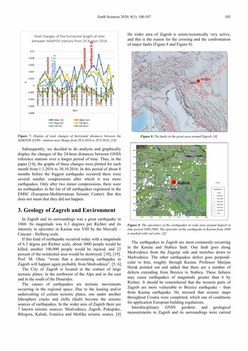
He wider area of Zagreb is seism-tectonically very active,
and this is the reason for the crossing and the confrontation
of major faults (Figure 8 and Figure 9).
Figure 8. The faults in the great area around Zagreb. [4]
Figure 9. The epicenters of the earthquakes in wide area around Zagreb in
time period 1880-2004. The epicenter of the earthquake in Kasina from 1880
is marked with red color. [4]
The earthquakes in Zagreb are most commonly occurring
in the Kasina and Stubica fault. One fault goes along
Medvednica from the Zagorje side and stretches down to
Medvednica. The other earthquakes defect goes perpendi-
cular to him, roughly through Kasina. Professor Marijan
Herak pointed out and added that there are a number of
defects extending from Brezica to Stubica. These failures
may cause earthquakes of magnitude greater than 6 by
Richter. It should be remembered that the western parts of
Zagreb are more vulnerable to Brezice earthquake – than
from Kasina earthquake. He stressed that seismic maps
throughout Croatia were completed, which one of conditions
for application European building regulations.
Interdisciplinary GNSS geodetic and geological
measurements in Zagreb and its surroundings were carried

104 Nikola Solaric et al.: Reference GNSS Stations for Warning on Possibility of Upcoming Earthquake in Zagreb
out from 1997 to 2015. They analyzed and compared results
of measurements from 2008 to 2015. The measurements
confirmed the constant presence of tectonic activity in the
wider area around Medvednica [9]. This indicates that
earthquakes are possible in the Zagreb area in future.
4. Proposal
The previous three examples of the earthquakes (Kraljevo,
Drežnica and Skopje) were analyzed by "The method of daily
changing the distances between GNSS permanent referent
stations". Based on these results we can conclude that this
method can help geophysics with other own methods for
eventual earthquakes warning in Zagreb. Today in Zagreb
there are approximately million inhabitants and it would be
very useful to try within CROPOS to establish department
for processing and analysis of GNSS measurement data of
the referent stations in order to detect the appearance of
compression in earth crust. In this case, after one or more
days there is a greater chance to expect earthquakes.
That department would be useful and rational organized
within the Control Centre of CROPOS system to detect the
appearance of compression of the earth crust based on GNSS
measurements. With the help of other geophysical methods,
it is probably possible to announce the appearance of major
devastating earthquake in Zagreb and its surroundings. In this
way, the CROPOS network of permanent reference stations
would be used by surveyors, seismologists and other
geophysicists. By this way so the large invested financial
resources were rationally exploited.
Figure 10. CROPOS Network and three - quadrangles net with diagonal
lines and triangle with one GNSS station in triangle for warning the
earthquake in Zagreb and surroundings.
In this case, the area of Zagreb should be monitored from
daily changes of distances between referent GNSS stations.
The first would be analyzed, for example (Figure 10):
1. Blue quadrangle (Zagreb, Zabok, Cakovec, Bjelovar)
with diagonals,
2. Red quadrangle (Zagreb, Zabok, Bjelovar, Sisak) with
diagonals,
3. Green quadrangle (Zagreb, Karlovac, Brezice, Zabok)
with diagonals and
4. Yellow triangle (Sisak, Karlovac, Zabok) with GNSS
station Zagreb in this triangle.
The GNSS measurement data of the reference GNSS
stations would be used to determine compression in the
Earth's crust which precedes the earthquake two or some
days later. Also, it will be necessary to predict magnitude of
this earthquake especially if it is a devastating earthquake.
For this purpose, it will be necessary to have great experience
and from largeness of compression tray to predict magnitude
of earthquake. By this way we will probably be capable to
announce the appearance of devastating earthquakes. It
would be necessary to have great experience for evaluation
of compression to predict what magnitude will be earthquake.
This is important especially if it will be a devastating
earthquake greater than about magnitude of 5.0 per Richter.
Such a possible earthquake announcement would enable a
significant reduction in the number of victims in Zagreb e
and reduce the damage.
Today GNSS measurements still have a great perspective
of improving accuracy (precision) of positioning. Namely,
this can be achieved by installing transmitters on the
satellites with the third frequency. Also, the improvement of
precision of GNSS measurement is also increased by the
increase the number of navigation satellites. [8]. Namely, by
introducing new navigation systems Galileo and Beidou and
modernizing of existing navigation system GPS and
GLONASS. On that way a large number of highly accurate
navigation satellites are obtained with the ability to achieve
high-precision coordinates of GNSS stations.
For monitoring the area around the Krško nuclear power
plant, it is necessary to make detailed analysis together with
Slovenian colleagues.
5. Earthquakes Near Zagreb in 2018
Seismographs of the Seismological Service of the
Republic of Croatia recorded a moderate earthquake with an
epicenter ten kilometers south+east of Velika Gorica near
Kuce (Figure 11) at 6 hours, 27 minutes, 34.3 seconds on
November 24, 2018. The magnitude of the earthquake was
2.7 according to Richter, and in area of epicenter could sense
grade III-IV intensities according to the Mercalli-Cancani-
Sieberg (MCS) scale. [18]
Also, the seismographs of the Seismological Service
recorded a weak earthquake with the epicenter at Markovo
Polje, between Kasina and Sesvete near Zagreb (Figure 11),
at 8 hours and 23 minutes on November 26, 2018. The
earthquake had a magnitude of M=2.4 according to Richter.
Based on magnitude, the intensity at the epicenter of grade
III-IV of the Mercalli-Cancani-Sieberg (MCS) scale was
calculated. This earthquake was not registered in EMSC

Earth Sciences 2020; 9(3): 100-107 105
(European-Mediterranean Seismic Center) but you can see
information about this earthquake. [19] In this area in Croatia
there were no other registered earthquakes until 8.12.2018 in
the EMSC and in Seismological service. [17]
The first, we calculated the daily changes in lengths
between GNSS reference stations in the CROPOS network
near Zagreb (Figure 11), mostly in the red square of Zabok-
Zagreb, Zabok-Bjelovar, Zagreb-Bjelovar, Zagreb-Sisak,
Sisak-Bjelovar, Zabok-Cakovec, Zagreb-Cakovec.
Table 1. Daily changes in lengths between CROPOS GNSS reference stations.
Date Zagreb-Cakovec Zagreb-
Zabok
Zagreb-
Bjelovar Zagreb-Sisak
Zabok-
Cakovec
Zabok-
Bjelovar
Bjelovar-
Sisak
18.11.2018 1.74 0.12 -0.27 0.35 1.19 -0.82 0.14
19.11.2018 -1.45 -1.71 -0.14 -1.01 0.08 0.69 1.57
20.11.2018 1.33 1.51 1.09 0.46 -0.38 -0.78 -1.71
21.11.2018 0.73 0.76 0.35 0.16 0.20 0.30 0.86
22.11.2018 -0.88 -0.72 -0.13 0.49 -0.20 -0.14 0.17
23.11.2018 0.41 -0.31 -0.37 0.34 1.00 0.22 -0.33
24.11.2018 0.43 -0.08 0.77 -0.05 0.06 -0.14 0.60
25.11.2018 0.85 -0.05 0.15 -1.14 0.12 -0.90 0.03
26.11.2018 -0.82 0.56 -0.38 0.26 -0.83 0.41 -0.14
Earthquakes: 24.11.2018 (ML=2.7 per Richter) and 26.11.2018 (ML=2.4 per Richter).
Figure 11. The map of Zagreb with surroundings and epicenters of
earthquakes in the 2018, and the epicenter of the largest earthquake in
Zagreb in 1880 near Kasina.
Based on the calculated daily length changes between the
GNSS reference stations, a graph of the daily length changes
(Figure 12) and (Table 1) was made. From it can be seen that
there was a compression on 19.11.2018, i.e. shortening side
Zagreb–Zabok up to a length of 1.7 mm/day and sides
Zagreb-Cakovec, Zagreb-Bjelovar, Zagreb-Sisak for slightly
smaller amounts were reduced. Five days after on the 24
November 2018 was earthquake magnitude 2.7 according to
Richter scale in Kuce. The compression of the day
20.11.2019 continued but on other sites, which do not
intersect at the same point. So, there is no earthquake behind
these compressions. The compression ware on the
22.11.2018 in the 5 sites and after 4 days was earthquake
26.11.2018. in Markovo polje.
Figure 12. The daily changes in sites length between CROPOS reference
GNSS stations.
There was a little less compression 22 November 2018, as
there was a slight reduction in some lengths up to 1 mm/day,
and the two sites extended (see Table 1). After the 4 days
compression on 26 November 2018 there was a smaller
magnitude 2.5 earthquake according to Richter. From this it
can be seen that by this method of daily changes the lengths
between the GNSS reference stations could also be indicated
by earthquakes of small magnitude of 2.5 according to
Richter.
6. Determination Position of Epicenters
Based on the sides where compression (shortening) occurs,
one cannot predict where will be epicenter of earthquake. But
it is possible determined area where it will be probably

106 Nikola Solaric et al.: Reference GNSS Stations for Warning on Possibility of Upcoming Earthquake in Zagreb
occurred. In each case, the point of the epicenter must be between the sides that are compressed i.e. shortened Figure 13.
Figure 13. Assessment position of earthquakes epicenters.
7. Conclusion
This analysis proves that it makes sense that a part of the
service will be organized at the CROPOS Center in Zagreb. It
will monitor daily changes of lengths in the Zagreb area between
GNSS reference stations and announce ground compressions,
after which an earthquake may occur in compressed faults.
According to the size of the compression, when it is estimated
that this could cause an earthquake of magnitude greater than
approximately 5.0 according to Richter, one should consider
carefully alerting people to a possible earthquake.
Probably for this purpose big experience will be required.
When it is confirmed that it was proper to organize in
Zagreb a part of the service that will monitor the application
of lengths between reference stations. Such service should be
organized to monitor the lengths around the Krsko Nuclear
Power Plant, near Dubrovnik, Split, Rijeka, and wherever
necessary.
Acknowledgements
We are grateful to our colleague’s Zeljko and Kristijan
Gulija from the company Geowild, representatives of Leica
Geosystems from Zagreb, for connecting us with the
colleagues from the Agency for Real Estate Cadastre (AREC)
in Macedonia. Also, we are very grateful to Dipl. Eng. Saso
Dimeski Head of Sector for geodetic works of the AREC in
Macedonia, who gave to us the calculated coordinates of the
4 MAKPOS GNSS reference stations around of Skopje but
also participated in writing this paper. Thank much to Ph. D.
Marko Pavasovic, and mag. sc. Marija Pejakovic for partially
assistance in developing this work.
Many thank for useful discussions and helpful advice to
Prof. Ph. D. Eduard Prelogovic and Prof. Ph. D. Marijan
Herak.
References
[1] Dalovic S., Skrnjug J. (2011): Analiza promjena dužina baznih linija permanentnih stanica pre i nakon zemljotresa u Kraljevu (Analysis of changes length of the base lines of permanent stations before and after the earthquake in Kraljevo), Geodetska sluzba, 114, 12–19, (Serbia).
[2] Kuk V., Prelogovic E., Sovic I., Kuk K., Sariri K. (2000): Seizmoloske i Seizmotektonske znacajke zagrebackog podrucja (Seismological and seism-tectonically properties of the wider Zagreb area), Gradevinar 52, 11, 647-653 (Croatia). JCE-52-2000-11-02 Rasjedi u okolici Zagreba.pdf (Accessed 4 November 2018).
[3] Marjanovic M., Basic T. (2010): CROPOS – Positioning Easier than Ever, Trimble Dimensions 2010 Conference Converge, Connect and Collaborate, 8–10 November 2010, Las Vegas, USA.
[4] Miklin Z. (2007): Potresi na zagrebackom podrucju (Earthquakes in the Zagreb area) (Kuk V. 2007), http://www.hgi-cgs.hr/zagreb_potresi.html (Accessed 4 November 2018).
[5] Oluic M. (GEOSAT Ltd, Croatia) (2015a): Remote Sensing in Pre-earthquakes Exploration, Case Study of Zagreb Region, Universal Journal of Geosciences 3 (6): 195-197. http://www.hrpub.org DOI: 10.13189/ujg.2015.030603 (Accessed 4 November 2018).
[6] Oluic M. (2015b): Potresi uzroci nastanka i posljedice s posebnim osvrtom na Hrvatsku i s posebnim osvrtom na Hrvatsku i susjedna podrucja (Earthquakes, the causes and consequences with special attention to Croatia and neighboring areas), izdavac (publisher) Prosvjeta– Zagreb (Croatia).
[7] Pavasovic M., Marjanovic M., Basic T. (2015): CROPOS kao Hrvatski terestricki Referentni okvir (CROPOS as Croatian Terrestrial Reference Frame), Proceedings, 4th CROPOS Conference, 22 May 2015, 26–29, Zagreb, Croatia.

Earth Sciences 2020; 9(3): 100-107 107
[8] Premuzic M., Sugar D., Bacic Z. (2018): Mogucnosti pozicioniranja primjenom Sustava Galileo i novih metoda mrežnog rjesenja (Positioning possibilities through the application of Galileo system and network positioning methods), 5. CROPOS konferencija – Zbornika radova, Zagreb, studeni 2018, 55-68. http://www.cropos.hr/files/docs/5-konferencija/Zbornik_radova.pdf (Accessed 4 November 2018).
[9] Pribicevic B., Dapo A., (2016): Analiza pomaka na Geodinamickoj mrezi Grada Zagreba iz razlicitih vremenskih epoha, (Shift analysis on the City Geodynamic Network of Zagreb from different epochs), Geodetski list, 70 (93), 3, 207 –230 (Croatia). https://hrcak.srce.hr/index.php?show=clanak&id_clanak_jezik=249933 (Accessed 4 November 2018). http://www.hgi-cgs.hr/zagreb potresi.html (Accessed 4 November 2018).
[10] Rudeš T. (2010): Zagreb 6, 5 po Richteru - četvrtina grada bila bi sravnjena sa zemljom, (Zagreb 6.5 per Richter - a quarter of a city would be dumped with the earth) Jutarnji list 13.03.2010. https://www.jutarnji.hr/.../zagreb-65-po-richteru-cetvrtina-grada-bila-bi-sravnjena-sa-z. (Accessed 4 November 2018).
[11] Solaric N., Solaric M., Svehla D. (2012a): Nove revolucionarne mogusnosti u geodeziji koje pruzaju otkrica za koja su dobivene Nobelove nagrade za fiziku 2005. i 1997. godine (New revolutionary opportunities in geodesy that provide the discoveries for which the 2005 and 1997 Nobel Prizes in Physics were awarded) Geodetski list Vol. 66 (92), 1, 1-19 (Croatia). https://hrcak.srce.hr/index.php?show=toc&id_broj=7007.
[12] Solaric N., Solaric M. (2012b): Prijedlog da se u Zagrebu i okolici uz CROPOS-ove stanice postavi nekoliko GPS (GNSS) permanentnih stanica za geodinamiku i mogucu najavu veceg zemljotresa u slijedecem periodu vremena (Proposal for Zagreb and Surroundings a few GNSS permanent stations for geodynamics and possibility the announcement of larger earthquake in the future period), Geodetski list, Vol. 66 (92, 149-164 (Croatia). http://hrcak.srce.hr/95827 (Accessed 4 November 2018).
[13] Solaric N., Solaric M., Pejakovic M. (2017): Dva dana prije potresa u Dreznici 2013. godine doslo je do kompresije terena (Two days before the Earthquake in Dreznica 2013 there has been compression of terrain), Geodetski list, Vol. 71 (94), No. 3, 203-214. (Croatia) https://hrcak.srce.hr/index.php?show=clanak&id_clanak_jezik=279500 (Accessed 4 November 2018).
[14] Solaric N., Solaric M., Bogdanovski Z., Dimeski S. (2018): Three days before the Earthquake in Skopje there was a compression of the Earth's crust, Geodetski list, Vol. 72 (95), No. 1, 15-35 (2018), https://hrcak.srce.hr/200222 (Accessed 4 November).
[15] URL 1: Stanovnici Dreznice o potresu: Tutnjalo je kao da dolazi vlak” (Residents of Dreznica about the earthquake: Has roared as if comes the train”), http://www.24sata.hr/news/graani-zovu-112-tresli-se-sjeverno-primorje-i-zagreb326069, (Accessed 4 November 2018).
[16] URL 2: U zemljotresu u Makedoniji oko 50 povrijedenih, građani u panici (In the Earthquake in Macedonia about 50 injured, citizens in panic), https://www.klix.ba/vijesti/regija/u-zemljotresu-u-makedoniji-oko-50-povrijedjenih- gradjani-u-panici/ 160911075, (Accessed 4 December 2018).
[17] URL 3: Seizmoloska sluzba: Izvjesca o potresima (Seismological Service: Earthquake Reports) (Accessed 4 December 2018).
[18] URL 4: Potres magnitude 2, 7 prema Richteru zatresao je jutros podrucje Velike Gorice, a osjetili su ga i Zagrepcani (A magnitude of 2.7 earthquake according to Richter shook this morning Velika Gorica, and was felt by the people of Zagreb.) https://www.google.hr/search?source=hp&ei=o5BtXef-Ha_orgT1j6_ACQ&q=Potres+magnitude+2%2C7+prema+Richteru+zatresao+je+ jutros+područje+Velike++Gorice%2C (Accessed 4 December 2018).
[19] URL 5: Ponovno potres kod Zagreba (Earthquake near Zagreb again) http://hr.n1info.com/Vijesti/a350548/Potres-kod-Zagreba.html (Accessed 4 December 2018).