reducing carbon emissions from deforestation in the ulu...
TRANSCRIPT
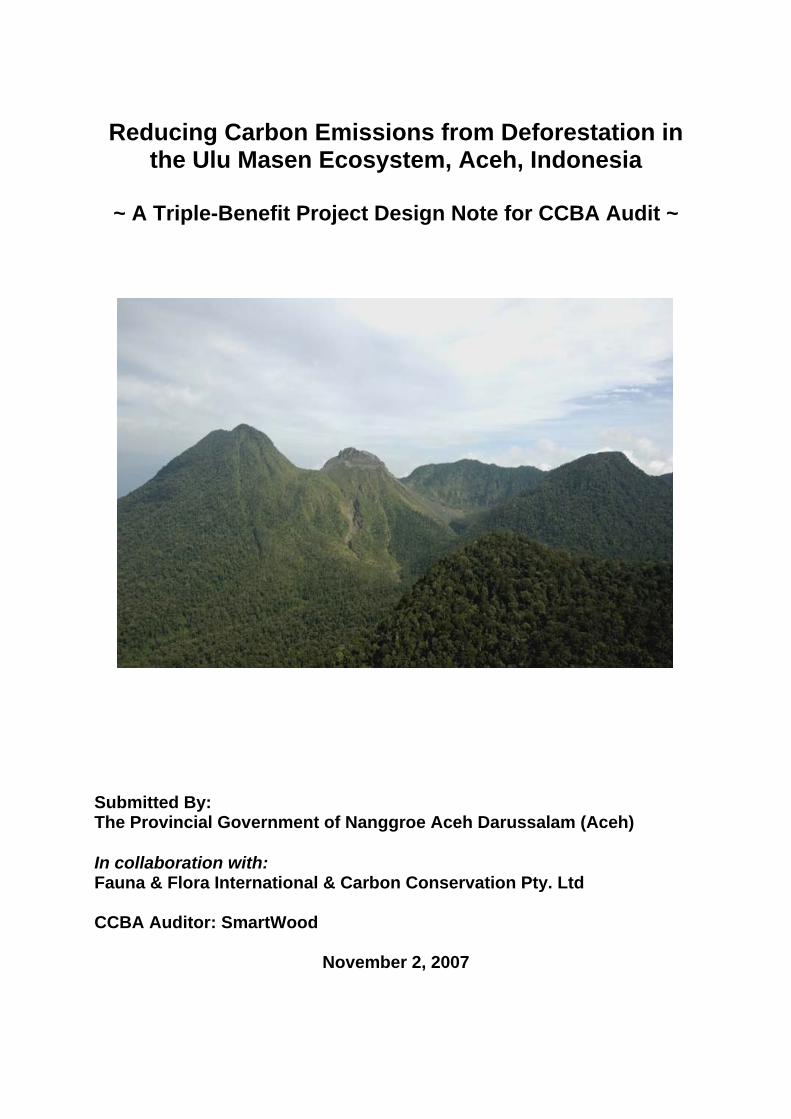
Reducing Carbon Emissions from Deforestation in
the Ulu Masen Ecosystem, Aceh, Indonesia
~ A Triple-Benefit Project Design Note for CCBA Audit ~
Submitted By: The Provincial Government of Nanggroe Aceh Darussalam (Aceh) In collaboration with: Fauna & Flora International & Carbon Conservation Pty. Ltd CCBA Auditor: SmartWood
November 2, 2007

Executive Summary This project will develop and test carbon finance mechanisms to reduce greenhouse gas emissions, contribute to sustainable economic and social development and conserve biodiversity over the next 30 years. The project will use land use planning and reclassification, increased monitoring and law enforcement, reforestation, restoration, and sustainable community logging on 750,000 ha of forest in the Ulu Masen Ecosystem located in the Indonesian Province of Nanggroe Aceh Darussalam (hereafter referred to as Aceh Province). The project estimates proposed activities will reduce deforestation in the area by 85% and 3,369,848 tons of CO2 emissions can be avoided each year. Adequate carbon finance is essential for this project to succeed. This Project Design Note is intended to provide a qualified CCBA auditor with sufficient information to make informed decision on whether the project passes CCBA validation, and if so at what level (basic, silver or gold). The project will be undertaken by the Government of Aceh and its institutions, with expected endorsement and support of the national Government of Indonesia (GOI) and relevant agencies. The proposal has been submitted for review to the National Working Group on Climate and Forests as a pilot project for reducing emissions from deforestation and degradation (REDD). The project is supported by a partnership of non-governmental and civil-society organizations (NGOs/CSOs) led by Fauna and Flora International (FFI). Carbon Conservation Ltd, PTY is the lead private company assisting with project design, development, start-up and carbon finance at the request of the Governor Irwandi’s office. Leadership by the Provincial Government will ensure compliance with, and integration with, governmental and regulatory structures, while FFI, its NGO partners and locally based CSOs will facilitate participatory processes for community development, spatial and land use planning, biodiversity conservation, collaborative law enforcement and community-based forest management. All project proponents are committed to ensuring that benefits are equitably shared among stakeholders, including forest dependent communities and those with customary rights to forest land. The project has been conceived to ensure that stakeholder confidence and commitment will be built through a participatory and transparent process. All levels of government and civil society have been invited to contribute to the design and implementation of project activities and initial community consultations have begun. In particular, traditional Mukim leaders have a critical role in the management of land and natural resources in Aceh’s rural communities, typically being responsible for between three and eight villages. Though their authority was undermined during the years of conflict, Mukim leaders are now formally recognised under Aceh’s Special Autonomy Law. Incentive payments to stakeholders for the delivery of forest protection will be initially funded from official development aid (ODA) funds. After the initial phase of the project, carbon finance from sale of Verified Emission Reductions (VERs) must be secured. This is contingent on:
1
• Emergence of a real market for REDD credits that allow sustainable forest land uses to out-compete unsustainable logging and forest conversion;
• Independent review and approval of this project’s baseline land use and carbon emission scenario
• Actual reductions in deforestation and degradation in the project area • Development of robust forest monitoring and carbon accounting systems. • Measures to address possible leakage and permanence concerns of credits.
2

1. Current Conditions & Background Aceh Province has a population of just over four million people and lies at the northern tip of the island of Sumatra. Aceh Province retains the largest contiguous area of forest left in Sumatra, stretching from near the northern city of Banda Aceh to the border with North Sumatra province. Much of these forests cover the Bukit Barisan Mountains, which runs down the spine of northern Sumatra (see Map 1). The mountains of the Bukit Barisan range are considered as giving rise to two distinct but connected ecosystems, the Ulu Masen ecosystem, which forms the northern-most forest and the Leuser ecosystem reaching from the southern part of Aceh into the province of North Sumatra. The Gunung Leuser National Park lies within Leuser ecosystem, a large landscape protected by presidential decree. While the National Park Status provides a strong legal status for protection, the Leuser Ecosystem is a multi-functional landscape and provides limited legal protection due to conflicting laws that give authority to provincial and district government for land use planning.
This project will focus on contiguous forests within the Ulu Masen ecosystem, a 750,000 hectare block of forest1 located in the four northernmost districts or kabupaten of Aceh Province, namely Aceh Besar, Aceh Jaya, Aceh Barat, and Pidie2. The Ulu Masen ecosystem is situated between 4’’20’3 N and 5’’30’0 N between 95’’20’0 East and 96’’30’0 East. Map 1. Aceh, Indonesia
1 Slight variations on project area depend on the type of file used to generate output tables. In general,
grid calculations are slightly larger than shape files. 2 Pidie District was sub-divided into 2 districts, Pidie and Pidie Jaya, but are considered one for the
purposes of this document.
3

1.1 Physical Parameters (soil, geology, climate) 1.1.1 Geology The Bukit Barisan Mountains comprise several different geological formations, the differing characteristics of each determining differences in the overlying soils, the hydrology, the vegetation cover and biological productivity. Extensive limestone areas, including karst limestone formations, are typically porous, retaining little surface water and having relatively low productivity. Intrusions of igneous granodiorites, for example in the Krueng Sabe watershed of Aceh Jaya district, have low porosity, thin soils and also have relatively low productivity. Map 2. Geology of Aceh
1.1.2 Climate The climate of Aceh is described as tropical with high humidity (80-90%) and little variation in mean daily temperature (25-27 °C) throughout the seasons. Mean annual temperature varies with elevation, decreasing from about 26°C at sea level by approximately 0.52°C per 100m rise in elevation3. While the steamy hot lowlands
3 Binnie & Partners. 1986. Inventory of Water Resources Schemes – Volume 2 - Existing Situation. Aceh Design Unit – Provincial Water Resources Development Plan Binnie and Partners Ltd. with Hunting Technical Surveys Ltd. and Hunting Surveys Ltd. - Ministry of Public Works, General
4

have a mean annual soil temperature of above 22°C, the mountain tops have a mean between 0-8°C (3000m and above)4. Wind speeds are generally low ranging between 1.5- 2.5 m/sec, though higher wind speeds have been observed in coastal areas5. The region can be classified into 11 rainfall types, based on the long term average number of wet and dry months6. The mapping of these zones for northern Sumatra and Aceh are shown in Map 3 Map 3. Rainfall Zonation in Aceh (source: Oldeman et al. 1979)
Directorate of Water Resources Development, Directorate of Planning and Programming Jakarta 4 van Beek, C. C. G. 1996. Geology, Geomorphology and Climate of Gunung Leuser National Park. Pages 33 - 48 in C. P. van Schaik and J. Supriatna, editors. Lueser - A Sumatran Sanctuary. Yayasan Bina Sains Hayati Indonesia, Jakarta, Indonesia 5 IWACO. 1993a. Study of water sources for allocation of water supply for for D. I. Aceh Province - Kabupaten Aceh Barat IWACO. IWACO. 1993b. Study of water sources for allocation of water supply for for D. I. Aceh Province - Kotmadya Banda Aceh Planning of Water Supply Development and Raw Water Sources Allocation IWACO. 6 Oldeman, L. R., I. Las, and S. N. Darwis. 1979. An agroclimatic map of Sumatra. Contributions Central Research Institute for Agriculture, Bogor 52 (1979):35.
5

In reference to this classification, the Aceh west coast and foothills and eastern Barisan mountains are mapped as the very wettest A and Af types (> 9 wet and < 2 dry months). More elevated Barisan mountains are mapped as slightly less wet B1 type (7 – 9 wet and < 2 dry months). The north eastern and eastern foothills of Aceh are the next driest types C1 and C2 (5 – 6 wet and < 2- 3 dry months). The rain-shadow areas of the Semangka fault (at Takengon and eastwards) and northern eastern coastal plains below the foothills are a dry type D1 and D2 (3 – 4 wet and < 2 – 3 dry months). Finally, the lower Kreung Aceh valley, and north and north eastern coastlines of Aceh are mapped as the driest type E2 (< 3 wet and 2 -3 dry months) climate. Mean annual rainfall in Aceh varies widely, caused partly by the complex inter-relationship between topography and precipitation. Based on Binnie and Partner’s 1980’s water resources review the region of highest rainfall is along the west coast and inland as far as the Barisan mountain range, with amounts between 3000 mm and 5000 mm per annum. In contrast, mean annual rainfall ranged from 1000 mm to 1500 mm in small areas along the north and east coast, with totals as low as 1500 mm in the inter-montane basin between Takengon and Owaq in Aceh Tengah. 1.1.3 Soil Detailed soil maps are available for the project area, but due to their size and complexity, and in the interest of space, they are not included in this document. Full land system classifications were conducted under the RePPProt study7. 1.1.4 Vegetation Types and Conditions The Ulu Masen mountains are known to support a diversity of forest types, due to their complex geology, climate types, range of soil types and altitudinal range. Forest type classifications carried out in the past recorded lowland broadleaf forest, pine forest, sub-montane broadleaf forest, montane broadleaf forest, and peat swamp forest. Most of the rich lowland forests that covered the plains along the coast have been converted to agriculture and other uses. There are still some remaining pockets of swamp and peat swamp forests along the west coast. In most areas above 500 meters there are still substantial areas of high quality forest. 1.2 Carbon Carbon stocks of tropical forest ecosystems are distributed in above ground and below ground biomass, litter and woody debris, and soil carbon. Biomass is the total dry mass of living matter in a tree and provides a means of estimating “forest carbon stocks”. Forest carbon stocks include the total amount of carbon stored in living above ground (branches and trunk) and below ground (roots) biomass.
7 RePPProt. 1988. Sumatra - Review of Phase I Results. Volume Two - Annexes 1-5, Regional Physical Planning Programme for Transmigration (RePPProt), Natural Resource Institute, ODNRI, ODA, London, England - Direktorat Bina Program, Direktorat Jenderal Penyiapan Pemukiman, Departemen Transmigrasi (Ministry of Transmigration), Jakarta, Jakarta, Indonesia
6

The most commonly accepted way to estimate forest carbon stocks over large areas is to apply carbon values to broad forest classes, the “biome-average approach”. This is the approach required by Tier 1 of the IPCC’s National Greenhouse Gas Inventories. Biome averages are freely available in the published literature and provide a source of globally-consistent information. Despite uncertainties, biome averages continue to be the most routinely used as the first approximation source of forest carbon stock data for estimating emissions from large-scale deforestation8. However, in reality, forest carbon stocks vary within biomes according to drainage, soil type, land-use history and other variables. Table 1. The IPCC 2006 National Guidelines for Greenhouse Gas Inventories. (See attached worksheet “IPCC Default Tables”)
350
IPCC Default value for above ground biomass tropical moist forest, insular Asia, table 4.7
0.47
IPCC Default value for carbon fraction of above ground biomass (tropical and subtropical), table 4.3
164.5 Tons of above ground carbon per hectare
1.37
Tropical rainforest conversion from above ground to total biomass (table 4.4)
225.4 IPCC Estimate of Per Hectare Carbon in Insular Asia (appropriate for Ulu Masen)
Project proponents commissioned research to estimate forest carbon in Ulu Masen using five biome average models. The models were run using the widely-accepted 2000 Global Land Cover Map (GLC 2000). This is the first example of a multi-model estimate approach of most major prominent carbon models being used to generate carbon estimates in forests at a scale of 1 km2 in the Ulu Masen area. These models include: Houghton, Olson, IPCC, Achard and Brown/Gibbs. The Olson model is based on a large compilation of literature studies and has three models for estimating carbon -high, medium and low carbon stocks per area. The Olson “medium” biomass estimates were used for these calculations. The Houghton model includes above ground, below ground, and ground cover carbon stocks. Values were obtained from summaries of global vegetation and from regional studies. The IPCC model is Tier 1 default values for the area, and produce the highest estimates (the most carbon per unit area) of all models. IPCC default values have been formally adopted as the best practices for estimating national carbon stocks. The Achard model weighted the country biomass figures from Brown by the 8 Ramankutty, N., H. K. Gibbs, F. Achard, R. DeFries, J. A. Foley, R. A. Houghton. 2007. Challenges to estimating carbon emissions from tropical deforestation. Global Change Biology 13(1):51-66.
7

FAO 1990 forest area country figures. The Gibbs and Brown model estimated forest carbon stocks for Southeast Asia using a rule-base GIS analysis to spatially extrapolated forest inventory data archived by the FAO based on climate, soils, topographic, population, and land use information. A forthcoming publication currently in review will provide more detailed notes on methods9. All of the non-IPCC models are based on a limited number of forest classes, though more detailed than the IPCC Tier 1 default values. Thus, the models can be thought of as “reasonably accurate” initial estimates. Averaging these five models, there are an estimated 188 tons of carbon per hectare in the Ulu Masen ecosystem, of which 20% is assumed to be below ground (150 tC above ground and 38 tC below ground). This average combines both intact and disturbed forests and does not discriminate for elevation. These two factors are critical and so project proponents took the average of all five models and made two other key assumptions to provide a higher-level of initial carbon estimate quality. 1st Assumption Disturbed forests have 75% of the carbon stocks as intact forests (FFI personal communication, 2007) and 63% of the forests in Ulu Masen are intact (see Table 2 below). Based on this assumption, project proponents estimate values for intact and disturbed forests in Ulu Masen at 200 tC/ha and 150 tC/ha respectively. [These numbers are “relatively round” only by coincidence – they were generated using the average value from the five global carbon models, accounting for the estimated average level of carbon loss associated with degradation, and the amount of degraded forests in the project area]. 2nd Assumption We used a simple elevation approach to model variability of carbon with elevation. We assumed the 500-1000 meter altitudinal band would have the average carbon levels (200 tC/ha and 150 tC/ha for intact and disturbed forests). We then assumed that the 0-500 meter band would be 10tC/ha higher (a total of 210tC/ha and 160tC/ha) and that higher elevations would decline slightly (see Table 2 and attached worksheet “Carbon Assumptions”). Using these two simple assumptions on top of five global carbon models, we populated a forest carbon model that produces unique carbon stocks estimates for forest classes based on elevation and disturbance. Table 2 (see worksheet “Carbon Assumptions”).
Forest Condition Intact Disturbed Area-Weighted Average
Elevation 0-500 210 160 182 500-1000 200 150 194 1000-1500 190 140 189 >1500 180 130 180
9 Gibbs, H., S. Brown, J. Niles and J Foley. 2007. Can Forest Carbon Stocks Be Measured in
Developing Countries? In press at Environmental Research Letters.
8
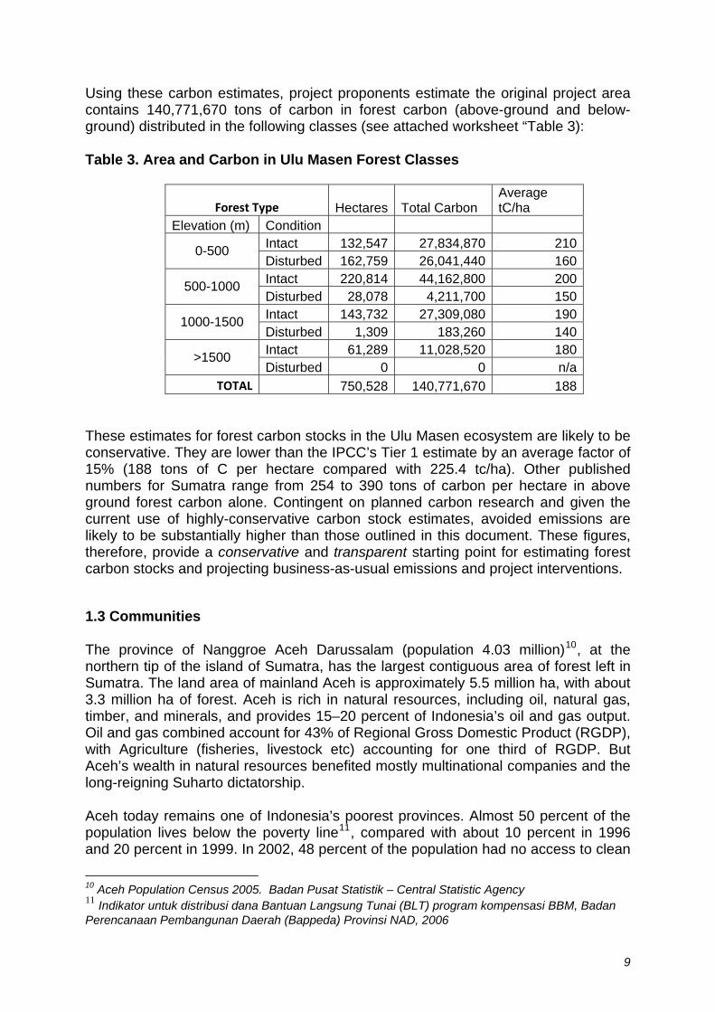
Using these carbon estimates, project proponents estimate the original project area contains 140,771,670 tons of carbon in forest carbon (above-ground and below-ground) distributed in the following classes (see attached worksheet “Table 3): Table 3. Area and Carbon in Ulu Masen Forest Classes
Forest Type Hectares Total Carbon Average tC/ha
Elevation (m) Condition Intact 132,547 27,834,870 210 0-500 Disturbed 162,759 26,041,440 160 Intact 220,814 44,162,800 200 500-1000 Disturbed 28,078 4,211,700 150 Intact 143,732 27,309,080 190 1000-1500 Disturbed 1,309 183,260 140 Intact 61,289 11,028,520 180 >1500 Disturbed 0 0 n/a
TOTAL 750,528 140,771,670 188 These estimates for forest carbon stocks in the Ulu Masen ecosystem are likely to be conservative. They are lower than the IPCC’s Tier 1 estimate by an average factor of 15% (188 tons of C per hectare compared with 225.4 tc/ha). Other published numbers for Sumatra range from 254 to 390 tons of carbon per hectare in above ground forest carbon alone. Contingent on planned carbon research and given the current use of highly-conservative carbon stock estimates, avoided emissions are likely to be substantially higher than those outlined in this document. These figures, therefore, provide a conservative and transparent starting point for estimating forest carbon stocks and projecting business-as-usual emissions and project interventions.
1.3 Communities
The province of Nanggroe Aceh Darussalam (population 4.03 million)10, at the northern tip of the island of Sumatra, has the largest contiguous area of forest left in Sumatra. The land area of mainland Aceh is approximately 5.5 million ha, with about 3.3 million ha of forest. Aceh is rich in natural resources, including oil, natural gas, timber, and minerals, and provides 15–20 percent of Indonesia’s oil and gas output. Oil and gas combined account for 43% of Regional Gross Domestic Product (RGDP), with Agriculture (fisheries, livestock etc) accounting for one third of RGDP. But Aceh’s wealth in natural resources benefited mostly multinational companies and the long-reigning Suharto dictatorship.
Aceh today remains one of Indonesia’s poorest provinces. Almost 50 percent of the population lives below the poverty line11, compared with about 10 percent in 1996 and 20 percent in 1999. In 2002, 48 percent of the population had no access to clean
10 Aceh Population Census 2005. Badan Pusat Statistik – Central Statistic Agency 11 Indikator untuk distribusi dana Bantuan Langsung Tunai (BLT) program kompensasi BBM, Badan Perencanaan Pembangunan Daerah (Bappeda) Provinsi NAD, 2006
9
water, 36 percent of children under the age of five were undernourished, and 38 percent of the Acehnese had no access to health facilities12.
Though unique in many ways, and now with the new autonomy laws in place, in a position to change, Aceh Province has been typical of many resource-rich regions, in that the wealth that has been accrued through the exploitation of these resources has not improved the welfare or contributed towards the livelihoods of the majority of the population. Rural communities in particular have been alienated from resources to which they can claim traditional rights. Much of this failure to convert resource wealth into community development has been the result of policies that effectively override customary tenure in an effort to facilitate investment by providing investors but not communities secure tenure, by corruption within the previous government’s institutions, and by the state of emergency.
The 2004 tsunami caused incomprehensible damage and devastating loss of life to the province, with over 150,000 dead or missing, 127,000 houses destroyed and a similar number damaged, over 500,000 homeless, 230 km of roads destroyed13, damage to over 37,500 hectares of land14 and 90% of surface corals and vast areas of mangroves.
Aceh was a province in difficulty even before the tsunami. For years the people and economy had suffered under the conflict in the preceding 30 years, particularly during the ten year period when Aceh was declared a Military Operational Area (Daerah Operasi Militer, or DOM) and the Martial law (Darurat Militer) status that came into effect in 2003.
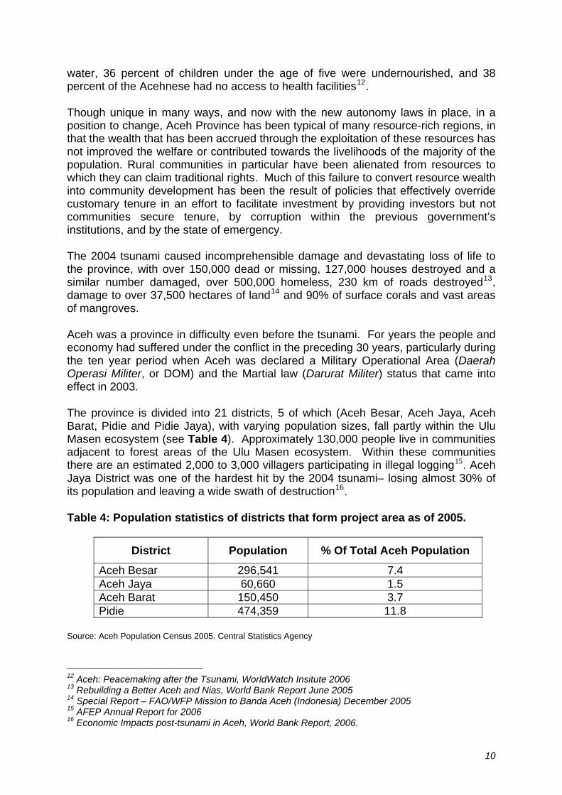
The province is divided into 21 districts, 5 of which (Aceh Besar, Aceh Jaya, Aceh Barat, Pidie and Pidie Jaya), with varying population sizes, fall partly within the Ulu Masen ecosystem (see Table 4). Approximately 130,000 people live in communities adjacent to forest areas of the Ulu Masen ecosystem. Within these communities there are an estimated 2,000 to 3,000 villagers participating in illegal logging15. Aceh Jaya District was one of the hardest hit by the 2004 tsunami– losing almost 30% of its population and leaving a wide swath of destruction16.
Table 4: Population statistics of districts that form project area as of 2005.
District Population % Of Total Aceh Population
Aceh Besar 296,541 7.4 Aceh Jaya 60,660 1.5 Aceh Barat 150,450 3.7 Pidie 474,359 11.8
Source: Aceh Population Census 2005. Central Statistics Agency
12 Aceh: Peacemaking after the Tsunami, WorldWatch Insitute 2006 13 Rebuilding a Better Aceh and Nias, World Bank Report June 2005 14 Special Report – FAO/WFP Mission to Banda Aceh (Indonesia) December 2005 15 AFEP Annual Report for 2006 16 Economic Impacts post-tsunami in Aceh, World Bank Report, 2006.
10
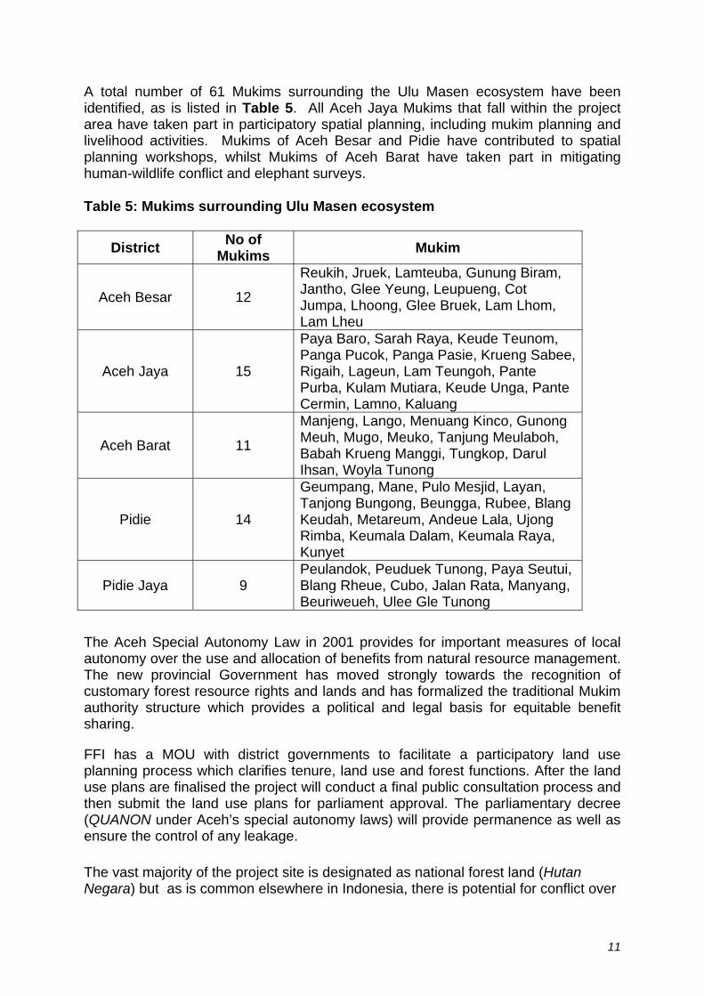
A total number of 61 Mukims surrounding the Ulu Masen ecosystem have been identified, as is listed in Table 5. All Aceh Jaya Mukims that fall within the project area have taken part in participatory spatial planning, including mukim planning and livelihood activities. Mukims of Aceh Besar and Pidie have contributed to spatial planning workshops, whilst Mukims of Aceh Barat have taken part in mitigating human-wildlife conflict and elephant surveys.
Table 5: Mukims surrounding Ulu Masen ecosystem
District No of Mukims Mukim
Aceh Besar 12
Reukih, Jruek, Lamteuba, Gunung Biram, Jantho, Glee Yeung, Leupueng, Cot Jumpa, Lhoong, Glee Bruek, Lam Lhom, Lam Lheu
Aceh Jaya 15
Paya Baro, Sarah Raya, Keude Teunom, Panga Pucok, Panga Pasie, Krueng Sabee, Rigaih, Lageun, Lam Teungoh, Pante Purba, Kulam Mutiara, Keude Unga, Pante Cermin, Lamno, Kaluang
Aceh Barat 11
Manjeng, Lango, Menuang Kinco, Gunong Meuh, Mugo, Meuko, Tanjung Meulaboh, Babah Krueng Manggi, Tungkop, Darul Ihsan, Woyla Tunong
Pidie 14
Geumpang, Mane, Pulo Mesjid, Layan, Tanjong Bungong, Beungga, Rubee, Blang Keudah, Metareum, Andeue Lala, Ujong Rimba, Keumala Dalam, Keumala Raya, Kunyet
Pidie Jaya 9 Peulandok, Peuduek Tunong, Paya Seutui, Blang Rheue, Cubo, Jalan Rata, Manyang, Beuriweueh, Ulee Gle Tunong
The Aceh Special Autonomy Law in 2001 provides for important measures of local autonomy over the use and allocation of benefits from natural resource management. The new provincial Government has moved strongly towards the recognition of customary forest resource rights and lands and has formalized the traditional Mukim authority structure which provides a political and legal basis for equitable benefit sharing.
FFI has a MOU with district governments to facilitate a participatory land use planning process which clarifies tenure, land use and forest functions. After the land use plans are finalised the project will conduct a final public consultation process and then submit the land use plans for parliament approval. The parliamentary decree (QUANON under Aceh’s special autonomy laws) will provide permanence as well as ensure the control of any leakage. The vast majority of the project site is designated as national forest land (Hutan Negara) but as is common elsewhere in Indonesia, there is potential for conflict over
11
land status where local communities regard adjacent forest lands as traditional / customary lands. For example when mukim leaders are asked about the extent of the area under their management, they routinely claim that the adjacent forests are managed by the mukim. The new autonomy roles have strengthen the role of mukims and within the structure of these customary ‘adat’ institution there are people assigned to over see agriculture, forestry and fisheries within a mukim area, which usually consists of 4-8 villages. Mukims are democratically elected and then approved by government in their position as traditional leaders. While there is potential for conflicts of forest resources within the project area, these can be avoided by involving communities and Mukim leaders in the participatory land use planning process, establishing jointly agreed boundaries and land use patterns, and developing a multi-stakeholder management structure with community representation for the Ulu Masen ecosystem. This process has already been initiated by FFI. As an example the participatory landuse planning process has been completed in the district of Aceh Jaya and the resulting spatial is in the final public consultation process before being approved by district parliament. Land use varies throughout the districts in the project area. Detailed descriptions of land use current as of 2006 can be found in the Appendix of this report. Dominant agricultural land uses in the lowlands include coconut groves along the coast followed inland by rice paddies, rubber gardens, small holder coffee and cacao garden, complex agroforests with fruit trees and nutmeg trees, and to a lesser extend upland fields with annual crops.
1.4 Biodiversity The mountain, hill and lowland ecosystems of Aceh support high levels of plant and animal biodiversity including charismatic and endangered mega-fauna including the Sumatran rhinoceros, tiger, orang-utan and elephant. Fauna FFI Aceh began initial elephant surveys in 1998 however in 2003 field surveys became impossible due to the heightened conflict situation. With the signing of the peace agreement between GOI and GAM in August 2005 and GAM disarmament in the months to follow, FFI Aceh began biodiversity surveys in late 2006 focused on primates, in particular the endemic Sumatran orang-utan (Pongo abelli, an endangered great ape which only occurs in the northern part of Sumatra), birds (over 300 species identified to date), reptiles and amphibians (87 species identified to date). A comprehensive survey programme has also begun to determine the range and abundance of the endangered Sumatran elephant (Elephas maximus). In the near future a comprehensive occupancy survey of the resident population of Sumatran tiger (Panthera tigris sumatrae), also highly endangered, will be conducted. Results of surveys to date, plus reports from local informants indicate that the populations of both tigers and elephants are could be among the most important populations in Sumatra. In conjunction with the Leuser ecosystem (that is contiguous with the Ulu Masen system along the border of Aceh Barat and Nagan Raya districts), these populations represent the main hope for the survival of these species in the wild.
12

It is also believed that there is a population of the critically endangered Sumatran rhinoceros (Dicerorhinus sumatrensis) in the project area, but this has still to be confirmed. Endangered and protected mammals that are confirmed or believed to occur in the project area include (please note that this list does not include bats, mustellids, or rodents):
Taxa English name Confirmed (C)/ Unconfirmed (U)
Endemic
Arctonyx collaris Hog badger U Arctictis binturong Binturong C Catopuma badia Bay cat U Catopuma temminckii Golden cat C Capricornis sumatrensis Serow C Cervus Sambar deer C Cuon alpinus Ajag U Cynocephalus variegatus Colugo C Dicerorhinus sumatrensis Sumatran Rhinoceros U Elephas maximus Sumatran elephant C Helarctos malayanus Malayan Sunbear C Hylobates syndactylus Siamang C Hylobates lar White handed Gibbon C Hystrix brachyura Common porcupine C Manis javanica Pangolin C Muntiacus muntjak Barking deer C Neofelis nebulusa Clouded Leopard C Nycticebus coucang Slow Loris C Panthera tigris sumatrae Sumatran Tiger C E Pardofelis marmorata Marbled Cat U Pongo abelii Sumatran Orangutan C E Prionailurus bengalensis Leopard cat C Presbytis thomasi Thomas’s Langur C E Prionailurus planiceps Flat-headed cat U Prionailurus viverrinus Fishing cat U Prionodon linsang Banded Linsang U Ratufa bicolor Giant tree squirrel C Tragulus napu Greater mouse deer C Tragulus javanicus Lesser mouse deer C Trachpithecus cristata Silvered Langur C
A full camera trapping program will also be conducted starting in December 2007, to obtain more complete mammal and ground bird species lists. FFI Aceh will also be expanding its species program in 2008 to include wildlife trade monitoring particularly for the Sumatran rhino and tiger. Since 2006 FFI Aceh has been working closely with Syiah Kuala University (Unsyiah) and Forestry University (STIK) to build long term capacity of faculty and students to conduct biodiversity and monitoring surveys.
It is expected that the complete species lists for Ulu Masen will be comparable with the adjacent Leuser ecosystem where over seven hundred species of vertebrates
13
have been recorded, including 320 birds, 176 mammals and 194 reptiles and amphibians). As in Ulu Masen, primates include the endemic orang-utan and Thomas’s langur (Presbytis thomasi) as well as at least six other primates (2 macaque species, white handed gibbon, siamang, silvered langur and slow loris). It is home to some 4 percent of all known bird species worldwide and threatened bird species recorded including the Argus Pheasant (Argusianus argus) and the Rhinoceros Hornbill (Buceros rhinoceros).
Flora
To date floral surveys within Ulu Masen have been limited to identification of key food species for elephants and orang-utan, but initial surveys have indicated that there is a high diversity of forest sub-types, this diversity being driven by the complex geology of the region, the variety of climate regimes, and elevation gradients. However, surveys carried out in the adjoining Leuser Ecosystem have recorded 8,500 different species of plants, including Casuarina trees (Casuarina sp.), Wild Nutmeg (Myristica spp.), Camphor (Drybalancops aromatica), Rotan (Calamus sp.), and Pandan (Pandanus sp.), while Pometia pinnata grow along the many rivers. Numerous species of moss and wild flowers also grow including gentians, primula and wild strawberries, and a great diversity of wild orchids. Rafflesia arnoldi, the largest flower in the world and Amorphophallus titanum, the world’s tallest flower, also occur.
Threats
This biodiversity is found in the 2.9 million hectares of land (of a total land area of 5.7 million hectares of land17) which is either protected as watershed forest or conservation area (Kawasan Hutan Lindung and Kawasan). Another 638,000 ha of “forest” comprises of tree plantations and logging concessions (Kawasan Hutan Produksi, Production forests)18 as shown in Table 6. The forests of Aceh are rich in tropical hardwood trees like semaram, merbau, kruing, and meranti, which fetch a high price on international markets and make logging (both legal and illegal) a very lucrative business. This and the conversion of forested areas for new development projects such as roads and other infrastructure (e.g. construction of Brimob base in Pocut Meurah Intan Taman Hutan Raya in the Seulawah ecosystem), and plantation crops are the major factors driving deforestation and fragmentation. The forests of Aceh continue to disappear at a rate of approximately 21,000ha per year19. During 2005- 2006 Greenomics, an Indonesian environmental NGO, estimated that 266,000 ha of forest were lost, mostly due to illegal logging. This habitat loss and fragmentation represent the major threats to the biodiversity described above, particularly the mega-fauna that require large areas of contiguous suitable habitat. Poaching, which is projected to accelerate following the improved security situation in the province, represents a further threat for target species, unless mitigating measures are taken.
17 Penduduk dan Kependudukan Aceh Pasca Gempa dan Tsunami, Hasil Sensus Penduduk
Nanggroe Aceh Darussalam 2005 Badan Pusta Statistik. 18 Data dan Informasi Kehutanan Provinsi NAD, Pusat Inventaris dan Statistik Kehutanan Badan
Planologi Kehutanan, Departemen Kehutanan Republik Indonesia 2004 19 Data dan Informasi Kehutanan Provinsi NAD, Pusat Inventaris dan Statistik Kehutanan Badan
Planologi Kehutanan, Departemen Kehutanan Republik Indonesia 2004
14
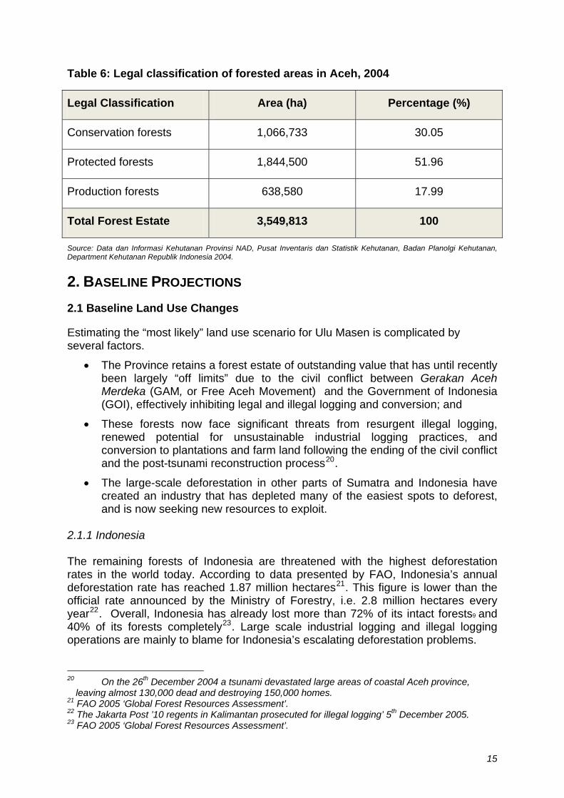
Table 6: Legal classification of forested areas in Aceh, 2004
Legal Classification Area (ha) Percentage (%)
Conservation forests 1,066,733 30.05
Protected forests 1,844,500 51.96
Production forests 638,580 17.99
Total Forest Estate 3,549,813 100
Source: Data dan Informasi Kehutanan Provinsi NAD, Pusat Inventaris dan Statistik Kehutanan, Badan Planolgi Kehutanan, Department Kehutanan Republik Indonesia 2004.
2. BASELINE PROJECTIONS 2.1 Baseline Land Use Changes
Estimating the “most likely” land use scenario for Ulu Masen is complicated by several factors.
• The Province retains a forest estate of outstanding value that has until recently been largely “off limits” due to the civil conflict between Gerakan Aceh Merdeka (GAM, or Free Aceh Movement) and the Government of Indonesia (GOI), effectively inhibiting legal and illegal logging and conversion; and
• These forests now face significant threats from resurgent illegal logging, renewed potential for unsustainable industrial logging practices, and conversion to plantations and farm land following the ending of the civil conflict and the post-tsunami reconstruction process20.
• The large-scale deforestation in other parts of Sumatra and Indonesia have created an industry that has depleted many of the easiest spots to deforest, and is now seeking new resources to exploit.
2.1.1 Indonesia The remaining forests of Indonesia are threatened with the highest deforestation rates in the world today. According to data presented by FAO, Indonesia’s annual deforestation rate has reached 1.87 million hectares21. This figure is lower than the official rate announced by the Ministry of Forestry, i.e. 2.8 million hectares every year22. Overall, Indonesia has already lost more than 72% of its intact forests9 and 40% of its forests completely23. Large scale industrial logging and illegal logging operations are mainly to blame for Indonesia’s escalating deforestation problems. 20 On the 26th December 2004 a tsunami devastated large areas of coastal Aceh province,
leaving almost 130,000 dead and destroying 150,000 homes. 21 FAO 2005 ‘Global Forest Resources Assessment’. 22 The Jakarta Post ’10 regents in Kalimantan prosecuted for illegal logging’ 5th December 2005. 23 FAO 2005 ‘Global Forest Resources Assessment’.
15
2.1.2 Sumatra Sumatra lost at least 6.6 million hectares of forest between 1985 and 1997, for an average annual deforestation rate of 2.4%.24 This trend has accelerated over the last ten years. With many of the prime logging areas in southern Sumatra already logged, the Ulu Masen-Leuser forest block, the largest forest block remaining in Sumatra, is facing increasing pressure. Conservation International has conducted wall-to-wall estimates of deforestation in Sumatra and project proponents have requested this information.
2.1.3 Aceh
In the year prior to the tsunami, a total 47 companies in Aceh were granted logging licenses. This was a rise of more than 150% over previous years. Since the tsunami and the end of the emergency efforts there has been a dramatic increase in illegal and unsustainable logging, in land clearance and in applications for land for clearance. This has been recorded for the Ulu Masen forests as well as elsewhere in the province (FFI Aceh unpublished, 2007.). The demands placed on the government to respond to the needs of the 150,000 families that lost their homes during the 2004 tsunami are enormous. Estimates place the requirement for reconstruction timber at 861,000 m3 25 and although support from the Multi Donor Fund for Aceh and Nias has helped provide timber from sustainable sources outside of Aceh, the post tsunami period has nonetheless seen an increase in illegal logging.
New threats are also emerging with the ending of the state of emergency and the opening of the economy for much needed investment. Rapidly developing new markets for palm oil for use as bio-fuel is fuelling a surge in demand for land to establish oil palm plantations. Indonesia is planning to develop 20 million hectares of new oil palm plantations and Aceh will be a natural target for allocation of land for this purpose. In addition, various estate crop companies are actively seeking new land clearing permits to plant fibre-board trees and rubber trees in Ulu Masen.
One study estimated an annual rate of deforestation between 1985 and 1997 for Aceh as 20,796 ha/year26. On October 13th, 2005, Department of Forestry and Plantation applied a policy on maximum annual allowable cut (RKT = rencana kerja tahunan) for concessions (HPHs) in Aceh up to 500.000 m3 for year 2006 while it was only 47.000 m3 in year 2005. Clearly, threats to forests in Aceh are growing and there is already a high rate of loss.
24 FWI/GWF. 2002. The State of the Forest: Indonesia. Bogor, Indonesia. 25 UNDP 2006 Timber Analysis report. 26 Department of Forestry and Plantation, based on a comparison of RePProT map in 1985 and
satellite map in 1998, as cited in WWF Press Release, October 17, 2006. Viewable at:
http://www.wwf.or.id/index.php?fuseaction=press.detail&language=e&id=PRS1161242880
16
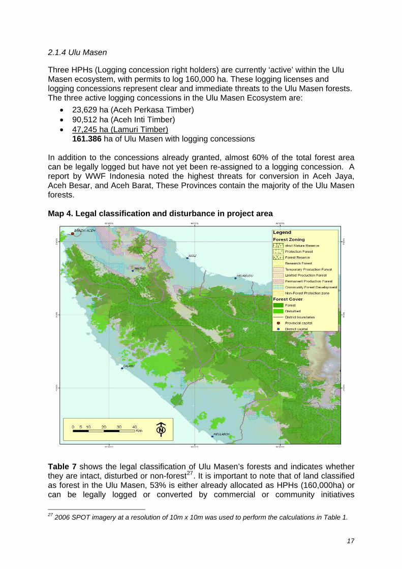
2.1.4 Ulu Masen
Three HPHs (Logging concession right holders) are currently ‘active’ within the Ulu Masen ecosystem, with permits to log 160,000 ha. These logging licenses and logging concessions represent clear and immediate threats to the Ulu Masen forests. The three active logging concessions in the Ulu Masen Ecosystem are:
• 23,629 ha (Aceh Perkasa Timber) • 90,512 ha (Aceh Inti Timber) • 47,245 ha (Lamuri Timber)
161.386 ha of Ulu Masen with logging concessions In addition to the concessions already granted, almost 60% of the total forest area can be legally logged but have not yet been re-assigned to a logging concession. A report by WWF Indonesia noted the highest threats for conversion in Aceh Jaya, Aceh Besar, and Aceh Barat, These Provinces contain the majority of the Ulu Masen forests. Map 4. Legal classification and disturbance in project area
Table 7 shows the legal classification of Ulu Masen’s forests and indicates whether they are intact, disturbed or non-forest27. It is important to note that of land classified as forest in the Ulu Masen, 53% is either already allocated as HPHs (160,000ha) or can be legally logged or converted by commercial or community initiatives
27 2006 SPOT imagery at a resolution of 10m x 10m was used to perform the calculations in Table 1.
17
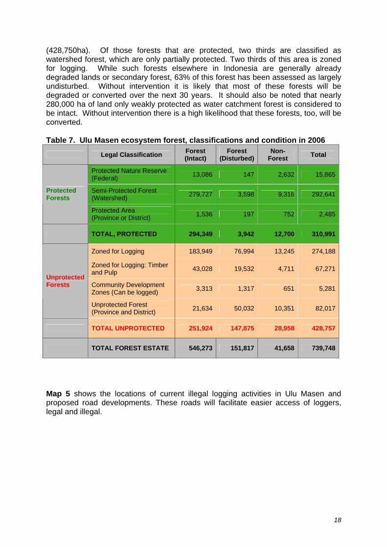
(428,750ha). Of those forests that are protected, two thirds are classified as watershed forest, which are only partially protected. Two thirds of this area is zoned for logging. While such forests elsewhere in Indonesia are generally already degraded lands or secondary forest, 63% of this forest has been assessed as largely undisturbed. Without intervention it is likely that most of these forests will be degraded or converted over the next 30 years. It should also be noted that nearly 280,000 ha of land only weakly protected as water catchment forest is considered to be intact. Without intervention there is a high likelihood that these forests, too, will be converted.
Table 7. Ulu Masen ecosystem forest, classifications and condition in 2006
Legal Classification Forest (Intact)
Forest (Disturbed)
Non-Forest Total
Protected Nature Reserve (Federal) 13,086 147 2,632 15,865
Semi-Protected Forest (Watershed) 279,727 3,598 9,316 292,641Protected
Forests
Protected Area (Province or District) 1,536 197 752 2,485
TOTAL, PROTECTED 294,349 3,942 12,700 310,991
Zoned for Logging 183,949 76,994 13,245 274,188
Zoned for Logging: Timber and Pulp 43,028 19,532 4,711 67,271
Community Development Zones (Can be logged) 3,313 1,317 651 5,281
Unprotected Forests
Unprotected Forest (Province and District) 21,634 50,032 10,351 82,017
TOTAL UNPROTECTED 251,924 147,875 28,958 428,757
TOTAL FOREST ESTATE 546,273 151,817 41,658 739,748
Map 5 shows the locations of current illegal logging activities in Ulu Masen and proposed road developments. These roads will facilitate easier access of loggers, legal and illegal.
18

Map 5. Roads and Logging in Project Area
The unprotected nature of 428,757 hectares in Ulu Masen clearly suggests land will be logged or converted unless dramatic steps are taken. However there is no clear and reliable estimate of how long a period the deforestation would occur? Would it be in the next five year? Thirty years? 100 years? To estimate baseline deforestation rates (ha/year), we need a transparent and conservative model that takes into account historical and regional rates of deforestation as well as on-the-ground aspects such as elevation, access to roads, etc (to represent the reality that faces the Ulu Masen area specifically, based on current land classifications, etc).
19
For estimating the baseline rate of deforestation in Ulu Masen for the next 30 years (from January 1, 2008 to December 31, 2038), we developed a land-class model to conservatively and transparently estimate what would be the likely outcome on different categories of forest in the project area without carbon finance. This model is based on professional opinions based on similar past examples as well as on site-specific information (e.g., proximity to roads or other development, planned roads, elevation, slope, nearness to populations, etc). For detailed notes of our assumptions for the 87 classes, please see “Calculations” worksheet.
Using these assumptions, we estimate an average annual deforestation (ha loss) rate (over 30 years, from 2008-2038) of 1.283% per year. This corresponds to an annual loss of 9,630 hectares per year in Ulu Masen. We believe this is very conservative, given the rates of deforestation have been significantly higher (more than 2%) in past years for other parts of Sumatra.
For areas likely to experience forest loss, we partitioned the loss into three predominant land use outcomes – palm oil, shrub, and mixed forests. And for these replacement systems, we estimated carbon stocks (see next section on carbon emissions)
In summary, the cessation of Aceh’s conflict and the normalisation of political and economic institutions mean it is highly likely that, without intervention, deforestation rates are likely to increase considerably without intervention. Ulu Masen’s forests are threatened by a legal land use landscape that allows substantial conversion of forests for plantations and other uses. This is compounded by illegal logging, and the government’s lack of resources to effectively prevent illegal conversion and degradation.
2.2 Baseline Scenario – Carbon Emissions
Based on literature review and unpublished information, we also assigned carbon values for the original and the “replacement” land use categories. Emissions are projected to be the difference between what is now natural forests and land use systems likely to replace these natural forests.
The carbon content for palm oil was based on the Alternatives to Slash & Burn 2000 Climate change working group report28, Appendix 3C, information on Indonesian carbon calculations. This report estimates 63.2 tons of above ground carbon in Indonesian palm oil plantations. We added a 20% factor to account for palm oil roots, so as to be consistent with our carbon stock estimates in forests (for a total of 76 t C/ha). Carbon content of mixed forests (85 t C/ha) and shrub (65 tC/ha) replacement systems were based on professional local opinions. A statistically robust carbon field inventory is planned for the early part of 2008 to test these parameters.
Based on the varying levels of threat and carbon per unit area, estimate to have at the end of the base year, 108,364,096 tons of carbon remaining in areas that are now forests. This corresponds to an annual gross loss of carbon of 1,771,816 tons of carbon and a net loss – after regrowth – of 1,080,252 tons of carbon. 1080, 28 http://www.asb.cgiar.org/publications/wgreports/wg_climatechange.asp
20

2.3 Baseline Scenarios - Communities Deforestation would provide some employment, infrastructure development and economic and social benefits. Research suggests that deforestation generates around $200-$250 per hectare in logging fees, concession fees and mandatory reforestation fees, with proceeds going primarily to national and district levels, with a smaller amount going to provincial government. The business-as-usual scenario for deforestation would generate hundreds and possibly thousands of jobs for this impoverished region. The scale of economic opportunities created by deforestation is difficult to predict and would depend on the nature of the subsequent land use and whether logs, timber and pulp would be exported with or without processing to add value. However, the direct economic benefits from illegal logging for local communities is limited, as well as the benefit for the government, as illegal sawmill operators don’t pay royalties. In addition to the impact of the baseline on direct community benefits, the consequences of this assumed level of deforestation would have a severe impact on the provision of ecosystem services in the region. The watershed for millions of people would be severely degraded, with almost certain declines in water quality and reliability. In addition to hydrological functions, Ulu Masen forests reduce run-off and soil erosion, reduce the risks of landslides, and help regulate the local and regional climate. These forests also provide important natural resources including fibres, foods and medicines for communities in Aceh Province. 2.4 Baseline Scenarios – Biodiversity The baseline scenario would likely cause substantial declines in the biodiversity of the region. Many endangered, threatened and endemic species would experience continued habitat loss, degradation and fragmentation. 2.5 Baseline Scenario – Water and Soil resources
Water contamination and soil erosion are likely to increase in the baseline scenario due to increased deforestation and degradation. Water quality would decline and the risk of landslides is likely to escalate. Logging, much of it illegal, has caused a growing number of flash floods and landslides in Aceh and throughout Sumatra, damaging homes and destroying livelihoods.
In late 2006 widespread flooding hit eastern and central Aceh and the neighboring province of North Sumatra. The extensive floods resulted in damages and losses of US$ 210 million, with damage to water and sanitation accounting for US $ 6.7 million. A World Bank assessment recorded 4,042 wells were destroyed, 10,903 were heavily damaged and 11,348 lightly damaged. Soils and agricultural fields, sustained damages totaling US$ 37 million, with 2,353 hectares requiring replacement, 14,440ha were heavily damaged and 7,610ha were lightly damaged29.
3 PROPOSED PROJECT DESIGN AND GOALS 29 Aceh Flood. Damage and Flood Assessment. World Bank 2007
21
3.1 Overview The project proponents can, with adequate carbon finance, institute measures that will reduce legal and illegal deforestation, promote reforestation and foster sustainable community forest management. Carbon-finance funds will be established to offset al, or most, of the opportunity costs of avoiding deforestation as well as support project activities and operations. A substantial portion of carbon finance will be deposited into these funds and will directly benefit local communities and forest guardians. By preventing deforestation, project proponents will help Aceh achieve a sustainable future that also preserves critical and highly-threatened habitat for biodiversity and develop a sustainable community model for the use and conservation of forest. As the lead project proponent, Aceh Province is seeking support for the following activities: • Identify and document opportunities to strengthen land tenure and resource
access of forest dependent communities and those with customary rights. • Identify and document opportunities to strengthen forest management, forest
governance and forest law enforcement processes at provincial, district and Mukim levels.
• Identify and document opportunities for establishing legal and regulatory frameworks to underpin trade in Carbon Rights and Carbon Credits.
• Develop provincial, district and Mukim level sustainable forest and land use plans, including rezoning Conversion Forest to Protection Forest or Limited Production Forest as appropriate and identifying land for community forest management, reforestation and community agro-forestry.
• Develop distribution mechanisms through consultation with stakeholders to ensure equitable and transparent distribution of benefits from carbon trading.
• Test distribution mechanisms and forest protection interventions by flushing ODA funds and VER revenues through the system.
• Support the development of community forestry, agro-forestry and other livelihood initiatives that support reductions in carbon emissions and reduce risk of future emissions at appropriate sites.
• Identify and provide technical and financial support to fill gaps in the development of capacity for carbon accounting, in particular in the development of essential tools such as using allometric relationships in the calculation of carbon sequestration in forest, agricultural and estate crop growth and other carbon accretion models, appropriate stratification of forest types, and soil carbon model development and calibration under a range of land uses.
• Develop the capacity of relevant Provincial Government, educational and scientific institutions to estimate, model and monitor forest and forest carbon stocks through technology transfer and skills development.
• Determine, based on historical trends in comparable areas, baseline rates of deforestation and forest degradation for the project area and the Province in the past.
• Develop and implement project management, advisory and consultative structures.
3.2 Major project activities
22
3.2.1. Prevention of Legal Logging Via Land Re-Classification The Governor of Aceh has made a commitment to reduce the areas of forest for logging and clearing in return for carbon finance. Thus the most important immediate activity is to revise provincial and district spatial plans, reduce the forest area classified as conversion forest, and increase the area under a range of formal permanent forest estate categories. The project will help the province avoid an estimated 85%of legal logging by using carbon finance to justify land reclassification and permanently eliminate the legal possibility of land conversion and logging. With carbon finance justification, areas currently zoned for logging will be reclassified as permanent protection forests and community-managed low-impact, limited production forest areas. This process will build on Governor Irwandi’s temporary logging moratorium and enable the Provincial government, in consultation with the national government, districts and mukims, to design an alternative to the widely-expected continued logging and legal conversion Ulu Masen.
The Government of Aceh will establish an institutional framework at provincial, district and Mukim levels to oversee and advise project implementation. The ongoing Aceh forest sector review process will determine the institutional structure for this and the composition of a steering committee. The steering committee will provide overall supervision of the project and will include representation from national, provincial and district governments, civil society organizations, and FFI and its partners.
A project implementation unit will be established at provincial level for project management and technical assistance. Technical assistance will be provided by FFI as well as through procurement of specialized technical service contractors.
Through a participatory planning process, the foundations for which have already been laid in Aceh Jaya under AFEP and FFI’s broader Aceh programme, multi-stakeholder management boards will be established within the four participating districts to provide oversight for project implementation at district, Mukim and village levels.
Building on the design of AFEP in which key roles have been allocated to Civil Society Organisations (CSOs) for external and independent oversight and ‘watch-dogging and whistle blowing’ functions, this project will provide grants to civil society organizations for independent monitoring of the project. This will entail monitoring the implementation of project activities and the delivery of outcomes, as well as the monitoring of government institutions and their delivery of the basic policy and operational environment for the project to operate in. Ensure the equitable and transparent distribution of benefits amongst stakeholders will also be an important role for CSOs.
The full, active and informed support of all stakeholders will be critical for the successful development of carbon finance distribution systems, especially as these will be new and of necessity, innovative, and will require flexibility in design to accommodate changes in their development and operation. FFI and its partners will
23

facilitate a consultative process to reach agreement on mechanisms for the distribution of benefits. Carbon finance funds will provide incentives to communities, districts and the province to re-classify lands currently slated for logging. Communities have indicated a strong willingness to participate provided there are financial incentives for conserving forests. Project proponents, notably FFI, in collaboration with the national focal point for REDD, the Ministry of Forestry have facilitated an initial provincial REDD consultation workshop. FFI has already begun consultations with Aceh Jaya District and have the support of key government agencies in Aceh to continue this work and to expand it into the other three districts that comprise the Ulu Masen Ecosystem. 3.2.2 Prevention of illegal logging The project will help curb illegal logging through support for enhanced enforcement, community agreements, increased employment and income for local people, recruiting forest wardens, conducting forest monitoring and patrols, and improving synergies through law enforcement and other relevant agencies. The project will also provide alternative livelihoods to forest-adjacent communities that commit to protecting the forest. In return for funding and technical assistance, communities will agree to protect the forest. 3.2.3 Reforestation, agro-forestry, mangrove restoration, fruit and coffee micro-plantations and orchards The project will use carbon finance to assist reforestation and restoration of mangroves, fruit tree gardens, coffee plantations and woodlots. All carbon sequestered in these project will be estimated and placed in our leakage management structure. In case any leakage from the project area is detected, the carbon sequestered through these programs can compensate off-site carbon losses, 3.3 Maps of Project Activities The project site covers a block of approximately 750,000ha30 of forest located across the Kabupaten (Districts) of Aceh Besar, Aceh Jaya, Aceh Barat, and Pidie31. Ongoing engagement with Mukim leaders and communities to implement AFEP activities has supported the selection of a range of suitable field sites for the design and testing of incentive based mechanisms for forest protection. All sites contain large areas of forest that are currently without, or with only weak, conservation status and are either zoned for logging or conversion to plantations or other non-forest land uses in the future. The project will work at the landscape level to implement its project activities and meet its goals. Given the complexity and size of the proposed project, specific maps of where individual activities will take place is not realistic. For example, we have calculated 87 different land use categories and these classes often cover numerous
30 Slight variations on project area depend on the type of file used to generate output tables. In
general, grid calculations are slightly larger than shape files. 31 Pidie District will shortly be subdivided into 2 districts, Pidie and Pidie Jaya, but are considered one
district in this document.
24

geographic areas. For example, HPK forests that are already degraded at an elevation of 500 -1,000 meters actually covers numerous specific geographic areas.
3.4 Timeframe and project accounting Project proponents used a timeframe of 30 years for accounting for changes in carbon emissions between the baseline and project scenario. However, the project proposes to operate and ensure permanence of avoided emissions for a period of 100 yeas. This bifurcation of time intervals is done to:
a) allow for reasonable estimates of medium term (30 years) of a baseline and carbon accounting, while;
b) Also ensuring the longevity of carbon credits for a period of time that is relevant for climate change and atmospheric CO2 levels.
The project will store a significant amount of carbon credits in a buffer account that will be used after the 30 years of the project period to continue implementing and funding core project activities, notably conservation and restoration of forests (see next section).
The 30 year project accounting period will also be divided into two phases, a pre-REDD credit phase (from 2008 to 2012) where early action REDD credits may or may not be available, and a period after 2012.
25

The first five-year phase will include several overlapping phases:
Phase 1: Information gathering, technology and skills transfer and development of project structures, institutional framework, and financing (6 months, July 2007 to December 2007).
Phase 2: Develop benefit sharing mechanisms; implement planning processes, implement legislative and regulatory changes, set up a system for forest and carbon stock monitoring, preparation for community forestry, reforestation and agro-forestry projects (18 months, July 2007 to December 2008).
Phase 3: Ongoing forest and carbon monitoring; promotion of sustainable community forest management, forest product value adding, reforestation and community agro-forestry; monitoring ‘virtual’ carbon funding (ODA funds) disbursed through incentive mechanisms (5 years, January 2008 to December 2012). Financed through the sale of voluntary Verified Emission Reductions (VERs), or early-action credits.
Phase 4: Transfer to 2nd commitment period REDD credits or appropriate outcome of UNFCCC negotiations. post-Kyoto commercial market mechanisms (Years 4 and 5).
The expectation is that after 2012, the project will be included in Indonesia’s baseline (reference emission scenario) and fungible post-Kyoto/UNFCCC carbon credits will be available. This, of course, is still a complex political process whose outcome can not be guaranteed. In the event that REDD credits do not materialize in a post-2012 regime, the first phase of voluntary, philanthropic and multilateral funds would be continued. This phase will focus on developing finance mechanisms from bilateral, multilateral and other emerging funds, as well as philanthropic sources and voluntary credits. The duration of the first phase of the project will be 5 years. Four distinct phases are envisaged that can fall into two clear stages of the project; institutional and operational set up, followed by testing, monitoring and refining. The set-up stage will build on and extend foundations established by FFI and its partners under AFEP.
3.5 Project risks and mitigation measures
Identified project risks have been divided into short and long term risks as follows: Short term
• Baseline risk • Leakage risk • Measurement risk
Long term
• Sovereign, legal and enforcement risk • Natural risk (fire, disease, pests etc) • Climate change risk
To manage the risk of loss of some project benefits through improved measurement, identification of leakage or baseline adjustment as the national and project accounts are reconciled, 20% of annual VERs will be reserved from sale pending such
26
27
reconciliation. National baseline development is considered likely to occur over the next two to three years. Strong linkages between carbon measurement, monitoring and accounting approaches at the project and national levels will be maintained to minimize possible adjustments to the project level accounts when final harmonization occurs. Risk management arrangements to protect the stored forest carbon in the long term have two elements. The first will be a “risk management buffer” of reserved credits, proposed to be 10% of the stream of VERs. The second will direct 20% of the stream of VERs into a revolving fund which will invest in other sustainable development projects which generate further emission reductions or sequestration. Thus, around 20% of project revenues will be used to develop:
• Mini and micro hydro projects • Sustainable biofuel production and use • Sustainable biomass power generation • Other renewable energy projects • Energy efficiency projects • Reforestation with sustainable plantations • Community based agroforestry
Reforestation and agroforestry will be particularly important in areas degraded by illegal logging carried out over the past several years and will be complimented by initiatives implemented under AFEP as part of its sustainable post-tsunami reconstruction support. Acehnese communities will enjoy the physical benefits of these projects, while VERs and/or CERs generated will be reapplied to risk management function through the revolving fund. It is expected that the total amount of verified emission reductions will increase over time. These arrangements will be implemented in addition to the use of best available methods to ensure that the forests in the project areas are legally protected and that applicable forest law is enforced. To the extent that current legal arrangements need strengthening, negotiations will be undertaken with those responsible for relevant legislation at the provincial and national levels. The Government of Aceh, with support from AFEP, will conduct participatory land use planning processes to establish environmentally, economically and socially sustainable land uses in and around the Ulu Masen forests. These risk management arrangements are designed to give assurance to buyers of VERs and CERs of the long term integrity of the carbon offset, and to maximize the contribution of project and subsequent carbon financing to economically, environmentally and socially sustainable development.

1
Carbon Pool
Project 1
Project 2
Project n
Carbon Rights
Carbon Assurance
50% credits
Sales (50%)
Baseline and leakage risk
Measurement risk
Sovereign, legal and enforcement
“Natural” risk – fire, pests, disaster
Climate change risk
20% risk credits
30% risk credits
Sell 20%, retain 10% for long term risk mangement. Use proceeds of sales for investment in local sustainable development emission reduction projects, eg Mini and micro-hydro, agroforestry, biofuels, sustainable plantations
Project benefits
Credits $
Risk management model
Return balance in short term (1-3 years) when risk managed
Diagram 1.

3.6 Stakeholders
See section 8.1. Stakeholder consultations have begun about the proposed project in multiple venues and forums. FFI has conducted a stakeholder consultation workshop at provincial level involving all 4 districts for the development of REDD pilot project including community leaders as well as local government. The land use planning process in Aceh is striving to be a fully participatory one, where communities are empowered to help plan and execute land use decisions.
3.7 Documentation
All non-proprietary documents will be publicly available and in Bahasa language at the offices of Fauna and Flora International as well as at the Climate, Community and Biodiversity website the governor’s office and posted on these two offices’ websites.
4. MANAGEMENT CAPACITY
4.1 Experience implementing projects
Carbon Conservation Pty Ltd Carbon Conservation, through its wholly owned subsidiary The Carbon Pool, has over six years experience in the carbon market, and has initiated and managed a globally significant avoided deforestation project in Queensland, Australia under the Australian Government’s Greenhouse Friendly initiative. Company personnel also have extensive experience in sustainable reforestation, and the management of carbon projects. The avoided deforestation project in Queensland, called Minding the Carbon Store, has given Carbon Conservation unique insights and capabilities in respect of REDD projects and the carbon trading opportunities arising. Fauna and Flora International FFI in Indonesia has implemented conservation projects since 1996 focusing on law enforcement, protected area management, and buffer zone development. FFI’s largest project in Indonesia, the Aceh Forest and Environment Project, is the largest World Bank funded project in the Indonesian forestry sector and with 13 million USD (including co-financing) is the largest NGO implemented project in Asia. FFI has encouraged the provincial Government of Aceh to commit to reducing deforestation through the development of a carbon financing mechanism. FFI and associated Indonesian NGOs have assisted the provincial governments to select a portfolio of project sites eligible for carbon financing for avoided deforestation, and facilitated a district level consultation process for the development of this proposal. FFI staff have significant experience in working in Aceh. FFI has considerable experience in the management of civil society grants for biodiversity conservation through it’ management of the BP conservation award program, the FFI flagship species fund and the Arcadia fund for land purchases for conservation.
1

Aceh Provincial Government
Provincial and local governments were significantly affected by the devastating tsunami. A high percentage of government staff were killed and many government offices were washed away or severely damaged. Since April 2005 the Aceh-Nias Rehabilitation and Reconstruction Agency (Badan Rehabilitasi dan Rekonstruksi - BRR) has worked closely with provincial government to support, strengthen and build capacity of government staff to effectively manage the province and its resources.
The mandate for BRR ceases in April 2009, and the exit strategy is currently in progress. BRR’s activities are focused on social development and building government capacity to ensure a smooth transition when the handover takes place.
Aid agencies and NGOs have also focused many of their efforts on empowering provincial and local government capacity. Activities have been designed to develop effective and accountable governance, focusing on strengthened legislative processes, increased government competencies, transparency and eliminating corruption.
4.2 Appropriate Scale of Management Experience
Fauna and Flora International Board or Trustees of the Organisation: Patron: Her Majesty the Queen (UK), President: Lord Cranbrook, Vice- Presidents: Emmanuel O A Asibey (Ghana), Lady Scott (UK), Sir David Attenborough (UK), Professor Frederick Kayanja (Uganda), Professor Grenville Lucas OBE (UK), Miriam Rothschild (UK) Ralph Daly OBE (Sultanate of Oman) David Bellamy OBE (UK) Gerard Bertrand (USA), Richard Fitter (UK). FFI is registered in the UK, and USA as a Charity. In the UK the charity was established by the trust deed in 1903 and was registered with the Charity Commission on 13 May 1992, Registered Charity Number 1011102. The Charity was incorporated as a private company limited by guarantee on 13 January 1992, Registered Company Number 2677068. DUNN number is 068497069. FFI legally operates in Indonesia under a Memorandum of Understanding with the Ministry of Forestry and LIPI since 1996. FFI acts to conserve threatened species and ecosystems world-wide, choosing solutions that are sustainable, based on sound science and take account of human needs FFI has around 100 staff based in Indonesia. FFI has considerable experience in the management of civil society grant for biodiversity conservation through its management of the BP conservation award program, the FFI flagship species fund and the Arcadia fund for land purchases for conservation. Carbon Conservation The Minding the Carbon Store project involved:
2
• development of project documentation • implementation of information management policies and procedures • establishment of risk management structures • field measurement of carbon stocks • development of legal arrangement for purchase of Carbon Rights from
landowners under relevant government legislation • undergoing independent verification of emission abatement through the
project • trading around 1 million tons CO2e of carbon credits, principally to Rio Tinto
Aluminum Emission reductions were verified and approved under the Australian Government’s Greenhouse Friendly initiative. . Fauna and Flora International FFI in Indonesia has implemented conservation projects since 1996 focusing law enforcement, protected area management, and buffer zone development. FFI’s largest project the Aceh Forest ad Environment Project is the largest World Bank funded project in the Indonesian forestry sector and with 13 million USD (including co-financing) the largest NGO implemented project in Asia. FFI has successfully implemented several GEF medium sized projects on behalf of UNDP and the World Bank in Asia (Indonesia, Vietnam, Cambodia) focused on landscape-based conservation, protected area management and integrated conservation and development. In collaboration with German Bank for Reconstruction KFW FFI is providing technical assistance a 12 million Euro government implement conservation project focusing on protected area management, forest law enforcement and community forestry in the Phong Nha – Ke Bang World Heritage Site landscape in Central Vietnam.
5. LEGAL STATUS& LAND TENURE
The Government of Indonesia’s new legislation on forest planning, management and use (Government Regulation PP6/2007) provides a key legal basis for the implementation of this project. This regulation authorises provincial and district governments to issue licenses (Izin Usaha Pemanfaatan Jasa Lingkungan - Permit for Ecological Service Utilization) for storing and absorbing carbon in both production and protection forests. The Special Autonomy Law for the Province of Aceh, passed in 2006 following the cessation of the armed conflict between GAM and the Government of Indonesia and the holding of free elections in Aceh, provides a further important legal basis for the retention and equitable sharing of funds generated through REDD carbon financing within the province.
This project will not require any involuntary relocation of people or communities. This project will not knowingly break any laws in its design or execution.
3

The project has the approval of the Provincial Governor and is being developed in consultation with districts, mukims and kebupaten.
Governor Irwandi submitted a letter to the federal government of Indonesia (date and status will be provided). Approval is expected in late 2007/early 2008, given the publicly-stated schedule of Indonesia for developing pilot projects.
6. ADAPTIVE MANAGEMENT & KNOWLEDGE DISSEMINATION
Project proponents realize that a 30 year project accounting timeframe and a project lifetime of 100 years will require considerable adaptive management strategies to be effective. For instance, in the year 2000, who would ever have predicted that Aceh would witness the world’s deadliest natural disaster and the cessation of a 30 year armed civil conflict in just five years?
To institute adaptive management, the project’s design and management structure will include several dimensions that allow the project to adjust to monitoring,
Project proponents will provide more details.
7.0 NET GREENHOUSE GAS CHANGES FROM PROJECT
The net carbon emission reductions from the project are conservatively estimated to be 27,546,438 over 30 years (see Table 8).
Table 8. Forest Carbon in Ulu Masen, Aceh (2008-2038; Baseline and Project Scenarios)
2008 Current Stocks
2038 Stocks Emissions Project Emission Reductions
Worksheet Reference
Baseline 140,771,670 108,364,096 32,407,574
N/A Worksheet
H134 and T134
Project 140,771,670 135,910,534 4,861,136 27,546,438 U134 and V134
Under the baseline assumptions as stated above, at the end of 30 years there would be 108,364,096 tons of carbon. And under the project scenario, where 85% of all deforestation is stopped, there would be 135,910,534 tons of carbon. Thus, the project expects to generate 27,546,438 tons of avoided carbon credits over 30 years (the difference between baseline scenario and project scenario). This is equal to 101,095,427 CO2 credits, using (22/6) to convert from carbon to carbon dioxide. Assuming linear deforestation and avoided deforestation (as we do), this equates to 3,369,848 tons of CO2 avoided (VERs) per year.
4
All the documentation and calculations are reference either in the appropriate part of this document (for example in carbon stocks and baseline sections) or are cited in the noted worksheets
7.1 Non-CO2 gases (CH4 and N2O)
The project does not expect non-CO2 gases to be more than 15% of the project’s overall greenhouse gas impact. The most likely source of non-CO2 gases would be in avoided N2O emissions by preventing the establishment of palm oil and rubber plantations and subsequent application of fertilizers. Project proponents are looking into whether palm oil nitrous oxide emissions from fertilisers are more than 15% of expected greenhouse gas impact.
7.2 Estimating and Mitigating Leakage
The Governor of Aceh has declared a moratorium on all logging in natural forests and set in place a mechanism for the full review of the Province’s forest sector. With support from the World Bank and at the request of the Governor, FFI is providing financial support from AFEP and facilitation for a range of consultations to inform the review process.
The Governor has made both implicit and explicit commitments to reduce the area of forest zoned for logging and conversion and to restructure tenure arrangements for and beneficiaries of forest management. Spatial and land-use planning at provincial, district and Mukim levels and the approval of these plans by appropriate Mukim, district and provincial forums will ensure that forest conversion and plantation development is not simply moved from the Ulu Masen pilot area to other locations in Aceh.
Under the forest sector review, the Provincial Forestry Department will examine the legality, performance and sustainability of existing logging concession. Until such time as the Government of Aceh is in a position to make rational and informed decisions on the future of the forest estate, the logging moratorium will remain in place. This is expected to effectively eliminate leakage within Aceh.
Leakage of project benefits to other parts of Indonesia is expected to be managed within the Government of Indonesia’s REDD strategy. However, as stated in the section on risk management herein, a credit reserve comprising 20% of credits generated by the project will be held pending reconciliation of the project level accounts against the national baseline.
7.3 Preliminary Monitoring Plan
The project will establish, equip and train provincial GIS Units based at provincial forest service offices (Dinas Kehutanan) Banda Aceh. The project will provide training and briefings for provincial and district agencies to familiarize them with the GIS systems and analysis methods. FFI is already providing GIS training to government officials and NGO representatives in Aceh through AFEP and will be able to continue this key activity.
5
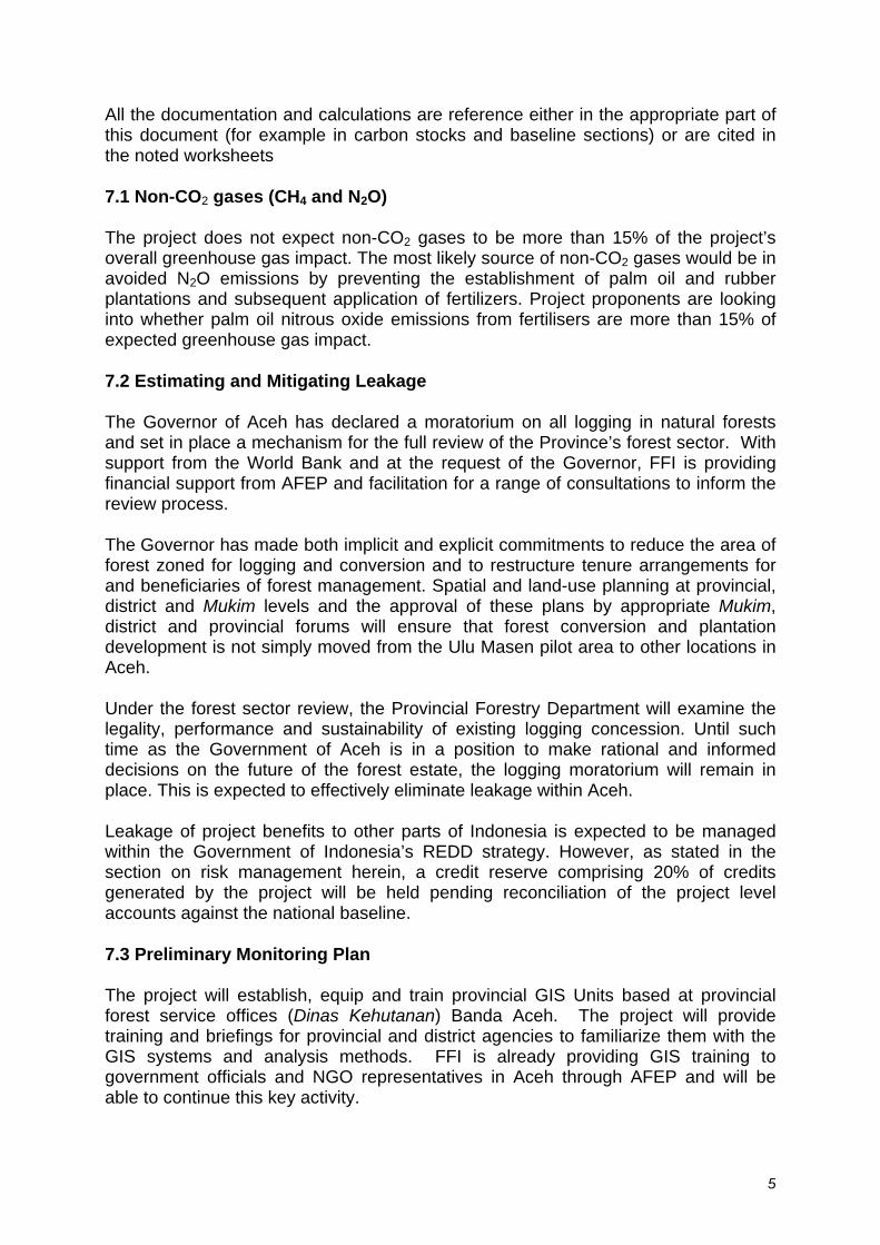
Monitoring in the mountains of Aceh is difficult because of the frequent presence of clouds and the size of the area. Experience in Kalimantan has shown that radar imagery can overcome these difficulties. Radar imagery, likely to be available through GOI from the Australian Government, will be used to assess changes that have taken place over time as a result of forest felling, road building, or even landslides and natural tree falls. Appropriate technical assistance and training will be provided for forest service staff seconded to the GIS Units. The project will equip and train the airborne monitoring teams that are being established by FFI and LIF with support from AFEP. This will allow the employment of ‘Ultra Light’ aircraft and high resolution photography in the assessment and monitoring of carbon stocks, both in the pilot areas and in surrounding forest blocks. This approach will provide even more reliable and timely monitoring capability than radar data, and has been used in Kalimantan over the last few years under the EU-funded Illegal Logging Response Centre project. It has proven effective in identifying locations of forest change and assisting government agencies’ forest protection efforts.
The Flight Design aircraft (Figure 1) and photographic monitoring system (Figure 2) is currently being developed and tested under the Aceh Forest and Environment Project team by FFI, LIF and partners. It is anticipated that this system will be operational within the next six months.
Figure 1 German engineered CT2K aircraft for monitoring forest cover changes and illegal logging.
Figure 2 Image from Nikon D2 camera mounted on ultra-light aircraft
6
Existing airstrips that have been improved and equipped by AFEP will be used as bases for these aircraft and small hangers will be constructed to protect them.
Airborne monitoring will be conducted on a regular basis to allow cross-checking of data provided by analysis of radar imagery. Planes will be equipped with high resolution digital cameras. Photographic images will be processed for bio-mass and carbon stock assessment. Additionally, forest crimes detected during monitoring flights will be reported to participating CSOs, joint community-ranger monitoring teams and forest law enforcement agencies for investigation on the ground.
A range of institutions will be supported or established by the project to provide the necessary capacity to monitor the status of carbon forests and support the assessment through ground truthing of carbon assessments, as well as to support the ongoing protection and management of the forest estate. Joint Community-Ranger Forest Monitoring The project will establish, equip, and train teams comprising community members and government rangers to monitor and report on forest cover and condition, and human activities, verify information from remote sensing on the ground, and provide a visible presence to support the protection of Carbon Forests. FFI has extensive experience of the establishment of such teams in Indonesia and the broader Asia region and has found them to be effective. The project will support management of the community forest monitoring programme in collaboration with local communities, district government, Mukim leaders and responsible forestry agencies (Dinas Kehutanan).
Community monitoring teams operating in the field will demonstrate the support of local socio-cultural institutions for forest protection and the majority of forest monitors will be known members of the community, selected through transparent processes by recognised local leaders. Forest monitoring teams will also be involved in a range of education and outreach initiatives. This approach is modelled on successful experiences of community monitoring and GOI-NGO co-management activities in Leuser, Kerinci, Gunung Palung, Komodo, and Bunaken National Parks, as well as the Sungai Wain Protection Forest, managed by the City of Balikpapan.
Community monitoring teams will not carry weapons. If routine monitoring detects illegal activity, the incident will be reported to the appropriate local authorities through appropriate channels. Formal reporting formats and communication channels will be established through discussions with appropriate forest management and protection agencies.
7
Monitoring forests and timber trade by GOI forest protection agencies The project will support GOI forest protection and conservation management agencies to strengthen their capacity to carry out their responsibilities. This support will include equipment, facilities and training for protected area and protection management agencies at district level, including support for ranger stations and essential equipment. The project will also provide support to assist GOI forest protection and conservation agencies in the performance of routine monitoring and field patrolling activities. Participation of civil society organizations Civil society organizations (CSOs) will be supported to conduct independent monitoring of forest crime (e.g. illegal local timber processing capacity, locations and activities of illegal sawmills, and illegal timber exports and transportation). This will be done by CSO monitoring groups through routine presence in project areas, discussions with local communities, and visual inspection of satellite and aerial imagery. CSOs will also be supported to play a role in monitoring the performance of logging concessions and low-impact community logging groups participating under the various incentive schemes described here. The project will also provide small grants to support the participation of CSOs in monitoring forest protection activities and official responses to forest crime, to facilitate public consultation processes, and to under-take follow up activities with local government agencies. This involvement will increase transparency and accountability in the forest protection process. Telapak, a local NGO currently supporting FFI’s implementation of AFEP has considerable experience in training CSOs and environmental monitors to document forest crime. It is anticipated that Telapak will play a key role in training forest investigators, monitors, and verifiers. Grants will be disbursed through Mukim leaders and other structures being established under AFEP.
7.4 Adapting to Climate Change
Climate change may alter the environment in Aceh. Although regional climate models vary in their projections, most agree that the area will get hotter on average.
1

Source: Susandi 2007
Indonesia is expected to witness modest rises in mean temperatures by the year 2020. This project fundamentally will help Sumatran fauna and flora adapt to climate change. By conserving the largest contiguous block of Sumatra forest at the northern portion of the island, the ability of climate-sensitive species to adapt is enhanced. 7.5 Voluntary Credit Sales The project expects to sell at least 10% of its credits into non-regulatory spheres, as currently no regulatory GHG abatement scheme allows avoided deforestation credits. 8.0 COMMUNITY IMPACTS, MONITORING AND CAPACITY BUILDING 8.1 Net Benefits, Stakeholder Involvement & Grievances 8.1.1 Safeguards and Stakeholder Consultation Process Framework FFI’s ongoing Aceh Forest and Environment Project which is funded by the World Bank (Aceh Multi-donor Trust Fund) triggers several Bank environmental and social safeguard policies. The project has been designed to find an appropriate balance between protecting forests and providing economic benefits to local communities and has no intention to displace people or restrict their livelihood opportunities. Nevertheless, a “process framework” has been developed to document procedures, consultations and activities to ensure compliance with Bank safeguards policies. The Framework outlines the criteria and procedures to ensure that any adverse livelihood impacts are avoided through consultation or mitigated through targeted assistance efforts for affected persons. Multi-stakeholder Advisory Councils with representatives from communities, traditional leaders, and local government institutions will help to ensure appropriate transparency and consultation. FFI has the experience and
2

capacity to understand and apply Bank safeguard policies and devise appropriate mitigations. The framework also addresses gender issues and consultative processes for responding to gender concerns and incorporating women’s voices into project activities. The project aims at using the same process framework developed under the Aceh Multi-Donor Trust Fund to implement this forest carbon project. We will seek to ensure the equitable and effective sharing of benefits from carbon financing schemes such that communities living in and around the forests can improve and sustain their livelihoods. We will use the process framework to ensure communities are provided incentives to support and actively engaged in the conservation and management of forest carbon. We also will consult with other stakeholders that are key to the project’s ultimate goal of reducing deforestation through community driven change. For instance, we will consult local and provincial authorities to help them develop the resources and political mandate to manage Aceh’s forest estate with an enhanced mandate for forest conservation and sustainable management. They will be encouraged to exercise their mandate in a transparent and equitable manner The development of equitable carbon financial distribution mechanisms requires certain key issues be addressed through a collaborative stakeholder dialogue:
• Indigenous people, local communities and civil society organizations must be encouraged and supported to participate fully and actively in the development of distribution mechanisms for avoided deforestation finances.
• Prior informed consent based on customary land tenure arrangements and resource access rights of local communities must be sought prior to the establishment of carbon forests or other substantive changes in land use.
• Robust, transparent and accountable systems for the allocation and tracking of distributed funds are required.
Once project proponents acquire adequate carbon finance and or other resources, the “process framework” described above will develop a process for deliberating, discussing and making decisions about the distribution of carbon finance. The Governor of Aceh has championed the development of a policy environment and legislation that recognize the critical role that forests play in people’s livelihood, and the need to recognize customary forest resource rights. At the Governors’ Roundtable on Climate the Governor reinforced his commitment by signing a joint declaration that recognizes the rights of communities to forest resources and the critical role of local communities in forest management. Avoided deforestation financial incentive schemes will provide rewards or compensations through regular payments into community funds or community projects. However, in certain cases and depending on expressed needs, non-monetary benefits such as support for improved health care or scholarships for education might be more culturally appropriate. The project will facilitate local communities to participate in spatial planning and the development of district and Mukim land use plans. FFI and its partners will conduct appropriate participatory learning (PL) processes in all forest fringe communities to
3

facilitate a public consultation process at the grass-root level to define equitable distributions mechanisms for and targets of financial benefits. The project will document stakeholder participation and emphasise the participation of often marginalised sub-groups such as women, returning internally-displaced peoples, former GAM fighters and their families, migrants and other under-represented minorities. To address the complexity of providing financial incentives to protect bio-carbon stocks while supporting the livelihoods of forest dependent communities, several funding mechanisms will be designed and tested. These will be based on ‘deposition account’ mechanisms that have been employed successfully in reforestation projects elsewhere in the region, for example by KfW in Vietnam. It is anticipated that disposition accounts may be established to channel carbon financing incentives and support to a range of initiatives including but not limited to:
• individuals and groups carrying out independent forest monitoring
• CSO’s supporting oversight functions
• community development programmes
• sustainable forest management enterprises
• joint forest protection and monitoring
• formal law enforcement operations,
• project management, monitoring and evaluation. In order to test the facility of these mechanisms for channelling incentive payments in effectively achieving the protection and sustainable management of forests, the project will ‘flush’ ODA funds through these deposition accounts. It should be noted that financing these incentive payments will take up a large proportion of the project finance, estimated to be in the region of 50% of the total project costs. This funding will allow testing of systems prior to engagement with carbon investors through the voluntary market in carbon credits or following the introduction of the anticipated post-Kyoto arrangements for the trading of REDD credits. It is proposed that, depending on the development of the voluntary market for carbon credits over the course of the project, the systems established by the project will allow for the generation of carbon credit-based co-financing in the latter years of the project. Release of funds will be tied to the documentation of measured reductions in deforestation provided through the monitoring systems described above, and in relation to the calculation of reductions in CO2 emissions. 8.1.2 Financial support to villages by provision of deposition accounts A number of preposition accounts will be established to provide incentives to local villages for their involvement in forest protection. These may include:
• Community Development Funds: These will provided a suitable mechanism for participating village communities that sign forest protection contracts and can be used for supporting construction of small-scale infrastructure such as
4
improved community access (bridges, trails, etc.), micro-irrigation schemes, health and education facilities, and support for agricultural improvements including the development of agro-forestry schemes.
• Alternative Livelihoods Funds: These will support development of appropriate and sustainable alternative livelihoods designed to reduce dependence on forest resources. The anticipated support for developing sustainable coffee production is an example.
• Community-Based Forestry Funds. Villages may receive funds to develop low-impact community forestry schemes, supporting the preparation of forest inventory and management planning, the establishment of community forest management institutions, the purchase of equipment and the meeting of FSC standards. Such funds could also be provided for community forestry schemes, for assisted or natural regeneration, and for forest protection.
Determining the eligibility of villages for these various schemes will be important to their success. In the final analysis, eligibility will be determined by evidence of compliance with the forest protection and sustainable forest management requirements that will be specified in village contracts. For community-based low impact logging operation, FCS certification and independent auditing by an accredited verifier will be important elements of determining eligibility. 8.1.3 Sustainable timber production fund A fund will be established to support participating logging concessionaires to introduce the necessary management changes that will allow their concessions to be included in the forest estate. This fund may provide grants or operate as a revolving credit fund to support changes in concession management. The fund will also provide incentive payments to participating concessionaires based on the performance of their concessions in REDD terms. 8.1.4 Financial support to individuals and groups through deposition accounts Payments for labour on, for example, forest establishment (reforestation and supported natural regeneration), and the involvement of groups and individuals in forest management and protection may be provided through the establishment of deposit accounts. 8.1.5 Revolving loan fund for small-scale enterprise development These will provide financing for the development of forest compatible environmentally sustainable business, such as improved post harvest technologies, community-based services for the nature tourism industry, forest tree and fruit tree nurseries, etc. Micro-credits can be made available to individuals, groups of households or cooperatives. 8.1.6 Monitoring and law enforcement deposition accounts Forest Protection Funds will be established at provincial and district levels to support a wide range of basic operational requirements, including the maintenance and running costs of equipment, patrol and law enforcement incentives, legal and
5

prosecution costs, and other operational requirements currently chronically under-funded. This fund will be established to support and is likely to be managed jointly by the Dinas Kehutanan, (Provincial Forest Service, the Balai Konservasi Sumber Daya Alam - BKSDA (Nature Conservation Department) and a range of Civil Society Organizations. 8.2 Off-site Community Impacts The project does not anticipate any negative offsite community impacts. 8.3 Monitoring Community Variables Project proponents are developing a plan to monitor community outcomes from the project, both within and outside of the project area. We will also develop a system for monitoring whether in-migration to the project occurs and for mitigating this. Since the project is being led by the Provincial government, project proponents will work to ensure that benefits are shared within and outside the project area to avoid any potential in-migration. 8.4 Capacity-Building and Best Practices Project proponents will strive to bring critical capacity in sustainable forest management to the area. By moving forward with this project, area citizens, academics, government officials and others will have the opportunity to engage a variety of skills and emerging ideas for forest conservation and management. 9.0 Biodiversity Impacts, Monitoring & Ecosystem Services Overall the project expects to create significant improvements to biodiversity conservation by avoiding habitat loss and degradation in northern Sumatra. 9.1 Net Biodiversity Impacts The net benefits for biodiversity of the project should be largely self-evident. The baseline scenario will witness a substantial amount of forest habitat being destroyed, degraded and fragmented. These outcomes would present an immediate threat to the viability of many species in the area. The project’s goal of reducing deforestation by 85% will have clear and compelling biodiversity benefits. 9.1.1 Non-Native Species The project will not use any non-native species. 9.1.2 Genetically-modified species The project will not use any genetically-modified species in its operations. 9.2 Offsite-Biodiversity Impacts The project does not anticipate any off-site negative biodiversity impacts. Most off-site impacts will be positive since larger habitat and forest areas will improve the long-term viability of populations off-site. 9.3 Biodiversity Monitoring See section 1.4. Project proponents are still determining which variables and frequency of biodiversity monitoring are most appropriate. Our biodiversity monitoring plan will build off of on-going monitoring programs initiated by FFI in the project area.
6

7
We plan to measure strategic biodiversity variables that are representative of the overall ecological health of the Ulu Masen area. 9.4 Water and Soil Resources See section 2.5. It is commonly expected that reducing deforestation in natural forests will improve the water and soil resources in the area. Project proponents are collecting information on the likely impact on soil and water resources in the baseline scenario by literature review of other areas with substantial deforestation in Sumatra.
Annex 1. Land Use Maps of Aceh Districts
The next 4 maps show current land use in the key Ulu Masen districts.

1
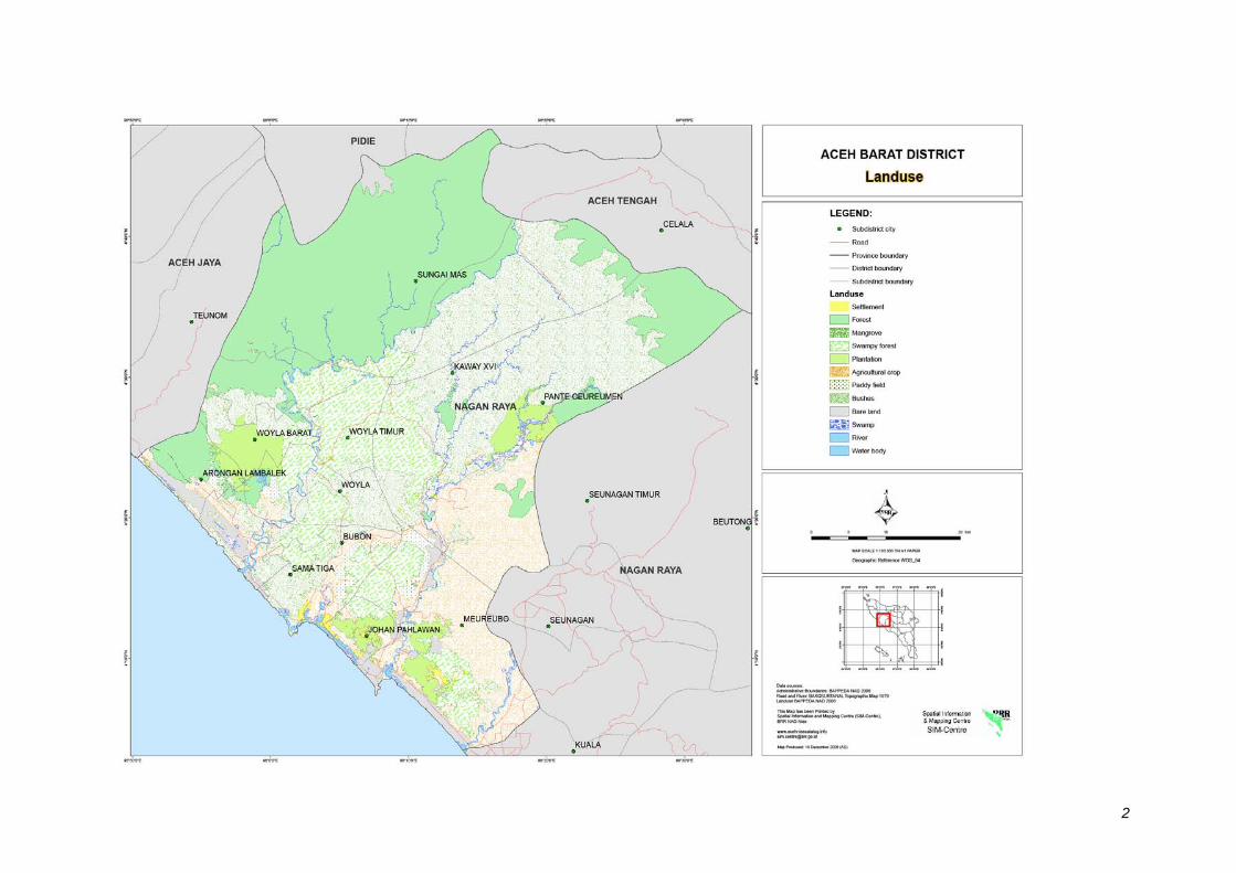
2
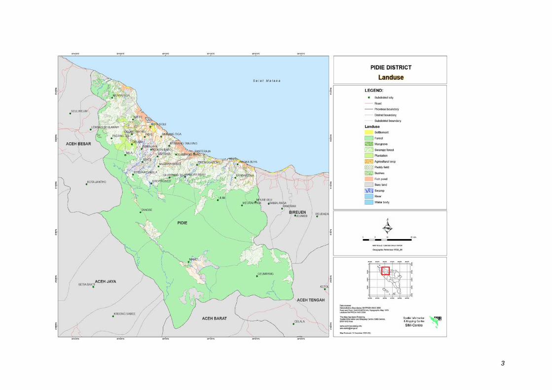
3
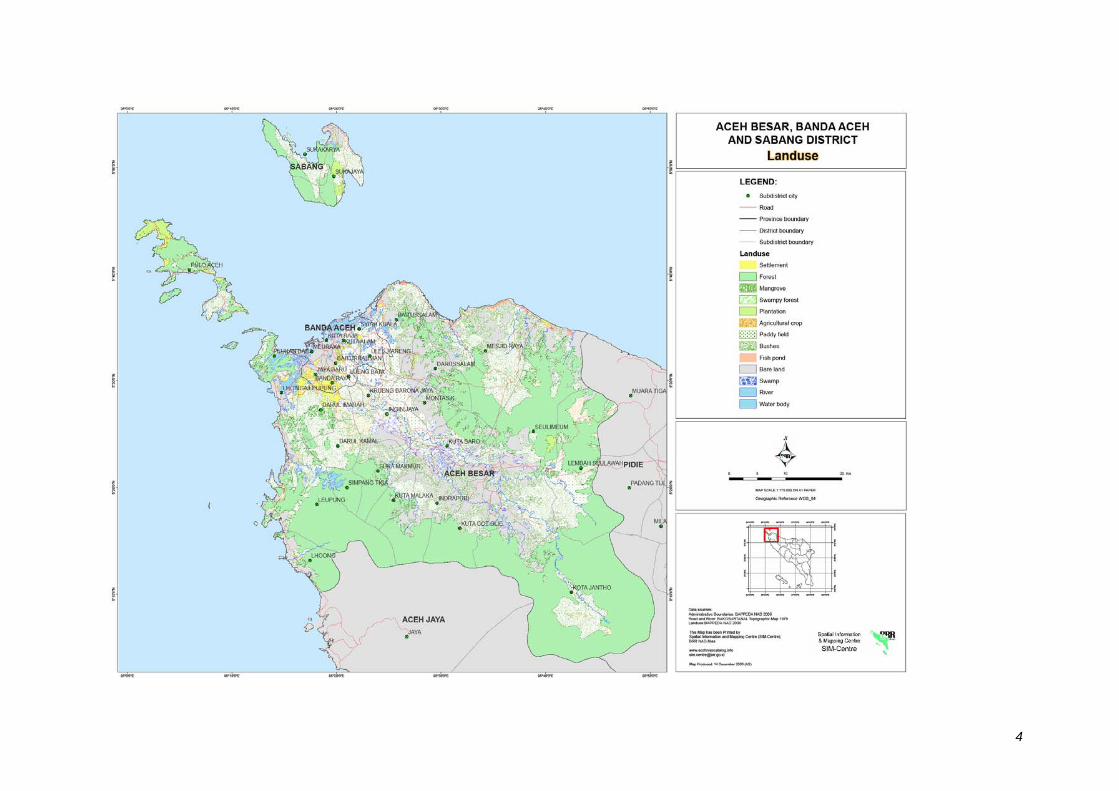
4