recroad reconstructing the paths of the roman …...the route in the itinerarium antonini the route...
TRANSCRIPT

RecRoadReconstructing the Paths of the Roman Travelers
from Aquileia to Singidunum
Sara ZanniUniversité Bordeaux Montaigne
Institut Ausonius

The Project

From the sources: the Itinerarium Antonini (IV-V AD)
The journey from Aquileia to Singidunum, following the Itinerarium Antonini, is 454 miles (about 673 km) long.

The route in the Itinerarium Antonini
The route described in the Itinerarium Antonini passesfrom Hemona (Ljubljana), then it turns to North-Westtowards Celeia and Patavione, to finally reach the basin ofthe Sava river at Cibalae e Sirmium.

From the sources: the Itinerarium Burdigalense (333-334 AD)
The journey from Aquileia to Singidunum, following the Itinerarium Burdigalense, is 471 miles (about 700 km) long.

The route in the Itinerarium Burdigalense
The route described in the Itinerarium Burdigalensepasses, again, from Hemona (Ljubljana), then it turns tothe North-West, towards Celeia and Patavione, to finallygo down to Cibalae and Sirmium.

From the sources: the Tabula Peutingeriana
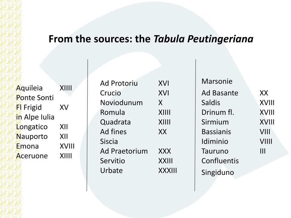
From the sources: the Tabula Peutingeriana
Marsonie
Ad Basante XXSaldis XVIIIDrinum fl. XVIIISirmium XVIIIBassianis VIIIIdiminio VIIIITauruno IIIConfluentis
Singiduno
Aquileia XIIIIPonte SontiFl Frigid XVin Alpe IuliaLongatico XIINauporto XIIEmona XVIIIAceruone XIIII
Ad Protoriu XVICrucio XVINoviodunum XRomula XIIIIQuadrata XIIIIAd fines XXSisciaAd Praetorium XXXServitio XXIII Urbate XXXIII

The route in the Tabula Peutingeriana
The route represented in the Tabula Peutingeriana passesfrom Emona (Ljubljana), then it turns South-West towardsthe Sava river, that it touches at Siscia. It follows thereforethe river to its confluence with the Danube in Singidunum.

Many roads, one destination
Romans built several roads(Viae) to connect Norts-Eastern Italy to the Danube:the travelers might choosethe most suitable itineraryaccording to his needs.
The RecRoad Project decided to reconstruct the one depicted onthe Tabula: the fastest, the easiest to travel in every season ofthe year, but probably also the first one built by the Romans.

From the Sources to the Maps: the historical atlases
In the images:
in green, the Roman roads network from the DARMC;
in red, the itinerary reconstructed for the RecRoad Project.

From the Sources to the Map: the RecRoad Project

Bibliography and precedent archaeological data

Remote Sensing: diachronical analysis
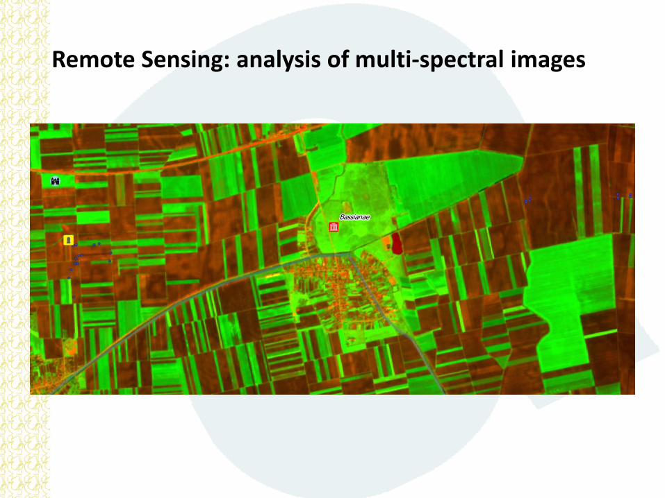
Remote Sensing: analysis of multi-spectral images

Remote Sensing: analysis of multi-spectral images
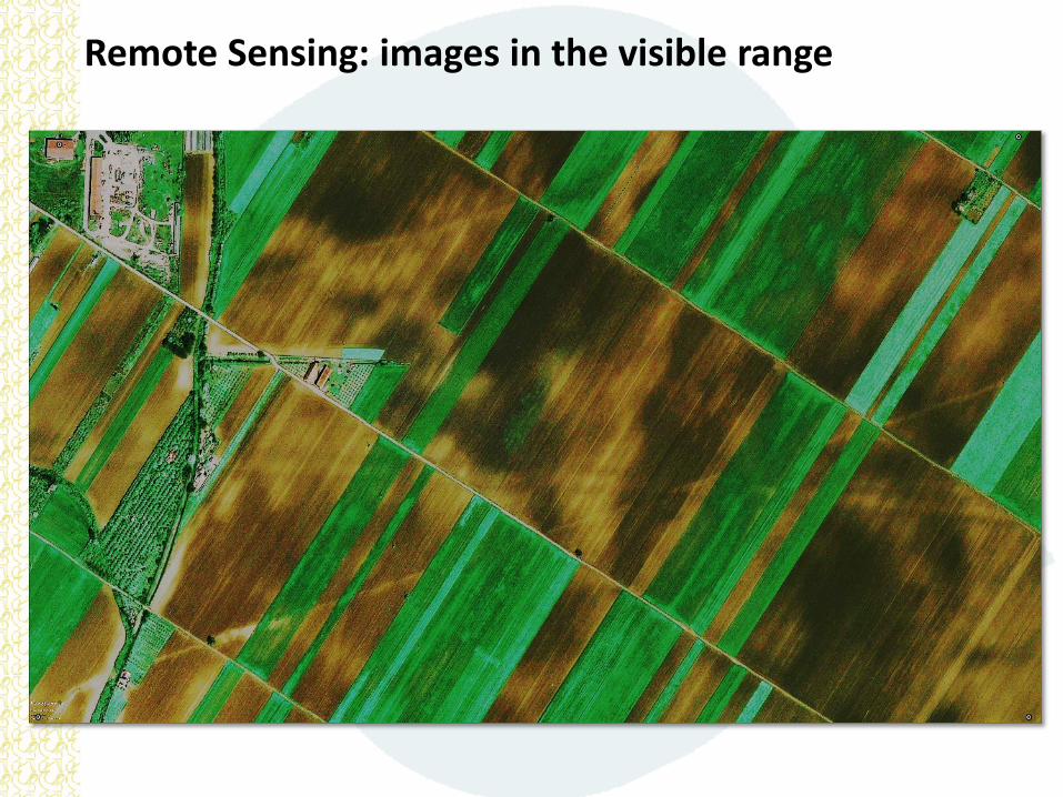
Remote Sensing: images in the visible range

Historical MapsDucatus Carnioliae Tabula Chorographica Iusu Sumptuque inclytorum ProvinciaeStatuum (1691 – 1757)

Historical MapsSpezialkarte der Österreichisch-Ungarischen Monarchie (1881 – 1901)

Historical MapsSpezialkarte der Österreichisch-Ungarischen Monarchie (1881 – 1901)

From the Sources to the Map: the GIS

From the Source to the Map: the surface surveys

From the Source to the Map: the surface surveys

From the map to the publication: digital atlases

From the Publication to the Communication:VIATORES, on the footsteps of the Roman travelers

Preliminary results:

Surveying from Sirmium to Singidunum
A special thanks to Dr. Biljana Lučić and to the Director of the Institute for the Protection of Cultural Monuments, Dr. Ljubiša Šulaja, who permitted these results.

Follow us:HTTP://RECONSTRUCTINGROMANROADS.WORDPRESS.COM