reconnaissance geochemical survey of tlie farah garan
TRANSCRIPT
DEPARTMENT OF THE INTERIOR U.S. GEOLOGICAL SURVEY
Reconnaissance Geochemical Survey of tlie Farah Garan-Kutam Mineral Belt,Kingdom of Saudi Arabia
By Rashid M. Samater ., Peter R, Johnson, and Arthur A. Bookstrom If
Open-File Report 91-39
Report prepared by the U.S. Geological Survey in cooperation with the Deputy Ministry for Mineral Resources, Saudi Arabia
I/ USGS Mission, Saudi Arabia
CONTENTS
Page ABSTRACT...................................................... 1
INTRODUCTION.................................................. 2Location and physiography................................ 4Previous and present work................................ 5Acknowledgments.......................................... 6
FIELD AND LABORATORY PROCEDURES............................... 6
DATA ANALYSIS AND PRESENTATION OF RESULTS..................... 7
DISCUSSION OF RESULTS........................................ 12Panned-concentrate geochemical anomalies................ 12Minus-80-mesh geochemical anomalies..................... 15
CONCLUSIONS AND RECOMMENDATIONS.............................. 19
DATA STORAGE................................................. 23
REFERENCES CITED............................................. 24
ILLUSTRATIONS[Plates are in pocket]
Plate 1. Geochemical anomaly map of the Farah Garan - Kutam mineral-belt, showing analytical results from panned- concentrate wadi-sediment samples.
Plate 2. Geochemical anomaly map of the Farah Garan - Kutam mineral belt, showing analytical results from sieved wadi-sediment samples.
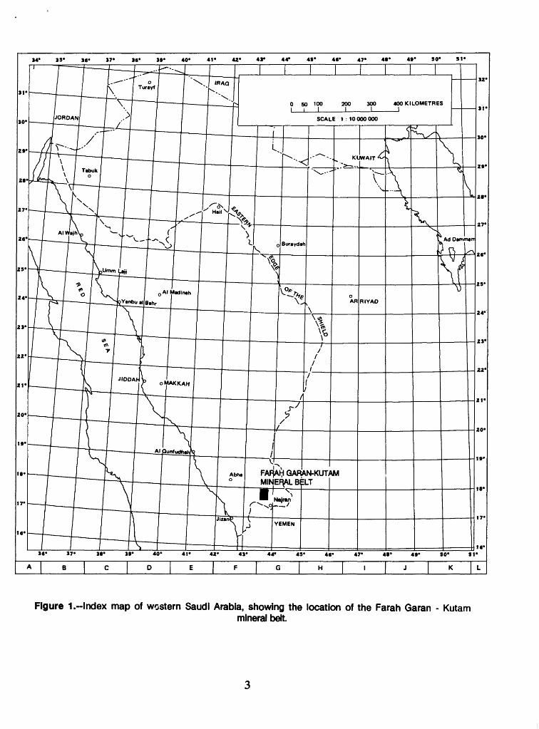
Figure 1. Index map of western Saudi Arabia, showing thelocation of the Farah Garan - Kutam mineral belt............. 3
Figure 2. Frequency-versus-element-concentration histograms for Farah Garan - Kutam mineral belt wadi-sediment geo chemi cal samples............................................. 8

TABLES
PageTable 1. Geometric means, standard deviations, and
threshold values for elements obtained from Farah Garan - Kutam mineral belt wadi-sediment geochemical samples..................................................... 10
Table 2. Threshold, moderately anomalous, and highly anomalous classes for Farah Garan - Kutam mineral belt wadi-sediment geochemical samples........................... 11
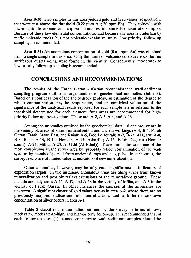
Table 3. Summary of anomalies outlined by Farah Garan-Kutam geochemical reconnaissance survey..................... 20
ii
RECONNAISSANCE GEOCHEMICAL SURVEY OF THE FARAH GARAN - KUTAM MINERAL BELT,
KINGDOM OF SAUDI ARABIA
ByRashid M. Samater, Peter R. Johnson,
and Arthur A. Bookstrom
ABSTRACT
Wadi-sediment samples were collected from 450 sites in a 580-km2 area (sample density 1.5 per km2) as part of an exploration program designed to assess the mineral potential of the Farah Garan - Kutam mineral belt and to evaluate mineralization at the Farah Garan ancient working (DGMR Project 3.03.10). Demagnetized panned-concentrate and sieved minus-80-mesh fractions were prepared from each bulk sample of approximately 5 kg. The fractions were analyzed for silver, arsenic, copper, lead, and zinc by atomic-absorption methods and for gold by an atomic-absorption graphite-furnace method.
The analytical results for the panned-concentrate samples delineate 21 anomalies, and the results for the minus-80-mesh samples delineate 24. Of the latter, 14 are coincident with panned-concentrate anomaly areas, whereas 10 are uniquely defined. The analytical results of the panned-concentrate samples uniquely define two areas. Overall, the panned-concentrate samples yielded threshold values higher than the threshold values for the minus-80-mesh samples (for gold, 10 times higher), and delineate anomalous areas larger than those for the minus-80-mesh samples. This observation is consistent with the results of similar surveys elsewhere in the Arabian Shield, which indicate that panned-concentrate samples more effectively outline geochemical anomalies than sieved fine-grained samples.
In the present survey, geochemical anomalies locate all the sites of mineralization known from previous work. The survey is therefore technically a success. However, a large number of these anomalies probably result from contamination of the wadi systems by metal dispersed from ancient mine workings, and this particular survey, overall, may be of limited value as a guide to the discovery of hitherto unknown mineralization. Nevertheless, the survey outlines two areas that may mark extensions to known mineralization, and a number of other areas in which no mineralization is known. Based on a consideration of the character of the bedrock geology, the value of each reported analytical result in relation to the respective element thresholds, and the number of anomalous samples that cluster in any given area, four areas are recommended for high-priority follow-up sampling.
INTRODUCTION
This report presents the results of wadi-sediment geochemical sampling that was undertaken in the Farah Garan - Kutam mineral belt (fig. 1) in Jumad Awal 1408 (December 1987). The survey was part of a program of exploration by the U.S. Geological Survey designed to assess the mineral potential of the Farah Garan - Kutam mineral belt and to evaluate mineralization at the Farah Garan ancient working. A mineral-resource potential has been known to exist in the area since the early 1970s, following the discovery of ancient gold and copper mines at Farah Garan and Kutam (Anderson, 1979). Subsequent exploration of the ancient mine sites in the mid-1970s and early 1980s by the U.S. Geological Survey (USGS) and Riofinex Limited, on behalf of the Saudi Arabian Directorate General of Mineral Resources (DGMR), and by Noranda Limited, a private company, located no deposits of economic significance (D. Bent and D. Maclnnis, written commun., 19771). Nevertheless, the region continued to attract the attention of geologists working with the DGMR. Reappraisal of the region by the USGS in the mid-1980s, in the light of newly developed mineral-deposit models (W.H. White, written commun., 1986), suggested that the Farah Garan - Kutam mineral belt warranted further examination.
The region is underlain by late Proterozoic metavolcanic, metasedimentary, and intrusive rocks that form part of a belt of rocks that extends 300 km north into the south-central part of the Shield and 80 km south toward Sa'dah in the Yemen Arab Republic. In the literature, the metavolcanic and metasedimentary rocks are assigned to the Halaban group (Sable, 1985). However, given the possibility that the rocks of the southeastern Shield constitute an allochthonous crustal unit, or terrane (Johnson and Vranas, 1984), the use of the term "Halaban" is questionable, and the term is not further used in this report.
The two principal ancient workings in the survey area are Farah Garan (copper, zinc, and associated gold and silver), and Kutam (copper). Both are volcanogenic-type sulfide deposits. Other smaller workings include Badr, Le Jourah, Milha, Hemair, Al Uthl (Al Ethel), and Asharfat, all of which exploited gold in quartz veins. The locations of the mineral occurrences are shown on plates 1 and 2. Further details of the geology and mineralization of the region are given by Bookstrom and others (1989) and Doebrich (1989).
1 Bent, D., and Maclnnis, D., 1977, Final report on Phase 1 exploration program Kutam-Talah concession: Noranda Ltd. (unpublished report cited in Smith and others, 1984).
3S» 3«« 37» 36» 3»« 40' 41 42» 43» 44» 4S» 46° 47» 48° 4»° SO* SI
0 50 100 200 300 400 KILOMETRESIII
SCALE 1 : 10 000 000
GARAN-KUTAM MINERAL B^LT
37» 38» 3»° 40° 41» 42° 43° 44» 48« 46* 47* 48* 4»» SO* SI
Figure 1.-Index map of western Saudi Arabia, showing the location of the Farah Garan - Kutammineral belt.
LOCATION AND PHYSIOGRAPHY
The Farah Garan - Kutam mineral belt is located between lats 17°30'N. and 17°53'N. and longs 43°30'E. and 43°47'E., 140 km southeast of Abha in the Southern Province of the Kingdom of Saudi Arabia (fig. 1). The area is situated about 25 km northeast of the Abha-Najran paved highway, and is accessible by vehicle along a desert track from the village of Talha, located on the highway 15 km north of Zahran al Janub.
The terrain in much of the survey area is rugged, and consists of steep-sided valleys deeply incised into the gently east-tilted Najran Plateau. The tilting resulted from mid-Oligocene to present-day uplift of the Red Sea Escarpment (Schmidt and others, 1982), which also caused rejuvenation of the drainage and the onset of vigorous erosion. The crest of the escarpment, between 2700 and 2900 m above sea level, is 15 km west of the survey area; within the survey area, summit levels descend from 2400 m above sea level in the west to 2100 m above sea level in the east. Vertical relief in the incised wadis is as much as 300 m. In much of the survey area, the drainage pattern is trellised, reflecting structural and lithologic control on the development of the wadis. However, a dendritic pattern is locally present in an area centered 4 km northeast of Kutam, where the undulating topography ranges between 2200 and 2300 m above sea level and represents part of the Najran Plateau preserved within the survey area. Wadis in both drainage-pattern areas are considered suitable for sediment sampling, although the great number of short, first- and second-order wadis that drain into the large main wadis necessitates a dense sampling program to effectively cover the study area. The wadis, particularly second-order wadis, contain a predominance of coarse-grained alluvium, making it difficult in places to locate sufficient amounts of appropriate sample material. The average temperature in the survey area ranges from 33° C in the summer to 17° C in the winter. Average annual rainfall is below 200 mm, and tends to occur as local downpours in the spring months.
Erosion at the present time is predominantly mechanical, although a variable, but limited, amount of chemical weathering and dispersion is evidenced by the presence of calcrete, gypsum, and iron-sulphate seepages at the base of some steep-sided wadis and in the vicinity of some gossans (Parker, 1982). The prevalent type of weathering and erosion affects the interpretation of the results of the geochemical survey. Dense ironstones, or gossans, and slag from ancient workings, which tend to resist comminution, are likely to be subjected to mechanical rather than chemical erosion, and to be dispersed as discrete grains some distance downstream from the source.
PREVIOUS AND PRESENT WORK
Ancient mining activity, evidenced by old trenches and adits, grindstones, and slag heaps, indicates that the mineral potential of the area was recognized and exploited centuries ago. In 1393-94 (1973-74), while mapping the geology of the Mayza' quadrangle (17/43B) at 1:100,000 scale, R.E. Anderson of the USGS found the Farah Garan and Kutam workings (Anderson, 1979). Colleagues from the USGS subsequently explored the two localities, Kutam between 1973 and 1975 (Smith and others, 1977), and Farah Garan during 1975 and 1976 (Smith, 1979). The Kutam prospect was mapped, geochemically sampled, and surveyed by electric self- potential, gamma radiation, and Turam electromagnetic methods (Smith and others, 1977). The results indicated that exploratory drilling was justified, and eight holes were drilled in 1974 and 1975. Concurrently, additional geophysical surveys were completed, and the scope of geologic mapping was extended. The results of drilling yielded an indicated and inferred reserve estimate of 8.1 million tonnes, at a grade of 0.31 g/t gold, 6.13 g/t silver, 1.83 percent copper, and 0.95 percent zinc. Subsequent exploration by Noranda Ltd. between 1975 and 1976, yielded a similar grade and tonnage estimate (D. Bent and D. Maclnnis, written commun., 1977; see footnote, p. 2) and concluded that the deposit was subeconomic.
During 1975-76, C.W. Smith and A.M. Helaby of the USGS mapped and sampled ancient mines of the Farah Garan district, including Al Ashyab, Lejourah, and Hemair, and H.R. Blank conducted ground geophysical surveys, using Turam electromagnetic and self-potential methods (Smith, 1979). Based on the results of this phase of exploration, a diamond-drilling program was recommended and was undertaken by the USGS at Farah Garan between October 1978 and March 1979 (Smith and Mawad, 1982). Three holes were completed, intersecting between 30m and 50 m of sparse zinc-copper-gold-silver mineralization and several narrow isolated zones of high-grade base and precious-metal mineralization.
Between Moharram 1399 (December 1978) and Rabi Thani 1401 (February 1981), the Riofinex Geological Mission conducted an extensive exploration and assessment program of the base-metal mineral potential of the region, including geologic mapping at 1:50,000 scale and wadi-sediment sampling (Parker, 1982). The results from the geochemical survey were subsequently evaluated and supplemented by sampling for gold (Sanderson, 1984), and further tested in the Farah Garan area by a follow-up geochemical program (Saleh, 1985). Renewed exploration of the region by USGS commenced in Moharram 1408 (August 1987). The Farah Garan ancient mine site was mapped and drilled, and the economic significance of the mineralization assessed (Doebrich, 1989); the mineral belt was mapped at 1:50,000 scale (Bookstrom and others, 1989); the area was geochemically sampled at the regional scale of 1:50,000 (this report); and the area was sampled at various larger scales for follow-up purposes (Kellogg and others, 1989).
ACKNOWLEDGMENTS
This study was performed in accordance with a cooperative agreement between the U.S. Geological Survey (USGS) and the Saudi Arabian Ministry of Petroleum and Mineral Resources as Subproject 3.03.10 of the 1408 and 1409 Work Programs.
The authors thank Mohsin Mohamed Ahmed for sample preparation and panning. The technical review was done by Dr. Richard B. Carten (USGS).
FIELD AND LABORATORY PROCEDURES
No specific orientation survey preceded this sampling program. Instead, the specifications of the program were based on practices adopted by earlier workers in the region, on experience gained by the first author elsewhere in the Arabian Shield, and on the general approach of the USGS Saudi Arabian Mission to geochemical sampling. Particular background information that contributed to the design of the survey was provided by Parker (1982), Samater (1982), Samater and others (1989), Sanderson (1984), Gaukroger and Sale (1985), Overstreet and Day (1985), and Saleh (1985). Because of the mountainous character of the survey area, contamination by eolian debris is minimal, and no special precautions were taken to screen out very fine grained, wind-borne material (Barbier, 1987).
Sample collection was aided by use of a Jet Ranger II Bell helicopter and was accomplished in 18 days during the month of Jumad Awal 1408 (December 1987). Some of the wadis were either too steep or too narrow to accommodate a helicopter, and these were accessed on foot. In principle, sample sites were preselected in the office prior to field work in order to ensure a uniform distribution. The intended sample locations were marked on aerial photographs at sites immediately above the confluence of one wadi with another. In general, the sample sites were located in first- or second-order wadis that are tributaries to the main wadis; only in rare instances were sites selected in a main wadi. In practice, the locations of the sample sites were modified in the field depending on the specific geographic features encountered and on the suitability of the site for sampling.
Samples were collected at 450 locations in an area of approximately 580 km2, resulting in a sampling density of about one sample per 1.5 km2. At each sample site, a single excavation was made and about 5 kg. of unconsolidated wadi material was collected at a depth of about 20 cm. Because much of the wadi alluvium consists of poorly sorted gravel, the samples were sieved on location to remove clasts coarser than 10 mesh (2 mm). The resulting minus-10-mesh (-2 mm) samples were taken to the Farah Garan field camp and mechanically split. A small portion of one split was
sieved to obtain a minus-80-mesh fraction (-180 micron). The remaining portion of the split was added to the second split and the resulting composite sample was hand-panned to obtain a minus-10-mesh (-2 mm) heavy-mineral concentrate. The panned concentrates were dried, and the magnetic fraction (chiefly magnetite) was removed with a hand magnet. Both minus-80-mesh and panned concentrate fractions were sent to Skyline Labs, Inc., Denver, Colorado, in May 1989 for analysis.
The demagnetized panned-concentrate and minus-80-mesh samples were analyzed for silver, arsenic, copper, lead, and zinc by atomic-absorption spectroscopy, and for gold by an atomic-absorption graphite-furnace method. It was anticipated that the results of analysis of the panned concentrates and the minus- 80-mesh fraction would complement each other. If ultrafine gold was inadvertently washed off during panning and therefore not reported in the panned-concentrate samples, it would be detected in the minus-80-mesh samples (Gaukroger and Sale, 1985). Additionally, it was expected that panning would provide a more sensitive indicator of anomalous concentrations of elements than the minus-80-mesh samples (Samater, 1982).
Rock Analysis Storage (RASS) sample numbers for this project begin at 233001 and end at 233950. Panned-concentrate samples were allocated numbers 233001-233450, and the minus-80-mesh samples were allocated numbers 233501-233950.
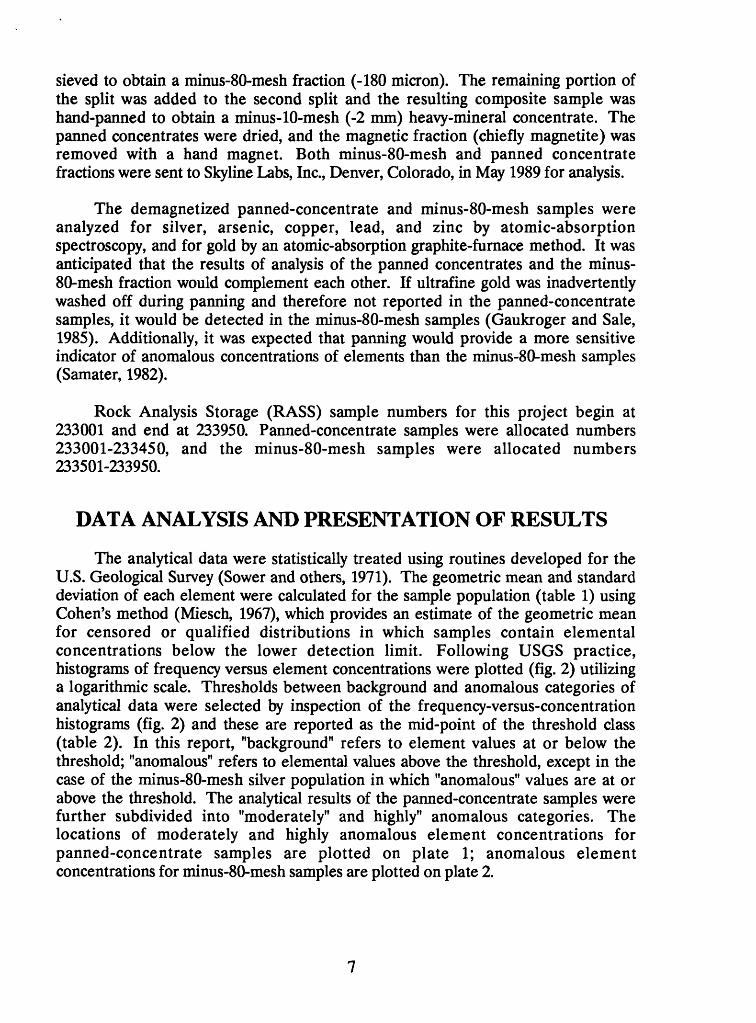
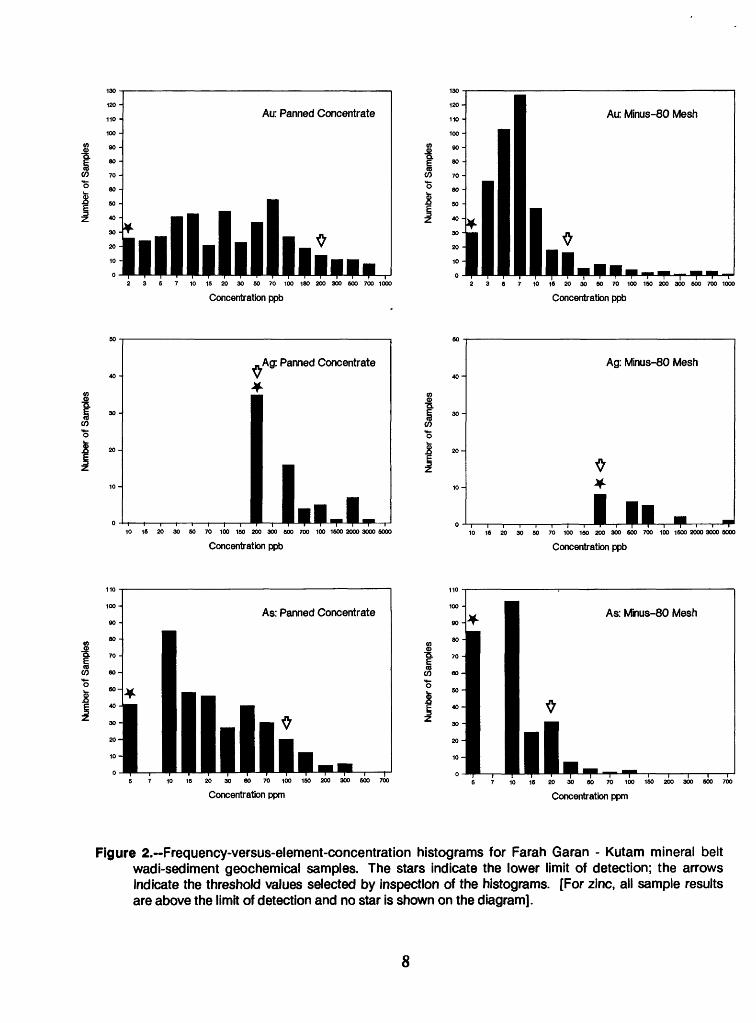
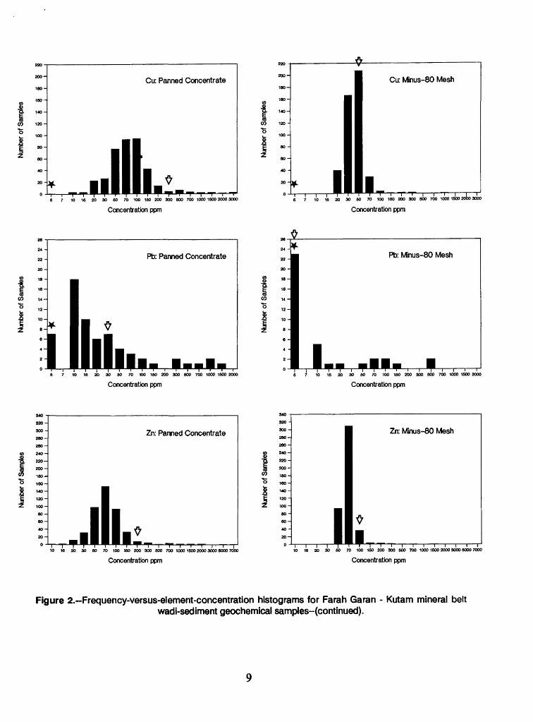
DATA ANALYSIS AND PRESENTATION OF RESULTS
The analytical data were statistically treated using routines developed for the U.S. Geological Survey (Sower and others, 1971). The geometric mean and standard deviation of each element were calculated for the sample population (table 1) using Cohen's method (Miesch, 1967), which provides an estimate of the geometric mean for censored or qualified distributions in which samples contain elemental concentrations below the lower detection limit. Following USGS practice, histograms of frequency versus element concentrations were plotted (fig. 2) utilizing a logarithmic scale. Thresholds between background and anomalous categories of analytical data were selected by inspection of the frequency-versus-concentration histograms (fig. 2) and these are reported as the mid-point of the threshold class (table 2). In this report, "background" refers to element values at or below the threshold; "anomalous" refers to elemental values above the threshold, except in the case of the minus-80-mesh silver population in which "anomalous" values are at or above the threshold. The analytical results of the panned-concentrate samples were further subdivided into "moderately" and highly" anomalous categories. The locations of moderately and highly anomalous element concentrations for panned-concentrate samples are plotted on plate 1; anomalous element concentrations for minus-80-mesh samples are plotted on plate 2.
120 -
110 -
100 -
90 -
80 -
70 -
Air. Panned Concentrate
lllll.llllh2 3 6 7 10 15 20 30 50 70 100 180 200 300 600 700 1000
130
120-
110 -
100-
90 -
80 -
70 -
60 -
50 -
Air. Minus-80 Mesh
illll,,Concentration ppb
2 3 S 7 10 18 20 30 60 70 100 150 200 300 600 700 1000
Concentration ppb
,Ag: Panned Concentrate
I10 16 20 30 50 70 100 150 200 300 600 700 100 1600 2000 3000 5000
Concentration ppb
Ag: Minus-80 Mesh
10 18 20 30 SO 70 100 160 200 300 600 700 100 1600 2000 3000 5000
Concentration ppb
As: Panned Concentrate
6 7 10 16 20 30 8O 70 100 150 200 300 600 700
Concentration ppm6 7 10 18 20 30 60 70 100 150 200 300 500 700
Concentration ppm
Figure 2. Frequency-versus-element-concentration histograms for Farah Garan - Kutam mineral belt wadi-sediment geochemical samples. The stars indicate the lower limit of detection; the arrows Indicate the threshold values selected by inspection of the histograms. [For zinc, all sample results are above the limit of detection and no star is shown on the diagram].
8
Num
ber o
f Sam
ples
Num
ber
of S
ampl
esN
umbe
r of S
ampl
es
Tl
<5*
(D CO
CO
31
2.Is
1 1
CQ 3-
-
Num
ber o
f Sam
ples
Num
ber
of S
ampl
esN
umbe
r of
Sam
ples
3 5
2.3 CO
o ~n
si w n g.0
ii Q
)
' I C
T CD
Table 1.-Geometric means, standard deviations, and threshold values for elements obtained from Farah Garan - Kutam mineral belt wadi-sediment geochemical samples
[Number of samples (N) with concentrations greater than the lower detection limit. All values are in ppm. Geometric mean and standard deviation calculated by methods of Sower and others (1971), assigning values to samples below the detection limits according to Cohen's method for estimating means of censored distributions (Miesch, 1967).]
El ement N Detection Geometric limit mean (ppm) (ppm)
Standard Selected histogram deviation threshold values (ppm) (mid-point of class
interval) (ppm)
Panned concentrates
GoldSilverArsenicCopperLeadZinc
GoldSilverArsenicCopperLeadZinc
Note: ***
***
44574
35845065
450
44422
25745038
450
= 83.6= 85.6 = 95.1
005555
005555
.002
.2
.0
.0
.0
.0
Minus-80
.002
.2
.0
.0
.0
.0
percent ofpercent of oercent of
0.03*
13.497.6**74.4
14
51410236429
mesh-fraction
0.0067***4.839.81.168.1
samplessamples samoles
00
1155
10784
belowbelow below
.3
.3
.0
.6
.0
.0
samples
.09
.9
.8
.0
.3
.5
detectiondetection detection
00
10030030
200
00
20505
100
.2
.2
.0
.0
.0
.0
.02
.20
.0
.0
.0
.0
limit;limit; limit:
in these cases no meaningful geometric mean has been calculated. The silver threshold is set at the detection limit.
10
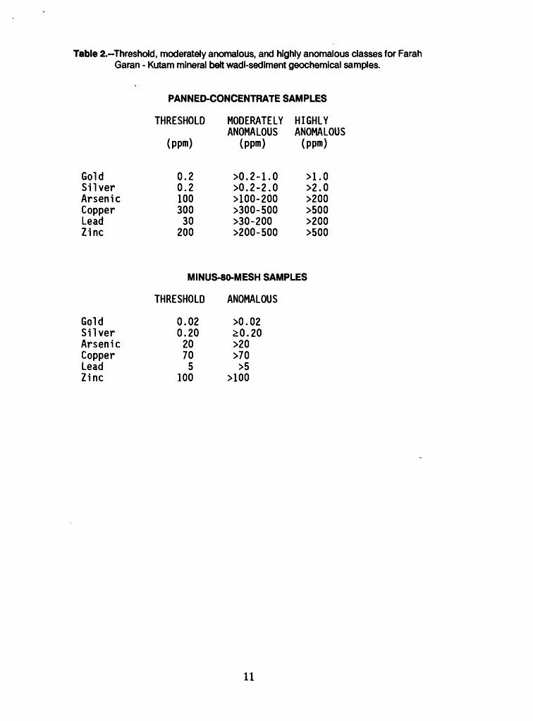
Table 2.-Threshdd, moderately anomalous, and highly anomalous classes for Farah Garan - Kutam mineral belt wadi-sediment geochemical samples.
PANNED-CONCENTRATE SAMPLES
THRESHOLD MODERATELY HIGHLYANOMALOUS ANOMALOUS
(ppm) (ppm) (ppm)
Gold 0.2 >0.2-1.0 >1.0Silver 0.2 >0.2-2.0 >2.0Arsenic 100 >100-200 >200Copper 300 >300-500 >500Lead 30 >30-200 >200Zinc 200 >200-500 >500
MINUS-80-MESH SAMPLES
THRESHOLD ANOMALOUS
Gold 0.02 >0.02Silver 0.20 £0.20Arsenic 20 >20Copper 70 >70Lead 5 >5Zinc 100 >100
11
DISCUSSION OF RESULTS
PANNED-CONCENTRATE GEOCHEMICAL ANOMALIES
Twenty one anomalous areas are delineated on plate 1, comprising clusters of samples that yield above threshold values for the tested elements. Three areas, A-6, A-19, and A-20, are outlined on the basis of solitary samples containing high gold concentrations; other anomalous areas comprise two or more anomalous samples.
Area A-l: This area comprises a cluster of seven samples containing between 0.8 and 36.0 ppm Ag (the maximum silver value in the survey). No ancient workings are known in the area, and the source of the silver is unknown. The bedrock consists of a quartz porphyry intrusion. Volcanic-exhalative beds, which characterize mineralized areas elsewhere in the Farah Garan - Kutam mineral belt, were not observed. The abundance of silver and absence of other indications of mineralization distinguishes this anomaly from others in the region, and suggests that its origin is unique. However, because coincident gold and base-metal concentrations are not featured in the area, only moderate-priority follow-up sampling is recommended.
Area A-2: This area comprises a cluster of four samples containing anomalous gold values (ranging from 0.24 to 1.9 ppm Au). They were collected from a small catchment area draining into Wadi al Arin from the north and from a very small wadi entering Wadi al Arin from the south. No ancient workings are known in the area. Bedrock primarily consists of a quartz porphyry intrusion. High-priority follow-up is recommended.
Area A-3: This area is anomalous in silver (0.4-2.8 ppm Ag), copper (305-1300 ppm Cu), zinc (450-1500 ppm Zn), lead, and gold (0.43 ppm Au), and consists of four tightly clustered samples. The samples were collected from a small drainage system immediately south of the watershed south of the Farah Garan drainage. Bedrock in the anomaly area is similar to bedrock at Farah Garan, and because of this similarity and the proximity of the area to the Farah Garan prospect, high- priority follow-up sampling is recommended.
Area A-4: Area A-4 is the largest cluster of high value samples in the survey area. The area is underlain by a succession that includes numerous beds of volcanic-exhalative rock of the type hosting mineralization at Farah Garan. Farah Garan and Farah Garan East occur in the western, up-stream, part of the anomaly area, and other, minor ancient workings occur in the eastern part. The anomaly area comprises six samples anomalous in gold (0.3-3.7 ppm Au), three samples anomalous in arsenic (100-325 ppm As), and seven samples variously anomalous in copper, zinc, lead, and silver (0.8-5.9 ppm Ag). The wadi system in the anomaly area
12
drains east, transverse to the north-south strike of the bedrock (Bookstrom and others, 1989). Although it is likely that the anomalies chiefly reflect contamination caused by metal dispersion from the ancient workings, the area is judged to warrant high-priority follow-up because of its size.
Area A-5: This area comprises a small cluster of samples marked by anomalous gold (0.47-6.4 ppm Au) and silver (0.4 ppm Ag). The area includes the ancient workings and large ore-processing site of Lejourah (Blank, in Smith, 1979), and the anomalous concentrations of elements in the samples probably reflect contamination. Precious-metal-bearing quartz veins are likely sources. A moderate priority is recommended for follow-up work.
Area A-6: The area is marked by a solitary sample site from which the panned- concentrate fraction yields high values of gold (3.9 ppm Au) and silver (1.5 ppm Ag). The sample was obtained immediately upstream from an assemblage of volcanic- exhalative rock, at a site 2.5 km along strike north of Farah Garan. The concentrations of arsenic and other elements are very low, and the area is accorded a low priority for follow-up.
Area A-7: This anomaly occurs 6 km northeast of the Farah Garan prospect and is underlain, in part, by an assemblage of volcanic-exhalative rock types comparable to that at Farah Garan. However, only moderately anomalous concentrations of metals are reported: 0.32-0.58 ppm gold, 0.4-2.1 ppm silver, and 145-340 ppm arsenic. The ancient workings of Al Qarn (auriferous quartz vein) are in the vicinity of the anomaly area but sediment from the wadi draining the workings does not contain anomalous concentrations of analyzed elements. Only moderate-priority follow-up is warranted.
Area A-8: Area A-8 is a cluster of five moderately anomalous gold samples (0.28-0.79 ppm Au) associated with minor concentrations of lead and silver. The sampled wadis are underlain chiefly by graywacke and mafic volcanic rocks. Apart from the Badr ancient working, sources for the anomalous gold are not known. Moderate-priority follow-up sampling is recommended.
Area A-9: This area is marked by a cluster of three samples anomalous in gold and one sample anomalous in gold, arsenic, and copper. It is underlain by a relatively homogeneous quartz porphyry intrusion; ancient workings are not known. Small auriferous quartz veins in the region may account for the scatter of gold concentrations. The analytical results are very low (0.26-0.32 ppm Au) however, and only low-priority follow-up is recommended.
Area A-10: This area includes a scatter of samples that are anomalous in gold, arsenic, copper, and zinc. The samples were collected from several small second- order wadis, and the analytical results reflect anomalous concentrations of metals at scattered sites over a large area. The bedrock is heterogeneous. Thin units of
13
volcanic-exhalative assemblages cross the southern part of the area, and a shear zone trends west-southwest along the major axis of the area. Ancient workings are not mapped, and the source of the gold-arsenic association is unknown. Moderate- priority follow-up is recommended.
Area A-ll: Area A-11 consists of a small cluster of samples that contain concentrations of gold (0.21 ppm Au), zinc (185-325 ppm Zn), and arsenic (155-170 ppm As) close to the threshold values for the reported elements. The Kholan shear zone is the dominant structure in the area. The bedrock consists of sheared mafic volcanic rock and minor occurrences of volcanic-exhalative rock (Bookstrom and others, 1989). Because of the low elemental concentrations, only low-priority follow-up sampling is warranted.
Area A-12: This small area is marked by two anomalous arsenic samples. They were obtained from sample sites in short first-order wadis that drain mafic-volcanic and sheared rocks within the Kholan shear zone. Because the reported concentrations of arsenic are relatively low, and the concentrations of other elements are not anomalous, only low-priority follow-up is recommended.
Area A-13: This area is similar to area A-12; it comprises two anomalous arsenic concentrations in samples from short first-order wadis that drain the Kholan shear zone. No anomalous concentrations of other elements are present. The panned-concentrate-sample results warrant low-priority follow-up. However, the presence of anomalous gold and silver in minus 80-mesh samples from the same area (as reported below) upgrades the priority of the area, and moderate-priority follow-up is recommended.
Area A-14: This anomaly area encompasses the Hemair ancient workings, and the reported anomalous concentrations of gold, silver, and arsenic (0.47 and 0.67 ppm Au; 1.2 and 2.4 ppm Ag; and 245 ppm As) probably reflect contamination of the wadi alluvium by the ancient workings. Two wadis were sampled: a first-order wadi that crosses the ancient workings north of Wadi Maslulah, and a third-order wadi south of Wadi Maslulah. Although bedrock in the area includes volcanic-exhalative units of the type present at Farah Garan, only moderate-priority follow-up sampling is recommended because the size of the anomaly area is small and contamination is a significant factor.
Area A-15: Area A-15 consists of minor concentrations of gold (0.23 ppm Au in one sample), arsenic (105 ppm and 110 ppm As), zinc, copper, silver, and lead in samples collected from short first- and second-order wadis. The Asharfat ancient working (auriferous quartz vein) lies in the vicinity of the anomaly area but does not cause any noticeable enhancement of metal values. Units of volcanic-exhalative bedrock are mapped only in the western part of the area (Bookstrom and others, 1989) and the area warrants only moderate-priority follow-up sampling.
14
Area A-16: This small anomalous area includes two samples that yield moderate to high gold concentrations (0.53-2.4 ppm Au), coincident moderately anomalous arsenic (320 ppm As), and moderately anomalous copper. The geology of the area is complex, as the area includes the southern part of the Kholan shear zone, a zone of pyritization, and a volcanic-exhalative assemblage that extends into the area from Degarth (Hemair south) and Hemair ancient workings (Bookstrom and others, 1989). High-priority follow-up sampling is recommended.
Area A-17: In this area, three samples occur along a wadi that drains east from an area of high ground that possibly contains an extension of the Milha ancient workings (auriferous quartz veins). Reported gold concentrations range from 0.58 to 5.7 ppm Au. Moderate- to high-priority follow-up sampling is recommended.
Area A-18: Highly anomalous gold concentrations (1.2 and 2.2 ppm Au) were noted in samples from two sites in this area. The samples were collected from wadis that drain high ground south of the Milha ancient workings (auriferous quartz veins). It is possible that the sampling results reflect an extension of the Milha mineralization, and the area should be further tested by moderate- to high-priority follow-up sampling.
Area A-19: Defined by a single sample that yielded moderately anomalous concentrations of gold, arsenic, and copper (0.71 ppm Au, 160 ppm As), this area is judged to warrant low-priority follow-up sampling. The area is crossed by the Kholan shear zone and a zone of pyritization that extends south from the vicinity of the Hemair ancient workings.
Area A-20: A single sample from this area yielded an extremely high gold concentration (24 ppm Au); coincident silver is moderately anomalous (0.4 ppm Ag). The sampled wadi drains the Al Uthl (Al Ethel) ancient workings (auriferous quartz veins), and the reported gold concentration may be the result of contamination. Moderate-priority follow-up is recommended.
Area A-21: This area is marked by moderately anomalous concentrations of arsenic, gold, and silver. The results were obtained from samples collected at sites in second-order wadis approximately 1.5 km downstream from the Milha ancient workings (auriferous quartz veins), and presumably reflect this mineralization and (or) contamination by the ancient workings. Only low-priority follow-up sampling is warranted.
MiNUS-80-MESH GEOCHEMICAL ANOMALIES
Twenty-four anomaly areas are delineated by analytical results obtained from the minus-80-mesh wadi-sediment samples (plate 2). Forteen coincide with anomaly areas outlined by the panned concentrate samples; the other 10 areas are uniquely
15
defined by the results of the minus-80-mesh sampling. The format of the labels used to identify the anomaly areas on plate 2 follows that used for the panned-concentrate anomaly areas (plate 1) except that the prefix "B" substitutes for "A". Coincident panned-concentrate and minus-80-mesh anomaly areas have the same suffix number; areas uniquely defined by the minus-80-mesh samples are anomalies B-22 toB-31.
The minus-80-mesh analytical results do not outline any anomalies corresponding to areas A-l, A-2, A-6, A-9, A-12, A-18, A-20, and A-21.
Area B-3: This small area of clustered samples anomalous in zinc, silver, and copper (but not gold, lead, or arsenic) correlates with panned-concentrate anomaly area A-3. It is adjacent to the Farah Garan mineralized area and warrants high-priority follow-up sampling.
Area B-4: Area B-4 contains the largest cluster of anomalous minus-80-mesh samples in the survey area, and it is comparable in size to the area outlined by anomalous panned-concentrates samples (A-4). All elements are represented (0.7 ppm Au, 0.8 ppm Ag, plus Pb, Cu, Zn, and As). The area includes the Farah Garan and Farah Garan East ancient workings. Although most of the anomalous concentrations of metals are likely to reflect contamination, high-priority follow-up sampling is recommended.
Area B-5: The anomaly consists of a single gold-rich sample (0.18 ppm Au) that is coincident with one of the gold-rich panned-concentrate samples from area A-5. The anomaly is probably caused by contamination from the Lejourah ancient workings, and only low-priority follow-up is warranted.
Area B-7a: Area B-7a correlates with the western part of area A-7. It consists of a single sample anomalous in lead, zinc, and silver collected from an area underlain by volcanic-exhalative bedrock. Moderate-priority follow-up sampling is recommended.
Area B-7b: This area, which correlates with the eastern part of area A-7, consists of samples anomalous in arsenic and silver. The area is underlain by the Kholan shear zone. No supporting evidence of mineralization has been mapped in the immediate vicinity of the anomaly area, and follow-up sampling should be given a low-priority status.
Area B-8: This area is marked by two samples containing anomalous concen trations of gold (0.08 ppm and 0.36 ppm Au). The area occurs in the core of Area A-8, also characterized by anomalous gold, and warrants moderate-priority follow-up sampling.
16
Area B-10: Two samples constitute this area, one anomalous in gold, and the other in silver (0.05 ppm Au, and 0.4 ppm Ag). The area coincides with the southwestern part of area A-10, and moderate-priority follow-up sampling is recommended.
Area B-ll: This area comprises samples anomalous in zinc and arsenic. In the absence of supporting gold anomalies, only low-priority follow-up sampling is recommended.
Area B-13: This area is marked by anomalous gold (0.3 ppm Au), silver (0.4 ppm Ag), and arsenic (25 ppm As) values from three different samples collected at sites in short first-order wadis. The corresponding panned-concentrate anomaly area (A-13) consists of arsenic anomalies. The area is underlain by rocks of the Kholan shear zone; volcanic-exhalative units do not appear to be present. Panned- concentrate samples from the area contain no anomalous gold, but the presence of high gold concentrations in the minus-80-mesh samples upgrades the priority of the area, and moderate-priority follow-up sampling is recommended.
Area B-14: Area B-14 reflects mineralization at the Hemair prospect and correlates with area A-14. Anomalous concentrations of gold (0.45 ppm Au), arsenic, silver, copper, lead, and zinc are reported, but because contamination is likely to be a major factor affecting the analytical results, only moderate-priority follow-up sampling is recommended.
Area B-15: Two samples anomalous in zinc and copper outline this area in the western part of area A-15 and coincide with panned-concentrate samples anomalous in the same elements. Quartz veins are common in the area and contain traces of copper and zinc mineralization. However, in the absence of support from significant gold or arsenic concentrations, only low-priority follow-up sampling is warranted.
Area B-16: This area is marked by anomalous concentrations of gold (1.0 ppm Au) and arsenic (105 ppm As), in samples collected from a small wadi system that probably drains a southward extension of the Hemair mineralization in an area that correlates with area A-16. The area warrants high-priority follow-up sampling.
Area B-17: The anomalous concentrations of gold (0.14 ppm Au) and arsenic (35 ppm As) present in this area possibly mark a northward extension of the type of auriferous quartz veins present at Milha. The high metal values were obtained from a single minus-80-mesh sample and correlate with anomalies of gold and arsenic from a panned-concentrate sample in the western part of area A-17. Moderate- to high-priority follow-up sampling is recommended.
Area B-19: This area is outlined by three samples anomalous in arsenic. They were collected from wadis that drain pyritized rock along the southern extension of the Kholan shear zone. The area correlates with area A-19, which is moderately
17
anomalous in gold and arsenic; but in the absence of high gold values, the area only warrants low-priority follow-up sampling.
Area B-22: Area B-22 consists of a single sample anomalous in gold (0.11 ppm Au) collected from a first-order wadi. In the absence of support by any other anomalous elements, low-priority follow-up sampling is recommended.
Area B-23: This area, underlain by the Kholan shear zone, is marked by anomalous concentrations of gold and arsenic. The adjacent area A-12 along the strike of the shear zone, is marked only by anomalous arsenic. Low-priority follow-up sampling is recommended.
Area B-24: This area contains a single anomalous gold sample (0.18 ppm Au) collected from a small first-order wadi. The anomaly is not supported by any other coincident anomalies. Only low-priority follow-up is recommended.
Area B-25: This area is defined by anomalous concentrations of gold (0.44 ppm Au) and silver (0.2 ppm Ag) in samples obtained from two sites in short first-order wadis. The area coincides with one panned-concentrate sample anomalous in arsenic (sample #233007), and lies upstream, along strike, from the Lejourah ancient workings. It warrants moderate priority follow-up sampling.
Area B-26: This area consists of a single anomalous gold value (0.48 ppm Au) and two anomalous copper values. The anomalous element concentrations were yielded by samples collected from a small second-order wadi. Neither volcanic-exhalative rock assemblages nor quartz veins or ancient workings appear to be present mapped in the area, and the source of the gold is unknown. Moderately anomalous concentrations of gold occur in a panned-concentrate sample acquired from an adjacent wadi in area B-25, and moderate priority follow-up sampling is recommended.
Area B-27: The small wadi sampled in this area yielded a single anomalous concentration of gold (0.12 ppm Au). The source of the gold is unknown. The wadi drains part of the Kholan shear zone and an area of high ground in which there conceivably may be extensions of the Milha-type of quartz-vein mineralization. The panned-concentrate sample from the same site contained metal values below the threshold; therefore, only moderate-priority follow-up sampling is recommended.
Area B-28: A single silver anomaly (1.4 ppm Ag) occurs in this area, obtained from a sample collected in a wadi that drains a zone of pyritized rock on the margin of the Hadadah pluton. Moderate-priority follow-up sampling is warranted.
Area B-29: This anomaly area contains a single sample rich in silver (4.5 ppm Ag) the highest silver value for sieved samples in the survey area. Because the sampled second-order wadi possibly drains a northward extension of quartz veins from the Milha prospect, moderate-priority follow-up sampling is recommended.
18
Area B-30: Two samples in this area yielded gold and lead values, respectively, that were just above the threshold (0.22 ppm Au; 20 ppm Pb). They coincide with low-magnitude arsenic and copper anomalies in panned-concentrate samples. Because of these low elemental concentrations, and because the area is underlain by mafic volcanic rocks but not volcanic-exhalative units, low-priority follow-up sampling is recommended.
Area B-31: An anomalous concentration of gold (0.61 ppm Au) was obtained from a single sample in this area. Only thin units of volcanic-exhalative rock, but no auriferous quartz veins, were found in the vicinity. Consequently, moderate- to low-priority follow-up sampling is recommended.
CONCLUSIONS AND RECOMMENDATIONS
The results of the Farah Garan - Kutam reconnaissance wadi-sediment sampling program outline a large number of geochemical anomalies (table 3). Based on a consideration of the the bedrock geology, an estimation of the degree to which contamination may be responsible, and an empirical valuation of the significance of the analytical results reported for each sample site in relation to the threshold determined for each element, four areas are recommended for high- priority follow-up investigations. These are: A-2, A-3, A-4, and A-16.
Among the anomalies outlined by the geochemical data, 10 enclose, or are in the vicinity of, areas of known mineralization and ancient workings (A-4, B-4: Farah Garan, Farah Garan East, and Raiah; A-5, B-5: Le Jourah; A-7, B-7a: Al Qarn; A-8, B-8, Badr; A-14, B-14: Hemair; A-15: Asharfat; A-16, B-16: Degarth (Hemair south); A-21: Milha; A-20: Al Uthl (Al Ethel)). These anomalies are some of the most conspicuous in the survey area but probably reflect contamination of the wadi systems by metals dispersed from ancient dumps and slag piles. In such cases, the survey results are of limited value as indicators of new mineralization.
Other anomalies, however, may be of greater significance as indicators of exploration targets. In two instances, anomalous areas are along strike from known mineralization and possibly reflect extensions of the mineralized ground. These include anomaly areas A-16, A-17, and A-18 in the vicinity of Milha, and A-3 in the vicinity of Farah Garan. In other instances the sources of the anomalies are unknown. A significant cluster of gold values occurs in area A-2, where there are no previously mapped indications of mineralization, and a hitherto unknown concentration of silver occurs in area A-l.
Table 3 classifies the anomalies outlined by the survey in terms of low-, moderate-, moderate-to-high, and high-priority follow-up. It is recommended that at each follow-up site: (1) panned-concentrate wadi-sediment samples should be
19
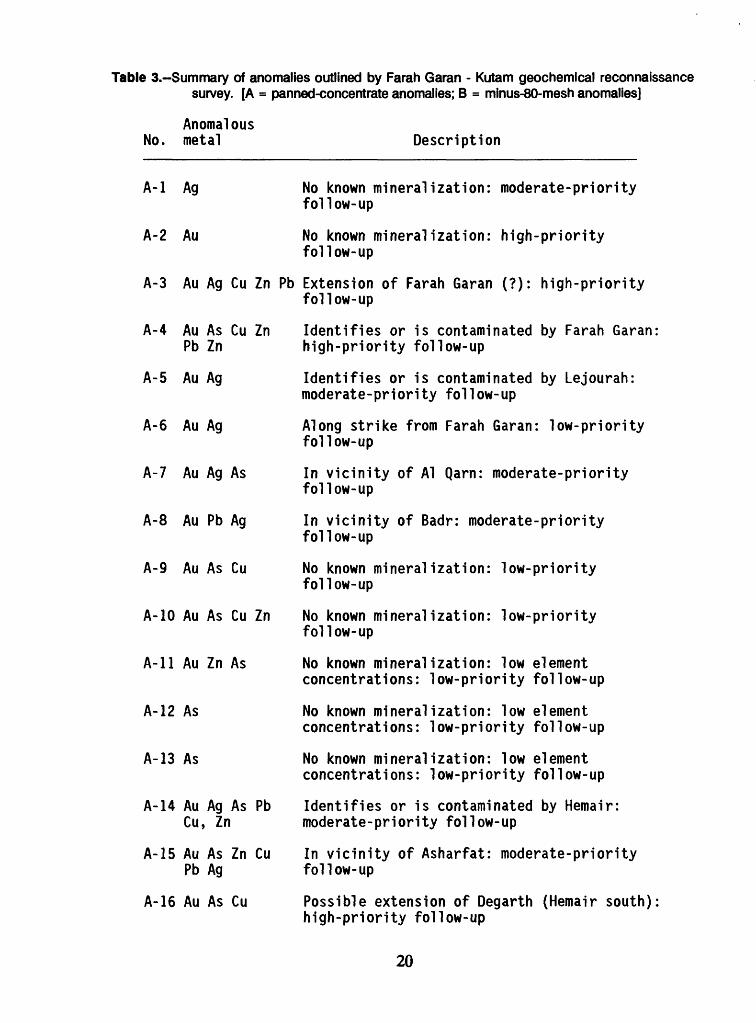
Table 3.-Summary of anomalies outlined by Farah Garan - Kutam geochemical reconnaissance survey. [A = panned-concentrate anomalies; B = minus-80-mesh anomalies]
Anomalous No. metal Description
A-l Ag No known mineralization: moderate-priorityfollow-up
A-2 Au No known mineralization: high-priorityfollow-up
A-3 Au Ag Cu Zn Pb Extension of Farah Garan (?): high-priorityfollow-up
A-4 Au As Cu Zn Identifies or is contaminated by Farah Garan: Pb Zn high-priority follow-up
A-5 Au Ag Identifies or is contaminated by Lejourah:moderate-priority follow-up
A-6 Au Ag Along strike from Farah Garan: low-priorityfollow-up
A-7 Au Ag As In vicinity of Al Qarn: moderate-priorityfollow-up
A-8 Au Pb Ag In vicinity of Badr: moderate-priorityfollow-up
A-9 Au As Cu No known mineralization: low-priorityfollow-up
A-10 Au As Cu Zn No known mineralization: low-priorityfollow-up
A-11 Au Zn As No known mineralization: low elementconcentrations: low-priority follow-up
A-12 As No known mineralization: low elementconcentrations: low-priority follow-up
A-13 As No known mineralization: low elementconcentrations: low-priority follow-up
A-14 Au Ag As Pb Identifies or is contaminated by Hemair: Cu, Zn moderate-priority follow-up
A-15 Au As Zn Cu In vicinity of Asharfat: moderate-priority Pb Ag follow-up
A-16 Au As Cu Possible extension of Degarth (Hemair south):high-priority follow-up
20
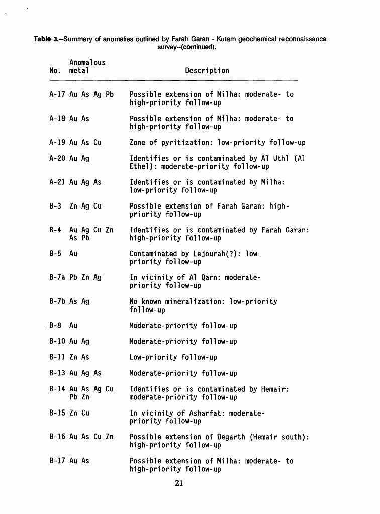
Table 3.-Summary of anomalies outlined by Farah Garan - Kutam geochemical reconnaissancesurvey--(continued).
Anomalous No. metal Description
A-17 Au As Ag Pb Possible extension of Mil ha: moderate- tohigh-priority follow-up
A-18 Au As Possible extension of Milha: moderate- tohigh-priority follow-up
A-19 Au As Cu Zone of pyritization: low-priority follow-up
A-20 Au Ag Identifies or is contaminated by Al Uthl (AlEthel): moderate-priority follow-up
A-21 Au Ag As Identifies or is contaminated by Milha:low-priority follow-up
B-3 Zn Ag Cu Possible extension of Farah Garan: high- priority follow-up
B-4 Au Ag Cu Zn Identifies or is contaminated by Farah Garan: As Pb high-priority follow-up
B-5 Au Contaminated by Lejourah(?): low- priority follow-up
B-7a Pb Zn Ag In vicinity of Al Qarn: moderate- priority follow-up
B-7b As Ag No known mineralization: low-priorityfollow-up
B-8 Au Moderate-priority follow-up
B-10 Au Ag Moderate-priority follow-up
B-ll Zn As Low-priority follow-up
B-13 Au Ag As Moderate-priority follow-up
B-14 Au As Ag Cu Identifies or is contaminated by Hemair: Pb Zn moderate-priority follow-up
B-15 Zn Cu In vicinity of Asharfat: moderate- priority follow-up
B-16 Au As Cu Zn Possible extension of Degarth (Hemair south):high-priority follow-up
B-17 Au As Possible extension of Milha: moderate- tohigh-priority follow-up
21
Table 3.-Summary of anomalies outlined by Farah Garan - Kutam geochemical reconnaissancesurvey-(continued).
Anomalous No. metal Description
B-19 As Pyritized zone: low-priority follow-up
B-22 Au Single sample: low-priority follow-up
B-23 Au As Low-priority follow-up
B-24 Au Single sample: low-priority follow-up
B-25 Au Ag Moderate-priority follow-up
B-26 Au Cu No known mineralization: moderate-priorityfollow-up
B-27 Au Single sample: possible extension of Milha:moderate-priority follow-up
B-28 Ag Pyritized zone: moderate-priority follow-up
B-29 Ag Single sample; high concentration: possibleextension of Milha: moderate-priority follow-up
B-30 Au Pb Low-priority follow-up
B-31 Au Single sample: moderate-priority follow-up
22
collected to verify the reconnaissance geochemical anomaly; (2) the bedrock should be closely examined for evidence of mineralization; and (3) rock-chip sampling should be undertaken to determine the bedrock metal contents in areas of potential interest. Follow-up work based on this study is included in Kellogg and others (1989).
On a more general note, the results of the present survey are consistent with a conclusion drawn from results of geochemical surveys conducted by the USGS elsewhere in the Arabia Shield (Samater, 1982; Samater and others, 1989), namely that panned-concentrate wadi-sediment samples more effectively outline geochemical anomalies than sieved bulk samples. In the present study, the gold threshold for panned-concentrate samples (0.2 ppm Au) is 10 times the threshold for sieved samples (0.02 ppm Au), and in five cases (areas A-7, A-8, A-10, A-15, A-17) the size of the panned-concentrate anomaly area is larger than the minus-80-mesh anomaly area. Furthermore, areas A-l and A-2 are uniquely defined by clusters of panned-concentrate samples. In contrast, minus-80-mesh samples that yield unique anomalous gold values, in the sense that the samples do not coincide with anomalous panned-concentrate samples, tend to be solitary and isolated, rather than clustered in a manner that could be interpreted as significant for exploration.
DATA STORAGE
Data and work materials used in preparation of this report include analytical results and are archived as datafile USGS-DF-10-5, which is stored at the office of the U.S. Geological Survey Mission in Jiddah, Saudi Arabia. No Mineral Occurrence Documentation System (MODS) localities were established in connection with work on this report, although existing MODS records in the area were updated by addition of this report number.
23
REFERENCES CITED
Anderson, R. E., 1979, Geology of the Wadi 'Atf (Sheet 17/43A) and Mayza'(Sheet 17/43B) quadrangles, Kingdom of Saudi Arabia: Saudi Arabian Directorate General of Mineral Resources Bulletin 25,33 p.
Barbier, J., 1987, Arid environment geochemical exploration in Saudi Arabia The problem of aeolian contamination: Journal of Geochemical Exploration, v. 27, pp. 29-51.
Bookstrom, A.A., Vennum, W.R., and Doebrich, J.L., 1989, Geology and Mineral Resources of the Farah Garan - Kutam Mineral Belt, southeast Asir, Kingdom of Saudi Arabia: Saudi Arabian Directorate General of Mineral Resources Technical Record USGS-TR-10-3, (in prep.).
Doebrich, J.L, 1989, An evaluation and geochemical survey of the Farah Garan prospect, Kingdom of Saudi Arabia with a section on A ground electromagnetic geophysical survey by M.A. Bazzari: u - s - Geological Survey Open-File Report 90-420.
Gaukroger, K.F., and Sale, S.V., 1985, Geochemical orientation studies of gold in drainage sediments on the Arabian Shield: Saudi Arabian Deputy Ministry for Mineral Resources Open-File Report RF-OF-05-26,39 p.
Johnson, P.R., and Vranas, G. J., 1984, The origin and development of late Proterozoic rocks in the Arabian Shield - an analysis of terranes and mineral environments: Saudi Arabian Deputy Ministry for Mineral Resoruces Open-File Report RF-OF-04-32,96 p.
Kellogg, K.S., Jannadi, E., and El Komi, M., 1989, Follow up evaluation of fifteen geochemical anomalous areas and evaluation of four prospects in the Farah Garan - Kutam mineral belt: Saudi Arabian Directorate General of MineralResources Open-File Report USGS-OF-09-10, U.S. Geological Survey Open-File Report 90-418.
Miesch, A.T., 1967, Methods of computation for estimating geochemical abundance: U. S. Geological Survey Professional Paper 574-B, 15 p.
Overstreet, W.C., and Day, G.W., 1985, Review of the use of magnetic concentrates ingeochemical exploration: u - s - Geological Survey OPne-File Report 85-541
Parker, T.W.H., 1982, Assessment of the mineral potential of the Kutam-Halahila district, south-east Asir: Saudi Arabian Deputy Ministry for Mineral Resources Open-File Report RF-OF-O2-22,149 p.
24
Sable, E.G., 1985, Geologic map of the Najran Quadrangle, Sheet 17G, Kingdom of Saudi Arabia: Saudi Arabian Deputy Ministry for Mineral Resources Geoscience Map GM-78, scale 1;250,000, with explanatory note, 17 p.
Saleh, Y. T., 1985, Follow-up Geochemical Sampling in the Farah Garan Area, Southeast Asir: Saudi Arabian Deputy Ministry for Mineral Resources Open-File Report RF-OF-O5-13,27 p.
Samater, R.M., 1982, Reconnaissance geochemical survey of the Al Jurdhawiyah and Wadi al Jirir quadrangles, sheets 25/42D and 25/42C, Kingdom of Saudi Arabia: Saudi Arabian Deputy Ministry for Mineral Resources Open-File ReportUSGS-OF-02-89, 19p. U.S. Geological Survey Open-File Report 83-299.
Samater, R.M., Christian, R.P., and Walker, B.M., 1989, Reconnaissance wadi- sediment geochemical survey of the Bi'r Jarbuah area, Kingdom of Saudi Arabia: Saudi Arabian Directorate General of Mineral Resources Open-File Report, USGS-OF-10-1,32 p. U.S. Geological Survey OPen-File Report 90-286,
Sanderson, P.M., 1984, Progress report on the assessment of south-east Asir: Saudi Arabian Deputy Ministry for Mineral Resources Open-File Report RF-OF-O4-ll,29p.
Schmidt, D.L., Hadley, D.G., and Brown, G.F., 1982, Middle Tertiary continental rift and evolution of the Red Sea in southwestern Saudi Arabia: Saudi ArabianDeputy Ministry for Mineral Resources Open-File Report USGS-OF-03-6,56 p.U.S. Geological Survey Open-File Report 83-641.
Smith, C.W., 1979, Ancient mines of Farah Garan area, Southwestern Saudi Arabia, with a section on Reconnaissance geophysical exploration, by H. R. Blank: U.S.Geological Survey Open-File Report 79-1659.
Smith, C. W., Anderson, Ernest, and Dehlavi, M. R., 1977, Geology and ore deposits of the Kutam mine, Kingdom of Saudi Arabia: U.S. Geological SurveyOpen-File Report 78-519.
Smith, C.W., and Mawad, M.M., 1982, Drilling results at Farah Garan ancient mine, Southeast Asir: Deputy Ministry for Mineral Resources Open-File ReportUSGS-OF-O2-42. (Copy available from Saudi Arabia DMMR)
Smith, E.A., Barnes, D.P., Johnson, P.R., Bognar, B., Garfield, L., and Scheibner, E., 1984, A review of the geology, mineralization, and mineral resource potential of the Kingdom of Saudi Arabia: Saudi Arabian Deputy Ministry for Mineral Resources Open-File Report RF-OF-05-1,322 p.
Sower, F.B., Eicher, R.N., and Seiner, G.I., 1971, The Statpac system: U.S. Geological Survey Computer Center Division, Computer Contributions no. 11,36 p.
25