recommended zoning changes - university of oregon
TRANSCRIPT

North of Lovejoy Project: Recommended Zoning Changes
City of Portland, Oregon Bureau of Planning March 2005
Central City Plan-era illustration, mid-1980s

Portland Bureau of Planning May 2005 ii
FOR MORE INFORMATION, PLEASE CONTACT: Joe Zehnder Portland Bureau of Planning 1900 SW Fourth Avenue, Rm. 4100 Portland OR 97201-5350 503.823.7815 [email protected] The regulatory changes recommended in this document will be presented at a City Council Public Hearing: Thursday May 26, 2005, 2:00 PM City Council Chambers, City Hall Please contact Joe Zehnder (503.823.7815) for further information.
To help ensure equal access to information, the Portland Bureau of Planning offers the following services to disabled citizens: Interpreter (please allow two working day’s notice); Accessible meeting places; Hearing assistance devices available with advance notice
for public hearings; and Planning documents printed in large type sizes
for the visually impaired (two working days’ notice required).
If you have a disability and need accommodations, please call 503/823-7700 (TDDD 503/823-6868). Persons requiring a sign language interpreter must call at least 48 hours in advance.
Portland Bureau of Planning iii May 2005
ACKNOWLEDGMENTS Portland City Council
Tom Potter, Mayor Sam Adams, Commissioner Randy Leonard, Commissioner Dan Saltzman, Commissioner Erik Sten, Commissioner Portland Planning Commission
Ingrid Stevens, President Paul R. Schlesinger, Vice President Timothy W. Smith, Vice President Christine Caruso Don Hanson Larry Hilderbrand Gail Shibley
Portland Bureau of Planning
Tom Potter, Mayor Gil Kelley, AICP, Director Joe Zehnder, AICP, Principal Planner Project Staff
Graham Clark, Senior Planner Mark Bello, PhD, AICP, City Planner II Additional Assistance
Arun Jain, Chief Urban Designer Gary Odenthal, GIS Manager Carmen Piekarski, GIS Analyst Kevin Martin, GIS Analyst Mark Raggett, City Planner II – Urban Design Phil Goff, City Planner II – Urban Design David Davies, Portland Development Commission

Portland Bureau of Planning iv May 2005
Portland Bureau of Planning 1 May 2005
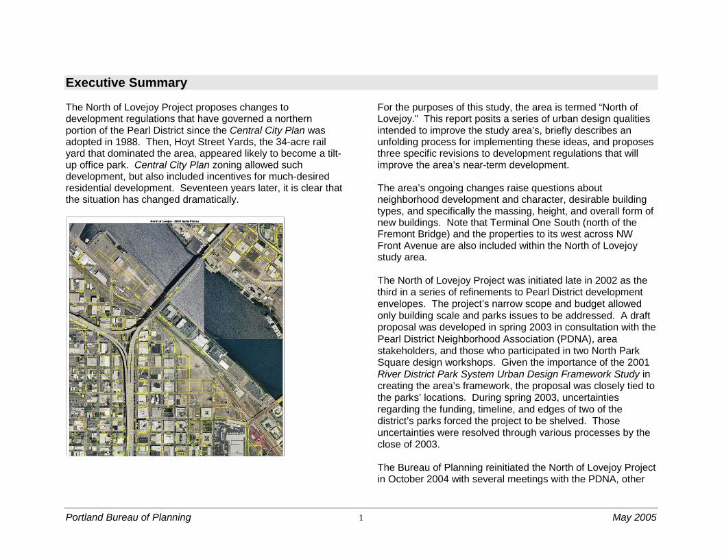
Executive Summary The North of Lovejoy Project proposes changes to development regulations that have governed a northern portion of the Pearl District since the Central City Plan was adopted in 1988. Then, Hoyt Street Yards, the 34-acre rail yard that dominated the area, appeared likely to become a tilt-up office park. Central City Plan zoning allowed such development, but also included incentives for much-desired residential development. Seventeen years later, it is clear that the situation has changed dramatically.
For the purposes of this study, the area is termed “North of Lovejoy.” This report posits a series of urban design qualities intended to improve the study area’s, briefly describes an unfolding process for implementing these ideas, and proposes three specific revisions to development regulations that will improve the area’s near-term development. The area’s ongoing changes raise questions about neighborhood development and character, desirable building types, and specifically the massing, height, and overall form of new buildings. Note that Terminal One South (north of the Fremont Bridge) and the properties to its west across NW Front Avenue are also included within the North of Lovejoy study area. The North of Lovejoy Project was initiated late in 2002 as the third in a series of refinements to Pearl District development envelopes. The project’s narrow scope and budget allowed only building scale and parks issues to be addressed. A draft proposal was developed in spring 2003 in consultation with the Pearl District Neighborhood Association (PDNA), area stakeholders, and those who participated in two North Park Square design workshops. Given the importance of the 2001 River District Park System Urban Design Framework Study in creating the area’s framework, the proposal was closely tied to the parks’ locations. During spring 2003, uncertainties regarding the funding, timeline, and edges of two of the district’s parks forced the project to be shelved. Those uncertainties were resolved through various processes by the close of 2003. The Bureau of Planning reinitiated the North of Lovejoy Project in October 2004 with several meetings with the PDNA, other
Portland Bureau of Planning 2 May 2005
stakeholders, and City staff. By January, it was clear that the quantitative regulatory issues addressed in the project were insufficient to describe the urban design framework – the “design story” – and other qualitative aspects desired for the neighborhood as its grows north toward the Willamette River. To fill this void, the Bureau organized a design charrette (an intensive design workshop) as described below. Urban Design Framework Charrette A charrette was held February 3-4 to elaborate the desired
urban design qualities for this portion of the Pearl District. It included 18 participants including representatives from the neighborhood, developers, city agencies, and the design community. In the charrette, the participants considered design and other qualities desired for the North of Lovejoy area. The results of the charrette touched on broad issues and ideas that could shape the district. The ideas were well received at a subsequent February 15 neighborhood association meeting. Many of these ideas, listed below, require further development and ongoing collaboration with the neighborhood, landowners, and infrastructure bureaus:
A shift in the north-south/east-west street grid toward the Willamette River in the district’s northernmost reaches – to occur southwest of the Burlington Northern Santa Fe/NW Naito Parkway alignments;
Re-envisioning Neighborhood Park as a “hinge,” bridging the Pearl District south of the railway and Naito Parkway with future attractions and/or open spaces at the riverfront;
The need to determine the anchor function that will occur in the proximity of Centennial Mills/Riverfront Park, if the proposed grade-separated pedestrian
crossing of the Burlington Northern railroad tracks and Naito Parkway is to be successful;
The desire to emphasize the NW 9th & Overton intersection as an urban portal, “wrapped” with active uses and building edges that build on The Pinnacle’s (the nearly-complete building at the intersection’s SW corner) gateway design; and
The appropriate massing north of NW Overton Street surrounding the park, and at a finer scale, the interface between future buildings and the park. Charrette participants unanimously agreed that if the parks are to be successful, more density appears necessary in the environs.
Bureau of Planning staff and the other charrette participants are currently developing a timeline (including milestones) for advancing these bigger ideas. An urban design framework map is under development for use in evaluating individual future development proposals. As charrette concepts are further honed, some regulatory changes beyond those proposed in the North of Lovejoy Project may be advanced. In the meantime, the charrette process confirmed that the regulatory changes proposed in the North of Lovejoy Project will enhance the neighborhood in the nearer term.
Zoning Recommendations
At the public hearing on April 12, 2005, the Planning Commission considered the following proposed regulatory changes:
Designate the parks as open space. Rezone and change the Comprehensive Plan designation for the

Portland Bureau of Planning 3 May 2005
district’s park spaces (Jamison Square, North Park Square, and Neighborhood Park) from Central Employment to Open Space.
Allow for additional building height in a way that protects the parks. To protect the parks from excessive shading and to encourage a sense of enclosure, change maximum building heights on ten blocks at the south, southwest, and west edges of the parks. Limit buildings to 100 feet facing the parks. Allow as much as 225 feet for structures on the far sides of these blocks.
Allow additional development capacity. Increase the base floor area ratio (FAR) to 4:1 on the twelve blocks between NW Overton and Lovejoy Streets, 12th Avenue, and the Burlington Northern railroad tracks. Existing FAR bonus provisions are not impacted – as much as 3:1 additional FAR remains available through the FAR bonus process.
The pages that follow provide detail about the project process, timeline, and proposal.
During the hearing the Planning Commission heard no testimony in opposition to the project and, through staff, heard that the Pearl District Neighborhood Association Land Use Committee had voted to support the project’s recommendations. There was general support among the Planning Commissioners for the proposed changes. However, there also was concern that slab buildings, rather than more slender towers, could result from the increased FAR and height. Such long and tall slab buildings could negatively impact the neighborhood, its design character and views. There was discussion of whether there should be limitation on the length of the slab in addition to requiring buildings to step back from
the street above certain heights. There was discussion of limiting the maximum width of the possible towers as was done in the South Waterfront regulations. There was discussion of how upper floor setbacks and the quality of the massing and design of the buildings could mitigate the possible impacts on the neighborhood from this new larger scale tower. In the end, the majority of Planning Commissioners agreed to support the proposed zoning regulation changes and to depend on the Design Commission and the design review process to ensure that proposed buildings will be attractive and successful additions to the neighborhood. Planning Commission Recommendation
The Planning Commission recommends that City Council adopt the ordinance, recommended report, and proposed Zoning Code amendments proposed by the North of Lovejoy Project.
The Planning Commission also endorsed sending a letter from the Planning Commission to the Design Commission asking that they consider and address the design issues of concern to the Planning Commission when reviewing projects being built under these new provisions.

Portland Bureau of Planning 4 May 2005
Study Area and Context The North of Lovejoy study area is bounded by the more developed areas of the Pearl District (to the south), the “transition area” immediately west (and extending beyond I-405) and the Willamette River to the north and east. The Portland Streetcar pivots near North Park Square (expected completion in summer 2005) in the heart of the study area. Northward along the waterfront, the former Port of Portland Terminal One South is being redeveloped as River North, a waterfront residential development.
This study considers the area within the Northwest Triangle subdistrict of the Central City Plan.
History and Trends The area now called the River District is one of the oldest parts of Portland. Added to Portland's original town site in 1865, the area was predominantly residential by the 1880s. However, manufacturing facilities became increasingly common in the late 19th century, including breweries, iron works, stables, lumber mills and other industrial and commercial enterprises. Freight rail operations expanded in conjunction with the growth of the area's industry. By the 1920s, the district had changed considerably. Residences were less common and industrial and wholesale operations began to dominate, often occupying half and full block sites. Transportation and trans-shipment functions became more firmly entrenched. Three cargo rail depots were located in the area: Union Depot near Union Station; the North Bank depot near NW Hoyt and 11th; and the Northern and Southern Depot on the site of what is now the Main Post Office. Rail lines were extended into the heart of the district along NW 15th, 13th, 12th, 10th, 4th, and Front avenues and NW Flanders Street. A thriving waterfront included grain, flour, coal and other cargo shipping facilities. Excellent rail connections made the district a vital transfer point for raw commodities and a variety of manufactured goods. These advantages, plus proximity to downtown and the concentration of related uses attracted manufacturing operations. Union Station’s 1896 completion helped to solidify the district as a major transportation hub. Industrial, wholesale and transportation land uses dominated the River District for much of the twentieth century. Following World War II, however, economic and land use trends began to affect the character and intensity of inner city industrial areas across the nation. Industry increasingly favored single-

Portland Bureau of Planning 5 May 2005
story structures on large tracts of land near truck-friendly outer freeway belts instead of the vertically oriented, multi-story buildings in older, more confined areas such as the River District. Railroad operations consolidations made smaller yard like those in the River District obsolete. By the early 1980s, people began to consider the declining importance of industrial and wholesale operations in the River District as a unique opportunity for Portland to add to previous Central City revitalization successes. A Regional Urban Design Action Team (RUDAT), a group organized by Portland’s local chapter of the American Institute of Architects in 1983, recommended that urban housing become a focus of private and public revitalization efforts. Over time, citizens, property owners and policy makers seized the opportunity to reinvent the River District as a vital mixed-use community with a large resident population and a variety of urban amenities including art galleries, restaurants, and specialty retail. The burgeoning area’s adaptable and relatively inexpensive spaces and their close proximity to the central business district made it attractive to non-industrial users. Action plans like the River District Development Plan capitalized on existing infrastructure and honed public and private investments to encourage changes that are transforming the district. Major capital improvements include: the Transit Mall extension north of Burnside to Union
Station (completed in 1993);
the replacement of the Lovejoy viaduct with an at-grade street and now shortened Broadway Bridge connection (2001);
the completion of the Portland Streetcar (2001); and
the Pearl District’s three parks – Jamison Square (complete), North Park Square (to be completed this
summer), and Neighborhood Park (likely to be completed in 2008-09).
This rapid pace of change is particularly notable in the area north of NW Hoyt Street, where redevelopment has been aided by the availability of a large tract of vacant former rail yard and a single dominant ownership. Central City Plan policies, the River District Design Guidelines, and historic resource regulations are in place to help the area retain the flavor of its industrial and transportation heritage. Industry and warehousing, although greatly diminished in intensity, remain in portions of the River District.
Planning and Policy Framework Four major planning studies in the last several decades have
shaped the future in this area. These are:
the Downtown Plan (1972);
the Northwest Triangle Study (1984);
the Central City Plan (1988); and
the River District Plan (1995) and the related River District Design Guidelines (1996).
Other studies have helped set the direction in the northern reaches of the Pearl District; these are described following the four major planning studies. Major Plans Downtown Plan (1972)
The Downtown Plan proposed some future changes for the area then known as “North Downtown” by:

Portland Bureau of Planning 6 May 2005
recognizing the important supportive role played by an existing industrial and distribution center in close proximity to the central business district;
calling for relocation of some industrial uses in response to market shifts in land use and development patterns;
promoting mixed use development in portions of the area; and
expecting that the railyards and waterfront would remain “Transportation Terminal Facilities.”
Northwest Triangle Study (1985)
The Northwest Triangle Study built upon the work of the Regional/Urban Design Assistance Team (R/UDAT) project, a joint effort by the American Institute of Architects and the City of Portland. The R/UDAT study, undertaken in 1983, documented the changing character of the area, presented alternative future scenarios, and called for the City to undertake a concerted planning effort for the northwest warehousing area. The R/UDAT team called for the area north of NW Lovejoy to be redeveloped as a business park. The City’s response, Northwest Triangle Study, built upon this framework. The North of Lovejoy study area was divided into two subdistricts:
Railyards: redevelopment was likely, but a broad economic/market analysis was recommended to identify impacts on downtown. Study results were to be folded into the Central City Plan.
Willamette Waterfront (south of the Fremont Bridge): the area, deemed obsolete for marine industrial uses, called for new manufacturing, distribution, office and commercial uses.
To implement the plan, specific zoning was designed to:
guard against negative impact resulting from increased land use intensities (floor to site area ratio of 2:1, and 100 ft. building height);
preserve open space and foster creation of new open space; and
ensure visual and physical access to the river.
Central City Plan (1988)

Portland Bureau of Planning 7 May 2005
Central City Plan (1988) The Central City Plan built upon the work of the Downtown Plan, embracing a greater geography and expanding its range of policy concerns. The Central City Plan encouraged changes to the River District by changing much of the district’s zoning to Central Employment (CX). The CX zone is intended to foster a transition from an industrial past to a different future based on mixed-use development. Residential functions are encouraged through FAR bonuses. The plan’s Urban Design Concept map illustrated a northward extension of the North Park Blocks, terminating with a water feature/public attraction at NW Front Avenue. Retaining 2:1 FAR and 100 foot maximum building heights but adding bonuses:
Up to 3:1 bonus FAR, especially for housing
As much as 75 feet of additional available building height, through design review process
River District Plan (1995)
In the early 1990s, citizens and landowners in the North Downtown area, cognizant of the challenges and opportunities presented by the changing character of the area, got together and crafted a vision for the transitioning district. The vision statement describes the newly named River District, made up of the former North of Downtown and Northwest Triangle districts, as a vital urban community of connected, diverse, and mixed-use neighborhoods. The vision also called for the district to accommodate a significant portion of Portland's expected future population growth. Portland City Council acknowledged the River District Vision in March 1992 and called for the City and community to
craft strategies for its implementation. City Council endorsed the resulting River District Development Plan in May 1994 as the framework for directed change in the district. The Bureau of Planning led the subsequent update to the Central City Plan to incorporate the River District changes. Adopted by City Council in April 1995, the River District Plan created:
a new River District subdistrict (incorporating the former North of Burnside and Northwest Triangle subdistricts);
a new River District Policy with related objectives and action items.
a new urban design map for the district; and
amendments to other Central City Plan policies to reflect the adoption of the River District Plan.
The new River District subdistrict, which incorporated the former North of Burnside and Northwest Triangle subdistricts, includes policy language that calls for the extension of "downtown development throughout the River District that is highly urban in character." The plan also calls for the district to house a substantial resident population with supporting jobs, services and recreation. The Central City Plan Economic Development policy was updated to target 5,500 new housing units, 1.5 million square feet of new office space, and 500,000 square feet of new retail facilities. Housing objectives called for fostering a mix of housing types, prices and rent levels. River District Design Guidelines (1996)
The River District Design Guidelines, adopted in February 1996, guide Design Commission decisions on the district’s development proposals. In conjunction with the Central City Fundamental Design Guidelines, the River District guidelines

Portland Bureau of Planning 8 May 2005
constitute the mandatory approval criteria for new development projects subject to design review in the River District. The design guidelines recognize two distinct North of Lovejoy sub-areas:
Tanner Creek Area: Identity for the Tanner Creek area will be established by designing Tanner Creek Park as both a neighborhood park and a key link in the cross-town park blocks corridor (Guideline B5-1)
Waterfront Area: Identity will be reinforced with design solutions that contribute to the character of the Waterfront and acknowledge its heritage. (Guideline A5-1-8)
The Pearl District Neighborhood Association and others wish to update the River District Design Guidelines to incorporate changes to the Tanner Basin concept, to the former Industrial Sanctuary area to the west, and to reflect the building forms the district has produced that were largely unanticipated in the guidelines process. Other Plans and Studies Union Station Clock Tower-Related FAR and Height Study (2000)
This study revisited FAR and height limits in the vicinity of Union Station designed to protect the clock tower’s visual prominence. Could FAR limits and bonus and associated height be changed to respond to “a decade’s worth of district transformation?”
Based on the project’s urban design analysis, City Council revised FAR and height limits in an area bounded by NW Hoyt and Lovejoy streets and I-405 and the Willamette River.
Guild’s Lake Industrial Sanctuary Plan (2001)
In 1999, City Council provided funding for the Bureau of Planning to review the industrial plan put forth by the Northwest Industrial Neighborhood Association (NINA). NINA sought to strengthen Comprehensive Plan policies that call for the continued industrial use of land in “industrial sanctuaries.” In October 2001, City Council adopted the Guild’s Lake Industrial Sanctuary Plan. New Comprehensive Plan policies and a new Zoning Code chapter limit commercial activities and their impact on industrial areas. The plan district’s southern boundary is adjacent to that of the North of Lovejoy Project at Terminal One South/River North. Northwest Transition Area Project (2001)
In 1999, City Council directed the Bureau of Planning to propose regulatory changes to transition industrially zoned lands south of the Guild’s Lake area to employment, residential and mixed-use zoning. The transition area extended between NW Lovejoy and Vaughn streets and 12th and 23rd avenues. City Council adopted Northwest Transition Zoning Project changes in August 2001. East of I-405, the Northwest Transition Area Project changes are generally summarized as follows:
Areas north of NW Lovejoy and west of NW 12th were
changed from the industrial sanctuary Comprehensive Plan designation to a Central Employment designation with a design review overlay (from IG1 to EXd);
The maximum base height became 100 feet, with a 5:1 floor area ratio (FAR) within one block of the freeway and one block of the streetcar, and a 4:1 FAR for the remaining areas west of NW 12th Avenue;

Portland Bureau of Planning 9 May 2005
Active use and window requirements were adopted for sites located within one block of the streetcar alignment.
Northwest District Plan (2003)
The Northwest District Plan updated the 1977 Northwest District Policy Plan with a comprehensive land use, urban design, transportation, housing, and economic development framework adopted in 2003. Further studies were completed by late 2003.
Among other actions, the Northwest District Plan increased allowed land use intensities in the Northwest Transition Area, immediately west of the Pearl District. This area is expected to take advantage of Portland Streetcar service and other locational advantages to intensify as a more vibrant urban district.
The Northwest District Association challenged some of the adopted plan’s provisions, taking an appeal to the Oregon Land Use Board of Appeals. LUBA remanded plan provisions that increased land use intensities, informing the City of Portland that transportation system capacity issues were not adequately addressed. On appeal from NWDA, the Oregon Court of Appeals remanded to LUBA part of the plan remanded to LUBA in March 2005. LUBA has not made its final determination.
Urban Renewal Plans and Agreement River District Urban Renewal Plan (1998)
The River District Urban Renewal Area, created in 1998, provides public capital in the form of tax-increment financing. Portland has used urban renewal to provide the infrastructure necessary to “prime the pump” of the private development that
follows. Within the urban renewal area’s boundary, property assessments are “frozen” at the initial year’s level. Increases in assessments during the life of the plan go to pay off the bonds that provided the capital for the infrastructure investments. The River District Urban Renewal is projected to reach maximum indebtedness (after which it could finance no more projects) in the year 2020. Development Agreement between Hoyt Street Properties and the City of Portland (1998)
Development in the North of Lovejoy study area is also guided by a development agreement between the landowner (Hoyt Street Properties) and the City of Portland via the Portland Development Commission. Under this public-private agreement, the City to provide infrastructure to support development, and in return the Hoyt Street Properties provides identified amenities. Specifically the Development Agreement requires the following:
Housing Affordability Components: Fifteen percent of housing units must be affordable to
those earning 0-50% of the Portland region’s median family income (MFI); and
Twenty percent of housing units must be affordable to those earning 51-80% MFI.
Minimum Density Components: At the agreement’s onset, a minimum of 15 dwelling units
must be built per acre;
Upon the demolition and replacement of the Lovejoy viaduct, a minimum of 87 dwelling units must be built per acre;
Portland Bureau of Planning 10 May 2005
Upon completion of the Portland Streetcar, a minimum of 109 dwelling units must be built per acre; and
Upon the completion of the area’s first park (now known as Jamison Square), a minimum of 131 dwelling units must be built per acre.
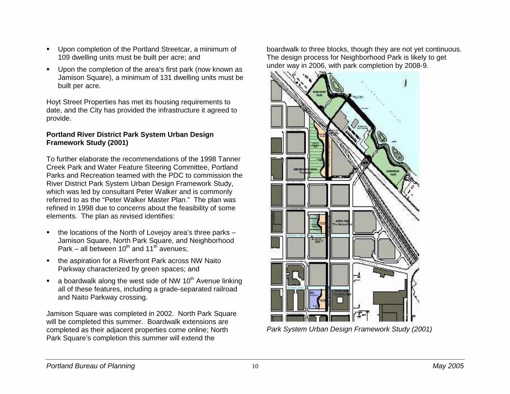
Hoyt Street Properties has met its housing requirements to date, and the City has provided the infrastructure it agreed to provide. Portland River District Park System Urban Design Framework Study (2001) To further elaborate the recommendations of the 1998 Tanner Creek Park and Water Feature Steering Committee, Portland Parks and Recreation teamed with the PDC to commission the River District Park System Urban Design Framework Study, which was led by consultant Peter Walker and is commonly referred to as the “Peter Walker Master Plan.” The plan was refined in 1998 due to concerns about the feasibility of some elements. The plan as revised identifies: the locations of the North of Lovejoy area’s three parks –
Jamison Square, North Park Square, and Neighborhood Park – all between 10th and 11th avenues;
the aspiration for a Riverfront Park across NW Naito Parkway characterized by green spaces; and
a boardwalk along the west side of NW 10th Avenue linking all of these features, including a grade-separated railroad and Naito Parkway crossing.
Jamison Square was completed in 2002. North Park Square will be completed this summer. Boardwalk extensions are completed as their adjacent properties come online; North Park Square’s completion this summer will extend the
boardwalk to three blocks, though they are not yet continuous. The design process for Neighborhood Park is likely to get under way in 2006, with park completion by 2008-9.
Park System Urban Design Framework Study (2001)

Portland Bureau of Planning 11 May 2005
Pearl District Development Plan (2001)
The Pearl District Development Plan represents a set of priorities for the Pearl District Neighborhood Association and for the Portland Development Commission as the neighborhood continues to change. The plan elaborates a vision and a series of actions that will enable the district to retain important characteristics (especially of architectural, commercial, and employment heritage) in the face of continued change and increasing land values. The plan includes goals for the built environment, neighborhood amenities, housing, arts and culture, economic opportunities, edges and gateways, and transportation/parking. The PDDP specifically lists a reexamination of building height and bulk provisions in the area north of NW Lovejoy Street and east of NW 12th Avenue as a priority; the North of Lovejoy Project was undertaken partially in response to these desires.
Existing North of Lovejoy Area Development Regulations The Comprehensive Plan, the Planning and Zoning Code (especially the Central City Plan District Chapter 33.510) and the official Zoning Map regulate new development. This section summarizes the regulations most pertinent to the study area. Note that the North of Lovejoy Project focused on zoning/Comprehensive Plan designations, maximum building height, and maximum floor area ratio provisions due to budget and scope limitations.
Area Zoning and Comprehensive Plan Designations
South of the Fremont Bridge, the study area is designated and zoned Central Employment (EX), a zone that allows a wide variety of industrial, commercial and residential uses. The EX zone is intended to foster urban, mixed-use development in central areas that are predominantly industrial in nature. North of Lovejoy areas north of the Fremont Bridge and east of NW Front Avenue are designated and zoned Central Residential (RX), which allows the highest dwelling units density of any residential zone. Density is not regulated by a maximum number of units per acre. Instead, the maximum size of buildings and intensity of use are regulated by floor area ratio (FAR) limits and other development standards. North of the Fremont Bridge and west of NW Front Avenue, the area is designated Central Employment (EX) but retains Heavy Industrial (IH) zoning. Heavy Industrial zoning implements the Comprehensive Plan’s Industrial Sanctuary policies. Though this area is outside the Guild’s Lake Industrial Sanctuary, the North of Lovejoy Project does not propose amending the zoning to conform to the Comprehensive Plan designation. Plan District Regulations Maximum Building Bulk and Height (33.510.200 and 205)
The study area’s current maximum building bulk and height limits were established by the Central City Plan. The maps on the following page show the existing building height limits and shows the existing building bulk limits, expressed as floor area ratio (FAR). A project's FAR is calculated as the ratio of the total floor area of all buildings on a site to the site's area. For example, a 2-story building that covers its entire site has a
Portland Bureau of Planning 12 May 2005
Existing Maximum Height
FAR of 2:1; a two-story building that only covers half of its site has an FAR of 1:1. Vehicle parking at or above grade is counted as FAR; below-grade parking is not. Generally, the highest FARs in the Central City are closest to concentrated transit service, especially along the Transit Mall.
Today, the North of Lovejoy area’s maximum building height is 100 feet, and the maximum FAR is 2:1 (note that several study area blocks south of NW Lovejoy Street have slightly different regulations).
Existing Maximum FAR Bonus Options for Building Height and FAR (33.510.210) Central City plan district regulations allow additional development potential beyond the base FAR and height limitations under certain circumstances. The additional development potential is granted in exchange for providing amenities that implement the policies of the Central City Plan. FAR bonuses available in the North of Lovejoy study area may be awarded for providing housing, day care facilities, rooftop gardens, public art, water features, or locker rooms, among other options. Generally, bonus FAR of up to 3:1 in addition to the base allowed FAR may be awarded for the provision of these amenities. All but one of the study area’s completed projects has made use of the residential bonus provision.

Portland Bureau of Planning 13 May 2005
In some areas, bonus building height beyond the base allowed height may be awarded in conjunction with earned bonus FAR or for providing housing. Height bonuses may be awarded in the North of Lovejoy area only west of NW Naito Parkway. Area projects that exceed 100 feet have made use of this provision.
Northwest Triangle Subarea (33.510.245 and 250) Among the outcomes of the Northwest Triangle Study was the requirement for new connections and sufficient open space in areas transitioning from waterfront industrial or rail yard uses. These requirements promote adequate light and air, visual relief, outdoor recreation, and a robust pedestrian network. The frequent connections requirement applies to both areas; waterfront regulations apply only east of NW Naito Parkway.
Overlay Regulations Greenway Regulations (33.440)
The River General (g) greenway overlay zone applies to North of Lovejoy properties that border the Willamette River. The Greenway Zones chapter (33.440) contains both use restrictions and development standards and a review process. Applicable development standards include:
setbacks;
required landscaping;
recreation trail/required viewpoints; and
viewpoints and view corridors
Proposed changes are subject to greenway review, which focuses on development riverward of the greenway setback. The greenway setback extends from the top of the bank to a point 25 feet landward of the top of the bank. As part of greenway review, the Willamette Greenway design guidelines are reviewed for compliance.
Design Review (33.420)
North of Lovejoy properties generally are within the Design (d) overly zone, which indicates areas subject to design review; the exception is the area of Heavy Industrial properties west of NW Front Avenue. Design review is intended to ensure that new development conserves and enhances recognized special design values. Design review is required for all new development and certain modifications to existing development.
Depending on the type of review, the Portland Design Commission and/or the Portland Historic Landmarks Commission serve as the review body for development proposals subject to design review. Several sets of design review approval criteria apply within the study area:
the Central City Fundamental Design Guidelines and Zoning Code development standards apply to all Central City areas outside the Industrial Sanctuary.
Within the River District, except in historic districts, the River District Design Guidelines apply in addition to the Central City guidelines.
Proposals involving a recognized historic landmark must satisfy the criteria for historic design review contained in Zoning Code chapter 33.846. Proposals for historic landmarks listed in the National Register of Historic Places must meet certain federal guidelines in addition to applicable local criteria. In the North of Lovejoy study area, only Albers Mill is a listed historic resource.
In the eastern portion of the study area within the River General (g) overlay zone, the Willamette Greenway Design Guidelines apply in addition to both the River District and Central City guidelines.

Portland Bureau of Planning 14 May 2005
Recent Pearl District Development Characteristics The table in this section summarizes data on Pearl District development since 1996. Research was initiated to provide a framework for understanding the relationships between building mass and height and the space devoted to residential, commercial, and vehicle parking uses. Two caveats are necessary about of the table’s contents: Project information is based on
information submitted by the project’s applicant during the Design Review process. While slight project revisions sometimes occur following design review, these revisions are unlikely to significantly change the project characteristics.
Several of the projects provide
vehicle parking that serves nearby functions – more than just the immediate project. These projects include The Edge, the Louisa, One Waterfront Place, and Station Place.
In very general terms, project size, expressed as FAR, has increased from the mid-1990s as illustrated at right.
Recent Pearl District Project Massing
FAR 1996 or earlier
1997 1998 1999 2000 2001 2002 2003 2004
9-10
The Eliza-beth
9.64/175'
8-9 The
Gregory 8.4/141'
The
Edge 8.5/145'
7-8
Marshall Wells Lofts
7.77/110'
The Henry
7.69/173' (13.54 FAR
on its 20,000 sf
site)
The Louisa
7.25/175'
6-7 The
Pinnacle 6.43/175'
5-6 Park Place
5.4/150'
4-5 River-stone 4.6/72'
Tanner Place
4.86/75'
Lovejoy Station 4.25/56'
Street-car Lofts 4.98/93'
Bridgeport
4.71/91' The
Lexis 4.25/80'
Burling-ton
Tower 4.93/124' 10th @
Hoyt 4.7/68' The
Lexis 4.55/80'
The Sitka 4.3/75'
3-4 Pearl Court
3.35/40'
Kearney Plaza
3.26/56'
Station Place
3.51/144'
Water-front Pearl
3.48/115'
2-3
One Water-
ront Place
2.92/145'
Less than 2
Pearl Town-homes West
1.42/35'
Johnson St.
Town-houses 1.88/37’
NW Front Town-homes 1.2/35'

Portland Bureau of Planning 15 May 2005
Table 1: Bulk, Height, and Floor Area Characteristics of Recent Pearl District Projects
Project Name Address FAR Building Height
Res. Units
LUR File # Res. Sq.
Ft. Comm’l Sq. Ft.
Bldg Sq. Ft.
Site Sq. Ft.
Parking
The Avenue Lofts 1415 NW Hoyt 3.76 120’ 225 03-106858 270,724 0 270,724 72,000 187
Bridgeport Condominiums 1130-1133 NW 12th 4.71 91’ 124 01-00360 180,587 7,852 188,439 40,000 138
Burlington Tower 900 NW Lovejoy 4.93 124’ 163 02-127082 142,723 11,052 211,966 43,000 163
The Edge 805 NW 14th 8.5 145’ 117 02-132006 287,481 40,000 340,000 40,000 N/A
The Elizabeth NW 9th & Glisan 9.64 175’ 182 03-153965 264,500 15,000 337,326 35,000 213
The Gregory 420 NW 11th 8.4 141’ 145 99-00379 150,000 48,000 336,000 40,000 201
The Henry 128 NW 11th 7.69 173’ 123 01-00632 191,340 14,800 270,731 20,000 159
Johnson St. Townhouses NW 11th & Johnson 1.88 37’ 13 98-00702 31,068 0 35,582 18,898 13
Kearney Plaza 930 NW 12th 3.26 56’ 131 98-00298 106,000 9,000 140,000 43,000 159
The Lexis 1125 NW 9th 4.55 80’ 139 01-106334 135,561 9,000 182,883 40,000 143
The Louisa 1201 NW Couch 7.25 175’ 244 02-154552 258,346 ~32,000 290,346 40,000 3 levels
Lovejoy Station 915 NW Lovejoy 4.25 56’ 177 99-00897 164,000 6,000 170,000 40,000 88
Marshall Wells Lofts 1420 NW Lovejoy 7.77 110’ 164 00-00637 179,000 5,180 310,800 40,000 179
NW Front Townhomes NW Riverside 1.2 35’ 71 03-102995 159,246 0 159,246 130,897 137
One Waterfront Place 701 NW Naito Pkwy 2.92 145’ 0 01-00165 0 256,000 418,000 143,090 700
Park Place NW 10th & Lovejoy 5.4 150’ 124 01-00431 172,010 14,800 216,000 43,000 134
Pearl Court 920 NW Kearney 3.35 4 levels 194 96-00233 134,000 0 134,000 40,000 18
Pearl Townhomes West 601-637 NW 11th 1.42 35’ 10 93-00279 29,135 0 29,135 20,500 6
The Pinnacle NW 9th & Overton 6.43 175’ 179 03-100642 238,000 6,950 257,200 40,000 205
Riverstone 1030 NW Johnson 4.62 72’ 122 97-00238 175,000 10,000 185,000 40,000 130
The Sitka NW 11th & Overton 4.3 75’ 217 03-168997 160,000 12,000 172,000 40,000 130
Station Place NW 9th & Marshall 3.51 144.5’ 175 01-00776 150,000 28,200 185,765 52,857 500
Streetcar Lofts 1030 NW 12th 4.98 93.5’ 152 00-00021 123,395 10,960 199,110 40,000 146
Tanner Place 809 NW 11th 4.86 75’ 122 98-00866 187,900 11,350 199,250 41,000 146
10th @ Hoyt 911 NW Hoyt 4.7 68.5’ 175 02-125719 135,194 12,997 188,000 40,000 160
Waterfront Pearl 1200-1300 NW Naito 3.48 115’ 370 04-036771 602,535 3,250 673,683 193,561 843

Portland Bureau of Planning 16 May 2005
Project Process The North of Lovejoy Project was initiated late in 2002, as the third in a series of refinements to Pearl District development entitlements and standards. The project was scoped and funded only to consider building scale and parks issues. A draft proposal was developed in spring 2003 in consultation with the Pearl District Neighborhood Association (PDNA), area stakeholders, and those who participated at two North Park Square design workshops. The location and nature of the park blocks described in the 2001 River District Park System Urban Design Framework are among the most critical parts of the area’s ongoing development. During spring 2003, uncertainties regarding the funding, timeline, and other aspects of the district’s parks forced the project to be shelved. These issues were resolved by the close of 2003. The Bureau of Planning reinitiated the North of Lovejoy Project in October 2004. By January, it was clear that the quantitative regulatory issues addressed in the project were insufficient to describe the urban design framework – the “design story” – and other qualitative aspects desired for the neighborhood as its grows north toward the Willamette River. These included growing questions on how best to relate development to the waterfront, and questions about the overall composition and form of the emerging neighborhood. To fill this void, the Bureau organized a design charrette (an intensive design workshop) as described below.
The North of Lovejoy Charrette
A charrette was held February 3-4 to consider current and future neighborhood qualities and development in the northern portion of the Pearl District generally and in a more focused way for the North of Lovejoy area including the waterfront. Eighteen participants including neighborhood representatives, developers, city agencies and the design
community attended. In the charrette, the participants considered community aspirations for the North of Lovejoy area. The event’s opening session consisted of an afternoon spent discussing larger hopes for the Pearl District and the North of Lovejoy area. This was done by examining the area both internally and within the larger context of the district’s immediate edges.
The charrette concluded with collective clarity on broad issues and ideas that could shape the district. These ideas were subsequently well received at a February 15 neighborhood association meeting. Identified in the charrette only as broad approaches and concepts, many of these ideas (listed below) require further development and ongoing collaboration with the neighborhood, land owners, and infrastructure bureaus. Day one of the charrette was spent placing North of Lovejoy in its context. Highlights of that discussion are as follows:
The North of Lovejoy study area presents a real opportunity to envision how the northward expansion of the Pearl District is completed as it nears the BNSF tracks, Naito Parkway, and riverfront properties.
The NW Pearl, west of the North of Lovejoy study area,
is expected to continue the Pearl’s transition from industrial use to more mixed use residential and commercial uses. Regarding this western part of the Pearl, charrette participants expressed a desire to preserve jobs, allow larger buildings against I-405, retain and improve connections beneath the freeway, and explore recreational or other uses for the parcels beneath the freeway.
The Pearl waterfront (Centennial Mills and of the area
the Peter Walker Master Plan identifies as Riverfront Park) has an uncertain future, but charrette participants uniformly agreed that this riverfront site must be an important destination and amenity for downtown – a

Portland Bureau of Planning 17 May 2005
counterpoint to the focus of the Brewery Blocks to the south.
The U.S. Main Post Office site should not be
redeveloped to be more of the same street grid and uses that predominate the area. It is a unique and major opportunity to add to the Central City in a different, distinct and supporting way.
Enhanced connectivity to Union Station, under I-405
and on alternative paths through the neighborhood were considered important characteristics for the future of the area.
Focused Retail Corridors with local serving emphasis
on Overton between 9th and 13th, area serving emphasis on Lovejoy between 9th and 13th and better use of the boardwalk extending along 10th Avenue from Jamison Square to the waterfront. Strategies for achieving such focus were not developed.
Having set the larger context for the neighborhood, the event’s second day was devoted to a more focused discussion of the area between Northrup and the waterfront. The area’s design story was described in terms of use, form, and amenities. The discussion raised the importance of considering creating hierarchies of movement and open space; creating shifts in scale; and maintaining diversity. Specific ideas discussed include: Orientation to the waterfront: Participants
supported re-envisioning the Neighborhood Park as a “hinge,” shifting its orientation and that of the street grid the south of the railway and Naito Parkway to better connect the Pearl with future attractions and/or open spaces at the riverfront;
The future of the waterfront: There was concern about the need to determine the nature of Centennial Mills/Riverfront Park, whether any of the buildings would be reused and the implications of this for the proposed pedestrian crossing over the railroad tracks and Naito Parkway;
Gateway to the Pearl: Participants shared an interest in emphasizing NW 9th & Overton as a portal, “wrapped” with active uses and building edges that build on The Pinnacle’s (the nearly-complete building at the intersection’s SW corner) gateway design;
Buildings on the park: There was interest in treating the buildings along the Neighborhood Park differently than the blocks to the south in terms of massing, fineness of scale, the interface between buildings and the park, i.e., buildings with residential entrances directly on the park and the possibility of vacating parts of streets.
Markers for the park: Block 19 and a future taller “iconic” feature at the northern terminus of 11th should be treated as visual landmarks for the park and neighborhood.
Future development intensity: Charrette participants agreed that residential density in the vicinity would greatly support a vibrant park and that this together with larger considerations of diversity in family structure, mix of housing types and focused retail corridors could open consideration for increased development capacity in the final phases of North of Lovejoy development.
Portland Bureau of Planning 18 May 2005
Portland Bureau of Planning 19 May 2005
The diagram on the previous page summarizes the charrette’s results. These are initial ideas that will require further development and collaboration with the neighborhood, landowners, and infrastructure bureaus.
Public Reaction The charrette created enthusiasm among the event participants and at a subsequent February 15 neighborhood association meeting. On March 1, the Pearl District Neighborhood Association’s Land Use and Transportation Committee voted to support the North of Lovejoy development regulation changes as summarized in this report with the proviso that work on the urban design framework be continued and concluded prior to any additional changes. Next Steps Bureau of Planning staff is developing a timeline for the continued review and development of ideas from the charrette. This will produce an urban design framework map for use in evaluating future individual development proposals. As charrette concepts are further honed, there may be some more regulatory changes proposed. In the meantime, the charrette findings confirmed that the changes proposed in the current North of Lovejoy Project will enhance the neighborhood in the nearer term. Out of the charrette, there was agreement that increased density in the blocks north of NW Overton Street could contribute to the success of the Neighborhood Park and of the Riverfront Park/Centennial Mill. However, this cannot be considered without evaluating the area’s transportation issues through a transportation modeling process. The area has three constraints that taken together may prove serious:
Relatively distant access to the regional freeway system and even to major city traffic streets;
Relatively distant transit service (the Portland Streetcar
service only reaches Lovejoy and Northrup and bus service is limited to infrequent service along NW Naito Parkway and Lovejoy or the Transit Mall at Union Station).
The BNSF railway line limits the street grid connections
to NW Naito Parkway intersections with NW 9th and 14th avenues. No other crossing points are available to the north/east; thus, vehicle demand is concentrated on these two intersections.
The transportation system analysis process could begin in summer 2005 and by fall, transportation modeling results should help form the outlines of the transportation system’s ability to handle density, as well as the steps that could be undertaken, including transit enhancements, to improve the transportation situation in the area. The charrette also confirmed that the North of Lovejoy regulatory proposal is appropriate. It will improve the neighborhood in the short term while broader charrette issues are further developed and advanced. Rezoning the parks to open space needs to occur, despite uncertainty about the eventual edges on the northern half of Neighborhood Park. Maximum building height provisions around the parks should be changed to protect the parks from excessive shadowing and to promote a sense of enclosure. And maximum floor area ratio limits should be increased to allow somewhat larger buildings, but with FARs no more than 4:1 (7:1 with bonuses), the height envelope will be much larger than the available FAR can fill.
Portland Bureau of Planning 20 May 2005
North of Lovejoy – Recommended Changes The Bureau recommends several limited regulatory changes that the Planning Commission will consider at the public hearing scheduled for April 12. The recommended changes are as follows:
Designate the parks as open space: Rezone and change the Comprehensive Plan designation for the district’s park spaces (Jamison Square, North Park Square, and Neighborhood Park) from Central Employment to Open Space.
Allow for additional building height in a way that protects the parks: To protect the parks from excessive shading and to encourage a sense of enclosure, change maximum building heights on ten blocks at the south, southwest, and west edges of the parks. Limit buildings to 100 feet facing the parks. Allow as much as 225 feet for structures on the far sides of these blocks.
Allow additional development capacity: Increase the base floor area ratio (FAR) to 4:1 on the twelve blocks between NW Overton and Lovejoy streets, 12th Avenue, and the Burlington Northern railroad tracks. Existing FAR bonus provisions are not impacted – as much as 3:1 additional FAR remains available through the FAR bonus process.
Rezoning the Parks The Central Employment (EX) zoning on the district’s three parks – Jamison Square, North Park Square, and Neighborhood Park – was put in place by the Central City Plan in 1988. Rezoning these parks is merely recognizing
them for their new purposes. In chapter 22.100, the Portland Zoning Code describes the purpose of the Open Space (OS) zone:
The Open Space zone is intended to preserve and enhance public and private open, natural, and improved park and recreational areas identified in the Comprehensive Plan. These areas serve many functions including: • Providing opportunities for outdoor recreation; • Providing contrasts to the built environment; • Preserving scenic qualities; • Protecting sensitive or fragile environmental areas; • Preserving the capacity and water quality of the
stormwater drainage system; and • Providing pedestrian and bicycle transportation
connections. The edges of Jamison and North Park squares are certain – the park properties will end at the street right-of-way. In the case of Jamison Square, the NW Kearney Street pedestrianway forms the northern edge; the pedestrianway is not proposed for rezoning. The edges of Neighborhood Park are somewhat more fluid. Portland Parks and Recreation owns the property bounded by NW Overton Street, 11th Avenue, a line between Raleigh and Quimby streets, and a line near the extended centerline of 10th Avenue, which is not intended to become a public street. The total parcel is 90,200 square feet, or about 2.2 acres. But the Peter Walker Master Plan depicts the park extending northward to the BNSF railway tracks; an agreement for a triangular parcel about 26,000 square feet that would fulfill that intention has not been completed. Further, the charrette considered a “hinge” function where

Portland Bureau of Planning 21 May 2005
the park’s orientation would shift from north-south, instead toward the river, somewhere just north of Pettygrove Street. Other property transactions would be necessary to fulfill this change in orientation. However, rezoning the property now owned by Portland Parks and Recreation (the two parcels that end just south of NW Quimby Street) is warranted to reflect the site’s future. Changing Maximum Building Height The North of Lovejoy Project proposes to amend maximum building height provisions around the Parks’ South, Southwest, and West Edges. This approach has been applied elsewhere in the Central City; the nearby example is the North Park Blocks, where building heights are limited to 100 feet on the parks’ west edge. The Central City Plan limits maximum building heights on these edges to limit shadowing during times when the parks are intensively used. Buildings along Jamison Square’s south, southwest, and west edges vary from 75 feet to 35 feet and back to 75 feet. Buildings along North Park Square’s southwest and west edges are approximately 90 feet. Zoning Code provisions require any proposed incursion into these edges to analyze the shadow conditions at both Noon and 3:00 PM on April 21.
Increasing Maximum FAR The district’s allowed building mass as expressed by floor area ratio (FAR) today is 2:1, which is the lowest in the Central City. Recent housing projects in the area indicate continued market enthusiasm for living in this part of the Pearl District. The completion of North Park Square and, later, Neighborhood Park, are both likely to extend this enthusiasm. An increase to 4:1 will match properties to the south and west, both of which were updated in the last several years. Analysis of the district’s development characteristics as captured on Table 1 (pg. 15) indicates that 1 FAR may yield approximately 25 housing units.

Portland Bureau of Planning 22 May 2005

Portland Bureau of Planning 23 May 2005

Portland Bureau of Planning 24 May 2005