recommendations for exploration pun ponton -majagual...
TRANSCRIPT

RECOMMENDATIONS FOR EXPLORATION
PUN PONTON -MAJAGUAL HILL
Dominican Republic
EVERTON RESOURCES 205-2742 St. Joseph Boulevard
Orleans, Ontario, Canada
K1C 1G5
November 7, 2012
Prepared By:
CARACLE CREEK INTERNATIONAL CONSULTING INC. Scott Jobin-BevansPh.D., P.Geo
Doris Fox, M.Sc. , P.Geo
EVERTON MINERA DOMINICA, S.R.L Carlos A. Carrasco C.
Hugo Domingues, M.Sc., C.P.C

Recommendations for Exploration and Drilling:
Pun Ponton – Majagual Hill
Everton Resources
November 5, 2012 CARACLE CREEK INTERNATIONAL CONSULTING INC. Page | 1
TORONTO – VANCOUVER – SUDBURY– JOHANNESBURG – DOMINICAN REPUBLIC
WWW.CARACLECREEK.COM
Office Locations This report has been prepared by
Caracle Creek International Consulting Inc. (C aracle
Creek) on
Toronto behalf of Everton Resources.
34 King Street East, 9th Floor
Toronto, ON
Canada, M5C 2X8 2012
Tel: +1.416.368.1801
Vancouver
409 Granville Street, Suite 1409
Vancouver, BC
Canada, V6C 1T2
Tel: +1.604.637.2050
Sudbury
25 Frood Road
Sudbury, ON
Canada, P3C 4Y9
Tel: +1.705.671.1801
TF: +1.866.671.1801
Puerto Plata
13 Pedro Clisante, El Batey, Sosua
Puerto Plata, Dominican Republic
Tel: +1-829-909-2242
Johannesburg
7th Floor
The Mall Offices
11 Cradock Avenue, Rosebank
South Africa
Tel: +1.27 (0) 11.880.0278
[email protected] Issued by: Toronto
www.caraclecreek.com
Recommendations for Exploration and Drilling:
Pun Ponton – Majagual Hill
Everton Resources
November 5, 2012 CARACLE CREEK INTERNATIONAL CONSULTING INC. Page | 2
TORONTO – VANCOUVER – SUDBURY– JOHANNESBURG – DOMINICAN REPUBLIC
WWW.CARACLECREEK.COM
TABLE OF CONTENTS
1.0 SUMMARY ..................................................................................................................................................... 4
2.0 INTRODUCTION .......................................................................................................................................... 6
3.0 GEOLOGICAL SETTING AND MINERALIZATION ............................................................................. 7
3.1 REGIONAL GEOLOGY ............................................................................................................................. 7
3.2 PUN-PONTON PROPERTY GEOLOGY ................................................................................................... 9
4.0 EXPLORATION .......................................................................................................................................... 11
4.1 SAMPLING AND TRENCHING .............................................................................................................. 11
4.2 STREAM SEDIMENT SAMPLING ......................................................................................................... 12
4.3 MAPPING .................................................................................................................................................. 13
4.4 GEOPHYSICS - AIRBORNE MAGNETIC, EM AND 2D-IP ................................................................. 16
4.5 ALTERATION MAPPING ....................................................................................................................... 17
4.6 PETROGRAPHIC STUDY ....................................................................................................................... 19
4.7 STRUCTURAL GEOLOGY ..................................................................................................................... 21
4.8 GEOCHEMISTRY .................................................................................................................................... 23
5.0 DEPOSIT MODEL AND DISCUSSION .................................................................................................... 23
6.0 CONCLUSIONS AND RECOMMENDATIONS ...................................................................................... 38
Figures
Figure 1. Location of all Properties held by Everton Resources Inc in the Dominican Republic, including the Pun
Ponton Property. ............................................................................................................................................................ 6
Figure 2. Schematic geological map of the island of Hispanola showing the location of topographic sheet ................ 7
Sabana Grande de Boya (yellow in key map modified from Lewis and draper, 1990 in Escuder Viruete et al., 2002).
....................................................................................................................................................................................... 7
Figure 3. Regional Total Magnetic Intensity (TMI) from SYSMIN airborne survey, with location of the core Everton
Resources properties, including Pun Ponton. ................................................................................................................ 8
Figure 4. Distribution of geological units within the Pun Ponton Property (source: SYSMIN) and location of the
Majagual Hill, Copey Hill and Cumani Cu-Au porphyry targets. Au analysis results from rock, soils and stream
sediment sampling programs. ........................................................................................................................................ 9
Figure 5. Distribution of Au in rock and soil samples within the Pun Ponton Property and location of the Majagual
Hill, Copey Hill and Cumani porphyry targets. ........................................................................................................... 12
Figure 6. Detailed geology with Au in rock samples Rocks on the eastern half of the map are interpreted to represent
mesothermal to porphyry type targets. Rocks on the western half of the area show resemblance to epithermal type
environment. ................................................................................................................................................................ 14

Recommendations for Exploration and Drilling:
Pun Ponton – Majagual Hill
Everton Resources
November 5, 2012 CARACLE CREEK INTERNATIONAL CONSULTING INC. Page | 3
TORONTO – VANCOUVER – SUDBURY– JOHANNESBURG – DOMINICAN REPUBLIC
WWW.CARACLECREEK.COM
Figure 7. Detailed geology map of the Majagual Hill area with Cu in rock samples .................................................. 15
Figure 8. Regional SYSMIN Total Magnatic Intensity (TMI) survey over the Pun Ponton Property and surrounding
area. The locations of the Majagual Hill, Copey Hill and Cumani Cu-Au Targets are shown for reference. .............. 16
Figure 9. PIMA alteration halos at the Majagual Hill target........................................................................................ 17
Figure 10. Hand sample MJ-7: Patchy texture Qtz.-Tourmaline ................................................................................. 18
Figure 11. Sample T41-51.3m Tantahuatay-Yanacocha ............................................................................................. 18
Figure 12. MJ-7 Granoblastic texture with growth tourmaline (250µm) ..................................................................... 19
Figure 13. XRD difractogram showing the mineral composition of sample ML-7 ..................................................... 20
Figure 14. Conceptual model of the main structural features at Majagual Hill. Location of trenches T-1, T-2 and T-3
are shown. .................................................................................................................................................................... 21
Figure 15. Stratification dipping to the SW at Majagual Hill. ..................................................................................... 22
Figure 16. Geomorphological features at Majagual Hill (looking north) ................................................................... 23
Figure 17. Conceptual Model and likely target location for Majagual Hill (Sinclair, 2007). ...................................... 24
Figure 18. Section 2089732 mN: Conceptual model for Majagual Hill target (note: drawing does not show
postulated intrusive outline). ....................................................................................................................................... 25
Figure 19. Conceptual Orthogonal Convergence Model ............................................................................................. 26
Figure 20. Au in rock; max value 213.9 ppb ............................................................................................................... 27
Figure 21. Ag in rock; max value 29.8 ppm ................................................................................................................ 28
Figure 22. As in rocks; max value > 10,000 ppm (overlimit) ...................................................................................... 29
Figure 23. Hg in rocks; max value 5.81 ppm ............................................................................................................... 30
Figure 24. Sb in rocks; max value >2,000 ppm (overlimit) ......................................................................................... 31
Figure 25. Boron in rocks; max value 192 ppm........................................................................................................... 32
Figure 26. Cu in rock; max value 6,331.6 ppm ........................................................................................................... 33
Figure 27. Mo in Rocks; max value 136.3 ................................................................................................................... 34
Figure 28. Pb in rocks; max value 498.1 ppm ............................................................................................................. 35
Figure 29. Hematite veinlets with alteration ................................................................................................................ 36
Figure 30. Dispersion of Zn in soils over a 100 x 100m grid. The geometry of this dispersion appears to indicate .. 37
the extent of the mineralized centre at Majagual Hill; centre has a diamter of approximately 1.8km ......................... 37
Figure 31. Proposed drill collar locations for 4 diamond drill holes at the Majagual Hill Target ............................... 39
Figure 32. Proposed areas for the 3 phases of diamond drilling at the Majagual Hill target. ...................................... 42
Tables
Table 1. Details of the proposed Phase I diamond drill program at Majagual Hill...................................................... 41

Recommendations for Exploration and Drilling:
Pun Ponton – Majagual Hill
Everton Resources
November 5, 2012 CARACLE CREEK INTERNATIONAL CONSULTING INC. Page | 4
TORONTO – VANCOUVER – SUDBURY– JOHANNESBURG – DOMINICAN REPUBLIC
WWW.CARACLECREEK.COM
1.0 SUMMARY
The Majagual Hill Cu-Au-Mo Porphyry target is one of three targets located within the Ponton
concession of the Pun-Ponton Property, covering an area of 6,725 ha and situated in the south central
region of the Dominican Republic and is the focus of this report. The Copey Hill and Cumani targets,
located southwest of the Majagual Hill target on the same property are not discussed in detail in this
report.
The Majagual Hill target is hosted in the Early Cretaceous Los Ranchos Formation, a series of tholeiitic
island arc volcanic and volcanoclastic rocks that underlies much of the Property and is also host to the
neighbouring Pueblo Viejo gold deposit (Barrick Gold/Goldcorp). The Los Ranchos Formation, possibly
co-genetic with the Maimón Formation, forms a 17 km wide zone between the Hatillo Thrust in the
southwest and a Tertiary limestone platform to the northeast. Tonalite intrusives occur throughout the
Property. Extensive Quaternary cover fills the main valleys and/or the flat plains at the edges. A major
fault system, oriented northwest to southeast, controls much of the topography and the distribution of
rivers and creeks.
The SYSMIN geological mapping project (2002) identified three main sub-units of the Los Ranchos
Formation on the Property; the Lower Unit being the most extensive and containing several areas of
mineral potential. The Lower Unit, interpreted to represent an intra-oceanic island arc, contains mainly
polygenetic pyroclastic breccias intercalated with mafic basaltic lavas and lesser andesite as fine-grained,
well stratified volcanoclastic horizons; the thickness of this unit is more than 1,500 metres.
Work to date on the Property includes conventional soil grid sampling, rock sampling, trenching, stream
sediment sampling, geological mapping, alteration mapping (PIMA) and XRD sample analyses. Zonation
in alteration was identified forming a concentric alteration pattern with haloes of propylitic alteration
south-southeast of Majagual Hill. This external ring is followed towards the centre by haloes of argillic
and phyllic alteration. Over the area of interest an intense advance argillic alteration developed with
localized areas of silicification. Two regional structural orientations have been mapped: 1) A NW-SE
regional fault system parallel to the regional corridor generated during the formation of the island arc.
And 2) A set of NE-SW faults (transfer structures). It appears that this second lineament favors the
generation of N-S conjoints. The conceptual model of these structures is orthogonal convergence. Key
elements (Au-Ag-As-Hg-Sb-B-Bi-Mo) are grouped along regional orthogonal structures. The association
of these elements with an advance argillic alteration zone or transitional to potassic alteration zone
delineate the centre of a hydrothermal (mineralized) system. Boron concentrations in rocks defining an

Recommendations for Exploration and Drilling:
Pun Ponton – Majagual Hill
Everton Resources
November 5, 2012 CARACLE CREEK INTERNATIONAL CONSULTING INC. Page | 5
TORONTO – VANCOUVER – SUDBURY– JOHANNESBURG – DOMINICAN REPUBLIC
WWW.CARACLECREEK.COM
elliptic zone, suggest a breccia body, emplaced in the volcanic pile and rocks around the Boron anomaly
show paragenesis with clear indications of hydrothermal origin.
Work to date on the Property points to the development of a mid-depth hydrothermal - porphyry Cu-Au
mineralized system at Majagual Hill. To evaluate this theory, rock textures were compared against the
known hydrothermal Yanacocha deposit. The textures in the two samples are similar and are interpreted
as transitional textures from an epithermal environment to a porphyry environment.
The proposed work program is based on previous work and the applied deposit model, and is designed to
intersect Cu-Au-Mo mineralized zones. Phase I proposes five drill holes totalling 2000m at Majagual Hill
over the central intersection of the regional structures and coinciding with the prerequisite porphyry
alteration and mineral distribution pattern. Three dimensional digital modelling of existing data and all
incoming data is highly recommended to better understand the 3D orientation of the targets and assist in
the interpretation of drill results. Ground geophysics and down hole geophysics, especially IP, are
recommended on the Property to assist in the 3D modelling and the delineation of mineralized zones.
Two additional phases of exploration surrounding Majagual Hill are recommended following the positive
results of Phase I.

Recommendations for Exploration and Drilling:
Pun Ponton – Majagual Hill
Everton Resources
November 5, 2012 CARACLE CREEK INTERNATIONAL CONSULTING INC. Page | 6
TORONTO – VANCOUVER – SUDBURY– JOHANNESBURG – DOMINICAN REPUBLIC
WWW.CARACLECREEK.COM
2.0 INTRODUCTION
The Majagual Hill Cu-Au target is located within the Ponton concession of the Pun-Ponton property (the
“Property”) which covers 6,725 ha and is situated in the south central region of the Dominican Republic
(Figures 1, 2 and 3). Two additional Cu-Au porphyry targets, Copey Hill and Cumani, situated southwest
of the Majagual Hill target (Figure 3), are not discussed in detail in this report.
The proposed diamond drill hole locations at Majagual Hill are based on the results obtained from the
geochemical and geological exploration programs completed on the Property. Results from surface
exploration suggest the existence of Cu-Au mineralization (+/-Mo), formed along shoulders to porphyry
intrusions. The style of alteration and metal associations observed on the Property suggest that this area
contains several Cu-Au porphyry targets. The objective of the recommended diamond drilling program is
to intersect Cu-Au mineralized zones associated with a “World Class” Cu-Au porphyry deposit.
Figure 1. Location of all Properties held by Everton Resources Inc in the Dominican Republic, including the Pun
Ponton Property.
Recommendations for Exploration and Drilling:
Pun Ponton – Majagual Hill
Everton Resources
November 5, 2012 CARACLE CREEK INTERNATIONAL CONSULTING INC. Page | 7
TORONTO – VANCOUVER – SUDBURY– JOHANNESBURG – DOMINICAN REPUBLIC
WWW.CARACLECREEK.COM
3.0 GEOLOGICAL SETTING AND MINERALIZATION
3.1 Regional Geology
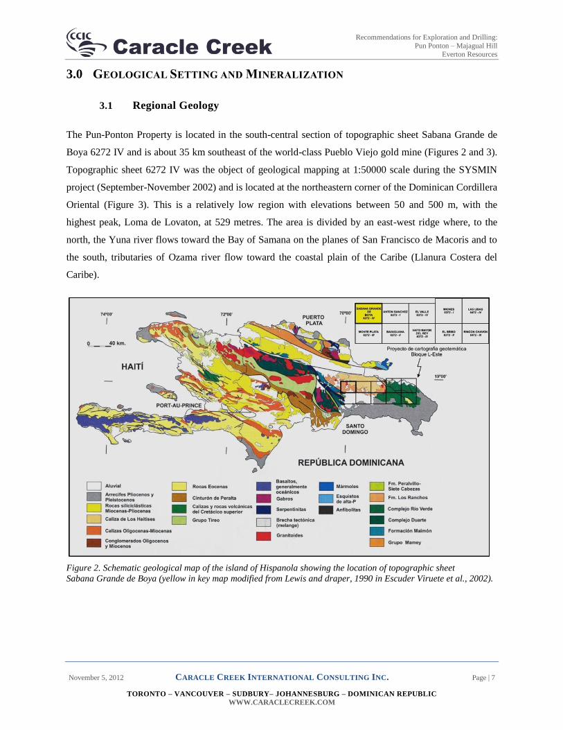
The Pun-Ponton Property is located in the south-central section of topographic sheet Sabana Grande de
Boya 6272 IV and is about 35 km southeast of the world-class Pueblo Viejo gold mine (Figures 2 and 3).
Topographic sheet 6272 IV was the object of geological mapping at 1:50000 scale during the SYSMIN
project (September-November 2002) and is located at the northeastern corner of the Dominican Cordillera
Oriental (Figure 3). This is a relatively low region with elevations between 50 and 500 m, with the
highest peak, Loma de Lovaton, at 529 metres. The area is divided by an east-west ridge where, to the
north, the Yuna river flows toward the Bay of Samana on the planes of San Francisco de Macoris and to
the south, tributaries of Ozama river flow toward the coastal plain of the Caribe (Llanura Costera del
Caribe).
Figure 2. Schematic geological map of the island of Hispanola showing the location of topographic sheet
Sabana Grande de Boya (yellow in key map modified from Lewis and draper, 1990 in Escuder Viruete et al., 2002).

Recommendations for Exploration and Drilling:
Pun Ponton – Majagual Hill
Everton Resources
November 5, 2012 CARACLE CREEK INTERNATIONAL CONSULTING INC. Page | 8
TORONTO – VANCOUVER – SUDBURY– JOHANNESBURG – DOMINICAN REPUBLIC
WWW.CARACLECREEK.COM
Figure 3. Regional Total Magnetic Intensity (TMI) from SYSMIN airborne survey, with location of the core Everton
Resources properties, including Pun Ponton.

Recommendations for Exploration and Drilling:
Pun Ponton – Majagual Hill
Everton Resources
November 5, 2012 CARACLE CREEK INTERNATIONAL CONSULTING INC. Page | 9
TORONTO – VANCOUVER – SUDBURY– JOHANNESBURG – DOMINICAN REPUBLIC
WWW.CARACLECREEK.COM
3.2 Pun-Ponton Property Geology
The Early Cretaceous Los Ranchos Formation (LRF), which underlies much of the Property, consists
mainly of tholeiitic island arc volcanic and volcanoclastic rocks and is interpreted to represent an intra-
oceanic island arc; the LRF may be co-genetic with the Maimón Formation. The LRF forms a 17 km wide
zone between the Hatillo Thrust in the southwest and a Tertiary limestone platform to the northeast
(Figure 4). Cevicos, a tonalite batholith, is located at the northeast corner of the sheet and tonalites in
general are well represented on the southern part of the map sheet. The northeast quarter is covered by
tabular bodies of Los Haitises limestone with characteristic karst morphology. Extensive Quaternary
cover fills the main valleys and/or the flat plains at the edges. Topography and the distribution of rivers
and creeks are the result of geological formations as well as a major fault system oriented northwest to
southeast.
Figure 4. Distribution of geological units within the Pun Ponton Property (source: SYSMIN) and location of the
Majagual Hill, Copey Hill and Cumani Cu-Au porphyry targets. Au analysis results from rock, soils and stream
sediment sampling programs.

Recommendations for Exploration and Drilling:
Pun Ponton – Majagual Hill
Everton Resources
November 5, 2012 CARACLE CREEK INTERNATIONAL CONSULTING INC. Page | 10
TORONTO – VANCOUVER – SUDBURY– JOHANNESBURG – DOMINICAN REPUBLIC
WWW.CARACLECREEK.COM
Prior to the SYSMIN project geological mapping, there was limited detailed geological information on
the Los Ranchos Formation found in Kesler, (2005) and Kesler et al., (1992), which concentrated on the
Pueblo Viejo deposit area. The SYSMIN project proposed three main sub-units of the LRF; all three units
outcrop on the Pun Ponton Property. The Lower Unit is the most extensive and within this unit, several
areas of mineral potential have been identified (Figure 4).
Lower Unit: Primarily polygenetic pyroclastic breccias intercalated with mafic basaltic lavas and lesser
andesite as fine-grained, well stratified volcanoclastic horizons. Breccias outcrop usually as “boulders” of
several meters in diameter have various grain size, texture and composition. The thickness of this unit is
more than 1,500 m. The lower contact of this unit is masked by the intrusion of tonalite at depth. The
lower unit is interpreted to represent an intra-oceanic island arc.
Intermediate Unit: Felsic lavas, dacites and riodacites associated with pyroclastic ashes and epiclastites of
felsic composition. The thickness of this unit varies and can reach more than 1,000m in places. This unit
is very distinct yellowish-beige to pinkish. The unit is covered by a particular type of vegetation due to
high silica content of the bedrock.
Upper Unit: Composed of andesitic pyroclastics, mainly monogenetic breccias and agglomerates with
minor massive intervals of andesites and porphyritic basalts. The upper unit is discordant with the Los
Haitises limestone.

Recommendations for Exploration and Drilling:
Pun Ponton – Majagual Hill
Everton Resources
November 5, 2012 CARACLE CREEK INTERNATIONAL CONSULTING INC. Page | 11
TORONTO – VANCOUVER – SUDBURY– JOHANNESBURG – DOMINICAN REPUBLIC
WWW.CARACLECREEK.COM
4.0 EXPLORATION
Since the joint venture between Everton Minera Dominicana S.R.L. (project operator) and Linear Gold
Caribe (Brigus Gold Corp.), surface reconnaissance programs have been carried out over the entire area
of the Property. This work included prospecting and sediment, rock and soil sampling. The follow up
work over anomalous areas of interest resulting from these reconnaissance surveys included geological
mapping, alteration mapping, geochemical analysis, gridded soil sampling (conventional and auger) and
additional rock sampling and trenching.
4.1 Sampling and Trenching
Conventional soil samples were collected over a 100 x100 m grid covering an irregular polygon of
approximately 7 km2. This grid was later extended to the north over the Pun concession. A total of 738
soil samples were collected at a 50 cm depth (Figures 4 and 5).
Continuous anomalous regions identified in the conventional soil sampling program, were followed up by
auger soil sampling using a denser grid of 50 x 50 m. This soil survey covered an area of approximately
0.84 km2. The average depth of sampling was 1.03 m and a total of 374 samples were collected.
Rock chip sampling was not done on a systematic grid. Geologists sampled interesting outcrops during
reconnaissance mapping, resulting in an irregular distribution of samples over the concession. There are
heavily sampled areas and a large part of the ground without rock chip samples. A total of 836 rock
samples were collected (Figures 4 and 5).
Four trenches were completed on Majagual (Figures 7 and 13). One of the four trenches was shallow and
so samples from this trench are considered channel samples. The other three trenches had an average
depth of 1.69 m with a maximum of 2.0 m. Sampling was continuous every 2.0 m. Samples were
collected from the floor of the trenches as channels for a total of 126 samples

Recommendations for Exploration and Drilling:
Pun Ponton – Majagual Hill
Everton Resources
November 5, 2012 CARACLE CREEK INTERNATIONAL CONSULTING INC. Page | 12
TORONTO – VANCOUVER – SUDBURY– JOHANNESBURG – DOMINICAN REPUBLIC
WWW.CARACLECREEK.COM
Figure 5. Distribution of Au in rock and soil samples within the Pun Ponton Property and location of the Majagual
Hill, Copey Hill and Cumani porphyry targets.
4.2 Stream Sediment Sampling
In 1997 MIM (Linear Gold Caribe/Brigus Gold Corp.) carried out sampling of stream sediments and
BLEG samples (37 samples). In December 2007 Everton collected 93 samples that were analyzed using
ICP-MS (Acme Labs 1F-MS) and tested for 53 elements. During 2007-2008 a total of 57 samples were
collected during various programs. During 2011-2012 the stream sediment program was extended to the
west and north of concession covering various sub-streams; a total of 243 samples were collected.
Overall, a total of 430 stream sediment samples were collected.

Recommendations for Exploration and Drilling:
Pun Ponton – Majagual Hill
Everton Resources
November 5, 2012 CARACLE CREEK INTERNATIONAL CONSULTING INC. Page | 13
TORONTO – VANCOUVER – SUDBURY– JOHANNESBURG – DOMINICAN REPUBLIC
WWW.CARACLECREEK.COM
4.3 Mapping
Recent geological mapping at 1:5000 scale around the Majagual Hill area identified rocks of Los Ranchos
Formation Lower Unit. The main mapped units are described as follows:
LATITE-BASALT: Fine-grained, aphyric texture, strongly sheared with minor pyrite breccias
pyrophyllite, smectite, sugary silica.
BASALTIC ASH TUFF: Thin bedded, composed by very fine grained crystal-glass and some rounded
"like bomb" lithic clast. Some layers showing green cherty texture, generated by intense silica
replacement. Coarse-grained pyrite occurs in cherty layers.
AMYGDALOIDAL BASALTIC FLOW: The rock has an intense hydrothermal alteration, masking the
original protolith. Observed abundant rounded to sub-rounded vesicular structures filled specular hematite
or white clay minerals. In groundmass occur as abundant brownish muscovite flakes.
ANDESITE LITHIC TO CRYSTAL TUFF: Showing several brownish to white colors. The strongly
hydrothermal alteration obliterated the original texture. One can observe a paste composed by lithic
ghosts and in some case crystals that have been replaced by clay minerals giving a fine granular
appearance. Many of the outcrops are cut by sulfide after oxide (cm) or hair like veinlet’s, also
disseminated pyrite near the edge.
BRECCIATED ROCKS: Several descriptive terms are grouped here:
Intrusion Breccia: This breccia composed by white amorphous silica fragments, cemented by specular
hematite and brownish powdering iron oxide.
Dilational Breccia: Form by angular to rounded silica clast; infilling open brittle rock + silica + reddish
hematite + specular hematite.
FERRICRETE: Poorly sorted gravel-pebble to boulders fragments, very compact and strong iron oxide
cemented and located in several streams around the hill.
PYRITE FAULT GOUGE: In the central main zone. Pyrites occurs as coarse-grained, semi-massive,
mixed fine-grained pasty pyrite + kaolinite. External halo clay minerals > Pyrite fine to medium grained
over 25%. PIMA scanning shows: quartz + pyrophyllite + kaolinite + illite + dickite +/- diaspore.

Recommendations for Exploration and Drilling:
Pun Ponton – Majagual Hill
Everton Resources
November 5, 2012 CARACLE CREEK INTERNATIONAL CONSULTING INC. Page | 14
TORONTO – VANCOUVER – SUDBURY– JOHANNESBURG – DOMINICAN REPUBLIC
WWW.CARACLECREEK.COM
Figure 6. Detailed geology with Au in rock samples Rocks on the eastern half of the map are interpreted to
represent mesothermal to porphyry type targets. Rocks on the western half of the area show resemblance to
epithermal type environment.

Recommendations for Exploration and Drilling:
Pun Ponton – Majagual Hill
Everton Resources
November 5, 2012 CARACLE CREEK INTERNATIONAL CONSULTING INC. Page | 15
TORONTO – VANCOUVER – SUDBURY– JOHANNESBURG – DOMINICAN REPUBLIC
WWW.CARACLECREEK.COM
Figure 7. Detailed geology map of the Majagual Hill area with Cu in rock samples

Recommendations for Exploration and Drilling:
Pun Ponton – Majagual Hill
Everton Resources
November 5, 2012 CARACLE CREEK INTERNATIONAL CONSULTING INC. Page | 16
TORONTO – VANCOUVER – SUDBURY– JOHANNESBURG – DOMINICAN REPUBLIC
WWW.CARACLECREEK.COM
4.4 Geophysics - Airborne Magnetic, EM and 2D-IP
A coarse, regional airborne magnetic survey was completed by SYSMIN in 2002 (Figures 3 and 8). No
ground or detailed airborne geophysical surveys have been completed on the Property to date.
Figure 8. Regional SYSMIN Total Magnatic Intensity (TMI) survey over the Pun Ponton Property and surrounding
area. The locations of the Majagual Hill, Copey Hill and Cumani Cu-Au Targets are shown for reference.

Recommendations for Exploration and Drilling:
Pun Ponton – Majagual Hill
Everton Resources
November 5, 2012 CARACLE CREEK INTERNATIONAL CONSULTING INC. Page | 17
TORONTO – VANCOUVER – SUDBURY– JOHANNESBURG – DOMINICAN REPUBLIC
WWW.CARACLECREEK.COM
4.5 Alteration Mapping
During soil sampling, several outcrops were tested with PIMA to identify the mineralogy of alteration. A
paragenesis and zonation in alteration was identified based on the data collected. An alteration map of the
zones identified is shown in Figure 9. The main alteration assemblage observed is diaspore + kaolinite +
dickite + tourmaline + pyrophyllite + quartz.
Figure 9. PIMA alteration halos at the Majagual Hill target.
Recommendations for Exploration and Drilling:
Pun Ponton – Majagual Hill
Everton Resources
November 5, 2012 CARACLE CREEK INTERNATIONAL CONSULTING INC. Page | 18
TORONTO – VANCOUVER – SUDBURY– JOHANNESBURG – DOMINICAN REPUBLIC
WWW.CARACLECREEK.COM
Rock textures were compared against the known hydrothermal Yanacocha deposit for similarities to assist
in deposit model interpretation (Figure 10 and 11). The textures in the two samples are similar and are
interpreted as transitional textures from an epithermal environment to a porphyry environment. The
transitional “patchy” textures at Tantahuatay -Yanacocha are associated with Mo anomalies; the same
occurs at Majagual Hill. Moreover, the development of these textures indicates an intense activity of
replacement by magmatic hydrothermal fluids, with total destruction of the original textures of the rock.
Associations like pyrophyllite-diaspore-kaolinite-dickite-tourmaline are clear evidence of the existence of
a thermal convection cell generated by an intrusive at medium depth. Although the textures in these
samples are indicative of porphyry type environment, the samples shown below are not mineralized and
are included as a reference to the texture only.
Figure 10. Hand sample MJ-7: Patchy texture Qtz.-
Tourmaline
Figure 11. Sample T41-51.3m Tantahuatay-Yanacocha

Recommendations for Exploration and Drilling:
Pun Ponton – Majagual Hill
Everton Resources
November 5, 2012 CARACLE CREEK INTERNATIONAL CONSULTING INC. Page | 19
TORONTO – VANCOUVER – SUDBURY– JOHANNESBURG – DOMINICAN REPUBLIC
WWW.CARACLECREEK.COM
4.6 Petrographic Study
One sample (MJ-7) taken from an area of advanced argillic alteration was selected for petrographic study
(Figures 10, 11 and 12). A report detailing the findings of the petrographic study concluded the sample
came from and area representing a hydrothermal system:
“The texture of the minerals of sample MJ-7 observed under petrographic microscope clearly indicates a
hydrothermal rock. Quartz shows a granoblastic texture that indicates precipitation under hydrothermal
conditions. Afterwards, the tourmaline grows overprinting the granoblastic quartz with a clearly
hydrothermal replacement. There are no other minerals and the original protolith has been completely
replaced. In conclusion, is very likely that the fluid from which this rock precipitated is a hydrothermal
fluid of magmatic origin. Moreover, the B anomaly present in this specimen is a sufficient clue for further
research”. (Lisard Torro; May 2012, e-mail).
Figure 12. MJ-7 Granoblastic texture with growth tourmaline (250µm)

Recommendations for Exploration and Drilling:
Pun Ponton – Majagual Hill
Everton Resources
November 5, 2012 CARACLE CREEK INTERNATIONAL CONSULTING INC. Page | 20
TORONTO – VANCOUVER – SUDBURY– JOHANNESBURG – DOMINICAN REPUBLIC
WWW.CARACLECREEK.COM
The results of a XRD analyses confirm the presence of quartz-tourmaline paragenesis (Figure 13). This
combined with the detection of Diaspore +/- Tremolite are interpreted to indicate that this zone is high
temperature and of a Potassic or Sodic-calcic composition. In addition, the distribution of Boron tends to
form an E-W elongated ellipse which suggests the presence of a breccia like body that cuts through the
volcanic pile.
Figure 13. XRD difractogram showing the mineral composition of sample ML-7
Visible
Ref. Code
Score
Compound Name
Displacement [°2Th.]
Scale Factor
Chemical Formula
* 01-079-1910
76 Quartz 1,025 Si O2
* 01-085-1814
55 Dravite 0,095 Na Mg3 Al6 ( B O3 )3
Si6 O18 ( O H )4

Recommendations for Exploration and Drilling:
Pun Ponton – Majagual Hill
Everton Resources
November 5, 2012 CARACLE CREEK INTERNATIONAL CONSULTING INC. Page | 21
TORONTO – VANCOUVER – SUDBURY– JOHANNESBURG – DOMINICAN REPUBLIC
WWW.CARACLECREEK.COM
4.7 Structural Geology
Two regional structural orientations have been mapped on the Property (Figure 14): 1) A NW-SE regional
fault system developed parallel to the regional corridor generated during the formation of the island arc.
This lineament tends to form discontinuous zones of pyrite fault gauge. And 2) A set of NE-SW faults
(transfer structures) whose planes do not show development of pyrite fault gauge (at least in outcrop).
These lineaments are visible in the SYSMIN maps. It appears that this second lineament favors the
generation of N-S conjoints with semi-massive pyrite or pyrite fault gauge. The conceptual model of these
structures is shown in Figures 17 and 19.
Volcanoclastic units that outcrop in the vicinity of Majagual Hill dip to the southwest at 45-55 degrees
(Figure 15) and are interpreted to be a monocline cut by a series of faults oriented at NW-SE and NE-SW.
The NW-SE fault set shows dextral displacement of lithologic contacts.
Figure 14. Conceptual model of the main structural features at Majagual Hill. Location of trenches T-1, T-2 and T-
3 are shown.

Recommendations for Exploration and Drilling:
Pun Ponton – Majagual Hill
Everton Resources
November 5, 2012 CARACLE CREEK INTERNATIONAL CONSULTING INC. Page | 22
TORONTO – VANCOUVER – SUDBURY– JOHANNESBURG – DOMINICAN REPUBLIC
WWW.CARACLECREEK.COM
Figure 15. Stratification dipping to the SW at Majagual Hill.

Recommendations for Exploration and Drilling:
Pun Ponton – Majagual Hill
Everton Resources
November 5, 2012 CARACLE CREEK INTERNATIONAL CONSULTING INC. Page | 23
TORONTO – VANCOUVER – SUDBURY– JOHANNESBURG – DOMINICAN REPUBLIC
WWW.CARACLECREEK.COM
4.8 Geochemistry
Rock samples were sent for multi-element analysis at ACME labs. The relative concentration of certain
elements, most notably Au, Ag, As, Cu, B, Mb, Mo, Pb and Sb, have been used to identify the deposit
model. The results of the geochemical analysis are discussed below in relation to the deposit model.
5.0 DEPOSIT MODEL AND DISCUSSION
Based on the information to date, the Majagual Hill target is interpreted as a medium depth hydrothermal
porphyry system that formed in an extensional island arc environment. Conceptual models for this type of
system are provided in Figures 17 and 19. This interpretation is based on the alteration mapping,
structural mapping and geochemistry as described below.
Intense hydrothermal alteration observed at Majagual Hill extends for more than 5 km in diameter. A
concentric alteration pattern has been observed with haloes of propylitic alteration developed mainly
towards south-southeast of Majagual Hill. This external ring is followed towards the centre by haloes of
argillic and phyllic alteration. Over the area of interest an intense advance argillic alteration developed
with localized areas of silicification (Figure 9). Alteration minerals such as diaspore + kaolinite + dickite
+ tourmaline + pyrophyllite + quartz identified at higher elevations at Majagual Hill indicate the
emplacement of an intrusive body at depth.
Figure 16. Geomorphological features at Majagual Hill (looking north)

Recommendations for Exploration and Drilling:
Pun Ponton – Majagual Hill
Everton Resources
November 5, 2012 CARACLE CREEK INTERNATIONAL CONSULTING INC. Page | 24
TORONTO – VANCOUVER – SUDBURY– JOHANNESBURG – DOMINICAN REPUBLIC
WWW.CARACLECREEK.COM
Figure 17. Conceptual Model and likely target location for Majagual Hill (Sinclair, 2007).
Majagual Hill
Target

Recommendations for Exploration and Drilling:
Pun Ponton – Majagual Hill
Everton Resources
November 5, 2012 CARACLE CREEK INTERNATIONAL CONSULTING INC. Page | 25
TORONTO – VANCOUVER – SUDBURY– JOHANNESBURG – DOMINICAN REPUBLIC
WWW.CARACLECREEK.COM
Figure 18. Section 2089732 mN: Conceptual model for Majagual Hill target (note: drawing does not show
postulated intrusive outline).
The structural setting at Majagual Hill is an ideal environment for the emplacement of intrusive bodies at
the main intersections of an orthogonal system: orthogonal convergence (Figure 14 and 19). The area to
the east (trenches 1, 2 and 3) is interpreted to represent the peripheral zone of an intrusion. In orthogonal
convergence vertically elongate intrusions might most easily be emplaced upward during a
relaxation of the regional stress regime; vertical stress becomes dominant. Cone-shaped sheeted fractures
ring the top of the intrusion and propagate upwards as concentric or kinked straight segments, and display
dip variations from moderately inward close to the intrusion, steepening both at higher levels and further
from the intrusion. There is a small element of horizontal stress near the intrusion but only a vertical
component at higher levels. Concentric (sheeted) fractures propagate above intrusions with high
interstitial fluid pressures compared to lithostatic pressures and form concave upward shapes. Heidrick
and Titley (1982) describe radial and concentric fractures developed by hydraulic fracturing in association
with the emplacement of 'upward-extending' intrusions in the southwestern US, and elsewhere. These
predominate in the host rocks away from intrusions. Concentric sheeted fractures are inferred herein to
preferentially develop above the intrusion margins and stockwork fractures to overlie the carapace. Radial
and concentric fractures may predominate as dikes. These radial and concentric fracture systems around
and related to mid-shallow level intrusives act as structural controls for the emplacement of
mineralization.

Recommendations for Exploration and Drilling:
Pun Ponton – Majagual Hill
Everton Resources
November 5, 2012 CARACLE CREEK INTERNATIONAL CONSULTING INC. Page | 26
TORONTO – VANCOUVER – SUDBURY– JOHANNESBURG – DOMINICAN REPUBLIC
WWW.CARACLECREEK.COM
Figure 19. Conceptual Orthogonal Convergence Model
One of the most convincing parameters of the existence of the emplacement of an intrusive body at
medium depth is the geochemical distribution of Au-Ag-As-Cu-Mo-Pb in the rocks relative to the area’s
structures and alteration pattern. The anomalous values of these metals represent the in situ response to
possible mineralization at depth. The distribution of these elements around the area of intersection of
regional faults (NW-SE: Arc Parallel structure and NE-SW: transfer structure) suggests the presence of a
major mineralization centered on the converging structures at Majagual Hill (Figures 20 – 28).
Au-Ag-As-Hg-Sb-B-Bi: These elements are grouped along regional structures as shown in Figures 20
through 28. The presence of mobile elements like Hg, As and Sb, the last two with concentrations above
the upper detection limit of 10,000 ppm for As and 2,000 ppm for Sb, suggest the preservation of the top
part of the system. The association of these elements with an advance argillic alteration zone or
transitional to potassic alteration zone delineate the centre of a hydrothermal (mineralized) system.
Boron: Boron concentrations in soils with values higher than 100 ppm tend to define an elliptic zone,
most likely a breccia body, emplaced in the volcanic pile (Figure 27). The rocks outcropping around the
Boron anomaly show a qtz-tourmaline paragenesis with clear indications of hydrothermal origin.

Recommendations for Exploration and Drilling:
Pun Ponton – Majagual Hill
Everton Resources
November 5, 2012 CARACLE CREEK INTERNATIONAL CONSULTING INC. Page | 27
TORONTO – VANCOUVER – SUDBURY– JOHANNESBURG – DOMINICAN REPUBLIC
WWW.CARACLECREEK.COM
Cu-Mo-Pb: similar to mobile elements, Cu, Mo and Pb converge around the area of intersection of
regional faults. Significant values of Cu >0.6% have been encountered in rocks with intense oxidation.
Given the low mobility of Mo and Pb, these elements could indicate in situ mineralization at the top as
well as at the periphery of Majagual Hill. Figures 26 to 28 show this distribution.
Figure 20. Au in rock; max value 213.9 ppb

Recommendations for Exploration and Drilling:
Pun Ponton – Majagual Hill
Everton Resources
November 5, 2012 CARACLE CREEK INTERNATIONAL CONSULTING INC. Page | 28
TORONTO – VANCOUVER – SUDBURY– JOHANNESBURG – DOMINICAN REPUBLIC
WWW.CARACLECREEK.COM
Figure 21. Ag in rock; max value 29.8 ppm

Recommendations for Exploration and Drilling:
Pun Ponton – Majagual Hill
Everton Resources
November 5, 2012 CARACLE CREEK INTERNATIONAL CONSULTING INC. Page | 29
TORONTO – VANCOUVER – SUDBURY– JOHANNESBURG – DOMINICAN REPUBLIC
WWW.CARACLECREEK.COM
Figure 22. As in rocks; max value > 10,000 ppm (overlimit)

Recommendations for Exploration and Drilling:
Pun Ponton – Majagual Hill
Everton Resources
November 5, 2012 CARACLE CREEK INTERNATIONAL CONSULTING INC. Page | 30
TORONTO – VANCOUVER – SUDBURY– JOHANNESBURG – DOMINICAN REPUBLIC
WWW.CARACLECREEK.COM
Figure 23. Hg in rocks; max value 5.81 ppm

Recommendations for Exploration and Drilling:
Pun Ponton – Majagual Hill
Everton Resources
November 5, 2012 CARACLE CREEK INTERNATIONAL CONSULTING INC. Page | 31
TORONTO – VANCOUVER – SUDBURY– JOHANNESBURG – DOMINICAN REPUBLIC
WWW.CARACLECREEK.COM
Figure 24. Sb in rocks; max value >2,000 ppm (overlimit)

Recommendations for Exploration and Drilling:
Pun Ponton – Majagual Hill
Everton Resources
November 5, 2012 CARACLE CREEK INTERNATIONAL CONSULTING INC. Page | 32
TORONTO – VANCOUVER – SUDBURY– JOHANNESBURG – DOMINICAN REPUBLIC
WWW.CARACLECREEK.COM
Figure 25. Boron in rocks; max value 192 ppm

Recommendations for Exploration and Drilling:
Pun Ponton – Majagual Hill
Everton Resources
November 5, 2012 CARACLE CREEK INTERNATIONAL CONSULTING INC. Page | 33
TORONTO – VANCOUVER – SUDBURY– JOHANNESBURG – DOMINICAN REPUBLIC
WWW.CARACLECREEK.COM
Figure 26. Cu in rock; max value 6,331.6 ppm

Recommendations for Exploration and Drilling:
Pun Ponton – Majagual Hill
Everton Resources
November 5, 2012 CARACLE CREEK INTERNATIONAL CONSULTING INC. Page | 34
TORONTO – VANCOUVER – SUDBURY– JOHANNESBURG – DOMINICAN REPUBLIC
WWW.CARACLECREEK.COM
Figure 27. Mo in Rocks; max value 136.3

Recommendations for Exploration and Drilling:
Pun Ponton – Majagual Hill
Everton Resources
November 5, 2012 CARACLE CREEK INTERNATIONAL CONSULTING INC. Page | 35
TORONTO – VANCOUVER – SUDBURY– JOHANNESBURG – DOMINICAN REPUBLIC
WWW.CARACLECREEK.COM
Figure 28. Pb in rocks; max value 498.1 ppm

Recommendations for Exploration and Drilling:
Pun Ponton – Majagual Hill
Everton Resources
November 5, 2012 CARACLE CREEK INTERNATIONAL CONSULTING INC. Page | 36
TORONTO – VANCOUVER – SUDBURY– JOHANNESBURG – DOMINICAN REPUBLIC
WWW.CARACLECREEK.COM
Figure 29. Hematite veinlets with alteration
“Sulfide after specular hematite veinlet with developed clay (sericite) + pyrite after oxide halo, along vein. The rock has an intense alteration masking the original protolith. However observed abundant rounded to sub- rounded vesicular structures filled specular hematite or white clay minerals. In groundmass occur abundant tiny brownish muscovite flakes. The groundmass shows a sugary appearance, but very soft” from C3 logging.

Recommendations for Exploration and Drilling:
Pun Ponton – Majagual Hill
Everton Resources
November 5, 2012 CARACLE CREEK INTERNATIONAL CONSULTING INC. Page | 37
TORONTO – VANCOUVER – SUDBURY– JOHANNESBURG – DOMINICAN REPUBLIC
WWW.CARACLECREEK.COM
Another important feature identified through gridded sampling at Majagual Hill is the Zn dispersion is
soils over a 100m x 100m. A clear ring shaped (depletion) distribution can be observed in the Zn
distribution pattern that defines the extension of the mineralized central zone delineated by the other
elements (Figure 30).
Figure 30. Dispersion of Zn in soils over a 100 x 100m grid. The geometry of this dispersion appears to indicate
the extent of the mineralized centre at Majagual Hill; centre has a diamter of approximately 1.8km

Recommendations for Exploration and Drilling:
Pun Ponton – Majagual Hill
Everton Resources
November 5, 2012 CARACLE CREEK INTERNATIONAL CONSULTING INC. Page | 38
TORONTO – VANCOUVER – SUDBURY– JOHANNESBURG – DOMINICAN REPUBLIC
WWW.CARACLECREEK.COM
6.0 CONCLUSIONS AND RECOMMENDATIONS
The previous work on the Pun-Ponton Property has returned abundant evidence of a hydrothermal system
and dome emplacement at Majagual Hill. The extensional environment of island-arc evolution has
favored pathways for the emplacement of volcanic structures with the capacity to generate thousands of
metres thick volcanoclastic packages (Los Ranchos Formation). The complex evolution, volcanism and
intrusions, and the enrichment of the magma in metals like Au-Ag-As + (Cu-Mo-Pb) has generated
centres with potential to host world class deposits. The sampling and mapping programs, especially the
alteration and structural mapping have delineated target areas within the system and enhanced the
understanding of the prospect to the point that drill targets can be proposed as the next phase of
exploration and advancement of the project.
Based on the current understanding of the Majagual target, a minimum of 5 drill holes totalling 2000
metres are proposed as the next phase of exploration (Table 1; Figure 32).
If Phase I drilling at Majagual Hill is successful in intersecting significant mineralization, there are
additional areas to the NW and SE with similar geochemical anomalies that should be tested (Phase II and
III; Figure 32).

Recommendations for Exploration and Drilling:
Pun Ponton – Majagual Hill
Everton Resources
November 5, 2012 CARACLE CREEK INTERNATIONAL CONSULTING INC. Page | 39
TORONTO – VANCOUVER – SUDBURY– JOHANNESBURG – DOMINICAN REPUBLIC
WWW.CARACLECREEK.COM
Figure 31. Proposed drill collar locations for 4 diamond drill holes at the Majagual Hill Target
Coincident with the drill program, a detailed ground geophysical IP / EM survey is proposed for the Pun-
Ponton property to better understand the mineral distribution, especially at depth. There has also been
considerable success with down hole IP and EM and this should be considered; using the drill hole as a
platform for more detailed subsurface investigation and expansion of the area tested by a single drill hole.
These types of geophysical surveys will also help identify drill targets on Copey Hill and Cumani. The
Earth Probe System is capable of these types of surveys and can provide high resolution data up to 400m
from surface and up to 80m off hole.
Most importantly, the existing data should be compiled into a digital 3D model to better assess the
mineral distribution and should include a complete review of Copey and Cumani as well. With proper
elevations of surface samples, and assay results from trench and auger samples, the three dimensional

Recommendations for Exploration and Drilling:
Pun Ponton – Majagual Hill
Everton Resources
November 5, 2012 CARACLE CREEK INTERNATIONAL CONSULTING INC. Page | 40
TORONTO – VANCOUVER – SUDBURY– JOHANNESBURG – DOMINICAN REPUBLIC
WWW.CARACLECREEK.COM
distribution of mineralized zones can be modeled and used to best target mineralization at depth.
Geophysical and drill data results can be incorporated as collected for an evolving model. In the end, a 3D
model produced early in the program and iteratively updated will be an invaluable tool for drill program
design and the ultimate success of a project.
Two additional phases of exploration are proposed assuming positive results of Phase I. The three
proposed phases are shown in Figure 32, and are designed to follow-up on the results of the alteration
mapping, sample program and structural / deposit interpretation.

Recommendations for Exploration and Drilling:
Pun Ponton – Majagual Hill
Everton Resources
November 5, 2012 CARACLE CREEK INTERNATIONAL CONSULTING INC. Page | 41
TORONTO – VANCOUVER – SUDBURY– JOHANNESBURG – DOMINICAN REPUBLIC
WWW.CARACLECREEK.COM
Table 1. Details of the proposed Phase I diamond drill program at Majagual Hill.
Hole UTM E UTM N Az Dip Depth (m) Objectives Target Area Highlights
A
407729
2089695
270
-60
400
Target to intersect a zone with intense oxidation, generated by oxidized stringer type veinlets.
Trench with 15m @ 0.3 g/t, including 1.00m@ 1.17 g/t Au. Several Au over 0.3 g/t in soil. Continuous anomalous gold values in trenches with peak of 0.6 g/t. Several Mo anomaly samples (rock and soil), some over 100 ppm. Several Cu over 1000 ppm in soil Advanced argillic alteration and strong iron oxide stained.
B
406781
2089724
090
-60
500
Test the upper (top) portion of the system where anomalous concentrations of Au-Ag-As-Cu-Mo-Pb converge.
Au> 200 ppb rock sample. As> 10,000 ppm in rock *Sb> 2,000 ppm in rock * B> 190 ppm in soil Cu> 0.6% in rock Mo> 136 ppm in rock Pb> 498 ppm in rock. Qtz-Tourmaline + Kaolinite + Dickite + Diaspore + Pyrophyllite alteration. Several gossanous floats *Overlimit ACME assay
B1 406997 2089626 025 -60 450 Same as previous Same as previous
C
407630
2089878
235
-60
400
Drill testing based on NW-SE dilatant structures. Likely to intersect significant mineralization at depth.
Continuous anomalous gold > 0.2 g/t in trenches. Several Au over 0.3 g/t in soil with peak of 0.51 g/t. Advanced argillic alteration and strong iron oxide staining.
D
407087
2089994
240
-60
400
Drill testing based on NW-SE dilatant structures. Likely to intersect significant mineralization at depth.
Informal working, pyrite fault gouge Cu>0.3% Several Au>100 ppb. Hg> 5.81 ppm (Max value in rock/ overall target). As> 250 ppm

Recommendations for Exploration and Drilling:
Pun Ponton – Majagual Hill
Everton Resources
November 5, 2012 CARACLE CREEK INTERNATIONAL CONSULTING INC. Page | 42
TORONTO – VANCOUVER – SUDBURY– JOHANNESBURG – DOMINICAN REPUBLIC
WWW.CARACLECREEK.COM
Figure 32. Proposed areas for the 3 phases of diamond drilling at the Majagual Hill target.