real time gps positioning of leo satellites mitigating...
TRANSCRIPT
Real time GPS Positioning of LEO SatellitesMitigating Pseudorange Multipath through
Neural Networks
P. RAMOS-BOSCH, M. HERNANDEZ-PAJARES, J.M. JUAN and J. SANZTechnical University of Catalonia (UPC), Barcelona, Spain
Received April 2007; Revised October 2007
ABSTRACT: A method for real-time positioning of LEO satellites using dual frequency GPS receivers is pre-sented. It is based on an a priori ground estimation of a pseudorange multipath map computed by means of aSelf-Organizing Map neural network algorithm. The generated map characterizes the multipath environment ofthe satellite. This a priori estimation allows a real time correction of the pseudorange observables onboard theLEO satellite with a number of parameters affordable for space applications in terms of CPU and memoryusage. The novelty of the approach consists of the use of neural networks to reduce the number of parametersand the use of a hybrid offline-online method. Precise IGS clocks and orbits have been used to measure theimpact of these corrections in the navigation solution. Improvements in 3D positioning error of about 40%–50%for SAC-C (obtaining errors �90cm) and 25%–35% for CHAMP (obtaining errors �70cm) are demonstrated.
INTRODUCTION
Nowadays more and more low Earth orbiting(LEO) satellites are equipped with GPS receivers,and their accurate positioning is becoming an im-portant aspect to the scientific community. Nor-mally, this is done in postprocessing, where pres-ent techniques make use of GPS carrier phasemeasurements, attaining position accuracies of5 cm with dual-frequency receivers and 10 cm withsingle-frequency receivers [1]. Nevertheless, someapplications, such as Autonomous FormationFlying (AFF) [2] and Space Rendezvous and Dock-ing (RVD) [3], require real time solutions. In thiskind of processing, which obviously has to be doneon the LEO satellite, the utilization of phase meas-urements is a more complex task, since it involvesthe on the fly estimation of the carrier phase ambi-guities. In order to avoid carrier phase ambiguityresolution in real time processing, the alternativeis to use the code pseudorange measurements,which are unambiguous measurements but havehigher multipath and thermal noise errors.
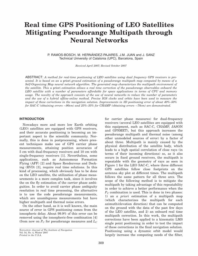
On the other hand, as it is well known, the mainsource of error in GPS positioning comes from theionospheric delay. About 99.9% of this error can beremoved using the ionospheric-free combination [4](from now on PC for pseudorange measures and LC
for carrier phase measures) for dual-frequencyreceivers (several LEO satellites are equipped withthis equipment, such as SAC-C, CHAMP, JASONand GPSMET), but this approach increases thepseudorange multipath and thermal noise (amongother unmodeled sources of error) by a factor ofabout three. Multipath is mainly caused by thephysical distribution of the satellite body, whichleads to a high spatial correlation of close rays (interms of their incoming directions) so, as it alsooccurs in fixed ground receivers, the multipath isrepeatable with the geometry of rays as seen inFigure 1 for the LEO SAC-C, where three differentGPS satellites follow close footprints on theantenna sky plot at different times. The multipathfollows the same pattern for all three arcs. Thescope of the following method is to mitigate themultipath by taking advantage of this repeatabilityin order to achieve a better performance when thePC combination is used. This is done in two phases:1) an a priori estimation of a multipath map(which characterizes the multipath for eachazimuth/elevation direction) that can be computedon the ground with the data of the past few daysof the LEO satellite, and 2) an onboard real timemultipath correction. In this work, the multipathcorrections have been applied to a kinematic LMSsingle point positioning in order to test the impactof these corrections in the final navigation solution.Positioning using a dynamic orbit model wouldlargely increase the computing needs of the filter,
NAVIGATION: Journal of The Institute of NavigationVol. 54, No. 4, Winter 2007Printed in the U.S.A.
309
and would probably need a simplification of themost common models to do this kind of processingin real time. This is out of the scope of the presentwork, which aimed to present a low cost methodfor LEO positioning. Therefore kinematic position-ing has been chosen instead, due to its very lowrequirements in terms of CPU and memory usage.
The idea of characterizing multipath by itsincoming directions can be seen in [5], and someefforts have obtained satellite maps, such as [6] forCRISTA-SPAS and [7] for CHAMP. The multipathmap would also absorb other direction-dependenteffects, such as phase center variations. An exam-ple of this could be seen for satellite JASON-1,which has large pseudorange phase center varia-tions depending on the incoming direction (up to90 cm, as can be seen in [8]). In the presentedmethod, the map is obtained using a Self-Organiz-ing Map algorithm (a type of neural network with-out classical counterpart, see [9] for more details)in order to minimize the parameters needed tocharacterize the satellite multipath environment(obtaining the same performance with about halfof the parameters).
This method is mainly based on the work donein [10] and has evolved to the present state.
METHOD
The a priori multipath map estimation will pro-vide the multipath detected for a set of given direc-tions which will be called cell centers. The multi-path for each observation can be obtained bymeans of a classic observable combination thatallows isolating the multipath [5].
In this work, the main observable used is theionospheric-free pseudorange combination, whichis defined as
Pc ¼ f 21 P1 � f 2
2 P2
f 21 � f 2
2
¼ qþ c�dtrec � dtsat
�þ relþMPc þ ePc ð1Þ
where f1 and f2 are the frequencies of the GPS sig-nals (1575.42 MHz and 1227.60 MHz, respec-tively), P1 and P2 are the pseudorange codes forboth frequencies, q is the geometric range betweenthe receiver at the time of reception and the GPSsatellite at the time of transmission, c is the speedof light, dtrec is the difference between GPS referenceclock and the receiver clock, dtsat is the differencebetween GPS reference clock and the GPS satelliteclock, rel is the relativistic effect on the signal, MPc isthe multipath of the combination, and ePc is the ther-mal noise and other unmodeled effects.
Nevertheless, with antispoofing activated, themeasurements of P1 and P2 are much noisier thanthe ones of C/A (coarse acquisition code). For thisreason, this observable has been chosen instead ofP1, thus redefining PC:
Pc ¼ f 21 C=A� f 2
2 P2
f 21 � f 2
2
¼ qþ c�dtrec � dtsat
�þ relþMPc þ TGD þ ePc ð2Þ
where TGD is the instrumental delay differencebetween C/A and P1. Note that, despite instru-mental delays for the ionospheric-free combinationbeing defined as zero, this is only true when thecombination is obtained using P1 and P2. However,when PC is computed using C/A instead of P1,TGD must be added into the equation.
Therefore, Equation (2) is the main observableused for the LEO satellite real time positioning.But, in order to isolate the multipath, MPc, in thea priori process, LC must be used:
Lc ¼ f 21 L1 � f 2
2 L2
f 21 � f 2
2
¼ qþ c�dtrec � dtsat
�þ relþ BIASLc þmLc þ eLc
ð3Þ
where BIASLc is the unknown phase ambiguityand mLc is the phase multipath. The wind-up term isneglected and inserted as unmodeled noise into eLc.
Using Equations (2) and (3), the following equationis used to isolate the multipath in the a priori process:
Pc� Lc ¼MPc þ BC þ e (4)
where mLc has been neglected and BC is an unknownconstant value for each arc (it is the contribution ofBIASLc, from Equation (3) and TGD from Equation(2)). The value of BC must be estimated for eachcycle-slip of any L1 or L2.
Equation (4) provides two unknowns per pseudo-observation that need to be estimated: MPc and BC.
Fig. 1–Repeatability of multipath for different arcs and times. Yaxis represents the multipath in meters plus an unknown bias(difference between ionospheric-free pseudorange and carrierphase combinations). Data processed from SAC-C satellite forday 155 of 2002.
310 Navigation Winter 2007
The second term is kept constant along an arc andthe first one is different for each observation, butsimilar for close rays due to the geometric natureof multipath. This similarity of the multipath forclose rays can be used to group multipath unknownsin the a priori postprocessing and estimate a mapdepending on the azimuth and elevation between theLEO and GPS satellites (always in a LEO body-fixedreference frame). This map is computed with a neu-ral network (a 2D Self-Organizing Map), leading to acell distribution adapted to multipath variations(irregular grid), with a higher center density wheregreater variations are detected.
The onboard real time processing uses this a pri-ori multipath map estimation and applies theproper corrections, i.e., the values of the cells, toeach observable.
A PRIORI MULTIPATH MAP ESTIMATION
The computation of the a priori multipath mapis done in postprocessing and on the ground. Theperiod of time used for this estimation should allowfor covering most of the possible ray directionsthat the LEO antenna can receive. Five days ofdata have been proven to be a good choice. In thiscontext, the process is divided into several steps:
• Preprocessing: A few stages are done in orderto prepare the data: cycle-slip detection, TGDestimation (to correct this term of Equation (2)in the real time processing), and the optimalreference frame determination (to obtain theLEO attitude and compute the azimuth andelevation of each GPS satellite with respect tothe LEO body-fixed reference frame).
• BC estimation: Merging all the observationsgiven by Equation (4), a single matrix is cre-ated to estimate all the unknowns (bias andmultipath unknowns grouped in cells of 5 � 5degrees). The inversion of this matrix providesan estimation of BC for all arcs.
• Regular grid map: The BC estimated valuesare then used to recalculate the multipath ofeach observation, forming cells of 1 � 1 degrees(using Equation (4)).
• Multipath variation estimation: From the 1 �1 map, a value is assigned to each cell propor-tional to the standard deviation of the multi-path values of the nearest cells.
• Monte Carlo algorithm: This algorithm distrib-utes thousands of directions across the sky,assigning more directions where more multi-path variation is estimated. This will be thetraining set for the neural network.
• Self-Organizing Map: The directions generatedare inserted as inputs into this step and thecell centers of the final SOMM are generated
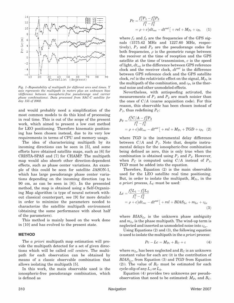
simultaneously to its indexation (with twoindex values) by means of a self-organizingmap [9]. Centers are ordered in such a waythat two close cells in the sky have similarindices. This is used to avoid unaffordablesearches in real time LEO scenarios (see theReal Time Multipath Mitigation section). InFigure 2 the distribution of these cells isshown for a five-day test for a SAC-C satellite.This map has been found to be repeatable fordifferent selections of days.
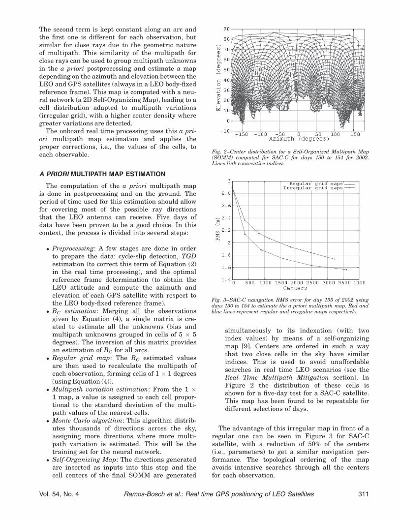
The advantage of this irregular map in front of aregular one can be seen in Figure 3 for SAC-Csatellite, with a reduction of 50% of the centers(i.e., parameters) to get a similar navigation per-formance. The topological ordering of the mapavoids intensive searches through all the centersfor each observation.
Fig. 3–SAC-C navigation RMS error for day 155 of 2002 usingdays 150 to 154 to estimate the a priori multipath map. Red andblue lines represent regular and irregular maps respectively.
Fig. 2–Center distribution for a Self-Organized Multipath Map(SOMM) computed for SAC-C for days 150 to 154 for 2002.Lines link consecutive indices.
Vol. 54, No. 4 Ramos-Bosch et al.: Real time GPS positioning of LEO Satellites 311

Afterwards, the SOMM can be transmitted tothe LEO satellite (along with the TGD informa-tion) and the real time process can begin. Theimages of a 131 regular grid map and a SOMMare plotted in Figure 4 in order to see the differen-ces between both maps.
REAL TIME MULTIPATH MITIGATION
The real time process is split into these steps:
• Preprocessing: Similar to the a priori process,a few stages are done to prepare the data:cycle-slip detection, TGD correction, and theoptimal reference frame determination.
• Cell selection: The closest cell to the directionof each observation is searched by looking at aradius of 2 indices around the previous obser-vation of the same arc (if a cycle-slip wasdetected a search through all cell centers isperformed).
• Multipath correction: The proper multipathcorrection of the selected cell is applied di-rectly to the observable. Another possibleapproach would be to use a low CPU burdenneural algorithm, which has been tested in[10], to allow a real time updating of the cellvalues.
• LEO Positioning: Positioning is performed bymeans of standard least mean squares andwith smoothed and unsmoothed PC to comparethe results. In order to discard bad measure-ments, when there are six or more satellitesavailable and the fitting RMS is too high, allthe combinations with 1 less satellite are com-puted and the one with lower RMS is chosenas the final position (as seen in [7] and [11],BlackJack GPS receivers have been reportedto have anomalous measurements).
CPU AND MEMORY COST
The method has been developed to be used inLEO satellites, so it is very important that the realtime process can run under low CPU and memoryenvironments. On the other hand, the a priori pro-cess (to be done on ground facilities) is not a timecritical process and can be done in 15 minutes in aPentium IV desktop computer.
The real time process can be done onboard andthe only difference from an unmitigated multipathpositioning would be the steps of Cell selection andMultipath correction. Both steps have low complex-ity: the Multipath correction is simply an additionof a number, and the Cell selection is a search overthe cells closer to the previously selected cell(thanks to the topology obtained with the Self-Organizing Map, which is an advantage in front ofa classic irregular map without topological order-
ing). As mentioned above, when no cycle-slip isdetected, the searching radius is 2 cells (so a totalof 25 cells per epoch and satellite are explored),but when a cycle-slip is found, all the map isscanned (for numeric calculations, 2500 centerswill be assumed, as this is the grid used in theData and Results section). With the cycle-slipdetection algorithm implemented, it is seen that,in mean, 150 cells are explored for each observa-tion, and 7 satellites are in view per epoch, whichleads to about 1000 cells explored per epoch.
Each scanned cell is based on the projection ofthe LoS vector (line of sight) into the cell vector(3D unitary vectors). The cell with major projectionof all the scanned cells is the selected cell. Eachprojection comprises a three dimensional scalarproduct, which needs three multiplications, twoadditions and a comparison (against the previousmaximum value of the projection). Taking intoaccount that there are, on average, 1000 cellsexplored per epoch, the requirements of the pro-cess are 3000 multiplications, 2000 additions and1000 comparisons per epoch (on average), which isa low CPU cost for a satellite processor.
The memory requirement is just the storage ofthe values of the multipath map (13 bits giving8192 numbers to quantize multipath values, fromþ20 to �20 in steps of 0.5 cm) and the position ofthe cells (11 bits for azimuth, from 0 to 360 insteps of 0.25 deg, and 9 bits for elevation, from�10 to þ90 in steps of 0.25 deg) which leads to33 bits per cell * 2500 cells¼ 82.5 Kbits� 10 KBytes,which is also a negligible contribution to the satel-lite memory requirements.
DATA AND RESULTS
GPS observations in RINEX format at a sam-pling rate of 0.1 Hz from two different LEO satel-lites have been used: SAC-C and CHAMP (both
Fig. 4–On left, regular grid map with 26347 centers, on theright, SOMM with 2484 centers. Map for SAC-C for days 150 to154 for 2002.
312 Navigation Winter 2007
equipped with dual-frequency BlackJack GPSreceivers). The POD antennae of both satellites arezenith oriented. To assess the method, the obtainedpositions have been compared with the postpro-cessed precise orbit determination from JPL (avail-able at: ftp://sayatnova.jpl.nasa.gov), which havean accuracy of a few centimeters.
The strategy has also been tested using preciseIGS clocks and orbits instead of the broadcastones. Clearly, this is an unrealistic situation, but isdone because in this way it is possible to asses theimpact of this mitigation in the final navigation so-lution avoiding the broadcast orbits and clockerrors. To be able to make use of this method in a
real time environment, clocks of GPS satellitesshould be estimated or provided (also using pre-dicted orbits, which have errors slightly higherthan the precise ones, but on the order of a fewcentimeters, so it would not have a large impact onthe solution).
The 3D positioning error RMS shown in allresults corresponds to the RMS of the 95% of theobservations with less error (i.e., the 5% of thetotal epochs with higher error are discarded, andthe remaining ones are used in the RMS computa-tion). This has been done, on one hand, to discardepochs with bad line-of-sight geometries and, onthe other hand, to filter out bad measurements,
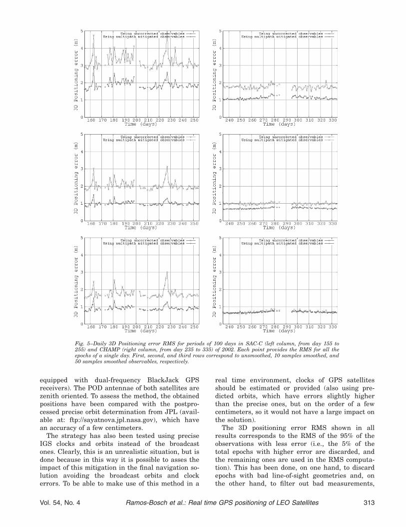
Fig. 5–Daily 3D Positioning error RMS for periods of 100 days in SAC-C (left column, from day 155 to255) and CHAMP (right column, from day 235 to 335) of 2002. Each point provides the RMS for all theepochs of a single day. First, second, and third rows correspond to unsmoothed, 10 samples smoothed, and50 samples smoothed observables, respectively.
Vol. 54, No. 4 Ramos-Bosch et al.: Real time GPS positioning of LEO Satellites 313
which can affect the positioning with errors up totens of meters.
Different smoothing periods have been used withsimilar results, gaining about 50% improvementin smoothed and unsmoothed observables. Thesmoothing of the pseudorange using carrier phaseobservables is a standard procedure and moredetails can be seen in [12].
In Figure 5, the RMS error position is shown fora full 100 day period for non-smoothed, 10 sampleswith smoothing, and 50 samples with smoothingobservables for SAC-C and CHAMP satellites.
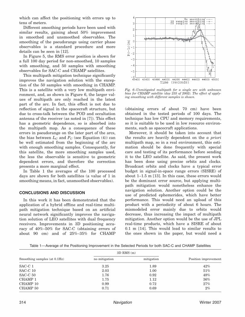
This multipath mitigation technique significantlyimproves the navigation solution with the excep-tion of the 50 samples with smoothing in CHAMP.This is a satellite with a very low multipath envi-ronment, and, as shown in Figure 6, the larger val-ues of multipath are only reached in the latestpart of the arc. In fact, this effect is not due toreflection of signal in the spacecraft structure, butdue to cross-talk between the POD and occultationantenna of the receiver (as noted in [7]). This effecthas a geometric dependence, so is absorbed intothe multipath map. As a consequence of theseerrors in pseudorange on the later part of the arcs,the bias between LC and PC (see Equation (4)) canbe well estimated from the beginning of the arcwith enough smoothing samples. Consequently, forthis satellite, the more smoothing samples used,the less the observable is sensitive to geometricdependent errors, and therefore the correctionpresents a more marginal effect.
In Table 1 the averages of the 100 processeddays are shown for both satellites (a value of 1 insmoothing means, in fact, unsmoothed observables).
CONCLUSIONS AND DISCUSSION
In this work it has been demonstrated that theapplication of a hybrid offline and real-time multi-path mitigation technique based on an artificialneural network significantly improves the naviga-tion solution of LEO satellites with dual frequencyreceivers. Improvements in 3D positioning accu-racy of 40%–50% for SAC-C (obtaining errors ofabout 90 cm) and of 25%–35% for CHAMP
(obtaining errors of about 70 cm) have beenobtained in the tested periods of 100 days. Thetechnique has low CPU and memory requirements,so it is suitable to be used in low resource environ-ments, such as spacecraft applications.
Moreover, it should be taken into account thatthe results are heavily dependent on the a priorimultipath map, so in a real environment, this esti-mation should be done frequently with specialcare and testing of its performance before sendingit to the LEO satellite. As said, the present workhas been done using precise orbits and clocks.Broadcast orbits and clocks have a typical errorbudget in signal-in-space range errors (SISRE) ofabout 1–1.5 m [13]. In this case, these errors wouldbe the dominant error source, but applying multi-path mitigation would nonetheless enhance thenavigation solution. Another option could be theuse of predicted ephemerides, which have betterperformance. This would need an upload of thisproduct with a periodicity of about 6 hours. Themismodeled error mainly due to orbits woulddecrease, thus increasing the impact of multipathmitigation. Another option would be the use of JPLreal-time products, which have a SISRE of about0.1 m [14]. This would lead to similar results tothe ones shown in the paper, but would need a
Fig. 6–Unmitigated multipath for a single arc with unknownbias for CHAMP satellite (day 235 of 2002). The effect of apply-ing smoothing with different samples is shown.
Table 1—Average of the Positioning Improvement in the Selected Periods for both SAC-C and CHAMP Satellites
Smoothing samples (at 0.1Hz)
3D RMS (m)
Position improvementno mitigation mitigation
SAC-C 1 3.25 1.89 42%SAC-C 10 2.03 1.00 51%SAC-C 50 1.76 0.92 48%CHAMP 1 1.75 1.12 36%CHAMP 10 0.99 0.72 27%CHAMP 50 0.71 0.69 2%
314 Navigation Winter 2007
permanent communication link to the satellite,which is still an open problem.
Multipath mitigation is not only useful in thepresented context, but it could also provideenhancements in the following points:
• Using carrier phase measurements in the nav-igation filter. This would increase the comput-ing needs of the filter, but could be feasibledepending on the processor of the satellite. Asthe present method only mitigates pseudor-ange multipath, it would only have a marginalimpact on carrier phase positioning. Theadvantage this could bring is allowing a fasterconvergence time after a cycle slip, as pseudor-ange measurements would have less noise(this would be beneficial for a LEO, which hasshort arcs on the order of 90–100 minutes).
• Single frequency receivers. The main problemin single frequency receivers would be toobtain the multipath map. The present methodmakes use of the carrier phase measurementsof both frequencies in order to isolate the mul-tipath. Therefore, the offline part of themethod would have to change radically. Anoption to do this would be to use theGRAPHIC combination [15], which would cre-ate an ionospheric-free pseudo-observable withmultipath and an unknown ambiguity. Thiscombination could be used to simultaneously(onground) estimate LEO positions and clocks,ambiguities, and multipath values. The multi-path values obtained would be affected byerrors in the GPS orbits and clocks, and theestimation process would be weaker than theone presented in this paper, but could allowfor the creation of multipath maps for singlefrequency receivers.
ACKNOWLEDGMENTS
The first author would like to thank to the IONGNSS organization for their Student Sponsorshipto present the initial version of the paper at IONGNSS 2006.
Part of the work presented in this paper hasbeen done in the frame of the ‘‘Neural Networksfor Radionavigation’’ project funded by ESA (underGrant No. ITT4584). The authors would like tothank the project team for their support. In addi-tion, the authors wish to thank the support fromthe ‘‘Departament d’Universitats, Recerca i Soci-etat de la Informacio de la Generalitat de Catalu-nya’’ and from the European Social Fund, with theadditional support of the Spanish projects IBER-WARTK and WARTKATNET (references ESP2004-05682-C02-01 and ESP2007-62676, respectively).
Finally, the second author wants to express hisdebt to his colleague Enric Monte, who introducedhim to the neural networks world 17 years ago.
REFERENCES
1. Montenbruck, O., van Helleputte, T., Kroes, R. andGill, E., Reduced Dynamic Orbit Determination usingGPS Code and Carrier Measurements, Aerospace Sci-ence and Technology, Vol. 9, No. 3, 2005, pp. 261–271.
2. Kapilal, V., Sparks, A. G., Buffington, J. M. andQiguo, Yan, Spacecraft Formation Flying: Dynamicsand Control, Proceedings American Control Confer-ence, Vol. 6, 1999, pp. 4137–4141.
3. Philip, N. K., Krishna Kumar, E. and Ananthasaya-nam, M. R., Sliding Observer for a Robust RelativePositiong and Attitude Estimation During the FinalPhase of an Autonomous Docking Mission, Proceed-ings 49th International Astronautical Congress, Mel-bourne, Australia, 1998.
4. Davies, K., Ionospheric Radio, Institution of Electri-cal Engineers, 1990.
5. Parkinson, B. W. and Spilker, J. J., Global PositioningSystem: Theory and Applications, 1996, pp. 560–566.
6. Reichert, A. K. and Axelrad, P., Carrier-phase Multi-path Corrections for GPS-based Satellite AttitudeDetermination, NAVIGATION, Journal of The Insti-tute of Navigation, Vol. 48, No. 2, 2001, pp. 77–88.
7. Montenbruck, O. and Kroes, R., In-flight Perform-ance Analysis of the CHAMP BlackJack GPS Re-ceiver, GPS Solutions, Vol. 7, No. 2, 2003, pp. 74–86.
8. Haines, B., Bar-Sever, Y., Bertiger, W., Desai, S. andWillis, P., One-centimeter Orbit Determination forJason-1: New GPS-Based Strategies, Marine Geod-esy, Vol. 27, 2004, pp. 299–318.
9. Kohonen, T., The self-organizing map, ProceedingsIEEE, 78, 1990, pp. 1464–1480.
10. Hernandez-Pajares, M., Juan, J. M. and Sanz, J.,GPS Code Multipath Detection and Mitigation in aLEO Scenario using Neural Networks, ESA WPP,ISSN 1022-6656, Vol. 173, 2000, pp. 594–622.
11. Williams, J., Lightsey, E. G., Yoon, S. and Schutz, R.E., Testing of the ICESat BlackJack GPS Receiver En-gineering Model, Proceedings of the 15th InternationalTechnical Meeting of the Satellite Division of TheInstitute of Navigation ION GPS 2002, Portland, USA,2002, pp. 703–714.
12. Minimum Operational Performance Standards forGlobal Positioning System/Wide Area AugmentationSystem Airborne Equipment, RTCA, DO-229C,Issued November 2001, p. 46.
13. Warren, D. L. and Raquet, J. F., Broadcast vs Pre-cise GPS Ephemerides: A Historical Perspective, GPSSolutions, Vol. 7, No. 3, 2003, pp. 151–156.
14. Bar-Sever, Y., Muellerschoen, R., Reichert, A., Vozoff,M. and Young, L., The Development and Demonstra-tion of NASA’s Global Differential System, Proceed-ings of ESTEC 2002, Pasadena, USA, 2002.
15. Yunck T. P., Coping with the Atmosphere and Iono-sphere in Precise Satellite and Ground Positioning,Environmental Effects on Spacecraft Trajectories andPositioning, AGU Monograph, 1993.
Vol. 54, No. 4 Ramos-Bosch et al.: Real time GPS positioning of LEO Satellites 315