readiness preparation proposal (r-pp) · · 2013-01-29readiness preparation proposal (r-pp) for...
TRANSCRIPT

R-PP Template Version 6, for Country Use and Public Comment (November 23, 2011) (To replace R-PP draft v. 5, Dec. 22, 2010)
1
Readiness Preparation Proposal (R-PP)
for Country: EL SALVADOR
Date of submission or revision: APRIL 9, 2012
APRIL 23, 2012; May 31, 2012; Agosto 25, 2012
September 28, 2012
Version 6 Working Draft
November 23, 2011
Forest Carbon Partnership Facility (FCPF)
The United Nations Collaborative Programme on Reducing Emissions from Deforestation and Forest Degradation in
Developing Countries (UN-REDD)
Disclaimer: The World Bank and the UN-REDD Programme do not guarantee the accuracy of the data included in the Readiness Preparation Proposals (R-PPs) submitted by REDD Country Participants and
accepts no responsibility whatsoever for any consequence of their use. The boundaries, colors, denominations, and other information shown on any map in the R-PPs do not imply on the part of the
World Bank any judgment on the legal status of any territory or the endorsement or acceptance of such boundaries.

R-PP Template Version 6, for Country Use and Public Comment (November 23, 2011) (To replace R-PP draft v. 5, Dec. 22, 2010)
2
Table of Contents Overarching Guidelines for Preparing an R-PP Component 1: Organize and Consult ...................................................................................................................................................... 7
1a. National Readiness Management Arrangements ......................................................................... 7 1b. Information Sharing and Early Dialogue with Key Stakeholder Groups ..................................... 16 1c. Consultation and Participation Process ....................................................................................... 50
Component 2: Prepare the REDD-plus Strategy .............................................................................................................................. 59 2a. Assessment of Land Use, Forest Law, Policy and Governance ................................................. 59 2b. REDD-plus Strategy Options....................................................................................................... 89 2c. REDD-plus Implementation Framework .................................................................................... 102
2d. Social and Environmental Impacts during Readiness
Preparation REDD-plus Implementation…………………………………………………………. 102
Component 3. Develop a National Forest Reference Emission Level and/or a Forest Reference Level ............. 103 Component 4. Designing and Information System for Multiple Benefits, Other Impacts, Governance, and Safeguards .......................................................................................................................................... Error! Bookmark not defined.
4a. Designing a Monitoring System .................................................... Error! Bookmark not defined. 4b. Multiple Benefits and other positive impacts from REDD+ activities ........... Error! Bookmark not defined.
Component 5: Schedule and Budget ....................................................................................... Error! Bookmark not defined. Component 6. Desing a Program Monitoring and Evaluation Framework Suggested Annexes for the R-PP (Optional) ........................................................................................................................................... Error! Bookmark not defined. ANNEXES ............................................................................................................................................. Error! Bookmark not defined. Annexes Providing Additional Guidelines or Information: [in the separate Annexes document]

R-PP Template Version 6, for Country Use and Public Comment (November 23, 2011) (To replace R-PP draft v. 5, Dec. 22, 2010)
3
Note: For submission to UN-REDD, an additional cover page with required signatures and information should be attached, which will be provided by the UN-REDD Secretariat.
Contact Information Please provide the details for the national REDD-plus focal points (lead official, and day-to-day contact) submitting the R-PP in the table below.
Name Herman Rosa Chávez
Title Minister
Name Lina Pohl
Title Vice minister
Name Salvador Nieto
Title UNFCCC United Nations Framework Convention on Climate Change
Name Sonia Baires
Title Director General for Climate Change and Strategic Matters
Organization Ministry of Environment and Natural Resources
Address Edificio MARN, km 5 Carretera a Santa Tecla, Calle y Colonia Las Mercedes,
San Salvador, El Salvador, C.A.
Telephone (503) 2132-9418, Conmutador (503) 2132-6276
Fax (503) 2132-9432
E-mail [email protected] [email protected]
Website www.marn.gob.sv
MARN Technical Contact
Name Jorge Ernesto Quezada Díaz
Title Link REDD Plus
Organization Ministry of Environment and Natural Resources
Address Edificio MARN, km 5 Carretera a Santa Tecla, Calle y Colonia
Las Mercedes, San Salvador, El Salvador, C.A.
Telephone (503) 2132-9407, Conmutador (503) 2132-6276
Fax (503) 2132-9432
Email [email protected]
Website www.marn.gob.sv
R-PP Development Team
Please list the names and organizations of the authors and contributors to the R-PP (insert as many rows as necessary in the table below).
Authors Organization
Jorge Ernesto Quezada Díaz MARN
Deborah Barry MARN
José Francisco Rodriguez García MARN
Karla Ciudad Real MARN
Frank Sullyvan Cardoza Ruiz Consultor GIZ/MARN
Data Providers and
Relevant Information
Ana Deisy López Directorate General for
General information

R-PP Template Version 6, for Country Use and Public Comment (November 23, 2011) (To replace R-PP draft v. 5, Dec. 22, 2010)
4
Environmental Observatory
(MARN)
Giovanni Molina MARN
Vladimir Baiza MARN
Nelson Saz MARN
Gabriel Cortéz MARN
Francisco Antonio Rodríguez Vásquez MARN
Lucia Gómez MAG
Amílcar López MAG
Julio Olano MAG
Guillermo Mayorga GIZ
Carlos Pérez GIZ
Óscar Rodríguez GIZ
Abner Jiménez GIZ
Summary of the R-PP
Dates of R-PP preparation (beginning to submission): October 2011 June 2012
Expected duration of R-PP implementation (month/year to
month/year):
October 2012 October 2015
Total budget estimate: US$ 6,586,000
Expected government signer of R-PP grant request (name,
title, affiliation):
Minister Herman Rosa Chávez
Expected key results from the R-PP implementation process: Outcome 1) Established and working participation and consultation structure Outcome 2) Information on conditions of forests and territories with identified REDD+ feasibilities, including activities to increase Carbon Stocks Outcome 3) Defined Baseline Outcome 4) MRV System designed Outcome 5) Validated and socialized mitigation-adaptation-based approach
Acronyms the country uses in the R-PP
ACCIES Coordinating Association for Indigenous Communications in El Salvador ACUDESBAL Association of United Communities of the Bajo Lempa ADESCO Associations of Communal Development ADIT Association for Integral Development of Tejutepeque AMSS San Salvador Metropolitan Area ANIS El Salvador National Indigenous Association APRAINORES Association of Organic Agroindustrial Producers of El Salvador ARDM Association for Municipal Reconstruction and Development ASPROCAÑA Salvadorian Association of Sugar Cane Producers BANDESAL Development Bank of El Salvador BCIE Central American Bank for Economic Integration BMI Multisector Investment Bank CACH Environmental Committee for Chalatenango CAMAGRO Agrocultural, Agroindustrial and Livestock Chamber of El Salvador CATHALAC International Organization that Promotes Sustainable Development for Latin

R-PP Template Version 6, for Country Use and Public Comment (November 23, 2011) (To replace R-PP draft v. 5, Dec. 22, 2010)
5
America and the Caribbean CEL Executive Hydroelectric Commission for Río Lempa CENTA National Centre for Agrocultural, Livestock and Forest Technology CENDEPESCA Centre for Fishing and Aquaculture Development CESTA Integral Centre for Adequate Technology CIAT Tropical Agriculture International Centre CMI Integrated Monitoring Centre CNPI National Coordination of Indigenous People for the Ministry of Culture of the Presidency COMURES Corporation of Municipalities for the Republic of El Salvador CONFRAS Confederation of Federations of the Salvadorian Agrarian Reform CONAFOR National Forset Commission of Mexico CORDES Foundation for Communal Cooperation and Development CRS Catholic Relief Service CSC Salvadorian Coffee Council DACGER Adaptation to Climate Change and Strategic Risk Management Division DBH Diameter Breast Height DIGESTYC General Division for Statistics and Census EI Earth Institute - University of Columbia Columbia/USA EIA Environmental Impact Assessment FAO Food and Agriculture Organization of the United Nations FCPF Forest Carbon Partnership Facility FECAGRO Association of Sugar Cane Producers FEDECOPADES Federation of Cooperative Associations of Agricultural Production for El Salvador FEDECREDITO Federation of Credit Banks and Workers Banks FIAES Fund of the Initiative for the Americas FIAGRO Foundation for Agricultural Technological Innovation FOMILENIO El Salvador Millenium Fund FONAES El Salvador Environmental Fund FUSADES Salvadorian Foundation for Economic and Social Development FUNDAMUNI Foundation of Support to Municipalities of El Salvador FUNDAUNGO Dr. Guillermo Manuel Ungo Foundation FUNPROCOOP Foundation for the Promotion of Cooperatives FUNDE National Foundation for Development GHE Greenhouse Gas GIS Geographic Information System GIZ German Agency for International Cooperation IDB Inter-American Development Bank IDES Initiative for Economic and Social Development IGN National Geographic Institute INGEI National greenhouse gas stocks IPCC Intergovernmental Panel on Climate Change
ISTA Salvadorian Institute for Agrarian Transformation
IUCN International Union for the Conservation of Nature

R-PP Template Version 6, for Country Use and Public Comment (November 23, 2011) (To replace R-PP draft v. 5, Dec. 22, 2010)
6
LULUCF Land Use, Land-Use Change and Forestry MARN Ministry of Environment and Natural Resources MbA Mitigation based on Adaptation MAG Ministry of Agriculture and Livestock MESPABAL Permanent Bureau for Stakeholders of the Bajo Lempa MH Ministry of Finance MOP Ministry of Public Works MRV Monitoring, Reporting and Verification OPAMSS Planning Office for the Metropolitan Area of El Salvador PAES Environmental Program for El Salvador PAF Family Agricultural Program PREP National Program for the Restoration of Ecosystems and Landscapes PRISMA Salvadorian Program for Development and Environment Research PROCAFE Salvadorian Foundation for Coffee Research PROCARES Training Program for the Reconstruction of El Salvador PPM Permanent Sampling Plots REDD+ Reducing Emissions from Deforestation and Degradation of Forests RENAPES National Network of Private Natural Reserves of El Salvador R-PP Readiness Preparation Proposal for National Readiness SAGDEL Advice and Training System for Local Development SALVANATURA Ecological Foundation of El Salvador SANP Protected Natural Areas System SECULTURA Ministry of Culture of El Salvador SESA Strategic Environmental and Social Assessment SINAMA National Environment Management System SME Small and Medium Enterprises STP Technical Secretariat of the Presidency UCA Universidad Centroamericana José Simeón Cañas UES Universidad de El Salvador UL Universidad Luterana UNDRIP Declaration of the United Nations on the Rights of the Indigenous People UNDP United Nations Development Program UNES Unidad Ecológica Salvadoreña UNFCCC United Nations Framework Convention on Climate Change USAID United States Agency for International Development WWF World Wildlife Fund ZAMORANO Universidad Zamorano

R-PP Template Version 6, for Country Use and Public Comment (November 23, 2011) (To replace R-PP draft v. 5, Dec. 22, 2010)
7
Component 1: Organize and Consult
1a. National Readiness Management Arrangements
National Readiness Preparation Structure
1a.1. National Strategic Reference Framework for REDD+ Program
On May 30th, 2012 the Cabinet adopted the 2012 National Environmental Policy, whose main objective is "revert environmental degradation and reduce vulnerability to climate change". The new Policy is based on six main lines of action: the inclusive restoration and conservation of ecosystems; the incorporation of the environmental issue into land management; water resources management, the adaptation to climate change and risk reduction; responsibility and environmental compliance and comprehensive sanitation. One of the main instruments of the Policy is the National Plan for Adaptation to Climate Change which initially includes the following aspects:
1. Systematic observation of the climate
2 Agriculture resilient to climate and biodiversity-friendly
3. Synergistic development of physical and natural infrastructure
4 Restoration and inclusive conservation of critical ecosystems
5. Integration of climate variability in budget planning
6 Climate Financing
7. Environmental sanitation and health
8. Land management
9. Human settlements
10. Water infrastructure and water management
11. Renewable energy
12. Education, development of skills and research
Under this framework, on May 7th, 2012, the MARN officially launched the National Program for the Restoration of Ecosystems and Landscapes (PREP), with which the Ministry intends to address, in a planned and aggressive manner, the severe deterioration of ecosystems and the loss of key ecosystem services, that make El Salvador show a high vulnerability to the environmental and social threats of climate variability. The PREP is also presented as an urgent response to the need for immediate recovery of resilience and ecosystem resistance in the face of a growing climate threat. It complies with the cost-benefit conditions, and adopts an innovative approach by proposing a comprehensive intervention of landscapes and connected territories, addressing at least three of the components of the National Plan for Adaptation to Climate Change mentioned above: the development of an agriculture resilient to climate and biodiversity friendly; the inclusive

R-PP Template Version 6, for Country Use and Public Comment (November 23, 2011) (To replace R-PP draft v. 5, Dec. 22, 2010)
8
restoration and conservation of critical ecosystems, and the synergic development of physical infrastructure and natural infrastructure.
Climate resilient agriculture and biodiversity-friendly: Recognizing that agricultural activities represent the main use of the soil of the country, this component seeks to start the transition from an agriculture heavily based on "bare ground" practices, burning and intensive use of agro-chemicals that pollute the soil and water sources and destroy biodiversity, towards a cleaner and more resistant to the climate threat agriculture and livestock activity. Through the massive expansion of agro-forestry and sustainable agriculture practices, we expect to recover soil and vegetation, mitigate climate change by capturing CO2 and fixation of carbon in the soil and vegetation, improve water regulation, reduce the use of agrochemicals, and improve conditions to preserve biodiversity (species, ecosystems, and genetics).
Synergic development of physical infrastructure and natural infrastructure: the physical infrastructure, in El Salvador, particularly the road infrastructure, is highly vulnerable to climate variability and has been heavily impacted by the increase in the frequency and intensity of extreme weather events. New design parameters can reduce this vulnerability, but significantly raise its costs, so combining investments in physical infrastructure with investment aimed at developing natural infrastructure can be more cost efficient. For example, the expansion of agroforestry in Watersheds and recovery of gallery forests would improve water regulation and help to protect bridges and ports. In addition, they would restore and expand biological corridors, creating a more favorable environment for conserving biodiversity.
Inclusive restoration and conservation of critical ecosystems: The inclusive restoration and conservation of forests, mangroves and wetlands is essential to sustain productive activities, ensure the livelihoods of local communities, conserve biodiversity and reduce climate risk. Forest ecosystems and natural areas deserve special attention and terrestrial, coastal marine ecosystems, especially mangroves deserve high priority attention to recover their role as protection against tidal waves and tsunamis, reduce coastal erosion, and strengthen their functionality as breeding areas of a wide range of marine species. The restoration and integrated management of wetlands is vital to maintain the storage capacity of nutrients and water, protect against floods and ensure sites for breeding, reproduction and development of hundreds of species of high protein and economic value. A central aspect that cannot be ignored is that the restoration and conservation may only be sustained, in time and in the territory, if it is rooted in local practices through an inclusive management supported by community action and effective coordination of local governments and national public institutions. One of the major initiatives to promote within the framework of PREP is the National REDD+ Program, with a focus on Mitigation based on Adaptation. Although the strategic proposal for the REDD+ Program in El Salvador advocates the reduction of the rates of deforestation and degradation of remnant forest ecosystems - natural ecosystems, forest plantations, agroforestry systems such as coffee plantations, forests in Protected Natural Areas among others; this will focus primarily on the increase of Forest Carbon Reserves, considering the high vulnerability and conditions of environmental degradation

R-PP Template Version 6, for Country Use and Public Comment (November 23, 2011) (To replace R-PP draft v. 5, Dec. 22, 2010)
9
experienced by the country. These forest ecosystems represent the most important carbon sinks and allow the hosting of the largest percentage of biodiversity of the country, in addition to a series of key local and national development ecosystem services which they provide. Figure 1 shows a diagram the proposal of the National REDD+ Program hierarchical linkages and interrelationships with other instruments such as the National Forestry Policy and the National Strategy on Biological Diversity.
Figure 1. Hierarchical links between the REDD+ Program and National Instruments
1a.2. Structure for National Readiness Preparation
The Climate Change Committee of the National System for Environment Management, created on August 20th, 2012 by agreement N ° 84 of the Executive Body in the field of the Environment and Natural Resources, serves as a deliberative body of policies, plans and programs related to climate change adaptation and its mitigation. The Committee is currently formed by the Minister of Finance, the Minister of Public Works, Transportation, Housing and Urban Development, the Minister of Agriculture and Livestock and the Minister of Environment and Natural Resources. One of the first decisions the Committee has been to invite the Minister for Foreign Affairs to participate in the same. Similarly, a Technical Committee has been established, composed of high level representatives of these Ministries, which will be responsible for advising and supporting the technical issues on climate change and on specialized topics at a political level.
REDD PLUS NATIONAL PROGRAM
NATIONAL PROGRAMME OF RESTORATION OF ECPSYSTEMS AND LANDSCAPES
DIVERSITY NATIONAL STRATEGY BIOLÓGICA
NATIONAL ADAPTATION PLAN AL CAMBIO CLIMATICO
NATIONAL ENVIRONMENT POLICIES
NATIONAL FORESTRY
POLICY

R-PP Template Version 6, for Country Use and Public Comment (November 23, 2011) (To replace R-PP draft v. 5, Dec. 22, 2010)
10
The primary responsibility of the Committee on Climate Change is to boost the National Plan for Adaptation to Climate Change and its Program for the Restoration of Ecosystems and Landscapes (PREP), promoting inter-agency articulation and coordination in an environment of full participation of the different stakeholders of society, in order to ensure targeted and synergetic interventions that will achieve positive and significant impacts on climate change. Under the framework of the Committee, three inter-institutional agreements have been signed that, among other things, seek to establish important commitments in the framework of PREP; design and implement strategies for resource mobilization; promoting an initial implementation: MARN-MAG Agreement; MARN-MOP Agreement; and MARN-MH Agreement.
In order to avoid dispersion, specific institutional arrangements for the national preparation and design of the El Salvador REDD Plus Strategy have not been created, but rather, structures for participation and coordination will be strengthened. In this sense, the conducting, monitoring and evaluating of the country’s Readiness preparation process will be developed at two levels:
a) National Strategic Level, through the Committee on Climate Change of the National Environment Management System (SINAMA). The Committee on Climate Change will be the Directive Body of the REDD-Plus Strategy and will be a platform for high level advocacy and coordination that will allow better attention and follow up on the international commitments and the national agenda of "Mitigation based on Adaptation". The Committee will be supported by the Directorate-General for Climate Change and Strategic Affairs (DGCCAE) of the MARN, providing specialized consulting and the guidelines proposals for the design, preparation and implementation of the REDD Plus National Strategy of El Salvador. Similarly, the DGCCAE will support the conduction of the Program of Communication and Strengthening of national capacities related to REDD+ and the approach of Mitigation based on Adaptation.
To ensure compliance with the relevant national legislation, taking into account the REDD+ Strategic Options discussed in section 2b, under the framework of the SINAMA the Climate Change Committee may receive support from other institutions such as the Supreme Court of Justice, Court of Accounts (I put the Audit Court, so which ever you decide to use you will have to change one) of El Salvador and the Legislative Assembly. The imminent installation of the environmental courts - the Environmental Courts of First Instance and the Environmental Chambers of Second Instance - by the Supreme Court of Justice following the provisions in the Environment Act (reforms by Legislative Decree 1045 of April 12, 2012) will come to strengthen the compliance and surveillance on damage to the environment including those illegal activities related to deforestation and forest degradation. This will in turn, improve the attention of several drivers of change also discussed in the section 2b. The MARN has already started some training activities on environmental issues and intends to include the relevant topics for REDD+.

R-PP Template Version 6, for Country Use and Public Comment (November 23, 2011) (To replace R-PP draft v. 5, Dec. 22, 2010)
11
Figure 2. Meeting of the Committee on Climate Change of the SINAMA. Ministers of MARN, MH, MAG, and MOP, accompanied by Deputy Ministers MIREX and MH.
The SINAMA was established by the Environment Act as the central authority for the coordination of public environmental governance. THE SINAMA is coordinated by the Ministry of Environment and Natural Resources (MARN) and it is politically constituted by the heads of the ministries, autonomous institutions and municipal governments, and operationally, by the Environmental Units of each of these entities. Of the 262 municipalities, 212 have established the Environmental Units which have Operational Plans and have hired at least one technician to monitor activities. However, only 178 of these have full time technicians. By 2012, 145 municipalities prepared the corresponding annual Operating Plan and 128 have regulatory and management instruments. These technicians of the Environmental Units are actively participating in the consultation workshops in different regions where they are being held, getting informed and contributing to the REDD+ proposal.
In the framework of the program to strengthen the SINAMA, the MARN is developing a strengthening process of the institutional capacities and human resources on the access, analysis and interpretation of relevant environmental information. During the second half of 2012 and in 2013, it is expected that work will be carried out with 6 ministries, 80 municipalities and 14 governmental departments. Seventeen monitoring stations will be installed linked to the Environmental Observatory of the MARN - which includes the construction of infrastructure and the installation of specialized equipment - allowing access to and local analysis of information. Technicians from the municipal environmental units, staff of the local governments and the ministries will also be trained in the following topics: use and interpretation of the environmental visualization system; environmental legislation and municipal code; Environmental Units’ competence and coordination of the SINAMA; categorization of activities, works or projects and attention to environmental complaints and environmental evaluation process. This initiative, already in the process of implementation, will allow and facilitate the development of proposed REDD+ training activities, as well as other activities to strengthen the Environmental Units.

R-PP Template Version 6, for Country Use and Public Comment (November 23, 2011) (To replace R-PP draft v. 5, Dec. 22, 2010)
12
b)An cross-sectional advisory level. The Climate Change Committee shall establish an Advisory Committee with the participation of representatives of all the key sectors. To facilitate active cross-sectional participation processes, Work Groups for Dialogue and Consultation will be established, which under the Mitigation based on Adaptation approach, will attend specific themes, advising and providing guidelines for the design, preparation and implementation of the National REDD+ strategy of El Salvador. Initially, five issues that will require a dialogue and broad consultation processes have been identified: Governance Mechanisms; Design of an Incentives and Compensation Program; MRV/Safeguards Monitoring System; implementation of strategies related to drivers of deforestation and forest degradation; and on the adequacy of legal frameworks, recognizing rights. The Working Group of dialogue with the indigenous communities will be strengthened and, in addition, initiatives and regional authorities of cross-sectional coordination will also be used and strengthened expanding the participation of local stakeholders and Local Advisory Committees established within the framework of the implementation of the Protected Natural Areas Act and the Permanent Territorial Work Groups. In addition, the Dialogue Working Groups for Forestry Development have been established and coordinated by the Ministry of Agriculture and Livestock, through the General Directorate of Forestry, Watersheds and Irrigation Management. These working groups are made up of representatives of forest producers, government agencies, environmental local and tourism offices, cooperatives and community associations. These working groups are forums for discussion and analysis of the development of the forestry sector, and among the topics and issues discussed is the program of incentives and mechanisms for environmental compensation. Working groups have already been established in several regions of the country. Thus, there is the Productive Forestry Work Group of Chalatenango (northern part of the country), MEFORPRO La Palma, Chalatenango; Productive Forest Table of San Vicent (central part of the country), MEFORPRO in San Vicente; Dialogue Working Group for Forests of Cabañas-Cuscatlan in Cinquera; and MECONFOR Cabañas-Cuscatlan Work Group; Dialogue Work Group of Usulután North, Usulután South, Mercedes Umaña and Jiquilisco (eastern part of the country). The Working Group with the Indigenous Communities. MARN has established a dialogue process with Indigenous Communities whose initial aim is the socialization of the National Policy on the Environment, as well as the opening of a space for full participation in the formulation process of the National Environment Strategy. To follow up this process, the Indigenous People formed a Committee of indigenous leaders, both women and men, representatives from across the country. The agenda includes a series of meetings in the Western, Eastern, Central, and Paracenter regions of the country, which aims to involve the greater representation of different communities. Initially it has addressed, among others, issues related to the inclusive restoration and conservation of critical ecosystems and adaptation to climate change and risk reduction.
Below, is the executive and operational framework presented schematically for REDD+ within the National Environment System (SINAMA) (Figure 3), showing the different

R-PP Template Version 6, for Country Use and Public Comment (November 23, 2011) (To replace R-PP draft v. 5, Dec. 22, 2010)
13
spaces of participation of institutions and relevant sectors for the REDD+ preparation for El Salvador. A table with the preliminary proposal of composition of the thematic dialogue work groups is also presented. It is worth mentioning that these work groups will be of the “Open-ended” kind. Both the Cross-sectional Advisory Authority and the Themes Dialogue Work Group will allow open spaces of participation and incidence for all key stakeholders. A permanent process of dialogue is proposed between the REDD+ stakeholders and the Committee on Climate Change, at both the political and technical levels. The thematic work groups will have an open-ended character, allowing the substantive theme to be attended to and deepening the discussions and analyses, in order to obtain specific proposals.
Themes Dialogue Work Groups
SINAMA MARN MOP MAG
MH MIREX Climate Change
Committee Political Level - MINISTERS
Technical Level – High Level
Links
Cross-sectional Consultation
Authority
Attention Strategy of
D&D Drivers
Monitoring Systems
MRV/Safeguards
Incentives and
Compensation System
Adequacy of legal frameworks
recognizing rights
Forestry Agreement Work Groups Indigenous Communities Work
Groups
Technical Secretariat
DGCCAE from MARN
Governance
Mechanisms

R-PP Template Version 6, for Country Use and Public Comment (November 23, 2011) (To replace R-PP draft v. 5, Dec. 22, 2010)
14
Figure 3. Executive and operational structure for REDD+ in the National Environment System (SINAMA) and composition proposals for Tematic Working Groups.
TThheemmeess DDiiaalloogguuee WWoorrkk GGrroouupp
Drivers Attention Strategy
Monitoring System MRV/Safeguards
Incentives and Compensation System
Adequacy of legal frameworks recognizing rights
MARN, MOP, MAG (DGOFCR, D. Livestock), CENTA, Nacional Commission Against Forest Fires, Sugar Cane Work Group, NGO
Academia Scientific Sector, Indigenous Communities, ADESCO, Local Work Groups, MAG, MARN (DG Environmental Observatory DGCCAS), CENTA
Forestry Sectors; coffee producers; NGO ANP Joint-Handlers; RENAPES; Local stakeholders work groups; Agricultural and Livestock Associations; NGO
MH, MIREX, MARN, MAG, MOP, Indigenous Communities, Local Communities and ADESCO, NGO, farmer’s associations, local work groups
Governance mechanisms
Representatives of Agrocultural Livestock Cooperatives, NGO, Academia Scientific Sector, Forestry Sector, Coffee Producers Association, Indigenous Communities, Private Sector and Producers Representatives, Local communities and ADESCO, Local work groups

R-PP Template Version 6, for Country Use and Public Comment (November 23, 2011) (To replace R-PP draft v. 5, Dec. 22, 2010)
15
Budget 1a: Summary of National Readiness Management Arrangements Activities and Budget
Main Activity Sub-Activity Estimated Cost (in thousands US$)
2012 2013 2014 2015 Total
Strengthening of SINAMA and Climate Change Committee on REDD+ MbA
Workshops and meetings
$ 5 $ 25 $ 25 $ 25 $ 80
REDD+ national working group
(Technical group on Climate Change)
Establishment of the REDD+ working team
$ 10 $ 30 $ 30 $ 30 $ 100
Legal process for structuring and regulating institutions
$ 5 $ 20 $20 $ 5 $ 50
Coordinator of the Readiness Preparation Process
$12 $36 $ 36 $ 36 $ 120
Workshops and meetings
$ 5 $ 5 $ 5 $ 5 20
National Strategy for REDD+ Mitigation based on Adaptation Training and Communication
Development, publication and distribution of material on REDD+
$ 25 $ 50 $ 50 $ 25 $ 150
Design and layout of REDD+ Strategy MbA portal
$ 10 $ 20 $ 10 $ 10 $ 50
Communications specialist
$ 8 $ 24 $ 24 $ 24 $ 80
High level workshops to give relevance to the REDD+ strategy and stakeholders’ training
$ 5 $ 15 $ 15 $ 15 $ 50
Workshops and meetings with stakeholders and sectors
$ 5 $ 25 $ 10 $ 10 $ 50
Total $90 $ 250 $ 225 $ 185 $ 750
GIZ $ 53 $ 134 $ 85 $ 60 $332
FCPF $22 $ 66 $ 90 $ 90 $ 268
Government (GOES) SINAMA Monitoring and Strengthening Activities
$65 $ 100 $100 $ 85 $ 350

R-PP Template Version 6, for Country Use and Public Comment (November 23, 2011) (To replace R-PP draft v. 5, Dec. 22, 2010)
16
Early Dissemination Stage for the R-PP development phase
1. The Mitigation proposal based on the Adaptation and evolution of the consultation process
Since the development of the R-PIN (2/16/2009), under coordination of the MARN, to date, the approach of how El Salvador should address a national REDD+ program has evolved significantly, fed by several factors, including the negotiations on climate change, finally enabling the country to decide to present its proposal to the FCPF. The most important fact to highlight is that conception, design and implementation of the REDD+ strategy is within the approach of adaptation to the impacts of climate change, particularly climate variability. The national priority is unquestionably the adaptation and it is this logic and these actions that must guide the construction of mitigation within the REDD+ strategy, taking into account that, by the type of actions to promote (restoration of vegetal cover among others), it will at the same time open the opportunity to generate significant mitigation co-benefits. From this perspective and order of precedence it has been determined that the REDD+ approach for El Salvador will be mitigation based on the adaptation.
From a first step of briefing the population, generated through consultation for the National Environment Policy, and subsequently, with two Strategic Environmental and Social Assessments (SESA) in progress, and together with a much more precise reading of the impact trends of climate variability in El Salvador (see section 2.a), the MARN is able to determine with greater clarity and specificity the causes of social, environmental and economic vulnerability in the country. It just resumes the level and dynamics of some processes of environmental degradation that is exacerbated by the lack of forest and vegetal cover and misuse and degradation of soils as the main causes for the formulation of a strategic framework for adaptation. It considers that facing the changes in the frequency, intensity, duration, source (Pacific) and spatial distribution of rain storms (and possible drought) - that make up the climate variability - the levels of degradation will become accentuated, exacerbating erosion, gullies and landslides, sedimentation, contamination and flooding in the country until it reaches a stage of unsustainable levels of response. 1 Based on this, the MARN resizes and specifies its approach on how to reverse environmental degradation and reduce the risk from the impacts of climate change and the most urgent answer; it visualizes a role for mitigation, as part of these efforts. Actions to promote are largely avoiding deforestation of the remnants of forests, protected areas and agro-forestry systems (shade coffee), expand gallery forests and natural regeneration, and
1 See section 2.(a for the implications of the damage and costs of Tropical Depression E12, October, 2011)
1b. Information Sharing and Early Dialogue with Key Stakeholder Groups

R-PP Template Version 6, for Country Use and Public Comment (November 23, 2011) (To replace R-PP draft v. 5, Dec. 22, 2010)
17
promote ecological corridors and agroforestry on slopes and the massive use of soil and water conservation. In summary, the adaptation actions which must be promoted mean an effort of mass restoration of rural landscapes and ecosystems (including the agroecosystems) underpinning them. In the case of El Salvador, many of these actions will be consistent with REDD+ activities, in particular, to avoid deforestation, reverse the forest degradation (including shade coffee plantations and mangroves) and especially with the increase and improvement of forest carbon stocks (REDD+) through changes in agricultural practices in a wider landscape. Thus the approach is conceived as mitigation based on the adaptation, and is incorporated as a central axis in the formulation of a National Program of Restoration of Ecosystems and Landscapes (PREP), known as PREP-REDD+.
2. Early dissemination and consultations
For early dissemination on REDD+, one of the most important activities was the consultation for the National Policy on Environment, with an emphasis on national and social issues. The second one is the design and implementation of the SESA in the MARN for the elaboration of strategies and plans for the Marine Coastal Strip development, and framework for the Fomilenio II (MCC) investment, where people were trained in a SESA method/approach. The third one is the SESA on the Agriculture for Family Program of the Ministry of Agriculture and Livestock which is in the design phase.
These three processes are directly relevant to the exercise of the early dissemination in its capacity of explanation on the theme of climate change and its implications for El Salvador (differences between adaptation and mitigation of global warming) as training exercises for the staff of MARN on the issue of the SESA. In the case of the EAE of the Family Agriculture Plan, it is expected that this process will contribute with relevant material for consultation with the farmer sector. These exercises are core activities of the MARN at this time, and have allowed building knowledge on the perspectives, ideas, and proposals of all sectors of the country, facing the problem of climate change and the management of natural resources.
Consultation on the National Environment Policy
According to the Environment Act, the population is entitled to participate in consultations prior to the definition and adoption of environmental policy (Article 9). Beyond this provision, the 2012 National Environmental Policy, approved by the Cabinet on May 30, 2012, is made under the premise that the full commitment and participation of citizens are necessary conditions to face the environmental problems of the country.
With this conviction, on June 5th, 2011 – World Environment Day – the MARN massively disseminated the document "Environment Policy for Public Consultation” through one of the newspapers of national circulation. The National Policy on Environment was created (Figure 4), to inform the public about the environmental situation in the country, communicate priorities identified by the Government and to facilitate a dialogue in territorial consultations with various sectors of national life.

R-PP Template Version 6, for Country Use and Public Comment (November 23, 2011) (To replace R-PP draft v. 5, Dec. 22, 2010)
18
This comprehensive process served as a basic socialization on the elements and fundamental implications of climate change, contributing to the general understanding of adaptation and mitigation, as a necessary background in order to later deepen on the mitigation of global warming and REDD+. At the same time, it meant a projection of the MARN as the governmental entity with knowledge and leadership on the issues related to climate change, also disseminating its special role as the Ministry with focal points of international conventions. As a result of this comprehensive exercise the MARN was entrusted and legitimized as the entity that should promote studies relating to the impact of climate change that will allow the designing of action plans to reduce the negative effects on productive activities, encourage adaptation and mitigation efforts, as well as an adequate planning of programs and projects to ensure better management of water resources, design regulatory frameworks, promote energy efficiency and water consumption, among other strategies.
The 2012 National Environment Policy, approved by the Cabinet on May 30, 2012 (Annex 5), recognizes that the central problem which should be addressed is the severe environmental degradation and the increasing vulnerability of the country to climate change and breaks down the central problem in six specific problems: growing climate threat; degradation of ecosystems of great value; widespread environmental insalubrity; critical state of water resources; disorderly occupation of the territory; and low culture of responsibility and environmental compliance.
In view of this problem, the general objective of the 2012 National Environment Policy is to reverse environmental degradation and reduce vulnerability to climate change. The specific objectives are to: reduce climate risk; reverse the degradation of ecosystems; reverse environmental insalubrity; the sustainable management of water resources; environmentally plan the use of the territory; and encourage a culture of responsibility and environmental compliance.
In line with the specific objectives, the following priority lines of action are proposed: adaptation to climate change and risk reduction; restoration of ecosystems and degraded landscapes; integral environment sanitation; integrated management of water resources; integration of the environmental issue into land management; responsibility and environmental compliance.

R-PP Template Version 6, for Country Use and Public Comment (November 23, 2011) (To replace R-PP draft v. 5, Dec. 22, 2010)
19
Figure 4. Presentation meeting for the "Consultation of the new National Environment Policy".
During the process of consultation of the National Environment Policy, two main lines were dealt with which are essential and contribute to REDD+ activities; focusing on the consultation and discussion in a participatory manner specifically in:
1- Inclusive restoration and conservation of ecosystems and
2- Adaptation to climate change and risk reduction.
The basic aspects that relate to the inclusive restoration and conservation of critical ecosystems were discussed in this consultation of the National Environment Policy, where the inclusive restoration and conservation of FORESTS, beaches, mangroves, wetlands are needed to sustain productive activities, ensure the livelihoods of local communities, conserve biodiversity and reduce climate risk. During the consultation emphasis was made on the promotion of agro-forestry and agro-ecological practices and on the actions that should be strengthened to preserve the forested areas and terrestrial natural areas, and where it was expressed explicitly that the restoration and conservation could only sustained in time and in the territory if it is rooted in local practices through inclusive management supported by actions of the communities.
Related to the issue of adaptation to climate change and risk reduction, aspects were discussed where an approach to adaptation to climate change is incorporated, especially with the increasing climate variability; the restoration of ecosystems, watersheds and landscapes, and the development of hydraulic infrastructure.
This territorial, public consultation with different sectors identified key environmental issues that concern the population and the different social sectors. Also, it generated a meaningful dialogue in which men, women, young people, businessmen and entrepreneurs, environmentalists, farmers, representatives of academia, among others, were able to

R-PP Template Version 6, for Country Use and Public Comment (November 23, 2011) (To replace R-PP draft v. 5, Dec. 22, 2010)
20
express their concerns and their contributions, achieving a participation of more than 800 people nationally, as well as 135 written contributions which were received electronically or by postal mail.
Mesoamerican Regional Dialogue: Forests, Governance and Climate Change
From 2011, the MARN and various government entities have participated in workshops and dialogues organized for the countries of the Central American region which followed the evolution of the same concept and concrete proposals of REDD to REDD+ (Figure 5). Thus, personnel were trained in the international interaction and for the elaboration of a proposal for REDD+ that could respond to the specific conditions of El Salvador.
Figure 5. Mesoamerican Regional dialogue: forests, governance and climate change.
A milestone in this process, and the first dissemination of the approach of the MbA was on September 9, 2010 when the " Mesoamerican forests, governance and climate change Dialogue" meeting was held in San Salvador – one with broad participation of Ministers of Central America, CONAFOR (Mexico) and representatives of the main national farmer and indigenous organizations and the Mesoamerican region, where the Minister of the MARN launched the concept and explained the logic of mitigation based on adaptation (MbA) as the only approach which could be functional for El Salvador to enter into a REDD+ process, to reflect the order of priorities in the country's needs. The meeting allowed a first dissemination and discussion with a large audience and broad national sectors and the entire Mesoamerican region.2
Between July and November of 2011, the MbA proposal began to take a more concrete form as one of the core elements of the emerging National Program for the Restoration of Ecosystems and Landscapes (PREP), which is displayed as a flagship program for adaptation to climate change and mitigation of global warming, proposed by MARN. Coined within the framework of the National Environment Policy, the PREP should orient a large set of efforts within the mandate of the Ministry, as part of its quest for coordination and action set within the State and civil society. Otherwise, the national participation in
2 Although it was not organized as a formal consultation, but as an act of dissemination and debate, an open discussion among broad sectors on the approach, reflected a very positive resonance by the fact of prioritizing adaptation logic over mitigation. http://www.prisma.org.sv/index.php?id=26&tx_ttnews[tt_news]=201&cHash=e56eb62ee12e47123243db4fab65b5ce

R-PP Template Version 6, for Country Use and Public Comment (November 23, 2011) (To replace R-PP draft v. 5, Dec. 22, 2010)
21
mitigation schemes will not be meaningful or echo in the face of the size of the challenge of adaptation. Thus, the REDD+ El Salvador proposal is formulated to make the relationship of MbA (PREP-REDD+) visible.
At the same time, approaching the MbA includes the possibility of some actions in PREP-REDD+ to ensure the conservation and restoration of biological diversity in consistency with the Strategic Plan 2011-2020 of the Convention on Biological Diversity and the Aichi Targets. The actions of forest restoration, biodiverse agroforestry systems, including the restoration of agro-biodiversity (soils and vegetation), would be an approach that seeks to restore, preserve and maintain ecosystemic services, in order to strengthen the other social and environmental benefits. At the same time, these actions will have clear co-benefits of reducing emissions and increasing carbon sequestration. MARN recognizes that a large part of the national problem of environmental degradation has been not only the loss of key natural areas for ecosystem functions, but that at the same time the agricultural soils of the country have been losing their productive capacity.3 Increases in the fertility of the soils include the increase in the micro and macro fauna of soils, which requires a decrease in the use of agrochemicals.4
The impact of the last extreme climate event (the E12 Tropical Depression) from October 10 to 19, 2011, has led to the fact hat the pace and timing of the early dissemination processes on PREP-REDD+ have received a sense of particular urgency, accelerating some aspects of priority and dialogues deeper between ministries and local stakeholders (farmers, municipalities, NGOs among others) to move forward in agreements on joint actions in the short term. That is to say, the urgency of adaptive responses also accelerates the need for experimentation with mitigation. MARN was forced to the early elaboration of criteria to delimit the territories where the experiment and learning should begin, and demonstrate the impacts and co-benefits of the MbA approach. As mentioned, it is the needs of adaptation (areas of vulnerability to the impact of climate variability) that will dictate the initial regions/territories to work on and where the challenge of REDD+ be addressed (see Annex 1). 3. Stakeholders Identification
The initial identification of the different groups of stakeholders potentially involved or affected by the design and implementation of REDD-PREP+ process is the key to achieving the objectives of a domestic consultation (see Table 1). Identification is a process in itself, and can be expanded as the same dialogues and consultations are carried out, as well as the participation in events promoted by others, to determine the potential role of the stakeholders and the degree of interest and proposals that they have.
3 El Salvador is one of the countries of Latin America that has internalized the agricultural paradigm of the Green Revolution, with extensive use of
agricultural technologies based on certified seed together with fertilizers, herbicides, pesticides, etc.
4 It is worth mentioning that the focus of the MbA commitment to the restoration, conservation and maintenance of biodiversity means an effort to build
within the same approach of MARN with: the Divisions of Climate Change, Land Management, Environmental Governance and Natural Heritage. Also,
during the period of the development of the R-PP, with several instances within the Ministry of Agriculture and Livestock (MAG-CENTA).

R-PP Template Version 6, for Country Use and Public Comment (November 23, 2011) (To replace R-PP draft v. 5, Dec. 22, 2010)
22
MARN-driven processes have contributed to having a greater ability to visualize the sectors and stakeholders to be potentially affected by the PREP-REDD+. MARN’s PREP-REDD+ team, in coordination with the MAG’s General Directorate of Forestry, Watersheds and Irrigation Management, is in the process of the preparation of a map of stakeholders based on their territorial or sectoral linkage at the level of an eventual National PREP-REDD+ program. The main effort of PREP at this stage has been the purposeful dialogue, deliberation and agreements with local governments and social organizations, and ministries in the 3 priority territories to see how they want to participate in the PREP program and to be pioneers in the construction of a new approach on landscape. Mitigation in terms of avoiding deforestation and forest degradation would be retaken as an element in the landscape to be considered in the planning and actions of adaptation, i.e. the transformation of agriculture towards the sustainable (agroforestry, substitute system of burning, etc) and would potentially form part of what is meant in REDD+ as the plus, the improvement of carbon stocks. The R-E-D-D plus scheme would be presented as an option to form a set of broader actions, where the owners of forests and agro-systems will decide how to participate in the construction of the emerging national REDD+ strategy. Since the approach for the FCPF-REDD+ in El Salvador is mitigation based on the adaptation and as will be explained later, many of the actions promoted and carried out for adaptation would have clear co-benefits for mitigation, it would be optional for those who want to present their actions as such. Anyway, we have an initial distinction in the Map of Stakeholders on the role and competence of the various stakeholders in the field of adaptation, being those a much larger group of actions than those of mitigation, and subsequently, to mitigation based on adaptation. It is important to note that for the adaptation, the process of ascribing to the PREP process is totally voluntary and based on ways and means of conviction of the benefits, the use of the example of the existing successes (nationally and regionally) with the appropriate and intelligent use of a menu of incentives. For mitigation based on these adaptation actions, the formal process of consultation would be used (early dissemination) and a Strategic Environmental and Social Assessment (SESA) to determine the interests and possibilities of effective participation through a ‘Map of Stakeholders’ (Table 1).

R-PP Template Version 6, for Country Use and Public Comment (November 23, 2011) (To replace R-PP draft v. 5, Dec. 22, 2010)
23

R-PP Template Version 6, for Country Use and Public Comment (November 23, 2011) (To replace R-PP draft v. 5, Dec. 22, 2010)
24
Table 1. Map of Stakeholders potentially involved or affected by PREP-REDD+
5 PSD – To be determined during the consultation process, dialogues and SESA.
Participating and binding
Institutions and Stakeholders
SECTOR # 1
Activities related to the environmental laws, policies,
regulatory framework, conservation standards, agro-biodiversity
promotion and monitoring and verification
SECTOR # 2
Research, technical assistance, and technology transfer for production, processing and marketing agricultural and
livestock activities
Laws, Policies and Regulatory Framework
SECTOR # 3
Infrastructure and Energy
SECTOR # 4
Institutional, Legal and Financial
Role of coordinating greater inter-institutional efforts (STP)
Adaptation Mitigation Adaptation Mitigation Adaptation Mitigation Adaptation Mitigation
Institutions or Governmental agencies
Ministry of Environment and Natural Resources MARN
Local governments
ENVIRONMENTAL UNITS
Party responsible for the framework of MARN’s response to the vulnerability to climate variability.
Formulator of instruments of law, policy, strategy and climate change plans
Rules governing the elaboration of PREP as inter-ministerial adaptation program
Promoters in the territories of changes in approaches and monitoring progress
Implementation instruments
Party responsible for the construction of national REDD+ as mitigation based on the adaptation strategy
Under the responsibility of the national system of MRV and REDD+ regulatory framework
Promoter of transformation of agriculture in landscape and watershed management programs
MRV - reducing vulnerability
(expansion of bio-climate system; construction of indicators jointly with MAG)
Party responsible for mitigation based on the adaptation where relevant framework and agreed in the agriculture and livestock production and processing
Joint work with other sectors according to the national strategy, based on consultations
MRV - on CO2 and biodiversity
Promoter of transformation of analysis practices and infrastructure proposals
Technical support for implementation of the watershed approach
PSD5
Analysis and design of proposals jointly with MOP, OPAMSS, etc. (medium-term)
PSD
Design of key institutional instruments – environment law, Territorial Waters Management law, environmental policy
Responsible for dealing in coordination with Finance to expand environmental management in SINAMA
Development of municipal ordinances in accordance with local conditions for PREP and based on legal instruments
Regulatory framework on mitigation funds and the participation of individuals in the voluntary market
PSD

R-PP Template Version 6, for Country Use and Public Comment (November 23, 2011) (To replace R-PP draft v. 5, Dec. 22, 2010)
25
Institutions or Governmental agencies
MAG-CENTA
MAG-Forestry Unit, Watersheds and irrigation
Promotion of increasing AS practices as part of CC strategy
Research on AS in CEDAFs and CENTA
Development of Bio-climate systems with MARN support
Reform and enforce the implementation of the forestry law (agro-forestal)
Coordination of Watersheds management projects with MARN, local Governments and social organizations in a landscape approach
Optional: PSD
Participation in elaboration of indicators and standards of MRV of C02 and biodiversity for agro-systems, single-crops, etc.
Develop MRV REDD+ System jointly with MARN
Promotion of alternative systems of energy use in production and agricultural and livestock transformation (small, med. and large production)
Optional: PSD
Participation in the monitoring and evaluation of national MRV system
Design of main relevant institutional instruments:
(from CC strategy)
Institutions or Governmental agencies
Ministry of Health
Studies of impacts of general practices harmful to human health
Design and apply the rules of health related instruments
Share technical criterion
Coordination of
Studies of impacts of agricultural and livestock practices harmful to human health
Design and

R-PP Template Version 6, for Country Use and Public Comment (November 23, 2011) (To replace R-PP draft v. 5, Dec. 22, 2010)
26
inistry of Public Works (MOP)
Deputy Secretary of Territorial Development
(SSDT)
OPAMSS
Hydroelectric Executive Comisión of Rio Lempa (CEL)
Office for Vulnerability Matters
(SINAPROP)
(SINAPROP)
actions and approach to watershed management
Land Management and zoning for expansion of the AMSS
Enhancement of the role of the Rio Lempa regulation and coordination system with local governments
Internalization of costs of discharge effects down river
Coordination of MARN with the National Prevention and Disaster Mitigation System
PSD
PSD
PSD
apply health standards with instruments in coordination with Plant and Animal Health (MAG)
PSD
Design and implementation of Eco-systemic services compensation schemes (CSE)
Integration of technical criteria and search solutions of green infrastructure
PSD
CSE - as reduction mechanism of sediment dams (rational use of fluctuating land in exchange for protection of surrounding watershed)
PSD-
Inquire about replacing emissions in cement by use of green infrastructure
PSD
Forest conservation Organizations and environmental associations, Protected Natural Areas:
UNES
CESTA
PRISMA
Salvanatura
GAIA
Amigos de la Tierra
RENAPES
REDANP
- PSD
Contribution with its knowledge on the environmental problems of the country
Contribution to the research and the monitoring system
Optional: PSD
PSD
Optional: PSD

R-PP Template Version 6, for Country Use and Public Comment (November 23, 2011) (To replace R-PP draft v. 5, Dec. 22, 2010)
27
Fundacion Balsamo and others
Organizations of Producers/Communities Associations and Agricultural and Livestock NGOs:
FUNPROCOOP CONFRAS , FEDECOPADES, FUNDROPCOP Mesa de Actores Sociales Permanentes del Bajo Lempa (MESPABAL), MANGLE ACUDESBAL ARDM ADIT CACH Catholic Relief Service (CRS),
APRAINORES,
IDES
Caritas
CARE
PSD
PSD
Main initial stockholders in PREP, will be legitimized and supported with technical assistance, funds and instruments of laws, policies, standards, coordinated between ministries
Potentially receivers of greater resources to encourage the scaled AS approach
Optional: PSD
They will participate in the way they decide via MbA funds or directly in voluntary market
PSD
PSD
Associations of indigenous communities: Descent Leaders and communities from the Nahua, Lenca and Kakawira descent
National Coordination of Indigenous People (NCIP) of the Ministry of Culture; of the Presidency of the Republic
PSD
Optional: PSD
Benefitted from the recognition and strengthening and dissemination of their traditional practices and knowledge and natural rights on RRNN
Optional: PSD
Implementing acknowledgement of existing DD
Seek enhancement of claimed DD
Strengthen and multiply favorable municipal ordinances
PSD

R-PP Template Version 6, for Country Use and Public Comment (November 23, 2011) (To replace R-PP draft v. 5, Dec. 22, 2010)
28
Entrepreneurs Associations of agricultural-livestock production
Union associations of small and medium producers
Women Producer Associations
SalvadorianSugar Cane Producers Association (ASPROCAÑA)
Sugar Cane Refineries (6)
Regional Coffee Associations
CSC-SalvadorianCoffee Council
PROCAFE
FIAGRO
FECAGRO
ALBA Alimentos
PSD
Optional: PSD
Promotion of Expansion of small and medium-sized Coffee Producers with scheme incentives
A-Sugar cane producers and farmers will have to change harmful practices
Zoning of cultivation and grazing areas
Opcional: PSD
Large producers (coffee, sugarcane, cattle) may benefit from the voluntary market or national program projects of incentives (advocacy of certification and others).
Research and Studies Sector and OTHER:
-Universidad Nacional de El Salvador-Facultad --Agronomía -Universidad Luterana -PRISMA -FUSADES -FUNDAUNGO
Integrating research on CC and adaptation GOES efforts Strengthen capacity with funds to upgrade and integrate approaches to inter-disciplinary Research
Optional: PSD Development and provision of new curricular materials for middle-higher education
FEDECREDITO y miembros FEDECASES y miembros
PSD PSD PSD PSD

R-PP Template Version 6, for Country Use and Public Comment (November 23, 2011) (To replace R-PP draft v. 5, Dec. 22, 2010)
29
-Banco Nacional de Desarrollo de El Salvador (BANDESAL) -FIAES -FONAES
PSD PSD

R-PP Template Version 6, for Country Use and Public Comment (November 23, 2011) (To replace R-PP draft v. 5, Dec. 22, 2010)
30
For the purposes of the initial stage of PREP there was a deepening of early agreements in pilot sites, or PREP-REDD+ priority territories, which were efforts that went far beyond a query. This first stage focuses on dialogue and agreements at a national level with the relevant GOES authorities and with non-State stakeholders and local authorities in the three selected territories (see table 2). The second stage of early dissemination would expand the stakeholders and sectors as shown in the table below with a formal consultation on the basis of the R-PP and specific presentations by sector. This stage - in part - would include the body of what is consulted in the SESAs that MARN is making for the Fomilenio II and in the SESA on the Family Agriculture Program, if they are brought up to the expected levels.
Table 2. Stages for consultation
STAGE I
GOES
Inter- Agency Dissemination, Agreements and Commitments
NON GOVERNMENTAL
Emphasis on dissemination and agreements with local
stakeholders
NATIONAL
- MAG
- MOP
- CEL
- Technical Secretariat of the Presidency (STP)
- Study of key stakeholders for Stage II of the national consultation process.
- Early dissemination with more related groups
LOCAL - Definition of pilot territories (with use of land, Watersheds and vulnerability criteria)
- Initial dialogues together with MAG.
- Involvement of local municipalities in Pilot Territories.
- Definition of territories (including social and organizacional criteria).
- Initial dialogues together with MAG.
- Establish social counterparts in the country’s pilot territories.
STAGE II GOES NON GOVERNMENTAL
NATIONAL
- MARN/MAG Joint Consultation with all official authorities.
- STP Support- Presidential Level.
- Consultation and national communication campaign
(PREP-REDD+)
- Direct dialogues with key sectors.
LOCAL
- Local governments support wider consultation in territories.
- Expansion of groups cores to territorial work groups. Dialogues with major producers.
Stage I: Early dissemination and political-operational agreements
National Governmental Level
One of the key elements for the PREP-REDD+ approach is the recognition of the need that the Government agencies change the way of interacting with the population and its

R-PP Template Version 6, for Country Use and Public Comment (November 23, 2011) (To replace R-PP draft v. 5, Dec. 22, 2010)
31
representative forms in the territories, in order to effectively support the changes required in the specific action. To combat the tendency of the development of policies, plans and programs only from the perspective of a sector and from the Cabinet will not allow advancement. Therefore, MARN’s effort at this stage has focused strongly on searching coordination, agreements and joint action with other relevant bodies of the State.
During the first stage of early information dissemination on PREP-REDD+, the MARN is involved in a dialogue process between the most relevant government agencies, primarily with the Ministry of Agriculture (MAG) through the Directorate General of Forestry, Watersheds and Irrigation Management, the National Centre for Agricultural and Livestock Technology (CENTA) and CENDEPESCA for the purpose of achieving a shared understanding about the nature and extent of the PREP-REDD+ approach for El Salvador, and find the best way for their effective participation in the readiness process. Approximately 12 meetings and encounters were carried out at the level of Ministers and Vice Ministers of MAG with their counterparts from the MARN and technicians from both institutions, meetings with the Directorate General of Forestry, Watersheds and Irrigation Management, CENTA and CENDEPESCA with the PREP-REDD+ Unit which includes working sessions in conjunction with the technicians of the two institutions, achieving the following commitments:
a) Approval of the MAG to perform a SESA on its Family Agriculture Program and the organization of a joint team for its implementation. A broad approach on the implications of mitigation based on adaptation would be included here.
b) Formation of an inter-agency team between MAG and MARN. c) Opening for the contribution of MARN to the Climate Change Adaptation and
Mitigation Strategy of the Ministry of Agriculture. Progress has been made to incorporate the issues of Mitigation based on Adaptation into its strategic approach from their own concepts and planned actions.
d) Initial search agreement to affect 20% of agricultural production with a focus on the MbA (to determine if it is area or number of producers) first 3 years.
e) Agreements on areas of the country to be considered as joint pilot territories, especially for the General Directorate of Forestry, Watersheds and Irrigation Management, in such a way that it can coordinate actions within the framework of PREP-REDD+.
f) Dialogue and exploration starting with the coordination and joint programming of work plans in the three pilot territories with local stakeholders (governmental and non-governmental).
g) Initial proposals to prioritize the most important policies for the theme between MARN and MAG for these territories, establishing an integrated policy on the use of the soil (no burning, reduction in use of agrichemicals, promotion of agro-forestry, management of watersheds, review and adjustment of forest policy among others).
Secondly, during the period of the R-PP development, an opportunity has been opened to include the logic of PREP-REDD+ into the heart of one of the most important public investment projects in the country. In this case, the Technical Secretariat of the Presidency of El Salvador is involved as main coordinator of interministerial efforts, the MOP, MAG and MARN. This will be done through the implementation of a Strategic Environmental and

R-PP Template Version 6, for Country Use and Public Comment (November 23, 2011) (To replace R-PP draft v. 5, Dec. 22, 2010)
32
Social Assessment (in practice, an adjusted SESA) on the design of the public investment project in the Coastal Marine Strip (FCM) (funded by Millennium Challenge Corporation - FOMILENIO II in Spanish) MARN and its Directorate-General for Climate Change and Strategic Affairs (with team PREP-REDD+) have organized an intense dialogue process and a process of sensitization of decision-makers on the dynamics of degradation of ecosystems and natural resources of the Coastal Marine Strip (which includes nearly a third of the country), and the constraints and opportunities that this represents to an economic development plan which considers the restoration and maintenance of the same.
The area includes one of the PREP-REDD+ pilot territories, where part of the SESA exercise has fed on proposals arising from social organizations and local governments of the Bajo Lempa territory, through the participation of the MARN in more than 3 workshops and 15 meetings and workshops. 6 In addition, as part of the SESA effort, the MARN performed an economic analysis of the investment required (with the support of economists from the ARD, World Bank of the Central Reserve Bank of El Salvador) to demonstrate the Internal Rate of Return (IRR) in green infrastructure promotion systems (regeneration of forests, extension of agroforestry systems, soil and water conservation works) on a massive scale, are highly profitable versus the costs associated with the group of activities related to the reconstruction of damaged infrastructure, dredging of channels and ports among others. 7 This means the possible inclusion of additional funding for the expansion of PREP-REDD+ (See 2.c).
6 MARN participated actively in the promotion of the formation of the Permanent Bureau of the social actors of Bajo Lempa during the second half of 2011, around the central themes of PREP. Now, a sub-group of this table will be the territorial counterpart of PREP-REDD+.
7 Green infrastructure is an approach to handling intensive rains that uses vegetative coverage increase (forest, shrub, perennial crops, etc.) in rural and urban spaces to improve the capacity of water regulation and reduce erosion and sediment transport causing damage downstream. Applied to the case of the coastal strip of El Salvador it involves investing in agricultural slope areas to introduce agroforestry practices to mitigate floods and minimize sedimentation of infrastructure such as ports, as well as on the edges and drainage works used to evacuate the waters in flood-prone areas.

R-PP Template Version 6, for Country Use and Public Comment (November 23, 2011) (To replace R-PP draft v. 5, Dec. 22, 2010)
33
National Non-Governmental Level
Currently MARN, in coordination with the General Directorate of Forestry, Watersheds and Irrigation Management of the MAG, has planned to conduct a study of potential stakeholders, groups and social organizations who should participate in the early dissemination stage. Through specialized dialogues and broader workshops the concerns and suggestions of the various groups will be colleded to more precisely formulate the two following actions: the design of the SESA within which the consultation process as such would be implemented and the participative design of early actions to be carried out in the pilot territories.
Meanwhile, the PREP-REDD+ effort has sought commitments and actions specific to the private sector; also, an important breakthrough has been made in the field of agro-industrial production. An agreement was reached with a group of sugar cane producers to undertake experimenting with 2,500 hectares of "green harvest" or no-burning production during the 2011-2012 seasons. The MARN and the MAG organized a joint team that worked with sugarcane industrials groups, through the Sugar Cane Producers Association, in the process of selection, observation and monitoring, and studies of the impacts and implications for the reorganisation of the harvest not involving burning. This effort will be evaluated at the end of April, at the end of the harvest, to consider the next steps to implement the change in practices. The analysis of the impact on emissions within cane productive-transforming processes will be conducted under REDD+ actions.
During the first half of 2012, the carrying out of workshops or specialized meetings during the R-PP development stage will continue with the sectors considered to be those most interested or that may be potentially affected by preparative actions or the implementation of a PREP-REDD+ scheme. At the same time, the inputs gathered from this phase would allow a better design of the SESA once the R-PP is approved.
The workshops already carried out or planned for this period during R-PP development are with the national non-governmental sector and the delivery date of the report of the first draft of the R-PP is detailed in table 3. The MARN will hire additional support for the organization of the events scheduled during the following months.
Table 3. Description of workshops carried out.
Type of event Dates Participants Collected suggestions-inputs
Internal dissemination, dialogue and planning workshop of the MARN (Climate Change and Strategic Affairs Division)
February 23 and 24/2012
All MARN Divisions
Acceptance of the idea of re-dimensioning the role of the APs and to explore new modalities and forms of governance for the management of the APs within a wider scope approach. Ideas arose such as support the scientific process to measure restoration and mitigation with the creation of simple and practical indicators for the MRV.

R-PP Template Version 6, for Country Use and Public Comment (November 23, 2011) (To replace R-PP draft v. 5, Dec. 22, 2010)
34
Workshop of initial discussion with indigenous organizations, Izalco
March 16/ 2012, San Salvador
MARN, Indigenous People Directorate of the Secretariat of culture of the Presidency and representatives of the indigenous Sector of the country.
It was noted that there was little dissemination on climate change within organizations present. This highlights the need for special efforts to acknowledge and incorporate traditional knowledge in the PREP-REDD+ approaches.
Indigenous communities. Presentation on climate change - basic knowledge and important aspects.
April 18/ 2012, Sonsonate
Unión de comunidades de Cuscatlán, Sector de Cofradía, ANARIS Nahuizalco, Fundación Ama Izalco, Cantón El Canelo (Nahuizalco), Cantón Carrizal, Cantón Cusamaluco, Cantón Pushtán, ANIS, ACCIES/MUPOCH
Discussion on the theme and general-basic aspects of climate change, resulting in a broad and important discussion of the topic to clarify concepts and perceptions on the impacts of climate change on indigenous communities.
MARN MAG meeting (General Directorate of Forest Management, Watersheds and Irrigation)
June 14, Soyapango
MARN technical equipment and MAG team, Directorate
Within the framework of the REDD+ strategy the forest inventory planning and land management maps were discussed
Submit draft - El Salvador RPP - forestry technicians of the Ministry of agriculture and Livestock (MAG).
June 19/ 2012, San Salvador
Director and forest technicians of the forest General Directorate of forest, watersheds and irrigation of the Ministry of agriculture and Livestock
(MAG/DGOFCR) and REDD+ MARN technical team
-Discussed institutional mechanisms and mutual cooperation that should exist between both ministries (MARN-MAG) in the potential REDD activities to be undertaken at the national level.
- Different platforms of dialogue and working programs already established areas will be used to introduce and put forward the REDD+ theme-related activities.
Presentation of the R-PP technical document to key
July 06/ 2012, San Salvador
Directors, managers, specialists and technicians of the MARN.
General presentation on the national REDD+ proposal through the R-PP document. Within the framework of topics: negotiations

R-PP Template Version 6, for Country Use and Public Comment (November 23, 2011) (To replace R-PP draft v. 5, Dec. 22, 2010)
35
MARN personnel.
and REDD+ evolution in UNFCCC, climate funding, incentive program, and PREP
Indigenous communities – Eastern area. Socialization of environmental policy.
July 14/ 2012, Cacaopera, Morazán
Representatives of indigenous organizations in the Eastern, Central and Wesernt area (Cacaopera/Winaka, Fundación AMA, CCNIS, COPONAPN/ Nahuizalco, ACOLCHI,Comunidad Lenka Guatajiagua, Unión de Comarcas Indígenas Cabañas, Comunidad Agua Blanca, Torola, Ojos de Agua, Colón, San Miguelito, El Rodeo, La Estancia, Flor de Muerto, El Progreso, Unidad Ambiental Alcaldía de Cacaopera, La Hacienda, Guachipilín.
Among other topics,
Adaptation to climate change and risk reduction; inclusive restoration and conservation of ecosystems
Presentation of the national REDD+ proposal, the new environmental policy and national program of restoration of ecosystems and landscapes (PREP).
20/July 2012, San Salvador
Universidad Centroamericana José Simeón Cañas/UCA, Universidad Luterana de El Salvador/UL, Universidad Monseñor Oscar Arnulfo Romero/UMOAR, Universidad de Oriente-UNIVO, Universidad Católica de El Salvador/UNICAES, Universidad de El Salvador/UES; (Facultad Multidisciplinaria de Occidente y Oriente/FMOcc/Santa Ana y San Miguel),
-The arguments for the preparation of the new national environment policy and the urgent decisions that must be taken to avoid the high vulnerability continue affecting the communities in the country have been explained.
- Developing objectives and priorities implies a national effort of great magnitude that should be sustained for years and even decades with the coordinated actions of the State and the support and participation of all citizens and scientific sector.
- PREP, was presented, which aims to reduce the socio-economic and environmental

R-PP Template Version 6, for Country Use and Public Comment (November 23, 2011) (To replace R-PP draft v. 5, Dec. 22, 2010)
36
Universidad José Matías Delgado/UJMD, Universidad Gerardo Barrios/UGB, Fundación para el Desarrollo del Agro Salvadoreño/FUNDEAGROS/ZAMORANO, Ministerio de Agricultura y Ganadería/CENTA, Escuela Nacional de Agricultura/ENA, Ministerio de Medio Ambiente y Recursos Naturales/MARN.
vulnerability of the country and improve adaptation to climate change through the restoration of ecosystems and.
- Developed the theme of the evolutionary process of REDD (reducing emissions from deforestation and forest degradation) and the negotiations on REDD in the UNFCCC considering a close approach to the El Salvador Agenda.
- Discussed the proposal of the REDD+ program in El Salvador where the approach and planning of the landscape is priority so work will be carried out under the innovative approach of mitigation based on adaptation (MbA) in line with 5 REDD+ activities.
Establishment of reference levels and monitoring system in the R-PP.
Presentation of the national REDD+ and climate financing proposal to the coffee sector of the country.
July 26/ 2012, San Salvador
-Representatives of the Coffee Sector of the country, of El Salvador Development Bank (BANDESAL), Ministerio de Hacienda (MH), Unión de Cooperativas y Beneficiadores de la Reforma Agraria (UCAPROBEX), Asociación Cafetalera de El Salvador (ACDES), Asociación Salvadoreña de Beneficiadores y Exportadores de Café (ABECAFE).
- Presentation of the national REDD+ proposal for the country. Climate financing. Coffee plantation agroecosystem conservation in the country.
- Establishment of reference levels and monitoring system in the R-PP.
Indigenous - 27/Julio - Indigenous people - 6 Work groups were formed on

R-PP Template Version 6, for Country Use and Public Comment (November 23, 2011) (To replace R-PP draft v. 5, Dec. 22, 2010)
37
communities. Western Area. Socialization of environmental policy.
2012, Sonsonate
of the Western area:
Consejo Nahuat Pipil Nahuizalco, ADESCOMIIZ-Asociación de Desarrollo Comunal de Mujeres Indígenas de Izalco (CCNIS), MUPOCH, Fundación AMA, Comité Ambientalista Sonsonate, ANIS-Comacayán, COPONAPN, Comunidad Indígena de Juayúa, AT-THUNAL, Cofradía Asunción.
the themes:
1- Inclusive Restoration and conservation of ecosystems, 2 - adaptation to climate change and risk reduction, 3- integral environmental sanitation 4-responsibility, and environmental compliance, 5-integrated management of the resource water, 6-integration of environmental issues into land management.
- Related topics discussed on the consequences of climate change and how this affects production (corn, beans, and others) in indigenous areas, also proposed alternatives and greater involvement to train them and reduce vulnerability.
Dialogue on the national proposal for the REDD+ program
August 24/ 2012, San Salvador
Programa Salvadoreño de Investigación sobre Desarrollo y Medio Ambiente (PRISMA), Fundación para la protección del Arrecife de Los Cóbanos (FUNDARRECIFE), Movimiento Salvadoreño de Mujeres (MSM), Asociación Salvadoreña de Conservación del Medio Ambiente (ASACMA), Asociación de Reconstrucción y Desarrollo Municipal de Cinquera (ARDM), Asociación GAIA El Salvador, Centro de Protección para Desastres (CEPRODE), Alfabetización y
The "context of the REDD+ proposal for El Salvador" was presented. A detailed explanation of the components of the Readiness Preparation Proposal (R-PP) document was carried out.

R-PP Template Version 6, for Country Use and Public Comment (November 23, 2011) (To replace R-PP draft v. 5, Dec. 22, 2010)
38
Literatura en El Salvador (ALFALIT), Fundación de Asistencia Técnica para el Desarrollo Comunal Salvadoreño (ASISTEDCOS), SALVANATURA, Centro Agronómico Tropical de Investigación y Enseñanza (CATIE), Fundación Tecleña Pro Medio Ambiente (FUTECMA), Asociación MANGLE, Asociación Salvadoreña Pro-Desarrollo Social, Económico y Ambiental (PRODESAM), Área Natural Protegida de Normandía (CENCITA), Universidad de El Salvador (UES-Escuela de Biología), Pastorales y Equipos Ecológicos de El Salvador (Red PEES).
Local governmental and non-governmental level At this level there is a greater emphasis on early dissemination, consultation, and participation in selected territories. Given the urgency of responding to demands for adaptation to the impacts of climate variability already evidenced in El Salvador, and the fact that mitigation is a core part of the effort, a exercise in the combination of criteria was carried out so that the selection of territories respond to conditions and scenarios with apt limits and opportunities to choose PREPpilot territories that would simultaneously be REDD+ pilot areas (see Table 4).
Table 4. Meetings held at Local Government and non-governmental level
3 Meetings to form the PREP-REDD+ Core
Held on
February 2,
Representatives from CACH, CORDES y CRS, Mayor of Las Vueltas,
Agreement with the MbA approach, and proposals for joint action: promotion of no

R-PP Template Version 6, for Country Use and Public Comment (November 23, 2011) (To replace R-PP draft v. 5, Dec. 22, 2010)
39
Group in Montañona, Chalatenango and make proposals for possible actions.
2012
February 20, 2012
March 2, 2012
March 16, 2012
Mayor of Chalatenango, persons in charge of the Environmental Units of these City Halls, PRISMA, technician from MAG-CENTA Unit, Forest Division- MAG, Directorate Climate Change and Strategic Affairs-MARN (PREP –REDD+ team)
burning in forested regions with collective management of private and State lands, legal recognition of forests deprived of collective management. Proposals for organization of training/planning workshops of sustainable agriculture practices (AS) in vulnerable regions. Connection exploration between management committees of watersheds with agroforestry producers and AS.
2 Meetings for dissemination and constituing the core group of the Cinquera, Suchitoto, Jutiapa territory
February 1, 2012
March 21, 2012
ADRM-Cinquera, ACIT-Jutiapa, Mesa Forestry Work Group of Suchitoto, Directorate General of Forest, Watershed and Irrigation Management. Regional Climate Change Directorate–MARN (PREP-REDD+ team)
Core group training
Confirmation of participation in training/planning workshop for PREP-REDD+ pilots.

R-PP Template Version 6, for Country Use and Public Comment (November 23, 2011) (To replace R-PP draft v. 5, Dec. 22, 2010)
40
For the realization of the early dissemination workshops and meetings we have the initial support of the FCPF and funds for the REDD+ Program from the GIZ. It is important to note that the agreements and the work carried out in the PREP-REDD+ pilot sites will be another important source of feedback for the national design and the PREP-REDD+ plan at national level. The level of joint exploration with the stakeholders in the territories would give us a much more realistic view on how a national program can be more effective, especially with regard to: type of individual and collective actions required to achieve the objectives, the approach to incentives to use in a program, changes in governance and management systems on natural resources involved in the PREP-REDD+, the importance and consequences of gender in the approach, the opportunities and constraints of different arrangements and benefit-sharing systems, and the complexity and functionality of possible operational forms for the MRV system. These lessons will be useful for the adjustments and reforms that need to be made to policies, programs and actions from the ministries and Government agencies themselves.
Indigenous People: the particular case of El Salvador
The existence of Indigenous People in El Salvador remains a topic of much discussion both among specialists and social scientists as well as between public officials and politicians. Although there is already a Government recognition opening already (as will be explained later), the lack of basic studies and relevant and operational mechanisms for recognition complicates the possibility of knowing precisely how much of the population of El Salvador defines itself as indigenous. The political Constitution of 1983 (still in effect), does not recognize the ethnic and cultural diversity of the nation. The only mention that refers to this diversity is in article 62 that speaks about indigenous languages, which are part of the cultural heritage and should be an object of conservation, dissemination and respect.
Part of the explanation for the difficulty in identifying people or indigenous communities in the country is explained by the fact that, unlike the majority of the countries of Latin America, the level of taking away the lands of their origin from Indigenous People has been dramatic and almost total. According to a study commissioned by the Committee on the Elimination of Racial Discrimination, 85% of the Indigenous People do not have land to cultivate (they rent small parcels) and the rest, mostly have small poor quality land located on slopes.8
8 Alternative report on the situation of indigenous people in El Salvador subsequent to the recommendations made by the Committee on
the Elimination of Racial Discrimination (CERD) of the UN (April, 2008).

R-PP Template Version 6, for Country Use and Public Comment (November 23, 2011) (To replace R-PP draft v. 5, Dec. 22, 2010)
41
These factors contribute to a shortage of reliable indicators on the demographic composition of the indigenous population, which does not make their quantification easy, especially because classifications used for this purpose in the national censuses do not distinguish between mestizo or ladino and indigenous or other ethnic groups. These have been technically structured without considering the cultural, historical and ancestral issues associated with individual recognition belonging to Indigenous People (Martinez et. Al 2003). According to the 2003 profile of the Indigenous People, made by the multisectoral technical Committee for Indigenous People, with the support of the World Bank, the percentage of indigenous population ranged between 10 and 12%. On the other hand the VI census of population and V of housing carried out in 2007 by the DIGESTYC reflects that the indigenous population in El Salvador is 0.23% of a total of 5.7 million inhabitants. The socio-economic condition of the Indigenous People reflects the results of a long period of social and economic discrimination and marginalization. According to the El Salvador 2003 9, Human Development Report, the socio-economic status of the indigenous family revealed a deplorable condition. The situation in percentages is the following: 38.3% described as being in extreme poverty; 61.1% clasified on the poverty line and only 0.6% classified as satisfying their basic conditions of life".
During the formulation of the National Plan proposal for Territorial Management and Development (PNODT) prepared by the Government of El Salvador through the Vice Ministry of Housing and Urban Development and the Ministry of Environment and Natural Resources (2003), the regions, departments and municipalities with some presence/tradition of indigenous people are as follows:
Western Region:
Ahuachapán Department: Concepción de Ataco, San Francisco Menéndez, San Pedro Puxtla, Tacuba and Apaneca.
Sonsonate Department: Ciudad de Sonsonate (población dispersa), Caluco, Cuisnahuat, Izalco, Juayúa, Nahuizalco, Nahulingo, Salcoatitán, San Antonio del Monte, San Julián, Santa Catarina Masahuat, Santa Isabel Ishuatán, Santo Domingo de Guzmán and Sonzacate.
Central Region:
La Libertad Department: Jicalapa, Chiltiupán, Huizúcar, Jayaque, Teotepeque, Tepecoyo and Talnique.
San Salvador Department: Panchimalco, Rosario de Mora, Santiago Texacuangos, San Antonio Abad, Tonacatepeque.
Cuscatlán Department: Cojutepeque, San Pedro Perulapán, Santa Cruz Analquito, Monte San Juan, Tenancingo and Santa Cruz Michapa.
Eastern Region:
9 Chapter 8. Identities, national culture and cultural diversity: the forgotten human development dimensions. Table 8.1.

R-PP Template Version 6, for Country Use and Public Comment (November 23, 2011) (To replace R-PP draft v. 5, Dec. 22, 2010)
42
Usulután Department: Jiquilisco (Cantones Salinas Potrero, and Puerto Avalos) Ereguayquín, Ozatlán and Tecapán.
San Miguel Department: Lolotique and Moncagua (Cantón El Jocotal).
Morazán Department: Cacaopera, Chilanga, Guatajiagua, San Simón and Sensembra.
La Unión Department: Conchagua and Yucuaiquín.
Map 1 below, territorially locates municipalities with marked indigenous tradition.
Map 1. El Salvador Map showing the municipalities with marked indigenous tradition in the country.
A very important particularity of Indigenous People of El Salvador, in addittion to the great uprooting from their native lands, is that they are integrated into the dynamics of the socio-economic development of the region where they are, in some cases its geographical proximity to the cities have allowed them to move within the urban development that is generated around them. So the Indigenous People has been exposed to the transformations caused by urban development and economic modernization during the last three decades.
Much of the Indigenous People is incorporated into the productive activity of nearby cities: Ahuachapán and Sonsonate, Zacatecoluca, Gotera, Santa Ana and even San Salvador. They work in informal trade, the construction and services sector, through networks by which they are employed. In parallel, we find an important sector of the population engaged in agriculture focused on the production of basic grains, fruit trees and vegetables on a smaller scale; mostly are small farmers who supplement their income with various jobs,
R-PP Template Version 6, for Country Use and Public Comment (November 23, 2011) (To replace R-PP draft v. 5, Dec. 22, 2010)
43
including the contribution of the women who usually work in the street trade and domestic service.
However, during the past 20 years, several Indigenous People organizations have emerged who are beginning to regain their identity, in an increasingly more public way. Today, the main organizations of civil society representing indigenous people are: the Salvadorian National Indigenous Coordinating Council (CCNIS) founded in 1992 and which draws together 20 local organizations throughout the territory of the Lencas and Nahua people and the Coordinating Association of Indigenous Communities of El Salvador (ACCIES), founded in 1990, with 250 members of communities and towns in the departments of Sonsonate and San Salvador. The Nahua, Lencas, Kakawira and Mayas communities that still subsist in the country perform rituals so as to prevent the loss of their culture and to be recognized by society.
Indigenous People for the current Government of El Salvador
“Today, El Salvador faces a new reality in terms of recognizing itself as an intercultural society that is characterized by the following aspects: (i) existence of Indigenous People living permanently in urban areas outside the traditional cantons and municipalities of high indigenous heritage; (ii) the presence of people of indigenous descent, despite having lost ancestral aspects of their culture by acculturation, are considered as neo-indigenous; and (iii) many non-indigenous social sectors have been sensitized with the approaches on the rights of indigenous communities and participate with them in their social, cultural and economic demands”.
The current Government of President Mauricio Funes has embarked on a national program of support, rescue, and visibility of indigenous communities, whereby it acts, inter alia, in matters relating to culture, health, agriculture and housing. It has also created the National Directorate of Indigenous People, which depends on the Culture Secretariat of the Presidency of the Republic. Among the projects that this directorate has developed is the establishment of Three Houses of Multiculturalism, through which the ethnic contents of the three most representative indigenous communities of the country are promoted. La Casa Nahuizalco for the Nahua-Pipil population, La Casa Lenca in Guatajiagua; and La Casa Cacaopera, in Cacaopera. In addition, the Directorate aims to assume a bigger role in attention to the demands of the communities and work on policies to contribute to its development and provide discussion spaces. The National Congress of communities of indigenous people of El Salvador established in 2010 enabled the construction of an agenda of priorities and roadmap for a Comprehensive Attention Policy. Similarly, the Secretariat of Social Inclusion mentioned its interest in working in favor of the Indigenous People of the country, supporting among other things, the formulation of Government policy in favor of those people.
Also at the municipal government level, progress has been made with to the recognition of indigenous people, and the municipalities of Izalco and Nahuizalco, have taken up the initiative by issuing two municipal ordinances on the rights of indigenous communities in their territories, where all the rights that to belong them according to the UN Declaration on the Rights of Indigenous People are recognized, including their environmental rights.

R-PP Template Version 6, for Country Use and Public Comment (November 23, 2011) (To replace R-PP draft v. 5, Dec. 22, 2010)
44
Given the unique status of indigenous communities in the country (historic separation from their ancestral lands), a special effort will be carried out in the PREP-REDD+ strategy to know the problems which affect them most, on the part of the organizations representing them to assess what special actions could be part of the PREP-REDD+. Beforehand, we visualize the realization of a study on forms of land ownership of the identified populations, considering collective management of natural resources and present forms of governance which still influence them, to view options for changes in the sectoral policies that incorporate the recognition of their rights.
MARN is currently in a process of consultation with organizations representing Indigenous People in relation to different international conventions that are related to Aboriginal rights ("Protocol of Nagoya on Access to Genetic Resources and Fair and Equitable sharing of the benefits arising from their use" and on the implementation of Article 8j and related provisions, both from the Biological Diversity of the United Nations Convention).
The REDD+ consultation will start with a process of capacity-building in all aspects related to Climate Change, REDD+ and PREP-REDD+ so that they can participate in it with full knowledge and being fully informed. This training will be carried out in a participatory manner and with materials specially designed for the sector.
Consultation Workshops with the Indigenous Sector
Within the framework of the 2012 National Environment Policy, and as part of the commitment to Indigenous People to learn about the problems which affect them most, various consultations were made with indigenous communities in the Eastern, Western and central areas of the country as a first approach to ensure the development of a participative agenda in relevant topics such as: adaptation to climate change, reduction of vulnerability and risks; and reversal of environmental degradation. These issues are an integral part of the REDD+ theme and are an approach on general environmental aspects which shall gradually be deepened at the following events already planned in the framework of a process of strengthening capacities in the environmental issues, climate change and biodiversity. The workshops and meetings that have been specifically carried out are shown below (Table 5) with the participation of 301 persons (132 women and 169 men)
Table 5. Workshops and meetings with the indigenous sector at national level
No Date/
Place Objective Participants Women Men
1 18/April 2012, Sonsonate
Presentation on climate change in a general manner for the purposes of obtaining basic knowledge on important aspects. CBD and UNFCCC conventions
Union of Communities from Cuscatlán, Cofradía Sector, ANARIS Nahuizalco, Fundación Ama Izalco, Cantón El Canelo (Nahuizalco), Cantón Carrizal, Cantón Cusamaluco, Cantón Pushtán, ANIS,
12 38

R-PP Template Version 6, for Country Use and Public Comment (November 23, 2011) (To replace R-PP draft v. 5, Dec. 22, 2010)
45
ACCIES/MUPOCH
2 06/June and 17/July San Salvador
Two meetings with indigenous leaders to learn about two projects: "Capacity-building of indigenous communities Nahuatl, Pipil for advocacy in cultural policies" and "Establishment of a Creole seed bank for the creation of an agro-ecological microenterprise", within the framework of a program for adaptation to climate change.
Meeting with the representatives of the indigenous sector Fidel Flores(Asociación Coordinadora de Comunidades indígenas de El Salvador/ACCIES) and Moisés Tobar (Fundación Tribus Raíces de Cuscatlán)
1 6
3 14 July, Cacaoper, Morazán
Presentation and awareness of the New Environment Policy with indigenous sectors.
Among other topics addressed were: adaptation to Climate Change and Risk Reduction; Restoration and inclusive conservation of ecosystems
-Representatives from indigenous organizations of the Eastern, Paracentral and Western Area (Cacaopera/Winaka, Fundación AMA, CCNIS, COPONAPN/ Nahuizalco,ACOLCHI,Comunidad Lenka Guatajiagua, Unión de Comarcas Indígenas Cabañas, Comunidad Agua Blanca, Torola, Ojos de agua, Colón, San Miguelito, El Rodeo, La Estancia, Flor de Muerto, El Progreso, Unidad Ambiental Alcaldía de Cacaopera, La Haciendo, Guachipilín,
30 36
4 27 July, Agape, Sonsonate
Awareness of the National Environment Policy and National Plan for Adaptation to Climate Change. Among other topics addresed were: adaptation to Climate Change and Risk Reduction; Inclusive restoration and conservation of ecosystems
-Indigenous People Western Area: Consejo Nahuat Pipil Nahuizalco, ADESCOMIIZ-Asociación de Desarrollo Comunal de Mujeres Indígenas de Izalco (CCNIS), MUPOCH, Fundación AMA, Comité Ambientalista Sonsonate, ANIS-Comacayán, COPONAPN, Comunidad Indígena de Juayúa, AT-THUNAL, Cofradía Asunción
35 19
5 11 August, Apaneca, Ahuacha-pán
Awareness of the National Environment Policy and National Plan for Adaptation to Climate Change. Among other topics addressed:
-Tacuba (Barrio Chilapa), Comunidad La Bocanita (Llano de La Laguna), Cantón Las Brisas (Llano de La Laguna), Cantón San
29 27

R-PP Template Version 6, for Country Use and Public Comment (November 23, 2011) (To replace R-PP draft v. 5, Dec. 22, 2010)
46
Adaptation to Climate Change and Risk Reduction; Inclusive restoration and conservation of ecosystems.
Juan (Tacuba), Laguna El Espino, Comunidad El Campestre.
6 September 25, La Unión
Awareness of the national environment policy and National Plan for adaptation to climate change
- Uluas Indigenous People of the Eastern communities Intipuca Municipality, Union Department.
17 27
7 September 27, San Salvador
Context of the REDD+ proposal for El Salvador - Dialogue with indigenous leaders
-Representatives of different organizations of the indigenous people of the Western, central and eastern part of the country.
9 19
TOTAL 106 123
The results of the different workshops have yielded a series of observations and recommendations that have been picked up and incorporated after having been deliberated on and a technical assessment made, maintaining the spirit of positive feedback and continuous improvement of the R-PP document. Comments and recommendations have been received on the various aspects and issues, in particular on issues related to participation and institutional arrangements, methodology and the process of consultation during the stage of preparation, technical aspects of the evaluation, reference levels and monitoring, suggestions to improve the implementation of legislation and enforcement. The proposals and recommendations of the workshops and meetings have been considered fairly and justly. In order to exemplify the methodological development and outline of results obtained during the workshop with environment NGOs and Joint-handlers of Natural Protected Areas, we present some results/proposals as follows:
After making presentations about the National REDD+ Context and the preliminary content of the R-PP document, work groups were formed to address the following three points from three approaches: the concerns, the recommendations and conclusions of the ad hoc working group per group.
1. The Process of Consultation and Forms of Civil Society Participation
Concerns - Delay in planning processes in the face of the current dynamics in deterioration and
degradation of forests - It is necessary to provide more information and to strengthen organizations and
communities in the R-PP preparation stage - About language and methods for communicating with local communities before and during
the consultation and planning processes.

R-PP Template Version 6, for Country Use and Public Comment (November 23, 2011) (To replace R-PP draft v. 5, Dec. 22, 2010)
47
- Achieve work through cooperation, avoiding competition and promoting collaboration... Participation should be promoted with a view of shared responsibility and in proactive manner.
- Recommendations - The consultation should be multisectoral, multidisciplinary starting from territorial
authorities and stakeholders. - It must consider local stakeholders, particularly young people, and include the land
tenure issue. - The SINAMA must be reactivated in a serious and effective manner. - Continuous reporting on the agreements that the country adopts in international
negotiations on climate change. - The leading role of NGOs in the REDD+ process must be noted and properly
highlighted
- Conclusion - Place the REDD+ strategy within the country’s development strategies. - Highlight the issue of land tenure in the document. - Design a participatory process different from the consultation process, properly
considering the educational aspects to work with diverse stakeholders. - Involve territorial authorities in the inter-sectoral consultative level, and create a
mechanism to make decisions binding.
2. Response options proposed in the R-PP preliminary document
Concern Lack of evaluation of the REDD+ environmental awareness level of key stakeholders Recommendations
- Strengthen and develop local communities’ capacities, considering the gender issue. - Incorporate local agroforestry systems that contribute to the conservation of local forest ecosystems. - The subject of biosphere reserves in the national REDD+ strategy must be visualized - The key stakeholders should be appropriately chosen for the specific strategy processes/ components. For example, the ADESCO and the youth sector. - Analyze the forms of intervention (usurpation of lands) and pressure from communities on forest ecosystems and potential Protected Areas. - Supporting social projection programs from universities through agreements and
internal coordination with the MARN.
Conclusion -The Ministry of Education should be a key player in the process, promoting the strategy of education environment for the sustainability of the actions. -Environmental permits and compliance with the Environment Act should be approached as a priority, with strict rigor in the fulfillment of the same. -The design and use of incentives for producers, NGOs and other stakeholders are key.

R-PP Template Version 6, for Country Use and Public Comment (November 23, 2011) (To replace R-PP draft v. 5, Dec. 22, 2010)
48
-A system to prevent leaks at national level and encourage the permanence of forests must be designed. -Approve the policies relevant to land planning, together with the analysis of environmental laws to make the preparation of the REDD+ strategy more effective.
3. The Monitoring System and determination of the Reference baseline Concerns - That during the process the concerns that the NGOs have, the relationships and knowledge at the local level are not considered. - That local communities are not considered permanently in the planning and development processes. Recommendations -Create an Inter-Agency Commission for the program with the objective of monitoring and taking corrective actions -Train community leaders involved in the implementation of the monitoring system
-Ensure full participation from planning to implementation to field monitoring.
Conclusions -Incorporate water resource management, and monitor it continuously - Biomonitoring and the definition of the methodology applied to the national context is a key issue

R-PP Template Version 6, for Country Use and Public Comment (November 23, 2011) (To replace R-PP draft v. 5, Dec. 22, 2010)
49
Budget 1b: Summary of Information Sharing and Early Dialogue with Key Stakeholder Groups
Activities and Budget
Main Activity Sub-Activity Estimated Cost (in thousands)
2012 2013 2014 2015 Total
Consultation and planning of the REDD+ strategy
Technical workshops and logistics
$ 5 $ 10 $ 10 $ 0 $ 25
National, regional and sectoral workshops of planning and consultation for the REDD+ strategy design
$ 0 $ 20 $ 20 $ 0 $ 40
Preparation and evaluation meetings
$ 1 $ 3 $ 3 $ 3 $ 10
Consultation and empowerment at local community level
Socialization and consultation workshops
$ 5 $ 25 $ 25 $ 15 $ 70
Participants’ travel costs
$ 0 $ 10 $ 10 $ 10 $ 30
Cross-sectional Dialogue
Events of dialogue (logistics)
$ 3 $ 4 $ 4 $ 4 $ 15
Meetings' facilitation and management, information handling and systematization
$ 5 $ 10 $ 10 $ 10 $ 35
Capacity-building and consolidation of the REDD+ Strategy
Design and implementation of a strategy of empowering indigenous communities
$ 0 $ 20 $ 20 $ 10 $ 50
Events with the private sector linked to the REDD+ Strategy
$ 0 $ 10 $ 15 $ 0 $ 25
Research and high-level multilateral meetings
$ 5 $ 15 $ 15 $ 15 $ 50
Planning meetings $ 2 $ 5 $ 0 $ 0 $ 7
Communication, publications
$ 2 $ 10 $ 10 $ 10 $ 32
Total $ 38 $ 172 $ 172 $ 107 $ 489
FCPF $ 28 $ 142 $ 142 $ 77 $ 389
GOES $ 10 $ 30 $ 30 $ 30 $ 100

R-PP Template Version 6, for Country Use and Public Comment (November 23, 2011) (To replace R-PP draft v. 5, Dec. 22, 2010)
50
Stage II: National Consultation Process
As mentioned above, the second stage of the consultation process will be extended to sectors and stakeholders that could potentially be affected by REDD+, which will be consulted in two ways: through the SESA (Strategic Environmental and Social Assessment) and consultation workshops, focus groups and meetings directly on the REDD+ Strategy mitigation based on adaptation.
As part of the deepening of the consultation process and in conjunction with studies carried so far on each event, the main and more immediate causes of forest and agroforestry system deforestation and degradation will be identified, as well as the causes of the land use which produces such degradation. An analysis of the various causes and dynamics of degradation to be incorporated in an inclusive, transparent and accountable consultation process for decision-making with regard to the implementation of a durable PREP – REDD+ strategy would be developed from these studies.
The realization of a consultative process of greater scope, now at the national level in search of higher contributions from other sectors consulted will be achieved at this stage. The emphasis will remain on the stakeholders related to forests, management of protected areas, existing agroforestry systems (shade coffee) as well as stakeholders involved in agriculture and livestock in selected territories.
This consultation process will help us to better design the SESA during the preparation stage, and would allow the country to reconfirm the prioritization and expansion of areas of primary intervention for PREP-REDD+. It would also take into account the possibilities of the financing strategy to make the PREP-REDD+ efforts viable in order not arouse unnecessary expectations.
Initial consultation plan
The initial consultation plan will be organized and promoted in a transparent manner, informed and participatory manner, taking into consideration all stakeholders of civil society representatives, and that could potentially be affected by the implementation of REDD+, especially the indigenous and farmer communities. There are meetings planned for between the months of July and October 2012.
The PREP - REDD+ consultation plan refers to an ongoing process that seeks to incorporate all relevant stakeholders into the design and implementation of an El Salvador REDD program.
The consultation process will take place in 4 phases:
1. Preparation and dissemination of the consultation process (includes broader communication strategy for REDD+ for each sector and for a wider audience).
1c. Consultation and Participation Process

R-PP Template Version 6, for Country Use and Public Comment (November 23, 2011) (To replace R-PP draft v. 5, Dec. 22, 2010)
51
2. Application of the consultation process at national level.
3. Design and realization of the SESA to refine the national REDD+ mitigation based on adaptation Strategy.
4 Disclosure of the results and their contribution in the formulation, design and extension of the national REDD+ Strategy
The main strategy of the consultation process will have a methodology that seeks to increase the involvement of various institutional stakeholders through an initial briefing meeting (Stage I inputs and workshops with key representatives of the parties involved).
Brief description of 4 phases:
1. Preparation of materials and methodological approaches for the consultation process
Special preparation of the analysis of the climate variability impacts on
ecosystems and vulnerable and degraded landscapes around the country. Define the different most appropriate starting points (supported by inputs from
the early dissemination process) for the consultation process implied by PREP-REDD+, and on the negative and positive impacts expected on todays forestry, agroforestry and agricultural management.
Disseminate the opportunities and potential risks offered by PREP-REDD+ in El Salvador in the longer term (construction of scenarios using GIS, vulnerability analysis with the Environmental Observatory, MARN, among others).
Technical assistance support will be given to capacitate staff to cooperate in this stage of the consultation process.
2. Implementation of consultation process at a national level (GOES and non-
governmental) • Ensure that the different sectors/areas of the consultation process are part of the
SESA specifically the PREP-REDD+ in the future. • Broaden the participation of stakeholders in pilot territories. • Design a special process for consultation and incorporation of indigenous people (outside the pilot territories). • Mobilize support from the same sectors under consultation, in terms of the
formulation of materials.
3. Systematization and analysis of the results to support the process of the refinement of the options for the PREP-REDD+ strategy (linking with the SESA).
4. Dissemination of the results and their contribution in the formulation, design and expansion of the PREP-REDD+ strategy
Technical support will be sought within the communication strategy that will contribute to this stage of dissemination

R-PP Template Version 6, for Country Use and Public Comment (November 23, 2011) (To replace R-PP draft v. 5, Dec. 22, 2010)
52
The tentative calendar of the consultations to be carried out is shown in Table 6, some of these dates are already agreed on, and in other cases, workshops have already been held with various stakeholders enabling substantial progress at this stage of the process.

R-PP Template Version 6, for Country Use and Public Comment (November 23, 2011) (To replace R-PP draft v. 5, Dec. 22, 2010)
53
Table 6. Tentative calendar of consultations to be carried out (subject to availability of funds)
Organizations representing civil society, trade unions and others
potentially affected
Date of completion of the consultation process
(year 2012)
Type of consultation
NGOs and Environmental Associationms
Fourth week of August
National
Indigenous People Fourth week of August and September
National
NGOs working in the promotion of sustainable agriculture
First week of September
National
Cooperative agricultural sector and agricultural associations
Second week of September
National
Regional coffee producers associations
Third Week of September
Second week of October
Fourth Week of October
Western area
Central Area
Eastern Area
Protected Natural Areas Co-Handlers Areas Network (REDANP)
National Network of Private Protected Areas (RENAPES)
Fourth week of August
National
Municipal Governments (Municipal Environmental Units)
First week of October
Second week of October
Third week of October
Western Area
Central Area
Eastern Area

R-PP Template Version 6, for Country Use and Public Comment (November 23, 2011) (To replace R-PP draft v. 5, Dec. 22, 2010)
54
Research Institutions: Universities and NGOs
Third week of July and first week of October
National
Asociaciones y Mesas del sector forestal
Fourth week of October
National
Government Sector (CENTA-MAG, DGOFCR-MAG, DACGET-MOP, STP y SSDT, CEL, Secretaria de Vulnerabilidad, Dirección de Protección Civil, Secultura, ISTA, BANDESAL, CNE, SIGET, etc.)
Fourth week of September
National
Other agricultural associations (sugarcane producers, sugar mills, associations of breeders, fruit producers associations, fishermen, etc.)
Third week of October
National

R-PP Template Version 6, for Country Use and Public Comment (November 23, 2011) (To replace R-PP draft v. 5, Dec. 22, 2010)
55
Consultation Preparation Plan
At this stage which started in July 2012 technical workshops with experts, dialogue with representatives of the indigenous communities, initial consultation with the academic sector and NGO activists have been carried out. 5 Areas of relevant stakeholders have been identified, which can contribute important knowledge with their participation for the elaboration of the national strategy at this stage of the preparation, these sectors are:
1) Government actors (ministries, research centres, financial institutions);
2) Academic-Scientific sector, independent researchers, research centres;
3) Private Sector (Coffee Growers Associations);
4) Sector of environmental NGOs, Joint-handlers of Private Natural Areas;
5) Indigenous Sector from the Eastern, Western and Central Areas.
The participation of the representatives of the academic-scientific sector stands out in this period (universities and government research centres); FIDECAM-BANDESAL; the representatives of the Indigenous People (Eastern, Central and Western areas); civil society organizations (environmental NGOs), Directors and technicians of the General Directorate of Forestry, Watersheds and Irrigation Management of the Ministry of Agriculture and Livestock (MAG/DGFCR), MAG and CENTA units; Directors, managers, specialists and technicians from the Ministry of Environment and NaturalResources (MARN), some of these workshops were already done in July-August.
It is important to mention that this consultation plan and early dialogue process aims to socialize advances in formulation, receive comments and feedback on the process, doing so in a dynamic and flexible way. Some of the general activities for this consultation plan and early dialogue have represented a joint effort of coordination and planning, administrative and technical support to activities related to the process, coordination of activities with technicians from the MARN/MAG and other institutions to enable the sectors involved in the theme to participate and provide contributions, express their concerns and needs concerning the national REDD+ strategy.
The following are the themes to be dealt with, with the different sectors: climate funding, adaptation to climate change, incentive program, main REDD+ activities, awareness on solid waste, environmental issues, new environment policy of the country, the restoration of ecosystems and landscapes, REDD+ evolutionary process, monitoring system of co-benefits, mitigation based on adaptation (MbA), socialization of the National REDD+ Proposal.
Consultation Plan Implementation and Strategy
The early dialogue developed in the context of the formulation of the proposal for the R-PP Readiness preparation has counted on the participation of 478 people (206 women and 272 men) of different REDD+key sectors, which include the participation of 301 members

R-PP Template Version 6, for Country Use and Public Comment (November 23, 2011) (To replace R-PP draft v. 5, Dec. 22, 2010)
56
from indigenous communities (132 women and 169 men). To date, the notifications and the approach have been very positive, especially in the indigenous sector which has accompanied the process with different leaders and representatives substantially providing their points of view that will enable the national strategy proposal to be improved.
In the case of the indigenous communities, we propose that a familiarization process to be carried out for the communities to begin understanding the REDD+ issues; starting with the socialization of the Environment Policy and training on environmental issues to later incorporate REDD+ activities. The pace of work may vary according to the regions of the country, since in the case of the Western region, some proposals and projects are already being developed. Training workshops at the national level for the indigenous sector (Eastern, Central and western area) will be carried out in two stages during August–October, and a second of capacity-building process to be held from October to December 2012. The communities have also requested to work on broad agenda that includes:
1. Impact of indigenous communities and methodology of implementation of environmental laws, 2. Peaceful conflict resolution and violence prevention from ancestral worldview to women and young people. 3. Gender equality, from the ancestral worldview to women, men and young people, raising awareness in the beneficiary population on agro-ecological agriculture, 4. Strengthening of organizational and management capabilities, establishment of marketing processes, 5. Agro-ecological production processes with ancestral ecological, traditional and innovative techniques.
We propose establishing dialogue work groups with the key sectors ‘Subject Matter Dialogue Work Groups’. In this context we seek to identify and enhance the expertise and experience of the sectors, and its full and specialized participation and involvement in the construction of the National REDD+ Strategy. The topics to work on and a preliminary list of stakeholders could be the following: 1-Incentives and Compensation System with the forest, coffee growers sectors, NGOs, joint handlers of Natural Protected Areas, RENAPES, local stakeholders, agriculture and livestock associations. 2-MRV/Safeguards Monitoring System with the academic-scientific sector, indigenous communities, Communal Development Associations (ADESCO), local work groups, MAG, MARN and CENTA. 3- Strategies of attention of Drivers with MARN, MOP, MAG, CENTA, National Commission Against Forest Fires and National Sugar Cane Bureau. 4- Adaptation of legal frameworks for recognition of rights with MH, MIREX, MARN, MAG, MOP, indigenous communities, local communities, ADESCO, associations of farmers and local work groups. 5- Governance mechanisms with representatives of agricultural cooperatives, environmental NGOs, academic-scientific sector, forestry sector, coffee growers’

R-PP Template Version 6, for Country Use and Public Comment (November 23, 2011) (To replace R-PP draft v. 5, Dec. 22, 2010)
57
associations, indigenous communities, private sector, representatives of farmers, local communities and local work groups. Other organized groups that integrate these thematic work groups will be the forest work groups, the country’s watershed agencies, environmental units of the respective municipalities, local farmer groups. During the first year (2013) a timetable will be made establishing consultations every two months with each sector, i.e. six consultations by sector in the first year and for the second year (2014), consultations will be carried out every three months (four per year) for each sector.
As mentioned previously, in the case of Indigenous People we propose establishing a specific work group the "National Bureau of Indigenous Communities" that will ensure their full participation in the processes of formulation, implementation and monitoring of the National REDD+ Strategy mitigation based on the adaptation. To ensure their empowerment (communities and representatives) the capacity building program on the subject of climate change and forests and REDD+ programs will continue, and the actions and organizational structures will be supported. The Conflict Resolution and Agreements Office (ORCTA). During the consultation process and subsequent implementation of REDD+ activities, it is normal that there are conflicts where differences between two or more people or groups are expressed, characterized by tension, disagreement, the exaltation of emotions or polarization. In this context the objective of the Conflict and Agreements Office (OCA-MARN) will be to propose guidelines and strategies for prevention, management and resolution of conflicts, social and environmental actions, openly facing different situations during the process. This is in order to improve the chances of achieving the proposed objectives in the National REDD+ Strategy, mitigation based on the adaptation. The OCA-MARN will operate within the premises of the MARN and is comprised of a team of professionals with skills in negotiation, mediation and arbitration, and also in conflict management, consensus, diplomacy and analytical solution of problems.

R-PP Template Version 6, for Country Use and Public Comment (November 23, 2011) (To replace R-PP draft v. 5, Dec. 22, 2010)
58
Budget 1c: Summary of Consultation and Participation Activities and Budget
Main Activity Sub-Activity Estimated Cost (in thousands)
2012 2013 2014 2015 Total
Preparation of the Consultation Plan
Design and implementation of the mechanism of communication and capacity building
$ 5 $ 30 $ 30 $ 10 $ 75
Socialization and validation of proposals workshops with key actors
$ 5 $ 15 $ 10 $ 10 $40
Planning and facilitation of process meetings
$ 3 $ 5 $ 5 $ 5 $18
GOES Monitoring activities $5 $15 $15 $15 $50
Consultation Plan Implementation and Strategy
Workshops and national and regional consultation events, and training workshops.
$ 20 $ 50 $ 50 $ 50 $ 170
Strengthening of capacities and consultation with the national indigenous work group and travel expenses for participants
$ 10 $ 30 $ 30 $ 20 $ 90
Technical memory aids of the consultation process
$ 0 $ 5 $ 5 $ 5 $15
Communication and publications
$ 0 $ 20 $ 30 $ 10 $ 60
GOES Monitoring activities $5 $15 $15 $15 $50
Total $ 53 $ 185 $ 190 $ 140 $ 568
FCPF $ 43 $ 155 $ 160 $ 110 $ 468
GOES Monitoring and Conflict Resolution and Agreements Office
$ 10 $ 30 $ 30 $ 30 $ 100

R-PP Template Version 6, for Country Use and Public Comment (November 23, 2011) (To replace R-PP draft v. 5, Dec. 22, 2010)
59
2a.1. Conditions of Forest Ecosystems in El Salvador
El Salvador faces serious environmental problems at a national level due to the adoption of a model of development, whose economic processes and demographic trends, together with widespread degrading agricultural practices, continue causing a deterioration of ecosystems and a consequent drop in the provision of ecosystem services. In the face of climate change, particularly the variability, the cumulative effects of environmental degradation exponentially increase social and environmental vulnerability in the territories, impacting on the productive activities and the livelihoods of local communities, aggravating the already precarious situation of the same, while they constantly threaten the basic infrastructure of the country.
For many decades, policies that promoted the increase in agricultural exports were fostered, and the country underwent the conversion of its forested areas to agricultural producing indigoferas, cotton, coffee, sugar cane and livestock. In addition, the type of agriculture that was promoted depended on increasing levels of agrochemicals and other unsustainable practices, causing severe environmental degradation, characterized by a strong erosion and loss of fertile soil, soil and water contamination, loss of biodiversity and major alterations to the landscape. Currently, El Salvador has just a 27% coverage, which includes a 13% of natural ecosystems, and about 9% of shade coffee plantations (see map 2).
El Salvador has a land area of 21,041 km2 and in 1998, it was estimated that the country had an area of forest, including mangroves, of 3,226 km2 which amounted to 15.3% (322,600 ha) of the territory. An estimate made in 2008 showed an extension of natural ecosystems of 2,743 km² (MARN 2010), i.e. a 13% (274,321 ha) of the territory. This indicates that, apparently, during this period the country experienced a loss of forest cover of 48,280 hectares (2.3%) (Table 7).
The deciduous and semi-deciduous broadleaf forests representing an 8.5% throughout the national territory are the most affected by deforestation with a loss of 40,471 ha, comprising 83.8% of all the deforestation of the country. Instead, cloud forests and mangroves are those which have experienced less loss in this period (1998-2008) with 10 and 123 ha respectively (Figure 6).
Component 2: Prepare the REDD-plus Strategy
2a. Assessment of Land Use, Forest Law, Policy and Governance

R-PP Template Version 6, for Country Use and Public Comment (November 23, 2011) (To replace R-PP draft v. 5, Dec. 22, 2010)
60
Map 2. Map showing the tree cover of El Salvador. Ministry of Environment andNatural Resources.
Table 7. Surface, percentages at national level and loss of forest cover during the 1998-2008 period
FORESTS CLASSIFICATION SURFACE
1998 (ha)
SURFACE
2008 (ha)
National
Percentage
2008
Loss
1998-2008
(ha)
% of loss
1. Pine, or Monterey Pine or Oak Wood
Forests 49,080 44,825 2,13 4,256 8,9
2. Broadleaf deciduous and semi-
deciduous forests 217,408 176,937 8,41 40,471 83,8
3. Subperennifolios broadleaf forests 16,527 13,107 0,62 3,420 7,1
4. Cloud Forests 1,019 1,009 0,05 10 0,02
5. Mangroves 38,566 38,443 1,82 123 0,25
TOTAL 322,600 274,321 13,04 48,280 100
Source: Ecosystems MARNCCAD 2000 map and MARN/PACAP 2010 ecosystems map

R-PP Template Version 6, for Country Use and Public Comment (November 23, 2011) (To replace R-PP draft v. 5, Dec. 22, 2010)
61
Figure 6. Loss of coverage for the 1998-2008 period in hectares per type of forest
Broadleaf deciduous and semi-deciduous forests are currently affected by activities developed in agriculture and livestock, being these areas those that experience a high growth percentage in housing developments and urbanizations. Forests of pine or Monterey pine represent an area of 44,825 ha, that is, a 2.16% of the national territory, and mangroves with a 38,443 ha surface area (1.85% of the territory) are the most threatened by extractive activities (Figure 7).
Figure 7. Forests at national level and main rates of forest loss.
2a.2. Causes of Deforestation and Degradation of Forests in El Salvador

R-PP Template Version 6, for Country Use and Public Comment (November 23, 2011) (To replace R-PP draft v. 5, Dec. 22, 2010)
62
As mentioned earlier, it is historically known that the successive cycles of agricultural production to meet the domestic and external markets caused deforestation in the country, from the exploitation of the indigoferas until the end of the 19th century, the intensive cultivation of coffee from 1838 on culminating with the expansion of cotton cultivation in 1950 which was continued until the mid-1980s (MARN 2004).
The main causes of deforestation are complex and vary from one zone to another. A preliminary analysis indicates that - today - the main causes of deforestation and degradation of forests and soils in El Salvador are attributed to:
• The expansion of agricultural activities and implementation of non-sustainable practices;
• Urban growth and infrastructure construction; • Livestock production; • Firewood and wood extraction, and • In the case of mangroves illegal logging and extraction of firewood and wood for housing, agricultural and livestock activities, and the establishment of
saltworks and small shrimp hatcheries.
To a lesser extent, but always an important cause, are agricultural burning and forest fires. Population Dynamics and Development
According to the 2009 Statistical Yearbook, El Salvador has a population of 6,185,012 inhabitants, of whom 2,988,068 are women and 2,913,742 are men, representing 52.9% and 47.1%, respectively (DYGESTYC 2011). The Salvadorian population is distributed in fourteen departments, with 63% residing in urban areas, while 37% reside in the rural area. El Salvador is experiencing a phenomenon of strong emigration out of the country and internal migration from rural areas to urban areas. The fifth population census conducted in 1992 reported that 50.4% of the Salvadorianpopulation was concentrated in urban areas.
The phenomenon of migration to urban areas is accentuated in a higher proportion in the Metropolitan Area of San Salvador (AMSS), which is home to 31.7% of the Salvadorian population with 12 municipalities in the Department of San Salvador, and the municipalities of Antiguo Cuscatlán and Santa Tecla in the Department of La Libertad. Migration from rural areas to cities and urban growth increasingly puts pressures on natural ecosystems and agricultural areas adjacent to the cities. Sometimes this trend is associated with growth and distribution of the national industry, which has led to the formation of densely populated centers, some of them industrialized as is the case of the municipalities of Apopa, Soyapango, Mejicanos and others in the Metropolitan Area of San Salvador (AMSS).
The following map shows the dynamics of the spatially heterogeneous population, with high concentration and its relationship with the areas with tree cover, showing pressure points on the same, associated with the processes of urbanization (Map 3).

R-PP Template Version 6, for Country Use and Public Comment (November 23, 2011) (To replace R-PP draft v. 5, Dec. 22, 2010)
63
Map 3. Population growth in percentage by municipality, according to the population census conducted in 1992 and 2007 by DIGESTYC.
The population concentration and the urbanization processes in the country show two significant impacts. The first one, affecting the South-Western part of the country, threatening shade coffee plantations, and the most fertile agricultural areas of the country in the Valley of Zapotitán. The second impact is related to the involvement of important aquifer recharge areas. The development of the aquifer recharge areas has a double impact of deforesting and sealing the natural recharge surface and concentrating (pumping) the demand in these same areas, in such a way that they end up undermining the water resources that otherwise would be renewed. This dynamic creates a growing trend of more dependance on surface water for urban supply (Barry et al. 1996).

R-PP Template Version 6, for Country Use and Public Comment (November 23, 2011) (To replace R-PP draft v. 5, Dec. 22, 2010)
64
Forest Fires and Agricultural Burning Forest fires and agricultural burning are a recurring problem, affecting the country’s already scarce forest resources, causing destruction and serious damage to natural and semi-natural forests, forest plantations and protected natural areas. According to the National Commission for Forest Fires and the MARN, during the 2001-2012 period, forest fires affected 38,965 hectares (Table 8), being 2006 the year in which the greatest increase in events was recorded with 117 fires, which affected a total of 8,473 hectares. The departments most affected by fires in the past 10 years have been Chalatenango, Santa Ana, La Unión and Sonsonate. This problem will increase during the dry season, mainly due to the burning of stubble crops without any control, burning of grasslands, intentional fires, fires in wooded areas, prunning and burning of weeds on roads. Different productive sectors are involved in this situation, such as those associated with the production of sugar cane, livestock and even subsistence agriculture associated with a shifting agriculture system based on slash and burn cultivation.
Table 8. Departments and hectares affected during the 2001-2012 period.
YEAR AFFECTED AREA (ha)
AFFECTED DEPARTAMENTS
2001 1,613 Chalatenango, San Miguel, La Unión, San Salvador and Sonsonate
2002 1,261 Morazán, Ahuachapán, Santa Ana, San Salvador, San Miguel and Chalatenango
2003 3,661 San Miguel, La Unión, Santa Ana, La Paz, La Libertad, Usulután, San Vicente y Chalatenango
2004 3,493 Santa Ana, La Libertad, Morazán, Chalatenango, San Miguel, San Vicente and Sonsonate
2005 3,000 San Salvador, Chalatenango, San Vicente, Usulután, La Paz, San Miguel and La Libertad
2006 8,434 Ahuachapán, San Miguel, Morazán, La Unión, La Paz, La Libertad, San Salvador, Usulután, Sonsonate, Santa Ana, Chalatenango, San Vicente
2007 4,243 Ahuachapán, Cabañas, Chalatenango, La Libertad, La Paz, La Unión, Morazán, San Miguel, San Salvador, San Vicente, Santa Ana, Sonsonate, Usulután
2008 773 Ahuachapán, Chalatenango, La Libertad, La Paz, La Unión, Morazán, San Miguel, San Vicente, Santa Ana, Sonsonate, Usulután
2009 4,896 Ahuachapán, Cabañas, Chalatenango, Cuscatlán, La Libertad, La Paz, La Unión, Morazán, San Miguel, San Salvador, San Vicente, Santa Ana, Sonsonate, Usulután
2010 3,247 Ahuachapán, Cabañas, Chalatenango, La Paz, La Unión, Morazán, San Miguel, San Salvador, San Vicente, Santa Ana, Sonsonate, Usulután
2011 1,840 Sonsonate, La Libertad, San Salvador, Santa Ana, San Vicente, Cabañas,

R-PP Template Version 6, for Country Use and Public Comment (November 23, 2011) (To replace R-PP draft v. 5, Dec. 22, 2010)
65
La Unión
(marzo) 2012 2,504
Sonsonate, La Libertad, Ahuachapán, San Vicente, Chalatenango, Santa Ana, Cuscatlán and Cabañas
TOTAL 38,965 hectares 14 Departments of the country
Source: The data from 2001-2005 is from the CNIF (National Commission for Forest Fires) and that from the 2006-2012 are from MARN
Expansion of Agricultural Activities, Change of Land Use: case of coffee-growing areas and sugar cane cultivation in the country. The expansion of agricultural activities has multiple motivations in El Salvador; one is associated with the establishment of new basic grains cultivation areas, in the context of subsistence agriculture, expansion of sugar cane production areas, coffee-growing areas and other crops, such as pastures for livestock production. Below are two cases to illustrate the dynamics of this driver of deforestation and degradation of forests. Case of the cultivation of shade coffee. In El Salvador the cultivation of coffee is managed mainly under the modality of shade coffee, serving as a complex system of agroforestry. The loss of coverage in coffee plantations at national level between 1994 and 2010 was 41,028 hectares, with records of 215,358 hectares in 1994 and 174,330 hectares in 2010 (map 4). However there was a loss of the original plantation in 1994, 61,259 hectares, and a "compensatory" increase in other areas. Of the 61,259 hectares which underwent a change of use, 37,286 hectares have been already corroborated, and 23,973 hectares still have to be verified in field. Of the 37,286 evaluated hectares, it was revealed that 68% had a change in use of land to agricultural activities; 29% to urban development and 3% to forestry activities (see Table 9).

R-PP Template Version 6, for Country Use and Public Comment (November 23, 2011) (To replace R-PP draft v. 5, Dec. 22, 2010)
66
Table 9. New changes of land use in coffee plantations between 1994 and 2010.
CLASSIFICATION AREA % SURFACE (ha)
Production of basic grains 34 12,677.24
Continuous urban extension 29 10,812.94
Mainly agricultural land 12 4,474.32
Mosaic of crops and pastures 10 3,728.60
Annual crops associated to others 7 2,610.02
Sugar Cane 5 1,864.30
Evergreen forests 3 1,118.58
TOTAL 100 37,286
Uncharacterized change of use 23,973
Map 4. Map showing the sites where the change of use of ground coffee (1994-2010) ocurred occurred in the country.

R-PP Template Version 6, for Country Use and Public Comment (November 23, 2011) (To replace R-PP draft v. 5, Dec. 22, 2010)
67
Case of Sugar Cane Cultivation
El Salvador has traditionally cultivated sugarcane for sugar production. With the continuous increase in the price of sugar, the expansion of sugarcane production has accelerated, making it one of the main reasons for land use change. In addition, with successive increases in the price of oil and an increase in the demand for alternative energy sources, an interest has emerged in the improvement of this crop and its use for the ethanol production. The sugar cane cultivation agronomic practices currently used in El Salvador include the use of some technologies that may affect human health and the environment. The burning (including the so called reburning) is the activity in sugar cane production which generates a series of negative impacts that directly affect the soil and its biodiversity, water resources and the atmosphere. It is estimated that 97% of the total cultivated area of cane is burned for the harvest. Such unsustainable agricultural practices and the location of plantations in buffer zones of protected and fragile areas, such as mangroves and coral reef systems, ecosystems, have led this crop to be identified as one of the main causes of the degradation of ecosystems, with strong impacts on biodiversity, quality of soil and water resources.
Table 10 shows the historical evolution of the cultivated area harvested from the 2004-2005season, indicating an increase by 4,400 blocks, equivalent to 3,077 hectares, in relation to the 2009-2010 season. According to the Directorate General of Agricultural Economy (DGEA) of the Ministry of Agriculture and Livestock (MAG), sugar cane-producing areas are concentrated in the flat lands of the coastal area of the departments of Ahuachapán, Sonsonate, La Paz, San Vicente and Usulután; and the intermediate valleys of San Miguel, San Vicente, Cuscatlan, San Salvador, Chalatenango, La Libertad and Santa Ana.
Table 10. Harvested area under sugar cane cultivation in El Salvador from the 2004-2005 harvest until the 2009-2010 season. Source: own generation based on CONSAA data
SUGAR CANE HARVEST
CULTIVATED AREA HARVESTED IN BLOCKS
EQUIVALENT IN HECTARES
2004 – 2005 81,197 56,781
2005 – 2006 78,538 54,922
2006 – 2007 81,983 57,331
2007 – 2008 86,472 60,470
2008 – 2009 86,093 60,205
2009 – 2010 85,597 59,858
Average 83,313 58,261
Some sources indicate that currently there are 63,000 hectares of sugar cane under cultivation, and a recent study conducted by the MARN estimated that there were between 65,000 and 70,000 hectares by 2011. However, an accurate study with updated data (ongoing study) is required.
This is one of the most extensive crops in the country that has experienced rapid growth since 2000, having implications on forest resources specifically because, for its
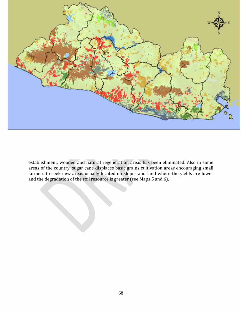
R-PP Template Version 6, for Country Use and Public Comment (November 23, 2011) (To replace R-PP draft v. 5, Dec. 22, 2010)
68
establishment, wooded and natural regeneration areas has been eliminated. Also in some areas of the country, sugar cane displaces basic grains cultivation areas encouraging small farmers to seek new areas usually located on slopes and land where the yields are lower and the degradation of the soil resource is greater (see Maps 5 and 6).

R-PP Template Version 6, for Country Use and Public Comment (November 23, 2011) (To replace R-PP draft v. 5, Dec. 22, 2010)
69
Map 5. Expansion of sugar cane cultivation (in red), and pressure on natural ecosystems and coffee plantations in the country.
Map 6. Expansion of the sugar cane cultivation (in red) and pressure on forest cover areas.
Case of Salty Forests: multi-causal process. In spite of the crucial need to preserve the integrity of the mangroves, due to its multiple functions: such as being natural barrier against tidal waves and tsunamis, nutrition and reproduction of aquatic life zone and important carbon sink,10 in El Salvador it has degraded by: a) increased disordered and unplanned saltworks and shrimp hatcheries in the mangroves; (b) contamination by agrochemicals runoff from surrounding farms, domestic and industrial discharges, solid waste; (c) the erosion due to unsustainable agricultural and livestock practices in the
10
Donato et al., (2011) Mangroves among the most carbon-rich forests in the tropics, Nature Geo-Science, DOI: 10.1038/NGEO1123

R-PP Template Version 6, for Country Use and Public Comment (November 23, 2011) (To replace R-PP draft v. 5, Dec. 22, 2010)
70
higher and middle watersheds parts, causing the siltation of estuaries and bays; (d) indiscriminate logging and conversion of salty forest to farmland; (f) expansion of human settlements; (and g) urban and tourist projects.
The lack of planning for the coastal marine area development and the overexploitation of resources has led to the reduction and deterioration of large tracts of mangrove forests and other ecosystems. The change of land use for agricultural and livestock activities, the division of land into lots and the construction of infrastructure are the main threats to the ecosystems of the area.
The advance of the agricultural frontier for sugar cane and basic grains plantations has caused a serious alteration in the landscape, with the consequent increase of vulnerability and loss of key ecosystems services for productive activities. El Salvador went from about 100,000 mangrove hectares in the 50s to about 40,000 ha. today: 38,534 ha. barely intervened and about 2,000 affected by sediment or deforestation. According to the Map of Natural Ecosystems (MARN 2010), almost half of the mangrove barely intervened is located in Bahia de Jiquilisco (18,998 hectares or 49%); 23% (8,979 ha) are in Golfo of Fonseca; 19% (7,162 ha) in the Estero de Jaltepeque; and the remaining 9% between Barra de Santiago (2.497 ha); the Los Cóbanos complex (495 ha) and in the departments of La Libertad, La Paz (393 ha).
In addition, the salty forests include 2,052 hectares which have been intervened for aquaculture and salt production: 61% (1249 ha) in Bahia de Jiquilisco; 30% (611 ha) in Bahia de la Union; and the remaining 9% in Estero del Jaltepeque (125 ha) and Los Cóbanos (66 ha). Shrimp hatcheries are to be found primarily in Bahia de Jiquilisco, while salt production takes place mainly in Bahia de la Union.
The construction of small ponds has a strong impact on the mangroves since they interrupt natural water flows, due to the construction of trails (openings) or by channels due to accumulation of sediments (see Figure 8). In Bahia de Jiquilisco 944 hectares are affected by siltation, deforestation, and flooding. The advance of the agricultural frontier for sugar cane and basic grains plantations, the indiscriminate use of agrochemicals, solid waste and waste water are also factors of degradation of the mangrove swamp. Tourism infrastructure projects, such as marinas, also are a growing threat.
Figure 8. Photos showing trails and deforestation of mangroves

R-PP Template Version 6, for Country Use and Public Comment (November 23, 2011) (To replace R-PP draft v. 5, Dec. 22, 2010)
71
Indirect causes of deforestation and degradation
In general terms, some of the major underlying causes of deforestation and degradation have been identified and are:
1- Migration and remittances that distort prices of land.
2- Poverty and lack of economic opportunities in areas near forests.
3- Confusing and inaccessible mapping information (land ownership) on forest
limits.
It is important to mention that fiscal policies, incentives and development promoted as government projects outside the forest sector have profound impacts on forest resources that often affect them indirectly.
Other factors that require further studies are related to the social and economic pressure by high population density which exceeds 300 inhabitants per square kilometer. Wood is an important source of energy for the country, so it is important to understand the dynamics on the use and management of forest resources, which could result in significant impacts on some points. A 2005 study indicated that 30% of urban households used firewood as fuel for cooking, and 63% of rural households, used it as its main fuel. It was estimated that 76% of fuelwood consumed came from direct collection and the remaining 24% of residential or industrial consumption was supplied by a marketing system. To better understand this problem it is necessary to update and conduct further research on the current demand for firewood for domestic consumption in rural and urban areas by region and offer strategies to keep this resource available.
Studies required to strengthen this theme
It is necessary to recognize that much of the existing information is scattered, in different scales and with different methodologies, ambiguous and sometimes non-existent due to lack of orientation and quality. An analysis of the existing information, identifying data and relevant information, as well as the gaps and further information needs is required. Because of the nature of the REDD+ proposal, Mitigation based on Adaptation, the scope of the required studies is broad. While the main conduction of the analysis of existing information and additional studies lies with MARN and MAG, this work should be carried out in a participatory way involving relevant stakeholders such as Academia and forestry research institutes, NGOs, associations and agricultural and forest associations, local communities and indigenous communities. The main studies that should be carried out in the first year of the Readiness preparation phase are as follows:
1- Study on the pattern and axes of current economic accumulation and its relationship with the change in land use for the country, including the effect of remittances.
2- Study on agrocultural-livestock production systems to scale and their impact on tenure and land markets and land use change.
3- Study on the trend and types/approaches of urbanization and its impact on the

R-PP Template Version 6, for Country Use and Public Comment (November 23, 2011) (To replace R-PP draft v. 5, Dec. 22, 2010)
72
land market and land use change. 4- Evaluation of deforestation or degradation and its underlying causes at the
national level. 5- Development of an index and cause of economic pressure (risk) of
deforestacion/degradation in strategic areas of El Salvador and of forest and soils degradation considering the REDD+ guidelines.
6- Critical lessons on past incentives system for reforestation, and agroforestry in the country, and elaboration of a proposal for new approach to incentives
7- Identification of policies and activities to solve the causes of deforestation and degradation.
8- Identification and evaluation of strategic areas as carbon pools supported by local communities.
9- Assessment of needs for strengthening capacities and governance structures at municipal and local government level.
10- Study on rights on captured and stored carbon and its management.
2a.3. Institutional efforts and projects for reforestation and conservation of forest ecosystems
For over five decades, numerous projects were carried out in the country to promote reforestation, communal and individual tree farming and agroforestry systems implementing projects for wood products and firewood provision. These works allowed the development of research on woody-energetic species, agroforestry systems, establishing of ditches and crops in alleys, identification of fast-growing timber species, and the evaluation and promotion of forest plantations. Some of the initiatives developed by the State to address the forestry sector were as follows:
1- Reforestation and creation of a forestry development pole. MAG/ International
Cooperation. PERIOD: 1970. AMOUNT: US$ 5,6 million. IMPLEMENTATION AREAS: Northern part of Metapán, Santa Ana Municipality; National Park of Montecristo San Andrés, La Libertad. DESCRIPTION: Establishment of 500 ha of pine and cypress. It had a Centre for processing and equipment for hauling wood. Drying patios. GOALS: Reforest risk areas, generate employment, establish a pole of development, and mitigate effects of floods. SCOPE: Establishment of the First Centre for Forestry Development (CEDEFOR) in San Andrés, La Libertad; it had technology to train and promote the use of timber to forest users, acquisition of equipment for drying, preserve and cure wood and seedling production establishments. DIFFICULTIES: Lack of availability of species required according to the planting conditions of the site there was no adequate know-how of the demand for the design of the nurseries.
2- ORE-MAG project. PERIOD: 1980. AMOUNT: US$ 5.6 million IMPLEMENTATION AREAS: Land of Cooperative Associations of the reformed sector (agrarian reform). DESCRIPTION: Planting of 10,000 ha of forest plantations, giving priority to the introduction of teak (Tectona grandis). OBJECTIVES: Plantations run by the State, incorporating cooperatives from the reformed sector. SCOPE: The planting of 3,000

R-PP Template Version 6, for Country Use and Public Comment (November 23, 2011) (To replace R-PP draft v. 5, Dec. 22, 2010)
73
ha of forest plantations was achieved. DIFFICULTIES: It lacked technical follow-up. SUBSEQUENT ACTIONS: Fires caused by the beneficiaries in order to maintain employment in the planting. Cooperatives are not being taken advantage of, distorting the main issue at cooperative level. There was lack of technical monitoring completely isolating the articulation of the forestry production chain. To date, these forest initiatives are changing the use of land turning them into agricultural plots and housing.
3- The cultivation of multipurpose trees, MADELEÑA project. Sponsored by AID,
executed by CATIE. PERIOD: 1989. AMOUNT: US$ 14 million. IMPLEMENTATION AREAS: Land of independent farmers throughout the country. DESCRIPTION: Provide technical assistance and bag and seed donation to beneficiaries. Implementation of agroforestry systems options as an option for the rural area, on the basis of socio-economic studies. OBJECTIVES: To increase social participation. Reintegration of community social forestry. To strengthen environmental education and solidarity among beneficiaries. SCOPE: It managed to establish 321 communal nurseries, producing 2,2 million plants and 800 nurseries with a production of 8 million plants. Participation of 5,670 beneficiaries. Establishment of agroforestry social community approach. Agroforestry systems in rural areas using corn and beans, in designs of crops in alleys, outline trees, wind-break screens, energy copses and protein banks for livestock. Development of recovery of ecosystems and buffer management groups. SUBSEQUENT ACTIONS: Lack of State monitoring. There were no donations of plants that could meet the needs of the beneficiaries (in terms of species).
4- Environment Credit Fund Project, (FOCAM). PERIOD: 1996. AMOUNT: US$ 10,7 million line of credit. DESCRIPTION: Promotion of forestry investment through a program of loans whose interest rates would be 6% for funding land reform (by that time interest rates were 24%). OBJECTIVES: To give a futuristic picture to investors, through the forest theme with the participation of the WB and private banking. SCOPE: Granting of subsidiary rates during the period of grace of the credits and subsequent market rates. Creating spaces for dialogue and consultation on the forest issue. More than 6,500 hectares of plantations and productive forests. SUBSEQUENT ACTIONS: Biased process out of the reach of investors based on lack of knowledge of the behavior of forest, species needing 10 years to reach their profitability point. There were imbalances in rates of assets and liabilities due to the dollarization of the country. Technical assistance was not integrated into the Projects and Loans for the establishment and management of forest plantations.
5- El Salvador Forest Bonus Project, support for investment. Special Fund of the
resources from the privatization of ANTEL (FANTEL/Framework Agreement for the provision of services MAG.) PERIOD: 2005. AMOUNT: US$ 4,8 million implementing only US$ 886,286.99. DESCRIPTION: Funds for forest management and establishment of forest plantations. Granting up to a maximum of US$ 375.00/ha planted and only one-time, equivalent to 25% of total investment per

R-PP Template Version 6, for Country Use and Public Comment (November 23, 2011) (To replace R-PP draft v. 5, Dec. 22, 2010)
74
hectare of forest plantation, distributed over 4 years; amount that decreased according to the age, density and type of species. SCOPE: In 2004, coffee agroforestry systems are incorporated, benefiting 200 has approximately and managed to attend 1,700 ha of forest. SUBSEQUENT ACTIONS: Project was unattractive. Lack of productive forestry chain elements.
Some lessons learned from the efforts made in the forestry sector in El Salvador.
There is ignorance as to the economic valuation of forest ecosystems, figures from other countries are used, such as the value of the mangroves per square kilometer, but it is not disclosed in the national information, moreover, there is nobody doing research or giving priority to the issue.
Lack of involvement of the population in the process of identification of forestry projects, in order to develop those projects that conform to the needs and conditions of the population.
Some forestry projects were developed for the sole purpose of generating jobs, which had the effect of not taking into consideration their sustainability.
Forestry projects were considered short term projects; without considering that plantations become profitable after 10 years of having been established.
The approach and type of incentives were very restricted (in general such as individual payment for works) without considering the environment and rationality of the producer, therefore, options with more potential to stimulate a continuous practice were not created.
Projects with a vision that includes a connection of the producer with the market were not designed.
Policies, Strategies and Planning Activities for the Conservation and Use of Forests
El Salvador does not have an explicit forest policy that recognizes the strategic value of the sector and orient its development in the long term. Thus, forest management has been isolated from the national development processes, without integrating and generating synergies with other closely related sectors. This has resulted in that the model of forestry development adopted by the country in recent decades, has been of a kind of extracting nature, directed almost exclusively at timber production. The Forestry Authority has been limited to exercising the functions of regulating the activities of logging, and has not been able to answer to the promotion needs required by the sector.
Under the existing regulatory framework, forest administration has been the responsibility of the Ministry of Agriculture and Livestock, and the Ministry of Environment and Natural Resources, giving certain powers to municipalities. In addition, the Attorney-General has the competence of applying the Penal Code, which contains articles specifically on the protection of ecosystems and protected species. In this way, decision-making has been centralized, with little coordination and inter-institutional and cross-sectional coordination. The creation of spaces for dialogue and sectoral coordination have been

R-PP Template Version 6, for Country Use and Public Comment (November 23, 2011) (To replace R-PP draft v. 5, Dec. 22, 2010)
75
absent, which has impeded local governments, community-based organizations and organized citizens from influencing the formulation and implementation of policies and programs, and public forest management at local and regional level.
There is no Incentive Program that encourages private investment in the protection and management of national forest resources and promotes reforestation and restoration activities. Mechanisms and instruments of promotion referred to in the current legal regulations, such as the "forest bonus" and "FOCAM" loans, which should be used to promote commercial reforestation, have been applied without obeying a national strategy and in an institutional environment unfavourable for a long term investment. Other promotion initiatives have been temporary and not designed according to the socio-economic needs of the beneficiaries. In the Salvadorian case, smallholdings, and collective ownership constitute special conditions to be taken into account when formulating public policies aimed at consrving and managing forest resources.
Currently, there is a widely consulted Forest Policy proposal pending approval and formalization. This policy, promoted by the Ministry of Agriculture and Livestock, through the General Directorate of Forestry, Watersheds and Irrigation Management, which seeks the recognition and compensation of positive externalities of forests and plantations (mitigation of natural disasters; protection of soils and waters; improvement of the infiltration of producing watersheds; capture and storage of carbon protection of biodiversity and livelihood provision, scenic beauty, etc.), and thus ensure that the sector is competitive guaranteeing legal security for long-term investments, that forestry activities are integrated into local and national development, and that there will be a greater involvement and participation of society in forest management. This policy proposalis counting on the participation of municipalities and local organizations in all those activities that relate to forest management, protection of watersheds, reduction of risks and forestry control, giving a guarantee of sustainability to activities and actions.
The 2012 National Environment Policy is designed to guide the work of central and municipal public administration in the implementation of plans and development programs, having two major objectives: reverse environmental degradation and reduce vulnerability to climate change. In this new policy, forest activities, including agro-forestry, acquire high relevance, since among other things, this policy promotes the conservation of the forest masses and drives the activities of restoration of ecosystems and rural landscapes through the massive expansion of eco-efficient forestry and agroforestry systems, as a way of reducing risks and building resilience and resistance to the adverse effects of climate change, which also leads to positive effects in the conservation of biodiversity, food security and poverty reduction. In the management of water resources the policy relies on the recovery of natural infrastructure which together with the development of specific physical infrastructure, improves water regulation, moderates flood and drainage, reduces sediment flows, improves irrigation and water harvesting.

R-PP Template Version 6, for Country Use and Public Comment (November 23, 2011) (To replace R-PP draft v. 5, Dec. 22, 2010)
76
Both policies create an optimal national stage for the implementation of the National REDD+ Strategy, which at the same time is presented as an instrument for the effective enforcement of these policies, since it is fully articulated in their strategic guidelines. El Salvador Forestry Strategy The El Salvador Forestry Strategy, EFSA, published in 2006, is an instrument geared to the challenges of the current context of competitiveness, in which the country is immersed, and which in turn will enable the development of the forest sector to be boosted in a constitutional, articulated, and efficient context, with suitable financial and legal mechanisms on the basis of the planning and sustainable management of goods and services from the sector. The EFSA had the following strategic components: planning, management and forest protection; expansion of the forestry base; valuation of wood and non-wood forest products; institutional and research strengthening, education and training. The first three components, present the conceptual and technical approach of what should be and where the forestry sector should go, the other two components constitute the base or main basis of any strategy, as they contain the proposals of policy and lines of action concerted and to be implemented.
Current regulatory framework and policy related to the protection and control of deforestation and forest degradation
The protection, study and exploitation activities of forest resources are regulated by various laws in El Salvador. The main framework is the 2002 Forestry Act, but it also has the Environment Act (1998), the Wildlife Conservation Act (amended in 2001), the Protected Natural Areas Act (2005) and the Criminal Code (amended in 2006). See details in Table 11.
The Forestry Act aims "To establish provisions favorable to the increase, management and sustainable use of forest resources and the development of the timber industry". The MAG is the competent authority for this law, but provides that the regulation on planting, pruning and felling of trees in urban areas will be the exclusive competence of the municipalities. In the case of the Wildlife Conservation Act, the competent authority is MARN and it is its function to regulate regular protection, restoration, conservation, and sustainable use of wildlife, leaving it to the MAG, an institution that also serves as a CITES Management Authority, the responsibility with regard to marketing. Under the Wildlife Conservation Act, the MARN is always responsible for developing and keeping the official listings of threatened and endangered species up to date, ensuring their protection and restoration, as well as to develop guidelines and exploitation quotas. The Protected Areas Act under jurisdiction of the MARN, establishes the legal regime for the administration, management and increase of the Protected Natural Areas and all the salty forests regulations. The Environment Act, also under the jurisdiction of the MARN, in its article 77 provides for the management and sustainable use of forests, the MARN in coordination with the MAG and in consultation with relevant institutions and the organized sectors, shall draw up and apply a set of market mechanisms, to facilitate and promote reforestation, taking into account the economic valuation of the forest incorporating, among others, values of non-timber use, environmental services as protector of water resources, soil,

R-PP Template Version 6, for Country Use and Public Comment (November 23, 2011) (To replace R-PP draft v. 5, Dec. 22, 2010)
77
biodiversity, energy, the fixation of carbon from the atmosphere, the production of oxygen and its effects as a climate regulator. The same article also provides that the MARN shall develop, in coordination with the institutions involved, a proposal on those forest areas, which by their value for the conservation of soil, biodiversity and water need to be acquired by the State or included in programs with funding for their conservation. The Criminal Code, whose application lies with the Attorney General of the Republic, includes provisions and typifies crimes, associated with behaviors that violate legal protected natural and environmental goods, in particular violations against "protected" forests and flora and protected fauna.
The broad legal framework and the dispersion of roles and responsibilities require serious national efforts for consultation and coordination, in order to avoid problems in enforcing the rules. The lack of harmonization of institutional policies, a divergence of approaches, as well as a lack of coordination of interventions has resulted in duplication of institutional efforts, increasing bureaucracy and inadequate enforcement of legislation.
Moreover, the responsible government authorities have low institutional capacities, are understaffed and have insufficient budgets to comply with their legal institutional objectives and responsibilities associated with the management of forests, making it difficult to carry out a concerted, effective and efficient management of the lines of action identified in the policy and its instruments. It has been estimated that the authorities have the capacity to regulate only between 35 and 40 percent of the forest cover, through various mechanisms and instruments.
Through several regulations the government has tried to regulate the practice of burning in agriculture, which often triggers forest fires, even under the Criminal Code, burning in agriculture is a criminal offence typified in article 262-A, which reads as follows: "He who which intentionally burns stubble or crops of any nature will be punished by a fine of between ten to two hundred days fine;" " each day equivalent to the minimum daily wage, according to the economic capacity of the offender", however, in the same article, it excludes farmers who carry out strictly cultural agricultural duties from any penalty, preventing the eradication of this bad agricultural practice.
Other factors add to this, such as those related to the markets. Agroforestry coffee cultivation systems face problems of fluctuation in international prices, it loses its opportunity cost in the face of the pressure of urbanization in areas along the volcanic ridge. The sustained upward trend in the price of sugar, under protected domestic market conditions, can operate as a driver of change in land use, leading to a change in use of basic grain or forests areas to sugar cane plantations.
Table 11. Regulatory framework on conservation and sustainable use of forest resources.
Name of the Document Objective Competent Authority Date of Issuance
Forest Act Establish provisions which allow the increased, management and sustainable use of forest resources and the development of the timber industry
MAG
Some attributions are given to the Municipalities
Issued by Legislative Decree No. 852 of May 22, 2002, published in Official Journal Number 110, Volume 355 on June 17, 2002
Environment Act Regulate environmental management. MARN Issued by Legislative

R-PP Template Version 6, for Country Use and Public Comment (November 23, 2011) (To replace R-PP draft v. 5, Dec. 22, 2010)
78
Promote the protection, conservation and recovery of the environment and the sustainable use of natural resources. Ensure the implementation of international legislation ratified by El Salvador
Decree No. 233 of March 2, 1998, published in Official Journal Number 79, Volume 339 on May 4, 1998.
Wildlife Conservation Act
The protection, restoration, management, exploitation and conservation of wildlife. This includes the regulation of activities such as hunting, collection and marketing, as well as other forms of use and exploitation of this resource.
MARN
MAG with the attribution of regulating commerce
Amended by Legislative Decree No. 441 and published in the Official Journal Number 133, volume 352, dated July 16, 2001
Protected Natural Areas Act
Regulate the establishment of the legal system, administration, management and increase in the Protected Natural Areas.
MARN Issued by Decree legislative No. 579 dated January 13, 2005, published in Official Journal Number 32, Volume 366 on February 15, 2005
Criminal Code Primary purpose is to orient criminal laws within a concept of guarantees, of high effectiveness to prevent the social and criminal violence facing our country.
Office of the Prosecutor General of the Republic
Reforms: (31) D.L. No. 957, February 08, 2006, published in the O.J. No. 28, Volume 370, February 09, 2006.
Special rules to regulate international trade in endangered species of wildlife, according to the Convention on International Trade in endangered species of wild fauna and flora
Develop legal provisions to regulate international trade in endangered wild species of fauna and flora according to the CITES Convention
MAG Administrative Authority
MARN Scientific Authority
Executive Decree 35 dated April 15, 2009
Official Journal 383 dated May 18, 2009.
Protected Natural Areas System
In El Salvador, the conservation efforts through protected natural areas (ANP) began in the mid 70s through the identification and preliminary prioritization of the most representative natural land areas. During the agrarian reform process, developed in the 80s, the Salvadorian State identified, prioritized, and reserved a hundred properties of different sizes and nature, to integrate them into a national system of Protected Areas. The 1998 Environment Act, through articles 78, 79, 80 and 81, establishes the Protected Natural Areas System and provides that the Ministry of Environment and Natural Resources, is responsible for formulating policies, plans and strategies for the conservation and sustainable management of Protected Natural Areas. In 2005, the Protected Natural Areas Act was issued and its regular objective is the establishment, administration, management and increase of the Protected Natural Areas to conserve biological diversity, ensure the functioning of essential ecological processes and the sustainability of natural systems. That same year the MARN developed a broad cross-sectoral consultation process and launched the National Strategy for the Management of Protected Natural Areas and Biological Corridor, which established the strategic lines, priority activities and national goals, among other, those related to management and planning and management of the ANP in the Conservation Areas, with the aim of promoting local stakeholders to manage the territory

R-PP Template Version 6, for Country Use and Public Comment (November 23, 2011) (To replace R-PP draft v. 5, Dec. 22, 2010)
79
as functional landscapes, planning the use of the soil and properly managing natural ecosystems remnants, ecological corridors, and other structural and geographical elements.
Consolidation of the National System of Protected Areas (SANP) is a central element of the current Strategic Plan of the Ministry of Environment and Natural Resources, by recognizing the importance played by this system in the conservation of the natural assets of El Salvador and the consequent provision of ecosystem services for the sustainable development of the country. The strategy used to consolidate the national system provides for the incorporation into the system, of those properties that were identified as potential Protected Natural Areas registered in favor of the Salvadorian Institute for Agrarian Transformation (ISTA), the incorporation of Areas of other State institutions, municipal and private, and the Declarations of Biosphere Reserves made by the United Nations Education, Science and Cultural Organization (UNESCO), and RAMSAR sites through the Convention of Wetlands of International Importance RAMSAR. In the past three years the country has worked on strengthening the system, achieving a significant increase in the country’s protected surface, obtaining the Declaration of New Protected Natural Areas, new RAMSAR sites and the Tri-national Biosphere Reserve El Trifinio, increasing it to 25% of the national territory. El Salvador has the international designation of a total of six RAMSAR sites covering an area of 192,960 hectares (see map 7). In order to ensure an appropriate management of these wetlands of international importance, the MARN is implementing the Comprehensive Plan for the Improvement of Wetlands that will benefit 479,800 inhabitants. The Plan includes the management of the areas of influence and associated watersheds that will allow activities eligible in the National REDD+ Strategy. Similarly, the work of consolidation of the SANP includes the formulation and implementation of a National Plan for Prevention and Attention to Forest Fires, which will enable that driver of deforestation and degradation of forest ecosystems to be better dealt with.
MARN has promoted a strategy of civil society participation in the management of Protected Natural Areas (ANP), establishing agreements with NGOs and other institutions for the co-management of the same. These co-management institutions have played an important role in the management and conservation in the Areas, which has represented a significant contribution in the process of consolidation of the Protected Natural Areas System.

R-PP Template Version 6, for Country Use and Public Comment (November 23, 2011) (To replace R-PP draft v. 5, Dec. 22, 2010)
80
Map 7. El Salvador map that identifies the Protected Natural Areas System, with Protected Areas, RAMSAR sites, and Biosphere Reserves.
2.a.4. Other aspects and dynamics to be considered in the REDD+ Strategy mitigation based on adaptation Current use of the soil in El Salvador
According to the last Map of Use of Soil of El Salvador drafted by the MARN in 2002, 20,051 Km2 of land area were being used as follows: 67.23% for agricultural activities, 19.42% for forests and woody cover, and 13.35% between bodies of water and wetlands and urban extension.

R-PP Template Version 6, for Country Use and Public Comment (November 23, 2011) (To replace R-PP draft v. 5, Dec. 22, 2010)
81
Map 8. Classes of land use according to IPCC (MARN, CORINE Land Cover 2002)
Specifically, agricultural activities were distributed as follows: 17.49% for cultivation of basic grains, 12.40% for pastures, 10.49% for coffee, 4.26% for sugar cane, 0.20% for fruit trees, 0.21% oil palms, 3.88% for an association of annual and permanent crops, 8.38% for a mosaic of crops and pastures, 9.41% for a mosaic of pastures and natural vegetation, and 0.51% for other crops. Table 12 shows the distribution and specific values per hectare for each of the types of agricultural activities.
Table 12. Uses of soil for El Salvador 2002 (CORINE Land Cover 2002)
SOIL USES Hectares % National Area
Agriculture
Basic Grains 368,447.1 17.49
Pasture 261,203.2 12.40
Coffee 220,927.8 10.49
Sugar Cane 89,740.8 4.26
Fruit Trees 4,256.1 0.20
Oil Palms 4,342.1 0.21
Annual and Permanent Crops Association 81,715.2 3.88
Mosaic Crops and Pastures 176,536.4 8.38
Mosaic Crops and Pastures and Natural 198,223.1 9.41

R-PP Template Version 6, for Country Use and Public Comment (November 23, 2011) (To replace R-PP draft v. 5, Dec. 22, 2010)
82
Vegetation
Other 10,689.7 0.51
TOTAL AGRICULTURE 1,416,081.5 67.23
Forest and Wood Cover 409,066.70 19.42
Other Uses (urban areas, wetlands, water bodies) 278,851.8 13.35
GENERAL TOTAL 21,041 Km2 100
Conflict in the use of land, its degradation and associated vulnerability. The inappropriate use of land in accordance with its optimal natural use generates conditions of low utilization and soil deterioration, which leads to a land use conflict. According to data of the MARN, 91% of the lands of the country are used inappropriately, i.e. are used regardless of the optimal use of the soil, being that 45% shows a high conflict with the use and 45% displayed a low conflict. Only 9% of the land is used according to the optimal use of the soil (Map 9). In El Salvador, the processes of soil degradation are severe, it is estimated that 59 million metric tons of soil are lost annually by erosion in 75% of the country’s territory (Perdomo 1990). Among the causes of this degradation are natural processes such as erosion of the young reliefs, scarcely consolidated materials and the occurrence of heavy rains with great erosive power, accelerated by the loss of coverage and the inadequate agricultural practices employed by subsistence farming that takes place in a high percentage of the slopes around the country (PNODT 2003). The Environmental Program of El Salvador (PAES 2002) estimated that more than 70% of the land cultivated with basic grains, are on slopes.

R-PP Template Version 6, for Country Use and Public Comment (November 23, 2011) (To replace R-PP draft v. 5, Dec. 22, 2010)
83
Map 9. Map showing soil use conflict in El Salvador.
During the formulation of the National Management and Territorial Development Plan (PNODT 2003) it was estimated that 40% of Salvadorian soil presents severe erodibility, 10% high erodibility and 10% high erosion. Soils that show severe erodibility extend over mountainous areas, including the mountain border in the North of the country and the main mountains of the coast range which includes the Tacuba, El Balsamo and Jucuarán, as well as the recent volcanic chain of Apaneca-ILamatepec, San Salvador, San Vicente, Usulután, San Miguel and Conchagua (see Map 10). By 2012, with the increase in climate variability (see below) the areas and levels of erosion have increased significantly, due to a growing change in land use due to the extent of urbanization in high areas (forests and shade coffee) and the advance of sugar cane cultivation on natural regenerated areas of forest and pasture. 11
The social impact that is generated by the accelerated deterioration of the soils is related to the use and possession of the land, directly affecting the majority of small farmers who usually grow basic grains on land of steep slopes, obtaining low yields in its production. This fact does not allow them to generate sufficient revenue to invest in soil conservation works, so it generates a vicious circle that increase the level of poverty of the rural population even more, and worsens soil degradation.
11
Currently the MARN is carrying out studies to evaluate sugar cane cultivation as a Driver of change in land use,
and carrying out an analysis of the expansion of lots and urban development.

R-PP Template Version 6, for Country Use and Public Comment (November 23, 2011) (To replace R-PP draft v. 5, Dec. 22, 2010)
84
Map 10. Map showing the problems of erodibility in El Salvador.
Impact of climate variability
In addition to anthropogenic threats, the country is being heavily impacted by the effects of climate variability. Its geographical location, in the Tropical belt, within the area of Intertropical Convergence (ITCZ), the influence of the currents in the Pacific Ocean to the South, and the small size of its territory, previously allowed the country not to show large fluctuations in the majority of climate parameters throughout the year, and to have a relatively small annual temperature variation, with the occurrence of higher values towards the month of April and a decrease in the months of December and January. However, this pattern has been changing in recent decades due to increased climate variability, resulting in the country experiencing a temporal and spatial regime of anomalous rainfall, with strong implications for welfare, for the national economy and productive activities. Thus, in recent years El Salvador has faced an increase in natural disasters linked to hydro-meteorological phenomena, going from one or two phenomena per decade to the 8 that we have experienced in the past and present decade (Figure 9).
2005 and 2010 (January to September) have been the rainiest in a 40 year period (Figure 10). This trend can change in future decades, since all climate change scenarios indicate that in the coming years, we will experience more intense and more frequent extreme events.

R-PP Template Version 6, for Country Use and Public Comment (November 23, 2011) (To replace R-PP draft v. 5, Dec. 22, 2010)
85
Climate variability and extreme events have already established a clear pattern in El Salvador, which increases the vulnerability of urban and rural populations, and key ecosystems that underlie not only its food production capacity, but also aggravates the degradation of large tracts of farmland by the erosion and depletion of nutrients from soils due to extended poor management practices. In a single recent event, Tropical Depression 12E in October 2011 the country experienced high rainfall concentrated values concentrated in the shortest period ever, causing severe damage and loss.
Figure. 9 Average rainfall per decade, based on the registration of 25 primary and ordinary weather stations in the period between 1971-2000 at national level. December, 2011

R-PP Template Version 6, for Country Use and Public Comment (November 23, 2011) (To replace R-PP draft v. 5, Dec. 22, 2010)
86
1650
1700
1750
1800
1850
1900
1950
1971-1980 1981-1990 1991-2000 2001-2010
Llu
via
(m
m)
Decenios
Lluvia interdecenal, período 1971-2010, El Salvador
Lluvia: aumento de 48mm/10 años
Figure 10. Inter-decadal rain during the 1971-2010 period
Damages and losses are magnified with continuing torrential rains, not only causing surface erosion of soils, but also an over-saturation of entire geomorphological structures which usually crack slowly, but when saturated they slide and fall increasing the load and force of rivers sediments. This makes the road infrastructure and settlements (watershed downstream) ever more vulnerable to extreme events, since the design and location of the social infrastructure has not considered the impacts of climatic variability. Ongoing studies reflect a disorderly urban development, increasing the problem (see table 13). At the same time, predominant agricultural practices deepen environmental degradation and make agriculture play a double role, causing extensive degradation which at the same time makes it increasingly vulnerable to the climate.
This dynamic of degradation is now exacerbated with the registered impacts of climate variability, manifested with an increase in frequency, intensity, and duration of rainfall (or drought) due to changes in the Pacific and Atlantic Ocean systems.12 With the highest population density in the hemisphere after Haiti, throughout the 20 thousand square kilometers of a highly deforested area, and with agricultural systems mainly seasonal, the scope of the impact of extreme weather events increases, putting at risk nearly 90% of the population, 95% of the national territory and 90% of GDP (Germanwatch 2010). See Table 14. Today, it is impractical for El Salvador to sustain growth and economic development without the adoption of a vision and practice of adapting to these impacts as their first priority in the face of climate change.
12
The Rio Lempa watershed is particularly vulnerable to the intensified hydrologic cycle and has been identified by international scientists as a ‘hot spot’ of climate change impact. Climate model based consensus on the hydrological impacts of climate change to the Río Lempa Watershed of Central America. E.P.Mauer, J.C., Adam, A.W, Wood, In Hydrology and Earth System Sciences, 13 pp. 183-19, 2009

R-PP Template Version 6, for Country Use and Public Comment (November 23, 2011) (To replace R-PP draft v. 5, Dec. 22, 2010)
87
Table 13. Loss and damages suffered by the country in three extreme events
Losses/Damages E96/Ida
Nov 2009
Agatha
May 2010
TD 12E
Oct 2011
Economic $315 million $112 million $840 million
Agriculture $28 million $11 million $105 million
Bridges 24 collapsed
55 damaged 25 damaged
8 collapsed
26 damaged
Roads 132 damaged 61 damaged 40% damaged
Schools 111 damaged 378 damaged 947 damaged
Deaths 198 12 34
Table 14. Risks and their percentage in the El Salvador.
TYPE OF RISK PERCENTAGE AT NATIONAL LEVEL (%)
National Territory under risk 88.7
Territory with high susceptibility to landslide 38.0
Territory with susceptibility to flooding 10.0
Population living in areas at risk 95.4
GDP generated in risk areas 96.5
Source: MARN 2011; Germanwatch 2010.

R-PP Template Version 6, for Country Use and Public Comment (November 23, 2011) (To replace R-PP draft v. 5, Dec. 22, 2010)
88
Budget 2a: Summary of Assessment of Land Use, Land Use Change Drivers, Forest Law, Policy and Governance Activities and Budget
Main Activity Sub-Activity Estimated Cost (in thousands)
2012 2013 2014 2015 Total
Action plan for analysis of agents and causes of deforestation
Evaluation of the direct and indirect causes of deforestation or degradation at a national level.
$ 0 $ 40 $ 0 $ 0 $ 40
Study on land use change economic model of El Salvador.
$ 0 $ 15 $ 0 $ 0 $ 15
Research and analysis on consumption of firewood in rural and urban areas in El Salvador.
$ 0 $ 20 $ 0 $ 0 $ 20
Development of a risk index for deforestation and forest degradation, considering REDD+ guidelines.
$ 0 $ 15 $ 15 $ 0 $ 30
Development and research of the index of economic pressure (risk) of deforestation in strategic areas of the country.
$ 25 $ 25 $ 25 $ 5 $ 80
Strategies for the reduction of emissions of all uses of soil in the country.
$ 0 $ 20 $ 20 $ 0 $ 40
Analysis of the implementation of national policies on natural resources and the existing institutional framework.
$ 0 $ 10 $ 20 $ 0 $ 30
Analysis of opportunity costs of land and implications with REDD+ $ 0 $ 0 $ 10 $ 20 $ 30
Evaluation and analysis of the regulatory framework for the definition of rights $ 0 $ 20 $ 0 $ 0 $ 20
Strengthening and proposal of the current laws on governance in wooded areas. $ 0 $ 0 $ 10 $ 0 $ 10
Evaluation of the dynamics of the main fronts of deforestation and degradation that exist in the country.
$ 0 $ 10 $ 10 $ 0 $ 20
Evaluation of strengthening capacities and structures of governance at municipal and local government level.
$ 5 $ 5 $ 5 $ 5 $ 20
Communications, newsletters, and publications. $ 4 $ 3 $ 3 $ 2 $ 12
GOES monitoring $25 $25 $25 $25 $100
Total $ 59 $ 208 $ 143 $ 57 $ 467
FCPF $ 0 $ 183 $ 118 $ 32 $ 333
GIZ $ 34 $ 0 $ 0 $ 0 $ 34
GOES $25 $25 $25 $25 $100

R-PP Template Version 6, for Country Use and Public Comment (November 23, 2011) (To replace R-PP draft v. 5, Dec. 22, 2010)
89
THE REDD+ NATIONAL STRATEGY in EL SALVADOR "Mitigation based on Adaptation" Background As mentioned previously, efforts for mitigation of global warming, the purpose of the REDD+ strategy for El Salvador falls within the approach, logic and adaptation actions as a priority and guiding framework. Within this framework, a subset of adaptation actions, synergic with the mitigation, which potentially qualify as recognized results in REDD+ and prioritized by the relevant stakeholders, could enter into a compensation scheme for reducing emissions.13 The orientation logic of this first stage of adaptation will focus on actions to reduce the vulnerability of the population, productive capacity and infrastructure development. In the first stage, it would focus on increasing forest and plant cover in space and time in territories with characteristics of generalizable vulnerability in the country. Reforestation efforts are proposed (structurally limited), natural and directed regeneration of forests, conservation of existing forests, including shade coffee plantations, re-establishment and expansion of gallery forests, the expansion of agro-systems, and the massive promotion of soil and water conservation within the agricultural and livestock production. Increasing all types of vegetation in large areas of the territory where it is necessary and feasible for the reduction of vulnerability, would simultaneously generate mitigation co-benefits and at the same time would increase biodiversity. The proposal of adaptation measures goes far beyond, looking to promote a transition in the approach and system of agricultural and livestock degrading practices towards a restoration of the agroecosystem in landscapes and watersheds (which include other critical ecosystems), which yields local benefits (in plots/farms) such as soil retention and fertility, increasing the capacity of a more sustained production. At the same time, watershed downstream, with a reduction of contamination, sedimentation and consequential flooding (rivers, villages, roads, canals, drains, dams and ports). In other words, it seeks to reverse the degradation pattern resulting most of the practices and its impact on rural landscapes and watersheds, which significantly increases vulnerability in the face of climate changes, especially with regard to variability. This approach also seeks to reduce the dependence on the use of inputs based on petrochemical production (fertilizers, pesticides, herbicides, gasoline), as a necessary step of the transition. Increasing the biomass in the soil and vegetation (forest and agro-
13
There are criteria for the definition (forests) and measurement (CO2 capture) that govern the REDD+ scheme, which is a
dynamic process at the international level. As part of the process of creating ENAREDD, El Salvador would make definitions
appropriate to the condition of the country and would follow the indicator parameters established for REDD+ in a broad
consultation with experts. Where it is intended to expand the recognition parameters of REDD+ activities is in the „plus‟ (see
Component 3.3),
2b. REDD-plus Strategy Options

R-PP Template Version 6, for Country Use and Public Comment (November 23, 2011) (To replace R-PP draft v. 5, Dec. 22, 2010)
90
forestry) is a primary task, which at the same time will result in a high level of synergy with the objective of stopping extreme erosion, soil displacement, formation of gullies and landslides, which are ever more extensive, and to maintain water and soil moisture, increasing the capacity to withstand periods of drought. It is on the restoration of the country’s agro-systemic services (water regulation, fertility of soils, etc.), where mitigation actions will be focused. This is what we call the ‘triple benefit’ of sustainable agriculture practices. (See Table 15). The same practice that generates a reduction in CO2 emissions also increases soil biodiversity, reduces erosion and loss of soil. Table 15. Triple benefits from the same practices. Variation of GHG emissions in different agricultural practices (TCO2eq / ha)a
Dairy Production
System TCO2equ / ha
Maize Production System
TCO2equ /ha
Maize, Soybean and Wheat System Rotation
TCO2equ /ha
Dairies in conventional grazing in Costa Rica.
4.24
Maize with intensive use of fertilizers (N, P, K) in United States.
0.84
Rotation of maize, soybean and wheat with conventional tillage in United States.
1.14
Silvopastoral Dairies in Costa Rica.
2.32
Maize with BMPs (less N and not P K fertilizers) in United States
0.54
Maize, soybean and wheat rotation with low chemical input from leguminous coverage in United States.
0.63
Rotation of maize, soybeans and wheat, using organic methods with leguminous coverage in United States.
0.41
Rotation of maize, soybean and wheat with zero tillage in United States.
0.14
a Scaled data case studies of Esparza Farm by Leonardo Guerra, CATIE;Et Adiento-edge et al. 2007. Al Robertson, Paul Harwood, 2000, respectively. N nitrogen; P Phosphorus; K Potassium; BMP best management practices
One of the most important challenges for the country is the recovery of the productive capacity of basic grains as food for the vast majority of the population. The Family Agriculture Plan promoted by the Ministry of Agriculture with the support of international agencies14, seeks to restore the productive capacity and increase production in the short term. The main action has been the distribution of subsidized15 packages of certified seed, fertilizer, pesticides or chemical herbicides, as an almost emergency measure, to address the loss in the country's food security. While increased production results have been positive in the short term, even with heavy losses because of TD E12, the dilemma is how to
14
IICA, FAO, FIDA , PMA and others
15 PAF- Family Agriculture Program, Ministry of Agriculture- there are approximately 325,000 small producers, who are
designated as beneficiaries of the program with „packages‟ of certified sedes and chemical fertilizers.

R-PP Template Version 6, for Country Use and Public Comment (November 23, 2011) (To replace R-PP draft v. 5, Dec. 22, 2010)
91
maintain future production, both in terms of impacts on the soil and growing costs of these inputs and the dilemma of food security. An important part of the PREP-REDD+ approach aims to contribute to this national commitment of strengthening food security and rural livelihoods in a sustainable manner, introducing from here on, changes in the agricultural-livestock production approach, with the promotion of the expansion of agroforestry systems, soil and water conservation and promoting a transition to low carbon emissions agriculture (Table 16). Initial analysis shows the need to undertake this transition, on the one hand due to the increase in prices of inputs and the difficulty of sustained subsidies, and on the other, because of the high rates of potential return that recovering this productive capacity of basic grains would mean, even without income from REDD+ schemes. Table 16. Adaptation is priority, but generates co-benefits from mitigation
ACTIONS and Benefits from ADAPTATION
MITIGATION and Biodiversity
Soil conservation Erosion slows and reatins the water in soil
Rebuilds soil (soil biodiversity) and captures more CO2.
Agroforestry systems. Stabilize soils and land and retain H2O in watershed upstream, regulate rivers, stop floods (Gallery forest)
Increases CO2 capture (many other benefits: biodiversity, diverse production, improve the landscape).
Organic agriculture Reduces contamination in site and watershed downstream (rivers and mangroves and costs).
Emits less CO2 (abandonment of use of fertilizers, and other petroleum-based products). Encourages increased biodiversity
If the massive restoration of the country’s agroecosystems could be achieved, working on the planning and management of higher capacity management, landscape by landscape, watershed by watershed with the support of legal, regulatory, normative and financial incentives, the results would be enormous. In macro-economic terms, the retention of soils and water in situ would ensure greater productive capacity for self-consumption or the market, but it will also have the added benefit of significantly reducing the costs of dredging of ports and systems of irrigation and drainage on flat land and mangroves, and of damage to physical infrastructure in low watersheds, not to mention the social emergency costs. Taking into account that El Salvador has no large extensions of forests as the other countries of the region do, and that most of the rural area is in agricultural units (parcels and farms), with small remnants of natural ecosystems in many cases within these, there is a prevailing need to respond to the impacts of climate variability on agriculture and the impacts of this same agriculture on the agroecosystems that sustain it. The PREP-REDD+

R-PP Template Version 6, for Country Use and Public Comment (November 23, 2011) (To replace R-PP draft v. 5, Dec. 22, 2010)
92
strategy will be implemented on the basis of the need for adaptation to the effects of climate variability and this would be what guides the which, where and how actions that should be carried out. Thus, seeking that some of the mitigation co-benefits derived from these same actions might form a part of the REDD+ effort. And, given the conditions described in the previous components that show the degree of degradation of natural ecosystems, and especially the agroecosystems of the country, the restoration mainly translates into improving carbon ‘stocks’, or the ‘plus’ of REDD+. The National Program of Restoration of Ecosystems and Landscapes, and REDD+ Mitigation based on Adaptation The National Program of Restoration of Ecosystems and Landscapes occurs at a time of strong changes in the country and at the global level. El Salvador lives a situation of political change that demands recovering planning capacity in a context of global changes, where climate change represents a strong challenge due to the extraordinary situation of the social environmental vulnerability of the national territory. REDD+ strategic options within the framework and logic of actions of mitigation based on adaptation are presented below, where, given the conditions of the country’s forest ecosystems, they focus on avoiding further deforestation, and reversing the degradation of forests and especially on carbon stocks improvement activities. Axes of action
1. Expand agroforestry and promote transition to agriculture which is resilient to climate change, biodiverse and reduces of CO2 emissions.
2. Conservation of forest ecosystems, protected areas, existing mangroves and restoration of degraded forests, and other supporting ecosystems.
3. Restoration of gallery forests and revegetation of riverside landscapes 4. Promotion of green infrastructure for retention, collection and water management
and the recharging of aquifers. 5. Applied research, training and education. 6. Local and national institutional strengthening with capacity building
The PREP recognizes that the local impacts of vulnerability are very different, and the capacity to respond to them are also. The patterns of ownership of land, crops and livestock activities, systems of organization of production (cane vs. coffee, etc.) distribution and gradient of slopes and plains, degree of organization and capacity for local governance that determine the potential to be able to respond appropriately vary.16 In some territories there are answers underway, in others, conflicts predominate, but there are also cases where the population is simply abandoning the territories. These various scenarios demand that understanding of local processes be improved to build, together with the stakeholders,
16 View Robin Mearns, et al., (2010) Economics of Adaptation to Climate Change: Synthesis Report, World Bank. See the discussion on
vulnerability based on exposure, sensitivity and capacity response at local level how the State needs to recognize it to act properly

R-PP Template Version 6, for Country Use and Public Comment (November 23, 2011) (To replace R-PP draft v. 5, Dec. 22, 2010)
93
strategies that strengthen processes and assertively handle conflicts. These principles are equally important for all REDD+ strategies and actions options. STRATEGY OPTIONS FOR REDD+ As mentioned earlier, the preliminary analysis identifies as key drivers of deforestation and degradation of soils and forest ecosystems the following: the expansion of agricultural activities and the implementation of non-sustainable practices; urban growth and the construction of infrastructure; livestock production; the extraction of firewood and wood; mangroves and forest fires, and in the case of mangroves, illegal logging and extraction of firewood and timber for housing, agriculture and livestock activities, and the establishment of saltworks and small shrimp hatcheries. In addition, these direct pressures on the small forest ecosystems are intensified by the existence of a scenario of non-harmonized sectoral policies, unarticulated institutional approaches and some economic and commercial factors. (Eg.) The Family Food Program widens coverage of agricultural subsidies which drives deforestation in these areas, for sowing season.) The severe deterioration in agricultural soils leads to a drop in productivity and the production of basic grains and other foods; high levels of erosion and loss of fertile soil; high surface run-off, siltation of rivers, irrigation systems and dams and decrease in infiltration and aquifer recharge capacities, affecting the livelihoods of local communities. To reverse this situation the national REDD+ strategy for El Salvador must aim with high priority at the massive expansion of the eco-efficient agroforestry systems, low in CO2 emissions and agriculture resilient to climate, allowing also for the restoration of ecological connectivity across the rural landscape. All of this is favoring the increase and improvement of forest carbon reserves.
Within the framework of the adaptation to the impacts of climate variability and the National Program of Restoration of Ecosystems and Landscapes, the National REDD+ Strategy proposes a set of options to deal with drivers and prevent deforestation and forest degradation, including complex agroforestry systems, their conservation, but above all to increase and improve forest carbon stocks. It is understood that the options would have to be organized in such a way that impacts will occur in specific territories whose characteristics of vulnerability (erosion, sedimentation, contamination, flooding) require that they are continuous landscapes (watersheds, sub-watersheds, hydrographic regions). The strategy then displays a much broader scope than only the wooded areas, and includes complete ecological landscapes of production systems and mosaics and other adjacent land uses. Only in this way could the generation of expected co-benefits from mitigation based on adaptation be guaranteed: increase ability for carbon capture and storage, reduce emissions, conservation of biodiversity, recovering the capacity of water regulation and restoring soils and fertility, improving the livelihoods of local communities.

R-PP Template Version 6, for Country Use and Public Comment (November 23, 2011) (To replace R-PP draft v. 5, Dec. 22, 2010)
94
This approach opens two main spaces for REDD+ action, one in mainly rural landscapes which includes agriculture and livestock, forestry, aquaculture and fisheries and the other related to urban issues. The strategy considers both, recognizing their intimate relationship, but the REDD+ effort, as part of the priority of adaptation, is concentrated in a more articulated way for the first, the rural aspect. To be consistent with this emphasis, it reflects on the prioritization of social sectors and key stakeholders to be consulted at both stages of the consultation process (early dissemination and the SESA), the most relevant. To address the drivers of deforestation and forest degradation, and enhance forest carbon pools, ensure the permanence and sustainability of all interventions the strategy must also consider the following options: Strategy Options
1. Promote agro-forestry and productive activities resilient to the impacts of climate change, low CO2 emissions and contribute to the connectivity of forests and Protected Natural Areas;
2. Conservation of forest ecosystems and restoration of ecosystems recovering ecological connectivity and promote and encourage the organization, governance and management capacity of forestry and agroforestry resources at territorial level.
3. Design and implementation of an Incentives Program and compensation mechanisms to promote changes towards better use of soil, the adoption of good agricultural, livestock and forestry practices; the implementation of activities for the conservation and restoration of forest ecosystems;
4. Development of new legal instruments for the recognition of rights over natural resources and forest resources managed collectively. (Including community protection areas)
5. Activate the instruments of the legal instruments, in particular those referred to in the Environmental Act and Land Management Act, related to: the zoning and land management; the regulation of agricultural practices; the change of land use control; the control of illegal logging and forest fires. Special attention should receive the activation of the Etrategic Environmental Assessment of new policies, plans and programs, and the Environmental Assessment.
6. Harmonizing sectoral laws and policies, plans and programs in sectors linked to the use of land, land-use change and forestry and environmental management.
7. Develop a regulatory framework and institutions to recognize and govern activities that provide ecosystem services, including the capture and storage of carbon.
See the description of strategy options and their relationship with the reduction of deforestation, forest degradation and the improvement of carbon stocks in Table 17 below. An initial reflection is developed on the political, economic and institutional feasibility according to the degree of progress in the consultation process. It foresees that the continuation of stage I, the studies on the causes of degradation and the implementation of a SESA which includes the processes within the pilot territories, would contribute key

R-PP Template Version 6, for Country Use and Public Comment (November 23, 2011) (To replace R-PP draft v. 5, Dec. 22, 2010)
95
elements to adjusting the findings of the feasibility of implementation and potential synergies or conflicts with other actions. Also, depending on the degree of reception, commitment, support (institutional, political, and financial) the possibility of adjusting the strategy options themselves would be considered.

R-PP Template Version 6, for Country Use and Public Comment (November 23, 2011) (To replace R-PP draft v. 5, Dec. 22, 2010)
96
Table 17. Strategy options and their relationship with the reduction of deforestation, forest degradation, and the improvement of carbon stocks.
Strategic Options REDD+ Activities Relation (examples)
CO2 stocks improvement
- Agroforestry systems with trees and permanent vegetation increases the capture of CO2
- Some of the agroforestry systems can act as a biological corridor connecting ANPs or are riparian
2- Development of a Program of Incentives and Compensation for changes in land use and agriculture, livestock, forestry and agroforestry practices.
Conservation of forests
Prevent deforestation of forests
Reverse the degradation of the forest
Sustainable forest management
- Direct incentives for stakeholders (individual and collective) to increase their profits, compensation for eco-systemic services to maintain the forest.
- Regulate and provide technical assistance and certification to the sustainable management of the forest
Incentives for agriculture and livestock systems surrounding forests (no-burning, agro-silvopastoral systems, etc)
3- To promote and encourage the organization, governance and management capacity of forestry and agroforestry resources at territorial level.
Prevent deforestation of forests
CO2 stocks improvement
- Structuring incentives to increase local forest management organization and promote community Conservation Areas.
- Promote Community Development Organizations to assume a leading role in promoting AS at landscape and watershed level.
4- Research and design new legal, regulatory and normative instruments of recognition of rights over forest resources managed collectively
Prevent deforestation of forests
Revert forests degradation
- Recognize via the ANPs and Environment Act, new forms of collective forest management and wider areas of restoring natural areas
5- Activate the instruments of the Environment and Land Management Act, and the
Prevent deforestation of
- Environmental zoning of vulnerable areas avoiding land

R-PP Template Version 6, for Country Use and Public Comment (November 23, 2011) (To replace R-PP draft v. 5, Dec. 22, 2010)
97
There are some indications of the viability or social, economic, political and institutional difficulties of the options proposed above. However, it is extremely important that the implications for each sector or stakeholder is better known. To begin with, there is a need for quality studies on the different large scale productive sectors (sugar cane, coffee, and livestock) which will be very necessary to provide an objective analysis of the possibilities
Strategic Environmental Assessment of new policies, plans and programs, and the environmental impact assessment.
forests
CO2 stocks improvement
use change for other crops
- Design and implement the new institutional figures for Community Conservation Areas
- Change key harmful practices through agreements, SESAs and activity Tables on large scale agrocultural and livestock activities (sugar cane and livestock / no-burning)
6- Harmonize policies, plans and programs in sectors related to land-use, land-use change and forestry and environmental management
Revert forest degradation
C02 stocks improvement
- Coordinate the legal transfer of the ANPs with the SalvadorianInstitute for Agrarian Transformation
- Reorient forestry policy that encourages the expansion in agro systems with native species
- Coordinate with the MAG recognition of their policies and AS incentives
7- Develop a regulatory framework and institutions to recognize and govern activities that provide ecosystem services, including carbon capture and storage.
CO2 stocks improvement
Forest conservation (of all kinds, including Protected Natural Areas)
- Promote the adoption of the Water Act (it acknowledges the H2O provision as and ecosystem service)
- Implement the institutionalization that dictates the Land Management Act (June, 2012)
- Strengthen regulatory frameworks that recognize compensation for Eco-systemic Services (CEL, MAG, MARN, MOP)

R-PP Template Version 6, for Country Use and Public Comment (November 23, 2011) (To replace R-PP draft v. 5, Dec. 22, 2010)
98
of each option.17 The Ministry of agriculture and livestock (MAG) is in the process of doing some of these studies (with IICA), and the MARN will complement them by incorporating the social and environmental impacts (landscapes and watersheds) of each. With the results of these analyses the consultation process will be made easier (or in some cases the SESA) with each sector to explore their perceptions, interests, and availability to introduce the changes in needed practices. For small and medium-sized producers of basic grains, it is important to know the current socio-economic and demographic conditions better given the changes that have occurred during the war and post-war (20 years), including the role of migration and remittance in the rural economy, for their magnitude as social phenomena. However, the immediate work has already begun with efforts on the part of the MAG in preparation for its Family Agriculture Program, with the support of the FAO, and it is expected that there will be a better understanding of their economic interests and capabilities within the SESA of the PAF.
It is important to note that this year frameworks and institutional tools which are important to implement the Environment Act are being established: there is a National Environment Policy recently approved by the Cabinet; SINAMA will be activated; in late July 2012 the Planning and Territorial Development Act that will trigger environmental zoning processes came into force; the submission of a General Water Act draft to the Legislative Assembly; and specialized environmental courts will be soon created.
Furthermore, the study on land tenure and particularly the role, weight and dynamics of land rentals, along with the study on legal frameworks and carbon rights (CO2) will be key to complementing the ability to perform a SESA with much greater knowledge on the most sensitive issues for the implementation of strategic options. Table 18 shows a relationship between the strategic options proposed with the different drivers of deforestation and degradation of forest ecosystems, as well as a qualitative assessment of the implementation difficulties of each of the options proposed, specifying whether their degree of implementation difficulty is high, medium, or low.
Table 19 shows the participation of different key stakeholders in the development and implementation of the Strategic Options to address the drivers of deforestation and forest degradation.
17
There have been very few studies on the different agricultural livestock sectors in recent decades. The last two agricultural
livestock censuses were carried out in 1971 and 2007, with a span between them of 36 years without basic information.

R-PP Template Version 6, for Country Use and Public Comment (November 23, 2011) (To replace R-PP draft v. 5, Dec. 22, 2010)
99
Table 18. Relation of drivers with strategic proposals and stakeholders
D&D Drivers
Strategic options to address the drivers of deforestation and forest degradation
Relevant stakeholders
Change of Land Use for Agriculture
Activation of legal instruments to regulate change of use, prohibition and penalty for illegal use changes - low implementation difficulty Activation of legal instruments relating to the zoning and land management - medium implementation difficulty Harmonize agriculture, housing and environment policies and sectoral laws which have influence on the change of land use - medium implementation difficulty Design and implementation of an Incentives Program and compensation mechanisms. Development of legal instruments and policies for the recognition of rights over natural resources and on possible collective forest management high implementation difficulty
MARN; MAG; PNC; Prosecutor's Office of the Republic. MARN, MAG, MOP, Municipalities, CASALCO, MARN, MAG, MH Farmers Associations, Stockbreeders Associations. Local Communities. Indigenous People.
Infrastructure building - Development, division of land into lots
Livestock - pasture expansion
Forest Fires
Activation of legal instruments relating to the regulation of agricultural practices and control of forest fires - medium implementation difficulty Conservation of forest ecosystems and restoration of ecological connectivity - medium implementation difficulty
MARN, MAG, Firemen, Local communities, National Commission on Prevention and Control of Forest Fires
Illegal Logging
Activate the legal instruments relating to the sustainable use of forest resources and the control of illegal logging, with high difficulty of implementation
MARN, MAG, Municipalities Forest Producers, Local Communities Forestry Work Groups
Unsustainable agricultural practices
Activation of legal instruments relating to the zoning and land use management - medium implementation difficulty Harmonize agriculture, housing and environment policies and sectoral laws which have influence on the change of land use - medium implementation difficulty Design and implementation of a program of incentives and compensation mechanisms, including legal mechanisms and policy of recognition of rights over natural resources and on possible collective forest management - high implementation difficulty
MARN, MAG, Municipalities Forest producers, local communities Farmers associations, Stockbreeders Associations, Territorial Work Groups Indigenous People

R-PP Template Version 6, for Country Use and Public Comment (November 23, 2011) (To replace R-PP draft v. 5, Dec. 22, 2010)
100
Table 19. Participation of key stakeholders in the development and implementation of the strategic options to address the drivers of deforestation and forest degradation
Proposed strategic options Main responsable institutions
Support or Coordination Stakeholders or Institutions
Activation of legal instruments related to change of use regulations, prohibition and penalty for illegal use changes
MARN in coordination with MAG and MOP (Vice-Ministry of Housing)
Office of the Prosecutor General of the Republic and the National Civil Police
Activation of legal instruments related to the environmental zoning – development of guidelines
MARN In coordination with MAG, MITUR y MOP
Activation of legal instruments related to land management
National Council for Territorial Management and Development
Presidency of the Republic; MINSAL; MAG; STP; MARN; MOP Municipalities
Harmonize agriculture, housing policies and environment sectoral laws which have an influence on the change of land use
MARN in coordination MAG, MITUR, MOP y MINEC
Technical Secretariat of the Presidency
Design and implementation of a program of incentives and compensation mechanisms
MARN Technical Secretariat of the Presidency, MINEC, MAG, ADESCO Indigenous Communities, Local Communities
Development of legal instruments and policies recognizing the rights over natural resources and on possible collective forest management
MARN Technical Secretariat of the Presidency, MINEC y MAG, Indigenous Communities, Local Communities
Activation of legal instruments relating to the regulation of agricultural practices and the control of forest fires
MAG MARN, ONG, PNC, Office of the Prosecutor General of the Republic
Activation of legal instruments relating to the sustainable use of forest resources and the control of illegal logging
MAG MARN, ONG, PNC, Office of the Prosecutor General of the Republic
Conservation of forest ecosystems and restoration of ecological connectivity
MARN in coordination with MAG
ONG, ADESCO, Indigenous Communities, Local Communities
Design and implementation of an incentives program and compensation mechanisms, including legal mechanisms and policy of recognition of rights over natural resources and on possible collective forest management
MARN Technical Secretariat of the Presidency, MINEC, MAG, Indigenous Communities, Local Communities, ADESCO

R-PP Template Version 6, for Country Use and Public Comment (November 23, 2011) (To replace R-PP draft v. 5, Dec. 22, 2010)
101
Budget 2b: REDD-plus Strategy Options
Output (major
activity) Activities or Sub-activities
Budget allocation in thousand (estimated cost in thousands)
2012 2013 2014 2015 Total
Strategic
Options
Analysis of options to address key Drivers of Forest
Deforestation and Degradation $ 0 $ 50 $ 0 $ 0 $ 50
Proposed strategy to address key Drivers of Forest
Deforestation and Degradation $ 0 $ 0 $ 50 $ 0 $ 50
Identification of limiting factors for the
implementation and operation of the strategy
against illegal logging
$ 0 $ 0 $ 15 $ 0 $ 15
Proposal for improvement in the implementation
of the forestry and environmental legislation $ 0 $ 20 $ 0 $ 0 $ 20
Planning of activities related to the increase of the
forest carbon reserves and identification and
validation of proposals for green infrastructure in
priority sites
$ 0 $ 0 $ 30 $ 0 $ 30
GOES Monitoring and support to Strategy Planning
to face drivers of change and deforestation and
degradation of forests
$10 $30 $30 $30 $100
Strengthening
of incentive
mechanisms
for protection
and forest
management
activities
Analysis of the incentive program options and
proposals for new schemes. $ 0 $ 25 $ 0 $ 0 $ 25
Analysis of the existing regulatory framework and
information gaps regarding the regulation and
compensation for ecosystem services.
$ 0 $ 25 $ 0 $ 0 $ 25
Identification and proposals of wood-based
bioenergy agroforestry and production systems $ 0 $ 25 $ 0 $ 0 $ 25
Development of policy and regulations
instruments related to the property rights over
natural resources and benefit-sharing
$ 0 $ 15 $ 5 $ 0 $ 20
Evaluation of use of activities consistent with the
strategies and means of livelihood, which
guarantee the conservation of forests and
agroforestry landscapes
$ 0 $ 0 $ 25 $ 0 $ 25
Evaluation of feasibility of the strategy options
(cost benefit, additionality, leakage) $ 0 $ 0 $ 15 $ 20 $ 35
Communications and publications $ 0 $ 10 $ 10 $ 10 $ 30
GOES Monitoring and support to educational and
research activities $10 $30 $30 $30 $100
Total $20 $ 230 $ 210 $ 90 $ 550
FCPF $ 0 $ 70 $ 95 $ 0 $ 165
GIZ $0 $100 $55 $30 $185
GOES $20 $60 $60 $60 $200

R-PP Template Version 6, for Country Use and Public Comment (November 23, 2011) (To replace R-PP draft v. 5, Dec. 22, 2010)
102
2c. REDD-plus Implementation Framework
International context
As Signatory Party to the United Nations Framework Convention on Climate Change (UNFCCC) El Salvador he has participated actively in the negotiations of the Convention, and has adopted the decisions of the conferences of Cancun (COP16) and Durban (COP17), including decisions on REDD+. The COP17 approved the creation of the "Special Work Group on the Durban Platform for the strengthening of action", which in substance has the purpose creating a new "Protocol, another legal instrument or agreed result with legal force under the Convention" to achieve the ultimate objective of the Convention. This new Protocol, instrument or legally binding agreement shall apply to all Parties, not only to the members Parties in Annex I as is the case with the Kyoto Protocol.
This is a matter of paramount importance and object of monitoring by El Salvador, since it will establish, inter alia, commitments of mitigation or reduction of emissions for the country, which must be negotiated under the appropriate conditions that do not prevent the sustainable development objectives and the reduction of poverty in the country. It must also ensure that the fundamental principles of the Convention framework are respected in this new mechanism: equity, common but differentiated responsibilities and historical responsibilities in the generation of the climate change problem.
In any case, we need the country to get ready for the new international context, therefore, it is essential to create the foundations for a system that allows for the verification of the efforts being made in the field of climate change mitigation, without overlooking the priority given by El Salvador to the issue of adaptation. In this sense, the design and implementation of a robust, transparent and accurate monitoring system, nationally, allowing the assessment of the national results in terms of maintenance and increase of carbon sinks, the restoration and conservation of the biodiversity and impacts on the livelihoods, the restoration of the soil, erosion control, water regulation, increased infiltration and aquifer recharge, and generation of social and economic benefits is a high priority.
Another fundamental aspect of the implementation of a REDD+ strategy in El Salvador, is related to climate funding. Global negotiations have advanced up to the creation of a Green Climate Fund, which could be in the future the most important financial mechanism to
Standard 2c the R-PP text needs to meet for this component: REDD-plus implementation framework:
Describes activities (and optionally provides ToR in an annex) and a work plan to further elaborate institutional arrangements and issues relevant to REDD-plus in the country setting. Identifies key issues involved in REDD-plus implementation, and explores potential arrangements to address them; offers a work plan that seems likely to allow their full evaluation and adequate incorporation into the eventual Readiness Package. Key issues are likely to include: assessing land ownership and carbon rights for potential REDD-plus strategy activities and lands; addressing key governance concerns related to REDD-plus; and institutional arrangements needed to engage in and track REDD-plus activities and transactions.

R-PP Template Version 6, for Country Use and Public Comment (November 23, 2011) (To replace R-PP draft v. 5, Dec. 22, 2010)
103
mobilize public and private resources that will enable countries to develop significant efforts on mitigation, adaptation and transfer of technology among other things. It is within this framework and these agreements that the proposal of design and implementation of institutional arrangements at El Salvador is located.
National context
As has been presented in previous sections of this document, El Salvador has established the adaptation to climate change as a national priority, and it is with this logic that it will guide the strategic actions of the restoration of ecosystems and landscapes in the country. Many actions to promote this would have co-benefits from mitigation.
In this sense, although the National REDD+ Program advocates the reduction of the rates of deforestation and degradation of remaining forest ecosystems, this primarily focuses on the increase of the forest (and agroforestry) carbon reserves, with a focus on restoration. It will require a review of the policy and the Forestry Act and some adjustments in the agricultural-livestock policy and its programs, especially practices and incentive programs (direct and indirect subsidies, prices, and supplies aimed at the productive sub-sectors).
At least two factors characterize El Salvador and force the country to adopt specific and innovative approaches. Its low percentage of tree cover, so it is necessary to direct efforts at the rural area and current land uses, where the action to promote not only consists of facing the advance of the agricultural frontier, but the changes in agriculture itself. A second aspect is that, unlike other countries where there is already an established institutionality, in El Salvador the institutional framework for the program of mitigation based on adaptation must be designed and built.
The framework of implementation should pay attention to at least three points: the evaluation and establishment of institutional long-term arrangements, establishment of institutions and governance regimes, and an assessment of the mechanisms of compensation and incentive programs.

R-PP Template Version 6, for Country Use and Public Comment (November 23, 2011) (To replace R-PP draft v. 5, Dec. 22, 2010)
104
An evaluation must be made of the functioning and efficiency of the institutional arrangements in the stages of formulation and preparation of the R-PP, identifying strengths, opportunities and institutional coordination difficulties, deficiencies and capacity building needs, as well as effective participation levels and a good definition of roles and responsibilities of the institutions and all sectors. The results should be directed either at a strengthening of institutional arrangements, or the establishment of new arrangements within the framework of REDD+ implementation in order to fully meet the proposed strategy options, under a criteria of cost-effectiveness
Issues and problems to address during implementation
One of the leading problems which we will face in this stage of implementation will be, how to orient policies and incentives to promote a change in patterns degrading soil use and the sustained adoption of good practices. Some examples of problems to address are:
Agroforestry systems such as coffee, which face fluctuation problems in the international price, and tend to lose its opportunity cost in the face of the pressure from urbanization in the land of coffee plantations with cool heights along the volcanic ridge.
The trend towards the sustained rise in the price of sugar, under protected domestic market conditions, operates as a driver of change of land use, replacing the production of basic grains and forested areas, and pushing livestock to the hillsides.
The development strategy of the Marine Coastal Strip that could boost tourism development in areas adjacent to mangroves, reefs and beaches boarding of these important and fragile ecosystems.
The expansion of aquaculture activities in the mangroves. Agricultural livestock production without practices for the conservation of soil, and
water conservation, requires a significant incentive fund to boost the transition to agriculture resilient to climate change.
Another central issue that will require studies and important proposals for direct incentives and compensation programs for the above-mentioned actions is the condition of the land in the country. They are three key elements which we should highlight:
The existence of an extreme regime of an absolutely individual private property domain of the land becomes one of the main challenges of the REDD+ proposal, mitigation based on adaptation. Therefore, unlike most of the countries of Latin America, there are no legal figures of collective land in El Salvador or communal land of any kind. On 14th of March of 1882 Decree 62 was issued (see Annex 6), which was the culmination of a ruthless process of abolition of indigenous common lands. Thus, the material basis for the reproduction of indigenous identity was systematically eliminated. The vision that condemned common lands and with them the customary collective governance systems, recurrent official actions hostile to the notion of collective land or common management of natural resources continued to emerge, such as the abandonment of official support in the 90s and 2000s to cooperatives created by the counter-insurgent Agrarian Reform during the war of the 80s.

R-PP Template Version 6, for Country Use and Public Comment (November 23, 2011) (To replace R-PP draft v. 5, Dec. 22, 2010)
105
The process of Agrarian Reform and the Land Transfer Program which in the post-war period has achieved an important impact on land tenure and legal security. At the same time, it fragmented ownership of land into 325,000 producing units, of which 86% currently represent small units of less than 3 hectares.
The existence of a large market of rental land which hinders the type of governance arrangements and condition for investment in land use changes.
Extensive emigration of citizens out of the country complicates this even more since many migrants are the owners of the land, therefore they rent it out.
The need to integrate adaptation needs into the regulation of the Land Management Act.
This component describes the scheme and critical path for the design and implementation of economic, legal, institutional and governance arrangements necessary to assure that the strategy presented can be implemented in El Salvador. The framework of the implementation is defined in three phases so that knowledge of the causes of deforestation and degradation of forests, soils and ecosystems can be increased and so as to achieve the capacity to correctly choose options (2b) to reverse it and address the drivers. The critical path is reflected through the characterization of the objective of each stage and the main actions to be complied with.
Figure 11 shows the critical path which consists of three stages:
In the first stage: as mentioned earlier in the document, Stage I of the REDD+ design and implementation will focus on the completion of the studies mainly directed at the issues and problems faced during implementation. Moreover, some of the studies and the process of discussion of the results will be the key to elucidate the way for appropriate proposals. The studies to perform and discuss with the same sectors and Government entities with actions relevant to them are:
Study to deepen the analysis of the sugarcane industry in terms of production costs, levels of subsidy, margins of profit, etc. In order to determine the economic context

R-PP Template Version 6, for Country Use and Public Comment (November 23, 2011) (To replace R-PP draft v. 5, Dec. 22, 2010)
106
in which incentives will be directed for the promotion of an agriculture more resilient to climate change (agro-forestry, conservation of soils, intensive livestock, etc.). Also, to deepen the analysis of the relationship of the land market and its linkage with the sugarcane production model, to discern possible alternatives to advance in the change of harmful practices.
A study on the extent, modalities and impact of the land rental market to have a solid base on which to boost some of the proposals: regulation of the Land Management Act, regulations of the Water Act, system of protected areas, proposed expansion of the categories of rights to the management of protected areas, biosphere, etc.
Study of the progress of urban subdivision (land speculation) and urbanization (planned and spontaneous) as a driver for forest and shade coffee areas deforestation. Also, include the analysis of the evaluation of urban land and the opportunity costs of agro-forestry activities to be promoted.
Review of existing international cases with similar framework systems to ours, and clear carbon rights in forest, agro-forestry, etc. scenarios to learn about the frameworks of the proposals. (Brazil, Colombia, Guatemala, etc)
Review of other legal frameworks where control of the State over other natural resources, and the mechanisms of rights sharing with non-State entities are established. (Water Act, etc.)
Design of a proposal for options on how to handle carbon rights internationally and domestically, within the framework of the national REDD+ proposal which could be financed solely based on public funds (not market), national and international.
Dissemination of the results of the studies listed above within the framework of the SESA and Communication Strategy, each with the relevant sectors/stakeholders.
This first stage, specifically with regard to the studies and analyses, will be coordinated by the MARN, which will be supported by competent institutions (MAG and MOP among others) and specialized stakeholders. The communication strategy will allow the socialization of the results and the SESA the involvement of relevant stakeholders in REDD+.
In the second stage, a central element will be the review and analysis of the results obtained in the preparation phases. The key topics are: results from the adaptation and promotion of changes in agriculture - livestock production (agroforestry, green infrastructure, conservation of soil and water, etc.), organization and capacity of local governance, effectiveness of coordination and inter-ministerial action, trials of systems that combine self-regulation and government regulation.
The functionality or non functionality of the technical and financial instruments will be analyzed as a basis for developing a legal/regulatory framework to compensate for the eco-systemic service provision, including the reduction of CO2 emissions and carbon sequestration. The social feasibility, costs and impacts of proposals for new legal tenure figures and rights management issued by the pilot territories will be analyzed. Institutional arrangements - roles, competences, and institutional responsibilities will be refined. At the

R-PP Template Version 6, for Country Use and Public Comment (November 23, 2011) (To replace R-PP draft v. 5, Dec. 22, 2010)
107
same time, the design of the system will be consolidated for monitoring, reporting and verification. The second stage will be important for the identification of sources of financing and the feasibility of support for the mitigation based on the adaptation scheme in El Salvador. The trade-offs of different actions to be prioritized, considering their importance within the framework of wider PREP considerations and various development programs in the country.
The third stage is where full implementation, which would have the legal and regulatory frameworks designed, the consolidated institutional arrangements made, the design of instruments for the promotion, regulation, incentive and compensation of actions at a level of national importance will be carried out. The monitoring system will be designed to include the ability to measure emissions and increase of CO2 storage schemes supported under the strategy and the changes in levels of biodiversity at national level. The training programs for government staff and the participation of civil society (community measurements) would be designed and running.

R-PP Template Version 6, for Country Use and Public Comment (November 23, 2011) (To replace R-PP draft v. 5, Dec. 22, 2010)
108
Budget 2c: Summary of REDD-plus Implementation Framework Activities and Budget
Main Activity Sub-Activity Estimated Cost (in thousands)
2012 2013 2014 2015 Total
Institutional arrangements for the implementation
Institutional arrangements of the preparation and proposal of improvements stage for the implementation stage
$ 0 $ 0 $ 5 $ 0 $ 5
Studies of procedures and responsibilities for the implementation of REDD+ activities in field
$ 0 $ 10 $ 0 $ 0 $ 10
Legal institutional framework to set actions according to right and define benefits
Promotion of the adoption of legal proposals and policies
$ 0 $ 5 $ 10 $ 0 $ 15
Workshops work, analysis of standards, validation of proposals, training
$ 0 $ 20 $ 10 $ 0 $ 30
Improve the local instruments for forests management and all the ecosystem services provided on the main deforestation fronts
Additional analysis of means and instruments used in areas of deforestation
$ 0 $ 20 $ 0 $ 0 $ 20
Incorporation or creation of innovative alternatives for managing forests in priority areas
$ 0 $ 20 $ 15 $ 0 $ 35
Evaluation of exploitation of non-forest resources
$ 0 $ 30 $ 0 $ 0 $ 30
Publications and communications
$ 0 $ 5 $ 5 $ 10 $ 20
Establish systems of financing to ensure incentive systems
Identify sources of financing $ 0 $ 15 $ 0 $ 0 $ 15
Identify the mechanisms conducive to the flow of funds and incentive payments
$ 0 $ 5 $ 0 $ 0 $ 5
Planning, coordination, systematization initiatives workshops and meetings
$ 0 $ 5 $ 10 $ 0 $ 15
Total $ 0 $ 165 $ 85 $ 40 $ 300
FCPF $ 0 $ 135 $ 55 $ 10 $ 200
GOES follow up $10 $ 30 $30 $30 $100

R-PP Template Version 6, for Country Use and Public Comment (November 23, 2011) (To replace R-PP draft v. 5, Dec. 22, 2010)
109
The MARN believes it is highly valuable to carry out a social and environmental evaluation strategic process for any planning effort, investment or major change planned for the development of the country. Therefore, for over a year we have been creating the capacity to conduct these processes applied to the most important development issues; to date this instrument has been applied to the national mining policy, energy policy and biofuels production. We are currently working in the SESA of Fomilenio II.
Based on this recent experience, MARN recognizes that the Strategic Environmental and Social Assessment (SESA) is an instrument which will be applied as a pre-assessment, during the process, and subsequently to identify and evaluate the existing environmental and socio-economic conditions and whose dynamics sets the restrictions and opportunities for the design of the action alternatives. 18 In other words, the exercise of the SESA helps determine the critical factors that must be considered in the determination of the program to build. It should be noted that the SESA will be developed after the consultation process during the stage of early dissemination with the stakeholders. The results of this first stage will be used to refine and design the array of topics and specific questions of interest of each stakeholder/sector.
The SESA will be carried out as an integral part of the analysis and interpretation of the environmental, social and economic conditions on which the plan is proposed. At the same time, it will include the perceptions of the problems on the part of those involved or affected in the design of the actions or the program. It will assess how the existing environmental and socio-economic conditions set constraints and opportunities from which the different alternatives for the same plan can derive. In this sense it is important that it precedes the plan itself, due to its value of beinge able to contribute to a broader vision of options.
18 This methodological approach is more similar to the Bank refers to as „Institution-Centered SESA‟ but goes beyond this by
proposing a more holistic approach.
http://web.worldbank.org/WBSITE/EXTERNAL/TOPICS/ENVIRONMENT/0,,contentMDK:22093394~pagePK:148956~piPK:
216618~theSitePK:244381,00.html
Standard 2d the R-PP text needs to meet for this component: Social and environmental impacts during readiness preparation and REDD-plus
implementation:
The proposal includes a program of work for due diligence to assess strategic environmental and social risks and impacts in the context of the ESAE process. It also provides a simple description of how and when assessment is in compliance with the World Bank’s or UN-REDD-plus Programme’s safeguard policies, including methods to evaluate how to address those impacts via studies, consultations, and specific mitigation measures aimed at preventing or minimizing adverse effects. For FCPF countries, a simple work plan is presented for how the ESAE process will be followed, and for preparation of the ESMF.
2d. Social and Environmental Impacts during Readiness Preparation REDD-plus Implementation

R-PP Template Version 6, for Country Use and Public Comment (November 23, 2011) (To replace R-PP draft v. 5, Dec. 22, 2010)
110
On the other hand, the SESA is not seen as a comprehensive data collection process, nor for extensive efforts of diagnosis; but, in the following way:
The SESA has the potential to serve as an instrument of mediation, to ensure that the assessment itself facilitates the integration of environmental and social values in decision making processes, thus influencing the capacity of decision-makers to accept them. At the same time, its role should improve communication between the different social stakeholder/interests, facilitating discussion and agreementsbased on different systems of belief, convictions, social roles, values and accumulated experiences, individual needs, and other factors which express different world views and determine the context in which decisions are made. 19
As part of its process to strengthen their capacity, the MARN, the ministers, directors and advisors of the Office, along with the key technical personnel, have been undergoing training on the SESA methodology with direct advice from an international expert through the application to other investment design processes in the country.20 As a requirement for the design of the development strategy of the Marine-Coastal-Strip of the country, which will allow a donation from Fomilenio II (MCC-USA), the training has been the actual application, during the month of February and March 2012.
In the second week of April, the MARN began the second SESA process, under the guidance of Maria Rosario Partidario, on the Family Agriculture Program of the Ministry of Agriculture and Livestock. It is still in the initial phase of the formation of the integrated MARN-MAG team, as the ones who will conduct the evaluation.21
Both Fomilenio II and the PAF are programs of great importance, dealing with PREP-REDD+. Fomilenio II is conducted by the Technical Secretariat of the Presidency, it is a strategic action to boost the economy of the country’s marine coast (67 municipalities) and the PAF is the main program of the MAG whose main objective is the boosting of Salvadorianagriculture.
Fomilenio II includes major investments in tourist and logistics infrastructure that may adversely affect salty forests (mangroves) and the remnants of sweet forest (deciduous and sub deciduous) that are still preserved in the coastal area, for its part the PAF includes small producers from across the country, with ‘agriculture packages’ subsidy program for conventional agriculture offering an excellent opportunity to discuss and analyze together with the MAG and these sectors from the PREP-REDD+ perspective.
19 Vicente, G. and Maria R. Partidario, SESA-Enhancing communication for better environmental results. Environmental Impact
Assessment Review, 26 (2006) 696-706
20 The approach belongs to Maria R. Partidario, Universidad Técnica de Lisboa, who has been hired to instruct personnel during
SESA.
21 To see an explicative graph of María Rosario Partidario, See: Maria do Rosário Partidário 2007. Strategic Environmental
Assessment (Good Practices Guide): Methodological Guidance. Portuguese Environment Agency. EDITORIAL AMADARA.

R-PP Template Version 6, for Country Use and Public Comment (November 23, 2011) (To replace R-PP draft v. 5, Dec. 22, 2010)
111
MARN acknowledges and it is in full agreement that “The strategic nature, national and multisectoral nature of PREP-REDD+ activities require a strategic approach for risks management”. In view of the nature of the MbA approach itself - where the mitigation efforts are part of and are within a larger adaptation approach to the impacts of climate change – the actions themselves, seek to reverse environmental degradation and reduce vulnerability through the restoration of ecosystems and landscapes.
In other words, some of the safeguards will be treated as basic elements of the same approach and design as the PREP-REDD+, such as the restoration of biodiversity of forests, agroforestry and agricultural-livestock systems.
Due to the breadth of the type of actions, and the variety of areas of the country that would be affected, the MARN considers that several of the safeguards could be activated and attended. We propose that the SESA process guarantee adequate attention and response, through the demonstration of how some core elements of the same PREP strategy aim to avoid the problems that usually arise in the contexts of extensive forests with populations dependent on them, not so in the context of El Salvador. Placing themselves in the special context of El Salvador and its mitigation based on the adaptation approach, the need for special efforts that compensate the sectors adversely affected should be pointed out, if it were the case. The anticipated safeguards to be possibly activated and attended are as follows:
OP/B 4.01 Environmental Evaluation OP/B 4.04 Natural Habitat OP/B 4.10 Indigenous People OP/B 4.11 Physical Cultural Resources OP/B 4.36 Forests OP/B 4.12 Involuntary Resettlement OP/B 7.60 Projects in areas of dispute
Also to be taken into account, as agreed in the UNFCCC (Cancun 2010) COP16 in its Decision 1CP.16, Appendix I on safeguards for REDD+ national programs
Within the design phase of the Strategy, the implementation of the Strategic Environmental and Social Assessment and (SESA) will seek considerations at various levels and with each one of them, explain the manner how it intends to attend the relevant safeguards: a) At a diagnosis level:
Extend the MARN-Observatory system analysis of the dynamics and degree of degradation of ecosystems and agricultural landscapes to the most appropriate sites for the implementation of the PREP-REDD+strategy.
Adapt and apply the system of analysis of socio-environmental vulnerability currently under development within the MARN to these same selected regions.
Generate the ability to visualize alternative scenarios of PREP-REDD+ results at manageable scales for national and local participants.

R-PP Template Version 6, for Country Use and Public Comment (November 23, 2011) (To replace R-PP draft v. 5, Dec. 22, 2010)
112
b) At a participating level: In pilot territories: identification, evaluation and analysis of key issues from the
stakeholders’ perspective in relation to the issues affecting them, and the range of options available (with the support of the visualization scenarios) which will be addressed during the pilot stage (first cycle) and in the preparation of the PREP-REDD+ Strategy.
In the Government sector with the ministries and relevant autonomous entities: identification, evaluation and analysis of the key axes for harmonization of policies, regulations, and the approaches of projects and existing programs that are relevant. Given the importance of adaptation as a priority and guiding part of the mitigation efforts, many of the potential elements for mitigation will be addressed during the pilot stage (first cycle) and in the preparation of the PREP Strategy.
With indigenous groups: in a special way determine the most important potential support points within the strategic options for PREP-REDD+ that can help improve the condition of marginality and contempt that the indigenous groups suffer.
With the productive sectors with large scale (sugar cane, coffee, livestock) crops: identification, evaluation and analysis of key issues from the perspective of these stakeholders in relation to the key issues affecting them, and the range of available options (with the support of the visualization of scenarios)
With research and teaching institutions: National University, research institutes, NGOs specialized in issues related to Climate Change: explore the possibilities of their contribution to the generation of scenarios and other types of inputs and relevant analysis.
With the NGOs in support of the development, assistance to agricultural livestock production, management of mangroves and protected areas: identification, evaluation and analysis of key issues from the perspective of these stakeholders in relation to the issues affecting them, and the range of available options (with the support of the visualization of scenarios).
c) At an institutional level: Assessment of the status of legal, policy, regulatory, institutional gaps and their
implementation and enforcement capacity. Assessment of ability to address key environmental, social and governance issues
associated with the underlying causes of deforestation, degradation of forests and soils and increasing vulnerability to climate change.
d) Analysis of the political economy The direct and underlying causes of deforestation, degradation of forests and soils
and increasing vulnerability to climate change. Political limits to strategic options to address the direct and underlying causes of
deforestation, degradation of forests and soils and increasing vulnerability to climate change.
e) Prioritization of problems and issues focusing on strategy options for PREP-REDD+ at different scales (watersheds-landscapes, local-municipal, national).
f) Analysis of proposals for incentives systems and approaches to promote PREP-REDD+ actions and its impacts in terms of costs and benefits (in situ and ex situ).

R-PP Template Version 6, for Country Use and Public Comment (November 23, 2011) (To replace R-PP draft v. 5, Dec. 22, 2010)
113
g) Evaluation of governance systems and installed capacities (qualified human resources, degree of organization, technical – scientific practical know-how) to manage the priority themes.
h) Analysis of the opportunities and manner in which the PREP-REDD+ strategy can be part of plans and development and strategies on a larger scale (Marine Coastal Strip Development Strategy, Fomilenio II, Fomilenio I regions, etc) at national level.
i) Analysis of the results and the formulation of options that arise as more feasible to perform at different times, the financial and social mobilization costs involved.
g) The dissemination and dialogue with the sectors most involved in the options
As mentioned above, the SESA is currently in the process of designing the development strategy for the Marine Coastal Strip, with the leadership of MARN and under the guidance of Maria Rosario Partidario. At the conclusion of this process, and depending on the relevant results achieved an analysis would be made of the pending training, resources and calendar needs to be able to schedule the SESA process for PREP-REDD+.
Strategic Environmental and Social Assessment (SESA)
The SESA will be performed using the methodology of Maria Rosario Partidario, which consists of three major phases: 1) the context for SESA, 2) analysis and evaluation and 3) monitoring, which are briefly described in table 19 below.

R-PP Template Version 6, for Country Use and Public Comment (November 23, 2011) (To replace R-PP draft v. 5, Dec. 22, 2010)
114
Table 19. Methodology to perform the SESA
Phases: Steps: 1- The context for SESA
1. Identify the object of evaluation (defining the
problem, frame the vision and the goals that are pursued).
2. Identify the critical factors for SESA: the strategic issues related to trends, environmental factors, sectoral conflicts interactions and referente frame (environment and sustainability objectives) box.
3. Identify SESA’s objectives 4. Establish appropriate stakeholder forums
and the communication and involvement strategy of each one.
5. Establish the connection scheme for policy, planning, and programing-integration processes.
2- Analysis and Evaluation
6. Characterize and analyze the main trends related to the critical factors.
7. Use possible future scenarios and consider options and alternatives to achieve the proposed objectives.
8. Analyze and consider the results of 1.4 as an input key for modifying/evaluating options.
9. Assess and compare options 10. Reach conclusions about opportunities, risks
and management measures. 3- Monitoring 11. Propose a monitoring program (guidelines
for planning, monitoring and management) and the necessary institutional arrangements for good governance
12. Incorporate mechanisms for the participation of key stakeholders in the monitoring process.
Budget 2d: Summary of Social and Environmental Impacts activities and Budget
Main Activity Sub-Activity Estimated Cost (in thousands)
2012 2013 2014 2015 Total
Establishment of institutional arrangements for the effectiveness of
Consulting for definition and identification of groups and actors
$ 10 $ 0 $ 0 $ 0 $ 10

R-PP Template Version 6, for Country Use and Public Comment (November 23, 2011) (To replace R-PP draft v. 5, Dec. 22, 2010)
115
the SESA
Consulting for design and validation of safeguards information system
$ 0 $ 10 $ 0 $ 0 $ 10
Prioritization and development of complementary studies for the SESA
Elaboration of studies and research
$ 0 $ 20 $ 0 $ 0 $ 20
Validation and socialization workshops
$ 0 $ 5 $ 0 $ 0 $ 5
Analysis and participatory evaluation of social and environmental impacts
Regional inter-agency, cross-sectional national workshops
$ 0 $ 40 $ 30 $ 0 $ 70
Socialization and validation of evaluation results
$ 0 $ 5 $ 5 $ 0 $ 10
Participants’ traveling expenses
$ 0 $ 10 $ 5 $ 0 $ 15
Facilitation of consultations and preparation of the final report
$ 0 $ 0 $ 10 $ 0 $ 10
Establishment of the Attention and Conflict Resolution Office
$ 0 $ 50 $ 50 $ 50 $ 150
Publications on SESA
Framework for Environmental and Social Monitoring
$ 0 $ 0 $ 10 $ 0 $ 10
National SESA Report $ 0 $ 0 $ 15 $ 0 $ 15
SESA Director Managing SESA $ 0 $ 20 $ 10 $ 10 $ 40
MARN Monitoring SESA process
MARN Monitoring SESA process
$ 10 $ 30 $ 30 $ 30 $ 100
Total $ 20 $ 190 $ 165 $ 90 $ 465
FCPF $ 10 $ 160 $ 135 $ 60 $ 365
GOES $ 10 $ 30 $ 30 $ 30 $ 100

R-PP Template Version 6, for Country Use and Public Comment (November 23, 2011) (To replace R-PP draft v. 5, Dec. 22, 2010)
116
3.1 Background Although the REDD+ Strategy in El Salvador is intent on the reduction of the rates of deforestation and the degradation of ecosystems forest remnants - natural ecosystems, forest plantations, agroforestry systems such as coffee plantations, forest etc. Protected Natural Areas - this will focus primarily on the increase of the forest carbon reserves, considering the high vulnerability and circumstances of environmental degradation experienced by the country. In 2008, the MARN showed that 42% of the country lacks tree cover (170,299 Ha) of the total of the areas prone to landslides and 67% of the margins of the main rivers (loss of gallery or riparian forests).
Similarly, it reflects a lack of tree cover in 64% of the main water recharge zones (387,630 Ha). These data are worrying, mainly taking into account the fact that the country suffers a high rate of annual deforestation. In the case of Bosque Salado it is estimated that 15 to 20% is affected and requires some type of restoration or repair.
The results of the five REDD+ activities in El Salvador shall be evaluated and monitored through the determination of three parameters: forested areas that are deforested or
Component 3. Develop a National Forest Reference Emission Level and/or a Forest Reference Level
Box 3-1: The Cancun COP Decision 1/CP.16, National Forest Reference Emission Level and/or Forest Reference Level
"71. (b) A national forest reference emission level and/or forest reference level6 or, if appropriate,
as an interim measure, subnational forest reference emission levels and/or forest reference levels, in accordance with national circumstances, and with provisions contained in decision 4/CP.15, and with any further elaboration of those provisions adopted by the Conference of the Parties; 6 In accordance with national circumstances, national forest reference emission levels and/or
forest reference levels could be a combination of subnational forest reference emissions levels and/or forest reference levels.”
Source: http://unfccc.int/resource/docs/2010/cop16/eng/07a01.pdf
Standard 3 the R-PP text needs to meet for this component: Develop a National Forest Reference Emission Level and/or a Forest Reference Level:
Present work plan for how the reference level for deforestation, forest degradation (if desired), conservation, sustainable management of forest, and enhancement of carbon stocks will be developed. Include early ideas on a process for determining which approach and methods to use (e.g., forest cover change and GHG emissions based on historical trends, and/or projections into the future of historical trend data; combination of inventory and/or remote sensing, and/or GIS or modeling), major data requirements, and current capacity and capacity requirements. Assess linkages to components 2a (assessment of deforestation drivers), 2b (REDD-plus strategy activities), and 4 (monitoring system design).
(FCPF and UN-REDD recognize that key international policy decisions may affect this component, so a stepwise approach may be useful. This component states what early activities are proposed.)

R-PP Template Version 6, for Country Use and Public Comment (November 23, 2011) (To replace R-PP draft v. 5, Dec. 22, 2010)
117
converted to other land uses; wooded areas that remain and are preserved; and recovery of forested areas or change of use of soil to forest land use. The first includes deforestation; the second includes the degradation of forests, conservation of carbon reserves and sustainable management of forests; the third includes the increase in forest carbon stocks. In this sense, it is necessary to know a single baseline or reference level to establish or measure the impact of activities to reduce emissions from deforestation and forest degradation and the "removals" resulting/obtained from an increase in carbon reserves.
3.2. Data and information sources to establish a reference level for El Salvador
The predictions of the rates of emissions or future removals must be based on historical rates, which may be adjusted to national circumstances. The determination of the baseline, as Business as Usual (BAU), allows the justification of an adjustment of historical trends and comparison with actual emissions. In other words, reducing emissions through El Salvador REDD+ activities will be estimated as the difference between the values of the reference level and real/updated emissions, based on the results of the activities expressed in terms of emissions or "removals". Although El Salvador does not count on the systematic monitoring of its forest cover, there are data and information from studies and analyses carried out at different times, which have been produced using different protocols and methodologies that do not allow, in some cases, a proper comparison. Two studies have been developed using methodologies and reasonably consistent source data (Corine Land Cover), which make them a valuable resource for the establishment of a national scenario, these being the 2002 Land Use Map, and the 2010 Land Use Map.
3.2.1. Historic Maps and Images
With the exception of a couple of studies, information existing since 1978 on coverage in El Salvador is scattered and unsystematic, such studies were prepared with different methodologies therefore, there are issues in their comparisons. We have information about the vegetation for 1978, 1996, 2000, 2002, 2007 and 2010 of natural and semi-natural ecosystems and the 2010 map coverage and land use map in final stage of development by the University of El Salvador (Table 20).
Table 20. Information on forest cover and land uses from 1978 until 2010
YEAR NAME INSTITUTION SATELLITE IMAGE
1978 Map of land use. Ministry for Agriculture and Livestock. Landsat 93/74
1996 Map of land use. Ministry for Agriculture and Livestock. Mapping of natural vegetation.
2000 Map of terrestrial and aquatic ecosystems.
Ministry for Environment and Natural Resources.
Landsat TM, 30 meters of resolution (with images from 1998)
2002 Map of land use. Ministry for Environment and Natural Resources.
Corine Land Cover, Landsat 1998, 30 Meters of resolution.
2007 Map of forest cover of El Salvador.
Ministry for Environment and Natural Resources.
Aster 2006, 15 meters, of resolution

R-PP Template Version 6, for Country Use and Public Comment (November 23, 2011) (To replace R-PP draft v. 5, Dec. 22, 2010)
118
2010 El Salvador map of ecosystems.
Ministry for Environment and Natural Resources.
Landsat 30 x 30 m y Aster 15x15 m. (with images from 2008)
2010 Coverage and land use map. (in final stage of development)
Universidad de El Salvador (UES). Corine Land Cover, Aster 15x15 m. (donadas por CATHALAC-NASA)
In addition, MARN's Environmental Information System has at its disposal the following satellite images (Table 21):
Table 21. SIA/MARN images
TYPE OF IMAGE RESOLUTION YEAR LEVEL
Landsat 30 mts. 1998, 2000, 2003 National
SPOT XS 2.5 mts 2000 Metropolitan Region
IKONOS 4 1 mts. 2001 Metropolitan Region
Radarsat 2.5 mts. Trifinio and Golfo de Fonseca
IRS 10 mts. 2000 National
Modelo digital de elevación (SRTM)
90 mts. 2002 National
ASTER 15 mts. 2006 National
Rapide Eye 5 mts. 2011 National
Additionally, other national institutions have their own geographic information system and generate specific studies, these institutions include: the University of El Salvador, the SalvadorianFoundation for Coffee Research of (PROCAFE) made specific to monitor shade coffee growing (agro ecosystem). (Http://www.procafe.com.sv/menu).
Studies carried out by various stakeholders show contradictions in the forest coverage data, since for some years coverage is smaller and for the following years it is large. The use of different methodologies, images and resolutions does not allow changes in coverage to be compared (Table 22).
Table 22. 1978-2010 Plant coverage in El Salvador.
TYPE OF FOREST
1978 (DGRNR)
1990 (Núñez et
al.)
1996 (Cruz y Gómez)
2000
(MARN)
2002
(Use of Land)
2010
MARN
Conifers 48,500 25,000 25,000 48,500 76,400 44,825
Broadleaved 90,700 52,000 52,000 90,800 77,400 191,053
Mangroves 45,300 45,000 39,200 35,800 41,500 38,443
Plantations 5,800 7,000 4,800 5,800 6,500 n.d.
Subtotal 190,300 129,000 121,000 180,900 202,000 274,321
Shade Coffee 187,200 164,900 164,900 195,000 160,900 201,949
TOTAL 377,500 293,900 285,900 375,900 362,900 476,270

R-PP Template Version 6, for Country Use and Public Comment (November 23, 2011) (To replace R-PP draft v. 5, Dec. 22, 2010)
119
Figure 12. Tree cover during the 1978-2010 period in the country In Figure 12 you can graphically see the apparent historical coverage loss in hectares from 1978 to 2002, a reduction is observed of 14,600 hectares for this period; however, the use of different methodologies, images and resolutions does not allow comparing changes in coverage during this period. The comparison that is feasible to perform because the same methodology was used by standardizing the categories of vegetation is the map of ecosystems of the MARN (2000) with its update produced by PACAPMARN (2010). The most notable increase is in the broad-leaved forest reporting 90,800 ha. in 2000, and 191,053 ha. representing an increase of 100,253 hectares. According to one of the authors of the 2010 ecosystems map, this was due to underestimations in the category of this type of forest in the previous study, where another type of ecosystem was included, specifically the semi-deciduous broadleaf of lowlands, explaining the low value observed in 2000 with respect to 2010. This may not necessarily mean an increase in coverage, but a problem with the number of forest categories used in 2000. 3.2.2. Projection of deforestation A preliminary analysis on climate change mitigation scenarios in land use, land-use change and forestry sector, the Bariloche Foundation (2010) drafted a trend-based scenario taking as reference the national greenhouse gas inventories (GHG) (INGEI 2000-2005), national circumstances, the definition of the baseline in land use, the situation of the forestry sector in the country and the socio-economic aspects as well as the clear-cut scenarios from socio-economic foundations, the country’s forestry potential and the forestry strategy foreseen by the State and other institutions, such as the Development Bank of El Salvador (BANDESAL), former Multisectorial Investments Bank (BMI).

R-PP Template Version 6, for Country Use and Public Comment (November 23, 2011) (To replace R-PP draft v. 5, Dec. 22, 2010)
120
According to the Fundación Bariloche, in El Salvador, for the next 25 years, a strong degradation of natural resources is expected; this will increase the risks of floods, droughts and land degradation, caused by extreme events, which are becoming increasingly frequent due to climate change. Energy demand will continue to grow, primarily using sources based on hydrocarbons, as well as alternative energy sources, such as geothermics and water. In that study, fuelwood consumption showed a declining trend, substituted by natural gas. The country's economy would maintain an interest in the services sector, to the detriment of the productive sector, although with a small intention to improve on this. The forestry sector would grow very little to be of significance, suggesting a forest scheme of production applied in the Central American region, which is based on the promotion of planted forests and sustainable forest management. However, the demand for wood and other forest products showed a tendency to increase, which would lead it to an increase in the import of forest products.The rate of deforestation and conversion of coffee plantations could decrease, if there is a significant impact on the part of the programs that induce environmental awareness of the population, and the implementation of programs and incentives for reforestation, the consolidation of the Protected Natural Areas. The rate of deforestation and conversion of coffee plantations is expected to decrease progressively towards 2025, on the basis of the rates determined in the INGEI 2000 and 2005 of 1.66% in forest, and 1.32% in coffee. Forest land (broadleaf, conifers and mangroves), which will be deforested, will entirely become agricultural land; in the case of the coffee plantations, 80% will be converted into urban land and the remaining 20% in agricultural land. Secondary forests will be eliminated by 25% by 2025, specifically those found in lands of an agricultural vocation, due to pressure on these lands to attain food security. Eliminated forests will be converted to agricultural land in their entirety. Given the conditions of pressure on the land and the structure of land tenure, there are limitations for medium or large-scale reforestation projects (with forest plantations) to be implemented, unless an instrument of socialization of production mechanism is elaborated, which is not provided for in any of the plans analysed. With regard to the implementation of management plans, this presents the same situation of pressure for land and ownership of land, as well as the shortage of productive forest.
3.2.3. Greenhouse gas emissions (GHG) at 2005
Below is a breakdown of greenhouse gas emissions at 2005. Emissions are grouped according to the sectors that comprise the main human activities that contribute to the release or capture of greenhouse gases.
The GHG emissions percentage contribution of each sector in the long term is shown in Table 23 below.
Table 23. Percentage distribution of net annual emissions of greenhouse gases by sector for 2005
Sector
Equivalent Emissions Total CO2e per
Sector
Percentage
Contribution
CO2 CO2e (CH4) CO2e (N2O)

R-PP Template Version 6, for Country Use and Public Comment (November 23, 2011) (To replace R-PP draft v. 5, Dec. 22, 2010)
121
Energy 5,620.188 219.971 69.536 5,909.695 40.9%
Industrial Processes 442.078 - - 442.078 3.1%
Agriculture - 1,650.144 1,465.254 3,115.397 21.6%
UTCUTS 3,292.063 80.009 8.120 3,380.193 23.4%
Waste - 1,490.519 115.520 1,606.039 11.1%
Total emissiom in CO2e 9,354.329 3,440.643 1,658.429 14,453.402 100%
The following Figure 13 indicates quantities - Gg – of CO2e emissions by sector and its
corresponding percentage contribution. The greatest contribution comes from the energy sector
with a contribution of 40.9%, followed by the LULUCF sector with 23.4%.
Figure 13. Quantities - Gg - CO2e emissions by sector and its corresponding percentage contribution
There is no data for El Salvador on CO2 emissions from mineral soils, therefore they are not included in this inventory for 2005.
In detail, the emissions of the subsectors of the land-use and land-use change and forestry (LULUCF) sector, is shown in Table 24 below:
Table 24. Percentage contribution of GHG in Gg of CO2e for the LULUCF sector
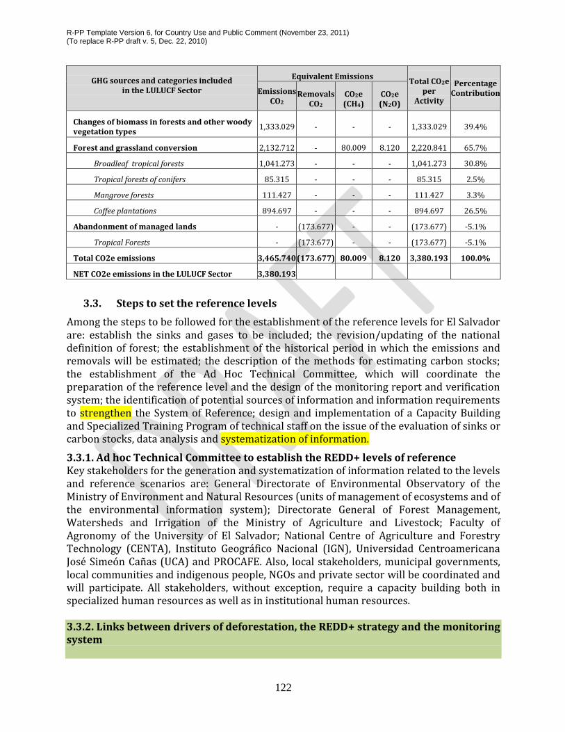
R-PP Template Version 6, for Country Use and Public Comment (November 23, 2011) (To replace R-PP draft v. 5, Dec. 22, 2010)
122
GHG sources and categories included
in the LULUCF Sector
Equivalent Emissions Total CO2e
per Activity
Percentage Contribution Emissions
CO2 Removals
CO2 CO2e (CH4)
CO2e (N2O)
Changes of biomass in forests and other woody vegetation types
1,333.029 - - - 1,333.029 39.4%
Forest and grassland conversion 2,132.712 - 80.009 8.120 2,220.841 65.7%
Broadleaf tropical forests 1,041.273 - - - 1,041.273 30.8%
Tropical forests of conifers 85.315 - - - 85.315 2.5%
Mangrove forests 111.427 - - - 111.427 3.3%
Coffee plantations 894.697 - - - 894.697 26.5%
Abandonment of managed lands - (173.677) - - (173.677) -5.1%
Tropical Forests - (173.677) - - (173.677) -5.1%
Total CO2e emissions 3,465.740 (173.677) 80.009 8.120 3,380.193 100.0%
NET CO2e emissions in the LULUCF Sector 3,380.193
3.3. Steps to set the reference levels
Among the steps to be followed for the establishment of the reference levels for El Salvador are: establish the sinks and gases to be included; the revision/updating of the national definition of forest; the establishment of the historical period in which the emissions and removals will be estimated; the description of the methods for estimating carbon stocks; the establishment of the Ad Hoc Technical Committee, which will coordinate the preparation of the reference level and the design of the monitoring report and verification system; the identification of potential sources of information and information requirements to strengthen the System of Reference; design and implementation of a Capacity Building and Specialized Training Program of technical staff on the issue of the evaluation of sinks or carbon stocks, data analysis and systematization of information.
3.3.1. Ad hoc Technical Committee to establish the REDD+ levels of reference Key stakeholders for the generation and systematization of information related to the levels and reference scenarios are: General Directorate of Environmental Observatory of the Ministry of Environment and Natural Resources (units of management of ecosystems and of the environmental information system); Directorate General of Forest Management, Watersheds and Irrigation of the Ministry of Agriculture and Livestock; Faculty of Agronomy of the University of El Salvador; National Centre of Agriculture and Forestry Technology (CENTA), Instituto Geográfico Nacional (IGN), Universidad Centroamericana José Simeón Cañas (UCA) and PROCAFE. Also, local stakeholders, municipal governments, local communities and indigenous people, NGOs and private sector will be coordinated and will participate. All stakeholders, without exception, require a capacity building both in specialized human resources as well as in institutional human resources. 3.3.2. Links between drivers of deforestation, the REDD+ strategy and the monitoring system

R-PP Template Version 6, for Country Use and Public Comment (November 23, 2011) (To replace R-PP draft v. 5, Dec. 22, 2010)
123
The purpose of the relationships and links of the reference level with the drivers of deforestation and degradation (Component 2a), REDD+ Strategy (Component 2b) and the monitoring system (Component 4a) is to maintain coherence throughout the different phases of the REDD+ Program in El Salvador. Links to the drivers of deforestation and degradation (Component 2a)
As was mentioned earlier, preliminary analyses indicate that deforestation in El Salvador is a multicausal phenomenon that is mainly associated with processes related to farming expansion, the disorderly growth of urban areas, urbanization and human settlements, and forest fires. Poor agricultural practices and extreme events and natural phenomena exacerbate the problem of forest degradation and loss of fertile soil.
The analysis of the drivers of deforestation and forest degradation should be carried out in depth, in order to get the relevant information to estimate the area of forests that are annually converted to different land uses and the degraded area for each driver, and clearly establish the strategy to address and counterattack each of the drivers whether direct or indirect. The link to establish a consistent reference level will be carried out by monitoring the strategies evaluated and adopted in Component 2a, this will be done with the purpose of obtaining and having more accurate and effective data to make the respective comparisons with information generated presently and in the future. Links with the National REDD+ Strategy (Component 2b)
The reference level will provide a course of action for REDD+ strategy activities that will allow us to know the rate of loss or recovery of forests; areas that are being impacted or degraded; current and necessary legislation; actions and benefits of adaptation and mitigation activities; it establishes the effectiveness measurement system of the measures taken for strategy implementation.
Links to the Monitoring System (Component 4)
In this component, the reference level sets the starting point for the monitoring of forest carbon by building the comparative methodology using maps and national forest inventory.
3.3.3. Review / update the national definition of forest
Among the information and prerequisites to consider within the National REDD+ Strategy is the definition of forest for El Salvador, allowing, inter alia, the identification of which type of soil/land use will be included in REDD+ activities in the country. The methodology adopted under the UNFCCC, based on small area, percentage of tree cover and minimum height of the trees, will be used for this definition. El Salvador already has a definition of forest, which was presented to the Clean Development Mechanism of the Kyoto Protocol, which must be updated and adapted to the national REDD+ program. In the Marrakesh Agreement "Forest" is conceived as a series of quantitative parameters related to the morphological form of vegetation, describing it as a minimum area of land of 0.05 and 1.0 hectares (ha) with a crown cover (or equivalent population density) that exceeds 10-30% and

R-PP Template Version 6, for Country Use and Public Comment (November 23, 2011) (To replace R-PP draft v. 5, Dec. 22, 2010)
124
trees that can reach a minimum height of between 2 and 5 meters (m) at maturity in situ. In other words, a forest may consist in dense forest formations where trees of various heights and the undergrowth cover a significant proportion of the ground, or also a clear forest mass (11CP.7, UNFCCC, 2001).
Taking into account that the El Salvador REDD+ Strategy will provide for a prioritization of the increase in forest carbon reserves, in the context of PREP/REDD+, including agroforestry systems, "Forest" should, in addition to increasing carbon stocks and emissions of CO2, among others, due to the lower use of fossil fuel-based inputs, contribute to ensuring food security, improve the living conditions of the population, conserve biodiversity, and recover the provision of ecosystem services key to climate change adaptation.
The process of definition/adoption of the Forest concept will be based on the results of a study and scientific and technical analysis of possible options, and will involve all key sectors in a process of dialogue and consultations with representatives of all public, private and academic sectors, and with local stakeholders. 3.3.4 Capacity Building Program
A diagnosis of the needs in human resources, equipment, and programs for the development of systems for monitoring, reporting and verification and reference levels should be made. This will allow the design and implementation of a program to strengthen capabilities and specialized training of technical staff on different themes for the preparation phase (Readiness). 3.4. Comparison of Coverage and Land Use (2002-2010) Establishment of images comparisons The Coverage and Land Use Map (2010), must be validation in the field with more accurate satellite images, since the construction of the coverage was based on Aster images with a 15 mts resolution pixel, showing a considerable level of error. To correct this failure, a supervised classification based on Rapid Eye images will be made, using Corine Land Cover methodology, frame by frame. After performing all the classifications, a mosaic will be constructed uniting all the frames, using a Lambert Conformal conical projection. Another process for data verification will take place through an in field demarcation using high-resolution GPS with an error of +/- 2 centimeters in post-processing generating land use coverage with more accurate data. Subsequently, an update to the coverage of the 2010 land will be made, based on the corrected coverage, and will be compared with 2002 Land Use Coverage; it should be noted that the two coverages have the same methodology of classification, so they have the same classes, thus allowing the loss or increase in forested area to be determined. The update process will take place through a similar map every 5 years; for which a mechanism for obtaining similar or better resolution images should be established, in order to build comparable maps.

R-PP Template Version 6, for Country Use and Public Comment (November 23, 2011) (To replace R-PP draft v. 5, Dec. 22, 2010)
125
3.5 Forest Inventory
The development of the Forest Inventory at a national level is planned, this will be built on the land use map; for this purpose it is necessary to perform the following activities: MAG - MARN Agreement; define the technical requirements (2 technical workshops to define objectives, scope, links, form the Ad Hoc technical teams; carry out the activities: design, cartography, samples of plots to calculate sampling error and the National Inventory as such (Table 25).) Approximately 1 to 2 years is considered necessary to complete the forest inventory and an estimated investment of US$ 740,000.00.
Table 25. Activities and persons responsible for the elaboration of the reference level.
ACTIVITIES OBJECTIVE RESPONSIBLE POTENTIAL
CONTRIBUTORS Establishment of sinks Quantify emissions at
national level MARN MOP, Indigenous
Communities, MAG, UCA, UES, RENAPES, PRISMA, ADESCOS.
REDD+ forest definition Identify the type of land use to be included in REDD+ activities
MARN MAG, GIZ, UCA, UES, UL, RENAPES, CORDES, CACH, ARDM, ACUDESBAL, PRISMA. Representatives of Indigenous Communities
Preparation of 2011 land use map
Qualitative and quantitative comparisons of the different uses in the country
MARN – MAG – GIZ.
Indigenous Communities, ADESCOS, UCA, UES, CACH, ARDM, CUDESBA, PRISMA, ISTA.
Development of forest inventory
Quantify the forest masses and their current status in the country.
MAG MARN (OTNAM), UES, UCA, UL, SEMAFOR, FINNFOR, CATIE.
Comparative analysis of maps (2002-2011) to establish the baseline
Define the loss of forests at national level.
MARN MAG, UES, UCA, UL, SEMAFOR, FINNFOR, CATIE.
Definition of methodologies for carbon measurement
Establish a robust method for the quantification of carbon capture or loss
MARN. MAG, UES, UCA, UL, SEMAFOR, FINNFOR, CATIE.
Creation of AD HOC Committee
Coordinate the preparation of the reference level and the design of the monitoring system
MARN MAG, UES, UCA, CENTA, IGN, PROCAFE.
Identification of possible sources of information to strengthen the reference level
Stregthen the reference level
MARN MAG, PROCAFE, UCA, UES, UL.
Design and implementation of the capacity building program
Develop skills in relevant subjects associated with REDD+
MARN MAG, GIZ, UCA, UES, UL, SEMAFOR, FINNFOR, CATIE.
Data analysis and Generate the national MARN MAG, GIZ, UCA, UES, UL.

R-PP Template Version 6, for Country Use and Public Comment (November 23, 2011) (To replace R-PP draft v. 5, Dec. 22, 2010)
126
systematization of information
reference information
Budget Component 3 : Summary of Reference Level Activities and Budget
Main Activity Sub-Activity Estimated Cost (in thousands)
2012 2013 2014 2015 Total
Land use map
Rapide Eye satellite imagery
$ 35 $ 0 $ 0 $ 0 $35
Land use map updating
$ 0 $ 60 $ 0 $ 0 $60
Forest inventory Forest Inventory $ 0 $ 0 $ 740 $ 0 $740
Calculation of carbon
Taking samples and data in field $ 0 $ 30 $ 0 $ 0 $30
Laboratory Analysis
$ 0 $ 10 $ 0 $ 0 $10
Data Processing $ 0 $ 5 $ 0 $ 0 $5
Field team for carbon and biodiversity measurement
$ 0 $ 150 $ 0 $ 0
$ 150
Institutional strengthening
Training of technical personnel
$ 0 $ 50 $ 0 $0 $50
National consultation workshops
Workshops on forest definition for the country
$ 5 $ 5 $ 0 $ 0 $ 10
GOES Technical Monitoring
GOES Technical Monitoring
$ 0 $ 50 $ 50 $ 50 $ 150
Total $ 40 $ 360 $ 790 $ 50 $1,240
GIZ $40 $ 5 $740 $0 $785
FCPF $ 0 $ 305 $ 0 $ 0 $ 305
GOES $ 0 $ 50 $ 50 $ 50 $ 150

R-PP Template Version 6, for Country Use and Public Comment (November 23, 2011) (To replace R-PP draft v. 5, Dec. 22, 2010)
127
Resources available: Several forest governance guidelines toolkits or documents are available that might be important references or offer useful approaches for work on this component. Some such tools include: Governance of Forest Toolkit by World Resources Institute, Analytical Framework for Governance Reform by the World Bank, and REDD+ Social and Environmental Standards by the Climate Community and Biodiversity Alliance (CCBA) and Care International. Please refer to the annexes for the links to access these tools. Chatham House and UN-REDD have jointly posted several workshop and issue papers referenced in Annex A.
4.1 Methodology to be used and frequency of data collection The objective of this component is to design and implement a national monitoring system, standardized based on information integrated with satellite imagery and field collected data. This system should be nationwide, with a coherent strategy and allow for a report at multiple and multifunctional levels in a consistent and transparent manner which includes all the information gathered from monitoring systems. In this context, to monitor GHG emissions associated with forests (deforestation and degradation) generally at least the following variables should be measured regularly: a) national forest coverage (distinguishing forest types) and b) the carbon intensities of the different forest types (emission factors), data will accompany a consistent methodology and adapted to the country so it may be comparable to the baseline scenario.
As mentioned above, the results of the five REDD+ activities in El Salvador will be evaluated and monitored through the determination of three parameters:
1. forest areas which are deforested or converted to other land uses; 2. forested areas that remain and are preserved; 3. and recovery of forest areas and / or change of land use to forest or forestry usage.
The first includes deforestation, the second includes forest degradation, conservation of carbon stocks and sustainable forest management, and the third includes increasing forest carbon stocks.
Component 4. Designing and Information System for Multiple Benefits, Other Impacts, Governance, and
Safeguards
4a. Designing a Monitoring System

R-PP Template Version 6, for Country Use and Public Comment (November 23, 2011) (To replace R-PP draft v. 5, Dec. 22, 2010)
128
Criteria for the design of the monitoring system
The monitoring system should follow up on:
Reduced emissions and changes / increases in carbon stocks due to the implementation of REDD activities.
The implementation of the strategy as designed; and
Additional benefits for adopting REDD
To monitor changes in carbon stocks, a map of land use and forest cover updated to the date of the calculation, the intensities of biomass for different forest types in the map and the fraction of carbon (FC) per biomass unit and forest type will be required. The monitoring system proposed for El Salvador must meet the following criteria:
1. Representative: able to represent land use / land occupation categories systems in their proportions (homogeneous or heterogeneous).
2. Consistent over time: able to represent land use / land occupation categories systems systems consistently over time.
3. Complete: all land in the country should be included, with increases in some areas to maintain a balance with respect to other areas.
4. Transparent: In sources and data collection, definitions, methodologies and assumptions clearly described and accessible.
In addition, the monitoring system will provide data to improve understanding of the processes of forest management and restoration of degraded forests. It should also contain information on the 5 forest carbon pools established by the IPCC: 1) above ground biomass, 2) below ground biomass, 3) deadwood 4) dead leaves and detritus, 5) soils. There will be a preliminary study on the costs required to perform all field work, the strategy of involvement and community support, laboratory analysis and preparation of reports. This preparation is subject to consultation through workshops, in order to select the best option, seek the involvement or support or contributions necessary for monitoring implementation, in which the formulated methodologies, valid for the region, are presented. The proposed allometric equations are adapted in many cases to tree species native to Central America, in order to obtain more accurate carbon quantification estimates.
It is important to recognize that all these equations require accurate statistics such as the number of livestock, surface of vegetation coverage and other, but they will also include and consider non-statistical activities data to complete a more accurate calculation as a percentage of carbon in the biomass, fraction of burned biomass, oxidation factor, to mention but a few. The goal in this process is to develop the measurement, calculation and quantification in the most transparent and consistent was possible.
4.2. Institutional Arrangements
Systematization and those responsible for the analysis of information.

R-PP Template Version 6, for Country Use and Public Comment (November 23, 2011) (To replace R-PP draft v. 5, Dec. 22, 2010)
129
The entity responsible for data collection, systematization and subsequent use will be under the MARN, through the Directorate General of Environmental Observatory, with support from the Ministry of Agriculture and Livestock (MAG), through the General Directorate of Forestry, Watershed and Irrigation Management and the National Centre for Agricultural and Forestry Technology (CENTA) - These entitites will be supported in turn, by the National Geographic Institute (IGN), the Universidad Centroamericana José Simeón Cañas (UCA) and the SalvadorianFoundation for Coffee Research PROCAFE. We also expected to count on the participation / involvement of local stakeholders, Municipal Governments, indigenous and local communities, NGOs and private sectors. All stakeholders without exception will require capacity building, in both specialized human resources and institutional. It is important to recognize that there are some potential partners who can be integrated to provide knowledge and expertise, such as the Ministry of Public Works (MOP), Universidad de El Salvador (UES) National Network of Private Reserves of El Salvador (RENAPES), SalvadorianProgram for Development and Environment Research (PRISMA), German Agency for International Cooperation (GIZ), Lutheran University (UL), Foundation for Community Development and Cooperation (CORDES), Chalatenango Environmental Committee (CACH), Association for Municipal Reconstruction and Development (ARDM), Association of United Communities of the Bajo Lampa (ACUDESBAL).
Establish National Technical Monitoring Office (OTNAM) The National Technical Monitoring Office (OTNAM), will be located within the premises of the MARN and will consist of two high-level specialists and 2 people on a technical level (field) responsible for the coordination and management of the monitoring system. Another OTNAM responsibility will be to establish and verify the permanent sample plots (PSP) which will be done with the support of SEMAFOR (CATIE / FINNFOR) who have extensive experience in Central America PSP network. This office should be strengthened with top computer team. It is expected that after a year of operation the OTNAM can strengthen the capacities of other relevant national forest sector institutions and stakeholders who work in or affect the priority areas. After two years of operation the OTNAM should standardize and regulate the methodology for the production of local maps of forest cover and develop national report and verification protocols in conjunction with the stakeholders from different sectors.
The national forest research and monitoring program will be developed, and will be supported by the General Directorate of Environmental Monitoring of the Ministry of Environment and Natural Resources (MARN) that will focus specifically on the development and generation of relevant information on exploitation, forest management and other topics as inputs for monitoring forest carbon stocks. This program will also be responsible for issues concerning research on allometric models, licenses and specialized programs for quantifying carbon and biodiversity.
Those responsible for in situ data collection

R-PP Template Version 6, for Country Use and Public Comment (November 23, 2011) (To replace R-PP draft v. 5, Dec. 22, 2010)
130
A specialized technical team and assistants with experience in establishing permanent sample plots is required. During the measurements it is recommended using a full time team of six people (a Forest Engineer / Agronomist, a botanist and four assistants with experience in establishing plots or people from the communities who will need training in order to ensure data precision). It is recommendable that this team be the one to monitor all pilot areas and then be responsible for training the people in the communities near the pilot areas in order to replicate the knowledge and engage them in these measurements. This team will integrate diverse representatives from public universities, centers of higher education, national NGOs, Community Development Associations (ADESCO) among others. It aims to share a transparent field measurement process in which from the start other institutions and civil society in general are involved, to support the design and implementation of these measures.
4.3. Evaluation of national capacity and monitoring activities
It is necessary to strengthen the existing capacities of the national institutions to monitor at a national level. Another important concept to take into consideration is that the design of the monitoring system, apart from meeting international requirements as regards the issue of deforestation and forest degradation, also manages to fill a series of information gaps that currently exist that will strengthen the activities and initiatives of national forest related public institutions, programs and projects among others. The following are important aspects concerning the implementation of a nationwide capacity development plan.
National climate change adaptation Capacity Development Plan
El Salvador, needs to know, develop and strengthen national capacities, in both the scientific-technical areas, and within the institutional and legal frameworks. For this purpose the German International Cooperation (GIZ) in October 2011 developed the study titled: “Diagnosis of capacities to meet the challenges of Climate Change Adaptation in El Salvador within the framework of Reducing Emissions from Deforestation and Forest Degradation”. This study's main objective was to develop a diagnostic on capabilities to meet the challenges of Climate Change Adaptation in El Salvador at systemic, institutional and individual levels, at both centralized and decentralized levels, this constitutes a valuable input that provides key information to be integrated into a development plan for improved capabilities.
This proposal was based on the gaps and training needs in the area of climate change. This information is a valuable input in order to improve national capacities that help meet the challenges of climate change adaptation, taking into account that education is one of the ways by which adaptive and resilience capacities can be developed and strengthened. We identified a number of training needs in the area of climate change, particularly in the area

R-PP Template Version 6, for Country Use and Public Comment (November 23, 2011) (To replace R-PP draft v. 5, Dec. 22, 2010)
131
of climate change adaptation and REDD+, from which 93 topics remained after appraisal, and then grouped into the following five areas:
a. General issues on climate change
b. Standards, regulations and negotiations
c. Impacts, vulnerability and adaptation to climate change
d. Climate change mitigation measures
e. Reducing deforestation and forest degradation (REDD+)
There is a demand to develop and strengthen knowledge, and this is not only focused on adaptation and REDD+, it also includes topics on basic concepts and knowledge, mitigation measures, governance, international conventions and instruments and climate change planning policy.
It is also important to note that since June 2011, the "Regional Certification Course in Forest Resources Monitoring" is being carried out with the participation of all the Central American countries, funded by the German Agency for International Cooperation (GIZ). This training program aims to strengthen the technical capacity of countries in the region to implement forest resources monitoring systems in the context of reducing carbon dioxide (CO2) emissions from deforestation and forest degradation.
The topics were: a) Conceptual bases of Forest Resources Monitoring in the context of REDD; b) Forest Measurements, c) Processing of Satellite Images for Forest Cover Monitoring and d) the processing of data to identify potential REDD areas. Participants are officials from national environmental entities and forestry institutions and the program is taught with the support of the Tropical Agricultural Research and Higher Education Center(CATIE). The first session was conducted on the campus of CATIE, in Costa Rica. The second training session was conducted in October 2011, the third in February 2012 and the last in August 2012.
Two technicians from the Ministry of Agriculture and Livestock (MAG) and a technician from the Ministry of Environment and Natural Resources (MARN) are currently involved in this Certification Program. At the level of training on the specific topic of MRV, this certification is the one which most directly focuses on the REDD theme.
Proposal for the development of capacities to meet the challenges of adapting to climate change in El Salvador
The study: "Diagnosis of the capacities to meet the challenges of Climate Change Adaptation in El Salvador within the framework of Reducing Emissions from Deforestation and Forest Degradation" revealed that there is a strong demand from public sector institutions, guilds and civil society to develop and strengthen their knowledge, experience and skills to understand and cope with the phenomenon of climate change in a superior manner. This demand is not only focused on adaptation and REDD+ issues, but also includes topics on

R-PP Template Version 6, for Country Use and Public Comment (November 23, 2011) (To replace R-PP draft v. 5, Dec. 22, 2010)
132
basic concepts and knowledge, mitigation measures, governance, international conventions and instruments and climate change planning policy.
Consultant training proposal for El Salvador
The proposal and identification of training needs is carried out through a national workshop in which the relevant stakeholders from the governmental, private, NGOs, civil society and local communities sectors participate. The workshop will be held under the framework of the national monitoring program and will include the following topics:
1. Vegetation cover baseline 2. Biomass/ carbon baseline 3. REDD Reference level 4. Monitoring and reporting
Information on reference levels for REDD will be presented as input specifically on: 1. Historical deforestation (trends) 2. Agents of deforestation. 3. Future deforestation. The main topics to be developed and used for the monitoring system are: 1. Monitoring of deforestation and degradation. 2. Inputs for the national inventory of greenhouse gases. 3. Monitoring co-benefits and safeguards. In order to obtain the following information: 1. Identify or validate information products. 2. Complete list of existing information. 3. Identify information gaps and training needs. 4. Identify stakeholders to obtain or generate information. 5. Comment on the ease and / or difficulties as regards access to the data. 4.4 Methods for estimating CO2/REDD+ emissions and reserves
Types of Monitoring and Evaluation
Different types of monitoring will be implemented nationwide, these are:
• Monitoring of existing forests, including agroforestry systems.
• Monitoring of increase in forest carbon stocks.

R-PP Template Version 6, for Country Use and Public Comment (November 23, 2011) (To replace R-PP draft v. 5, Dec. 22, 2010)
133
Carbon and multiple benefits will be the aspects subject to monitoring (Component 4b). To calculate the carbon stocks in forests and agroforestry systems. Carbon is considered above ground as follows: (trees, shrubs, litter and dead wood) and below ground carbon is soil and roots.
Biomass intensities by forest type and agroforestry system
To calculate this it is necessary to know and classify various types of forest, to allow the allometric models to estimate biomass per tree or per hectare. To detect changes in biomass due to forest degradation, evaluated field data is required from remote high spatial and spectral resolution sensors, being a valuable support the land use map using the equivalent methodology on a five year basis, with 2002 and 2010 maps serving as the base. To calculate the quantification of carbon in different types of forests and agroforestry systems the methodology described in Annex 3 will be used.
4.5. Reporting and Verification System
Reporting and verification of emission reduction A system of verification of emission reductions will be set up. This should include a coverage map and a table, which should also appear in the monitoring report. Special attention should be paid to the development and use of allometric equations for biomass per tree and per unit area. However, for the estimation of the fraction of carbon by forest type, further studies to different forest types should be carried out.
Leakage monitoring
Leakage monitoring will take place nationwide from baseline for El Salvador. The methodology for assessing and monitoring leakage is through comparative analysis of maps, this will take into account the latest information, to determine and identify in which areas and / or areas there have been problems of deforestation and degradation.
In order to involve other stakeholders in monitoring activities people in the communities near the work areas as well as representatives of public universities, centers of higher education, national or international NGOs, development associations Communal (ADESCO) and others who are interested in the subject, will receive training (Table 26). According to a prearranged design and based on the general guidelines set out in this report, these entities will form part of the structure and capacity to carry out REDD+ monitoring. Information collected by local stakeholders, will be delivered to the Ministry of Environment and Natural Resources (MARN), who will be responsible for processing and analyzing this data to prepare reports for the FCPF.

R-PP Template Version 6, for Country Use and Public Comment (November 23, 2011) (To replace R-PP draft v. 5, Dec. 22, 2010)
134
Table 26. Activities and those responsible for the monitoring, reporting and verification system for El Salvador.
ACTIVITIES
PRECISION (SCALE
AND GEOGRAPHIC
AREA)
OBJECTIVE
THE RESONSIBLE PARTIES
POTENTIAL PARTNERSHIP
IDEAL MEASUREMENT
FREQUENCY
Preparation of a coverage map of country by forest types (GIS analysis and establishment of control points)
1:25,000 depending on the extent of each region
Identify rlevant areas of coverage loss in order to step up development programs and strategies
• Ministry of Environment and Natural Resources (MARN) through National Technical Monitoring Office (OTNAM) • Ministry of Agriculture and Livestock (MAG) through General Division of Forest, Watersheds and Irrigation Management.
• Environtl Committee of Chalatenango (CACH) • Partnership for Reconstruction and Municipal Development (RCMD) United Association of Lower Lempa Communities (ACUDESBAL) • SalvadorianResearch Program on Development and Environment (PRISMA) • Local Communities • National Indigenous Association of El Salvador (ANIS) • National Coordination of Indigenous People (SCU) of the Ministry of Culture, of the Presidency of the Republic • MANGLE Association • Foundation for Cooperation and Community Development (CORDES) • Technical Team
5 years
Forest Inventory by ecosystem types and inheritance status through permanent
1:5,000 or more accuracy depending on the geographical
- Quantify biomass in order to assess the current state of the country's ecosystems -Determine
• Ministry of Environment and Natural Resources (MARN) through National Technical Monitoring Office
• Civil Society Organizations • Local Communities • National University of El Salvador (UES) • Lutheran University (UL) • Jose Simeon Canas Central
• Updates every 5 years using yearly
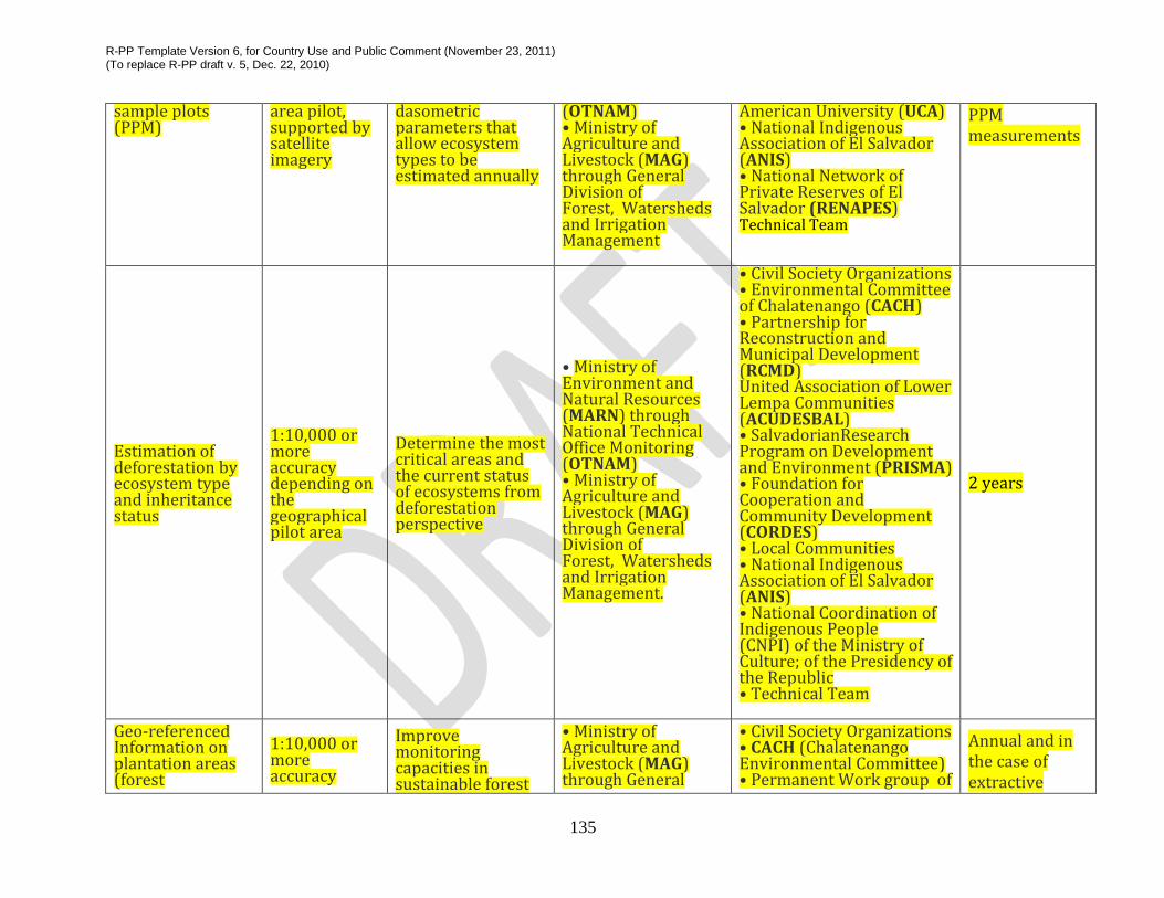
R-PP Template Version 6, for Country Use and Public Comment (November 23, 2011) (To replace R-PP draft v. 5, Dec. 22, 2010)
135
sample plots (PPM)
area pilot, supported by satellite imagery
dasometric parameters that allow ecosystem types to be estimated annually
(OTNAM) • Ministry of Agriculture and Livestock (MAG) through General Division of Forest, Watersheds and Irrigation Management
American University (UCA) • National Indigenous Association of El Salvador (ANIS) • National Network of Private Reserves of El Salvador (RENAPES) Technical Team
PPM measurements
Estimation of deforestation by ecosystem type and inheritance status
1:10,000 or more accuracy depending on the geographical pilot area
Determine the most critical areas and the current status of ecosystems from deforestation perspective
• Ministry of Environment and Natural Resources (MARN) through National Technical Office Monitoring (OTNAM) • Ministry of Agriculture and Livestock (MAG) through General Division of Forest, Watersheds and Irrigation Management.
• Civil Society Organizations • Environmental Committee of Chalatenango (CACH) • Partnership for Reconstruction and Municipal Development (RCMD) United Association of Lower Lempa Communities (ACUDESBAL) • SalvadorianResearch Program on Development and Environment (PRISMA) • Foundation for Cooperation and Community Development (CORDES) • Local Communities • National Indigenous Association of El Salvador (ANIS) • National Coordination of Indigenous People (CNPI) of the Ministry of Culture; of the Presidency of the Republic • Technical Team
2 years
Geo-referenced Information on plantation areas (forest
1:10,000 or more accuracy
Improve monitoring capacities in sustainable forest
• Ministry of Agriculture and Livestock (MAG) through General
• Civil Society Organizations • CACH (Chalatenango Environmental Committee) • Permanent Work group of
Annual and in the case of extractive

R-PP Template Version 6, for Country Use and Public Comment (November 23, 2011) (To replace R-PP draft v. 5, Dec. 22, 2010)
136
management) and critical areas of illegal extracting activities
management and design strategies to reduce illegal logging
Division of Forest, Watersheds and Irrigation Management. • Ministry of Environment and Natural Resources (MARN) through National Technical Monitoring Office (OTNAM) • National Institute of Agrarian Transformation of El Salvador (ISTA)
Bajo Lempa Social Stakeholders (MESPABAL) • Local Communities • SalvadorianResearch Program on Development and Environment (PRISMA) • National Centre of Agricultural and Forestry Technology CENTA • Foundation for Cooperation and Community Development (CORDES) • Association for Reconstruction and Municipal Development (RCMD) United Association of Bajo Lempa Communities (ACUDESBAL) • Technical Team
activities every 5 years
Evaluation of forest degradation
1:10,000 or more accuracy depending on the geographical pilot area
Determine the most critical areas and current status of ecosystems in areas related to ecosystem degradation activities
• Ministry of Agriculture and Livestock (MAG) through General Division of Forest, Watersheds and Irrigation Management. • Ministry of Environment and Natural Resources (MARN) through National Technical Monitoring Office (OTNAM)
• Civil Society Organizations • Local Communities • Permanent Work group of Bajo Lempa Social Stakeholders (MESPABAL) • Environmental Committee of Chalatenango (CACH) • Partnership for Reconstruction and Municipal Development (RCMD) United Association of Lower Lempa Communities (ACUDESBAL) • Foundation for Cooperation and Community Development (CORDES) • UNES SalvadorianEcological Unit
2 years

R-PP Template Version 6, for Country Use and Public Comment (November 23, 2011) (To replace R-PP draft v. 5, Dec. 22, 2010)
137
• Indigenous People • Technical Team
Evaluation of social and environmental impacts
-Identify the contribution of the activities carried out in the pilot areas and determine the most relevant impacts
-Systematize perception of environmental and social impacts resulting from the adoption of the technologies generated
-Valuate social and environmental costs of long-term continuation of the project and develop the strategies needed to achieve the desired objectives
• Ministry of Agriculture and Livestock (MAG) through General Division of Forest, Watersheds and Irrigation Zoning. • Ministry of Environment and Natural Resources (MARN) through National Technical Monitoring Office (OTNAM)
• Civil Society Organizations • Environmental Committee of Chalatenango (CACH) • Partnership for Reconstruction and Municipal Development (RCMD) United Association of Lower Lempa Communities (ACUDESBAL) • Permanent Work group of Baja Lempa Social Stakeholders (MESPABAL) • Foundation for Cooperation and Community Development (CORDES) • SalvadorianResearch Program on Development and Environment (PRISMA) • Local Communities • National Coordination of Indigenous People (CNPI) of the Ministry of Culture, of the Presidency of the Republic • MANGLE Association • Local Communities • Technical Team
Annual

R-PP Template Version 6, for Country Use and Public Comment (November 23, 2011) (To replace R-PP draft v. 5, Dec. 22, 2010)
138

R-PP Template Version 6, for Country Use and Public Comment (November 23, 2011) (To replace R-PP draft v. 5, Dec. 22, 2010)
139
Budget 4a: Summary of Monitoring Activities and Budget
Main Activity Sub-Activity Estimated Cost (in thousands)
2012 2013 2014 2015 Total
National forest monitoring and research program (PIMFO)
Research on allometric models, licenses and specialized programs for quantifying carbon and biodiversity
$ 0 $ 20 $ 20 $ 0 $ 40
Develop and generate relevant information on use, forest management for the monitoring forest carbon stocks
$ 0 $ 17 $ 20 $ 0 $ 37
Strengthening National Technical Monitoring Office (OTNAM)
Technical staff for monitoring (2 specialists and field staff) responsible for coordination / monitoring system unit
$ 0 $ 50 $ 100 $ 100 $ 250
Survey and verification of permanent field plots (Logistics and Equipment)
$ 0 $ 50 $ 50 $ 20 $ 120
Technical support and training for Semafor (FINNFOR / CATIE) for the establishment of permanent sample plots (PPM)
$ 0 $ 30 $ 30 $ 0 $ 60
MARN technical staff to support the OTNAM
$ 0 $ 60 $ 60 $ 60 $ 180
Strengthening the Computer skills of the National Technical Monitoring Team (OTNAM)
$ 0 $ 70 $ 30 $ 0 $ 100
Strengthen the capacity of national institutions and relevant stakeholders of the forestry sector
$ 0 $ 50 $ 50 $ 50 $ 150
Methodological development and Protocols
Standardize and regulate the methodology for the production of local forest cover maps
$ 0
$ 0
$ 40
$ 10 $ 50
Develop reporting and verification protocols with socialized sector stakeholders
$ 0 $ 30 $ 30 $ 0 $ 60
Total $ 0 $ 377 $ 430 $ 240 $ 1,047
FCPF $ 0 $ 187 $ 240 $ 170 $ 597
Government (GOES) $ 0 $ 130 $ 90 $ 60 $ 280
GIZ $ 0 $ 60 $ 100 $ 10 $ 170

135
Forest ecosystems provide a range of key ecosystem services at global, national and local scales. In addition to representing the most important carbon sinks and containing the highest percentage of biodiversity, among others things, forests protect watersheds, promoting soil conservation and land stabilization, regulation of water flow, and guaranteeing the supply of good quality water. The monitoring of the multiple benefits of REDD+ activities that prevent deforestation and degradation of forest ecosystems, and facilitate increased carbon stocks, is an important component of the National REDD+ Strategy in El Salvador.
The proposed REDD+ strategy for El Salvador seeks to promote activities that contribute simultaneously to mitigation and adaptation, and that in turn enable various international commitments, such as the conservation and restoration of forest ecosystems and sustainable forest management, consistent with the Strategic Plan for Biodiversity of the Convention on Biological Diversity and the AICHI Targets, particularly Target 15 which requires the restoration in 2020 of at least 15 percent of degraded ecosystems worldwide, representing about 150 million hectares, to be addressed. Other identified targets are 5, 7 and 11. Thus, the REDD+ program should seek to improve the resilience of ecosystems by conserving biodiversity and increasing carbon stocks, thus contributing both to climate change mitigation, adaptation and the combating of desertification and drought in the country.
The high level of land degradation in El Salvador has a growing cost as it is being increasingly exposed to extreme weather events. As a result, not only is there an increase in flooding and landslides that cause deaths, loss of livelihoods, the destruction of infrastructure and housing, but erosion is also causing alarming rates of soil fertility loss, and the sedimentation of wetlands which affects their performance and productivity, contributing to the loss of their ability to provide ecosystem services which are key to the welfare of local communities. Under these circumstances, it is essential that the national REDD+ proposal support ecosystem restoration through promoting change in cultivation practices on agricultural land located on slopes which affect other key forest ecosystems. It seeks to promote farming practices based on agroforestry which besides increasing carbon stocks important, restore ecosystem services, reduce runoff and prevent nutrient loss, and generate greater resilience to extreme weather events, resulting in improved production. These measures may be accompanied by other measures of green infrastructure development: the reforestation and rehabilitation of gallery forests; the establishment of energy forests recovering ecological connectivity; and the conservation / restoration of secondary forests aimed at the protection of critical areas.
4b.1. Towards a System to Monitor Additional Benefits resulting from REDD+ activities During the preparation of the National REDD+ Strategy, a monitoring system of the co-benefits will be established which will be designed and built in a participatory manner,
4b. Multiple benefits and other positive impacts of REDD+ activities

136
under the coordination of the Department of Climate Change and Strategic Affairs, and the Department of Environmental Observatory, both pertaining to the Ministry of Environment and Natural Resources. In addition, the support and participation of specialists from government institutions, private sector, academia, NGOs and local stakeholders, will be promoted, initially based on the current capacities of national institutions and the information available. The scope of the system will increase as national capacities are strengthened.
It should address the collection of data and information related to the co-benefits provided by forest ecosystems, as well as the evaluation of the parameters related to deforestation and forest degradation drivers. It will be necessary to develop a set of indicators and verifiers that allow us to summarize the information in standard numbers, graphs or maps and can be used to infer changes resulting from projects or REDD+ activities and provide appropriate follow-up on strategic positive social and environmental impacts, and consequently to REDD+ Safeguards, as agreed under the UNFCCC.
Under the REDD+ framework, the system should evaluate the generation of social benefits related to sustainable development and poverty reduction, such as increased income, increased sources of livelihood, the improvement and strengthening of forest governance and, environmental benefits, particularly improved protection of biodiversity, soil and water conservation and the recovery of key ecosystem services, such as the regulation of water flows.
To select priority additional benefits in a participatory manner to be evaluated in the Monitoring System, and to identify and establish verifiers and indicators for each benefit selected, the following steps shall be followed:
a) Identify information on providers and stakeholders to participate in the monitoring system. b) Establish institutional arrangements for monitoring and follow-up (see Figure 14). c) Select the additional benefits that will be taken into account in the monitoring and tracking system. d) Develop and adopt methodologies and protocols for collection of data and information. e) Establish indicators for each of the benefits that will be monitored and develop a process of socialization of list of indicators. f) Carry out workshops to disseminate and validate proposals.
Similarly, a participatory process will be developed to design and establish an information system related to the attention and respect of REDD+ Social and Environmental Safeguards that were agreed on in Cancun, Mexico 2010, under the framework of the UNFCCC.
4b.2. Preliminary proposal of biodiversity monitoring component
Biodiversity or biological diversity is the variability between living organisms, including terrestrial, marine and freshwater organisms and the ecological complexities of which they form part, which includes diversity within a species, diversity between species and the diversity of ecosystems. Additionally, there are three aspects of biodiversity that must be

137
considered in order to fully understand the relationships between the components: composition, structure, and function. The composition has to do with the identity and variety of elements at a given organizational level; it includes lists of species and diversity measurements of species and genes. The structure is the physical organization and the spatial relationship between elements of a system, from habitat complexity to the structure of patches and other landscape elements. The role involves ecological and evolutionary processes, including gene flow, obstacles and nutrient recycling.
A monitoring system should include systematic biodiversity observation actions of variables related to the biodiversity at different levels, allowing, on the one hand, an assessment of the status and progress of each variable to be made and on the other hand, a comprehensive evaluation of the contribution of a series of interventions that have been made in relation to the problems and opportunities of a specific geographical area. Monitoring will be conducted at repeated intervals of time so as to provide baseline information to track changes in the future. Work will be carried out on establishing a set of key indicators on the state of the biodiversity components of be monitored, taking into consideration the aspects of composition, structure and function at all levels of organization from which biodiversity will be addressed. The set of indicators should be chosen to maximize sensitivity to changes.
In a preliminary discussion that should be consulted and validated, some verifiers and indexes were identified to carry out the monitoring of biodiversity at landscape organization and ecosystems levels, to enable the assessment of two aspects at each level: composition and structure, and some basic measurements at role level. The impacts of the five REDD+ activities on biodiversity can be monitored by considering a broad territorial space, the landscape level, as well as direct changes in ecological systems under consideration. The verifiers and indices proposed for the ecosystem and landscape levels (Tables 27 and 28, and Annex 4), for projects of conservation and restoration projects, are:
Table 27. Monitoring indicators for the conservation and restoration at ecosystem level, and corresponding verifiers and indexes for monitoring.
LEVEL
ASPECT
Conservation INDICATOR
Restoration INDICATOR
VERIFIERS AND INDEXES
ECO-SYSTEMS
Composition
The composition of the ecosystem is unchanged
There are changes in composition of species showing habitat recovery processes
List of species that make up the communities prioritized
Relative abundance of species
Species diversity indexes
Species dominance indexes

138
Structure
The structural diversity of the ecosystem is unchanged
There are structural changes in the vegetation showing habitat recovery processes
Vertical vegetation structure
Canopy opening
Proportion of clearings
Diversity β is unchanged
Increase/reduction in diversity β, (composition of species among communities)
Diversity indexes between priority communities
Indexes of similarity between priority communities
Role
Diversity of the ecosystem is unchanged
Increase in the diversity of functional groups key to hábitat recovery.
Diversity of pollinators
Diversity of decomposers
Diversity of disseminators
Diversity of other beneficial species
To establish protocols for monitoring the diversity of soil organisms, together with other information and data, we recommend using the result generated under the framework of the project: "Restoration and conservation of biodiversity in El Salvador through the adaptation and dissemination of an agroforestry system of logging and pruning”, which is being implemented by the Earth Institute at Columbia University / USA, the International Center for Tropical Agriculture through the Fertility Institute of CIAT / Colombia, the SalvadorianResearch on Development and Environment Program (PRISMA), Zamorano University / Faculty of Agriculture (Honduras) and the Ministry of Environment and Natural Resources (MARN) of El Salvador, which is funded with financial support from the U.S. Agency for International Development (USAID).
Monitoring wildlife and soil organisms. Plant diversity can be measured by recording the diameter at breast height (DBH), and height of each tree species over 5 cm DBH within research plots. The low vegetation (shrubs and herbs) can be identified and the percentage of coverage can be estimated in two sub-plots of 5 x 5 meters (see Kessler et al., 2011). Macroinvertebrates in soil will be evaluated based on the TSBF method (Anderson and Ingram 1993). Bird diversity will be assessed by quantitative counts of species (sightings and hearings of songs) at 20 minute intervals at 4 different times of day within each management plot (Herzog et al., 2002). The latter will be sampled twice a year, both in the rainy season, and in the dry season. Soil Biota will be evaluated, including macroinvertebrates based on the TSBF method (Anderson and Ingram, 1993) with three soil monoliths (25 x 25 cm, 30 cm deep, equally spaced along a transect) and with the selection of the macrofauna in the detritus and soil at different depths in each plot. Samples collected from each monolith will be delivered sorted, separated in at least 17 general taxonomic units (eg, Isopoda, Chilopoda, Oligochaeta) and preserved in alcohol or formalin, and then classified taxonomically. In order to evaluate the microbial operation, samples of soil (0-10 cm) will be collected adjacent to the monolith, frozen and the fatty acid profiles of phospholipids (FAG) analyzed. To provide a breakdown of the microbial biomass and

139
activity present at the time of sampling, FAG is a valuable indicator of microbial diversity and relative biomass of the main functional groups (Bossio et al., 1998, Kaur et al. 2005).
Table 28. Monitoring indicators for the conservation and restoration at landscape level and
corresponding verifiers and indexes for monitoring.
LEVEL
ASPECT
Conservation
INDICATOR
Restoration
INDICATOR
VERIFIERS AND INDEXES
LANDSCAPES
Structure
Landscape
structure
remains
unchanged
Increased
Access between
patches
Patch areas of interest
Core patch areas of interest
Patch diversity indexes
Dominance of patches
Contagion
Fractal dimension
Role
Landscape
processes
remain
unchanged, no
changes occur in
structure.
Landscape
processes
produce
positive
changes in the
landscape
structure
Percent change in the area of each patch type
Percentage of change in the index area of each
type of patch
4b.3. Monitoring the social and economic benefits of REDD+ activities
The conservation, restoration and increase of forest ecosystems will in turn increase the provision of key ecosystem services, such as those essential to the welfare of local communities, particularly those related to livelihoods. In this regard, it is expected, among other aspects, that locally there will be an increase in job creation, household income, food security support, permanent access to natural medicines and firewood. Thus, the implementation of the National REDD+ Strategy should promote sustainable provision of livelihoods to local communities, including fair and equitable access to non-timber forest.
The system monitoring social and economic benefits should include systematic actions tracking policy indicators, process indicators and outcome indicators. As mentioned above, a participatory process to design and identify the set of indicators and verifiers generating multiple benefits will be carried out, however, a preliminary proposal could include some indicators to evaluate whether participation in the benefits of the REDD+ program is going through in a transparent and equitable manner; if the program provides a sustained improvement in the livelihoods of local communities, including indigenous communities; if the Program has brought about an increase in local jobs; if the program provides special attention to women or vulnerable people; whether legal and traditional rights over resources, etc. are acknowledged and respected under the Program.

140
4b.4. Governance Monitoring in REDD+ The Governance Monitoring System in REDD+ should include a list of indicators and verifiers that, among others, will allow: the evaluation and monitoring of the institutional work in terms of effectiveness and efficiency in the management of ecosystems and forest resources; the evaluation and monitoring of the effectiveness and efficiency in the implementation of laws and regulations on the subject; the evaluation and monitoring of the incentives programs and compensation mechanisms to see if they provide incentives appropriately, timely, transparently and responsibly, and if such incentives promote and facilitate actions and REDD+ activities minimizing the negative social impacts; the evaluation and monitoring of systems and established channels for participation, including the direct assessment of policies for involvement and participation of specific sectors, in particular, the participation of indigenous communities; and an evaluation and monitoring of processes and systems of decision making and compliance with the established principles. 4b.5. Preliminary proposal for monitoring the benefits from soil and water conservation
The conservation and restoration of ecosystems, by increasing forest carbon stocks through the promotion / adoption of Eco-efficient Agroforestry Systems, will include the adoption water and soil conservation practices, which depending on where they executed, will result in different types of ecosystem services and multiple benefits, among which may be mentioned: recovery / maintenance of moisture retention capacity in the soil, agricultural water demand reduction; increased soil organic matter with increased biologically rich biodiversity and soil biota microbiota, diminishted vulnerability to extreme weather conditions such as increased moisture or drought, increased carbon in soil; increased infiltration capacity and facilitating of percolation and groundwater recharge, with reduced runoff.
a) The monitoring of Erosion Control, through the local estimation of soil erosion, using the "Revised Universal Soil Loss Equation - RUSLE".
b) The monitoring of increased infiltration and aquifer recharge, by calculating the coefficient of infiltration and aquifer recharge calculation. A "local" Water Balance, evaluating and comparing the infiltration capacity of the site under intervention, will be established, before and after the implementation of REDD+ activities. Monitoring Erosion Control
The preliminary proposal to quantitatively analyze and evaluate the risks of existing and potential erosion, as well as erosion control, through REDD+ activities, particularly those associated with increasing forest carbon stocks, is to estimate erosion using the USLE equation with a number of adaptions, ie through the "Revised Universal Soil Loss Equation" (RUSLE). This is a tool to estimate and monitor soil erosion in agricultural production systems, taking into account that it is precisely in production units (plots or farms) where

141
erosion reduces productive potential due to the mass loss and degradation of soil properties. The analysis will mainly focus on the modeling of erosion through erosion mapping using the following five factors:
1. Rainfall erosivity in MJ/ ha*mm/ h, 2. Soil erodibility t/ ha.MJ* ha/mm*h, 3. Topographic factor (slope length and inclination factor of the slope), 4. Crop management (vegetation), 5. Conservation or management practices (conservation of soil structure).
By integrating the results of these factors a sole map on soil loss rates will be obtained. This methodology is applied using the ArcGIS 10 program. The RUSLE is expressed using the following equation: A = R*K*LS*C*P (Mannaerts 1999; Seville et al. 2009), wherein: A = estimated average soil loss in t/ha/año R = rainfall erosion factor in MJ MJ/ha*mm/h K = soil erodibility factor in t/ha.MJ*ha/mm*h LS = topographic factor (L = slope length and S = inclination factor) C = crop management factor (vegetation), dimensionless P = factor for conservation or management practices (conservation of soil structure), dimensionless.
Besides that, erodibility conditions become more latent, and the effect of gravity is greater when the soil has a determined slope. This methodology will also determine the variability of the factors of erosion in different parts of the watersheds and helps quantify factors related to erosivity, erodibility, topography, crop management and conservation practices in the different areas under intervention. It is proposed that erosion rates be proposed at baseline (before intervention) establishing a baseline that allows the evaluation of activities and interventions, this is particularly relevant, as it facilitates the implementation of control methods and concrete actions such as crop rotation practices and soil conservation in accordance with the socioeconomic and biophysical characteristics of the areas assessed which result in specific suggestions that will allow greater resilience in livelihoods. Monitoring increased infiltration and aquiferous recharge To complement the monitoring of REDD+ activities in an area, water regulation will be monitored, which will be evaluated through the strengthening of infiltration and subsequent aquifer recharge capacities. Rainwater infiltration will be calculated through the difference in the values of precipitation, real evapotranspiration (RET) and runoff, and it is proposed that the calculation of the area’s water balance be made, before and after REDD+ interventions, using the following relation:
Infiltration (I) = Precipitation (P) - Real Evapotranspiration (RET) - Runoff (C)

142
Where the Runoff value is established by considering current land use, in terms of vegetation cover, average inclination, and permeability according to soil texture.
Table 29 shows the runoff coefficients for different types of vegetation.
RUNOFF COEFFICIENT
VEGETATION
COVERAGE SOIL TYPE
LAND GRADIENT
PRONOUNCED STEEP MEDIUM SLIGHT NEGLIGIBLE
>50% 20% - 50% 5% - 20% 1% - 5% <1%
NO VEGETATION
Impermeable 0.80 0.75 0.7 0.65 0.6
Semipermeable 0.70 0.65 0.6 0.55 0.5
Permeable 0.50 0.45 0.4 0.35 0.3
CROPS
Impermeable 0.70 0.65 0.6 0.55 5
Semipermeable 0.60 0.55 0.5 0.45 0.4
Permeable 0.40 0.35 0.3 0.25 0.2
PASTURE
LIGHT VEGETATION
Impermeable 0.65 0.6 0.55 0.5 0.45
Semipermeable 0.55 0.5 0.45 0.4 0.35
Permeable 0.35 0.3 0.25 0.2 0.15
DENSE HERBAL VEGETATION
HIERBA DENSA VEGETACION
Impermeable 0.60 0.55 0.5 0.45 0.4
Semipermeable 0.50 0.45 0.4 0.35 0.3
Permeable 0.30 0.25 0.2 0.15 0.1
DENSE FOREST VEGETATION
Impermeable 0.55 0.5 0.45 0.4 0.35
Semipermeable 0.45 0.4 0.35 0.3 0.25
Impermeable 0.25 0.2 0.15 0.1 0.05
NOTE: In areas prone to fires the coefficient should be increased as follows:
Crops: multiply by 1.1
Herbs, Pasture and light vegetation, Forests and dense vegetation: Multiply by 1.3
PONDERED"C" (Pc)
Cover Gradient % Ha C Cxha
Forest 30 30 0.40 12.00
Crop 15 20 0.50 10.00
Pasture 8 50 0.45 22.50
Total 100 44.50
Pc = 44.50/100 = 0.44

143
The RAS method will be used to determine groundwater recharge which serves as a tool to support decision-making on the protection and sustainable management of water resources. The aquifer recharge is defined as surface water infiltration which passes the non-saturated subsurface zone to the saturated zone, becoming part of the aquifer. The groundwater recharge depends on several factors, including: precipitation, evaporation/transpiration, geology, the subsoil texture of the substrate, vegetation, land use, topography, slope/runoff and depth towards the aquifer.
The calculation of the aquifer recharge:
R = C x BC where,
R = aquifer recharge (mm/year) C = coefficient of infiltration CB = Climate Balance (mm/year) The infiltration coefficient (C) is a relative dimensionless value, which expresses - in a defined area - the infiltration potential of this area. The infiltration coefficient is defined as:
C = (Kp + Kv + Kfc) where,
C = Coefficient of Infiltration
Kp = infiltration fraction due to incline
Kv = infiltration fraction due to vegetation cover
Kfc = infiltration fraction due to soil texture In an area with the same climatic water balance, the same type of soil and the same range of the slope, the only factor that could vary in the area would be cover change (Kv) or rather land use. Subsequently, REDD+ activities are expected to affect infiltration into the subsoil and therefore Aquifer recharge in this area, this being an impact indicator.
REFERENCES: Mannaerts, C. 1999. Erosion Factors. Module 11: Soil degradation. ITC. Postgraduate Course in data collection on water resources. Lecture and exercise notes. CLAS. Cochabamba, Bolivia. Sevilla L., V. A., J.A. Comerma G., & O. Silva (2009). Characterization of the Cuanca del Rio Canoabo in the state of Carabobo, Venezuela III. Soil erosion. Tropical Agronomy 59 (3): 249-264.

144
Figure 14. Diagram of the institutional arrangements for the design and implementation of the monitoring system.
Figure 14 shows the layout of the institutional arrangements for the monitoring system. The expected benefits to the REDD+ program are to the right and the organizational levels to the left. It is proposed that a group be put together to carry out the monitoring institutionally. Its members should be present from the design and identification of indicators and verifiers phase through to the follow up phase. Similarly, the various stakeholders should receive the necessary training to ensure their efficient involvement in the process. MARN and MAG, the responsible institutions, will systematize and manage data and information. The support of specialized institutions from the scientific academic sector, private sector, NGOs and local communities will be vital. It is proposed that the following up of some of the verifiers be carried out directly by local communities and Indigenous People, under local Community monitoring schemes.
Water regulation, infiltration and aquifer recharge
Erosion Control
Livelihood Means
Biodiversity and ecosystemic Services
Socio-economic Benefits Community Monitoring
Monitoring System Institutional Framework
Carbon Reserves Reservas de Carbono
Inter-institutional Monitoring Group
Grupo de Monitoreo Inter-institucional
Data Generation and Administration and Coordinating Group
(MARN and MAG)Generación y
Support organizations – Academia Ngos Private Sector Local communities

145
Budget 4b. Multiple benefits and other positive impacts from REDD+ Activities
Main Activity Sub-Activity Estimated Cost (in thousands)
2012 2013 2014 2015 Total
Monitoring of biodiversity and Multiple Benefits
Monitoring of landscape biodiversity and ecosystems
$ 0 $40 $ 40 $ 40 $ 120
Monitoring of biodiversity of soil in priority areas of project (field personal and tools)
$ 0 $ 40 $ 40 $ 40 $ 120
Preparation of Erosion Map (RUSLE)
$ 0 $ 60 $ 0 $ 0 $ 60
Monitoring of Erosion and impacts on livelihood means.
$ 0 $ 20 $ 20 $ 10 $ 50
Strengthening of MARN Environmental Observatory
$ 0 $ 40 $ 40 $ 40 $ 120
Monitoring results validation Workshops
$ 0 $ 10 $ 10 $ 10 $ 30
Publications and Communications
$ 0 $ 10 $ 10 $ 10 $ 30
GOES Technical Follow up
GOES Technical Follow up
$ 0 $ 40 $ 30 $ 30 $ 100
Total $ 0 $ 260 $ 190 $ 180 $ 630
FCPF $ 0 $ 150 $ 95 $ 85 $ 330
USAID $ 0 $ 70 $ 65 $ 65 $ 200
GOES $ 0 $ 40 $ 30 $ 30 $ 100

146
Please propose your detailed schedule, budget and allocation across donors in Table 5.
Table: Summary of the R-PP component Budgets
CO
MP
ON
E
NT
SU
B-
CO
MP
ON
E
NT
ACTIVITIES
ESTIMATED COST (IN THOUSAND USD)
GOES FCPF USAID GIZ Total
Activities
Total General
CO
MP
ON
EN
T 1
1a
Strengthening of the SINAMA and of the
Climate Change Comité on REDD Plus MbA $ 0 $ 80 $ 0 $ 0 $ 80
$ 750
Grupo Nacional REDD de trabajo (Unidad
PREP REDD+ ampliada con otros actores) $ 150 $ 140 $ 0 $ 0 $ 290
Nacional Training Capacities and REDD+
Communication Mitigation based on
Adaptation $ 0 $ 48 $ 0 $ 332 $ 380
1b
REDD Strategy Consulting and planning
process $2 0 $ 75 $ 0 $ 0 $ 95
$ 489
Consulting and empowering process at
local community level $2 0 $ 100 $ 0 $ 0 $ 120
Inter-sector Dialogue $2 0 $ 50 $ 0 $ 0 $ 70
Strengthening and consolidation REDD+
Strategy capacities $4 0 $ 164 $ 0 $ 0 $ 204
1c
Consulting Preparation Plan $ 5 0 $ 133 $ 0 $ 0 $ 183
$ 568 Implementation and Consulting Plan
Strategy $ 5 0 $ 335 $ 0 $ 0 $ 385
CO
MP
ON
EN
T 2
2a Action plan for the analysis of
deforestation agents and causes $10 0 $ 333 $ 0 $ 34 $ 467 $ 467
2b
Strategic Options $ 50 $ 165 $ 0 $ 0 $ 215
$ 450 Strengthening of incentive mechanisms for
forest protection and management
activities $ 5 0
$ 0 $ 0 $ 185
$ 235
2c
Institutional arrangements for
implementation $ 25
$ 15 $ 0 $ 0
$ 40
$ 300
Institutional Legal Framework to establish
actions pursuant to law and to define
benefits $ 25 $ 45 $ 0 $ 0 $ 70
Improve local mechanisms for forest
management and all the ecosystemic
services provided in the main
deforestation fronts.
$ 25 $ 105 $ 0 $ 0 $ 130
Standard 5 the R-PP text needs to meet for this component: Completeness of information and resource requirements
The R-PP proposes a full set of activities to achieve REDD-plus readiness, and identifies capacity building and financial resources needed to accomplish these activities. A budget and schedule for funding and technical support requested from the FCPF and/or UN-REDD, as well as from other international sources (e.g., bilateral assistance), are summarized by year and by potential donor. The information presented reflects the priorities in the R-PP, and is sufficient to meet the costs associated with REDD-plus readiness activities identified in the R-PP. Any gaps in funding, or sources of funding, are clearly noted.
Component 5: Schedule and Budget
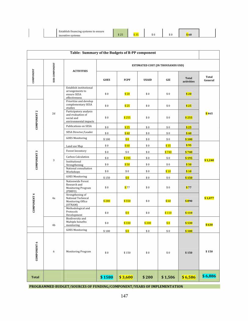
147
Establish financing systems to ensure
incentive systems $ 25 $ 35 $ 0 $ 0 $ 60
Table: Summary of the Budgets of R-PP component
CO
MP
ON
EN
T
SU
B-C
OM
PO
NE
NT
ACTIVITIES
ESTIMATED COST (IN THOUSANDS USD)
GOES FCPF USAID GIZ Total
activities
Total General
2d
Establish institutional arrangements to ensure SESA effectiveness
$ 0 $ 20 $ 0 $ 0 $ 20
$ 465
CO
MP
ON
EN
T 2
Prioritize and develop complementary SESA studies
$ 0 $ 25 $ 0 $ 0 $ 25
Participatory analysis and evaluation of social and environmental impacts
$ 0 $ 255 $ 0 $ 0 $ 255
Publications on SESA $ 0 $ 25 $ 0 $ 0 $ 25
SESA Director/Leader $ 0 $ 40 $ 0 $ 0 $ 40
GOES Monitoring $ 100 $ 0 $ 0 $ 0 $ 100
CO
MP
ON
EN
T 3
3
Land use Map $ 0 $ 60 $ 0 $ 35 $ 95
$ 1,240
Forest Inventory $ 0 $ 0 $ 0 $ 740 $ 740
Carbon Calculation $ 0 $ 195 $ 0 $ 0 $ 195 Institutional Strengthening $ 0 $ 50 $ 0 $ 0 $ 50
National consultation Workshops $ 0 $ 0 $ 0 $ 10 $ 10
GOES Monitoring $ 150 $ 0 $ 0 $ 0 $ 150
CO
MP
ON
EN
T 4
4a
Nationwide Forest Research and Monitoring Program (PIMFO)
$ 0 $ 77 $ 0 $ 0 $ 77
$ 1,077 Strengthening of National Technical Monitoring Office (OTNAM)
$ 280 $ 550 $ 0 $ 60 $ 890
Methodological and Protocols Development
$ 0 $ 0 $ 0 $ 110 $ 110
4b
Biodiversity and Multiple benefits monitoring
$ 0 $ 330 $ 200 $ 0 $ 530 $ 630
GOES Monitoring $ 100 $ 0 $ 0 $ 0 $ 100
CO
MP
ON
EN
T 6
6 Monitoring Program $ 0 $ 150 $ 0 $ 0 $ 150 $ 150
Total
$ 1580 $ 3,600 $ 200 $ 1,506 $ 6,586 $ 6,886
PROGRAMMED BUDGET/SOURCES OF FUNDING/COMPONENT/YEARS OF IMPLEMENTATION

148
FUNDING SOURCES 2012 2013 2014 2015 TOTAL
COMPONENT 1a
GIZ $ 53 $ 134 $ 85 $ 60 $332
FCPF $22 $ 66 $ 90 $ 90 $ 268
Government (GOES) $65 $ 100 $ 100 $ 85 $ 350
Total $140 $ 300 $ 275 $ 235 $ 950
COMPONENT 1b
FCPF $ 28 $ 142 $ 142 $ 77 $ 389
Government (GOES) $ 10 $ 30 $30 $30 $ 100
Total $ 38 $ 172 $ 172 $ 107 $ 489
COMPONENT 1c
FCPF $ 43 $ 155 $ 160 $ 110 $ 468
Government (GOES) $ 10 $ 30 $ 30 $ 30 $ 100
Total $ 53 $ 185 $ 190 $ 140 $ 568
COMPONENT 2c
FCPF $ 0 $ 183 $ 118 $ 32 $ 333
GIZ $ 34 $ 0 $ 0 $ 0 $ 34
Government (GOES) $ 25 $ 25 $25 $25 $ 100
Total $ 59 $ 208 $ 143 $ 57 $ 467
COMPONENT 2b
FCPF $ 0 $ 70 $ 95 $ 0 $ 165
GIZ $0 $100 $55 $30 $185
Government (GOES) $ 20 $ 60 $60 $60 $ 200
Total $ 20 $ 230 $ 210 $ 90 $ 550
COMPONENT 2c
FCPF $ 0 $ 135 $ 55 $ 10 $ 200
Government (GOES) $ 10 $ 30 $30 $30 $ 100
Total $ 10 $ 165 $ 85 $ 40 $ 300
COMPONENT 2d
FCPF $ 10 $ 160 $ 135 $ 60 $ 365
Government (GOES) $ 10 $ 30 $ 30 $ 30 $ 100
Total $ 20 $ 190 $ 165 $ 90 $ 465
COMPONENT 3
GIZ $40 $ 5 $740 $0 $785

149
FCPF $ 0 $ 305 $ 0 $ 0 $ 305
Government (GOES) $ 0 $ 50 $ 50 $ 50 $ 150
Total $ 40 $ 360 $ 790 $ 50 $1,240
COMPONENT 4a
FCPF $ 0 $ 187 $ 240 $ 200 $ 627
Government (GOES) $ 0 $ 130 $ 90 $ 60 $ 280
GIZ $ 0 $ 60 $ 100 $ 10 $ 170
Total $ 0 $ 377 $ 430 $ 270 $ 1,077
COMPONENT 4b
FCPF $ 0 $ 150 $ 95 $ 85 $ 330
USAID $ 0 $ 70 $ 65 $ 65 $ 200
Government (GOES) $ 0 $ 40 $ 30 $ 30 $ 100
Total $ 0 $ 260 $ 190 $ 180 $ 630
COMPONENT 6
FCPF $ 50 $ 30 $ 40 $ 30 $ 150
GRAN TOTAL $ 430 $ 2,477 $ 2,690 $ 1,289 $ 6,886

150
BUDGET BY YEAR OF IMPLENTATION AND FUNDING SOURCE
FUNDING SOURCE 2012 2013 2014 2015 TOTAL
Government (GOES) $ 150 $ 525 $ 475 $ 430 $1580
GIZ $127 $299 $980 $100 $1,506
USAID $ 0 $70 $65 $65 $200
COUNTERPART TOTAL $277 $894 $1,520 $595 $3286
FCPF TOTAL $153 $1,583 $1,170 $694 $3,600
GRAND TOTAL $430 $2,477 $2,690 $1,289 $6,886

151
COMPONENT 6. Monitoring and Evaluation Framework Program Design
The monitoring component has been developed following the structure of the document so as to facilitate the analysis and allow an evaluation of the performance and monitoring of the implementation of activities in the various components. The different indicators and means of verification proposed permit verification as to whether they are getting the expected products with the effectiveness and efficiency contemplated in the RPP document.
The MARN REDD+ Unit will be responsible for implementing the monitoring program, and shall submit regular reports to the PREP-REDD+ Advisory Council, and SINAMA, to be properly socialized with Environmental Units and Territorial Coordination Work groups. Below is the table describing a set of criteria, the products, and the means of verification that will monitor progress of the implementation of activities during the Readiness Preparation for El Salvador each Component.
Component 1: Organization and Consultation
NUMBER INDICATOR CRITERIA PRODUCT INSTRUMENTS/ MEANS OF
VERIFICATION
Component 1.a Management Arrangements for Readiness
1.a.1
There is a basic structure for the management of Readiness whose levels, integration and representation of all stakeholders, allow the proposal of actions for the preparation and monitoring of the development of the REDD+ Strategy
The REDD+ strategy in El Salvador, is based on a platform of participation and interagency and cross-sectional coordination, fully incorporating and ensuring synergy between sectoral policies and national and local initiatives.
SINAMA Minutes or Aide Memoires (National Environment Management System).
Minutes or Aide Memoires on Advisory Council meetings for the National Ecosystem Restoration and Landscapes (PREP REDD +)
1.a.2
The capabilities necessary to support the preparation and implementation of REDD+ Strategy, clarity of roles, functions, communication, and cooperation mechanisms at operational levels exist.
Processes Strengthening Environmental Units SINAMA in course
Disemmination process on the vision of "Mitigation based on Adaptation" of the National REDD+ Strategy.
Workshops held; List of Participants
Aide Memoire or minutes from meetings of the Environmental Units and Permanent Territorial Work groups.
Component 1.b Information sharing in order to build dialogue
1.b.1
A process of dissemination and
Development of workshops and roundtable discussions on REDD+
Aide Memories of the workshops held
Component 6. Designing a Monitoring and Evaluation Framework Program

152
early dialogue with stakeholders on REDD+ strategy in El Salvador has been developed.
List of participants at each of the workshops
Component 1.c Consultation Mechanism
1.c.1
The Objectives, content and participants of the consultation process for the preparation and implementation of REDD+ Strategy were defined in a participatory manner.
System of Consultation, Content of consultation and stakeholders to consult defined.
Plan of Consultation and Disemmenation for REDD+ Strategy.
1.c.2
A wide and representative consultation process has been developed
Consultation carried out. Aide Memories of Workshops, Meetings and Debates.
1.c.3
There has been a process of socialization and validation of the results of the consultation.
Consultation process socialized and validated.
Document validated, Aide Memoires on Consultation.
1.c.4
Consolidation and start up of REDD+ Strategy, has socialization, monitoring and accountability mechanisms.
REDD+ Strategy published and socialized.
Minutes of the socialization events
REDD+ Strategy Document published.
Component 2: Development of the Strategy
NUMBER
INDICATOR CRITERIA PRODUCT
INSTRUMENTS/ MEANS OF VERIFICATION
Component 2.a: Policy Evaluation and Building Strategy Scenario
2.a.1
The main points of deforestation in El Salvador have been identified and characterized.
Deforestation points identified and characterized.
Analysis document on the deforestation drivers and sources in El Salvador.
2.a.2
The lines for implementation and intervention strategies to reduce emissions from deforestation and forest degradation in El Salvador have been prioritized.
Strategic lines of intervention designed.
Document on strategic guidelines.
2.a.3
The place and manner of intervention to increase forest carbon stocks have been identified in a participatory manner.
Strategic lines of intervention designed.
Document on strategic guidelines.
Component 2b: Strategy Options
2.b.1
Goals and objectives, and implement actions and initiatives to meet the drivers, reduce emissions from deforestation and forest degradation and increase carbon stocks were defined.
Application of different instruments and REDD+ strategic initiatives proposals.
Restored ecosystems and landscapes, with recovery of key ecosystem services, conservation of biodiversity and the reduction of social and environmental risk.
Report of intervention and implementation of the various instruments and strategic REDD+ proposals.

153
Component 2.c: Implementation Framework
2.c.1
Have there been any institutional arrangements that make the implementation of the strategy through political arrangements and the necessary regulation possible?
Interagency Strategy implementation Framework defined.
REDD+ Strategy Document
2.c.2
There is a legal framework for the development of the strategy that defines the rights over carbon reductions.
Regulatory framework determining the rights over carbon reductions.
Standards adopted
2.c.3
The distribution system for benefits generated by REDD+ implementation have been defines, socialized and validated.
Benefit Distribution Mechanism socialized and Validated.
Instruments generated and REDD+ Strategy Paper Document
Component 2.d: Social and Environmental Impacts caused by the development of strategy.
2.d.1
The main social and environmental impacts resulting from the implementation of REDD+ Strategy have been identified in a participatory manner
Diagnosis of social and environmental impacts for the development of safeguards. Identification and assessment of existing environmental and socio-economic conditions whose dynamics establish a place for constraints and opportunities in the design of the alternative actions.
SESA Document and aide memoire Workshop
2.d.2
The selected REDD+ strategy measures and options that better serve and have the least social and environmental impact have been identified.
Careful attention to REDD+ safeguards
Report on the Implementation of the REDD+ Strategy and attention to safeguards.
Component 3. Reference Level Development:
NUMBER
INDICATOR CRITERIA
PRODUCT INSTRUMENTS/ MEANS OF
VERIFICATION
3.1
A set of criteria for modeling the dynamics of forest cover based on physiographic, biological, social and economic aspects that condition existing livelihoods and affect present and future rates of deforestation and degradation have been defined and approved.
Methods for the mapping of land use. Digital elevation land map in 1:1000 scale, forest inventory and carbon map through consultation and validation workshops.
Document with Reference Levels.
Workshop aide memoires
3.2
Methodologies to project deforestation trends identified
Methods and models for developing scenarios of deforestation identified and applied.
Deforestation Scenarios document.
3.3
Deforested areas that require action to recover key ecosystem functions have been identified.
Methods and models for the preparation of restoration and increased carbon stocks scenario.
Restoration and increased forest carbon stocks scenarios Document.
3.4 There is technical personnel Technical capacities and equipment List of Technicians.

154
trained on the various methodologies used, and the equipment (hardware) and program (software) required.
installed and operating.
Aide Memoires of training workshops.
Hardware and software inventory.
Component 4: Monitoring System
NUMBER INDICADOR CRITERIA PRODUCT INSTRUMENTS/ MEANS OF
VERIFICATION
Component 4.a: Emissions and removals
4.a.1
An implementing unit for the system of monitoring, reporting and verification of REDD+ has been set up.
Specialized Monitoring Unit installed.
Unit Operational Plan developed and implemented.
4.a.2
Protocols to monitor, report and verify emissions reductions and removals or increase carbon stocks exist.
MRV Platform established.
MRV Platform developed.
4.a.3
There are technicians trained in the different monitoring methodologies used, and equipment (hardware) and program (software) required.
Monitoring techniques capacities and equipment installed and operating.
Aide Memoires on Monitoring and Evaluation workshops.
Hardware and software inventory.
Component 4b: Multiple benefits, other impacts and Governance
4.b.1
There is a system to evaluate the impacts and multiple benefits of REDD+ activities.
List of social and environmental indicators identified and validated.
Evaluation and Control report.
4.b.2
Will there be an evaluation of the implementation of the safeguards developed on the social and economic impacts that will come about under the framework of the REDD+ Implementation?
System on information with regard to the attention given to the compliance with established safeguards.
Report on REDD+ Safeguards attention.
Component 5: Program and Budget
NUMBER INDICATOR CRITERIA PRODUCT INSTRUMENTS/ MEANS OF
VERIFICATION
5.1
There is financial planning and a system monitoring budget execution for the different activities with regard to the connection and articulation of the products to be obtained from the main RPP themes.
RPP preparation Budget monitoring Program.
Budget Advance Report.
Component 6: Design of a Monitoring and Evaluation Program
6.1
There is a Monitoring and Evaluation program designed.
List of Indicators and Monitoring
Program developed. Monitoring and evaluation report

155
Budget 6. Design a Program Monitoring and Evaluation Framework Suggested Annexes for the R-PP (Optional)
Main Activity Sub-Activity Estimated Cost (in thousands)
2012 2013 2014 2015 Total
Monitoring Program
Preparation of Software $ 20 $0 $ 0 $ 0 $ 20
Monitor Specialist $ 25 $25 $ 25 $ 25 $ 100
Control and accountability Workshops. $ 5 $ 5 $ 5 $ 5 $ 20
Mid-term Report $ 0 $ 0 $ 10 $ 0 $ 10
Total $ 50 $ 30 $ 40 $ 30 $ 150
FCPF $ 50 $ 30 $ 40 $ 30 $ 150

156
ANNEXES

157
ANNEX 1. ADDRESSING TERRITORIES AND LANDSCAPES IN THE PREP
Criteria for selection of the Territories
The nature of the PREP effort in the design and start up stage makes it necessary to contemplate various elements simultaneously. The criteria for the selection of the sites where the work should start should represent the challenges of adaptation, or in other words reduce vulnerability to the impacts of climate variability and, at the same time, present conditions for mitigation actions based on adaption. In almost all options within the country, this possibility exists. Thus, the work of selecting the territories has been done with the dual purpose.
There are other criteria which are important to note: firstly, the need to start working on smaller scale areas (socially, technically and financially manageable) which demonstrate a high value, and that the selected sites show characteristics of ecosystemic vulnerability.
In its initial phase (July-December 2011) other key criteria were developed to determine where to start the job. The criteria were: • What constitute territories with high levels of vulnerability to the above mentioned climate change-related impacts. • The landscape and important ecosystem challenges along the Rio Lempa should be represented because of their importance in the provision and regulation of both water and electricity generation, and its increasingly more commonplace overflow which cause floods and disasters. • Geographical position in the watershed and illustrative capability by making the largest and most important river in the country visible. • Differences in the geology, structure and behavior of soil, slopes, different levels of experimentation with agro-livestock conservation practices, differences in the predominant crops, different models of land ownership, proximity to various kinds of wetlands. (It is necessary to review each particular ecosystem). • There must be a potential to conduct at least 3 REDD+ actions. • There should be a minimum level of local organization (civil society and municipalities): while the 'territories' can be constructed based on natural, geographic, scientific and criteria of another nature, it is recognized that they are also constructed socially.
Counting on a minimum level of capacity in the population and its productive, communitarian organizations and interest groups etc. is fundamental to the process of starting up PREP-REDD+, to represent and be involved in consultations and discussions among themselves and with the various state entities. They must also have significant social capital to accelerate learning and restoration actions, generating lessons for areas with less organizational capacity. The weight of each criterion is not the same in each region, however, the national scope of PREP/ REDD+ makes it necessary that from the start of the program a balance is sought in the number of sites with locally "installed" social capacity, the management capacity of the state agencies and the available budget, which as a whole represents a nationwide vision.

158
The process of discussion and search for territories lasted several months involving entities within the MARN, between the MARN and MAG, the Technical Secretariat of the Presidency (STP) and taking into account the technical criteria of the work involving the Ministry of Public Works (MOP) and Power Plant (CEL). In this same period, the MARN team, with the help of NGOs with a longstanding relationship with social land managements, a process of systematic inquiry and discussion was undertaken with organizations in the territories themselves. The extreme event of Tropical Depression 12E, revealed the need to advance the process of the evaluation of possibilities and limitations of working in each area in preparation for the next agricultural cycle.
The three initial territories are: A - The territory of the Bajo Lempa including the municipalities of Zacatecoluca, Tecoluca and Jiquilisco. The municipalities that border both sides of the Rio Lempa in its delta.
Features: • Alluvial (sedimentary, clay) and recent volcanic • Different structure and behaviors to the watershed above • Region of the country's best agricultural soils (even with its high levels of contamination) • Greater crop diversity but a greater evidence of monoculture on a much larger scale • Increased legal and de facto landlordism (cane cultivation, possibly cattle) • Presence of complex agroforestry systems (shade coffee) and protected areas • Experience with conservation and organic practices (small scale), combined with highly harmful practices on a large scale. • Well developed organizational capacity
B- The territory located in mid Basin and includes the municipalities of Cinquera,
Suchitoto and Jutiapa
Features: • Quaternary Geology, but with lower levels of decomposition • Structure and behavior of different soils (less infiltration, less erosive) than upper Basin • Lower percentage of high slopes in landscapes than in upper Basin • Increased diversity of crops (cattle on a larger scale) • Presence of forests, protected areas and wetlands • Less experience with conservation practices of all kinds • Tenure combined with small farms with medium sized property • Organizational capacity moderately high
C- The territory that is part of the upper basin known as La Montañona, (with parts of six municipalities that comprise it)
Features: • Quaternary Geology, older and in a state of decomposition

159
• Structure and behavior of different soils • Prevalence of high slopes and rugged topography • Prevalence of basic grain agriculture and small-scale livestock • Presence of forests, protected areas and wetlands • Increased social experience with conservation practices (planting in contours, zero tillage, live barriers, stubble management, etc.) • Predominance of small farms • High organizational capacity
It is important to take note that there will be a sub-group of municipalities in these regions that will be prioritized for the first agricultural cycle, in accordance with the funding and human resources available to start work. The idea is, as work is carried out in the first cycle (2012) and funding is found work would expand in the selected territories.
The funding approach focuses on small, medium producers and cooperatives. Another approach will be used with large producers (industrial cane, coffee and livestock).
Participating Funds: • Small Grants Program of El Salvador-GEF • FIAES-Wetland Donations Programs • Several mangrove-reef projects (P, TyBiodiversidad, Taiwan, etc) • Biodiversity and Agrobiodiversity Project-USAID

160
Geographical location of work zones in El Salvador (PREP/REDD +)

161
A - Bajo Lempa Territory
B-
Media-Cinquera Basin Territory
C- Alta Cuenca Territory

162

163
ANNEX 2. WORKSHOPS, MEETINGS, AND CONSULTATIONS ON REDD+ THEME

164

165
REDD GIZ CCAD Control Program Workshop with Focal Points and Program Coordinators, the Ministries of the Central American region.
11/23 and 24 /2011
San Salvador.
Objective: • Presentation of overall progress of the Regional Agenda for 2011, review of Regional Agenda issues and the validation of eight priority issues for the region and their deviations.
Results Obtained: • Establish priorities for 2012 and corrective actions to take. • Reflection on regional leadership space. • Establish future Agreements.
Control Meeting of Technical Regional Forest Monitoring Group
10/27 y 28 /2011
San Salvador.
Objective: Prioritize work plan actions of the Regional Monitoring Group. The technical liaisons of the CCAD.GIZ REDD Project participated.
Mesoamerican Dialogue on Forests, Governance and Climate Change, between the Ministers of Environment of El Salvador, Guatemala, Honduras and representatives of institutions from the Governments of Costa Rica, Panama, Nicaragua.
9/8 /2011
San Salvador
Objective: • Provide a space for open dialogue between decision-makers and civil society stakeholders on critical issues related to climate change, the role of forests, mechanisms such as Reducing Emissions from Deforestation and Forest Degradation • Deepen the implications for rights, tenure and territorial governance in Mesoamerica.

166
REDD+ RELATED WORKSHOPS HELD IN EL SALVADOR
WORKSHOP DATES PROGRESS
Exchange of experiences between Specialists in Forest Carbon Project Finance, Carbon Markets and Clearing, aimed at the implementation of projects
02/28 and 29 /2012
San Salvador.
Objective: Exchange of experiences to guide actions for the implementation of forest carbon projects in Central America and the Dominican Republic.
Results Obtained: • Consensus on procedures and requirements for the implementation of forest carbon projects in the region, and the establishment of a network for the exchange of information, experiences and best practices. • Preparation of a Roadmap for key actions to consider in establishing compensation mechanisms and pilot projects in the region. http://www.reddccadgiz.org/noticia.php?id=114.
http://www.reddccadgiz.org/noticia.php?id=114
Workshop for the Characterization and valorization of the geographic areas for the implementation of a pilot REDD PLUS.
01/25 /2012
San Salvador.
Objetive
Share the particular objective of REDD El Salvador.
Results Obtained: Overview of REDD Potential and the areas defined by PREP.
Discussion on Forest Monitoring Systems in the framework of the development of activities of the REDD / CCAD-GIZ program in Central America with representatives from CATIE, FAO, INPE, USFS, Rainforest Alliance, United States Forest Service and CATHALAC-SERVIR among others.
12/13 and 15 /2011
San Salvador.
Objective:
• Discuss the minimum requirements for monitoring forest resources and the implementation of monitoring systems, with the vision that they become management tools to improve forest management. Results Obtained: • Promote the implementation of measures to halt the destruction of forests. http://www.reddccadgiz.org/noticia.php?id=110

167
WORKSHOP DATES PROGRESS
REDD PLUS Program (RPP) Planning Workshop under the framework of Ecosystem Restoration and Landscapes PREP, with the participation of the Ministry of Agriculture and Livestock and the Ministry of Environment and Natural Resources.
22 /02/2012
San Salvador.
Objective:
Planning of the National REDD Strategy PLUS under the Landscape Restoration Program and Ecosystems..
Results:
Establish Strategic MAG-MARN Alliance.
REDD PLUS Planning Program Workshop in the Context of the Landscape Restoration Program. (PREP) with MARN Team and strategic areas related to the subject within the Ministry.
23 and 24/2/2012
San Salvador.
Objective: • Planning the National REDD PLUS Strategy under the framework of the landscapes and ecosystems Restoration Program.
Presentation of REDD Plus approach based on mitigation, where representatives of MARN, Coordinator of Indigenous Communities of the Secretariat of Culture of the Presidency were present.
03/16//2012
Sonsonate.
Objective: • Presentation of the approach and focus of the Environmental Policy and Climate Change thematic Results: • Promotion of Awareness of the National Environmental Policy.
.
PREP conception Workshop involving CATIE (FINFOR), UNDP, PRISMA, MAG and MARN staff.
28 /02/2011
San Salvador.
Objective: Restoration Approach for risk reduction.
Results: • An approved Restoration Program policy. • Visit territories, seeking to promote construction processes of institutional arrangements, moving towards governance. • Identified local indicators that contributed to a national monitoring program.

168
WORKSHOP DATES PROGRESS
Submittal of proposal to eradicate the practice of burning sugar cane with
7/26/2011
San Salvador
Objective: Coordinate the initial actions for the establishment of a green harvest process

169
Sugar Industry Representatives (producers and refineries), representatives from MAG, MARN and Salva Natura.
Results: Identification of variables involved in the production and cutting sugar cane process Definition of a roadmap
Meeting with Roberto Codas (sugar work group) and representatives of MAG, MARN and sugarcane industry sector.
8/10/2011
San Salvador
Objective: • Presentation of the experience of growing Organic sugar. Results: • Agreement to request sugar refinery work plan for the 2011-2012 harvest.
Meeting with sugarcane work group , Representatives from MARN, MAG and Agro sugarcane Industry Sector.
8/20 /2011
San Salvador
Objective: Know the current state of the sugar industry Present green harvest sugar refinery sector plans Results: Obtain the approval of the Ministers of MARN and MAG for the sugar industry plans.
Meeting with Representatives Ian Cherett and MARN. Representatives.
8/10/2011
San Salvador.
Objective: • Presentation on sustainable agriculture for the PREP approach and strategy.
Meeting with Juan Rene Guzman (UNDP) and UNDP and MARN representatives.
10/12 /2011
San Salvador
Objective: • Presentation of SGP support for PREP.
Meeting with Director of CENTA (Dr. Rene Rivera) and MARN Representatives.
10/13/2011
San Salvador
Objective: • Presentation of the Ecosystem Restoration and landscapes Program (PREP). Results: • Agreement on technical cooperation partnerships between CENTA and MARN.
Meeting with FAO, MARN Representatives and Jaime Tobar.
(I will give the details to Nelson).
10/13/2011
San Salvador
San Salvador
Objective: • Presentation PESA Project

170
ANNEX 3. METHODOLOGY TO USE AND FREQUENCY OF DATA COLLECTION
For monitoring changes in carbon stocks (carbon stock change method) the measurements proposed are:
1-Forested areas: permanent sample plots (PSP) will be established using stratified systematic sampling (SSS) which consists of the selection of plots from a rigid pre-established scheme in order to cover all the project area and enable the estimation of the next average of the true value detecting most of the population variation. These PSP are intended to provide an understanding of forest response to interventions either through silvicultural harvesting or treatments over time and the calculation will be per plot. Likewise, they will help provide data on predictions of tree growth such as: diameter, average biomass, height, basal area and/or total volume or trade and other factors affecting growth and variability in annual increments. The plots will cover 50x50 meters in forest areas and 20x25 in agroforestry or plantation areas, where measurements will be made of all individuals with a dbh greater than 5 cm. Height will be measured with a digital hypsometer, this recommendation is for natural forest and agroforestry systems. The four places where carbon can be stored will be considered: on the ground (herbs and woody stems), below ground (roots), dried leaves and dead wood and in the soil.
2-Agroforestry Systems: To assess woody species in agroforestry systems, the plot size should depend on the type, age and density of the ecosystem. We recommend using rectangular and square plots of 20 x 100 m, to measure trees and palms with dbh greater than 30 cm, and subplots of 5 x 40 m for smaller individuals with dbh between 5 to 30 cm. To estimate the total biomass allometric equations will be used for reference in accordance with local conditions (climate, ecosystem, species and diameter). It should be pointed out that allometric equations of forest species in tropical forests are mainly based on a single variable, the diameter at breast height (dbh). These allometric equations will allow the above ground biomass of these species in agroforestry systems to be estimated. In the case of forest species which constantly suffer pruning management (lower than 1.3 m in height), or with multiple trunks, it is recommended that allometric equations be set from basal diameter.
3-Crops and fallowed land: To evaluate carbon fixation temporary plots can be used where trees are combined with annual crops, in order to assess biomass at the end of the annual cycle. In these areas circular plots of 400 square meters (11.28 m radius) shall be established and then to estimate the total biomass allometric equations adapted for Central America shall be used. All scattered trees with a dbh above 5 cm will be included and the height of the same estimated. Measurements will be made in the four places where carbon can be stored: on the ground (herbs and woody stems), below ground (roots), dried leaves and dead wood and in the soil. (80% of the carbon is approximately in the silt -clay fraction). The parameters to be measured will be wood density, samples and calculations of herbs, woody stems, leaves, soil, dead plant matter and roots. Allometric equations for estimating aboveground biomass (kg dry matter per tree) in isolated trees (scattered) is Log10 Y = -2.18062 + 0.08012 (dbh) -0.0006244 (DAP2) (Ruiz 2002) and Y = 4.5 + 7.7 * H for palms (Frangi and Lugo 1985).
4 - The measurement and estimation of tree root biomass: According to Schlegel et al. (2001),

171
to take an inventory of roots it is necessary to carry out complete excavation. The roots are the carbon "store" below ground. Fixation values may be obtained by direct measurement or estimated from data taken from literature. We can estimate the fixation value in a percentage of 10 to 15% relative to the above ground biomass calculated in our system, this is a low percentage. In existing literature on the above ground biomass relation: root of some types of land uses, and can be used to set the value of carbon fixation. The formulas for these cases are:
Formula for all types of forests: Y = exp [-1.085 + 0.9256 • ln (BA)] r2: 0.83
Formula valid for tropical forests: Y = exp [-1.0587 + 0.8836 • ln (BA)] r2: 0.84
Where:
Y = root biomass in tonnes of dry matter per hectare (t DM/ha)
ln = natural logarithm, exp = "elevated to power of"
BA = biomass in tonnes of dry matter per hectare (t DM/ha)
Sample size for building models: 151 individuals (trees)
5 - Soil Carbon: To quantify the carbon in soil we need to determine its apparent density and carbon content in a laboratory. In the field sampling can be taken as follows:
a) Carbon content. For sampling we can choose from:
i) Collecting the sample in the center of the site. A 30 cm depth pit is dug, the soil extracted is homogenized and passed through a 5 mm sieve. From the ground it is passed through the mesh so we get our sample. The amount to collect will depend on the requirements of the laboratory where we do our analysis. This procedure has the disadvantage that the sample cannot be sufficiently representative on taking the sample at a single point.
ii) Taking the sample at various points within the site. Take the sample at different points gives us the opportunity to have a more representative sample.
The selection of points is done randomly. It may be the same in which samples are taken from leaves or herbs. Samples are taken at depth increments (0-10 cm, 10-20 cm and 20-30 cm) (Annex 4). The samples obtained in each of the four points are mixed to obtain a composite sample for each depth increment.
b) Apparent density. It is convenient to determine the apparent density by depth increments. Samples will be taken in the field depending on the method we use to for their determination.
i) Test tube Method. 100-200 g of soil may be sufficient for subsequent processing in the laboratory. The same sample can be used for determining the carbon content in soil. It is a simple method that has the disadvantage of not being very reliable.
ii) Method of a cylinder of a known volume. We need a cylinder of a known volume to be used to extract the soil. When using this method it is preferable to take additional samples to determine the carbon content in the soil.

172
Dry biomass: To consider the fraction of carbon in dry biomass (or carbon-factor CF). The generic value reported by the IPCC (Intergovernmental Panel of Climate Change) of 0.5 will be used. It becomes necessary to consider the different types of coverage with regard to natural forests, forest remnants and agroforestry systems whose floristic composition is very diverse at a level of wood density, basal area, biomass among other characteristics.

173
ANNEX 4. ECOLOGICAL LANDSCAPE MONITORING
VERIFIERS AND INDEXES
There are several indexes to quantify whether the structure at the landscape level is unchanged, including (Forman and Godron 1986, Dale et al. 1994, McGarigal and Marks 1995, Stork et al. 1997).
Patch area: is the total area of the patch of interest and is the basic measure for landscape structure studies
Patch wealth: is the number of patch types in the landscape. This index is important as many organisms are present in a single patch type, therefore the richness of a patch can be correlated with the richness of species (McGarigal and Marks 1995). Based on the wealth of a patch diversity indexes can be estimated (Shannon – Wiener Index - landscape-level) (Lapin and Barnes 1995).
Inner Patch habitat: is the area within which no edge effects occur in the patch of interest. A reduction in the habitat interiors of a conservation area has strong effects on species that are being conserved, since the inner habitat where the species can survive is being diminished. The delimitation of the inner habitat is important for conservation since the reduction of the total area of the patch provides information on the reduction in the core area which is in most cases is much higher (Figure A4.1).
Figure A4.1. Reduction of total habitat and interior habitat of patches in forests
Bigger patches of each type of vegetation: It is thus calculated because the ecological characteristics of the landscape may be closely related to the characteristics of the larger patch. The more information about the patch may provide tools for determining the

174
viability of populations, since a population may not persist in a patch inferior to its range of distribution.
a) Dominance: This index measures how common is a type of patch on the landscape, and it is measured based on the relative abundance of each patch type in the landscape. It can serve as an indicator of the degree to which a species that depends on a particular type of habitat can be spread over the landscape (Figure A4.2).
b) Contagion: This index measures the aggregation of the various types of patches in the landscape. It is an important index for species that require contiguous areas of a particular type of ecosystem for survival (Figure 2). High values of contagion occur in landscapes with large, contiguous patches while landscapes with many small, scattered patches are characterized by low values of contagion.
c) Fractal dimension: a measure of the relative perimeter / area indicating the complexity of shape of each type of patch. Natural areas tend to have more complex shapes than areas altered by man. The differences in this index can influence the diversity of species living on the edges or requiring multiple habitats (Figure A4.2).
d) Porosity: is a measure of the density of patches in the landscape. Porosity is a feature of the landscape matrix and to measure it one simply counts the number of patches present (understand patches as areas with closed borders). Porosity is a variable that can positively or negatively affect the connectivity of the matrix (Figure A4.2).
a) DOMINANCE
HIGH LOW

175
b) CONTAGION
HIGH LOW
c) FRACTAL DIMENSION
HIGH LOW
d) POROSITY
HIGH P= 9 LOW P=1
Figure A4.2. Graphic representation of the meaning of the indexes of dominance, contagion, and fractal dimension. Modified from Dale et al. (1994) and Forman and Godron (1996).

176
Minimum, maximum and average distance between two patches of the same type of ecosystem: distant patches from a same type of ecosystem can prevent certain species from moving between them, unlike when the distance between patches is small, even species with the least capacity to move can manage to connect between the patches.
Edge amount of each type of patch: elongated patches with complex shapes can serve as corridors for the dispersion of some species, while having the effect of strong edge for others. The measurement of the forest area between the different types of vegetation in a landscape can be useful when compiling the habitat available for species that prefer or avoid certain types of ecosystems.
Landscape structure and conservation
Joint analysis of changes in the structural measurements of the landscape can allow important aspects for ecosystem conservation in the landscape to be concluded. For example, when the number of edges, the fractal dimension, contagion and dominance decrease, then the landscape is becoming a less fragmented and more connected landscape. Also these measures analyzed as a whole can be related to the behavior of certain species that inhabit the landscape.
The ability to cross patches depends not only on the distance between patches but also on the existence of such corridors and the type of landscape corridor (Figure A4.3). The corridors or conduits serve as barriers to the movement of many animals, plants, materials and water. Species able to move through a well connected landscape matrix may see their mobility inhibited by the existence of narrow connections between nearby patches, while the species that move from patch to patch limit their movement if they have to cross long distances between patches present in a matrix with a low porosity (Forman and Godron 1986).
The landscape-level connectivity is highly dependent on the scale, as organisms with different dispersal mechanisms would vary significantly. Moreover, the sensitivity and importance of a landscape structure and its connectivity also depend on the scale of the organism that perceives this connectivity and scale that this connectivity measures Keitt et al. 1997). Dunning et al. (1992) mention other important aspects for the conservation dependent on the spatial configuration of the landscape:
Complementary habitats: This refers to when a species requires resources in different habitats depending on the stage of the life cycle that it is going through. The landscapes that have complementary connected habitat patches have larger populations than those with isolated or distant these habitats.
Additional Habitats: When one or more species that need large habitats to survive, are present in small habitats, since they can feed on neighboring patches.
Donor and receptor habitats: When a relatively productive habitat (donor) functions as donor organisms to other less productive habitats (receptors). It is critical to identify these types of habitats if you really wish to effectively conserve biodiversity, because if conservation measures are taken in receptor habitats but not in donors habitats, populations will decline and disappear because the destruction of donor habitats may lead to the extinction of receptors.

177
Applying the concepts directed at the conservation of natural areas, it can be said that even when protected areas should be as large as possible, their value as a shelter depends ultimately on their distribution in the landscape and their integrity. Theoretically maintaining or generating undisturbed ecosystems corridors that connect the fragments that can be used as a shelter should be focused on. There are few studies to confirm and determine the real value of such corridors in tropical ecosystems (Boyle and Sayer 1995).
Figure A4.3. Graphic representation of the effect of the types of corridors on the mobility of organisms throughout the landscape. Shaded areas indicate conditions that inhibit displacement. Taken from Forman and Godron (1986).
Bibliography
1. Forman, R.; Godron, M. 1986. Landscape Ecology. John Wiley y Sons. Canada. 619 p.
2. Dale V.; Offerman H.; Frohn R.; Gardner, R. 1994. Landscape characterization and biodiversity research. En: Boyle T B J y Boontawee B 1994 Measuring and monitoring biodiversity in tropical and temperate forest. Proceedings of the IUFRO Symposium held at Chiang Mai, Thailand. 1994. 47 – 65.
3. McGarigal, K.; Marks, B. 1995. FRAGSTATS: Spatial Pattern Analysis Program for Quantifying Landscape Structure. An updated version of the USDA Forest Service - Technical Report PNW- GTR-351. En: http://www.fs.fed.us/pnw/pubs/gtr_351.pdf
4. Stork, N.; Boyle, T.; Dale ,V.; Eeley, H.; Finegan, B.; Lawes, M.; Manokaran, N.; Prabhu, R.; Soberon, J. 1997. Criteria y Indicators for Conservation of Biodiversity. CIFOR Working paper Nº17. 29p. En: http://www.cifor.cgiar.org/publications/pdf_files/wpapers/wp-17.pdf
5. Lapin, M.; Barnes, B. 1995. Using the landscape ecosystem approach to assess species and ecosystem diversity. Conservation Biology 9(1): 1148-1158.
6. Keitt, T.; Urban, D.; Milne, B. 1997 Detecting critical scales in fragmented landscapes. Conservation Ecology 1(1) Art 4. http://www.consecol.org/vol1/iss1/art4

178
7. Boyle, T.; Sayer, J. 1995. Measuring, monitoring and conserving biodiversity in managed tropical forest. Commonwealth Forestry Review 74 (1): 20-25.

179
ANNEX 5. TEXT OF THE NATIONAL ENVIRONMENTAL POLICY
2012 NATIONAL ENVIRONMENT POLICY

180
Adopted by the Cabinet May 30, 2012

181
Content Presentation ...................................................................................................................................... Error! Bookmark not defined.
1. The 2012 National Environment Policy in response to a context of widespread
environmental risk ................................................................................................................... Error! Bookmark not defined. 2. Pubic consultation and its results ....................................................................................... Error! Bookmark not defined. 3. Environmental diagnosis ........................................................................................................ Error! Bookmark not defined.
Degradation of ecosystems of great value .............................................................. Error! Bookmark not defined. Widespread environmental insalubrity ................................................................... Error! Bookmark not defined. Critical state of water resources.................................................................................. Error! Bookmark not defined. Disorganized occupation of territory ........................................................................ Error! Bookmark not defined. Weak culture of environmental responsibility and compliance .................. Error! Bookmark not defined. Growing climate threat .................................................................................................... Error! Bookmark not defined.
4. Objectives of the 2012 National Environment Policy ................................................ Error! Bookmark not defined. 5. Principles ....................................................................................................................................... Error! Bookmark not defined. 6. Priority areas of action ............................................................................................................. Error! Bookmark not defined.
Inclusive restoration and conservation of ecosystems ..................................... Error! Bookmark not defined. Comprehensive environmental sanitation ............................................................. Error! Bookmark not defined. Integrated management of water resources.......................................................... Error! Bookmark not defined. Incorporation the environmental aspect into land management ................ Error! Bookmark not defined. Responsibility and environmental compliance .................................................... Error! Bookmark not defined. Climate change adaptation and risk reduction ..................................................... Error! Bookmark not defined.
7. The challenge of coordination: The role of SINAMA ................................................... Error! Bookmark not defined.

1
Presentation
On May 30th, 2012, the Cabinet the Government of El Salvador approved a new National Environment Policy. This is an important milestone as the only time this happened before was in September 2000, although the Environmental Act requires that this policy be updated at least every five years.
The 2012 National Environmental Policy retook the key concerns as regards environmental issues in the country, as expressed in the extensive public territorial and sectoral consultation carried out as part of its development process, as well as the recent studies and reports that confirm the plight of environmental degradation in the country and the increasing threat posed by climate change to El Salvador.
Faced with this problem which represents a generalized environmental risk, the 2012 National Environmental Policy proposes an ambitious global goal: To reverse environmental degradation and reduce environmental vulnerability to climate change.
This is certainly not a goal we can achieve in a few months, but it is the goal over the medium and long term that we, as Salvadorans, have set ourselves if we want a country which is less vulnerable, with real possibilities to set out on a path of sustainable economic and social development.
The six priority lines of action proposed by the 2012 National Environmental Policy present great challenges in themselves that can be the basis for a national unified agenda on environmental issues
This is about recovering degraded ecosystems and landscapes; decisively moving toward comprehensive environmental sanitation; achieving a modern and effective institutional framework for managing water resources; instating order in our territory environmentally; promoting a culture of responsibility and environmental compliance, and promoting strong decisive actions aimed at adapting to climate change and risk reduction.
This environmental agenda involves a huge national effort that must be sustained for years or even decades, so this will only be possible through coordinated State action, including the municipalities, and especially with the support and full participation of the citizenry.
As heads of the Ministry of Environment and Natural Resources we urge that all of us embrace and push this environmental agenda forward, from our particular positions, but above all as citizens fully assuming our rights and responsibilities.
A less vulnerable El Salvador, restored, clean, orderly, safe, sustainable is possible and absolutely necessary.
Herman Rosa Chavez and Dolores Lina Pohl Minister and Deputy Minister of Environment and Natural Resources Government of El Salvador

2
1. The 2012 National Environment al Policy in response to a context of widespread environmental risk
The Environmental Act requires the updating of the National Environmental Policy on at least a five year basis together with its approval by the Cabinet. This policy had not been updated since September 2000 when it was first approved. Since then a different environmental reality has arisen, one that demands answers based on the new guidelines as proposed by the 2012 National Environmental Policy.
Currently, the growing climate threat facing the country, the result of global climate change, is the greatest environmental situation acknowledged nationwide. This was also internationally recognized by the organization Germanwatch when it placed the country in the first position on the 2009 Global Climate Risk Index, following the impacts of Low Pressure IDA E96 associated with Hurricane (E96/Ida) in November 200922. Subsequent events like Tropical Storm Agatha (May 2010) and Tropical Depression 12E (October 2011) confirmed that climate variability is a growing threat to El Salvador.
The environmental issue is also now commands greater recognition by the state in view of the fact that society demands urgent responses to the worsening of environmental degradation in the country. Valuable ecosystems such as mangroves, wetlands and coffee plantations are seriously threatened. Water resources are in a critical condition. Environmental sanitation problems are widespread. The heightened disorganized territorial occupation has added to environmental degradation and generated greater risks, etc.
Environmental degradation and climate variability are obstacles to improving the quality of life and building a strong, competitive economy, able to grow and create quality jobs. It also aggravates the risk to our population, especially the poorest sector. In fact, in the 2010 Report of the Global Fund for Disaster Reduction and Recovery, El Salvador topped the list of the highest-at-risk countries in the world: 88.7% of the territory is considered as a risk area and therein lives 95.4% of the population and 96.4% of gross domestic product23 is generated there.
Faced with the reality of widespread risk, the 2012 National Environmental Policy recognizes that the central issue that must be addressed is the severe environmental degradation and the increasing vulnerability of the country with regard to climate change.
This central issue is expressed through a number of specific problems:
22
Harmeling, Sven. Global Climate Risk Index 2011. Who Suffers most from Extreme Weather Events? Weather-
Related Loss Events in 2009 and 1990 to 2009.Bonn, pag. 7.
23Global Facility for Disaster Reduction and Recovery. Annual Report 2010: Integrating disaster risk reduction and
climate adaptation into the fight against poverty. Washington, p. 96

3
Degradation of ecosystems of great value
Widespread environmental insalubrity
Critical state of water resources
Disorganized occupation of territory
Weak culture of responsibility and environmental compliance
Growing climate threat
Faced with this problem, the overall goal of the 2012 National Environment Policy is: to reverse environmental degradation and reduce vulnerability to climate change.
Reverse the degradation of ecosystems
Reverse the environmental insalubrity
Sustainable management of water resources
Environmental organization of use of territory
Foster a culture of environmental responsibility and compliance
Reduce climate risk
In line with the specific objectives, we propose the following priorities for taking action:
Restoration of degraded ecosystems and landscapes
Comprehensive Environmental Sanitation
Integrated management of water resources
Integration of the environmental issue in land management
Environmental Responsibility and Compliance
Climate change adaptation and risk reduction
The objectives and priority lines of action set forth in the 2012 National Environmental Policy are simple but highly ambitious. They require a great national effort, sustainable over years or even decades together with State coordination and the support and participation of all citizens.
To implement the 2012 National Environmental Policy the mechanism for coordination of public environmental management established in the Environmental Law will be activated: the National Environment Management Authority (SINAMA) composed of the ministries and autonomous institutions of the central government and municipalities.
However, it is important to note that a true activation of the SINAMA requires that the highest authorities of every ministry, autonomous entity and municipality, fully recognize and endorse, as required by law, that environmental management is also their responsibility and not just that of the Ministry of Environment and Natural Resources (MARN), which by law has the responsibility of coordinating the SINAMA.

4
A key task of SINAMA will be to assist in the formulation of the National Environmental Strategy and Action Plan as also required by the Environmental Act. This strategy must develop the priority lines of action, specify the concrete actions to be carried out, specify individual institutional responsibilities and identify the goals to be achieved over time.
This way, a greater coherence between the initiatives underway will be achieved and the scope of activities to assist institutional, economic and social stakeholders in the environmental problems that they face may be widened so that we can move forward in a concrete and sustainable way towards the great objective proposed: that of reversing environmental degradation and reducing vulnerability to climate change.
2. Public consultation and results
According to the Environmental Act, the public has a right to participate in the consultations leading to the definition and adoption of environmental policy (EA Article 9). Adding to this provision, the 2012 National Environmental Policy was formulated under the premise that the full commitment and participation of citizens are essential to solving the environmental problems facing the country. With this in mind, on June 5, 2011 - World Environment Day – The MARN widely disseminated the Public Consultation Document for Environmental Policy. The National Environmental Policy came into being, to inform the public about the environmental situation in the country, communicating the priorities identified by the government and facilitating regional dialogue and consultations with various sectors nationwide.
In San Salvador’s territorial consultation many issues arose, among others, were those related to wastewater treatment and water management, solid waste, herbicides and insecticides overuse, cane burning, air pollution, climate change, land management, civic participation, renewable energy, environmental incentives, reforestation, environmental education, and coordination with the private sector, environmental assessment, environmental compliance and specialized environmental courts.
Inside the country, some of these issues and other specific ones were highlighted, depending on the area of the country. In Bajo Lempa (Jiquilisco) there was a great concern about the agricultural practices related to sugar cane cultivation. It was proposed that compliance with environmental regulations be strengthened, the burning of sugar cane banned, as well as the use of ripeners and health damaging agrochemicals. In western part (Santa Ana) lack of land management and deforestation due to lot development were issues of concern, as was the problem of solid waste, which resulted in the proposal of the construction of landfills. The importance of strengthening municipal environmental units was also pointed out.
In the eastern part of the country (San Miguel) environmental sanitation was the focus. The improvements of solid waste management, wastewater treatment, trace control, and curbing pollution from waste and chemical waste were proposed. The need to ensure environmental compliance and attention to complaints were highlighted. In Cabañas (Ilobasco) the issue of sanitation also arose, this time linked to poultry and pig farms. Great

5
concern was also expressed about mining and burning cane fields. It was proposed that awareness and environmental compliance be fostered.
Women's organizations stressed that the National Environmental Policy should have a gender perspective. They expressed particular concern about the use of pesticides, water pollution, deforestation and GMOs. Initiatives promoting environmental awareness, participation, integrated water management, land management, environmental compliance, research and the rescue ancestral knowledge were proposed.
Environmental organizations proposed creating a decontamination fund with contributions from the big industry sector, awareness campaigns, rigorous implementation of rules as far as possible and the setting up of environmental courts. They also recommended promoting clean technologies and agroecological approach using native seed, eliminating reliance on agrochemicals and crop diversification. They proposed citizen policy oversight mechanisms and the strengthening of the role of environmental units. Natural protected areas co-managing organizations stressed the importance of strengthening the protection of these and the resolution of conflicts affecting them, especially those related to the squatting on land and those generating large investments.
Culture-related organizations stressed the importance of the mass media for the dissemination of environmental issues among youth and adults. They proposed generating processes that articulate cultural and artistic practices locally taking advantage of the space offered by cultural centers and zoological and child parks. They also proposed environmental incentives, strengthening the management of solid waste, environmental compliance and the creation of a responsible consumer culture.
In a meeting with young people they proposed increasing awareness and education in schools, the management of solid waste and wastewater, deforestation prevention, reforestation promotion, green agriculture, organic fertilizers, protecting ecosystems, marine wildlife monitoring, strengthening environmental compliance to prevent damage to the environment, especially vehicle emissions control, mining companies, and dams.
For chancellors and representatives of universities in the country, the National Environmental Policy and the consultation process itself were very positive, they thus considered it important that this policy outlive the period of government and that the State establish the basis for a policy involving all sectors and the public in general. They stressed that culture and environmental education were central to this effort, not only in a formal sense, but also in the informal environment through the identification of replicate examples that should be encouraged in order to generate environmental culture and education. The chancellors offered to focus university research and outreach on environmental and development issues. The specific themes highlighted were water issues, the central role of the Rio Lempa and solid waste management.
The bishops of the El Salvador Episcopal Conference showed great interest in environmental issues and expressed particular interest in specific topics, these included mining, logging, and burning practices and the use of ripeners in sugarcane cultivation, air pollution caused by buses and the case of lead contamination in Sitio del Niño.

6
A special committee on Rural Development (Rural Dialogue Group) considered it was a priority to have a national plan for adaptation to climate change, strengthening early warning systems in the most vulnerable areas of the country and strengthening risk management. They proposed curbing irrational use of agrochemicals, the encroachment of urban and industrial frontier and water pollution. They also proposed reforestation, cleaner and more efficient technologies and incentives to improve practices as well as responsible consumption. They proposed strengthening institutional environmental units, effective interagency coordination, ensuring environmental compliance, partnerships with research centers and promoting environmental citizenship.
The Executive Committee of the National Association of Private Enterprise (ANEP) said it was everyone's responsibility to prevent environmental degradation because of its high economic impact, reconciling that effort with economic growth. For this to occur they considered it necessary to have clear and predictable rules, to gradually apply the rules and to the availability of economic incentives, self-regulation and voluntary agreements. ANEP recommended strengthening environmental education and legislation to promote sorting, recycling, reuse, and solid waste reduction and the creation of associated waste collector groups. They also proposed promoting efficient irrigation technologies and public-private partnerships for wastewater treatment. In the ANEP opinion, the main challenge is to achieve a productive and diversified territory that generates economic, social and environmental benefits, with this in sight it proposed updating and implementing the National Land Management and Development Plan, the introduction of compensation and payment for environmental services, and taking advantage of carbon markets.
In short, the territorial public consultation with different sectors enabled the key environmental issues of concern to the public and social sectors to be identified. A significant dialogue was also generated in which men, women, youth, businessmen and women, environmentalists, farmers, representatives from academia and the Episcopal, among others, were able to express their concerns and contributions, achieving a participation of more than 800 people nationwide, plus 135 written submissions were received. (85) electronically or (50) by post. A notable intervention was the participation of children through written contributions such as those sent by 21 students from Centro
Escolar Cantón Ánimas de San José Guayabal, in the Department of Cuscatlán, who insisted that they want to see clean rivers, streets free of garbage and a reforested country.
3. Environmental diagnosis
Confirming the findings of the public consultation process and taking into account the most recent studies, the 2012 National Environmental Policy recognizes that the central issue that must be addressed is the severe environmental degradation and the increasing vulnerability of country to climate change.
This central problem is expressed in six specific issues:

7
• Degradation of ecosystems of great value • Widespread environmental insalubrity • Critical state of water resources • Disorganized occupation of Territory • Weak culture of environmental
Growing climate threat
Degradation of ecosystems of great value
Ecosystems are the "natural infrastructure" of the country and their recovery and good management is essential to reducing risks, to supporting productive activities and to ensuring the welfare of the population. Ecosystems - communities of organisms that interact with each other and with their physical environment - can be defined from the global to the microscopic scale. However, from the point of view of national environmental management what concerns us especially are the croplands and grasslands, rivers and wetlands (lakes, ponds, swamps, marshes), forests, as well as parks and green areas in urban spaces. These ecosystems are closely connected and between them flows of energy, nutrients and organisms occur.
When ecosystems are properly managed they are able to provide services such as providing food, fiber, genetic resources and quality water; regulating services such as the purification of air and water, pest control and protection from extreme weather events, cultural services of leisure and recreation, and basic support services that are necessary to provide other ecosystem services such as soil formation and retention, biomass production and atmospheric oxygen, the recycling nutrients and providing habitat for many species of wild life.
When mismanaged, ecosystems cannot adequately provide those services and climate changes with the aftermath of extreme events, changes in rainfall patterns and increases in temperature, further aggravate the situation. Some results are loss of crops, soil degradation and loss, biological invasions, loss of wildlife, water shortages, disease, floods, flooding, landslides and other problems that cause major social and economic losses annually.
El Salvador has a long history of human intervention and occupation and its territory is a complex mosaic that may include patches of forest, coffee plantations, scrub, grassland, maize and grain crops, sugar cane, home fruit gardens, small rivers and streams with gallery forests, lagoons and estuaries where migratory birds nest and where fishing goes on, mangroves, etc. Despite the great diversity of ecosystems found in the country, the land used for farming or agro-ecosystems have expanded and occupy most of the territorial area.
The agro-ecosystems are strongly connected with other ecosystems, allowing farming practices to have a strong influence the state of all ecosystems in El Salvador. These practices generally contributed to degradation. The result has been deforestation and

8
watershed degradation to the point that very little water infiltrates and the ability of the soil to retain it is so limited that even "normal" rain adds to gully formation and can cause massive landslides. The sediment load in rivers makes it difficult to use it for drinking water and ends up obstructing water systems, drainage, hydroelectric dams, access to ports, the natural channels of the mangroves, not to mention the impacts of flooding and damage to social infrastructure.
The recent dynamics of deforestation and the expansion of some crops like sugar cane were of particular concern during the public consultation. An analysis of the MARN and the University of El Salvador, based on satellite images shows, in effect, that the area used for sugarcane increased by more than 30,000 hectares between 2000 and 2010, especially in San Miguel, Sonsonate, La Paz , San Vicente, Usulutan and Chalatenango.
As for forest ecosystems, although there was resurgence during the war and in the nineties24, this trend has reversed again. In 2007, the forest cover (excluding coffee) was estimated at 274,321 hectares, representing a reduction of 48,280 hectares compared to 1998. The coffee surface also fell 48,706 hectares between 2000 and 2009, a year in which it represented 174,481 hectares as a result of a the shift to other agricultural uses and lot and industrial development25.
A very important forest ecosystem in El Salvador is the mangrove or salt forest which covered 100.000 hectares in the fifties. That figure is now 40,000 hectares, bringing with it the loss of multiple services. Mangroves are habitats and sites of nutrition and reproduction to mollusks, crabs and fish and are of social and economic importance; they are marine shrimp farms, whose larvae migrate from the open ocean to the mangrove that provides them with substances rich in nutrients and protection from predators.
It is precisely the significant extensions of mangrove that persist in Bahia de la Union and Bahia de Jiquilisco which support most of Central Pacific fisheries production. Where there is marked degradation of mangroves, such as in the Barra de Santiago and the Jaltepeque estuary, their contribution to fisheries has been significantly reduced.
The loss and degradation of salt forest was mainly caused by the disorderly and unplanned increase in salt and shrimp farms in the mangroves, pollution by agrochemical runoff from nearby farms, solid waste, household and industrial waste; the erosion due to unsustainable agricultural and livestock practices in the upper and middle Watershed causing the siltation of estuaries and bays; indiscriminate logging, and the conversion of salty forest to agricultural land; the expansion of human settlements and urban development and touristic projects.
24
Hecht S. and other. Globalization, Forest Resurgence, and Environmental Politics in El Salvador.World Development Vol. 34,
No. 2, pp. 308–323, 2006.
25 Arévalo, M; Méndez, D. Multiseason Analysis of El Salvador„s coffee areas and their impact on socio-economic development.
Thesis, Faculty of Agronomy, Universidad de El Salvador. November 2011. The 2000 data comos from the Corine Land Cover
Map from the MARN published in 2002 which used satellite images from 2000. The 2009 data comes from the map used in this
thesis base don satélite images from 2008 and 2009.

9
El Salvador also has significant wetlands (lakes, lagoons, bays, estuaries and wetlands) that are key to retaining and exporting sediment and nutrients, to purifying water, replenishing groundwater and protecting against floods and floods. Wetlands are essential to the livelihoods of many local communities and support activities related to recreation, fisheries and tourism, and provide habitat services for a wide range of plant and animal species, and is especially important as habitat for birds , including migratory species that use them for only part of the year.
In fact, despite its small size, El Salvador has six internationally recognized wetlands under the RAMSAR Convention: Güija Lake, the Olomega and Jocotal Lagoons, the Cerron Grande Reservoir, the Jaltepeque Estuary and the Jiquilisco bay. We soon expect to include Barra de Santiago and Bahia de la Union on the list.
Despite their extraordinary importance the wetlands have been degraded by pollution generated by solid waste, untreated sewage, agricultural chemicals and unsustainable extraction practices of their resources. The heavy load of nutrients that ends in lakes and ponds, promotes algae growth and invasive plants in wetlands threatening to suffocate them with serious consequences for fishing and other activities. The uncontrolled extraction of sand and rock from rivers causes soil erosion which is deposited in wetlands, causing sedimentation to occur. The presence of invasive species of wildlife, logging and burning are other factors affecting the degradation of wetlands.
Although the reduction and deterioration of habitat is the main cause of loss of species diversity in El Salvador, for some species over-exploitation is a major cause in the significant reduction of their populations and their genetic variability. About 10% of all species recorded in the country, related to groups of amphibians, reptiles, birds, mammals and plants are threatened or endangered.
Amphibians are a critically endangered group because all species are under serious threat from climate changes and the effect of a fungus that is decimating populations around the world. Birds are affected by hunting, disturbance and habitat fragmentation and the desiccation and pollution of wetlands. Four species of sea turtles are in danger of extinction worldwide - ridley, leatherback, hawksbill and prieta - critically depend on our country because they nest on our beaches, Jiquilisco Bay being the most important site of all the Eastern Pacific for the hawksbill turtle nesting.
The abuse of agrochemicals is a threat to the diversity of insects, such as beetles, flies, wasps and bees; in their role as pollinators they guarantee the reproduction of many plants and the maintenance of genetic variability as well as the agricultural crop production. El Salvador has agrobiodiversity resources of great national, regional and global importance. The CENTA Seed Bank has a collection of local beans and corn, different varieties of cucurbits and species of native fruit trees and plants of medicinal and industrial interest, including 195 native varieties of landrace beans and 40 of maize, among which some varieties have been identified as promising in the fight against climate change.

10
Widespread environmental insalubrity
El Salvador´s environmental quality is low as a result of: inadequate management of solid waste and toxics; abuse of agrochemicals in agriculture; inadequate or no treatment of wastewater from industry, agribusiness and homes that pollutes rivers, lakes and lagoons; operating conditions of the municipal slaughterhouses, and air pollution generated by vehicular transport and agricultural practices such as burning.
With the ban on open dumps, the volume of waste deposited in the open has been halved, from 1,611 tons of waste per day in 2007 to 800 tons in 2011, an amount which is still high. But transportation costs and waste disposal have became unsustainable for several municipalities because of the limited supply of disposal sites, the absence of mechanisms to regulate the quality of these services and their costs, as well as inadequate municipal rates and collection mechanisms.
As a result, illegal, precarious and unhealthy transfer points proliferated and in some cities coverage and frequency of municipal collection service decreased causing health problems. On the other hand, there is still very limited progress in sorting at the source of origin, reduction and waste utilization and practices which persist such as waste burning (in the 2007 Census, 56% of people said they burned their waste ).
The dumping of raw sewage impairs surface water, making its purification more expensive, limiting its use in production and representing a serious health risk. High levels of fecal coliform bacteria in surface waters is an indicator of sewage contamination and is associated with gastrointestinal diseases which are one of the ten top causes of death in the country and the second leading cause of disease.
To dilute 1 m3 of wastewater 75 m3 of clean water is needed, so it is not surprising that most of the rivers present high levels of contamination. In fact, the monitoring of 55 rivers conducted annually by the MARN found in 2011 that the Water Quality Index in 38% of 123 sites sampled was bad (31%) or terrible (7%), only 17% could be made safe by conventional methods and only 26% was suitable for irrigation.
According to the Rio Acelhuate discharge Registry carried out in 201126, the San Salvador Metropolitan Area (AMSS) downloads 3.56 cubic meters of waste water per second into the river. Discharges from the commercial and public sectors account for 12% and 6%, respectively, while the housing sector provide 80% of the total and is the leading cause of fecal contamination.
Although industrial discharges represent only 2% of spills they contain sometimes physical, biological and chemical components, including heavy metals, which hinder treatment. Most industries do not yet have their environmental permits and have not implemented
26
Study on the Update of the discharge registry, an evaluation on the application, compliance and verification of the
technical and legal wastewater framework in the lower Watershed of the Acelhuate River. Critical Area
Decontaminating Program, 2011.

11
environmental adaptation measures such as treatment systems in accordance with their discharges.
According to another 2010 MARN research study, 55 municipal slaughterhouses operate in the country under poor sanitary conditions with no health and environmental permits27. Wastewater generated by these traces are discharged directly into water bodies (51%), the sanitary sewer (20%) or other receptors such as soil or evacuated into treatment facilities (29%). Only 18% of the traces have some form of treatment, but most do not work as they are old systems that have received no maintenance.
Air pollution is another issue which has a great impact on health. Acute respiratory diseases are by far the leading cause of disease in El Salvador and air pollution forms a part of it. Nationally, the practice of agriculture burning is the main source of air pollution, which is followed by vehicle emissions. An emissions inventory published by the AMSS28 in 2006 noted that the fleet of public transport buses accounted for only 1.3% of the vehicle fleet, but emitted 34% of particles smaller than 10 microns (PM10). Unlike particles larger than 10 microns, which are filtered by the nose and throat, particles smaller than that size can penetrate into the deepest parts of the lungs causing serious health problems.
As regards hazardous materials and waste, there were emblematic cases of pesticide wastes abandoned for over ten years in San Miguel (Toxaphene) and inappropriate lead management in Sitio del Nino which seriously affected the neighboring communities.
The government attended to the first case in 2010, when the waste was removed and other measures such as health care to affected families and potable water supply were implemented. The second case is more complex was initially systematically addressed through an extensive interagency effort that is being developed with a view to achieving a comprehensive clean up of the area, since its declaration as an environmental emergency in August 2010, the first such declaration ever made in the country.
Critical state of water resources
In addition to surface water, groundwater has also suffered great deterioration. Aquifers in San Salvador and the central coastal plain have been overexploited; the Zapotitan aquifer also has pollution problems. Some aquifers in the western coastal area are saline, a result of mismanagement, which has led to their being abandoned, thus forcing the deeper wells to be drilled.
Although annual rainfall is a major supply of water, the actual availability of water is low and scarce locally due to: loss of regulatory capacity and water infiltration, the serious deterioration of water quality and increasing climate variability, which has resulted in major changes in the spatial and temporal distribution of rainfall. The type of agriculture
27
Solid and hazardous Waste Unit. Study on the functioning of baseline municipal tracers in El Salvador, 2010-
2011.
28Emissions Stock Survey, Air Quality Diagnosis, Monitoring Network Design, Eurolatina, 2006

12
developed in the country, especially on hillsides, has created serious problems of erosion and loss of productive land in the upper reaches of the river, leading to the reduction of infiltration in the rainy season and increased surface runoff.
Accelerated and disorganized growth in urban areas and the resulting increase in soil impermeabilization, adds to this degradation and diminishes water regulation capacity, dangerously increasing flows during the rainy season, causing river overflows and flooding. It also increased the risk of landslides and sedimentation which reduces the hydraulic capacity of the rivers.
In the dry season in much of the country extreme aridity is experienced and most riverbeds run dry or have very little water, as a result of the loss of water retention by the soil in the upper parts of the watersheds. Increasing climate variability further aggravates the situation in the rainy season, heavier and more concentrated rains at the rate at which a soil devoid of vegetation does not allow infiltration and water transport to aquifers for use in the dry season are becoming more common.
In addition to climate variability, slower changes associated with climate change such as rising average temperature and sea levels will have increasing impacts. Increased temperatures deteriorate water quality because it accelerates the decomposition of organic matter in the water, which lowers the dissolved oxygen within it. Likewise, increases in sea levels could affect coastal aquifers causing saltwater intrusion which could occur if the salty sea water enters the coastal subsurface mixing with freshwater reserves. Excessive extraction of water in that area could accelerate that process and collapse coastal flood aquifers with salt water.
The institutional problem of water management is particularly acute. They are currently about 27 institutions with different legal frameworks and competencies involved, without clear leadership, which has generated disperse actions and an institutional crisis in the sector which results in poor water resources management.
The first and only attempt to establish a sector stewardship came in late 1981 with the Integrated Water Resources Law sanctioned by the Revolutionary Government Junta29. That brief six articles law has not been repealed, it gave stewardship of the water sector to the defunct Ministry of Planning and Coordination of Economic and Social Development, through a specialized office - currently non existent - that would be responsible for drafting the National Development and Water Resource Use Plan as well as coordinating actions between the user communities or those related to the different water uses.
Since then, during the last 30 years there have been at least five attempts to push through legislation to resolve the water sector institutional problem, but for various reasons, including differences within the Executive, those efforts were unsuccessful. That is why it was so significant that on March 22, 2012 - World Water Day - the Executive presented a very comprehensive draft Water bill to the Legislature, through the Ministry of
29
Legislative Decree Nº: 886 published in Official Gazette: 221 Volume: 273, December 2nd, 1981.

13
Environment and Natural Resources, seeking to provide the country with a modern framework and an integrated management organization.
Disorganized occupation of territory
The marked disorder in the forms of land occupation for economic, social and housing reasons has led to irrational use of land and other natural resources, increasing environmental degradation and vulnerability to natural hazards. Among the specific problems caused are: the degradation of watershed areas in strategic and key ecosystems such as mangroves and wetlands; the deterioration and misuse of water resources; the worsening environmental vulnerabilities and disaster risks due to increased human settlements located in areas of high risk; the reduction and misuse of farmland, urban expansion and the impermeabilization of the upper reaches of the Watersheds and its socio-environmental consequences downstream due to runoff, landslides and floods, etc.
This situation is not spontaneously generated; rather it is the result of the progressive weakening of development planning and its institutions with a legal framework that encourages the fragmentation of responsibilities between the different institutions. The important urban and territorial development planning has been losing ground within national planning since the late seventies, after plans for the development of the metropolitan area of San Salvador, for example, were tucked away and forgotten and the city continued to expand without any control.
In the eighties, the armed conflict, the 1986 earthquake and some public policies such as land reform sparked territorial transformation processes that are on going today. The 1986 Municipal Code transferred the jurisdiction of local planning to municipalities, but without financial and technical resources to perform this function and in 1993 the Law of Land management and Development of the Metropolitan Area of San Salvador was passed. In the nineties and two thousands, the policies of liberalization and deregulation further dismantled state institutions and regulatory functions and territorial development planning. The preparation of the AMSS Land management and Development plans (1996 and 2011) and that of the country (2004) on being non-binding left implementation at the discretion of existing national and local authorities.
Other than those weaknesses in themselves, this institutional context made it difficult for the MARN to fulfill the mandate that the Environmental Act established to ensure that the environmental issue was incorporated into regional and local development and land management policies, plans and programs. In this regard, the approval of the Legislative Assembly’s Land management and Development Act in July 2011 and its entry into force on July 29, 2012 represents an important milestone. This Act, together with the Environmental Act, provides a path to environmentally organize land use and project its development.
Weak culture of responsibility and environmental compliance
In El Salvador there is growing awareness of environmental problems. However, we have not yet developed a culture of responsibility and environmental compliance that results in

14
individual and collective behavior to respond to the severity of environmental problems than most acknowledge.
We tend to minimize the impact of our individual and everyday actions - in businesses, homes, offices, in the countryside and in the city - without acknowledging the seriousness of the cumulative environmental impacts. We have not developed an institutional environment to promote, focus, assess and expose our positive actions for the environment within the family, community, local and national environments; while at the same time exposing and punishing our transgressions.
The result is waste dumped everywhere on roads, streets, highways, streams, rivers, lakes, estuaries and coasts; abandoned or buried toxic waste amidst human settlements; pollutants discharges discharged untreated directly into water bodies; lot development and urban projects changing land use without considering the environmental consequences and risks generated; public and private investment projects that systematically ignore significant negative environmental impacts in their formulation or suppose that these impacts are a necessary and unavoidable cost of development .
Although we now have additional laws and regulations which we can help us in an effort to reverse this degrading and predatory dynamic, it is important to recognize that the severity of environmental problems are not due essentially to a lack of regulation, but rather to a pervasive culture of incompliance, starting with the State itself, which for decades provided a bad example for the business sector and the rest of society, which led the evasion of environmental obligations to be considered normal and acceptable.
Building an environmentally responsible citizenship means forming a culture of compliance with existing regulations. The example should be given by those who are at the head of the State; but also by businessmen and entrepreneurs who are key to advancing a culture of environmental compliance. Therefore, environmental commitment in their own economic activity is fundamental; their philanthropic activity for environmental causes can add value in all cases, but it cannot be a substitute for the former.
The general public seems to be willing to take on greater environmental commitment and is called upon to do its part environmentally and to be a comptroller of this Policy and of State and corporate action. In a survey conducted in 2011 by the MARN, when asked “To what degree is the environment deteriorated in the country?” 76% of respondents answered that it was very deteriorated, which shows that most people are aware30 of the environmental degradation, but mechanisms are required so they can channel their concerns.
In this regard, it is important to take organized civil society into account as regards environmental and risk management issues, they have been carrying out actions related to protection, management and awareness of the environment, accumulating significant knowledge and experience in specific territories. Some non-governmental and community
30
The first nation survey on knowledge, behavior and perceptions of the Salvadorean people on the environment and
disaster risks in 2001, requested by the MARN and carried out by the Instituto Universitario de Opinión Pública
(IUDOP) de la Universidad Centroamericana “José Simeón Cañas” (UCA), in September, 2011.

15
organizations have even developed proposals and local or regional development initiatives. The government and municipalities should accompany such efforts so as to empower and integrate them into their policies, programs and plans.
Growing climate threat
According to a recent report by the Intergovernmental Panel on Climate Change (IPCC, is its acronym in English): "A changing climate leads to changes in the frequency, intensity, spatial distribution, duration and occurrence of extreme weather events (...) In addition, in the XXI Century "in many parts of the globe the weight of high rainfall as a percentage of total precipitation is likely to increase." 31
In El Salvador that statement is an obvious reality. The distribution of rainfall in time and space, as well as in intensity and duration has changed substantially. Too much rain or too little rain, unseasonable rains, you can have heavy rains in certain parts of the country while in others it does not rain, and more and more frequent extreme weather events affecting the country from the Pacific Ocean.
In recent years several rainfall records have been set. In November 2009, a record of accumulated rainfall in six hours - 350mm was set in San Vicente volcano - during the E96/Ida low pressure episode. This extreme event, highly concentrated spatially and the first to be recorded in November during the transition to the dry season, caused a large landslide in Verapaz, overflowing rivers, destroyed bridges, extensive damage to agriculture, two hundred people died and many more were affected.
In May 2010, Tropical Storm Agatha broke the 24 hours record of cumulative rainfall: 484mm in the station in Hachadura on Rio Paz. That event, the first extreme event registered in May, also caused great aftermath damage west of the country, including the destruction of Manuel Jose Arce international bridge. In 2010 a new record for annual rainfall was also set: 2,549 mm as a national average, 41% above the average for the 1971-2000 period (1.812 mm).
In October 2011, Tropical Depression 12E set records with respect to its duration (10 days) of accumulated rainfall (1,513 mm in the Balsamo mountain range) and damages and losses: $ 840 million or 4% of GDP. In February 2011, October 2011 and April 2012 rainfall records were also set for those months.
The frequency of extreme events that directly affect El Salvador increased dramatically in recent years. In the sixties and seventies, a hurricane in each of those decades struck El Salvador (Francelia in 1969 and Fifi in 1974), in the eighties, there were two, including Paul (1982) that caused the landslide that buried 300 people in Montebello that was the first time we were struck from the Pacific Ocean. In the nineties the number rose to four, including Andrew (1997) which came from the Pacific and Mitch (1998) that came from the
31
Managing the Risks of Extreme Events and Disasters to Advance Climate Change Adaptation. Special Report of
the Intergovernmental Panel on Climate Change. 2012.

16
Atlantic. In the first decade of this century, El Salvador was hit by eight events, half from the Atlantic, including Stan (2005) and the other half from the Pacific including the low pressure associated with Ida E96 (2009) and Tropical Storm Agatha (2010). The decade opened with the devastating Tropical Depression 12E (2011).
With increased frequency, the pattern of occurrence throughout the year has also changed. Until the early nineties, the events recorded occurred in September (1969, 1974, 1982 and 1993) and October (1988), but those that have occurred since the mid-nineties to date have occured in six different months: Adrian (2005) , Alma (2008) and Agatha (2010) in May, Alex (2010) in June, Cesar (1996) and Andrew (1997) in July, Isidore (2002) and Mathew (2010) in September, Stan (2005) and DT12E (2011) in October, and E96/Ida (2009) in November.
This data evidences the dramatic change in climate or climate variability already being experienced by El Salvador. The government's response since 2009 focused on further actions that would have a bearing on protecting the lives of people when these extreme events occur.
Systematic observation has improved extraordinarily through a powerful natural hazard monitoring network system which includes six weather radars installed since July 2010; the network of meteorological, hydrologic, seismic, volcanic, oceanographic monitoring has been strengthened through the expansion of a network of stations directed at the observation and analysis of these threats; also made were maps showing areas at risk due to floods, landslides, tsunamis as well as vulnerability and risks studies of the most critical areas; these were significantly strengthened by early warning and civil protection systems, which can now rely on a network of 600 local observers. As a result, emergency response improved substantially and the loss of human lives reduced.
Although these advances have been essential to protecting people, they have not prevented economic losses due to floods, overflows, flooding, soil loss, landslides, gully erosion, silting up of drains, dams and ports, or by the degradation of mangroves, rivers, lagoons, estuaries and bays. Climate threat will continue to grow as will the economic losses suffered if we do not gradually but radically change the bad practices that heighten climate risk, such as the ones related to agriculture, livestock and aquaculture, construction and urban development, and the limited vision held with regard to development infrastructure.
Climate variability is the main cause of the annual fluctuation in agricultural production in El Salvador as we are reminded by the loss of most of the bean harvest in 2010 as a result of excessive rainfall that year and the losses in the agriculture worth more than $ 100 million from Tropical Depression 12E in 2011. Alternatively, in 2001 the loss of agricultural production due to drought was also significant ($ 38 million). In addition to climate variability, agriculture will be increasingly affected by the slow but inexorable changes in the average environmental conditions such as temperature and water availability which are major determinants in agricultural production, as this reduces productivity and makes it more vulnerable due to an increase in vector-borne diseases.

17
Climate variability also impacts human settlements. Extreme events weaken the strength of materials and construction systems. They also reduce the ability of the infrastructure to support heavy loads of water or properly channel these flows, causing greater physical vulnerability to buildings and infrastructure. Human settlements located in the low areas of hills and volcanoes, slopes, on the coast or near rivers and streams, can be affected by landslides or flooding. In all cases, the poor are the most affected.
4. Objectives of the 2012 National Environmental Policy
GENERAL OBJECTIVE:
Reverse environmental degradation and reduce vulnerability to climate change.
SPECIFIC OBJECTIVES:
1. Reverse environmental insalubrity; 2. Sustainable management of water resources; 3. Environmentally organize territory; 4. Foster a culture of accountability and environmental compliance; 5. Reverse the degradation of ecosystems and landscapes; 6. Reduce climate risk.
5. Principles
The 2012 National Environmental Policy is based on the thirteen principles established by Article 2 of the Law on the Environment (LMA) for this policy, starting with the one affirming the right of people "to a healthy and ecologically balanced environment"and obliging the State to "protect, promote and defend that right actively and systematically"(Art. LMA. 2, letter a).
It is clear that this right has been breached and that the SalvadorianState has neglected to actively defend it. But neither did the public assume that "it was the responsibility of society in general ... replace or compensate for the natural resources used ... reduce or mitigate their impact on the environment ... (removing) patterns of unsustainable production and consumption" (LMA. Art . 2, section d). By contrast, the poor culture of accountability and environmental compliance worsened environmental degradation.
El Salvador is also a victim of the limited responsibility of those countries that for decades prompted their development through the use of fossil fuels and the consequent generation of greenhouse gases emissions, the consequences of which have been manifested themselves in a gross disorder of the global climate system with heavy impacts on the country.
Given this stark national and global environmental reality, the 2012 National Environment Policy has taken into account the principle that: "Economic and social development must be compatible and balanced with the environment, taking into account the social interest expressed in Article 117 of the Constitution"(Art. LMA. 2, section b), which expressly "declares that the protection, restoration, development and utilization of natural resources is

18
of social interest"(Constitution of the Republic of El Salvador, Art . 117). This is to ensure "the sustainable use, availability and quality of natural resources as a basis for sustainable development and to improve the quality of life of the people" (Art. LMA. 2, section c).
Reversing environmental degradation and reducing vulnerability to climate change is not something that can be achieved in a few years and with scattered efforts. By contrast, it implies a widespread national effort and public environmental management "global and cross sectional, shared by the various State institutions, including Municipalities and supported and complemented by civil society" (Art. 2 LMA., Section h ). It supposes a level of environmental education that promotes, "awareness in the population as regards the protection, conservation, preservation and restoration of the environment." (LMA. Article 2, section m), and proposes "obtaining behavioral change over punishment in order to stimulate the creation of a culture of environmental protectionism" (Art. LMA. 2, section k).
Principles of the National Environmental Policy pursuant to the Environmental Law (Article 2)
a) All citizens have the right to a healthy and ecologically balanced environment. The State shall protect, promote and defend that right actively and systematically, as a requirement to ensure harmony between mankind and nature; b) Economic and social development must be compatible and balanced with the environment, taking into account the social interest stated in Article 117 of the Constitution;
c) The sustainable use, availability and quality of natural resources must be guaranteed as a basis for sustainable development and consequently to improve the quality of life of the population;
d) It is the responsibility of society in general, the state and every natural and legal individual, to replace or compensate for the natural resources used to ensure their existence, satisfy their basic needs, of growth and development, to establish their actions to reduce or mitigate their impact on the environment; therefore the elimination of production and consumption patterns that are not sustainable will be sought; aside from the sanctions that the law gives rise to;
e) Preventive and precautionary principles prevail in environmental protection management;
f)The pollution of the environment or any of its elements, which prevent or impair its essential processes shall entail an obligation to restore or compensate the damage caused entailing the need tol indemnify the State or any person or entity affected if any, under this law;
g) The formulation of a national environmental policy should take into account the institutional capacities of the state and municipalities, demographic factors, cultural levels of the population, the degree of contamination or deterioration of the elements of the environment, and the economic and technological capacity of the country's productive sectors;
h) State environmental management must be global and cross sectional, shared by the various institutions, including municipalities and supported and complemented by civil society, pursuant to the provisions of this Act, its regulations and other laws on the matter;
i) In the production processes or import of products eco-efficiency must be fostered, encouraging the rational use of production factors and discouraging unnecessary production of solid waste, inefficient use of energy, water resources and waste materials or raw materials that can be recycled;
j) State environmental management should apply the criteria of effectiveness, which can achieve environmental benefits at the lowest cost and in the shortest time, balancing the need for environmental protection with economic growth:

19
k) Behavior change is favored over punishment in order to stimulate the creation of a culture of environmental protectionist;
l) To adopt regulations that will facilitate achieving goals to improve the environment, promoting a wide range of options for compliance, supported by economic incentives that encourage the generation of action that minimize negative effects to the environment, and
m) Environmental education will aim to promote culture to environmental awareness in the population on the protection, conservation, preservation and restoration of the environment.
Achieving synergies between environmental and economic objectives is essential, thus the 2012 National Environmental Policy should promote "the realization of environmental benefits at the lowest cost and in the shortest time, balancing the need to protect the environment with those of economic growth"(Art. 2, sectin j). It is not at all about avoiding environmental obligations, on the contrary, the "contamination of the environment or any of its elements, which prevent or impair its essential processes shall entail an obligation to restore or compensate damage caused" (Art. LMA. 2, letter f). Additionally, the widespread risk faced by the country requires that "the principle of precaution and prevention" prevails. (Art. LMA. 2.e).
Rather it is more about discouraging "unnecessary production of solid waste, inefficient use of energy, water resources and waste of raw materials or materials that can be recycled" (Art. 2, section i) and of counting on " economic incentives that encourage the generation of action to minimize negative effects on the environment "(Art. 2, section l) and of establishing ambitious but realistic goals that take into account "the institutional capacities of the state and municipalities, the demographic, cultural levels of the population, the degree of contamination or deterioration of the elements of the environment, and the economic and technological capacity of the productive sectors of the country"(Art. 2, section g).
6. Priority areas of action
In line with its specific objectives and principles, the 2012 National Environmental Policy proposes the following priorities for action:
• Inclusive restoration and conservation of ecosystems • Comprehensive Environmental Sanitation • Integrated water resources management • Incorporation of the environmental issue in land management • Responsibility and Environmental Compliance • Climate change adaptation and risk reduction
The National Environmental Strategy and Action Plan, which is also required by the Environment Act, must develop these priority areas, specify the concrete actions to develop individual and institutional responsibilities to achieve the goals over time.

20
Inclusive restoration and conservation of ecosystems
Environmental degradation in El Salvador has reached a point that requires meaningful restoration action to reduce risks, support productive activities and ensure the welfare of the population. Likewise, it is essential to ensure the participation of communities in improving conditions to preserve and enhance, in a socially inclusive manner, the important national heritage represented by the diversity of ecosystems, species and genetics still found in the country, despite environmental degradation.
Reversing the degradation of ecosystems requires an ambitious and massive effort such as the one proposed in the National Ecosystem and Landscapes Restoration Program (PREP), whose main components are:
• Development of agriculture which is climate-resilient and biodiversity-friendly • Synergistic Development of physical infrastructure and natural infrastructure • Inclusive restoration and conservation of critical ecosystems
Unlike the actions that took place in the past, a central feature of this program is that it does not seek to transform the isolated points in the territory, but rather the landscapes and connected territories or entire watersheds from the water parts to the lower watershed waters to ensure not only soil recovery, but also to improve water regulation and the conditions for the biodiversity recovery and conservation.
This program represents a massive mobilization of farmers, local governments and organizations, as well as an articulated central government action, especially the MAG, MARN MOP and, with local stakeholders. The program should be able to grow and be sustained over time and it is starting up with the existing seed capital: human, social and financial, that is, with producers and organizations that practice and promote good practices, some of them ancestral, and a modest initial funding available from various sources. This is why, in its start-up phase, the PREP has focused on the construction of specific work agendas between three ministries which are highly involved in the territory (MAG, MOP and MARN), local governments and small, medium and large organizations.
Climate resilient and biodiversity-friendly agriculture: while the country solves the dilemma of food insecurity with the short-term stimulus from conventional agriculture, this component seeks to begin the transition from farming that use "bare ground" practices based heavily on burning and intensive use of agrochemicals that contaminate soil and water sources and destroy biodiversity, to agriculture and livestock which is cleaner and more resistant to the growing climate threat.
Based on the recognition that the impacts of climate variability on agriculture and the production of basic grains in particular are so severe, achieving food security and the viability of commercial agriculture depends on the incorporation by this sector of aggressive climate change adaptation measures.
Among these measures is the agro-ecological zonification of the country in order to select the right types of crops and good practices for the territories and their new and changing

21
conditions; the development and use of crop varieties resistant to salt, drought or excess moisture; more efficient use of water resources; improved pest management; and the massive expansion of agroforestry and agroecology practices including changes in crops and crop varieties, planting programs with minimum tillage and conservation works along vulnerable watersheds, along with effective no burning campaigns and planning to support it.
The gradual but radical transformation of agricultural practices is essential, not only to reduce losses from climate change in the agricultural sector itself, but also to transform the signs of their environmental impacts from negative to positive. There is an urgent need to abandon the burning and over-tillaging of soils in production on every scale - small, medium and large - and with all crops; to incorporate soil and water conservation measures, promote agroforestry extension and organize livestock production more intelligently to better adapt to wet and dry season extremes.
The massive expansion of agro-forestry and sustainable agriculture practices, some of which have already been practiced since ancient times, enables the improvement of soil conditions for agriculture, the retention of moisture and improved water regulation, reducing erosion and sedimentation, and maintaining vital services such as pollination and natural pest control. As soil and vegetation recover, and the use of agrochemicals is reduced, conditions for conserving biodiversity (species, ecosystems and genetic) also improve and this also contributes to climate change mitigation by capturing CO2 and carbon in soil and vegetation. The inclusive restoration and conservation of crop diversity is also key to conserving specific gene pools, for example, varieties which are tolerant to moisture, drought and salinity, to adapt crops and livestock to climate variability.
Synergistic development of physical infrastructure and natural infrastructure: physical infrastructure, particularly road infrastructure is extremely vulnerable to the impacts of climate variability and has been heavily impacted by the increased frequency and intensity of extreme weather events. New design parameters can reduce this vulnerability, but also significantly increase costs, so it may be more cost effective and certainly more beneficial to combine physical infrastructure investments with investments used to develop natural infrastructure.
In fact, the expansion of agroforestry in the watersheds and gallery forests along the banks of rivers improves water regulation and helps to protect critical infrastructure such as bridges and ports. It is an approach that has implications for the design of investment projects in infrastructure. In the case of new designs of bridges, it implies analysis and action not only in the place of location of the bridge but also the modeling and analysis of the hydrological behavior of watersheds and river channels to evaluate comprehensive intervention options to mitigate the effects of high water levels and ensure the effectiveness of the total investment. In urban areas, it is critical to begin to reverse ground impermeabilization and building codes that improve rainwater management and reduce surface runoff and its severe impact on the lower areas of cities.

22
Inclusive restoration and conservation of critical ecosystems: The inclusive restoration and conservation of mangroves, beaches, wetlands and forests is essential to supporting productive activities, ensuring the livelihoods of local communities, conserving biodiversity and reducing climate risk.
Of particular concern are coastal marine ecosystems, particularly mangroves to recover their role of protection against tides and tsunamis, to reduce coastal erosion, and enhance their functionality as breeding areas for a wide range of marine species. To recover the mangroves their natural channels need to be cleared to re-establish the natural dynamics of the ebb and flow of freshwater and saltwater, to facilitate the natural regeneration of mangroves in degraded areas, and control the activities that are carried out within them.
The integrated restoration and management of wetlands is also vital to maintain the storage capacity for nutrients and water, to protect against high water levels and flooding and guarantee breeding sites, reproduction and development of hundreds of species of high economic and protein value. To improve the quality of wetlands unsustainable aquaculture extraction and management practices should be eliminated and actions of environmental sanitation and control of nutrients encouraged, as should other measures that guarantee correct hydraulic operation such as the cleaning up of solid waste and other material which obstruct the flow of rivers connected to the wetlands.
Similarly, actions to preserve forested areas and natural land areas should be increased. One aspect that cannot be ignored is that restoration and conservation can be sustained over time and in the territory only if they become part of the local practices through an inclusive management supported by community action and effective coordination by local governments and the national public institutions.
Comprehensive Environmental Sanitation
To reverse the widespread environmental insalubrity affecting El Salvador and achieve minimum levels of environmental salubriousness, it is essential to advance in the health management of drinking water, wastewater, excreta and solid waste, as well as in hygienic behavior that reduces health risk and prevents contamination.
Environmental sanitation in El Salvador focused on sewerage in urban areas and in promoting latrines in rural areas. In recent years, solid waste management was also prioritized and actions were taken to address the serious problems caused by the hazardous waste mismanagement. Major restructuring actions to address the problem of direct discharges of untreated sewage and industrial and agribusiness effluent must now be integrated into the agenda.
In all cases, it is necessary to ensure the sustainability of management systems related to waste, hazardous materials and waste water. It is also essential that a regulatory framework for the provision of sanitation services through private companies, public-private alliances, and municipal companies be developed, to ensure quality service, healthy competition, and reasonable rates that prevent abuses but can recover investment costs pertaining to operation, maintenance and future expansion. In any case, some kind of

23
subsidy will be needed to ensure that all people, especially the most vulnerable groups have access to sanitation.
In order to achieve greater coherence and effectiveness, it is proposed that actions already being promoted and others that are being considered are organized and integrated into a National Environmental Sanitation Strategy under the following programs:
Rural and urban sanitation: in rural areas, this program should improve the management of: excreta, greywater, sewage, solid waste and water supply wells, promoting the application of appropriate technologies. In urban areas, expanded sewerage coverage and domiciliary wastewater treatment in urban municipality centers must be ensured, as should the implementation of institutional arrangements that guarantee the financial and administrative sustainability of sanitation systems.
Treatment and reuse of wastewater: wastewater is a valuable resource and its usage should be promoted under this program. Wastewater with high organic content may generate methane once treated and can also be used for irrigation purposes rather than be discharged into waterways. In the case of industrial wastewater, other materials can be recovered for reuse in the production process.
Wastewater management should enhance treatment with the appropriate technologies that give priority to physical and biological treatments rather than chemical or mechanical treatments, while promoting the use and reuse of treated wastewater, for example, in agriculture. In the case of agro-industrial wastes, it is vital that State actions promoting the compliance with environmental regulations by companies requiring prior treatment is strengthened. In the case of domiciliary discharges, modest but coordinated investment program, focused on territories that rehabilitate existing treatment plants and maximize the reuse of treated wastewater to prevent its discharge into water bodies would have a high impact.
Integrated management of solid and hazardous waste: implementation of the current National Program for the Integrated Management of Solid Waste should be continued and its scope extended to hazardous waste and materials. Under this program treatment infrastructure, transfer and disposal of solid waste should be expanded and maintained, ensuring geographic accessibility to municipalities, and the sustainability of the management systems and the mechanisms regulating the quality and cost of services. It is essential to involve all the population and business in the adoption of the 3R culture (Reduce, Recycle, Reuse) with an emphasis on the reduction, separation at source and productive utilization of solid waste. Municipalities need to be strengthened to improve coverage and lower costs through greater efficiency. The elimination, reduction and proper management of hazardous waste and materials should also be promoted; and the regulatory framework strengthened through an Integrated Hazardous, Solid and Special Waste Management Act. The fundamental principle of this law should be the sharing of the responsibility for the generation of solid waste with consumers, importers, distributors and producers, as this will give more strength to the sensitization and awareness programs aimed at changing habits and capabilities, as should the optimization of production and distribution systems.

24
Improving Municipal Traces: under this program new hygienic municipal slaughterhouses must be built to ensure quality, health and safety of meat products, as well as the appropriate treatment of waste and wastewater.
Improving Air Quality: in rural areas the focus should be to reduce the practice of burning and to improve home kitchens. In urban areas, this program should focus on controlling the vehicular pool taking advantage of the updated information on vehicle emissions which will be available in the second half of 2012 as a result of the emissions tests performed on all vehicles that renewed their plates.
Because of the concentration of vehicles and their particular congestion conditions, it is important to pay particular attention to the Metropolitan Area of San Salvador (AMSS). Advantage should be taken of the network of air quality monitoring in real time for the AMSS, recently established by the MARN, which has the technology to identify when and where in the AMSS air quality crosses thresholds that may warrant measures to protect the population to minimize effects on health.
Integrated water resources management
The critical situation of water resources and their unequal availability countrywide, demands that the acute problem of institutional management be solved through the adoption and prompt implementation of a General Water Act in order to establish a unified system that ensures the protection and use of water resources, as proposed in the Draft Water Act that the government presented to the Legislature in March 2012. From the perspective of the 2012 National Environmental Policy, that law must foster institutional development so that it at least incorporates the following aspects:
Water as a national asset for public use: water is a strategic resource for life and the economic and social development of the country. Therefore, its use and enjoyment by the entire population of the country must be ensured and its administration should only be granted and exercised in harmony with the common good, the protection of the environment and the interest of the Nation.
Human right to water and sanitation; the right of all people to have enough clean, healthy, safe, acceptable, accessible and affordable water for personal and domestic use, in quantity, quality, continuity and coverage should be guaranteed. This right also implies that the priority use of water should be to address the supply of the population and its basic needs.
Sustainability: Human welfare is directly related to the quality of ecosystems such as rivers, lakes, lagoons, estuaries, mangroves etc., thus it must be ensured that they have the necessary water quantity and quality to ensure smooth running. Water also is renewed through the hydrological cycle; therefore, good soil management in the watersheds is essential to ensuring good water regulation, and the protection of recharge areas to ensure adequate infiltration into aquifers.
Climate change adaptation and risk management: water management in El Salvador necessarily has to incorporate an approach to adaptation to climate change, especially with

25
increasing climate variability. The restoration of ecosystems, watersheds and landscapes, and the development of water infrastructure for water management will become increasingly important in this context.
Directorship and regulation: to overcome the current institutional crisis in water management by clearly defining the directorship of the sector to ensure the availability of water in quantity and quality for various uses. The aforementioned Bill proposes a National Water Council with its Advisory Committee and other competent bodies to regulate water use in the different subsectors and to avoid the overexploitation and pollution of surface and groundwater sources. The National Council would approve the National Policy of Water Resources and the National Water Plan, it would also be the highest authority to resolve conflicts of national interest related to the priorities and use of water resources and to declare national emergencies or critical situations related to an excess or lack of water.
Public assignations and permits: any person or entity, public or private, seeking to exploit water resources for non-domestic use must obtain the corresponding authorization, either as an assignation in the case of public entities or permits, in the case of individuals. All authorizations must establish the conditions of the wastewater discharged into a receiving environment. Permits for commercial, industrial, agro-industrial or recreational water use must specify their duration, quantity and quality of water to be extracted in a defined geographical area, and the use or specific benefit. Wastewater discharge permits into a recipient body must establish required pretreatment according to current standards. In all cases, permissions cannot be transferred or marketed.
Charges for assignations and permits to finance priority investments: the charging of fees for public assignations and permits would finance key watershed management programs for infiltration and water control; investments for the decontamination of surface water; the promotion water recycling; among other activities.
Rainwater harvesting and use: so as to promote its use, individuals should be able to freely use, without authorization or payment, rainwater directly collected and stored artificially by them, provided they do not cause harm to third parties. In case of damage, the responsible party should be obliged to provide the respective redress and compensation.
Information and Planning: a robust water information system is essential to support planning at all levels (national, by watershed, region or area). This resource should be systematically assessed as regards the quantity and quality in the different watersheds around the country. It is necessary to have information on water uses and needs in order to make the water balance at watershed and micro-watershed level and to identify water stress areas due to water shortages in quantity or quality. Wastewater discharges into receiving bodies should be closely monitored. More knowledge is needed on the state of the aquifers and their actual water availability and operational status. This requires strengthening networks monitoring the quantity and quality of surface and groundwater, and research and analysis capabilities.

26
Local Water Governance: integration of the population organized around water issues with an emphasis on integrated watershed management is key to promoting actions that address water issues.
Incorporating the environmental issue in land management
Soil is a fundamental resource because it is involved in water cycles and in the elements composing it and the energy and matter in ecosystems is transformed in the soil. It is a very slow regeneration resource, and like water, subjected to multiple pressures that have severely degraded it. Therefore, its use and enjoyment should be regulated through land management to ensure its regeneration and its ability to provide support to current and future activities. The consequences of the way soil has been used in El Salvador have been very serious and the growing climate threat gives a sense of urgency to land management.
A first step in the direction of strengthening the institutions in charge of land management has been the passing of the National Land management and Development Law by the Legislature. This Act, after its entry into force on July 29th, 2012, creates a new institutional context that will facilitate the full deployment of the mandate of the Environment Act which requires ensuring the incorporation of the environmental issue into land management. To advance in an articulated and coordinated development of the mandates of both laws, the following tasks are essential:
Environmental guidelines and environmental zonification for land management and development: according to the Environmental Act, these guidelines should be issued by the MARN and there compliance is obligatory in any plan of Land management and Development. In turn, the Land management and Development Act requires strategies and guidelines for water resources management; the protection and management of natural resources and biodiversity; the prevention and mitigation of natural hazards; and the treatment and management of urban, industrial and special waste. Therefore, such guidelines should be developed and issued as soon as possible. In parallel, it is necessary to develop environmental and land use zonification as an instrument of territorial planning to ensure the suitability of the soil to support the required uses, according to it conditions and limitations.
Strategic Environmental Assessment: Environmental Law requires the strategic environmental assessment (SEA) of plans, policies and programs of the public administration, in so much as the Law on Land management and Development expressly requires the strategic environmental assessment of departmental land management and development plans. To ensure the consistency of the strategic environmental assessments of the national and departmental plans for land management and development, the reference framework and methodological guidelines for the SEA will necessarily have to be drafted in a way that would guarantee their consistency with the 2012 National Environ mental Policy.
Plan for the land management and development of the coastal marine strip: faced with the imminent increase in public and private investments concentrating on the strip, it is essential to formulate said plan to ensure that the coastline is developed in an orderly way,

27
based on its potential, decreasing social, environmental and economic vulnerability, and taking into account environmental zonification in accordance with biological, meteorological, seismological and climatic features. The plan shall promote the conservation and restoration of valuable coastal and marine ecosystems, to ensure human welfare and a permanent supply of the services they provide and which sustain economic activities in the areas of influence. The environmental reference framework of said Plan includes the provisions of the Environment Act and other environmental laws, the 2012 National Environmental Policy and the policy regulating the use of coastal marine resources, which is also required by the Environmental Law.
Strengthening and coordination of technical capabilities: to implement the mandates and develop the tools required by the Law on Land management and Development and the Environment Act, it is necessary to integrate territorial information and technical support systems taking advantage of existing capacities and strengthening some others, in all ministries that are part of the National Land Management and Development (Environment and Natural Resources, Ministry of Public Works, Housing, Transport and Urban Development, Ministry of Agriculture and Livestock and Ministry of Health).
Responsibility and Environmental Compliance
Initiatives to promote and create a culture of responsibility and environmental compliance are central to achieving the objectives of the National Environmental Policy. To ensure consistency and efficiency, it is proposed that they be integrated into a National Responsibility and Environmental Compliance Program which could include, among others, the following initiatives:
Environmental compliance monitoring and citizen control: based on a systematic monitoring and control process that feeds a public information system, regular reports on the state of environmental compliance by companies and municipalities, ranked on the best and worst environmental performances, should be published using a set of indicators. Furthermore, a fundamental role of control, monitoring and evaluation by the citizenry in an organized or independent manner, within a model that fosters citizens rights and commitments aimed at a better use and exploitation of natural resources and the prevention of contamination should be promoted.
Dialogue on compliance and environmental assessment: with business chambers, central and local government institutions to establish shared compliance agreements with verifiable and progressive goals. As part of these agreements joint efforts can be made in the development and dissemination of best practice guidelines to facilitate the adoption of appropriate technologies to reduce the pollution levels (soil, water and air) of production activities in the country. Economic incentive schemes which do not involve sacrificing taxes should also be explored.
It is also necessary to achieve greater efficiency and effectiveness in the environmental assessment of public and private projects. A way must be found to balance, on the one hand, the dilemma arising from addressing social demand for more stringent environmental assessments to ensure that new private and public projects do not generate more

28
degradation and increased risks, and on the other, of meeting the demand of business sectors and some public sectors that require said process to be a "process" that is simple and expeditious that keeps requirements to a minimum so that investment will not be hindered.
An open dialogue with stakeholders based on the premise that the environmental assessment is essential to improve the country ‘s environmental performance and avoid generating greater risks, but at the same time recognizing that improving the efficiency and effectiveness of this process is essential to facilitating investment which would be highly beneficial for the country. Guides of best practices for project design, a more proactive role of business chambers in supporting their partners in this area and mechanisms to finance capacity building in MARN in this regard can be part of that process.
Responsibility passed on to producers, importers and distributors: Under this principle, which is applied in other countries, producers, importers and distributors should be encouraged to take responsibility for the final destination of products such as packaging, tires, refrigerators, vehicles, batteries, oils, electronic products , agrochemicals, among others. Special attention should be paid to hazardous materials, whose movement, use as well as the final disposal of their waste should be very strictly monitored.
Responsibility passed on to Consumers: Under this principle, complementing the preceding principle, consumer awareness is sought with regard to the selection of products that promote solid waste reduction, with a preference for products that do not harm the environment in their use and disposal, have less packaging or recyclable packaging on the domestic market.
Communication: Major Communication initiatives are essential to promoting environmental responsibility and compliance, but to be effective it must be sustained over time, which means expensive and ephemeral advertising campaigns cannot be carried out. The key will be to have a communication strategy that articulates several initiatives in one great effort involving the population that also manages to commit the main stakeholders involved in the field of communications in the country.
Environmental education and awareness: the fundamental purpose of environmental education (formal, non-formal and informal) should be to help create an environmental culture at individual, family and community levels that translates into everyday actions and commitments for the environmental recovery of the country. In the case of formal education, this means a curriculum more closely linked to the daily lives of students and the promotion of real learning situations. Moreover, it is necessary to strengthen extracurricular education or training processes outside formal education. Awareness, in turn, is complemented by education, thus through innumerable forms of activity, mechanisms or resources it is sought to raise awareness among the population on different aspects, so that a better understanding can influence behavior change.
Environmental Courts: the above components essentially seek to develop a culture of responsibility, in line with a principle that the Environment Act established for the National Environmental Policy, in the sense of promoting "behavior change over punishment" (LMA,

29
Art 2, section k). However, it is also necessary to strengthen the State’s ability to sanction and coerce in order to comply with the principles which set out, on the one hand, that pollution carries an obligation "to restore or compensate for the damage caused, indemnifying the State or any natural or legal person related to the case "(LMA, Art 2, section e), and on the other, as regards the protection of the environment “the principle of preventive and precautionary shall prevail " (LMA, Art 2, section d), which obliges measures to prevent environmental damage to be taken, even when there is no scientific certainty that this could happen.
Based on these principles, the reform of the Environment Act enacted by the Legislature in April 2012 which ordered the creation of specialized environmental courts is very important because it strengthens the sanctions regime and empowers the judges of specialized courts to issue safeguard measures to protect the environment.
Climate change adaptation and risk reduction
In the face of increasing climate risk, it is essential that measures to promoter climate change adaptation to reduce losses and economic damage from extreme events and other slower changes such as increased temperature and sea levels that cumulatively have a significant impact also.
There are important advances in the Ministry of Public Works, Transportation, Housing and Urban Development with its Climate Change Adaptation and Strategic Risk Management Unit and its Infrastructure Sector and Human Settlements Plan to deal with Climate Change; in the Ministry of Agriculture and Livestock with its Environmental Adaptation and Mitigation to Climate Change Strategy; in the Ministry of Education with its 2012-2022 Educational Plan related to Climate Change and Integrated Risk Management that is consistent with the May 2011 legislative reforms of the Basic Education Act and the Law on Higher Education32; and the Ministry of Health which with support from the MARN is developing a bio-climate monitoring system that will strengthen the health sector’s response to climate variability.
Additionally, the National Ecosystem Restoration and Landscapes Program, initially developed within the Ministry of Environment and Natural Resources, represents a remarkable initiative to adapt to climate change, not only because it is ambitious, but also because it represents the first time the country seeks to substantively articulate the actions of three ministries - MAG, MARN and MOP with a strong territorial presence - for the development of its three lines of action: Developing a way of agriculture which is both climate resilient and biodiversity-friendly; Synergistic development of physical and natural infrastructure; and inclusive Restoration and conservation of critical ecosystems such as mangroves, wetlands and forests.
32 The Reform of the Basic Education Law widens the MINED mandate which must now also enhance throughout the educational
system: “environmental protection and sustainability; ecological risk management; and the adaptation and mitigation of climate
change”. In the reform of the Higher Education Law research is now conceived as: “the systematic quest and analysis of new
knowledge to enhance scientific, social and environmental reality, as well as to mitigate the adverse effects of climate change”.

30
Those efforts represent important components of a National Climate Change Adaptation Plan which also include, among other things, the following components:
Dynamic risk Atlas: information is key to decision making, so its generation, dissemination and use must be invested in. The Government of El Salvador, through MARN, in recent years, greatly strengthened the systematic observation of natural phenomena with a special emphasis on climate observation and the monitoring of floods, landslides and earthquakes. Vulnerability studies were also developed at municipal level to support disaster risk reduction and response to emergencies that directly affect the population.
This effort should be continued and expanded to support climate risk reduction in critical sectors such as agriculture, infrastructure and health, with specialized agro-climate, bio-climate and infrastructure vulnerability monitoring networks. All this information should be available to the public and decision makers at all levels, so special attention should be paid to the development of communication platforms so that it gets to those who need it in a timely and appropriate manner.
Water Management and Hydraulic Infrastructure: climate variability correlates with serious problems associated with excess water in the rainy season, as it does with problems of aridity and water scarcity in the dry season. To improve water regulation and water management, it is necessary to develop water infrastructure that allows flooding to be moderated, facilitates drainage of flooded areas, reduces sediment flows, improve irrigation and water harvesting.
In order to maximize the return on these investments, the development of water infrastructure in the country must be able to integrate sectoral interests, such as those related to power generation, agriculture, supply of drinking water, management and canalization of rainwater, risk reduction, protection of road network infrastructure, etc.. It is essential to perform such works in synergy with natural infrastructure, respecting the natural dynamics and critical ecosystems.
A master plan for water infrastructure with that perspective would better cope with the new climatic phenomena we are experiencing, for example, the heavier and spatially concentrated rainfall that generate so much destruction, but also the spatial and temporal irregularity of rainfall causes increasing problems in agriculture, water supply and power generation.
Land management: growing climate threat makes land management essential. It is necessary to organize and adapt urban development and human settlements to avoid further increasing risks; ensuring that agricultural practices are compatible with the characteristics of the soil and its slopes; protecting riverbanks and riverbeds, strictly controlling the extraction of gravel and stone; respecting the natural dynamics of rivers and floodplains; avoiding short-term interventions that create problems and higher risks in the midterm; effectively protecting critical ecosystems so they can continue to provide their benefits etc.

31
Human settlements: in the face of growing climate threat, it is vital to improve the safety of human settlements to reduce the loss of property and human lives. As part of that effort resistance studies should be developed to improve construction materials; and adopt new planning regulations that incorporate elements oriented towards bio-construction and a risk reduction approach.
Environmental sanitation and health: improving environmental sanitation is key, especially in flood-prone areas to avoid serious effects on health when such events occur. The design and location of housing in these areas should take into account the higher frequency in flood recurrence. Likewise, climate variability demands increased epidemiological and vector control, as well as the development of bioclimatic indicators and protocols to support early warning systems in health matters.
Education, capacity and research development: it is essential to substantively incorporate climate change adaptation and mitigation into the curriculum of Basic and Higher Education and Scientific Research; and also to promote the development and especially the application of adaptive technologies and a culture of prevention and risk reduction. Given the complexity of the phenomena of change, it is important to recognize that the quest of adaptation alternatives requires interdisciplinary and inter-institutional efforts that transcend sectoral approaches. Therefore, special efforts should be made to salvage and return to local knowledge because it is of great importance in the quest for adaptation.
Renewable Energy: the expansion of renewable energy sources is a common component of all national climate change plans, but for El Salvador it is essential that this process seeks not only to reduce emissions of greenhouse gases, but also to create synergies with other National Environmental Policy issues. For example, power generation based on biogas (methane) in landfills and wastewater treatment plants can support comprehensive sanitation actions. Similarly, hydroelectric projects should primarily be considered as multipurpose works and integrate water management actions for different purposes, watershed protection and the promotion of agroforestry and sustainable agriculture.
Integrate climate variability in budget planning: Extreme weather events have had significant budget impacts in recent years, as they have caused the redirection of resources to emergencies and fund rehabilitation and reconstruction. However, from the point of view of budget planning, these events continue to be surprises instead of a new routine item that should be taken into account in budget planning. To avoid that the economic damage caused by these events continue to expand exponentially, budget planning should ensure the funding of priority services and investments aimed at reducing the vulnerability of communities, physical works and economic sectors in the short and midterm, on the basis of the risk and vulnerability indicators. Moreover, it must be ensured that investment projects incorporated the climate change adaption perspective into their design.
Climate funding: El Salvador needs to acquire significant financial resources to promote and implement the necessary climate change adaptation processes and the country is not able to mobilize these resources primarily through additional borrowing. Therefore,

32
priority should be given finding nonrefundable external climate funding through innovative proposals that support the different components of the national climate change plan.
7. The challenge of coordination: The role of SINAMA
The Environment Act established the National Environment Management System (SINAMA) as a public environmental management coordination mechanism whose purpose is "to establish, implement and maintain in public sector organizations and institution the principles, standards, programming, stewardship and coordination of State environmental management". For this purpose it establishes that it is: "the responsibility of the senior management of each public sector body or institution to implement, enforce and monitor environmental management." (LMA, Art. 6)
Putting SINAMA into operation is a pending debt and is essential for implementing the 2012 National Environmental Policy and advance towards the objectives it proposes. Therefore, true SINAMA activation requires that the highest authorities from each ministry, and Autonomous body and Municipality fully recognize and endorse, as required by the Act, that environmental management is their responsibility and not just that of the MARN, which does have the responsibility for coordinating the SINAMA.
Under this approach, the environmental units that make up the operating level of SINAMA and which all ministries, municipalities and autonomous institutions must have in order to comply with the Environment Act, must report directly to the senior management of each entity and the person or institution responsible for each environmental unit should have the ideal profile to ensure that environmental management really becomes a cornerstone of the work of each entity to incorporate environmental considerations into policies, plans, programs and public projects from conception to execution without implying the creation of large structures. This requires that the environmental units comply with the following functions:
• Coordinate and monitor the incorporation of the environmental issue into policies, plans, programs, projects and environmental actions within the institution; • Ensure compliance with environmental standards of the programs, projects and activities the institution develops; • Support the Ministry of Environment and Natural Resources (MARN) in the control and monitoring of the environmental assessment; • Ensure the necessary coordination in environmental management, at both governmental and municipal levels; • Collect and organize environmental information within their institution and provide the MARN with the same in accordance with the defined channels; • Foster programs to promote waste reduction, reuse and recycling of solid waste (3R), green purchasing and water and energy saving;
As part of the implementation of the 2012 National Environment Policy, it will be necessary that all ministries and Central Government Autonomous Institutions create their environmental units and located them accordingly within their organizational structure. In

33
early 2012, 25% of the Central Government dependencies still did not have legally established Environmental units and those that had them were basically using them as the pertinent authority to request environmental permits or provide as liaisons to obtain the MARN’s in capacity building projects , complaints, etc.
As regards the municipalities, all the city halls around the country have complied with the formal requirements of setting up their environmental unit, but only 70% of the Municipal Environmental Units have appointed technicians in charge of them. The city halls with the most resources have environmental units which even have a high technical level, but which are not yet seen as strategic for the management of municipalities.
During the past year, legislative and judicial institutions have established structures that carry out the role of Environmental Units, although they are not bound by law to do so. Likewise, the Audit Court of the Republic has also created its Environmental Unit; in none of these cases are these units strategically placed within the organizational structure of their institutions.
The role of MARN as the coordinator of the SINAMA as defined by the regulations of the Environmental Law is as follows:
• To establish policies that will guide the design, organization and operation of the system; • To issue directives to guide environmental management; • To develop the Systems Internal guidelines; • To coordinate the actions of environmental units in environmental management; • To promote the establishment of mechanisms to promote community participation in environmental management; • To promote the participation of environmental units in the supervision, coordination and monitoring of policies, plans and programs of their institution; and • To establish procedures for the handling of information on environmental management and the state of the environment, in accordance with Article 6 section c) of the Act.
A key initial task of SINAMA will be to assist in the formulation of the National Environmental Strategy and Action Plan as is also required by the Environment Act. This strategy should develop priority action lines; it should also specify the concrete actions to be developed, the individual and institutional responsibilities to achieve the goals over time.

34
Annex 6. (Official Journal of the Republic, Vol. 12, March 14, 1882, Decree No. 62) with extinction and Common Land in El Salvador

35